View the Wisconsin Biking Guide - Wisconsin Department of Tourism
View the Wisconsin Biking Guide - Wisconsin Department of Tourism
View the Wisconsin Biking Guide - Wisconsin Department of Tourism

You also want an ePaper? Increase the reach of your titles
YUMPU automatically turns print PDFs into web optimized ePapers that Google loves.
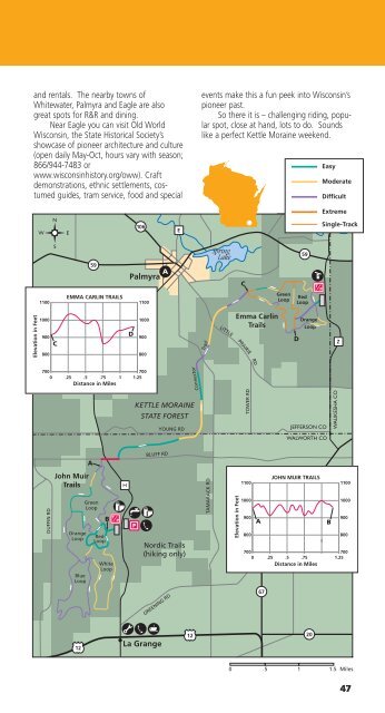
and rentals. The nearby towns <strong>of</strong><br />
Whitewater, Palmyra and Eagle are also<br />
great spots for R&R and dining.<br />
Near Eagle you can visit Old World<br />
<strong>Wisconsin</strong>, <strong>the</strong> State Historical Society’s<br />
showcase <strong>of</strong> pioneer architecture and culture<br />
(open daily May-Oct, hours vary with season;<br />
866/944-7483 or<br />
www.wisconsinhistory.org/oww). Craft<br />
demonstrations, ethnic settlements, costumed<br />
guides, tram service, food and special<br />
events make this a fun peek into <strong>Wisconsin</strong>’s<br />
pioneer past.<br />
So <strong>the</strong>re it is – challenging riding, popular<br />
spot, close at hand, lots to do. Sounds<br />
like a perfect Kettle Moraine weekend.<br />
Easy<br />
Moderate<br />
Difficult<br />
106<br />
E<br />
Extreme<br />
Single-Track<br />
59<br />
Palmyra<br />
Spring<br />
Lake<br />
C<br />
59<br />
1100<br />
EMMA CARLIN TRAILS<br />
1100<br />
Green<br />
Loop<br />
Red<br />
Loop<br />
Elevation in Feet<br />
1000<br />
900<br />
C<br />
800<br />
D<br />
1000<br />
900<br />
800<br />
Trail<br />
LITTLE<br />
Emma Carlin<br />
Trails<br />
PRAIRIE<br />
D<br />
Orange<br />
Loop<br />
Z<br />
RD<br />
700<br />
0<br />
700<br />
.25 .5 .75 1 1.25<br />
Distance in Miles<br />
Connector<br />
KETTLE MORAINE<br />
STATE FOREST<br />
YOUNG RD<br />
TOWER RD<br />
JEFFERSON CO<br />
WAUKESHA CO<br />
WALWORTH CO<br />
A<br />
BLUFF RD<br />
DUFFIN RD<br />
John Muir<br />
Trails<br />
Orange<br />
Loop<br />
Blue<br />
Loop<br />
Green<br />
Loop<br />
B<br />
Red<br />
Loop<br />
White<br />
Loop<br />
H<br />
Nordic Trails<br />
(hiking only)<br />
TAMARACK RD<br />
Elevation in Feet<br />
1100<br />
1000<br />
900<br />
800<br />
700<br />
0<br />
A<br />
JOHN MUIR TRAILS<br />
67<br />
.25 .5 .75<br />
Distance in Miles<br />
1<br />
1100<br />
1000<br />
900<br />
B<br />
800<br />
700<br />
1.25<br />
GREENING RD<br />
67<br />
12<br />
La Grange<br />
12<br />
20<br />
0 .5<br />
1 1.5 Miles<br />
47