

download pdf - Utah Geological Survey - Utah.gov
download pdf - Utah Geological Survey - Utah.gov
download pdf - Utah Geological Survey - Utah.gov

Create successful ePaper yourself
Turn your PDF publications into a flip-book with our unique Google optimized e-Paper software.
GEOLOGIC MAP OF THE SHORT CANYON<br />
QUADRANGLE, EMERY COUNTY, UTAH<br />
by Hellmut H. Doelling and Paul A. Kuehne<br />
MAP 255DM<br />
UTAH GEOLOGICAL SURVEY<br />
a division of<br />
UTAH DEPARTMENT OF NATURAL RESOURCES<br />
2013
GEOLOGIC MAP OF THE SHORT CANYON<br />
QUADRANGLE, EMERY COUNTY, UTAH<br />
by Hellmut H. Doelling and Paul A. Kuehne<br />
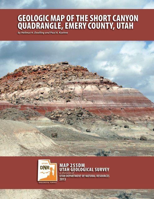
Cover photo: View looking west across the brightly banded unit of the Brushy Basin<br />
Member of the Morrison Formation.<br />
MAP 255DM<br />
UTAH GEOLOGICAL SURVEY<br />
a division of<br />
UTAH DEPARTMENT OF NATURAL RESOURCES<br />
2013
STATE OF UTAH<br />
Gary R. Herbert, Governor<br />
DEPARTMENT OF NATURAL RESOURCES<br />
Michael Styler, Executive Director<br />
UTAH GEOLOGICAL SURVEY<br />
Richard G. Allis, Director<br />
PUBLICATIONS<br />
contact<br />
Natural Resources Map & Bookstore<br />
1594 W. North Temple<br />
Salt Lake City, UT 84116<br />
telephone: 801-537-3320<br />
toll-free: 1-888-UTAH MAP<br />
website: mapstore.utah.<strong>gov</strong><br />
email: geostore@utah.<strong>gov</strong><br />
UTAH GEOLOGICAL SURVEY<br />
contact<br />
1594 W. North Temple, Suite 3110<br />
Salt Lake City, UT 84116<br />
telephone: 801-537-3300<br />
website: geology.utah.<strong>gov</strong><br />
Although this product represents the work of professional scientists, the <strong>Utah</strong> Department of Natural Resources,<br />
<strong>Utah</strong> <strong>Geological</strong> <strong>Survey</strong>, makes no warranty, expressed or implied, regarding its suitability for a particular use,<br />
and does not guarantee accuracy or completeness of the data. The <strong>Utah</strong> Department of Natural Resources, <strong>Utah</strong><br />
<strong>Geological</strong> <strong>Survey</strong>, shall not be liable under any circumstances for any direct, indirect, special, incidental, or consequential<br />
damages with respect to claims by users of this product. For use at 1:24,000 scale only.
CONTENTS<br />
ABSTRACT.......................................................................................................................................................................................................................................... 1<br />
INTRODUCTION.............................................................................................................................................................................................................................. 1<br />
STRATIGRAPHY............................................................................................................................................................................................................................... 1<br />
Subsurface Rock Units......................................................................................................................................................................................................... 1<br />
Jurassic Rocks.......................................................................................................................................................................................................................... 2<br />
Carmel Formation, Winsor Member..................................................................................................................................................................... 2<br />
Entrada Sandstone....................................................................................................................................................................................................... 2<br />
Curtis Formation........................................................................................................................................................................................................... 3<br />
Summerville Formation............................................................................................................................................................................................. 3<br />
Morrison Formation.................................................................................................................................................................................................... 4<br />
Tidwell Member.................................................................................................................................................................................................... 4<br />
Salt Wash Member................................................................................................................................................................................................ 4<br />
Brushy Basin Member......................................................................................................................................................................................... 5<br />
Cretaceous Rocks................................................................................................................................................................................................................... 5<br />
Cedar Mountain Formation.............................................................................................................................................................................. 5<br />
Buckhorn Conglomerate Member.................................................................................................................................................................. 5<br />
Ruby Ranch Member........................................................................................................................................................................................... 5<br />
Short Canyon member........................................................................................................................................................................................ 6<br />
Mussentuchit Member........................................................................................................................................................................................ 6<br />
Dakota Formation ........................................................................................................................................................................................................ 7<br />
Mancos Shale.................................................................................................................................................................................................................. 7<br />
Tununk Member.................................................................................................................................................................................................... 7<br />
Ferron Sandstone Member............................................................................................................................................................................... 8<br />
Blue Gate Member............................................................................................................................................................................................... 8<br />
Quaternary Deposits............................................................................................................................................................................................................. 8<br />
Alluvial Deposits.................................................................................................................................................................................................... 8<br />
Stream alluvium..................................................................................................................................................................................................... 8<br />
Alluvial mud............................................................................................................................................................................................................ 8<br />
Alluvial-fan deposits............................................................................................................................................................................................ 8<br />
Pediment-mantle deposits................................................................................................................................................................................ 9<br />
Mass-Movement Deposits......................................................................................................................................................................................... 9<br />
Landslide deposits................................................................................................................................................................................................ 9<br />
Talus, colluvium, and rock-fall deposits...................................................................................................................................................... 9<br />
Mixed-Environment Deposits.................................................................................................................................................................................. 9<br />
Mixed eolian and alluvial deposits................................................................................................................................................................ 9<br />
STRUCTURAL GEOLOGY.............................................................................................................................................................................................................. 9<br />
Regional Structural Setting................................................................................................................................................................................................ 9<br />
Folds and Faults...................................................................................................................................................................................................................... 9<br />
ECONOMIC GEOLOGY..................................................................................................................................................................................................................10<br />
Petroleum and Gas Possibilities.....................................................................................................................................................................................10<br />
Coal ............................................................................................................................................................................................................................................10<br />
Gypsum .....................................................................................................................................................................................................................................10<br />
Other Resources...................................................................................................................................................................................................................10<br />
Water Resources...................................................................................................................................................................................................................10<br />
GEOLOGIC HAZARDS...................................................................................................................................................................................................................10<br />
Landslides and Rock Falls.................................................................................................................................................................................................10<br />
Debris Flows and Flooding..............................................................................................................................................................................................10<br />
Problem Soils.........................................................................................................................................................................................................................11<br />
Earthquakes...........................................................................................................................................................................................................................11<br />
ACKNOWLEDGMENTS................................................................................................................................................................................................................11<br />
REFERENCES..................................................................................................................................................................................................................................11
GEOLOGIC MAP OF THE SHORT CANYON<br />
QUADRANGLE, EMERY COUNTY, UTAH<br />
by Hellmut H. Doelling and Paul A. Kuehne<br />
ABSTRACT<br />
The Short Canyon quadrangle lies along the west edge of<br />
the Colorado Plateau physiographic province and the east<br />
edge of the High Plateaus, near a transition zone between<br />
the Colorado Plateau to the east and the Basin and Range<br />
Province to the west, and is in the Colorado River drainage<br />
basin. The west boundary is located about 5 miles (8 km)<br />
east of Emery, <strong>Utah</strong>, and about 40 miles (64 km) east of<br />
Salina, <strong>Utah</strong>. The south boundary is 2 to 3 miles (3–5 km)<br />
north of Interstate Highway 70.<br />
Exposed bedrock ranges from Middle Jurassic to Late<br />
Cretaceous in age, includes (in ascending order) the Carmel<br />
Formation (part), Entrada Sandstone, Curtis Formation,<br />
Summerville Formation, Morrison Formation, Cedar<br />
Mountain Formation, Dakota Formation, and the Mancos<br />
Shale (part), and is about 3700 feet (1200 m) thick. The<br />
rocks of the quadrangle dip gently northwestward from<br />
the large San Rafael Swell anticline (to the southeast) into<br />
the Wasatch Plateau syncline (to the northwest). Quaternary<br />
surficial deposits of Holocene and Pleistocene age<br />
include varieties of alluvium, eolian, mass-movement, and<br />
mixed-environment deposits.<br />
No mineral commodities are known to have been produced<br />
from the quadrangle area. Only thin coal deposits<br />
have been discovered in the Ferron Sandstone Member of<br />
the Mancos Shale and in the Dakota Formation.<br />
INTRODUCTION<br />
The Short Canyon quadrangle is located in Emery County<br />
in central <strong>Utah</strong>. The south boundary of the quadrangle<br />
is 2 to 3 miles (3–5 km) north of Interstate 70; the west<br />
boundary is 5 miles (8 km) east of the town of Emery and<br />
40 miles (64 km) east of Salina, <strong>Utah</strong>. The quadrangle is<br />
named after Short Canyon, which flows into Dry Wash in<br />
the northern third of the quadrangle. The map area coincides<br />
with the west edge of the Colorado Plateau physiographic<br />
province and the east edge of the High Plateaus, a<br />
transition zone between the Colorado Plateau and Basin<br />
and Range Province. Emery and Moore are small towns in<br />
the southern part of Castle Valley, immediately west of the<br />
quadrangle.<br />
The highest elevation on the quadrangle is along the<br />
Molen Reef in section 15, T. 22 S., R. 7 E. at 6930 feet (2113<br />
m) and the lowest elevation is South Salt Wash along the<br />
south margin of the quadrangle in section 28, T. 22 S., R. 8<br />
E., at 5720 feet (1743 m).<br />
The principal access is a paved road that extends east<br />
from Moore to I-70. This road passes northwest-southeast<br />
across the middle of the quadrangle; several poorly maintained<br />
roads extend northeast and southwest from this<br />
principal roadway.<br />
The quadrangle was first mapped geologically by C.T. Lupton<br />
(1916) at a scale of 1:62,500 as part of the U.S. <strong>Geological</strong><br />
<strong>Survey</strong> coal-mapping program. Thereafter, Orkild<br />
(1956) produced a photogeologic map of the quadrangle<br />
(Emery 1NE). With some modification, the Orkild (1956)<br />
map was used in the first geologic map of <strong>Utah</strong>, which<br />
was printed at a scale of 1:250,000 (Hintze and Stokes,<br />
1963). It was also included in a geologic map of the Salina<br />
quadrangle (1:250,000) by Williams and Hackman<br />
(1971). Doelling (1972) mapped part of the quadrangle<br />
at 1:33,500 as part of a study of the Emery coal field, and<br />
Doelling (2004) remapped the quadrangle as part of a<br />
1:100,000-scale mapping project. The present project provides<br />
greater geologic detail at a larger scale.<br />
STRATIGRAPHY<br />
Sedimentary strata exposed in the Short Canyon quadrangle<br />
range in age from Middle Jurassic to Late Cretaceous,<br />
and have a total thickness of 3700 feet (1200 m). Several<br />
Quaternary units have been differentiated, including alluvial,<br />
eolian, mass movement, and mixed-environment<br />
deposits.<br />
Subsurface Rock Units<br />
Nearby drill holes have penetrated a normal stratigraphic<br />
sequence of formations below the oldest exposed units<br />
of the quadrangle. The <strong>Utah</strong> Plateau #1-X Federal well,<br />
SW1/4SW1/4 section 11, T. 22 S., R. 8 E., was spudded in<br />
the Entrada Sandstone about one mile (1.6 km) east of the<br />
quadrangle’s east boundary. Reported thicknesses are:
2<br />
Carmel Formation, 615 feet (187 m); Navajo Sandstone,<br />
565 feet (172 m); Kayenta Formation, 250 feet (76 m);<br />
Wingate Sandstone, 374 feet (114 m); and Chinle Formation,<br />
271 feet (83 m) (<strong>Utah</strong> Division of Oil, Gas and Mining,<br />
2008).<br />
The Amerada #1 Government Colman well, NW1/4SW1/4<br />
section 17, T. 23 S., R. 9 E., is three to four miles (5–6 km)<br />
southeast of the southeast corner of the Short Canyon<br />
quadrangle. Reported thicknesses are: Chinle Formation,<br />
264 feet (80 m); Moenkopi Formation, 816 feet (249 m);<br />
Kaibab Limestone, 23 feet (7 m); and the Cedar Mesa<br />
Sandstone, 900 feet (274 m) thick (<strong>Utah</strong> Division of Oil,<br />
Gas and Mining, 2008).<br />
Jurassic Rocks<br />
Carmel Formation, Winsor Member<br />
The Carmel Formation is the oldest bedrock formation<br />
exposed in the Short Canyon quadrangle. Only the upper<br />
50 feet (15 m) of the Winsor Member is exposed, but the<br />
total thickness is about 400 feet (130 m) (Doelling, 2004).<br />
The exposures are limited to the southeast corner of the<br />
quadrangle, all in sections 22 and 27, T. 22 S., R. 8 E. The<br />
outcrops form steep earthy slopes and consist of alternating<br />
green-gray and red-brown gypsiferous siltstone and<br />
calcisiltite, and thin alabaster gypsum beds. The Winsor<br />
Member of the Carmel is Middle Jurassic, Bathonian to<br />
Callovian in age (Douglas Sprinkel, <strong>Utah</strong> <strong>Geological</strong> <strong>Survey</strong>,<br />
written communication, 2009).<br />
Entrada Sandstone<br />
The Entrada Sandstone overlies the Carmel Formation in<br />
the southeast corner of the Short Canyon quadrangle. We<br />
measured 705 feet (215 m) of Entrada along the Red Ledges<br />
in sections 20, 21, and 22 in T. 22 S., R. 8 E. Wright and<br />
Dickey (1958), in an isopach map based on numerous surface<br />
sections they measured in this area, showed that the<br />
formation thickens westward, and is probably 600 to 800<br />
feet (180–245 m) thick on the west flank of the San Rafael<br />
Swell near the Short Canyon quadrangle. Others (Morris<br />
and others, 2000; Hintze and Kowallis, 2009) indicated<br />
the Entrada is 400 to 900 feet (120–275 m) thick between<br />
Price and Cathedral Valley. The differences in thickness<br />
may be explained by the presence of the J-3 unconformity<br />
at the top, and the amount of erosion that took place prior<br />
to deposition of the overlying Curtis Formation.<br />
<strong>Utah</strong> <strong>Geological</strong> <strong>Survey</strong><br />
The Entrada Sandstone is mostly fine-grained sandstone<br />
with a few medium- to coarse-grained lenses and subordinate<br />
siltstone beds and partings. It is mainly light brown<br />
to orange brown. Siltstone partings are generally darker<br />
brown. At irregular intervals, light-gray sandstone ledges<br />
divide units in the Entrada. The sand is cemented with calcium<br />
carbonate; toward the base of the exposed section<br />
secondary gypsum veinlets are locally present. It is generally<br />
exposed as cliffs, but also forms ridges, steep slopes,<br />
and benches along the Red Ledges and to the southwest.<br />
We divide the Entrada into three informal members; lower<br />
(Jel), middle (Jem), and upper (Jeu). The lower member<br />
(Jel) is 295 feet (90 m) thick and forms smooth steep<br />
slopes. The outcrops weather earthy and, where exposed,<br />
are indistinctly bedded. The unit is criss-crossed with thin<br />
satin-spar gypsum veinlets that decrease upwards. The<br />
lower 50 to 55 feet (15–17 m) is bright red-brown and<br />
contains several thin gypsum beds, and the remainder is<br />
light brown and subtly banded.<br />
The middle member (Jem) is about 255 feet (80 m) thick<br />
and forms cliffs and ledges divided by earthy weathering<br />
slopes. The cliffs are mostly thin to thick bedded and locally<br />
massive, and the ledges are commonly rippled. The<br />
lower part contains paper-thin gypsum veinlets and blebs<br />
of widely scattered pink chert nodules.<br />
The upper member (Jeu) is 155 feet (45 m) thick. At its<br />
base, a gray-white sandstone ledge, 1 to 3 feet (0.3–1 m)<br />
thick, is medium to coarse grained, is moderately sorted, is<br />
cross-bedded, and has sucrosic weathering. Above this is<br />
a red-brown, massive, smooth-weathering sandstone unit.<br />
The lower half of this unit commonly weathers into knobs;<br />
the upper half forms a smooth bare-rock bench. The uppermost<br />
unit is red-brown sandstone that is thin to thick<br />
bedded and forms a vertical cliff; the upper 5 feet (2 m)<br />
forms thin ribs.<br />
The Entrada Sandstone is considered Middle Jurassic<br />
(Callovian) in age (Anderson and Lucas, 1994). No fossils<br />
or other age indicators were found in the Entrada in the<br />
Short Canyon quadrangle, but it is between the underlying<br />
Carmel Formation that contains palynomorphs of Callovian<br />
age near the top, and the overlying Curtis Formation,<br />
which has yielded a few marine early Late Jurassic invertebrate<br />
fossils in the San Rafael Swell (Anderson and Lucas,<br />
1994). A regional unconformity (J-3 unconformity) separates<br />
the Entrada from the overlying Curtis Formation. Pipiringos<br />
and O’Sullivan (1978) estimated the elapsed time<br />
between uplift and erosion of the Entrada and the onset<br />
of burial beneath the Curtis sediments to be less than 1<br />
million years. The Entrada Sandstone correlates with the<br />
Preuss Sandstone in the central Wasatch Range and part<br />
of the Twist Gulch Formation in central <strong>Utah</strong> (Sprinkel,<br />
1994).<br />
Although the Entrada Sandstone clearly contains eoliandeposited<br />
sandstone in eastern and parts of southern<br />
<strong>Utah</strong>, the formation on the west flank of the San Rafael<br />
Swell (including the Short Canyon quadrangle) is different<br />
and undoubtedly water-laid. Morris and others (2000) in-
Geologic map of the Short Canyon quadrangle, Emery County, <strong>Utah</strong> 3<br />
dicated the unit is the product of tidal flat deposition. Discussing<br />
its deposition in the area of Capitol Reef National<br />
Park (where outcrops are similar to those in Short Canyon<br />
quadrangle), Smith and others (1963) judged that the Entrada<br />
Sandstone was deposited in quiet water, and cited<br />
Baker and others (1936) and Craig and others (1955),<br />
who considered the deposition to have been largely subaqueous.<br />
Curtis Formation<br />
The Curtis Formation overlies the Entrada Sandstone in<br />
the southeastern and eastern parts of the quadrangle. We<br />
measured the Curtis in section 19, T. 22 S., R. 8 E., where<br />
the formation is 214 feet (65 m) thick, and in sections 27<br />
and 34, T. 21 S., R. 8 E., where the formation is 202 feet (62<br />
m) thick. Craig and Dickey (1956) reported that the Curtis<br />
is 250 feet (76 m) thick in the northern part of the San<br />
Rafael Swell, but that it thins to the south and east. In the<br />
Capitol Reef area to the south, the Curtis thins (Doelling<br />
and Kuehne, 2007), and pinches out a few miles south of<br />
the Wayne-Garfield county line.<br />
In the Short Canyon quadrangle, the Curtis is mostly silty<br />
sandstone with minor siltstone and mudstone (sandy).<br />
At the base, it has a poorly sorted pebble conglomerate<br />
as much as 0.5 foot (0.2 m) thick, with gray pebbles ranging<br />
from coarse grit to 4 inches (10 cm) across, that are<br />
contained in a matrix of fine- to coarse-grained sandstone.<br />
The sandstone above is light gray, light green-gray, or light<br />
tan-gray, moderately to poorly sorted, muddy, and mostly<br />
calcareous. Most units are planar bedded; a few exhibit<br />
faint cross-stratification. Siltstone, wherever present, is<br />
medium gray in color. A few units, especially near the bottom<br />
contain scattered pebbles.<br />
The Curtis Formation consists of two informal units: a<br />
lower mostly cliffy unit 95 to 105 feet (29–32 m) thick,<br />
and an upper slope former about 85 to 100 feet (26–30<br />
m) thick. The lower member (Jcl) forms a cliff with the<br />
upper Entrada member (Jeu) and has a broad bench, partially<br />
covered with mixed eolian and alluvial sand (Qea),<br />
at its top (South Sand Bench). The lower 25 feet (8 m) of<br />
the lower member is a green-gray calcareous siltstone and<br />
sandy shale. It forms a slightly recessed vertical cliff and<br />
locally a steep slope between the uppermost Entrada and<br />
the cliffy sandstone. The cliffy part of the lower member<br />
is mostly light-gray, fine- to medium-grained, calcareous<br />
sandstone that is largely thin to medium bedded, but locally<br />
thick to very thick bedded. The beds weather into nearly<br />
structureless slabby planar blocks. The thicker beds locally<br />
exhibit some eolian cross-bedding, knobby weathering,<br />
and large tafoni ("stonepecker" holes).<br />
The upper member (Jcu) exhibits a deeper green-gray,<br />
light-brown, and lightpurplish<br />
coloration. It displays a series of low slopes<br />
capped by thin ledges. Although fine-grained sandstone<br />
remains the dominant lithology, siltstone and mudstone<br />
are more abundant than in the lower member. The slopes<br />
are earthy or exhibit the thin-bedded to shaly nature of<br />
the rock. The thin ledges weather into thin platy material,<br />
pancake-shaped plates, or chips. The Curtis is one of the<br />
easiest formations to identify in the quadrangle, forming<br />
a light band between the brownish Entrada below and the<br />
brownish Summerville Formation above.<br />
The age of the Curtis Formation is early Late Jurassic. The<br />
Curtis had been considered Callovian in age (see Hintze,<br />
1988, p. 47), but recent palynological work by Wilcox and<br />
Currie (2006) showed that it is early Oxfordian (earliest<br />
Late Jurassic ~161 to 156 Ma). The Curtis Formation and<br />
its correlatives were probably deposited in a single transgressive-regressive<br />
sequence recording the final pulse of<br />
the Jurassic interior seaway. The Curtis Formation correlates<br />
with the Stump Sandstone of northern <strong>Utah</strong>. The Curtis<br />
in the Short Canyon quadrangle is conformably overlain<br />
by the Summerville Formation.<br />
The Curtis sediments were deposited in a shallow-water<br />
marine environment (Craig and Dickey, 1956), and some<br />
of the sandstone is glauconitic. Glauconite is a cementing<br />
mineral that forms only in marine environments where<br />
sedimentation rates are relatively low. However, the moderate<br />
to poor sorting in the lower part of the Curtis Formation<br />
of the Short Canyon quadrangle might indicate some<br />
wave action.<br />
Summerville Formation<br />
The Summerville Formation overlies the Curtis Formation<br />
with a conformable, gradational contact in the Short Canyon<br />
quadrangle. We measured it in section 19, T. 22 S., R.<br />
8 E., northwest of the Canyon Pond where it is about 295<br />
feet (90 m) thick. We also measured it north of Dry Wash<br />
where it is 255 feet (80 m) thick. The Summerville Formation<br />
was defined by Gilluly and Reeside (1928) at Summerville<br />
Point in the northern San Rafael Swell where it<br />
has a thickness of about 165 feet (50 m). In the San Rafael<br />
Swell, the upper boundary with the Morrison Formation<br />
is the J-5 unconformity, and the Summerville Formation<br />
varies considerably in thickness due to gentle folding and<br />
erosion prior to deposition of the Morrison. Although such<br />
synclines and anticlines are not persistent throughout the<br />
San Rafael Swell area, beveling of the formation beneath<br />
the unconformity probably accounts for differences in<br />
thickness of the Summerville. Trimble and Doelling (1978)<br />
reported that the Summerville thickness in the San Rafael<br />
River mining area, on the east side of the San Rafael Swell,<br />
varies from 105 to 400 feet (32–122 m) because of smallamplitude<br />
folds in the unit.<br />
The Summerville Formation ordinarily forms a steep, con-
4<br />
vex slope punctuated by a few ledges. In the Short Canyon<br />
quadrangle, it consists of very fine grained silty sandstone<br />
interbedded with thin siltstone beds. It is generally evenly<br />
bedded, but not as evenly bedded as in the eastern part of<br />
the San Rafael Swell (Doelling, 2004). The bedding ranges<br />
from laminar (a few millimeters) to medium (as much as<br />
2 feet [0.6 m]). The thickest beds generally form ledges.<br />
Light- to medium-brown beds dominate (80%), although<br />
the thinnest and thickest beds are very light gray (20%). A<br />
few thin beds of gray limestone are also present, and the<br />
Summerville is generally calcareous.<br />
The age of the Summerville Formation, like the Curtis Formation,<br />
is early Late Jurassic. The Summerville Formation<br />
had been considered to be Callovian in age (Hintze, 1988,<br />
p. 47), but recent palynological work by Wilcox and Currie<br />
(2006) show that the unit is early Oxfordian in age (earliest<br />
Late Jurassic; ~161 to 156 Ma). The Summerville was<br />
probably deposited in shallow quiet waters as might occur<br />
under tidal-flat conditions (Craig and Dickey, 1956). Common<br />
features associated with the Summerville beds are<br />
mud cracks and ripple marks.<br />
The Summerville Formation in the Short Canyon quadrangle<br />
is overlain by the Tidwell Member of the Morrison Formation.<br />
Pipiringos and O’Sullivan (1978) indicated that<br />
the contact is a regional unconformity (J-5 unconformity)<br />
with a hiatus of about 2 million years; however, in this area<br />
the unconformity is not obviously displayed and appears<br />
gradational. However, a subtle bench or a reduction in the<br />
overall slope angle is present at the contact. The contact is<br />
placed where the light- to medium-brown overall color of<br />
the Summerville changes to the conspicuously red-brown<br />
coloration of the Tidwell Member.<br />
Morrison Formation<br />
The Morrison Formation is generally divisible into three<br />
members in the San Rafael Swell and Castle Valley areas:<br />
in ascending order, the Tidwell, Salt Wash, and Brushy<br />
Basin Members. The Morrison is about 570 to 580 feet<br />
(174–177 m) thick in the Short Canyon quadrangle. In the<br />
quadrangle, the Tidwell and Brushy Basin Members thicken<br />
southward, whereas the Salt Wash Member is thickest<br />
in the north.<br />
Tidwell Member<br />
Tidwell Member: The Tidwell Member of the Morrison<br />
Formation overlies the Summerville Formation in the<br />
quadrangle. In the southern part of the quadrangle (NW ¼<br />
sec. 19, T. 22 S., R. 8 E.) the Tidwell is 90 feet (25 m) thick.<br />
In the northern part of the quadrangle (sec. 33, T. 21 S., R.<br />
8 E.) the member is about 70 feet (20 m) thick.<br />
<strong>Utah</strong> <strong>Geological</strong> <strong>Survey</strong><br />
The Tidwell Member is slope forming, bright red-brown,<br />
locally mottled siltstone and subordinate, very fine grained,<br />
platy-weathering sandstone. Scattered throughout are<br />
thin gypsum beds that become more numerous and thicker<br />
toward the top. The thickest gypsum bed near the top is<br />
as much as 14 feet (4 m) thick. The gypsum beds are silty,<br />
weather frothy or hackly, and are impure alabaster. Many<br />
of the siltstone beds contain flattened blebs and lozenges<br />
of pink gypsum. Locally, light-gray, gritty, medium- to<br />
coarse-grained sandstone beds are present near the base<br />
or middle of the member.<br />
The Tidwell is Late Jurassic in age (Kimmeridgian) (Demko<br />
and others, 2004; Hintze and Kowallis, 2009), and the<br />
upper contact is placed above bright red-brown siltstones<br />
of the Tidwell and below either a smooth, slope-forming,<br />
medium-gray, silty sandstone or gray hard conglomerate<br />
of the Salt Wash Member.<br />
Salt Wash Member<br />
Salt Wash Member: The Salt Wash Member of the Morrison<br />
Formation overlies the Tidwell Member in the quadrangle.<br />
We measured about 95 feet (29 m) of Salt Wash<br />
Member in the southern part (section 13, T. 22 S., R. 7 E.),<br />
and 225 feet (69 m) in the northern part (sections 28 and<br />
29, T. 21 S., R. 8 E.) of the Short Canyon quadrangle. The<br />
contact between the Salt Wash and Brushy Basin Members<br />
is difficult to place, and is mostly marked with a dashed<br />
line on the geologic map (plate 1). Regionally, the Salt<br />
Wash Member contains sandstone, conglomeratic sandstone,<br />
and conglomeratic units, but in the Short Canyon<br />
quadrangle it has more shaly units. We mapped the contact<br />
just below a brightly banded unit of the Brushy Basin<br />
Shale Member, which continues persistently across the<br />
quadrangle.<br />
The Salt Wash Sandstone Member consists of lenticular<br />
and discontinuous, mostly gray conglomerate, conglomeratic<br />
sandstone, and sandstone ledges interbedded with<br />
light-gray, green-gray, lavender, purple, and red silty and<br />
sandy mudstones. The mudstones dominate (70 percent)<br />
over the ledge-formers (30 percent) in the northern part,<br />
and are more equally distributed in the southern part of<br />
the quadrangle. The ledges typically increase near the<br />
base and top of the Salt Wash Member.<br />
The ledges contain poorly sorted, subangular grains to<br />
cobbles, are mostly medium to thick bedded and trough<br />
cross-stratified, contain partings of variously colored siltstone<br />
mudstones, and are generally calcareous. Some conglomerates<br />
are hard and well indurated, while others are<br />
loosely cemented. A few beds contain imprints of logs and<br />
branches.<br />
The mudstones commonly contain carbonized plant debris,<br />
and are color banded, calcareous, and indistinctly<br />
bedded. Sandy mudstones may grade laterally into ledgeformers.<br />
The mudstones form undulating to steep slopes.<br />
These beds are normally assigned a Late Jurassic age<br />
(Kimmeridgian) (Hintze and Kowallis, 2009; Demko and<br />
others, 2004). The upper contact is placed above the up-
Geologic map of the Short Canyon quadrangle, Emery County, <strong>Utah</strong> 5<br />
permost ledges of gray conglomerate, conglomeratic sandstone,<br />
or coarse sandstone or gray, green gray, lavender, or<br />
purple mudstones, and below the brightly banded outcrop<br />
of the Brushy Basin Member.<br />
Brushy Basin Member<br />
Brushy Basin Member: The Brushy Basin Member overlies<br />
the Salt Wash Member everywhere on the Short Canyon<br />
quadrangle. We divided the member into two informal<br />
units on the geologic map (plate 1). The lower and thickest<br />
part is a brightly banded unit (Jmbb) that is overlain<br />
by a purple unit of shale or mudstone (Jmbp). The entire<br />
Brushy Basin is 285 to 385 feet (87–117 m) thick, and is<br />
thickest in the southern part of the quadrangle. The lower<br />
banded unit is 205 to 265 feet (60–80 m) thick and the<br />
purple unit is 80 to 120 feet (25–35 m) thick. The age<br />
of the Brushy Basin Member is Late Jurassic (Tithonian)<br />
(Demko and others, 2004; Gradstein and Ogg, 2009; Hintze<br />
and Kowallis, 2009).<br />
The brightly banded unit of the Brushy Basin Member<br />
forms a steep smooth slope, which is thin to thickly banded<br />
in shades of light-gray, light-brown, or light-purple. It is<br />
mostly mudstone made up of clay, silt, fine-grained sandstone,<br />
and is commonly bentonitic. The unit also contains<br />
scattered horizons of brown limestone nodules, thin white<br />
sandstone, and lenticular conglomeratic beds.<br />
The purplish silty mudstone unit forms a steep slope that<br />
is commonly divided in two by a persistent ledge of sandstone<br />
and conglomerate. It also contains many horizons<br />
of brown limestone nodules that break up and litter the<br />
slope surfaces. Where the Buckhorn Conglomerate Member<br />
of the Cedar Mountain Formation has been channeled<br />
into the purple unit, the upper contact is easily discernible;<br />
however, where mudstones of the Cedar Mountain<br />
Formation are found above it, we placed the contact where<br />
the purple is replaced by green-gray mudstone.<br />
Cretaceous Rocks<br />
Cedar Mountain Formation<br />
The Cedar Mountain Formation forms mostly light-gray or<br />
light-greenish-gray, smooth, rounded slopes beneath the<br />
yellow-gray sandstone of the Dakota Formation. We recognize<br />
four members in the Short Canyon quadrangle (in ascending<br />
order): the Buckhorn Conglomerate, Ruby Ranch<br />
Member, Short Canyon member (new informal name), and<br />
Mussentuchit Member.<br />
Buckhorn Conglomerate Member<br />
Buckhorn Conglomerate Member: The Buckhorn Conglomerate<br />
Member is locally present at the base of the<br />
Cedar Mountain Formation. This lower member is lenticular<br />
in the Short Canyon quadrangle, and is included with<br />
the Ruby Ranch Member where the Buckhorn is very thin<br />
on the map. The Buckhorn is generally 0 to 40 feet (0–12<br />
m) thick.<br />
The Buckhorn Conglomerate Member is composed of<br />
sandstone, conglomeratic sandstone, conglomerate, and<br />
mudstone with an overall gray-brown color, and generally<br />
forms rubbly, cliffy ledges and benches. These beds<br />
are lenticular, poorly to moderately sorted, and trough<br />
cross-stratified. Generally, the pebble and cobble clasts<br />
are subangular to subrounded chert. Some beds are clast<br />
supported while others are matrix supported. The matrix<br />
is mostly medium- to coarse-grained sandstone. The subordinate<br />
mudstone units are present as partings and beds<br />
between the coarser-grained units. The mudstone is lightto<br />
dark-gray, argillaceous, locally carbonaceous and sandy,<br />
and indistinctly bedded, and forms recesses and slopes<br />
between ledges. The Buckhorn Conglomerate Member appears<br />
conformable with the overlying Ruby Ranch member.<br />
Lenticular sandstone beds are generally present in the<br />
Ruby Ranch Member directly over the Buckhorn channels.<br />
Greenhalgh and Britt (2007) considered the Buckhorn to<br />
be Barremian-Aptian (late Early Cretaceous) in age, but<br />
noted that no diagnostic fossils have been found within it.<br />
Some workers used a regional calcrete bed that is near the<br />
base of the Cretaceous, but locally above the Buckhorn, to<br />
place the Buckhorn in the Jurassic (Aubrey 1996, 1998;<br />
Currie, 1997). However, Kirkland and Madsen (2007)<br />
showed that there are several unrelated calcrete beds and<br />
that they are post-depositional and cut across bedding.<br />
We follow Greenhalgh and Britt (2007) and Kirkland and<br />
Madsen (2007) and consider the Buckhorn late Early Cretaceous<br />
in age and as the basal unit of the Cedar Mountain<br />
Formation. The Buckhorn is discontinuous throughout the<br />
Colorado Plateau region beneath the other members of<br />
the Cedar Mountain Formation. It may laterally interfinger<br />
with the Yellowcat Member (not present in this quadrangle)<br />
(Greenhalgh and Britt, 2007), and is overlain sequentially<br />
by the Poison Strip (also absent in this quadrangle),<br />
Ruby Ranch, and Mussentuchit Members (Kirkland and<br />
others, 1997).<br />
Ruby Ranch Member<br />
Ruby Ranch Member: The Ruby Ranch Member, which<br />
forms a continuous outcrop belt in the quadrangle, varies<br />
from 76 to 131 feet (23–40 m) in thickness. Kirkland and<br />
others (1999) indicated it is separated from the overlying<br />
Mussentuchit Member by an unconformity, which may explain<br />
the variation.<br />
The Ruby Ranch Member is mainly clayey and silty mudstone,<br />
but locally has accumulations of lenticular sandy<br />
mudstone and ledgy sandstone that are more common<br />
above the Buckhorn Conglomerate channels. The fresh unweathered<br />
mudstone is generally dark gray to dark purple<br />
gray and is darker in color than on the weathered slopes.<br />
Commonly, the mudstone contains layers of mediumbrown<br />
or medium-brown-gray limestone nodules. These<br />
nodular layers break up on weathering, and where abundant,<br />
nodules cover much of the slope surface. The sandstone,<br />
where present, is mostly poorly sorted and ranges
6<br />
from fine grained to pebbly. Where fresh, the mudstone<br />
breaks conchoidally into small to large, angular, equidimensional<br />
fragments.<br />
The Ruby Ranch Member generally forms "bumpy" to<br />
smooth-weathering, light-gray to light-greenish-gray<br />
slopes with abundant carbonate nodules littering the<br />
slopes. Where the Buckhorn Conglomerate Member is<br />
not present, light-hued, medium to thick mudstone beds<br />
that vary in resistance and steepness form a continuous<br />
slope from the top of the Salt Wash Member to the base<br />
of the Mussentuchit Member. The Brushy Basin Member<br />
slopes are generally smoother than the Ruby Ranch Member<br />
mudstones. Subtle, slightly less variegated, and duller<br />
overall color banding, indicative of variations in the mudstone<br />
bedding, is more common in the Ruby Ranch Member.<br />
The age of the Ruby Ranch Member is Early Cretaceous<br />
(Aptian-Albian) according to fossil evidence and radiometric<br />
and stratigraphic relations (Kirkland and others,<br />
1999; Kirkland and Madsen, 2007). The Ruby Ranch Member<br />
is generally present everywhere the Cedar Mountain<br />
Formation is exposed throughout the Colorado Plateau<br />
region, but is missing in southwestern <strong>Utah</strong> (Kirkland and<br />
others, 1999; Jim Kirkland, <strong>Utah</strong> <strong>Geological</strong> <strong>Survey</strong>, verbal<br />
communication, 2008).<br />
Short Canyon member<br />
Short Canyon member: We introduce a new informal<br />
member of the Cedar Mountain Formation with a type section<br />
located on the north side of Short Canyon in section<br />
20, T. 21 S., R. 8 W. The member is discontinuous and most<br />
prominent in the north half of the quadrangle. It represents<br />
a channel deposit that preceded and was partly contemporaneous<br />
with the deposition of the Mussentuchit Member<br />
and is much like the Buckhorn Member at the base of the<br />
Ruby Ranch Member. In the north half of the Short Canyon<br />
quadrangle it resembles the Dakota Formation as well.<br />
The Short Canyon member consists of one to three resistant<br />
ledges of conglomerate, conglomeratic sandstone,<br />
and sandstone, that are separated by slope-forming sandstone,<br />
local gray to black carbonaceous (and possibly<br />
coaly) shale, and rare, thin gypsiferous sandstone lenses.<br />
The ledges and cliffs are various shades of gray, gray<br />
brown, and brown, and are cross-stratified and commonly<br />
trough cross-bedded. The conglomerate contains poorly<br />
sorted, subrounded to subangular grit to cobbles as much<br />
as 4 inches (10 cm) across. The clasts consist of quartzite,<br />
siliceous limestone, and sandstone and are poorly to well<br />
cemented with calcite or silica. The abundance of quartzite<br />
clasts distinguishes the Short Canyon member from the<br />
Buckhorn Conglomerate (Gary Hunt, <strong>Utah</strong> <strong>Geological</strong> <strong>Survey</strong>,<br />
verbal communication, 2009). The sandstone in the<br />
ledges is also poorly sorted, and some beds are very fine<br />
to medium grained but others are fine to coarse grained.<br />
The cementation varies in degree, and is calcareous or siliceous,<br />
but the rock is mostly firm. The ledges probably<br />
<strong>Utah</strong> <strong>Geological</strong> <strong>Survey</strong><br />
represent channel deposits of an ancient river system. Carbonaceous<br />
shale and coaly shale as much as 2 feet (0.6 m)<br />
thick and rare gypsiferous sandstone lenses are present in<br />
the highest parts of the principal ledges.<br />
Slope-forming, muddy sandstone separates the ledgeforming<br />
rock. Beds are fine to medium grained; light gray,<br />
green gray, orange, and light brown; poorly cemented; and<br />
friable. Cementation is principally calcareous. Locally present<br />
in the earthy-weathering slopes are very small rip-up<br />
clasts of nearly white mudstone, and well-indurated sandstone<br />
forms a slight ledge in the slope. The slope-forming,<br />
muddy sandstone is generally lighter and less structured<br />
than mudstone in the Mussentuchit Member.<br />
As ascertained by Kirkland and others (1999), the Ruby<br />
Ranch and Mussentuchit Members contact is an unconformity.<br />
The Short Canyon member is a channel-form deposit<br />
laid down above the plane of unconformity. Such channels<br />
are not present in the southern part of the quadrangle, but<br />
subparallel the Cedar Mountain Formation outcrop belt in<br />
the north. The Short Canyon member continues in outcrop<br />
into the Molen quadrangle to the north. A channel or set<br />
of channels is thickly developed where the Cedar Mountain<br />
Formation outcrop belt crosses Short Canyon. There<br />
are at least three channel ledges: the lowest cuts deeply<br />
into the Ruby Ranch Member, and the highest rises into<br />
the Mussentuchit Member above. Although we could not<br />
actually pinpoint a place, the Dakota Formation may locally<br />
rest directly on the Short Canyon member. However,<br />
at one location we measured 104 feet (32 m) of the Short<br />
Canyon member and only 38 feet (12 m) of the Mussentuchit<br />
Member. The lowest ledge is widest and the highest<br />
is the narrowest. The lower contact with the Ruby Ranch<br />
Member is wavy and irregular. The upper contact with the<br />
Mussentuchit Member is relatively abrupt and discordant<br />
to regional bedding and probably represents the boundary<br />
between the sides of channels and overbank or lacustrine<br />
deposits.<br />
Mussentuchit Member<br />
Mussentuchit Member: The Mussentuchit Member unconformably<br />
overlies the Ruby Ranch Member wherever<br />
they are in contact. Where it overlies the Short Canyon<br />
member, the contact is conformable. The Mussentuchit<br />
Member is continuous across the quadrangle ranging<br />
from 38 to 110 feet (12–33 m) thick, and generally thins<br />
northward. It differs from the Ruby Ranch by the lack of<br />
nodular limestone horizons and by an increase of volcanic<br />
ash material in the mudstone. The type section of this<br />
member was designated by Kirkland and others (1997) at<br />
a location on the south side of Mussentuchit Wash in the<br />
Willow Springs quadrangle, about 12 miles (19 km) to the<br />
south. The upper contact with the Dakota Formation is an<br />
unconformity.<br />
The mudstone of the Mussentuchit Member weathers into<br />
light-gray, white, and light-green-gray colors. The mudstone<br />
is smectitic, sandy, or silty. Ledges locally include
Geologic map of the Short Canyon quadrangle, Emery County, <strong>Utah</strong> 7<br />
some medium green-gray, fine- to medium-grained sandstone.<br />
Like the Ruby Ranch, differences in resistance afford<br />
variable slopes with changes in slope angle. Locally,<br />
some dark lignitic horizons are present, especially near<br />
the top of the unit.<br />
The radiometric age of the Mussentuchit Member has been<br />
established as 98.39 Ma obtained by Cifelli and others<br />
(1997), and Garrison and others (2007). Thus, this member<br />
is considered Cenomanian in age based on Gradstein<br />
and Ogg (2009). The Mussentuchit Member has also yielded<br />
a rich dinosaur fauna. The member crops out mostly<br />
along the west flank of the San Rafael Swell and extends<br />
into southwest <strong>Utah</strong> (Biek and others, 2003; Biek and others,<br />
2007). It correlates to the Mowry Shale in northern<br />
<strong>Utah</strong> (Sprinkel, 2007) but is not present in many parts of<br />
the Colorado Plateau region.<br />
Dakota Formation<br />
The Dakota Formation is also locally known as the Dakota<br />
Sandstone. Inasmuch as the Dakota is mostly shale in the<br />
Short Canyon quadrangle, we use the term “formation.”<br />
In its full development in the quadrangle, it consists of<br />
a lower slope, a lower sandstone ledge or cliff, a middle<br />
slope, an upper sandstone ledge or cliff, and a thin, pebbly<br />
upper slope containing Pycnodonte newberryi (oyster<br />
shell fossils). The five divisions are not developed everywhere<br />
in the quadrangle; in many areas the upper sandstone<br />
ledge is thin or missing, and in other areas the lower<br />
sandstone ledge is thin or missing. The lower boundary is<br />
an unconformity. The upper boundary is mapped where<br />
overlying deeper marine (Mancos Shale) deposits first<br />
occur. In some areas of the San Rafael Swell, a local unconformity<br />
has been identified near the base of the upper<br />
slope that contains pebbles and Pycnodonte newberryi fossils<br />
(Eaton and others, 1990; Jim Kirkland, <strong>Utah</strong> <strong>Geological</strong><br />
<strong>Survey</strong>, verbal communication, 2008). However, for mapping<br />
purposes we have included the thin slope interval in<br />
the Dakota Formation following Lawyer (1972) and Peterson<br />
and others (1980). The Dakota is 50 to 100 feet (15–<br />
30 m) thick. The thickness varies, but is generally thickest<br />
in northern exposures.<br />
The Dakota Formation consists of interbedded sandstone,<br />
shale, carbonaceous shale, coal, conglomeratic sandstone,<br />
and conglomerate. The sandstone ledges or cliffs consist<br />
of thin to thick lenses of sandstone and conglomerate.<br />
The sandstone beds are generally light hued, including<br />
yellow, orange gray, light tan gray, or very light brown.<br />
They are commonly fine to medium grained, but locally<br />
they contain rounded or subrounded pebbles and cobbles<br />
that grade into gray conglomerate; most are well to moderately<br />
sorted. Partings in the ledges and cliffs consist of<br />
carbonaceous shale or gray shale. The conglomerate and<br />
sandstone commonly exhibit trough cross-beds. Burrows<br />
and plant imprints are locally common. The carbonaceous<br />
shale partings commonly contain plant debris. The rock is<br />
moderately cemented with calcite. Locally, the sandstone<br />
contains pyrite nodules, but most have altered to brown<br />
limonite.<br />
The slopes contain irregularly bedded mudstone, siltstone,<br />
sandy shale, gray shale, carbonaceous shale, coal,<br />
muddy sandstone, and brown sandstone. Except for the<br />
brown sandstone, the strata weather into slopes and recesses.<br />
The most common colors are shades of gray or<br />
gray brown. Coal beds, where present, are very thin and<br />
lenticular, rarely exceeding 6 inches (15 cm) in thickness,<br />
although one may be up to 1.5 feet (0.5 m) thick. Except<br />
for the brown variety, most sandstone beds are friable and<br />
fine grained. The brown variety of sandstone is typically<br />
thin-bedded and cemented with calcite. The Dakota Formation<br />
is Late Cretaceous (Cenomanian) in the Short Canyon<br />
quadrangle (Eaton and others, 1990; Molenaar and<br />
Cobban, 1991).<br />
Mancos Shale<br />
The Mancos Shale is represented by three members on<br />
the west side of the Short Canyon quadrangle. These are<br />
(ascending order) the Tununk Member, Ferron Sandstone<br />
Member, and Blue Gate Member. The Mancos Shale was<br />
deposited during the time of the Cretaceous Western Interior<br />
Seaway.<br />
Tununk Member<br />
Tununk Member: The Tununk is the oldest of the Mancos<br />
Shale members and represents the westernmost incursion<br />
of the Western Interior Seaway. In the quadrangle,<br />
it is present beneath the Molen Reef in a southwest-tonortheast<br />
band as a steep concave slope; locally as a vertical<br />
cliff. We measured the Tununk Member in the NW 1/4<br />
section 14, T. 22 S., R. 7 E., where it was about 675 feet<br />
(205 m) thick.<br />
The Tununk Member is composed of marine mudstone<br />
and shale that is medium to dark brown or gray and locally<br />
black, and that breaks into equidimensional fragments<br />
when excavated. The unit is soft, silty, and sandy<br />
(fine grained) near the bottom and top. Bedding is mostly<br />
indistinct to thin and laminated. The Tununk contains secondary<br />
gypsum veinlets and is mostly calcareous. In the<br />
upper 50 feet (15 m), the shale is interbedded with thin,<br />
brown to gray, very fine grained sandstone beds that are<br />
about 1 foot (0.3 m) apart. The upper contact is mapped at<br />
the base of the first medium or thick sandstone bed of the<br />
overlying Ferron Sandstone Member.<br />
About 100 feet (30 m) below the top of the member is a<br />
conspicuous ledge of sandstone, about 25 feet (8 m) thick,<br />
which we informally call the Moore sandstone bed (not<br />
mapped). The sandstone is light-gray, fine grained, blocky,<br />
and massive.
8<br />
The Tununk Member overlies the Dakota Sandstone at<br />
most locations in the Colorado Plateau region. It correlates<br />
with the Tropic Shale in southwestern <strong>Utah</strong> (Hintze<br />
and Kowallis, 2009). Fossils indicate it is Late Cretaceous<br />
(Cenomanian) in age (Molenaar and Cobban, 1991).<br />
Ferron Sandstone Member<br />
Ferron Sandstone Member: The Ferron Sandstone<br />
Member of the Mancos Shale generally forms a series<br />
of sandstone cliffs above the steep slope of the Tununk<br />
Shale Member and is 325 feet (100 m) thick in the quadrangle,<br />
thinning to the northeast. It consists of interbedded<br />
yellow-gray, light-brown, and white sandstone, gray<br />
sandy shale, dark-gray carbonaceous shale, and dark gray<br />
to black coal. The sandstone is mostly fine to medium<br />
grained, mostly calcareous, thin to massive lenticularly<br />
bedded, cross-stratified, rippled, bioturbated, and contorted.<br />
The member contains limonitic nodules (some still<br />
have pyrite cores) and thin lenticular coal beds up to 2.3<br />
feet (0.7 m) thick.<br />
The Ferron Sandstone overlies the Tununk Member conformably.<br />
It was deposited in fluvial, deltaic, and lagoonal<br />
environments. It correlates with the Tibbett Canyon and<br />
Smoky Hollow Members of the Straight Cliffs Formation<br />
in the Kaiparowits Plateau. It is exposed near the Henry<br />
Mountains to the southeast, where it is thinner. It surrounds<br />
the northern half of the San Rafael Swell, but thins<br />
northeastward from Short Canyon, eventually losing its<br />
cliff-forming character. Fossils indicate it is Late Cretaceous<br />
(Turonian) in age (Molenaar and Cobban, 1991).<br />
The lower part is middle Turonian, and the upper feldspathic<br />
part is upper Turonian (Gardner, 1995; Ryer and<br />
Anderson, 2004).<br />
Blue Gate Member<br />
Blue Gate Member: Like the Tununk Member, the Blue<br />
Gate Member of the Mancos Shale forms steep earthy<br />
slopes. It forms most of the surface of Castle Valley, west of<br />
the Short Canyon quadrangle. It differs from the Tununk<br />
Member in being a lighter shade of gray and exhibiting<br />
more laminated and thin beds. It is the youngest sedimentary<br />
bedrock unit with approximately 300 feet (100 m) exposed<br />
in the quadrangle. The entire lower part of the Blue<br />
Gate Member is about 1600 feet (490 m) thick in this part<br />
of Castle Valley.<br />
The lower Blue Gate Member is mostly evenly bedded, pale<br />
blue-gray, marine shale, which is irregularly interbedded<br />
with siltstone and several yellow-gray sandstone beds that<br />
are slightly more resistant. The member forms a broad<br />
badlands slope with thin ledges. The Blue Gate Member is<br />
present below the Book Cliffs in the Colorado Plateau region<br />
and in the Henry Mountains basin. It correlates with<br />
the John Henry Member of the Straight Cliffs Formation in<br />
the Kaiparowits Plateau area (Peterson, 1969). Santonianage<br />
(Late Cretaceous) fossils are present in the lower Blue<br />
Gate Member and overlying Emery Sandstone (Peterson<br />
and others, 1980).<br />
Quaternary Deposits<br />
<strong>Utah</strong> <strong>Geological</strong> <strong>Survey</strong><br />
Alluvial Deposits<br />
Stream alluvium<br />
Stream alluvium: Clay- to boulder-size clasts are common<br />
along courses of modern washes and stream channels,<br />
including Short Canyon and Dry Wash. They are unconsolidated<br />
and poorly to moderately sorted, and consist<br />
of interlayered coarse and fine lenses. The coarsest materials<br />
are commonly in the wash channel. Generally two<br />
other levels of alluvium (terraces?) are discernible (not<br />
mapped), one about 5 feet (2m) above the wash channel,<br />
the next about 25 feet (8 m) above the first level. Higher<br />
levels were not observed in this quadrangle. Sources are<br />
varied, but the alluvium of the major drainages consists<br />
dominantly of Mancos Shale mud and very fine-grained<br />
sand. Dry Wash, for example, is dominated by gray, finely<br />
laminated Mancos mud (clay, silt, and very fine-grained<br />
sand), with very thin streaks of fine-grained sandstone derived<br />
from the Summerville Formation. The walls of the<br />
highest level commonly stand vertical. The upper surfaces<br />
of the levels are coarsely fluted in the direction of flow.<br />
The base of the wash channel and that of the 5-foot (2 m)<br />
level generally contain some gravel from the Morrison and<br />
Cedar Mountain Formations where the alluvium is below<br />
these outcrops; a small percentage from the Ferron Sandstone,<br />
Dakota, and Summerville Formations may also be<br />
present.<br />
The alluvium of the major channels is probably no thicker<br />
than 30 feet (9 m) and its presence suggests a period of<br />
canyon or valley filling. Currently, the highest levels of the<br />
alluvial deposits are being eroded by the washes (downcutting<br />
mode) and suggest that at one time they were laid<br />
down on top of previously eroded bedrock surfaces. The<br />
alluvium deposits are Holocene to late Pleistocene.<br />
Alluvial mud<br />
Alluvial mud: Light gray mud, mostly derived from Mancos<br />
Shale Members, has been deposited as valley fill, slope<br />
wash, and fans in the northwest part of the quadrangle.<br />
It consists dominantly of unconsolidated clay, silt, and<br />
sand particles in deposits that are mostly structureless,<br />
laminated, or crudely stratified. Alluvial mud deposits are<br />
probably not more than 15 feet (5 m) thick in this quadrangle<br />
and are probably Holocene to late Pleistocene.<br />
Alluvial-fan deposits<br />
Alluvial-fan deposits: Alluival-fan deposits generally consist<br />
of unconsolidated silt to cobble-size particles that are<br />
carried from surrounding bedrock outcrops by torrential<br />
rainfall and are deposited where washes experience a reduction<br />
in gradient, forming fan-shaped deposits. Alluvialfan<br />
deposits are much like the alluvial mud deposits in that<br />
they are derived from local sources; however, they contain<br />
less mud. They commonly interfinger with the alluvium of<br />
prominent drainages at their lower ends and are currently<br />
being gullied headward by the tributaries of these prominent<br />
drainages. As mapped, they commonly contain minor
Geologic map of the Short Canyon quadrangle, Emery County, <strong>Utah</strong> 9<br />
quantities of alluvium and eolian deposits. These fan deposits<br />
are less than 15 feet (5 m) thick, generally cover<br />
bedrock, and are Holocene to late Pleistocene.<br />
Pediment-mantle deposits<br />
Pediment-mantle deposits: These deposits consist of<br />
unconsolidated silt to gravel-size material with local accumulations<br />
of sandstone boulders that are generally<br />
derived from nearby bedrock. Pediment deposits in the<br />
southeast corner of the quadrangle represent an old alluvial<br />
surface that developed on the lower Entrada Sandstone<br />
and the Winsor Member of the Carmel Formation,<br />
and has subsequently been dissected. The deposits slope<br />
northwestward, indicating that the source was toward the<br />
San Rafael Swell. They do not vary much in thickness and<br />
consist of chippy and platy limestone gravel mixed with<br />
light-brown, very fine-grained sand that is about 4 feet<br />
(1.3 m) thick. In many places southeast of South Salt Wash<br />
this gravel is overlain by 2 to 3 feet (0.7–1 m) of gypsite,<br />
impure gypsum mixed with silt and very fine grained sand.<br />
A few pediment deposits are found on the Summerville<br />
and Curtis Formations (mostly on the Curtis) on the west<br />
side of North Salt Wash between the Moore Road and Dry<br />
Wash. They may represent the deposits of a paleo-North<br />
Salt Wash but are now aligned along a ridge west of the<br />
wash. They are composed of quartzite gravel, chalcedony<br />
(chert), limestone, gritstone, and siltstone in poorly sorted<br />
fine to coarse sand. The gravel contains clasts to 5 inches<br />
(12 cm) across, but is dominated by 1/2-inch to 1-inch<br />
(1–2.5 cm) pieces, all poorly sorted. The clasts are mostly<br />
derived from the Cedar Mountain Formation and Morrison<br />
Formation, with a small component from the Summerville<br />
Formation. These deposits drape down toward the wash<br />
and may be partly colluvial, with maximum thickness<br />
probably not more than 15 feet (5 m) thick. Similar small<br />
Qap deposits are scattered along the Dry Wash drainage<br />
and in other areas of the quadrangle. Qap deposits are<br />
considered mostly Holocene to early Pleistocene.<br />
Mass-Movement Deposits<br />
Landslide deposits<br />
Landslide deposits: Landslide deposits are not common<br />
in the Short Canyon quadrangle. However, a few have developed<br />
below cliff-forming units resting on shale. The<br />
smallest are grouped with the talus and rock-fall deposits<br />
(Qmtc); only larger deposits were mapped. The Coal Cliffs<br />
or Molen Reef consists of the Ferron Sandstone Member<br />
resting upon the steep slope of the Tununk Member of<br />
the Mancos Shale. In some places, the sandstone cliff has<br />
separated from the main mass of the lower part of the Ferron<br />
Sandstone Member and slipped on the Tununk Shale<br />
as rotational blocks. The rotational blocks are generally<br />
broken into many large pieces. In at least one place, the<br />
same has occurred with the Dakota Formation resting on<br />
the Mussentuchit Member of the Cedar Mountain Formation.<br />
Thicknesses vary and most deposits are Holocene to<br />
late Pleistocene.<br />
Talus, colluvium, and rock-fall deposits<br />
Talus, colluvium, and rock-fall deposits: Deposits of<br />
accumulated rock debris occur on slopes below cliffs and<br />
ledges. Large blocks that have broken off and fallen from<br />
a ledge or cliff are ubiquitous in the quadrangle; only the<br />
larger deposits are mapped. They are especially prevalent<br />
below the Molen Reef on the steep slope of the Tununk<br />
Member of the Mancos Shale.<br />
These deposits rarely exceed 5 feet (1.5 m) in thickness<br />
and consist of poorly sorted angular fragments. Rounded<br />
fragments in talus were probably rounded prior to having<br />
been incorporated in the parent formation. These deposits<br />
are considered Holocene to late Pleistocene.<br />
Mixed-Environment Deposits<br />
Mixed eolian and alluvial deposits<br />
Mixed eolian and alluvial deposits: Most of these deposits<br />
rest upon the lower Curtis Formation (Jcl) and largely<br />
cover the slopes down dip from the ledge formed at the<br />
Curtis-Entrada contact. The sand is mostly fine to medium<br />
grained and is derived from the Curtis Formation, and<br />
thought to be the product of both sheet wash and eolian<br />
processes. Small amounts of fine to medium gravel are<br />
found in the deposits, and the amount of gravel increases<br />
to the northwest. They are Holocene to late Pleistocene in<br />
age.<br />
STRUCTURAL GEOLOGY<br />
Regional Structural Setting<br />
The Short Canyon quadrangle is located on the gently dipping<br />
western flank of the San Rafael Swell. Structurally, the<br />
area is a basin, as reflected by regional strikes and dips of<br />
the strata. Structure contours show the strikes generally<br />
to be north-northeasterly ranging from N. 25° E. to N. 50°<br />
E. Along this trend, dips average between 2 and 7 degrees<br />
to the northwest into the basin. Locally in the northwest<br />
corner of the quadrangle, dips increase to as much as 10<br />
degrees.<br />
Folds and Faults<br />
A pair of north-south trending fold axes in sections 26 and<br />
27, T. 21 S., R. 7 E., can be traced for about 1.25 miles (2<br />
km), and involve strata of the Ferron Sandstone Member<br />
of the Mancos Shale. Both the syncline (east) and anticline<br />
(west) plunge northward at about 2 degrees before dying<br />
out. Dips within the Molen Reef range from 5 to 7 degrees<br />
northwesterly, flatten out at the syncline, then dip 1 to 4<br />
degrees easterly up to the anticline (about 0.6 mile [1 km])<br />
before dipping northwesterly again toward Castle Valley.<br />
Faults are rare in the Short Canyon quadrangle, and have<br />
only minor displacements. Only one small displacement
10<br />
fault was mapped in the southwest corner of the map area.<br />
The structural setting surrounding the Short Canyon quadrangle<br />
is discussed in Neuhauser (1988) and Tripp (1989).<br />
ECONOMIC GEOLOGY<br />
Petroleum and Gas Possibilities<br />
No wells have been drilled for petroleum or gas in this<br />
quadrangle. Wildcat wells were drilled to test the Sinbad<br />
Member of the Moenkopi Formation on the adjacent Sid<br />
and Charley quadrangle to the east, but proved dry (<strong>Utah</strong><br />
Division of Oil, Gas and Mining, 2008). Several wells encountered<br />
gas along an anticline in the Ferron Sandstone<br />
Member of the Mancos Shale north of the quadrangle near<br />
the town of Ferron. However, the Ferron is eroded at the<br />
surface in the Short Canyon quadrangle, and the possibility<br />
for hydrocarbon discovery is deemed low. Several papers<br />
have been written on petroleum and gas potential including<br />
Tripp (1989), Gloyn and others (2003), and U.S. <strong>Geological</strong><br />
<strong>Survey</strong> Uinta-Piceance Assessment Team (2003).<br />
Coal<br />
Coal is present in the Ferron Sandstone Member of the<br />
Mancos Shale and in the Dakota Formation. The area is a<br />
part of the Emery coalfield. The Ferron Sandstone coals<br />
were originally evaluated by Lupton (1916); additional<br />
work was added by Doelling (1972) and Quick and others<br />
(2004).<br />
The Short Canyon quadrangle is located at the very north<br />
end of the coalfield and no economic deposits are known.<br />
Doelling (1972) and Quick and others (2004) reported<br />
that the thickest bed in the quadrangle is found in the<br />
southwest corner of section 35, T. 21 S., R. 7 E., where it is<br />
1.9 to 2.3 feet (0.6–0.7 m) thick. The bed is lenticular and<br />
discontinuous, and over a short distance (100 feet [30 m])<br />
dissipates into even thinner beds and bone coal.<br />
Coal in the Dakota Formation is generally very thin and<br />
commonly missing, but at one location (NE ¼ sec. 22, T. 22<br />
S., R. 7 E.) it is 1.5 feet (0.5 m) thick.<br />
Gypsum<br />
Gypsum beds are present in the Winsor Member of the<br />
Carmel Formation, in the lowermost member of the Entrada<br />
Sandstone, and in the Tidwell Member of the Morrison<br />
Formation. Exposures at the surface in the Carmel and<br />
Entrada are generally thin, rarely exceeding 2 feet (0.6 m)<br />
in thickness. The Tidwell generally contains several beds,<br />
but only the uppermost is thick; locally this bed is as much<br />
as 13 feet (4 m) thick, but contains siltstone partings, is<br />
impure, and weathers frothy and hackly.<br />
Other Resources<br />
<strong>Utah</strong> <strong>Geological</strong> <strong>Survey</strong><br />
Chalcedony is abundant locally in the Morrison and Cedar<br />
Mountain Formations. Red (jasper), yellow (citrine), and<br />
gray (flint) chalcedony could be worked into jewelry. Various<br />
types of nodules and other rock oddities are found at<br />
many quadrangle localities, which might interest “rock<br />
hounds.”<br />
Water Resources<br />
The Short Canyon quadrangle is located on the edge of a<br />
middle-latitude desert at the foot of the Wasatch Plateau.<br />
Annual precipitation ranges from 6 to 8 inches (15–20<br />
cm), the higher amount falling in the higher elevations<br />
(Richardson and others, 1980). Elevations range from a<br />
low of about 5720 feet (1740 m) (where South Salt Wash<br />
exits the quadrangle in the southeast corner) to a high of<br />
about 6930 feet (2113 m) along the Molen Reef near the<br />
southwest margin of the quadrangle. All drainages are<br />
ephemeral, generally draining the area from west to east.<br />
However, after a series of wet years, Dry Wash and Short<br />
Canyon may have flowing water in their channels for short<br />
distances.<br />
The Short Canyon quadrangle provides winter grazing<br />
for cattle, and water catchments have been constructed<br />
across the quadrangle. Most of these catchments collect<br />
flow in small washes, which channel water for a short<br />
time after a brief rainfall or snowfall. Every few years a<br />
torrential summer rainfall causes flash floods in many of<br />
the washes, destroying the catchment dams. These catchments<br />
are quickly repaired for the winter grazing season.<br />
Groundwater studies in the area include that by Lines and<br />
Morrissey (1981).<br />
GEOLOGIC HAZARDS<br />
Landslides and Rock Falls<br />
Few landslides (Qms) were mapped in the Short Canyon<br />
quadrangle. Rock falls occur sporadically; they are most<br />
evident at the foot of the Molen Reef, but can occur from<br />
any cliff-forming unit. Large angular boulders in Qmtc deposits<br />
attest to previous rock-fall events.<br />
Debris Flows and Flooding<br />
Flooding-induced erosion and deposition are the most<br />
active and potentially damaging geologic hazards in the<br />
quadrangle, especially in areas of mapped young alluvial<br />
deposits. The sparsely vegetated slopes, benches, and<br />
deep, narrow washes are subject to rapid erosion from<br />
waters generated by cloudburst rainstorms. Debris flows<br />
and floods generally remain confined to stream channels
Geologic map of the Short Canyon quadrangle, Emery County, <strong>Utah</strong> 11<br />
in high-relief areas, but may exit channels and deposit<br />
debris where slope gradients decrease or channels are<br />
shallow along their travel paths. Debris flows and stream<br />
floods regularly damage the few roads in the Short Canyon<br />
quadrangle. These hazards are directly related to torrential<br />
rainfall, which is more likely to occur in the late summer<br />
season, although long, steady rains and snowmelt in<br />
the spring can also cause damage. Because most roads are<br />
not surfaced or paved, those crossing the shale members<br />
of the Mancos can become so muddy that travel over them<br />
is extremely difficult.<br />
Problem Soils<br />
The clay- and mud-bearing bedrock units and unconsolidated<br />
deposits, fine-grained rocks associated with some of<br />
the cliff-forming formations, and soils derived from them<br />
are susceptible to collapse, shrink-swell, piping, and dissolution.<br />
Essentially, problem soils develop on all formations<br />
stratigraphically above the Salt Wash Member of the<br />
Morrison Formation.<br />
Earthquakes<br />
The quadrangle is in a low-risk zone, having a 30% probability<br />
of an earthquake greater than magnitude 5.0 within<br />
the next 100 years (U.S. <strong>Geological</strong> <strong>Survey</strong>, 2007). Inasmuch<br />
as the area is uninhabited and few structures (roads,<br />
powerlines) exist, potential for damage is low.<br />
ACKNOWLEDGMENTS<br />
We appreciate the help of James Kirkland and Don DeBlieux,<br />
who gave us mapping pointers in the field on the<br />
Cedar Mountain and Morrison Formations. We also thank<br />
Don Clark, Grant Willis, David Tabet, Steve Bowman, James<br />
Kirkland, and Robert Ressetar, who reviewed this map. All<br />
are employees of the <strong>Utah</strong> <strong>Geological</strong> <strong>Survey</strong>.<br />
REFERENCES<br />
Anderson, O.J., and Lucas, S.G., 1994, Middle Jurassic stratigraphy,<br />
sedimentation and paleogeography in the<br />
southern Colorado Plateau and southern high plains,<br />
in Caputo, M.V., Peterson, J.A., and Franczyk, K.J., editors,<br />
Mesozoic systems of the Rocky Mountain region,<br />
USA: Rocky Mountain Section SEPM (Society for Sedimentary<br />
Geology), p. 299–314.<br />
Aubrey, W.M., 1996, Stratigraphic architecture and deformational<br />
history of Early Cretaceous foreland basin,<br />
eastern <strong>Utah</strong> and southwestern Colorado, in Huffmann,<br />
A.C., Jr., Lund, W.R., and Godwin, L.H., editors,<br />
Geology and resources of the Paradox Basin: <strong>Utah</strong><br />
<strong>Geological</strong> Association Guidebook 25, p. 211–220.<br />
Aubrey, W.M., 1998, A newly discovered, widespread fluvial<br />
facies and unconformity marking the Upper Jurassic/Lower<br />
Cretaceous boundary, Colorado Plateau, in<br />
Carpenter, K., Chure, D.J., and Kirkland, J.I., editors, The<br />
Morrison Formation—An integrated study: Modern<br />
Geology, v. 22, p. 209–233.<br />
Baker, A.A., Dane, C.H., and Reeside, J.B., Jr., 1936, Correlation<br />
of the Jurassic formations of parts of <strong>Utah</strong>, Arizona,<br />
New Mexico, and Colorado: U.S. <strong>Geological</strong> <strong>Survey</strong><br />
Professional Paper 183, 66 p.<br />
Biek, R.F., Willis, G.C., Hylland, M.D., and Doelling, H.H.,<br />
2003, Geology of Zion National Park, <strong>Utah</strong>, in Sprinkel,<br />
D.A., Chidsey, T.C., and Anderson, P.B., editors, Geology<br />
of <strong>Utah</strong>'s Parks and Monuments: Geologic Association<br />
Publication 28 (second edition), p. 107–138.<br />
Biek, R.F., Rowley, P.D., Hacker, D.B., Hayden, J.M., Willis,<br />
G.C., Hintze, L.F., Anderson, R.E., and Brown, K.D.,<br />
2007, Interim geologic map of the St. George and east<br />
part of the Clover Mountains 30' x 60' quadrangles,<br />
Washington and Iron Counties, <strong>Utah</strong>: <strong>Utah</strong> <strong>Geological</strong><br />
<strong>Survey</strong> Open-File Report 478, 70 p., scale 1:100,000.<br />
Cifelli, R.L., Kirkland, J.I., Weil, A., Deinos, A.R., and Kowallis,<br />
B.J., 1997, High-precision 40 Ar/ 39 Ar geochronology<br />
and the advent of North America’s Late Cretaceous<br />
terrestrial fauna: Proceedings National Academy of<br />
Science, USA, v. 97, p. 11163–11167.<br />
Craig, L.C., and Dickey, D.D., 1956, Jurassic strata of southeastern<br />
<strong>Utah</strong> and southwestern Colorado, in Peterson,<br />
J.A., editor, Geology and economic depositsof east central<br />
<strong>Utah</strong>: Intermountain Association of Petroleum<br />
Geologists Seventh Annual Field Conference Guidebook,<br />
p. 93–104.<br />
Craig, L.C., Holmes, C.N., Cadigan, R.A., Freeman, V.L., Mullens,<br />
T.E., and Weir, G.W., 1955, Stratigraphy of the<br />
Morrison and related formations, Colorado Plateau<br />
region, a preliminary report: U.S. <strong>Geological</strong> <strong>Survey</strong><br />
Bulletin 1009-E, p. 125–168.<br />
Currie, B.S., 1997, Sequence stratigraphy of nonmarine<br />
Jurassic-Cretaceous rocks, central Cordilleran foreland-basin<br />
system: <strong>Geological</strong> Society of America Bulletin,<br />
v. 109, no. 9, p. 1206–1222.<br />
Demko, T.M., Currie, B.S., and Nicoll, K.A., 2004, Regional<br />
paleoclimatic and stratigraphic implications of paleosols<br />
and fluvial/overbank architecture in theMorrison<br />
Formation (Upper Jurassic), Western Interior, USA:<br />
Sedimentary Geology 167, p. 115–135.<br />
Doelling, H.H., 1972, Central <strong>Utah</strong> coal fields: <strong>Utah</strong> <strong>Geological</strong><br />
and Mineral <strong>Survey</strong> Monograph Series No. 3,<br />
p. 416–496 (Emery coalfield and specifically Emery 3<br />
NE quadrangle, p. 470–471).<br />
Doelling, H.H., 2004, Interim geologic map of the east half<br />
of the Salina 30' x 60' quadrangle: <strong>Utah</strong> <strong>Geological</strong>
12<br />
<strong>Survey</strong> Open-File Report 438, 12 p., scale 1:100,000.<br />
Doelling, H.H., and Kuehne, P.A., 2007, Interim geologic<br />
map of the Loa 30' x 60' quadrangle, Wayne, Garfield,<br />
and Emery Counties, <strong>Utah</strong>: <strong>Utah</strong> <strong>Geological</strong> <strong>Survey</strong><br />
Open-File Report 489, 27 p., scale 1:62,500.<br />
Eaton, J.G., Kirkland, J.I., and Kauffman, E.G., 1990, Evidence<br />
and dating of mid-Cretaceous tectonic activity<br />
in the San Rafael Swell, Emery County, <strong>Utah</strong>: The<br />
Mountain Geologist, v. 27, no. 2, p. 39–45.<br />
Gardner, M.H., 1995, The Stratigraphic hierarchy and tectonic<br />
history of the Mid-Cretaceous foreland basin<br />
of central <strong>Utah</strong>, in Dorobek, S.L., Ross, G.M., editors,<br />
Stratigraphic evolution of foreland basins: Society for<br />
Sedimentary Geology, p. 283–303.<br />
Garrison, J.R., Brinkman, D., Nichols, D.J., Layer, P., Burge,<br />
D., Thayn, D., 2007, A multidisciplinary study of<br />
the Lower Cretaceous Cedar Mountain Formation,<br />
Mussentuchit Wash, <strong>Utah</strong>—a determination of the<br />
paleoenvironment and paleoecology of the Eolambia<br />
caroljonesa dinosaur quarry: Cretaceous Research,<br />
vol. 28, no. 3, p. 461–494.<br />
Gilluly, J., and Reeside, J.B., 1928, Sedimentary rocks of the<br />
San Rafael Swell and some adjacent areas in eastern<br />
<strong>Utah</strong>: U.S. <strong>Geological</strong> <strong>Survey</strong> Professional Paper,150-D,<br />
p. 61–110.<br />
Gloyn, R.W., Tabet, D.E., Tripp, B.T., Bishop, C.E., Morgan,<br />
C.D., Gwynn, J.W., and Blackett, R.E., 2003, Energy,<br />
mineral, and ground-water resources of Carbon and<br />
Emerry Counties, <strong>Utah</strong>: <strong>Utah</strong> <strong>Geological</strong> <strong>Survey</strong> Bulletin<br />
132, 162 p.<br />
Gradstein, F.M., and Ogg, J.G., 2009, The geologic time scale,<br />
in Hedges, S.B., and Kumar, S., editors, The timetree of<br />
life: Oxford University Press, p. 26–34.<br />
Greenhalgh, B.W., and Britt, B.B., 2007, Stratigraphy and<br />
sedimentology of the Morrison/Cedar Mountain<br />
boundary, east-central <strong>Utah</strong>, in Willis, G.C., Hylland,<br />
M.D., Clark, D.L., and Chidsey, T.C., Jr., editors, Central<br />
<strong>Utah</strong>—diverse geology of a dynamic landscape: <strong>Utah</strong><br />
<strong>Geological</strong> Association Publication 36, p. 81–100.<br />
Hintze, L.F., Kowallis, B.J., 2009, Geologic history of <strong>Utah</strong>:<br />
Brigham Young University Geology Studies Special<br />
Publication 9, 225 p.<br />
Hintze, L.F., 1988, Geologic history of <strong>Utah</strong>: Provo, Brigham<br />
Young University, 202 p.<br />
Hintze, L.F., and Stokes, W.L., 1963, Geologic map of <strong>Utah</strong>,<br />
SE quarter: <strong>Utah</strong> State Land Board, scale 1:250,000.<br />
Kirkland, J.I., Britt, B.B., Burge, D.L., Carpenter, K., Ciffelli,<br />
R., DeCourten, F.L., Eaton, J.G., Hasiotis, S., and Lawton,<br />
T.L., 1997, Lower to middle Cretaceous dinosaur faunas<br />
of the central Colorado Plateau—A key to understanding<br />
35 million years of tectonics, sedimentology,<br />
evolution and biogeography: Brigham Young University<br />
Geology Studies, v. 42, pt. 2, p. 69–103.<br />
<strong>Utah</strong> <strong>Geological</strong> <strong>Survey</strong><br />
Kirkland, J.I., Cifelli, R.L., Britt, B.B., Burge, D.L., DeCourten,<br />
F.L., Eaton, J.G., and Parrish, J.M., 1999, Distribution of<br />
vertebrate faunas in the Cedar Mountain Formation,<br />
east-central, <strong>Utah</strong>, in Vertebrate paleontology in <strong>Utah</strong>:<br />
<strong>Utah</strong> <strong>Geological</strong> <strong>Survey</strong> Miscellaneous Publication<br />
99-1, p. 201–216.<br />
Kirkland, J.I., and Madsen, S.K., 2007, The Lower Cretaceous<br />
Cedar Mountain Formation, eastern <strong>Utah</strong>—The<br />
view up an always interesting learning curve, in Lund,<br />
W.R., editor, Field guide to geological excursions in<br />
southern <strong>Utah</strong>, <strong>Geological</strong> Society of America, Rocky<br />
Mountain Section 2007 annual meeting: <strong>Utah</strong> <strong>Geological</strong><br />
Association Publication 35, 108 p., compact disk.<br />
Lawyer, G.F., 1972, Sedimentary features and paleoenvironment<br />
of the Dakota Sandstone (early Upper Cretaceous)<br />
near Hanksville, <strong>Utah</strong>: Brigham Young University<br />
Geology Studies, v. 19, part 2, p. 89–120.<br />
Lines, G.C., and Morrissey, D.J., 1981, Hydrology of the Ferron<br />
sandstone aquifer and effects of proposed surface-coal<br />
mining in Castle Valley, <strong>Utah</strong>: U.S. <strong>Geological</strong><br />
<strong>Survey</strong> Open-File Report 81-535, p. 104–108.<br />
Lupton, C.T., 1916, Geology and coal resources of Castle<br />
Valley: U.S. <strong>Geological</strong> <strong>Survey</strong> Bulletin 628, 88 p.<br />
Molenaar, C.M., and Cobban, W.A., 1991, Middle Cretaceous<br />
stratigraphy on the south and east sides of the Uinta<br />
Basin, northeastern <strong>Utah</strong> and northwestern Colorado:<br />
U.S. <strong>Geological</strong> <strong>Survey</strong> Bulletin 1787, p. 13.<br />
Morris, T.H., Manning, V.W., and Ritter, S.M., 2000, Geology<br />
of Capitol Reef National Park, <strong>Utah</strong>, in Sprinkel, D.A.,<br />
Chidsey, T.C., Jr., and Anderson, P.B., editors, Geology of<br />
<strong>Utah</strong>’s parks and monuments: <strong>Utah</strong> <strong>Geological</strong> Association<br />
Publication 28, p. 85–105.<br />
Neuhauser, K.R., 1988, Sevier-age ramp-style thrust faults<br />
at Cedar Mountain, northwestern San Rafael Swell<br />
(Colorado Plateau), Emery County, <strong>Utah</strong>: Geology<br />
(Boulder) vol. 16, no. 4, p. 299–302.<br />
Orkild, P.P., 1956, Photogeologic map of Emery 1 NE [Short<br />
Canyon] quadrangle, Emery County, <strong>Utah</strong>: U.S. <strong>Geological</strong><br />
<strong>Survey</strong> Miscellaneous Geologic Investigations<br />
Map I-166, scale 1:24,000.<br />
Peterson, F., 1969, Four new members of the Upper Cretaceous<br />
Straight Cliffs Formation in the southeastern<br />
Kaiparowits region, Kane County, <strong>Utah</strong>: U.S. <strong>Geological</strong><br />
<strong>Survey</strong> Bulletin 1274-J, 28 p.<br />
Peterson, F., Ryder, R.T., and Law, B.E., 1980, Stratigraphy,<br />
sedimentology, and regional relationships of the Cretaceous<br />
System in the Henry Mountains region, <strong>Utah</strong>,<br />
in Picard, M.D., editor, Henry Mountains symposium:<br />
<strong>Utah</strong> <strong>Geological</strong> Association Publication 8, p. 151–170.<br />
Pipiringos, G.N., and O’Sullivan, R.B., 1978, Principal<br />
unconformities in Triassic and Jurassic rocks, western<br />
interior United States—A preliminary survey: U.S.<br />
<strong>Geological</strong> <strong>Survey</strong> Professional Paper 1035-A, 29 p.
Geologic map of the Short Canyon quadrangle, Emery County, <strong>Utah</strong> 13<br />
Quick, J.C., Tabet, D.E., Hucka, B.P., and Wakefield, S.I., 2004,<br />
The available coal resources for eight 7.5-minute<br />
quadrangles in the southern Emery coalfield, Emery<br />
and Sevier counties, <strong>Utah</strong>: <strong>Utah</strong> <strong>Geological</strong> <strong>Survey</strong><br />
Special Study 112, 37 p.<br />
Richardson, E.A, Ashcroft, G.L., and Westbrook, J.K., 1980,<br />
Precipitation, in Wahlquist, W.L., editor, Atlas of <strong>Utah</strong>:<br />
Brigham Young University Press, Provo, <strong>Utah</strong>, p.<br />
66–67.<br />
Ryer, T.A., and Anderson, P.B., 2004, Facies of the Ferron<br />
Sandstone, east-central <strong>Utah</strong>, in Chidsey, T.C., Jr.,<br />
Adams, R.D, and Morris, T.H., editors, Regional to wellbore<br />
analog for fluvial-deltaic reservoir modeling—<br />
the Ferron Sandstone of <strong>Utah</strong>: AAPG Studies in Geology,<br />
no. 50, p. 59–78.<br />
Smith, J.F., Jr., Huff, L.C., Hinrichs, E.N., and Luedke, R.G.,<br />
1963, Geology of the Capitol Reef area, Wayne and<br />
Garfield Counties, <strong>Utah</strong>: U.S. <strong>Geological</strong> <strong>Survey</strong> Professional<br />
Paper 363, 102 p.<br />
Sprinkel, D.A., 1994, Stratigraphy and time-stratigraphic<br />
cross sections—A north-south transect from near the<br />
Uinta Mountain axis across the Basin and range transition<br />
zone to the western margin of the San Rafael<br />
Swell, <strong>Utah</strong>: U.S. <strong>Geological</strong> <strong>Survey</strong> Miscellaneous<br />
Investigation Series Map I-2184-D, 2 plates.<br />
Sprinkel, D.A., 2007, Interim geologic map of the Vernal<br />
30'X60' quadrangle, Uintah and Duchesne Counties,<br />
<strong>Utah</strong>, and Moffat and Rio Blanco Counties, Colorado:<br />
<strong>Utah</strong> <strong>Geological</strong> <strong>Survey</strong> Open-File Report 506DM, 3<br />
plates.<br />
Tripp, C.N., 1989, A hydrocarbon exploration model for the<br />
Cretaceous Ferron Sandstone Member of the Mancos<br />
Shale, and the Dakota Group in the Wasatch Plateau<br />
and Castle Valley of east-central <strong>Utah</strong>, with emphasis<br />
on post-1980 subsurface data: <strong>Utah</strong> <strong>Geological</strong> and<br />
Mineral <strong>Survey</strong> Open-File Report 160, 82 p.<br />
Trimble, L.M., and Doelling, H.H., 1978, Geology and uranium-vanadium<br />
deposits of the San Rafael River mining<br />
area, Emery County, <strong>Utah</strong>: <strong>Utah</strong> <strong>Geological</strong> and Mineral<br />
<strong>Survey</strong> Bulletin no. 113, 122 p.<br />
U.S. <strong>Geological</strong> <strong>Survey</strong> Uinta-Piceance Assessment Team,<br />
2003, Petroleum assessment of oil and gas in the Uinta-Piceance<br />
Province, <strong>Utah</strong> and Colorado: U.S. <strong>Geological</strong><br />
<strong>Survey</strong> DDS-69-B, compact disk.<br />
U.S. <strong>Geological</strong> <strong>Survey</strong>, 2007, Earthquake probability mapping:<br />
Online, http://eqint.cr.usgs.<strong>gov</strong>/eq-men/html/<br />
neweqprob-06.html, accessed August 12, 2007.<br />
<strong>Utah</strong> Division of Oil, Gas and Mining, 2008, Oil and gas<br />
well log search: Online, http://oilgas.ogm.utah.<strong>gov</strong>/<br />
Data_Center/LiveData_Search/scan_data_lookup.cfm,<br />
accessed March 20, 2008.<br />
Wilcox, W.T., and Currie, B.S., 2006, Depositional age and<br />
sequence stratigraphy of the Jurassic Curtis, Summerville,<br />
and Stump Formations, <strong>Utah</strong> and Colorado<br />
[abs]: <strong>Geological</strong> Society of America Abstracts with<br />
Programs, v. 38, no. 7, p. 388.<br />
Williams, P.L., and Hackman, R.J., compilers, 1971, Geology,<br />
structure, and uranium deposits of the Salina quadrangle,<br />
<strong>Utah</strong>: U.S. <strong>Geological</strong> <strong>Survey</strong> Miscellaneous<br />
Investigations Map I-591, scale 1:250,000.<br />
Witkind, I.J., 1988, Geologic map of the Huntington 30'<br />
x 60' quadrangle, Carbon, Emery, Grand, and Uintah<br />
Counties, <strong>Utah</strong>: U.S. <strong>Geological</strong> <strong>Survey</strong> Miscellaneous<br />
Investigations Series Map I-1764.<br />
Wright, J.C., and Dickey, D.D., 1958, Pre-Morrison Jurassic<br />
strata of southeastern <strong>Utah</strong>, in Sanborn, A.F., editor,<br />
Guidebook to the Geology of the Paradox Basin, Intermountain<br />
Association of Petroleum Geologists Ninth<br />
Annual Field Conference, p. 172–181.
UTAH GEOLOGICAL SURVEY<br />
a division of<br />
<strong>Utah</strong> Department of Natural Resources<br />
Plate 1<br />
<strong>Utah</strong> <strong>Geological</strong> <strong>Survey</strong> Map 255DM<br />
Geologic Map of the Short Canyon Quadrangle<br />
Qa l<br />
Km b<br />
Qa l<br />
Km b<br />
Qa f<br />
Qm tc<br />
Qm tc<br />
Km f<br />
Qm tc<br />
Qm tc<br />
Km t<br />
Kd<br />
Kc m<br />
Qm tc<br />
Qa f<br />
Kc r<br />
Jm b b<br />
Qa l<br />
Jm s<br />
Km b<br />
4900<br />
Qa l<br />
5000<br />
Km b<br />
Km b<br />
10<br />
Qa f<br />
Km b<br />
Km b<br />
5<br />
7<br />
3<br />
4<br />
3<br />
5<br />
Km f<br />
Qm tc<br />
5<br />
6<br />
Qm tc<br />
Qm tc<br />
Qa f<br />
Qa f<br />
Qa f<br />
Qa f<br />
Qa f<br />
Kd<br />
Kc m<br />
Kd<br />
Qa f<br />
Kc m<br />
Kc m<br />
Kd<br />
Kc m<br />
Kc s<br />
Qa l<br />
Jm b p<br />
Qa p<br />
Jm s<br />
Qa l<br />
Km b<br />
Qa m<br />
Km b<br />
Qa f<br />
8<br />
8<br />
5100<br />
5200<br />
5400<br />
5300<br />
2<br />
5<br />
Qa f<br />
5500<br />
4<br />
Qa l<br />
2<br />
2<br />
2<br />
Qa f<br />
3<br />
Qa f<br />
4<br />
Qm tc<br />
Qa f<br />
5<br />
Qm tc<br />
Qa f<br />
Qa f<br />
Qm tc<br />
5<br />
Qa f<br />
Qa f<br />
Qa f<br />
Km t<br />
Qa l<br />
Qa f<br />
Qa f<br />
Qa l<br />
Kd<br />
Qm tc<br />
Qm tc<br />
Kc m<br />
Kc s<br />
Qa f<br />
Qa l<br />
4<br />
Qa l<br />
Kc m<br />
Kc r<br />
Kc b<br />
Kc m<br />
Qm tc<br />
4<br />
Kc b<br />
Jm b p<br />
Kc m<br />
Jm b b<br />
Qa f<br />
Jm s<br />
Kc r<br />
4<br />
Kc b<br />
Kc b<br />
Kc b 4<br />
Qa p<br />
Jm s<br />
4<br />
Qa f<br />
Jm s<br />
Jm s<br />
Jm s<br />
Jm s<br />
Jm t<br />
Qa m<br />
Km b<br />
Km f<br />
4<br />
Qa l<br />
3<br />
4<br />
Qm tc<br />
Km t<br />
Km f<br />
2<br />
Qa l<br />
4 5<br />
3<br />
Qm tc<br />
Km t<br />
7<br />
Km t<br />
Qa l<br />
6<br />
5 Qm tc<br />
Qm s<br />
5600<br />
Qm tc<br />
7<br />
5700<br />
Qm tc<br />
Qm tc<br />
Qa f<br />
5800<br />
5900<br />
Qm tc<br />
Qa f<br />
Qm tc<br />
Kc m<br />
Kd<br />
Kc s<br />
Qa f<br />
6000<br />
6100<br />
Kc b<br />
Qa f<br />
Kd<br />
5<br />
6200<br />
Jm b b<br />
Qa f<br />
Qa f<br />
5<br />
Kc b<br />
6300<br />
Kc b<br />
Qm tc<br />
Kc b<br />
Kc m<br />
Kc r<br />
Jm b p<br />
Jm b b<br />
Qa l<br />
6400<br />
Jm b b<br />
Jm b b<br />
Jm b b<br />
Qa l<br />
Qa f<br />
Qa f<br />
Jm b b<br />
Jm b b<br />
Jm b p<br />
Jm b b<br />
Jm s<br />
Qa p<br />
Qa p<br />
Qa f<br />
Qa p<br />
Qa f<br />
Jm s<br />
Qa p<br />
Jm s<br />
Qa p<br />
Jm t<br />
Jm t<br />
Qa f<br />
4<br />
Jm s<br />
6<br />
Qa f<br />
Jm s<br />
Qa p<br />
Jm s<br />
Jm t<br />
Jm b b<br />
Qa f<br />
Jm t<br />
Jm s<br />
Qa f<br />
Jm s<br />
Js<br />
Jm t<br />
Qa f<br />
Qa f<br />
Jc u<br />
5<br />
Qa p<br />
Jc u<br />
Qa l<br />
Js Qa p Jc l<br />
Js<br />
Qa f<br />
Qea<br />
Js<br />
Qa f<br />
Jc u<br />
Qea<br />
Jc l<br />
Qa f<br />
5<br />
Jc l<br />
Jc u<br />
Qea<br />
Jc l<br />
Jeu<br />
Jeu<br />
Jeu<br />
Km f<br />
Qm tc<br />
7<br />
Qm tc<br />
Qa f<br />
Qa l<br />
Qa f<br />
Jm b p<br />
Qa f<br />
Jm b b<br />
Jm s<br />
Jm s<br />
6500<br />
Jm s<br />
6600<br />
Qa f<br />
Jm t<br />
Js<br />
Jc u<br />
Qa p<br />
Qea<br />
Jc l<br />
Jem<br />
Jeu<br />
Km t<br />
Qa p<br />
Qa f<br />
Km t<br />
Qa p<br />
Qa f<br />
Kc s<br />
Jm s<br />
Qa f<br />
6700<br />
4<br />
Qa f<br />
Qa p<br />
Qa p<br />
Jc l<br />
Qm s<br />
Qm tc<br />
Km t<br />
Jm b p<br />
6800<br />
Jeu<br />
Jc l<br />
Jem<br />
Qa f<br />
Kc b<br />
Jm b b<br />
Qa p<br />
6900<br />
Jc l<br />
Qea<br />
Js<br />
A<br />
Qm tc<br />
4<br />
Kc m<br />
Js<br />
7000<br />
Jc l<br />
Qa l<br />
Qa p<br />
Jm b p<br />
Qa l<br />
Jm t<br />
Jc u<br />
Qea<br />
Jc l<br />
Jc l<br />
Km f<br />
Qea<br />
Km t<br />
Qm tc<br />
Qm tc<br />
Qm tc<br />
Qa p<br />
Qa p<br />
Qm tc<br />
Kc m<br />
Kc b<br />
Qa f<br />
Kc m<br />
Kd<br />
Kd<br />
Qa f<br />
Qa f<br />
Kc m<br />
Jm b p<br />
Kc r<br />
Kc s<br />
Kc b<br />
Kc s<br />
Jm b b<br />
Qa f<br />
Jm s<br />
3<br />
Qa l<br />
Jm t<br />
Qa f<br />
Js<br />
4<br />
Qa f<br />
Jc l<br />
Jc u<br />
Jc l<br />
Jc l<br />
7100<br />
7200<br />
Qa f<br />
5<br />
Jc l<br />
7300<br />
Jc l<br />
4<br />
7400<br />
Jeu<br />
Qa f<br />
Qa f<br />
Jem<br />
Qa f<br />
Qa l<br />
Qa l<br />
Qa p<br />
Qm tc<br />
Qm tc<br />
Kc m<br />
Kd<br />
3<br />
Qa f<br />
Qa l<br />
Jm t<br />
Qa f<br />
Jc u<br />
Qea<br />
Jc l<br />
7500<br />
Qa f<br />
Qa l<br />
Qa p<br />
Qa p<br />
Km t<br />
Qm tc<br />
Kc m<br />
Qm tc<br />
Kd<br />
Qa l Qa f<br />
Qa f<br />
Kd<br />
Jm b p Qa f<br />
Kc r<br />
Qm tc<br />
Kc m<br />
Qm tc<br />
Qa l<br />
Qm tc<br />
Qa f<br />
Qa f Kc r<br />
Qa f<br />
Kc b<br />
Kc r<br />
Kc b<br />
Qa f<br />
Qa l<br />
Jm s<br />
Qa f<br />
Qa f<br />
Jm s<br />
4<br />
Qa f<br />
Jm s<br />
Qa f<br />
Qea<br />
Qa f<br />
Qa f<br />
Qa l<br />
Qea<br />
Jc l<br />
Qa f<br />
Jc l<br />
Jc l<br />
Qa l<br />
Jeu<br />
Jem<br />
Jeu<br />
Jc l<br />
Jc l<br />
Jel<br />
4<br />
7600<br />
Qa l<br />
Qa p<br />
Jel<br />
Qa f<br />
7700<br />
Qa f<br />
5<br />
Qa l<br />
Qa p<br />
A'<br />
Qa p<br />
Kc m<br />
Qa l<br />
Kc r<br />
Jm b p Kc b<br />
Jm b b<br />
Jm b b<br />
Jm b p<br />
Jm b b<br />
Qa f<br />
Qa f<br />
Qa l<br />
Qa l<br />
Qa l<br />
Jm s<br />
Qa l<br />
Jm t<br />
Js<br />
Jm s<br />
Qa f<br />
Qa f<br />
Jc u<br />
Js<br />
Qa f<br />
Jc l<br />
Jc u<br />
Jc l<br />
Jc u<br />
Qea<br />
Qea<br />
Qa f<br />
Jeu<br />
4<br />
Jeu<br />
Qa f<br />
Qa p<br />
Qa f<br />
Jel<br />
Qa p<br />
Jel<br />
Jel<br />
7800<br />
Qa p<br />
Qa p<br />
Jc w<br />
7900<br />
Qa l<br />
Although this product represents the work of professional<br />
scientists, the <strong>Utah</strong> Department of Natural Resources, <strong>Utah</strong><br />
<strong>Geological</strong> <strong>Survey</strong>, makes no warranty, expressed or implied,<br />
regarding its suitability for a particular use, and does not<br />
guarantee accuracy or completeness of the data. The <strong>Utah</strong><br />
Department of Natural Resources, <strong>Utah</strong> <strong>Geological</strong> <strong>Survey</strong>,<br />
shall not be liable under any circumstances for any direct,<br />
indirect, special, incidental, or consequential damages, with<br />
respect to claims by users of this product. For use at 1:24,000<br />
scale only.<br />
TRU E N ORTH<br />
10°86'<br />
MAGN ETIC N ORTH<br />
APPROXIMATEMEAN<br />
DECLIN ATION ,2013<br />
SCALE1:24,000<br />
1 0.5 0 1 MILE<br />
1000 0 1000 2000 3000 4000 5000 6000 7000 FEET<br />
1 0.5 0 1 KILOMETER<br />
CON TOU RIN TERV AL40FEET<br />
GEOLOGIC MAP OF THE SHORT CANYON QUADRANGLE,<br />
EMERY COUNTY, UTAH<br />
by<br />
Hellmut H. Doelling and Paul A. Kuehne<br />
2013<br />
U<br />
TAH<br />
QU ADRAN GLE<br />
LOCATION<br />
Ba se fro m U SGSSho rtCa nyo n 7.5’Qua dra ngle (1983)<br />
Pro jec tio n:U TM Zo ne 12<br />
Da tum :N AD1927<br />
Sphero id:Cla rke 1886<br />
Pro jec tMa na ger:Gra ntC.W illis<br />
GISa ndCa rto gra phy:Pa ulA.Kuehne a nd<br />
Lo riJ.Stea dm a n<br />
<strong>Utah</strong> <strong>Geological</strong> <strong>Survey</strong><br />
1594W estN o rth Tem ple,Suite 3110<br />
P.O.Bo x 146100,Sa ltLa ke City,U T84114-6100<br />
(801) 537-3300<br />
geo lo gy.uta h.go v<br />
1 2 3<br />
4 5<br />
6 7 8<br />
1.Fe ro n<br />
2.Mo len<br />
3.Ho rn SilverGulc h<br />
4.Em ery Ea st<br />
5.Sida ndCha rley<br />
6.Mesa Bute<br />
7.Big BendDra w<br />
8.Co pperGlo b e<br />
ADJOIN IN G 7.5'QU ADRAN GLEN AMES
<strong>Utah</strong> <strong>Geological</strong> <strong>Survey</strong><br />
a division of<br />
<strong>Utah</strong> Department of Natural Resources<br />
Plate 2<br />
<strong>Utah</strong> <strong>Geological</strong> <strong>Survey</strong> Map 255 DM<br />
Geologic Map of the Short Canyon Quadrangle<br />
DESCRIPTION OF MAP UNITS<br />
LITHOLOGIC COLUMN<br />
Qal<br />
Qam<br />
Qaf<br />
Qap<br />
Qms<br />
Qmtc<br />
Qea<br />
Km<br />
Kmb<br />
Kmf<br />
Kmt<br />
Kd<br />
Kc<br />
Kcm<br />
Kcs<br />
Kcr<br />
Kcb<br />
Stream alluvium (Holocene to Late Pleistocene) – Unconsolidated; poorly to moderately sorted clay, silt,<br />
sand, granules, and gravel in stream channels; includes low-level terrace deposits; mostly from local<br />
sources; alluvium in the major drainages is mainly Mancos Shale mud interlayered with locally derived<br />
very fine grained sand; coarser constituents are commonly interlensed with the finer constituents; includes<br />
local colluvium especially south of Short Canyon Spring; uppermost surfaces characterized by weak soil<br />
development; upper surfaces adjacent to the main channel are commonly fluted (eroded) by flood waters;<br />
as much as 30 feet (9 m) thick.<br />
Alluvial-mud deposits (Holocene to late Pleistocene) – Mostly unconsolidated clay, silt, and sand, deposited<br />
as fans and mudflows; eroded from Mancos Shale outcrops; form valley fill and mud dominated alluvial<br />
fans; locally deeply incised by erosion; unstratified and nearly structureless; as much as 15 feet (5 m)<br />
thick.<br />
Alluvial-fan deposits (Holocene to late Pleistocene) – Unconsolidated deposits of poorly sorted, generally<br />
unstratified, muddy silt, sand, and gravel; gravel ranges from pebbles to boulders; deposits are locally<br />
derived and reflect the source materials; as much as 15 feet (5 m) thick.<br />
Pediment-mantle deposits (Holocene to early Pleistocene) – Mostly unconsolidated sand and gravel, but<br />
with local silt and boulders, deposited on top of older erosional surfaces; deposits are mostly locally<br />
derived and contain angular to rounded pebbles and cobbles from Ferron Sandstone, Dakota Formation,<br />
Buckhorn Conglomerate and other ledges in the Cedar Mountain Formation, and Saltwash Member of the<br />
Morrison Formation; crudely stratified, mostly matrix supported; as much as 15 feet (5 m) thick, but<br />
average 10 feet (3 m) in thickness.<br />
Landslide and slump deposits (Holocene to late Pleistocene) – Large coherent blocks to fragmented masses<br />
of bedrock and surficial debris transported downslope by mass movement; present along the Molen Reef;<br />
debris varies in size from 0.5 to 10 feet (0.2 to 3 m) in diameter; thicknesses vary.<br />
Talus, colluvium, and rock-fall deposits (Holocene to late Pleistocene) – Generally angular rock-fall<br />
blocks, boulders, and small fragments deposited as veneers on slopes below ledges and cliffs; colluvium<br />
contains additional slope-wash debris of poorly sorted rock fragments in a sandy matrix; only larger<br />
deposits are mapped; mostly present along Molen Reef; thicknesses vary, but average less than 5 feet (1.5<br />
m).<br />
Mixed eolian and alluvial deposits (Holocene to Late Pleistocene) – Unconsolidated fine- to mediumgrained<br />
sand and minor pebble gravel mostly resting on the lower Curtis Formation from which much of<br />
the deposits are derived; deposited by sheetwash and wind; present along South Sand Bench; as much as<br />
10 feet (3 m) thick, but mostly less than 5 feet (1.5 m) thick.<br />
Mancos Shale<br />
Blue Gate Member (Upper Cretaceous, Campanian-Santonian) – Mostly pale blue-gray marine shale,<br />
nodular and irregularly bedded mudstone, and siltstone with several yellow-gray, slightly more resistant,<br />
sandy beds; mostly a slope former, with sandy beds more common in the lower and upper parts; only lower<br />
part is preserved in the northwest corner of the quadrangle, about 300 feet (100 m) is exposed.<br />
Ferron Sandstone Member (Upper Cretaceous, Turonian-Cenomanian) – Alternating yellow-gray,<br />
light-brown, and white sandstone, sandy gray shale, gray and carbonaceous shale, and thin coal; mostly<br />
fine to medium grained sandstone, commonly calcareous; lenticular, thin to very thick beds; caps the<br />
Molen Reef; about 325 feet (100 m) thick, thinning northeastward.<br />
Tununk Member (Upper Cretaceous, Cenomanian) – Medium- to dark-gray marine shale; forms steep<br />
slope under Ferron Sandstone cliff; becomes increasingly sandy toward top; has 5- to 10-foot (1.5–3 m)<br />
thick Moore sandstone bed that makes a ledge (not mapped) 100 feet (30 m) below the top; about 675 feet<br />
(205 m) thick.<br />
Dakota Formation (Upper Cretaceous, Cenomanian) – Variable assemblages of yellow-gray sandstone,<br />
conglomerate, conglomeratic sandstone, light-brown shale, and coal; sandstone is generally fine to coarse<br />
grained, cross-bedded, thick bedded, and lenticular; conglomerate contains gray quartzite and black chert<br />
pebbles up to 6 inches (15 cm) across; forms ledges and slopes; local coal beds are generally very thin and<br />
bony; 50 to 100 feet (15–30 m) thick.<br />
Cedar Mountain Formation – Undivided on cross section. Members are designated from Kirkland and<br />
others (1997).<br />
Mussentuchit Member (Upper to Lower Cretaceous, Cenomanian-Albian) – Mostly gray, silty, smectitic<br />
mudstone containing a few thin, green-gray, lenticular sandstone beds and some lignitic zones near the<br />
top; form smooth rounded slopes; 38 to 110 feet (12–33 m) thick.<br />
Short Canyon Member (informal new name) (Upper to Lower Cretaceous, Cenomanian) – Conglomerate,<br />
conglomeratic sandstone, and sandstone ledges, separated by slope-forming sandstone, local gray to black<br />
carbonaceous (and possibly coaly) shale, and rare thin gypsiferous sandstone lenses; ledges are crossstratified,<br />
gray, gray brown, and brown, and contain poorly sorted subrounded to subangular grit to<br />
cobbles as much as 4 inches (12 cm) across; slope-forming sandstone is mostly light gray or green gray,<br />
fine to medium grained, poorly cemented and friable; 0 to 104 feet (0–32 m) thick, and discontinuous,<br />
thickening northward in quadrangle.<br />
Ruby Ranch Member (Lower Cretaceous, Albian-Aptian) – Mostly green-gray, light gray, and purple,<br />
silty mudstone that contains nodular brown limestone beds; also has a basal muddy sandstone bed; locally<br />
contains a few lenticular ledges of fine-grained, locally pebbly sandstone, especially at base; brown<br />
limestone ledges commonly break up and litter the smooth slopes; 76 to 131 feet (23–40 m) thick.<br />
Buckhorn Conglomerate Member (Lower Cretaceous, Barremain-Aptian?) – Gray-brown conglomerate,<br />
conglomeratic sandstone, and sandstone; contains pebble- and cobble-sized clasts of quartzite, chert, and<br />
black siliceous limestone in a matrix of poorly sorted, fine- to coarse-grained sandstone interbedded with<br />
gray-green silty and sandy shale; sandstone is trough cross-bedded, lenticular, and discontinuous; forms<br />
ledges and benches that are channeled into the underlying purple unit of the Brushy Basin Member of the<br />
Morrison Formation; mapped only where the outcrops form benches; is included with the Ruby Ranch<br />
Member (Kcr) where thin or less well developed; 0 to 40 feet (0–12 m) thick.<br />
Figure 1. View to the southwest near Short Canyon of the Salt Wash Member of the Morrison Formation to the Ferron Sandstone Member<br />
of the Mancos Shale. The Short Canyon Member of the Cedar Mountain Formation is not present in this view.<br />
Js<br />
Kcb<br />
Jmbb<br />
Jmbp<br />
Jms<br />
Jms<br />
Figure 2. View of the upper member of the Curtis Formation, Summerville Formation, and the Tidwell and Salt Wash Members of the<br />
Morrison Formation. View to the east near North Salt Wash.<br />
Jcu<br />
CORRELATION OF MAP UNITS<br />
Qal Qaf Qms Qmtc Qea<br />
Qam<br />
Qap<br />
Kd<br />
Upper<br />
Lower<br />
Upper<br />
Middle<br />
Lower<br />
HOLOCENE<br />
Kcm<br />
Kcr<br />
PLEISTOCENE<br />
QUATERNARY<br />
Kmf<br />
Jmt<br />
Kmt<br />
Js<br />
System<br />
Series-Stage<br />
CRETACEOUS<br />
JURASSIC<br />
upper<br />
middle upper<br />
lower<br />
Campanian<br />
Santonian<br />
Callorian Oxfordian<br />
Kimmeridgian Tithonian<br />
Aptian Albian<br />
Ceuomanian<br />
Turonian<br />
Mancos Shale<br />
Formations, Members<br />
feet (m)<br />
Blue Gate<br />
Shale Member<br />
300+ (100+)<br />
Ferron Sandstone<br />
Member<br />
325 (100)<br />
Tununk Shale Member<br />
~675 (205)<br />
Map<br />
Symbol<br />
Kmb<br />
Kmf<br />
Kmt<br />
Dakota Formation<br />
50–100<br />
(15–30)<br />
Kd<br />
38–110<br />
Mussentuchit Mbr<br />
(12–33) Kcm<br />
0–104<br />
Short Canyon Mbr(0–32)<br />
Kcs<br />
Ruby Ranch Mmr 76–131<br />
(23–40)<br />
Kcr<br />
0–40<br />
Buckhorn Cong Mbr (0–12) Kcb<br />
purple unit<br />
80–120 Jmbp<br />
(25–35)<br />
Cedar Mtn<br />
Formation<br />
Morrison Formation<br />
Curtis<br />
Formation<br />
Entrada Sandstone<br />
Brushy<br />
Basin<br />
Member<br />
brightly<br />
banded<br />
unit<br />
205–265<br />
(60–80)<br />
Salt Wash Member<br />
95–225<br />
(30–70)<br />
Tidwell Member 70–90<br />
(20–25)<br />
Summerville Formation<br />
255–295<br />
(80–90)<br />
Upper member<br />
85–100 (26–30)<br />
Lower member<br />
95–105 (29–32)<br />
Upper member<br />
~155 (45)<br />
Middle member<br />
~255 (80)<br />
Lower member<br />
~295 (90)<br />
50+<br />
Carmel Formation, Winsor Member<br />
Bath.<br />
(15+)<br />
Jmbb<br />
Jms<br />
Jmt<br />
Js<br />
Jcu<br />
Jcl<br />
Jeu<br />
Jem<br />
Jel<br />
Jcw<br />
. . . . . . . . . . . . . . . .<br />
. . . . . . . . . . . . . . . .<br />
. . . . . . . . . . . . . . . . .<br />
. . . . . . . . . . . . . . . .<br />
. . . . . . . . . . . . . . . . . .<br />
. . . . . . . . . . . . . . . .<br />
. . . . . . . . . . . . . . .<br />
. . . . . . . . . . .<br />
. . . . . . . . . . . . . . . .<br />
. . . . . . . . . . . . . . .<br />
Lithology<br />
. . . . . . . . . . . . . . . . . . . .<br />
. . . . . . . . . . . . . . . . . . . . . .<br />
. . . . . . . .<br />
...<br />
...<br />
...<br />
.<br />
.. ...<br />
... .<br />
...<br />
...<br />
...<br />
... . . . . .. . .. .. .. .. .. .. .. .. .. .. .. ..<br />
..<br />
o . o . o . . o . o . . o . o . . o . o . . o . o . . o . o . . o . .<br />
.<br />
.<br />
.<br />
.<br />
.<br />
.<br />
.<br />
.<br />
.<br />
.<br />
.<br />
.<br />
.<br />
.<br />
.<br />
.<br />
.<br />
.<br />
.<br />
.<br />
.<br />
.<br />
.<br />
.<br />
.<br />
.<br />
.<br />
.<br />
.<br />
.<br />
.<br />
.<br />
.<br />
.<br />
.<br />
.<br />
.<br />
.<br />
.<br />
.<br />
.<br />
.<br />
.<br />
.<br />
.<br />
.<br />
.<br />
.<br />
.<br />
.<br />
.<br />
.<br />
.<br />
.<br />
.<br />
.<br />
.<br />
.<br />
.<br />
.<br />
.<br />
.<br />
.<br />
.<br />
.<br />
.<br />
.<br />
.<br />
.<br />
.<br />
.<br />
.<br />
.<br />
.<br />
.<br />
.<br />
. . . . . . . . . . . . . . .<br />
. . . . . . . . . . . . . . .<br />
.<br />
.<br />
.<br />
.<br />
.<br />
.<br />
.<br />
.<br />
.<br />
.<br />
.<br />
.<br />
.<br />
.<br />
.<br />
.<br />
.<br />
.<br />
.<br />
.<br />
.<br />
.<br />
.<br />
.<br />
.<br />
.<br />
.<br />
.<br />
.<br />
.<br />
.<br />
.<br />
.<br />
.<br />
.<br />
.<br />
.<br />
.<br />
.<br />
.<br />
.<br />
.<br />
.<br />
.<br />
.<br />
.<br />
.<br />
.<br />
.<br />
.<br />
.<br />
.<br />
.<br />
.<br />
.<br />
.<br />
.<br />
.<br />
.<br />
. . . . . . . . . . . . . . . . . . .<br />
. . . . . . . . . . . . . . . . . .<br />
. . . . . . . . . . . . . . . . .<br />
. . . . . . . . . . . . . . . . .<br />
. . . . . . . . . . . . . . . . .<br />
. . . . . . . . . . . . . . . . .<br />
. . . . . . . . . . . . . . . . . . . .<br />
. . . . . . . . . . . . . . . . . . . . .<br />
. . . . . . . . . . . . . . . . . . . . . .<br />
. . . . . . . . . . . . . . . . . . . . . .<br />
. . . . . . . . . . . . . . . . . .<br />
. . . . . . . . . . . . . . . . . . .<br />
. . . . . . . . . . . . . . . . . . .<br />
. . . . . . . . . . . . . . . . . .<br />
. . . . . . . . . . . . . . . . . . .<br />
. . . . . . . . . . . . . . . . .<br />
. . . . . . . . . . . . . . . . . .<br />
. . . . . . . . . . . . . . . . . . .<br />
. . . . . . . . . . . . . . . . . . .<br />
. . . . . . . . . . . . . . . . . .<br />
. . . . . . . . . . . . . . . . . . .<br />
. . . . . . . . . . . . . . . . . . . .<br />
. . . . . . . . . . . . . . . . . .<br />
. . . . . . . . . . . . . . . . .<br />
. . . . . . . . . . . . . . . .<br />
. . . . . . . . . . . . . . .<br />
. . . . . . . . . . . . . . .<br />
. . . . . . . . . . . . . .<br />
. . . . . . . . . . . . . .<br />
. . . . . . . . . . . . . . .<br />
. . . . . . . . . . . . . . .<br />
. . . . . . . . . . . . . . . .<br />
. . . . . . . . . . . . . . . . .<br />
. . . . . . . . . . . . . . . . . .<br />
. . . . . . . . . . . . . . . . . . .<br />
. . . . . . . . . . . . . . . . . . . .<br />
. . . . . . . . . . . . . . . . . . . .<br />
Jm<br />
Jmb<br />
Jmbp<br />
Jmbb<br />
Jmst<br />
Jms<br />
Morrison Formation<br />
Brushy Basin Member – Undivided on cross section.<br />
Purple unit (Upper Jurassic, Tithonian) – Mostly light purple to light pink gray siltstone and mudstone;<br />
commonly forms two steep slopes separated by a persistent ledge of sandstone and conglomerate; contains<br />
many horizons of brown limestone nodules that break up and litter slopes; 80 to 120 feet (25–35 m) thick.<br />
Brightly banded unit (Upper Jurassic, Tithonian) – Mudstone with clay, silt, and fine-grained sandstone,<br />
banded in shades of light gray, light brown, or light purple; mudstone is commonly bentonitic; also<br />
contains scattered horizons of brown limestone nodules, thin white sandstone beds, and lenticular<br />
conglomeratic beds; forms steep slopes with local ledges; 205 to 265 feet (60–80 m) thick.<br />
Salt Wash and Tidwell Members, undivided – on cross section only.<br />
Salt Wash Member (Upper Jurassic, Kimmeridgian) – Gray conglomeratic sandstone and interbedded<br />
green-gray, purple, and light gray mudstone and siltstone; forms slopes, cliffy ledges and benches; 95 to<br />
225 feet (30–70 m) thick, thickening irregularly northward.<br />
unconformity<br />
Kmb<br />
unconformity<br />
Km<br />
Kmf<br />
Kmt<br />
local unconformity<br />
Kd<br />
unconformity?<br />
Kcm<br />
Kcs<br />
Kc<br />
unconformity<br />
Kcr<br />
Kcb<br />
unconformity<br />
Upper<br />
Lower<br />
CRETACEOUS<br />
MAP SYMBOLS<br />
Contact – dashed where gradational or approximate<br />
Normal fault – Bar and ball on downthrown side;<br />
dashed where approximately located<br />
Jmt<br />
Js<br />
Jc<br />
Jcu<br />
Jcl<br />
Tidwell Member (Upper Jurassic, Kimmeridgian) – Red-brown, locally mottled siltstone and subordinate<br />
very fine-grained, platy-weathering sandstone interbedded with gypsum beds; light- to medium-gray,<br />
medium- to coarse-grained sandstone beds are locally present in the basal part to lower half of the unit;<br />
many siltstone beds contain flattened blebs and lozenges of pink gypsum; 70 to 90 feet (20–25 m) thick;<br />
gypsum beds are as much as 14 feet (4.3 m) thick.<br />
Summerville Formation (Upper Jurassic, Oxfordian) – Light- to dark-brown and subordinate white or<br />
light-gray, thin and evenly bedded siltstone and very fine-grained sandstone; forms convex slopes; 255 to<br />
295 feet (80–90 m) thick.<br />
Curtis Formation – Undivided on cross section.<br />
Upper member (Upper Jurassic, Oxfordian) – Green-gray and subordinate light-brown, fine-grained<br />
sandstone forming a series of slopes divided by thin ribs of more resistant sandstone; mostly thin-bedded;<br />
becomes finer-grained and less resistant in upper part; 85 to 100 feet (26–30 m) thick.<br />
Lower member (Upper Jurassic, Oxfordian) – Light-gray to light green-gray, fine-grained, thin-to thickbedded,<br />
calcareous sandstone; most beds are cliffy and ledgy and weather into thick slabs; lower quarter<br />
is green-gray siltstone and mudstone that forms a slightly recessed vertical cliff or a steep slope; a few thin<br />
pebbly or gritty beds are commonly found in the lower quarter; 95 to 105 feet (29–32 m) thick.<br />
Jm<br />
Jmbp<br />
Jmb<br />
Jmbb<br />
Jmst<br />
Jms<br />
Jmt<br />
unconformity?<br />
Js<br />
Jcu<br />
Jc<br />
Jcl<br />
unconformity<br />
Jeu<br />
Je Jem<br />
Jel<br />
Upper<br />
Upper<br />
Middle<br />
JURASSIC<br />
A<br />
5500<br />
12<br />
A'<br />
Structure contour – contour interval 100 feet, drawn on<br />
base of Dakota Formation; short dash where contour<br />
is projected above ground surface; long dash where<br />
approximate<br />
Anticlinal axis – showing plunge<br />
Synclinal axis – showing plunge<br />
Line of cross section<br />
Strike and dip of inclined bedding<br />
Spring<br />
Prospect<br />
Je<br />
Jeu<br />
Jem<br />
Jel<br />
Entrada Sandstone upper, middle, and lower members (Middle Jurassic, Callovian) – Undivided on<br />
cross-section only. Overall, formation is orange-brown to brown silty sandstone and subordinate siltstone;<br />
sandstone is very fine to fine grained with scattered medium or coarse grains; thin bedded to massive or<br />
indistinctly bedded; weathers into cliffs, ledges and earthy slopes. Divided into three informal members:<br />
upper member (Jeu) commonly stands as a cliff and has a basal white fine-grained sandstone marker bed<br />
at its base; middle member (Jem) consists of alternating ledges and thin-bedded earthy slopes; lower<br />
member (Jel) forms mostly earthy slopes, has indistinct bedding, and contains abundant gypsum in thin<br />
beds and satin-spar veinlets; Je is about 705 feet (215 m) thick; Jeu is about 155 feet (45 m) thick, Jem is<br />
about 255 feet (80 m) thick, and Jel is about 295 feet (90 m) thick.<br />
Jcw<br />
Jcw<br />
Carmel Formation, Winsor Member (Middle Jurassic, Bathonian-Callovian) – Mostly siltstone interbedded<br />
with calcisiltite, calcarenite, and gypsum; mostly green gray and red brown; criss-crossed with satinspar<br />
gypsum veinlets; mostly forms steep earthy slopes littered with platy calcarenite or calcisiltite; only<br />
upper 50 feet (15 m) exposed in the quadrangle.<br />
7000<br />
6000<br />
5000<br />
4000<br />
A<br />
Elevation<br />
(feet)<br />
West<br />
Kmf<br />
Kd<br />
Kmt<br />
Kc<br />
Jmb<br />
Jmst<br />
Js<br />
Jc<br />
Molen<br />
Reef<br />
Je<br />
Jcw<br />
Kd<br />
Kc<br />
Jmst<br />
Js<br />
Jc<br />
Je<br />
Jcw<br />
South Sand Bench<br />
Jc<br />
Lookout<br />
Point<br />
Je<br />
Jcw<br />
Glen Canyon Group and older formations<br />
South<br />
Salt Wash<br />
East<br />
A'<br />
Elevation<br />
(feet)<br />
7000<br />
6000<br />
5000<br />
4000<br />
3000<br />
Quaternary units not shown on cross section.<br />
3000


