

Mt Martha Mooring Area Information (PDF File 1.3 MB) - Parks Victoria
Mt Martha Mooring Area Information (PDF File 1.3 MB) - Parks Victoria
Mt Martha Mooring Area Information (PDF File 1.3 MB) - Parks Victoria

Create successful ePaper yourself
Turn your PDF publications into a flip-book with our unique Google optimized e-Paper software.
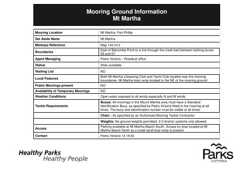
<strong>Mooring</strong> Ground <strong>Information</strong><br />
<strong>Mt</strong> <strong>Martha</strong><br />
<strong>Mooring</strong> Location<br />
Set Aside Name<br />
Melways Reference<br />
Boundaries<br />
Agent Managing<br />
Status<br />
Waiting List<br />
Local Features<br />
Public <strong>Mooring</strong>s present<br />
Availability of Temporary <strong>Mooring</strong>s<br />
Weather Conditions<br />
Tackle Requirements<br />
<strong>Mt</strong> <strong>Martha</strong>, Port Phillip<br />
<strong>Mt</strong> <strong>Martha</strong><br />
Map 144 H12<br />
East of Balcombe Point to a line through the creek bed between bathing boxes<br />
56 and 57.<br />
<strong>Parks</strong> <strong>Victoria</strong> – Rosebud office<br />
Sites available<br />
NO<br />
Both <strong>Mt</strong> <strong>Martha</strong> Lifesaving Club and Yacht Club located near the mooring<br />
boundaries. <strong>Mt</strong> <strong>Martha</strong> boat ramp located to the NE of the mooring ground<br />
NO<br />
NO<br />
Open water exposed to all winds especially N and W winds<br />
Buoys: All moorings in the Mount <strong>Martha</strong> area must have a Standard<br />
Identification Buoy, as specified by <strong>Parks</strong> <strong>Victoria</strong> fitted to the mooring at all<br />
times. The buoy and identification number must be visible at all times.<br />
Chain : As specified by an Authorised <strong>Mooring</strong> Tackle Contractor<br />
Access<br />
Contact <strong>Parks</strong> <strong>Victoria</strong> 13 19 63<br />
Weights: No ground weights permitted. 2-3 Anchor systems only allowed.<br />
Parking available at <strong>Mt</strong> <strong>Martha</strong> Beach South. Access by boat located at <strong>Mt</strong><br />
<strong>Martha</strong> Beach North as a small sand boat ramp is present.
(<br />
(<br />
BAY ROAD<br />
BAY ROAD<br />
DOMINION DOMINION DOMINION DOMINION DOMINION DOMINION DOMINION DOMINION DOMINION ROAD ROAD ROAD ROAD ROAD ROAD ROAD ROAD ROAD<br />
ESPLANADE<br />
ESPLANADE<br />
ESPLANADE<br />
ESPLANADE<br />
ESPLANADE<br />
ESPLANADE<br />
ESPLANADE<br />
ESPLANADE<br />
ESPLANADE<br />
Map Produced using <strong>Parks</strong> <strong>Victoria</strong>’s ParkView<br />
Mapping System<br />
Date Produced: 12 October 2011<br />
GEOCENTRIC DATUM OF AUSTRALIA – (GDA94)<br />
STATE DIGITAL MAPBASE USED WITH PERMISSION<br />
OF LAND VICTORIA,<br />
DEPARTMENT OF SUSTAINABILITY AND<br />
ENVIRONMENT.<br />
This map supercedes all previous editions.<br />
)<br />
0 0.10 0.20<br />
kilometers<br />
<strong>Mooring</strong> Ground <strong>Information</strong><br />
<strong>Mt</strong> <strong>Martha</strong>, Port Phillip


