Appendix 1 - Development Brief
Appendix 1 - Development Brief
Appendix 1 - Development Brief

Create successful ePaper yourself
Turn your PDF publications into a flip-book with our unique Google optimized e-Paper software.
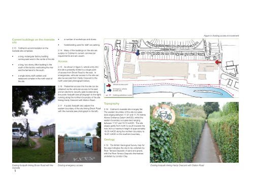
Figure 3: Existing access & movement<br />
Current buildings on the riverside<br />
site<br />
2.13 Cobham’s accommodation on the<br />
riverside site comprises:<br />
• a long, rectangular factory building<br />
running east-west in the centre of the site<br />
• a long, two storey office building to the<br />
south of the factory overlooking the river<br />
and the farmland to the south<br />
• a single storey staff canteen and<br />
restaurant complex in the north west of<br />
the site<br />
• a number of workshops and stores<br />
• hardstanding used for staff car parking.<br />
2.14 Many of the buildings on the site are<br />
surplus to Cobham’s current commercial<br />
requirements and are vacant.<br />
Access<br />
2.15 As shown in figure 3, vehicle entry into<br />
the site is presently limited to a single point<br />
of access from Brook Road to the east. In<br />
emergencies, vehicular access to the site can<br />
also be secured from Hardy Crescent to the<br />
north west (see photograph below).<br />
Hardy<br />
Crescent<br />
Churchill Road<br />
Brook Road<br />
2.16 Pedestrian access into the site can be<br />
obtained via the vehicular access to the east<br />
and an electronic security gate located along<br />
the public footpath (see photograph to the right)<br />
running along the northern boundary of the site<br />
linking Hardy Crescent with Station Road.<br />
2.17 A public footpath also adjoins the<br />
eastern boundary of the site linking Brook Road<br />
with the riverside (see photograph to the left).<br />
Topography<br />
Vehicle access point<br />
Emergency vehicle<br />
access only<br />
Existing pedestrian routes<br />
2.18 Cobham’s riverside site is largely flat.<br />
The western boundary of the site occupies<br />
land ranging between 17.37 and 17.76 metres<br />
Above Ordnance Datum (mAOD), whilst the<br />
eastern boundary occupies land ranging<br />
between 17.07 and 18.10 mAOD. The site<br />
slopes gently from north to south towards the<br />
river, from a maximum height of approximately<br />
18.00 mAOD along the northern boundary to<br />
16.97 mAOD on the southern boundary.<br />
Geology<br />
2.19 The British Geological Survey map for<br />
the area indicates the site to be underlain by<br />
River Terrace Deposits of sand and gravel,<br />
with the River Terrace Deposits themselves<br />
underlain by London Clay.<br />
Existing footpath linking Brook Road with the<br />
riverside<br />
5<br />
Existing emergency access<br />
Existing footpath linking Hardy Crescent with Station Road