Surface Water Management - Atkins
Surface Water Management - Atkins
Surface Water Management - Atkins

You also want an ePaper? Increase the reach of your titles
YUMPU automatically turns print PDFs into web optimized ePapers that Google loves.
Contact<br />
If you are interested in<br />
discussing any flooding<br />
related issues in more detail<br />
then please contact one of our<br />
experts based around the UK.<br />
North East<br />
paul.jenkins@atkinsglobal.com<br />
Tel: 01642 525200<br />
North West<br />
zorica.todorovic@atkinsglobal.com<br />
Tel: 01925 238561<br />
East Anglia / Midlands<br />
charlotte.nunns@atkinsglobal.com<br />
Tel: 01733 366993<br />
Wales<br />
gwion.kennard@atkinsglobal.com<br />
Tel: 02920 358026<br />
South East<br />
andy.taylor@atkinsglobal.com<br />
Tel: 01372 754377<br />
South West<br />
christi.brasher@atkinsglobal.com<br />
Tel: 01454 662293<br />
Woodcote Grove, Ashley Road,<br />
Epsom, Surrey KT18 5BW<br />
Tel: 01372 726140<br />
Fax: 01372 740055<br />
water@atkinsglobal.com<br />
www.atkinsglobal.com<br />
This publication is printed on Greencoat paper. It is produced<br />
from 80% recycled post-consumer fibre: 10% TCF (Totally<br />
Chlorine Free) virgin fibre, 10% ECF (Elemental Chlorine Free)<br />
fibre, FSC certification and NAPM recycled certification. The<br />
mill has obtained both ISO 9001 and ISO 14001 accreditations,<br />
which means all responsibilities to the local environment<br />
and manufacturing processes are strictly monitored.<br />
© <strong>Atkins</strong> Ltd except where stated otherwise.<br />
The <strong>Atkins</strong> logo, ‘Carbon Critical Design’ and the strapline<br />
‘Plan Design Enable’ are trademarks of <strong>Atkins</strong> Ltd.<br />
<strong>Surface</strong> <strong>Water</strong><br />
<strong>Management</strong>
Best <strong>Water</strong> and Wastewater Consultancy 2008 -<br />
Edie.net Consultancy Survey<br />
Why improve surface water management?<br />
Following the 2007 floods, the Environment Agency (EA) estimated<br />
that two-thirds of the 57,000 homes affected were flooded from<br />
surface water run off overloading drainage systems. The Government<br />
commissioned Sir Michael Pitt to conduct an independent review of the<br />
floods and the final Pitt Report was published in June 2008. Many of its<br />
recommendations have been translated into statutory duties in the draft<br />
Flood and <strong>Water</strong> <strong>Management</strong> Bill.<br />
The Bill highlights the need to improve surface water management and<br />
places Local Authorities with a central role in managing local flood risk.<br />
With the EA also given a new strategic role to manage all sources of<br />
flooding within England, it calls for improved co-ordination between<br />
stakeholders at the earliest opportunity to improve surface water<br />
management to avoid such events<br />
happening again.<br />
“<strong>Atkins</strong> has carried out valuable work for the Birmingham <strong>Water</strong> Group, lead by the Birmingham City Council with<br />
representatives from the Environment Agency and Severn Trent <strong>Water</strong>. The integrated modelling of Wood Brook<br />
has enabled the group to better appreciate how river, sewer and surface water flows interact in the catchment and<br />
to work together to consider the best approach to flood alleviation for the area.” Birmingham City Council<br />
How we can help<br />
<strong>Atkins</strong> has already worked with key stakeholders including Local<br />
Authorities, Environment Agency, highways agencies and water<br />
companies following the 2007 floods to improve flood risk management<br />
in urban and rural areas.<br />
We have the skills required to develop effective <strong>Surface</strong> <strong>Water</strong><br />
<strong>Management</strong> Plans and contribute to <strong>Water</strong> Cycle Studies, which draw on<br />
our extensive experience in surface water drainage, flood risk, sustainable<br />
drainage systems (SUDS), water quality, GIS database development and<br />
engineering design. From these core skills, our multi-disciplinary team can<br />
provide the holistic services required to achieve effective surface water<br />
management from strategy to implementation.<br />
Our services<br />
Stakeholder engagement<br />
To manage surface water and flood risk over large geographic areas<br />
involves co-ordination and partnership between stakeholders. Within<br />
all our projects <strong>Atkins</strong>’ ensures that everyone with an interest has an<br />
effective say in the development of proposals. We also work to gain<br />
their active support. Where appropriate, our teams exceed statutory<br />
requirements for consultation and create drop-in sessions, workshops<br />
and presentations to maximise engagement.<br />
Information exchange<br />
<strong>Atkins</strong> can undertake above and below ground asset surveys and<br />
translate complex data into easily accessible and useable maps<br />
and databases. We can also utilise our award winning Spatial Data<br />
Infrastructure (SDI). Used successfully for the Partnership for Urban South<br />
Hampshire, a consortium of 11 Local Authorities, the tool provided<br />
an easy to use web-based toolkit to share flood risk information to all<br />
stakeholders and residents. It has provided a useful decision support tool<br />
for planning officers when considering applications for development.<br />
Assessment of flood risk and prioritisation<br />
Our specialists can assess and define flood risk from specific<br />
sites for a new development or on a regional scale for local government.<br />
A greater understanding of the extent and frequencies of flood risk<br />
can be developed from the information we provide, helping to inform<br />
planning and development decisions. <strong>Atkins</strong> can also help avoid costly<br />
damage and disruption to critical infrastructure such as power stations<br />
and major roads by implementing protection measures.<br />
A current example of our work is a pilot study for the Welsh Assembly<br />
Government (WAG) where we are developing an urban flood risk<br />
management plan for Prestaytn that is aimed at spreading best<br />
practice across Wales. We have also been at the forefront of modelling<br />
techniques, and have undertaken groundbreaking integrated urban<br />
modelling for a diverse range of locations and clients.<br />
Solution identification<br />
In the past three years, <strong>Atkins</strong> has delivered schemes that have reduced<br />
flood risk to over 20,000 properties across England and Wales. Our<br />
experience encompasses both structural and non-structural flood<br />
alleviation schemes above and below the ground. These include the<br />
design and build of drainage systems, water retaining structures, flood<br />
embankments and walls as well as pumping stations. <strong>Atkins</strong> can also<br />
assist with the feasibility, design and site support of Sustainable Drainage<br />
Systems (SUDS). This is an increasingly viable alternative to traditional<br />
methods as it aligns with Government and Environment Agency<br />
guidelines and enhances the sustainability of any development.<br />
Emergency planning and civil protection<br />
<strong>Atkins</strong> can develop emergency plans to ensure the stakeholders affected<br />
will have procedures in place to manage flood incidents safely. Our<br />
recent experience includes developing and facilitating an emergency<br />
exercise for West Mercia Local Resilience Forum to test plans for response<br />
to flooding. ‘Exercise Extend’ was developed and delivered by <strong>Atkins</strong>’<br />
resilience specialists to over 100 delegates from the Local Authorities,<br />
emergency services, Department for Transport, Highways Agency, military,<br />
utility companies, British Red Cross, private sector businesses and other<br />
voluntary organisations.<br />
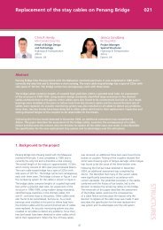
The image shows how hydraulic models can be brought vividly to life<br />
using technology similar to those developed by the film industry.<br />
Visualisations of the impact of flooding are a powerful way of raising<br />
awareness amongst the public and stakeholders about risks.