Current results from AIRS/AMSU/HSB
Current results from AIRS/AMSU/HSB
Current results from AIRS/AMSU/HSB

Create successful ePaper yourself
Turn your PDF publications into a flip-book with our unique Google optimized e-Paper software.
International TOVS Study Conference-XIII Proceedings<br />
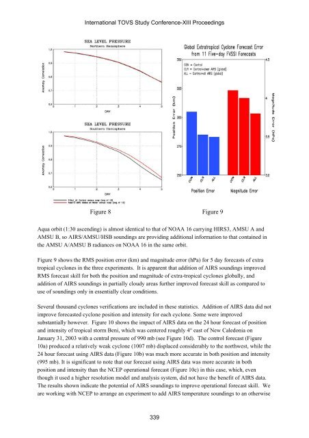
Figure 8 Figure 9<br />
Aqua orbit (1:30 ascending) is almost identical to that of NOAA 16 carrying HIRS3, <strong>AMSU</strong> A and<br />
<strong>AMSU</strong> B, so <strong>AIRS</strong>/<strong>AMSU</strong>/<strong>HSB</strong> soundings are providing additional information to that contained in<br />
the <strong>AMSU</strong> A/<strong>AMSU</strong> B radiances on NOAA 16 in the same orbit.<br />
Figure 9 shows the RMS position error (km) and magnitude error (hPa) for 5 day forecasts of extra<br />
tropical cyclones in the three experiments. It is apparent that addition of <strong>AIRS</strong> soundings improved<br />
RMS forecast skill for both the position and magnitude of extra-tropical cyclones globally, and<br />
addition of <strong>AIRS</strong> soundings in partially cloudy areas further improved forecast skill as compared to<br />
use of soundings only in essentially clear conditions.<br />
Several thousand cyclones verifications are included in these statistics. Addition of <strong>AIRS</strong> data did not<br />
improve forecasted cyclone position and intensity for each cyclone. Some were improved<br />
substantially however. Figure 10 shows the impact of <strong>AIRS</strong> data on the 24 hour forecast of position<br />
and intensity of tropical storm Beni, which was centered roughly 4° east of New Caledonia on<br />
January 31, 2003 with a central pressure of 990 mb (see Figure 10d). The control forecast (Figure<br />
10a) produced a relatively weak cyclone (1007 mb) displaced considerably to the northwest, while the<br />
24 hour forecast using <strong>AIRS</strong> data (Figure 10b) was much more accurate in both position and intensity<br />
(995 mb). It is significant to note that our forecast using <strong>AIRS</strong> data was more accurate in both<br />
position and intensity than the NCEP operational forecast (Figure 10c) in this case, which, even<br />
though it used a higher resolution model and analysis system, did not have the benefit of <strong>AIRS</strong> data.<br />
The <strong>results</strong> shown indicate the potential of <strong>AIRS</strong> soundings to improve operational forecast skill. We<br />
are working with NCEP to arrange an experiment to add <strong>AIRS</strong> temperature soundings to an otherwise<br />
339