Federally Administered Tribal Areas (FATA) - NDMA
Federally Administered Tribal Areas (FATA) - NDMA
Federally Administered Tribal Areas (FATA) - NDMA

You also want an ePaper? Increase the reach of your titles
YUMPU automatically turns print PDFs into web optimized ePapers that Google loves.
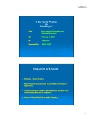
Climate<br />
<strong>FATA</strong> is situated on the edge of two major climatic systems, the Monsoon to the east and the<br />
Mediterranean towards the west. Most parts of <strong>FATA</strong> are arid and semi-arid, with warm<br />
summers and cold winters. Although some areas in the Kurrum and Orakzai agencies fall within<br />
the humid and sub-humid zone (Dichter,1967; Khan, 1991). The pattern of rainfall in summer<br />
and winter is diversified to such an extent that it is difficult to determine which is dominant.<br />
According to meteorological data, the area receives more winter precipitation as a result of<br />
western disturbances and some rain in the summer from the Monsoon. Annual rainfall in the<br />
area varies dramatically from 630 millimeters reported in Kurrum during 2001–02 to just 88<br />
millimeters in the neighboring Khyber Agency during the same year (GoKP, 2005a). However,<br />
the 2010 monsoon brought unprecedented climatic behavior which resulted in increase rainfall<br />
and flash floods in <strong>FATA</strong>. Moreover, the global warming and world hydrological imbalances are<br />
also researched to cause unexpected disasters in areas which never faced such disasters.<br />
River System of <strong>FATA</strong>:<br />
The Kurrum River flows north-west to south-east, entering North Waziristan below the town of<br />
Tal in the Hangu district of the Khyber Pukthoon khwa flowing into the Indus River. In Orakzai<br />
Agency, the Khanki and Mastura streams flow to the east to join the Bara River. The towns of<br />
Bara and Khajuri form a plain area from where the Bara River and its tributaries join the Kabul<br />
River near Peshawar district. To the north of the Kabul River stand the Mullagori and Shalman<br />
hills. The fertile Bara, Khanki, Kurram, Wana and Mastura valleys contain the most extensively<br />
cultivated land in <strong>FATA</strong>. These rivers have a large catchment area and shows complex<br />
watersheds and hydrological cycles, that require more research and actions.<br />
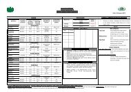
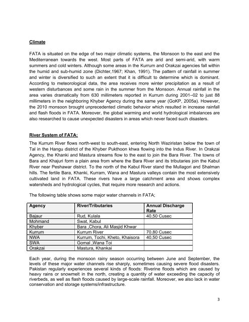
The following table shows some major water channels in <strong>FATA</strong>;<br />
Agency River/Tributaries Annual Discharge<br />
Rate<br />
Bajaur Rud, Kulala 40,50 Cusec<br />
Mohmand<br />
Swat, Kabul<br />
Khyber<br />
Bara ,Chora, Ali Masjid Khwar<br />
Kurrum Kurrum River 70,80 Cusec<br />
NWA Kurrum, Tochi, Kheto, Khaisora 40,50 Cusec<br />
SWA<br />
Gomal ,Wana Toi<br />
Orakzai<br />
Mastura, Khankai<br />
Each year, during the monsoon rainy season occurring between June and September, the<br />
levels of these major water channels rise sharply, sometimes causing severe flood disasters.<br />
Pakistan regularly experiences several kinds of floods: Riverine floods which are caused by<br />
heavy rains or snowmelt in the north, creating a quantity of water exceeding the capacity of<br />
riverbeds, as well as flash floods caused by large-scale rainfall. Moreover, we also lack in water<br />
conservation and storage systems/infrastructure.<br />
3