Awards of Excellence - ACEC|Manitoba
Awards of Excellence - ACEC|Manitoba
Awards of Excellence - ACEC|Manitoba

Create successful ePaper yourself
Turn your PDF publications into a flip-book with our unique Google optimized e-Paper software.
2012 <strong>Awards</strong> <strong>of</strong> <strong>Excellence</strong><br />
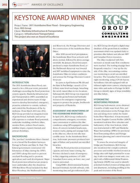
Keystone Award winner<br />
Project Name: 2011 Assiniboine River Flood – Emergency Engineering<br />
Firm: KGS Group<br />
Client: Manitoba Infrastructure & Transportation<br />
Category: Infrastructure/Transportation<br />
This project also won an Award <strong>of</strong> <strong>Excellence</strong><br />
Introduction<br />
The 2011 Assiniboine River Flood, estimated<br />
to be a 300-year event, presented<br />
challenges exceeding the flood protection<br />
system capacity. Manitoba Infrastructure<br />
and Transportation (MIT) assembled an<br />
experienced and diverse team <strong>of</strong> engineers<br />
to develop fast-tracked, emergency,<br />
proactive solutions to contain, redirect<br />
and control the floodwaters <strong>of</strong> the Assiniboine.<br />
From March 2011 into 2012,<br />
KGS Group provided an integrated team<br />
<strong>of</strong> geotechnical, hydraulic and survey/<br />
GIS expertise to evaluate flood potential,<br />
undertake modeling, reinforce dikes,<br />
monitor flows, redirect flood waters,<br />
stabilize slopes, expand channels and<br />
armour shorelines.<br />
BACKGROUND<br />
The ‘perched’ Assiniboine River channel<br />
is on a broad flat floodplain between<br />
Portage la Prairie and Baie St. Paul. The<br />
federal government constructed 134<br />
kilometres <strong>of</strong> dikes during the 1950’s<br />
and 1960’s along this reach to prevent<br />
overland flooding and to promote<br />
agriculture and rural development. Major<br />
flood protection infrastructure projects<br />
were undertaken after the disastrous<br />
1950 Red River Flood included the Red<br />
River Floodway, the Shellmouth Dam<br />
and Reservoir, the Portage Diversion and<br />
the construction <strong>of</strong> the Assiniboine River<br />
Dikes.<br />
After 2010 record level precipitation,<br />
the Assiniboine River froze at levels well<br />
above normal, followed by above-average<br />
snowfalls. By January, flood forecasters<br />
predicted a major Assiniboine flood, so<br />
the Shellmouth Reservoir was lowered<br />
and MIT mobilized equipment to raise the<br />
Assiniboine Dikes in winter conditions<br />
and armour the Portage Diversion Control<br />
Structure.<br />
Ice jams in April between PR 430 and<br />
the Baie St Paul Bridge, caused a 2.5 m<br />
(8 feet) water level surcharge, breaching<br />
the newly raised dikes in two locations.<br />
Subsequently, KGS Group was requested<br />
to provide geotechnical and hydraulic<br />
resources for emergency engineering<br />
support to protect the people, livelihoods<br />
and property <strong>of</strong> Manitoba.<br />
ASSESSMENT AND MONITORING OF<br />
THE ASSINIBOINE RIVER DIKES<br />
In April 2011, KGS Group conducted a<br />
comprehensive emergency reconnaissance<br />
assessment to address the dike<br />
conditions using GPS-equipped cameras.<br />
Areas <strong>of</strong> concern included headscarps,<br />
tension cracks, piping and seepage boils<br />
at the dike toe, <strong>of</strong>ten in wet silty inaccessible<br />
areas. As the Assiniboine River<br />
rose, hydrostatic pressures produced new<br />
signs <strong>of</strong> failure and potential uncontrolled<br />
breaches.<br />
With the flood protection at maximum<br />
capacity and more water coming, the<br />
Province declared a state <strong>of</strong> emergency<br />
in May, triggering assistance <strong>of</strong> 1,800<br />
Canadian Forces army, air force, navy and<br />
reserve personnel.<br />
Using ESRI’s (Environmental Systems<br />
Research Institute) ArcGIS s<strong>of</strong>tware, with<br />
monitoring data and geo-referenced pho-<br />
tos, KGS Group developed a digital map<br />
database <strong>of</strong> the geotechnical condition<br />
assessment which was updated daily to<br />
prioritize dike failures and allocate MIT<br />
and Canadian Forces resources.<br />
The dikes weakened with flow<br />
increases as steady state flow conditions<br />
were reached. The restling seepage lines<br />
frequently exited to ½ way up the dry<br />
side <strong>of</strong> the dike, necessitating continuous<br />
monitoring to avoid uncontrolled<br />
breaches. The Canadian Forces initiated<br />
night monitoring, using a CP-140 Aurora<br />
Surveillance Aircraft equipped with an<br />
infrared night-vision camera, relaying realtime<br />
video and audio to Portage for KGS<br />
Group to identify signs <strong>of</strong> slope instability<br />
and dike failure.<br />
HYDROMETRIC<br />
MONITORING PROGRAM<br />
KGS Group hydrometric crews obtained<br />
2 months <strong>of</strong> daily water level, flow, and<br />
velocity information at the Portage diversion<br />
and along rivers within the Assiniboine<br />
River Watershed. A boat-mounted<br />
Acoustic Doppler Current Pr<strong>of</strong>iler (ADCP)<br />
monitored real-time flow velocities and<br />
bathymetry <strong>of</strong> the river bottom, which<br />
was instrumental to MIT and Manitoba<br />
Water Stewardship (MWS) for provincial<br />
flood forecasting efforts and Portage<br />
Diversion planning and control structure<br />
operation.<br />
To assess the structural integrity <strong>of</strong><br />
bridge pier foundations, KGS Group<br />
also monitored the complex sediment<br />
processes and mobile riverbed erosion at<br />
bridge sites with high potential for scouring.<br />
A side-scan imagery sonar unit, coupled<br />
with a Differential Global Positioning<br />
System (DGPS) was used to identify<br />
potential riverbed erosion at bridge piers<br />
and abutments, including pr<strong>of</strong>iling at the<br />
peak and recession <strong>of</strong> the flood.<br />
page 22 | Manitoba Consulting Engineer<br />
Click Here to return to Table <strong>of</strong> Contents