Airport Liquefaction Susceptibility Analysis Report - ABAG ...
Airport Liquefaction Susceptibility Analysis Report - ABAG ...
Airport Liquefaction Susceptibility Analysis Report - ABAG ...

You also want an ePaper? Increase the reach of your titles
YUMPU automatically turns print PDFs into web optimized ePapers that Google loves.
Fugro Consultants, Inc.<br />
Project No. 04.79221200<br />
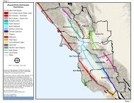
Another characteristic of the bay margin areas is the presence of artificial fill. Fill has a long<br />
history in and around San Francisco Bay; fill placement has been ongoing for more than a<br />
hundred years, and much of the emplaced fill is susceptible to liquefaction. All five of the<br />
airports studied are founded on Holocene alluvium, estuarine deposits, or on fill overlying these<br />
Holocene deposits, and liquefaction is a hazard that needs to be evaluated when assessing the<br />
integrity of the infrastructure at these important facilities.<br />
2.1 <strong>Liquefaction</strong> during the 1989 Loma Prieta Earthquake<br />
During the 1989 Loma Prieta earthquake, soil liquefaction at Oakland International <strong>Airport</strong><br />
caused considerable damage to the 3,000 meter-long main jet runway, located along the<br />
southwest edge of the airport. This runway was built entirely on fill in the early 1960s. Sand<br />
boils, settlement, and lateral spreads were documented within wide areas of airport fill to the<br />
north, south, and east of the damaged runway section (Holzer, 1998; Figures 2A and 2B).<br />
Extensive soil liquefaction was documented within the western section of the airport fill, where<br />
sand boils and cracks were observed and approximately the northwestern 900 meters of the<br />
runway was damaged (Figure 2A). In addition, the adjacent taxiway pavement sustained heavy<br />
damage, with cracks as wide as 30 centimeters and vertical displacement up to 15 centimeters<br />
(Figure 2B, photo A). The perimeter dikes at the west end of the runway experienced settlement<br />
and lateral spreading of approximately 0.5 to 0.7 meters (Holzer, 1998).<br />
<strong>Liquefaction</strong> damage was also documented in other locations on the airport property. Sand boils<br />
and large fissures caused by lateral spreading damaged an undeveloped area of fill to the north<br />
and northeast of the main runway. <strong>Liquefaction</strong> and settlements of as much as 8 cm were<br />
observed in several locations near the main terminal buildings, which are supported on deeper<br />
foundations and were not significantly damaged. In addition, a below-ground tramway, which<br />
allows service vehicles carrying passengers' luggage to pass under part of one of the main<br />
terminal buildings, was filled with sand and water released from the subsurface (Figure 2B,<br />
photo B) (Holzer, 1998).<br />
2.2 Fill Emplacement around San Francisco Bay<br />
The historical placement of fill into and on the margins of San Francisco Bay began in the 1850s<br />
and accelerated through the mid-1900s as urbanization encroached on the Bay (Hitchcock et<br />
al., 2008). By 1970, the rapid filling of the Bay and its tidal marshes had virtually halted after the<br />
1969 implementation of the San Francisco Bay Plan (SFBCDC, 1969), which included<br />
restrictions on Bay margin development and requirements that fill be engineered.<br />
Four of the five airports evaluated in this report were partly or wholly constructed prior to 1965<br />
on fill over estuarine deposits of the tidal marsh, tidal flats, or bay mud. Fill materials and<br />
emplacement methods evolved over the decades, resulting in a mosaic of fill types present<br />
within the Bay area today. Emplacement methods included 1) scooping of tidal marsh<br />
3<br />
May 31, 2013