Airport Liquefaction Susceptibility Analysis Report - ABAG ...
Airport Liquefaction Susceptibility Analysis Report - ABAG ...
Airport Liquefaction Susceptibility Analysis Report - ABAG ...

Create successful ePaper yourself
Turn your PDF publications into a flip-book with our unique Google optimized e-Paper software.
Fugro Consultants, Inc.<br />
Project No. 04.79221200<br />
placed directly on young Bay mud and Holocene fluvial deposits around the bay margins. A<br />
variety of techniques were used to place and compact the fills, including emplacement of fill via<br />
large-scale hydraulic pumping (pumping or sluicing of water sand and silt slurry, typically<br />
dredged from the bay). Sandy and silty hydraulic fills along the bay margins are particularly<br />
susceptible to liquefaction. Much of the hydraulic fill was placed prior to 1965, before the effects<br />
of strong ground motions on non-engineered fill were well understood. Since 1969, engineering<br />
design and review of proposed Bay fills has been required (Hitchcock and others, 2008).<br />
In the following sections, we describe the geologic setting and present a geologic model for<br />
each site based on subsurface information, regional geologic and geomorphic maps, historical<br />
aerial photography, and maps of fill placement through time. The geologic units found at each<br />
airport are described in detail in Appendix A.<br />
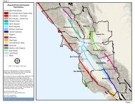
4.1 San Francisco International <strong>Airport</strong> (SFO)<br />
San Francisco International <strong>Airport</strong> is located on the west shore of the San Francisco Bay in<br />
northern San Mateo County. The airport is built entirely on artificial fill overlying estuarine<br />
deposits (Figure 3A). Maps of the historical extent of bay environments based on 1800s US<br />
Coast Survey mapping, show that the airport property encompasses former tidal marsh, tidal<br />
flat, shell flat, and shallow bay environments (Figure 3B; SFEI, 2000). The estuarine deposits<br />
are collectively referred to as Bay Mud on Figure 3A and Young Bay Mud (YBM) on Figure 3C.<br />
Borehole and CPT data show that the stratigraphy underlying San Francisco International<br />
<strong>Airport</strong> generally consists of artificial fill, underlain Young Bay Mud (YBM) alluvium, Old Bay<br />
Mud (OBM), and Pleistocene alluvium (Figure 3C). These sediments are underlain at depth by<br />
Franciscan Complex bedrock.<br />
Development of the SFO property began with the construction of a perimeter levee around the<br />
tidal marsh lands in 1880 (Figure 3D, photo A). The construction of the first airfield in 1927<br />
involved the import and placement of fill inboard of the levee (URS, 2006). By 1938 the fill had<br />
extended beyond the original perimeter to add new runways (Figure 3D, photo B). Later<br />
expansions of the airport involved subsequent episodes of fill placement on at least ten different<br />
occasions (URS, 2006). WLA (1999) identified three distinct units (Fills A, B, and C) at SFO:<br />
• Fill A: lean clay with fine gravel and fine to medium sand<br />
• Fill B: loose to medium dense, poorly graded sand with minor clay and silt<br />
• Fill C: brown to gray to black, granular, poorly graded gravel with rounded to subangular<br />
fine to coarse gravel and minor clay and sand<br />
The borehole data reviewed by WLA (1999) indicate that artificial fill at the airport ranges from 5<br />
to 25 feet in thickness, with an average thickness throughout most of the site of 10 to 15 feet.<br />
The thickest sections of fill are located along the northern, eastern, and southern margins of the<br />
airport (WLA, 1999; URS, 2006; Figure 3C).<br />
9<br />
May 31, 2013