Airport Liquefaction Susceptibility Analysis Report - ABAG ...
Airport Liquefaction Susceptibility Analysis Report - ABAG ...
Airport Liquefaction Susceptibility Analysis Report - ABAG ...

You also want an ePaper? Increase the reach of your titles
YUMPU automatically turns print PDFs into web optimized ePapers that Google loves.
Fugro Consultants, Inc.<br />
Project No. 04.79221200<br />
The liquefaction analyses performed generally calculated the highest settlement values along<br />
the perimeter levees and dike along the western edge of the property. The levees and dike are<br />
primarily composed of two distinct fill units: medium stiff Bay Mud fill, approximately 10 to 20<br />
feet thick between stations 0+00 to 168+00; and loose to medium dense sand and gravel<br />
approximately15 to 30 feet between stations 168+00 to 250+00 (URS, 2011; Figure 4A). The<br />
foundation materials underlying the levees and dikes are composed of soft to medium stiff silty<br />
clay (likely to be Young Bay Mud) along most of the alignment, with the exception of the<br />
northern end of the alignment, where it is underlain by predominantly clayey sand and silty<br />
sand. Of the levee and dike fill materials, the sand and gravel fill was calculated to be liquefiable<br />
in all 5 scenarios while the Bay Mud fill yielded varying results.<br />
In addition to the levee and dike fill, coarse grained layers within the Young Bay Mud and the<br />
Merritt Sand were found to be liquefiable. Along the western portion of the property, the Merritt<br />
Sand is located approximately 10 to 40 feet below ground surface. Along the eastern and<br />
northern portions of the property, the borings suggest the presence of Merritt Sand, however the<br />
deepest boring analyzed (36.5 feet below ground surface) does not fully penetrate through the<br />
sand, leaving the thickness of the Merrit Sand in this portion of the property unknown. It is also<br />
unclear what the nature, extent, and thickness of the Merritt Sand is below the main airport<br />
terminals, where no subsurface data was evaluated.<br />
6.1.3 Buchanan Field <strong>Airport</strong><br />
The liquefaction analyses performed for each of the five scenarios results in a calculated<br />
settlement of between 1 and 4 inches (Table 3). The analyses used data available from 62<br />
borings. Of the borings analyzed, only 10 were deeper than 30 feet and 31 were drilled to a total<br />
depth of less than 10 feet (Table 2). The borings analyzed were concentrated within the<br />
northern half of the property and outside of the property along the western property boundary.<br />
No subsurface data was available for the southern half of the property.<br />
Borehole data indicates that the surficial deposits at the airport are primarily composed of<br />
artificial fill (subdivided into four distinct units; Fills A, B, C, and D), underlain by estuarine mud<br />
in the northern portion of the property, and Holocene medial and distal alluvial fans deposits in<br />
the southern portion of the property. Due to the sparse data available below 30 feet and<br />
absence of subsurface borehole data for the southern half of the property, the nature and extent<br />
of the contact between the estuarine mud and Holocene alluvial fan deposits is poorly<br />
constrained.<br />
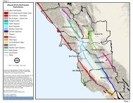
Based on geologic and geomorphic mapping, Witter and others (2006) characterize Quaternary<br />
deposits at Buchanan as having a moderate susceptibility to liquefaction, with a small cluster of<br />
deposits at the north end having a very high susceptibility to liquefaction. These deposits likely<br />
correspond to areas of mapped artificial fill over estuarine mud deposits. Given the relative<br />
ages, densities, and textures of these deposits, Fill A (aggregate baserock composed of sandy<br />
gravel with minor amounts of fill), Fill B (well graded sand with varying amounts of gravel), Fill C<br />
25<br />
May 31, 2013