
Create successful ePaper yourself
Turn your PDF publications into a flip-book with our unique Google optimized e-Paper software.
1<br />
2<br />
5<br />
5<br />
River<br />
0<br />
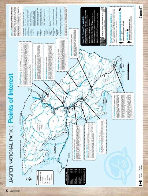
JASPER NATIONAL PARK Points of Interest<br />
Rock<br />
River<br />
Widhay<br />
Rock<br />
Lake<br />
Blue<br />
Creek<br />
Creek<br />
Resthaven<br />
Icefield<br />
Azure<br />
Lake<br />
Smoky<br />
Chown<br />
Glacier<br />
Twintree<br />
Lake<br />
Topaz<br />
Lake<br />
Indian<br />
Snake<br />
Brûlé<br />
Lake<br />
Moosehorn<br />
Calumet<br />
Glaciers<br />
Swoda<br />
Snake Indian Falls<br />
Creek<br />
River<br />
River<br />
Fiddle River<br />
River<br />
Snaring<br />
Robson<br />
Calumet<br />
Peak<br />
Robson<br />
Glaciers<br />
Snake<br />
Indian<br />
Upright<br />
Snaring<br />
Talbot<br />
Lake<br />
Rocky<br />
River<br />
Miette<br />
Pyramid<br />
Lake<br />
Jacques<br />
Lake<br />
River<br />
Maligne<br />
Beaver<br />
Lake<br />
Mystery<br />
Lake<br />
Moose River<br />
to Prince George<br />
and Prince Rupert<br />
WILLMORE WILDERNESS PARK<br />
Bridgland<br />
to Grande Cache and<br />
Willmore Wilderness Park<br />
Moose Lake<br />
Yellowhead<br />
Lake<br />
Fraser River<br />
to Valemount<br />
and Kamloops<br />
MT. ROBSON<br />
PROVINCIAL PARK<br />
16<br />
JASPER<br />
NATIONAL<br />
PARK<br />
Medicine<br />
Medicine<br />
Lake<br />
Five<br />
Lakes<br />
Tent<br />
River<br />
River<br />
ATH<br />
ABASCA<br />
River<br />
Amethyst<br />
Lake<br />
Pyramid<br />
Roche Ronde<br />
Celestine<br />
Lake<br />
<strong>Jasper</strong><br />
Lake<br />
Cairn<br />
Astoria<br />
The<br />
Ramparts<br />
JASPER<br />
Whistlers<br />
93<br />
40<br />
The Ancient Wall<br />
Chown<br />
Whitehorn<br />
Emperor Falls<br />
Kinney Lake<br />
Berg<br />
Lake<br />
Overlander<br />
Falls<br />
Lynx<br />
Reef<br />
Icefield<br />
River<br />
Cavell Lake<br />
Mt. Edith Cavell<br />
Moab<br />
Edith Lake<br />
Cavell<br />
Roche<br />
Miette<br />
Roche Bonhomme<br />
Maligne Canyon<br />
Tekarra<br />
Pocahontas<br />
Wabasso Lake<br />
93a<br />
16<br />
Miette<br />
Hotsprings<br />
Utopia<br />
Hardisty<br />
Horseshoe<br />
Lake<br />
Maligne Lake<br />
Maligne<br />
Lake<br />
Samson<br />
Peak<br />
Southesk<br />
Lake<br />
Southesk<br />
Kerkeslin<br />
Roche<br />
Perdrix<br />
to Hinton<br />
and<br />
Edmonton<br />
Alberta<br />
British Columbia<br />
LEGEND<br />
? Information Centre<br />
Camping<br />
Hostel<br />
Park Station<br />
Glacier<br />
Mountain peak<br />
Robson River<br />
Continental Divide<br />
Miette<br />
Fitzwilliam<br />
Yellowhead<br />
River<br />
DISTANCES<br />
Pass<br />
16<br />
River<br />
River<br />
Sunwapta<br />
Whirlpool<br />
Brazeau<br />
Poboktan<br />
River<br />
RIVER<br />
Brazeau<br />
Lake<br />
Creek<br />
JonasCreek<br />
Geraldine<br />
Lakes<br />
Fryatt<br />
Buck<br />
Lake<br />
Christie Sunwapta<br />
Falls<br />
Brussels Sunwapta<br />
Peak Falls<br />
Fortress Lake<br />
HAMBER<br />
PROVINCIAL<br />
PARK<br />
Clemenceau Icefield<br />
Gong<br />
Lake<br />
Gong<br />
Nelson<br />
GEC<br />
Chaba<br />
River<br />
Alberta<br />
Helmet<br />
Meadow Creek<br />
<strong>Jasper</strong> Townsite to…<br />
BANFF<br />
CALGARY<br />
EDMONTON<br />
HINTON<br />
LAKE LOUISE<br />
MOUNT ROBSON<br />
PRINCE GEORGE<br />
PRINCE RUPERT<br />
VANCOUVER<br />
…VIA ROGERS PASS<br />
…VIA COQUIHALLA HWY<br />
…VIA TRANS CANADA HWY<br />
MI<br />
178<br />
256<br />
234<br />
50<br />
143<br />
57<br />
230<br />
697<br />
680<br />
523<br />
540<br />
KM<br />
281<br />
404<br />
370<br />
79<br />
226<br />
88<br />
363<br />
1101<br />
1074<br />
805<br />
853<br />
? Viewpoint<br />
Parkway 93A (7 km From <strong>Jasper</strong>)<br />
An alternate route between <strong>Jasper</strong> townsite and Athabasca Falls,<br />
following the old highway. Several scenic picnic areas with names like<br />
Otto’s Cache and Meeting of the Waters are found along the way. The<br />
Mt. Edith Cavell road begins at km 2.5. Wabasso Campground is<br />
located at km 4.5. Access the Moab Lake fire road at km 10.<br />
Geikie<br />
Roche<br />
Noire<br />
Lac<br />
Beauvert<br />
Athabasca Falls<br />
Medicine Lake<br />
Surprise<br />
Lake<br />
Unwin<br />
Charlton<br />
Maligne<br />
Isaac Lake<br />
Woolley<br />
Monkhead<br />
Brazeau<br />
Balinhard<br />
Sunwapta<br />
Brazeau<br />
Icefield<br />
Poboktan<br />
Marble<br />
9 10<br />
Stutfield<br />
Apex Kitchener<br />
Icefield Centre<br />
The Twins<br />
Chaba<br />
Snowdome Athabasca<br />
Glacier Athabasca<br />
Andromeda<br />
Columbia<br />
to Lake<br />
BANFF Louise<br />
NATIONAL and Banff<br />
PARK<br />
Olympus<br />
Dalhousie<br />
Maligne<br />
River<br />
Mount Edith Cavell (29 km from <strong>Jasper</strong>)<br />
Edith Cavell was a heroine of World War I. A switchback road (no vehicles<br />
>7m) climbs 14.5 km to a picnic area under the mountain’s spectacular<br />
north face. Excellent views of the Angel Glacier and a self-guiding trail. A<br />
busy place with limited parking, try to visit before 10 am or after 3 pm.<br />
Road is open June 25 to October 15 (snow dependent).<br />
Beacon<br />
Lake<br />
Endless Chain<br />
Athabasca Falls (30 km from <strong>Jasper</strong>)<br />
The Athabasca River pours into a narrow canyon cut in a very hard,<br />
quartz-rich rock. A thundering spectacle with a bridge and platforms<br />
at the better vantage points. Picnicking. Junction with parkway 93A.<br />
Moberly<br />
Homestead<br />
Hooker Icefield<br />
Athabasca<br />
Pass<br />
Hooker<br />
3 4<br />
93<br />
Tangle Ridge<br />
?<br />
Sunwapta Pass<br />
Columbia Icefield<br />
Icefield Centre (103 km from <strong>Jasper</strong>)<br />
The Columbia Icefield: visual high point of the<br />
Icefields Parkway. An access road takes you to<br />
an interpretive trail leading to the toe of the<br />
Athabasca Glacier.<br />
For your own safety, do not walk on the glacier<br />
without proper equipment and a knowledgeable<br />
guide. The Icefield Centre combines all services<br />
under one roof along with impressive views of<br />
numerous glaciers and surrounding peaks.<br />
Parks Canada offers trail and visitor information<br />
and impressive interpretive exhibits. Commercial<br />
services include “Ice Explorer” rides on the<br />
Athabasca Glacier, a hotel, a cafeteria and a gift<br />
shop. Open May to October.<br />
Miette Hotsprings (61 km from <strong>Jasper</strong>)<br />
A winding mountain road leads you up the scenic Fiddle Valley to the hottest mineral<br />
springs in the Canadian Rockies! Along the way, stop at the Pocahontas Interpretive<br />
Trail just off Highway 16 on the Miette Road to learn about the history of coal mining in<br />
the area. Pocahontas Campground is 3 km up the road. Farther along, look for a<br />
viewpoint facing the impressive limestone slabs of Ashlar Ridge. Facilities at the springs<br />
include: Parks Canada soaking pools, a cool pool, a food concession, an interpretive<br />
trail, a picnic area, some outstanding day hikes and a privately-owned motel. Road and<br />
facilities are open mid-May to mid-October.<br />
Maligne Canyon (11.5 km from <strong>Jasper</strong>)<br />
The Maligne River plunges 23 m into a steep-walled gorge of limestone<br />
bedrock. A self-guiding trail takes you over six different footbridges,<br />
providing spectacular views of the canyon en route. A privately owned<br />
teahouse is located adjacent to the parking area.<br />
Medicine Lake (27 km from <strong>Jasper</strong>)<br />
A most peculiar lake. The Maligne River flows in but there is no surface<br />
outlet. Instead, the water flows underground for many kilometres,<br />
emerging in such places as Maligne Canyon and Lac Beauvert. Look for<br />
an interpretive plaque describing this phenomenon at the first<br />
lakeshore viewpoint on your way up the Maligne Valley.<br />
5 10 15<br />
Kilometers<br />
Miles<br />
0 5 10<br />
Maligne Lake (48 km from <strong>Jasper</strong>)<br />
Maligne Lake is the largest lake in <strong>Jasper</strong> National Park (22 km<br />
long) and the deepest (97 m). Renowned for its scenery and its<br />
fishing, the area also offers exceptional hiking opportunities. A<br />
concession provides cruises on the lake, rowboat rentals, fish<br />
guiding and restaurant service. Day use area only; no overnight<br />
accommodation, gas or camping.<br />
Sunwapta Falls (55 km from <strong>Jasper</strong>)<br />
A short access road next to the motel takes you to the<br />
parking area. The falls tumble into a limestone gorge<br />
rather like Maligne Canyon. Motel and restaurant are<br />
open May to October.<br />
CAMPING is limited to designated campgrounds.<br />
Camping is available either through advance reservations<br />
(pccamping.ca or 1-877-737-3783) or on a first-come<br />
first-served basis. Camping fees vary with services<br />
provided. Consult The Mountain <strong>Guide</strong> for a current listing<br />
of fees and services. If a campground is full, park staff will<br />
direct you to other locations. Enjoy your stay!<br />
CAMPGROUND CAPACITY AND FACILITIES<br />
1. POCAHONTAS 130 sites & 10 walk-in tent sites, flush<br />
44 km toilets, hot and cold running water<br />
2. SNARING RIVER 56 sites & 10 walk-in tent sites,<br />
16 km kitchen shelters, dry toilets<br />
3. WHISTLERS 781 sites, kitchen shelters, flush<br />
3 km toilets, trailer sewage disposal,<br />
hook-ups, showers, wheelchair<br />
accessible washrooms & showers<br />
4. WAPITI 366 sites, kitchen shelters, flush toilets,<br />
3.8 km showers, electrical hook-ups<br />
6<br />
7<br />
8<br />
5. WABASSO 232 sites, flush toilets, hot and cold<br />
16 km running water, trailer sewage disposal,<br />
electrical hook-ups<br />
6. MOUNT 42 sites, kitchen shelter, dry toilets<br />
KERKESLIN<br />
36 km<br />
7. HONEYMOON 35 sites, kitchen shelters, dry toilets,<br />
LAKE swimming<br />
52 km<br />
8. JONAS CREEK 26 sites, kitchen shelter, dry toilets<br />
77 km<br />
9. COLUMBIA 33 tent sites, kitchen shelters, dry toilets<br />
ICEFIELD<br />
109 km<br />
10. WILCOX CREEK 46 sites, kitchen shelters, dry toilets,<br />
111 km trailer sewage disposal<br />
Most campgrounds open mid-May to early September; limited facilities<br />
for off-season winter camping available during the rest of the year.<br />
How To Drive For Wildlife<br />
Park roadways intersect important travel corridors<br />
for wildlife. You can help prevent road kills.<br />
Stay alert and scan the road ahead.<br />
Look for shining eyes at night.<br />
When you see one animal, watch for others.<br />
Obey posted speed limits. They usually indicate<br />
animal crossing areas.<br />
Pay special attention during dawn and dusk.<br />
Always keep your distance<br />
Any wild animal can be dangerous if you get too close.<br />
Do not approach or entice wildlife. Use binoculars or a<br />
telephoto lens instead. Stay at least:<br />
100 metres (10 bus lengths) away from<br />
BEARS, COUGARS and WOLVES<br />
30 metres (3 bus lengths) away from<br />
ELK, DEER, SHEEP, GOATS and MOOSE<br />
30 <strong>Jasper</strong>.travel