Final SHLAA Report (December 2009) - The Royal Borough of ...
Final SHLAA Report (December 2009) - The Royal Borough of ...
Final SHLAA Report (December 2009) - The Royal Borough of ...

You also want an ePaper? Increase the reach of your titles
YUMPU automatically turns print PDFs into web optimized ePapers that Google loves.
<strong>Final</strong> <strong>SHLAA</strong> <strong>Report</strong> (<strong>December</strong> <strong>2009</strong>)<br />
5<br />
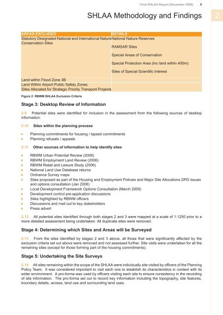
<strong>SHLAA</strong> Methodology and Findings 2<br />
AREAS EXCLUDED<br />
DETAILS<br />
Statutory Designated National and International NatureNational Nature Reserves<br />
Conservation Sites<br />
RAMSAR Sites<br />
Land within Flood Zone 3B<br />
Land Within Airport Public Safety Zones<br />
Sites Allocated for Strategic Priority Transport Projects<br />
Figure 2: RBWM <strong>SHLAA</strong> Exclusion Criteria<br />
Stage 3: Desktop Review <strong>of</strong> Information<br />
Special Areas <strong>of</strong> Conservation<br />
Special Protection Area (Inc land within 400m)<br />
Sites <strong>of</strong> Special Scientific Interest<br />
2.9 Potential sites were identified for inclusion in the assessment from the following sources <strong>of</strong> desktop<br />
information:<br />
2.10 Sites within the planning process<br />
Planning commitments for housing / lapsed commitments<br />
Planning refusals / appeals<br />
2.11 Other sources <strong>of</strong> information to help identify sites<br />
RBWM Urban Potential Review (2006)<br />
RBWM Employment Land Review (2006)<br />
RBWM Retail and Leisure Study (2006)<br />
National Land Use Database returns<br />
Ordnance Survey maps<br />
Sites proposed as part <strong>of</strong> the Housing and Employment Policies and Major Site Allocations DPD issues<br />
and options consultation (Jan 2006)<br />
Local Development Framework Options Consultation (March <strong>2009</strong>)<br />
Development control pre-application discussions<br />
Sites highlighted by RBWM <strong>of</strong>ficers<br />
Discussions and mail out to key stakeholders<br />
Press advert<br />
2.12 All potential sites identified through both stages 2 and 3 were mapped at a scale <strong>of</strong> 1:1250 prior to a<br />
more detailed assessment being undertaken. All duplicate sites were removed.<br />
Stage 4: Determining which Sites and Areas will be Surveyed<br />
2.13 From the sites identified by stages 2 and 3 above, all those that were significantly affected by the<br />
exclusion criteria set out above were removed and not assessed further. Site visits were undertaken for all the<br />
remaining sites (except for those forming part <strong>of</strong> the housing commitments).<br />
Stage 5: Undertaking the Site Surveys<br />
2.14 All sites remaining within the scope <strong>of</strong> the <strong>SHLAA</strong> were individually site visited by <strong>of</strong>ficers <strong>of</strong> the Planning<br />
Policy Team. It was considered important to visit each one to establish its characteristics in context with its<br />
wider environment. A pro-forma was used by <strong>of</strong>ficers visiting each site to ensure consistency in the recording<br />
<strong>of</strong> site information. <strong>The</strong> pro-forma set out to record key information including the topography, site features,<br />
boundary details, access, land use and surrounding land uses.