Download - National Environmental Services Center - West Virginia ...
Download - National Environmental Services Center - West Virginia ...
Download - National Environmental Services Center - West Virginia ...

You also want an ePaper? Increase the reach of your titles
YUMPU automatically turns print PDFs into web optimized ePapers that Google loves.
N E W S & N O T E S<br />
EMS Resource <strong>Center</strong>s Available to<br />
Assist Local Governments<br />
The U.S. <strong>Environmental</strong> Protection Agency<br />
(EPA) has designated seven organizations<br />
around the country to become environmental<br />
management systems (EMS) local resource<br />
centers. These centers will help local agencies<br />
adopt EMSs to improve their overall environmental<br />
performance and compliance and meet<br />
environmental goals. The announcement supports<br />
EPA’s overall policy of actively promoting<br />
adoption of EMSs that help improve environmental<br />
performance and compliance.<br />
EMSs, used extensively in private industry,<br />
are now being adopted by a growing number<br />
of local governments, through work led by the<br />
Office of Water in collaboration with other EPA<br />
offices. EMSs provide organizations with a<br />
structured process for identifying and then reducing<br />
a broad range of environmental impacts<br />
from their operations and meeting key<br />
environmental goals. The designated EMS local<br />
resource centers are located in existing academic<br />
or other nonprofit institutions that have<br />
a proven track record of providing high quality<br />
environmental assistance in their respective<br />
areas. The organizations selected as EMS resource<br />
centers include the following:<br />
• Georgia Institute of Technology—Economic<br />
Development Institute; Contact: Tim Israel,<br />
(404) 894-0968, tim.israel@edi.gatech.edu.<br />
• Purdue University – <strong>Center</strong> for Clean Manufacturing<br />
Technology and Safe Materials<br />
(CMTI); Contact: Lynn Corson, (765) 463-<br />
4749, corson@purdue.edu.<br />
• Texas Commission on <strong>Environmental</strong> Quality;<br />
Contact: Ken Zarker, (512) 239-3145,<br />
kzarker@tceq.state.tx.us.<br />
• University of Florida—<strong>Center</strong> for Training,<br />
Research, and Education for <strong>Environmental</strong><br />
Occupations (TREEO); Contact: William<br />
Engel, (352) 392-9570 bengel@treeo.doce.<br />
ufl.edu.<br />
• University of Massachusetts at Lowell—EMS<br />
Service Program; Contact: Matthew Donahue,<br />
(978) 934-4741, matthew_donahue@uml.edu.<br />
• <strong>Virginia</strong> Polytechnic Institute & State University—<strong>Center</strong><br />
for Organizational and Technological<br />
Advancement (COTA); Contact:<br />
Robert Herbert, (540) 853-8276, bherbert@vt.edu.<br />
• The Zero Waste Alliance in Portland, Oregon;<br />
Contact: Larry Chalfan, (503) 279-<br />
9383, lchalfan@zerowaste.org.<br />
EPA will work with the centers to help them<br />
better serve the needs of local and state agencies<br />
that wish to learn more about EMSs and adopt<br />
them for their operations. Each center will also<br />
share information on their activities through an<br />
online national clearinghouse of EMS information<br />
for public agencies, available at www.peercenter.net.<br />
Additional information about the<br />
local resource centers can be found at<br />
www.peercenter.net/resourcecenters/.<br />
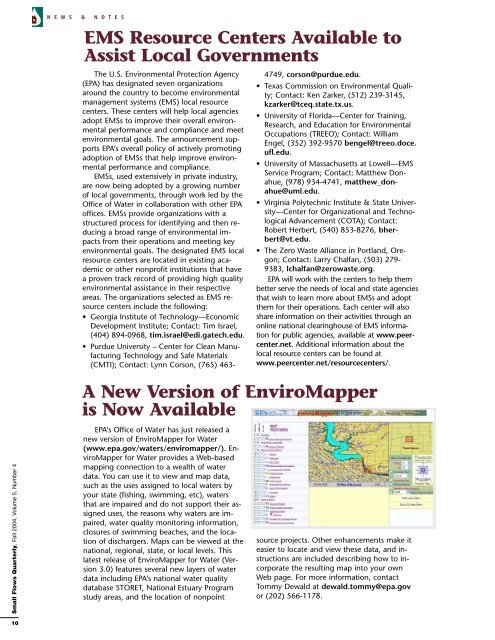
A New Version of EnviroMapper<br />
is Now Available<br />
Small Flows Quarterly, Fall 2004, Volume 5, Number 4<br />
EPA’s Office of Water has just released a<br />
new version of EnviroMapper for Water<br />
(www.epa.gov/waters/enviromapper/). EnviroMapper<br />
for Water provides a Web-based<br />
mapping connection to a wealth of water<br />
data. You can use it to view and map data,<br />
such as the uses assigned to local waters by<br />
your state (fishing, swimming, etc), waters<br />
that are impaired and do not support their assigned<br />
uses, the reasons why waters are impaired,<br />
water quality monitoring information,<br />
closures of swimming beaches, and the location<br />
of dischargers. Maps can be viewed at the<br />
national, regional, state, or local levels. This<br />
latest release of EnviroMapper for Water (Version<br />
3.0) features several new layers of water<br />
data including EPA’s national water quality<br />
database STORET, <strong>National</strong> Estuary Program<br />
study areas, and the location of nonpoint<br />
source projects. Other enhancements make it<br />
easier to locate and view these data, and instructions<br />
are included describing how to incorporate<br />
the resulting map into your own<br />
Web page. For more information, contact<br />
Tommy Dewald at dewald.tommy@epa.gov<br />
or (202) 566-1178.<br />
10