Roxeth Hill Appraisal 1st Draft , item 42. PDF 5 MB - Harrow Council
Roxeth Hill Appraisal 1st Draft , item 42. PDF 5 MB - Harrow Council
Roxeth Hill Appraisal 1st Draft , item 42. PDF 5 MB - Harrow Council

Create successful ePaper yourself
Turn your PDF publications into a flip-book with our unique Google optimized e-Paper software.
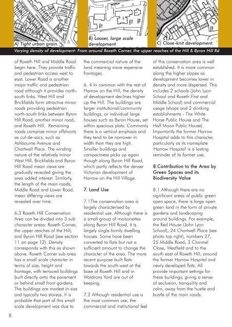
A) Tight urban grain.<br />
B) Looser, large scale<br />
development.<br />
C) Close-knit development.<br />
Varying density of development: From around <strong>Roxeth</strong> Corner, the upper reaches of the <strong>Hill</strong> & Byron <strong>Hill</strong> Rd<br />
of <strong>Roxeth</strong> <strong>Hill</strong> and Middle Road<br />
begin here. They provide traffic<br />
and pedestrian access west to<br />
east. Lower Road is another<br />
major traffic and pedestrian<br />
road although it provides northsouth<br />
links. West <strong>Hill</strong> and<br />
Brickfields form attractive minor<br />
roads providing pedestrian<br />
north-south links between Byron<br />
<strong>Hill</strong> Road, another minor road,<br />
and <strong>Roxeth</strong> <strong>Hill</strong>. Remaining<br />
roads comprise minor offshoots<br />
as cul-de-sacs, such as<br />
Ashbourne Avenue and<br />
Chartwell Place. The winding<br />
nature of the relatively minor<br />
West <strong>Hill</strong>, Brickfields and Byron<br />
<strong>Hill</strong> Road mean views are<br />
gradually revealed giving the<br />
area added interest. Similarly,<br />
the length of the main roads,<br />
Middle Road and Lower Road,<br />
mean differing views are<br />
revealed over time.<br />
6.3 <strong>Roxeth</strong> <strong>Hill</strong> Conservation<br />
Area can be divided into 3 sub<br />
character areas: <strong>Roxeth</strong> Corner,<br />
the upper reaches of the <strong>Hill</strong>;<br />
and Byron <strong>Hill</strong> Road (see section<br />
11 on page 12). Density<br />
corresponds with this as shown<br />
above. <strong>Roxeth</strong> Corner sub-area<br />
has a small scale character in<br />
terms of size, height and<br />
frontage, with terraced buildings<br />
built directly onto the pavement<br />
or behind small front gardens.<br />
The buildings are modest in size<br />
and typically two storeys. It is<br />
probable that part of this small<br />
scale development was due to<br />
the commercial nature of the<br />
land meaning more expensive<br />
frontages.<br />
6. 4 In common with the rest of<br />
<strong>Harrow</strong> on the <strong>Hill</strong>, the density<br />
of development declines higher<br />
up the <strong>Hill</strong>. The buildings are<br />
larger institutional/community<br />
buildings, or individual large<br />
houses such as Byron House, set<br />
within spacious plots. Commonly<br />
there is a vertical emphasis and<br />
they tend to be narrower in<br />
width than they are high.<br />
Smaller buildings and<br />
compactness picks up again<br />
though along Byron <strong>Hill</strong> Road,<br />
which partly reflects the denser<br />
Victorian development of<br />
<strong>Harrow</strong> on the <strong>Hill</strong> Village.<br />
7. Land Use<br />
7.1The conservation area is<br />
largely characterised by<br />
residential use. Although there is<br />
a small group of maisonettes<br />
along Byron <strong>Hill</strong> Road, it is<br />
largely single-family dwelling<br />
houses. Some have been<br />
converted to flats but not a<br />
sufficient amount to change the<br />
character of the area. The more<br />
recent purpose built flats<br />
towards the south-west at the<br />
base of <strong>Roxeth</strong> <strong>Hill</strong> and in<br />
Waldrons Yard are out of<br />
keeping.<br />
7.2 Although residential use is<br />
the most common use, the<br />
commercial and institutional feel<br />
of this conservation area is well<br />
established. It is more common<br />
along the higher slopes as<br />
development becomes lower in<br />
density and more dispersed. This<br />
includes 2 schools (John Lyon<br />
School and <strong>Roxeth</strong> First and<br />
Middle School) and commercial<br />
usage (shops and 2 drinking<br />
establishments - The White<br />
Horse Public House and The<br />
Half Moon Public House).<br />
Importantly the former <strong>Harrow</strong><br />
Hospital adds to this character,<br />
particularly as its nameplate<br />
'<strong>Harrow</strong> Hospital' is a lasting<br />
reminder of its former use.<br />
8.Contribution to the Area by<br />
Green Spaces and its<br />
Biodiversity Value<br />
8.1 Although there are no<br />
significant areas of public green<br />
open space, there is large open<br />
green land in the form of private<br />
gardens and landscaping<br />
around buildings. For example,<br />
the Red House (John Lyon<br />
School), 24 Chartwell Place (see<br />
photo top right), numbers 27,<br />
25 Middle Road, 3 Clonmel<br />
Close, Westfield and to the<br />
south east of <strong>Roxeth</strong> <strong>Hill</strong>, around<br />
the former <strong>Harrow</strong> Hospital and<br />
newly developed flats. All<br />
provide important settings for<br />
these buildings, giving a sense<br />
of seclusion, tranquility and<br />
calm, away from the hustle and<br />
bustle of the main roads.<br />
8