Roxeth Hill Appraisal 1st Draft , item 42. PDF 5 MB - Harrow Council
Roxeth Hill Appraisal 1st Draft , item 42. PDF 5 MB - Harrow Council
Roxeth Hill Appraisal 1st Draft , item 42. PDF 5 MB - Harrow Council

You also want an ePaper? Increase the reach of your titles
YUMPU automatically turns print PDFs into web optimized ePapers that Google loves.
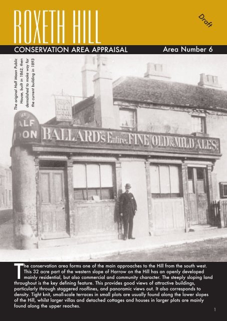
The original Half Moon Public<br />
House, built in 1862, then<br />
demolished to make way for<br />
the current building in 1893<br />
<strong>Roxeth</strong> <strong>Hill</strong><br />
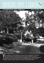
CONSERVATION AREA APPRAISAL Area Number 6<br />
<strong>Draft</strong><br />
The conservation area forms one of the main approaches to the <strong>Hill</strong> from the south west.<br />
This 32 acre part of the western slope of <strong>Harrow</strong> on the <strong>Hill</strong> has an openly developed<br />
mainly residential, but also commercial and community character. The steeply sloping land<br />
throughout is the key defining feature. This provides good views of attractive buildings,<br />
particularly through staggered rooflines, and panoramic views out. It also corresponds to<br />
density. Tight knit, small-scale terraces in small plots are usually found along the lower slopes<br />
of the <strong>Hill</strong>, whilst larger villas and detached cottages and houses in larger plots are mainly<br />
found along the upper reaches.<br />
1
Site of the recently<br />
developed former<br />
<strong>Harrow</strong> Hospital,<br />
<strong>Roxeth</strong> <strong>Hill</strong>, one of<br />
the most important<br />
conservation area<br />
sites<br />
1. Overview of <strong>Roxeth</strong> <strong>Hill</strong><br />
Conservation Area<br />
1.1 The area contains a variety<br />
of architectural styles including<br />
typical Edwardian villas, Arts and<br />
Crafts inspired terraces and<br />
detached buildings and 1930s<br />
semi-detached properties. In<br />
recognition of the wealth of<br />
architecturally and/or historically<br />
important buildings, ten<br />
properties are statutory listed<br />
whilst many more are locally<br />
listed. There is a leafy feel<br />
throughout due to a number of<br />
public trees along the pavement,<br />
and a great deal of dense<br />
private trees and shrubbery and<br />
large open spaces visible from<br />
the streetscene.<br />
Map 1: Conservation Area in relation to surrounding <strong>Harrow</strong><br />
on the <strong>Hill</strong> Conservation Area<br />
1.2 The area is dominated by<br />
the two principal roads of <strong>Roxeth</strong><br />
<strong>Hill</strong> and Middle Road, which<br />
contain two of the most<br />
important conservation area<br />
sites, <strong>Harrow</strong> Hospital and John<br />
Lyon School respectively. There<br />
are a number of ancillary<br />
offshoots, for instance West <strong>Hill</strong><br />
and Brickfields. These form the<br />
highest parts of the conservation<br />
area, providing attractive northsouth<br />
links between Byron <strong>Hill</strong><br />
and <strong>Roxeth</strong> <strong>Hill</strong>. Lower Road and<br />
Byron <strong>Hill</strong> Road form important<br />
boundaries to the west and<br />
north-east respectively.<br />
2.0 Location and Context<br />
2.1 <strong>Roxeth</strong> <strong>Hill</strong> Conservation<br />
Area is set amongst seven other<br />
conservation areas around<br />
<strong>Harrow</strong> on the <strong>Hill</strong> as illustrated<br />
by map 1. <strong>Harrow</strong> on the <strong>Hill</strong><br />
Village is directly north,<br />
characterised by small Victorian<br />
terraced development closely<br />
associated with the growth of<br />
<strong>Harrow</strong> School. Sudbury <strong>Hill</strong> is<br />
to the east and the Mount Park<br />
estate to the south, each<br />
characterised by large Victorian<br />
villas in extensive grounds. The<br />
south and west of the<br />
conservation area is<br />
characterised by less elevated<br />
land and more modern<br />
residential and commercial<br />
development. <strong>Roxeth</strong> <strong>Hill</strong><br />
therefore has a character quite<br />
distinct from surrounding<br />
conservation areas.<br />
3. Planning policy context<br />
3.1 The area was designated as<br />
a Conservation Area in 1969.<br />
This status means it is<br />
considered an area of 'special<br />
historic or architectural interest,<br />
the character or appearance of<br />
which it is desirable to preserve<br />
or enhance'. The initial<br />
boundary, which remains today,<br />
2
is illustrated in the map on page<br />
5.<br />
3.2 Designation of a<br />
conservation area puts a duty on<br />
the local authority to assess the<br />
special interest of the<br />
conservation area and to<br />
develop management and<br />
enhancement proposals. So, this<br />
Conservation Area <strong>Appraisal</strong><br />
(C.A.A.) evaluates the special<br />
character and appearance of<br />
the area and sets out<br />
opportunities for preservation<br />
and enhancement. This provides<br />
the basis for making sustainable<br />
decisions about its future<br />
through the development of<br />
management proposals. These<br />
are contained in the linked<br />
document '<strong>Roxeth</strong> <strong>Hill</strong><br />
Management Strategy'.<br />
3.3 It is important to note<br />
however, that no appraisal can<br />
ever be completely<br />
comprehensive and that the<br />
omission of a particular<br />
building, feature or open space<br />
should not be taken to imply it is<br />
of no interest.<br />
3.4 This appraisal and<br />
management strategy can be set<br />
within broader Conservation<br />
Area Policy guidance contained<br />
in local policy for <strong>Harrow</strong> in the<br />
Adopted <strong>Harrow</strong> Unitary<br />
Development Plan 2004<br />
(HUDP), the emerging Local<br />
Development Framework (LDF),<br />
<strong>Harrow</strong> on the <strong>Hill</strong> Conservation<br />
Area Supplementary Planning<br />
Document, and within national<br />
policy provided by Planning<br />
Policy Guidance Note 15 and<br />
the Planning (Listed Building and<br />
Conservation Areas) Act 1990.<br />
4. Archaeology and Geology<br />
4.1 An archaeological priority<br />
area covers part of the north<br />
east of this conservation area<br />
and is illustrated on the<br />
'Historical Development' map on<br />
page 5 The linked document<br />
entitled '<strong>Harrow</strong> on the <strong>Hill</strong><br />
Supplementary Planning<br />
Document' consider archaeology<br />
and geology for this<br />
conservation area and the wider<br />
<strong>Harrow</strong> on the <strong>Hill</strong> area.<br />
5. Historical Development<br />
5.1 The development of the<br />
conservation area should be<br />
viewed in context with the wider<br />
<strong>Hill</strong>. Records indicate that the<br />
region belonged to the Saxon<br />
Kings of Mercia in the eighth<br />
century AD and it is probable<br />
that the continuous settlement of<br />
<strong>Harrow</strong> on the <strong>Hill</strong> dates from<br />
this time. The area was attractive<br />
for early settlement due to its<br />
topography, water sources and<br />
good drainage.<br />
5.2 Despite its archaeological<br />
importance, there is little<br />
documented history for this<br />
conservation area before the<br />
late 18th century. However, it is<br />
known that the wider site of<br />
<strong>Harrow</strong> Hospital was used in the<br />
16th century for archery. Just<br />
west of the Hospital, historic<br />
maps note shooting butts, set up<br />
when Henry VIII decreed archery<br />
should be practiced by all.<br />
Certainly the butts were in use<br />
for the 'Silver Arrow' archery<br />
competition started by Sir Gilbert<br />
Talbot in 1684 that was held by<br />
<strong>Harrow</strong> School on the site each<br />
summer.<br />
5.3 Late Eighteenth Century<br />
Development during the late<br />
18th century was concentrated<br />
along Byron <strong>Hill</strong> Road and the<br />
parts of Middle Road nearest to<br />
this (see historical development<br />
map on page 5). This was part<br />
of the <strong>Harrow</strong> on the <strong>Hill</strong> Village<br />
expansion. The establishment of<br />
the nearby <strong>Harrow</strong> School in the<br />
early seventeenth century meant<br />
the Village expanded to<br />
accommodate its growth over<br />
time. Please refer to the <strong>Harrow</strong><br />
on the <strong>Hill</strong> Village <strong>Appraisal</strong> for<br />
more information on this.<br />
5.4 Early to Mid 19th<br />
Century<br />
5.5 Enclosure of common fields<br />
along the bottom end of Middle<br />
Road, lower Road and <strong>Roxeth</strong><br />
<strong>Hill</strong> took place and was<br />
complete by 1817. This meant<br />
land was divided into small plots<br />
and a number of cottages were<br />
formally laid out in a linear<br />
3
Lower Road:<br />
Early 19th<br />
Century Small-<br />
Scale Cottages<br />
Resulting From<br />
Enclosure<br />
Christ<br />
Church, built<br />
in 1862, set<br />
back from the<br />
main road<br />
amongst<br />
greenery<br />
pattern across along the bottom<br />
end of Middle Road, Lower<br />
Road and <strong>Roxeth</strong> <strong>Hill</strong> (see photo<br />
above). This formed a centre,<br />
known as <strong>Roxeth</strong> Corner to the<br />
wider area of <strong>Roxeth</strong> (now South<br />
<strong>Harrow</strong>). Indeed, <strong>Roxeth</strong> <strong>Hill</strong> was<br />
first formally named in the<br />
<strong>Harrow</strong> Enclosure Award of<br />
1817 as <strong>Roxeth</strong> Green Road. It<br />
acquired its present name by<br />
1889.<br />
5.6 To service the need created<br />
by this residential development,<br />
part of the growth was the<br />
establishment of institutional and<br />
community uses, for instance,<br />
The Half Moon (a conversion<br />
from two cottages) and the<br />
White Horse public houses, and<br />
several shops. The former<br />
gained its name from a nearby<br />
pond of that shape. Both pubs<br />
were rebuilt in 1893 and 1959<br />
respectively.<br />
5.7 <strong>Roxeth</strong> School (now <strong>Roxeth</strong><br />
Nursery, First and Middle<br />
School) and Christ Church are<br />
further examples of this pattern<br />
of development. The former<br />
moved to its present site in<br />
1838. The son of the great<br />
Victorian philanthropist Lord<br />
Shaftesbury had died while a<br />
pupil at <strong>Harrow</strong> School. In<br />
memory of his son, Anthony, he<br />
gave the school its oldest<br />
surviving building that fronts<br />
<strong>Roxeth</strong> <strong>Hill</strong> in 1851. This<br />
remains in use and is now<br />
Grade II listed.<br />
5.8 Although <strong>Roxeth</strong> was<br />
becoming more suburban,<br />
Christ Church was built in 1862<br />
to reflect its country hamlet<br />
roots. So, it is surrounded by<br />
dense planting and is an<br />
exception to the mainly linear<br />
development as it is set back<br />
from the main road (see photo<br />
above right).<br />
5.9 The above institutional and<br />
community developments<br />
marked the beginning of the<br />
area's long history as the<br />
location for these types of<br />
developments. The school and<br />
the Church also mark the start<br />
of the larger scale developments<br />
on the upper slopes.<br />
5.10 Late 19th Century<br />
The majority of development<br />
took place during the late 19th<br />
century and onto the early 20th<br />
century. These comprise typical<br />
Edwardian villas, Arts and Crafts<br />
inspired buildings (terraces and<br />
detached) and 1930s semidetached<br />
properties.<br />
5.11 Formal residential growth<br />
continued as demand increased.<br />
This occurred in linear form and<br />
along the slope of the land<br />
reflecting the formal layout<br />
begun by enclosure. Part of this<br />
was due to the speculative<br />
building, for example, E.S Prior's<br />
development of 60-66 Middle<br />
Road (1887).<br />
5.12 The pattern of institutional<br />
and community development<br />
also continued in order to serve<br />
the increasing residential<br />
development. This also followed<br />
the linear plan form begun by<br />
enclosure. The John Lyon School<br />
, built on the north side of<br />
Middle Road in 1876, is an<br />
important example. Local needs<br />
were no longer fulfilled by the<br />
older foundation of <strong>Harrow</strong><br />
School. This later led to the<br />
Lower School of John Lyon<br />
(1876) and also the school<br />
taking up occupation of the<br />
earlier Red House (also known<br />
as Byron <strong>Hill</strong> House) opposite.<br />
This was later extended by E.S.<br />
Prior for his brother John<br />
Templer. Similarly, greater<br />
demand meant that the <strong>Roxeth</strong><br />
First and Middle School mid way<br />
along <strong>Roxeth</strong> <strong>Hill</strong> was extended<br />
in 1898 when there were more<br />
than 600 pupils.<br />
5.13 Early 20th Century<br />
South <strong>Harrow</strong> Station opened in<br />
South <strong>Hill</strong> Avenue, near the<br />
present conservation area, in<br />
1903. This was for the<br />
Metropolitan District Railway and<br />
trains here ran to Hanger Lane<br />
Junction where a connection<br />
could be caught to central<br />
London. In 1933 the Piccadilly<br />
Line with through trains to<br />
central London was introduced.<br />
These two factors meant greater<br />
access to central London. Both<br />
were spurs to further formal<br />
4
60 - 66<br />
Middle Road:<br />
Late 19th<br />
century<br />
speculative<br />
development<br />
by E, S. Prior<br />
Map 4: Historical Development of <strong>Roxeth</strong> <strong>Hill</strong> Conservation Area<br />
<br />
N<br />
5
Salvation Army<br />
Building, 1907,<br />
was part of the<br />
beginning of<br />
community<br />
developments<br />
in the area<br />
Base of Middle<br />
Road: Shops<br />
converted to<br />
residential use in the<br />
mid C20th leaving<br />
shopfront remains<br />
clearly visible<br />
linear suburban development in<br />
the area (see historical<br />
development map on page 5). A<br />
particular example is Ashbourne<br />
Avenue where properties were<br />
largely built in the 1930s.<br />
However, the actual road was<br />
laid out from 1899 to 1902 on<br />
the site of Ashbourne House<br />
where Charles Wood ran a<br />
preparatory school from 1871<br />
until the late 1890s. Plans for<br />
the Estate were submitted for<br />
approval in 1898 but only 3<br />
properties had been built by the<br />
mid-1920s.<br />
5.14 The increased accessibility<br />
and density of residential<br />
development meant institutional<br />
and community uses continued<br />
to grow as part of this linear<br />
development. The former<br />
<strong>Harrow</strong> Hospital is an important<br />
example. This was the third<br />
hospital to be built on or close<br />
to <strong>Roxeth</strong> <strong>Hill</strong>. The first was<br />
opened in 1866 in Vine Cottage<br />
lower down <strong>Roxeth</strong> <strong>Hill</strong>, which<br />
were converted for the purpose.<br />
It was too small and so a new<br />
hospital building was developed<br />
on Lower Road (outside the<br />
present conservation area), in<br />
1872. Again the increased<br />
number of surrounding residents<br />
meant there was the need for a<br />
larger one and so the Cottage<br />
Hospital (<strong>Harrow</strong> Hospital) was<br />
built (see photo on page 20).<br />
This was the first purpose built<br />
hospital for the <strong>Hill</strong>, built in<br />
1905-6. The apparent reason<br />
for concentrating hospitals in<br />
this part of the <strong>Hill</strong> was that their<br />
location on the southern slope<br />
was considered more conductive<br />
to the health of their patients,<br />
despite the steep ascent<br />
necessary to reach them. The<br />
hospital expanded over the<br />
years. For example, it was<br />
extended to the west in 1915 for<br />
war use, and again in 1931 in<br />
memory of J.N. Stuart who was<br />
hospital president from 1921-<br />
28.<br />
5.15 Following the pattern for<br />
community developments here<br />
the Salvation Army was built in<br />
1907 and the Half Moon public<br />
house on <strong>Roxeth</strong> Corner was<br />
rebuilt in 1893 and during the<br />
early years of the twentieth<br />
century, was regarded as the<br />
village centre of <strong>Roxeth</strong>. Its<br />
adjacent well-patronized shops<br />
along Middle Road included<br />
Wingroves (a butchers), and<br />
Sladdens (a drapers shop). This<br />
occupied an adjacent property<br />
that can lay some claim to being<br />
<strong>Harrow</strong>'s first department store.<br />
The above occurred partly<br />
because <strong>Harrow</strong> Town Centre<br />
had yet to be developed and<br />
also due to its prominent<br />
junction location.<br />
5.16 Mid 20th century to<br />
Present Day<br />
Many of the small shops towards<br />
<strong>Roxeth</strong> Corner closed with the<br />
rise of superstores and <strong>Harrow</strong><br />
Town Centre and the growth of<br />
South <strong>Harrow</strong> district centre. The<br />
former small shops were<br />
converted to residential<br />
properties. The remains of<br />
shopfronts are still clearly visible<br />
along the lower parts of Middle<br />
Road (see photograph above).<br />
5.17 Development now<br />
comprised of extensions and<br />
piecemeal infill as the demand<br />
for suburban development<br />
increased. This generally<br />
followed the existing linear<br />
pattern, for example, along<br />
<strong>Roxeth</strong> <strong>Hill</strong> (for instance, 81 to<br />
97 <strong>Roxeth</strong> <strong>Hill</strong> in the early<br />
1960s), Brickfields, Ashbourne<br />
Avenue and Middle Road. John<br />
Lyon School is an important<br />
example here. As demand<br />
increased extensions and new<br />
school buildings were built<br />
along the top of Middle Road.<br />
For instance, a number of<br />
buildings added to its site in<br />
darker red brick by Sheppard<br />
Robson & Partners in 1973,<br />
1981, 1989 and new buildings<br />
by Kenneth Reed Associates in<br />
the 1990s, (see photo above<br />
right).<br />
5.18 Piecemeal residential<br />
development also led to a more<br />
scattered plan form as<br />
permission for two offshoot cul<br />
de sac roads (Clonmel Close<br />
and Chartwell Place) was<br />
granted in the late 1990s to<br />
infill open land to the rear of the<br />
existing main roads.<br />
6
Modern<br />
John Lyon<br />
School<br />
Buildings,<br />
Middle<br />
Road<br />
Steep gradient<br />
of <strong>Roxeth</strong> <strong>Hill</strong><br />
creates<br />
staggering of<br />
rooflines &<br />
long distance<br />
views<br />
Development followed shortly<br />
afterwards. All infill has respected<br />
the existing density of<br />
development however, aside from<br />
those 1980’s properties towards<br />
the end of Ashbourne Avenue<br />
that create a crowded<br />
appearance.<br />
5.19 The former <strong>Harrow</strong><br />
Hospital and its grounds is the<br />
most important example of<br />
recent development. <strong>Harrow</strong><br />
Hospital closed in 1998. Due to<br />
its lack of use, the character of<br />
both the building and the area<br />
was being compromised by its<br />
increasingly poor state of repair<br />
in the early 2<strong>1st</strong> century and so<br />
the building was included on the<br />
English Heritage's Resister of<br />
Buildings at Risk. Permission was<br />
granted in 2004 to convert the<br />
building to residential use,<br />
incorporating new expansions<br />
and properties, that are<br />
sympathetically sited and<br />
designed (in terms of scale,<br />
character and materials). It was<br />
felt that this would be a suitable<br />
and sustainable use and so<br />
would preserve its character and<br />
that of the surrounding area.<br />
Works followed and are now<br />
complete. They included a new<br />
private road off <strong>Roxeth</strong> <strong>Hill</strong><br />
named Cottage Road, which<br />
gained its name from the former<br />
'Cottage Hospital'.<br />
PART 2: THE CHARACTER OF<br />
THE CONSERVATION AREA<br />
TODAY<br />
6. Topography, Plan Form and<br />
Density of Development<br />
6.1 As its name suggests, the<br />
conservation area is<br />
characterised by its topography,<br />
see map. This is important in<br />
creating unfolding and dramatic<br />
views. The former is created<br />
through interesting juxtapositions<br />
of buildings and spaces adding<br />
interest to the streetscene. The<br />
latter is most strikingly clear as<br />
the land drops away steeply<br />
westwards from the top of <strong>Roxeth</strong><br />
<strong>Hill</strong>. This begins at 110m above<br />
mean sea level and falls to 75m.<br />
Notably on <strong>Roxeth</strong> <strong>Hill</strong> the<br />
gradient falls to both the east<br />
and west and the north and<br />
south, combining to make the<br />
townscape more interesting and<br />
attractive. The effect is similar,<br />
although less dramatic, for<br />
Middle Road where there are<br />
views of the skyline. (Views are<br />
discussed in more detail in<br />
section 9).<br />
6.2 A key nodal point is the<br />
junction at <strong>Roxeth</strong> Corner where<br />
four roads meet along the lower<br />
reaches in the south-western<br />
corner. The central, major roads<br />
Map 5: Topography of <strong>Roxeth</strong> <strong>Hill</strong> Conservation Area<br />
<br />
N<br />
7
A) Tight urban grain.<br />
B) Looser, large scale<br />
development.<br />
C) Close-knit development.<br />
Varying density of development: From around <strong>Roxeth</strong> Corner, the upper reaches of the <strong>Hill</strong> & Byron <strong>Hill</strong> Rd<br />
of <strong>Roxeth</strong> <strong>Hill</strong> and Middle Road<br />
begin here. They provide traffic<br />
and pedestrian access west to<br />
east. Lower Road is another<br />
major traffic and pedestrian<br />
road although it provides northsouth<br />
links. West <strong>Hill</strong> and<br />
Brickfields form attractive minor<br />
roads providing pedestrian<br />
north-south links between Byron<br />
<strong>Hill</strong> Road, another minor road,<br />
and <strong>Roxeth</strong> <strong>Hill</strong>. Remaining<br />
roads comprise minor offshoots<br />
as cul-de-sacs, such as<br />
Ashbourne Avenue and<br />
Chartwell Place. The winding<br />
nature of the relatively minor<br />
West <strong>Hill</strong>, Brickfields and Byron<br />
<strong>Hill</strong> Road mean views are<br />
gradually revealed giving the<br />
area added interest. Similarly,<br />
the length of the main roads,<br />
Middle Road and Lower Road,<br />
mean differing views are<br />
revealed over time.<br />
6.3 <strong>Roxeth</strong> <strong>Hill</strong> Conservation<br />
Area can be divided into 3 sub<br />
character areas: <strong>Roxeth</strong> Corner,<br />
the upper reaches of the <strong>Hill</strong>;<br />
and Byron <strong>Hill</strong> Road (see section<br />
11 on page 12). Density<br />
corresponds with this as shown<br />
above. <strong>Roxeth</strong> Corner sub-area<br />
has a small scale character in<br />
terms of size, height and<br />
frontage, with terraced buildings<br />
built directly onto the pavement<br />
or behind small front gardens.<br />
The buildings are modest in size<br />
and typically two storeys. It is<br />
probable that part of this small<br />
scale development was due to<br />
the commercial nature of the<br />
land meaning more expensive<br />
frontages.<br />
6. 4 In common with the rest of<br />
<strong>Harrow</strong> on the <strong>Hill</strong>, the density<br />
of development declines higher<br />
up the <strong>Hill</strong>. The buildings are<br />
larger institutional/community<br />
buildings, or individual large<br />
houses such as Byron House, set<br />
within spacious plots. Commonly<br />
there is a vertical emphasis and<br />
they tend to be narrower in<br />
width than they are high.<br />
Smaller buildings and<br />
compactness picks up again<br />
though along Byron <strong>Hill</strong> Road,<br />
which partly reflects the denser<br />
Victorian development of<br />
<strong>Harrow</strong> on the <strong>Hill</strong> Village.<br />
7. Land Use<br />
7.1The conservation area is<br />
largely characterised by<br />
residential use. Although there is<br />
a small group of maisonettes<br />
along Byron <strong>Hill</strong> Road, it is<br />
largely single-family dwelling<br />
houses. Some have been<br />
converted to flats but not a<br />
sufficient amount to change the<br />
character of the area. The more<br />
recent purpose built flats<br />
towards the south-west at the<br />
base of <strong>Roxeth</strong> <strong>Hill</strong> and in<br />
Waldrons Yard are out of<br />
keeping.<br />
7.2 Although residential use is<br />
the most common use, the<br />
commercial and institutional feel<br />
of this conservation area is well<br />
established. It is more common<br />
along the higher slopes as<br />
development becomes lower in<br />
density and more dispersed. This<br />
includes 2 schools (John Lyon<br />
School and <strong>Roxeth</strong> First and<br />
Middle School) and commercial<br />
usage (shops and 2 drinking<br />
establishments - The White<br />
Horse Public House and The<br />
Half Moon Public House).<br />
Importantly the former <strong>Harrow</strong><br />
Hospital adds to this character,<br />
particularly as its nameplate<br />
'<strong>Harrow</strong> Hospital' is a lasting<br />
reminder of its former use.<br />
8.Contribution to the Area by<br />
Green Spaces and its<br />
Biodiversity Value<br />
8.1 Although there are no<br />
significant areas of public green<br />
open space, there is large open<br />
green land in the form of private<br />
gardens and landscaping<br />
around buildings. For example,<br />
the Red House (John Lyon<br />
School), 24 Chartwell Place (see<br />
photo top right), numbers 27,<br />
25 Middle Road, 3 Clonmel<br />
Close, Westfield and to the<br />
south east of <strong>Roxeth</strong> <strong>Hill</strong>, around<br />
the former <strong>Harrow</strong> Hospital and<br />
newly developed flats. All<br />
provide important settings for<br />
these buildings, giving a sense<br />
of seclusion, tranquility and<br />
calm, away from the hustle and<br />
bustle of the main roads.<br />
8
Public and Private<br />
Greenery Breaks up<br />
the Streetscene as<br />
shown (a) outside<br />
Chartwell Place and<br />
(b) towards the top of<br />
<strong>Roxeth</strong> <strong>Hill</strong><br />
Map 6: Land Use of <strong>Roxeth</strong> <strong>Hill</strong> Conservation Area<br />
<br />
N<br />
9
Panoramic<br />
views from<br />
outside<br />
number 9<br />
Byron <strong>Hill</strong> Rd<br />
Break in built<br />
form between 21<br />
& 23 Ashbourne<br />
Ave. frames<br />
views to greenery<br />
& open land<br />
beyond<br />
8.2 These green spaces together<br />
with smaller private gardens and<br />
public open spaces provide an<br />
openness and greenery that is<br />
important in breaking up the<br />
street scene and creating a soft<br />
feel. They also help create an<br />
area of some biodiversity value,<br />
although the conservation area<br />
is not designated as an area of<br />
special nature conservation<br />
value. For these reasons many<br />
trees are protected by Tree<br />
Preservation Orders. These are<br />
shown in the map below entitled<br />
'Important trees'. They are found,<br />
for example, to the west of<br />
Brickfields, around the north east<br />
of Middle Road, and north and<br />
east of Ashbourne Avenue.<br />
Other important trees are found<br />
in the conservation area, and<br />
again are mainly private. For<br />
example, <strong>Roxeth</strong> <strong>Hill</strong>, the <strong>Roxeth</strong><br />
Nursery, First and Middle<br />
School, Christ Church and the<br />
<strong>Harrow</strong> Hospital are all<br />
surrounded by significant that<br />
add to the area's character. All<br />
trees have protected status by<br />
virtue of being in a conservation<br />
area. Any works to these trees<br />
require 6 weeks notice to<br />
<strong>Harrow</strong> <strong>Council</strong>.<br />
Map 7: Tree Preservation Orders and Surrounding<br />
Metropolitan Open Land<br />
8.3 The importance of greenery<br />
within each street is outlined by<br />
the townscape character section.<br />
8.4 Metropolitan Open Land<br />
just outside the conservation<br />
area to the north (behind the<br />
John Lyon School) and south<br />
(behind Ashbourne Avenue)<br />
shown on the map below<br />
provides an important setting to<br />
the conservation area adding to<br />
the softer feel created by the<br />
greenery within.<br />
9. Key Views<br />
9.1 The changes in level of the<br />
land gives rise to attractive<br />
views, due to: the staggering of<br />
roof levels in line with the slope<br />
of the <strong>Hill</strong>, vistas up and down<br />
the hill and panoramic views out<br />
towards the distant skyline.<br />
There is for example, staggered<br />
roof levels all along Middle<br />
Road and along <strong>Roxeth</strong> <strong>Hill</strong>.<br />
Also, a long distance view north<br />
of <strong>Harrow</strong> is available from<br />
outside number 9 Byron <strong>Hill</strong><br />
Road (see photo top left).<br />
Similarly there are panoramic<br />
views available from the top of<br />
Middle Path and from the top of<br />
<strong>Roxeth</strong> <strong>Hill</strong>.<br />
9.2 Views off main roads, such<br />
as from <strong>Roxeth</strong> <strong>Hill</strong> to Christ<br />
Church, and through breaks in<br />
the built form add interest to the<br />
streetscene allowing framed<br />
views of buildings and glimpses<br />
of trees and open space.<br />
10
Map 8: Key Views Into, Wtihin and Out of <strong>Roxeth</strong> <strong>Hill</strong> Conservati<br />
<br />
N<br />
11
View<br />
towards the<br />
Red House<br />
from<br />
Clonmel<br />
Close<br />
View towards St<br />
Mary’s Church<br />
spire (the<br />
landmark<br />
<strong>Harrow</strong> on the<br />
<strong>Hill</strong> building)<br />
9.3 The architectural and<br />
historic importance of buildings<br />
is an important source of views.<br />
There are key views to the<br />
statutory listed Red House from<br />
all angles because of its corner<br />
location, for example, from the<br />
top of Middle Road, and above<br />
the garages in Clonmel Close.<br />
The decorative elongated porch<br />
of number 27 Middle Road from<br />
Chartwell Place (see photo on<br />
page 9) also forms the source of<br />
a key view whist St Mary’s Spire<br />
forms an important view out of<br />
the conservation area from the<br />
entrance to Clonmel Close (see<br />
photo above).<br />
9.4 Important views are also<br />
those to trees and open spaces.<br />
For example, there are good<br />
views from further down <strong>Roxeth</strong><br />
<strong>Hill</strong> to those at the junction of<br />
<strong>Roxeth</strong> <strong>Hill</strong> and London Road.<br />
Also, large forest trees, such as<br />
those in the churchyard,<br />
combined with the topography<br />
means there are attractive views<br />
looking down on trees. The<br />
open space behind number 27<br />
Middle Road (see photo on<br />
page 9) forms part of a key<br />
view, complemented by the<br />
decorative porch here. The open<br />
space and trees behind number<br />
22 and 24 Ashbourne Avenue<br />
forms an important view, partly<br />
framed by the arch of this<br />
building (see photo below).<br />
9.5 There are important views<br />
into the conservation area from<br />
outside, for example, from<br />
View towards 22 & 24 Ashbourne Avenue with open space<br />
and greenery around and beyond<br />
Mount Park/ Georgian Way,<br />
Lower Road, London Road and<br />
Byron <strong>Hill</strong> Road. Again, these<br />
include views towards greenery,<br />
open space, high quality<br />
architecture and panoramic<br />
views.<br />
9.6 Key views are highlighted<br />
on the map on the previous<br />
page . It is not a comprehensive<br />
list but indicates the sort of views<br />
that are important.<br />
10. Streetscape character<br />
The area has low boundary<br />
walls either brick or soft<br />
treatments such as wooden<br />
picket fences or hedges. For the<br />
larger buildings this includes<br />
higher treatments (barred metal<br />
fences) that retain through views<br />
to the topography and<br />
architecture. This maintains the<br />
more soft, open character.<br />
Generally there are central<br />
tarmaced roads with kerbed<br />
tamaced pavements either side.<br />
However, there are good paving<br />
slabs from numbers 29 and 31<br />
down to number 25 Middle<br />
Road, along Ashbourne Avenue<br />
and interesting small rectangular<br />
textured paving down Middle<br />
Path.<br />
11.Townscape Character of<br />
Individual Roads<br />
11.1 Summary of townscape<br />
character:<br />
<strong>Roxeth</strong> <strong>Hill</strong> conservation area is<br />
made up of three main<br />
12
character areas (see map<br />
below). The first, <strong>Roxeth</strong> Corner,<br />
is along the lower slopes of the<br />
<strong>Hill</strong> spreading up Lower Road,<br />
Middle Road and <strong>Roxeth</strong> <strong>Hill</strong>.<br />
This is mainly characterised by a<br />
high density, small-scale,<br />
terraced, linear residential<br />
development (see photo on<br />
page 14). This creates a more<br />
urban feel particularly when<br />
combined with the: wide streets,<br />
loud traffic (particularly as four<br />
roads meet here), street<br />
furniture/road markings, and<br />
limited number of large green<br />
spaces.<br />
11.2 The second is found on<br />
the upper slopes of the <strong>Hill</strong>,<br />
and, often, away from the main<br />
roads. It is has softer,<br />
occasionally semi-rural feel due<br />
to generally larger properties<br />
and a lower density. It is more<br />
dispersed as there are more<br />
commercial and institutional<br />
land uses and development is<br />
often detached, following<br />
winding offshoot roads. There is<br />
a more leafy, tranquil and<br />
secluded atmosphere as there<br />
are narrower roads surrounded<br />
by more greenery and more<br />
open green spaces. Importantly,<br />
there is a sense of greater<br />
openness as the higher elevation<br />
means more long distance views<br />
and there is more space around<br />
properties.<br />
11.3 The third character area,<br />
Byron <strong>Hill</strong> Road, is again on the<br />
higher slopes of the <strong>Hill</strong> and is<br />
similar to the second, except that<br />
it has higher density and more<br />
terraced, linear residential<br />
development making it feel<br />
more a part of the <strong>Harrow</strong> on<br />
the <strong>Hill</strong> Village.<br />
11.4 However, the conservation<br />
area has common characteristics<br />
giving a sense of unity. For<br />
example, development is<br />
staggered following the slope of<br />
the <strong>Hill</strong>, dense public and<br />
private greenery breaks up the<br />
streetscene, and there is a high<br />
quality of architecture.<br />
11.5 Character Area 1:<br />
<strong>Roxeth</strong> Corner<br />
11.6 Northolt Road<br />
This marks an entrance into the<br />
conservation area. There is a<br />
harsh, enclosed character as<br />
Dublin Court consists of ground<br />
floor shops topped by 2 floors of<br />
flats, directly fronting the<br />
pavement. This adds to the<br />
urban character created by this<br />
busy junction.<br />
11.7 Lower Road<br />
An urban character is created<br />
due to the width of the road<br />
(emphasised by an absence of<br />
Map 9: Sub-Character Areas of <strong>Roxeth</strong> <strong>Hill</strong> Conservation Area<br />
<br />
N<br />
13
Character Area 1:<br />
Ashbourne Avenue,<br />
High Density<br />
development although<br />
relatively soft leafy<br />
suburban character<br />
parking) and the loud traffic<br />
noise. Adding to this atmosphere<br />
is the high density terraced<br />
commercial and residential<br />
development, the patchwork<br />
effect of the pavement due to<br />
repairs; bulky street signs; and<br />
the relatively high number of<br />
replacement UPVC windows at<br />
either end. The dense, urban<br />
feel is heightened nearer <strong>Roxeth</strong><br />
Corner as more buildings<br />
directly front the pavement. The<br />
urban characteristic lessens<br />
further north where there are<br />
short front gardens.<br />
11.8 Base of <strong>Roxeth</strong> <strong>Hill</strong><br />
Here there is an urban feel as<br />
there is a mix of closely spaced<br />
community (the Salvation Army<br />
Hall and the Half Moon Public<br />
House) and residential buildings,<br />
often directly fronting the<br />
pavement. It also has an urban<br />
character as it is a wide main<br />
road (its width emphasised due<br />
to a lack of parking), and is<br />
busy with loud traffic as it<br />
approaches the junction.<br />
Importantly though this urban<br />
atmosphere is lightened as<br />
buildings on the south side, and<br />
all those past the Salvation Army<br />
on the north side, are set back<br />
behind green front gardens.<br />
11.9 Base of Middle Road<br />
An enclosed character is created<br />
as there are closely spaced<br />
residential terraced groups in a<br />
linear form (see photo below).<br />
Character Area 1: High density, small scale terraced linear<br />
residential development along base of Middle Road<br />
An urban characteristic is<br />
evident due to tarmaced<br />
pavements, a high amount of<br />
parking, and traffic noise is high<br />
along this wide main road,<br />
particularly approaching the<br />
junction. Importantly, this urban<br />
atmosphere is limited as<br />
buildings are low levelled and<br />
about half are set back behind<br />
small green garden space. Also,<br />
the parking space adjacent to<br />
the pub close to the junction<br />
provides welcome relief breaking<br />
up the enclosed feel.<br />
11.10 Ashbourne Avenue<br />
This urban character is echoed<br />
since there are a high number of<br />
visible alterations, including<br />
unsympathetic UPVC<br />
replacement windows. Also, the<br />
number of modern infill<br />
properties is high, as is the level<br />
of parking creates a crowded<br />
atmosphere. Buildings appear to<br />
require minor repairs therefore<br />
contributing to a run-down<br />
environment. Despite this it has<br />
a slightly separate, more<br />
suburban feel compared to the<br />
rest of this character area. This<br />
is because it is characterised by<br />
a tranquil, leafy residential<br />
ambiance as it is a quiet cul de<br />
sac with tree lined streets and<br />
continuously paved pavements.<br />
Also, all buildings are set back<br />
behind front green garden<br />
space.<br />
11.11 Waldrons Yard<br />
There is an urban character due<br />
14
Character Area 2: Larger<br />
detached properties,<br />
Lower Density of<br />
Development and a more<br />
leafy character. Pictures<br />
Base<br />
show Middle Road (left)<br />
of<br />
and Clonmel Close (right)<br />
to the noise and proximity to the<br />
junction, and the tall flats, with<br />
protruding first floor sections<br />
directly fronting the pavement.<br />
These create a sense of<br />
enclosure.<br />
11.12 Character Area 2:<br />
Upper Reaches of the <strong>Hill</strong><br />
11.13 Middle Road Towards<br />
Byron <strong>Hill</strong> Road<br />
There is an open character to<br />
the upper level of Middle Road.<br />
It is relatively quiet and sheltered<br />
set away from the junction and<br />
buildings are detached and have<br />
a dispersed plan form set back<br />
from the road. Also there is a<br />
leafy feel as buildings are<br />
surrounded by greenery (shrubs,<br />
grass and/or trees). A more<br />
open character is evident<br />
towards the Byron <strong>Hill</strong> Road end<br />
as more properties are<br />
detached, and the elevation<br />
provides long distance views.<br />
brick wall, thick trees and large<br />
metal gates. These are detached<br />
buildings are spread out<br />
intermittently along the winding<br />
road and surrounded by<br />
landscaped greenery.<br />
11.16 Clonmel Close<br />
This short, quiet residential cul<br />
de sac is characterised by a<br />
suburban, spacious and leafy<br />
character. This is due to<br />
buildings having a detached,<br />
sprawled plan form giving a<br />
three dimensional quality and<br />
allowing important surrounding<br />
areas of green space. This is<br />
particularly important for<br />
number 1 due to its prominent<br />
corner location.<br />
11.17 <strong>Roxeth</strong> <strong>Hill</strong> Towards<br />
London Road Junction<br />
This is characterised by softer<br />
features as buildings are<br />
sheltered and set back from the<br />
main road behind greenery and<br />
sit neatly in their plots. For<br />
instance, the two key sites, the<br />
former <strong>Harrow</strong> Hospital and<br />
Christ Church, are set back and<br />
surrounded by green space.<br />
11.18 Despite <strong>Roxeth</strong> <strong>Hill</strong><br />
being in two character areas<br />
there is consistency. Heavy traffic<br />
creates a lot of noise and the<br />
width of the road, like Lower<br />
Road, is emphasised since there<br />
is no parking here. The<br />
intermittent lampposts, with<br />
attractive decorative detail, are<br />
Staggering of rooflines along Middle Road creates a consistent<br />
character<br />
11.14 Despite Middle Road<br />
being in two character areas<br />
there is consistency due to the<br />
uninterrupted use of heritage<br />
style lampposts and the roofline<br />
is continually staggered in line<br />
with the slope of the <strong>Hill</strong> (see<br />
photo right).<br />
11.15 Chartwell Place<br />
A quiet, secluded residential<br />
atmosphere is apparent as there<br />
are single family dwelling<br />
houses, cut-off from the main<br />
road behind a relatively high<br />
15
in character and unify the road<br />
and all rooflines neatly follow<br />
the slope of the <strong>Hill</strong> (see photo<br />
on page).<br />
11.19 West <strong>Hill</strong><br />
West <strong>Hill</strong> up to Westfield is<br />
characterised by more intimate,<br />
semi-rural features. It begins<br />
from <strong>Roxeth</strong> <strong>Hill</strong> as a narrow<br />
footpath. Although noise is loud<br />
from the main road after the first<br />
5 metres this disappears, and, in<br />
stark contrast, there is a quiet,<br />
enclosed and secluded feel. The<br />
sheltered, country feel is<br />
reinforced by the winding of the<br />
road and the tunnel of greenery.<br />
Whilst grand, buildings are set<br />
back and sit neatly in their<br />
surroundings. Although the<br />
road opens out towards Byron<br />
<strong>Hill</strong> Road, a sense of enclosure<br />
is retained as buildings are<br />
densely packed, close to the<br />
pavement.<br />
West <strong>Hill</strong>: A sheltered country feel created by the tunnel<br />
of greenery<br />
11.20 Brickfields<br />
Brickfields also has a village<br />
atmosphere. This is due to the<br />
winding and minor nature of the<br />
road and well-spaced buildings<br />
present only on one side. There<br />
is also a leafy, secluded<br />
character. On the <strong>Roxeth</strong> <strong>Hill</strong><br />
side this is also due to tall gates<br />
blocking traffic entry and thick<br />
vegetation limiting traffic noise<br />
and views to this road. Adding<br />
to this well-kept greenery is<br />
visible from the surrounding<br />
private grounds and towards<br />
<strong>Roxeth</strong> <strong>Hill</strong> partly shade/obscure<br />
the buildings' frontages.<br />
Unfortunately towards Byron <strong>Hill</strong><br />
Road there is a higher level of<br />
street furniture (more signs and<br />
road markings) creating a<br />
cluttered feeling, and less<br />
greenery and more road<br />
markings adding to its more<br />
urban nature.<br />
11.21 Middle Path<br />
This joins Middle Road and falls<br />
away towards Lower Road<br />
creating dramatic and long<br />
distance open views. Further<br />
semi-rural characteristics include<br />
the open land opposite; the<br />
dense greenery, the low level<br />
cottages only on one side of the<br />
road, and a similarly low lying<br />
church. However, replacement<br />
uPVC windows and the busy<br />
road at the base of this path<br />
limit this country feel.<br />
11.22 Character Area 3:<br />
Byron <strong>Hill</strong> Road<br />
16
Middle Path,<br />
dramatic character<br />
created by steeply<br />
sloping land and<br />
long distance<br />
views beyond<br />
11.23 Byron <strong>Hill</strong> Road and<br />
Athena Close<br />
There is a shady and leafy<br />
atmosphere due to its dense,<br />
lush private and public<br />
vegetation breaking up the<br />
streetscene and the winding<br />
roads gradually revealing views.<br />
This is reinforced as buildings<br />
are set back behind front<br />
gardens. However, this area is a<br />
more urban character as there is<br />
higher density, linear<br />
development of relatively small<br />
buildings, some terraced.<br />
12. Positive, Neutral and<br />
Negative Buildings<br />
The buildings of <strong>Roxeth</strong> <strong>Hill</strong><br />
together form a group of<br />
architectural and/or historic<br />
importance. All positive<br />
properties are highlighted in the<br />
map below (Positive, Neutral<br />
and Negative Buildings). It also<br />
marks those that have a<br />
negative impact. These detract<br />
from the area's special character<br />
for example by being of<br />
inappropriate design, siting and<br />
materials. These are looked at<br />
more closely in section 14 and<br />
the management strategy.<br />
13. Character of Buildings<br />
(Architecture and Materials)<br />
13.1 Summary<br />
The buildings within <strong>Roxeth</strong> <strong>Hill</strong><br />
Conservation Area are<br />
constructed in different yet<br />
harmonising proportions,<br />
designs, and materials. The<br />
variety is important in adding<br />
interest. The buildings are<br />
between 1 and 6 storeys in<br />
height. Along the lower reaches<br />
are small-scale terraces and on<br />
higher ground, larger villas and<br />
townhouses are found. The<br />
larger buildings are generally<br />
formed with additional dormers<br />
to lessen apparent bulk.<br />
Buildings are often traditionally<br />
designed, for instance there are<br />
many Arts and Crafts inspired<br />
groups, which gives unity,<br />
although these vary from modest<br />
to more grand designs.<br />
13.2 The nineteenth century and<br />
early 20th century buildings,<br />
which are those of the most<br />
architectural quality, are<br />
generally constructed in brick.<br />
Soft red bricks are very common<br />
but brown and yellow London<br />
stocks are also found in the<br />
area. Some buildings also utilise<br />
render. The traditional buildings<br />
have pitched roofs, covered with<br />
red clay tiles or slate.<br />
Fenestration tends to be timber<br />
sashes or small paned<br />
casements.<br />
Character Area 3: Shady, leafy character of Byron <strong>Hill</strong> Road<br />
12.1 All applications for<br />
demolition will be judged<br />
against the policies contained<br />
within the Unitary Development<br />
Plan or the forthcoming Local<br />
Development Framework. There<br />
will be a presumption against<br />
the demolition of buildings of<br />
character.<br />
17
Modern properties<br />
adjacent the former<br />
<strong>Harrow</strong> Hopspital<br />
reflects the design<br />
character and alignment<br />
13.3 A variety of more modern<br />
post-war development has<br />
occurred on a piecemeal basis.<br />
This varies from two storey<br />
individual houses, such as<br />
Clonmel Close, to modern 4<br />
storey townhouses like 81-97<br />
<strong>Roxeth</strong> <strong>Hill</strong>. Modern flatted<br />
development is also found in the<br />
area, for instance, the 3 storey<br />
Kymes Court or on extensions to<br />
the Brickfields development.<br />
These are generally neutral or<br />
negative in quality since they<br />
lack an understanding of local<br />
context in terms of scale, form,<br />
proportions, alignment, siting<br />
and high quality materials and<br />
design. However, the recent<br />
redevelopment of <strong>Harrow</strong><br />
Hospital is a more positive<br />
example. The modern buildings<br />
37 - 51 <strong>Roxeth</strong> <strong>Hill</strong> - attractive interwar group<br />
and extensions here use<br />
traditional materials, and a<br />
form, size and detailing to echo<br />
that of the original listed<br />
building and surrounding<br />
conservation area.<br />
13.4 The characteristics of<br />
buildings by road are outlined<br />
below. However, this does not<br />
give a fully detailed and<br />
comprehensive review. Many<br />
that are not mentioned or are<br />
outlined briefly still make an<br />
important contribution to the<br />
area's architectural character,<br />
both individually and in<br />
combination with others.<br />
13.5 <strong>Roxeth</strong> <strong>Hill</strong><br />
There is townscape unity as it is<br />
characterised mainly by<br />
assymmetrical Arts and Crafts<br />
inspired properties and rooflines<br />
following the <strong>Hill</strong>'s gradient.<br />
Townscape character varies<br />
though according to the use and<br />
size of buildings. Generally the<br />
small, residential properties are<br />
less decorative than the larger,<br />
commercial/institutional<br />
buildings. They are also more<br />
often designed in groups.<br />
13.6 This is illustrated by the<br />
relatively simple, small-scale<br />
residential Arts and Crafts style<br />
properties from number 1 Mead<br />
Villas, on both sides of the road<br />
up to the footbridge. There is<br />
unity in their design since they<br />
are all brick (brown or red), two<br />
storey, semi-detached (often a<br />
mirrored pair) and no wider than<br />
2 bays. Also, they often have: a<br />
bay window; a black tiled roof;<br />
and white wooden casement<br />
windows. Sub-groups here<br />
provide additional townscape<br />
unity. Numbers 37-51 (see<br />
photo on the left) on the north<br />
side for instance often have:<br />
white render, two storey square<br />
bay fronts, red tiled pitched<br />
roofs and porched fronts.<br />
Number 42 onwards are each<br />
low-lying render clad buildings,<br />
with slightly overhanging<br />
bracketed first floors. Mead<br />
Villas are of brown brick, with<br />
brown gravel render, two storey<br />
bays, red tile hanging, gable<br />
ends and red tiled, hipped roofs.<br />
Although not Arts and Crafts, 17<br />
and 21 to 25 <strong>Roxeth</strong> <strong>Hill</strong> can be<br />
18
Map 10: Positive, Negative and Neutral Buildings Within <strong>Roxeth</strong> <strong>Hill</strong> Conservation Area<br />
<br />
N<br />
19
The small, relatively<br />
simple Studio (left) and<br />
slightly larger more<br />
decorative Arts and<br />
Crafts Cobblers (right)<br />
grouped with the above due to<br />
their attractive, simple, smallscale<br />
nature.<br />
13.7 The small, detached<br />
properties of the Studio,<br />
Cobblers and 24 <strong>Roxeth</strong> <strong>Hill</strong> are<br />
also relatively simple. The Studio<br />
is a pleasingly plain, two storey<br />
cottage. It has white painted<br />
brick, a pitched roof and square<br />
leaded windows. The slightly<br />
larger Cobblers has a steeply<br />
pitched red tiled roof with<br />
hanging tiles over its gable<br />
ends. 24 <strong>Roxeth</strong> <strong>Hill</strong> is small<br />
scale and simplistic although<br />
has added visual interest with its<br />
brick on edge on tile creasing<br />
parapet wall, and its tall<br />
moulded feature on the front<br />
apex providing a certain flourish.<br />
13.8 Remaining Arts and Crafts<br />
style properties are larger and<br />
The former <strong>Harrow</strong> Hospital<br />
correspondingly more<br />
decorative, detailed and<br />
individual. The former <strong>Harrow</strong><br />
Hospital provides the most<br />
striking example. In terms of<br />
scale it reaches three storeys<br />
and its frontage is over 100m<br />
wide. It is very decorative, as<br />
well as being quite Arts and<br />
Crafts in style, Pevsner has<br />
described it as 'a lively design in<br />
homely free Baroque, just right<br />
for a Cottage Hospital'. Its<br />
decorative features include<br />
striped quoins of red and yellow<br />
stone, windows with strong red<br />
brick arches, and a triangular<br />
pediment around its doorway.<br />
Arnold Mitchell, was the, much<br />
admired, local architect. He<br />
went to <strong>Harrow</strong> School and also<br />
built Hampstead's University<br />
College Schools and London's<br />
Mayfair Hotel.<br />
13.8 The adjacent Siddons<br />
House links well to <strong>Harrow</strong><br />
Hospital and its surrounding<br />
detached infill buildings due to<br />
its scale and detached, Arts and<br />
Crafts design. It has a redhipped,<br />
tiled roof and are is<br />
largely of red brick with white<br />
render sections and occasional<br />
dormer windows. Again a local<br />
architect was the designer, in this<br />
case from Greenhill, A.R Barker.<br />
There is differing decorative<br />
detail here in the form of white<br />
brackets beneath the roofline<br />
and 3 dormer windows above<br />
accentuating its asymmetry.<br />
Siddons House, <strong>Roxeth</strong> <strong>Hill</strong><br />
13.9 Like <strong>Harrow</strong> Hospital, The<br />
Half Moon Public House (see<br />
photo on the right) is a<br />
particularly distinctive. It has a<br />
distinctive asymmetrical mock<br />
Tudor style, particularly clear<br />
through its steeply sloping roof.<br />
There are three decorative<br />
carved panels facing <strong>Roxeth</strong> <strong>Hill</strong>,<br />
and mock arrow slots. Its stable<br />
doors to the right of the current<br />
beer garden show its age. Its<br />
signage perched on the roof<br />
and corner location helps give it<br />
its landmark character. The<br />
adjacent Salvation Army Hall<br />
and New Citadel is an example<br />
of harmonising variety in the<br />
townscape since it is again has<br />
very distinctive architecture<br />
almost Gothic in style, yet can<br />
be seen as an Arts and Crafts<br />
style building. Its flat roof and<br />
battlement, stone edged,<br />
20
<strong>Roxeth</strong> First and<br />
Middle School, is<br />
similar to the<br />
design of<br />
Christchurch,<br />
<strong>Roxeth</strong> <strong>Hill</strong><br />
parapet fronting the road is its<br />
most striking feature.<br />
13.10 The remaining larger<br />
historic properties also have a<br />
pleasingly distinctive yet<br />
harmonising architectural style.<br />
<strong>Roxeth</strong> First and Middle School<br />
by W.G. and C. Habershon, for<br />
instance, has a decorative gothic<br />
style with supporting stone<br />
buttresses and windows with<br />
tracery. Its steeply pitched tiled<br />
roof is classified as a free Neo-<br />
Tudor style. This has recently<br />
been carefully restored. It is a<br />
very attractive building with<br />
delicate stonework. Christ<br />
Church opposite links to this<br />
building as it also has a steeply<br />
pitched roof with horizontal<br />
banding details and is set back<br />
from the main road. This allows<br />
the listed building to sit neatly in<br />
the landscape. It is a small flint<br />
faced church with a tiny bellturret<br />
and small stone window<br />
frames by Giles Gilbert Scott.<br />
Providing local interest, John<br />
Chapman is commemorated in<br />
the east window for his<br />
contribution to <strong>Roxeth</strong><br />
employment in the 1850s. The<br />
bell turret was restored in the<br />
1990s (Check) by HHT.<br />
uPVC windows and timber<br />
cladding.<br />
13.12 Ashbourne Avenue<br />
Numbers 22 and 24 (developed<br />
between 1914 and 1932, see<br />
photo on page 11) are<br />
landmark unlisted buildings due<br />
to their interesting design. They<br />
form one elongated single storey<br />
building with small casement<br />
windows and a steeply pitched,<br />
pan tiled roof. There is a central<br />
projecting hipped gable end<br />
block, with red tile hanging<br />
contained within the roof. This<br />
begins above ground floor level<br />
and below this is a central<br />
tunnel. This is important in<br />
framing views from <strong>Roxeth</strong> <strong>Hill</strong> to<br />
the open land behind.<br />
13.13 Otherwise buildings are<br />
mainly typical two-storey 1930s<br />
garden suburb style semidetached<br />
properties that link<br />
historically with the opening of<br />
the South <strong>Harrow</strong> Tube. They are<br />
constructed of dark brown/red<br />
tiled roofs, white/brown pebbly<br />
render, red brick, casement<br />
windows (often UPVC<br />
replacement) with occasional<br />
attractive brick quoin detail.<br />
However, the design and<br />
materials of each varies. Also,<br />
many alterations are visible and<br />
are quite rundown. Furthermore,<br />
a number of less attractive<br />
1980s and 1990s infill<br />
properties create a more<br />
crowded appearance. These do<br />
not relate well as they are of a<br />
less attractive, block design<br />
lacking visual interest and use<br />
modern materials such as brown<br />
clapperboard and UPVC<br />
windows.<br />
The Half Moon Public House - a Landmark Unlisted Building<br />
on this Corner Site<br />
13.11 At the top of the <strong>Hill</strong> is<br />
a group of plain 1960s houses<br />
81-97 <strong>Roxeth</strong> <strong>Hill</strong>. These are out<br />
of character due to their<br />
terraced form at the top of the<br />
<strong>Hill</strong>, and plain design using hard<br />
modern materials, for example,<br />
21
Middle Road: contrast between<br />
decorative Arts & Crafts style (for<br />
example the John Lyon School, left)<br />
and the simple cottage properties on<br />
the right<br />
13.14 Northolt Road<br />
Dublin Court directly fronts the<br />
road. At 3 stories high, and wide<br />
enough to hold four shop fronts<br />
this means it dominates the road<br />
in a way not characteristic of<br />
other conservation area<br />
buildings. Its plain block design<br />
and harsh materials including<br />
UPVC replacement casement<br />
windows and concrete surrounds<br />
to shop openings create an<br />
unattractive building again, out<br />
of keeping (see picture on<br />
page).<br />
13.15 Middle Road<br />
A key feature of the Middle<br />
Road townscape is the contrast<br />
between the decorative and<br />
varied Arts and Crafts styles<br />
towards the upper reaches (the<br />
Red House and the John Lyon<br />
School for example), and the<br />
simplicity of the cottage style<br />
buildings which are more<br />
Classical in style.<br />
13.16 All cottages vary slightly<br />
giving added interest. They are<br />
however predominantly:<br />
Victorian, of brown or yellow<br />
brick and towards <strong>Roxeth</strong><br />
Corner. A number are white<br />
rendered and a few have been<br />
have been painted white.<br />
Importantly a number retain their<br />
original name plaque. Windows<br />
are generally attractive as they<br />
are of timber, in a 6 over 6<br />
paned sash style, and<br />
occasionally have a gently<br />
curved and protruding ground<br />
floor bay window, topped with<br />
View towards the Red House on Middle Road. This section is<br />
designed by E.S. Prior who designed many other landmark<br />
buildings in the <strong>Harrow</strong> on the <strong>Hill</strong> Conservation Area<br />
brick arches. The more<br />
unaltered these buildings are,<br />
the more in keeping they are<br />
with their intended simplicity, so<br />
it is unfortunate that a number<br />
now have UPVC casements.<br />
Providing a sense of uniformity<br />
here is their two storey, box like<br />
structure with gently pitched<br />
brown or black tiled/slate roofs,<br />
following the gradient of the<br />
<strong>Hill</strong>. Also, the buildings come in<br />
mirrored pairs or larger groups<br />
of very similar buildings.<br />
13.17 Number 23, 25, 25a and<br />
27 provide a good transition<br />
between the cottages and the<br />
Arts and Crafts style buildings,<br />
since they are slightly larger than<br />
the cottages and have some<br />
more decorative features. For<br />
instance, number 23 has a<br />
hipped slate roof and, notably, a<br />
central pilastered doorcase and<br />
angled addition with corner<br />
pilasters. <strong>Roxeth</strong> Mead (number<br />
27) has a two storey bay window<br />
and a decorative cast iron porch<br />
along its elongated shape.<br />
Lower House and Buckolt House<br />
(25 and 25a) form an<br />
assymetrical villa which has a<br />
steeply pitched white triangular<br />
pediment above the entrance<br />
way to Buckolt House, that<br />
mirrors (although if off-centre<br />
from) the pitch of the above<br />
gable end.<br />
13.18 The John Lyon School<br />
buildings dominate the upper<br />
level of Middle Road. They<br />
22
The Assymetrical<br />
Arts and Crafts<br />
Style White<br />
Horse Public<br />
House<br />
provide consistency due to their<br />
scale, use of red brick and<br />
collective ownership and use.<br />
The school site begins with the<br />
corner sited, grade II listed, The<br />
Red House. The front section is<br />
a typical red brick Georgian<br />
building. However, E.S. Prior<br />
built a large red brick Arts and<br />
Crafts addition (1883). He was<br />
once a <strong>Harrow</strong> School pupil and<br />
constructed many other notable<br />
pieces on the <strong>Hill</strong>. From Byron<br />
<strong>Hill</strong> Road, the Red House's red<br />
tile hanging is visible, with its<br />
small dormer windows with<br />
steeply pitched roofs to mirror<br />
the slope of its cat slide roof.<br />
From Middle Road, there are<br />
numerous Ipswich (overhanging<br />
curved bay) windows and a<br />
mock Tudor overhanging first<br />
floor gable end constructed of<br />
imitation timber and rough cast<br />
infill. Its tall chimney is visible<br />
from all around. All these<br />
features together create a lot of<br />
visual interest. This links it to the<br />
Arts and Crafts style, original<br />
John Lyon School building<br />
(1876 by H.M Burton). This is<br />
made of plain brick and a red<br />
clay tiled roof. It has stone<br />
framed openings and supporting<br />
buttresses and is locally listed.<br />
13.19 60 to 66 (even) Middle<br />
Road link to the above as they<br />
are Arts and Crafts buildings by<br />
E.S.Prior (see photo on page 5).<br />
These are grade II listed. They<br />
are 2 .5 storey houses in a<br />
picturesque style. Above the red<br />
brick ground floor is rough cast<br />
work alternating with tile<br />
hanging and a red tiled roof.<br />
They are deliberately<br />
assymetrical giving a quirky and<br />
interesting appearance. This is<br />
enhanced by: many different<br />
sized gables; quirky porches;<br />
and different coloured tiles. The<br />
plain cottages along Middle<br />
Road underline how much this<br />
style was a conscious reaction<br />
against the immediate past.<br />
13.20 The White Horse Public<br />
House again links to the above<br />
due to its assymetrical Arts and<br />
Crafts style. It is constructed of<br />
red brick with triangular red tile<br />
hanging sections. The steeply<br />
sloping brown tiled roof sections<br />
of each gable end are a real<br />
feature, as each gable end is set<br />
back from the last. The lamp<br />
heads attached mirror those<br />
lampposts throughout the street.<br />
13.21 Middle Path<br />
This comprises small scale,<br />
simple cottage buildings. They<br />
are brown brick or beige<br />
rendered, with brick arched, 6<br />
over 6 paned timber sash<br />
windows and pitched slate roofs.<br />
In these ways they are similar to<br />
those cottages along Middle<br />
Road and Lower Road. However,<br />
here they range from single to 2<br />
storey, are detached and have<br />
more interest through, for<br />
example, protruding porches or<br />
outside window shutters. Indeed,<br />
positively Cricket Field Cottage<br />
stands out, for its two-storey<br />
wooden casement bay window<br />
with central grey tile hanging. All<br />
buildings here follow the<br />
gradient.<br />
13.22 Chartwell Place<br />
The buildings are largely<br />
detached, two storey modern<br />
red brick buildings with red clay<br />
tiled hipped roofs spread<br />
intermittently. This creates a<br />
sense of uniformity here that<br />
does not detract from the<br />
character and appearance of<br />
the conservation area. However,<br />
this architectural style means<br />
Cricket Field Cottage, Middle<br />
Path: Attractive Two Storey<br />
Casement Window With Grey<br />
Tile Hanging<br />
23
Lower Road:<br />
Contrast between<br />
simple smaller scale<br />
properties (left) and<br />
larger, more<br />
decorative ones<br />
(right)<br />
they are isolated from the<br />
remaining conservation area.<br />
Their tall entrance gates add to<br />
the sense of separateness.<br />
13.23 Lower Road<br />
This is similar to Middle Road in<br />
that there is a contrast between<br />
the simple Edwardian/Victorian<br />
cottages, and the more<br />
decorative properties away from<br />
<strong>Roxeth</strong> Corner. Indeed, the<br />
cottage buildings are identical in<br />
style to those along Middle Road<br />
(please see section 13.16 and<br />
13.17). The more decorative<br />
properties are usually bay<br />
fronted adding to their relative<br />
grandeur. Two pairs of red brick,<br />
two storey bay fronted semi<br />
detached buildings (numbers<br />
35-41) provide the most<br />
distinctive cluster.<br />
The individuality of numbers 29,<br />
31 and 33 forms an attractive<br />
group. 31 Lower Road, for<br />
instance, is an attractive locally<br />
listed semi-detached brown brick<br />
cottage livened up by its<br />
decorative white bargeboards<br />
(gable end decoration) and front<br />
square bay sash window. Its<br />
neighbour at number 29 largely<br />
mirrors its shape and colour.<br />
Decoration here though is<br />
Decorative brick detail on <strong>Harrow</strong> Welsh Congregational<br />
Church<br />
provided by the use of red brick<br />
detail, for example, to form a<br />
circle on the gable end. <strong>Harrow</strong><br />
Welsh Congregational Church is<br />
part of this architectural group<br />
with more decorative properties.<br />
Different sized bricks are used to<br />
create intersecting arches and<br />
other patterns (see photo below).<br />
In places, every other brick<br />
protrudes to create more<br />
interest. Also, the light grey brick<br />
building has supporting<br />
buttresses and arched windows.<br />
13.24 Brickfields<br />
There is generally a vertical and<br />
grand emphasis towards <strong>Roxeth</strong><br />
<strong>Hill</strong>. These are: three storey;<br />
classically detailed; constructed<br />
of yellow stock brick with<br />
wooden sash windows; and of a<br />
uniform height. The locally listed<br />
Glasfryn House is symmetrical,<br />
with a central entrance that has<br />
a classical style pilastered<br />
doorway and stone steps.<br />
Brickfields House is similar<br />
except it is wider with bay<br />
windows. The grandeur is<br />
retained in the section of<br />
Hamson Court facing Westfield.<br />
It is a landmark unlisted<br />
building. It is a two storey, red<br />
brick building with grey tiled<br />
hipped roof, one hipped dormer<br />
and small windows. Its tall<br />
chimneys have individual shafts<br />
and pots creating its most<br />
striking feature.<br />
Towards Byron <strong>Hill</strong> Road are the<br />
more simple, modern and<br />
24
Classically<br />
inspired<br />
entrance<br />
to West<br />
<strong>Hill</strong> Hall<br />
Number 7 Byron<br />
<strong>Hill</strong> Road: Double<br />
fronted classically<br />
inspired Victorian<br />
villa<br />
smaller scale Pear Tree Cottage<br />
and Brickfields House and the<br />
modern infill of Hanson Court<br />
facing <strong>Roxeth</strong> First and Middle<br />
School. None relate well due to<br />
their: plain block design,<br />
proportions and uPVC windows.<br />
As such they lack visual interest.<br />
Poorly proportioned, plain block<br />
design of Brickfields House<br />
13.25 West <strong>Hill</strong><br />
Buildings have a grand yet<br />
unobtrusive design, often with<br />
classical detail. Winton, for<br />
instance, has a smart neoclassical<br />
door surround of the<br />
brown brick, attractively framed<br />
by the symmetry of the sliding<br />
sash, stone framed windows on<br />
the front elevation.<br />
Another example is West <strong>Hill</strong><br />
Hall as it is a smart two storey<br />
white rendered building with<br />
sash windows, a pitched grey<br />
tiled roof and neo-classical<br />
details such as Doric pillars.<br />
There are decorative archways<br />
and the far north of the building<br />
has an arched entranceway. This<br />
once provided access for horses.<br />
The building is quite concealed,<br />
set back towards the end of<br />
West <strong>Hill</strong> where there is only<br />
pedestrian access. This creates a<br />
surprise element adding to its<br />
appeal. Westfield is a 2 storey<br />
yellow stock brick house with a<br />
hipped slate roof. It has a mostly<br />
plain front. This sets off its<br />
decorative features: semi circular<br />
stained glass window above the<br />
door below a further circular<br />
window and a double yellow<br />
stone, brick chimney. The stone<br />
steps to the entranceway and a<br />
porch with classical columns<br />
create drama. These<br />
architectural features have<br />
contributed to its Grade II listing.<br />
13.26 The grandeur is<br />
continued in West <strong>Hill</strong> House<br />
though in this case particularly<br />
through its dominance. It is: 3<br />
storeys and has a 6 bay width;<br />
unusual pale blue coloured<br />
front; and has a corner location.<br />
Its sash windows and<br />
rectangular two storey bay<br />
window are attractive features<br />
contributing to its locally listed<br />
status.<br />
13.27 Byron <strong>Hill</strong> Road<br />
These are generally detached,<br />
relatively small scale simple<br />
and/or classically inspired villas<br />
or cottages. Number 5 Byron<br />
<strong>Hill</strong> Road for instance, is<br />
attractive in its simplicity. It is a<br />
small, brown brick building with<br />
shuttered first floor sash windows<br />
and an attached garage. Its<br />
curved ground floor window that<br />
protrudes just slightly is its most<br />
appealing feature.<br />
13.28 Number 7 Byron <strong>Hill</strong><br />
Road is a symmetrical 2 storey<br />
brown brick villa with pitched<br />
slate roof. Its two storey bay<br />
windows frame the central<br />
pillared porch. Its decorative<br />
pillars are interesting features<br />
that complement the decorative<br />
frieze panels between the<br />
ground and first floor level of<br />
the bay windows. Number 9 is<br />
also of brown stock brick but is<br />
a narrower, three storey building<br />
with its roof having just a slight<br />
pitch. The vine growing up the<br />
side helps it blend in with the<br />
streetscape greenery.<br />
13.29 29 Byron <strong>Hill</strong> Road is an<br />
attractive simple two storey<br />
cottage with black tiled pitched<br />
roof. This is statutory listed. Its<br />
ground floor consists of red<br />
brick, and is unique in that its<br />
first floor and gable end consist<br />
of old black timber cladding.<br />
This, together with its size, and<br />
design of its windows, gives it its<br />
old world feel. Its windows are<br />
of a small, diamond leaded,<br />
unpainted and timber framed<br />
casement style.<br />
29 Byron <strong>Hill</strong> Road<br />
25
Arts and Crafts<br />
inspired tile<br />
hanging detail of<br />
number 21 Byron<br />
<strong>Hill</strong> Road<br />
13.30 Number 11 is particularly<br />
dominant due to its prominent<br />
corner location. It is the largest<br />
on this road (at three stories<br />
high and three bays wide), and<br />
is the only one to have its front<br />
elevation white rendered. Like<br />
numbers 7 and 9, it has a two<br />
storey bay window, although in<br />
this case against a third storey<br />
gable end. Its corner site with<br />
Brickfields and West <strong>Hill</strong><br />
underscores these principal<br />
features.<br />
13.31 Number 21 stands out<br />
for its decorative Arts and Crafts<br />
inspired detail. It is a red brick<br />
building set back from the main<br />
road. Its ground floor consists of<br />
garages. Its sloping roof allows<br />
it to sit pleasantly in its leafy<br />
setting. It has an overhanging<br />
first floor and relatively unusual<br />
footprint as its two sides facing<br />
the road are at right angles to<br />
each other. More interest is<br />
added by its vertical red<br />
decorative tile hanging above<br />
Elegant assymetary of number 11 Byron <strong>Hill</strong> Road<br />
the first floor windows.<br />
13.32 The infill development of<br />
number 31 does not relate well<br />
as it is of yellow stock brick, with<br />
brown plastic cladding and<br />
replacement UPVC casement<br />
windows. Also, its siting means<br />
good views towards number 11<br />
are blocked from Clonmel<br />
Close.<br />
13.33 Athena Close<br />
This is characterised by simple<br />
low rise, relatively modern<br />
buildings. There is decorative<br />
red type hanging and a steeply<br />
pitched roof. Their lack of detail<br />
and quality of materials means<br />
they are not of the same<br />
architectural quality as buildings<br />
in the surrounding conservation<br />
area. The rear of the yellow<br />
brick, 11 Brickfields is visible<br />
from here.<br />
13.34 Clonmel Close<br />
This is characterised by buildings<br />
varying in designs, heights, ages<br />
and materials. Similarities such<br />
as their use of simple classical<br />
detail draw the area together.<br />
26<br />
13.35 Byron House is the most<br />
striking architecturally. It is a<br />
simple red brick Georgian<br />
building, similar to the original<br />
block of the nearby Red House.<br />
It is relatively large (3 storeys<br />
high and 5 bays wide), with<br />
brick arched sash windows. A<br />
small red brick single storey<br />
porch stands on the side of the<br />
building with corner classical<br />
pilasters.
Blue plaques have been used on<br />
London buildings to mark where<br />
famous individuals have lived<br />
and worked since 1867. Such a<br />
plaque highlights this property's<br />
historical significance as the<br />
home of poet and critic Matthew<br />
Arnold (1868-1873).<br />
PART 3:<br />
SUMMARY OF ROXETH HILL<br />
CONSERVATION AREA<br />
14. Conservation Area<br />
Assets<br />
o Green spaces<br />
o Landmark Buildings<br />
o Key Views<br />
o Sloping Land<br />
o Varied yet harmonising<br />
architecture of buildings.<br />
o Historic associations of<br />
buildings/places.<br />
and re-painting works. Also,<br />
development is taking place that<br />
is not sympathetic with the<br />
historical/architectural value of<br />
the area, particularly in the<br />
southern higher-density areas.<br />
There are, for example,<br />
prominent satellite dishes,<br />
replacement uPVC windows and<br />
obtrusive extensions. The<br />
streetscene quality is generally<br />
high, benefiting from a<br />
significant level of private<br />
greenery and unobtrusive<br />
boundary treatments. However,<br />
street clutter seems high in<br />
places, roadsurfaces could<br />
benefit from resurfacing and any<br />
hardsurfacing of front gardens<br />
should be managed.<br />
Enhancement proposals to<br />
address these issues are covered<br />
in the linked management<br />
document.<br />
16. Negative Features,<br />
Problems, Pressures<br />
Negative features, pressures and<br />
issues are touched upon in the<br />
section above but are<br />
comprehensively outlined in the<br />
following tables. They are<br />
elements that detract from the<br />
special character and offer the<br />
potential for improvement. A<br />
separate document entitled 'A<br />
Management Strategy for <strong>Roxeth</strong><br />
<strong>Hill</strong> Conservation Area'<br />
addresses this.<br />
Byron House with Blue Plaque marking former home of the<br />
19th century noted poet and critic Matthew Arnold<br />
15. General Condition of the<br />
Area<br />
The general condition of the<br />
area is good. This is firstly in<br />
terms of its economic vitality in<br />
the relevant areas (through<br />
schools and shops, see land use<br />
map on page). The physical<br />
condition of historic buildings<br />
and other heritage assets is also<br />
generally good, many benefiting<br />
from further protected status as<br />
listed buildings. However, some<br />
could benefit from minor repair<br />
27
Conservation Area <strong>Appraisal</strong><br />
Negative Features<br />
Site Specific<br />
Negative Features<br />
Site Address<br />
1 Chartwell Place,<br />
Middle Road<br />
Description . (Why negative? Scale? Design? Condition?<br />
Unauthorised work?)<br />
This is unauthorised work and creates a hard, urban feel. It is<br />
visible from the main road creating a cluttered appearance.<br />
8 air conditioning units covering 3 flank walls<br />
Ashbourne Avenue<br />
This is an inappropriate design given the character of the area.<br />
This occurred before 1988 though so no planning permission<br />
was required.<br />
Stone and timber cladding<br />
<strong>Harrow</strong> Welsh<br />
Congregational Church<br />
Replacement uPVC windows detract from the historic nature of<br />
the property.<br />
Pollution and replacement UPVC windows<br />
On pavement outside<br />
the Grade II listed Red<br />
House boundary wall<br />
and entrance way<br />
Metal guard rail bent over towards the listed wall and<br />
entrance way of The Red House<br />
Along <strong>Roxeth</strong> <strong>Hill</strong> and<br />
around the roundabout<br />
on Brickfields<br />
Its harsh modern design and damaged appearance visually<br />
disrupts the setting of this Grade II listed building.<br />
The plain modern appearance is out of keeping with the historic<br />
character of the area.<br />
Metal guard rails<br />
Outside <strong>Roxeth</strong> <strong>Hill</strong><br />
School, <strong>Roxeth</strong> <strong>Hill</strong><br />
Its large, prominent, harsh, urban modern appearance is out of<br />
keeping with the historic and architecturally significant character<br />
of this road. Also, it detracts from views towards the Grade II<br />
listed <strong>Roxeth</strong> Nursery, First and Middle School. As such it is<br />
obtrusive.<br />
Footbridge<br />
The Old Studio, Rear of The greenery around it appears overgrown and messy. Rubbish<br />
104-106 High Street, has accumulated around the premises. The paintwork makes the<br />
<strong>Harrow</strong> on the <strong>Hill</strong> building appear chipped, faded and derelict. The lower front<br />
window is boarded up and windows to the rear are broken.<br />
28<br />
Dilapidated building and overgrown garden
Generic Negative Features Site Address Description .<br />
Inappropriately Ashbourne<br />
placed and overuse Avenue, <strong>Roxeth</strong><br />
of satellite dishes <strong>Hill</strong><br />
(facing and visible<br />
from highway, more<br />
than 2 on residential<br />
properties)<br />
Creates a cluttered, urban appearance that detracts<br />
from the special character of the area.<br />
Traffic noise and<br />
congestion<br />
Along <strong>Roxeth</strong> <strong>Hill</strong>,<br />
Lower Rd and<br />
Northolt Rd.<br />
Picture shows<br />
Lower Rd towards<br />
Northolt Rd.<br />
Creates a harsh, urban feel to the area detracting<br />
attention from the special character of the area.<br />
Extensions/<br />
alterations visible<br />
from the streetscene<br />
e.g. rear extensions,<br />
stone cladding,<br />
shutters.<br />
Hardsurfacing of<br />
front gardens<br />
Ashbourne<br />
Avenue and<br />
<strong>Roxeth</strong> <strong>Hill</strong><br />
Intermittent<br />
Highlights the loss/alteration of original features.<br />
Cumulatively minor alterations can detract greatly from<br />
the traditional nature and special interest of a<br />
conservation area.<br />
Creates unsympathetic hard urban appearance. Soft<br />
landscaping and greenery is important in breaking up<br />
the steetscene. To remove this detracts from a key<br />
characteristic of the area.<br />
Loss of front<br />
boundary walls<br />
Along <strong>Roxeth</strong> <strong>Hill</strong><br />
(shown in the<br />
picture) and<br />
Lower Road<br />
This breaks up the continuity of boundary treatments<br />
and can add to the problems of the resurfacing of front<br />
gardens.<br />
Parked cars along<br />
the sides of the<br />
roads<br />
Middle Road,<br />
Ashbourne<br />
Avenue<br />
The sheer number of parked cars along these roads<br />
creates a crowded and congested feel.<br />
Inadequate<br />
protection for all<br />
locally listed/<br />
landmark unlisted<br />
buildings<br />
Throughout the * Although their status highlights their architectural and<br />
conservation historic importance, it does not afford any statutory<br />
area, see map on protection.<br />
page in particular<br />
the Half Moon<br />
PH, <strong>Roxeth</strong> <strong>Hill</strong><br />
and 22 and 24<br />
Ashbourne Ave<br />
29
Street clutter Brickfields, outside<br />
such as overuse <strong>Roxeth</strong> First and<br />
and repetition Middle School, Along<br />
in Road Signs West <strong>Hill</strong> and Along<br />
Lower Road Towards<br />
<strong>Roxeth</strong> Corner. The<br />
picture shows Lower<br />
Road<br />
Large telegraph<br />
poles<br />
Middle Road (shown in<br />
picture) and<br />
Ashbourne Avenue<br />
These signs often appear unnecessary and create a<br />
hard, urban cluttered appearance, for instance, there<br />
are four no waiting signs in close proximity around the<br />
roundabout in Brickfields. They detract attention from<br />
the historic and / or architecturally important features of<br />
the conservation area<br />
These appear obtrusive and out of character as they<br />
detract from the setting of the historic and/or<br />
architecturally important buildings here. They create<br />
street clutter and are particularly out of character with<br />
small cottages along Middle Road and the semidetached<br />
suburban feel of Ashbourne Avenue.<br />
Bumpy, broken<br />
pavement and<br />
roads<br />
Throughout the<br />
conservation area<br />
This appears unsightly and creates a run down<br />
appearance<br />
Replacement<br />
UPVC windows<br />
Intermittent but<br />
especially along<br />
Ashbourne Ave &<br />
Lower Rd. Picture<br />
shows 29 and 31<br />
Middle Rd - note<br />
replacement windows<br />
on the right compared<br />
to original on the left.<br />
Signals loss of original features that contribute to the<br />
historic character of the conservation area. Some do not<br />
replicate the original design. Where they copy the<br />
original design, due to modern materials and methods<br />
of production they fail to replicate the narrow<br />
proportions and cross section of traditional windows.<br />
Some buildings<br />
could benefit<br />
from minor<br />
repair and repainting<br />
works.<br />
Throughout the<br />
conservation area<br />
At present this is not having a major impact but<br />
cumulatively it will do. It will create a run down<br />
character and buildings could eventually become at risk.<br />
This will put the special character of the area at risk.<br />
Possible future<br />
pressure for<br />
development<br />
Throughout the<br />
conservation area<br />
There may be pressure for new development, for<br />
example, for more residential use. Also, the schools may<br />
need to improve their facilities. Unless care is taken over<br />
any new buildings the special character of the area<br />
could be threatened.<br />
30
Neutral Features<br />
17 Neutral Areas<br />
Neutral areas/issues neither enhance nor detract from the character or appearance of the conservation<br />
area. Like negative features though they offer the potential for enhancement. These points are also<br />
addressed in the document: 'A Management Strategy for <strong>Roxeth</strong> <strong>Hill</strong> Conservation Area'<br />
Neutral Area Location Why Neutral .<br />
The use of<br />
tarmac along<br />
pavements<br />
Street furniture<br />
such as signs,<br />
bins, salt bins<br />
and guard<br />
rails, street<br />
lights.<br />
All areas apart from<br />
Middle Path,<br />
Ashbourne Avenue<br />
and along Middle<br />
Road from<br />
Throughout<br />
conservation area.<br />
Picture shows<br />
Ashbourne Avenue.<br />
This does not match the quality of paving slabs which<br />
are used in some parts of the conservation area<br />
On occasion, no attention seems to have been paid to<br />
the conservation area status or status of listed buildings<br />
when installing street furniture, for example, plain street<br />
lights. Their siting often detracts attention from the<br />
special quality of the conservation area.<br />
Much post-war Intermittent throughout<br />
development the conservation area<br />
(picture shows Kymes<br />
Court).<br />
These are generally neutral or negative in quality as they<br />
generally have a plain, block design, lacking traditional<br />
detailing. Materials are often too modern in<br />
appearance, for instance, uPVC windows that cannot<br />
replicate traditional profiles. Window paneling can be<br />
out of keeping where it is not regularly sized. Scale can<br />
cause obtrusiveness as larger properties are generally<br />
found only on higher elevations. Picture shows Kymes<br />
Court which ignores the smaller scale and alignment of<br />
surrounding developments.<br />
31
<strong>Roxeth</strong> <strong>Hill</strong><br />
18 Public Consultation<br />
This document, and the<br />
associated management<br />
strategy, will be the subject of<br />
public consultation. Views will<br />
be sought from residents and it<br />
will be available for viewing on<br />
the <strong>Harrow</strong> <strong>Council</strong> website and<br />
at the Planning Department<br />
offices at Garden House, 5 St.<br />
John's Road. They will be<br />
amended to reflect the views<br />
expressed by respondents to the<br />
consultation. The documents will<br />
then be recommended for<br />
approval by the Local<br />
Development Framework Panel<br />
and will subsequently be<br />
adopted as formal planning<br />
documents by the Portfolio<br />
Holder for Planning,<br />
Development & Enterprise.<br />
020 8736 6180<br />
Other Publications<br />
The <strong>Council</strong> produce the following supplementary<br />
Guidance leaflets that are relevant to the <strong>Roxeth</strong> <strong>Hill</strong><br />
Conservation Area<br />
Conservation Areas: Residential Planning Guidelines<br />
Listed Buildings: Planning Guidelines<br />
London Borough of <strong>Harrow</strong> Conservation Areas<br />
London Borough of <strong>Harrow</strong> Listed Buildings<br />
Further information regarding the Statutory Background<br />
and general <strong>Council</strong> policies relating to conservation areas<br />
can be found in the <strong>Harrow</strong> Unitary Development Plan<br />
32 Published April 2007<br />
Produced by:<br />
<strong>Harrow</strong> <strong>Council</strong><br />
Urban Living,<br />
Conservation Team<br />
Garden House<br />
5 St Johns Road<br />
<strong>Harrow</strong><br />
HA1 2EE<br />
Contact the team on:<br />
020 8736 6164, 6100, or 6101<br />
or www.harrow.gov.uk