The Ecology of San Francisco Bay Tidal Marshes - USGS National ...
The Ecology of San Francisco Bay Tidal Marshes - USGS National ...
The Ecology of San Francisco Bay Tidal Marshes - USGS National ...
You also want an ePaper? Increase the reach of your titles
YUMPU automatically turns print PDFs into web optimized ePapers that Google loves.
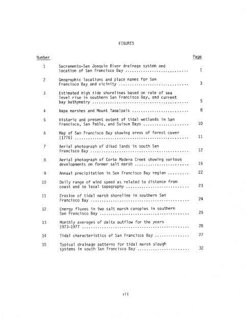
FIGURES<br />
Number<br />
1 Sacramento-<strong>San</strong> Joaquin River drainage system and<br />
location <strong>of</strong> <strong>San</strong> <strong>Francisco</strong> <strong>Bay</strong> ..........................-. 1<br />
Geographic locations and place names for <strong>San</strong><br />
<strong>Francisco</strong> <strong>Bay</strong> and vicinity ............................... 3<br />
Estimated high tide shorelines based on rate <strong>of</strong> sea<br />
level rise in southern <strong>San</strong> <strong>Francisco</strong> <strong>Bay</strong>, and current<br />
bay bathymetry ........................................... 5<br />
Napa marshes and Mount Tamalpais ......................... 8<br />
Historic and present extent <strong>of</strong> tidal wetlands in <strong>San</strong><br />
<strong>Francisco</strong>, <strong>San</strong> Pablo, and Suisun <strong>Bay</strong>s .................... 10<br />
Map <strong>of</strong> <strong>San</strong> <strong>Francisco</strong> <strong>Bay</strong> showing areas <strong>of</strong> forest cover<br />
(1776) ................................................... 11<br />
Aerial photograph <strong>of</strong> diked lands in south <strong>San</strong><br />
<strong>Francisco</strong> <strong>Bay</strong> ............................................ 12<br />
Aerial photograph <strong>of</strong> Corte Madera Creek showing various<br />
developments on former salt marsh 15<br />
........................<br />
Annual precipitation in <strong>San</strong> <strong>Francisco</strong> <strong>Bay</strong> region ......... 22<br />
Daily range <strong>of</strong> wind speed as related to distance from<br />
coast and to local topography ............................ 23<br />
Erosion <strong>of</strong> tidal marsh shoreline in southern <strong>San</strong><br />
<strong>Francisco</strong> <strong>Bay</strong> ............................................ 2 4<br />
Energy fluxes in two salt marsh canopies in southern<br />
<strong>San</strong> <strong>Francisco</strong> <strong>Bay</strong> ........................................ 25<br />
Monthly averages <strong>of</strong> delta outflow for the years<br />
1973-1977 ................................................ 26<br />
<strong>Tidal</strong> characteristics <strong>of</strong> <strong>San</strong> <strong>Francisco</strong> <strong>Bay</strong> ............... 27<br />
Typical drainage patterns for tidal marsh slough<br />
systems in south <strong>San</strong> <strong>Francisco</strong> <strong>Bay</strong> ....................... 32


