
Create successful ePaper yourself
Turn your PDF publications into a flip-book with our unique Google optimized e-Paper software.
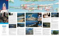
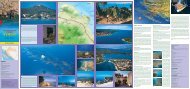
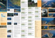
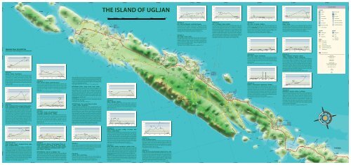
THE ISLAND OF UGLJAN<br />
TOURISM<br />
Surgery<br />
Hotel<br />
Restaurant<br />
Tourist Office<br />
LEGEND<br />
Diving club<br />
Berth<br />
Ferry pier<br />
Lighthouse<br />
Camp<br />
Berth for big boats<br />
TRAIL NO. 14<br />
Kali – Veliki vrh (Big peak) –uvala Mala Lamjana<br />
The trail leads from Kali uphill, across <strong>the</strong> main road to <strong>the</strong> cemetery.<br />
Somewhat over <strong>the</strong> cemetery it leads left on macadam road and<br />
across olive groves to Velik vrh. Immediately after <strong>the</strong> peak it leaves<br />
<strong>the</strong> macadam road and descends to a drystone wall to reach <strong>the</strong> next<br />
macadam and <strong>the</strong>n left downhill to <strong>the</strong> sea and <strong>the</strong> fishery.<br />
Trail length 4.1 km, climb 85 m, descent 85 m, walking 1.15 h.<br />
TRAIL NO. 15<br />
Kali – Drage – Kanali – Preko<br />
Starting from Kali, <strong>the</strong> trail leads uphill to <strong>the</strong> cemetery, fur<strong>the</strong>r straight<br />
on to <strong>the</strong> large building next to <strong>the</strong> crossing, <strong>the</strong>n to <strong>the</strong> right on<br />
macadam road across olive groves to <strong>the</strong> crossing. It turns left at <strong>the</strong><br />
crossing and follows rough macadam across partly abandoned olive<br />
groves to reach an asphalted road. It takes <strong>the</strong> asphalted road and<br />
proceeds on <strong>the</strong> right to reach Preko.<br />
Trail length 5.6 km, climb 80 m, descent 80 m, walking 1.45 h.<br />
STAZA BR 16<br />
Kali – Sv. Pelegrin – Nehaj – Kukljica<br />
The trail goes straight ahead from Kali, onto Mali Lamjan beach, and<br />
proceeds to <strong>the</strong> main road, crosses <strong>the</strong> road and fur<strong>the</strong>r on asphalted<br />
road to <strong>the</strong> branching road named «Put. sv. Pelegrina» (St. Pelegrin<br />
Road) and goes uphill. A paved road intersects <strong>the</strong> macadam road and<br />
<strong>the</strong> trail keeps <strong>the</strong> macadam to <strong>the</strong> peak, to sv. Pelegrin chapel. A rough<br />
macadam road <strong>the</strong>n leads to a better one and <strong>the</strong> trail goes right onto<br />
<strong>the</strong> better macadam road that after a short time becomes rough again,<br />
and, at <strong>the</strong> end, a narrow trekking trail. The trail continues straight on<br />
past Mount Nehaj, where it again leads to a rough macadam road and<br />
<strong>the</strong>n proceeds to <strong>the</strong> main road, crosses it and leads to Kukljica.<br />
Trail length 5.4 km, climb 103 m, descent 103 m, walking 1.45 h.<br />
TRAIL NO. 17<br />
Kali – Otrić – Sv. Jerolim – Kukljica<br />
Starting from <strong>the</strong> locality <strong>the</strong> trail coasts <strong>the</strong> sea to reach Zaotrić Cove<br />
(Sculpture Park), and <strong>the</strong>n uphill to <strong>the</strong> main road, straight ahead on<br />
<strong>the</strong> road (ATTENTION! Heavy traffic.) for about 1700 m to take a left<br />
bend and reach <strong>the</strong> trekking trail and <strong>the</strong>n arrive in Kostanj Cove. A<br />
good trail coasts <strong>the</strong> sea past sv. Jerolima (St. Jerome) chapel, across<br />
Gnojišća Cove, around Mount Zaglav and into Kukljica.<br />
Trail length 6.2 km, climb 20 m, s descent 20 m, walking 2 h.<br />
TRAIL NO. 20<br />
Drage – Fratar<br />
The road leads from Drage to a new road penetrating <strong>the</strong> woods and<br />
descends briefly to <strong>the</strong>n climb across olive groves. After about 1 km to<br />
<strong>the</strong> left <strong>the</strong> trail that connects this one to trail no.5 branches <strong>of</strong>f, while<br />
this trail continues upward to <strong>the</strong> pass and <strong>the</strong>n right to continue on<br />
<strong>the</strong> branching at Fratar (183 m) and fur<strong>the</strong>r to Sv. Mihovil.<br />
Trail length 1.51 km, climb 70 m, descent 00 m, walking 25 min.<br />
CULTURE<br />
Gas station<br />
Beaches blue flag<br />
Free climbing<br />
Fortification<br />
Church<br />
Monastery<br />
ROADS<br />
Main roads<br />
Local roads<br />
O<strong>the</strong>r roads<br />
Numbered biking trails<br />
Numbered walking trails<br />
Sailing route<br />
NATURE<br />
Berth for small boats<br />
Prohibited berthing<br />
Viewpoint<br />
Hill<br />
Cave<br />
Waterflow<br />
Sea depth<br />
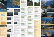
TREKKING TRAIL DESCRIPTION<br />
The description <strong>of</strong> all <strong>the</strong> trails begins on <strong>the</strong> main <strong>island</strong> road<br />
Inhabited area<br />
TRAIL NO. 1<br />
Lukoran – Turkija – Šćah (286 m)<br />
The trail starts on <strong>the</strong> main <strong>island</strong> road. It leads first on <strong>the</strong><br />
asphalted road by <strong>the</strong> cemetery to <strong>the</strong> center <strong>of</strong> Turkija village.<br />
It continues on a marked trail between <strong>the</strong> houses to <strong>the</strong><br />
south and reaches <strong>the</strong> last houses. A few meters after <strong>the</strong>se<br />
last houses <strong>the</strong>re is a right branching between drystone walls<br />
leading uphill. Then <strong>the</strong> trail crosses macchia and continues to<br />
<strong>the</strong> pass between Šćah and Plišivac, on <strong>the</strong> right along <strong>the</strong> ridge<br />
to reach <strong>the</strong> peak.<br />
Trail length 3.8 km, climb 250 m, descent 000 m, walking1.15 h.<br />
TRAIL NO. 2<br />
Preko – Sv. Mihovil (250 m) (parking lot) Željina stijena<br />
(rock)–uvala Željina (Cove) – Sv. Mihovil (St. Michael)<br />
The trail leads from <strong>the</strong> parish church straight upward to <strong>the</strong><br />
main road, across <strong>the</strong> road and between drystone walls to <strong>the</strong><br />
asphalted road that leads towards Sv. Mihovil and <strong>the</strong>n again<br />
on <strong>the</strong> asphalted one upward across olive groves and fur<strong>the</strong>r on<br />
to <strong>the</strong> parking lot on Sv. Mihovil. It is possible to go right from<br />
<strong>the</strong> parking lot and straight onto Sv. Mihovil or left, across high<br />
macchia for about 100 m, and <strong>the</strong>n right through pinewood and<br />
down across a deep gorge to come under <strong>the</strong> rock (suitable for<br />
climbing). Then it continues along <strong>the</strong> lower edge <strong>of</strong> <strong>the</strong> rock for<br />
about 350 m and down to Željina vela Cove and again proceeds<br />
fur<strong>the</strong>r until under <strong>the</strong> rocks and <strong>the</strong>n left (trail partly ensured by<br />
wire cable) and upward to <strong>the</strong> pass and to Sv. Mihovil.<br />
Trail length 5.5 km, climb 250 m, descent 250, walking 1.50 h.<br />
TRAIL NO. 4<br />
Preko – Završće – Kanali – uvala Svitla (Cove)<br />
250 m west to <strong>the</strong> crossing leading to <strong>the</strong> ferryboat a macadam road<br />
branches uphill across Završće pass (multiple crossing). At <strong>the</strong> crossing<br />
it leads gently downhill and southwest to intersect a macadam road<br />
and climb across <strong>the</strong> pass and again down between olive groves to <strong>the</strong><br />
end <strong>of</strong> <strong>the</strong> road. Fur<strong>the</strong>r on <strong>the</strong>re is a visible trekking trail downward<br />
to <strong>the</strong> cove.<br />
Trail length 2.8 km, climb 105 m, descent 105 m, walking 1 h.<br />
TRAIL NO 5<br />
Kali – Križice – Kanali – (Rt (cape)Skrajno)<br />
– Zarunjiški – (Kobiljak 199 m) – Mrđina<br />
The trail begins from <strong>the</strong> parish church and leads upward to <strong>the</strong> main<br />
road, <strong>the</strong>n across <strong>the</strong> road to <strong>the</strong> cemetery to reach <strong>the</strong> large building<br />
next to <strong>the</strong> crossroad. It <strong>the</strong>n continues southwest to <strong>the</strong> end <strong>of</strong> <strong>the</strong><br />
canyon (canals – branching for Cape Skrajno – macadam road) and<br />
<strong>the</strong>n uphill on a partly paved road (branching for Kobiljak) to reach <strong>the</strong><br />
pass (end <strong>of</strong> road) and <strong>the</strong>n fur<strong>the</strong>r between high drystone walls and<br />
down to <strong>the</strong> cove.<br />
Trail length 4.6 km, climb 199 m, descent 199 m, walking 1.30 h.<br />
again and keeps to <strong>the</strong> road until <strong>the</strong> crossing. At <strong>the</strong> crossing it branches<br />
to <strong>the</strong> left to <strong>the</strong> end <strong>of</strong> a rough macadam road. From <strong>the</strong>re <strong>the</strong> trail takes<br />
<strong>the</strong> northwest direction and past vrh Nehaj (peak) to a macadam road,<br />
remains on <strong>the</strong> road until <strong>the</strong> first left branching and uphill to sv. Pelegrin<br />
chapel. It proceeds downward across olive groves to an asphalted road<br />
and along <strong>the</strong> asphalted road to Kali.<br />
Trail length 8.1 km, climb 110 m, descent 110 m, walking 2.30 h.<br />
SECTION Kali – Križice – Drage – Kanali – Polje – Turkija<br />
The trail leads from <strong>the</strong> parish church in Kali and upward to <strong>the</strong><br />
main road, <strong>the</strong>n across <strong>the</strong> road to <strong>the</strong> cemetery and fur<strong>the</strong>r to <strong>the</strong><br />
large building next to a crossing. At <strong>the</strong> crossing it turns right on<br />
macadam road and among olive groves to ano<strong>the</strong>r crossing, <strong>the</strong>n<br />
left to <strong>the</strong> turnaround, and fur<strong>the</strong>r along a narrow macadam among<br />
partly abandoned olive groves to <strong>the</strong> asphalt. It continues left on <strong>the</strong><br />
asphalted road for 100 m, and straight on a macadam road for 150 m<br />
to reach <strong>the</strong> «T» crossing. The trail <strong>the</strong>n leads right along <strong>the</strong> trekking<br />
trail and between drystone walls<br />
ATTENTION! The trail is overgrown with macchia). The trail continues<br />
to <strong>the</strong> macadam road turnaround and <strong>the</strong>n immediately along <strong>the</strong><br />
trekking trail to Turkija village.<br />
Trail length 6.7 km, climb 90 m, walking 2 h.<br />
SECTION Turkija – Doci –uvala Prtljug– Fortošćina<br />
– Ljokine – Muline – Gornje Selo<br />
The trail leads from <strong>the</strong> village and shortly on asphalted road, at <strong>the</strong><br />
first bend right and after 50 m left on a new macadam road. At a sharp<br />
right bend <strong>the</strong> trail branches left (trekking trail) and fur<strong>the</strong>r on between<br />
drystone walls and across olive groves to a macadam road to proceed to<br />
<strong>the</strong> sea (Prtljug Cove). It coasts <strong>the</strong> sea to <strong>the</strong> end <strong>of</strong> <strong>the</strong> cove and <strong>the</strong>n<br />
takes <strong>the</strong> northwest direction to <strong>the</strong> asphalt. It follows <strong>the</strong> asphalted<br />
road to <strong>the</strong> right for about 500 m, and, at <strong>the</strong> branching left to Fortošćina<br />
village, and left again towards <strong>the</strong> sea for about 700 m, and right along a<br />
macadam road to Ljokine village. From <strong>the</strong>re <strong>the</strong> trail takes a left turn to<br />
<strong>the</strong> sea (St Cosmus and Damian chapel), coasts <strong>the</strong> sea along Štrmeljiva<br />
Cove to Pavlešina Cove where <strong>the</strong>re is a small port. It coasts <strong>the</strong> sea again<br />
to reach Dražica Cove and fur<strong>the</strong>r to <strong>the</strong> indented Južna luka Cove. It <strong>the</strong>n<br />
proceeds northwest across high macchia to reach <strong>the</strong> o<strong>the</strong>r shore and <strong>the</strong><br />
village <strong>of</strong> Muline. It leaves <strong>the</strong> village and continues downward between<br />
drystone walls to Gornje Selo and Svih svetih (All Saints) chapel.<br />
Trail length 12.5 km, climb 30 m, descent 45 m, walking 3.45 h.<br />
TRAIL NO. 9<br />
Ugljan – Batalaža – Dražica<br />
The road leads from Ugljan locality to Batalaga village. It <strong>the</strong>n turns<br />
left and onto a trekking trail to <strong>the</strong> main road, across it, and <strong>the</strong>n on<br />
an asphalted road that becomes macadam after about 300 meters. It<br />
continues on <strong>the</strong> macadam road to reach Guduče village and fur<strong>the</strong>r<br />
again to Dražica Cove.<br />
Trail length 2.7 km, climb 20 m, descent 20 m, walking 50 min.<br />
STAZA BR 18<br />
Kali – Preko – Poljana – Sutomišćica<br />
The trail leads from Kali, along <strong>the</strong> northwest coast, to Preko. It proceeds<br />
along <strong>the</strong> coast to Poljana village. It starts climbing from Poljana (from<br />
<strong>the</strong> cove) and leads on a macadam road to reach <strong>the</strong> first houses in<br />
Sutomišćica village, and <strong>the</strong>n on paved road that leads down among<br />
summer houses.<br />
Trail length 5 km, climb 20 m, descent 20 m, walking 1.30 h.<br />
TRAIL NO. 19<br />
Kukljica – Gospa Snježna –Sabuša Cove – Kukljica<br />
The trail leaves Kukljica and coasts southward to Cape Glavica and<br />
fur<strong>the</strong>r to Gospe Snježne (Our Lady <strong>of</strong> <strong>the</strong> Snows) chapel. It continues<br />
coasting for about 350 m to reach a pier and <strong>the</strong>n right along <strong>the</strong> trail<br />
between <strong>the</strong> drystone wall to <strong>the</strong> main road. It <strong>the</strong>n follows <strong>the</strong> road<br />
left for 600 m and <strong>the</strong>n right to <strong>the</strong> end <strong>of</strong> a macadam road. It continues<br />
on <strong>the</strong> trekking trail past <strong>the</strong> drystone wall to <strong>the</strong> sea, coasting <strong>the</strong><br />
shores to reach Velika Sabuša Cove and fur<strong>the</strong>r to Mala Sabuša Cove.<br />
From <strong>the</strong>re it climbs uphill to a macadam road and follows it to reach<br />
<strong>the</strong> main road, crosses it and comes to Kukljica.<br />
Trail length 6.8 km, climb 40 m, s descent 40 m, walking 2.15.<br />
TRAIL NO. 21<br />
Ugljan – Čeprljada – Fortošćina – Ljokine<br />
– Guduče – Donje Selo – Muline – Gornje Selo<br />
The trail starts at Ugljan port and coasts around Cape Tratica to Čeprljada<br />
Cove, and <strong>the</strong>n climbs to <strong>the</strong> village, intersects <strong>the</strong> main <strong>island</strong> road<br />
to reach Strihine village and fur<strong>the</strong>r on to Ivanac village. It turns right<br />
from <strong>the</strong> village to reach Fortošćina village and <strong>the</strong>n left towards <strong>the</strong><br />
sea for about 700 m, <strong>the</strong>n right on a macadam road to Ljokine village. It<br />
<strong>the</strong>n proceeds straight on to Funčići village, <strong>the</strong>n Guduče and fur<strong>the</strong>r to<br />
Donje Selo. It continues left from <strong>the</strong> sea to reach <strong>the</strong> deep Južna luka<br />
Cove, <strong>the</strong>n northwest through high macchia to reach <strong>the</strong> o<strong>the</strong>r shore<br />
and coast <strong>the</strong> shores to reach Muline village. The trail leaves <strong>the</strong> village<br />
to climb between drystone walls to Gornje Selo.<br />
Trail length 8.7 km, climb 30 m, descent 30 m, walking 2.30 h.<br />
TRAIL NO. 22<br />
Sutomišćica – Goričina – Križina – Sv. Mihovil<br />
The trail leaves Sutomišćica Cove and climbs to reach <strong>the</strong> church <strong>of</strong> sv.<br />
Fume. 50 m before reaching <strong>the</strong> church it takes a left bend along <strong>the</strong><br />
village road for about 500 m, <strong>the</strong>n to <strong>the</strong> right and upward on <strong>the</strong> main<br />
<strong>island</strong> road. It intersects <strong>the</strong> road and climbs to a macadam road that<br />
becomes a large country trail that crosses olive groves to reach a vast<br />
terrace– Polje. Across <strong>the</strong> terrace <strong>the</strong> trail proceeds on macadam road<br />
and gently climbs <strong>the</strong> slopes in <strong>the</strong> direction <strong>of</strong> <strong>the</strong> antenna system<br />
on Sv. Mihovil. Shortly after <strong>the</strong> beginning <strong>of</strong> <strong>the</strong> climb <strong>the</strong> trail takes<br />
a sharp turn to <strong>the</strong> left, and after 300 m it joins <strong>the</strong> asphalted road that<br />
leads to sv. Mihovil peak (250 m).<br />
Trail length 4.4 km, climb 250 m, descent 00, walking 1.30 h.<br />
Map Author<br />
Nataša Kapov, dipl. ing.<br />
za LEMAX d.o.o.<br />
Map Assistant<br />
Darko Ohnjec<br />
Geographic Data<br />
TK 25 Državna geodetska uprava<br />
Hrvatski hidrografski institut<br />
Gauss-Krüger Projection<br />
Scale<br />
1 : 30 000<br />
Year<br />
2006.<br />
TRAIL NO. 3 and 3a)<br />
Preko – Završće – Kanali – Vela glava (236 m) – Mala<br />
glava – Sv. Mihovil (250 m)<br />
250 m west from <strong>the</strong> turn for <strong>the</strong> ferryboat, a macadam road<br />
branches upward across Završće pass (multiple crossing). At <strong>the</strong><br />
crossing, <strong>the</strong> trail leads south and descends gently and intersects<br />
an abandoned macadam road. It follows <strong>the</strong> signs for about 500<br />
m until <strong>the</strong> crossing where trail 3a) branches <strong>of</strong>f and leads to Fratar<br />
(183 m), while this trail continues to <strong>the</strong> right and leads to <strong>the</strong> end<br />
<strong>of</strong> <strong>the</strong> road. It proceeds north-northwest along <strong>the</strong> drystone wall<br />
and upward on <strong>the</strong> ridge, <strong>the</strong>n along <strong>the</strong> ridge to Vela glava peak<br />
(mountain refuge). The trail leaves Vela glava ridge and proceeds to<br />
Mala glava and fur<strong>the</strong>r on to reach <strong>the</strong> parking lot under Sv. Mihovil<br />
and <strong>the</strong>n on a road with walls at <strong>the</strong> sides to reach <strong>the</strong> top.<br />
Trail length 4.1 km, climb 250 m, walking 1.30 h.<br />
TRAIL NO. 6<br />
Island Transversal – Ždrelac – Veli vrh (peak) (123 m) – Sv.<br />
Pelegrin (92 m) – Križice – Drage – Kanali – Polje – Turkija<br />
– Doci –uvala Prtljug (Cove)– Ljokine – Sv. Kuzma i Damjan<br />
(St. Cosmus and Damian) –uvala Dražica (Cove) – Južna<br />
luka – Muline – Gornje Selo<br />
SECTION Ždrelac – Veli vrh– Sv. Pelegrin – Kali<br />
The trail begins at <strong>the</strong> bridge across Ždrelac Channel. It stays on asphalted<br />
road for 450 m. It <strong>the</strong>n takes a left turn on <strong>the</strong> macadam road for ano<strong>the</strong>r<br />
450 m and reaches <strong>the</strong> end <strong>of</strong> <strong>the</strong> road. It continues fur<strong>the</strong>r along <strong>the</strong><br />
drystone wall coasting <strong>the</strong> shore until Velika Sabuša Cove to proceed to<br />
Mala Sabuša Cove. It leaves <strong>the</strong> cove and climbs to <strong>the</strong> asphalted road<br />
and stays on it for about 200 m, <strong>the</strong>n left on a macadam road for 350 m.<br />
It <strong>the</strong>n climbs from <strong>the</strong> drystone wall, past Veli vrh to a macadam road<br />
TRAIL NO. 7<br />
The trail leads from <strong>the</strong> locality <strong>of</strong> Ugljan and takes <strong>the</strong> road towards<br />
Batalaža village and fur<strong>the</strong>r on to Sušica village and cove. It proceeds<br />
from <strong>the</strong> cove and climbs along <strong>the</strong> village trail to reach Svih svetih (All<br />
Saints) church and fur<strong>the</strong>r on <strong>the</strong> road to Gornje Selo.<br />
Trail length 2.8 km, 30 m, descent 00 m, walking 45 min.<br />
TRAIL NO. 8<br />
Lukoran – Doci –uvala Prtljug<br />
The trail leaves Lukoran port, crosses <strong>the</strong> main road and leads to a<br />
macadam road, <strong>the</strong>n briefly straight on and <strong>the</strong>n to <strong>the</strong> right across<br />
olive groves and gardens to reach <strong>the</strong> sea and Prtljug Cove.<br />
Trail length 3.5 km, climb 40 m, descent 40 m, walking 1.00 h.<br />
TRAIL NO. 10<br />
Uvala Lukoran – Sv. Lovro – Turkija – Sv. Fumja – Mali<br />
Lukoran – uvala Lukoran<br />
The trail leads from Lukoran port up to <strong>the</strong> church <strong>of</strong> sv. Lovre (St.<br />
Lawrence). It crosses <strong>the</strong> main road east from <strong>the</strong> church and <strong>the</strong>n goes<br />
upward on macadam road and at <strong>the</strong> bend takes a left turn. It continues<br />
on macadam until <strong>the</strong> asphalt and <strong>the</strong>n goes right to Turkija village,<br />
crosses <strong>the</strong> village and fur<strong>the</strong>r on <strong>the</strong> trekking trail across abandoned<br />
olive groves to <strong>the</strong> macadam road. On <strong>the</strong> macadam road it goes left to<br />
reach <strong>the</strong> main road, <strong>the</strong>n crosses it and continues until sv. Fumje church.<br />
Left from <strong>the</strong> church it takes <strong>the</strong> macadam road to reach Mali Lukoran<br />
village, <strong>the</strong>n shortly to <strong>the</strong> right coasting <strong>the</strong> sea and left on macadam<br />
road, at <strong>the</strong> side <strong>of</strong> Mount Trpinje to reach Lukoran Cove.<br />
Trail length 6.2 km, climb 65 m, descent 65 m, walking 2.00 h.<br />
TRAIL NO. 11<br />
Preko – Polje – Grušine – Sutomišćica – Poljana – Preko<br />
Starting from <strong>the</strong> parish church <strong>the</strong> trail goes uphill, across <strong>the</strong> main road<br />
and onto <strong>the</strong> asphalted one. It <strong>the</strong>n reaches a sharp bend, and shortly<br />
after turns right on <strong>the</strong> asphalted road that leads left while <strong>the</strong> trail<br />
proceeds straight ahead on macadam road to <strong>the</strong> «T» crossing. It <strong>the</strong>n<br />
continues briefly on <strong>the</strong> left and <strong>the</strong>n right onto <strong>the</strong> trekking trail that<br />
leads between drystone walls to reach <strong>the</strong> following macadam road.<br />
(ATTENTION! Here <strong>the</strong> trail is partly overgrown with macchia). The trail<br />
takes <strong>the</strong> macadam and goes right to <strong>the</strong> main road, <strong>the</strong>n crosses it to<br />
take <strong>the</strong> road that leads to Sutomišćica Cove. It briefly coasts <strong>the</strong> sea<br />
and <strong>the</strong>n turns right between houses and uphill on paved road. It <strong>the</strong>n<br />
reaches a macadam road and proceeds to Poljana village and fur<strong>the</strong>r<br />
coasting <strong>the</strong> sea comes to Preko.<br />
Trail length 6.2 km, climb 96 m, descent 96 m, walking 2 h.<br />
TRAIL NO. 12<br />
Preko – Sv. Mihovil (250 m)<br />
The trail leads straight ahead from <strong>the</strong> parish church and uphill to <strong>the</strong><br />
main road, crosses it and continues between drystone walls to <strong>the</strong><br />
asphalted road that leads toward Sv. Mihovil (St. Michael), <strong>the</strong>n on <strong>the</strong><br />
asphalted road upward across olive groves and fur<strong>the</strong>r on to reach <strong>the</strong><br />
parking lot on Sv. Mihovil. It proceeds to <strong>the</strong> right from <strong>the</strong> parking lot<br />
and upward to <strong>the</strong> fort at <strong>the</strong> very top.<br />
Trail length 2.8 km, climb 250 m, walking 2.00 h.<br />
TRAIL NO. 13<br />
Preko – Vrh (137 m) Završće (peak)– Glavine (177 m) – Kali<br />
The trail leads from <strong>the</strong> parish church in Preko to <strong>the</strong> main road, crosses<br />
<strong>the</strong> road and climbs to <strong>the</strong> asphalted road to <strong>the</strong>n proceed left on a<br />
macadam road across Mount Vrh and fur<strong>the</strong>r on to Završće crossing. It<br />
proceeds in <strong>the</strong> same direction on macadam road, past a restaurant and<br />
climbs straight to Glavina peak to continue onwards on rough macadam<br />
road and <strong>the</strong>n partly on paved road downwards to <strong>the</strong> cemetery. Before<br />
reaching <strong>the</strong> cemetery it turns left into <strong>the</strong> locality <strong>of</strong> Kali.<br />
Trail length 4.3 km, climb 177 m, descent 177 m, walking 1.30 h.