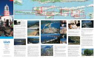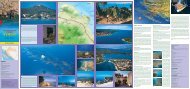
THE ZADAR REGION
THE ZADAR REGION
THE ZADAR REGION
- No tags were found...

Create successful ePaper yourself
Turn your PDF publications into a flip-book with our unique Google optimized e-Paper software.
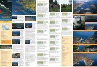
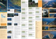
Trail no. 15SALI - VELA PLO»A -KRU©EVO POLJE (field)Trail length 3.2 kmClimb 80 mDescent 40 mWalk 1 hTrail difficulty - easy.The trail leaves the center of the locality and reaches the cemetery. At the crossing, whichis 100 m before the cemetery, it takes to the l. first on asphalted road and then further ona field trail across gardens and olive groves. It crosses the main island road, and then furtheron asphalt in the s. direction. Our trail branches at a distance of about 1 km from themain road. It proceeds gently upwards, across the pass and then onto the field calledKruπevo polje.Trail no. 16SALI - VELA PLO»A - »UHPOLJE - DUGONJIVA - MALAPROVERSATrail length 7.9 kmClimb 70 mDescent 70 mWalk 2.30hTrail difficulty - easy.The trail leaves the center of the locality and reaches the cemetery. At the crossing, 100 min front of the cemetery, it continues on asphalt and then on a trail that crosses gardensand olive groves, the main island road and continues on asphalt in the s. direction. At adistance of about 1 km from the main road, the trail branches to the left, and after about900 m the main road again branches. The trail again takes the l. diverging (the r. divergingleads to landfills), and after the asphalted road it continues on macadam road whichleads partly between dry stone wall fences and partly through abandoned fields for about3 km. At the r. diverging between two prominent peaks (Gomiljak to the r. and Veli Vrh tothe l.) the trail reaches the following diverging and proceeds l. up to the sea, then alongthe coast to the cape where there are remains of villae rusticae - Mala Proversa Passage.Trail no. 17SALI - VELA PLO»A - »UHPOLJE (field) - MAVAR - MALIDO»IΔ - SALITrail length 9 kmClimb 70 mDescent 70 mWalk 3hTrail difficulty - easy.The trail leaves the center of the locality and climbs to the cemetery. At the crossing, 100m in front of the cemetery, it continues on asphalt and then on a trail that crosses gardensand olive groves, the main island road and continues on asphalt in the s. direction.The trail branches at a distance of about 1 km from the main road. It proceeds l. forabout 900 m, and then the main road branches again. The trail takes the l. diverging (ther. diverging leads to the landfills), and after the asphalted road it continues on macadamroad for about 3 km., leading partly between dry stone wall fences and partly throughabandoned fields. At the r. diverging of about 500 m there is a sharp right bend leadingto the cove. The trail leads l. and gently upwards, across a vast clearing to the left, thenon a rough road through olive groves to reach a good macadam road. It stays on themacadam road to reach a crossing. At the crossing it turns l. and climbs gently at thepoint where it connects at a right angle with the Sali- Mala Proversa road taken earlier.The trail keeps on the road that goes r. to reach Sali.Trail no. 8ÆMAN - MALO JEZERO -VELO JEZERO - TRASOMVODOVODA (the watersupply route) - ÆMANTrail length 8.1 kmClimb 120 mDescent 120 mWalk 2.30hTrail difficulty - averageThe trail follows the road from Æman and reaches the main island road, intersects andcontinues on an asphalted road upwards to reach a pass where the road branches. It thentakes the l. branching downwards to reach a vast and deep valley with Malo jezero (smalllake), and along its banks along the water supply buildings and the desalinator up to Velojezero (big lake). The same trail is taken to go back from V.jezero to the desalinator andthen r. along the water supply route to reach the road and then downwards along theroad in order to reach the main island road. The trail turns l. on that same road and afterabout 1 km reaches Æman.Veliko and Malo jezero (a big and small lake that are exceptionally interesting karst formationswith rich and fertile land and sources of drinking water that supply the entireisland. The water is brackish (contains a good amount of salt) and therefore desalinatorshave been put up.Trail no. 9ÆMAN - MALO JEZERO (lake)- DUGO POLJE (field) -TELA©ΔICATrail length 15 kmClimb 100 mDescent 100 mWalk 4.30hTrail difficulty - averageThe trail follows the road from Æman and reaches the main island road, intersects and continueson an asphalted road upwards to reach a pass where the road branches. It then takes thel. branching downwards to reach a vast and deep valley with Malo jezero (small lake), andalong its banks, the water supply buildings and the desalinator. About 150 m after the apparatusthere is a l. branching into the woods and then steeply upwards to reach a vast field(once an orchard). The trail crosses the meadow and goes l. through a vast pass and down tothe field called Dugo polje. It crosses the field and reaches an asphalted road, stays on theroad until it reaches the sea and then r. to the TelaπËica Nature Park entrance. It proceeds onmacadam road to the restaurant in TelaπËica Bay and further on until the lake called Mir.Trail no. 10ZAGLAV - »ELINJAK (198 M)Trail length 4.5 kmClimb 198 mWalk 1.30hTrail difficulty - average.The trail follows the road from Zaglav and reaches the main island road. After about 400m the trail takes a r. turn and proceeds on a concrete road to reach the crossing on thepass. At the crossing it continues l. on a bad macadam road to reach the last olive groves.After these groves it goes l. and climbs steeply to the very top of the peak that offers awonderful view of the entire surroundings.Trail no. 11OKO ZAGLAVSKOG VRHA(around Zaglav Peak)Trail length 4.13 kmClimb 30 mDescent 30 mWalk 1,15hTrail difficulty - easy.The trail starts from the center of Zaglav and nw. along the newly built macadam road tothe sea (Trstenica Cove). It continues in the se. direction, then s. and slightly upwards toreach the contour line around Zaglav Peak and back to Zaglav.Trail no. 12.NOVI ZAGLAV - OKOREBARA - SALITrail length 5.9 kmClimb 80 mDescent 80 mWalk 1.30 hTrail difficulty - easy.Leaving the gas station in N.Zaglav the trail follows the road leading to the main islandroad. About 150 m before the main road there is a l. macadam road branching. The trailtakes the branching that leads straight to the next crossing and then turns l. It follows thecontour line around Mount Rebro to reach the locality of Sali.Trail no. 13a) SALI - DOLAC - STRIHINAGRBA - MAGROVICA COVE -TELA©ΔICATrail length 13 kmClimb 130 mDescent 130 mWalk 4 hTrail difficulty - easy.The trail leaves the center of the locality and reaches the cemetery to climb to the mainisland road. Then r. for about 600 m and in front of the pass it takes a l. turn onto amacadam road and climbs upwards, then across the gentle passage downwards and acrosswell kept olive groves to the asphalted road that connects Sali and TelaπÊica. It then followsthe road to the l. for about 200 m to reach the sea (Magrovica Cove) and further toTelaπÊica Nature Park.b) SALI - DOLAC - MAGROVICA COVE - TELA©ΔICATrail length 12.5 kmClimb 90 mDescent 90 mWalk 3.45 hTrail difficulty - easy.The trail leaves the center of the locality and reaches the cemetery to climb to the mainisland road. It keeps the road and then to the r. for about 900 m up to an asphalted roadbranching for TelaπÊica Nature Park. Right before the branching there is a left divergingmacadam road. The trail continues on this road, crosses olive groves and goes straightdown to where the road becomes a trail. It keeps on this trail until the asphalt and proceedson asphalt to reach TelaπÊica Nature Park.Trail no. 14SALI DEBELA GRBA - FAR-FARIKULAC COVETrail length 2.7 kmClimb 130 mDescent 130 mWalk 1 hTrail difficulty - from easy to average.The trail leaves the center of the locality and reaches the cemetery to continue onto themain island road. It keeps on the road for about 200 m and then takes a l. diverging on amacadam road. It crosses olive groves and climbs to reach a pass between mounts V. andM. BerËastac. After the pass it descends slightly to reach the end of the road. From thereit proceeds on a well-visible trail down to Farfarikulac Cove.Abbreviations: n. - north / ne. - northeast / nw. - northwest / s. - south se. - southeast / sw. - southwest / e. - east /w. - west / l. - left / r. - right / m. - meter/ ha. - height above sea levelTrail no. 1.BOÆAVA - KAPELICA- SOLINE- SAKARUN COVE- CAPELOPATA - POLJE - VELI RAT -“PUNTA BJANKA “ LIGHT-HOUSE - MOST COVETrail length 11.8 kmClimb 120 mDescent 120 mWalk 3.30hTrail difficulty - easyTake the trail from the port of Boæava towards the cemetery. Continue from the cemeteryand between the dry stone walls and through the olive groves, first across the larger trailfor agricultural vehicles, which after about ten minutes changes into a village trail ascendingslightly along the n. slopes of Mount Kapelica (135 m) until the pass is reached wherea telecommunication base station has been built. Cross the pass and proceed down toSoline village. Remain shortly along the shores to reach the church, and from the churchonto a well-visible transmitter. Passing by it, cross the asphalted road and continuebetween the dry stone walls down to a large beach (Sakarun Cove). Follow the beach tothe end to proceed on a macadam road next to the sea, around Cape Lopata, and furtheron to the west along the sea to Polje hamlet. Again cross the asphalted road and godown to the sea. Follow the coast to reach Veli rat. Cross the locality to reach the portand the macadam road. Turn slightly left and up the asphalted road to reach the sea(Slatine Cove). A few minutes after having left the cove, a macadam road branches fromthe asphalt. It is possible to proceed on the asphalt to reach Veli Rat lighthouse (built in1849) and further on the macadam to Most Cove, or along the macadam to the sea(Suπica Cove) and from the cove l. along the magnificent pine tree-lined path to the lighthouseand further on to Most Cove.Most Cove is called so for the narrow piece of land that connects Tisno and Okljuk. Itis an exceptionally interesting natural product of large grains of sand and enormousdeposits of dry sea grass creating extraordinarily interesting shapes that the human handwould never have been able to create. Ii is worthwhile to stroll along the n. beach andaround Cape Suhi and the rough beach of ”ValaËin Æal”. Attention should be paid here tothe layers of rock in the shallows where nature has created very interesting shapes.Trail no. 2BOÆAVA - POLJE - ©IPNATACOVE - ST. NEDILJA COVE -BOÆAVATrail length 2.7 kmClimb 40 mDescent 40 mWalk 1hTrail difficulty - easyProceed from the port in Boæava to the church, and after having passed around 200 m gol. into the fields. Cross the fields to reach an asphalted road turn r. on the asphalted road.About 300 meters onwards there is an insignificant-looking branching to the l. whichbrings to the olive groves, cross the groves and reach the coast. The constructed promenadetakes the trail around St. Nedilja Cape and back to Boæava.Trail no. 3BOÆAVA - OPATI»INA COVE -GRU©EVICA COVE - M.GOSPA - DRAGOVE -PAPRENICA COVE - LUKACOVE - BOÆAVATrail length 8.3 kmClimb 158 mDescent 158 mWalk 3.30 hTrail difficulty - averageFrom the center of Boæava and past Hotel Boæava the trail proceeds next to the sea, acrossOpatiËina Bay where there is a concrete beach, and further along the coast to GruπevicaCove. Shortly after having left the cove the trail takes a bend to the r. and rises steeply toM.Gospa chapel (158 m). From the chapel it shortly takes a large trail and then l. across adense and steep valley along the contour line to reach the village of Dragove. Dragove isan exceptionally interesting old village with a large cistern and a church on the highground.Then the trail leads s. from the church and along a concrete trail to the asphalted road. Ittakes the road in direction s. to reach a sharp right bend. Here it leaves the asphalt andgoes down the old wine route to reach Paprenica Cove where an abandoned military horizontaltunnel for boats can be seen from a distance. The trail skirts the tunnel from thetopside and then descends to the sea. The trails goes further on along the sea and acrossLuka Cove with its lovely beach and proceeds across the coves of Gruπevica and OpatiËinato return to Boæava.Trail no. 4a) BRBINJ - RAZVR©JE -BRBI©ΔICA COVETrail length 3.9 kmClimb 140 mDescent 140 mWalk 1.30 hTrail difficulty - easy.The trail starts from the church in Brbinj. It briefly takes the road upwards and then l. toJaz Cove. It proceeds upwards across the settlement to the main island road. It stays tothe l. on the road for about 400 m, and then r. and upwards on a concrete road (furtherasphalted) across Razvrπje Pass, and to the other side of the island to reach the cove witha lovely sandy beach.The trail branches at the last sharp l. bend before the beach and then to the r. It branchessharply downwards to reach extraordinarily interesting formations of plates shaped bythe waves from the open sea (KameniËina).b) BRBINJ - ZAVR©JE - LU©INJA DRAGATrail length 4.3 kmClimb 140 mDescent 10 mWalk 1.30hTrail difficulty - easyThe same description as under a) can be used to reach Zavrπje Pass. At the pass there is a r.branching of a new macadam that winds its way along the top of the island crag throughabandoned olive trees and dry stone walls leading to the main island road near the abandonedquarry on Luπinja Draga peak. The trail then takes the road to the r. and reachesthe road back to Brbinj or takes the asphalted main island road.Trail no. 5a) SAVAR - BRBINJ (on theroad) RAZVR©JE - U.BRBI©ΔICATrail length 4.6 kmClimb 140 mDescent 140 mWalk 1.40 hTrail difficulty - easy.The trail takes the main island road from Savar and remains on the road and then to ther. for about 1600 m. Then it turns l. on a concrete (and further asphalted) road and acrossRazvrπje Pass to the other side of the island to reach the cove with a lovely gravel beach.The trail branches at the last sharp l. bend before the beach and then to the r. It branchessharply downwards to reach extraordinarily interesting formations of plates shaped bythe waves from the open sea (KameniËina).b) SAVAR - BRBINJ (on the road) RAZVR©JE - LU©INJA DRAGATrail length 5 kmClimb 140 mDescent 10 mWalk 1.45 hTrail difficulty - easy.On leaving Savar the trail takes the main island road to the right and remains on it forabout 1600 m. Then it turns l. on a concrete road to Razvrπje Pass. At the pass there is aright branching of a new macadam road that winds its way along the top of the islandcrag through abandoned olive trees and dry stone walls leading to the main island roadnear the abandoned quarry on Luπinja Draga peak. Then it takes the road to the r. andreaches the same road back to Brbinj or takes the asphalted main island roadTrail no. 6SAVAR - on the road - STARIKAMENOLOM (old quarry) -VRH O©TRAVICA (peak) -STRA©NA PEΔ (cave)Trail length 11.3 kmClimb 275 mDescent 205 mWalk 4hTrail difficulty - difficultThe trail takes the main island road leaving Savar. Then l. on the road for about 5300 muntil the abandoned quarry Hrnjetine is reached. There r. for about 100 m up to a concretehouse, then l. and up a slightly visible macadam trail. The trail climbs steeply along the n.slopes of Mount ©kare, then across a vast cove to reach a large pass. There is a l. trail thatbranches for Oπtravica peak (275 m) while this trail continues s. along a vast plateau toreach a good viewpoint on bare and rocky high ground. The view here spreads overnumerous coves and steep shores overlooking the open sea. The trail continues steeplydownwards along very rough and crumbly ground up to the very entrance to the cave.Upon returning from the cave it is recommended to take the macadam road until theabandoned quarry.Trail no. 7ÆMAN - GLAVO»EVO POLJE(field) - SRIDNJE POLJE (field)Trail length 4 kmClimb 100 mDescent 100 mWalk 1.15 hTrail difficulty - easy.The trail leads from the cove itself and on a road to reach the main island road. It intersectsand leads on an asphalted road upwards to the pass where the road branches. Thetrail then proceeds on the r. branching and descends, crosses a macadam road at the edgesof a small field (GlavoËevo polje) and further on to another field called Sridnje polje.DUGI OTOK. On a sunny day in October ourjourney started in the ferryboat port leavingfor the most distant island of the Zadar localwaters - Dugi otok. At the ferryboat’sbypassing of the northwestern cape of theisland of Ugljan, a mountainous silhouetteof narrow and long land appeared on thehorizon. At first you think, ”This is just likethe Velebit”, only on the other side. Thisassociation will be revoked many times during your stay on the island.Enjoying the afternoon sun on the ship’s deck, and watching the islands of thearchipelago, we asked ourselves how it would have looked without these naturalbarriers. One prevents the penetration of cold and continental air fromthe north and the other, the insular one that protects the islands from theopen sea, gives the region a Mediterranean atmosphere with a marvellousarchipelago experience.A JOURNEY NORTH. After having left the ferryboat in the early morning hoursat the landing in Brbinj, famous from ancient times for its Glagolithic priests,vigilant guards of heritage, situated between the two protected coves of Jazand LuËina, we decided to turn north towards the part of the island withbeaches and coves. On theway we passed Dragove,an old island settlement ona hilltop whose name ismentioned in written documentsfrom the 14th century.The restored parishchurch of St. Leonard andthe cemetery stand on adistinguished locationwhich offers a view of theislets in front of andbehind Dumbovica. Thissmall place where time ismeasured only by yourfootsteps has resisted successfully to the force of urbanization, has preservedthe traditional way of living allowing only a few new houses to emerge in itsnarrow streets.We noticed the same on passing through Soline, VeruniÊ and Veli Rat. Thatimposing part of island nature attracts numerous visitors with its beauty. Smalllocalities are situated at the extreme northwestern part of the island, withtheir fishing ports facing the open sea and used by the local fishermen in theirdaily sea trips. The entire region of Δuna Cove connected with Pantera Covethrough a narrow canal isknown for its berths thatare traditionally used bynumerous seafarers lookingfor a safe anchoragefor the night.We hurried on to themost extreme point on theisland and Punta Bjankalighthouse at a height of42 m, being the highestlantern on the Adriatic,and built in 1849, duringthe Austro-Hungarian period.A twisting and narrowasphalted road struggled its way through the pine forest while after everybend we patiently expect contact with the sea. We soon noticed an extendedpeak of a lighthouse and the sound of the breaking waves hitting the rockycoast of the peninsula. The lighthouse area is prepared for guest accommodation.The small houses that remind us of Spanish architecture have been builton properly premises decorated with flowers. In the lighthouse yard there isthe stone chapel of sv. Nikola (St. Nicholas), the patron of sailors. Outdoorweddings are becoming more frequent in this romantic setting.Upon our return we were full of expectations and visited the beach in Sakarunfor which we had heard to be more beautiful than the famous Caribbeanbeaches! They were certainly right. The sunrays falling vertically on the beachiridescent with the white sand on the beach gave the sea a fantastic and clearturquoise colour. Our eyes absorbed these colours and it then seemed as ifthere were only two things in the world, the sea and us.The trip continues further to the gentle port of Boæava located in a smallcove surrounded by stone houses next to the sea. On the opposite side of thecove there are two newly built hotels. The locality was first mentioned in 1327under the name of Bosane, known for its fishing tradition and olive oil processing.A JOURNEY SOUTH. Themain road meanders fromBrbinj and passes theisland localities, the closestamong which is Savar.Descending down a steeproad to the sea we cometo the pre-Romanesquechurch of St. Pelegrin from1300. The church is situatedin the picturesque CapePelegrin, and then StraπnapeÊ (cave) visited in 1904by the Austro-Hungarianemperor Francis Joseph.The Forum in Zadar, as well as many palaces and churches in Venice and Rome,was built from the stone taken from here. We watch a fisherman in a smallpeninsula-shaped port taking caught fish out of the net. He explained to ushow he was setting aside for lunch the bigger fish such as sea bream andgrouper, while the rest was for the local cats that were already waiting forhim.We proceed southwards and the road leads across the narrowest part ofthe island where the sea can be seen from both sides. We watch with respectthe imposing open sea on one side while on the other a there is a gentlegroup of green islands and islets from where Rava and Iæ are as visible as thepalm of one’s hand. The view from the sea passes over to the mountains, andthe tallest one in front of us isVela Straæa (337 m) with a transmitteron its top. A ramp at thefoot of the road warns us thataccess is not permitted. Under themountain that descends steeplytowards the sea at the end ofRava Channel our view reachesthe picturesque locality of Lukawhich can be reaches by a markedtrail or an asphalted road thatleads directly to the boat landing.The next two localitiesof Æman and Zaglav areonly at a distance of a fewkilometres. The only gasstation in this part of theZadar archipelago is inZaglav.At the crossing of theroad that leads to thesouth of the island weleave Æman and take theopposite direction at thesign by the road with theinscription Æmansko jezero(Lake Æman). The narrow and winding road at the beginning seems to leadnowhere. But with a little patience, after going uphill and downhill, andbends that turn in all directions, across fields where special quality tomatoesare grown, vineyards and dense evergreen under bush. We arrived at two naturalphenomena, two Karst lakes, one bigger than the other, lakes that arefilled with water only in the rainy periods of the year. The Big and Small Lakeare exceptionally interesting Karst creations with rich soil and sources of drinkingwater that supplies the entire island. The water is brackish (contains a lotof salt) so desalinators have been installed.A few km from Zaglav we came to the main island locality of Sali which ishome for half of the 1500 inhabitants of the island. The place is traditionallyknown for its fishermen, well-known for their fishing skills and the fishprocessing industry (”MardeπiÊ”). Today Sali is being promoted as the nauticaland tourist center of the island, and the change here to urban ambience ispleasant for the entire island is besieged by silence.Thanks to the closeness of TelaπÊica Nature Park, Sali is becoming the startingport for visits to this most attractive part of the island. TelaπÊica is reachedby a road that twists around the eastern part of the cove. Silence reigns herein the non-seasonal period. While walking along the trails that had beencrossed by thousand s of visitors’ feet during the summer season we felt satisfiedof being here in the period of the year when the beauty of nature wasshared only by us and the seagulls. It was delightful to sit on a rock under apine tree and difficult to rise and proceed onwards. But the presentimentthat there was more beauty to be seen from the heights rising above the lakeshastened us on to the sharp cliffs on the wild southern coast of the park. Thehighest point called GrapaπÊak (166 m) offers a breathtaking view towards thesouth, the Kornati islands and the open sea. The Zadar region is by far knownfor its spectacular sunsets. While watching the gentle redness on the horizonwe tried to think of what the sunrise was like here during the warm summermonths. The locals say that when the weather is fine after the bora wind thehighest peaks of the Apennine peninsula can be seen on the opposite side ofthe Adriatic.The center of the bay in which there are 2 islets and rocks is the salt lakecalled Mir for which it has been said to be able to heal many diseases with itsmedical mud. The reflection of theshores on the perfect lake mirrorreminds us of another nature completelydifferent from thisMediterranean one.If in Sali you take a turn at themonument and proceed on anasphalted road where at the end ofthe road there is an inscription ofProversa in fading letters, you canthen reach the very end of the island.A macadam road leads to the end of the island from where extends a fantasticview of the Kornati islands, the strait of Mala Proversa, the only place throughwhich you can reach the Kornati and TelaπËica from the open sea. Due to itswell-arranged trails and wonderful nature these are the most interestingregions for cycling and trekking on the island.At the end of our journey we can say that Dugi otok, with its variety,length and difference in height, is just the place for cycling and trekking forthose who are looking for extreme physical challenges to those who wish toenjoy strolling and being part of nature. Silence is the island’s greatest asset.Sometimes it is so intensive that you can hear it.GEOGRAPHICAL CROSS-SECTION VIEW. Dugi otok is the biggest and mostdistant island of the Zadar archipelago, 52 km long and in some places up to5 km wide, with two characteristic ends; to the northeast, Veli rat is almostcompletely flat, covered with pine and under the constant influence of windscoming from the Velebit and the Kvarner region, to the south the coast isnaked and indented, typical Kornati islands characteristic belonging only tothis region.The southern part of the island is rocky with steep cliffs and sharp rocks onits southwestern flank, while the central and western part are mountainousand covered with pine and dense green underbush, and in some places woods.Karst valleys with rich soil stretch under the mountain chains. The westerncoast is steep and high while the rest of the coast is filled with coves, straitsand sandy beaches.CLIMATE. The summers are mainly sunny and the winters mild with an averageyearly temperature of above 16°C. The number of sunshine hours is around2700 yearly, with less than 100 rainy days on average.FLORA AND FAUNA. The Mediterranean vegetation has more than 400 typesof plants, numerous rare and endemic plants. The northwestern coast aboundsin rosemary, sage, and other ethereal plants. The forests of pine, black oak,fields, vineyards and olive groves are a contrast to the rocky lawn with denseunderbush. The preserved olive trees in the fields of Sali are of particularinterest. The island has a rich animal world. There are about 250 types ofplants and 300 animal organisms in the submarine world, including today’srare and preserved red corals and the meat-eating sponge.DUGI OTOK - History. Dugi otok was mentioned under the name of Pizuhalready in the 10th century by the emperor Constantine Porfirogenet underthe name of Pizuh. Almost the entire island was owned by the Zadar monasteriesand citizens. The oldest preserved written documents on fishery fromdate 995 and mentions the Dugi otok fishermen fishing pilchard ”na luË”.At the end of the 10th and 11th century the island was called InsulaTilagus. That name has become the bay of TelaπÊica. The name Veli otok wasfirst noted in Glagolithic in 1460. The island was settled a long time ago. Theoldest archeological findings are from the late Stone Age (Æman). Manyremains from rich houses, settlements and cemeteries have been preservedfrom the Roman period. In the strait of Mala Proversa there was a vast Romansummer villa partly researched and preserved. The remains of a swimmingpool are well visible, and sewage system traces can be seen in the sea.CULTURAL MONUMENTSParish church of the Assumption, 15th cent. - SaliChurch of St. Rocco from 1644, enlarged in 1855 - SaliChurch of St. Nicholas, 16th cent. - SaliChurch of St. Anthony - SaliChurch of St. Victor - SaliSt. Pelegrin’s chapel, 1300 - SavarChurch of St. Jacob, built in the 15th cent. - SolineChurch of St. Michael, 15th cent - ZaglavSt. John’s chapel, 13th cent. - ÆmanParish church of St. Leonard, 12th cent. - DragoveChurch of St. Nicholas, 15th cent. - BoæavaChurch of Our Lady of Carmela, 17th cent. - VeruniÊCYCLING TRAILSAbbreviations: MTB - bicycle for difficult ground (mountain bike)CB - bicycle for asphalted roads (city bike)Trail no. 1, 1x, 1xx BOÆAVA - SAKARUN COVE - CAPE LOPATA - POLJE - VELI RAT(BRANCHING FOR <strong>THE</strong> VIEWPOINT OVERLOOKING <strong>THE</strong> OPEN SEA - 1x) - LIGHT-HOUSE (CHOICE ACROSS SU©ICA COVE- 1xx) - MOST COVE.Trail length 12.8 km, climb 150 m, descent 150 m, bicycle - MTBTrail no. 2 BOÆAVA - ROAD ACROSS POLJE - ST. NEDILJA - BOÆAVATrail length 3.3 km, climb 30 m, descent 30 m, bicycle- MTBTrail no. 3 BOÆAVA - MALA GOSPA BRANCHING - DRAGOVETrail length 7.5 km, climb 158 m, descent 40 m, bicycle - MTBTrail no. 4 DRAGOVE - KOPA»INE - MALA VODATrail length 3.7 km, climb 140 m, descent 140 m, bicycle - MTBTrail no. 5 DRAGOVE - LU©INJA DRAGA - KAMI»INA - RAZVR©JE - BRBI©ΔICA COVE-BRBINJTrail length 11.7 km, climb 140 m, descent 140 m, bicycle - CBTrail no. 6 BRBINJ - SAVARTrail length 3.86 km, climb 60 m, descent 60 m, bicycle - CBTrail no. 7 SAVAR - STARI KAMENOLOM (old quarry) - STRA©NA PEΔ (cave)Trail length 9.2 km, climb 140 m, descent 70 m, bicycle TBTrail no. 8 LUKA - ÆMAN - SLOTINO POLJE - »LAVO»EVO POLJE - MALO JEZERO -VELIKO JEZEROTrail length 5.93 km, climb 100 m, descent 100 m, bicycle - MTBTrail no. 9 ZAGLAV - OKO ZAGLAVSKOG VRHA (around Zaglav peak) - NOVI ZAGLAV- OKO REBARA - SALITrail length 8.43 km, climb 65 m, descent 65 m, bicycle - MTBTrail no. 10 ZAGLAV - TELA©ΔICATrail length 6.22 km, climb 95 m, descent 95 m, bicycle - MTBTrail no. 11 SALI - DOLAC - STRIHINA GRBA - MAGROVICA COVE- TELA©ΔICATrail length 13 km, climb 130 m, descent 130 m, bicycle - MTBTrail no. 12 SALI - VELA PLO»A - KRU©EVO POLJETrail length 3.2 km, climb 80 m, descent 50 m, bicycle - MTBTrail no. 13 SALI - VELA PLO»A - »UH POLJE - DUGONJIVE - MALA PROVERSATrail length 7.9 km, climb 86 m, descent 85 m, bicycle - MTBTrail no. 14 SALI - ZAGLAV - ÆMAN - LUKA - SAVAR - BRBINJ - DRAGOVE - BOÆAVA -VELI RAT - ”Punta Bjanka” LIGHTHOUSETrail length 43.5 km climb 140 m descent 140 m, bicycle - CBDUGI OTOK (Long Island)TREKKING AND CYCLING MAP1:30000Information on the publisher and productionZadar County Tourist Board1 Sv. Leopolda B. MandiÊa 123000 Zadar, HrvatskaTel/Fax: +385 (0)23 315-316, 315-107tz-zd-zup@zd.t-com.hrwww.zadar.hrEditor: Ivo Dunatov, directorConception and design: Julije SkelinText: Julije Skelin, Mirjana TepπiÊCartography: LemaxProduction: Basic Produktion, www.basicproduktion.hrTrail description: Drago ErcegTranslation: Geo ZadarPhotographs: Zadar County Tourist Board Archives∂ Zadar County Tourist BoardAll rights preserved. Partial or complete reproduction is not allowed without theconsent of the publisher.TREKKING TRAILS:Dear visitors,· Take water and suitable cycling equipment with you, clothes and footwearfor walking· Do not pluck nor destroy the plants. Do not break branches and damage thetrees.· Abide by the rules of the national park, reserve and nature park.· Take your litter with you.· Do not light a fire in the forest, and turn out carefully a lighted fire!· Do at least one trifle for nature on every excursion. Pick up box, bottle or canthrown on the trail.Thank you!ENGLISHUSEFUL INFORMATIONHow to reach it?By ferryboatJadrolinija• daily boat connection Zadar-Sali-ZaglavDaily boat connection Zadar-Boæava• daily ferry connection Zadar-BrbinjJadrolinija - Zadar7 Liburnska obalaTel: +385 (0)23 254-800, Fax: +385 (0)23 250-351passdept@jadrolinija.hr, www.jadrolinija.hrJadrolinija - BrbinjBrbinj (Dugi otok)Tel/Fax: +385 (0)23 378-713Miatours• daily hydrofoil connection Zadar-Sali-ZaglavMiatoursVrata sv. Krπevana, ZadarTel: +385 (0)23 254-300, 254-400, Fax: +385 (0)23 254-401info@miatours.hr, www.miatours.hrBy airplainInternational airport Zadar - ZemunikTel: +385 (0)23 313-311Fax: +385 (0)23 313-466www.zadar-airport.hrIMPORTANT TELEPHONE NUMBERSEmergency 94Firemen 93Police 92Help on road (HAK) 987Information on phone nos. 988General information 981Zadar Mountain Rescue Service (GSS)Tel: +385 (0)23 235-971GSM: +385 (0)91 535-1754Protection and Rescue Center 112TOURIST OFFICESInformation on hotel and private accommodation as well as auto camps andother tourist points of interest can be acquired at the tourist offices.Zadar County Tourist Board1 Sv. Leopolda B. MandiÊa, 23000 Zadar, HrvatskaTel/Fax: +385 (0)23 315-316, 315-107tz-zd-zup@zd.t-com.hr, www.zadar.hrDugi otok Tourist OfficeObala Perta Lorinija, 23281 Sali, HrvatskaTel: +385 (0)23 377 094tz-sali@zd.t-com.hr, www.dugiotok.hrBoæava Tourist Office23286 BoæavaTel: +385 (0)23 377-607Fax: +385 (0)23 377-632turisticko-drustvo-bozava@zd.t-com.hrBrbinj Tourist OfficeTel: +385 (0)23 378-741Luka Tourist OfficeTel: +385 (0)23 372-143Sali Tourist OfficeTel: +385 (0)23 377-094VeruniÊ Tourist OfficeTel: +385 (0)23 378-029Veli Rat Tourist OfficeTel: +385 (0)23 378-126Zaglav Tourist OfficeTel: +385 (0)23 377-094Æman Tourist OfficeTel: +385 (0)23 372-013TelaπÊica Nature ParkUlica Danijela Grbina23281 Sali, HrvatskaTel/Fax: +385 (0)23 377-094telascica@zd.t-com.hrwww.telascica.hr<strong>ZADAR</strong> COUNTYTOURIST OFFICEBrbinjSakarunÆmanZaglavProversa - NP KornatiDragoveVeli RatSavarLukaPP TelaπÊicaVeli RatBoæavaNP KornatiSaliHUNGARYSLOVENIAZAGREBITALYDUGI OTOK<strong>THE</strong> <strong>ZADAR</strong> <strong>REGION</strong>