
Create successful ePaper yourself
Turn your PDF publications into a flip-book with our unique Google optimized e-Paper software.
<strong>Zadar</strong> County<br />
TOURIST Board<br />
Ošljak<br />
ENGLISH<br />
ITALY<br />
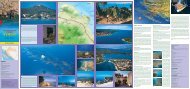
UGLJAN<br />
TREKKING &<br />
MOUNTAIN BIKING MAP<br />
UGLJAN<br />
THE ISLAND OF UGLJAN<br />
Olive Island<br />
Olive Island<br />
Trekking & mountain biking map<br />
1:30000<br />
Information on publisher and production:<br />
<strong>Zadar</strong> County Tourist Board<br />
1 Sv. Leopolda B. Mandića<br />
23000 <strong>Zadar</strong>, Croatia<br />
Tel/Fax: +385 (0)23 315-316, 315-107<br />
tz-zd-zup@zd.t-com.hr<br />
www.zadar.hr<br />
Editor: Ivo Dunatov, direktor<br />
Concept and design: Julije Skelin<br />
Text: Ivo Dunatov<br />
Cartography: Lemax<br />
Production: Basic Produktion, www.basicproduktion.hr:<br />
Trail description: Drago Erceg<br />
Translations: Geo <strong>Zadar</strong><br />
Photographs: <strong>Zadar</strong> County Tourist Board Archives<br />
Print: Tiskara Malenica, Šibenik 2006<br />
© ZADAR COUNTY TOURIST BOARD<br />
All rights reserved. Complete or partial reproduction and duplication<br />
is not allowed without <strong>the</strong> prior consent <strong>of</strong> <strong>the</strong> publisher.<br />
Dear visitors,<br />
• Take water and suitable cycling equipment with<br />
you, clo<strong>the</strong>s and footwear for walking<br />
• Do not pluck nor destroy <strong>the</strong> plants. Do not<br />
break branches and damage <strong>the</strong> trees.<br />
• Abide by <strong>the</strong> rules <strong>of</strong> <strong>the</strong> national park, reserve and nature park.<br />
• Take your litter with you.<br />
• Do not light a fire in <strong>the</strong> forest, and turn out carefully a lighted fire!<br />
• Do at least one trifle for nature on every excursion.<br />
Pick up a box, bottle or can thrown on <strong>the</strong> trail.<br />
Thank you!<br />
SLOVENIA<br />
<strong>Zadar</strong> Region<br />
CROATIA<br />
HUNGARY<br />
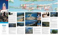
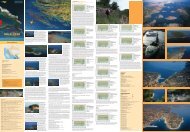
THE ISLAND OF UGLJAN – Olive Island<br />
Ugljan is one <strong>of</strong> <strong>the</strong> most picturesque <strong>island</strong>s in <strong>the</strong> <strong>Zadar</strong> archipelago.<br />
It lies opposite <strong>Zadar</strong> from which it is divided by only <strong>the</strong><br />
few NM <strong>of</strong> <strong>the</strong> <strong>Zadar</strong> Channel. The surface <strong>of</strong> this eternally green<br />
<strong>island</strong> is covered by olive groves, idyllic coves and colorful fishing<br />
ports. It has been tied to <strong>the</strong> sea, seafaring and fishing for generations.<br />
More than two thousand years <strong>of</strong> traditional olive processing<br />
has left thousands <strong>of</strong> olive trees that <strong>of</strong>fer oil <strong>of</strong> exceptional quality<br />
and aroma.<br />
Fishing and tourist localities extend along <strong>the</strong> eastern side <strong>of</strong> <strong>the</strong><br />
<strong>island</strong>, among which <strong>the</strong> most well-known are Preko, Kukljica, Kali<br />
and Ugljan. The o<strong>the</strong>r side <strong>of</strong> <strong>the</strong> <strong>island</strong> is mainly uninhabited and<br />
steep. Thanks to its coves, surrounding <strong>island</strong>s and a rich maritime<br />
underworld it is a real challenge for diving and game fishing.<br />
The wavy high plains <strong>of</strong> <strong>the</strong> inland are covered with around ten kilometers<br />
<strong>of</strong> trekking and biking trails, leaving an unforgettable picture<br />
<strong>of</strong> colors, odors and panorama to all passers-by.<br />
Most <strong>of</strong> <strong>the</strong> inhabitants <strong>of</strong> <strong>the</strong> <strong>island</strong>, around 7,500, deal mainly<br />
with olive growing, fishing and, <strong>of</strong> course, tourism.<br />
The mild Mediterranean climate, <strong>the</strong> blue sea, rocky and sandy<br />
beaches, tens <strong>of</strong> <strong>island</strong>s and islets in <strong>the</strong> proximity and memories <strong>of</strong><br />
times gone by make <strong>the</strong> fertile <strong>island</strong> <strong>of</strong> Ugljan all <strong>the</strong> more desirable<br />
for sea and <strong>island</strong> lovers.<br />
Geographical Cross-section View <strong>of</strong> <strong>the</strong> Island Ugljan lies parallel<br />
to <strong>the</strong> near mainland, it extends in <strong>the</strong> northwest-sou<strong>the</strong>ast direction,<br />
24 km in length and 3-4 km in width. The total surface area <strong>of</strong><br />
<strong>the</strong> <strong>island</strong> is 52 km², and <strong>the</strong> length <strong>of</strong> <strong>the</strong> coastline is somewhat<br />
more than 70 km.<br />
The <strong>island</strong> relief is exceptionally mountainous. It is made up <strong>of</strong> two<br />
parallel mountain chains whose height is around 100 to 300 m<br />
above sea-level. The mountainous high plains fill <strong>the</strong> central part<br />
<strong>of</strong> <strong>the</strong> <strong>island</strong> and it is covered by a whole net <strong>of</strong> dry walls creating a<br />
maze <strong>of</strong> trekking trails, a result <strong>of</strong> thousands <strong>of</strong> years <strong>of</strong> land clearing<br />
in order to gain more surface area for olive groves.<br />
The eastern side <strong>of</strong> <strong>the</strong> <strong>island</strong> descends gently towards <strong>the</strong> sea, and<br />
all <strong>the</strong> localities have taken shelter in its coves. The opposite side is<br />
mainly wild, steep and uninhabited.<br />
Climate The <strong>island</strong> <strong>of</strong> Ugljan has all <strong>the</strong> characteristics <strong>of</strong> Mediterranean<br />
climate with an average annual temperature <strong>of</strong> 16°, around<br />
800 mm <strong>of</strong> rainfall and 2600 hours <strong>of</strong> sun annually.<br />
Flora and Fauna The vegetation <strong>of</strong> <strong>the</strong> <strong>island</strong> is characterized by<br />
Mediterranean flora. The typical <strong>island</strong> vegetation <strong>of</strong> black oak, pine<br />
trees, cypresses and high bushes is, on most <strong>of</strong> <strong>the</strong> <strong>island</strong>, substituted<br />
by Mediterranean cultivation dominated by olive and fig trees.<br />
Nothing is more characteristic for <strong>the</strong> <strong>island</strong> scenery <strong>of</strong> Ugljan than<br />
<strong>the</strong> thousands <strong>of</strong> olive trees. The archeological findings in Muline<br />
confirm that <strong>the</strong> olive processing and oil production on <strong>the</strong> <strong>island</strong><br />
are more than 2000 years old.<br />
The olive groves function as an eco system, attracting many songbirds<br />
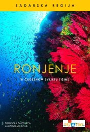
with <strong>the</strong>ir micro world. The ecologically clean submarine<br />
world <strong>of</strong> <strong>the</strong> <strong>island</strong> <strong>of</strong> Ugljan, with some ten small <strong>island</strong>s belonging<br />
to it, are <strong>the</strong> habitat <strong>of</strong> numerous types <strong>of</strong> fish, seashells, and corals,<br />
a real place <strong>of</strong> discovery for divers.<br />
History The <strong>island</strong> <strong>of</strong> Ugljan was inhabited already in <strong>the</strong> Younger<br />
Stone Age. The first known name <strong>of</strong> <strong>the</strong> <strong>island</strong> comes from Plinius<br />
who said: “Lissa is situated opposite <strong>Zadar</strong>.” In <strong>the</strong> Middle Ages <strong>the</strong><br />
<strong>island</strong> went by <strong>the</strong> name <strong>of</strong> St. Mihovil (St. Michael), while <strong>the</strong> current<br />
name <strong>of</strong> Ugljan is <strong>of</strong> relatively new date. That name signifies<br />
<strong>the</strong> main production <strong>of</strong> <strong>the</strong> <strong>island</strong>, olive oil. The Liburnians, an Illyrian<br />
tribe, were <strong>the</strong> first known inhabitants <strong>of</strong> <strong>the</strong> <strong>island</strong>. In <strong>the</strong> 4 th<br />
century B.C. <strong>the</strong>y built settlements on mounts Celinjak, Kuranj and<br />
Sv. Mihovil, and <strong>the</strong> remains can still be seen today. The Romans<br />
colonized <strong>the</strong> <strong>island</strong> <strong>of</strong> Ugljan in <strong>the</strong> 1 st century B.C. The colonists<br />
built family houses, villae rusticae, on <strong>the</strong> new Ugljan properties and<br />
some ten <strong>of</strong> <strong>the</strong>ir remains are reminders <strong>of</strong> <strong>the</strong> period. The biggest<br />
villas are on Gospodska gomila, towards Cape Supetar and Stivan in<br />
Muline, where remains <strong>of</strong> a Roman mill and olive processing facilities<br />
have been preserved.<br />
In <strong>the</strong> early Middle Ages <strong>the</strong> Croats settled on <strong>the</strong> <strong>island</strong> leaving remains<br />
<strong>of</strong> Early Croatian three-stand pattern stone decorations and<br />
numerous toponyms. Most <strong>of</strong> <strong>the</strong> land on <strong>the</strong> <strong>island</strong> was owned by<br />
<strong>Zadar</strong> municipality, and assigned to <strong>the</strong> use or ownership <strong>of</strong> <strong>the</strong><br />
most well-known noble families that built <strong>the</strong>ir homes – castles on<br />
<strong>the</strong> <strong>island</strong>. In <strong>the</strong> Middle Ages Ugljan, as well as <strong>Zadar</strong>, fell under <strong>the</strong><br />
rule <strong>of</strong> <strong>the</strong> Venetian Republic. At <strong>the</strong> beginning <strong>of</strong> <strong>the</strong> 19 th century<br />
it fell under French rule for a short period <strong>of</strong> time and <strong>the</strong>n under<br />
Austrian rule until <strong>the</strong> fall <strong>of</strong> <strong>the</strong> monarchy. In 1918 it became an<br />
integral part <strong>of</strong> Croatia.<br />
Historical Monuments<br />
– St. Michael’s (St. Michael) Fortress – Preko, Venetian fortress from<br />
<strong>the</strong> 13 th century<br />
– Early Christian basilica – Ugljan 5 th century<br />
– Early Christian memory – Ugljan 4 th century<br />
– St. Jerome (St. Jerome) Monastery – Ugljan 15 th century<br />
– Villa rustica – Ugljan (Muline) 1 st century<br />
– Church <strong>of</strong> St. Cosmos and Damian – Ugljan 11 th century<br />
– Church <strong>of</strong> St. Hippolytus – Ugljan 11–13 th century<br />
– Church <strong>of</strong> <strong>the</strong> Assumption– Ugljan 18 th century<br />
– Church <strong>of</strong> All Saints – Ugljan 12 th century<br />
– Beršić Castle– Ugljan 17 th century<br />
– St. Paul <strong>the</strong> Hermit’s Monastery – Preko (<strong>island</strong> <strong>of</strong> Galevac) 15 th<br />
century<br />
– Church <strong>of</strong> Our Lady <strong>of</strong> <strong>the</strong> Rosary – Preko 18 th century<br />
– Church <strong>of</strong> St. John <strong>the</strong> Baptist – Preko 11 th century<br />
– Church <strong>of</strong> St. Lawrence – Kali 18 th century<br />
– Church <strong>of</strong> Our Lady <strong>of</strong> <strong>the</strong> Snow – Kukljica 16 th century<br />
– Church <strong>of</strong> St. Paul – Kukljica 17 th century<br />
– Church <strong>of</strong> St. Euphemia – Sutomišćica 19 th century<br />
– Church <strong>of</strong> St. Lawrence – Lukoran 19 th century<br />
– Church <strong>of</strong> St. Jerome – Kostanj Cove 18 th century<br />
– Church <strong>of</strong> St. Pelegrin – 15 th century<br />
Gastronomy Light, low caloried, slightly seasoned – boiled – are<br />
<strong>the</strong> characteristics <strong>of</strong> <strong>the</strong> <strong>island</strong>’s cuisine. Fresh or cooked vegetables,<br />
a lot <strong>of</strong> fish and seafood seasoned with olive oil and wine<br />
is <strong>the</strong> main food <strong>of</strong> an <strong>island</strong> dish. The longevity and slim figure <strong>of</strong><br />
<strong>the</strong> <strong>island</strong>ers is pro<strong>of</strong> that what we introduce into our body is very<br />
important.<br />
Localities on <strong>the</strong> Island <strong>of</strong> Ugljan<br />
Almost all <strong>the</strong> localities extend along <strong>the</strong> eastern side <strong>of</strong> <strong>the</strong> <strong>island</strong>,<br />
situated in natural coves, while <strong>the</strong> sou<strong>the</strong>rn side is uninhabited.<br />
Southward itinerary: Preko – Kali – Kukljica – Island <strong>of</strong> Pašman<br />
Preko is <strong>the</strong> road and administration center <strong>of</strong> <strong>the</strong> <strong>island</strong> <strong>of</strong> Ugljan,<br />
situated, as <strong>the</strong> name states, opposite <strong>Zadar</strong>. Its old center consists<br />
<strong>of</strong> typical Dalmatian architecture and numerous patrician family<br />
summer houses. The best way to feel <strong>the</strong> Mediterranean atmosphere<br />
is by walking along <strong>the</strong> quay or sipping a favorite drink on<br />
one <strong>of</strong> <strong>the</strong> terraces with a view <strong>of</strong> <strong>the</strong> <strong>Zadar</strong> Channel. Preko is <strong>the</strong><br />
closest starting point for <strong>the</strong> excursion to St. Michael’s fortress (265<br />
m above sea level). There is a three-km-long asphalted road that<br />
leads to <strong>the</strong> fortress. The view from <strong>the</strong> fortress spreads over more<br />
than 200 <strong>island</strong>s <strong>of</strong> <strong>the</strong> archipelago <strong>of</strong> <strong>Zadar</strong> and Kornati National<br />
Park. Only about 80 m from Preko lies <strong>the</strong> idyllic islet <strong>of</strong> Galevac<br />
(Školjić), covered with dense Mediterranean vegetation that shelters<br />
<strong>the</strong> 15 th century valuable monastery <strong>of</strong> Franciscan friars <strong>of</strong> <strong>the</strong><br />
third order. Its sandy beach makes it a popular swimming sight. The<br />
nearby cove rightfully carries <strong>the</strong> blue flag – a symbol <strong>of</strong> clear sea.<br />
The 11 th century Romanesque church <strong>of</strong> St. John is situated on <strong>the</strong><br />
eastern side <strong>of</strong> <strong>the</strong> locality, near <strong>the</strong> ferryboat landing.<br />
Kali is <strong>the</strong> most famous fishing locality on <strong>the</strong> Adriatic, known for its<br />
fishermen that have proved <strong>the</strong>ir maritime skills on all world seas.<br />
Two small ports full <strong>of</strong> fishing boats and fishermen mending <strong>the</strong>ir<br />
nets on <strong>the</strong> piers give <strong>the</strong> locality a special feature. The old nucleus<br />
with its narrow streets and stone houses built in <strong>the</strong> Dalmatian<br />
style is situated on a hill from which spreads a magnificent view <strong>of</strong><br />
<strong>the</strong> surroundings, all towered by <strong>the</strong> bell tower <strong>of</strong> <strong>the</strong> church <strong>of</strong> St.<br />
Lawrence, <strong>the</strong> patron <strong>of</strong> <strong>the</strong> place. Every year in August, <strong>the</strong> famous<br />
“Fishermen’s Feast” takes place in his honor, a feast that best <strong>of</strong>fers<br />
<strong>the</strong> feeling <strong>of</strong> <strong>the</strong> Mediterranean spirit <strong>of</strong> <strong>the</strong> region.<br />
Kukljica is situated near <strong>the</strong> Strait <strong>of</strong> Ždrelac and it can be called <strong>the</strong><br />
door to Telaščica Nature Park and Kornati National Park. The old nucleus<br />
with its original examples <strong>of</strong> folk architecture is divided from<br />
<strong>the</strong> tourist peninsula <strong>of</strong> “Zelena punta” by a large cove with a small<br />
port always filled with fishing boats and wooden sail boats. The attractive<br />
sandy beaches <strong>of</strong> Sabuša, Kostanj and Jelenica under <strong>the</strong><br />
shade <strong>of</strong> pine trees are situated on both sides <strong>of</strong> <strong>the</strong> locality. A valuable<br />
monument is <strong>the</strong> 15 th century restored church <strong>of</strong> St. Jerome in<br />
Kostanj Cove. Every year, on <strong>the</strong> feast <strong>of</strong> Our Lady <strong>of</strong> <strong>the</strong> Snow, celebrated<br />
on August 5 th , an interesting procession <strong>of</strong> boats takes place<br />
sailing from Kukljica to <strong>the</strong> church <strong>of</strong> Our Lady <strong>of</strong> <strong>the</strong> Snow in <strong>the</strong><br />
Strait <strong>of</strong> Ždrelac, where, according to tradition, 400 years earlier snow<br />
fell on that midsummer day.<br />
Westward itinerary: Preko – Poljana – Sutomišćica – Lukoran – Ugljan<br />
Poljana is a docile locality in a cove bordered by <strong>the</strong> colorful peninsula<br />
<strong>of</strong> St. Peter with a Romanesque 13 th century church that bears<br />
<strong>the</strong> same name on one side, and a series <strong>of</strong> houses surrounded by<br />
well-arranged gardens on <strong>the</strong> o<strong>the</strong>r side. Numerous wells with drinking<br />
water and a greater number <strong>of</strong> sunshine hours is <strong>the</strong> reason for<br />
which vegetables grow here throughout all four seasons <strong>of</strong> <strong>the</strong> year<br />
and <strong>the</strong>y are always freshly available at <strong>the</strong> marketplace in <strong>Zadar</strong>.<br />
Sutomišćica is situated in a large and sheltered cove, a safe haven<br />
for navigators. The cultivated gardens are pro<strong>of</strong> <strong>of</strong> <strong>the</strong> diligent<br />
hands <strong>of</strong> <strong>the</strong> local people. The rose hip must be emphasized here<br />
for it matures in September, around <strong>the</strong> feast <strong>of</strong> <strong>the</strong> patroness <strong>of</strong> <strong>the</strong><br />
locality, Saint Euphemia. It is worthwhile to have a look at <strong>the</strong> 17 th<br />
century Lantana family summer house (a family from <strong>Zadar</strong>).<br />
Lukoran – Veli Lukoran is a place <strong>of</strong> hidden coves and beaches<br />
where <strong>the</strong> pine trees touch <strong>the</strong> sea. There are summer houses<br />
among which <strong>the</strong> most famous is that <strong>of</strong> <strong>the</strong> de Ponte family from<br />
<strong>the</strong> 17 th century. It is said that Mali Lukoran had been place for resting<br />
even in antiquity. Tradition says that <strong>the</strong> poet Petar Preradović,<br />
enchanted and influenced by <strong>the</strong> sunrise <strong>of</strong> <strong>the</strong> <strong>island</strong>, wrote his<br />
patriotic poem “Zora puca” (Dawn is Breaking).<br />
Ugljan is <strong>the</strong> biggest locality on <strong>the</strong> <strong>island</strong>, in terms <strong>of</strong> space, and it has<br />
a long-standing tourist tradition. The locality is situated on <strong>the</strong> northwestern<br />
part <strong>of</strong> <strong>the</strong> <strong>island</strong>, along with some ten hamlets and numerous<br />
gentle coves where Cinta is pointed out for its beauty. There are also<br />
monuments from ancient history, villa rustica, a mausoleum <strong>of</strong> late antiquity,<br />
remains <strong>of</strong> an Early Christian period basilica, and a 1 st century<br />
building for oil processing in Muline Cove. All this is pro<strong>of</strong> <strong>of</strong> early human<br />
existence in this area. The Franciscan monastery <strong>of</strong> St. Jerome from<br />
1430 is situated in a pinewood cape, right next to <strong>the</strong> sea. Bishop Šimun<br />
Kožić Benja is buried in <strong>the</strong> monastery cloister. The newly restored Renaissance<br />
castle Califi called “Brčić” is also part <strong>of</strong> <strong>the</strong> valuable heritage.<br />
The <strong>island</strong> <strong>of</strong> Ošljak has a surface <strong>of</strong> 0.5 km², 2 km <strong>of</strong> coastline and only<br />
half a NM distance from Preko. It is <strong>the</strong> smallest permanently inhabited<br />
<strong>island</strong> on <strong>the</strong> Adriatic. It has a protected landscape where olives, pinewoods<br />
and cypresses give shade to <strong>the</strong> rocky beaches. The old fishing<br />
port with a church from <strong>the</strong> 5 th century is one <strong>of</strong> <strong>the</strong> most colorful places<br />
in <strong>the</strong> whole Adriatic. The trekking trail around <strong>the</strong> <strong>island</strong> is 2 km long, it<br />
passes by a lighthouse and <strong>the</strong> remains <strong>of</strong> an earlier windmill, and it is a<br />
true delight for those who enjoy walking.<br />
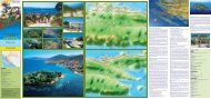
USEFUL INFORMATION<br />
How to reach it?<br />
By car<br />
From <strong>Zadar</strong> port, <strong>Zadar</strong> – Preko (<strong>island</strong> <strong>of</strong> Ugljan) line, 3.5 NM or from Italy by regular<br />
ferryboat line Ancona – <strong>Zadar</strong>.<br />
Ferryboat<br />
Jadrolinija<br />
Liburnska obala 7, <strong>Zadar</strong><br />
Tel: + 385 (0)23 254-800, Fax: + 385 (0)23 250-351<br />
passdept@jadrolinija.hr<br />
www.jadrolinija.hr<br />
Miatours<br />
Vrata sv. Krševana, <strong>Zadar</strong><br />
Tel: +385 (0)23 254-300, +385 (0)23 254-400, Fax: +385 (0)23 254-401<br />
info@miatours.hr<br />
www.miatours.hr<br />
By train<br />
Booking and ticket sale: Railway station <strong>Zadar</strong><br />
23000 <strong>Zadar</strong>; Ante Starčevića 3; Tel: +385 (0)23 212 555<br />
By airplane<br />
<strong>Zadar</strong> International Airport – Zemunik<br />
Tel. +385 (0)23 313-311, Fax. +385 (0)23 313-466<br />
www.zadar-airport.hr<br />
Bookings and Ticket Sale:<br />
Croatia Airlines<br />
2 Poljana Natka Nodila, <strong>Zadar</strong><br />
Tel. +385 (0)23 250 094, Fax +385 (0)23 250 109<br />
www.croatiaairlines.hr<br />
IMPORTANT telePHONE NUMBERS<br />
First Aid 94<br />
Firemen 93<br />
Police 92<br />
Road Assistance (HAK) 987<br />
Information on tel. numbers 988<br />
General information 981<br />
<strong>Zadar</strong> Mountain Rescue Service (GSS)<br />
Tel: +385 (0)23 235-971, GSM: +385 (0)91 535-1754<br />
Protection and Rescue Center 112<br />
TOUrist Offices<br />
Information on hotels and private accommodation, autocamps and o<strong>the</strong>r tourist<br />
sights can be looked for at <strong>the</strong> tourist <strong>of</strong>fice:<br />
<strong>Zadar</strong> County Tourist Board<br />
1 Sv. Leopolda B. Mandića<br />
23000 <strong>Zadar</strong>, Croatia<br />
Tel/Fax: +385 (0)23 315-316, 315-107<br />
tz-zd-zup@zd.t-com.hr<br />
www.zadar.hr<br />
Preko Tourist Office<br />
Tel/Fax: +385 (0)23 286-108<br />
tzpreko@preko.hr<br />
www.preko.hr<br />
Ugljan Tourist Office<br />
Tel/Fax: +385 (0)23 288-011<br />
info@<strong>ugljan</strong>.hr<br />
www.<strong>ugljan</strong>.hr<br />
Kali Tourist Office<br />
Tel/Fax: +385 (0)23 282-406<br />
info@kali.hr<br />
www.kali.hr<br />
Kukljica Tourist Office<br />
Tel: +385 (0)23 373-276, Fax: +385 (0)23 373-842<br />
tz-kukljica@zd.t-com.hr<br />
www.kukljica.hr
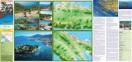
THE ISLAND OF UGLJAN<br />
TOURISM<br />
Surgery<br />
Hotel<br />
Restaurant<br />
Tourist Office<br />
LEGEND<br />
Diving club<br />
Berth<br />
Ferry pier<br />
Lighthouse<br />
Camp<br />
Berth for big boats<br />
TRAIL NO. 14<br />
Kali – Veliki vrh (Big peak) –uvala Mala Lamjana<br />
The trail leads from Kali uphill, across <strong>the</strong> main road to <strong>the</strong> cemetery.<br />
Somewhat over <strong>the</strong> cemetery it leads left on macadam road and<br />
across olive groves to Velik vrh. Immediately after <strong>the</strong> peak it leaves<br />
<strong>the</strong> macadam road and descends to a drystone wall to reach <strong>the</strong> next<br />
macadam and <strong>the</strong>n left downhill to <strong>the</strong> sea and <strong>the</strong> fishery.<br />
Trail length 4.1 km, climb 85 m, descent 85 m, walking 1.15 h.<br />
TRAIL NO. 15<br />
Kali – Drage – Kanali – Preko<br />
Starting from Kali, <strong>the</strong> trail leads uphill to <strong>the</strong> cemetery, fur<strong>the</strong>r straight<br />
on to <strong>the</strong> large building next to <strong>the</strong> crossing, <strong>the</strong>n to <strong>the</strong> right on<br />
macadam road across olive groves to <strong>the</strong> crossing. It turns left at <strong>the</strong><br />
crossing and follows rough macadam across partly abandoned olive<br />
groves to reach an asphalted road. It takes <strong>the</strong> asphalted road and<br />
proceeds on <strong>the</strong> right to reach Preko.<br />
Trail length 5.6 km, climb 80 m, descent 80 m, walking 1.45 h.<br />
STAZA BR 16<br />
Kali – Sv. Pelegrin – Nehaj – Kukljica<br />
The trail goes straight ahead from Kali, onto Mali Lamjan beach, and<br />
proceeds to <strong>the</strong> main road, crosses <strong>the</strong> road and fur<strong>the</strong>r on asphalted<br />
road to <strong>the</strong> branching road named «Put. sv. Pelegrina» (St. Pelegrin<br />
Road) and goes uphill. A paved road intersects <strong>the</strong> macadam road and<br />
<strong>the</strong> trail keeps <strong>the</strong> macadam to <strong>the</strong> peak, to sv. Pelegrin chapel. A rough<br />
macadam road <strong>the</strong>n leads to a better one and <strong>the</strong> trail goes right onto<br />
<strong>the</strong> better macadam road that after a short time becomes rough again,<br />
and, at <strong>the</strong> end, a narrow trekking trail. The trail continues straight on<br />
past Mount Nehaj, where it again leads to a rough macadam road and<br />
<strong>the</strong>n proceeds to <strong>the</strong> main road, crosses it and leads to Kukljica.<br />
Trail length 5.4 km, climb 103 m, descent 103 m, walking 1.45 h.<br />
TRAIL NO. 17<br />
Kali – Otrić – Sv. Jerolim – Kukljica<br />
Starting from <strong>the</strong> locality <strong>the</strong> trail coasts <strong>the</strong> sea to reach Zaotrić Cove<br />
(Sculpture Park), and <strong>the</strong>n uphill to <strong>the</strong> main road, straight ahead on<br />
<strong>the</strong> road (ATTENTION! Heavy traffic.) for about 1700 m to take a left<br />
bend and reach <strong>the</strong> trekking trail and <strong>the</strong>n arrive in Kostanj Cove. A<br />
good trail coasts <strong>the</strong> sea past sv. Jerolima (St. Jerome) chapel, across<br />
Gnojišća Cove, around Mount Zaglav and into Kukljica.<br />
Trail length 6.2 km, climb 20 m, s descent 20 m, walking 2 h.<br />
TRAIL NO. 20<br />
Drage – Fratar<br />
The road leads from Drage to a new road penetrating <strong>the</strong> woods and<br />
descends briefly to <strong>the</strong>n climb across olive groves. After about 1 km to<br />
<strong>the</strong> left <strong>the</strong> trail that connects this one to trail no.5 branches <strong>of</strong>f, while<br />
this trail continues upward to <strong>the</strong> pass and <strong>the</strong>n right to continue on<br />
<strong>the</strong> branching at Fratar (183 m) and fur<strong>the</strong>r to Sv. Mihovil.<br />
Trail length 1.51 km, climb 70 m, descent 00 m, walking 25 min.<br />
CULTURE<br />
Gas station<br />
Beaches blue flag<br />
Free climbing<br />
Fortification<br />
Church<br />
Monastery<br />
ROADS<br />
Main roads<br />
Local roads<br />
O<strong>the</strong>r roads<br />
Numbered biking trails<br />
Numbered walking trails<br />
Sailing route<br />
NATURE<br />
Berth for small boats<br />
Prohibited berthing<br />
Viewpoint<br />
Hill<br />
Cave<br />
Waterflow<br />
Sea depth<br />
TREKKING TRAIL DESCRIPTION<br />
The description <strong>of</strong> all <strong>the</strong> trails begins on <strong>the</strong> main <strong>island</strong> road<br />
Inhabited area<br />
TRAIL NO. 1<br />
Lukoran – Turkija – Šćah (286 m)<br />
The trail starts on <strong>the</strong> main <strong>island</strong> road. It leads first on <strong>the</strong><br />
asphalted road by <strong>the</strong> cemetery to <strong>the</strong> center <strong>of</strong> Turkija village.<br />
It continues on a marked trail between <strong>the</strong> houses to <strong>the</strong><br />
south and reaches <strong>the</strong> last houses. A few meters after <strong>the</strong>se<br />
last houses <strong>the</strong>re is a right branching between drystone walls<br />
leading uphill. Then <strong>the</strong> trail crosses macchia and continues to<br />
<strong>the</strong> pass between Šćah and Plišivac, on <strong>the</strong> right along <strong>the</strong> ridge<br />
to reach <strong>the</strong> peak.<br />
Trail length 3.8 km, climb 250 m, descent 000 m, walking1.15 h.<br />
TRAIL NO. 2<br />
Preko – Sv. Mihovil (250 m) (parking lot) Željina stijena<br />
(rock)–uvala Željina (Cove) – Sv. Mihovil (St. Michael)<br />
The trail leads from <strong>the</strong> parish church straight upward to <strong>the</strong><br />
main road, across <strong>the</strong> road and between drystone walls to <strong>the</strong><br />
asphalted road that leads towards Sv. Mihovil and <strong>the</strong>n again<br />
on <strong>the</strong> asphalted one upward across olive groves and fur<strong>the</strong>r on<br />
to <strong>the</strong> parking lot on Sv. Mihovil. It is possible to go right from<br />
<strong>the</strong> parking lot and straight onto Sv. Mihovil or left, across high<br />
macchia for about 100 m, and <strong>the</strong>n right through pinewood and<br />
down across a deep gorge to come under <strong>the</strong> rock (suitable for<br />
climbing). Then it continues along <strong>the</strong> lower edge <strong>of</strong> <strong>the</strong> rock for<br />
about 350 m and down to Željina vela Cove and again proceeds<br />
fur<strong>the</strong>r until under <strong>the</strong> rocks and <strong>the</strong>n left (trail partly ensured by<br />
wire cable) and upward to <strong>the</strong> pass and to Sv. Mihovil.<br />
Trail length 5.5 km, climb 250 m, descent 250, walking 1.50 h.<br />
TRAIL NO. 4<br />
Preko – Završće – Kanali – uvala Svitla (Cove)<br />
250 m west to <strong>the</strong> crossing leading to <strong>the</strong> ferryboat a macadam road<br />
branches uphill across Završće pass (multiple crossing). At <strong>the</strong> crossing<br />
it leads gently downhill and southwest to intersect a macadam road<br />
and climb across <strong>the</strong> pass and again down between olive groves to <strong>the</strong><br />
end <strong>of</strong> <strong>the</strong> road. Fur<strong>the</strong>r on <strong>the</strong>re is a visible trekking trail downward<br />
to <strong>the</strong> cove.<br />
Trail length 2.8 km, climb 105 m, descent 105 m, walking 1 h.<br />
TRAIL NO 5<br />
Kali – Križice – Kanali – (Rt (cape)Skrajno)<br />
– Zarunjiški – (Kobiljak 199 m) – Mrđina<br />
The trail begins from <strong>the</strong> parish church and leads upward to <strong>the</strong> main<br />
road, <strong>the</strong>n across <strong>the</strong> road to <strong>the</strong> cemetery to reach <strong>the</strong> large building<br />
next to <strong>the</strong> crossroad. It <strong>the</strong>n continues southwest to <strong>the</strong> end <strong>of</strong> <strong>the</strong><br />
canyon (canals – branching for Cape Skrajno – macadam road) and<br />
<strong>the</strong>n uphill on a partly paved road (branching for Kobiljak) to reach <strong>the</strong><br />
pass (end <strong>of</strong> road) and <strong>the</strong>n fur<strong>the</strong>r between high drystone walls and<br />
down to <strong>the</strong> cove.<br />
Trail length 4.6 km, climb 199 m, descent 199 m, walking 1.30 h.<br />
again and keeps to <strong>the</strong> road until <strong>the</strong> crossing. At <strong>the</strong> crossing it branches<br />
to <strong>the</strong> left to <strong>the</strong> end <strong>of</strong> a rough macadam road. From <strong>the</strong>re <strong>the</strong> trail takes<br />
<strong>the</strong> northwest direction and past vrh Nehaj (peak) to a macadam road,<br />
remains on <strong>the</strong> road until <strong>the</strong> first left branching and uphill to sv. Pelegrin<br />
chapel. It proceeds downward across olive groves to an asphalted road<br />
and along <strong>the</strong> asphalted road to Kali.<br />
Trail length 8.1 km, climb 110 m, descent 110 m, walking 2.30 h.<br />
SECTION Kali – Križice – Drage – Kanali – Polje – Turkija<br />
The trail leads from <strong>the</strong> parish church in Kali and upward to <strong>the</strong><br />
main road, <strong>the</strong>n across <strong>the</strong> road to <strong>the</strong> cemetery and fur<strong>the</strong>r to <strong>the</strong><br />
large building next to a crossing. At <strong>the</strong> crossing it turns right on<br />
macadam road and among olive groves to ano<strong>the</strong>r crossing, <strong>the</strong>n<br />
left to <strong>the</strong> turnaround, and fur<strong>the</strong>r along a narrow macadam among<br />
partly abandoned olive groves to <strong>the</strong> asphalt. It continues left on <strong>the</strong><br />
asphalted road for 100 m, and straight on a macadam road for 150 m<br />
to reach <strong>the</strong> «T» crossing. The trail <strong>the</strong>n leads right along <strong>the</strong> trekking<br />
trail and between drystone walls<br />
ATTENTION! The trail is overgrown with macchia). The trail continues<br />
to <strong>the</strong> macadam road turnaround and <strong>the</strong>n immediately along <strong>the</strong><br />
trekking trail to Turkija village.<br />
Trail length 6.7 km, climb 90 m, walking 2 h.<br />
SECTION Turkija – Doci –uvala Prtljug– Fortošćina<br />
– Ljokine – Muline – Gornje Selo<br />
The trail leads from <strong>the</strong> village and shortly on asphalted road, at <strong>the</strong><br />
first bend right and after 50 m left on a new macadam road. At a sharp<br />
right bend <strong>the</strong> trail branches left (trekking trail) and fur<strong>the</strong>r on between<br />
drystone walls and across olive groves to a macadam road to proceed to<br />
<strong>the</strong> sea (Prtljug Cove). It coasts <strong>the</strong> sea to <strong>the</strong> end <strong>of</strong> <strong>the</strong> cove and <strong>the</strong>n<br />
takes <strong>the</strong> northwest direction to <strong>the</strong> asphalt. It follows <strong>the</strong> asphalted<br />
road to <strong>the</strong> right for about 500 m, and, at <strong>the</strong> branching left to Fortošćina<br />
village, and left again towards <strong>the</strong> sea for about 700 m, and right along a<br />
macadam road to Ljokine village. From <strong>the</strong>re <strong>the</strong> trail takes a left turn to<br />
<strong>the</strong> sea (St Cosmus and Damian chapel), coasts <strong>the</strong> sea along Štrmeljiva<br />
Cove to Pavlešina Cove where <strong>the</strong>re is a small port. It coasts <strong>the</strong> sea again<br />
to reach Dražica Cove and fur<strong>the</strong>r to <strong>the</strong> indented Južna luka Cove. It <strong>the</strong>n<br />
proceeds northwest across high macchia to reach <strong>the</strong> o<strong>the</strong>r shore and <strong>the</strong><br />
village <strong>of</strong> Muline. It leaves <strong>the</strong> village and continues downward between<br />
drystone walls to Gornje Selo and Svih svetih (All Saints) chapel.<br />
Trail length 12.5 km, climb 30 m, descent 45 m, walking 3.45 h.<br />
TRAIL NO. 9<br />
Ugljan – Batalaža – Dražica<br />
The road leads from Ugljan locality to Batalaga village. It <strong>the</strong>n turns<br />
left and onto a trekking trail to <strong>the</strong> main road, across it, and <strong>the</strong>n on<br />
an asphalted road that becomes macadam after about 300 meters. It<br />
continues on <strong>the</strong> macadam road to reach Guduče village and fur<strong>the</strong>r<br />
again to Dražica Cove.<br />
Trail length 2.7 km, climb 20 m, descent 20 m, walking 50 min.<br />
STAZA BR 18<br />
Kali – Preko – Poljana – Sutomišćica<br />
The trail leads from Kali, along <strong>the</strong> northwest coast, to Preko. It proceeds<br />
along <strong>the</strong> coast to Poljana village. It starts climbing from Poljana (from<br />
<strong>the</strong> cove) and leads on a macadam road to reach <strong>the</strong> first houses in<br />
Sutomišćica village, and <strong>the</strong>n on paved road that leads down among<br />
summer houses.<br />
Trail length 5 km, climb 20 m, descent 20 m, walking 1.30 h.<br />
TRAIL NO. 19<br />
Kukljica – Gospa Snježna –Sabuša Cove – Kukljica<br />
The trail leaves Kukljica and coasts southward to Cape Glavica and<br />
fur<strong>the</strong>r to Gospe Snježne (Our Lady <strong>of</strong> <strong>the</strong> Snows) chapel. It continues<br />
coasting for about 350 m to reach a pier and <strong>the</strong>n right along <strong>the</strong> trail<br />
between <strong>the</strong> drystone wall to <strong>the</strong> main road. It <strong>the</strong>n follows <strong>the</strong> road<br />
left for 600 m and <strong>the</strong>n right to <strong>the</strong> end <strong>of</strong> a macadam road. It continues<br />
on <strong>the</strong> trekking trail past <strong>the</strong> drystone wall to <strong>the</strong> sea, coasting <strong>the</strong><br />
shores to reach Velika Sabuša Cove and fur<strong>the</strong>r to Mala Sabuša Cove.<br />
From <strong>the</strong>re it climbs uphill to a macadam road and follows it to reach<br />
<strong>the</strong> main road, crosses it and comes to Kukljica.<br />
Trail length 6.8 km, climb 40 m, s descent 40 m, walking 2.15.<br />
TRAIL NO. 21<br />
Ugljan – Čeprljada – Fortošćina – Ljokine<br />
– Guduče – Donje Selo – Muline – Gornje Selo<br />
The trail starts at Ugljan port and coasts around Cape Tratica to Čeprljada<br />
Cove, and <strong>the</strong>n climbs to <strong>the</strong> village, intersects <strong>the</strong> main <strong>island</strong> road<br />
to reach Strihine village and fur<strong>the</strong>r on to Ivanac village. It turns right<br />
from <strong>the</strong> village to reach Fortošćina village and <strong>the</strong>n left towards <strong>the</strong><br />
sea for about 700 m, <strong>the</strong>n right on a macadam road to Ljokine village. It<br />
<strong>the</strong>n proceeds straight on to Funčići village, <strong>the</strong>n Guduče and fur<strong>the</strong>r to<br />
Donje Selo. It continues left from <strong>the</strong> sea to reach <strong>the</strong> deep Južna luka<br />
Cove, <strong>the</strong>n northwest through high macchia to reach <strong>the</strong> o<strong>the</strong>r shore<br />
and coast <strong>the</strong> shores to reach Muline village. The trail leaves <strong>the</strong> village<br />
to climb between drystone walls to Gornje Selo.<br />
Trail length 8.7 km, climb 30 m, descent 30 m, walking 2.30 h.<br />
TRAIL NO. 22<br />
Sutomišćica – Goričina – Križina – Sv. Mihovil<br />
The trail leaves Sutomišćica Cove and climbs to reach <strong>the</strong> church <strong>of</strong> sv.<br />
Fume. 50 m before reaching <strong>the</strong> church it takes a left bend along <strong>the</strong><br />
village road for about 500 m, <strong>the</strong>n to <strong>the</strong> right and upward on <strong>the</strong> main<br />
<strong>island</strong> road. It intersects <strong>the</strong> road and climbs to a macadam road that<br />
becomes a large country trail that crosses olive groves to reach a vast<br />
terrace– Polje. Across <strong>the</strong> terrace <strong>the</strong> trail proceeds on macadam road<br />
and gently climbs <strong>the</strong> slopes in <strong>the</strong> direction <strong>of</strong> <strong>the</strong> antenna system<br />
on Sv. Mihovil. Shortly after <strong>the</strong> beginning <strong>of</strong> <strong>the</strong> climb <strong>the</strong> trail takes<br />
a sharp turn to <strong>the</strong> left, and after 300 m it joins <strong>the</strong> asphalted road that<br />
leads to sv. Mihovil peak (250 m).<br />
Trail length 4.4 km, climb 250 m, descent 00, walking 1.30 h.<br />
Map Author<br />
Nataša Kapov, dipl. ing.<br />
za LEMAX d.o.o.<br />
Map Assistant<br />
Darko Ohnjec<br />
Geographic Data<br />
TK 25 Državna geodetska uprava<br />
Hrvatski hidrografski institut<br />
Gauss-Krüger Projection<br />
Scale<br />
1 : 30 000<br />
Year<br />
2006.<br />
TRAIL NO. 3 and 3a)<br />
Preko – Završće – Kanali – Vela glava (236 m) – Mala<br />
glava – Sv. Mihovil (250 m)<br />
250 m west from <strong>the</strong> turn for <strong>the</strong> ferryboat, a macadam road<br />
branches upward across Završće pass (multiple crossing). At <strong>the</strong><br />
crossing, <strong>the</strong> trail leads south and descends gently and intersects<br />
an abandoned macadam road. It follows <strong>the</strong> signs for about 500<br />
m until <strong>the</strong> crossing where trail 3a) branches <strong>of</strong>f and leads to Fratar<br />
(183 m), while this trail continues to <strong>the</strong> right and leads to <strong>the</strong> end<br />
<strong>of</strong> <strong>the</strong> road. It proceeds north-northwest along <strong>the</strong> drystone wall<br />
and upward on <strong>the</strong> ridge, <strong>the</strong>n along <strong>the</strong> ridge to Vela glava peak<br />
(mountain refuge). The trail leaves Vela glava ridge and proceeds to<br />
Mala glava and fur<strong>the</strong>r on to reach <strong>the</strong> parking lot under Sv. Mihovil<br />
and <strong>the</strong>n on a road with walls at <strong>the</strong> sides to reach <strong>the</strong> top.<br />
Trail length 4.1 km, climb 250 m, walking 1.30 h.<br />
TRAIL NO. 6<br />
Island Transversal – Ždrelac – Veli vrh (peak) (123 m) – Sv.<br />
Pelegrin (92 m) – Križice – Drage – Kanali – Polje – Turkija<br />
– Doci –uvala Prtljug (Cove)– Ljokine – Sv. Kuzma i Damjan<br />
(St. Cosmus and Damian) –uvala Dražica (Cove) – Južna<br />
luka – Muline – Gornje Selo<br />
SECTION Ždrelac – Veli vrh– Sv. Pelegrin – Kali<br />
The trail begins at <strong>the</strong> bridge across Ždrelac Channel. It stays on asphalted<br />
road for 450 m. It <strong>the</strong>n takes a left turn on <strong>the</strong> macadam road for ano<strong>the</strong>r<br />
450 m and reaches <strong>the</strong> end <strong>of</strong> <strong>the</strong> road. It continues fur<strong>the</strong>r along <strong>the</strong><br />
drystone wall coasting <strong>the</strong> shore until Velika Sabuša Cove to proceed to<br />
Mala Sabuša Cove. It leaves <strong>the</strong> cove and climbs to <strong>the</strong> asphalted road<br />
and stays on it for about 200 m, <strong>the</strong>n left on a macadam road for 350 m.<br />
It <strong>the</strong>n climbs from <strong>the</strong> drystone wall, past Veli vrh to a macadam road<br />
TRAIL NO. 7<br />
The trail leads from <strong>the</strong> locality <strong>of</strong> Ugljan and takes <strong>the</strong> road towards<br />
Batalaža village and fur<strong>the</strong>r on to Sušica village and cove. It proceeds<br />
from <strong>the</strong> cove and climbs along <strong>the</strong> village trail to reach Svih svetih (All<br />
Saints) church and fur<strong>the</strong>r on <strong>the</strong> road to Gornje Selo.<br />
Trail length 2.8 km, 30 m, descent 00 m, walking 45 min.<br />
TRAIL NO. 8<br />
Lukoran – Doci –uvala Prtljug<br />
The trail leaves Lukoran port, crosses <strong>the</strong> main road and leads to a<br />
macadam road, <strong>the</strong>n briefly straight on and <strong>the</strong>n to <strong>the</strong> right across<br />
olive groves and gardens to reach <strong>the</strong> sea and Prtljug Cove.<br />
Trail length 3.5 km, climb 40 m, descent 40 m, walking 1.00 h.<br />
TRAIL NO. 10<br />
Uvala Lukoran – Sv. Lovro – Turkija – Sv. Fumja – Mali<br />
Lukoran – uvala Lukoran<br />
The trail leads from Lukoran port up to <strong>the</strong> church <strong>of</strong> sv. Lovre (St.<br />
Lawrence). It crosses <strong>the</strong> main road east from <strong>the</strong> church and <strong>the</strong>n goes<br />
upward on macadam road and at <strong>the</strong> bend takes a left turn. It continues<br />
on macadam until <strong>the</strong> asphalt and <strong>the</strong>n goes right to Turkija village,<br />
crosses <strong>the</strong> village and fur<strong>the</strong>r on <strong>the</strong> trekking trail across abandoned<br />
olive groves to <strong>the</strong> macadam road. On <strong>the</strong> macadam road it goes left to<br />
reach <strong>the</strong> main road, <strong>the</strong>n crosses it and continues until sv. Fumje church.<br />
Left from <strong>the</strong> church it takes <strong>the</strong> macadam road to reach Mali Lukoran<br />
village, <strong>the</strong>n shortly to <strong>the</strong> right coasting <strong>the</strong> sea and left on macadam<br />
road, at <strong>the</strong> side <strong>of</strong> Mount Trpinje to reach Lukoran Cove.<br />
Trail length 6.2 km, climb 65 m, descent 65 m, walking 2.00 h.<br />
TRAIL NO. 11<br />
Preko – Polje – Grušine – Sutomišćica – Poljana – Preko<br />
Starting from <strong>the</strong> parish church <strong>the</strong> trail goes uphill, across <strong>the</strong> main road<br />
and onto <strong>the</strong> asphalted one. It <strong>the</strong>n reaches a sharp bend, and shortly<br />
after turns right on <strong>the</strong> asphalted road that leads left while <strong>the</strong> trail<br />
proceeds straight ahead on macadam road to <strong>the</strong> «T» crossing. It <strong>the</strong>n<br />
continues briefly on <strong>the</strong> left and <strong>the</strong>n right onto <strong>the</strong> trekking trail that<br />
leads between drystone walls to reach <strong>the</strong> following macadam road.<br />
(ATTENTION! Here <strong>the</strong> trail is partly overgrown with macchia). The trail<br />
takes <strong>the</strong> macadam and goes right to <strong>the</strong> main road, <strong>the</strong>n crosses it to<br />
take <strong>the</strong> road that leads to Sutomišćica Cove. It briefly coasts <strong>the</strong> sea<br />
and <strong>the</strong>n turns right between houses and uphill on paved road. It <strong>the</strong>n<br />
reaches a macadam road and proceeds to Poljana village and fur<strong>the</strong>r<br />
coasting <strong>the</strong> sea comes to Preko.<br />
Trail length 6.2 km, climb 96 m, descent 96 m, walking 2 h.<br />
TRAIL NO. 12<br />
Preko – Sv. Mihovil (250 m)<br />
The trail leads straight ahead from <strong>the</strong> parish church and uphill to <strong>the</strong><br />
main road, crosses it and continues between drystone walls to <strong>the</strong><br />
asphalted road that leads toward Sv. Mihovil (St. Michael), <strong>the</strong>n on <strong>the</strong><br />
asphalted road upward across olive groves and fur<strong>the</strong>r on to reach <strong>the</strong><br />
parking lot on Sv. Mihovil. It proceeds to <strong>the</strong> right from <strong>the</strong> parking lot<br />
and upward to <strong>the</strong> fort at <strong>the</strong> very top.<br />
Trail length 2.8 km, climb 250 m, walking 2.00 h.<br />
TRAIL NO. 13<br />
Preko – Vrh (137 m) Završće (peak)– Glavine (177 m) – Kali<br />
The trail leads from <strong>the</strong> parish church in Preko to <strong>the</strong> main road, crosses<br />
<strong>the</strong> road and climbs to <strong>the</strong> asphalted road to <strong>the</strong>n proceed left on a<br />
macadam road across Mount Vrh and fur<strong>the</strong>r on to Završće crossing. It<br />
proceeds in <strong>the</strong> same direction on macadam road, past a restaurant and<br />
climbs straight to Glavina peak to continue onwards on rough macadam<br />
road and <strong>the</strong>n partly on paved road downwards to <strong>the</strong> cemetery. Before<br />
reaching <strong>the</strong> cemetery it turns left into <strong>the</strong> locality <strong>of</strong> Kali.<br />
Trail length 4.3 km, climb 177 m, descent 177 m, walking 1.30 h.