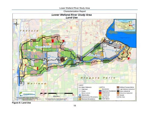
<strong>Lower</strong> <strong>Welland</strong> <strong>River</strong> Study Area <strong>Characterization</strong> <strong>Report</strong> Figure 6: Land Use 18
<strong>Lower</strong> <strong>Welland</strong> <strong>River</strong> Study Area <strong>Characterization</strong> <strong>Report</strong> Recreation Four golf courses fall within the study area, all within <strong>Niagara</strong> Falls: Oak Hall Par 3 Golf Course, Thundering Waters, Oaklands Golf Course, and Grand <strong>Niagara</strong> Golf Course. Campgrounds include Yogi Bear‟s Jellystone Park and King Waldorf‟s Tent and Trailer Park. In addition Dufferin Islands and Marineland Amusement Park are also located in this study area. The <strong>Welland</strong> <strong>River</strong> also offers ample opportunities for fishing, boating, and nature observation. Future Land Use In Ontario planning decisions are influenced by all levels of government: federal, provincial, regional and local (e.g. municipal). Although each tier has an appropriate role in planning decisions, co-ordination between tiers is necessary for effective planning and management of respective jurisdictions. For example, in <strong>Niagara</strong> the federal government would be responsible for regulating railroads, the <strong>Welland</strong> Canal, and the defense of our international boundary; whereas the provincial government‟s major responsibilities are primarily concerned with matters of provincial interest, for example, provincial transport routes, utilities, property assessment, land use planning, and protection of the environment, as well as numerous aspects of municipal development. Regional governments are responsible for planning, waste management, regional roads, treatment and distribution of water, and community services (e.g. police, health and welfare). Municipalities are primarily responsible for their respective jurisdictions in areas of physical, economic and social development while adhering to provincial and regional policies. However, some of the aforementioned responsibilities are shared with respective municipalities with some direction from the provincial government; areas such as treatment and distribution of water, waste management, planning and land use regulation. Provincial Tier In Ontario, the Growth Plan for the Greater Golden Horseshoe [(GGH) MPIR 2006] has been prepared under the Places to Grow Act (MPIR 2005), to help guide land-use planning decisions in the Greater Golden Horseshoe area. The Plan provides a framework for managing the projected future growth in the region by guiding decisions on a wide range of important planning aspects such as future transportation needs and infrastructure, natural heritage and resource protection, land use planning and housing requirements. The GGH promotes intensification of existing built-up areas and revitalization of urban growth centres while recognizing the vital economic and cultural importance of our rural communities. The GGH works with other government initiatives such as the Provincial Policy Statement [(PPS) MMAH 2005a], which provides overall direction on matters related to land use and development in Ontario, and municipal official plans by providing growth management policy direction. The PPS recognizes that sustainability of Ontario‟s natural and cultural heritage resources over the long term is of key provincial interest given that that they provide significant social, economic and environmental benefits; “Strong communities, a clean and healthy environment and a strong economy are inextricably linked” (PPS 2005). Accordingly, while providing direction on appropriate development, the policies of the PPS provide protection for; resources of provincial interest, quality of the natural environment, and public health and safety by focusing growth within existing settled areas and away from sensitive or significant natural resources or areas that may pose as a threat to public health and safety. 19