

Lower Welland River Characterization Report - Niagara Peninsula ...
Lower Welland River Characterization Report - Niagara Peninsula ...
Lower Welland River Characterization Report - Niagara Peninsula ...

Create successful ePaper yourself
Turn your PDF publications into a flip-book with our unique Google optimized e-Paper software.
<strong>Lower</strong> <strong>Welland</strong> <strong>River</strong> Study Area<br />
<strong>Characterization</strong> <strong>Report</strong><br />
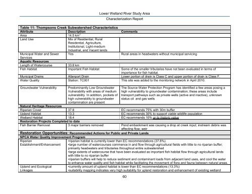
Table 11: Thompsons Creek Subwatershed Characteristics<br />
Attribute Description Comments<br />
Area 14.5 km 2<br />
Land Use<br />
Mix of Residential, Rural<br />
Residential, Agriculture,<br />
Institutional, Light-medium<br />
Industrial, and Vacant lands<br />
Municipal Water and Sewer Yes<br />
Rural areas in headwaters without municipal servicing<br />
Services<br />
Aquatic Resources<br />
Length of Watercourse 33.8 km<br />
Fish Habitat Important Fish Habitat Some of the smaller tributaries have not been evaluated in terms of<br />
importance for fish habitat.<br />
Municipal Drains Allanport Drain <strong>Lower</strong> portion of drain is Class C and upper portion of drain is Class F.<br />
Water Quality Station: TC001 This site was added to the monitoring network in April 2010.<br />
Groundwater Vulnerability<br />
Predominantly Low Groundwater<br />
Vulnerability with areas of medium<br />
vulnerability. In addition, pockets of<br />
high vulnerability to groundwater<br />
contamination are present<br />
The Source Water Protection Program has identified a few areas posing a<br />
high vulnerability to groundwater contamination; these areas include<br />
transport pathways such as private wells (active and inactive), unknown<br />
status oil and gas wells<br />
Natural Heritage Resources<br />
Riparian Cover 37.8 EC recommends 75% with 30m buffer<br />
Upland Habitat 13.3 EC recommends 30% to support viable wildlife population<br />
Wetland Habitat 18.4 EC recommends 10% or to historic value<br />
Restoration Projects Completed to date<br />
Fish Barrier Removal 3 major barriers removed Pond embankment was causing a drop at creek input; instream debris was<br />
affecting flow; weir<br />
Restoration Opportunities: Recommended Actions for Public and Private Lands<br />
NPCA Water Quality Improvement Program<br />
Riparian<br />
Establishment/Enhancement<br />
Upland and Ecological<br />
Linkages<br />
•riparian habitat is currently lower than EC recommendations (37.8%).<br />
•large number of watercourses commence in and flow through agricultural fields with little to no riparian buffer;<br />
primarily headwaters and tributaries throughout entire subwatershed<br />
•large extents of watercourse that have been evaluated as important fish habitat flow through agricultural lands<br />
with little to no riparian buffer<br />
•riparian buffers will help to reduce sediment and contaminant loads from adjacent land uses, and cool the water<br />
to enhance water quality and fish habitat while facilitating the movement of flora and fauna between natural areas.<br />
•currently amount of upland habitat is lower than EC recommendations (13.3%)<br />
•suitability mapping indicates very high suitability for upland restoration and enhancement of existing wetland<br />
60


