Rockland Preserve - Madison, Connecticut
Rockland Preserve - Madison, Connecticut
Rockland Preserve - Madison, Connecticut

You also want an ePaper? Increase the reach of your titles
YUMPU automatically turns print PDFs into web optimized ePapers that Google loves.
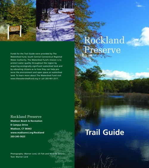
Funds for the Trail Guide were provided by The<br />
Watershed Fund, South Central <strong>Connecticut</strong> Regional<br />
Water Authority. The Watershed Fund’s mission is to<br />
protect water quality throughout the region by<br />
acquiring ecologically significant watershed land and<br />
by educating citizens as to how they can help preserve<br />
the environment and open space on watershed<br />
land. To learn more about The Watershed Fund visit<br />
www.thewatershedfund.org or call 203-401-2517.<br />
<strong>Rockland</strong><br />
<strong>Preserve</strong><br />
<strong>Rockland</strong> <strong>Preserve</strong><br />
<strong>Madison</strong> Beach & Recreation<br />
8 Campus Drive<br />
<strong>Madison</strong>, CT 06443<br />
www.madisonct.org/<strong>Rockland</strong><br />
203-245-5623<br />
Trail Guide<br />
Photography: Warner Lord, US Fish and Wildlife Service<br />
Text: Warner Lord
Welcome to the<br />
<strong>Rockland</strong> <strong>Preserve</strong><br />
About the <strong>Preserve</strong><br />
In December 1997 the citizens of <strong>Madison</strong> voted to<br />
purchase from the <strong>Madison</strong> Hills Limited Partnership<br />
II a 649-acre tract of land in North <strong>Madison</strong><br />
then known as Braemore. The land, located in the<br />
<strong>Rockland</strong> section of <strong>Madison</strong>, had been the focus of<br />
several attempts to create housing developments.<br />
None was successful, due in part to the character of<br />
the land. The property lies within the watershed of<br />
the Hammonasset River that is the source of public<br />
drinking water supplies stored in the Hammonasset<br />
Reservoir of the South Central <strong>Connecticut</strong> Regional<br />
Water Authority. The purchase price of the property<br />
was $4.8 million.<br />
Located in North <strong>Madison</strong>, west of Route 79 and<br />
just south of the <strong>Madison</strong>/Durham border, <strong>Rockland</strong><br />
<strong>Preserve</strong> is an area of rounded, rocky hills, steep<br />
gray cliffs, ledges, and lovely wooded areas. Long<br />
abandoned ancient roads offer easy access for the<br />
walker and hiker. Old Crooked Hill Road, Poole<br />
Road and Dead Hill Road tell stories of travel by foot<br />
and by horse and wagon of the residents of long ago.<br />
The centerpiece of the property is an area known<br />
as Coan Pond. Until 2002 it was a fen, much like a<br />
bog with black, damp soil, thick grasses and shrubs.<br />
Then a beaver arrived, a dam and a lodge were built,<br />
and once more Coan Pond was a pond.
The Houston Trail — red blaze, 1.5 miles<br />
The Houston Trail is named to honor Dave Houston,<br />
friend, teacher, and naturalist. It is marked with red<br />
blazes and begins at the Renee’s Way parking lot and<br />
makes a large loop. Ten interpretive signs are placed<br />
along the trail, pointing out a mix of old and new.<br />
The Outdoor Education Center and the footbridge<br />
are modern additions. Old Crooked Hill Road and<br />
Dead Hill Road were built for horse-drawn vehicles.<br />
<strong>Madison</strong>’s <strong>Rockland</strong> District once had its own<br />
school, post office, church and store. Roland<br />
Stevens, a lifelong <strong>Rockland</strong> resident, described his<br />
neighborhood in these words:<br />
“First it is rocky—very, very, very rocky—and<br />
that, I presume is how it came by its name. Ledges<br />
of rocks drop off toward the plainlands and meadows<br />
and swamps; in the hills ledges break off into<br />
flat wooded areas, and then rise again in jagged,<br />
climbable walls. Everywhere, except in the plains,<br />
there are scatterings of large boulders, stones and<br />
pebbles, although, a few of the lots surrounding the<br />
homes have been cleared for gardens and pastures.<br />
The plainlands are clear of stones, easy to cultivate,<br />
and rich for growing.<br />
“<strong>Rockland</strong> now is rural with most all of the conveniences<br />
of modern living, and on the main road<br />
there is a steady, fast-moving flow of commercial<br />
and pleasure traffic, which we often wish we could<br />
do without.<br />
“In the early days it was back country, rugged,<br />
undeveloped, and rich in timber, with some acreage<br />
satisfyingly cleared for growing by the determination<br />
and hard work of people who valued personal independence<br />
and a free way of life. It was remote, and<br />
it stayed that way by geography and social pattern,<br />
until the paved road came through.”<br />
On the trail there is a restoration of a Charcoal<br />
Pit Bottom, complete with the fireplace used by the<br />
collier (charcoal maker) and his helpers as they<br />
tended the huge mound of smoldering wood.<br />
Making charcoal was hard, dirty work, beginning<br />
with cutting many cords of wood into four-foot<br />
lengths, which were carefully stacked into a huge<br />
dome-shaped pile.<br />
The pile was covered with a layer of leaves, dirt<br />
and sod. The collier carefully tended a fire designed<br />
to smolder rather than burst into flames. Flames<br />
meant ashes, not charcoal. For as long as two weeks<br />
the men tended the charcoal mound, watching day<br />
and night for signs that the neatly stacked wood was<br />
turning into charcoal rather than ashes.<br />
As you walk the Houston Trail and other trails,<br />
think of those who walked here before you. Remember<br />
the collier and his helpers, and Roland Stevens and<br />
his neighbors. And remember this land called <strong>Rockland</strong><br />
<strong>Preserve</strong> has been preserved forever for you<br />
and future generations to enjoy.<br />
Charcoal Pit Bottom on the Houston trail.
The Coan Pond Trail — white blaze, 1 mile<br />
Starting at the parking lot, walk down the hill and<br />
turn right onto the Coan Pond Trail marked with<br />
white blazes. The pond appears in front of you. Take<br />
a brief detour to the water’s edge and look out over<br />
the pond (#1). The shrubs breaking the pond’s surface<br />
are left from the days before the arrival of the<br />
beaver in 2002, when the pond was more properly<br />
called a fen—a wet boggy place with no stream<br />
emptying into it. Its sole source of water is precipitation—snow<br />
and rain. Today the water level reflects<br />
the amount of precipitation—dry summer, dry pond!<br />
Retrace your steps from the shore of the pond,<br />
following the white blazes to the left along the edge<br />
of the pond. In summer, pond lilies grow close to<br />
shore and turtles and frogs populate the dark water.<br />
Occasional waterfowl, herons and egrets feed and<br />
deer have been known to gambol in the shallows.<br />
One never knows what sights will greet the visitor.<br />
As you walk, watch for the sign that marks the<br />
portion of the rail that crosses land owned by the<br />
Regional Water Authority. Passing between two large<br />
lichen-covered boulders, the trail climbs a steep rise<br />
that offers another panoramic view of the pond. The<br />
trail continues climbing and then drops down a<br />
steep slope to meander along the shore. Watch for<br />
the curly-barked Yellow Birch tree (#2), close relative<br />
to the Black Birch tree (#3), whose small twigs<br />
offer the pleasant smell of wintergreen when the<br />
bark is bruised.<br />
Just before the dam, to the right of the trail is the<br />
characteristic flat area that marks the location of a<br />
charcoal pit bottom (#4), where charcoal was made.<br />
The soil here is black and filled with bits of charcoal.<br />
Charcoal production was a major industry for<br />
the residents of <strong>Rockland</strong> and the surrounding area.<br />
Leaving the charcoal area, the trail crosses a stone<br />
dam offering views of the pond from the east. After
the dam, the trail rises to enter a wooded area typical<br />
of <strong>Rockland</strong> <strong>Preserve</strong>—young trees suggest that tree<br />
cutting was recently an important industry. The forest<br />
here is open with little understory. The ground is<br />
covered with huckleberry bushes (#5). Huckleberries<br />
are much like blueberries but smaller and darker in<br />
color. <strong>Rockland</strong> residents once picked hundreds of<br />
bushels of huckleberries, which were sold to merchants<br />
in New Haven for making pies.<br />
One common feature of the New England landscape<br />
is missing in <strong>Rockland</strong>—there are few stone<br />
walls. One reason for this may be that the soil here is<br />
thin and not suitable for farming so there was no<br />
need for walls.<br />
Passing through the huckleberry patch, the trail<br />
turns and leaves the higher area to follow the shore of<br />
the pond. Near the intersection with the yellow trail<br />
it passes through a grove of Beech trees (#6), easily<br />
identified by their smooth gray bark and sharply<br />
pointed leaves. In summer they bear a fruit called<br />
beechnuts, much favored by blue jays.<br />
Leaving the forest, the trail winds down to a disturbed<br />
area beside the pond. Here is evidence of a<br />
failed attempt to build a golf course: piles of rotting<br />
gray timbers fastened together (#7) to support heavy<br />
digging equipment to create a water hole for a golf<br />
course, and huge piles of dirt left when the land was<br />
cleared of trees and soil.<br />
Here also is testimony to nature’s ability to<br />
heal. Sassafras, Black Birch, Gray Birch and Aspen<br />
trees have replaced the Oaks destroyed when the<br />
land was cleared, covering the denuded landscape.<br />
At this point the Coan Pond Trail intersects with<br />
the Houston Trail (red). Keep to the left on the white<br />
trail, crossing over the outlet stream for Coan Pond<br />
on the footbridge. As you cross the bridge, look to<br />
your left. The beaver left a legacy of toppled trees<br />
across the water. Beside the bridge is the beaver dam.<br />
Follow the trail up the hill and turn left to the<br />
Outdoor Education Center. An unmarked but wellworn<br />
trail leads from here along the shore to the<br />
spot (#1) where you first viewed the pond. Or you<br />
may follow the white blazes back to the parking lot.<br />
Eagle Scouts from <strong>Madison</strong> constructed the footbridge<br />
and the outdoor classroom on the Coan Pond Trail.
Beaver at the pond Only humans can change<br />
the landscape more than beavers. In the spring of<br />
2002, a single beaver arrived at Coan Pond and<br />
began to cut down trees. Beaver feed on water lily<br />
tubers, clover, apples and the leaves and green bark<br />
of aspen and other fast-growing trees. To survive in<br />
winter they store small branches and twigs under<br />
water near their lodges. By the fall of 2002, a small<br />
dam had been constructed. There was no evidence<br />
of an attempt to build a lodge and apparently the<br />
beaver chose not to spend the winter.<br />
The following spring, evidence of beaver appeared<br />
again. This time a lodge was built and the height of<br />
the dam was increased. A smaller secondary dam<br />
was constructed north of Old Crooked Hill Road.<br />
The beaver made its presence known very quickly<br />
as more and more trees were felled. Although beaver<br />
are elusive, one was photographed at the pond in<br />
March, 2003.<br />
The activities of the beaver completely altered the<br />
character of Coan Pond. Before their arrival, the area<br />
was lush with vegetation and wildlife. Butterflies,<br />
dragonflies, and damselflies filled the air; cranberries<br />
grew in profusion along the northern edge of the<br />
fen. A wide variety of plants grew on the surface:<br />
sundews, buttonball, steeplebush, high bush<br />
blueberry, sweet pepper bush, yellow-eyed grass,<br />
water willow, asters, and sedges. Spatterdock and<br />
water lilies grew in the deeper water along the<br />
northern shore.<br />
The beaver survived the winter of 2003–04 and<br />
increased the height of the dam, gradually flooding<br />
more and more of Coan Pond. In the fall of 2004,<br />
hikers noticed that the water level of the pond had<br />
risen until it covered the dam, reaching the bottom<br />
of the footbridge. Eventually water began to flow<br />
over Old Crooked Hill Road, threatening to erode it.<br />
At the same time the beaver felled several large trees<br />
near the road, and in one case completely blocked<br />
the road.<br />
To protect the road, a town crew was sent to see<br />
what could be done. The blockage was removed and<br />
the water level dropped, continuing at that level<br />
from that point on.<br />
From that time on there was no further beaver<br />
activity. The beaver dam was not repaired and no<br />
more tree cutting was observed. Throughout the<br />
summer of 2005, the water level of the pond fell as a<br />
result of a lack of rain. The beaver made no attempt<br />
to repair the dam and it was presumed that the<br />
beaver had moved on.<br />
In early January 2006, the beaver lodge was<br />
inspected. The roof had fallen in and it was in generally<br />
poor condition. It appeared that the beaver<br />
had abandoned it.<br />
After the arrival of the beaver, the water level<br />
rose and many marsh plants ceased to exist. The<br />
shrubs whose tops remained above the surface of the<br />
water struggled to survive. The young Red Maples<br />
died and one world replaced another. Frogs and<br />
turtles thrived and water birds found a new habitat.
The Boundary Trail — orange blaze, 1.5 miles<br />
Follow the Red Trail from the parking lot past the<br />
outhouse on the right, crossing Old Crooked Hill<br />
Road, bearing right to follow the Red Trail to<br />
Crooked Hill Road and the intersection with the<br />
Boundary Trail (1.0 mile) identified by orange<br />
blazes. (Watch for signs to Boundary Trail at <strong>Rockland</strong><br />
junction.)<br />
The trail follows Crooked Hill Road toward<br />
Guilford. As you walk, notice the rough, rocky trail<br />
beneath your feet. As you look about, you see rocks<br />
everywhere. At the foot of the hill where the trail<br />
turns to the right you will see an enormous boulder<br />
called a glacial erratic. (#1) The erratic and the<br />
rocks in the roadway and the woods are a reminder<br />
that a huge sheet of ice passed over this land thousands<br />
of years ago. We don’t know how thick this<br />
ice was, but it certainly covered everything you see<br />
many feet deep.<br />
Cross the stream and continue west until the trail<br />
turns left onto another old woods road. To the right<br />
the land rises, and to the left it slopes toward a wet<br />
area. This area of the <strong>Preserve</strong> is an area of contrast:<br />
high, rocky hills and cliffs; streams; swampy areas<br />
and vernal pools.<br />
The old road curves gently to the right, bringing<br />
into view high cliffs and extensive wet areas. Here<br />
grows the majestic Black Oak tree (#2), a common<br />
tree in the <strong>Preserve</strong>.<br />
As you walk, you will pass a large wet area to the<br />
right referred to as a vernal pool (#3) — a temporary<br />
wet area commonly seen in spring when rain is<br />
plentiful. Vernal pools provide a valuable habitat for<br />
Wood Frogs, Mole Salamanders, and Fairy Shrimp<br />
who use the shallow water for breeding. In the<br />
spring the pool may be filled with the gelatinous<br />
masses of eggs, and in summer there may be no<br />
water at all.<br />
Near the vernal pool, to the right of the trail,<br />
stands a very tall Tulip Tree (#4), named for its<br />
orange flowers resembling tulips.<br />
The trail slopes gently down toward the boundary<br />
line between <strong>Madison</strong> and Guilford. Pay close attention<br />
to the orange trail markers in this area, as the<br />
trail turns right, leaving the road for a short distance<br />
before returning again.
Rock pile marks the <strong>Madison</strong>/Guilford boundary.<br />
A pile of rocks beside the trail (#5) marks the town<br />
boundary. Until 1962 the selectmen of <strong>Madison</strong> and<br />
Guilford walked the boundaries to inspect each of<br />
the thirty piles of stones spread from Long Island<br />
Sound to the point where the boundaries of Guilford,<br />
<strong>Madison</strong>, and Durham meet. As they stopped<br />
at each marker, they chiseled their initials and the<br />
date into one of the stones.<br />
The trail leads past the remains of a charcoal<br />
bottom (#6), turns right sharply and climbs upward,<br />
following the line of a stone wall to the top of the hill.<br />
The trail skirts the edge of the hill with views to<br />
the south. Pay careful attention to the trail markers,<br />
as several other trails converge in this area. On the<br />
left you will see a group of Red Cedar trees (#7)<br />
easily identified by their dark green needles and<br />
shaggy, reddish bark. They are a reminder that the<br />
top of the hill was once an open area. Cedars grow<br />
best in open fields, slowly dying back as other forest<br />
trees move in and block their sunlight.<br />
Continue until the trail turns right again and<br />
begins down the side of the hill to reconnect with<br />
the orange trail. As you wind down into the valley,<br />
look to the right and marvel at the ancient, twisted<br />
rocks—hundreds of millions of years old—older<br />
than we can imagine.<br />
<strong>Madison</strong> is located in a part of <strong>Connecticut</strong><br />
geologists call “The Eastern Upland.” The rocks of<br />
the Eastern Upland have been subjected to intense<br />
heat and pressure that have left them layered and<br />
twisted looking.<br />
Millions of years ago the rocks beside the Boundary<br />
Trail lay many miles beneath the surface of the<br />
earth. It was there that they were compressed and<br />
twisted, much as snow is compacted into a snowball.<br />
These rocks, known as metamorphic rocks, have<br />
been exposed by a combination of glacial action and<br />
erosion. Two kinds of metamorphic rocks are common<br />
to the Eastern Highlands: schist, a layered<br />
sparkly rock; and gneiss (pronounced nice), a hard,<br />
fine-grained rock with a banded appearance. The<br />
rocks you see here are gniess. These are the rocks<br />
that give <strong>Rockland</strong> <strong>Preserve</strong> its name. These are the<br />
rocks that lie under your feet everywhere you walk<br />
in the <strong>Preserve</strong>.<br />
Glacial erratic in the forest at <strong>Rockland</strong> <strong>Preserve</strong>.
Plants and Animals Common<br />
to <strong>Rockland</strong> <strong>Preserve</strong><br />
FROGS<br />
Bullfrog<br />
Green Frog<br />
Leopard Frog<br />
Wood Frog<br />
TURTLES<br />
Painted Turtle<br />
Snapping Turtle<br />
Wood Turtle<br />
BIRDS<br />
Blue Heron<br />
Blue Jay<br />
Catbird<br />
Chickadee<br />
Crow<br />
Evening Grosbeak<br />
Great Egret<br />
Oriole<br />
Pileated Woodpecker<br />
Redwinged Blackbird<br />
Rufuous Sided Towhee<br />
Tufted Titmouse<br />
Yellow Warbler<br />
TREES<br />
Aspen<br />
Black Birch<br />
Black Oak<br />
Beech<br />
Chestnut Oak<br />
Gray Birch<br />
Pepperidge<br />
Sassafras<br />
Tulip<br />
Yellow Birch<br />
SHRUBS<br />
Alder<br />
Autumn Olive<br />
Blackberry<br />
High Bush Blueberry<br />
Huckleberry<br />
Mountain Laurel<br />
Swamp Azalea<br />
Sweet Pepper Bush<br />
Sweet Fern<br />
Witch Hazel<br />
FLOWERS<br />
Aster<br />
Birdsfoot Violet<br />
Blue Violet<br />
Cinquefoil<br />
Goldenrod<br />
Lady Slipper<br />
May Flower<br />
White Violet<br />
Wood Anemone<br />
Yellow-eyed Grass<br />
FERNS<br />
Christmas Fern<br />
Common Polypody<br />
Ebony Speenwort<br />
LICHEN<br />
British Soldiers<br />
Parmelia<br />
Pixie Cups<br />
Smooth Rock Tripe<br />
Toadskin<br />
MOSS<br />
Before You Go Hiking<br />
• Learn about the area. Study maps and information<br />
about trails and other physical features of the<br />
<strong>Preserve</strong> before you set off.<br />
• Plan your hike according to length of the trail and<br />
the time you have available.<br />
• Check weather reports before you head out. Leave<br />
word of your intended hiking route and anticipated<br />
time of return with family or friends.<br />
• Don’t attempt a hike that is beyond your physical<br />
capabilities.<br />
On The Trail<br />
• Wear appropriate clothing and footwear. Layered<br />
clothing is best to meet changing weather conditions.<br />
• Carry a map, compass and cellular telephone<br />
with you.<br />
• Take appropriate equipment and supplies. A daypack<br />
containing water, high-energy food, first aid kit,<br />
pocket knife, and insect repellent is useful. Rain gear<br />
and extra warm clothing may also be handy.<br />
• Do not wade into the water of any ponds or streams,<br />
and do not walk on any frozen ponds or streams.<br />
Do not drink water from ponds or streams.<br />
• Report any discovered hazards or unusual activities<br />
at the <strong>Preserve</strong> to <strong>Madison</strong> Beach & Recreation<br />
Department at your earliest opportunity.<br />
• If you get lost or someone is injured, keep calm,<br />
stay dry, keep warm and stay put.<br />
• Any person knowing you are overdue should be<br />
instructed to report this to the <strong>Madison</strong> Police<br />
Department.<br />
• In case of emergency or accident, at least one person<br />
should remain with the injured person. Call 911, if<br />
possible, for emergency assistance. Know and use basic<br />
first aid techniques. Others should note the location<br />
and contact local emergency personnel.<br />
Important Emergency Phone Numbers<br />
Emergency: 911<br />
Non-emergency <strong>Madison</strong> Police: 245-2721<br />
<strong>Madison</strong> Fire Department: 911<br />
<strong>Madison</strong> Beach & Recreation Department: 245-5623