Land Use and Rural Neighborhoods ... - City of Las Vegas
Land Use and Rural Neighborhoods ... - City of Las Vegas
Land Use and Rural Neighborhoods ... - City of Las Vegas

You also want an ePaper? Increase the reach of your titles
YUMPU automatically turns print PDFs into web optimized ePapers that Google loves.
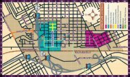
SOUTHWEST SECTOR<br />
The Southwest Sector <strong>of</strong> the Master Plan is located along<br />
Cheyenne Avenue to the north, portions <strong>of</strong> Rainbow <strong>and</strong> Jones<br />
Boulevard to the east, the Bruce Woodbury Beltway to the<br />
west, <strong>and</strong> the city limit boundaries to the south. Many <strong>of</strong> the<br />
city’s more recently developed areas such as Summerlin <strong>and</strong><br />
the Lakes are located within the Southwest Sector Plan. The<br />
following Master Development Plan Areas are located within<br />
the Southwest Sector:<br />
Canyon Gate<br />
The Lakes<br />
South Shores<br />
Summerlin West<br />
Desert Shores<br />
Peccole Ranch<br />
Summerlin North<br />
Sun <strong>City</strong><br />
Future <strong>L<strong>and</strong></strong> <strong>Use</strong><br />
page 26<br />
PD-0006-05-2012 RS LU_RNP