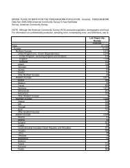
Land Use and Rural Neighborhoods ... - City of Las Vegas
Land Use and Rural Neighborhoods ... - City of Las Vegas
Land Use and Rural Neighborhoods ... - City of Las Vegas

You also want an ePaper? Increase the reach of your titles
YUMPU automatically turns print PDFs into web optimized ePapers that Google loves.
straints <strong>of</strong> the Centennial Hills Sector Plan, few opportunities for<br />
light manufacturing uses exist within the Centennial Hills sector <strong>of</strong><br />
the city. Given the propensity for visual pollution, all uses within<br />
the district are required to be completely self-contained within a<br />
structure giving a business park appearance. The Employment<br />
Center Mixed <strong>Use</strong> District permits the broadest spectrum <strong>of</strong> uses<br />
within the Town Center; however, residential development opportunities<br />
are minimal. Local supporting l<strong>and</strong> uses such as parks,<br />
other public recreational facilities, some schools, <strong>and</strong> churches<br />
are also allowed in this district. Development in this l<strong>and</strong> use<br />
designation shall be consistent with the Mixed <strong>Use</strong> section <strong>of</strong> the<br />
Centennial Hills Sector Plan.<br />
PF-TC (Public Facilities – Town Center) – The Public Facilities<br />
district is intended to accommodate any property which is used for<br />
a Public <strong>and</strong>/or Quasi-Public purpose. Any project which is owned<br />
<strong>and</strong> operated by a governmental agency (e.g., schools) or is used<br />
solely by a non-pr<strong>of</strong>it organization (e.g., religious facility) qualifies<br />
for this l<strong>and</strong> use designation. Utility projects can also qualify<br />
for this designation <strong>and</strong> must adhere to the design regulations <strong>of</strong><br />
Town Center.<br />
CLIFF’S EDGE (PROVIDENCE)<br />
L (Low Density Residential) – The Low Density category<br />
allows for lower density single-family product types. This category<br />
allows up to 5.5 dwelling units per gross acre. However, within<br />
the Low Density <strong>L<strong>and</strong></strong> <strong>Use</strong> Category, seven acres have been designated<br />
as a buffer area around unincorporated parcels that are not<br />
a part <strong>of</strong> the Cliff’s Edge Master Plan Area. Property within these<br />
seven acres has a maximum allowable density <strong>of</strong> 2.0 units per<br />
gross acre.<br />
Description <strong>of</strong> Master Plan <strong>L<strong>and</strong></strong> <strong>Use</strong> Categories<br />
ML (Medium-Low Density Residential) – The Medium Low<br />
Density Residential category allows for medium density detached<br />
or attached single-family product types including, but not limited<br />
to, duplexes, compact lots, cluster <strong>and</strong> zero lot line developments.<br />
This category allows up to 8.0 dwelling units per gross acre.<br />
RSL (Residential Small Lot) – This l<strong>and</strong> category allows for<br />
higher density detached <strong>and</strong> attached single-family product types,<br />
including, but not limited to, senior housing, duplexes, compact<br />
lots, townhomes, condominiums, apartments, cluster <strong>and</strong> zero lot<br />
line developments. The Residential Small Lot category provides for<br />
the development <strong>of</strong> up to 15.0 dwelling units per gross acre.<br />
M (Medium Density Residential) – The Medium Density<br />
Residential category includes a variety <strong>of</strong> higher density multifamily<br />
units such as condominiums, townhomes <strong>and</strong> apartment<br />
developments. This category allows up to 25.0 dwelling units per<br />
gross acre.<br />
page 44<br />
PD-0006-05-2012 RS LU_RNP