Land Use and Rural Neighborhoods ... - City of Las Vegas
Land Use and Rural Neighborhoods ... - City of Las Vegas
Land Use and Rural Neighborhoods ... - City of Las Vegas

You also want an ePaper? Increase the reach of your titles
YUMPU automatically turns print PDFs into web optimized ePapers that Google loves.
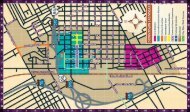
SOUTHEAST SECTOR<br />
The Southeast Sector <strong>of</strong> the Master Plan is located along<br />
portions <strong>of</strong> Jones <strong>and</strong> Rainbow Boulevards to the west, <strong>and</strong><br />
the city limit boundaries to the northeast <strong>of</strong> Rancho Drive,<br />
south, <strong>and</strong> east. The Southeast Sector is comprised <strong>of</strong> many <strong>of</strong><br />
the city’s more mature areas. Much <strong>of</strong> the Southeast Sector is<br />
built out, <strong>and</strong> future growth in the area will most likely consist<br />
<strong>of</strong> infill development <strong>and</strong> neighborhood revitalization. The<br />
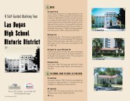
Southeast Sector includes Downtown <strong>and</strong> Downtown North,<br />
West <strong>Las</strong> <strong>Vegas</strong>, <strong>and</strong> the <strong>Las</strong> <strong>Vegas</strong> Medical District. The historic<br />
John S. Park <strong>and</strong> <strong>Las</strong> <strong>Vegas</strong> High School neighborhoods<br />
are also located here.<br />
Future <strong>L<strong>and</strong></strong> <strong>Use</strong><br />
page 28<br />
PD-0006-05-2012 RS LU_RNP