

Download - Geological Survey of Ireland
Download - Geological Survey of Ireland
Download - Geological Survey of Ireland

You also want an ePaper? Increase the reach of your titles
YUMPU automatically turns print PDFs into web optimized ePapers that Google loves.
Geology Matters - Autumn 2006<br />
replace the GSI’s existing Visual Basic<br />
GeoData application. The CF<br />
application consists <strong>of</strong> sets <strong>of</strong> screens<br />
which allow users to display, insert,<br />
update and delete data held in the<br />
Oracle database. The system will be<br />
readily available and more reliable<br />
and upgrades will integrate<br />
seamlessly without disrupting users.<br />
The new application will provide a<br />
solution for an Internet mapping<br />
service by way <strong>of</strong> ArcIMS and ArcSDE<br />
s<strong>of</strong>tware that are used to deliver<br />
dynamic maps, GIS Data and Internet<br />
Mapping services via the Web.<br />
Screens for six <strong>of</strong> the eight datasets<br />
have been developed and there is<br />
fine-tuning being carried out on<br />
screens for the final two.<br />
The new database will be rolled out<br />
in-house to GSI staff so that they can<br />
query and manage their own datasets.<br />
The public will also be able to view<br />
geological data via this CF interface<br />
in the Customer Centre in GSI <strong>of</strong>fices.<br />
It is expected to make it available to<br />
the public over the web in the future.<br />
METADATA PROJECT/<br />
IRISH SPATIAL DATA<br />
EXCHANGE SYSTEM (ISDE)<br />
Silvia Caloca<br />
Metadata, <strong>of</strong>ten called “data about data”, consists <strong>of</strong> a file containing information<br />
about a dataset; that is the content, structure, currency and availability. The<br />
information contained in the metadata file can be information on GIS layers,<br />
databases, maps, samples etc. All digital data should be accompanied by this<br />
descriptive information to aid users’ understanding <strong>of</strong> the dataset that is being<br />
used. In a data rich organisation like GSI, metadata is vital.<br />
GSI compiled metadata initially as part <strong>of</strong> the 1:100,000 Map series, and more<br />
recently as part <strong>of</strong> the corporate database project CONoR (see article on CONoR<br />
in this edition <strong>of</strong> Geology Matters). As a result metadata is now available<br />
internally and also externally for selected datasets through web sites such as:<br />
http://www.epa.ie/metadataxml (principally Water Framework Directive related<br />
data), http://www.marinedataonline.ie, http://mida.ucc.ie/pages/atlas/atlas.php<br />
(both mainly marine/Irish National Seabed <strong>Survey</strong> data), and<br />
http://gistst01.marine.gov.ie/metadataexplorer/. The exchange <strong>of</strong> data is<br />
essential to avoid duplication <strong>of</strong> effort and to ensure that organisations are<br />
aware <strong>of</strong> available datasets.<br />
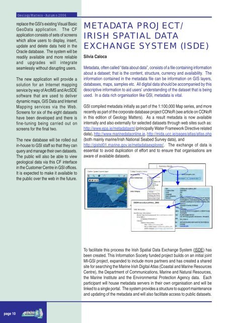
To facilitate this process the Irish Spatial Data Exchange System (ISDE) has<br />
been created. This Information Society funded project builds on an initial joint<br />
MI-GSI project, expanded to include more partners and has created a shared<br />
site for searching the Marine Irish Digital Atlas (Coastal and Marine Resources<br />
Centre), the Department <strong>of</strong> Communications, Marine and Natural Resources,<br />
the Marine Institute and the Environmental Protection Agency data. Each<br />
participant will house metadata servers in their own organisation and will be<br />
linked to a single portal. The system provides a structure to support maintenance<br />
and updating <strong>of</strong> the metadata and will also facilitate access to public datasets.<br />
page 10


