

Download - Geological Survey of Ireland
Download - Geological Survey of Ireland
Download - Geological Survey of Ireland

You also want an ePaper? Increase the reach of your titles
YUMPU automatically turns print PDFs into web optimized ePapers that Google loves.
Geology Matters - Autumn 2006<br />
mineralizing fluids (to form mineral<br />
deposits) or radon travels through the<br />
earth.<br />
In the case <strong>of</strong> the electromagnetic<br />
system the instrumentation measures<br />
the strength <strong>of</strong> the electromagnetic<br />
field set up locally by a current within<br />
special coils in the wingtips <strong>of</strong> the<br />
aircraft. The instruments on board the<br />
aircraft measure the electrical<br />
conductivity <strong>of</strong> the ground. Geologists<br />
and geophysicists interpret these<br />
measurements in terms <strong>of</strong> more or<br />
less conductive materials in the<br />
ground. Examples <strong>of</strong> conductive<br />
materials would be metallic mineral<br />
deposits, water-bearing gravels, water<br />
known to be associated with certain<br />
shales and also certain granites.<br />
Uranium is unstable and it decays to<br />
among other elements radon. In<br />
forming radon gamma radiation is<br />
emitted and it is this radiation that the<br />
aircraft instrumentation system<br />
measures. Radon as we know can<br />
be dangerous as it is known to be<br />
associated with lung cancer. The<br />
radiation emitted has a telltale<br />
signature which when measured by<br />
the aircraft system and the data<br />
processed by geophysicists allows us<br />
to identify those areas with elevated<br />
uranium. Once the source <strong>of</strong> the<br />
parent uranium is known we must<br />
then identify how and by what route<br />
stations were set up (figure 3). The<br />
base stations were set up at<br />
Enniskillen airport for the Cavan-<br />
Monaghan-Leitrim survey and at<br />
Kerry airport for the Castleisland and<br />
Silvermines areas.<br />
In addition a public awareness<br />
campaign was launched and Aurum<br />
Exploration Ltd were commissioned<br />
by the GSI to provide logistical support<br />
to ensure that people on the ground<br />
were informed <strong>of</strong> the survey being<br />
carried out in their area. This included<br />
on the ground footwork as well as<br />
advertisements in local papers and<br />
radio. The survey was completed on<br />
the 27 th June. The data was delivered<br />
21 st September and we are currently<br />
carrying out detailed quality<br />
assurance and quality control. We<br />
hope to provide some insights into the<br />
findings <strong>of</strong> this airborne survey in<br />
forthcoming newsletters.<br />
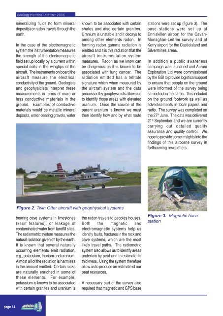
Figure 2. Twin Otter aircraft with geophysical systems<br />
bearing cave systems in limestones<br />
(karst features), or leakage <strong>of</strong><br />
contaminated water from landfill sites.<br />
The radiometric system measures the<br />
natural radiation given <strong>of</strong>f by the earth.<br />
It is known that several naturally<br />
occurring elements emit radiation,<br />
e.g., potassium, thorium and uranium.<br />
Almost all <strong>of</strong> the radiation is harmless<br />
in the amount emitted. Certain rocks<br />
are naturally enriched in some <strong>of</strong><br />
these elements. For example,<br />
potassium is known to be associated<br />
with certain granites and uranium is<br />
the radon travels to peoples houses.<br />
Both the magnetic and<br />
electromagnetic systems help us<br />
identify faults, fractures in the rock and<br />
cave systems, which are the most<br />
likely travel paths. The radiometric<br />
system also allows us to identify areas<br />
underlain by peat and to estimate its<br />
thickness. Using the system therefore<br />
allow us to produce an estimate <strong>of</strong> our<br />
peat resources.<br />
A necessary part <strong>of</strong> the survey also<br />
required that magnetic and GPS base<br />
Figure 3. Magnetic base<br />
station<br />
page 14


