

Download - Geological Survey of Ireland
Download - Geological Survey of Ireland
Download - Geological Survey of Ireland

Create successful ePaper yourself
Turn your PDF publications into a flip-book with our unique Google optimized e-Paper software.
Geology Matters - Autumn 2006<br />
BRÉIFNE WEB-MAPPING<br />
Gráinne Ní Shé<br />
Bréifne is a collaborative initiative<br />
between the <strong>Geological</strong> <strong>Survey</strong>s <strong>of</strong><br />
<strong>Ireland</strong> (GSI) and Northern <strong>Ireland</strong><br />
(GSNI), the Academy <strong>of</strong> Irish Cultural<br />
Heritages at University <strong>of</strong> Ulster<br />
(Magee), and the local authorities <strong>of</strong><br />
five counties: Sligo, Leitrim,<br />
Roscommon, Cavan and Fermanagh.<br />
The Special EU Programmes Body<br />
(SEUPB) funded the project, under<br />
the Programme for Peace and<br />
Reconciliation 2000-2004, with an<br />
overall aim to promote sustainable<br />
economic development within the<br />
region, particularly within the tourism<br />
sector.<br />
The project area covers<br />
approximately 3,500km 2 , delineated<br />
by the Sligo Coast to the west, Lough<br />
Key to the south and Lough Erne to<br />
the north and east, with the principal<br />
focus on an “upland core”<br />
encompassing the Dartry, Arigna,<br />
Sliabh an Iarainn, Cuilcagh and<br />
Bricklieve Mountains.<br />
The team based at GSI have carried<br />
out development work on a<br />
customised web-mapping interface as<br />
a method <strong>of</strong> delivering and explaining<br />
the heritage <strong>of</strong> the region. It is<br />
intended that the Bréifne Web-<br />
Mapping ArcIMS site will help people<br />
plan a visit to the Bréifne region. The<br />
site can also be used for educational<br />
purposes. Users can select the<br />
information <strong>of</strong> interest to them;<br />
navigate around the map and print<br />
hard copy maps and reports. The<br />
website contains information on<br />
accommodation, restaurants,<br />
activities, as well as information on<br />
sites <strong>of</strong> geological archaeological,<br />
ecological and cultural interest.<br />
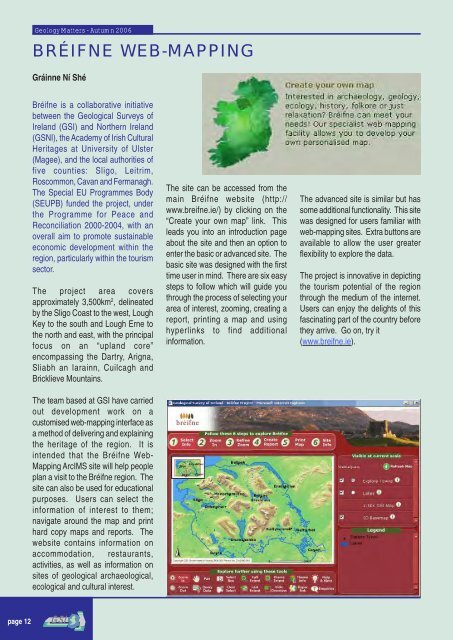
The site can be accessed from the<br />
main Bréifne website (http://<br />
www.breifne.ie/) by clicking on the<br />
“Create your own map” link. This<br />
leads you into an introduction page<br />
about the site and then an option to<br />
enter the basic or advanced site. The<br />
basic site was designed with the first<br />
time user in mind. There are six easy<br />
steps to follow which will guide you<br />
through the process <strong>of</strong> selecting your<br />
area <strong>of</strong> interest, zooming, creating a<br />
report, printing a map and using<br />
hyperlinks to find additional<br />
information.<br />
The advanced site is similar but has<br />
some additional functionality. This site<br />
was designed for users familiar with<br />
web-mapping sites. Extra buttons are<br />
available to allow the user greater<br />
flexibility to explore the data.<br />
The project is innovative in depicting<br />
the tourism potential <strong>of</strong> the region<br />
through the medium <strong>of</strong> the internet.<br />
Users can enjoy the delights <strong>of</strong> this<br />
fascinating part <strong>of</strong> the country before<br />
they arrive. Go on, try it<br />
(www.breifne.ie).<br />
page 12


