3.04 Gravimetric Methods – Superconducting Gravity Meters
3.04 Gravimetric Methods – Superconducting Gravity Meters
3.04 Gravimetric Methods – Superconducting Gravity Meters

Create successful ePaper yourself
Turn your PDF publications into a flip-book with our unique Google optimized e-Paper software.
110 <strong>Superconducting</strong> <strong>Gravity</strong> <strong>Meters</strong><br />
Δg (μGal)<br />
Δg (μGal)<br />
10<br />
5<br />
0<br />
<strong>–</strong>5<br />
Membach: 4 Aug. 1995<strong>–</strong>31 May 2000<br />
<strong>–</strong>10<br />
0 365 730 1095 1460<br />
t (days)<br />
10<br />
5<br />
0<br />
<strong>–</strong>5<br />
<strong>–</strong>10<br />
Potsdam: 30 Jun. 1992<strong>–</strong>8 Oct. 1998<br />
0 365 730 1095 1460 1825 2190<br />
t (days)<br />
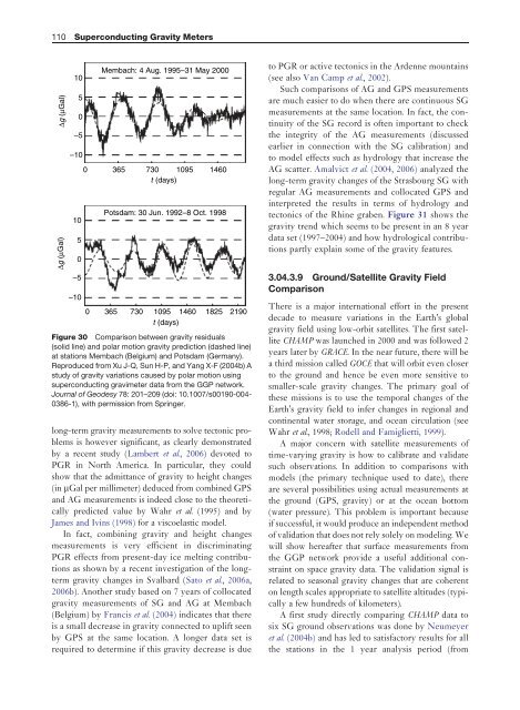
Figure 30 Comparison between gravity residuals<br />
(solid line) and polar motion gravity prediction (dashed line)<br />
at stations Membach (Belgium) and Potsdam (Germany).<br />
Reproduced from Xu J-Q, Sun H-P, and Yang X-F (2004b) A<br />
study of gravity variations caused by polar motion using<br />
superconducting gravimeter data from the GGP network.<br />
Journal of Geodesy 78: 201<strong>–</strong>209 (doi: 10.1007/s00190-004-<br />
0386-1), with permission from Springer.<br />
long-term gravity measurements to solve tectonic problems<br />
is however significant, as clearly demonstrated<br />
by a recent study (Lambert et al., 2006) devotedto<br />
PGR in North America. In particular, they could<br />
show that the admittance of gravity to height changes<br />
(in mGal per millimeter) deduced from combined GPS<br />
and AG measurements is indeed close to the theoretically<br />
predicted value by Wahr et al. (1995) and by<br />
James and Ivins (1998) for a viscoelastic model.<br />
In fact, combining gravity and height changes<br />
measurements is very efficient in discriminating<br />
PGR effects from present-day ice melting contributions<br />
as shown by a recent investigation of the longterm<br />
gravity changes in Svalbard (Sato et al., 2006a,<br />
2006b). Another study based on 7 years of collocated<br />
gravity measurements of SG and AG at Membach<br />
(Belgium) by Francis et al. (2004) indicates that there<br />
is a small decrease in gravity connected to uplift seen<br />
by GPS at the same location. A longer data set is<br />
required to determine if this gravity decrease is due<br />
to PGR or active tectonics in the Ardenne mountains<br />
(see also Van Camp et al., 2002).<br />
Such comparisons of AG and GPS measurements<br />
are much easier to do when there are continuous SG<br />
measurements at the same location. In fact, the continuity<br />
of the SG record is often important to check<br />
the integrity of the AG measurements (discussed<br />
earlier in connection with the SG calibration) and<br />
to model effects such as hydrology that increase the<br />
AG scatter. Amalvict et al. (2004, 2006) analyzed the<br />
long-term gravity changes of the Strasbourg SG with<br />
regular AG measurements and collocated GPS and<br />
interpreted the results in terms of hydrology and<br />
tectonics of the Rhine graben. Figure 31 shows the<br />
gravity trend which seems to be present in an 8 year<br />
data set (1997<strong>–</strong>2004) and how hydrological contributions<br />
partly explain some of the gravity features.<br />
<strong>3.04</strong>.3.9 Ground/Satellite <strong>Gravity</strong> Field<br />
Comparison<br />
There is a major international effort in the present<br />
decade to measure variations in the Earth’s global<br />
gravity field using low-orbit satellites. The first satellite<br />
CHAMP was launched in 2000 and was followed 2<br />
years later by GRACE. In the near future, there will be<br />
a third mission called GOCE that will orbit even closer<br />
to the ground and hence be even more sensitive to<br />
smaller-scale gravity changes. The primary goal of<br />
these missions is to use the temporal changes of the<br />
Earth’s gravity field to infer changes in regional and<br />
continental water storage, and ocean circulation (see<br />
Wahr et al., 1998; Rodell and Famiglietti, 1999).<br />
A major concern with satellite measurements of<br />
time-varying gravity is how to calibrate and validate<br />
such observations. In addition to comparisons with<br />
models (the primary technique used to date), there<br />
are several possibilities using actual measurements at<br />
the ground (GPS, gravity) or at the ocean bottom<br />
(water pressure). This problem is important because<br />
if successful, it would produce an independent method<br />
of validation that does not rely solely on modeling. We<br />
will show hereafter that surface measurements from<br />
the GGP network provide a useful additional constraint<br />
on space gravity data. The validation signal is<br />
related to seasonal gravity changes that are coherent<br />
on length scales appropriate to satellite altitudes (typically<br />
a few hundreds of kilometers).<br />
A first study directly comparing CHAMP data to<br />
six SG ground observations was done by Neumeyer<br />
et al. (2004b) and has led to satisfactory results for all<br />
the stations in the 1 year analysis period (from