Chapter 11 Population and Environment - Central Bureau of Statistics
Chapter 11 Population and Environment - Central Bureau of Statistics
Chapter 11 Population and Environment - Central Bureau of Statistics

You also want an ePaper? Increase the reach of your titles
YUMPU automatically turns print PDFs into web optimized ePapers that Google loves.
CHAPTER <strong>11</strong><br />
POPULATION AND ENVIRONMENT: A SITUATION<br />
ANALYSIS OF POPULATION, CULTIVATED LAND AND<br />
BASIC CROP PRODUCTION IN NEPAL IN 2001<br />
- Dr. Bhim Prasad Subedi *<br />
<strong>11</strong>.1 Introduction<br />
For all practical purposes the territory <strong>of</strong> Nepal is finite. There is a limit to the environmental<br />
resources within this territory that Nepalese citizen can utilize. The increasing presence <strong>of</strong> people<br />
on its territory is presenting economic, social <strong>and</strong> ecological problems. It is only over the last two<br />
decades that we have raised ques tions regarding multifaceted implications <strong>of</strong> our increasing<br />
presence. At the world scale during 1980s the Brundtl<strong>and</strong> Report (WCED, 1987) brilliantly<br />
presented the idea <strong>of</strong> sustainable development. It stated that development should meet the needs<br />
<strong>of</strong> present generations without compromising the ability <strong>of</strong> future generations to meet their needs.<br />
This statement is ambiguous <strong>and</strong> as Sutton (2003:294) states “it is both difficult to disagree with<br />
while at the same time imposes many implicit constraints as to how development should take<br />
place.” Over the course <strong>of</strong> time, sustainable development has been interpreted differently for<br />
reason that it contains ideas <strong>of</strong> environmental sustainability, economic efficiency <strong>and</strong> human<br />
equity (Costanza <strong>and</strong> Folke, 1997). Subsequently for collective human objective the<br />
environmentalists pursued “sustainability’ as the primary theme, while economists went on to<br />
persue ‘efficiency’ <strong>and</strong> for many other social scientists <strong>and</strong> humanists ‘equity’ became the main<br />
concern due to increasing presence <strong>of</strong> human beings on the specific territorial unit. In all these,<br />
the concern remains <strong>of</strong> balancing human impact on earth’s ability to absorb the impact. In pursing<br />
the interpretations <strong>and</strong> attempting to examine population-environment relations further measures<br />
such as environmental sustainability index (see, Sutton, 2003; Samuel-Johnson <strong>and</strong> Esty, 2001)<br />
have been developed. Likewise, the concepts such as ‘carrying capacity’ <strong>and</strong> ‘population<br />
pressure’ have gained further attention in the literature (see, Daily <strong>and</strong> Ehrlich, 1992).<br />
In Nepal there have been some attempts in the past to highlight the population environment<br />
relations some explicitly while others implicitly (see, Shrestha <strong>and</strong> Sharma, 1980; Shrestha <strong>and</strong><br />
Conway 1982; Shrestha, Conway <strong>and</strong> Bhattarii 1999; Subedi 1995). These attempts are worth<br />
*<br />
Dr. Subedi is an Associate Pr<strong>of</strong>essor <strong>of</strong> TU, Geography Department, Kirtipur.<br />
1
mentioning. However, in the context <strong>of</strong> <strong>Population</strong> Census 2001 <strong>and</strong> other recent information the<br />
need for updating <strong>and</strong>/or reassessing the population resource situation has become imperative.<br />
This paper is based on the broader framework <strong>of</strong> population <strong>and</strong> environment relations using<br />
Nepal as a case. Because the scope <strong>of</strong> human environment relation study is vast this paper<br />
concentrates only on existing population, l<strong>and</strong> resource <strong>and</strong> adequacy <strong>of</strong> basic crop production in<br />
the country. The food crop production is considered as an expression <strong>of</strong> human effort to maximize<br />
the utilization <strong>of</strong> available l<strong>and</strong> resource amidst increasing presence <strong>of</strong> human number. For this<br />
<strong>and</strong> for data limitation (discussed later) the conclusions should be taken as indicative rather than<br />
comprehensive.<br />
This paper is divided into six sections. The first section gives an introduction to population <strong>and</strong><br />
sustainable development issues. The second section briefly mentions the materials used in this<br />
paper <strong>and</strong> methods <strong>of</strong> analysis. The third section discusses l<strong>and</strong> resources situation in terms <strong>of</strong><br />
cultivated l<strong>and</strong> in the country. The fourth section deals with basic crop production for the last five<br />
years for which data are available. The fifth section is about cereal crop availability <strong>and</strong><br />
requirement in the district. The last section concludes the paper with some limitations <strong>and</strong> policy<br />
implications.<br />
<strong>11</strong>.2 Materials <strong>and</strong> Methods<br />
Three main sources <strong>of</strong> data have been utilized. <strong>Population</strong> Census 2001 is the main data source<br />
for size <strong>and</strong> distribution <strong>of</strong> population. Similarly data on proportion <strong>of</strong> cultivated l<strong>and</strong> for 75<br />
districts <strong>of</strong> Nepal is obtained from Japan Forest Technology Association (JAFTA) 2000. Data on<br />
cropped area <strong>and</strong> production <strong>of</strong> food crops are taken from Statistical Information on Nepalese<br />
Agriculture. Five crops namely barley, maize, millet, paddy <strong>and</strong> wheat are considered as primary<br />
food crops in general. However, in the Mountain region potato is consumed as basic crop.<br />
Therefore, inclusion <strong>of</strong> potato produc tion as part <strong>of</strong> basic crop is considered desirable.<br />
Consequently, production <strong>of</strong> potato is included in the figure on total food crop production.<br />
Data quality <strong>and</strong> adequacy are always issues for the comprehensive analysis <strong>of</strong> population <strong>and</strong><br />
basic crop availa bility situation in Nepal. There are some inherent limitations <strong>of</strong> data on l<strong>and</strong><br />
resources <strong>and</strong> crop production that are utilized in this paper. But under the given circumstances<br />
these are the best available sources that provide district level information on l<strong>and</strong> <strong>and</strong> crop<br />
production covering all 75 districts. Department <strong>and</strong> Directorates within the Ministry <strong>of</strong><br />
Agriculture <strong>and</strong> Cooperatives are the primary institutions responsible for providing reliable data<br />
on cropped area <strong>and</strong> crop production. On the other h<strong>and</strong> JAFTA has provided data on l<strong>and</strong><br />
2
esources through utilization <strong>of</strong> latest remote sensing technology. It would have been better if l<strong>and</strong><br />
use data were available in the disaggregated form for agriculture <strong>and</strong> grassl<strong>and</strong>. Apparently this<br />
was not possible for 2000. Agriculture l<strong>and</strong> in the data set included grassl<strong>and</strong> also. The resulting<br />
proportion <strong>of</strong> l<strong>and</strong> under agriculture is thus higher than what it really is.<br />
The adequacy <strong>of</strong> food production in the district is based on nutrition requirement <strong>of</strong> individuals in<br />
the district. The Report <strong>of</strong> the Commission on Strengthening the Supplies System 2051 (pp. 146–<br />
148) gives the calorie requirement <strong>of</strong> the individual. Individual calorie requirements are stated to<br />
be different for the Tarai <strong>and</strong> the Hills (including Mountain). Accordingly in the Hills (including<br />
Mountain region) the total calorie requirement is 2,344 calories per person per day. The<br />
corresponding requirement in the Tarai is 2,144 calories. Of the total requirement it is also<br />
estimated that 87.3 percent should be available from cereals (see, Gautam, 1993). Therefore, the<br />
adequacy <strong>of</strong> food supply is based on the proportion <strong>of</strong> cereal needs in the total amount. Thus, the<br />
cereal requirement is estimated at 2046.3 calories for the Hill <strong>and</strong> 1871.7 calories for the Tarai.<br />
The national average is estimated to be 1999.7.<br />
The calorie values for various basic crops differ. Annex <strong>11</strong>.1 gives the calorie values <strong>of</strong> six crops<br />
considered in this paper. This difference is taken into account while analyzing the adequacy <strong>of</strong><br />
basic crop production in the region <strong>and</strong> the districts. Details are discussed in the fifth section <strong>of</strong><br />
the paper.<br />
<strong>11</strong>.3 Distribution <strong>of</strong> Cultivated L<strong>and</strong><br />
L<strong>and</strong> is the primary resource for agrarian economies. Nepal is no exception. The importance <strong>of</strong><br />
l<strong>and</strong> as a resource is further warranted in Nepal since overwhelming majority <strong>of</strong> population i.e.,<br />
more than 85 percent, live in rural areas <strong>and</strong> more than 60 percent economically active population<br />
has agriculture as their primary occupation. Data on agriculture l<strong>and</strong> for all 75 districts in the<br />
country are available from two sources <strong>and</strong> for two time periods. These sources are: L<strong>and</strong><br />
Resource Mapping Project (LRMP) 1978/79 <strong>and</strong> Japan Forest Technology Association (JAFTA)<br />
2000. These two sources are not necessarily comparable in the categories to which they report the<br />
l<strong>and</strong> use situation but these are the best available sources for data on distribution <strong>of</strong> l<strong>and</strong> resource<br />
by district at present in the country. The distribution <strong>of</strong> l<strong>and</strong> resource situation in both these time<br />
periods is discussed below.<br />
3
<strong>11</strong>.3.1 Distribution <strong>of</strong> Cultivated L<strong>and</strong> in 1978/79<br />
<strong>11</strong>.3.1.1 Cultivated L<strong>and</strong> 1978/79<br />
Of the total l<strong>and</strong> in the country only 18 percent was classified as cultivated l<strong>and</strong> in 1978/79. This<br />
proportion is based on air photo data <strong>of</strong> L<strong>and</strong> Resource Mapping Project 1978/79. Data on<br />
proportion <strong>of</strong> l<strong>and</strong> under cultivation is important because the size <strong>of</strong> rural population that can be<br />
supported in a given area depends upon the proportion <strong>of</strong> l<strong>and</strong> under cultivation at present <strong>and</strong> the<br />
proportion that could be brought under cultivation in the near future. The proportion <strong>of</strong> cultivated<br />
l<strong>and</strong> varies by ecological regions <strong>and</strong> by districts in the country. Generally, the proportion<br />
decreases from south to north. Districts located in the Tarai region have higher proportion. For<br />
example on an average, districts in Tarai have 40 percent <strong>of</strong> their total l<strong>and</strong> used for cultivation.<br />
This high proportion is primarily because <strong>of</strong> the plain l<strong>and</strong>form <strong>and</strong> high fertility <strong>of</strong> soil there. It is<br />
also to be noted that most <strong>of</strong> the l<strong>and</strong> brought under cultivation in the Tarai is also <strong>of</strong> recent<br />
origin. On the contrary, districts in the mountain region have limited proportion <strong>of</strong> l<strong>and</strong> suitable<br />
for cultivation. More specifically, only 4.4 percent <strong>of</strong> the total l<strong>and</strong> is used for cultivation in this<br />
region. The rugged terrain, altitude <strong>and</strong> steep slope are the main limiting factors. Moreover, a<br />
large proportion <strong>of</strong> l<strong>and</strong> in the mountain region is rocky <strong>and</strong> barren. The hill region, which is<br />
situated in between two extremes, occupies an intermediate position in the proportion <strong>of</strong><br />
cultivated l<strong>and</strong>. Of the total l<strong>and</strong> 17.2 percent is cultivated there. This proportion is less than half<br />
<strong>of</strong> the proportion in the Tarai. There is also an east-west variation in this proportion. Districts<br />
located in the east have higher proportion <strong>of</strong> cultivated l<strong>and</strong> <strong>and</strong> the proportion gradually<br />
decreases towards west. This applies to all ecological zones.<br />
Jhapa district has the highest proportion <strong>of</strong> l<strong>and</strong> under cultivation. Of its total l<strong>and</strong>, 68.2 percent is<br />
under cultivation. Manang represents the contrary with negligible proportion i.e., 0.3 percent<br />
under cultivation. Among 75 districts, largest proportion <strong>of</strong> districts (26.6%) has 20-30 percent <strong>of</strong><br />
their total l<strong>and</strong> under cultivation. Districts with 10-20 percent l<strong>and</strong> under cultivation follow this<br />
(25.3%). Districts from Mid -western <strong>and</strong> Far-Western Hills are among districts having this<br />
proportion. Districts with higher proportion <strong>of</strong> cultivated l<strong>and</strong> are located in the eastern Tarai.<br />
Despite hilly terrain, districts in the eastern hills are almost comparable with Mid-western <strong>and</strong><br />
Far-western Tarai in the proportion <strong>of</strong> cultivated l<strong>and</strong>. While long history <strong>of</strong> settlement, high<br />
population growth <strong>and</strong> sufficient rainfall may have collectively resulted into relatively high<br />
proportion <strong>of</strong> cultivated l<strong>and</strong> in the Eastern hills, the Mid-western <strong>and</strong> Far -western Tarai are<br />
among relatively newly inhabited areas in Nepal Tarai.<br />
4
Almost one-fourth or eighteen districts have very limited proportion <strong>of</strong> cultivated l<strong>and</strong> i.e., less<br />
than ten percent. Generally districts in the Mountain region have this situation but a number <strong>of</strong><br />
hill districts in the Mid-west <strong>and</strong> Far west also fall in this category. More importantly, among<br />
eighteen districts three have as low as less than one percent <strong>of</strong> their total l<strong>and</strong> under cultivation.<br />
Humla, Dolpa <strong>and</strong> Manang are among the districts having lowest proportion <strong>of</strong> l<strong>and</strong> under<br />
cultivation.<br />
<strong>11</strong>.3.1.2 Cultivated L<strong>and</strong> Per Capita<br />
The proportion <strong>of</strong> cultivated l<strong>and</strong> gives an indication <strong>of</strong> l<strong>and</strong> resource situation in the given<br />
district or region. However, in the population resource context the per -capita distribution is more<br />
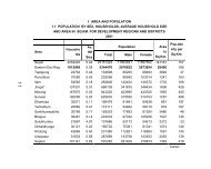
meaningful. Table <strong>11</strong>.1 gives the l<strong>and</strong> resource per capita by ecological zones (regions) for 1981.<br />
Cultivated l<strong>and</strong> per capita at the national level was o.176 ha or roughly 3.5 ropani. This refers to<br />
net cultivated l<strong>and</strong>. In the mountain region <strong>and</strong> also in the high hills livestock farming is<br />
important part <strong>of</strong> livelihood. Thus, it is desirable to include area under grassl<strong>and</strong> while calculating<br />
per capita l<strong>and</strong> availability. With inclusion <strong>of</strong> grassl<strong>and</strong> the per capita l<strong>and</strong> availability is 0.29 ha<br />
or 5.76 ropani (Table <strong>11</strong>.1).<br />
Table <strong>11</strong>.1: Cultivated l<strong>and</strong> per person by ecological zones, 1981.<br />
Region (Zones)<br />
Cultivated L<strong>and</strong> Per Capita (in ha)<br />
Cultivated L<strong>and</strong> Only Cultivated L<strong>and</strong> Including Grass L<strong>and</strong><br />
Mountain 0.17438 1.04733<br />
Hill 0.14718 0.22337<br />
Tarai 0.20729 0.21861<br />
Nepal 0.17578 0.29275<br />
Note :<br />
In this table data on l<strong>and</strong> is taken from LRMP 1978/79 <strong>and</strong> data on population is from <strong>Population</strong><br />
Census 1981.<br />
Variation by ecological region is obvious. Per capita cultivated l<strong>and</strong> (net) is highest in the Tarai<br />
followed by the Mountain region. The Hill region has the lowest per capita net cultivated l<strong>and</strong>.<br />
This generalization does not hold true when grassl<strong>and</strong> is included as part <strong>of</strong> cultivated area. The<br />
Mountain ranks highest with more than a hectare <strong>of</strong> l<strong>and</strong> per capita. Pastures (locally known as<br />
kharka) are common features <strong>of</strong> overall l<strong>and</strong>scape in the Mountain region. The area under<br />
grassl<strong>and</strong> decreases from north to south or from the mountain to the plains. Tarai with minimal or<br />
no grassl<strong>and</strong> ranks lowest. The Hill occupies a middle position with 0.22 ha per capita l<strong>and</strong>.<br />
5
<strong>11</strong>.3.1.3 Man-L<strong>and</strong> Ratio<br />
Man-l<strong>and</strong> ratio is a very common way <strong>of</strong> expressing population resource situation in the country.<br />
In general this ratio is considered as indicative <strong>of</strong> the pressure <strong>of</strong> population on l<strong>and</strong> resources.<br />
Areas with high ratios are indicative <strong>of</strong> higher stress <strong>of</strong> population on l<strong>and</strong> resources. Man-l<strong>and</strong><br />
ratios discussed in this section is calculated using data for population <strong>and</strong> the l<strong>and</strong> availability in a<br />
roughly comparable time frame. While population data is for 1981, data on cultivated l<strong>and</strong> refers<br />
to 1978/79. Accordingly, at the national level man-l<strong>and</strong> ratio is 5.6 persons per hectare. It is high<br />
in the districts located in the <strong>Central</strong> <strong>and</strong> Western Hill. Kathm<strong>and</strong>u <strong>and</strong> Manang are two extremes.<br />
Districts located in the Mountain region have relatively lower ratios.<br />
Based on the value <strong>of</strong> man-l<strong>and</strong> ratio in 1981, the seventy-five districts <strong>of</strong> the country have been<br />
categorized into fiv e categories (Table <strong>11</strong>.2). There are four districts having less than four persons<br />
per hectare. While three <strong>of</strong> them are from the Tarai one is from the Mountain. None <strong>of</strong> the Tarai<br />
districts have more than six persons per hectare in 1981. They demonstrate mod erate situation i.e.,<br />
four to six persons per hectare. Some Tarai districts especially those from the Mid-west <strong>and</strong> Far -<br />
west are among districts demonstrating low man-l<strong>and</strong> ratios. On the contrary, the Hill districts in<br />
general <strong>and</strong> Kathm<strong>and</strong>u valley districts <strong>and</strong> Kavrepalanchok in particular exhibit high man-l<strong>and</strong><br />
ratios.<br />
Table <strong>11</strong>.2: Man-l<strong>and</strong> ratio by districts 1981.<br />
Categories<br />
(persons per<br />
ha)<br />
Less than Four<br />
Four to Five<br />
Five to Six<br />
Six to Ten<br />
More than Ten<br />
Number<br />
(percent) <strong>of</strong><br />
Districts<br />
4<br />
(5.3 %)<br />
18<br />
(24.0 %)<br />
27<br />
(36.0 %)<br />
22<br />
(29.4 %)<br />
4<br />
(5.3 %)<br />
Name <strong>of</strong> the Districts<br />
Mustang, , Kailali, Bardiya, Kapilvastu<br />
Humla, Mugu, Dolpa, Solukhumbu, Sankhuwasabha,<br />
Jajarkot, Dhankuta, Tehrathum, Panchthar, Ilam,<br />
Kanchanpur, Banke, Dang, Rup<strong>and</strong>ehi, Siraha, Saptari,<br />
Sunsari, Jhapa<br />
Bajhang, Jumla, Rasuwa, Taplejung,<br />
Dadeldhura, Doti, Achham, Dailekh, Surkhet, Salyan, Rolpa,<br />
Rukum, Sindhuli, Ramechhap, Udayapur, Okhaldhunga,<br />
Khotang, Bhojpur, Nawalparasi, Chitwan, Parsa, Bara,<br />
Rautahat, Sarlahi, Mahottari, Dhanusha, Morang<br />
Darchula, Bajura, Kalikot, Manang, Sindhupalchok Dolakha,<br />
Baitadi, Arghakhanchi, Pyuthan, Gulmi, Palpa,<br />
Baglung,Myagdi, Parbat, Kaski, Syangja, Tanahun,<br />
Lamjung, Gorkha, Dhading, Nuwakot, Makwanpur<br />
Kathm<strong>and</strong>u, Lalitpur, Bhaktapur, Kavrepalanchok<br />
Note :<br />
For the convenience <strong>of</strong> readers, whereas districts located in the Mountain region are underlined,<br />
the Hill districts are italicized. Likewise the Kathm<strong>and</strong>u valley districts are both underlined <strong>and</strong><br />
italicized.<br />
6
Over the past two decades the population has grown rapidly. Between 1981 <strong>and</strong> 2001 more than<br />
8.1 million people have been added in the country. Two censuses have been conducted<br />
successively in between. They have recorded more than 2.0 percent annual growth rate during<br />
these years. On the other h<strong>and</strong>, comparable <strong>and</strong> comprehensive data on l<strong>and</strong> resources as per<br />
LRMP are not available. It is widely reported that with population increase some marginal areas<br />
have also been brought to cultivation over these years. This leads to the likelihood <strong>of</strong> increase in<br />
the proportion <strong>of</strong> cultivated l<strong>and</strong>. In the mean time, several studies in Nepal have noted that the<br />
amount <strong>of</strong> l<strong>and</strong> that can be brought under cultivation at present in Nepal is limited (see, Ives <strong>and</strong><br />
Messerli, 1989).<br />
<strong>11</strong>.3.2 Distribution <strong>of</strong> Cultivated L<strong>and</strong> in 2001<br />
Japan Forest Technology Association (JAFTA) 2001 has provided area <strong>of</strong> agriculture <strong>and</strong> grass<br />
l<strong>and</strong> for 75 districts <strong>of</strong> the country. This data is used as the latest information on distribution <strong>of</strong><br />
cultivated l<strong>and</strong> by district. In a strict sense, the categories <strong>of</strong> l<strong>and</strong> use under LRMP <strong>and</strong> JAFTA<br />
may not be comparable. Nonetheless, broader generalizations are possible in terms <strong>of</strong> direction<br />
<strong>and</strong> extent <strong>of</strong> change. Moreover, in this section the focus is on the state <strong>of</strong> affairs than a<br />
comparative assessment.<br />
<strong>11</strong>.3.2.1 Cultivated L<strong>and</strong> 2000<br />
According to JAFTA 2000 the total cultivated (agriculture) l<strong>and</strong> including grassl<strong>and</strong> in the<br />
country is 4,061,631 ha which constitutes 27.6 percent <strong>of</strong> the total area <strong>of</strong> the country. This high<br />
proportion is due to the inclusion <strong>of</strong> grassl<strong>and</strong> in the same category. Separate categories <strong>of</strong> l<strong>and</strong><br />
for agriculture <strong>and</strong> grassl<strong>and</strong> are not available in this source. Unless specified, cultivated l<strong>and</strong> in<br />
the following discussion includes grassl<strong>and</strong>.<br />
Regional variation is evident in the proportion <strong>of</strong> cultivated l<strong>and</strong> <strong>and</strong> grassl<strong>and</strong>. The Mountain<br />
region has 10 percent <strong>of</strong> its total area under cultivation in 2000. The corresponding proportions<br />
are 27.2 percent <strong>and</strong> 55.2 percent in the Hill <strong>and</strong> the Tarai. Variation by 15 eco-development<br />
regions is also apparent. The two extremes in this case include Western Mountain with 0.1<br />
percent <strong>and</strong> Eastern Tarai with 75.6 percent <strong>of</strong> total area under cultivation. The proportion <strong>of</strong><br />
cultivated l<strong>and</strong> decreases from East to West except Mid -western region. Of the fifteen ecodevelopment<br />
regions three namely Eastern, <strong>Central</strong> <strong>and</strong> Western Tarai have more than 50 percent<br />
<strong>of</strong> their total l<strong>and</strong> under cultivation. Similarly, three regions namely Eastern <strong>and</strong> <strong>Central</strong> Hills <strong>and</strong><br />
7
Far-western Tarai have 40-50 percent <strong>of</strong> their total l<strong>and</strong> under cultivation. Eastern <strong>and</strong> <strong>Central</strong><br />
Mountains, <strong>and</strong> Western <strong>and</strong> Far -western Hills have 20-25 percent <strong>of</strong> their l<strong>and</strong> under cultivation.<br />
Mid-western Mountain has only 3.2 percent <strong>of</strong> total l<strong>and</strong> under cultivation. Moreover, Midwestern<br />
Hill <strong>and</strong> Far -western Mountain are roughly comparable with 14.5 <strong>and</strong> 13.6 percent <strong>of</strong><br />
their total l<strong>and</strong> under cultivation respectively. In all eco-development regions north-south<br />
variation is more distinct than the east-west variation.<br />
At the district level the differences are far greater than the eco-development regions. Jhapa with<br />
88 percent <strong>of</strong> its l<strong>and</strong> under cultivation represents one end whereas Dolpa with less than 0.1<br />
percent represents another extreme. On the whole, districts located in Tarai have higher<br />
proportion <strong>of</strong> cultivated l<strong>and</strong> compared with districts in the Hill <strong>and</strong> the Mountain. Generally<br />
districts from Eastern <strong>and</strong> <strong>Central</strong> Tarai have more than 50 percent <strong>of</strong> their total l<strong>and</strong> under<br />
cultivation. Districts in the Hill demonstrate complex situation. The proportion <strong>of</strong> cultivated l<strong>and</strong><br />
ranges from 4.5 percent (Rukum) to 54.8 percent (Okhaldhunga) excluding Kathm<strong>and</strong>u valley.<br />
Specific generalizations are difficult to make except what the districts in the East, Center <strong>and</strong><br />
West have higher proportion, those in the Far -west have medium <strong>and</strong> those in the Mid-west have<br />
lower proportions <strong>of</strong> total l<strong>and</strong> under cultivation. Some Hill districts namely Tehrathum,<br />
Dhankuta, Okhaldhunga <strong>and</strong> Kathm<strong>and</strong>u also have more than 50 percent <strong>of</strong> their l<strong>and</strong> under<br />
cultivation. More importantly, all Tarai districts have more than 40 percent <strong>of</strong> their total l<strong>and</strong><br />
under cultivation by 2000. Banke (30.6%) <strong>and</strong> Dang (36.2%) are two exceptions.<br />
<strong>11</strong>.3.2.2 Cultivated L<strong>and</strong> Per Capita<br />
Cultivated l<strong>and</strong> per capita for 2001 is 0.175 ha or 3.4 ropani for the country as a whole. Among<br />
ecological regions the Hill has lowest per-capita l<strong>and</strong> i.e., 0.163 ha or 3.2 ropani. The Mountain<br />
on the other h<strong>and</strong>, demonstrates the highest value, a result <strong>of</strong> low population size. Although the<br />
per capita l<strong>and</strong> in the Tarai is higher than the Hill, the difference is rather minimal whereas the<br />
difference between the Hill <strong>and</strong> the Mountain is far higher than the difference between the Hill<br />
<strong>and</strong> the Tarai (Table <strong>11</strong>.3).<br />
8
Table <strong>11</strong>.3: Cultivated l<strong>and</strong> per person <strong>and</strong> per household 2000.<br />
Region (Zones)<br />
Cultivated L<strong>and</strong> Per Person<br />
(ha)<br />
Cultivated L<strong>and</strong> Per Household<br />
(ha)<br />
Mountain 0.307121 1.620500<br />
Hill 0.162554 0.840429<br />
Tarai 0.167393 0.962222<br />
Nepal 0.175438 0.954954<br />
Note :<br />
<strong>Population</strong> figures are from <strong>Population</strong> Census 2001 <strong>and</strong> the figures for area under cultivation is<br />
taken from JAFTA 2001.<br />
The distribution <strong>of</strong> cultivated l<strong>and</strong> per household shows a similar situation. L<strong>and</strong> per household is<br />
lowest in the Hill followed by the Tarai. L<strong>and</strong> per household in the Mountain is nearly double that<br />
<strong>of</strong> the Hill. In the country as a whole, l<strong>and</strong> per household is less than one hectare. This figure is<br />
lower than the one available from the L<strong>and</strong> Resource Mapping Project. Although these two<br />
sources are not strictly comparable, the decrease in the amount <strong>of</strong> l<strong>and</strong> per household is quite<br />
logical given the rapid increase <strong>of</strong> population over last two decades.<br />
<strong>11</strong>.3.2.3 Man-L<strong>and</strong> Ratio, 2001<br />
The overall man-l<strong>and</strong> ratio for 2001 is 5.7 persons per hectare. Districts with highest <strong>and</strong> the<br />
lowest man-l<strong>and</strong> ratio are from the Mountain. Whereas Dolpa has the highest man-l<strong>and</strong> ratio <strong>of</strong><br />
383.7 persons per hectare, Solukhumbu has the lowest value <strong>of</strong> 1.6 persons. Mustang, Dhading,<br />
Kathamndu <strong>and</strong> Manang are among districts with high man-l<strong>and</strong> ratios. On the contrary,<br />
Taplejung, Mugu, Sankhuwasabha <strong>and</strong> Okhaldhunga are among districts with low man-l<strong>and</strong><br />
ratios.<br />
Broadly, districts in the Mountain <strong>and</strong> the Tarai demonstrate a special pattern. Majority Mountain<br />
districts have less than four persons per hectare <strong>of</strong> cultivated l<strong>and</strong>. Likewise, majority Tarai<br />
districts have man-l<strong>and</strong> ratios between six to ten persons (Table <strong>11</strong>.4). The Hill districts are<br />
complex <strong>and</strong> demonstrate diverse situation. On the one h<strong>and</strong>, there are eight districts having less<br />
than four persons per hectare, there are five districts with more than ten persons per hectare on the<br />
other. Kathm<strong>and</strong>u valley districts especially Kathm<strong>and</strong>u <strong>and</strong> Bhaktapur have very high man-l<strong>and</strong><br />
ratio compared with other hill districts. Both these districts have more than 40 persons per hectare<br />
while Lalitpur has about 22 persons per hectare. In the context <strong>of</strong> high-man-l<strong>and</strong> ratio in<br />
Kathm<strong>and</strong>u it should be noted that Kathm<strong>and</strong>u valley with the only metropolitan city is the most<br />
urbanized section <strong>of</strong> the country.<br />
9
Table <strong>11</strong>.4: Man-l<strong>and</strong> ratio by districts 2001.<br />
Categories<br />
(persons per<br />
ha)<br />
Number<br />
(percent) <strong>of</strong><br />
Districts<br />
Less than Four 17 (22.7%)<br />
Four to Five 14 (18.7%)<br />
Five to Six 13 (17.3%)<br />
Six to Ten 20 (26.7%)<br />
More than Ten <strong>11</strong> (14.6%)<br />
Name <strong>of</strong> the Districts<br />
Darchula, Bajhang, Bajura, Humla, Mugu, Dolakha, Solukhumbu,<br />
Sankhuwasabha, Taplejung,<br />
Ramechhap, Makwanpiur, Khotang, Sindhuli, Bhojpur, Dhankuta,<br />
Tehrathum, Panchthar<br />
Jumla, Manang, Rasuwa, Sindhupalchok<br />
Dadeldhura, Doti, Gorkha, Udayapur, Ilam,<br />
Kailali, Bardiya, Dang, Kapilvastu, Jhapa<br />
Baitadi, Achham, Surkhet, Jajarkot, Salyan, Lamjung, Tanahun,<br />
Dhading, Nuwakot, Makwanpur,<br />
Kavrepalanchok,<br />
Banke, Nawalparasi,<br />
Kalikot, Dailekh, Myagdi, Pyuthan, Gulmi, Arghakhanchi, Palpa,<br />
Syangja<br />
Rup<strong>and</strong>ehi, Chitwan, Parsa, Bara, Rautahat, Sarlahi, Mahottari,<br />
Dhanusha, Siraha, Saptari, Sunsari, Morang<br />
Dolpa, Mustang, Manang, Rukum, Rolpa, Baglung, Parbat, Kaski,<br />
Kathm<strong>and</strong>u, Lalitpur, Bhaktapur<br />
Note :<br />
1. For the convenience <strong>of</strong> readers, whereas districts located in the Mountain region are<br />
underlined, the Hill districts are italicized. Likew ise the Kathm<strong>and</strong>u valley districts are both<br />
underlined <strong>and</strong> italicized.<br />
2. While data on l<strong>and</strong> resource refers to 2000, the population data refers to 2001.<br />
With few extremes such as Dolpa, Mustang <strong>and</strong> Manang, the values <strong>of</strong> man-l<strong>and</strong> ratios are<br />
comparable for 1981 <strong>and</strong> 2001. Further investigation is necessary to elucidate the extreme values.<br />
One likely explanation is the existence <strong>of</strong> large parcels <strong>of</strong> pasture in these mountain districts that<br />
are included in the current data on agriculture l<strong>and</strong>. Nevertheless, this comparability <strong>of</strong> man-l<strong>and</strong><br />
ratio after two decades is a concern. As stated earlier there has been an addition <strong>of</strong> more than 8.1<br />
million population over these years. If the cultivated l<strong>and</strong> had remained the same, this additional<br />
number would mean an addition <strong>of</strong> 3.0 persons per hectare by 2001 over 1978/79. Thus, the<br />
comparability <strong>of</strong> man-l<strong>and</strong> ratio therefore means a definite increase in the amount <strong>of</strong> l<strong>and</strong> under<br />
cultivation. Without longitudinal data with comparable categories <strong>and</strong> definitions, the extent <strong>of</strong><br />
increase cannot be elucidated. The specific assessment <strong>of</strong> changes in l<strong>and</strong> resource in general <strong>and</strong><br />
cultivated l<strong>and</strong> in particular is difficult <strong>and</strong> this paper, being a situation analysis is beyond its<br />
scope.<br />
Given three ecological zones (north-south) <strong>and</strong> fiv e development regions (east-west) it is also<br />
useful to analyze man-l<strong>and</strong> ratio by eco-development regions. Among fifteen eco-development<br />
regions, two regions demonstrate very high man-l<strong>and</strong> ratios in 2001. These include Western<br />
Mountain <strong>and</strong> Kathm<strong>and</strong>u valley. Limited availability <strong>of</strong> cultivated l<strong>and</strong> for the former <strong>and</strong> large<br />
10
population size in the latter can be attributed for the high ratios respectively. On the other h<strong>and</strong>,<br />
Eastern Mountain has the lowest man-l<strong>and</strong> ratio. On the whole, with an exception <strong>of</strong> Western<br />
Mountain these ratios are low in the Mountains <strong>and</strong> high in the Hills. Tarai is in-between but<br />
values <strong>of</strong> various Tarai regions are closer to the corresponding Hill regions than to the Mountain<br />
regions (Table <strong>11</strong>.5).<br />
Table <strong>11</strong>.5: Man-l<strong>and</strong> ratio by eco-development region, 2001.<br />
Eco-Development<br />
Region<br />
Cultivated<br />
L<strong>and</strong>* (ha)<br />
Total <strong>Population</strong>**<br />
Man-L<strong>and</strong> Ratio<br />
(p/ha)<br />
NEPAL 4061631 23151423 5.7<br />
Mountain 518377 1687859 3.3<br />
Eastern 209705 401587 1.9<br />
<strong>Central</strong> 131326 554817 4.2<br />
Western 564 24568 43.6<br />
Mid-western 68769 309084 4.5<br />
Far-western 108013 397803 3.7<br />
Hill 1666363 1025<strong>11</strong><strong>11</strong> 6.2<br />
Eastern 470656 1643246 3.5<br />
<strong>Central</strong> 44<strong>11</strong>67 3542732 8.0<br />
Western 387327 2793180 7.2<br />
Mid-western 199545 1473022 7.4<br />
Far-western 167668 798931 4.8<br />
Tarai 1876891 <strong>11</strong>212453 6.0<br />
Eastern 549214 3299643 6.0<br />
<strong>Central</strong> 553045 3934080 7.1<br />
Western 308707 1753265 5.7<br />
Mid-western 264218 1230869 4.7<br />
Far-western 201707 994596 4.9<br />
Kathm<strong>and</strong>u Valley 43670 1645091 37.7<br />
Note :<br />
Cultivated l<strong>and</strong> in this column includes grassl<strong>and</strong>. Disaggregated data for cultivated l<strong>and</strong> only is<br />
not available.<br />
Source : * Japan Forest Technology Association (JAFTA), 2001. ** CBS, 2002.<br />
Eco-development regions in the Hill primarily <strong>Central</strong>, Western <strong>and</strong> Mid-western hills are regions<br />
with man-l<strong>and</strong> ratio <strong>of</strong> more than 7 persons per hectare. Of the Tarai regions it is only <strong>Central</strong><br />
Tarai that has this ratio <strong>of</strong> more than 7 persons per hectare. This man-l<strong>and</strong> ratio when considered<br />
in the context <strong>of</strong> differences in terrain conditions, history <strong>of</strong> settlement, overall quality <strong>of</strong> soil <strong>and</strong><br />
yield <strong>of</strong> cereal crops (see tables below) by ecological zones, the pressure <strong>of</strong> population on l<strong>and</strong><br />
resource is far higher in the eco-development regions <strong>of</strong> the Hill than in other regions.<br />
<strong>11</strong>
<strong>11</strong>.4 Basic Crop Production<br />
The proportion <strong>of</strong> cultivated l<strong>and</strong>, per -capita availability <strong>and</strong> man-l<strong>and</strong> ratios are expressions <strong>of</strong><br />
population resource relations since they reflect the resource availability in the given area.<br />
Cultivated l<strong>and</strong> is the prime resource for agrarian population because without this the production<br />
<strong>of</strong> varieties <strong>of</strong> food <strong>and</strong> other crops necessary to meet the daily calorie requirement is not possible.<br />
Thus, analysis <strong>of</strong> population situation must take into consideration <strong>of</strong> crop production <strong>and</strong><br />
availability situation in the country in order to regulate population growth especially when the<br />
country such as Nepal is faced with rapid growth <strong>of</strong> population.<br />
<strong>11</strong>.4.1 Basic Crop Production at the National Level<br />
Six crops namely barley, maize, millet, paddy, wheat, <strong>and</strong> potato are considered as basic crops as<br />
these crops are used to meet the basic food requirement <strong>of</strong> citizens in the country. Since potato is<br />
consumed as basic crop in the Mountain region its inclusion, as part <strong>of</strong> basic crop is considered<br />
desirable. As noted earlier the production figures <strong>of</strong> these six basic crops discussed below are<br />
five-year averages <strong>of</strong> 1997/98 to 2001/02. The total basic crop production in the country is 8.04<br />
million metric ton a year. Of all the crops, the amount <strong>of</strong> paddy production is highest in the<br />
country. Of the total basic crop production, paddy shares nearly 50 percent. Maize, potato <strong>and</strong><br />
wheat come next with their shares 17.9 percent, 14.9 percent, <strong>and</strong> 14.1 percent respectively (Table<br />
<strong>11</strong>.6). Paddy, maize <strong>and</strong> wheat are also the first three crops in terms <strong>of</strong> total cropped area in the<br />
country (see Subedi et. al, 2003). The total production amount <strong>of</strong> barley <strong>and</strong> its share in the total<br />
basic crop production is very small.<br />
Table <strong>11</strong>.6:<br />
Basic crops, their production <strong>and</strong> yield in Nepal.<br />
Basic Crops<br />
Production (5-year Average 1997/98-2001/02)<br />
Total (Metric ton)<br />
Share in Total<br />
Production (%)<br />
Yield (Mt/per ha)<br />
Barley 31,603 0.4 1.12<br />
Maize 1,438,135 17.9 1.74<br />
Millet 287,357 3.6 1.<strong>11</strong><br />
Paddy 3,950,233 49.1 2.53<br />
Wheat 1,137,187 14.1 1.77<br />
Potato 1,198,862 14.9 7.35<br />
Total 8,043,377 100 2.31<br />
Source: Based on Statistical Information on Nepalese Agriculture, Various Dates (1997/98 – 2001/02).<br />
12
Of the six crops mentioned above except paddy <strong>and</strong> millet all others are grown in all 75 districts.<br />
However, there is a wide gap in the yields <strong>of</strong> these crops. Whereas yield <strong>of</strong> potato is more than<br />
seven metric ton per hectare i.e., highest among all basic crops, the yield <strong>of</strong> millet per hectare is<br />
only 1.1 metric ton. Moreover, yield <strong>of</strong> paddy is slightly over 2.5 metric ton per hectare. Wheat<br />
comes next in yield per unit <strong>and</strong> is followed by maize.<br />
<strong>11</strong>.4.2 Regional Variation in Basic Crop Production<br />
The production <strong>of</strong> basic crops varies by ecological zones <strong>and</strong> by districts. Mountain region (zone),<br />
which occupies 35 percent <strong>of</strong> the total territory, has 7.3 percent <strong>of</strong> total population in 2001,<br />
contributes only 6.7 percent in the basic crop production. Similarly, the hill, which occupies 42<br />
percent <strong>of</strong> the territory <strong>and</strong> has 44.3 percent <strong>of</strong> total population, produces 37.9 percent <strong>of</strong> the total<br />
basic crop production. Moreover, the Tarai occupying 23 percent <strong>of</strong> the territory <strong>and</strong> 48.4 percent<br />
<strong>of</strong> population produces 55.4 percent <strong>of</strong> basic crops.<br />
All basic crops are grown in all three ecological zones though their yields differ. However, some<br />
crops are more area specific than others. For example, there is high concentration <strong>of</strong> barley<br />
production in the Mountain districts with Jumla producing the highest amount. Paddy is grown in<br />
all districts except Manang <strong>and</strong> Mustang. Tarai districts dominat e in the production <strong>of</strong> paddy<br />
although it is also commonly grown in the Hill districts. Maize is grown in all districts but more<br />
extensively in the Hill districts. Of all the crops, its share in the total cereal production is highest<br />
in the Hill districts. Wheat is also produced as widely as maize. However, its production is higher<br />
in Tarai districts. The districts <strong>of</strong> the Mid-western <strong>and</strong> Far -western Hills also produce<br />
considerable amount <strong>of</strong> wheat. Of total cereal production, the role <strong>of</strong> wheat is more import ant in<br />
the Hill than in other ecological zones. Potato is grown in all ecological zones <strong>and</strong> all 75 districts.<br />
It is considered more important in the Mountain districts even if its production is higher in the<br />
Hill <strong>and</strong> Tarai districts. Millet is important in the Hills <strong>and</strong> Mountain districts except Manang <strong>and</strong><br />
Mustang.<br />
<strong>11</strong>.4.2.1 Production in the Mountain<br />
Based on the production <strong>of</strong> the last five years the average annual basic crop production in the<br />
Mountain is 540 thous<strong>and</strong> metric ton. By far the share <strong>of</strong> potato is highest (Table <strong>11</strong>.7). It is<br />
followed by maize. Paddy is also produced in the Mountain especially in the low-lying river<br />
basins. Paddy contributes about 17 percent <strong>of</strong> total basic crop production in this region (zone).<br />
13
Wheat <strong>and</strong> millet are other crops with their share <strong>of</strong> <strong>11</strong>.6 percent <strong>and</strong> 10.6 percent respectively.<br />
Moreover, among six basic crops the share <strong>of</strong> barley is lowest. But if its production per district is<br />
taken into account Mountain ranks highest. Average barley production in the sixteen Mount ain<br />
districts is 838 metric ton per year.<br />
Table <strong>11</strong>.7:<br />
Basic crops, their production <strong>and</strong> yield in the Mountain.<br />
Basic Crops<br />
Production (5-Year Average 1997/98-2001/02)<br />
Total (Metric ton)<br />
Share in Total<br />
Production (%)<br />
Yield (Mt/per ha)<br />
Barley 13,408 2.5 1.08<br />
Maize <strong>11</strong>9,436 22.1 1.41<br />
Millet 55,390 10.3 1.06<br />
Paddy 91,<strong>11</strong>9 16.9 1.54<br />
Wheat 62,746 <strong>11</strong>.6 1.30<br />
Potato 197,650 36.6 3.37<br />
Total 539,749 100.0 1.71<br />
Source : Based on Statistical Information on Nepalese Agriculture, Various Dates (1997/98 – 2001/02).<br />
Compared with other ecological zones per unit yields <strong>of</strong> these basic crops are low in the<br />
Mountain. Yield <strong>of</strong> crops depends upon nature <strong>of</strong> soil, rainfall, temperature, terrain condition,<br />
duration <strong>of</strong> growing season, <strong>and</strong> other agricultural inputs. In most <strong>of</strong> these attributes the Mountain<br />
region is not privileged. Nonetheless, <strong>of</strong> all these crops in the Mountain potato has highest yield<br />
per ha. Its average yield is approximately 3.4 metric ton per ha. Barley, despite highest per district<br />
production, has the yield <strong>of</strong> 1.1 metric ton per hectare.<br />
<strong>11</strong>.4.2.2 Production in the Hill<br />
L<strong>and</strong> in the Hill with its long history <strong>of</strong> human settlement has been used to produce varieties <strong>of</strong><br />
crops for centuries. Apart from hill l<strong>and</strong>form the region also comprises <strong>of</strong> mid-l<strong>and</strong> valleys <strong>and</strong><br />
flood plains, which produce crops whose yields are comparable to that <strong>of</strong> the Tarai. Kathm<strong>and</strong>u<br />
valley is an exception where yields <strong>of</strong> most basic crops are highest in the country. On the average<br />
the Hill (i.e. 39 districts) produces 3 million metric ton <strong>of</strong> basic crops annually. Maize is the<br />
dominant crop there <strong>and</strong> its contribution is 32 percent in the total basic crop production. Paddy<br />
comes next with its near 30 percent contribution (Table <strong>11</strong>.8). The share <strong>of</strong> potato is also notable.<br />
14
Millet contributes 7 percent only but <strong>of</strong> all ecological zones largest amount <strong>of</strong> millet is produced<br />
in the Hill. Among 73 millet-producing districts Sindhupalchok has the highest millet production.<br />
Table <strong>11</strong>.8 : Basic crops, their production <strong>and</strong> yield in the Hill.<br />
Basic Crops<br />
Production (5-Year Average 1997/98-2001/02)<br />
Total (Metric ton) Share in Total Production (%)<br />
Yield (Mt/per<br />
ha)<br />
Barley 16,639 0.5 1.16<br />
Maize 983,619 32.3 1.72<br />
Millet 218,878 7.2 1.<strong>11</strong><br />
Paddy 894,390 29.4 2.36<br />
Wheat 381,445 12.5 1.58<br />
Potato 550,964 18.1 9.56<br />
Total 3,045,934 100.0 2.08<br />
Source: Based on Statistical Information on Nepalese Agriculture, Various Dates (1997/98 – 2001/02).<br />
Mid-western Hill is also notable for barley production although its share in the total crop<br />
production is nominal. Wheat is as widely produced as that <strong>of</strong> maize. It is especially important in<br />
the Mid-western <strong>and</strong> Far-western Hill. Hill districts namely Kavrepalanchok, Ilam <strong>and</strong><br />
Makwanpur are noteworthy for potato production. The yield <strong>of</strong> basic crops in the Hill in general<br />
is moderate. It is higher than the mountain but lower than the Tarai all together.<br />
<strong>11</strong>.4.2.3 Production in the Tarai<br />
Tarai is the main basic crop producing area in the country. The plain terrain with fertile soil plus<br />
its sub-tropical monsoon climate has facilitated the crop production in this region. Annually Tarai<br />
produces 4.46 million metric ton <strong>of</strong> basic crop. Paddy is the main crop there. Of the six crops<br />
paddy contributes 66 percent <strong>of</strong> the total production. It is for this reason Tarai is sometimes<br />
called “rice-bowl” <strong>of</strong> the country. Tarai is noted not only for highest production <strong>of</strong> paddy but also<br />
for highest yield per hectare (Table <strong>11</strong>.9). Jhapa district ranks highest in the paddy production<br />
<strong>and</strong> is closely followed by Morang. Wheat is second to paddy in the total crop production. All<br />
Tarai districts produce wheat but it is produced in large quantity in the Western <strong>and</strong> Far -western<br />
Tarai.<br />
15
Table <strong>11</strong>.9 : Basic crops, their production <strong>and</strong> yield in the Tarai.<br />
Basic Crops<br />
Production (5-year Average 1997/98-2001/02)<br />
Total (Metric ton) Share in Total Production (%)<br />
Yield (Mt/per ha)<br />
Barley 1,556 0.0 1.12<br />
Maize 335,081 7.5 2.0<br />
Millet 13,089 0.3 1.21<br />
Paddy 2,964,724 66.5 2.63<br />
Wheat 692,996 15.6 1.97<br />
Potato 450,249 10.1 9.65<br />
Total 4,457,695 100.0 2.61<br />
Source : Based on Statistical Information on Nepalese Agriculture, Various Dates (1997/98 – 2001/02).<br />
Potato is increasingly grown in all districts <strong>of</strong> Tarai. It may be more important in the Mountain<br />
but its total production is highest in Tarai. No regiona l concentration is evident in its production.<br />
While Bara is noted for highest potato production, Chitwan produces largest quantity <strong>of</strong> maize in<br />
the country. As noted earlier the yield <strong>of</strong> crops is highest in the Tarai. This applies to all crops<br />
considered in this study despite some crops are grown most widely in the Hill or in the Mountain.<br />
<strong>11</strong>.4.2.4 Basic Crop Production by District<br />
Above discussion on regional variation by ecological zones summarized the north south variation.<br />
Discussion by districts is expected to add east-west variation within the ecological zones thereby<br />
complementing the discussion above. Basic crop production varies by district. In many instances<br />
average crop production in the district reflect larger intra-regional variation than inter regional<br />
variation. Districts are not always comparable in size <strong>and</strong> proportion <strong>of</strong> cultivated l<strong>and</strong>. District<br />
level variation <strong>of</strong> basic crop production should consider this variation. The average annual<br />
production <strong>of</strong> six basic crops by district is given in An nex <strong>11</strong>.2 <strong>and</strong> the figures are selfexplanatory.<br />
However, it is suffice to mention that irrespective <strong>of</strong> ecological zones the crop<br />
production is higher in the districts located in the eastern part <strong>of</strong> the country than those in the<br />
western part. Kathm<strong>and</strong>u valley districts are rather unique in crop production. For most <strong>of</strong> these<br />
crops discussed above their production levels in the valley are far higher.<br />
<strong>11</strong>.5 <strong>Population</strong> <strong>and</strong> Adequacy <strong>of</strong> Basic Crop Production<br />
One expression <strong>of</strong> population resource relations is adequacy or inadequacy <strong>of</strong> basic crop<br />
production in the region. This adequacy is assessed in terms <strong>of</strong> whether the production is adequate<br />
to meet the nutrition requirement <strong>of</strong> the population living in the region. For this, the total<br />
16
production from basic crops is converted into total calorie value they produce. To assess the<br />
district situation, the nutritional calorie values <strong>of</strong> six crops are first calculated separately <strong>and</strong><br />
summed up latter 1 .<br />
The calorie conversion (per 100 gram) <strong>of</strong> individual crop is based on conversion factor published<br />
in the Agricultural Marketing Information Bulletin (Special Issue – 2002). As stated earlier Annex<br />
<strong>11</strong>.1 gives the calorie conversion factor for basic crops considered in this study. For calorie<br />
conversion <strong>of</strong> paddy, it is first converted into equivalent rice unit by using a conversion factor <strong>of</strong><br />
0.6175.<br />
<strong>11</strong>.5.1 Adequacy by Ecological Zones<br />
This calorie value is assessed against the calorie required for the population as <strong>of</strong> 2001. Since the<br />
timeframe <strong>of</strong> both the data sources i.e., basic crop production <strong>and</strong> population census is<br />
comparable; the results are expected to be robust. Table <strong>11</strong>.10 gives the population <strong>and</strong> total<br />
cereal calorie available from the basic crops produced in the respective zones. A total <strong>of</strong> 18,396<br />
billion calorie is available from six basic crops in the country annually. Regional inequality is<br />
evident (Fig.1). Of the total calorie available in the country, Tarai produces 63 percent. This is<br />
against its population share <strong>of</strong> 48.4 percent. The Hill produces nearly 32 percent <strong>of</strong> available<br />
calorie but its share <strong>of</strong> population is 44.3 percent. The Mountain has the least share both in<br />
available calorie <strong>and</strong> in resident population. But its share <strong>of</strong> resident population is greater than its<br />
share <strong>of</strong> available calorie.<br />
Table <strong>11</strong>.10 : <strong>Population</strong> <strong>and</strong> availability <strong>of</strong> cereal calorie by ecological zones, 2001.<br />
Ecological <strong>Population</strong> 2001<br />
Zone Number Percent<br />
Production <strong>of</strong> Basic Calorie Available<br />
Crop (in mt) * Total (in 000) Percent<br />
Mountain 1687859 7.3 539749 1033736940 5.6<br />
Hill 1025<strong>11</strong><strong>11</strong> 44.3 3045933 5796400202 31.5<br />
Tarai <strong>11</strong>212453 48.4 4457694 <strong>11</strong>566199441 62.9<br />
Nepal 23151423 100 8043376 18396336583 100<br />
Note :<br />
* This includes 5-year average (1997/98-2001/02) production <strong>of</strong> barley, maize, millet, paddy,<br />
potato <strong>and</strong> wheat.<br />
** The calculation <strong>of</strong> total calorie required is based on total population in 2001 for respective<br />
regions <strong>and</strong> districts.<br />
1<br />
Since this discussion is limited to resource availability over space, policy issues primarily the management <strong>and</strong><br />
distribution within the space (i.e., within the geographic unit), are beyond the scope <strong>of</strong> this paper.<br />
17
Fig. 1. Proportional share <strong>of</strong> population <strong>and</strong> cereal calorie<br />
available by ecological zones, 2001<br />
70<br />
60<br />
62.9<br />
50<br />
44.3<br />
48.4<br />
Percent<br />
40<br />
30<br />
31.5<br />
<strong>Population</strong><br />
Available calorie<br />
20<br />
10<br />
7.3<br />
5.6<br />
0<br />
Mountain Hill Tarai<br />
The proportional distribution <strong>of</strong> total cereal calorie required per person per day remains the same<br />
for the Hill <strong>and</strong> the Tarai (Table <strong>11</strong>.<strong>11</strong>). This resemblance despite differences in the proportional<br />
share <strong>of</strong> total population is because <strong>of</strong> differential calorie requirement in the Hill <strong>and</strong> in the Tarai.<br />
On the contrary, these two regions are far apart in the total calorie available per day. While the<br />
Tarai produces 63 percent <strong>of</strong> the total calorie available in the country, the Hill produces<br />
approximately 32 percent only. The Mountain <strong>and</strong> the Hill have shortage <strong>of</strong> total calorie<br />
requirement.<br />
Table <strong>11</strong>.<strong>11</strong>: Adequacy <strong>of</strong> available cereal calorie <strong>and</strong> balance situation by ecological zones,<br />
2001.<br />
Ecological<br />
Zone<br />
Total Calorie<br />
Required<br />
Total Calorie<br />
Available per day*<br />
Total Percent Total Percent<br />
Balance (in<br />
calorie)<br />
Balance in<br />
person<br />
Mountain 3453865872 7.6 2832155999 5.6 -621709872.5 -832.0<br />
Hill 20976848439 46.2 15880548499 31.5 -5096299940 -6906.0<br />
Tarai 20986348280 46.2 31688217648 62.9 10701869368 14328.0<br />
Nepal 45417062591 100.0 50400922146 100.0 4983859555 6590.0<br />
Note : * This calculation <strong>of</strong> calorie available per day is based on 5-year average (1997/98-2001/02)<br />
production <strong>of</strong> barley, maize, millet, paddy, potato <strong>and</strong> wheat.<br />
The balance situation in terms <strong>of</strong> total calorie requirement <strong>and</strong> availability suggests that Mountain<br />
<strong>and</strong> Hill have negative balance <strong>and</strong> Tarai the positive balance. This balance situation when<br />
translated into number <strong>of</strong> person suggests a positive balance <strong>of</strong> mere 6590 persons in the country.<br />
18
Obviously, Tarai appears to be able to support additional 14 thous<strong>and</strong> people at the present level<br />
<strong>of</strong> technology <strong>and</strong> production. On the contrary, the Hill has negative balance <strong>of</strong> 6906 persons <strong>and</strong><br />
the Mountain a negative balance <strong>of</strong> 832 persons.<br />
<strong>11</strong>.5.2 Adequacy by Development Regions<br />
The proportional share <strong>of</strong> population <strong>and</strong> cereal calorie available by development region also<br />
shows regional inequality. But compared with inequality by ecological zones the level <strong>of</strong><br />
inequality by development region is less convincing. Of the five development regions three<br />
namely, Eastern, Mid -western <strong>and</strong> Far-western exceed proportional share <strong>of</strong> available calorie to<br />
population (Table <strong>11</strong>.12). However, the differences are marginal in Mid-western <strong>and</strong> Far -western<br />
region. It is only Eastern region where the difference is noticeable (i.e., 25.8 percent against 23.1<br />
percent).<br />
Table <strong>11</strong>.12 : <strong>Population</strong> <strong>and</strong> availability <strong>of</strong> cereal calorie by development regions, 2001.<br />
<strong>Population</strong> 2001<br />
Development<br />
Region Number Percent<br />
Production <strong>of</strong> Basic<br />
Crop (in mt) *<br />
Calorie Available<br />
Total (in<br />
000)<br />
Percent<br />
Eastern 5344476 23.1 2303281 4739526755 25.8<br />
<strong>Central</strong> 8031629 34.7 2517549 5743552067 31.2<br />
Western 4571013 19.7 1567539 3605410492 19.6<br />
Mid-western 3012975 13.0 1008816 2443294140 13.3<br />
Far-western 2191330 9.5 646192 1864553130 10.1<br />
Nepal 23151423 100.0 8043376 18396336583 100.0<br />
Note :<br />
* This includes 5-year average (1997/98-2001/02) production <strong>of</strong> barley, maize, millet, paddy,<br />
potato <strong>and</strong> wheat.<br />
** The calculation <strong>of</strong> total calorie required is based on total population in 2001 for respective<br />
regions <strong>and</strong> districts.<br />
<strong>Central</strong> development region is the only region that has noticeably higher share <strong>of</strong> population than<br />
its share in available calorie (Fig.2). The Western development region shows almost identical<br />
share. Overall it is Eastern <strong>and</strong> <strong>Central</strong> development region that show noticeable difference. While<br />
the former exceeds its share in ava ilable calorie to its share <strong>of</strong> population, the latter shares more<br />
population than the available calorie. It is to be noted that <strong>Central</strong> development region is the<br />
region that has largest size <strong>of</strong> urban population including Kathm<strong>and</strong>u valley where a large<br />
proportion is dependent on non-agricultural occupation.<br />
19
Fig. 2. Proportional share <strong>of</strong> population <strong>and</strong> cereal calorie available<br />
by development regions, 2001<br />
40<br />
35<br />
34.7<br />
31.2<br />
30<br />
25<br />
20<br />
23.1<br />
25.8<br />
19.7<br />
19.6<br />
15<br />
10<br />
13<br />
13.3<br />
9.5<br />
10.1<br />
5<br />
0<br />
Eastern <strong>Central</strong> Western Mid-western Far-western<br />
<strong>Population</strong><br />
Available calorie<br />
To meet the calorie requirement <strong>of</strong> population as recorded by population census 2001 an average<br />
<strong>of</strong> 45,417 million calorie per day is necessary in the country. The development regions differ in<br />
the amount <strong>of</strong> calorie required per day <strong>and</strong> their proportional share reflects the difference. This<br />
inequality is largely due to dissimilarity in proportion <strong>of</strong> cultivated l<strong>and</strong> <strong>and</strong> population size <strong>of</strong> the<br />
regions. <strong>Central</strong> region has highest calorie requirement followed by Eastern <strong>and</strong> Western region<br />
respectively (Table <strong>11</strong>.13). There is a mismatch between necessary calorie <strong>and</strong> total available in<br />
the region. The available calorie per day clearly exceeds the requirement in Eastern region. No<br />
other regions exceed the requirement as much as this region does.<br />
Table <strong>11</strong>.13: Adequacy <strong>of</strong> available cereal calorie <strong>and</strong> balance situation by development<br />
regions, 2001.<br />
Ecological<br />
Zone<br />
Required Calorie/day<br />
Available Calorie/day*<br />
Total Percent Total Percent<br />
Balance<br />
(in calorie)<br />
Balance in<br />
Person<br />
Eastern 10360283571 22.8 12985004808 25.8 2624721237 3432<br />
<strong>Central</strong> 15748232055 34.7 15735759088 31.2 -12472967 -17<br />
Western 9047543833 19.9 9877836965 19.6 830293132 <strong>11</strong>12<br />
Mid-western 5950541015 13.1 6693956547 13.3 743415531 995<br />
Far-western 4310462<strong>11</strong>7 9.5 5108364738 10.1 797902621 1068<br />
Nepal 45417062591 100 50400922146 100 4983859555 6590<br />
Note : * This calculation <strong>of</strong> calorie available per day is based on 5-year average (1997/98-2001/02)<br />
production <strong>of</strong> barley, maize, millet, paddy, potato <strong>and</strong> wheat.<br />
20
The balance situation in terms <strong>of</strong> total calorie requirement <strong>and</strong> availability shows a negative<br />
situation for <strong>Central</strong> region only. All other regions have positive balance. This balance when<br />
translated into number <strong>of</strong> person is highest for Eastern region <strong>and</strong> lowest or negative for <strong>Central</strong><br />
region. Inter-regional comparison in terms <strong>of</strong> development regions <strong>and</strong> ecological zones suggests<br />
that inequality by ecological zones is far greater than inequality by development region. Of the<br />
four development regions showing positive balance, the range is between 995 <strong>and</strong> 3432 persons<br />
only. Even the negative balance is only <strong>of</strong> 17 persons for <strong>Central</strong> zone. This is in contrast with far<br />
higher negative balance <strong>of</strong> more than 6,900 persons in the Hill.<br />
<strong>11</strong>.5.3 Adequacy by Districts<br />
Districts differ in their l<strong>and</strong> resource <strong>and</strong> population size. As a result, they differ in their<br />
proportional share <strong>of</strong> available calorie <strong>and</strong> <strong>of</strong> required amount. <strong>Population</strong> size in the districts<br />
ranges from 9,587 for Manang to 1,081,845 for Kathm<strong>and</strong>u. In terms <strong>of</strong> their share in the total<br />
population whereas Kathm<strong>and</strong>u shares nearly five percent <strong>of</strong> the total population in the country,<br />
Manang’s share is less than 0.5 percent. There is huge difference in the amount <strong>of</strong> basic crop<br />
production <strong>and</strong> it is reflected in the inter -district variation in total cereal calorie available by<br />
district. Of all the districts Bara has highest available calorie <strong>and</strong> Manang the lowest. Bara,<br />
topping the rank <strong>of</strong> districts is largely because <strong>of</strong> its wheat production. Bara ranks highest in<br />
wheat production <strong>of</strong> all 75 districts <strong>and</strong> it is wheat that has highest calorie value per 100 gram.<br />
Apart from Bara, other districts with high values with regards to available calorie include Jhapa,<br />
Morang, Rup<strong>and</strong>ehi, Saptari, Dhanusha, Sunsari, Kapilvastu, Parsa, Kailali <strong>and</strong> Kanchanpur<br />
respectively (Map <strong>11</strong>.1). Among districts falling at the bottom include, Dolpa, Mustang, Humla,<br />
Mugu <strong>and</strong> Rasuwa. A detail <strong>of</strong> population <strong>and</strong> available calorie by district is presented in<br />
Annex <strong>11</strong>.3.<br />
Because <strong>of</strong> the size <strong>and</strong> locational difference (ecological zones) in calorie requirement <strong>of</strong> the<br />
residents, districts differ. Total calorie requirement in the districts ranges from 19.6 million per<br />
day for Manang to 2.2 billion for Kathm<strong>and</strong>u. In the total calorie requirement <strong>of</strong> the nation as a<br />
whole, the share <strong>of</strong> Manang comes out to be less than 0.5 percent whereas the share <strong>of</strong><br />
Kathm<strong>and</strong>u is almost five percent. Districts namely Morang, Rup<strong>and</strong>ehi, Jhapa, Dhanusha,<br />
Sarlahi, Sunsari, <strong>and</strong> Kailali are among districts that have higher calorie requirement (Map <strong>11</strong>.2).<br />
Since the production <strong>and</strong> yield <strong>of</strong> basic crops is high in Tarai districts, the available calorie per<br />
day is also high there. The balance situation between requirement <strong>and</strong> availability suggests that 46<br />
out <strong>of</strong> 75 districts have negative balance. Among districts with negative balance 13 (out <strong>of</strong> 16) are<br />
21
Map 1<br />
Map <strong>11</strong>.1<br />
NEP AL<br />
Cerea l Calori e Availabi lity by Di strict, 2001<br />
46.77<br />
N<br />
208 .57<br />
225.4 9<br />
282 .08<br />
193 .87<br />
51.49<br />
155 9.17<br />
329.69<br />
327 .06<br />
403 .45 183.5 7<br />
157 8.99<br />
<strong>11</strong>9 2.59<br />
145 .76<br />
270.3 7 230 .32<br />
728 .80<br />
1018.40<br />
Maxim u m = 2 283 .2 (Ba ra )<br />
Ave ra ge = 67 2<br />
Min im um = 25.5 (Mana ng )<br />
536.68<br />
<strong>11</strong>7 1.18<br />
390.02<br />
352 .8 3<br />
346 .90<br />
100 0 100 Kilometers<br />
28.27<br />
39.85<br />
25.54<br />
200 .7 4<br />
555.12<br />
422 .09<br />
315 .69<br />
386.5 8<br />
401.3 6<br />
508.7 4<br />
108 .94<br />
Ce re al calorie a vailab le p er d ay ( in m illio n)<br />
Mo re than 800<br />
400 - 8 00<br />
200 - 4 00<br />
100 - 2 00<br />
Less tha n 10 0<br />
586.3 2<br />
302 .59 407.0 7 430 .38<br />
595.40<br />
389.0 0<br />
570 .4 3<br />
260.4 7<br />
180 .66<br />
1646.64<br />
367.7 6<br />
220 6.88 1483.63 928 .8 9<br />
290.3 7 247 .14<br />
588.0 2<br />
298.7 1<br />
324 .7 2<br />
469.2 6<br />
779.7 1<br />
460.50<br />
267 .70<br />
161 9.03 460.8 3<br />
409 .22<br />
392.48<br />
2283.23<br />
262.21<br />
1418.33 321.82<br />
135 4.06<br />
1208.86<br />
469 .12<br />
334 .21<br />
1668.74<br />
143 4.21 169 0.87 2280.22<br />
1663.32 2280.97<br />
Note: The availability figures are based on 5 y ear av erage production (1997/98 - 2001 /02)<br />
<strong>of</strong> crops namely barley, maiz e, millet, paddy, wheat <strong>and</strong> potato.<br />
22
Map <strong>11</strong>.2<br />
Map 2<br />
83.07<br />
NE PAL<br />
Cereal Ca lorie Requ irement b y District, 200 1<br />
N<br />
479.69<br />
258.17<br />
249.64<br />
341.79<br />
222.60<br />
473.28 423.72 216.05<br />
89.91<br />
182.99<br />
60.46<br />
Cerea l cal orie req uirem ent per day (in m illion)<br />
More than 8 00<br />
40 0 - 80 0<br />
20 0 - 40 0<br />
10 0 - 20 0<br />
Le ss than 1 00<br />
707.31<br />
30.66<br />
460.83<br />
<strong>11</strong>54.27<br />
275.98<br />
385.60<br />
19.62<br />
590.41<br />
234.19<br />
716.20 436.89<br />
550.33<br />
589.61<br />
429.73<br />
778.67<br />
722.18<br />
322.96 362.50<br />
434.81 91.53<br />
607.04 649.33<br />
865.44<br />
645.07<br />
625.88<br />
426.43<br />
693.00<br />
590.31<br />
417.91<br />
549.55<br />
461.36<br />
902.<strong>11</strong><br />
325.78 275.63<br />
1053.52 883.53<br />
1325.95<br />
2213.78<br />
220.36<br />
803.39 691.21 789.20<br />
M axim um = 22 13 (K athma ndu )<br />
434.65<br />
A verage = 605<br />
320.66<br />
930.64<br />
572.60 473.48<br />
M in im u m = 1 9 (Ma nan g)<br />
413.47<br />
1046.53<br />
<strong>11</strong>89.84<br />
231.46<br />
1020.32 1035.95<br />
415.44<br />
588.70<br />
578.71<br />
1071.36<br />
100 0 100 Kilometers<br />
1256.59 1578.25<br />
1067.40<br />
<strong>11</strong>71.00 1287.93<br />
Note: This map is bas ed on 87.3 percen t c er eal requ irement in the total calorie in ta ke per d ay.<br />
23
from the Mountain <strong>and</strong> 33 (out <strong>of</strong> 39) are from the Hill. Six districts in the Hill <strong>and</strong> three districts<br />
in the Mountain have positive balance (see, Annex <strong>11</strong>.4). All Tarai districts have positive<br />
balance. The existing positive balance in terms <strong>of</strong> number <strong>of</strong> persons ranges from 1656 (Bara) to<br />
six (Rukum). Likewise, the negative balance in the districts ranges from six in Panchthar to 2,177<br />
in Kathm<strong>and</strong>u. The positive balance reflected in 29 districts shows that the available calorie is<br />
adequate to supply necessary daily calorie for additional 14,328 persons. On the contrary, 46<br />
districts with negative balance show calorie shortage equivalent to 7,738 persons. Therefore,<br />
despite 61.3 percent districts showing shortage <strong>of</strong> necessary cereal calorie the overall national<br />
balance appears positive equivalent to 6,590 persons. In other words if these 75 districts are to be<br />
interpreted in terms <strong>of</strong> over population <strong>and</strong> under population 46 districts are over populated i.e.,<br />
negative food balance. On the contrary, only 29 districts are under populated (Map <strong>11</strong>.3). In its<br />
entirety positive numerical balance <strong>of</strong> more than 6,500 persons suggested a positive direction but<br />
for a nation <strong>of</strong> more than 23 million people with more than 2 percent growth rate per annum this<br />
is not a situation to be content with.<br />
<strong>11</strong>.6 Conclusion<br />
Because <strong>of</strong> the multi-faceted <strong>and</strong> multidisciplinary nature plus multiplicity <strong>of</strong> approaches, the<br />
experiences <strong>and</strong> interpretations related to population-environment relations are varied <strong>and</strong> <strong>of</strong>ten<br />
contested. <strong>Environment</strong>al concerns are not only matters for natural scientists but also matters for<br />
social scientists <strong>and</strong> therefore they are equally considered social issues (Blaikie 1995: 2). In<br />
Nepal whereas there has been increasing realization <strong>of</strong> rapid growth <strong>of</strong> population in recent<br />
decades as undesirable (NPC 1992; 1998), the implications <strong>of</strong> accelerated l<strong>and</strong> degradation,<br />
deforestation <strong>and</strong> depletion <strong>of</strong> other natural resources (see Blaikie <strong>and</strong> Brookfield, 1987; Ives <strong>and</strong><br />
Messerli 1989) is also being realized ever more. As a result, the population-environment issues<br />
have gained attention in the public policy in Nepal over the last few years. However, in reality the<br />
public programs has been largely dominated by epistemology <strong>of</strong> population <strong>and</strong> environment as<br />
separate entities rather than population-environment as integrated entities.<br />
Increasing presence <strong>of</strong> people on the finite territory <strong>of</strong> Nepal has multifaceted implications. For a<br />
l<strong>and</strong>locked hill country with the territorial size <strong>of</strong> 147181 km 2 , population <strong>of</strong> 23.15 million (2001)<br />
growing at the rate <strong>of</strong> 2.25 percent per annum, the cultivated l<strong>and</strong> has been the main<br />
environmental resource on which majority <strong>of</strong> its population depends for earning its livelihood.<br />
Together with grassl<strong>and</strong> only 27.6 percent <strong>of</strong> the territory is arable in which inequalities abound<br />
by ecological zones, development regions <strong>and</strong> by districts. The average man-l<strong>and</strong> ratio is 5.7<br />
persons per hectare (2001). These ratios are high in the Tarai <strong>and</strong> low in the Mountains in general.<br />
24
Map 3<br />
Map <strong>11</strong>.3<br />
Ov er <strong>and</strong> Un der <strong>Population</strong> b y District, 2001<br />
[Base d on Bala nce o f C ereal C rop Ava ilability a nd C e real R eq uire me nt, 200 1]<br />
N<br />
-55.0<br />
-15 5.7<br />
-48 .6<br />
<strong>11</strong>4 0.5<br />
-264.6<br />
95.8<br />
-27.1 -43.5<br />
-195.8<br />
568 .6<br />
-255.0<br />
-49.8<br />
-61.1<br />
185.3 5.9<br />
637.8 133.6<br />
Maxim um = 1656 in Bara<br />
Avera ge = 88<br />
Minim um = -2177 in K athm<strong>and</strong>u<br />
-38.5 -51.4<br />
-103.0<br />
396.6 -<strong>11</strong>7.7<br />
409.4<br />
100 0 100 Kilometer s<br />
-43.1<br />
-17 1.7<br />
-295.2<br />
-9.7<br />
-84.4<br />
-16 5.8 -318.7<br />
-21 5.0<br />
996 .8<br />
-44 .8<br />
<strong>11</strong>79.4<br />
12.3<br />
-299.3<br />
575 .9<br />
7.9<br />
52.0<br />
60.7<br />
-10 8.3<br />
-351.6<br />
921 .7<br />
23.3<br />
-26.6<br />
-2176.7<br />
-12 5.3<br />
-447.4 -490.7<br />
305 .9<br />
1655.8<br />
252.4<br />
Cereal calorie balance in pers on per day)<br />
500 - 1 656<br />
250 - 5 00<br />
0.1 - 250<br />
-0.1 - - 250<br />
-250 - - 500<br />
- 500 - - 2177<br />
-40.8<br />
-12.7<br />
-182.0<br />
-149.6<br />
-210.8<br />
-70.9<br />
-53 .1<br />
-10 8.5<br />
-47 .4 -38.2<br />
60.3 -5.7<br />
-41.2<br />
-340.7<br />
-25.2<br />
425 .9 -146.7<br />
551.8<br />
485 .8<br />
939 .8<br />
834 .7<br />
659 .2 1329.5<br />
Note: Fig ures in negativ e ( -) suggest over population whereas fig ures in positive sugge st under population.<br />
25
The available l<strong>and</strong> resource translated into cultivated l<strong>and</strong> is primarily used to produce six basic<br />
crops namely barley, maize, millet, paddy, potato <strong>and</strong> wheat. The crop produce <strong>of</strong> the district is<br />
assumed to meet the minimum cereal calorie requirements <strong>of</strong> the resident population. The<br />
requirements differ by ecological zones. The 75 districts in the country exhibit a wide range <strong>of</strong><br />
man-l<strong>and</strong> ratios <strong>and</strong> available cereal calorie. There are still major disparities between ecological<br />
zones <strong>and</strong> between districts. Disparities by development regions are less noticeable compared to<br />
disparities by ecological zones.<br />
Since there is little scope for expansion <strong>of</strong> cultivated l<strong>and</strong> in the country there is no option in<br />
future except producing more basic crops <strong>and</strong> other commodities from less per capita arable l<strong>and</strong>.<br />
This means the need for more cereal calorie has to be met through higher yields per unit <strong>of</strong> l<strong>and</strong><br />
<strong>and</strong> better post-harvest management.<br />
The discussion <strong>of</strong> l<strong>and</strong> resources, its utilization by local population as reflected in the basic crop<br />
production <strong>and</strong> the adequacy <strong>of</strong> cereal calorie available from these produces in the district <strong>and</strong> in<br />
the regions is set in the broader framework <strong>of</strong> population-environment relations. Underst<strong>and</strong>ing<br />
these relations becomes critical in planning for overall development <strong>of</strong> resident population.<br />
Resources are for people <strong>and</strong> development is all about people. In countries such as Nepal the use,<br />
over use <strong>and</strong>/or misuse <strong>of</strong> available resources depends upon individual behavior <strong>of</strong> population,<br />
which in turn is governed by overall status <strong>of</strong> household economy i.e., shortage or surplus. The<br />
rural population in Nepal is still building up in absolute number. This addition is likely to ov eruse<br />
or degrade the productivity <strong>of</strong> resources especially that <strong>of</strong> l<strong>and</strong>. Occupational changes from<br />
agriculture to non-agriculture are expected to take place over time but the pace is likely to be slow<br />
given stagnant economy <strong>of</strong> the country. Channels <strong>of</strong> communications plus inter -sectoral<br />
coordination are imperfect <strong>and</strong> districts differ in the extent <strong>of</strong> their commitment to improving the<br />
welfare <strong>of</strong> their resident population.<br />
Rapid population growth <strong>and</strong> increasing pressure on l<strong>and</strong> resources to earn the much-needed<br />
calorie is a major challenge in the country. In this respect, strong efforts are needed to attain<br />
stability in the level <strong>of</strong> population. In the mean time, large increases in basic crop production in<br />
the country are essential to meet the basic calorie requirement <strong>of</strong> current as well as increasing<br />
population. The environmental dimension <strong>of</strong> this increased presence <strong>of</strong> population especially the<br />
one related to people’s attempts at using resources to meet basic requirement is a major policy<br />
concern. The concerns are further worrisome due to individual behavior <strong>of</strong> people where priorities<br />
are given to meeting immediate individual needs <strong>and</strong> broader community goals are pushed to the<br />
periphery.<br />
26
In order to regulate population so that they do not put additional stress on environment, the state<br />
must place emphasis on improving family welfare. From the existing emphasis on family<br />
planning there is a need to move towards family welfare. The programs <strong>of</strong> population should<br />
never be an isolated activity. As Salim (1997) pointed out, the emphasis on family welfare<br />
signifies things closely related to environment such as clean water <strong>and</strong> sanitation. One can link the<br />
programs with what it signifies to daily activities <strong>of</strong> people. For example one can start programs<br />
with the campaign that clean water is needed to wash h<strong>and</strong>s to pray for which clean river is a<br />
necessity. Ensuring clean rivers mean keeping forest cover or plantation <strong>of</strong> trees. Indonesian story<br />
is an important lesson to learn. In this respect Salim (1997) putting forward the success story <strong>of</strong><br />
Indonesia stressed this approach <strong>of</strong> linking environment issues with daily activities <strong>and</strong> posits that<br />
this way there is incentive to plant trees to ensure clean water for praying <strong>and</strong> thus ensure a clean<br />
environment. All this in turn promotes family welfare.<br />
This paper should be considered as preliminary cross-sectional assessment. Inclusion <strong>of</strong> temporal<br />
aspect <strong>and</strong> further disaggregation <strong>of</strong> data would certainly give precision <strong>and</strong> further our<br />
underst<strong>and</strong>ing <strong>of</strong> this critical issue. While discussing the adequacy <strong>of</strong> cereal calorie this paper<br />
discussed availability <strong>of</strong> food, which is a function <strong>of</strong> production. This is only one <strong>of</strong> five major<br />
dimensions <strong>of</strong> sustainable development <strong>and</strong> food security. Four other dimensions as highlighted in<br />
Food Insecurity Atlas <strong>of</strong> Rural India (Vepa et al. 2001) include access to food, absorption <strong>of</strong> food<br />
in the body, vulnerability to transient hunger <strong>and</strong> sustainability <strong>of</strong> production. These dimensions<br />
need to be taken seriously in further analysis.<br />
In sum the lessons from situation analysis <strong>of</strong> population, l<strong>and</strong> <strong>and</strong> adequacy <strong>of</strong> food production in<br />
Nepal implies that there is a need <strong>of</strong> population regulation together with ecological, social <strong>and</strong><br />
economic sustainability. The use <strong>of</strong> natural resources must be based on principles <strong>of</strong> ecological<br />
sustainability <strong>and</strong> equity to save the children <strong>of</strong> today <strong>and</strong> tomorrow (see, also Swaminathan,<br />
2002). <strong>Population</strong> growth should be regulated as per available resources <strong>and</strong> the level <strong>of</strong><br />
technology <strong>and</strong> that care must be taken so that social practices do not unnecessarily harm the<br />
environment. Moreover, sound economic policies capable <strong>of</strong> addressing interregional inequalities<br />
are also integral to attain sustainable development <strong>of</strong> the nation.<br />
27
References<br />
Blaikie, P. (1995). Underst<strong>and</strong>ing <strong>Environment</strong>al Issues, In Stephen Morse <strong>and</strong> Michael Stocking<br />
(eds.). People <strong>and</strong> <strong>Environment</strong>, pp. 1-30. London: UCL Press Ltd.<br />
Blaikie, P. M. <strong>and</strong> Brookfield, H.C. (1987). L<strong>and</strong> Degradation <strong>and</strong> Society. London: Routledge.<br />
<strong>Central</strong> <strong>Bureau</strong> <strong>of</strong> <strong>Statistics</strong> (2002). <strong>Population</strong> Census 2001: National Report. National Planning<br />
Commission Secretariat,Kathm<strong>and</strong>u, Nepal.<br />
Costanza, R. <strong>and</strong> Folke, C. (1997). Valuing Ecosystem Services With Efficiency, Fairness <strong>and</strong><br />
Sustainability as Goals. In G. Daily (ed.). Nature’s Services, pp.49-70. Washington D.C.:<br />
Isl<strong>and</strong> Press.<br />
Daily, G.C. <strong>and</strong> Ehrlich, P.P. (1992). A Framework for Estimating <strong>Population</strong> Sizes <strong>and</strong><br />
Lifestyles that could be Sustained Without Undermining Future Generations. <strong>Population</strong>,<br />
Sustainability <strong>and</strong> Earth’s Carrying Capacity: Bioscience, 42(10): 761-771.<br />
Gautam, M. (1993). Food Security, Nutrition <strong>and</strong> Hygiene in Nepal, Report Submitted to the<br />
World Bank.<br />
Ives, J. <strong>and</strong> Messerli, B. (1989). The Himalayan Dilemma: Reconciling Development <strong>and</strong><br />
Conservation. London: Routledge.<br />
Japan Forest Technology Association (JAFTA) (2001). Activity Report <strong>of</strong> Wide Area Tropical<br />
Forest Resources Survey [Kingdom <strong>of</strong> Nepal]. Information System Development Project<br />
for the Management <strong>of</strong> Tropical Forest.<br />
L<strong>and</strong> Resource Mapping Project (LRMP) (1986). L<strong>and</strong> Utilization Report, 1978/79. Kathm<strong>and</strong>u:<br />
LRMP.<br />
Ministry <strong>of</strong> Agriculture <strong>and</strong> Co-operatives (MOAC), (2001). Agricultural Marketing Information<br />
Bulletin (Special Issue-2002). Lalitpur, Marketing Development Directorate, Department<br />
<strong>of</strong> Agriculture.<br />
Ministry <strong>of</strong> Agriculture <strong>and</strong> Co-operatives (MOAC), (2001). Statistical Information on Nepalese<br />
Agriculture, 2001/2002. Kathamndu: Agri-Business Promotion <strong>and</strong> <strong>Statistics</strong> Division.<br />
Ministry <strong>of</strong> Supplies (1994) (2051B.S.). Report <strong>of</strong> the Commission on Strengthening the Supplies<br />
System. Kathm<strong>and</strong>u, Nepal.<br />
National Planning Commission (1998). The Ninth Plan (1998-2002). Kathm<strong>and</strong>u, Nepal.<br />
National Planning Commission (1992). The Eighth Plan (1992-97). Kathm<strong>and</strong>u, Nepal.<br />
28
Samuel-Johnson, K. <strong>and</strong> Esty, D.C. (2001). 2001 <strong>Environment</strong>al Su stainability Index. Davos,<br />
Switzerl<strong>and</strong>: World Economic Forum.<br />
Shrestha, R.K <strong>and</strong> Sharma, P. (1980). Nepal: Atlas <strong>of</strong> Economic Development. National Council<br />
for Science <strong>and</strong> Technology. Kathm<strong>and</strong>u, Nepal.<br />
Shrestha, N.R. (1982). A Preliminary Report on <strong>Population</strong> Pressure <strong>and</strong> L<strong>and</strong> Resources in<br />
Nepal, The Journal <strong>of</strong> Developing Areas. 16: 197-212.<br />
Shrestha, N.R., Conway, D. <strong>and</strong> Bhattarai, K. (1999). <strong>Population</strong> Pressure <strong>and</strong> L<strong>and</strong> Resources in<br />
Nepal: a Revisit, Twenty Years Later, The Journal <strong>of</strong> Developing Areas. 33: 245-268.<br />
Subedi, B. P. (1995). <strong>Population</strong> <strong>and</strong> <strong>Environment</strong> in the Context <strong>of</strong> Sustainable Development in<br />
Nepal. <strong>Population</strong> Monograph <strong>of</strong> Nepal. National Planning Commission Secretariat,<br />
<strong>Central</strong> <strong>Bureau</strong> <strong>of</strong> <strong>Statistics</strong>, pp. 403-440. Kathm<strong>and</strong>u, Nepal.<br />
Subedi, B. P., Gurung, H., Kanelm, B.R. <strong>and</strong> Koirala, H.L. (2003). A Study on <strong>Population</strong><br />
Pressure Index (PPI) in Nepal. Report Submitted to UNFPA/Nepal.<br />
Sutton, P.C. (2003). An Empirical <strong>Environment</strong>al Sustainability Index Derived Solely Form<br />
Nighttime Satellite Imagery <strong>and</strong> Ecosystem Service Valuation. <strong>Population</strong> <strong>and</strong><br />
<strong>Environment</strong>. 24 (4): 293-3<strong>11</strong>.<br />
Swaminathan, M.S. (2002). From Rio-de Janeiro to Johannesburg: Action Today <strong>and</strong> Not Just<br />
Promises for Tomorrow. Chenni: East West Books (Madras).<br />
World Commission on <strong>Environment</strong> <strong>and</strong> Development (WCED) (1987). Our Common Future.<br />
Oxford: Oxford University Press.<br />
Vepa, S.S., Bhavani, R.V. et al. (2001). Food Insecurity Atlas <strong>of</strong> Rural India. Chennai: M.S.<br />
Swaminathan Research Foundation <strong>and</strong> the World Food Programme.<br />
29
Annex <strong>11</strong>.1 : Calorie conversion factor for basic crops (per 100 gram).<br />
Barley 336<br />
Maize 342<br />
Millet 309<br />
Rice 345<br />
Wheat 346<br />
Potato 097<br />
Note : Conversion factor <strong>of</strong> paddy to rice is 0.6175.<br />
Source :<br />
Agricultural Marketing Information Bulletin (Special Issue – 2002), HMG, Department <strong>of</strong><br />
Agriculture, Marketing Development Directorate, Harihar Bhawan, Lalitpur, Nepal 2059.<br />
Annex <strong>11</strong>.2 : Basic crop production by districts (in metric ton).<br />
District<br />
Total<br />
Cereal Crop Production (5-Year Average 1997/98-2001/02)<br />
Area Barley Maize Millet Paddy Wheat Potato Total<br />
Mountain<br />
Taplejung 3646 310 16466 5577 12903 2650 27019 64925<br />
Sankhuwasabha 3480 131 19137 8141 20362 2966 17<strong>11</strong>8 67855<br />
Solukhumbu 3312 642 12219 1775 2142 3560 30145 50484<br />
Dolakha 2191 182 9173 4006 6361 7097 20310 47129<br />
Sindhupalchok 2542 597 33205 21554 19181 <strong>11</strong>782 27620 <strong>11</strong>3939<br />
Rasuwa 1544 338 3546 1417 2418 <strong>11</strong>61 21763 30643<br />
Manang 2246 254 287 0 0 446 5565 6553<br />
Mustang 3573 890 372 0 0 <strong>11</strong>10 4037 6409<br />
Dolpa 7889 199 2668 688 464 272 4812 9103<br />
Mugu 3535 990 382 1076 801 1356 <strong>11</strong>44 5749<br />
Jumla 2531 3004 4761 3067 2544 2001 14896 30272<br />
Kalikot 1741 <strong>11</strong>70 2803 1203 2850 7049 4935 20009<br />
Humla 5655 892 <strong>11</strong>5 1060 658 716 4612 8053<br />
Bajura 2188 1269 1569 2689 6326 6073 3023 20949<br />
Bajhang 3422 1473 3030 1927 7650 7390 4393 25863<br />
Darchula 2322 1067 9704 12<strong>11</strong> 6458 7<strong>11</strong>8 6258 31816<br />
Hill<br />
Panchthar 1241 461 26553 7629 19238 6676 38484 99040<br />
Ilam 1703 78 43931 3842 26000 7859 5<strong>11</strong>68 132878<br />
Bhojpur 1507 65 37643 8237 42087 4758 20641 <strong>11</strong>3430<br />
Dhankuta 891 25 29524 7588 21369 4627 17084 80218<br />
Tehrathum 679 129 18079 3471 19808 4050 14931 60468<br />
Okhaldhunga 1074 106 15024 7542 15919 3404 17230 59225<br />
Khotang 1591 183 32651 12308 24296 5563 15028 90028<br />
Udayapur 2063 30 23040 2709 25888 7751 5189 64608<br />
Ramechhap 1546 230 29182 6789 14537 4796 24034 79567<br />
Sindhuli 2491 190 34610 12890 2<strong>11</strong>85 9809 15584 94268<br />
Kavre 1396 712 48855 1627 38501 20458 56088 166240<br />
Bhaktapur <strong>11</strong>9 36 6159 1202 24<strong>11</strong>0 9322 15361 56190<br />
Lalitpur 385 222 <strong>11</strong>598 1685 2<strong>11</strong>22 8693 8002 51322<br />
30
District<br />
Total<br />
Cereal Crop Production (5-Year Average 1997/98-2001/02)<br />
Area Barley Maize Millet Paddy Wheat Potato Total<br />
Kathm<strong>and</strong>u 395 9 16786 <strong>11</strong>44 50047 12556 18612 99155<br />
Nuwakot <strong>11</strong>21 36 32598 6921 43246 <strong>11</strong>344 17033 <strong>11</strong><strong>11</strong>78<br />
Dhading 1926 346 307<strong>11</strong> 7439 31781 7350 15120 92746<br />
Makwanpur 2426 35 38131 3327 29958 7526 46683 125660<br />
Gorkha 3610 255 31616 15791 35431 6561 15894 105548<br />
Lamjung 1692 187 19866 10264 25490 7407 9165 72379<br />
Tanahu 1546 10 42085 8016 39892 4951 4875 99829<br />
Kaski 2017 190 28294 12244 40710 10184 7580 99203<br />
Syangja <strong>11</strong>64 80 44921 17852 32721 12354 3990 <strong>11</strong>1918<br />
Palpa 1373 271 37768 3314 23280 10906 6395 81934<br />
Gulmi <strong>11</strong>49 613 30158 5498 24044 9807 3460 73581<br />
Arghakhanchi <strong>11</strong>93 713 27233 891 14678 10186 4067 57768<br />
Myagdi 2297 714 13345 3070 8147 5054 9544 39873<br />
Parbat 494 225 20642 8850 18685 5585 9170 63156<br />
Baglung 1784 1446 22754 13205 13075 104<strong>11</strong> 9198 70089<br />
Rukum 2877 <strong>11</strong>41 31485 1393 8751 15233 <strong>11</strong>104 69108<br />
Rolpa 1879 <strong>11</strong>13 18054 940 8824 13334 <strong>11</strong>964 54229<br />
Pyuthan 1309 244 17273 2458 <strong>11</strong>694 12834 5145 49649<br />
Salyan 1462 1347 35192 4003 12206 21053 8398 82199<br />
Jajarkot 2230 1873 14302 2645 6905 7337 4544 37607<br />
Dailekh 1502 554 14578 3208 13781 7816 3899 43835<br />
Surkhet 2451 1032 27622 1916 30824 26699 7490 95584<br />
Achham 1680 270 7512 2068 15270 10881 4832 40833<br />
Doti 2025 362 4531 2591 15232 14646 4967 42330<br />
Baitadi 1519 754 12578 1289 9955 10226 5033 39835<br />
Dadeldhura 1538 350 6735 1024 15703 <strong>11</strong>437 3977 39226<br />
Tarai<br />
Jhapa 1606 48 30663 2358 275302 28384 44668 381423<br />
Morang 1855 12 24404 1355 261006 32560 49487 368823<br />
Sunsari 1257 7 9065 945 163982 34<strong>11</strong>2 20759 228870<br />
Saptari 1363 4 3548 280 177720 29620 34940 246<strong>11</strong>2<br />
Siraha <strong>11</strong>88 8 4060 836 156957 26135 6898 194895<br />
Dhanusa <strong>11</strong>80 <strong>11</strong> 4161 717 145012 41222 14744 205867<br />
Mahottari 1002 78 5648 986 <strong>11</strong>5810 31786 26306 180614<br />
Sarlahi 1259 91 16427 612 108949 39807 9810 175697<br />
Rautahat <strong>11</strong>26 217 19396 <strong>11</strong>6 <strong>11</strong>4624 25768 19245 179366<br />
Bara <strong>11</strong>90 77 <strong>11</strong>244 <strong>11</strong>9 173414 57948 66636 309437<br />
Parsa 1353 87 <strong>11</strong>780 216 141728 40383 10534 204728<br />
Chitwan 2218 343 61896 1790 95209 16244 18321 193803<br />
Nawalparasi 2162 <strong>11</strong>7 16990 2085 123464 38325 8234 189215<br />
Rup<strong>and</strong>ehi 1360 40 1795 58 194939 52706 28133 277670<br />
Kapilbastu 1738 <strong>11</strong>0 1541 <strong>11</strong>1 160131 35562 14958 212413<br />
Dang 2955 73 42296 241 109705 25463 18139 195917<br />
Banke 2337 18 16600 0 89505 23739 18196 148058<br />
Bardiya 2025 35 16671 10 95483 31456 15789 159444<br />
Kailali 3235 134 20618 152 148721 35460 15066 220151<br />
Kanchanpur 1610 46 16278 100 <strong>11</strong>3063 46317 9386 185190<br />
31
Annex <strong>11</strong>.3 : <strong>Population</strong> <strong>and</strong> availability <strong>of</strong> cereal calorie by district, 2001.<br />
District<br />
<strong>Population</strong> 2001 Production <strong>of</strong> Basic Calorie Available<br />
Number Percent Crop (in mt) * Total (in 000) Percent<br />
Mountain<br />
Taplejung 134698 0.6 64925 90205323 0.5<br />
Sankhuwasabha 159203 0.7 67855 105983976 0.6<br />
Solukhumbu 107686 0.5 50484 6594<strong>11</strong><strong>11</strong> 0.4<br />
Dolakha 204,229 0.9 47129 95069969 0.5<br />
Sindhupalchok 305,857 1.3 <strong>11</strong>3939 217322489 1.2<br />
Rasuwa 44731 0.2 30643 39764717 0.2<br />
Manang 9587 0.0 6553 9320642 0.1<br />
Mustang 14981 0.1 6409 14545170 0.1<br />
Dolpa 29,545 0.1 9103 10317958 0.1<br />
Mugu 43,937 0.2 5749 18793878 0.1<br />
Jumla 89,427 0.4 30272 53202998 0.3<br />
Kalikot 105,580 0.5 20009 67001989 0.4<br />
Humla 40595 0.2 8053 17071893 0.1<br />
Bajura 108,781 0.5 20949 70761966 0.4<br />
Bajhang 167026 0.7 25863 82304825 0.4<br />
Darchula 121996 0.5 31816 76128036 0.4<br />
Hill<br />
Panchthar 202056 0.9 99040 149363906 0.8<br />
Ilam 282806 1.2 132878 171228398 0.9<br />
Bhojpur 203018 0.9 <strong>11</strong>3430 168084165 0.9<br />
Dhankuta 166479 0.7 80218 <strong>11</strong>7464525 0.6<br />
Tehrathum <strong>11</strong>3<strong>11</strong>1 0.5 60468 95706394 0.5<br />
Okhaldhunga 156702 0.7 59225 97709186 0.5<br />
Khotang 231385 1.0 90028 143254317 0.8<br />
Udayapur 287689 1.2 64608 121985540 0.7<br />
Ramechhap 212408 0.9 79567 109027505 0.6<br />
Sindhuli 279,821 1.2 94268 168203194 0.9<br />
Kavre 385672 1.7 166240 284594<strong>11</strong>4 1.5<br />
Bhaktapur 225461 1.0 56190 1342340<strong>11</strong> 0.7<br />
Lalitpur 337785 1.5 51322 <strong>11</strong>8521539 0.6<br />
Kathm<strong>and</strong>u 1081845 4.7 99155 214625930 1.2<br />
Nuwakot 288478 1.2 <strong>11</strong><strong>11</strong>78 208205491 1.1<br />
Dhading 338658 1.5 92746 157087394 0.9<br />
Makwanpur 392604 1.7 125660 171279658 0.9<br />
Gorkha 288134 1.2 105548 18569<strong>11</strong>20 1.0<br />
Lamjung 177149 0.8 72379 146495085 0.8<br />
Tanahu 315237 1.4 99829 148579684 0.8<br />
Kaski 380527 1.6 99203 202619406 1.1<br />
Syangja 317320 1.4 <strong>11</strong>1918 214005726 1.2<br />
32
District<br />
<strong>Population</strong> 2001 Production <strong>of</strong> Basic Calorie Available<br />
Number Percent Crop (in mt) * Total (in 000) Percent<br />
Palpa 268558 1.2 81934 141984514 0.8<br />
Gulmi 296654 1.3 73581 14<strong>11</strong>02743 0.8<br />
Arghakhanchi 208391 0.9 57768 <strong>11</strong>0444614 0.6<br />
Myagdi <strong>11</strong>4447 0.5 39873 73271069 0.4<br />
Parbat 157826 0.7 63156 <strong>11</strong>5225379 0.6<br />
Baglung 268937 1.2 70089 154064643 0.8<br />
Rukum 188438 0.8 69108 142357276 0.8<br />
Rolpa 210004 0.9 54229 128784365 0.7<br />
Pyuthan 212484 0.9 49649 126618005 0.7<br />
Salyan 213,500 0.9 82199 195886603 1.1<br />
Jajarkot 134868 0.6 37607 84066468 0.5<br />
Dailekh 225201 1.0 43835 98685472 0.5<br />
Surkhet 288,527 1.2 95584 266012523 1.4<br />
Achham 231285 1.0 40833 <strong>11</strong>9375708 0.6<br />
Doti 207066 0.9 42330 147258840 0.8<br />
Baitadi 234418 1.0 39835 102960371 0.6<br />
Dadeldhura 126162 0.5 39226 120335320 0.7<br />
Tarai<br />
Jhapa 688,109 3.0 381423 832553026 4.5<br />
Morang 843220 3.6 368823 832279513 4.5<br />
Sunsari 625633 2.7 228870 607<strong>11</strong>2989 3.3<br />
Saptari 570282 2.5 246<strong>11</strong>2 6171667<strong>11</strong> 3.4<br />
Siraha 572,399 2.5 194895 523487675 2.8<br />
Dhanusa 671364 2.9 205867 609091788 3.3<br />
Mahottari 553481 2.4 180614 49423<strong>11</strong>97 2.7<br />
Sarlahi 635701 2.7 175697 517688974 2.8<br />
Rautahat 545132 2.4 179366 441232636 2.4<br />
Bara 559135 2.4 309437 833380670 4.5<br />
Parsa 497219 2.1 204728 590946248 3.2<br />
Chitwan 472048 2.0 193803 339044543 1.8<br />
Nawalparasi 562870 2.4 189215 541525875 2.9<br />
Rup<strong>and</strong>ehi 708419 3.1 277670 805510084 4.4<br />
Kapilbastu 481976 2.1 212413 601024737 3.3<br />
Dang 462380 2.0 195917 427482398 2.3<br />
Banke 385840 1.7 148058 371716460 2.0<br />
Bardiya 382649 1.7 159444 435295854 2.4<br />
Kailali 616697 2.7 220151 576329814 3.1<br />
Kanchanpur 377899 1.6 185190 569098249 3.1<br />
33
Annex <strong>11</strong>.4 : Adequacy <strong>of</strong> available cereal calorie <strong>and</strong> balance situation by district, 2001.<br />
Districts<br />
Required Calorie/day<br />
Available Calorie/day*<br />
Total Percent Total Percent<br />
Balance<br />
(in calorie)<br />
Balance in<br />
Person<br />
Mountain<br />
Taplejung 275632517 0.6 247137870 0.5 -28494647 -38<br />
Sankhuwasabha 325777099 0.7 290367057 0.6 -35410042 -47<br />
Solukhumbu 220357862 0.5 180660579 0.4 -39697283 -53<br />
Dolakha 417913803 0.9 260465670 0.5 -157448133 -2<strong>11</strong><br />
Sindhupalchok 625875179 1.4 595404079 1.2 -3047<strong>11</strong>00 -41<br />
Rasuwa 91533045 0.2 108944430 0.2 174<strong>11</strong>385 23<br />
Manang 19617878 0.0 25536005 0.1 5918127 8<br />
Mustang 30655620 0.1 39849781 0.1 9194161 12<br />
Dolpa 60457934 0.1 28268378 0.1 -32189555 -43<br />
Mugu 89908283 0.2 51490078 0.1 -38418205 -51<br />
Jumla 182994470 0.4 145761638 0.3 -37232832 -50<br />
Kalikot 216048354 0.5 183567092 0.4 -32481262 -43<br />
Humla 83069549 0.2 46772309 0.1 -36297240 -49<br />
Bajura 222598560 0.5 193868401 0.4 -28730159 -38<br />
Bajhang 341785304 0.8 225492671 0.4 -<strong>11</strong>6292633 -156<br />
Darchula 249640415 0.5 208569961 0.4 -41070454 -55<br />
Hill<br />
Panchthar 413467193 0.9 409216181 0.8 -42510<strong>11</strong> -6<br />
Ilam 578705918 1.3 469<strong>11</strong>8899 0.9 -109587019 -147<br />
Bhojpur 415435733 0.9 460504560 0.9 45068827 60<br />
Dhankuta 340665978 0.8 321820618 0.6 -18845360 -25<br />
Tehrathum 231459039 0.5 262209299 0.5 30750259 -41<br />
Okhaldhunga 320659303 0.7 267696399 0.5 -52962904 -71<br />
Khotang 473483126 1.0 392477581 0.8 -81005545 -108<br />
Udayapur 588698001 1.3 334206958 0.7 -254491042 -341<br />
Ramechhap 434650490 1.0 298705494 0.6 -135944996 -182<br />
Sindhuli 572597712 1.3 460830669 0.9 -<strong>11</strong>1767043 -150<br />
Kavre 789200614 1.7 779709901 1.5 -9490713 -13<br />
Bhaktapur 461360844 1.0 367764414 0.7 -93596430 -125<br />
Lalitpur 691209446 1.5 324716545 0.6 -366492901 -491<br />
Kathm<strong>and</strong>u 2213779424 4.9 588016246 1.2 -1625763178 -2177<br />
Nuwakot 590312531 1.3 570426003 1.1 -19886528 -27<br />
Dhading 692995865 1.5 430376421 0.9 -262619444 -352<br />
Makwanpur 803385565 1.8 469259338 0.9 -334126227 -447<br />
Gorkha 589608604 1.3 508742796 1.0 -80865808 -108<br />
Lamjung 362499999 0.8 401356397 0.8 38856398 52<br />
Tanahu 645069473 1.4 407067626 0.8 -238001847 -319<br />
Kaski 778672400 1.7 555121661 1.1 -223550739 -299<br />
Syangja 649331916 1.4 586317059 1.2 -63014857 -84<br />
Palpa 549550235 1.2 388998668 0.8 -160551567 -215<br />
Gulmi 607043080 1.3 386582856 0.8 -220460224 -295<br />
34
Districts<br />
Required Calorie/day<br />
Available Calorie/day*<br />
Total Percent Total Percent<br />
Balance<br />
(in calorie)<br />
Balance in<br />
Person<br />
Arghakhanchi 426430503 0.9 302587984 0.6 -123842519 -166<br />
Myagdi 234192896 0.5 200742655 0.4 -33450241 -45<br />
Parbat 322959344 0.7 315685969 0.6 -7273375 -10<br />
Baglung 550325783 1.2 422094913 0.8 -128230870 -172<br />
Rukum 385600679 0.8 390019934 0.8 4419254 6<br />
Rolpa 42973<strong>11</strong>85 0.9 352833877 0.7 -76897308 -103<br />
Pyuthan 434806009 1.0 346898645 0.7 -87907364 -<strong>11</strong>8<br />
Salyan 436885050 1.0 536675625 1.1 99790575 134<br />
Jajarkot 275980388 0.6 230319089 0.5 -45661299 -61<br />
Dailekh 460828806 1.0 27037<strong>11</strong>55 0.5 -190457651 -255<br />
Surkhet 590412800 1.3 728801433 1.4 138388633 185<br />
Achham 473278496 1.0 327056735 0.6 -146221761 -196<br />
Doti 423719156 0.9 403448877 0.8 -20270279 -27<br />
Baitadi 479689553 1.1 282083208 0.6 -197606345 -265<br />
Dadeldhura 258165301 0.6 329685810 0.7 71520509 96<br />
Tarai<br />
Jhapa 1287933615 2.8 2280967195 4.5 993033579 1330<br />
Morang 1578254874 3.5 2280217844 4.5 701962970 940<br />
Sunsari <strong>11</strong>70997286 2.6 1663323259 3.3 492325973 659<br />
Saptari 1067396819 2.4 1690867702 3.4 623470882 835<br />
Siraha 1071359208 2.4 1434212808 2.8 362853600 486<br />
Dhanusa 1256591999 2.8 1668744623 3.3 412152625 552<br />
Mahottari 1035950388 2.3 1354058073 2.7 318107685 426<br />
Sarlahi <strong>11</strong>89841562 2.6 1418325956 2.8 228484394 306<br />
Rautahat 1020323564 2.2 1208856537 2.4 188532972 252<br />
Bara 1046532980 2.3 2283234713 4.5 1236701733 1656<br />
Parsa 930644802 2.0 1619030816 3.2 688386014 922<br />
Chitwan 883532242 1.9 928889160 1.8 45356918 61<br />
Nawalparasi 1053523779 2.3 1483632534 2.9 430108755 576<br />
Rup<strong>and</strong>ehi 1325947842 2.9 2206876943 4.4 880929101 <strong>11</strong>79<br />
Kapilbastu 902<strong>11</strong>4479 2.0 1646643<strong>11</strong>5 3.3 744528636 997<br />
Dang 865436646 1.9 <strong>11</strong>7<strong>11</strong>84651 2.3 305748005 409<br />
Banke 722176728 1.6 1018401261 2.0 296224533 397<br />
Bardiya 716204133 1.6 <strong>11</strong>92591382 2.4 476387248 638<br />
Kailali <strong>11</strong>54271775 2.5 1578985793 3.1 424714018 569<br />
Kanchanpur 707313558 1.6 1559173284 3.1 851859726 <strong>11</strong>41<br />
35