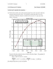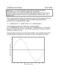
Katmandu GAMIT/GLOBK Short Course Introducuon
Katmandu GAMIT/GLOBK Short Course Introducuon
Katmandu GAMIT/GLOBK Short Course Introducuon

You also want an ePaper? Increase the reach of your titles
YUMPU automatically turns print PDFs into web optimized ePapers that Google loves.
<strong>Katmandu</strong> <strong>GAMIT</strong>/<strong>GLOBK</strong> <strong>Short</strong> <br />
<strong>Course</strong> <br />
Introduc:on <br />
Thomas Herring, MIT <br />
tah@mit.edu
Workshop Overview <br />
• Web site <br />
hGp://geoweb.mit.edu/~simon/gtgk/<br />
<strong>Katmandu</strong>12/ <br />
• Lectures and Tutorials: Day 1: <br />
1. Introduc:on to GPS data processing and how <br />
processing is treated in gamit/globk <br />
2. <strong>GAMIT</strong> Lecture: Overview of standard processing <br />
in <strong>GAMIT</strong>; daily session processing <br />
3. Tutorial session: Basic <strong>GAMIT</strong> example <br />
distributed with soTware <br />
11/16/12 <strong>Katmandu</strong> GG WS <br />
2
Workshop Overview <br />
• Lectures and Tutorials Day 2 <br />
1. <strong>GLOBK</strong> Lecture: Overview of the way <strong>GLOBK</strong> is <br />
used to analyze and combine results from <br />
<strong>GAMIT</strong> processing <br />
2. Modeling details, atmospheric delays, loading <br />
3. <strong>GLOBK</strong> por:on of the <strong>GAMIT</strong> example. Includes <br />
the glred and globk repeatability and velocity <br />
solu:on. <br />
11/16/12 <strong>Katmandu</strong> GG WS 3
Workshop overview <br />
• Lectures and Tutorial Day 3 <br />
1. Reference Frames Realiza:on; treatment of <br />
earthquakes, equipment changes and other <br />
effects <br />
2. Sta:s:cs of :me series and determina:on of <br />
error models for velocity es:mates <br />
3. Tutorial session: Salton Sea data analysis around <br />
:me of Magnitude 5.8 aTershock to El Major <br />
Cucapah April 4, 2010 Mw 7.2 earthquake. <br />
Demonstrates short session processing. <br />
11/16/12 <strong>Katmandu</strong> GG WS 4
Workshop Overview <br />
• Lectures and Tutorial Day 4 <br />
1. <strong>GLOBK</strong> prototyping tools for large analyses. <br />
Treatment of break in :me series and <br />
earthquake effects. <br />
2. <strong>GAMIT</strong>/<strong>GLOBK</strong> u:lity scripts and programs <br />
3. Finish up processing examples and address <br />
individual problems. <br />
11/16/12 <strong>Katmandu</strong> GG WS 5
Workshop Overview <br />
• Asking ques:ons during the workshop is cri:cal <br />
for gebng the most from this course. <br />
• It is expected that each user has a basic <br />
knowledge of UNIX and has already installed <br />
<strong>GAMIT</strong>/<strong>GLOBK</strong> and GMT on their laptops or has <br />
access to a version. <br />
• Each par:cipant can submit ques:ons/issues in <br />
email to tah@mit.edu. Use subject <br />
“<strong>Katmandu</strong>2012 Ques:on”. In the final tutorial <br />
session we will go over these ques:ons. <br />
• Ques:ons so far <br />
11/16/12 <strong>Katmandu</strong> GG WS 6
GPS overview <br />
• For GPS processing, the cri:cal informa:on needed is range and <br />
phase data from a receiver collec:ng data from mul:ple GPS <br />
satellites and informa:on about the orbits of the satellites (earth-fixed<br />
frame) and some informa:on about clocks in satellites. <br />
• In <strong>GAMIT</strong>, only crude clock informa:on needed due to double-differencing.<br />
<br />
• To integrate GPS orbits, informa:on needed about rota:on <br />
between earth-‐fixed and iner:al space. <br />
• For the most accurate GPS results, other ancillary informa:on <br />
needed (e.g., atmospheric models, ocean :des, antenna and <br />
receiver biases). <br />
• Program track (kinema:c processing) can use just RINEX data files <br />
and SP3 GPS orbit files but <strong>GAMIT</strong> needs a full suite of addi:onal <br />
files (track also can use some of these file). The main <strong>GAMIT</strong> <br />
processing script sh_gamit handles gebng all these files. <br />
11/16/12 <strong>Katmandu</strong> GG WS 7
GPS overview <br />
• <strong>GAMIT</strong> processes GPS phase and range data files <br />
(RINEX format) usually for 24-‐hour sessions of <br />
data. For newer data collec:on (post 1996), <br />
orbits do not need to be es:mated because IGS <br />
has very good combined orbits available. <br />
• <strong>GLOBK</strong> combines together results from daily GPS <br />
processing and is used to generate velocity <br />
es:mates and :me-‐series products. <br />
• ATer discussing some general GPS processing <br />
issues in the rest of this lecture, we then discuss <br />
<strong>GAMIT</strong> and <strong>GLOBK</strong> opera:ons. <br />
11/16/12 <strong>Katmandu</strong> GG WS 8
Instantaneous Posi:oning with GPS Pseudoranges <br />
Receiver solution or sh_rx2apr<br />
• Point position ( svpos ) 5-100 m<br />
• Differential ( svdiff ) 1-10 m<br />
Your location is:<br />
37 o 23.323’ N<br />
122 o 02.162’ W<br />
11/16/12 <strong>Katmandu</strong> GG WS <br />
9
Observables in Data Processing <br />
Fundamental observa0ons <br />
L1 phase = f1 x range (19 cm) L2 phase = f2 x range (24 cm) <br />
C1 or P1 pseudorange used separately to get receiver clock offset (:me) <br />
To es:mate parameters use doubly differenced <br />
LC = 2.55 L1 -‐ 1.98 L2 “Ionosphere-‐free phase combina:on” L1-‐cycles <br />
PC = 2.55 P1 -‐ 1.55 P2 “Ionosphere-‐free range combina:on” Meters <br />
Double differencing (DD) removes clock fluctua:ons; LC removes almost all of <br />
ionosphere. Both DD and LC amplify noise (use L1, L2 directly for baselines < 1 km) <br />
Auxiliary combina:ons for data edi:ng and ambiguity resolu:on <br />
“Geometry-‐free combina:on (LG)” or “Extra wide-‐lane” (EX-‐WL) <br />
LG = L2 -‐ f2/f1 L1 used in <strong>GAMIT</strong> <br />
EX-‐WL = L1 -‐ f1/f2 L2 used in TRACK <br />
Removes all frequency-‐independent effects (geometric & atmosphere) but not <br />
mul:path or ionosphere <br />
Melbourne-‐Wubbena wide-‐Lane (MW-‐WL): phase/pseudorange combina:on that <br />
removes geometry and ionosphere; dominated by pseudorange noise <br />
MW-‐WL = N1-‐N2=(L1-‐L2)-‐(ΔF/ΣF)(P1+P2) = (L1-‐L2)-‐0.12 (P1+P2) <br />
11/16/12 <strong>Katmandu</strong> GG WS 10
Modeling the observa:ons <br />
I. Conceptual/Quan:ta:ve <br />
• Mo:on of the satellites <br />
– Earth’s gravity field ( flaGening 10 km; higher harmonics 100 m ) <br />
– AGrac:on of Moon and Sun ( 100 m ) <br />
– Solar radia:on pressure ( 20 m ) <br />
• Mo:on of the Earth <br />
– Irregular rota:on of the Earth ( 5 m ) <br />
– Luni-‐solar solid-‐Earth :des ( 30 cm ) <br />
– Loading due to the oceans, atmosphere, and surface water and ice ( 10 mm) <br />
• Propaga:on of the signal <br />
– Neutral atmosphere ( dry 6 m; wet 1 m ) <br />
– Ionosphere ( 10 m but LC corrects to a few mm most of the :me ) <br />
– Varia:ons in the phase centers of the ground and satellite antennas ( 10 cm) <br />
* incompletely modeled <br />
11/16/12 <strong>Katmandu</strong> GG WS <br />
11
Modeling the observa:ons <br />
II. SoTware structure <br />
• Satellite orbit <br />
– IGS tabulated ephemeris (Earth-‐fixed SP3 file) [ track ] <br />
– <strong>GAMIT</strong> tabulated ephemeris ( t-‐file ): numerical integra:on by arc in iner:al space, fit to SP3 file, <br />
may be represented by its ini:al condi:ons (ICs) and radia:on-‐pressure parameters; requires <br />
tabulated posi:ons of Sun and Moon <br />
• Mo:on of the Earth in iner:al space [model or track ] <br />
– Analy:cal models for precession and nuta:on (tabulated); IERS observed values for pole posi:on <br />
(wobble), and axial rota:on (UT1) <br />
– Analy:cal model of solid-‐Earth :des; global grids of ocean and atmospheric :dal loading <br />
• Propaga:on of the signal [model or track ] <br />
– Zenith hydrosta:c (dry) delay (ZHD) from pressure ( met-‐file, VMF1, or GPT ) <br />
– Zenith wet delay (ZWD) [crudely modeled and es:mated in solve or track ] <br />
– ZHD and ZWD mapped to line-‐of-‐sight with mapping func:ons (VMF1 grid or GMT) <br />
– Varia:ons in the phase centers of the ground and satellite antennas (ANTEX file) <br />
11/16/12 <strong>Katmandu</strong> GG WS <br />
12
• Phase observa:ons [ solve or track ] <br />
Parameter Es:ma:on <br />
– Form double difference LC combina:on of L1 and L2 to cancel clocks & ionosphere <br />
– Apply a priori constraints <br />
– Es:mate the coordinates, ZTD, and real-‐valued ambigui:es <br />
– Form M-‐W WL and/or phase WL with ionospheric constraints to es:mate and resolve the <br />
WL (L2-‐L1) integer ambigui:es [ autcln, solve, track ] <br />
– Es:mate and resolve the narrow-‐lane (NL) ambigui:es <br />
– Es:mate the coordinates and ZTD with WL and NL ambigui:es fixed <br />
-‐-‐-‐ Es:ma:on can be batch least squares [ solve ] or sequen:al (Kalman filter [ track ] <br />
• Quasi-‐observa:ons from phase solu:on (h-‐file) [ globk ] <br />
– Sequen:al (Kalman filter) <br />
– Epoch-‐by-‐epoch test of compa:bility (chi2 increment) but batch output <br />
11/16/12 <strong>Katmandu</strong> GG WS <br />
13
Limits of GPS Accuracy <br />
• Signal propaga:on effects <br />
– Signal scaGering ( antenna phase center / mul:path ) <br />
– Atmospheric delay (mainly water vapor) <br />
– Ionospheric effects <br />
– Receiver noise <br />
• Unmodeled mo:ons of the sta:on <br />
– Monument instability <br />
– Loading of the crust by atmosphere, oceans, and surface water <br />
• Unmodeled mo:ons of the satellites <br />
• Reference frame <br />
11/16/12 <strong>Katmandu</strong> GG WS <br />
14
Limits of GPS Accuracy <br />
• Signal propaga:on effects <br />
– Signal scaGering ( antenna phase center / mul:path ) <br />
– Atmospheric delay (mainly water vapor) <br />
– Ionospheric effects <br />
– Receiver noise <br />
• Unmodeled mo:ons of the sta:on <br />
– Monument instability <br />
– Loading of the crust by atmosphere, oceans, and surface water <br />
• Unmodeled mo:ons of the satellites <br />
• Reference frame <br />
11/16/12 <strong>Katmandu</strong> GG WS <br />
15
Mul:path is interference between the direct and a far-field<br />
reflected signal (geometric op:cs apply) <br />
To mitigate the effects:<br />
• Avoid Reflective Surfaces<br />
• Use a Ground Plane Antenna<br />
• Use Multipath Rejection Receiver<br />
• Observe for many hours<br />
• Remove with average from many days<br />
11/16/12 <strong>Katmandu</strong> GG WS <br />
16
Antenna Ht<br />
0.15 m<br />
0.6 m<br />
Simple geometry for<br />
incidence of a direct and<br />
reflected signal<br />
1 m<br />
Multipath contributions to observed phase for three different<br />
antenna heights [From Elosegui et al, 1995]<br />
11/16/12 <strong>Katmandu</strong> GG WS <br />
17
Multipath and Water Vapor Effects in the Observations <br />
One-way (undifferenced) LC phase residuals projected onto the sky in 4-hr snapshots.<br />
Spatially repeatable noise is multipath; time-varying noise is water vapor.<br />
Red is satellite track. Yellow and green positive and negative residuals purely for visual effect.<br />
Red bar is scale (10 mm).<br />
11/16/12 <strong>Katmandu</strong> GG WS <br />
18
More dangerous are near-‐field signal interac:ons that change the <br />
effec:ve antenna phase center with the eleva:on and azimuth of the <br />
incoming signal <br />
Left: Examples of the antenna<br />
phase patterns determined in<br />
an anechoic chamber…BUT<br />
the actual pattern in the field is<br />
affected by the antenna mount<br />
To avoid height and ZTD errors<br />
of centimeters, we must use at<br />
least a nominal model for the<br />
phase-center variations (PCVs)<br />
for each antenna type<br />
Figures courtesy of UNAVCO<br />
Antenna Phase PaGerns <br />
11/16/12 <strong>Katmandu</strong> GG WS <br />
19
Limits of GPS Accuracy <br />
• Signal propaga:on effects <br />
– Signal scaGering ( antenna phase center / mul:path ) <br />
– Atmospheric delay (mainly water vapor) <br />
– Ionospheric effects <br />
– Receiver noise <br />
• Unmodeled mo:ons of the sta:on <br />
– Monument instability <br />
– Loading of the crust by atmosphere, oceans, and surface water <br />
• Unmodeled mo:ons of the satellites <br />
• Reference frame <br />
11/16/12 <strong>Katmandu</strong> GG WS <br />
20
Monuments Anchored to Bedrock are Critical for Tectonic Studies<br />
(not so much for atmospheric studies)<br />
Good anchoring:<br />
Pin in solid rock<br />
Drill-braced (left) in<br />
fractured rock<br />
Low building with deep<br />
foundation<br />
Not-so-good anchoring:<br />
Vertical rods<br />
Buildings with shallow<br />
foundation<br />
Towers or tall building<br />
(thermal effects) <br />
11/16/12 <strong>Katmandu</strong> GG WS <br />
21
Annual Component of Vertical Loading <br />
Atmosphere<br />
(purple)<br />
2-5 mm<br />
Water/snow<br />
(blue/green)<br />
2-10 mm<br />
Nontidal ocean<br />
(red)<br />
2-3 mm<br />
<br />
From Dong et al. J. Geophys. Res., 107, 2075, 2002 <br />
11/16/12 <strong>Katmandu</strong> GG WS <br />
22
Limits of GPS Accuracy <br />
• Signal propaga:on effects <br />
– Signal scaGering ( antenna phase center / mul:path ) <br />
– Atmospheric delay (mainly water vapor) <br />
– Ionospheric effects <br />
– Receiver noise <br />
• Unmodeled mo:ons of the sta:on <br />
– Monument instability <br />
– Loading of the crust by atmosphere, oceans, and surface water <br />
• Unmodeled mo:ons of the satellites <br />
• Reference frame <br />
11/16/12 <strong>Katmandu</strong> GG WS <br />
23
GPS Satellite<br />
Limits to model are<br />
non-gravitational<br />
accelerations due to<br />
solar and albedo<br />
radiation, unbalanced<br />
thrusts, and<br />
outgassing; and nonspherical<br />
antenna<br />
pattern<br />
Modeling of these<br />
effects has improved,<br />
but for global<br />
analyses remain a<br />
problem<br />
11/16/12 <strong>Katmandu</strong> GG WS <br />
24
Quality of IGS Final Orbits 1994-2011/07<br />
20 mm = 1 ppb Source: hGp://acc.igs.org <br />
11/16/12 <strong>Katmandu</strong> GG WS <br />
25
Quality of IGS Final Orbits Last Year 2011/11-2012/11<br />
20 mm = 1 ppb Source: hGp://acc.igs.org <br />
MIT <br />
11/16/12 <br />
<strong>Katmandu</strong> GG WS <br />
26
Limits of GPS Accuracy <br />
• Signal propaga:on effects <br />
– Signal scaGering ( antenna phase center / mul:path ) <br />
– Atmospheric delay (mainly water vapor) <br />
– Ionospheric effects <br />
– Receiver noise <br />
• Unmodeled mo:ons of the sta:on <br />
– Monument instability <br />
– Loading of the crust by atmosphere, oceans, and surface water <br />
• Unmodeled mo:ons of the satellites <br />
• Reference frame <br />
11/16/12 <strong>Katmandu</strong> GG WS <br />
27
Reference Frames <br />
Global Reference Frame quality:<br />
Center of Mass
Effect of Orbital and Geocentric Position Error/<br />
Uncertainty<br />
•<br />
High-precision GPS is essentially relative !<br />
Baseline error/uncertainty ~ Baseline distance x geocentric SV or<br />
position error<br />
SV altitude<br />
SV errors reduced by averaging:<br />
Baseline errors are ~ 0.2 • orbital error / 20,000 km<br />
e.g. 20 mm orbital error = 1 ppb or 1 mm on 1000 km baseline<br />
Network (“absolute”) position errors less important for small networks<br />
e.g. 5 mm position error ~ 1 ppb or 1 mm on 1000 km baseline<br />
10 cm position error ~ 20 ppb or 1 mm on 50 km baseline<br />
* But SV and position errors are magnified for short sessions<br />
11/16/12 <strong>Katmandu</strong> GG WS 29
Summary <br />
• High precision GPS (mm and beGer posi:oning) requires <br />
external informa:on in addi:onal to just the data and orbit <br />
informa:on. <br />
• Larger site separa:ons and mixed equipment types require <br />
more care in the data analysis than short baseline, <br />
homogeneous system data collec:on. <br />
• All of the external informa:on needed is available and the <br />
<strong>GAMIT</strong> processing system gathers most of this informa:on <br />
automa:cally. There is some informa:on that users need <br />
to keep up to date (discussed later). <br />
• The next two lectures examine running <strong>GAMIT</strong> and <strong>GLOBK</strong>. <br />
The final session today will be tutorial looking at an <br />
earthquake effected data set. <br />
11/16/12 <strong>Katmandu</strong> GG WS 30