12.010 HW 3 Solution 1 10/30/2000. 12.215 Homework #3 ... - MIT
12.010 HW 3 Solution 1 10/30/2000. 12.215 Homework #3 ... - MIT
12.010 HW 3 Solution 1 10/30/2000. 12.215 Homework #3 ... - MIT

Create successful ePaper yourself
Turn your PDF publications into a flip-book with our unique Google optimized e-Paper software.
<strong>12.0<strong>10</strong></strong> <strong>HW</strong> 3 <strong>Solution</strong> 1 <strong>10</strong>/<strong>30</strong>/<strong>2000.</strong><br />
<strong>12.215</strong> <strong>Homework</strong> <strong>#3</strong> <strong>Solution</strong> Due Monday <strong>10</strong>/<strong>30</strong>/2000<br />
Latitude and Longitude determination.<br />
(a) Find the time and the value of the maximum angle between the sun and its reflection<br />
using the data given below (Note: Acroread has an option that allows text to be<br />
copied from a PDF file, therefore it should not be necessary to re-type any of the<br />
values). (<strong>10</strong> points)<br />
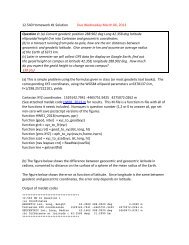
Sextant <strong>10</strong>/00<br />
75<br />
74<br />
2*Sun Elev (deg)<br />
73<br />
2*Sun Elev (deg)<br />
73<br />
72<br />
72<br />
72<br />
71<br />
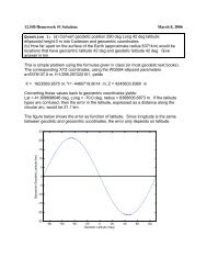
Y = M0 + M1*x + ... M8*x 8 + M9*x 9<br />
M0<br />
-858.71<br />
M1<br />
113.17<br />
M2<br />
-3.4318<br />
R<br />
0.99882<br />
70<br />
15.4 15.6 15.8 16.0 16.2 16.4 16.6 16.8<br />
GMT Hrs<br />
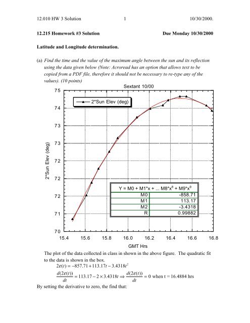
The plot of the data collected in class in shown in the above figure. The quadratic fit<br />
to the data is shown in the box.<br />
2<br />
2ε( t) = − 857. 71 + 113. 17t − 3.<br />
4318t<br />
d( 2ε( t))<br />
d( 2ε( t))<br />
= 113. 17 − 2 × 3.<br />
4318t<br />
⇒ = 0 when t = 16.4884 hrs<br />
dt<br />
dt<br />
By setting the derivative to zero, the find that:
<strong>12.0<strong>10</strong></strong> <strong>HW</strong> 3 <strong>Solution</strong> 2 <strong>10</strong>/<strong>30</strong>/<strong>2000.</strong><br />
(a) Sun reached maximum elevation at 16.4884 hrs UT = 16 hrs 29 min 18 sec<br />
(b) Find the mean index errors for the near and distance objects (5 points)<br />
Mean index error for nearby objects is 11.0’<br />
Mean index error of distant objects is 14.9’<br />
(c) At the time of the maximum angle between the sun and its reflection, find the right<br />
ascension (RA) and declination of the Sun, and the Greenwich Mean Sidereal Time<br />
(GMST). You can use the nautical almanac in Lindgreen Library or the on-line<br />
almanac referenced on the course web page. (<strong>10</strong> points)<br />
From the web site http://aa.usno.navy.mil/AA/data/docs/WebMICA_2.html that directly<br />
allows calculations of the positions of astronomical positions we obtain for the<br />
topocentric position of the Sun (these positions refer to a coordinate system whose origin<br />
is at the surface of the Earth. An approximate position must be given for these positions).<br />
2000 Oct 20 16:29:18.0 (UT1)<br />
Object R.A. Dec. Dist. Z.D. Az. Elong. Diam. Mag<br />
h m o ' A.U. o o o ' "<br />
Sun 13 42.4 -<strong>10</strong> 37 0.995 51 181 ---- 32 08.0 ----<br />
The other type of position is geocentric, apparent (meaning the value that would be seen)<br />
coordinates and these are given below for the Sun. These values should differ at most by<br />
the radius of the Earth divided by the distance to the sun (approximately 8.8”).<br />
Date Time Right Declination Distance Equation<br />
(UT1) Ascension of Time<br />
h m s h m s o ' " AU m s<br />
2000 Oct 20 16:29:18.0 13 42 25.924 - <strong>10</strong> 36 46.37 0.9955135<strong>10</strong> +15 18.5<br />
Greenwich Sidereal time has its own look up table and the value is.<br />
Date Time Sidereal Time<br />
h m s h m s<br />
2000 Oct 20 16:29:18.0 18 27 03.5<strong>10</strong>3<br />
RA of Sun 13h 42m 25.92s 13.7072 hrs<br />
Declination of Sun -<strong>10</strong> o 36’ 46.37” -<strong>10</strong>.6129 deg<br />
GST 18h 27m 03.51s 18.45<strong>10</strong> hrs<br />
(d) Using the mean index error for distance objects, compute the elevation angle to the<br />
Sun at its maximum (5 points)
<strong>12.0<strong>10</strong></strong> <strong>HW</strong> 3 <strong>Solution</strong> 3 <strong>10</strong>/<strong>30</strong>/<strong>2000.</strong><br />
Based on the quadratric fit in part (a), the maximum value of 2*elevation to Sun is<br />
74.2879 degrees. Since when we knew the elevation angle was zero, the mean reading on<br />
the Sextant was 14.9’ (0.2483 degree), the index error should be subtracted from the<br />
above value and then divided by 2 to obtain the elevation angle.<br />
Maximum elevation of Sun = 37.0198 deg.<br />
(e) Compute the approximate atmospheric bending contribution to this measured<br />
elevation to the sun (<strong>10</strong> points)<br />
The refraction correction is 1’/(tan ε + 0.03).<br />
At 37.0198 deg., refraction correction is 1.3’ = 0.0213 deg which should be subtracted<br />
from the apparent elevation.<br />
(f) Given the declination of the Sun and the in vacuum estimate of the elevation angle to<br />
the Sun, compute the latitude of the Green building. (<strong>10</strong> points)<br />
The figure below shows the geometry of the latitude determination<br />
ε obs<br />
∆ε Refraction<br />
ε true<br />
To Sun<br />
φ<br />
δ (negative)<br />
To Sun<br />
φ = [90 - ( ε obs -∆ε ) + δ]<br />
The latitude, φ, is given by (90-ε c )-δ s = 42.3796 degrees = 42 o 22.8’ (Actual 42 o 21.6’)
<strong>12.0<strong>10</strong></strong> <strong>HW</strong> 3 <strong>Solution</strong> 4 <strong>10</strong>/<strong>30</strong>/<strong>2000.</strong><br />
(g) Given the RA of the sun and the GST when the sun was at its maximum elevation<br />
angle, compute the longitude of the Green building (<strong>10</strong> points)<br />
The longitude is RA s -GST = -4.7438 hrs = -71.157 deg = 71 o 9.4’ (Actual 71 o 4.8’)<br />
(h) What would be the effect on the results from parts (f) and (g) if the near object index<br />
error correction were used (<strong>10</strong> points)<br />
A change in the index error would effect the latitude (the effect is half the size since we<br />
observed a reflection). There would be no effect on longitude.