Powerpoint
Powerpoint
Powerpoint

You also want an ePaper? Increase the reach of your titles
YUMPU automatically turns print PDFs into web optimized ePapers that Google loves.
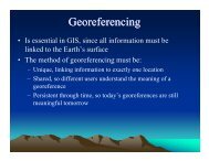
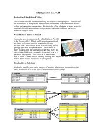
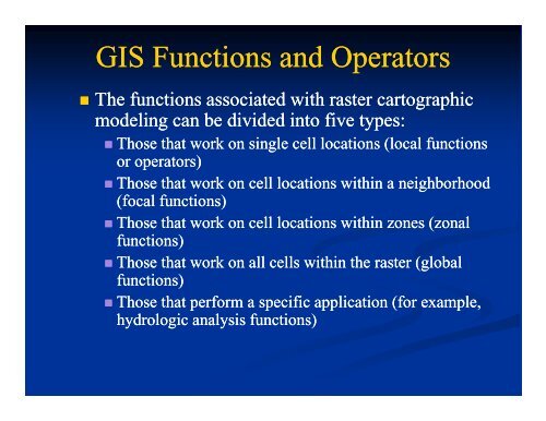
GIS Functions and Operators<br />
• The functions associated with raster cartographic<br />
modeling can be divided into five types:<br />
• Those that work on single cell locations (local functions<br />
or operators)<br />
• Those that work on cell locations within a neighborhood<br />
(focal functions)<br />
• Those that work on cell locations within zones (zonal<br />
functions)<br />
• Those that work on all cells within the raster (global<br />
functions)<br />
• Those that perform a specific application (for example,<br />
hydrologic analysis functions)
Map Algebra<br />
• Map algebra is a language specifically designed for<br />
geographic cell-based systems and provides the basis<br />
for cartographic modeling.<br />
• Based on concepts originally presented by Joe Berry<br />
and C. Dana Tomlin.<br />
• Map algebra provides a language to conveying logic<br />
constructs while maintaining the power of the<br />
mathematical ti base underlying the cell-based<br />
structure.<br />
• Map Algebra operators and functions apply<br />
mathematical computations on a raster “map” vs.<br />
matrix algebra.
Local Functions<br />
• Local functions apply their calculations to a single cell location before<br />
calculating the next location, until all cells have been processed. To<br />
perform the calculation, the local function only needs to know the values<br />
at the location for a single raster or for multiple rasters, as well as, in<br />
some cases, a comparison value.<br />
Operations or functions can be<br />
applied on single or multiple grids:<br />
output t = (inlayer1 1+i inlayer2) 2)/ 2<br />
output = sin(inlayer1)<br />
output = min(inlayer1, inlayer2, inlayer3)
Operators and Functions<br />
• There are three types of operations:<br />
• Arithmetic operators: *, /, -, +<br />
• Boolean operators: And, Or, Xor, Not<br />
• Relational operators: ==, >, =,
Operators and Functions<br />
• Mathematical functions are applied to the values in a<br />
single input raster. There are four groups of<br />
mathematical functions<br />
• Logarithmic<br />
• Arithmetic<br />
• Trigonometric<br />
• Powers<br />
• Other local functions compute statistics, combine, or<br />
other operations from a list of multiple inlayers.<br />
Output =min(Inl min(Inlayer1, 1 Inlayer2, Inlayer3)
Focal Functions<br />
Focal (or neighborhood) functions compute an output grid in which the<br />
output value at each cell location is a function of the input cells in the<br />
specified neighborhood “around” each output (or target) location.<br />
Neighborhoods can be<br />
different sizes and geometries.<br />
Different arithmetic and<br />
statistical functions can be<br />
applied to summarize a<br />
neighborhood values.<br />
Example:<br />
Output = focalsum (Input,<br />
rectangle, 3,3)<br />
3)
Zonal Functions<br />
• Zonal functions compute an output raster dataset where the<br />
output value for each location depends on the value of the cell<br />
at the location and the association that t location has within a<br />
cartographic zone.<br />
Output = zonalsum(inlayer, zonelayer)<br />
Output = zonalgeometry(zonelayer<br />
zonelayer, , all)
Global Functions<br />
• Global, or per-raster, raster, functions compute an output raster<br />
dataset in which h the output value at each cell location is<br />
potentially a function of all the cells combined from the<br />
various input raster datasets. There are two main groups of<br />
global functions: Euclidean distance and weighted distance.<br />
Output t from the Euclidean<br />
distance function, each cell<br />
contains the shortest distance to<br />
any input point.
Application Functions<br />
• There are a wide series of cell-based modeling functions<br />
developed to solve specific applications.<br />
• There is some overlap in the categorization of an application<br />
function and the local, focal, zonal, and global functions (such<br />
as the fact that even though slope is usually used in the<br />
application of analyzing surfaces, it is also a focal function).<br />
• Application functions include the following:<br />
• Density analysis<br />
• Surface generation<br />
• Surface analysis<br />
• Hydrologic analysis<br />
• Geometric transformation<br />
• Generalization<br />
• Resolution altering