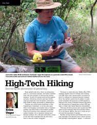
Into the Pasayten - Washington Trails Association
Into the Pasayten - Washington Trails Association
Into the Pasayten - Washington Trails Association

Create successful ePaper yourself
Turn your PDF publications into a flip-book with our unique Google optimized e-Paper software.
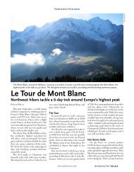
» On Trail July+August 2009 » <strong>Washington</strong> <strong>Trails</strong> www.wta.org<br />
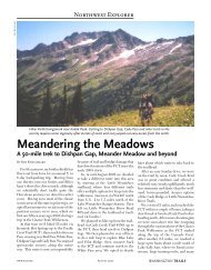
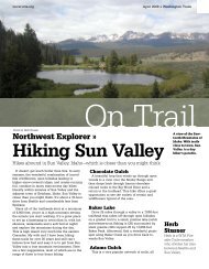
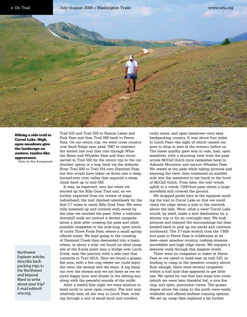
Hiking a side trail to<br />
Corral Lake. High,<br />
open meadows give<br />
<strong>the</strong> landscape an<br />
austere, tundra-like<br />
appearance.<br />
Photo by Ken Konigsmark<br />
Northwest<br />
Explorer articles<br />
describe backpacking<br />
trips in<br />
<strong>the</strong> Northwest<br />
and beyond.<br />
Want to write<br />
about your trip<br />
E-mail editor@<br />
wta.org.<br />
Trail 533 and Trail 529 to Ramon Lakes and<br />
Park Pass and <strong>the</strong>n Trail 506 back to Peeve<br />
Pass. On our return trip, we went cross country<br />
over Sand Ridge near peak 7567 to intersect<br />
<strong>the</strong> dotted line trail that cuts through Whistler<br />
Basin and Whistler Pass and <strong>the</strong>n reconnected<br />
to Trail 502 for <strong>the</strong> return trip to <strong>the</strong> car.<br />
Ano<strong>the</strong>r option is a loop back via <strong>the</strong> Ashnola<br />
River Trail 500 to Trail 514 over Diamond Pass,<br />
but this would have taken us down into a deep,<br />
burned-over river valley that required a steep<br />
climb back up to trail 502.<br />
It was, as expected, very hot when we<br />
started up <strong>the</strong> Billy Goat Trail and, as we<br />
fur<strong>the</strong>r expected from our review of maps<br />
beforehand, <strong>the</strong> trail climbed relentlessly for <strong>the</strong><br />
first 2.7 miles to reach Billy Goat Pass. We were<br />
fully loosened up and covered with sweat by<br />
<strong>the</strong> time we reached <strong>the</strong> pass. After a welcome<br />
downhill walk we noticed a decent campsite<br />
about a mile after crossing <strong>the</strong> pass and o<strong>the</strong>r<br />
possible campsites in <strong>the</strong> mile-long, open notch<br />
of rocky Three Fools Pass, where a small spring<br />
offered water. We kept going to <strong>the</strong> crossing<br />
of Diamond Creek <strong>the</strong>n descended into a basin<br />
where, in about a mile, we found an ideal campsite<br />
at <strong>the</strong> 8-mile point near a bridge over Larch<br />
Creek, near <strong>the</strong> junction with a side trail that<br />
connects to Trail 451A. Here we found a grassy,<br />
flat area, with a fire ring where we could enjoy<br />
<strong>the</strong> view, <strong>the</strong> stream and <strong>the</strong> stars. A log hung<br />
out over <strong>the</strong> stream and we sat <strong>the</strong>re as we enjoyed<br />
happy hour and dinner in <strong>the</strong> setting sun<br />
along with <strong>the</strong> peaceful sounds of <strong>the</strong> wilds.<br />
After a restful first night we were anxious to<br />
head north to more open country. The trail was<br />
relatively easy all <strong>the</strong> way to Larch Pass, winding<br />
through a mix of small larch and conifers,<br />
rocky areas, and open meadows—very easy<br />
backpacking country. It was about four miles<br />
to Larch Pass—<strong>the</strong> sight of which caused our<br />
jaws to drop in awe at <strong>the</strong> scenery before us.<br />
The forest quickly gave way to vast, lush, open<br />
meadows, with a stunning view from <strong>the</strong> pass<br />
across McCall Gulch (nice campsites here) to<br />
Ashnola Mountain and narrow Whistler Pass.<br />
We rested at <strong>the</strong> pass while taking pictures and<br />
enjoying <strong>the</strong> view, <strong>the</strong>n continued on ano<strong>the</strong>r<br />
mile into <strong>the</strong> meadows to eat lunch in <strong>the</strong> bowl<br />
of McCall Gulch. From here, <strong>the</strong> trail winds<br />
uphill to a windy 7,500-foot pass where a large<br />
snowfield still covered <strong>the</strong> ground.<br />
We dropped packs here at <strong>the</strong> signpost marking<br />
<strong>the</strong> trail to Corral Lake so that we could<br />
climb <strong>the</strong> ridge about a mile to <strong>the</strong> overlook<br />
above <strong>the</strong> lake. Wow, what a view! Corral Lake<br />
would, by itself, make a nice destination for a<br />
shorter trip or for an overnight stay. We took<br />
pictures and enjoyed <strong>the</strong> surroundings but <strong>the</strong>n<br />
headed back to pick up our packs and continue<br />
northward. The 3.7-mile stretch from <strong>the</strong> 7,500-<br />
foot pass to Peeve Pass is wilderness at its<br />
best—open meadow country, rushing streams,<br />
snowfields and high ridge views. We enjoyed a<br />
leisurely walk through this magical world.<br />
There were no campsites or water at Peeve<br />
Pass so we opted to head east on trail 533, intending<br />
to camp in <strong>the</strong> meadow country above.<br />
Sure enough, <strong>the</strong>re were several campsites<br />
within a half mile that appeared to get little<br />
use. We opted for one that had some tree cover<br />
(which we were later thankful for), a nice fire<br />
ring, and open, panoramic views. The grassy<br />
slopes above <strong>the</strong> camp to <strong>the</strong> north were easily<br />
walkable and offered endless roaming options.<br />
We set up camp <strong>the</strong>n explored a bit fur<strong>the</strong>r