Forecasters Guide - (IMD), Pune
Forecasters Guide - (IMD), Pune
Forecasters Guide - (IMD), Pune

Create successful ePaper yourself
Turn your PDF publications into a flip-book with our unique Google optimized e-Paper software.
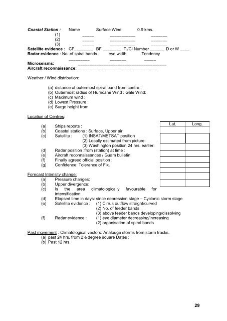
Coastal Station : Name Surface Wind 0.9 kms.<br />
(1) _____ ___________ _______<br />
(2) _____ ___________ _______<br />
(3) _____ ___________ _______<br />
Satellite evidence : CF________ BF ________ T./CI Number ______ D or W ____<br />
Radar evidence : No. of spiral bands eye width Tendency<br />
_________ _______ _____<br />
Microseisms:<br />
______________________________________<br />
Aircraft reconnaissance: __________________________________<br />
Weather / Wind distribution:<br />
(a) distance of outermost spiral band from centre :<br />
(b) Outermost radius of Hurricane Wind : Gale Wind:<br />
(c) Maximum wind :<br />
(d) Lowest Pressure :<br />
(e) Surge height from<br />
Location of Centres:<br />
(a) Ships reports :<br />
(b) Coastal stations : Surface, Upper air:<br />
(c) Satellite : (1) INSAT/METSAT position<br />
(2) Locally estimated from picture:<br />
(3) Washington position 24 hrs. earlier:<br />
(d) Radar position :from (station) at time :<br />
(e) Aircraft reconnaissances / Guam bulletin<br />
(f) Finally agreed official position :<br />
(g) Confidence: Tolerance of Fix.<br />
Lat.<br />
Long.<br />
Forecast Intensity change:<br />
(a) Pressure changes:<br />
(b) Upper divergence:<br />
(c) Is the area climatologically favourable for<br />
intensification:<br />
(d) Elapsed time in days: since depression stage – Cyclonic storm stage<br />
(e) Satellite evidence : (1) Cirrus outflow straight/curved<br />
(2) No. of feeder bands<br />
(3) above feeder bands developing/dissolving<br />
(f) Radar evidence : (1) eye diameter decreasing/increasing<br />
(2) organisation of spiral bands<br />
Past movement : Climatological vectors: Analouge storms from storm tracks.<br />
(a) past 24 hrs. from 2½ degree square Dates :<br />
(b) Past 12 hrs.<br />
29