kayaking the pacific islands. - Canoe & Kayak
kayaking the pacific islands. - Canoe & Kayak
kayaking the pacific islands. - Canoe & Kayak

You also want an ePaper? Increase the reach of your titles
YUMPU automatically turns print PDFs into web optimized ePapers that Google loves.
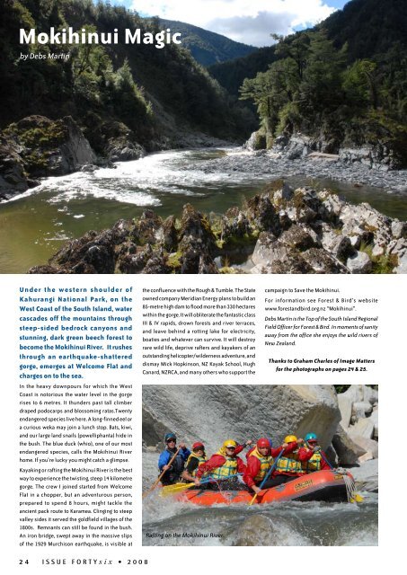
Mokihinui Magic<br />
by Debs Martin<br />
U n d e r t h e w e s t e r n s h o u l d e r o f<br />
Kahurangi National Park, on <strong>the</strong><br />
West Coast of <strong>the</strong> South Island, water<br />
cascades off <strong>the</strong> mountains through<br />
steep-sided bedrock canyons and<br />
stunning, dark green beech forest to<br />
become <strong>the</strong> Mokihinui River. It rushes<br />
through an earthquake-shattered<br />
gorge, emerges at Welcome Flat and<br />
charges on to <strong>the</strong> sea.<br />
In <strong>the</strong> heavy downpours for which <strong>the</strong> West<br />
Coast is notorious <strong>the</strong> water level in <strong>the</strong> gorge<br />
rises to 6 metres. It thunders past tall climber<br />
draped podocarps and blossoming ratas.Twenty<br />
endangered species live here. A long-finned eel or<br />
a curious weka may join a lunch stop. Bats, kiwi,<br />
and our large land snails (powelliphanta) hide in<br />
<strong>the</strong> bush. The blue duck (whio), one of our most<br />
endangered species, calls <strong>the</strong> Mokihinui River<br />
home. If you’re lucky you might catch a glimpse.<br />
<strong>Kayak</strong>ing or rafting <strong>the</strong> Mokihinui River is <strong>the</strong> best<br />
way to experience <strong>the</strong> twisting, steep 14 kilometre<br />
gorge. The crew I joined started from Welcome<br />
Flat in a chopper, but an adventurous person,<br />
prepared to spend 8 hours, might tackle <strong>the</strong><br />
ancient pack route to Karamea. Clinging to steep<br />
valley sides it served <strong>the</strong> goldfield villages of <strong>the</strong><br />
1800s. Remnants can still be found in <strong>the</strong> bush.<br />
An iron bridge, swept away in <strong>the</strong> massive slips<br />
of <strong>the</strong> 1929 Murchison earthquake, is visible at<br />
<strong>the</strong> confluence with <strong>the</strong> Rough & Tumble. The State<br />
owned company Meridian Energy plans to build an<br />
85-metre high dam to flood more than 330 hectares<br />
within <strong>the</strong> gorge. It will obliterate <strong>the</strong> fantastic class<br />
III & IV rapids, drown forests and river terraces,<br />
and leave behind a rotting lake for electricity,<br />
boaties and whatever can survive. It will destroy<br />
rare wild life, deprive rafters and kayakers of an<br />
outstanding helicopter/wilderness adventure, and<br />
dismay Mick Hopkinson, NZ <strong>Kayak</strong> School, Hugh<br />
Canard, NZRCA, and many o<strong>the</strong>rs who support <strong>the</strong><br />
Rafting on <strong>the</strong> Mokihinui River.<br />
campaign to Save <strong>the</strong> Mokihinui.<br />
For information see Forest & Bird’s website<br />
www.forestandbird.org.nz “Mokihinui”.<br />
Debs Martin is <strong>the</strong> Top of <strong>the</strong> South Island Regional<br />
Field Officer for Forest & Bird. In moments of sanity<br />
away from <strong>the</strong> office she enjoys <strong>the</strong> wild rivers of<br />
New Zealand.<br />
Thanks to Graham Charles of Image Matters<br />
for <strong>the</strong> photographs on pages 24 & 25.<br />
24 ISSUE FORTYsix • 2 0 0 8