

APPENDIX I List Of Submissions - Victorian Environmental ...
APPENDIX I List Of Submissions - Victorian Environmental ...
APPENDIX I List Of Submissions - Victorian Environmental ...

Create successful ePaper yourself
Turn your PDF publications into a flip-book with our unique Google optimized e-Paper software.
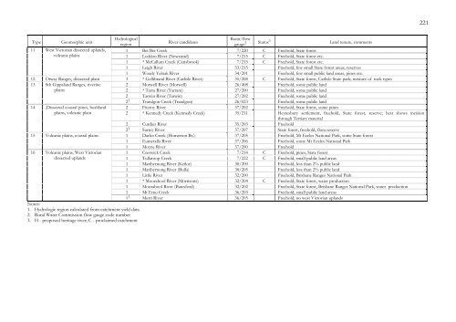
221<br />
Type Geomorphic unit<br />
Hydrological<br />
Basin/flow<br />
region<br />
River candidates<br />
gauge 2 Status 3<br />
Land tenure, comments<br />
11 West <strong>Victorian</strong> dissected uplands, 1 Bet Bet Creek 7/220 C Freehold, State forest<br />
volcanic plains<br />
1 Loddon River (Newstead) 7/215 C Freehold, State forest etc.<br />
1 * McCallum Creek (Carisbrook) 7/213 C Freehold, State forest etc.<br />
1 Leigh River 33/215 Freehold, few small State forest areas, reserves<br />
1 Woady Yaloak River 34/201 Freehold, few small public land areas, pines etc.<br />
12 Otway Ranges, dissected plain 3 * Gellibrand River (Carlisle River) 35/208 C Freehold, State forest, Carlisle State park; mixture of rock types<br />
13 Sth Gippsland Ranges, riverine<br />
2 Morwell River (Morwell) 26/408 Freehold, some public land<br />
plains<br />
2 * Tarra River (Yarram) 27/200 Freehold, some public land<br />
2 Tarwin River (Tarwin) 27/202 Freehold, some public land<br />
14 ,Dissected coastal pines, bushland<br />
plains, volcanic plain<br />
15 Volcanic plains, coastal plains<br />
16 Volcanic plains, West <strong>Victorian</strong><br />
dissected uplands<br />
Notes:<br />
1. Hydrologic region calculated from catchment yield data<br />
2. Rural Water Commission flow gauge code number<br />
3. H - proposed heritage river; C - proclaimed catchment<br />
2 1 Traralgon Creek (Traralgon) 26/023 Freehold, some public land<br />
2 Fitzroy River 37/202 Freehold, State forest, some pines<br />
2 * Kennedy Creek (Kennedy Creek) 35/211 Heytesbury settlement, freehold, State forest, reserve; best shows incision<br />
through Tertiary material<br />
2 Curdies River 35/203 Freehold<br />
2 1 Surrey River 37/207 State forest, freehold, flora reserve<br />
1 Darlot Creek (Homerton Br.) 37/205 Freehold, Mt Eccles National Park, some State forest<br />
1 Eumeralla River 37/206 Freehold, some Mt Eccles National Park<br />
1 Moyne River 37/200 Freehold<br />
1 Creswick Creek 7/214 C Freehold, pines, State forest<br />
1 Tullaroop Creek 7/222 C Freehold, small public land areas<br />
1 Maribyrnong River (Keilor) 30/200 Freehold, less than 2% public land<br />
1 Maribyrnong River (Bulla) 30/205 Freehold, less than 2% public land<br />
1 Little River 32/200 Freehold, Brisbane Ranges National Park<br />
1 * Moorabool River (Morrisons) 32/204 C Freehold, State forest, water production<br />
1 Moorabool River (Batesford) 32/202 Freehold, State forest, Brisbane Ranges National Park, water production<br />
1 Mt Emu Creek 36/203 Freehold, small public land areas<br />
1 1 Merri River 36/205 Freehold; no west <strong>Victorian</strong> uplands


