Draft Supplemental AIS Report Kamehameha Highway Guideway
Draft Supplemental AIS Report Kamehameha Highway Guideway
Draft Supplemental AIS Report Kamehameha Highway Guideway
You also want an ePaper? Increase the reach of your titles
YUMPU automatically turns print PDFs into web optimized ePapers that Google loves.
Cultural Surveys Hawai‘i Job Code: WAIMALU 2<br />
Management Summary<br />
Section 1 Management Summary<br />
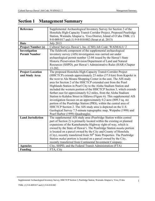
Reference<br />
<strong>Supplemental</strong> Archaeological Inventory Survey for Section 2 of the<br />
Honolulu High-Capacity Transit Corridor Project, Proposed Pearlridge<br />
Station, Waimalu Ahupua‘a, ‘Ewa District, Island of O‘ahu TMK: (1)<br />
9-8-009:017 and (1) 9-8-010:002 (Sroat et al. 2013)<br />
Date July 2013<br />
Project Number (s) Cultural Surveys Hawai‘i, Inc. (CSH) Job Code: WAIMALU 2<br />
Investigation<br />
Permit Number<br />
Project Location<br />
and Study Area<br />
Land Jurisdiction<br />
Agencies<br />
Funding<br />
The fieldwork component of the supplemental archaeological<br />
inventory survey (<strong>AIS</strong>) investigation was carried out under<br />
archaeological permit number 12-04 issued by the Hawai‘i State<br />
Historic Preservation Division/Department of Land and Natural<br />
Resources (SHPD), per Hawai‘i Administrative Rules (HAR) Chapter<br />
13-282.<br />
The proposed Honolulu High-Capacity Transit Corridor Project<br />
(HHCTCP) extends approximately 23 miles (37.0 km) from Kapolei in<br />
the west to Ala Moana Shopping Center in the east. The <strong>AIS</strong> study<br />
area for Section 2 of the HHCTCP extended east from the Pearl<br />
Highlands Station in Pearl City to the Aloha Stadium Station and<br />
included the western portion of the HHCTCP Section 3, which extends<br />
further east for approximately 0.2 miles, from the Aloha Stadium<br />
Station to Kalaloa Street in Hālawa (Figure 6). This supplemental <strong>AIS</strong><br />
investigation focuses on an approximately 0.2-acre (809.3 sq. m)<br />
portion of the Pearlridge Station (PRS), within the central area of<br />
HHCTCP Section 2. The <strong>AIS</strong> study area is depicted on the U.S.<br />
Geological Survey 7.5-minute topographic map, Waipahu (1998) and<br />
Pearl Harbor (1999) Quadrangles.<br />
The supplemental <strong>AIS</strong> study area (Pearlridge Station within central<br />
part of Section 2) is primarily located within the existing or planned<br />
expansions of the <strong>Kamehameha</strong> <strong>Highway</strong> right-of-way, which is<br />
owned by the State of Hawai‘i. The Pearlridge Station mauka portion<br />
is located on a parcel owned by the City and County of Honolulu<br />
(City), recently transferred from 50 th State Properties. The Pearlridge<br />
Station makai portion is located on a parcel owned by the City,<br />
recently transferred from Continental Investment Company.<br />
City, SHPD, and the Federal Transit Administration (FTA)<br />
FTA, City<br />
<strong>Supplemental</strong> Archaeological Inventory Survey, HHCTCP Section 2, Pearlridge Station, Waimalu Ahupua‘a, ‘Ewa, O‘ahu<br />
TMK: (1) 9-8-009:017 and (1) 9-8-010:002<br />
i


