Cultural Surveys Hawai‘i Job Code: WAIMALU 2 Methods 13-278 and 36 C.F.R. 79. The City is currently developing a curation program and seeking a curation facility that will meet these requirements. Until these curation measures are in place, all collected materials and associated records generated by the fieldwork will be temporarily curated at CSH’s main O‘ahu office in Waimānalo. <strong>Supplemental</strong> Archaeological Inventory Survey, HHCTCP Section 2, Pearlridge Station, Waimalu Ahupua‘a, ‘Ewa, O‘ahu 20 TMK: (1) 9-8-009:017 and (1) 9-8-010:002
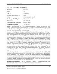
Cultural Surveys Hawai‘i Job Code: WAIMALU 2 Section 4 Results of Fieldwork Results of Fieldwork Fieldwork for this supplemental <strong>AIS</strong> was conducted on September 12, 2012 and September 25, 2012 by CSH field crew under the direction of principal investigator, Matt McDermott, M.A. The field crew consisted of Kelly Burke, M.Sc.; Brittany Enanoria, B.A.; Nifae Hunkin, B.A.; Frederick LaChance, B.A.; Kimi Matsushima, B.S.; and Tyler Turran, B.A. Fieldwork required approximately ten person-days to complete. Subsurface testing involved the backhoe excavation of a total of three test excavations, one within the makai footprint and two within the mauka footprint of the Pearlridge Station on <strong>Kamehameha</strong> <strong>Highway</strong> (see Figure 8). Prior to test excavation demarcation, the excavation area was surveyed with ground penetrating radar (GPR) to aid in the location of any subsurface utilities or other subsurface anomalies and in order to determine the best location for each test excavation. Excavation locations were recorded using a Trimble ProXH GPS unit, which, with post-processing, yields sub-foot (30 cm) horizontal position accuracy. Test excavation locations were also crossreferenced to LCA maps in order to research former land ownership and use (see Appendix H). The test excavations for the earlier <strong>AIS</strong> within the makai footprint of the Pearlridge Station were labeled PRS1 to PRS3. Accordingly, the test excavations conducted for this supplemental <strong>AIS</strong> were designated PRS-4, PRS-5, and PRS-6. Each test excavation measured approximately 0.75 m wide by 6.7 m in length. Depth of excavation ranged from between 2.65 to 2.95 mbs. Utilities and possible contaminated material were encountered within one test excavation (PRS- 4). Natural sediments were observed at the base of excavation in all three test excavations and were observed between 1.50 to 2.0 mbs. No significant cultural resources were observed within any of the test excavations. The following sections provide a summary of results for each of the three additional excavations within the Pearlridge Station, including observed stratigraphy. 4.1 Stratigraphic Summary Section 2 of the HHCTCP segment project area is situated along the low-lying coastal flats immediately inland of the East Loch of Pearl Harbor, generally within a quarter-mile of the shoreline. Traversed by Waiau Stream, Waimalu Stream, Kalauao Stream, and ‘Aiea Stream, the study area is part of a broad alluvial plain with relatively little topographic relief. The USDA soil survey data confirms that this area is notable for its alluvial deposition because, with few exceptions, the soils described for the study area are derived from alluvial parent material. The few exceptions are the higher areas of the area, where remnant eroding ridges in the vicinity of the H-1 overpass and near Aloha Stadium on <strong>Kamehameha</strong> <strong>Highway</strong> are noted. In these areas, the soils are derived from igneous bedrock and volcanic cinder. Originally, six test excavations were planned for testing within the Pearlridge Station footprint. However, due to lack of permitted access within TMK (1) 9-8-010:002, only three excavations (PRS1, PRS2, and PRS3) within the makai portion were completed. Also, alternative testing was conducted within the central corridor of <strong>Kamehameha</strong> <strong>Highway</strong> in the vicinity of the station columns. The alternative excavations included excavations E12, E13, and E14 from the original <strong>AIS</strong>. The observed stratigraphy at these excavations generally consisted of multiple <strong>Supplemental</strong> Archaeological Inventory Survey, HHCTCP Section 2, Pearlridge Station, Waimalu Ahupua‘a, ‘Ewa, O‘ahu 21 TMK: (1) 9-8-009:017 and (1) 9-8-010:002