Draft Supplemental AIS Report Kamehameha Highway Guideway
Draft Supplemental AIS Report Kamehameha Highway Guideway
Draft Supplemental AIS Report Kamehameha Highway Guideway

Create successful ePaper yourself
Turn your PDF publications into a flip-book with our unique Google optimized e-Paper software.
Cultural Surveys Hawai‘i Job Code: WAIMALU 2<br />
Results of Fieldwork<br />
4.1.3 Pearlridge Station Test Excavation 6 (PRS-6)<br />
Ahupua‘a:<br />
Waimalu<br />
LCA: 9315:1; 8525 B:3<br />
TMK #: 9-8-009:017<br />
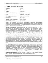
Elevation above Sea Level: 4.97 m<br />
UTM: 04Q 609168 2364942<br />
Max Length/Width/Depth: 6.70 m/0.75 m/2.90 m<br />
Orientation:<br />
29/209 TN<br />
Targeted Project Component: Additional test excavation<br />
USDA Soil Designation: Honouliuli clay (HxA)<br />
Setting: Pearlridge Station Test Excavation 6 (PRS-6) was located in a paved parking lot along<br />
the southern side (makai side) of <strong>Kamehameha</strong> <strong>Highway</strong>, approximately 75.0 m southwest of the<br />
Kaonohi Street and <strong>Kamehameha</strong> <strong>Highway</strong> intersection. No utilities were indicated in the<br />
vicinity of PRS-6. The excavation area was level with the surrounding land surface.<br />
Summary of Background Research and Land Use: An 1873 map of the Pearl Lochs by Lyons<br />
(Figure 10) shows PRS-6 in an area dominated by agricultural land and just north of two loko<br />
(fishpond). Loko Paakea is shown about 233.0 m southwest of PRS-6, while Loko Opu is 90.0 m<br />
southeast. The former shoreline is shown more than 150.0 m to the south. The 1919 U.S. Army<br />
War Department Fire Control Map (Figure 11) indicates that taro and rice fields were still<br />
present among beginning urban developments. The OR&L railroad line is present 145.0 m south<br />
of PRS-6, while other developing roads and buildings are north. A 1939 aerial photograph shows<br />
the surrounding landscape still largely devoted to agricultural use (Figure 12). By 1943, the<br />
railroad still present, and now <strong>Kamehameha</strong> <strong>Highway</strong> has been constructed (1943 U.S. Army<br />
War Department Fire Control map, Figure 13). The area remained only sparsely developed<br />
through the 1950s (1953 Army Mapping Service Topographic map, Figure 14). However, a<br />
1977-1978 U.S. Geological Survey orthophoto (Figure 15) shows an urban landscape dominated<br />
by buildings and large warehouses, with none of the former agricultural lands present.<br />
Documentation Procedures: PRS-6 was excavated to a maximum depth of 2.9 mbs. The water<br />
table was not encountered during excavation.<br />
Stratigraphic Summary: The stratigraphy of PRS-6 consisted of several fill layers overlying<br />
natural sediments. Observed strata included asphalt (Stratum Ia), extremely gravelly sand<br />
(Stratum Ib), sandy clay loam (Stratum Ic), cobbley gravelly loam (Stratum Id), sandy clay loam<br />
(Stratum Ie), silty clay loam (Stratum IIa), sandy silt (Stratum IIb), and a silty clay (Stratum IIc).<br />
Strata IIa through IIc generally conformed to the USDA soil survey designation of Honouliuli<br />
clay (HxA).<br />
Artifacts Discussion: No artifacts were observed.<br />
Feature Discussion: No features were observed.<br />
<strong>Supplemental</strong> Archaeological Inventory Survey, HHCTCP Section 2, Pearlridge Station, Waimalu Ahupua‘a, ‘Ewa, O‘ahu 40<br />
TMK: (1) 9-8-009:017 and (1) 9-8-010:002