Draft Supplemental AIS Report Kamehameha Highway Guideway
Draft Supplemental AIS Report Kamehameha Highway Guideway
Draft Supplemental AIS Report Kamehameha Highway Guideway

Create successful ePaper yourself
Turn your PDF publications into a flip-book with our unique Google optimized e-Paper software.
Cultural Surveys Hawai‘i Job Code: WAIMALU 2<br />
Results of Fieldwork<br />
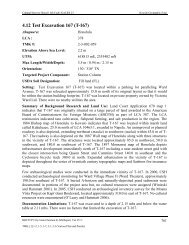
modern and historic fill layers overlying natural sediments. Upper fill strata were associated with<br />
either the development of <strong>Kamehameha</strong> <strong>Highway</strong> (E12, E13, and E14) or with paving and<br />
parking lot construction (PRS1, PRS2, and PRS3). Natural sediments were observed between 1.0<br />
to 1.85 mbs, extending to the base of excavation (Sroat et al. 2012).<br />
The stratigraphy observed within the three test excavations for this supplemental <strong>AIS</strong> was<br />
generally consistent with the stratigraphy documented for PRS1, PRS2, and PRS3. Excavation<br />
for the supplemental <strong>AIS</strong> was confined to two lots (the mauka and makai portions of the<br />
Pearlridge Station) on either side of <strong>Kamehameha</strong> <strong>Highway</strong>. All three excavations contained<br />
between four and seven layers of modern and historic fill that extended to between 1.95 to 2.10<br />
mbs. Upper fill layers were generally associated with modern paving or parking lot construction<br />
and included asphalt, gravel base courses, and loam fills. Lower fill layers consisted of clay, and<br />
silty and sandy loams. The fill layers overlie natural, alluvial sediments that occur between 1.5 to<br />
2.0 mbs and extend to the base of excavation. Natural sediments consisted of silty clay, sandy<br />
clay loam, silty clay loam, and clay loams.<br />
<strong>Supplemental</strong> Archaeological Inventory Survey, HHCTCP Section 2, Pearlridge Station, Waimalu Ahupua‘a, ‘Ewa, O‘ahu 22<br />
TMK: (1) 9-8-009:017 and (1) 9-8-010:002