

Storm Data and Unusual Weather Phenomena - CIG
Storm Data and Unusual Weather Phenomena - CIG
Storm Data and Unusual Weather Phenomena - CIG

You also want an ePaper? Increase the reach of your titles
YUMPU automatically turns print PDFs into web optimized ePapers that Google loves.
<strong>Storm</strong> <strong>Data</strong> <strong>and</strong> <strong>Unusual</strong> <strong>Weather</strong> <strong>Phenomena</strong><br />
Time Path Path Number of Estimated July 1995<br />
Local/ Length Width Persons Damage<br />
Location Date St<strong>and</strong>ard (Miles) (Yards) Killed Injured Property Crops Character of <strong>Storm</strong><br />
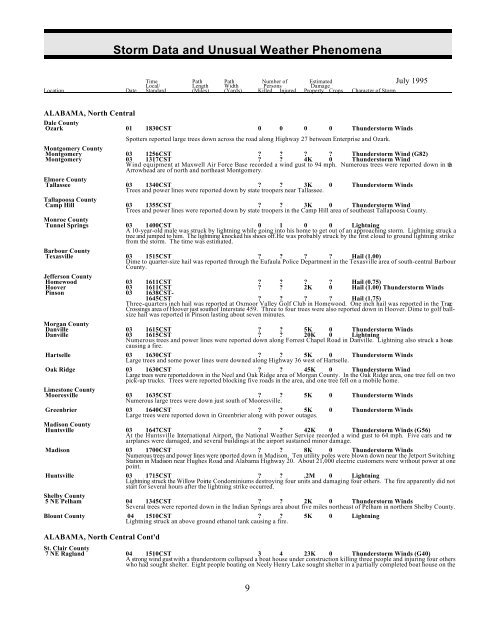
ALABAMA, North Central<br />
Dale County<br />
Ozark 01 1830CST 0 0 0 0 Thunderstorm Winds<br />
Spotters reported large trees down across the road along Highway 27 between Enterprise <strong>and</strong> Ozark.<br />
Montgomery County<br />
Montgomery 03 1256CST Thunderstorm Wind (G82)<br />
Montgomery 03 1317CST 4K 0 Thunderstorm Wind<br />
Wind equipment at Maxwell Air Force Base recorded a wind gust to 94 mph. Numerous trees were reported down in the<br />
Arrowhead are of north <strong>and</strong> northeast Montgomery.<br />
Elmore County<br />
Tallassee 03 1340CST 3K 0 Thunderstorm Winds<br />
Trees <strong>and</strong> power lines were reported down by state troopers near Tallassee.<br />
Tallapoosa County<br />
Camp Hill 03 1355CST 3K 0 Thunderstorm Wind<br />
Trees <strong>and</strong> power lines were reported down by state troopers in the Camp Hill area of southeast Tallapoosa County.<br />
Monroe County<br />
Tunnel Springs 03 1400CST 0 1 0 0 Lightning<br />
A 10-year-old male was struck by lightning while going into his home to get out of an approaching storm. Lightning struck a<br />
tree <strong>and</strong> jumped to him. The lightning knocked his shoes off. He was probably struck by the first cloud to ground lightning strike<br />
from the storm. The time was estimated.<br />
Barbour County<br />
Texasville 03 1515CST Hail (1.00)<br />
Dime to quarter-size hail was reported through the Eufaula Police Department in the Texasville area of south-central Barbour<br />
County.<br />
Jefferson County<br />
Homewood 03 1611CST Hail (0.75)<br />
Hoover 03 1611CST 2K 0 Hail (1.00) Thunderstorm Winds<br />
Pinson 03 1638CST-<br />
1645CST Hail (1.75)<br />
Three-quarters inch hail was reported at Oxmoor Valley Golf Club in Homewood. One inch hail was reported in the Trace<br />
Crossings area of Hoover just south of Interstate 459. Three to four trees were also reported down in Hoover. Dime to golf ballsize<br />
hail was reported in Pinson lasting about seven minutes.<br />
Morgan County<br />
Numerous trees <strong>and</strong> power lines were reported down along Forrest Chapel Road in Danville. Lightning also struck a hous e<br />
causing a fire.<br />
Danville<br />
Danville<br />
03<br />
03<br />
1615CST<br />
1615CST<br />
<br />
<br />
<br />
<br />
5K<br />
20K<br />
0<br />
0<br />
Thunderstorm Winds<br />
Lightning<br />
Hartselle 03 1630CST 5K 0 Thunderstorm Winds<br />
Large trees <strong>and</strong> some power lines were downed along Highway 36 west of Hartselle.<br />
Oak Ridge 03 1630CST 45K 0 Thunderstorm Wind<br />
Large trees were reported down in the Neel <strong>and</strong> Oak Ridge area of Morgan County. In the Oak Ridge area, one tree fell on two<br />
pick-up trucks. Trees were reported blocking five roads in the area, <strong>and</strong> one tree fell on a mobile home.<br />
Limestone County<br />
Mooresville<br />
were down just south of<br />
03<br />
Numerous<br />
1635CST<br />
large trees<br />
<br />
Mooresville.<br />
5K 0 Thunderstorm Winds<br />
Greenbrier 03 1640CST 5K<br />
Large trees were reported down in Greenbrier along with power outages.<br />
0 Thunderstorm Winds<br />
Madison County<br />
Huntsville 03 1647CST 42K 0 Thunderstorm Winds (G56)<br />
At the Huntsville International Airport, the National <strong>Weather</strong> Service recorded a wind gust to 64 mph. Five cars <strong>and</strong> two<br />
airplanes were damaged, <strong>and</strong> several buildings at the airport sustained minor damage.<br />
Madison 03 1700CST 8K 0 Thunderstorm Winds<br />
Numerous trees <strong>and</strong> power lines were reported down in Madison. Ten utility poles were blown down near the Jetport Switching<br />
Station in Madison near Hughes Road <strong>and</strong> Alabama Highway 20. About 21,000 electric customers were without power at one<br />
point.<br />
Huntsville 03 1715CST .2M 0 Lightning<br />
Lightning struck the Willow Pointe Condominiums destroying four units <strong>and</strong> damaging four others. The fire apparently did not<br />
start for several hours after the lightning strike occurred.<br />
Shelby County<br />
5 NE Pelham<br />
reported down in the Indian about miles Shelby County.<br />
04<br />
Several<br />
1345CST<br />
trees were<br />
<br />
Springs<br />
<br />
area<br />
2K<br />
five<br />
0<br />
northeast<br />
Thunderstorm Winds<br />
of Pelham in northern<br />
Blount County 04 1510CST <br />
Lightning struck an above ground ethanol tank causing a fire.<br />
5K 0 Lightning<br />
ALABAMA, North Central Cont'd<br />
St. Clair County<br />
7 NE Ragl<strong>and</strong> 04 1510CST 3 4 23K 0 Thunderstorm Winds (G40)<br />
A strong wind gust with a thunderstorm collapsed a boat house under construction killing three people <strong>and</strong> injuring four others<br />
who had sought shelter. Eight people boating on Neely Henry Lake sought shelter in a partially completed boat house on the<br />
9
<strong>Storm</strong> <strong>Data</strong> <strong>and</strong> <strong>Unusual</strong> <strong>Weather</strong> <strong>Phenomena</strong><br />
Time Path Path Number of Estimated July 1995<br />
Local/ Length Width Persons Damage<br />
Location Date St<strong>and</strong>ard (Miles) (Yards) Killed Injured Property Crops Character of <strong>Storm</strong><br />
St. Clair shore of the lake. The people were injured <strong>and</strong> killed when the boat house roof collapsed during the wind gust. (F29O,<br />
F06O, M04O)<br />
Etowah County<br />
Gadsden 04 1535CST 22K 0 Thunderstorm Winds (G65)<br />
Etowah County Emergency Management Agency reported a wind gust to 75 miles an hour on their wind measuring equipment.<br />
One building reportedly lost a roof, <strong>and</strong> trees were downed in scattered locations across the county.<br />
Tuscaloosa County<br />
Tuscaloosa 04 1555CST 0.5 50 Tornado (F0)<br />
15 NW Tuscaloosa 04 1620CST Funnel Cloud<br />
A tornado was reported by the Tuscaloosa Fire Department in the Elrod/Echola area of Tuscaloosa. One tree was blown down.<br />
Tuscaloosa County Sheriff's Department reported a funnel cloud in the Brownville area about 15 miles northwest of Tuscaloosa.<br />
Blount County<br />
Summit 04 1605CST 22K 0 Thunderstorm Winds<br />
6NE Oneonta 04 1630CST 5K 0 Thunderstorm Winds<br />
A mobile home was damaged <strong>and</strong> a tree was blown onto a house in northern Blount County around Summit. Trees <strong>and</strong> power<br />
lines were down along Highway 132 between Oneonta <strong>and</strong> Altoona.<br />
Marshall County<br />
Guntersville,<br />
Union Grove,<br />
<strong>and</strong> Arab 04 1615CST 8K 0 Thunderstorm Winds<br />
Numerous large trees <strong>and</strong> power lines were reported down in the Guntersville, Union Grove, <strong>and</strong> Arab areas of Marshall County.<br />
The area affected was primarily the central <strong>and</strong> southwest section of the county.<br />
Jackson County<br />
Dutton, Section 04 1630CST 2K 0 Thunderstorm Winds Hail (0.88)<br />
4 NE Stevenson 04 1647CST 3K 0 Thunderstorm Winds<br />
Trees were down <strong>and</strong> nickel-size hail was reported at Dutton in southeast Jackson County <strong>and</strong> Section. Large trees <strong>and</strong> power<br />
lines were reported down between Stevenson <strong>and</strong> Bridgeport. Several large trees blocked a road in Stevenson.<br />
Montgomery County<br />
Montgomery 04 1830CST Funnel Cloud<br />
A funnel cloud was observed over northeast Montgomery.<br />
Elmore County<br />
Tallassee 04 1900CST Thunderstorm Winds<br />
Trees were reported down by thunderstorm wind near Tallassee.<br />
Limestone County<br />
Athens 04 1945CST 7K 0 Lightning<br />
Lightning struck a workshop causing a fire that caused minor damage.<br />
Marion County<br />
8 SW Hamilton 04 2005CST 3K 0 Thunderstorm Winds<br />
Hamilton 04 2010CST Hail (0.75)<br />
Brilliant 04 2015CST 3K 0 Thunderstorm Winds<br />
Whitehouse 04 2020CST Funnel Cloud<br />
About ten trees were reported down along Highway 10in the southwest part of Marion County. Hail about the size of dimes was<br />
reported in Hamilton. Several trees were down on Highway 44 between Twin <strong>and</strong> Brilliant. A funnel cloud was reported near<br />
Whitehouse about 15 miles east of Hamilton.<br />
Lamar County<br />
6 E Detroit 04 2012CST 0.5 80 Tornado (F0)<br />
A tornado was reported at Henson Springs in northern Lamar County. The tornado occurred in the open with no damage<br />
reported.<br />
Winston County<br />
Haleyville 04 2045CST Hail (0.75)<br />
Double Springs 04 2105CST 5K 0 Thunderstorm Winds<br />
Three-quarter inch hail was reported at Haleyville. Power lines <strong>and</strong> several trees were downed in the Double Springs area.<br />
Lawrence County<br />
3 N Moulton 04 2104CST Funnel Cloud<br />
8 E Moulton 04 2119CST Funnel Cloud<br />
Hatton 04 2124CST 2K 0 Thunderstorm Winds<br />
Funnel clouds were observed about three miles north of Moulton <strong>and</strong> just north of Speake, about eight miles east of Moulton.<br />
Large trees were reported down in Hatton, northwest of Moulton.<br />
Limestone County<br />
3 S Athens 04 2150CST Funnel Cloud<br />
A funnel cloud was reported three miles south of Athens near Interstate 65.<br />
ALABAMA, North Central Cont'd<br />
Walker County<br />
Townley 05 1715CST 85K 0 Thunderstorm Winds<br />
Thunderstorm wind downed trees <strong>and</strong> damaged the roof on the volunteer fire department building in Townley. A church<br />
sustained minor damage <strong>and</strong> the bleachers at the Townley School were blown over. One house behind the post office had five<br />
trees fall on it. Funnel clouds were reported in many places in <strong>and</strong> around the Jasper area, however, there was no evidence that<br />
any of them had touched down.<br />
Cullman County<br />
5 E Cullman 05 1820CST 15K 0 Lightning<br />
1 NE Providence 05 1825CST 25K 0 Thunderstorm Winds<br />
Lightning struck a barn east of Cullman setting it on fire. One house sustained roof <strong>and</strong> awning damage in the Providenc e<br />
community of extreme northeast Cullman County on County Road 1437. A chicken house in the same area also sustained roof<br />
10
<strong>Storm</strong> <strong>Data</strong> <strong>and</strong> <strong>Unusual</strong> <strong>Weather</strong> <strong>Phenomena</strong><br />
Time Path Path Number of Estimated July 1995<br />
Local/ Length Width Persons Damage<br />
Location Date St<strong>and</strong>ard (Miles) (Yards) Killed Injured Property Crops Character of <strong>Storm</strong><br />
damage.<br />
Dallas County<br />
Selma 08 1345CST 8K 0<br />
Several trees were blown down with damage reported to several roofs of homes.<br />
Thunderstorm Winds<br />
Wilcox County<br />
Camden 08 1405CST 0<br />
Several trees were blown down in <strong>and</strong> around Camden.<br />
0 1K 0 Thunderstorm Winds<br />
Choctaw County<br />
Gilbertown 08 1416CST 0 0 1K 0 Thunderstorm Winds<br />
Several trees were blown down around Gilbertown.<br />
Monroe County<br />
Beatrice 08 1440CST 0 0 1.5K 0 Thunderstorm Winds<br />
Several trees <strong>and</strong> power lines were blown down in Beatrice.<br />
Excel 08 1500CST 0 0<br />
A church under construction was damaged by high winds.<br />
1K 0 Thunderstorm Winds<br />
Clarke <strong>and</strong> Washington<br />
Counties 08 1435CST-<br />
08 1500CST 0 0 2.5K 0 Thunderstorm Winds<br />
Trees <strong>and</strong> power lines were blown down by high winds throughout both Washington <strong>and</strong> Clarke counties. Most of the damage<br />
was three or four trees along with power lines blown down at a time in different parts of the counties.<br />
Conecuh County<br />
Evergreen<br />
0 0 2K 0 Thunderstorm Winds<br />
Trees <strong>and</strong> power lines were blown down around Burnt Corn <strong>and</strong> also in the city of Evergreen.<br />
Burnt Corn 08<br />
08<br />
1500CST-<br />
1530CST<br />
Mobile County<br />
Citronelle 08 1514CST 0 0 1.5K<br />
Trees <strong>and</strong> power lines were blown down around the city of Citronelle.<br />
0 Thunderstorm Winds<br />
Escambia County<br />
Atmore 08 1549CST<br />
Several trees were blown down in Atmore.<br />
0 0 1K 0 Thunderstorm Winds<br />
Mobile County<br />
Semmes 08 1606CST 0 0 1K 0 Thunderstorm Winds<br />
Several trees were blown down along Howells Ferry <strong>and</strong> Havens roads just southwest of Semmes.<br />
Baldwin County<br />
Silverhill 08 1645CST 0 0 .5K 0<br />
Trees were blown down in Silverhill. EMA estimated wind speed of 60 mph.<br />
Thunderstorm Winds<br />
Mobile County<br />
Mobile 08 1705CST 0 0 2K 0 Thunderstorm Winds<br />
High winds damaged a roof of a Pizza Hut on Dauphin Isl<strong>and</strong> Parkway. Several large tree limbs were also blown down.<br />
Fayette County<br />
Fayette 09 0750CST 3K 0 Thunderstorm Winds<br />
Winds blew down several trees in wind gusts estimated around 60 mph by an off-duty National <strong>Weather</strong> Service employee .<br />
Power was reported out across much of the city of Fayette. The Sheriff's Department reported trees down over the western part<br />
of the county to the west of Fayette.<br />
Tuscaloosa County<br />
Samantha 09 0809CST<br />
Nickel-size hail was reported at Samantha.<br />
Hail (0.88)<br />
Sumter County<br />
Livingston 09 1044CST-<br />
09 1050CST <br />
Hail that varied from pea to quarter-size fell for several minutes at Livingston.<br />
Hail (1.00)<br />
11
<strong>Storm</strong> <strong>Data</strong> <strong>and</strong> <strong>Unusual</strong> <strong>Weather</strong> <strong>Phenomena</strong><br />
Time Path Path Number of Estimated July 1995<br />
Local/ Length Width Persons Damage<br />
Location Date St<strong>and</strong>ard (Miles) (Yards) Killed Injured Property Crops Character of <strong>Storm</strong><br />
ALABAMA, North Central Cont'd<br />
Marengo County<br />
Myrtlewood 09 1140CST 5K 0 Thunderstorm Winds<br />
2 SW Sweetwater 09 1200CST 4K 0 Thunderstorm Winds<br />
10 SW Linden 09 1200CST Hail (0.75)<br />
Trees were reported down on Highway 69 at Myrtlewood. Dime-size hail was reported at Half Acre 10 miles southwest of<br />
Linden. Trees were reported down half way between Nanafalia <strong>and</strong> Dixons Mill near Sweetwater.<br />
Wilcox County<br />
Coy 09 1205CST 0 0 1K 0 Thunderstorm Winds<br />
Several trees were blown down across the highway near Coy.<br />
Clarke County<br />
Jackson 09 1230CST 0 0<br />
Several trees were blown down around the city of Jackson.<br />
1K 0 Thunderstorm Winds<br />
Monroe County<br />
Excel<br />
Fountain<br />
Mexia 09 1215CST 0 0<br />
Several trees were blown down in Fountain, Mexia <strong>and</strong> Excel.<br />
2.5K 0 Thunderstorm Winds<br />
Monroe County<br />
Monroeville 09 1215CST 0 0 0 0 Hail (0.75)<br />
Sumter County<br />
York 09 1230CST<br />
Dime-size hail was reported in York.<br />
Hail (0.75)<br />
Mobile County<br />
Mt. Vernon 09 1440CST 0<br />
Several trees were blown down along Highway 43.<br />
0 1K 0 Thunderstorm Winds<br />
Citronelle 09 1445CST<br />
Dime-size hail was reported around Citronelle.<br />
0 0 0 0 Hail (0.75)<br />
Baldwin County<br />
Stockton 09 1445CST 0 0<br />
Several trees were blown across Highway 225 in Stockton.<br />
1K 0 Thunderstorm Wins<br />
Mobile County<br />
Fort Gaines 09 1530CST 1 1 0 0 Lightning<br />
Lightning struck two males at a boat ramp. The two were securing their boat to get out of an approaching thunderstorm. A flash<br />
knocked the two down, killing the 36-year-old. The other male tried to revive him, but was unable to do so. They were likely<br />
struck by the first lightning bolt from the storm. (M36OU)<br />
Mobile County<br />
Mobile tipping were reported <strong>and</strong> the<br />
waterspout dissipated over the bay.<br />
Mobile Bay 09<br />
A<br />
1600CST<br />
waterspout moved<br />
2<br />
down<br />
20<br />
Bay,<br />
0<br />
over<br />
0<br />
sailboats<br />
1K<br />
<strong>and</strong> other<br />
0<br />
pleasure<br />
Waterspout<br />
crafts. No injuries<br />
Cherokee County<br />
Thunderstorm wind downed trees across the northern part of Cherokee County. Hail also damaged some crops in the same area.<br />
The Mt. Bethel Baptist Church was struck by lightning.<br />
Northern Part 09 1610CST 5K 15K Thunderstorm Winds, Hail (0.75)<br />
Lightning<br />
Baldwin County<br />
moved offshore south of <strong>and</strong> calls within<br />
a matter of minutes. Some of the boats turned over but no one was injured. The Coast Guard estimated wind speeds of 55 to<br />
65 MPH.<br />
Orange Beach 09<br />
A line<br />
1625CST<br />
of thunderstorms<br />
0<br />
Orange<br />
0<br />
Beach<br />
0.5K<br />
the Coast<br />
0<br />
Guard<br />
Thunderstorm Winds<br />
had 25 to 30 boater assistance<br />
Henry County<br />
Headl<strong>and</strong> 09 1630CST 2K 0 Thunderstorm Winds<br />
Headl<strong>and</strong> 09 1630CST 65K Lightning<br />
Thunderstorm wind downed trees <strong>and</strong> power lines in Headl<strong>and</strong> according to the Emergency Management Agency. A house was<br />
also struck by lightning causing significant damage in a resulting fire.<br />
Houston County<br />
5 SSW Ashford 09 1700CST 5K 0 Thunderstorm Winds Hail<br />
Pea-size hail covered the ground, <strong>and</strong> wind downed trees <strong>and</strong> power lines in the area between Ashford <strong>and</strong> Cottonwood according<br />
to emergency management.<br />
Pickens County<br />
3 W Ethelsville 09 1800CST Hail (0.75)<br />
Hail the size of dimes was reported three miles west of Ethelsville in extreme western Pickens County.<br />
Fayette County<br />
Fayette 09 1830CST 18K 0 Thunderstorm Winds<br />
Fayette police reported trees down in Fayette, one large tree fell on a laundromat on the south side of Fayette.<br />
12
<strong>Storm</strong> <strong>Data</strong> <strong>and</strong> <strong>Unusual</strong> <strong>Weather</strong> <strong>Phenomena</strong><br />
Time Path Path Number of Estimated July 1995<br />
Local/ Length Width Persons Damage<br />
Location Date St<strong>and</strong>ard (Miles) (Yards) Killed Injured Property Crops Character of <strong>Storm</strong><br />
ALABAMA, North Central Cont'd<br />
Tuscaloosa County<br />
2 N Samantha 09 1915CST 3K 0 Thunderstorm Winds<br />
Emergency management reported trees down across Highway 43 just north of Samantha.<br />
Sumter County<br />
Epes 09 1926CST <br />
Hail was reported at Epes. Several trees were also reported down in the area.<br />
Hail (0.75)<br />
Baldwin County<br />
Fairhope, Silverhill<br />
Foley, Robertsdale 10 0410CST-<br />
10 0445CST 0 0 4K 0 Thunderstorm Winds<br />
Several trees were blown down by persistent thunderstorms in south central part of the county.<br />
Baldwin County<br />
Fairhope<br />
vintage 1920's frame house in The<br />
10<br />
Lightning<br />
0514CST<br />
struck a<br />
0<br />
Fairhope.<br />
0 10K<br />
home suffered<br />
0 Lightning<br />
minimal damage.<br />
Montgomery County<br />
9 E Hayneville 11 1815CST 3K 0 Thunderstorm Winds<br />
A swath of trees were reported down on the Lowndes/Montgomery County line along Interstate 65.<br />
12 SW Montgomery<br />
Lowndes County<br />
11 1815CST 5K 0 Thunderstorm Winds<br />
Baldwin County<br />
lines were blown down near of a white wall<br />
of water.<br />
Mobile Bay 12<br />
Power<br />
1345CST<br />
poles <strong>and</strong> power<br />
0<br />
the<br />
0<br />
Tensaw<br />
1.5K<br />
River east<br />
0<br />
causeway<br />
Thunderstorm Winds<br />
bridge. A citizen reported<br />
Baldwin County<br />
Foley<br />
were peeled back from the of a<br />
12<br />
A roof<br />
1420CST<br />
<strong>and</strong> canopy<br />
0<br />
front<br />
0<br />
building<br />
0.5K<br />
by the wind<br />
0<br />
in<br />
Thunderstorm Winds<br />
Foley.<br />
Mobile County<br />
was measured just south of Mobile of Interstate 10<br />
Wallace Tunnel.<br />
Mobile 12<br />
A wind<br />
1425CST<br />
gust of 60 mph<br />
0<br />
downtown<br />
0 0<br />
near<br />
0<br />
Bender<br />
Thunderstorm Winds<br />
Shipyard which is just south<br />
Walker County<br />
Sumiton<br />
<strong>and</strong> roof damage was in<br />
12<br />
Trees<br />
1705CST<br />
were downed<br />
<br />
reported at<br />
<br />
Sumiton<br />
12K<br />
eastern<br />
0<br />
Walker<br />
Thunderstorm Winds<br />
County.<br />
Choctaw County<br />
Hodgewood 12 1815CST 0 0 1K 0 Thunderstorm Winds<br />
Several trees were blown down 1.5 miles north of Hodgewood. Power outages were also reported in Barrytown.<br />
Tuscaloosa County<br />
Moundville 13 1615CST 6K 0 Thunderstorm Winds<br />
Hale County<br />
Moundville 13 1615CST 2K 0 Thunderstorm Winds<br />
Trees were reported down at Moundville State Park on the north side of Moundville in Tuscaloosa County <strong>and</strong> on the west side<br />
of Moundville in Hale County.<br />
Pickens County<br />
13 S Gordo 13 1715CST-<br />
13 1725CST 8K 0 Thunderstorm Winds<br />
4 N Aliceville 13 1724CST Hail (1.75)<br />
Several trees were reported down in eastern Pickens County about 13 miles south of Gordo. Golf ball-size hail was reported four<br />
miles north of Aliceville.<br />
Fayette County<br />
Berry 13 1725CST 4K 0 Thunderstorm Winds<br />
Trees were reported down in Berry in southeast Fayette County.<br />
Lamar County<br />
Millport 13 1845CST 4K 0 Thunderstorm Winds<br />
Crossville 13 1910CST Hail (1.75)<br />
Vernon 13 1915CST Hail (0.75)<br />
Sulligent 13 1945CST-<br />
13 2005CST 45K 0 Thunderstorm Winds<br />
Trees were reported down between Fernbank <strong>and</strong> Millport in southern Lamar County. Half dollar to golf ball-size hail along with<br />
smaller hail was reported at Crossville in eastern Lamar County. Dime-size hail was reported at Vernon. Trees were downed<br />
in Sulligent including at least one that fell onto a mobile home. Several trees fell on cars on Mulberry Road south of Sulligent<br />
<strong>and</strong> about three-fourths of the city was without power at one time.<br />
Mobile County<br />
Mobile 13 2242CST 0 0 1K 0 Thunderstorm Winds<br />
Several trees were blown down across Bonnie Lane. The road was blocked for several hours.<br />
13
<strong>Storm</strong> <strong>Data</strong> <strong>and</strong> <strong>Unusual</strong> <strong>Weather</strong> <strong>Phenomena</strong><br />
Time Path Path Number of Estimated July 1995<br />
Local/ Length Width Persons Damage<br />
Location Date St<strong>and</strong>ard (Miles) (Yards) Killed Injured Property Crops Character of <strong>Storm</strong><br />
ALABAMA, North Central Cont'd<br />
Marshall County<br />
Boaz 15 1321CST 25K 0 Lightning<br />
Boaz 15 1349CST 8K 0 Lightning<br />
Lightning was responsible for starting two fires, one at a business <strong>and</strong> one at a home. Damaged was fairly significant in the fire<br />
at the retail rug store <strong>and</strong> minor at the residence.<br />
Madison County<br />
Gurley 15 1502CST <br />
Golf ball-size hail was reported in Gurley in east-central Madison County.<br />
Hail (1.75)<br />
Morgan County<br />
7 WNW Hartselle 15 1600CST 4K 0 Thunderstorm Winds<br />
Large trees <strong>and</strong> power lines were downed by thunderstorm wind in the western section of Morgan County around Neel.<br />
Lawrence County<br />
Courtl<strong>and</strong> 15 1646CST <br />
Large trees were downed <strong>and</strong> hail the size of dimes was reported.<br />
6K 0 Thunderstorm Winds Hail (0.75)<br />
Houston County<br />
Dothan 16 1430CST 30K 0 Thunderstorm Winds<br />
Dothan State Police reported two houses with roof damage in the southeast corner of the city of Dothan. Trees, power lines, <strong>and</strong><br />
wooden fences were also reported downed by the wind.<br />
Calhoun County<br />
downed trees in Anniston one fell cars one<br />
damage. Lightning also struck one house causing a fire.<br />
Anniston 16<br />
Thunderstorm<br />
1550CST<br />
wind<br />
<br />
including<br />
<br />
that<br />
85K<br />
on two<br />
0<br />
<strong>and</strong><br />
Thunderstorm Winds Lightning<br />
that fell on a house causing substantial<br />
Lee County<br />
Salem<br />
reported across a road near in of<br />
16<br />
Several<br />
1755CST<br />
trees were<br />
<br />
Salem<br />
<br />
the eastern<br />
2K<br />
part<br />
0<br />
Lee<br />
Thunderstorm Winds<br />
County.<br />
Montgomery<br />
1 E Ramer 17 1255CST 2K<br />
Power lines <strong>and</strong> trees were downed by the wind just east of Ramer.<br />
0 Thunderstorm Winds<br />
Butler County<br />
Foster Flats 17 1305CST .1 20 0 0 1K 0 Tornado F0<br />
The public reported a tornado briefly touched down <strong>and</strong> damaged a building in the Foster Flats area about eight miles east of<br />
Greenville. A train like roar was heard. Reported by a television station.<br />
Sumter County<br />
while hitchhiking along a woman, had sought shelter<br />
from the pouring rain under a tree when the lightning struck. (M32UT, (F42UT)<br />
Emelle 17<br />
Two<br />
1500CST<br />
people were killed<br />
2<br />
Alabama<br />
0<br />
17 near<br />
0<br />
Emelle.<br />
0<br />
The people,<br />
Lightning<br />
a man <strong>and</strong><br />
Colbert County<br />
6 SE Tuscumbia<br />
Volunteer Fire Department their<br />
17<br />
The<br />
1700CST<br />
Spring Valley<br />
<br />
reported<br />
<br />
wind<br />
15K<br />
damage to<br />
0<br />
fire<br />
Thunderstorm Winds<br />
station roof.<br />
Lawrence County<br />
Wheeler 17 1705CST <br />
Trees were reported down at Mallard Creek northeast of Wheeler.<br />
5K 0 Thunderstorm Winds<br />
Elmore County<br />
Wetumpka 17 1725CST 7K<br />
Trees <strong>and</strong> power lines were reported down in <strong>and</strong> around Wetumpka.<br />
0 Thunderstorm Winds<br />
Franklin County<br />
Phil Campbell 17 1900CST 1 0 0 Lightning<br />
A 48-year-old man was injured when lightning came in on the telephone line while he was talking on the telephone.<br />
Covington County<br />
Red Level 18 1745CST-<br />
18 1800CST 5K 0 Thunderstorm Winds<br />
Emergency management reported numerous trees downed just south of Red Level along Highway 107. A mobile home was also<br />
destroyed when wind ripped off the roof. Another mobile home was damage when a large limb fell on it.<br />
Elmore County<br />
3 S Wetumpka 18 1800CST 4K<br />
Power lines <strong>and</strong> small trees were reported down just south of Wetumpka.<br />
0 Thunderstorm Winds<br />
Montgomery County<br />
Montgomery 18 1820CST 18K<br />
A tree was blown down by thunderstorm wind <strong>and</strong> fell on a mobile home.<br />
0 Thunderstorm Winds<br />
Escambia County<br />
Brewton 18 1840CST 0 0 1K 0 Thunderstorm Winds<br />
Flomaton 18 1845CST 0 0 3K 0 Thunderstorm Winds<br />
Several trees were blown down along Appleton road in Brewton. Several trees were also blown down along Highway 31<br />
between Brewton <strong>and</strong> Flomaton. One of the trees was blown down on a house in Flomaton.<br />
vALABAMA, North Central Cont'd<br />
Wilcox County<br />
10 WNW Camden 18 1930CST 5K 0 Thunderstorm Winds<br />
Numerous trees up to a foot in diameter were downed along Highway 162 in the western part of Wilcox County.<br />
14
<strong>Storm</strong> <strong>Data</strong> <strong>and</strong> <strong>Unusual</strong> <strong>Weather</strong> <strong>Phenomena</strong><br />
Time Path Path Number of Estimated July 1995<br />
Local/ Length Width Persons Damage<br />
Location Date St<strong>and</strong>ard (Miles) (Yards) Killed Injured Property Crops Character of <strong>Storm</strong><br />
Mobile County<br />
0 0 12K 0 Lightning<br />
As thunderstorms moved through Mobile, lightning stuck three homes <strong>and</strong> a shed. At the first home, lightning struck a tree <strong>and</strong><br />
also a garage. The garage was completely destroyed. At the second home, lightning struck the air conditioning unit <strong>and</strong> set the<br />
attic on fire. At the third home, lightning struck the electrical panel <strong>and</strong> caused some damage. The last lightning strike was to<br />
a shed, which was completely destroyed.<br />
Mobile 19<br />
19<br />
1412CST-<br />
1430CST<br />
Henry County<br />
4 S Abbeville<br />
to four feet in diameter, was near for two hours.<br />
19<br />
A large<br />
1505CST<br />
oak tree, three<br />
<br />
blown<br />
<br />
down across<br />
4K<br />
Alabama<br />
0<br />
95<br />
Thunderstorm Winds<br />
Abbeville closing the road<br />
Montgomery County<br />
Montgomery 21 aftn 1 <br />
A 72-year-old woman was found dead in her apartment. (F72PH)<br />
Heat<br />
Mobile County<br />
3 SE Gr<strong>and</strong> Bay 21 1356CST 45K 0 Lightning<br />
Lighting struck a house located between Gr<strong>and</strong> Bay <strong>and</strong> Bayou La Batre causing a fire that did significant damage.<br />
Cullman County<br />
Cullman County Library a fire the system. Telephones <strong>and</strong><br />
computer systems were also knocked out of commission.<br />
Cullman 21<br />
Lightning<br />
1530CST<br />
struck the<br />
<br />
causing<br />
<br />
small<br />
3K<br />
that damaged<br />
0 Lightning<br />
air conditioning<br />
Coffee County<br />
8 S Enterprise<br />
house on Alabama 27 the but<br />
21<br />
Lightning<br />
1715CST<br />
struck a<br />
<br />
damaging<br />
<br />
electrical<br />
1K<br />
system<br />
0<br />
not<br />
Lightning<br />
causing a fire.<br />
Cullman County<br />
45K 0 Flash Flood<br />
Cullman 21 1738CST 4K 0 Thunderstorm Winds<br />
Numerous trees were blown down in the city of Cullman. Torrential rain with between four <strong>and</strong> six inches falling in three hours<br />
forced the evacuation of several families from the Homewood Trailer Park <strong>and</strong> closed U. S. Highway 31 on the south side of<br />
Cullman. Waters had receded by 2000 CDT.<br />
Cullman 21<br />
21<br />
1720CST-<br />
1845CST<br />
Morgan County 21 1725CST 15K<br />
Trees were reported down in scattered locations across the county.<br />
0 Thunderstorm Winds<br />
Morgan County<br />
Trinity 24 1434CST <br />
Dime-size hail was reported at Trinity immediately west of Decatur.<br />
Hail (0.75)<br />
Danville 24 1437CST<br />
One-half inch hail was reported at Danville.<br />
Hail (0.50)<br />
Decatur 24 1443CST Hail (1.75)<br />
Golf ball-size hail was reported just southwest of Decatur.<br />
Decatur 24 1500CST Thunderstorm Winds<br />
A large tree was blown down across a mobile home <strong>and</strong> a telephone pole was snapped off along Highway 20 in Decatur.<br />
Montgomery County<br />
Montgomery 24 1730CST 1 Heat<br />
A 43-year-old homeless man was found dead from heat stroke. He was on the floor of an ab<strong>and</strong>oned house where little ai r<br />
circulation was available. (M43PH)<br />
Madison County<br />
Toney 24 1746CST<br />
Large trees were blown down in Toney.<br />
5K 0 Thunderstorm Winds<br />
Huntsville 24 1810CST 45K<br />
Thunderstorm wind downed a large tree in Huntsville that fell on three cars.<br />
0 Thunderstorm Winds<br />
Pickens County<br />
Benevola 25 1930CST 4K 0 Thunderstorm Winds<br />
Power lines <strong>and</strong> trees were reported down in Benevola about 10 miles east of Aliceville.<br />
Tuscaloosa County<br />
Tuscaloosa 25 2000CST 15K 0 Thunderstorm Winds<br />
A portion of the roof of a building at Sheldon State Community College sustained damage during a thunderstorm.<br />
11 W Tuscaloosa 25 aftn 10K Lightning<br />
Lightning struck a tree killing 17 cows st<strong>and</strong>ing under it in the Buhl area about 11 miles west of Tuscaloosa.<br />
ALABAMA, North Central Cont'd<br />
Lauderdale County<br />
5 E Waterloo 25 2020CST 4K 0 Thunderstorm Winds<br />
Large trees were down across County Road 10, five miles east of Waterloo in the extreme western part of the county.<br />
Franklin County<br />
Russellville 25 2055CST <br />
Large trees were downed across Highway 24 near Russellville.<br />
5K 0 Thunderstorm Winds<br />
Colbert County<br />
3 E Muscle Shoals 25 2100CST 4K 0 Thunderstorm Winds<br />
15
<strong>Storm</strong> <strong>Data</strong> <strong>and</strong> <strong>Unusual</strong> <strong>Weather</strong> <strong>Phenomena</strong><br />
Time Path Path Number of Estimated July 1995<br />
Local/ Length Width Persons Damage<br />
Location Date St<strong>and</strong>ard (Miles) (Yards) Killed Injured Property Crops Character of <strong>Storm</strong><br />
Large trees were blown down across County Road 63 about three miles east of Muscle Shoals.<br />
Limestone County<br />
Elkmont 25 2208CST 4K<br />
Trees were reported down along with a few power lines near Elkmont.<br />
0 Thunderstorm Winds<br />
Madison County<br />
Huntsville 25 2239CST 25K Lightning<br />
Lightning struck the back of a house in northwest Huntsville causing a fire in the attic.<br />
Coffee County<br />
New Brocton 26 0300CST 10K 0 Lightning<br />
Lightning struck a power line shutting down power to about 300 customers in the New Brocton area.<br />
Lamar County<br />
Beaverton 26 1230CST 2K 0 Thunderstorm Winds<br />
A storage building was damaged <strong>and</strong> trees down at Beaverton in northeast Lamar County.<br />
Marion County<br />
Guin/Winfield 26 1323CST 5K 0 Thunderstorm Winds<br />
Trees <strong>and</strong> power lines were reported down in the Guin <strong>and</strong> Winfield area of southern Marion County.<br />
Fayette County<br />
Fayette 26 1323CST 3K 0 Thunderstorm Winds<br />
Fayette 26 1330CST 5K 0 Thunderstorm Winds<br />
Several trees <strong>and</strong> power lines were reported down in Fayette. A number of large pine trees were reported downed in southeast<br />
sections of Fayette.<br />
Lauderdale County<br />
Elgin 26 1336CST<br />
A funnel cloud was reported over Elgin.<br />
Funnel Cloud<br />
Lawrence County<br />
Caddo 26 1406CST 18K 0 Lightning<br />
A house fire was reported at Caddo <strong>and</strong> lightning was believed responsible for the fire.<br />
Limestone County<br />
reported at Clements about one of in County. Strong wind<br />
was also reported with the hail.<br />
1 W Coxey 26<br />
Dime-size<br />
1410CST<br />
hail was<br />
<br />
mile<br />
<br />
west<br />
<br />
Coxey<br />
<br />
extreme<br />
Hail (0.75)<br />
southwest Limestone<br />
3 SW Caddo 26 1429CST Funnel Cloud<br />
Caddo 26 1431CST 2K Thunderstorm Winds<br />
A funnel cloud was reported three miles southwest of Caddo. Large trees were blown down on Highway 327 near Caddo.<br />
Lauderdale County<br />
Florence<br />
to trees were blown down at Dam<br />
26<br />
Four<br />
1430CST<br />
five large<br />
<br />
Wilson<br />
<br />
according<br />
4K<br />
to Florence<br />
0 Thunderstorm Winds<br />
Police.<br />
Wheeler 26 1434CST 5K 0 Thunderstorm Winds<br />
Large trees were blown down near County Road 400 at Mallard Creek east of Wheeler according to emergency management.<br />
Morgan County<br />
4 S Decatur 26 1442CST Funnel Cloud<br />
6 WNW Hartselle 26 1508CST 5K 0 Thunderstorm Winds<br />
A funnel cloud was reported by a spotter over Flint City just south of Decatur. Trees were down <strong>and</strong> one house was reported<br />
with structural damage just north of Neel in extreme western Morgan County on Boys Ranch Road.<br />
Cullman County<br />
4 W Cullman 26 1435CST 10K 0 Thunderstorm Winds<br />
Cullman 26 1445CST 5K 0 Lightning<br />
Holly Pond 26 1455CST 8K 0 Thunderstorm Winds<br />
Power lines <strong>and</strong> trees were knocked down by the wind west of Cullman on United States 278. Lightning struck the Cullman<br />
County courthouse damaging emergency management <strong>and</strong> law enforcement radio equipment. Wind destroyed a shed <strong>and</strong><br />
damaged a barn at Holly Pond on County Road 91.<br />
Blount County<br />
Blountsville 26 1530CST 55K 0 Thunderstorm Winds (G55)<br />
Numerous trees were down on County Road 55, a mobile home was destroyed, <strong>and</strong> a mobile home was damaged in the area<br />
around Blountsville. A shed was also destroyed.<br />
ALABAMA, North Central Cont'd<br />
Coosa County<br />
Stuartville 26 1550CST 3K 0<br />
Alabama State Troopers reported trees down along Highway 231 at Stuartville.<br />
Thunderstorm Winds<br />
St. Clair County<br />
5 W Pell City 26 1628CST 4K 0 Thunderstorm Winds<br />
Several trees were reported down in the Chula Vista area about five miles west of Pell City.<br />
Dallas County<br />
reported trees down in the of <strong>and</strong> Alabama<br />
140.<br />
Selma 26<br />
Alabama<br />
1630CST<br />
State Troopers<br />
<br />
southeast<br />
<br />
part<br />
2K<br />
Selma near<br />
0<br />
the<br />
Thunderstorm Winds<br />
intersection of United States 80<br />
Lee County<br />
Opelika<br />
reported down in southern of<br />
29<br />
Several<br />
1700CST<br />
trees were<br />
<br />
sections<br />
<br />
Opelika.<br />
2K 0 Thunderstorm Winds<br />
16
<strong>Storm</strong> <strong>Data</strong> <strong>and</strong> <strong>Unusual</strong> <strong>Weather</strong> <strong>Phenomena</strong><br />
Time Path Path Number of Estimated July 1995<br />
Local/ Length Width Persons Damage<br />
Location Date St<strong>and</strong>ard (Miles) (Yards) Killed Injured Property Crops Character of <strong>Storm</strong><br />
Mobile County<br />
Wilmer 26 1730CST 0 0 1K 0 Thunderstorm Winds<br />
Several trees were blown down on Coleman Dairy road. One of the trees fell across a storage shed <strong>and</strong> damaged it.<br />
Chambers County<br />
corner of a house in Shawmut also started a fire that was<br />
brought under control in 15 minutes.<br />
Shawmut 29<br />
Lightning<br />
1804CST<br />
struck the<br />
<br />
<strong>and</strong><br />
<br />
blew bricks<br />
20K<br />
all over<br />
<br />
the place.<br />
Lightning<br />
The lightning<br />
Mobile County<br />
Semmes<br />
barn on Howells Ferry Road of completely destroyed.<br />
26<br />
Lightning<br />
1810CST<br />
struck a<br />
0<br />
south<br />
0<br />
Semmes.<br />
25K<br />
The barn<br />
0<br />
caught<br />
Lightning<br />
fire <strong>and</strong> was<br />
Elmore County<br />
Central section 29 1820CST 3K 0<br />
Sheriff's Department reported trees down in the central part of Elmore County.<br />
Thunderstorm Winds<br />
Autauga County<br />
White City 29 1900CST 5K 0<br />
Power lines were reported blown down just east of White City on County Road 49.<br />
Thunderstorm Winds<br />
St. Clair County<br />
5 N Pell City 29 1950CST 3K<br />
Trees were reported down in the area about five miles north of Pell City.<br />
0 Thunderstorm Winds<br />
ARIZONA<br />
Pima County<br />
2 N Tucson 02 1430MST 0 0 0 Thunderstorm Winds<br />
10 N Tucson 02 1657MST 0 0 0 Thunderstorm Winds<br />
A portion of a roof was blown off a business from a thunderstorm at 1430 MST. Another storm blew a portion of a roof off a<br />
home north of Tucson.<br />
Maricopa County<br />
Mesa 07 1757MST 0 0 <br />
Thunderstorm winds knocked over trees in the east part of the city.<br />
0 Thunderstorm Winds (G53)<br />
Pima County<br />
Three Points 11 1655MST 0 0 0 0 Thunderstorm Winds (G52)<br />
Coconino County<br />
40 SW Gr<strong>and</strong> Canyon 11 1710MST-<br />
11 1720MST 0 0 0 0 Tornado<br />
Pilot reported seeing a tornado.<br />
Maricopa County<br />
on the far eastern fringes the area dish, <strong>and</strong><br />
also caused damage to a mobile home.<br />
Queen Creek 11<br />
Winds<br />
2015MST<br />
from a thunderstorm<br />
0<br />
of<br />
0<br />
metro<br />
<br />
Phoenix<br />
0<br />
blew<br />
Thunderstorm Winds (G56)<br />
down a block wall <strong>and</strong> a satellite<br />
Pinal County<br />
Apache Junction<br />
with the same storm activity as entry a of a home.<br />
11<br />
Winds<br />
2015MST<br />
associated<br />
0<br />
the<br />
0<br />
above<br />
<br />
blew<br />
0<br />
roof off<br />
Thunderstorm Winds<br />
house <strong>and</strong> damaged a mobile<br />
Pima County<br />
20 N Tucson 12 1700MST 0 0 0 0 Flash Flood<br />
Water two feet deep flowed in dry washes <strong>and</strong> water across roads made them impassable to motorists.<br />
Maricopa County<br />
Ch<strong>and</strong>ler 12 1955MST 0 0 0 Thunderstorm Winds<br />
Mesa 12 2000MST 0 0 0 Thunderstorm Winds<br />
Thunderstorm winds in Ch<strong>and</strong>ler uprooted or downed several 15 to 40-foot trees, partially unroofed a home, <strong>and</strong> solar panels<br />
were ripped off some homes. In Mesa, winds associated with the same storm blew down power lines.<br />
17
<strong>Storm</strong> <strong>Data</strong> <strong>and</strong> <strong>Unusual</strong> <strong>Weather</strong> <strong>Phenomena</strong><br />
Time Path Path Number of Estimated July 1995<br />
Local/ Length Width Persons Damage<br />
Location Date St<strong>and</strong>ard (Miles) (Yards) Killed Injured Property Crops Character of <strong>Storm</strong><br />
ARIZONA, Cont'd<br />
Apache County<br />
St. John's 13 1120MST 0 0 0 0 Thunderstorm Winds (G62)<br />
Coconino County<br />
15 S Tusayon 13 1230MST 0 0 0 0 Funnel Cloud<br />
Mohave County<br />
15 E Kingman 13 1405MST 0 0 0 0 Flash Flood<br />
20 NE Kingman 13 1430MST 0 0 0 0 Flash Flood<br />
20 NE Kingman 13 1430MST-<br />
13 1445MST 0 0 0 0 Tornado (F0)<br />
Heavy rain associated with strong thunderstorms in the Valley Vista area lead to street <strong>and</strong> highway flooding. Water was reported<br />
running over a bridge in Hackberry at 1430 MST, <strong>and</strong> water three feet deep was on a highway five miles southeast of Hackberry.<br />
A small tornado was reported to have briefly touched down over open country south of Hackberry <strong>and</strong> Valentine between 1430<br />
<strong>and</strong> 1445 MST.<br />
Maricopa County<br />
Gila Bend 14 1340MST-<br />
14 1345MST 0 0 0 0 Tornado (F0)<br />
A flight service employee reported that a funnel cloud briefly touched the ground as a tornado in open country south of Gila<br />
Bend.<br />
Maricopa County<br />
Wickenburg 14 1805MST 0 0 0 0 Flash Flood<br />
A storm spotter in Wickenburg reported 1.15 inches of rain in one-half hour associated with persistent strong storms in the area.<br />
There was some flooding of roads. At 1830 MST, the same spotter reported rainfall of 1.9 inches in an hour with washes running<br />
full.<br />
Santa Cruz County<br />
Amado 14 1850MST 0 0 0 Flash Flood<br />
Water overflowed washes in Amado.<br />
Coconino County<br />
Page 17 1330MST 0 2 0 0 Lightning<br />
Lightning struck two people, seriously injuring one person <strong>and</strong> inflicting minor injuries to the second.<br />
Coconino County<br />
005-006-007-008-<br />
009-010 28 ALL 0 0 0 0 Extreme Heat<br />
An unseasonably strong high pressure system centered northwest New Mexico was responsible for one of the hottest days ever<br />
in Arizona. Several cities throughout Arizona reached or exceeded all-time high temperatures. Several reports of air conditioners<br />
conking out in the Phoenix Valley area, crippled by the oppressive heat.<br />
5 S Page<br />
AZZ001-002-003-004-<br />
18 1140MST 0 0 0 0 Funnel Cloud<br />
Maricopa County<br />
(G50)<br />
Mesa 28 2305MST 0 0 0 Thunderstorm Winds<br />
Phoenix 28 2315MST 0 0 0 Thunderstorm Winds<br />
Scottsdale 28 2330MST 0 0 98K 0 Thunderstorm Winds<br />
Strong microburst winds from a high-based thunderstorm moved through the Litchfield Park area around 2050 MST. A spotter<br />
in Litchfield Park reported roof <strong>and</strong> tree damage. At the Wigwam Resort, a palm tree <strong>and</strong> tennis court lights were blown over.<br />
At 2305 MST, a store window in Mesa was blown out by microburst winds. Thunderstorm winds up to 70 mph were reported<br />
in northwest Phoenix which blew off roofing material, <strong>and</strong> downed trees <strong>and</strong> power lines. A high school gymnasium in Scottsdale<br />
sustained roof damage from microburst winds which will cost around $98,000 to repair.<br />
Litchfield Park<br />
Mesa<br />
28<br />
28<br />
2050MST<br />
2220MST<br />
0<br />
0<br />
0<br />
0<br />
<br />
0<br />
0<br />
0<br />
Thunderstorm Winds<br />
Thunderstorm Winds<br />
Pima County<br />
A thunderstorm rapidly developed north of Tucson on the west side of the Santa Catalina mountains. The storm produced a 60<br />
mph wind gust <strong>and</strong> one-half inch hail just northwest of Tucson. It proceeded northwest with a downburst occurring near Interstate<br />
10 at the Marana exit. The downburst winds estimated at 60 mph caused near zero visibility in blowing dust <strong>and</strong> s<strong>and</strong>. Three<br />
separate accidents on both sides of Interstate 10 involved 21 cars, injured 24 people <strong>and</strong> caused about $70,000 in propert y<br />
damage. All damage was to vehicles on Interstate 10.<br />
6 NW Tucson<br />
Marana<br />
30<br />
30<br />
1411MST<br />
1445MST<br />
0<br />
0<br />
0<br />
24<br />
0<br />
70K<br />
0<br />
0<br />
Thunderstorm Winds (G52)<br />
Dust <strong>Storm</strong><br />
Pima County<br />
Ajo<br />
knocked down power lines Ajo.<br />
30<br />
Thunderstorm<br />
1730MST<br />
winds<br />
0<br />
near<br />
0 0 Thunderstorm Winds<br />
ARKANSAS, Central <strong>and</strong> North Central<br />
Dallas County<br />
7 N Fordyce 03 0515CST 0<br />
Thunderstorm winds caused roof damage to a building.<br />
0 0 Thunderstorm Winds<br />
Montgomery County<br />
5 SW Mount Ida 03 0740CST 0<br />
Thunderstorm winds downed some large tree limbs.<br />
0 0 Thunderstorm Winds<br />
18
<strong>Storm</strong> <strong>Data</strong> <strong>and</strong> <strong>Unusual</strong> <strong>Weather</strong> <strong>Phenomena</strong><br />
Time Path Path Number of Estimated July 1995<br />
Local/ Length Width Persons Damage<br />
Location Date St<strong>and</strong>ard (Miles) (Yards) Killed Injured Property Crops Character of <strong>Storm</strong><br />
ARKANSAS, Central <strong>and</strong> North Central, Cont'd<br />
Garl<strong>and</strong> County<br />
5 NE Crystal<br />
Springs 03 0825CST 0 0 0 0 Hail (1.00)<br />
5 NE Crystal<br />
Springs 03 0825CST 0 0 0 Thunderstorm Winds<br />
Thunderstorm winds blew down some trees.<br />
Franklin County<br />
Wiederkehr<br />
Village 03 0840CST 0 0 0 Thunderstorm Winds<br />
Thunderstorm winds downed several trees.<br />
Johnson County<br />
3 S Hunt 03 0850CST 0 0 0 0 Hail (0.75)<br />
Van Buren County<br />
Alread 03 1020CST 0 0 0 Thunderstorm Winds<br />
Several large tree limbs were knocked down.<br />
White County<br />
Bald Knob 03 1620CST 0 0 0 0 Hail (1.00)<br />
Bald Knob 03 1625CST-<br />
1830CST 0 0 0 Flash Flood<br />
Heavy rains resulted in flash flooding in parts of Bald Knob. Several streets were under water for a period of time.<br />
Union County<br />
Parkers Chapel 03 1713CST 0 0 0 0 Hail (0.75)<br />
Parkers Chapel 03 1717CST 0 0 0 0 Hail (1.75)<br />
Columbia County<br />
Magnolia 03 1755CST 0 0 0 0 Hail (0.75)<br />
Magnolia 03 1755CST 0 0 0 Thunderstorm Winds<br />
Several large tree limbs were blown down.<br />
Independence County<br />
Bethesda 03 1830CST 0 0 0 0 Hail (0.75)<br />
Desha County<br />
McGehee 04 1225CST 0 0 0 Thunderstorm Winds<br />
Thunderstorm winds damaged the roofs of two storage buildings <strong>and</strong> two homes in McGehee.<br />
Boone County<br />
Omaha 04 1959CST 0 0 0 Thunderstorm Winds (G61)<br />
Thunderstorm winds knocked down trees <strong>and</strong> power lines.<br />
Newton County<br />
Ponca 04 2013CST 0 0 0 Thunderstorm Winds<br />
Thunderstorm winds downed some large tree limbs.<br />
Marion County<br />
10 E Yellville 04 2025CST 0<br />
Thunderstorm winds blew down trees <strong>and</strong> power lines.<br />
0 0 Thunderstorm Winds (G52)<br />
Baxter County<br />
Lakeview 04 2105CST 0 0 <br />
Thunderstorm winds blew a boat dock into a retaining wall at Lakeview.<br />
0 Thunderstorm Winds<br />
Johnson County<br />
2 SE Clarksville 04 2125CST 0 0<br />
Thunderstorm winds knocked down a power pole <strong>and</strong> power line.<br />
0 Thunderstorm Winds<br />
Lamar 04 2145CST 0 0 0 Thunderstorm Winds<br />
Thunderstorm winds blew the roof off a large metal building, destroyed a farm shed <strong>and</strong> knocked down trees around Lamar.<br />
Searcy County<br />
Marshall 04 2130CST 0 0 0 Thunderstorm Winds<br />
The steel framework of a building under construction was blown down at the county airport in Marshall.<br />
Logan County<br />
Booneville 04 2130CST 0<br />
Thunderstorm winds downed trees <strong>and</strong> power lines.<br />
0 0 Thunderstorm Winds<br />
Polk County<br />
Yocana 04 2130CST 0 0 0 Thunderstorm Winds<br />
Thunderstorm winds knocked down some trees <strong>and</strong> caused structural damage to several buildings.<br />
Scott County<br />
Waldron 04 2145CST<br />
Thunderstorm winds knocked down some trees.<br />
0 0 0 Thunderstorm Winds<br />
19
<strong>Storm</strong> <strong>Data</strong> <strong>and</strong> <strong>Unusual</strong> <strong>Weather</strong> <strong>Phenomena</strong><br />
Time Path Path Number of Estimated July 1995<br />
Local/ Length Width Persons Damage<br />
Location Date St<strong>and</strong>ard (Miles) (Yards) Killed Injured Property Crops Character of <strong>Storm</strong><br />
ARKANSAS, Central <strong>and</strong> North Central, Cont'd<br />
Stone County<br />
4 E Mountain View 04 2156CST <br />
A funnel cloud was observed by law enforcement officials.<br />
Funnel Cloud<br />
Mountain View<br />
Mountain View<br />
04<br />
04<br />
2215CST<br />
2215CST<br />
0<br />
0<br />
0<br />
0<br />
0<br />
0<br />
0<br />
0<br />
Hail (0.75)<br />
Thunderstorm Winds (G52)<br />
Perry County<br />
Casa 04 2215CST<br />
Thunderstorm winds downed a few trees.<br />
0 0 0 Thunderstorm Winds<br />
Perryville 04 2235CST<br />
Some trees were blown down.<br />
0 0 0 Thunderstorm Winds<br />
Yell County<br />
Danville 04 2220CST<br />
Several trees were knocked down.<br />
0 0 0 Thunderstorm Winds<br />
Plainview 04 2230CST<br />
Thunderstorm winds downed some trees.<br />
0 0 0 Thunderstorm Winds<br />
Montgomery County<br />
2 N Joplin 04 2220CST<br />
Thunderstorm winds damaged some boat docks.<br />
0 0 0 Thunderstorm Winds<br />
1 SW Pencil Bluff 04 2225CST<br />
Some trees were blown down.<br />
0 0 0 Thunderstorm Winds<br />
Pope County<br />
Hector 04 2230CST 0 0 0 0 Hail (0.88)<br />
Conway County<br />
Oppelo 04 2235CST 0 0 0 Thunderstorm Winds<br />
Several trees were blown down.<br />
Garl<strong>and</strong> County<br />
Hot Springs<br />
downed some trees in the of Hot<br />
04<br />
Thunderstorm<br />
2235CST<br />
winds<br />
0<br />
western<br />
0<br />
part<br />
<br />
Springs.<br />
0 Thunderstorm Winds<br />
1 W Hot Springs 04 2255CST<br />
Some trees were blown down.<br />
0 0 0 Thunderstorm Winds<br />
Faulkner County<br />
Greenbrier 04 2235CST<br />
Some trees were knocked down.<br />
0 0 0 Thunderstorm Winds<br />
Greenbrier 04 2245CST 0 0 0 Thunderstorm Winds<br />
Thunderstorm winds damaged several homes which resulted in gas leaks. Numerous trees <strong>and</strong> power lines were also blown<br />
down.<br />
Van Buren County<br />
Clinton 04 2250CST 0 0<br />
Thunderstorm winds downed some trees onto power lines.<br />
0 Thunderstorm Winds<br />
Cleburne County<br />
10 SE Heber<br />
Springs 04 2300CST 0 0<br />
Thunderstorm winds knocked down some trees onto houses.<br />
0 Thunderstorm Winds<br />
Saline County<br />
1 NW Benton 04 2300CST<br />
Thunderstorm winds downed some trees.<br />
0 0 0 Thunderstorm Winds<br />
Pulaski County<br />
Morgan 04 2300CST<br />
A few trees were knocked down.<br />
0 0 0 Thunderstorm Winds<br />
Macon 04 2310CST 0 0 0 0 Hail (0.75)<br />
Little Rock 04 2310CST 0 0 0 Thunderstorm Winds<br />
Thunderstorm winds downed some trees.<br />
White County<br />
Searcy 04 2315CST 0<br />
Thunderstorm winds blew down trees <strong>and</strong> power lines.<br />
0 0 Thunderstorm Winds<br />
Independence County<br />
Oil Trough 04 2325CST 0 0 0 0 Thunderstorm Winds (G67)<br />
South Side 04 2330CST 0 0 0 Lightning<br />
Lightning struck the roof of a house which resulted in a fire. The fire was quickly extinguished <strong>and</strong> damage was confined to the<br />
roof <strong>and</strong> attic area of the house.<br />
Lonoke County<br />
Ward 04 2337CST<br />
Several trees were blown down.<br />
0 0 0 Thunderstorm Winds<br />
ARKANSAS, Central <strong>and</strong> North Central Cont'd<br />
Jackson County<br />
Newport 04 2340CST<br />
Some trees were knocked down.<br />
0 0 0 Thunderstorm Winds<br />
20
<strong>Storm</strong> <strong>Data</strong> <strong>and</strong> <strong>Unusual</strong> <strong>Weather</strong> <strong>Phenomena</strong><br />
Time Path Path Number of Estimated July 1995<br />
Local/ Length Width Persons Damage<br />
Location Date St<strong>and</strong>ard (Miles) (Yards) Killed Injured Property Crops Character of <strong>Storm</strong><br />
Diaz 04 2340CST 0 0 0 Thunderstorm Winds<br />
Thunderstorm winds downed a few trees.<br />
Independence County<br />
Sulphur Rock 05 0000CST<br />
Several trees were blown down.<br />
0 0 0 Thunderstorm Winds<br />
Jefferson County<br />
Redfield 05 0000CST 0 0<br />
Thunderstorm winds knocked down some large tree limbs.<br />
0 Thunderstorm Winds<br />
Prairie County<br />
Des Arc 05 0004CST 0 0 <br />
Thunderstorm winds blew the roof off a church <strong>and</strong> downed some trees.<br />
0 Thunderstorm Winds<br />
Woodruff County<br />
Cotton Plant 05 0025CST<br />
Some large trees limbs were blown down.<br />
0 0 0 Thunderstorm Winds<br />
Howard County<br />
Umpire 05 0030CST<br />
Several trees were blown down.<br />
0 0 0 Thunderstorm Winds<br />
Clark County<br />
Arkadelphia 05 0054CST<br />
A few small trees were blown down.<br />
0 0 0 Thunderstorm Winds (G39)<br />
Desha County<br />
1 W Dumas 05 0452CST-<br />
0800CST 0 0 0 Flash Flood<br />
Heavy rains resulted in flash flooding just west of Dumas. Highway 54 was under water for a period of time.<br />
Lincoln County<br />
5 NE Garrett<br />
0 0 0<br />
Heavy rains caused flash flooding along Highway 54 in eastern Lincoln County.<br />
Bridge 05 0452CST-<br />
0700CST Flash Flood<br />
Lonoke County<br />
3 SE Humnoke 06 1800CST 0<br />
Thunderstorm winds downed some large tree limbs.<br />
0 0 Thunderstorm Winds<br />
Pulaski County<br />
1 S Wrightsville 09 1810CST 0 0 0 0 Hail (0.88)<br />
Monroe County<br />
2 NE Cross Roads 09 1815CST 0 0 0 0 Hail (1.00)<br />
Saline County<br />
Vimy Ridge 09 1845CST 0 0 0 0 Hail (0.75)<br />
Van Buren County<br />
Winds<br />
Thunderstorm winds downed a few trees.<br />
5 NW Scotl<strong>and</strong><br />
5 NW Scotl<strong>and</strong><br />
14<br />
14<br />
1710CST<br />
1710CST<br />
0<br />
0<br />
0<br />
0<br />
0<br />
<br />
0<br />
0<br />
Hail (0.75)<br />
Thunderstorm<br />
Sharp County<br />
Evening Shade<br />
home in Evening Shade. A which<br />
14<br />
Lightning<br />
1800CST<br />
struck a<br />
0<br />
fire resulted<br />
0 <br />
completely<br />
0<br />
destroyed<br />
Lightning<br />
the house.<br />
Independence County<br />
Batesville 16 0130CST 2 0 0 0 Heat<br />
Two sisters died in their home in Batesvile as a result of heat exhaustion. Very hot temperatures outside caused the temperature<br />
inside their home, which was not air-conditioned, to reach an estimated 110 to 115 degrees when they were found .<br />
F97PH,F91PH<br />
Independence County<br />
Cord 17 1150CST 0 0 0 Thunderstorm Winds<br />
Some trees were blown down.<br />
Montgomery County<br />
Pine Ridge 17 1600CST-<br />
1800CST 0 0 0 Flash Flood<br />
Heavy rains in the Pine Ridge area resulted in flash flooding. Several roads were under water for a period of time. A loca l<br />
weather observer reported that just over two inches of rain fell in 30 minutes.<br />
Garl<strong>and</strong> County<br />
Hot Springs Village 17 1630CST 0 0 0 Thunderstorm Winds<br />
ARKANSAS, Central <strong>and</strong> North Central Cont'd<br />
Thunderstorm winds caused some roof damage in Hot Springs Village.<br />
Lafayette County<br />
Lewisville 17 1730CST 0 0<br />
Thunderstorm winds downed several trees along Highway 29.<br />
0 Thunderstorm Winds<br />
Union County<br />
El Dorado 20 1230CST 0 0 0 Lightning<br />
Lightning struck a gasoline storage tank <strong>and</strong> ignited its contents. The tank contained about 21,000 barrels of gasoline. The area<br />
21
<strong>Storm</strong> <strong>Data</strong> <strong>and</strong> <strong>Unusual</strong> <strong>Weather</strong> <strong>Phenomena</strong><br />
Time Path Path Number of Estimated July 1995<br />
Local/ Length Width Persons Damage<br />
Location Date St<strong>and</strong>ard (Miles) (Yards) Killed Injured Property Crops Character of <strong>Storm</strong><br />
around the tank was evacuated for several hours. The fire was allowed to burn itself out.<br />
Drew County<br />
Monticello 20 1400CST 0 0 0 Lightning<br />
Lightning struck the roof of a house in Batesville. A portion of the chimney was damaged along with a part of the roof.<br />
Garl<strong>and</strong> County<br />
Hot Springs Village 20 2230CST 0 0 0 Lightning<br />
Lightning struck a house which resulted in a fire. The fire caused heavy damage to the roof <strong>and</strong> attic area of the house.<br />
Saline County<br />
home in Benton which resulted a fire. was confined to the attic<br />
area of the home.<br />
Benton 21<br />
Lightning<br />
0400CST<br />
struck a<br />
0<br />
in<br />
0<br />
small<br />
<br />
Only<br />
0<br />
minor<br />
Lightning<br />
damage occurred <strong>and</strong><br />
Pope County<br />
Winds<br />
Thunderstorm winds downed some power lines.<br />
London<br />
London<br />
22<br />
22<br />
1632CST<br />
1632CST<br />
0<br />
0<br />
0<br />
0<br />
0<br />
<br />
0<br />
0<br />
Hail (0.75)<br />
Thunderstorm<br />
1 W Russellville 22 1632CST 0<br />
Thunderstorm winds knocked down several trees.<br />
0 0 Thunderstorm Winds<br />
Jackson County<br />
Balch 22 1800CST 0<br />
Thunderstorm winds damaged two farm buildings.<br />
0 0 Thunderstorm Winds<br />
Yell County<br />
5 NW Dardanelle 23 1205CST 0 0 0 0 Hail (0.75)<br />
5 NW Dardanelle 23 1205CST 0 0 0 0 Thunderstorm Winds (G52)<br />
Pope County<br />
Russellville 23 1215CST 0 0 0 Thunderstorm Winds<br />
Thunderstorm winds downed some trees.<br />
Russellville 23 1257CST 0 0 5K 0 Lightning<br />
Lightning struck the chimney of a residence in Russellville. A fire resulted which caused some damage to the attic area of the<br />
house.<br />
Conway County<br />
1 W Morrilton 23 1240CST<br />
A few trees were blown down.<br />
0 0 0 Thunderstorm Winds (G52)<br />
Faulkner County<br />
Greenbrier 23 1315CST<br />
Thunderstorm winds downed some trees.<br />
0 0 0 Thunderstorm Winds (G52)<br />
Franklin County<br />
6 S Cecil 23 1315CST 0 0 0 0 Hail (1.75)<br />
6 S Cecil 23 1315CST 0 0 0 Thunderstorm Winds<br />
Thunderstorm winds knocked down several trees.<br />
Sharp County<br />
Evening Shade<br />
home in Evening Shade <strong>and</strong> a The was<br />
23<br />
Lightning<br />
1430CST<br />
struck a<br />
0<br />
ignited<br />
0<br />
fire.<br />
<br />
home<br />
0<br />
completely<br />
Lightning<br />
destroyed.<br />
Cave City 23 1436CST<br />
Thunderstorm winds downed a few trees.<br />
0 0 0 Thunderstorm Winds<br />
1 E Evening Shade 23 1440CST<br />
Some trees <strong>and</strong> power lines were blown down.<br />
0 0 0 Thunderstorm Winds<br />
White County<br />
Beebe 23 1435CST<br />
Thunderstorm winds blew down some trees.<br />
0 0 0 Thunderstorm Winds<br />
Independence County<br />
Batesville 23 1440CST 0 0 0 Thunderstorm Winds<br />
Thunderstorm winds blew awnings off buildings. A plate glass window was blown out of a building under construction ni<br />
Batesville. Some trees were also blown down.<br />
22
<strong>Storm</strong> <strong>Data</strong> <strong>and</strong> <strong>Unusual</strong> <strong>Weather</strong> <strong>Phenomena</strong><br />
Time Path Path Number of Estimated July 1995<br />
Local/ Length Width Persons Damage<br />
Location Date St<strong>and</strong>ard (Miles) (Yards) Killed Injured Property Crops Character of <strong>Storm</strong><br />
ARKANSAS, Central <strong>and</strong> North Central Cont'd<br />
Pope County<br />
home in Russellville which in of the house <strong>and</strong> a portion of<br />
the electrical system.<br />
Russellville 23<br />
Lightning<br />
1443CST<br />
struck a<br />
0<br />
resulted<br />
0<br />
a fire.<br />
15K<br />
The fire<br />
0<br />
damaged<br />
Lightning<br />
the attic area<br />
Jackson County<br />
5 SW Swifton<br />
uprooted a large tree <strong>and</strong> some<br />
23<br />
Thunderstorm<br />
1445CST<br />
winds<br />
0<br />
knocked<br />
0<br />
down<br />
<br />
large<br />
0<br />
limbs.<br />
Thunderstorm Winds (G52)<br />
Polk County<br />
2 SW Rich Mountain 24 0405CST<br />
A few trees were blown down.<br />
0 0 0 Thunderstorm Winds<br />
Scott County<br />
Y City 24 0420CST<br />
Some large tree limbs were knocked down.<br />
0 0 0 Thunderstorm Winds<br />
Franklin County<br />
Branch 24 0430CST 0<br />
Thunderstorm winds downed some large tree limbs.<br />
0 0 Thunderstorm Winds<br />
Logan County<br />
Driggs 24 0440CST<br />
Thunderstorm winds blew down some trees.<br />
0 0 0 Thunderstorm Winds<br />
New Blaine 24 0455CST 0 0 0 Thunderstorm Winds<br />
Thunderstorm winds destroyed a barn, damaged some roofs, <strong>and</strong> knocked down some trees.<br />
Pope County<br />
London 24 0510CST 0 0<br />
Thunderstorm winds knocked down some large tree limbs.<br />
0 Thunderstorm Winds<br />
Atkins 24 0530CST 0 0<br />
Thunderstorm winds blew down several trees <strong>and</strong> large limbs.<br />
0 Thunderstorm Winds<br />
Perry County<br />
Thornburg 24 0550CST<br />
Thunderstorm winds downed some trees.<br />
0 0 0 Thunderstorm Winds<br />
Conway County<br />
Birdtown 24 0555CST<br />
Several trees were knocked down.<br />
0 0 0 Thunderstorm Winds<br />
Faulkner County<br />
Conway 24 0605CST 0 0 0 Thunderstorm Winds<br />
Thunderstorm winds downed some large trees <strong>and</strong> damaged some store awnings in Conway.<br />
White County<br />
5 S Rose Bud 24 0635CST<br />
Thunderstorm winds blew down some trees.<br />
0 0 0 Thunderstorm Winds<br />
Pulaski County<br />
4 W Little Rock 24 0645CST<br />
Several trees were blown down.<br />
0 0 0 Thunderstorm Winds<br />
Woodruff County<br />
Cotton Plant 24 1812CST 0 0 0 0 Hail (1.00)<br />
Monroe County<br />
5 NW Brinkley 24 1815CST 0 0 0 0 Hail (1.75)<br />
Jefferson County<br />
3 NE White Hall 25 1230CST 0 0 0 Thunderstorm Winds<br />
Thunderstorm winds downed some trees <strong>and</strong> limbs at the Pine Bluff Arsenal.<br />
Lonoke County<br />
1 N Beebe 25 1325CST 0 0 0 0 Hail (0.75)<br />
Lonoke County<br />
8 W Lonoke 25 1410CST 0 0 0 0 Hail (1.75)<br />
Faulkner County<br />
10 E Mayflower 25 1415CST 0 0 0 0 Hail (0.75)<br />
Prairie County<br />
Hazen 25 1418CST 0 0 0 0 Hail (0.75)<br />
DeValls Bluff 25 1418CST 0 0 0 Thunderstorm Winds<br />
Thunderstorm winds downed trees <strong>and</strong> power lines.<br />
Cabot<br />
White County<br />
25 1251CST 0 0 0 0 Hail (1.75)<br />
Hazen 25 1439CST<br />
Some power lines were blown down.<br />
0 0 0 Thunderstorm Winds<br />
Pulaski County<br />
2 SW N Little Rock<br />
North Little Rock<br />
25<br />
25<br />
1430CST<br />
1432CST<br />
0<br />
0<br />
0<br />
0<br />
0<br />
0<br />
0<br />
0<br />
Hail (1.00)<br />
Hail (0.75)<br />
ARKANSAS, Central <strong>and</strong> North Central Cont'd<br />
Gravel Ridge 25 1440CST 0 0 0 0 Hail (0.75)<br />
North Little Rock 25 1445CST 0 0 0 Lightning<br />
Lightning struck a power pole in the parking lot at the National <strong>Weather</strong> Service. The lightning travelled into the office <strong>and</strong><br />
23
<strong>Storm</strong> <strong>Data</strong> <strong>and</strong> <strong>Unusual</strong> <strong>Weather</strong> <strong>Phenomena</strong><br />
Time Path Path Number of Estimated July 1995<br />
Local/ Length Width Persons Damage<br />
Location Date St<strong>and</strong>ard (Miles) (Yards) Killed Injured Property Crops Character of <strong>Storm</strong><br />
damaged some electronic equipment.<br />
Pope County<br />
3 N Keo 25 1520CST 0 0 0 0 Hail (0.75)<br />
Arkansas County<br />
Casscoe 25 1550CST 0 0 0 0 Hail (1.00)<br />
Saline County<br />
East End 25 1615CST 0 0 0 0 Hail (1.75)<br />
Arkansas County<br />
2 SE Almyra 25 1645CST 0 0 0 0 Hail (0.75)<br />
10 E DeWitt 25 1718CST-<br />
1720CST 0.25 20 0 0 0 0 Tornado (F0)<br />
A small tornado touched down briefly in an open field. No damage was reported with the tornado.<br />
2 S Atkins<br />
Lonoke County<br />
25 1455CST 0 0 0 0 Hail (0.75)<br />
Pulaski County<br />
2 SW Sims 26 0145CST 0 0 0 Thunderstorm Winds<br />
Thunderstorm winds downed some trees.<br />
Alex<strong>and</strong>er<br />
Montgomery County<br />
25 1650CST 0 0 0 0 Hail (0.75)<br />
Pike County<br />
Pike City<br />
knocked down some large<br />
26<br />
Thunderstorm<br />
0250CST<br />
winds<br />
0<br />
tree<br />
0<br />
limbs.<br />
0 Thunderstorm Winds<br />
Antoine 26 0300CST 0 0<br />
Thunderstorm winds caused some roof damage at Antoine.<br />
0 Thunderstorm Winds<br />
Clark County<br />
Arkadelphia 26 0300CST 0 0<br />
Wind gusts up to 70 mph blew down some trees in Arkadelphia.<br />
0 Thunderstorm Winds (G61)<br />
Hot Spring County<br />
Friendship 26 0315CST 0<br />
Thunderstorm winds blew down some large tree limbs.<br />
0 0 Thunderstorm Winds<br />
Saline County<br />
Vimy Ridge 26 0330CST<br />
Some large tree limbs were knocked down.<br />
0 0 0 Thunderstorm Winds<br />
Dallas County<br />
Dalark 26 0335CST<br />
Large tree limbs were blown down.<br />
0 0 0 Thunderstorm Winds<br />
Manning 26 0345CST<br />
Thunderstorm winds downed some trees.<br />
0 0 0 Thunderstorm Winds<br />
Sparkman 26 0345CST 0 0<br />
Thunderstorm winds blew down a large tree onto a shelter.<br />
0 Thunderstorm Winds<br />
Grant County<br />
Ico 26 0345CST 0<br />
Thunderstorm winds downed several large tree limbs.<br />
0 0 Thunderstorm Winds<br />
Ouachita County<br />
Chidester 26 0410CST<br />
Thunderstorm winds blew down several trees.<br />
0 0 0 Thunderstorm Winds<br />
Jefferson County<br />
1 W Pine Bluff 26 0415CST 0<br />
Thunderstorm winds downed some large tree limbs.<br />
0 0 Thunderstorm Winds<br />
Tucker 26 0415CST<br />
A portion of a shop building was blown off.<br />
0 0 0 Thunderstorm Winds<br />
Prairie County<br />
4 NW Hazen 28 1553CST 0 0 0 0 Hail (0.75)<br />
Lonoke County<br />
Carlisle 28 1600CST 0 0 0 Hail (1.00)<br />
Hail up to quarter-size damaged some crops near Carlisle.<br />
ARKANSAS, Northwestern<br />
Washington County<br />
Springdale 03 0630CST 0 0 0 Thunderstorm Winds<br />
A severe thunderstorm produced strong winds which downed trees <strong>and</strong> power lines in Springdale.<br />
ARKANSAS, Norrthwestern Cont'd<br />
Benton County<br />
Countywide 04 1815CST-<br />
1900CST 0 0 0 Thunderstorm Winds<br />
Siloam Springs 04 1815CST 0 0 0 Thunderstorm Winds (G52)<br />
2 N Siloam Springs 04 1818CST 0 0 0 Thunderstorm Winds Hail (1.00)<br />
2 S Siloam Springs 04 1818CST 0 0 2K 0 Thunderstorm Winds (G61)<br />
Washington County<br />
1 W Springdale 04 1835CST 0 0 0 Thunderstorm Winds<br />
24
<strong>Storm</strong> <strong>Data</strong> <strong>and</strong> <strong>Unusual</strong> <strong>Weather</strong> <strong>Phenomena</strong><br />
Time Path Path Number of Estimated July 1995<br />
Local/ Length Width Persons Damage<br />
Location Date St<strong>and</strong>ard (Miles) (Yards) Killed Injured Property Crops Character of <strong>Storm</strong><br />
NR Springdale 04 1835CST 0 0 5K 0 Thunderstorm Winds<br />
Benton County<br />
Bentonville 04 1840CST 0 0 0 Thunderstorm Winds<br />
Lowell 04 1845CST 0 0 1K 0 Thunderstorm Winds<br />
Madison County<br />
Hindsville 04 1915CST 0 0 0 Thunderstorm Winds<br />
Carroll County<br />
Countywide 04 1915CST-<br />
1945CST 0 0 0 Thunderstorm Winds<br />
6 N Eureka Springs 04 1918CST 0 0 0 Thunderstorm Winds (G52)<br />
Urbanette 04 1940CST 0 0 0 Thunderstorm Winds<br />
Berryville 04 1940CST 0 0 0 Thunderstorm Winds<br />
Oak Grove 04 1940CST 0 0 0 Thunderstorm Winds<br />
Green Forest 04 1940CST 0 0 0 Thunderstorm Winds<br />
Washington County<br />
West Fork 04 1945CST 0 0 0 Thunderstorm Winds<br />
Crawford County<br />
Van Buren 04 2008CST 0 0 0 Hail (0.75)<br />
Sebastian County<br />
Fort Smith 04 2012CST 0 0 0 Hail (0.75)<br />
Washington County<br />
2 SW Winslow 04 2020CST 0 0 0 Thunderstorm Winds<br />
Sebastian County<br />
Greenwood 04 2100CST 0 0 0 Thunderstorm Winds<br />
Madison County<br />
Pettigrew 04 2112CST 0 0 0 Thunderstorm Winds<br />
Severe thunderstorms moved across northwest Arkansas during the evening of July 4th. Strong thunderstorm winds flipped an<br />
airplane at the Springdale Airport near Springdale, <strong>and</strong> widespread trees <strong>and</strong> power lines were blown down throughout Benton<br />
<strong>and</strong> Carroll Counties. Thunderstorm winds downed power lines <strong>and</strong> several large trees two miles north of Siloam Springs, <strong>and</strong><br />
numerous trees <strong>and</strong> power lines were blown down in Bentonville. Power lines were blown down in Urbanette <strong>and</strong> in Oak Grove,<br />
<strong>and</strong> a tree was blown down <strong>and</strong> camper shells were blown onto a highway in Lowell.<br />
A tree was blown down onto a house by 70 mph winds two miles south of Siloam Springs, <strong>and</strong> trees were also blown down just<br />
west of Springdale, in Hindsville, in Berryville, in Green Forest, two miles southwest of Winslow, <strong>and</strong> in Pettigrew. Large tree<br />
limbs were blown down in West Fork <strong>and</strong> in Greenwood, <strong>and</strong> Thunderstorm Wind gusted to 60 mph in Siloam Springs <strong>and</strong> six<br />
miles north of Eureka Springs. Quarter-size hail fell two miles north of Siloam Springs, <strong>and</strong> dime-size hail fell at Van Buren <strong>and</strong><br />
at Fort Smith.<br />
Washington County<br />
6 SE Strickler 24 0400CST 0 0 0 Thunderstorm Winds<br />
Sebastian County<br />
Lavaca 24 0420CST 0 0 0 Thunderstorm Winds<br />
Severe thunderstorms moved across northwest Arkansas during the early morning of July 24th. Strong thunderstorm winds<br />
downed trees at Devil's Den State Park six miles southeastof Strickler, <strong>and</strong> several utility lines were blown down by strong winds<br />
in Lavaca.<br />
Benton County<br />
Hiwasse 25 2100CST 0 0 0 Thunderstorm Winds (G61)<br />
Bentonville 25 2100CST 0 0 0 Thunderstorm Winds (G61)<br />
Sulphur Springs 25 2100CST 0 0 0 Thunderstorm Winds<br />
Lowell 25 2115CST 0 0 0 Thunderstorm Winds<br />
Carroll County<br />
6 N Eureka Springs 25 2130CST 0 0 0 Thunderstorm Winds<br />
Washington County<br />
Springdale 25 2200CST 0 0 0 Thunderstorm Winds (G52)<br />
Madison County<br />
Kingston 25 2200CST 0 0 0 Thunderstorm Winds<br />
Wesley 25 2200CST 0 0 0 Thunderstorm Winds<br />
Benton County<br />
Siloam Springs 25 2345CST 0 0 0 Thunderstorm Winds<br />
Washington County<br />
5 W West Fork 26 0000CST 0 0 0 Thunderstorm Winds<br />
Crawford County<br />
Van Buren 26 0015CST 0 0 0 Thunderstorm Winds<br />
Sebastian County<br />
Barling 26 0020CST 0 0 0 Thunderstorm Winds<br />
Washington County<br />
Winslow 26 0030CST 0 0 0 Thunderstorm Winds (G52)<br />
25
<strong>Storm</strong> <strong>Data</strong> <strong>and</strong> <strong>Unusual</strong> <strong>Weather</strong> <strong>Phenomena</strong><br />
Time Path Path Number of Estimated July 1995<br />
Local/ Length Width Persons Damage<br />
Location Date St<strong>and</strong>ard (Miles) (Yards) Killed Injured Property Crops Character of <strong>Storm</strong><br />
ARKANSAS, Northwestern Cont'd<br />
Madison County<br />
Severe thunderstorms moved across northwest Arkansas during the evening of July 25th <strong>and</strong> very early morning of July 26th.<br />
Strong thunderstorm winds blew the roofs off turkeyhouses in Pettigrew, <strong>and</strong> trees <strong>and</strong> power lines were blown down in Sulphur<br />
Springs. Power lines were blown down in Kingston <strong>and</strong> in Wesley, <strong>and</strong> trees were blown down six miles north of Eureka Springs,<br />
in Siloam Springs, five miles west of West Fork, in Van Buren, in Barling, <strong>and</strong> two miles north of Combs. Trees were blown<br />
down by 70 mph winds in Bentonville, <strong>and</strong> strong thunderstorm winds downed several large tree limbs in Lowell. Thunderstorm<br />
winds gusted to 70 mph in Hiwasse <strong>and</strong> to 60 mph in Springdale <strong>and</strong> in Winslow.<br />
2 N Combs<br />
Pettigrew<br />
26<br />
26<br />
0045CST<br />
0110CST<br />
0<br />
0<br />
0<br />
0<br />
<br />
5K<br />
0<br />
0<br />
Thunderstorm Winds<br />
Thunderstorm Winds<br />
ARKANSAS, Eastern<br />
Craighead County<br />
Jonesboro<br />
by a lightning strike while a<br />
03<br />
A man<br />
1500CST<br />
was injured<br />
0<br />
st<strong>and</strong>ing<br />
1<br />
outside<br />
0<br />
local<br />
0<br />
hospital.<br />
Lightning<br />
Greene County<br />
Walcott 05 0012CST 2 25 0 0 .01M 0 Tornado (F0)<br />
A tornado touched down just south of Walcott. A mobile home was overturned <strong>and</strong> several large trees were snapped off.<br />
Craighead County<br />
Jonesboro 05 0028CST<br />
Several trees <strong>and</strong> signs were knocked down.<br />
0 0 5K 0 Thunderstorm Winds<br />
Poinsett County<br />
Harrisburg 05 0030CST<br />
A few power lines were blown down.<br />
0 0 2K 0 Thunderstorm Winds<br />
Mississippi County<br />
Osceola<br />
Wilson 05 0130CST 0 0 5K 0 Thunderstorm Winds<br />
A couple of houses were damaged. Some trees <strong>and</strong> power lines were knocked down.<br />
Clay County<br />
Peach Orchard 07 1840CST 0 0 2K 0 Thunderstorm Winds<br />
Several power lines were blown down.<br />
Clay County<br />
Piggott 08 2139CST 0 0 2K 0 Thunderstorm Winds<br />
A few power lines were knocked down.<br />
5 W Corning<br />
Clay County<br />
08 0445CST 0 0 5K 0 Hail (1.75)<br />
Greene County<br />
Rector 08 2215CST 0 0 2K 0 Thunderstorm Winds<br />
Several trees were blown down.<br />
Hooker<br />
Clay County<br />
08 2200CST 0 0 0.1K 0 Hail (0.75)<br />
Mississippi County<br />
Blytheville 08 2223CST 0<br />
Some trees <strong>and</strong> power lines were knocked down.<br />
0 5K 0 Thunderstorm Winds<br />
Mississippi County<br />
Luxora 08 2236CST<br />
A service station suffered damage to its roof.<br />
0 0 5K 0 Thunderstorm Winds<br />
Poinsett County<br />
Lepanto 08 2239CST 0.5 10 0 0<br />
A tornado briefly touched down knocking over a couple of trees.<br />
1K 0 Tornado (F0)<br />
R<strong>and</strong>olph County<br />
Pocahontas<br />
Maynard 14 1525CST 0 0 5K 0 Hail (1.75)<br />
Greene County<br />
2 S Peach Orchard 14 1525CST 0 0 .01M 0 Thunderstorm Winds<br />
A roof was blown off of a mobile home. A utility pole was blown down as well.<br />
St. Francis County<br />
Wrn St. Francis<br />
County<br />
<strong>and</strong> a couple of power lines<br />
14<br />
Several<br />
1800CST<br />
large limbs<br />
0<br />
were<br />
0<br />
knocked<br />
2K<br />
down.<br />
0 Thunderstorm Winds<br />
Cross County<br />
Wynne 14 1830CST 0<br />
A few trees <strong>and</strong> power lines were knocked down.<br />
0 5K 0 Thunderstorm Winds<br />
Craighead County<br />
Brookl<strong>and</strong> 22 1628CST 0 0 0.1K 0 Hail (0.75)<br />
ARKANSAS, Eastern Cont'd<br />
Craighead County<br />
Brookl<strong>and</strong><br />
Craighead County<br />
22 1650CST 0 0 0.2K 0 Hail (0.88)<br />
26
<strong>Storm</strong> <strong>Data</strong> <strong>and</strong> <strong>Unusual</strong> <strong>Weather</strong> <strong>Phenomena</strong><br />
Time Path Path Number of Estimated July 1995<br />
Local/ Length Width Persons Damage<br />
Location Date St<strong>and</strong>ard (Miles) (Yards) Killed Injured Property Crops Character of <strong>Storm</strong><br />
Bay 22 1730CST<br />
Some trees <strong>and</strong> power lines were blown down.<br />
0 0 5K 0 Thunderstorm Winds<br />
Craighead County<br />
Caraway 22 1800CST<br />
Several power lines were knocked down.<br />
0 0 2K 0 Thunderstorm Winds<br />
Cross County<br />
Vanndale 22 1915CST<br />
Some power lines were blown down.<br />
0 0 2K 0 Thunderstorm Winds<br />
Cross County<br />
5 E Wynne 22 1955CST 1 10 0 0 1K 0<br />
A small tornado briefly touched down near Wynne knocking down a few trees.<br />
Tornado (F0)<br />
Clay County<br />
Knob 23 1440CST<br />
Several utility poles were knocked down.<br />
0 0 5K 0 Thunderstorm Winds<br />
Lawrence County<br />
Srn Lawrence County 23 1502CST<br />
Several trees were blown down.<br />
0 0 2K 0 Thunderstorm Winds<br />
Lawrence County<br />
Walnut Ridge 23 1510CST<br />
A large tree was knocked down across a road.<br />
0 0 1K 0 Thunderstorm Winds<br />
Greene County<br />
Paragould 23 1525CST-<br />
1535CST 1 25 0 0 .02M 0 Tornado (F0)<br />
Some houses had their windows blown out of them. A mobile home had its roof blown off, carried across a road <strong>and</strong> wrapped<br />
around a tree. A barn was destroyed. Numerous trees <strong>and</strong> power lines were blown down.<br />
Craighead County<br />
Dixie<br />
Jonesboro 23 1545CST 0 0 .03M 0 Thunderstorm Winds<br />
A few houses were damaged in Dixie. One wall of a building collapsed onto a car in Jonesboro. Numerous trees <strong>and</strong> power lines<br />
were knocked down.<br />
Craighead County<br />
Bay 23 1550CST 0 0 2K 0 Thunderstorm Winds<br />
A power pole was blown down.<br />
Poinsett County<br />
Lepanto 23 1620CST 0<br />
Several trees <strong>and</strong> power lines were knocked down.<br />
0 5K 0 Thunderstorm Winds<br />
Mississippi County<br />
Osceola 23 1625CST<br />
A few trees were blown down across a road.<br />
0 0 2K 0 Thunderstorm Winds<br />
Crittenden County<br />
West Memphis 23 1645CST 0<br />
Several trees <strong>and</strong> power lines were knocked down.<br />
0 5K 0 Thunderstorm Winds<br />
St. Francis County<br />
Forrest City<br />
Hughes 24 1945CST-<br />
1950CST<br />
Some power lines were blown down.<br />
0 0 5K 0 Thunderstorm Winds<br />
Cross County<br />
0 0 0.1K 0 Hail (0.75)<br />
Earle 24 2015CST 0 0 2K 0 Thunderstorm Winds<br />
A few trees <strong>and</strong> power lines were knocked down.<br />
Parkin<br />
Crittenden County<br />
24 2002CST<br />
Lee County<br />
Marianna<br />
lines were blown down.<br />
25<br />
Some<br />
1610CST<br />
trees <strong>and</strong> power<br />
0 0 5K 0 Thunderstorm Winds<br />
Crittenden County<br />
West Memphis 25 1612CST 0 0 1K 0 Hail (1.00)<br />
Crittenden County<br />
West Memphis 25 1617CST 0 0 2K 0 Thunderstorm Winds<br />
A few trees were knocked down.<br />
27
<strong>Storm</strong> <strong>Data</strong> <strong>and</strong> <strong>Unusual</strong> <strong>Weather</strong> <strong>Phenomena</strong><br />
Time Path Path Number of Estimated July 1995<br />
Local/ Length Width Persons Damage<br />
Location Date St<strong>and</strong>ard (Miles) (Yards) Killed Injured Property Crops Character of <strong>Storm</strong><br />
ARKANSAS, Southeast<br />
Chicot County<br />
Lake Village 28 1925CST 0 0 0 0 Thunderstorm Winds (G52)<br />
Ashley County<br />
Parkdale 28 1940CST 0 0 0 0 Hail (1.00)<br />
Ashley County<br />
2 SE Berlin 28 1945CST 0 0 2K 0 Thunderstorm Winds<br />
Several trees were blown down.<br />
ARKANSAS, Southwest<br />
Union County<br />
Parker's Chapel 03 1713CST 0 0 0 0 Hail (0.75)<br />
1 N Parker's Chapel 03 1717CST 0 0 0 0 Hail (1.75)<br />
Columbia County<br />
Magnolia 03 1755CST 0 0 0 0 Hail (0.75)<br />
Howard County<br />
Umpire 05 0030CST 0 0 0 0 Thunderstorm Winds<br />
Several trees were blown down by high winds just south of Umpire.<br />
S<strong>and</strong>bar 05 0200CST-<br />
0400CST 0 0 0 0 Flash Flood<br />
Heavy rainfall of four to six inches in the headwaters of the Cossatot River Basin caused the river to rise some thirteen feet. As<br />
a result, tourists who were camping in motorhomes adjacent to the river were str<strong>and</strong>ed by high water.<br />
Lafayette County<br />
Lewisville 17 1730CST 0<br />
Several trees were blown down along Highway 29 north.<br />
0 0 0 Thunderstorm Winds<br />
Union County<br />
2 SW El Dorado 20 1410CST 0 0 6 0 Lightning<br />
Lightning struck a gasoline storage tank causing itto explode. As a result, many people were evacuated from the immediate area.<br />
Howard County<br />
Dierks 26 0215CST 0 0<br />
Several trees were blown down <strong>and</strong> one building was damaged.<br />
1 0 Thunderstorm Winds<br />
Nashville 26 0215CST<br />
Several trees were blown down in Nashville.<br />
0 0 0 0 Thunderstorm Winds<br />
Mineral Springs 26 0230CST 0<br />
Several trees were blown down in Mineral Springs.<br />
0 0 0 Thunderstorm Winds<br />
Sevier County<br />
5 N De Queen 26 0230CST 0 0 0 0 Thunderstorm Winds<br />
Several trees were blown down which fell across Highway 71 five miles north of De Queen.<br />
Little River County<br />
2 W Ashdown 26 0245CST 0 0 0 0 Thunderstorm Winds<br />
Several trees were blown down which fell across Highway 108.<br />
Sevier County<br />
10 S De Queen 26 0245CST 0 0 0 0 Thunderstorm Winds<br />
Several trees were blown down which fell across Highway 41 ten miles south of De Queen blocking the highway.<br />
Nevada County<br />
Prescott 26 0320CST 0 0 0 0 Thunderstorm Winds (G60)<br />
Hempstead County<br />
1 E Hope 26 0330CST 0 0 0 0 Thunderstorm Winds<br />
Several trees were blown down across Highway 73 one mile east of Hope.<br />
Miller County<br />
15 S Texarkana 26 0345CST 0 0 0 0 Thunderstorm Winds<br />
Several trees were blown across Highway 160 15 miles south of Texarkana.<br />
CALIFORNIA, Northwest<br />
None reported.<br />
CALIFORNIA, South Central<br />
Kern County<br />
Mojave Airport 03 1545PDT 0 0 High Winds<br />
Wind gusts to 65Kts were reported at the Mojave Airport with a subsequent warning for high wind in the Mojave Desert portion<br />
of Kern County subsequently issued. No reports of damage were received.<br />
California, Western SFO July 1995<br />
None reported.<br />
CALIFORNIA, West South Central<br />
Los Angeles County<br />
5 NE Lancaster 28 1500PDT 0 0 0 Dry Microburst 61<br />
A thunderstorm produced a dry microburst that knocked down 10 power poles in Lancaster, severing power to three to fou r<br />
thous<strong>and</strong> customers. The wind fanned the flames of two fires, one of which burned more than 150 acres.<br />
COLORADO<br />
Yuma County<br />
17 N Laird 14 2010MST 0 0 .5K Hail (1.75)<br />
28
<strong>Storm</strong> <strong>Data</strong> <strong>and</strong> <strong>Unusual</strong> <strong>Weather</strong> <strong>Phenomena</strong><br />
Time Path Path Number of Estimated July 1995<br />
Local/ Length Width Persons Damage<br />
Location Date St<strong>and</strong>ard (Miles) (Yards) Killed Injured Property Crops Character of <strong>Storm</strong><br />
Golf ball hail broke windows <strong>and</strong> damaged siding.<br />
Yuma County<br />
23 NNW Wray 17 1545MST 0 0<br />
1 inch diameter branches broken by wind 19 NNW of Wray.<br />
Hail (0.75)<br />
Yuma County<br />
10 N Laird 17 1600MST 0 0 Hail (1.00)<br />
Kit Carson County<br />
4 NW Vona 19 1455MST 0 0 Hail (0.75)<br />
Kit Carson County<br />
2 S Stratton 19 1530MST 0 0 Hail (1.00)<br />
Kit Carson County<br />
15 S Burlington 19 1554MST 0 0 Hail (1.50)<br />
Spotter also reported 1.50 inch hail at 1607 MST.<br />
Cheyenne County<br />
14 N Arapahoe 19 1604MST<br />
Also 80 mph winds with power poles down.<br />
0 0 1K Hail (1.25)<br />
Kit Carson County<br />
12 S Burlington 19 1615MST 0<br />
Also wind broke two to three inch diameter branches.<br />
0 Hail (1.00)<br />
Kit Carson County<br />
2 SE Flagler 20 1650MST 0 0 Hail (0.88)<br />
Yuma County<br />
4 SE Idalia 20 1725MST 0 0 1K Thunderstorm Winds (G61)<br />
Thunderstorm winds estimated at 70 mph damaged two mobile homes, air conditioning, <strong>and</strong> broke winds. The winds also blew<br />
hay bales one quarter mile.<br />
Kit Carson County<br />
1 N Vona 22 1950MST 0 0<br />
Three-quarters inch hail also reported in Vona at 1953 MST.<br />
Hail (1.75)<br />
COLORADO, Cont'd<br />
Montrose County<br />
COZ011 01 0900MST 0<br />
A building was struck by lightning <strong>and</strong> burned down.<br />
0 Lightning<br />
El Paso County<br />
Colorado<br />
Springs 01 1145MST 0 0 0 0 Hail (0.75)<br />
Alamosa County<br />
3 W Alamosa 01 1215MST 0 0 0 0 Hail (0.75)<br />
El Paso County<br />
Colorado<br />
Springs 01 1242MST 0 0 0 0 Hail (0.75)<br />
Alamosa<br />
3 N Alamosa 01 1246MST 0 0 Hail (1.75)<br />
El Paso County<br />
Colorado<br />
Springs 01 1253MST 0 0 0 0 Hail (0.75)<br />
Las Animas County<br />
20 E Trinidad 01 1345MST 0.5 Narrow 0 0 0 0 Tornado (F0)<br />
A tornado was on the ground in open country <strong>and</strong> caused no known damage.<br />
Fremont County<br />
Holly 01 1405MST 0 0 0 0 Hail (1.00)<br />
Pueblo County<br />
Rye 01 1437MST 0 0 0 0 Thunderstorm Winds (G50)<br />
Pueblo County<br />
Pinon 01 1437MST 0 0 0 0 Hail (0.75)<br />
El Paso County<br />
Colorado Springs 01 1438MST 0 0 0 0 Hail (0.75)<br />
El Paso County<br />
Fountain 01 1500MST 1 1 0 0 Lightning<br />
Two women on the 17th hole of the Apple Tree Golf Course in Fountain were struck. The 17-year-old daughter died of a heart<br />
attack, the mother was burned. F17GF<br />
Florence<br />
Prowers County<br />
01 1405MST 0 0 Hail (1.75)<br />
29
<strong>Storm</strong> <strong>Data</strong> <strong>and</strong> <strong>Unusual</strong> <strong>Weather</strong> <strong>Phenomena</strong><br />
Time Path Path Number of Estimated July 1995<br />
Local/ Length Width Persons Damage<br />
Location Date St<strong>and</strong>ard (Miles) (Yards) Killed Injured Property Crops Character of <strong>Storm</strong><br />
COLORADO, Cont'd<br />
Prowers County<br />
Holly 01 1450MST 0 0 0 0 Hail (0.75)<br />
Baca County<br />
15W Two Buttes 01 1500MST 0 0 0 0 Hail (0.75)<br />
Baca County<br />
Walsh 01 1606MST 0 0 0 0 Hail (0.75)<br />
Baca County<br />
8 S to 8 E Walsh 01 1638MST 0 0 Hail (2.00)<br />
Baca County<br />
1 SW Walsh 01 1655MST 0 0 0 0 Hail (0.75)<br />
Baca County<br />
Walsh 01 1700MST 0 0 Small Stream Urban Flood<br />
2.60 inches of rainfall in a 45 minute period resulted in street flooding <strong>and</strong> the flooding of an office building.<br />
Eagle County<br />
COZ010 02 2025MST 0 0 0 Flash Flood<br />
Heavy rains resulted in a flash flood on Seven Castle Creek, washing out two access bridges to residences.<br />
Kiowa County<br />
10 S Sheridan Lake 02 2100MST 0 0 0 0 Hail (0.75)<br />
Prowers County<br />
10 NNW Holly 02 2145MST 0 0 Hail (1.50)<br />
Kiowa County<br />
10 S Eads 02 2314MST 0 0 0 0 Hail (0.88)<br />
Kiowa County<br />
6 S Eads 02 2320MST 0 0 Hail (1.75)<br />
Kiowa County<br />
10 S Eads 02 2321MST 0 0 0 0 Hail (1.00)<br />
Prowers County<br />
13 N Holly 03 0030MST 0 0 0 0 Hail (0.75)<br />
Baca County<br />
6 SW Walsh 03 1315MST 0 0 Hail (1.75)<br />
El Paso County<br />
Colorado Springs 03 1500MST-<br />
03 1600MST 0 0 Lightning Thunderstorm Windss<br />
Lightning triggered a minor housefire in the attic. Thunderstorm winds snapped numerous tree limbs which damaged parked cars.<br />
In addition, larger branches blocked rush hour traffic along some roads.<br />
Baca County<br />
3 SE Two Buttes 03 1645MST 0 0 0 0 Hail (0.88)<br />
Phillips County<br />
12 SE Holyoke 04 1140MST 0 0 0 0 Funnel Cloud<br />
Washington County<br />
18 S Otis 04 1458MST 0 0 0 0 Funnel Cloud<br />
Jefferson County<br />
Arvada 04 Unknown 0 2 0 0 Lightning<br />
Lightning injured two people st<strong>and</strong>ing in a field.<br />
Sedgewick County<br />
Julesburg 07 2000MST 0 0 Thunderstorm Windss<br />
Thunderstorm winds of unknown intensity downed a few power poles <strong>and</strong> a few small trees in the vicinity of Julesburg.<br />
Costilla County<br />
San Luis 08 1325MST 0 0 Lightning<br />
Lightning struck the bell tower at a park, the audio system was destroyed near the platform during a groundbreaking function.<br />
Pueblo County<br />
Pueblo Lake 08 1600MST 0 4 Thunderstorm Windss<br />
Strong thunderstorm winds capsized a boat <strong>and</strong> injured four occupants on Pueblo Lake.<br />
El Paso County<br />
Pikes Peak 09 1615MST 1 1 0 0 Lightning<br />
Two people hiking near the Pikes Peak Highway were struck by lightning. Well known l<strong>and</strong>scape photographer Rich Buzzeli<br />
was killed, while the other hiker was hospitalized. M38OU.<br />
Denver County<br />
Denver 10 Unknown 0 1 Dry Microburst<br />
Microburst winds blew a pine tree 60-foot tall <strong>and</strong> two feet in diameter over which struck <strong>and</strong> injured a man nearby.<br />
Denver County<br />
Denver 10 1831MST 0 0 Dry Microburst (G51)<br />
Microburst winds broke the back door window at the Denver Forecast Office.<br />
Larimer County<br />
Red Feather Lakes 11 1345MST 0 0 Dry Microburst (G53)<br />
Pitkin County<br />
Basalt 11 All Day 0 0 0 Flood<br />
Rapid snowmelt resulted in flooding along the Roaring Fork River in Basalt. A mobile home park <strong>and</strong> basements were<br />
COLORADO, Cont'd<br />
Clear Creek County<br />
Silver Plume 13 1230MST-<br />
flooded. A levee was eroded <strong>and</strong> a section of old Highway 82 was washed out.<br />
30
<strong>Storm</strong> <strong>Data</strong> <strong>and</strong> <strong>Unusual</strong> <strong>Weather</strong> <strong>Phenomena</strong><br />
Time Path Path Number of Estimated July 1995<br />
Local/ Length Width Persons Damage<br />
Location Date St<strong>and</strong>ard (Miles) (Yards) Killed Injured Property Crops Character of <strong>Storm</strong><br />
13 1530MST 0 0 Heavy rain<br />
Georgetown 13 1230MST-<br />
13 1530MST 0 0 Heavy Rain<br />
Heavy rains triggered mud slides on Interstate 70 in Silver Plume <strong>and</strong> just east of Georgetown.<br />
Rio Blanco County<br />
COZ002 13 1445MST 0 0 0 Thunderstorm Winds (G54)<br />
Jefferson County<br />
Highl<strong>and</strong>s Ranch 13 1700MST 0 1 0 0 Lightning<br />
Lightning struck <strong>and</strong> injured an assistant coach during a baseball game.<br />
Logan County<br />
R<strong>and</strong> 13 2215MST 0 0 Dry Microburst (G50)<br />
Douglas County<br />
Larkspur 14 1513MST 0 0 Hail (0.75)<br />
Adams County<br />
1 N Strasburg 14 1531MST 0 0 0 0 Thunderstorm Winds (G54)<br />
Logan County<br />
Fleming 14 1700MST 0 0 Dry Microburst<br />
Thunderstorm winds estmiated between 70 <strong>and</strong> 85 knots damaged the anemometer during the wind event.<br />
3 SSE Sterling<br />
Jackson County<br />
13 1730MST Short Narrow 0 0 Tornado (F0)<br />
Denver County<br />
downed trees <strong>and</strong> branches, a cars.<br />
Sedgewick County<br />
4 W Sedgewick 17 1318MST 0 0 Hail (0.50)<br />
Hail destroyed crops in the vicinity of Sedgewick.<br />
Denver 15<br />
Thunderstorm<br />
Unknown<br />
winds<br />
0<br />
damaging<br />
0 <br />
porch <strong>and</strong><br />
<br />
nearby<br />
Thunderstorm Winds<br />
Phillips County<br />
6 W Holyoke 17 1426MST Short Narrow 0 0 0 0 Tornado (F0)<br />
Tornado did no damage in open field.<br />
3 N Haxton<br />
Phillips County<br />
17 1404MST 0 0 0 0 Funnel Cloud<br />
Phillips County<br />
4 E Haxton<br />
sustained in the Haxton no<br />
17<br />
Extensive<br />
1435MST<br />
crop damage<br />
0<br />
vicinity<br />
0<br />
but<br />
<br />
estimate<br />
<br />
provided.<br />
Thunderstorm Winds (G61)<br />
Logan County<br />
Padroni 17 1450MST-<br />
17 1505MST 0<br />
Hail accumulated to four inches deep in some spots.<br />
0 Hail (1.75)<br />
0<br />
Crop damage sustained but no estimate provided.<br />
Logan County<br />
Iliff 17<br />
17<br />
1455MST-<br />
1505MST 0 Hail (1.00)<br />
Phillips County<br />
0 Thunderstorm Winds (G59)<br />
5NE Peetz 17 1539MST 1.5 Narrow 0 0 0 0 Tornado (F0)<br />
Tornado travelled an estimated 1.5 miles across open country.<br />
Haxton<br />
Logan County<br />
17 1452MST 0<br />
Jefferson County<br />
5 NE Bellview 17 1558MST 0 0 Thunderstorm Winds (G65)<br />
Weld County<br />
Keenesburg 17 1625MST 0 0 Hail (1.75)<br />
Custer County<br />
16 S Canon City 18 1435MST 0 0 Hail (1.75)<br />
Pueblo County<br />
2 SW Beulah 18 1540MST 0 0 0 0 Hail (0.75)<br />
Elbert County<br />
14 W Agate 19 1740MST ShortNarrow 0 0 Tornado (F0) Hail (0.50)<br />
A tornado ripped shingles off the roof of a house <strong>and</strong> the doors off a barn. A nearby wheat field was damaged as hail accumulated<br />
up to a foot deep. No estimate of damage was provided.<br />
Golden<br />
Larimer County<br />
17 1540MST 0 0 Hail (1.50)<br />
Douglas County<br />
Louviers 20 1355MST 0 0 0 0 Funnel Cloud<br />
Kiowa County<br />
1 NW Eads 20 1435MST 0 0 0 0 Hail (0.75)<br />
COLORADO, Cont'd<br />
Adams County<br />
1 N Strasburg 20 1447MST Short Narrow<br />
Tornado touched down in an open field.<br />
0 0 0 0 Tornado (F0)<br />
Arapaho County<br />
Centenniel Airport 20 1550MST 0 0 0 0 Thunderstorm Winds (G50)<br />
Larimer County<br />
Hohnholz Ranch 20 1600MST 0 0 Thunderstorm Winds (G52)<br />
Thunderstorm winds damaged a barn.<br />
31
<strong>Storm</strong> <strong>Data</strong> <strong>and</strong> <strong>Unusual</strong> <strong>Weather</strong> <strong>Phenomena</strong><br />
Time Path Path Number of Estimated July 1995<br />
Local/ Length Width Persons Damage<br />
Location Date St<strong>and</strong>ard (Miles) (Yards) Killed Injured Property Crops Character of <strong>Storm</strong><br />
Hail destroyed 620 acres of wheat.<br />
Cheyenne County<br />
14 N Arapaho 20<br />
20<br />
1600MST-<br />
1620MST 0 0 Hail (2.25)<br />
Lincoln County<br />
0 0 0 0 Funnel Cloud<br />
Red Feather Lakes 20 1658MST 0 0 Thunderstorm Winds (G66)<br />
Larimer County<br />
West Fort Collins 20 1745MST 0 0 Thunderstorm Winds<br />
Thunderstorm winds downed two large cottonwoods in West Fort Collins.<br />
2 N Limon<br />
Larimer County<br />
20 1605MST<br />
Adams County<br />
Denver International<br />
Airport 21 1421MST 0 0 0 0 Thunderstorm Winds (G55)<br />
21 Unknown 0 0 0 0 Thunderstorm Winds (G62)<br />
Baca County<br />
Walsh 21 1846MST-<br />
21 1905MST 0 0 Hail (2.00)<br />
Larimer County<br />
Red Feather Lakes 22 1526MST 0 0 0 0 Thunderstorm Winds (G56)<br />
Baca County<br />
Two Buttes 22 1830MST 0 0 Hail (1.50)<br />
22 1910MST 0 0 0 0 Hail (0.88)<br />
Prowers<br />
3 W Hartman 23 1701MST 0 0 0 0 Hail (1.00)<br />
El Paso County<br />
Colorado Springs 23 2230MST 0 0 Lightning<br />
Lighting struck a house causing minor fire damage to the attic.<br />
23 2240MST 0 0 Lightning<br />
Lighting struck an apartment building <strong>and</strong> sprayed some bricks causing minor damage. Lightning also caused several power<br />
outages. About 250 homes <strong>and</strong> businesses were without power from period of less than an hour to more than two hours.<br />
Morgan County<br />
Brighton 29 1654MST 0 0 Thunderstorm Winds (G51)<br />
Fort Morgan 29 2100MST 0 0 Thunderstorm Winds (G62)<br />
Thunderstorm winds fanned grassfires in the Brighton <strong>and</strong> Fort Morgan areas.<br />
Logan County<br />
3 N Iliff 30 1630MST 0 0 0 0 Funnel Cloud<br />
3 S Brush 30 1816MST Short Narrow 0 0 0 0 Tornado (F0)<br />
Delta County<br />
Mesa County<br />
Moffat County<br />
Montrose County<br />
Ouray County<br />
Rio Blanco County<br />
COZ001-003-006-<br />
009-011 30 Afternoon 0 0 0 Lightning<br />
Lightning ignited over four dozen tree <strong>and</strong> brush fires in northwest <strong>and</strong> west-central Colorado. It took firefighters over a week<br />
to extinguish all of the blazes.<br />
Mesa County 30 Unknown 0 0 <br />
Lightning struck <strong>and</strong> damaged a ranch structure <strong>and</strong> burned an estimated four acres.<br />
Lightning<br />
Sedgewick County<br />
Julesburg 30 1955MST 0 0 Lightning<br />
Lightning struck a home <strong>and</strong> damaged the chimney. A few bricks <strong>and</strong> a ventilator sitting atop the chimney were blown off. In<br />
addition, a few of the appliances in the home were damaged.<br />
CONNECTICUT<br />
Toll<strong>and</strong> County<br />
Ellington 08 1615EST 0 0 0 Thunderstorm Winds<br />
CONNECTICUT<br />
Several large trees were reported blown down.<br />
Toll<strong>and</strong> County<br />
Ellington<br />
0 0 0 0 Flash Flood<br />
Thunderstorms produced very heavy rainfall of 2.5 to 3.0 inches per hour. One road was reported to be impassable between<br />
Ellington <strong>and</strong> Stafford Springs <strong>and</strong> overflow <strong>and</strong> street flooding was reported on secondary roads off of Route 84.<br />
Stafford Springs 08<br />
08<br />
1540EST-<br />
1800EST<br />
Litchfield County<br />
Plymouth<br />
was reported.<br />
10<br />
Golf<br />
1848EST<br />
ball-size hail<br />
0 0 Hail (1.75)<br />
Hartford County<br />
West Hartford 11 1630EST-<br />
1640EST 0 0 0 0 Hail (0.75)<br />
32
<strong>Storm</strong> <strong>Data</strong> <strong>and</strong> <strong>Unusual</strong> <strong>Weather</strong> <strong>Phenomena</strong><br />
Time Path Path Number of Estimated July 1995<br />
Local/ Length Width Persons Damage<br />
Location Date St<strong>and</strong>ard (Miles) (Yards) Killed Injured Property Crops Character of <strong>Storm</strong><br />
Hartford County<br />
New Britain<br />
Southington 11 1630EST 0 0 0 Hail (1.00)<br />
Hartford County<br />
Burlington 11 1635EST 0 0 0 Hail (1.00)<br />
Hartford County<br />
New Britain 11 1640EST 0 0 0 0 Hail (0.75)<br />
New Haven County<br />
Meriden 11 1725EST 0 0 0 Hail (0.75)<br />
Litchfield County<br />
Norfolk 11 1745EST 0 0 0 Hail (0.88)<br />
Litchfield County<br />
Winchester Center 11 1815EST 0 0 0 0 Hail (0.75)<br />
CTZ002<br />
Hartford County 11 1630EST-<br />
11 1900EST 0 0 Urban Flood<br />
Severe thunderstorms caused large hail in parts of Litchfield, Hartford, <strong>and</strong> northeastern New Haven Counties. Very heavy<br />
rainfall accompanied these storms <strong>and</strong> 3.5 inches of rain was reported from southwest Hartford County as of 1930 local time.<br />
Urban street flooding occurred in parts of Hartford County, including Simsbury, where an unknown amount of property damage<br />
was reported.<br />
Litchfield County<br />
Torrington<br />
Winsted 15 0700EST 0 0 Thunderstorm Winds<br />
Hartford County<br />
Farmington 15 0705EST 0 0 Thunderstorm Winds<br />
Hartford County<br />
Windsor 15 0710EST 0 0 Thunderstorm Winds<br />
A fast-moving squall line of severe thunderstorms moving toward the east-southeast resulted in numerous reports of damaging<br />
winds across the northern portion of the state. The storms were part of a major mesoscale convective complex (derecho) that<br />
had tracked across the Great Lakes Region <strong>and</strong> New York State during the early morning hours. Many trees <strong>and</strong> power lines<br />
were knocked down by winds that reportedly gusted up to 60 mph. Up to 50,000 electric customers were reported to have lost<br />
power in Litchfield County.<br />
CTZALL 15 1400EST-<br />
15 1500EST 0 0 0 0 Record Heat<br />
A new state maximum temperature record of 106 degrees F was set at the climatological station at Danbury at 1542 local time.<br />
The previous record for the date was 105 degrees <strong>and</strong> was set on July 21, 1991. A new record high temperature record for the<br />
date was set at Bradley International Airport in Windsor Locks with 100 degrees; the old record was 93 set in 1984. At<br />
Bridgeport, a high temperature of 97 degrees easily surpassed the previous record for the date of 93 degrees set in 1974.<br />
Fairfield County<br />
Bethel 23 1800EST 0 0 0 Thunderstorm Winds<br />
Trees <strong>and</strong> power lines were knocked down in Bethel as severe thunderstorms passed through the area.<br />
New Haven County<br />
Prospect 23 1830EST .50 17 0 0 0 Tornado (F0)<br />
A small tornado touched down briefly in the town of Prospect. Large trees were completely uprooted, a wooden shack wa s<br />
destroyed, <strong>and</strong> a 45-foot tractor-semitrailer was tossed nearly 200 yards.<br />
Fairfield County<br />
Danbury<br />
Bethel<br />
Brookfield 27 2100EST 0 0 0 Thunderstorm Winds<br />
Thunderstorms downed several trees <strong>and</strong> power lines. A house was significantly damaged after being struck by lightning.<br />
Brookfield<br />
Fairfield County<br />
27 2100EST 0 0 0 Lightning<br />
New London County<br />
New London<br />
by gusty winds trees lines.<br />
27<br />
A thunderstorm<br />
2350EST<br />
accompanied<br />
0<br />
downed<br />
0<br />
several<br />
<br />
<strong>and</strong><br />
0<br />
power<br />
Thunderstorm Winds<br />
New Haven County<br />
Southbury 28 2120EST 0 0 0 Thunderstorm Winds<br />
CONNECTICUT, Cont'd<br />
Several trees <strong>and</strong> power lines were downed as a thunderstorm passed through the area.<br />
Windham County<br />
Woodstock 28 0100EST<br />
Trees were blown down in several parts of town.<br />
0 0 0 Thunderstorm Winds<br />
New Haven County<br />
Hampden 29 1615EST 0 0 0 Thunderstorm Winds<br />
New Haven County<br />
North Branford 29 1701EST 0 0 0 Thunderstorm Winds<br />
Several trees <strong>and</strong> power lines were downed across eastern portions of the county. One resident's swimming pool was severely<br />
damaged by a falling tree. In Hamden, a limousine was almost totalled by a falling tree.<br />
DELAWARE<br />
DEZ002>004 12 0900EST-<br />
05 2100EST 0 Heat Wave<br />
DEZ001 13 0900EST-<br />
18 2300EST 1 Heat Wave<br />
33
<strong>Storm</strong> <strong>Data</strong> <strong>and</strong> <strong>Unusual</strong> <strong>Weather</strong> <strong>Phenomena</strong><br />
Time Path Path Number of Estimated July 1995<br />
Local/ Length Width Persons Damage<br />
Location Date St<strong>and</strong>ard (Miles) (Yards) Killed Injured Property Crops Character of <strong>Storm</strong><br />
An oppressive heat wave, which lasted as long as twenty-five consecutive days in interior Kent <strong>and</strong> Sussex Counties, gripped<br />
the state after July 11th. A cold front brought temporary relief after the 18th in New Castle County. While the humidity levels<br />
dropped to comfortable levels for a few days after the 18th, temperatures still reached into the 90s. The hottest day of the month<br />
was the 15th when many records were set. High temperatures included 104F in Georgetown <strong>and</strong> Lewes, 103F in Odessa, 100F<br />
in Pennyhill <strong>and</strong> Bridgeville <strong>and</strong> 99F at the Greater Wilmington Airport. Dew point temperatures on the 15th were into the 80s,<br />
making apparent temperatures (heat index) feel well above 110F. The one heat related death occurred in Br<strong>and</strong>ywine Hills as<br />
an elderly woman with heart problems was found dead the morning of the 18th. The heat, especially on the 15th, caused the<br />
death of 3.7 million chickens throughout the Delmarva Peninsula. (FPH)<br />
New Castle County 16 0225EST-<br />
Northern 16 0235EST 1 0 Thunderstorm Winds<br />
4 S Hockessin 16 0230EST 0 0 0 Lightning<br />
The oppressive heat <strong>and</strong> humidity during the day on the 15th set the stage for a complex of severe thunderstorms the earl y<br />
morning of the 16th. A wide swath of downed tres <strong>and</strong> power lines occurred in northern parts of the county, mostly to the north<br />
of the Chesapeake <strong>and</strong> Delaware Canals. A 52-year-old male in the Limestone Hills Development of Pike Creek was killed in<br />
his sleep as the severe thunderstorm snapped a 70-foot tall tree in half plunging it into his bedroom. His wife was unharmed.<br />
About 35,000 Delmarva Power <strong>and</strong> Light customers lost power. More than 10,000 still did not have it restored Monday morning<br />
the 17th. It was the utility's worst power outage since the March snow storm of 1958. Lightning ignited a fire that badly damaged<br />
two stores in the old post office in Hockessin Corner.<br />
New Castle County<br />
2 W New Castle 17 2300EST 0 1 Lightning<br />
A 23-year-old male was knocked five feet <strong>and</strong> injured by lightning while talking on the phone at the Delaware Air Nationa l<br />
Guard's main gate off Commons Boulevard. He suffered a "slight muscle breakup" because of the strike.<br />
Sussex County<br />
Fairmount 22 1830EST 0 0 Thunderstorm Winds<br />
Severe thunderstorms uprooted trees across a road around Fairmount.<br />
DEZ001 23 0900EST-<br />
05 2200EST 0 Heat Wave<br />
One of the longest heat waves (two weeks) enveloped New Castle County Delaware for the rest of July <strong>and</strong> early August. The<br />
hottest temperatures during this heat wave were set in early August. No heat related deaths were reported.<br />
DEZALL month long 1 Unseasonably Warm<br />
In spite of a normal start to the first ten days of the month, July 1995 was one of the ten warmest on record. The mean<br />
temperature of 78.8 degrees at the Greater Wilmington-New Castle Airport was the 8th warmest July on record. The oppressive<br />
heat wave that most of the state had to endure from the 12th onward was one of the longest on record. Thwew was one heat<br />
related death. Countless others were affected by the heat. The heat put a tremendous strain on the agricultural <strong>and</strong> poultr y<br />
industries. (FPH)<br />
FLORIDA, Southern<br />
Palm Beach County<br />
15SE PBI 01 0900EST 0 0 0 0 Waterspout<br />
A pilot reported a waterspout 15 miles southeast of Palm Beach International Airport.<br />
Palm Beach County<br />
9 NW PBI 01 1520EST 1 0 0 0 Lightning<br />
A 53-year-old male golfer was killed instantly, when lightning struck his 7-iron on the follow-through. The incident occurred<br />
on the second hole of the Ibis Golf <strong>and</strong> Country Club, after a foursome had halted play because of lightning in the area. Th e<br />
lightning struck when the group resumed play. M53GF.<br />
Broward County<br />
E Central 02 1320EST 0 1 55K 0 Thunderstorm Winds (G70), Hail<br />
(1.00)<br />
A severe thunderstorm produced wind gusts up to 80 mph <strong>and</strong> quarter-size hail from Davie to Fort Lauderdale. The wind blew<br />
down trees <strong>and</strong> power lines which sparked a fire that destroyed a $50 thous<strong>and</strong> house, <strong>and</strong> caused electric outages to 5,000<br />
FLORIDA, Southern, Cont'd<br />
customers. A large tent was destroyed by thunderstorm winds, slightly injuring one person <strong>and</strong> ruining $5 thous<strong>and</strong> in fireworks.<br />
Martin County<br />
30 SSE MLB Palm<br />
City 02 1530EST 0 0 0<br />
Severe thunderstorms blew down trees <strong>and</strong> power poles in Palm City.<br />
0 Thunderstorm Winds<br />
Palm Beach County<br />
Lantana<br />
5SE PBI<br />
Lake Worth 02 1545EST 0 1 0 0 Hail (1.00), Lightning<br />
A woman in a mobile home was injured by a lightning strike. One-inch diameter hail was reported in Lantana <strong>and</strong> Lake Worth.<br />
Dade County<br />
10 S MIA Miami 02 1530EST 0 0 0 0 Thunderstorm Winds (G53)<br />
A severe thunderstorm produced 60 mph wind gusts at S.W. 112 St. <strong>and</strong> 67 Avenue in south Dade.<br />
Broward County<br />
5 W FLL Davie 03 1645EST Short 0 0 0<br />
A brief tornado in west Davie produced no known casualties or damage.<br />
0 Tornado (F0)<br />
Okeechobee County<br />
32 SW MLB<br />
Okeechobee 04 1500EST 0 0 5K 0 Thunderstorm Winds<br />
Severe thunderstorms blew down tree <strong>and</strong> power lines <strong>and</strong> damaged awnings in the town of Okeechobee.<br />
34
<strong>Storm</strong> <strong>Data</strong> <strong>and</strong> <strong>Unusual</strong> <strong>Weather</strong> <strong>Phenomena</strong><br />
Time Path Path Number of Estimated July 1995<br />
Local/ Length Width Persons Damage<br />
Location Date St<strong>and</strong>ard (Miles) (Yards) Killed Injured Property Crops Character of <strong>Storm</strong><br />
Monroe County<br />
three miles north of Key<br />
Lee County<br />
5 WNW FMY<br />
Cape Coral 04 1950EST 0 0 0 0 Thunderstorm Winds (G52)<br />
Wind gusts of 60 mph were reported in Cape Coral.<br />
3 N Key West 04<br />
A waterspout,<br />
1549EST<br />
sighted<br />
0<br />
West<br />
0<br />
International<br />
0<br />
Airport,<br />
0<br />
lasted<br />
Waterspout<br />
about 13 minutes.<br />
Marion County<br />
30 SSE<br />
GNV Ocala<br />
down in downtown Ocala.<br />
05<br />
Large<br />
1330EST<br />
trees blown<br />
0 0 1.5K 0 Thunderstorm Winds<br />
Collier County<br />
25 S FMY<br />
W Naples 05 1515EST 0<br />
Dime- to quarter-size hail reported in southeast Naples.<br />
0 0 0 Hail (1.00)<br />
Duval County<br />
Jacksonville 05 1535EST 0<br />
One-inch hail reported at the Dames Point Bridge.<br />
0 0 0 Hail (1.00)<br />
Nassau County<br />
9 NNE JAX Yulee 05 1605EST<br />
One-inch hail reported in Yulee.<br />
0 0 0 0 Hail (1.00)<br />
Duval County<br />
Jacksonville 05 1700EST 0 0 0 0<br />
Dime-size hail reported in the Bay Meadow, M<strong>and</strong>rin <strong>and</strong> Avenues Mall areas.<br />
Hail (0.75)<br />
Columbia County<br />
35 NNW GNV<br />
Lake City 05 1810EST 0 0<br />
Winds downed power lines in the south portion of Lake City.<br />
1K 0 Thunderstorm Winds<br />
Gilchrist County<br />
31 W GNV Bell 05 1920EST<br />
Winds downed trees <strong>and</strong> power lines.<br />
0 0 2K 0 Thunderstorm Winds<br />
Monroe County<br />
1 E EYW<br />
Stock Isl<strong>and</strong> 06 1315EST 0 1 0 0 Lightning<br />
A Florida Marine Patrol Officer was injured by a lightning strike as he leaned against his patrol car on a dock on Stock Isl<strong>and</strong>.<br />
It was raining heavily at the time. The officer was treated <strong>and</strong> released from a hospital.<br />
Taylor County<br />
32 ESE TLH<br />
Perry 06 1615EST 0 0 0 Thunderstorm Winds<br />
Taylor County Emergency Management reported several trees down <strong>and</strong> some flooding in parts of Perry, <strong>and</strong> along Highways<br />
19 <strong>and</strong> 27. Taylor County Sheriff's Office reported trees <strong>and</strong> power lines down at the intersection of Woodmore <strong>and</strong> Old<br />
FLORIDA, Southern Cont'd<br />
Dixie Highway <strong>and</strong> along Old Dixie Highway.<br />
Citrus County<br />
N half<br />
house fires in Homosassa, River Trees<br />
Citrus Counties.<br />
Hern<strong>and</strong>o County 07<br />
Lightning<br />
1515EST<br />
caused<br />
0<br />
Crystal<br />
0<br />
<strong>and</strong><br />
10K<br />
Beverly<br />
0<br />
Hills.<br />
Lightning Thunderstorm Winds<br />
were blown over in Hern<strong>and</strong>o <strong>and</strong> North<br />
Marion County<br />
39 SSW GNV<br />
Dunnellon<br />
down <strong>and</strong> wind damaged<br />
07<br />
Large<br />
1530EST<br />
trees blown<br />
0<br />
several<br />
0<br />
buildings.<br />
5K 0 Thunderstorm Winds<br />
Nassau County<br />
9 NNE JAX Yulee 07 1535EST<br />
Golf ball-size hail.<br />
0 0 0 0 Hail (0.75)<br />
Monroe County<br />
3 SW Key West 07 1528EST 0 0 0 0 Waterspout<br />
A waterspout, sighted three miles southwest of Key West International Airport, lasted about five minutes.<br />
Duval County<br />
Jacksonville 07 1605EST 0<br />
One-inch hail reported at the Dames Point Bridge.<br />
0 0 0 Hail (1.00)<br />
Putnam County<br />
20 E GNV<br />
Florahome 07 1630EST 0 0<br />
A truck was overturned on State Highway 100 in Florahome.<br />
5K 0 Thunderstorm Winds<br />
Duval County<br />
Jacksonville 07 1700EST 0 0 0 0 Hail (0.75)<br />
Numerous reports of dime-size hail in the M<strong>and</strong>arin, Baymeadow, <strong>and</strong> Avenues Mall area.<br />
35
<strong>Storm</strong> <strong>Data</strong> <strong>and</strong> <strong>Unusual</strong> <strong>Weather</strong> <strong>Phenomena</strong><br />
Time Path Path Number of Estimated July 1995<br />
Local/ Length Width Persons Damage<br />
Location Date St<strong>and</strong>ard (Miles) (Yards) Killed Injured Property Crops Character of <strong>Storm</strong><br />
Orange County<br />
38 SW DAB<br />
Apopka<br />
48 SSW DAB<br />
Windermere 07 1830EST 0 0 5K 0 Thunderstorm Winds Hail (0.75)<br />
Orange County<br />
50 WNW MLB<br />
Lake Buena<br />
Vista 07 1850EST 0 0 0 0 Hail (0.75)<br />
Osceola County<br />
42 WNW MLB<br />
Kissimmee 07 1900EST 0 0 0 0 Hail (0.88)<br />
Severe thunderstorms passed over the greater Orl<strong>and</strong>o/Disney World area <strong>and</strong> over Kissimmee blowing down a few trees <strong>and</strong><br />
power lines. Signs were damaged <strong>and</strong> nickel-size hail fell in Kissimmee.<br />
Polk County<br />
49E TPA<br />
Haines City 07 1930EST 0 0 3K 0 Thunderstorm Winds<br />
A barn roof was blown into a neighboring yard.<br />
Polk County<br />
39 E TPA<br />
Auburndale<br />
30 E TPA<br />
personnel reported one-inch in east of near<br />
Auburndale.<br />
Hillsborough County<br />
13 E TPA<br />
Br<strong>and</strong>on 08 1358EST 0 0 2K 0 Thunderstorm Winds<br />
A tree blew onto a house <strong>and</strong> power lines were downed.<br />
East Lakel<strong>and</strong> 07<br />
Emergency<br />
1947EST<br />
Management<br />
0<br />
hail<br />
0<br />
the<br />
0<br />
sections<br />
0<br />
Lakel<strong>and</strong><br />
Hail (1.00), Funnel Cloud<br />
<strong>and</strong> a funnel cloud was observed<br />
Brevard County<br />
31 NNW MLB<br />
Titusville<br />
fell <strong>and</strong> numerous trees <strong>and</strong> down<br />
08<br />
Golf<br />
1445EST<br />
ball-size hail<br />
0<br />
power<br />
0<br />
lines were<br />
0<br />
blown<br />
0<br />
in<br />
Hail (1.75)<br />
Mims <strong>and</strong> Titusville.<br />
Collier County<br />
25 S FMY<br />
W of Naples 09 0820EST 0 0 0 0<br />
Collier County Sheriff's Office reported two waterspouts just offshore Naples.<br />
Waterspout<br />
Dade County<br />
19S MIA<br />
Homestead 09 1222EST 0 1 0 0 Lightning<br />
FLORIDA, Southern Cont'd<br />
A 30-year-old male was knocked into the water by lightning, as he piloted a boat into Black Point Marina. A passerby jumped<br />
into the water <strong>and</strong> rescued the unconscious victim, who was treated at the hospital <strong>and</strong> released.<br />
Broward County<br />
5 NW MIA<br />
Miramar 09 1440EST<br />
Dime-size hail reported in Miramar.<br />
0 0 0 0 Hail (0.75)<br />
Liberty County<br />
38 NE PAM<br />
Bristol 09 1630EST 0 1 0 Lightning<br />
Lightning struck a tree, producing a surge in the water of a septic tank buried nearby, which travelled through the pipes <strong>and</strong> into<br />
the bathroom toilet of the house. The force of the electricity knocked a 69-year-old man sitting on the toilet into the air.<br />
Bay County<br />
N Portion 09 1750EST 0 0<br />
Bay County Sheriff's Office reported downed power lines.<br />
0 Thunderstorm Winds<br />
Monroe County<br />
3 SW Key West 09 1800EST 0 0 0 0 Waterspout<br />
Two waterspouts were sighted about three miles southwest of Key West International Airport.<br />
Gadsden County<br />
30 WNW TLH<br />
Gretna 09 1930EST 0 0 <br />
Gadsden County Sheriff's Office reported downed power lines near Gretna.<br />
0 Thunderstorm Winds<br />
Columbia County<br />
35 NNW GNV<br />
Lake City 10 1330EST 0 0 0 0 Hail (0.75)<br />
Dime-size hail.<br />
Brevard County<br />
17 N MLB<br />
Cape Canaveral 10 1410EST 0 0 0 0 Hail (0.75)<br />
Dime-size hail fell in Cape Canaveral.<br />
36
<strong>Storm</strong> <strong>Data</strong> <strong>and</strong> <strong>Unusual</strong> <strong>Weather</strong> <strong>Phenomena</strong><br />
Time Path Path Number of Estimated July 1995<br />
Local/ Length Width Persons Damage<br />
Location Date St<strong>and</strong>ard (Miles) (Yards) Killed Injured Property Crops Character of <strong>Storm</strong><br />
Columbia County<br />
35 NNW GNV<br />
Lake City 10 1430EST<br />
Large trees <strong>and</strong> power lines blown down.<br />
0 0 0 0 Thunderstorm Winds<br />
St. Lucie County<br />
7 NW Ft. Pierce<br />
5 S VRB 10 1430EST Short 0 0 50K 0 Tornado (F0)<br />
A small tornado touched down briefly in the mobile home community of Spanish Lakes, about seven miles northwest of Fort<br />
Pierce. The minimal tornado produced only minor damage to about 20 mobile homes, consisting mainly of damaged carports,<br />
porch roofs <strong>and</strong> underpinnings.<br />
Martin County<br />
28 SSE VRB<br />
Stuart 10 1435EST 0 0 0<br />
Two waterspouts were reported in the Indian River Lagoon near Stuart.<br />
0 Waterspout<br />
Brevard County<br />
32 SSE DAB<br />
Mims 10 1445EST 0 0 0 0 Thunderstorm Winds<br />
Severe thunderstorms moved over northern Brevard County blowing down trees <strong>and</strong> power lines in the Mims area.<br />
Bradford County<br />
23 N GNV<br />
Raiford 10 1500EST<br />
Large trees <strong>and</strong> power lines blown down.<br />
0 0 0 0 Thunderstorm Winds<br />
Alachua County<br />
19 WNW GNV<br />
High Springs 10 1505EST<br />
Numerous reports of large trees blown down.<br />
0 0 0 0 Thunderstorm Winds<br />
Columbia County<br />
35 NNW GNV<br />
Lake City 10 1505EST<br />
Large tree uprooted.<br />
0 0 0 0 Thunderstorm Winds<br />
Duval County<br />
Jacksonville 10 1600EST 1.5 20 0 0 2K 0<br />
Tornado skipped southeast from near the St. Johns River to University Boulevard.<br />
Tornado (F0)<br />
FLORIDA, Southern Cont'd<br />
Duval County<br />
Jacksonville 10 1630EST 0 0 0 0<br />
Large trees were blown down on Lem Turner Road just north of Interstate 295.<br />
Thunderstorm Winds<br />
Duval County<br />
Jacksonville 10 1650EST 0 0 0 0 Thunderstorm Winds<br />
Large trees were toppled at Sea Breeze <strong>and</strong> Ellis. Numerous large trees blown down north of Interstate 279.<br />
Brevard County<br />
17 N MLB<br />
Cape Canaveral 10 1730EST<br />
Cape Canaveral reported a wind gust of 58 mph.<br />
0 0 0 0 Thunderstorm Winds (G50)<br />
Collier County<br />
51 SSE FMY<br />
Everglades City 11 0920EST 0<br />
A waterspout was sighted just offshore Everglades City.<br />
0 0 0 Waterspout<br />
Polk County<br />
39 E TPA<br />
Bartow 11 1153EST 0 0 100K 0 Thunderstorm Winds (G75)<br />
Severe thunderstorm winds, measured at 86 mph at Bartow Municipal Airport, destroyed two light aircraft <strong>and</strong> heavily damaged<br />
four other others. Three large metal buildings were destroyed <strong>and</strong> two other structures suffered minor damage. Trees <strong>and</strong> power<br />
lines were also blown down.<br />
Broward County<br />
F0 Fort <strong>and</strong> a taxiway. It overturned<br />
seven planes, heavily damaging six of them.<br />
Ft. Lauderdale 11<br />
An<br />
1250EST<br />
tornado touched<br />
.25<br />
down at<br />
10<br />
Lauderdale<br />
0<br />
Executive<br />
0<br />
Airport<br />
200K<br />
travelled<br />
0<br />
one-quarter<br />
Tornado (F0)<br />
mile down<br />
Broward County<br />
Ft. Lauderdale<br />
onto a house in Ft. Lauderdale<br />
11<br />
A tree<br />
1310EST<br />
was blown<br />
0<br />
causing<br />
0<br />
$20<br />
20K<br />
thous<strong>and</strong> damage.<br />
0 Thunderstorm Winds<br />
Monroe County<br />
3 SE Key West 11 1330EST 0 0 0 0 Waterspout<br />
A waterspout was sighted about three miles southeast of Key West International Airport.<br />
Dade County<br />
33 SW MIA<br />
SE portion 11 1400EST 0 0 0 20K Thunderstorm Winds (G45)<br />
Numerous trees/plants at a nursery in south Dade were blown down by thunderstorm winds.<br />
Osceola County<br />
Deer Park<br />
37
<strong>Storm</strong> <strong>Data</strong> <strong>and</strong> <strong>Unusual</strong> <strong>Weather</strong> <strong>Phenomena</strong><br />
Time Path Path Number of Estimated July 1995<br />
Local/ Length Width Persons Damage<br />
Location Date St<strong>and</strong>ard (Miles) (Yards) Killed Injured Property Crops Character of <strong>Storm</strong><br />
14 W MLB 11 1430EST<br />
Dime-size hail fell in Deer Park.<br />
0 0 0 0 Hail (0.75)<br />
Brevard County<br />
14 NNW MLB Melbourne<br />
Rockledge 11 1440EST 0 0 0 0 Hail (0.75)<br />
Severe thunderstorms produced dime-size hail over many location in central <strong>and</strong> north Brevard County.<br />
Brevard County<br />
17 N MLB Cape<br />
Canaveral 11 1505EST 0 0 0 0<br />
Trees were blown down <strong>and</strong> dime-size hail was reported in Cape Canaveral.<br />
Thunderstorm Winds Hail (0.75)<br />
Leon County<br />
Tallahassee 11 1520EST 0 0 0 0 Thunderstorm Winds (G52)<br />
Brevard County<br />
4 SSE MLB<br />
Palm Bay 11 1533EST<br />
Dime-size hail fell in Palm Bay.<br />
0 0 0 0 Hail (0.75)<br />
Flagler County<br />
20 NW DAB<br />
Bunnell 11 1555EST 0 0 0<br />
Reports of numerous trees, tree limbs <strong>and</strong> power lines blown down.<br />
0 Thunderstorm Winds<br />
Leon County<br />
3 E Bloxham<br />
23 W TLH 11 1615EST 0 0 0 0 Hail (0.75)<br />
Baker County<br />
22 W NIP<br />
Maclenny<br />
3 E S<strong>and</strong>erson<br />
FLORIDA, Southern Cont'd<br />
27 W NIP 11 1815EST 0 0 0 0 Thunderstorm Winds Hail (0.75)<br />
Dime-size hail reported at Maclenny <strong>and</strong> large trees uprooted east of Exit 45 along Interstate 10.<br />
Collier County<br />
10 S Marco Isl<strong>and</strong><br />
60 S FMY 12 0826EST 0 0<br />
A waterspout was sighted 10 miles south of Marco Isl<strong>and</strong>.<br />
0 0 Waterspout<br />
Hillsborough County<br />
Tampa 12 1100EST 0 0 40K<br />
Lightning struck a storage tank igniting 34,000 gallons of methanol.<br />
0 Lightning<br />
Pinellas County<br />
St. Petersburg 12 1323EST 0 1 0 0 Lightning<br />
12 1315EST 2 20 0 1 200K 0 Tornado (F0), Waterspout<br />
A tornado touched down at 42 Avenue S <strong>and</strong> Fourth Street <strong>and</strong> moved southeast across the south end of Coquina Key <strong>and</strong> into<br />
Tampa Bay. Heaviest damage occurred on Coquina Key where two apartment buildings suffered roof damage <strong>and</strong> a carport was<br />
destroyed. An elderly woman was slightly injured by the debris of the collapsing roof. Another woman was injured by lightning<br />
while talking on the telephone.<br />
Dade County<br />
23 SSW MIA<br />
Homestead<br />
off poles <strong>and</strong> blew a sign one east Air Reserve Base.<br />
12<br />
A tornado<br />
1200EST<br />
snapped<br />
Short<br />
10 power<br />
0<br />
down<br />
0<br />
stop<br />
10K<br />
about<br />
0<br />
mile<br />
Tornado (F0)<br />
of Homestead<br />
Broward County<br />
12 NW FLL Sunrise<br />
A tornado briefly touched down near the Sawgrass Mills Shopping Center doing no damage. A 42-year-old female <strong>and</strong> a 48-yearold<br />
male were injured by lightning while walking to their apartment in Oakl<strong>and</strong> Park. They were treated for burns <strong>and</strong> muscle<br />
spasms.<br />
Oakl<strong>and</strong> Park<br />
5 N FLL<br />
12<br />
12<br />
1415EST<br />
1430EST<br />
Short 0<br />
0<br />
0<br />
2<br />
0<br />
0<br />
0<br />
0<br />
Tornado (F0)<br />
Lightning<br />
Broward County<br />
2 WNW FLL<br />
Plantation<br />
sighted in Plantation.<br />
12<br />
A funnel<br />
1440EST<br />
cloud was<br />
0 0 0 0 Funnel Cloud<br />
Madison County<br />
N Portion 12 1750EST 0 0 0<br />
A storm spotter reported wind gusts to 50 mph <strong>and</strong> some downed trees.<br />
0 Thunderstorm Winds<br />
Bay County<br />
21 ENE PAM<br />
Calloway 12 1820EST 0 0 0 0 Hail (0.75)<br />
Wakulla County<br />
17 SW TLH<br />
Crawfordville 12 1950EST 0 0 0 Thunderstorm Winds<br />
Wakulla County Sheriff's Office reported downed power lines along Highway 98, south of Crawfordville.<br />
Calhoun County<br />
38
<strong>Storm</strong> <strong>Data</strong> <strong>and</strong> <strong>Unusual</strong> <strong>Weather</strong> <strong>Phenomena</strong><br />
Time Path Path Number of Estimated July 1995<br />
Local/ Length Width Persons Damage<br />
Location Date St<strong>and</strong>ard (Miles) (Yards) Killed Injured Property Crops Character of <strong>Storm</strong><br />
3 N Blountstown<br />
38 NE TLH 13 1710EST 0 0 0 0 Thunderstorm Winds<br />
Calhoun County Sheriff's Office reported downed trees on Highway 71 near Blountstown <strong>and</strong> along Highway 274 near Chason.<br />
Gadsden County<br />
20 NW TLH<br />
Havana 13 1715EST 0 0 0 0 Thunderstorm Winds<br />
General public reported downed trees along Old Bainbridge Road, north of Gadsden/Leon County border.<br />
Hern<strong>and</strong>o County<br />
52 NNE PIE 13 1720EST Short 0 0 0<br />
A waterspout moved ashore <strong>and</strong> downed several trees before lifting.<br />
0 Tornado (FO) Waterspout<br />
Broward County<br />
5 E Boca Raton<br />
22 NE FLL 13 1725EST 0 0<br />
A pilot reported a funnel cloud five miles east of Boca Raton.<br />
0 0 Funnel Cloud<br />
Charlotte County<br />
30 NNW FMY<br />
Port Charlotte 13 1745EST 0 0 2K<br />
A screened lanai was blown off <strong>and</strong> power lines were blown down.<br />
0 Thunderstorm Winds<br />
Palm Beach County<br />
10 E PBI 14 0609EST 0 0<br />
A waterspout was reported four miles offshore Palm Beach.<br />
0 0 Waterspout<br />
39
<strong>Storm</strong> <strong>Data</strong> <strong>and</strong> <strong>Unusual</strong> <strong>Weather</strong> <strong>Phenomena</strong><br />
Time Path Path Number of Estimated July 1995<br />
Local/ Length Width Persons Damage<br />
Location Date St<strong>and</strong>ard (Miles) (Yards) Killed Injured Property Crops Character of <strong>Storm</strong><br />
FLORIDA, Southern Cont'd<br />
Sarasota County<br />
8 SE Sarasota<br />
13 SSE SRQ 14 1559EST<br />
Trees <strong>and</strong> power lines were blown down.<br />
0 0 0 0 Thunderstorm Winds<br />
Pinellas County<br />
7 WNW PIE<br />
Clearwater 14 1620EST<br />
Winds gusted to 58 mph at Clearwater.<br />
0 0 0 0 Thunderstorm Winds (G50)<br />
Marion County<br />
30 SSE GNV<br />
Ocala 14 1750EST<br />
Numerous reports of large hail around Ocala.<br />
0 0 0 0 Hail (0.75)<br />
Putnam County<br />
1 N Satsuma<br />
33 ESE GNV 15 1540EST<br />
Dime-size hail.<br />
0 0 0 0 Hail (0.75)<br />
Gilchrist County 15 Unknown 0 3 0 0 Lightning<br />
St. Johns County 15 Unknown 1 0 0 0 Lightning<br />
Citrus County<br />
50 S GNV<br />
Inverness 15 1745EST 0 0 7K 0 Thunderstorm Winds<br />
Severe thunderstorm winds blew down trees which damaged two mobile homes. Power lines were also blown down.<br />
Sarasota County<br />
W Sarasota<br />
by SKYWARN spotter.<br />
15<br />
Dime-size<br />
1805EST<br />
hail reported<br />
0 0 0 0 Hail (0.75)<br />
Citrus County<br />
West Part 15 1830EST 0 0<br />
Thunderstorm winds blew down several trees <strong>and</strong> power lines.<br />
0 0 Thunderstorm Winds<br />
Pasco County<br />
12 NNE New Pt Richey<br />
31 N TPA 15 1915EST 0 0 0 0 Thunderstorm Winds Hail (0.75)<br />
Severe thunderstorms blew down trees, large tree limbs <strong>and</strong> power lines <strong>and</strong> dropped dime-size hail.<br />
Monroe County<br />
3 SE Key West 16 1233EST 0 0 0 0 Waterspout<br />
A waterspout was sighted three miles southeast of Key West International Airport. It lasted about 17 minutes.<br />
Sarasota County<br />
W Central Part 16 1353EST 0 0 0<br />
Two funnel clouds were reported over west central Sarasota County.<br />
0 Funnel Cloud<br />
Monroe County<br />
3 SE Teatable Key<br />
15 SW Key Largo 16 1715EST 0 0 0 0 Waterspout<br />
Monroe County Sheriff's Office reported a waterspout three miles southeast of Teatable Key.<br />
Washington County<br />
Washington County Emergency Management reported downed trees <strong>and</strong> a telephone struck by lightning.<br />
Orange Hill 16 1730EST 0<br />
0<br />
0<br />
<br />
0<br />
<br />
0<br />
0<br />
Thunderstorm Winds<br />
Lightning<br />
Leon County<br />
5 W Iamonia 16 1820EST 0 0 0 0 Thunderstorm Winds<br />
A NWS employee reported a few downed trees <strong>and</strong> numerous tree limbs along SR 12.<br />
Lee County<br />
5 S FMY 16 1834EST 0 0 0 0 Thunderstorm Winds (G40)<br />
A half dozen trees <strong>and</strong> a few power lines were blown down by winds of 45 to 50 mph in the Villas sections of Ft. Myers.<br />
Calhoun County<br />
31NE PAM<br />
2 N Clarksville 16 1835EST 0 0 0 0 Thunderstorm Winds<br />
0 0 0 0 Hail (0.75)<br />
A storm spotter reported downed trees <strong>and</strong> dime-size hail.<br />
Holmes County<br />
31 SW DHN<br />
New Hope 16 1900EST 0 0 0 0 Thunderstorm Winds<br />
Holmes County Sheriff's Office reported downed trees along Highway 179A in the northwest portion of the county.<br />
Jefferson County<br />
9 ENE TLH<br />
Waukeenah 16 1940EST 0 0 0 0 Thunderstorm Winds<br />
Jefferson County Sheriff's Office reported numerous trees down along Highway 27 <strong>and</strong> blocking Berrington <strong>and</strong> Watermill<br />
FLORIDA, Southern Cont'd<br />
Clay County<br />
22 NE GNV<br />
Roads.<br />
40
<strong>Storm</strong> <strong>Data</strong> <strong>and</strong> <strong>Unusual</strong> <strong>Weather</strong> <strong>Phenomena</strong><br />
Time Path Path Number of Estimated July 1995<br />
Local/ Length Width Persons Damage<br />
Location Date St<strong>and</strong>ard (Miles) (Yards) Killed Injured Property Crops Character of <strong>Storm</strong><br />
Camp Bl<strong>and</strong>ing 16 2350EST<br />
Golf ball-size hail.<br />
0 0 0 0 Hail (1.75)<br />
Duval County<br />
Nassau County<br />
Clay County 17 0123EST-<br />
0500EST 0 0 20K 0 Urban Flood<br />
Three to four inches of rain fell in around two hours producing widespread urban flooding in the Jacksonville, Callahan <strong>and</strong><br />
Middleburg areas. Several roadways were flooded or washed out.<br />
Nassau County<br />
Taylor County<br />
32 ESE TLH<br />
Flash Flood<br />
Taylor County Sheriff's Office reported many streets flooded in the Perry area <strong>and</strong> other parts of Taylor County. Highway 19<br />
was closed due to high water.<br />
Perry 17<br />
17<br />
0210EST<br />
0600EST<br />
0<br />
0<br />
0<br />
0<br />
<br />
0<br />
<br />
0<br />
Broward County<br />
12 WNW FLL<br />
Sunrise<br />
funnel cloud near the of 75 the<br />
17<br />
Public<br />
1500EST<br />
reported a<br />
0<br />
intersection<br />
0<br />
Interstate<br />
0<br />
<strong>and</strong><br />
0<br />
Sawgrass<br />
Funnel Cloud<br />
Expressway.<br />
Leon County<br />
Centerville 17 1700EST 0 0 0<br />
Leon County Sheriff's Office reported downed trees <strong>and</strong> power lines.<br />
0 Thunderstorm Winds<br />
Leon County<br />
Tallahassee 17 1730EST 0 0 0 0 Thunderstorm Winds<br />
Tallahassee police reported downed trees <strong>and</strong> power lines on the east side of Tallahassee near Lincoln High School.<br />
Monroe County<br />
5 S Key West 18 0730EST 0 0 0 0<br />
Two waterspouts were sighted five miles south of Key West International Airport.<br />
Waterspout<br />
Washington County<br />
2 W Chipley<br />
32 S DHN 18 1550EST 0 0 15K 0 Thunderstorm Winds<br />
Washington County Emergency Management reported several downed trees <strong>and</strong> power outages. A mobile home was cut in half<br />
by a falling tree.<br />
Walton County<br />
3 S Freeport<br />
26 SE CEW 18 1645EST 0 0 0 0 Thunderstorm Winds<br />
Walton County Emergency Management reported downed trees on a side road off Highway 331.<br />
Calhoun County<br />
4 S Kinarrowd<br />
16 NE PAM 18 1755EST 0 0 0 0 Thunderstorm Winds<br />
<strong>Storm</strong> spotters reported a few trees <strong>and</strong> numerous tree limbs blown down along Highway 71.<br />
Gulf County<br />
5 W Weewahitchka<br />
5 S Weewahitchka<br />
19 E PAM 18 1810EST 0 0 0 0 Thunderstorm Winds Hail (0.75)<br />
<strong>Storm</strong> spotters <strong>and</strong> Gulf County Sheriff's Office reported downed trees <strong>and</strong> power lines <strong>and</strong> dime-size hail off Highway 22 in<br />
north Gulf County.<br />
Bay County<br />
Panama City 18 1715EST 0 0 50K 0 Thunderstorm Winds (G55)<br />
Bay County Emergency Management reported numeroustraffic lights down <strong>and</strong> trees fallen on power lines. A few buildings <strong>and</strong><br />
many roofs were also damaged, <strong>and</strong> a large metal building collapsed.<br />
Monroe County<br />
SE Boot Key<br />
Marathon 20 0800EST 0 0 0 0 Waterspout<br />
Monroe County Sheriff's Office reported a waterspout southeast of Boot Key.<br />
Monroe County<br />
5 S Key West 20 0810EST 0 0 0 0 Waterspout<br />
A waterspout was spotted five miles south of Key West International Airport.<br />
Alachua County<br />
Gainesville 20 1655EST 0<br />
Quarter-size hail reported in downtown Gainesville.<br />
0 0 0 Hail (1.00)<br />
FLORIDA, Southern Cont'd<br />
St. Lucie County<br />
20 SSE VRB<br />
Hutchinson Isl<strong>and</strong> 20 1900EST 0 1 0 0 Lightning<br />
A 32-year-old man was injured by lightning while watering his lawn.<br />
Highl<strong>and</strong>s County<br />
24 S AGR<br />
Lake Placid 21 1437EST 0 0 15K 0 Thunderstorm Winds<br />
Severe thunderstorm winds blew screens off patios <strong>and</strong> blew down fences <strong>and</strong> trees.<br />
Broward County<br />
41
<strong>Storm</strong> <strong>Data</strong> <strong>and</strong> <strong>Unusual</strong> <strong>Weather</strong> <strong>Phenomena</strong><br />
Time Path Path Number of Estimated July 1995<br />
Local/ Length Width Persons Damage<br />
Location Date St<strong>and</strong>ard (Miles) (Yards) Killed Injured Property Crops Character of <strong>Storm</strong><br />
15 NW FLL<br />
Sunrise 21 1800EST<br />
Public reported a funnel cloud in Sunrise.<br />
0 0 0 0 Funnel Cloud<br />
Monroe County<br />
5 N Key West 22 1937EST 0 0 0 0 Waterspout<br />
A waterspout, sighted five miles north of Key West International Airport, lasted about 15 minutes.<br />
St. Johns County 23 Unknown 1 0 0 0 Lightning<br />
Monroe County<br />
3 N Key West 23 1332EST 0 0 0 0 Waterspout<br />
A waterspout, which lasted about 28 minutes, was sighted three miles north of Key West International Airport.<br />
Monroe County<br />
8 SW Key West 24 0748EST 0 0 0 0 Waterspout<br />
A waterspout was sighted eight miles south of Key West International Airport. It dissipated after 20 minutes.<br />
St. Johns County<br />
St. Augustine<br />
28 SE NIP 24 2037EST<br />
Nickel-size hail.<br />
0 0 0 0 Hail (0.88)<br />
Duval County<br />
Jacksonville 24 2140EST 0 0<br />
Numerous reports of large trees <strong>and</strong> power lines blown down.<br />
0 0 Thunderstorm Winds<br />
Hendry County<br />
2 E Clewiston<br />
50 W PBI 25 1336EST 0 0 0 0 Waterspout<br />
Florida Marine Patrol sighted a waterspout on Lake Okeechobee, just east of Clewiston.<br />
Brevard County<br />
Merritt Isl<strong>and</strong><br />
15 NNE MLB 25 1355EST 0 1 0 0 Lightning<br />
A 40-year-old female was knocked 10 feet <strong>and</strong> slightly injured from a nearby lightning strike.<br />
Columbia County<br />
35 NNW GNV<br />
Lake City 26 1810EST 0 0 0 0<br />
Large trees <strong>and</strong> power lines blown down near Route 17 <strong>and</strong> Carl Edwards Road.<br />
Thunderstorm Winds<br />
Palm Beach County<br />
4 SE PBI<br />
Lake Worth 27 1430EST 1 0 0 0 Rip Current<br />
A 47-year-old male tourist from Ohio drowned in a rip current off Lake Worth Beach. Strong east winds associated with the<br />
approach of tropical storm Erin caused the rip current. M47IW.<br />
Hillsborough County<br />
Pinellas County 27 1149EST 0 0 0 0 Waterspout<br />
A waterspout was observed over the mouth of Tampa Bay, south of the Sunshine Skyway Bridge, <strong>and</strong> dissipated 10 minutes later.<br />
Pasco County<br />
18 NW TPA<br />
Holiday 27 1557EST 0 0 0 0<br />
A waterspout was observed in the Gulf of Mexico just offshore the City of Holiday.<br />
Waterspout<br />
Pasco County<br />
14 WSW TPA<br />
Largo 27 1619EST 0 0 2K 0 Thunderstorm Winds (G40), Funnel<br />
Cloud<br />
Wind gusts estimated at 40 to 50 mph collapsed the carport of a mobile home at the Ranchero Village development in Largo.<br />
A funnel cloud was also reported in the area.<br />
Pinellas County<br />
1 W Indian Rocks Bch<br />
19 W TPA 28 1048EST 0 0 0 0 Waterspout<br />
A waterspout in the Gulf of Mexico, just offshore Indian Rocks Beach, dissipated before reaching l<strong>and</strong>.<br />
FLORIDA, Southern Cont'd<br />
Pinellas County<br />
8 SW TPA<br />
Tampa Bay 28 1711EST 0 0 0 0 Waterspout<br />
A waterspout lasted seven minutes as it remained over Tampa Bay between the Courtney Campbell Causeway <strong>and</strong> the Howard<br />
Frankl<strong>and</strong> Bridge.<br />
Wakulla County<br />
22 SW TLH<br />
Medart 28 1800EST 0 0 0<br />
Wakulla County Sheriff's Office reported downed trees near Medart.<br />
0 Thunderstorm Winds<br />
Palm Beach County<br />
4 ENE PBI<br />
City of Palm Beach 31 1900EST 1 0 0 0 Rip Current<br />
A 19-year-old male resident drowned in a rip current, near the Breakers Hotel. The rip current was caused by swells from<br />
Hurricane Erin. M19IW.<br />
42
<strong>Storm</strong> <strong>Data</strong> <strong>and</strong> <strong>Unusual</strong> <strong>Weather</strong> <strong>Phenomena</strong><br />
Time Path Path Number of Estimated July 1995<br />
Local/ Length Width Persons Damage<br />
Location Date St<strong>and</strong>ard (Miles) (Yards) Killed Injured Property Crops Character of <strong>Storm</strong><br />
FLORIDA, West Central<br />
Highl<strong>and</strong>s County<br />
Avon Park 02 1900EST 0 0 5K 0 Thunderstorm Winds<br />
Thunderstorm winds downed two large treesonto a house which caused moderate structural damage. Another house in the same<br />
vicinity received minor roof damage from thunderstorm winds. Several fences were ripped down <strong>and</strong> a numerous large trees<br />
were downed.<br />
Highl<strong>and</strong>s County<br />
Avon Park 02 1900EST 0 0 0 0 Hail (0.75)<br />
Lee County<br />
Cape Coral<br />
5 WNW FMY 04 1950EST 0 0 0 0 Thunderstorm Winds (G52)<br />
Wind gusts of 60 mph were reported in Cape Coral.<br />
Citrus County<br />
Northern Half 07 1500EST-<br />
07 1530EST 0 0 5K 0 Thunderstorm Winds<br />
Thunderstorm winds downed numerous trees <strong>and</strong> power lines in Hern<strong>and</strong>o, Crystal River <strong>and</strong> Lecanto.<br />
Citrus County<br />
Northern Half 07 1500EST 0 0 65K 0 Lightning<br />
Lightning caused house fires in Homosassa, Crystal River, <strong>and</strong> in Beverly Hills.<br />
Polk County<br />
6 NE Winter Haven 07 1930EST 0 0 1K 0 Thunderstorm Winds<br />
Thunderstorm downburst wind blew the roof off a barn along U.S. Highway 17/92 between Lake Alfred <strong>and</strong> Haines City.<br />
Polk County<br />
3 NW Lakel<strong>and</strong> 07 1958EST 0 0 0 0 Hail (1.00)<br />
Hillsborough County<br />
34 SW Tampa 07 2315EST 0 0 0 0 Waterspout<br />
A waterspout was sighted over the Gulf of Mexico southwest of Egmont Key.<br />
Hillsborough County<br />
8 E Tampa 08 1358EST 0 0 10K 0 Thunderstorm Winds (G40)<br />
A medium sized tree was blown into the screen porch house of a house in Br<strong>and</strong>on. Lightning caused widespread powe r<br />
youtages to 16,000 electrical customers throughout Br<strong>and</strong>on for 90 minutes.<br />
Highl<strong>and</strong>s County<br />
Sebring 08 1700EST 0 0 0 0 Lightning<br />
Lightning struck a Florida Power electric substation transformer which caused a three hour power blackout to 1,300 customers.<br />
No damaged was reported from the lightning strike.<br />
Polk County<br />
4 NE Bartow 11 1153EST-<br />
11 1205EST 0 0 500K 0 Thunderstorm Winds (G75)<br />
A thunderstorm downburst wind gust measured at 86 mph struck the Bartow Municipal Airport. Two aircraft, <strong>and</strong> three large<br />
metal buildings, were destroyed. Four other aircraft were heavily damaged. Three additional aircraft incurred minor damage.<br />
A few of the aircraft were lifted <strong>and</strong> tossed nearly 500 yards. Two additonal structures incurred minor damage. Several medium<br />
sized trees, <strong>and</strong> some power lines, were downed.<br />
Polk County<br />
Lakel<strong>and</strong> 11 1225EST 0 0 0 0 Hail (0.75)<br />
Manatee County<br />
11 SW Bradenton 11 1510EST 0 0 0 0 Waterspout<br />
A waterspout was observed by several witnesses five miles west of Longboat Key.<br />
Polk County<br />
Winter Haven 11 1715EST 0 0 1 0 Lightning<br />
Lightning struck a lightning rod atop a restaurant <strong>and</strong> penetrated the roof to a light fixture a female employee was st<strong>and</strong>ing under.<br />
The electrical charge then struck <strong>and</strong> knocked the employee to her feet with only minor injury.<br />
FLORIDA, West Central Cont'd<br />
Hillsborough County<br />
Tampa 12 1116EST 0 0 50K 0 Lightning<br />
Lightning hit a 400,000 gallon chemical storage tank that contained 34,000 gallons of flammable methanol. The tank, located<br />
at the Port of Tampa, caught fire but was extinguished within two hours.<br />
Pinellas County<br />
2 SW St. Pete. 12 1315EST-<br />
7 SSE St. Pete. 12 1325EST 6 20 0 1 200K 0 Tornado (F1) Waterspout<br />
A tornado developed along the northeast shore of Lake Maggiore <strong>and</strong> touched down sporadically as it moved southeast across<br />
a densely populated area of south St. Petersburg. The first touchdown occurred near the intersection of 9th Street <strong>and</strong> 30t h<br />
Avenue where it toppled a large tree then continued southeast. Some of the most significant damage occurred near the<br />
intersection of 4th Street <strong>and</strong> 42nd Avenue where numerous homes, businesses <strong>and</strong> apartments incurred minor to moderat e<br />
structural damage. The tornado's final touchdown on l<strong>and</strong> occurred at the Coquina Key Apartments where carports were<br />
destroyed, a 24-foot pontoon boat was tossed <strong>and</strong> motorcycles were tossed over a hundred feet. The tornado moved southeast<br />
over Tampa Bay as a waterspout <strong>and</strong> finally dissipated approximately two to three miles offshore. One injury occurred from a<br />
roof that collapsed on an elderly woman.<br />
Pinellas County<br />
2 S St. Petersburg 12 1320EST 0 1 0 0 Lightning<br />
An 18-year-old female was struck <strong>and</strong> injured by lightning while talking on the telephone in her home.<br />
Manatee County<br />
43
<strong>Storm</strong> <strong>Data</strong> <strong>and</strong> <strong>Unusual</strong> <strong>Weather</strong> <strong>Phenomena</strong><br />
Time Path Path Number of Estimated July 1995<br />
Local/ Length Width Persons Damage<br />
Location Date St<strong>and</strong>ard (Miles) (Yards) Killed Injured Property Crops Character of <strong>Storm</strong><br />
16 E Bradenton 12 1450EST 0 0 1K 0 Thunderstorm Winds<br />
Thunderstorm winds downed a couple of trees, <strong>and</strong> removed the roof of a shed, near the intersection of State road 64 <strong>and</strong> County<br />
road 675.<br />
Lee County<br />
Ft. Myers 12 1500EST 0 0 1K 0 Lightning<br />
Lightning struck <strong>and</strong> destroyed a 75-foot silk oak tree behind a Century Village apartment building. Fourteen condos suffered<br />
minor damage from the exploding tree.<br />
Hern<strong>and</strong>o County<br />
18 WSW Brooksville 13 1720EST-<br />
13 1725EST 2 10 0 0 2K 0 Tornado (F0) Waterspout<br />
A waterspout moved onshore <strong>and</strong> downed several large trees along Amberjack Drive in Hern<strong>and</strong>o Beach before it lifted <strong>and</strong><br />
dissipated.<br />
Charlotte County<br />
Port Charlotte 13 1745EST 0 0 1K 0 Thunderstorm Winds (G40)<br />
Thunderstorm winds of less than 45 mph downed a screen lanai <strong>and</strong> a few power lines on Sevrin Road.<br />
Pinellas County<br />
5 E Clearwater 13 1900EST 0 0 1K 0 Thunderstorm Winds<br />
Thunderstorm winds downed a 40-foot double light pole, <strong>and</strong> a few power lines, at the junction of Brookerlake Parkway <strong>and</strong><br />
Eastlake Road.<br />
Pinellas County<br />
Clearwater Beach 13 1905EST 0 0 0 0 Waterspout<br />
A large waterspout was reported just offshore of Clearwater Beach.<br />
Sarasota County<br />
8 SE Sarasota 14 1559EST 0 0 1K 0 Thunderstorm Winds<br />
Thunderstorm winds downed a few trees <strong>and</strong> power lines at Marlborough Place, one mile east of Interstate 75.<br />
Pinellas County<br />
Clearwater 14 1620EST 0 0<br />
A 58 mph wind gust was measured by a SKYWARN spotter.<br />
0 0 Thunderstorm Winds (G50)<br />
Citrus County<br />
Inverness 15 1745EST 0 0 1K 0 Thunderstorm Winds<br />
A few trees <strong>and</strong> power lines were downed which caused minor damage to two mobile homes.<br />
Sarasota County<br />
1 W Sarasota 15 1805EST 0 0 0 0 Hail (0.75)<br />
Citrus County<br />
Western Citrus 15 1810EST-<br />
15 1850EST 0 0 3K 0 Thunderstorm Winds<br />
Several trees <strong>and</strong> power lines were downed from Lecanto to Crystal River along State Road 44.<br />
Pasco County<br />
12 NNE New Port<br />
Richey 15 1915EST 0 0 0 0 Hail (0.75)<br />
Pasco County<br />
Dade City 15 1920EST-<br />
15 1950EST 0 0 5K 0 Thunderstorm Winds<br />
Numerous trees, large braches, <strong>and</strong> power lines were downed by thunderstorm winds.<br />
Lee County<br />
5 S Fort Myers 16 1834EST 0 0 2K 0 Thunderstorm Winds (G45)<br />
FLORIDA, West Central Cont'd<br />
Thunderstorm winds of 45 to 50 mph downed a half dozen trees <strong>and</strong> a few power lines near U.S. Highway 41 <strong>and</strong> College<br />
Parkway in the Villas section of Fort Myers.<br />
Hillsborough County<br />
Pinellas County 17 1800EST-<br />
17 2200EST 0 0 0 0 Urban/Small Stream Flood<br />
Heavy rainfall of three to five inches in less than four hours caused flooding of streets <strong>and</strong> low-lying areas in the Tampa<br />
metropolitan area.<br />
Pasco County 18 0800EST-<br />
18 1200EST 0 0 700K 0 Flood<br />
Heavy rainfall of four to six inches inless than four hours caused flooding of streets <strong>and</strong> low-lying areas in the New Port Richey<br />
area of Western Pasco County. Floodwaters caused minor damage to approximately 155 single-family homes, one duplex <strong>and</strong><br />
66 businesses while four mobile homes <strong>and</strong> one business incurred major damage from Holiday north to New Port Richey along<br />
U.S. 19. Three large shop freezers worth $150 thous<strong>and</strong> were also destroyed in the flood. Total estimate of flood damage by<br />
Pasco County management officials was $700 thous<strong>and</strong>. Of that damage, $550 thous<strong>and</strong> was to businesses <strong>and</strong> $150 thous<strong>and</strong><br />
for structural damage to homes.<br />
Sarasota County<br />
Manatee County 18 1015EST-<br />
19 1800EST 0 0 200K 0 Flood<br />
Heavy rainfall of eight to 14 inches over a span of 30 hours caused flooding of homes, businesses <strong>and</strong> roadways over western<br />
Sarasota <strong>and</strong> western Manatee Counties. Two homes incurred major damage from the flooding while another 169 received minor<br />
damage. Most of the damage homes stretched from Sarasota south to Osprey along the U.S. 41 corridor.<br />
The most concentrated rainfall occurred in Sarasota County, where 13.8 inches of rain fell at Venice <strong>and</strong> up to eight inches in<br />
Sarasota. Nearly a foot of water covered <strong>and</strong> closed portions of U.S. Highway 301/41 in downtown Sarasota on the 18th.<br />
44
<strong>Storm</strong> <strong>Data</strong> <strong>and</strong> <strong>Unusual</strong> <strong>Weather</strong> <strong>Phenomena</strong><br />
Time Path Path Number of Estimated July 1995<br />
Local/ Length Width Persons Damage<br />
Location Date St<strong>and</strong>ard (Miles) (Yards) Killed Injured Property Crops Character of <strong>Storm</strong><br />
Charlotte County<br />
Lee County 18 1000EST-<br />
18 1800EST 0 0 0 0 Urban/Small Stream Flood<br />
Heavy rainfall of four to six inches over western Charlotte <strong>and</strong> Lee Counties in less than eight hours caused localized flooding<br />
of roadways <strong>and</strong> areas of poor drainage. The most concentrated rainfall occurred from Port Charlotte south to Sanibel Isl<strong>and</strong>.<br />
Charlotte County<br />
Lee County 18 1800EST-<br />
22 0200EST 0 0 100K 0 Flood<br />
Heavy rainfall of eight to 10 inches over western Charlotte <strong>and</strong> Lee Counties caused flooding of homes, businesses <strong>and</strong> roadways<br />
over the metropolitan areas of Ft. Myers <strong>and</strong> Punta Gorda over a 24 hour period. Flooding continued over western Lee <strong>and</strong><br />
Charlotte Counties through the 22nd as saturated soils, sheetflow <strong>and</strong> poor drainage combined to prolong the effects of the<br />
significant rainfall that occurred primarily from the 18th through 19th.<br />
Pinellas County<br />
29 W St. Pete. 20 1600EST 0 0 0<br />
A waterspout was observed over the Gulf 20 miles west of John's Pass.<br />
0 Waterspout<br />
Hillsborough County<br />
5 NW Tampa 20 1645EST 0 0 0 0 Heavy Rain<br />
Heavy rain of 3.85 inches in one hour fell in the Carrollwood area of northwest Tampa.<br />
Hillsborough County 20 1600EST-<br />
20 2000EST 0 0 0 0 Urban/Small Stream Flood<br />
Heavy rain of three to five inches of rain in less than four hours caused localized flooding of roadways <strong>and</strong> areas of poor drainage<br />
in the northern Tampa metropolitan area.<br />
Highl<strong>and</strong>s County<br />
Lake Placid 21 1437EST 0.1 5 0 0 2K 0 Tornado (F0)<br />
A short-lived tornado caused minor damage to two homes in the Placid Lakes subdivision. Also, fences were blown down ,<br />
shingles <strong>and</strong> screens were blown away, a storage shed was destroyed, <strong>and</strong> a mailbox was blown over by the tornadic winds.<br />
Pasco County<br />
10 N Port Richey 21 2150EST-<br />
21 2155EST 0 0 0 0 Waterspout<br />
A waterspout was observed over the Gulf one to two miles northwest <strong>and</strong> offshore of Hudson Beach.<br />
Manatee County<br />
13 NE Parrish 22 1130EST 0<br />
A male was struck <strong>and</strong> injured by lightning in Parrish.<br />
1 0 0 Lightning<br />
Pinellas County<br />
10 N St. Pete. 22 1415EST 0 1 0 0 Lightning<br />
A 49-year-old male was struck <strong>and</strong> injured by lightning near the St. Petersburg/Clearwater Airport.<br />
Lee County 23 1600EST-<br />
23 2000EST 0 0 0 0 Urban/Small Stream Flood<br />
Heavy rains of two to three inches in less than an hour caused localized flooding of roads <strong>and</strong> areas of poor drainage in the Ft.<br />
Myers metropolitan area.<br />
FLORIDA, West Central Cont'd<br />
Lee County 24 1500EST-<br />
24 2000EST 0 0 0 0 Urban/Small Stream Flood<br />
Heavy rains of three to five inches in less than two hours caused localized flooding of roads <strong>and</strong> areas of poor drainage from Cape<br />
Coral to North Fort Myers in Lee County.<br />
Hillsborough County<br />
0<br />
Heavy rain of 3.41 inches in one hour occurred in Lutz.<br />
10 N Tampa 24<br />
24<br />
1535EST-<br />
1635EST 0 0 0 Heavy Rain<br />
Hillsborough County 24 1535EST-<br />
24 2035EST 0 0 0 0 Urban/Small Stream Flood<br />
Heavy rains of three to five inches in less than two hours caused localized flooding of roads <strong>and</strong> areas of poor drainage across<br />
portions of the northern Tampa metropolitan area.<br />
Pinellas County<br />
15 NW St. Pete. 26 1048EST 0 0 0<br />
A waterspout was observed over the Gulf just offshore Indian Rocks beach.<br />
0 Waterspout<br />
Charlotte County<br />
De Soto County<br />
Lee County 26 1400EST-<br />
26 2000EST 0 0 100K 0 Flood<br />
Heavy rain of four to six inches over a six hour period caused flooding of a few homes, businesses <strong>and</strong> roads primarily in Arcadia<br />
of De Soto county <strong>and</strong> Ft. Myers of Lee County.<br />
Polk County<br />
0 0 0 0 Urban/Small Stream Flood<br />
Heavy rain of up to three inches in less than three hours causeda retention pond to overflow <strong>and</strong> close Florida State Road 60 for<br />
three nearly four hours.<br />
8 W Bartow 26<br />
26<br />
1620EST-<br />
2010EST<br />
Pinellas County<br />
8 NNE St. Pete. 26 1711EST-<br />
45
<strong>Storm</strong> <strong>Data</strong> <strong>and</strong> <strong>Unusual</strong> <strong>Weather</strong> <strong>Phenomena</strong><br />
Time Path Path Number of Estimated July 1995<br />
Local/ Length Width Persons Damage<br />
Location Date St<strong>and</strong>ard (Miles) (Yards) Killed Injured Property Crops Character of <strong>Storm</strong><br />
26 1718EST 0 0 0 0 Waterspout<br />
A waterspout was observed over Upper Tampa Bay east of the Bayside Bridge <strong>and</strong> between the Courtney Campbell <strong>and</strong> Howard<br />
Frankl<strong>and</strong> Bridges.<br />
Hillsborough County<br />
0 0 0 0 Waterspout<br />
A waterspout was observed over the mouth of Tampa Bay south of the Sunshine Skyway Bridge.<br />
26 SW Tampa 27<br />
27<br />
1149EST-<br />
1159EST<br />
Pasco County<br />
7 SSW Port Richey<br />
observed over the Gulf just of<br />
27<br />
A waterspout<br />
1557EST<br />
was<br />
0<br />
offshore<br />
0<br />
Holiday.<br />
0 0 Waterspout<br />
Pinellas County<br />
4 SE Clearwater 27 1622EST 0 0 1K 0 Thunderstorm Winds (G45)<br />
Thunderstorm winds of 40 to 50 mph caused the carport of a mobile home to collapse at the Ranchero Mobile Home Park in<br />
Largo.<br />
Hillsborough County<br />
27 SW Tampa<br />
observed over the mouth of Bay <strong>and</strong> Skyway Bridge.<br />
28<br />
A waterspout<br />
1240EST<br />
was<br />
0<br />
Tampa<br />
0<br />
between<br />
0<br />
Egmont<br />
0<br />
Key<br />
Waterspout<br />
the Sunshine<br />
Lee County 29 1545EST-<br />
29 1730EST 0 0 0 0 Urban/Small Stream Flood<br />
Heavy rains of two to three inches in less than a three hour period caused street flooding on Sanibel <strong>and</strong> Captiva Isl<strong>and</strong>s.<br />
FLORIDA, Western Panh<strong>and</strong>le<br />
Okaloosa County<br />
Destin 01 1530CST 0 0 0.5K 0 Thunderstorm Winds<br />
Winds estimated at 60 MPH overturned several small boats around Destin. No one was injured.<br />
Santa Rosa County<br />
Milton 08 1645CST 0 0 2K 0 Thunderstorm Winds<br />
Several trees were blown down in the west parts of Milton. One of the trees fell on a house causing damage to the roof.<br />
Escambia County<br />
McDavid 08 1645CST 0 0 1K 0 Thunderstorm Winds<br />
Several trees were blown down along County Road 164 near Pine Barren Creek in the north part of the county.<br />
Escambia County<br />
West Pensacola 08 1708CST 0 0 1K 0 Thunderstorm Winds Hail (0.75)<br />
Wind gust to 58 mph <strong>and</strong> dime-size hail was reported two miles east of Lillian, Alabama, on the west side of Pensacola just past<br />
the Lillian Bridge.<br />
Santa Rosa County<br />
Chumuckla 12 1520CST 0 0 1K 0 Thunderstorm Winds<br />
FLORIDA, Western Panh<strong>and</strong>le Cont'd<br />
Several trees were blown down around Chumuckla. Time of report was estimated.<br />
Okaloosa County<br />
Destin 17 1110CST 0 7 0 0 Lightning<br />
Seven people on Destin Beach were struck by lightning. One 14-year-old female was struck <strong>and</strong> six others around her received<br />
a shock from the strike. The female was taken to a hospital in Pensacola <strong>and</strong> was released after several weeks there. The other<br />
six people were treated at the scene. All the persons struck were from out of town. The strike occurred on the beach near the<br />
Holiday Inn in Destin. A thunderstorm was developing in the area <strong>and</strong> it was likely the people were struck by the first lightning<br />
bolt from the storm.<br />
Escambia County<br />
Perdido Bay 17 1455CST 0 0 2K 0 Thunderstorm Winds Hail (1.75)<br />
High winds damaged two homes near Inerarity Point in the southwest part of Escambia County. Golf ball-size hail was also<br />
reported around Perdido Bay in the same area as the wind damage.<br />
Okaloosa County<br />
Hurlburt Field 17 1510CST 0 3 0 0 Lightning<br />
Three people (2 males <strong>and</strong> a female) were struck by lightning on Hurlburt Air Force Base. A female had automobile trouble <strong>and</strong><br />
two males stopped to assist her. They were st<strong>and</strong>ing next to the vehicle when lightning struck near them. They were all three<br />
treated at the scene.<br />
Okaloosa County<br />
Ocean City 17 1515CST 0 1 0 0 Lightning<br />
A 15-year-old male was struck by lightning while riding his bicycle. He was treated <strong>and</strong> released at the scene.<br />
Okaloosa County<br />
Mary Esther 17 1520CST 0 0 0 0<br />
Wind gusts to 68 mph were recorded at Hurlburt Air Force Base in Mary Esther.<br />
Thunderstorm Winds<br />
Santa Rosa County<br />
Pace 18 1910CST 0 0 1.5k<br />
Several trees <strong>and</strong> power lines were blown down in <strong>and</strong> around Pace.<br />
0 Thunderstorm Winds<br />
Escambia County<br />
Pensacola 18 1920CST 0 0 0<br />
A wind gust of 60 mph was reported around Cordova Mall on 9th Avenue.<br />
0 Thunderstorm Winds<br />
Escambia County<br />
Pensacola NAS 18 1930CST 0 0 0 0 Thunderstorm Winds<br />
46
<strong>Storm</strong> <strong>Data</strong> <strong>and</strong> <strong>Unusual</strong> <strong>Weather</strong> <strong>Phenomena</strong><br />
Time Path Path Number of Estimated July 1995<br />
Local/ Length Width Persons Damage<br />
Location Date St<strong>and</strong>ard (Miles) (Yards) Killed Injured Property Crops Character of <strong>Storm</strong><br />
Wind gusts to 66 mph were recorded on Pensacola Naval Air Station in the southwest part of Escambia County.<br />
Escambia County<br />
Pensacola 18 1930CST 0 0 0.5k 0 Thunderstorm Winds<br />
Winds blew two to three small boats out of the water near the Bob Sikes Bridge. It could have been a possible waterspout but<br />
no one observed or thought they saw one.<br />
Santa Rosa County<br />
Gulf Breeze 18 1935CST 0 0 1.5k 0 Thunderstorm Winds<br />
Several trees <strong>and</strong> power lines were blown down in Gulf Breeze.<br />
Santa Rosa County<br />
Milton 18 1950CST 0 1 0 0 Lightning<br />
A 52-year-old Caucasian male had his h<strong>and</strong> on a chain link fence when lightning struck the fence <strong>and</strong> ran into him. The person's<br />
h<strong>and</strong> had second degree burns on his h<strong>and</strong>s <strong>and</strong> chest. He was treated <strong>and</strong> released from a local hospital after several days.<br />
Escambia County<br />
Pensacola Beach 18 2030CST 0 0 2k 0 Thunderstorm Winds<br />
Several tree limbs <strong>and</strong> power lines were blown down on cars. Part of a house under construction had its roof blown off.<br />
Santa Rosa County<br />
Gulf Breeze 19 0100CST 0 0 250k 0 Lightning<br />
Lightning struck a restaurant at the zoo located east of Gulf Breeze. The time of the strike was estimated. The fire smoldered<br />
for several hours before someone noticed smoke about sunrise. The building where the restaurant was located was completely<br />
destroyed.<br />
Santa Rosa County<br />
Pace 19 1550CST 0 0 30k 0 Thunderstorm Winds<br />
Trees were blown down along Woodbine Avenue (Highway 197A). One tree fell on a mobile home <strong>and</strong> damaged it. A barn<br />
<strong>and</strong> a house also suffered damage.<br />
Okaloosa County<br />
Crestview to<br />
Fort Walton Beach 27 1710CSt 0 0 1.5k 0 Thunderstorm Winds<br />
Several large tree limbs <strong>and</strong> power lines were blown down along Highway 85 between Crestview <strong>and</strong> Fort Walton Beach.<br />
Okaloosa County<br />
Mary Esther 27 1713CST 0 1 0 0 Lightning<br />
A 32-year-old female was very close to a lightning strike. She was taken to the hospital for observation <strong>and</strong> later released.<br />
GEORGIA, North <strong>and</strong> Central<br />
Chattahoochee County<br />
Cusseta 02 1900EST 0 0 1K 0 Thunderstorm Winds<br />
Thunderstorm winds blew several large trees down in the downtown area along Georgia Highway 520. Some of the trees fell<br />
on power lines, resulting in power outages.<br />
Glynn County<br />
St. Simons Is 03 1407EST 0 0 5.5K 0 Thunderstorm Winds<br />
Thunderstorm winds blew large tree down through the roof of a house in the St. Claire subdivision. Tree limbs were also reported<br />
down on power lines in the Kelvin grove subdivision.<br />
Floyd County<br />
Rome 03 1848EST 0 0 0 0 Hail (0.75)<br />
Dime to quarter-size hail fell.<br />
Floyd County<br />
Rome 03 1848EST 0 0 500 0 Thunderstorm Winds<br />
Thunderstorm winds blew numerous trees down.<br />
Madison County<br />
2 N Danielsville 03 1957EST 0 0 0 0 Hail (0.75)<br />
6 E Danielsville 03 2010EST 0 0 2K 0 Thunderstorm Winds<br />
Thunderstorm winds caused moderate to severe damage to a roof. Numerous trees were also knocked down between Danielsville<br />
<strong>and</strong> Paoli.<br />
Cherokee County<br />
Waleska 03 2000EST 0 0 300 0 Thunderstorm Winds<br />
Thunderstorm winds blew several trees down on power lines.<br />
Pickens County<br />
Jasper 03 2036EST-<br />
03 2045EST 0 0 1K 0 Thunderstorm Winds<br />
Thunderstorm winds blew several trees down onto power lines on Main Street, resulting in a power outage. Trees were also<br />
knocked down onto powerlines on Burnt Mountain road north of Jasper.<br />
Fannin County<br />
Blue Ridge 03 2050EST 0 0 3K 0 Thunderstorm Winds<br />
Thunderstorm winds knocked down numerous trees. Damage at the Blue Ridge Marina <strong>and</strong> pea-size hail.<br />
Gilmer County<br />
Ellijay 03 2100EST 0 0 1K 0 Thunderstorm Winds<br />
Thunderstorm winds blew trees down onto power lines on Flat Branch Road, just north of Ellijay.<br />
Crisp County<br />
Cordele 04 1420EST 0 0 10K 0 Thunderstorm Winds<br />
Thunderstorm winds knocked power lines down near Georgia Highway 257. A convenience store roof was also pulled off by<br />
the winds.<br />
Cherokee County<br />
Canton 04 1700EST 0 0 10K 0 Thunderstorm Winds<br />
47
<strong>Storm</strong> <strong>Data</strong> <strong>and</strong> <strong>Unusual</strong> <strong>Weather</strong> <strong>Phenomena</strong><br />
Time Path Path Number of Estimated July 1995<br />
Local/ Length Width Persons Damage<br />
Location Date St<strong>and</strong>ard (Miles) (Yards) Killed Injured Property Crops Character of <strong>Storm</strong><br />
Thunderstorm winds blew a roof off a building. Trees <strong>and</strong> power lines down all over the city.<br />
Cherokee County<br />
3 NE Tallapoosa 04 1720EST 0 0 Hail (1.00)<br />
Walker County<br />
LaFayette 04 1845EST 0 0 2K 0 Thunderstorm Winds<br />
Thunderstorm winds knocked down trees <strong>and</strong> powerlines in <strong>and</strong> around LaFayette as well as the southern portions of the county.<br />
7 NE Canton<br />
Haralson County<br />
04 1715EST 0 0 Hail (1.00)<br />
Long County<br />
Ludowici<br />
knocked down several trees.<br />
06<br />
Thunderstorm<br />
1445EST<br />
winds<br />
0 0 2K 0 Thunderstorm Winds<br />
Bryan County<br />
Blitchton 06 1515EST 0 0 20K 0<br />
Thunderstorm winds destroyed E. T. Bath's Barn along with 1,500 bales of hay.<br />
Thunderstorm Winds<br />
Effingham County<br />
Springfield 06 1645EST 0 0<br />
Thunderstorm winds knocked down several trees <strong>and</strong> large limbs.<br />
4K 0 Thunderstorm Winds<br />
Jenkins County<br />
5 W Millen 06 2100EST<br />
Thunderstorm winds knocked trees down.<br />
0 0 2K 0 Thunderstorm Winds<br />
Burke County<br />
Midville 06 2015EST 0 0 1K<br />
Thunderstorm winds knocked down a tree <strong>and</strong> several large limbs.<br />
0 Thunderstorm Winds<br />
Chatham County<br />
Savannah 10 1625EST 0 0 0 0 Hail (1.00)<br />
GEORGIA, North <strong>and</strong> Central Cont'd<br />
Chatham County<br />
1 S Savannah 10 1646EST 0 0 0 0 Hail (0.75)<br />
Fayette County<br />
3 NW Fayetteville 11 1700EST 0 0 750 0 Thunderstorm Winds<br />
Thunderstorm winds knocked down eight pine trees ranging in diameter from six to 12 inches <strong>and</strong> took tops of larger trees.<br />
Harris County<br />
8 W Hamilton 11 1745EST 0 0 600 0 Thunderstorm Winds<br />
Thunderstorm winds knocked down three trees. One of the trees was blocking Georgia Highway 129.<br />
Johnson County<br />
Winds<br />
Thunderstorm winds knocked down trees <strong>and</strong> power lines in the northern half of the county.<br />
Wrightsville<br />
Jenkins County<br />
11<br />
11<br />
2030EST<br />
2145EST<br />
0<br />
0<br />
0<br />
0<br />
<br />
8k<br />
<br />
0<br />
Hail (0.75)<br />
Thunderstorm<br />
Johnson County<br />
Wrightsville<br />
knocked down three parking<br />
11<br />
Thunderstorm<br />
2325EST<br />
winds<br />
0<br />
signs,<br />
0<br />
power<br />
1K<br />
was out<br />
0<br />
throughout<br />
Thunderstorm Winds<br />
the city for six hours.<br />
Treutlen County<br />
Soperton 12 0000EST 0<br />
Thundertsorm winds knocked down a few large trees.<br />
0 500 0 Thunderstorm Winds<br />
C<strong>and</strong>ler County<br />
12 N Metter 12 0015EST 0 0 20K 0 Thunderstorm Winds<br />
Thunderstorm winds uprooted <strong>and</strong> knocked down more than 15 trees, one of which rested against a home. The winds also<br />
stripped a 100 acres of beans <strong>and</strong> flattened 40 acres of corn.<br />
Pulaski County<br />
knocked a tree down on a one knocked down<br />
throughout the county. (FPH)<br />
4 S Hawkinsville 12<br />
Thunderstorm<br />
0051EST<br />
winds<br />
1<br />
home,<br />
0<br />
killing<br />
25K<br />
person<br />
0<br />
inside.<br />
Thunderstorm Winds<br />
Trees <strong>and</strong> power lines were<br />
Montgomery County<br />
0 0 3K 0 Thunderstorm Winds<br />
Thunderstorm winds knocked down several trees <strong>and</strong> one telephone pole. Some of the trees destroyed were more than 60-yearsold.<br />
6 N Mount Vernon 12<br />
12<br />
0130EST-<br />
0200EST<br />
Sumter County<br />
knocked down several one to foot A <strong>and</strong> was snapped<br />
in half, <strong>and</strong> a metal shed was peeled back over a cyclone fence.<br />
Americus 12<br />
Thunderstorm<br />
0300EST<br />
winds<br />
0<br />
two<br />
0<br />
diameter<br />
15K<br />
trees.<br />
0<br />
one<br />
Thunderstorm Winds<br />
one-half-foot diameter tree<br />
Rabun County<br />
Sky Valley<br />
knocked several trees down city<br />
12<br />
Thunderstorm<br />
1415EST<br />
winds<br />
0<br />
in<br />
0<br />
limits.<br />
500 0 Thunderstorm Winds<br />
Rabun County<br />
Mountain City 12 1445EST 0 0 500 0 Thunderstorm Winds<br />
Thunderstorm winds blew down three trees in city limits, marble-size hail was also reported.<br />
Habersham County<br />
Batesville 16 1445EST 0 0 7K 0 Thunderstorm Winds<br />
48
<strong>Storm</strong> <strong>Data</strong> <strong>and</strong> <strong>Unusual</strong> <strong>Weather</strong> <strong>Phenomena</strong><br />
Time Path Path Number of Estimated July 1995<br />
Local/ Length Width Persons Damage<br />
Location Date St<strong>and</strong>ard (Miles) (Yards) Killed Injured Property Crops Character of <strong>Storm</strong><br />
Thunderstorm winds in the northwest part of the county blew the roof of a barn off <strong>and</strong> caused damage to a shed. A few trees<br />
were downed on powerlines.<br />
Hart County<br />
Reed Creek 16 1600EST<br />
Thunderstorm winds blew a few trees down.<br />
0 0 400 0 Thunderstorm Winds<br />
Camden County<br />
St. Marys 16 1630EST 0<br />
Thunderstorm winds knocked down numerous trees.<br />
0 1.5K 0 Thunderstorm Winds<br />
Richmond County<br />
Hephzibah 16 1842EST 0 0<br />
Thunderstorm winds knocked trees <strong>and</strong> powerlines down.<br />
600 0 Thunderstorm Winds<br />
Taylor County<br />
Reynolds 16 1930EST 0 0 750 0 Thunderstorm Winds<br />
Thunderstorm winds knocked numerous trees down on powerlines, resulting in power outages.<br />
Jefferson County<br />
Wrens<br />
knocked down trees <strong>and</strong> Wrens <strong>and</strong><br />
Louisville.<br />
Louisville 16<br />
Thunderstorm<br />
2000EST<br />
winds<br />
0<br />
powerlines<br />
0<br />
across<br />
1K<br />
northern<br />
0<br />
portions<br />
Thunderstorm Winds<br />
of Jefferson County between<br />
Terrell County<br />
Parrott<br />
GEORGIA, North <strong>and</strong> Central Cont'd<br />
Herod 16 2030EST-<br />
16 2045EST 0 0 3K 0 Thunderstorm Winds<br />
Thunderstorm winds knocked trees down in northern part of the county. The thunderstorm winds ripped off a tin roof, blew down<br />
trees of varying sizes <strong>and</strong> scattered limbs <strong>and</strong> debris.<br />
Dougherty County<br />
Albany 16 2055EST-<br />
16 2130EST 0 0 15K 0 Thunderstorm Winds<br />
Thunderstorm winds blew five large pine trees down. Fallen trees were responsible for 700 people losing electricity, as well as<br />
causing minor damage to several homes.<br />
Camden County<br />
Spring Bluff 17 0258EST 0 0 0 200 Hail (0.75)<br />
Camden County<br />
St. Marys 17 0314EST 0 0 500 0 Thunderstorm Winds<br />
Thunderstorm winds knocked down several trees <strong>and</strong> blew down power lines within city limits.<br />
Fulton County<br />
Atlanta 17 1443EST 0 0 50K 0 Thunderstorm Winds53<br />
Hartsfield International Airport reported a wind gust of 53 knots. Thunderstorm winds blew 150 pound containers onto a 727<br />
on the tarmak, cracking the outer shell of the aircraft. At least six planes had to return to the hangars due to damage.<br />
Clayton County<br />
Jonesboro 17 1500EST 0 0 3K 0 Thunderstorm Winds<br />
Thunderstorm winds blew windows out of a business on Tara Boulevard.<br />
Early County<br />
Lucile 17 1530EST 0 0 500<br />
Thunderstorm winds blew trees down along Georgia State Road 39.<br />
0 Thunderstorm Winds<br />
Coweta County<br />
Haralson 17 1525EST 0 0 500<br />
Thunderstorm winds blew trees down onto power lines on Gordon Road.<br />
0 Thunderstorm Winds<br />
Meriwether County<br />
Alvaton 17 1540EST 0 0 500 0<br />
Thunderstorm winds blew trees down on power lines, resulting in power outages.<br />
Thunderstorm Winds<br />
R<strong>and</strong>olph County<br />
Coleman 18 1430EST 0 0 500 0 Thunderstorm Winds<br />
Thunderstorm winds blew a few trees down across power lines along Georgia Highway 266.<br />
Clay County<br />
Suttons Countyrner 18 1445EST 0 0 500 0 Thunderstorm Winds<br />
Thunderstorm winds blew a few trees down across power lines along Georgia Highway 37.<br />
Schley County<br />
Ellaville 18 1540EST 0 0<br />
Thunderstorm winds knocked two trees down on Concord Road.<br />
300 0 Thunderstorm Winds<br />
Muscogee County<br />
Columbus 18 1540EST 0 0 30K 0 Thunderstorm Winds<br />
Thunderstorm winds knocked down several trees <strong>and</strong> a corrugated tin <strong>and</strong> steel beam wall of a building. The wall fell onto a<br />
parking lot, resulting in extensive damage.<br />
Gwinnett County<br />
Snellville<br />
snapped several telephone<br />
21<br />
Thunderstorm<br />
1235EST<br />
winds<br />
0<br />
lines.<br />
0 1K 0 Thunderstorm Winds<br />
49
<strong>Storm</strong> <strong>Data</strong> <strong>and</strong> <strong>Unusual</strong> <strong>Weather</strong> <strong>Phenomena</strong><br />
Time Path Path Number of Estimated July 1995<br />
Local/ Length Width Persons Damage<br />
Location Date St<strong>and</strong>ard (Miles) (Yards) Killed Injured Property Crops Character of <strong>Storm</strong><br />
Jasper County<br />
blew several trees on power near at as Highway<br />
142.<br />
8 E Eudora 21<br />
Thunderstorm<br />
1330EST<br />
winds<br />
0<br />
lines<br />
0<br />
Murder<br />
500<br />
Creek<br />
0<br />
Bridge<br />
Thunderstorm Winds<br />
Georgia Highway 16, as well<br />
Putnam County<br />
Eatonton<br />
knocked trees down.<br />
21<br />
Thunderstorm<br />
1340EST<br />
winds<br />
0 0 500 0 Thunderstorm Winds<br />
Grady County<br />
Spense 21 1449EST 0 0 60K 0 Thunderstorm Winds<br />
Thunderstorm winds completely destroyed a mobile home <strong>and</strong> knocked over countless trees in the area.<br />
Jones County<br />
18 E James 21 1530EST 0 0 Hail (1.75)<br />
Madison County<br />
5N Athens 21 1600EST 0 0 2K 0 Thunderstorm Winds<br />
Thunderstorm winds uprooted a large Walnut tree, <strong>and</strong> knocked several others down in the same area.<br />
50
<strong>Storm</strong> <strong>Data</strong> <strong>and</strong> <strong>Unusual</strong> <strong>Weather</strong> <strong>Phenomena</strong><br />
Time Path Path Number of Estimated July 1995<br />
Local/ Length Width Persons Damage<br />
Location Date St<strong>and</strong>ard (Miles) (Yards) Killed Injured Property Crops Character of <strong>Storm</strong><br />
GEORGIA, North <strong>and</strong> Central Cont'd<br />
Jackson County<br />
Nicholson 21 1615EST-<br />
21 1630EST 0 0 500 0 Thunderstorm Winds<br />
Thunderstorm winds knocked several trees down across roads; powerlines were also snapped.<br />
Madison County<br />
Hull 21 1635EST 0 0 20K 0 Thunderstorm Winds<br />
Hull 21 1635EST 0 0 0 0 Hail (1.75)<br />
Thunderstorm winds blew several trees on some houses.<br />
Madison County<br />
Danielsville 21 1645EST 0 0 500 0 Thunderstorm Winds<br />
Thunderstorm winds knocked several trees down on power lines.<br />
Barrow County<br />
Statham 21 1717EST<br />
Thunderstorm winds blew several trees down.<br />
0 0 500 0 Thunderstorm Winds<br />
Rockdale County<br />
Conyers 21 1737EST 0 0 50K 0 Thunderstorm Winds<br />
Thunderstorm winds knocked over a concrete wall, damaging a building, ripping shingles from the front of the shopping center.<br />
Street lights were also damaged by the winds.<br />
Houston County<br />
Huber 23 1630EST 0 0 500 0 Thunderstorm Winds<br />
Thunderstorm winds blew a few large trees down across highway.<br />
Warner Robbins<br />
Twiggs County<br />
23 1559EST 0 0 Hail (1.00)<br />
Effingham County<br />
Guyton<br />
Springfield 23 1900EST 0<br />
Thunderstorm winds knocked numerous trees down.<br />
0 10K 0 Thunderstorm Winds<br />
Mitchell County<br />
Pelham 24 1415EST 0 0 1K 0 Thunderstorm Winds<br />
Thunderstorm winds knocked trees down along Georgia Highway 65 <strong>and</strong> along Georgia Highway 93, which is east of Cotton.<br />
Calhoun County<br />
Leary 24 1435EST 0 0 500<br />
Thunderstorm winds knocked several trees down along County Road 148.<br />
0 Thunderstorm Winds<br />
Macon County<br />
4 NW Montezuma 24 1645EST 0 0 1K 0 Thunderstorm Winds<br />
Thunderstorm winds damaged trees in the area of Georgia Highway 128 <strong>and</strong> within the city of Montezuma.<br />
Peach County<br />
Thunderstorm winds downed trees along Georgia Highway 49 <strong>and</strong> Vinson Road. Water was also at least two feet deep in some<br />
areas.<br />
5 NE Fort Valley<br />
5 NE Fort Valley<br />
24<br />
24<br />
1645EST<br />
1645EST<br />
0<br />
0<br />
0<br />
0<br />
1K<br />
0<br />
0<br />
0<br />
Thunderstorm Winds<br />
Flash Flood<br />
Jefferson County<br />
Wadley<br />
blew trees down on house.<br />
24<br />
Thunderstorm<br />
1755EST<br />
winds<br />
0 0 20K 0 Thunderstorm Winds<br />
Wilkenson County<br />
4 E Nickelsville 24 1830EST 0 0 1K 0<br />
Thunderstorm winds blew several large trees down along Old Toombsboro Road.<br />
Thunderstorm Winds<br />
Richmond County<br />
8 S Augusta 24 1855EST 0 0 500<br />
Thunderstorm winds knocked trees <strong>and</strong> powerlines down within McBean.<br />
0 Thunderstorm Winds<br />
Laurens County<br />
Dublin 24 1900EST 0 0 15K 0 Thunderstorm Winds<br />
Thunderstorm winds blew in plate glass window at auto dealership, seven cars were also damaged.<br />
Burke County<br />
Girard 24 1932EST 0 0 1K 0 Thunderstorm Winds<br />
Thunderstorm winds knocked down trees, some of which fell on power lines, causing power outages.<br />
Atkinson County<br />
Pearson 25 1645EST 0 0 40K 0 Thunderstorm Winds<br />
Thunderstorm winds knocked down a large tree <strong>and</strong> several limbs. The tree <strong>and</strong> limbs fell on a house, destroying it.<br />
Chatham County 25 1715EST 0 0<br />
Thunderstorm winds knocked down several trees county-wide.<br />
5K 0 Thunderstorm Winds<br />
Bacon County<br />
10 SW Alma 25 1732EST 0 0 500 0 Thunderstorm Winds<br />
GEORGIA, North <strong>and</strong> Central Cont'd<br />
Thunderstorm winds knocked down trees <strong>and</strong> limbs which were blocking the road.<br />
Bulloch County<br />
Statesboro 25 1800EST 0<br />
Thunderstorm winds knocked down several powerlines.<br />
0 500 0 Thunderstorm Winds<br />
51
<strong>Storm</strong> <strong>Data</strong> <strong>and</strong> <strong>Unusual</strong> <strong>Weather</strong> <strong>Phenomena</strong><br />
Time Path Path Number of Estimated July 1995<br />
Local/ Length Width Persons Damage<br />
Location Date St<strong>and</strong>ard (Miles) (Yards) Killed Injured Property Crops Character of <strong>Storm</strong><br />
Appling County<br />
40 N Waycross 25 1800EST 0 0 2K 0 Thunderstorm Winds<br />
Thunderstorm winds knocked down numerous trees over power lines across the entire county.<br />
Ware County<br />
5 E Bickley 25 1810EST 0 0 2.5K 0 Thunderstorm Winds<br />
Thunderstorm winds knocked down trees <strong>and</strong> power lines over the northern sections of the county.<br />
Bacon County<br />
Alma 25 1813EST 0 0 0 0 Hail (0.75)<br />
Pierce County<br />
Bristol 25 1830EST 0 0 0 0 Hail (0.75)<br />
Bristol 25 1830EST 0 0 2K 0 Thunderstorm Winds<br />
Thunderstorm winds uprooted several trees <strong>and</strong> blew down power lines.<br />
Liberty County<br />
Flemington<br />
knocked down several trees lines the<br />
25<br />
Thunderstorm<br />
1850EST<br />
winds<br />
0<br />
<strong>and</strong><br />
0<br />
power<br />
1K<br />
according<br />
0<br />
to<br />
Thunderstorm Winds<br />
Sheriff's Office.<br />
Long County<br />
Ludowici 25 1915EST 0 0 500<br />
Thunderstorm winds knocked several trees down within Ludowici.<br />
0 Thunderstorm Winds<br />
Telfair County<br />
McRae 25 2000EST-<br />
25 2030EST 0 0<br />
Thunderstorm winds knocked trees down on power lines.<br />
500 0 Thunderstorm Winds<br />
Liberty County<br />
Flemington<br />
knocked down trees <strong>and</strong><br />
25<br />
Thunderstorm<br />
2050EST<br />
winds<br />
0<br />
power<br />
0<br />
lines.<br />
4K 0 Thunderstorm Winds<br />
Rockdale County<br />
Conyers 26 1230EST 0 0 2K 0 Thunderstorm Winds<br />
Thunderstorm winds knocked several trees down on top of cars. Several power lines were knocked down by falling limbs in the<br />
same area.<br />
Douglas County<br />
McWhorter<br />
Douglasville 26 1400EST 0 0 5K 0 Thunderstorm Winds<br />
Thunderstorm winds knocked down trees on Georgia Highway 5, in McWhorter. Thunderstorm winds also toppled several trees<br />
in Douglasville, one of which extensively damaged a building <strong>and</strong> caused minor damage to two cars.<br />
Greene County<br />
Sparta 26 1415EST 0 0 500 0 Thunderstorm Winds<br />
Thunderstorm winds knocked trees down on power lines in White Plains <strong>and</strong> Sparta.<br />
White Plains<br />
Hancock County<br />
26 1400EST 0 0 500 0 Thunderstorm Winds<br />
Warren County<br />
Mayfield<br />
10 S Barnett<br />
knocked numerous trees on<br />
26<br />
Thunderstorm<br />
1430EST<br />
winds<br />
0<br />
down<br />
0<br />
power<br />
500<br />
lines.<br />
0 Thunderstorm Winds<br />
Warren County<br />
Warrenton 26 1445EST 0 0 500 0 Thunderstorm Winds<br />
Thunderstorm winds knocked trees down on the Eastern part of Briarcreek Church Road.<br />
Greene County<br />
10 E Greensboro 26 1452EST 0 0<br />
Thunderstorm winds knocked trees down on Highway 78.<br />
500 0 Thunderstorm Winds<br />
Upson County<br />
Thomaston 26 1500EST 0 0<br />
Thunderstorm winds knocked trees down south of Thomaston.<br />
500 0 Thunderstorm Winds<br />
Troup County<br />
LaGrange 26 1528EST 0 3 45K 0 Thunderstorm Winds<br />
Thunderstorm winds knocked a tree down on a house on Jefferson Street, there were also a tree down on Hill Street. Fallen trees<br />
damaged at least eight homes. Numerous trees fell on roads <strong>and</strong> cars, injuring two people in one car. More than 12,900 people<br />
were without power for part of the day. A child was injured when a tree fell onto an apartment.<br />
52
<strong>Storm</strong> <strong>Data</strong> <strong>and</strong> <strong>Unusual</strong> <strong>Weather</strong> <strong>Phenomena</strong><br />
Time Path Path Number of Estimated July 1995<br />
Local/ Length Width Persons Damage<br />
Location Date St<strong>and</strong>ard (Miles) (Yards) Killed Injured Property Crops Character of <strong>Storm</strong><br />
GEORGIA, North <strong>and</strong> Central Cont'd<br />
Putnam County<br />
Eatonton 26 1609EST 0 0 500 0<br />
Thunderstorm winds knocked trees down across Cole Branch <strong>and</strong> Pea Ridge Roads.<br />
Thunderstorm Winds<br />
Houston County<br />
Warner Robbins 26 1628EST 0 0 2K 0 Thunderstorm Winds<br />
Thunderstorm winds knocked over a light pole in the center of town. The power lines then started a tree on fire.<br />
Bibb County<br />
Macon 26 1630EST 0 0 2K 0 Thunderstorm Winds<br />
Thunderstorm winds knocked a light pole down next to the <strong>Weather</strong> Service office in Macon.<br />
Washington County<br />
10 W S<strong>and</strong>ersville 26 1730EST 0 0 500<br />
Thunderstorm winds knocked numerous trees down on power lines.<br />
0 Thunderstorm Winds<br />
Polk County<br />
0 0 1K 0 Thunderstorm Winds<br />
Thunderstorm winds knocked trees down across Cedartown <strong>and</strong> the western portions of the county.<br />
Cedartown 26<br />
26<br />
1755EST-<br />
1835EST<br />
Polk County<br />
0 0 1K 0 Thunderstorm Winds<br />
Thunderstorm winds knocked down numerous trees throughout the county as well as several trees <strong>and</strong> powerlines within the city<br />
of Rockmart.<br />
Rockmart 26<br />
26<br />
1830EST-<br />
1900EST<br />
Paulding County<br />
Braswell<br />
knocked numerous trees<br />
26<br />
Thunderstorm<br />
1900EST<br />
winds<br />
0<br />
down<br />
0<br />
between<br />
1.5K<br />
Braswell <strong>and</strong><br />
0<br />
Georgia<br />
Thunderstorm Winds<br />
Highway 61.<br />
Haralson County<br />
5 N Tallapoosa 26 1932EST 0<br />
Thunderstorm winds knocked down a couple of trees.<br />
0 500 0 Thunderstorm Winds<br />
Carroll County<br />
Temple 26 1935EST 0 0 1K 0 Thunderstorm Winds<br />
Thunderstorm winds knocked down several trees in the Venerable Road <strong>and</strong> Centerpoint Road Area.<br />
Gordon County<br />
Calhoun 26 1945EST 0 0 2K 0 Thunderstorm Winds<br />
Thunderstorm winds knocked over more than twenty trees, destroyed a barn <strong>and</strong> extensively damaged three buildings.<br />
Walker County<br />
Chickamauga<br />
Rossville 27 2110EST 0 0 1K 0 Thunderstorm wind<br />
Thunderstorm winds knocked down six large trees within Rossvile <strong>and</strong> at least two trees in Chickamauga.<br />
Chickamauga 27 2110EST 0 0 Hail (0.88)<br />
Jones County<br />
Round Oak 29 1330EST<br />
Thunderstorm winds knocked down a large tree.<br />
0 0 300 0 Thunderstorm Winds<br />
Jones County<br />
Gray 29 1515EST 0 0 1K<br />
Thunderstorm winds knocked down several trees in downtown Gray.<br />
0 Thunderstorm Winds<br />
Monroe County<br />
Bolinbrook 29 1530EST-<br />
High Falls 29 1600EST 0 0 2K 0 Thunderstorm Winds<br />
Thunderstorm winds knocked down a large tree along Highway 41. A couple of trees were also knocked down in High Falls<br />
<strong>and</strong> several power outages were reported.<br />
Jones County 29 1547EST 0 0 1K<br />
Thunderstorm winds knocked down a power line along Highway 49.<br />
0 Thunderstorm Winds<br />
Jasper County<br />
Monticello 29 1551EST 0 0 1K 0 Thunderstorm Winds<br />
Thunderstorm winds knocked a couple of trees down onto powerlines, resulting in minor power outages.<br />
Bibb County<br />
Macon 29 1610EST 0 0 500 0<br />
Thunderstorm winds knocked down three large trees on the west side of town.<br />
Thunderstorm wind<br />
Lamar County<br />
Barnesville 29 1615EST-<br />
29 1700EST 0 0 1K 0 Thunderstorm Winds<br />
Thunderstorm winds knocked several trees down in Barnesvile as well as in the eastern part of the county. Power outages<br />
GEORGIA, North <strong>and</strong> Central Cont'd<br />
were reported within Barnesville.<br />
Spalding County<br />
10 NE Griffin 29 1641EST-<br />
53
<strong>Storm</strong> <strong>Data</strong> <strong>and</strong> <strong>Unusual</strong> <strong>Weather</strong> <strong>Phenomena</strong><br />
Time Path Path Number of Estimated July 1995<br />
Local/ Length Width Persons Damage<br />
Location Date St<strong>and</strong>ard (Miles) (Yards) Killed Injured Property Crops Character of <strong>Storm</strong><br />
29 1656EST 0 0 2K 0 Thunderstorm Winds<br />
Thunderstorm winds knocked down a large tree into a street. Trees were also reported to have fallen on a couple of different<br />
power lines, resulting in widespread power outages.<br />
Fayette County<br />
Fayetteville 29 1650EST-<br />
29 1708EST 0 0 2K 0 Thunderstorm Winds<br />
Thunderstorm winds knocked down several trees onto powerlines. Power outages were reported starting at approximately 0600<br />
<strong>and</strong> continuing through 2100.<br />
Pike County<br />
2 W Concord 29 1700EST 0 0 1K 0 Thunderstorm wind<br />
Thunderstorm winds knocked down several trees.<br />
Meriwether County<br />
Primrose<br />
Rocky Mount<br />
Greenville<br />
N Gay 29 1720EST 0 0 4K 0 Thunderstorm Winds<br />
Thunderstorm winds knocked down a pine tree on State road 85 just north of Gay. In Primrose, thunderstorm winds knocked<br />
trees into cars. Thunderstorm winds knocked down a tree in Rocky Mount. In Greenville a large tree was knocked down into<br />
a road.<br />
Muscogee County<br />
Columbus 29 1745EST 0 0 1K 0 Thunderstorm Winds<br />
Thunderstorm winds knocked a tree down onto electrical wire in the Sears Woods area. Several telephone <strong>and</strong> electrical wires<br />
were also reported downed.<br />
Troup County<br />
10 SW Hamilton 29 1800EST 0 0 1K 0 Thunderstorm Winds<br />
Thunderstorm winds knocked down several trees on Doublechurch Road, causing more than 100 people to lose power.<br />
IDAHO, Southwestern<br />
Ada County<br />
Meridian 06 1400MST 0 0 0 0 Hail (0.75)<br />
Elmore County<br />
5 NW Mountain<br />
Home 06 1430MST 0 0 0 0 Heavy Rain<br />
Lincoln County<br />
Ice Caves 06 1440MST 0 0 0 0 Hail (0.75)<br />
Boise County<br />
Horseshoe Bend 06 1442MST 0 0 0 0 Hail (0.75)<br />
Lowman 06 1755MST 0 0 0 0 Hail (0.75)<br />
Blaine County<br />
20 S Hailey 06 1450MST 0 0 0 0 Hail (0.75)<br />
06 1600MST 0 0 0 0 Hail (0.75)<br />
Butte County<br />
Craters of<br />
The Moon 06 1550MST 0 0 0 0 Hail (0.75)<br />
Washington County<br />
Sturgell Mtn 06 1600MST 0 0 0 0 Thunderstorm Winds (G60)<br />
Coeur d'Alene 06 1630MST 0 0 4 0 High Winds<br />
Nez Perce County<br />
Lewiston 06 1648MST 0 0 3 0 Thunderstorm Winds (G59)<br />
Shoshone County<br />
Silver Valley 06 1700MST 0 0 5 0 Thunderstorm Winds (G60)<br />
Bonneville County<br />
Idaho Falls 06 1700MST 0 0 5 0 Lightning<br />
Minidoka County<br />
Minidoka Dam 06 1715MST 0 0 0 0 Thunderstorm Winds (G60)<br />
Cassia County<br />
Rupert 06 1740MST 0 0 0 0 Thunderstorm Winds (G60)<br />
Idaho County<br />
Cottonwood 06 1800MST-<br />
06 1900MST 0 0 4 4 Hail (1.00)<br />
Several severe thunderstorms moved through the state of Idaho. One thunderstorm in Northern Idaho produced hail .75 inch<br />
to 1.50 inches in diameter <strong>and</strong> high winds that downed power lines <strong>and</strong> trees in Nez Perce, Lewis, Latah, Shoshone, <strong>and</strong> Idaho<br />
counties. In thirty minutes, one inch of rain fell just northwest of Mountain Home. Winds gusting to 60 miles per hour occured<br />
at Osbourne, Sturgell Mountain, Rupert, <strong>and</strong> Minidoka Dam. One inch hail fell near Cottonwood <strong>and</strong> 1.50 inches hail fell at<br />
near Grangeville. This storm damaged the wheat <strong>and</strong> barley crops at a 100 percent loss in the Cottonwood area. Just south of<br />
Cottonwood trees were uprooted <strong>and</strong> the roof of an apartment building was torn off causing extensive property damage. This<br />
area also suffered a power outage. On Highway 95 near Lewiston Hill near Moscow two tractor-<br />
IDAHO, Southwestern Contd<br />
Owyhee County<br />
semitrailer were overturned by gusty winds. Power outages, telephone lines, trees downed, fire started by lightning caused<br />
damaged to an office building in Winchester. In the Peck area trees were downed <strong>and</strong> heavy rain caused visiblity to decrease<br />
to zero at times. Winds at Fenn <strong>and</strong> Cottonwood shattered windows <strong>and</strong> hail dented automobiles. In Southwest Idaho, lightning<br />
ignited nine grass fires. The largest was only 200 acres <strong>and</strong> all fires were contained quickly. The Moscow-Pullman Airport<br />
lost power to their runway lights until 2130 MST. They had to divert <strong>and</strong> cancel flights. Lake Coeur d'Alene had eight foot<br />
swells causing a dock to be torn apart. In Silver Valley, gusty winds to 60 mph downed power lines <strong>and</strong> trees. Silver Valley<br />
was also without power for a short period of time.<br />
54
<strong>Storm</strong> <strong>Data</strong> <strong>and</strong> <strong>Unusual</strong> <strong>Weather</strong> <strong>Phenomena</strong><br />
Time Path Path Number of Estimated July 1995<br />
Local/ Length Width Persons Damage<br />
Location Date St<strong>and</strong>ard (Miles) (Yards) Killed Injured Property Crops Character of <strong>Storm</strong><br />
Brace Flat 08 1600MST 0 0 0 0 Thunderstorm Winds (G61)<br />
Horse Butte 08 1600MST-<br />
08 1700MST 0 0 0 0 Thunderstorm Winds (G64)<br />
A severe thunderstorm moved through Owyhee County with gusty winds. Another storm in Ada County downed trees <strong>and</strong><br />
powerlines causing a power outage at the Bogus Basin Resort. The storm also caused three fire starts near the Mountain Home<br />
Community.<br />
Lemhi County<br />
Nr Salmon 09 1100MST 0 0 0 0 Thunderstorm Winds (G64)<br />
Canyon County 09 1440MST 0 0 0 Hail (1.00)<br />
Owyhee County<br />
6 W Murphy 09 1445MST 0 0 0 0 Hail (0.75)<br />
09 1500MST 0 0 0 0 Hail (0.75)<br />
7 NW Gr<strong>and</strong>view 09 1645MST 0 0 0 0 Hail (0.75)<br />
Idaho County<br />
Red River 09 1520MST 0 0 0 0 Hail (1.00)<br />
Ada County<br />
3 NNE Boise 09 1542MST 0 0 0 0 Hail (0.75)<br />
Black Creek 09 1550MST 0 1 3 0 Hail (1.50)<br />
Blaine County<br />
Ketchum 09 1550MST 0 0 4 0 Flood<br />
Idaho County<br />
Nr Elk City 09 1551MST 0 0 0 0 Hail (1.00)<br />
Payette County<br />
6 SE New Plymouth 09 1650MST 0 0 3 0 Hail (0.75)<br />
Idaho County<br />
Grangeville 09 2145MST-<br />
09 2230MST 0 0 3 0 Thunderstorm Winds (G60)<br />
Severe thunderstorms hit Idaho once again bringing large hail, gusty winds <strong>and</strong> some brief heavy rain. Wind <strong>and</strong> hail damage<br />
occured in several locations. Gusts to 70 mph in Butte <strong>and</strong> Clark Counties tipped over two tractor-semitrailer. In Rathdrum<br />
property damage was estimated at $1 million. New Plymouth suffered crop damage. One man was injured by 1.5 inch hail near<br />
Black Creek along Interstate 84. Due to heavy rains the Big Wood River rose to flood stage flooding some riverfront property<br />
near Ketchum.<br />
Blaine County<br />
Hailey 10 1600MST 0 0 4 0 High Winds<br />
Payette County<br />
New Plymouth 10 1650MST 0 0 0 0 Hail (0.75)<br />
Elmore County<br />
Black Butte 10 1700MST 0 0 3 0 Wildfire<br />
Blaine County<br />
Horten Peak 10 1720MST 0 0 0 0 Thunderstorm Winds (G60)<br />
20 SE Hailey 10 1733MST 0 0 0 0 Thunderstorm Winds (G60)<br />
5 S Ketchum 10 1735MST-<br />
10 1830MST 0 0 0 0 Thunderstorm Winds (G62)<br />
Gusty winds <strong>and</strong> hail associated with severe thunderstorms moved through southern Idaho <strong>and</strong> parts of northern Idaho. nI<br />
Dubois, a tractor-semitrailer was overturned causing the road to close for an hour. Trees <strong>and</strong> power lines were downed in the<br />
Hailey <strong>and</strong> the Terreton area. Lightning also caused seven fire starts. The largest fire was 500 acres at Black Butte.<br />
Clark County<br />
1 S Dubois 11 1500MST 0 3 4 0 High Winds<br />
Jefferson County<br />
9 N Hamer 11 1500MST 0 0 3 0 High Winds<br />
Sage Junction 11 1513MST-<br />
11 1600MST 0 0 0 0 Thunderstorm Winds (G70)<br />
High winds blew tractor-semitrailer off of Interstate 15 injuring three people in Clark County. A tractor-semitrailer was also<br />
blown off of Interstate 15 in Jefferson County. At Port of Entry at Sage Junction winds were clocked at 70 mph. In Dubois,<br />
widespread glass damage occured as well as roof <strong>and</strong> siding damage to many structures. Power lines <strong>and</strong> trees were also downed.<br />
Valley County<br />
30 E McCall 12 0345MST 0 0 0 0 Hail (0.75)<br />
IDAHO, Southwestern Cont'd<br />
Warm Lake 12 0445MST 0 0 3 0 Thunderstorm Winds (G60)<br />
Early morning severe thunderstorms produced strong gusty winds <strong>and</strong> hail.<br />
Ada County<br />
Cinder Butte 12 1230MST 0 0 0 0 Hail (0.75)<br />
Lucky Peak Dam 12 1305MST 0 0 0 0 Thunderstorm Winds (G60)<br />
Elmore County<br />
Mayfield 12 1245MST 0 0 0 0 Hail (1.50)<br />
Nr. Arrowrock Dam 12 1310MST 0 0 3 0 Thunderstorm Winds (G60)<br />
Boise County<br />
Highway 21<br />
Nr Lowman 12 1405MST 0 0 0 0 Hail (0.88)<br />
Idaho County<br />
Hells Lookout 12 1542MST-<br />
12 1630MST 0 0 0 0 Hail (1.50)<br />
55
<strong>Storm</strong> <strong>Data</strong> <strong>and</strong> <strong>Unusual</strong> <strong>Weather</strong> <strong>Phenomena</strong><br />
Time Path Path Number of Estimated July 1995<br />
Local/ Length Width Persons Damage<br />
Location Date St<strong>and</strong>ard (Miles) (Yards) Killed Injured Property Crops Character of <strong>Storm</strong><br />
Afternoon thunderstorms produced large hail in Ada, Elmore <strong>and</strong> Idaho Counties. Gusty winds downed trees near Arrowrock<br />
Dam.<br />
Nez Perce County<br />
Palouse Area 13<br />
13<br />
1430MST-<br />
1530MST 0 0 3 3 Thunderstorm Winds (G60)<br />
Winds gusted to 60 mph in the Palouse area. In Orofino trees were downed <strong>and</strong> at Peck over 70 trees at one farm were downed.<br />
Jefferson County<br />
0 0 3 3 Thunderstorm Winds (G80)<br />
Strong winds at Mud Lake uprooted trees, blew shingles from roofs, destroyed crops <strong>and</strong> gardens, <strong>and</strong> moved any loose objects.<br />
Mud Lake 16<br />
16<br />
1500MST<br />
1700MST-<br />
Idaho County<br />
S of Riggins 20<br />
20<br />
1535MST-<br />
1700MST 0 0 5 0 Heavy Rain<br />
Heavy rains caused mud slides to close Highway U. S. 95.<br />
Adams County<br />
New Meadows 20 1700MST 0 0 3 0 High Winds<br />
Valley County<br />
McCall 20 1710MST 0 0 3 0 High Winds<br />
Brundage Mountain 20 1730MST 0 0 0 0 Thunderstorm Winds (G65)<br />
Owyhee County<br />
Riddle 20 1805MST-<br />
20 1900MST 0 0 0 0 Hail (0.75)<br />
Stong gusty winds downed trees <strong>and</strong> power lines in Valley <strong>and</strong> Adams Counties. In Howe, trees were uprooted <strong>and</strong> the post<br />
office suffered wind damage. While in McCall two houses were damaged by the wind as well as a truck that was smashed by<br />
a downed tree. Dime-size hail fell at Riddle in Owyhee County.<br />
Owyhee County<br />
12 W Gr<strong>and</strong>view 21 1605MST-<br />
21 1700MST 0 0 0 0 Hail (0.75)<br />
A severe thunderstorm in Owyhee County produced 0.75 inch hail.<br />
Bonneville County<br />
Idaho Falls 22 1430MST 0 0 3 0 Lightning<br />
Idaho Falls 22 1450MST-<br />
22 1600MST 0 0 3 0 Lightning<br />
Lightning struck two homes in Idaho Falls setting them on fire. Minor damage occured.<br />
Clearwater County<br />
Kamiah 28 1840MST 0 0 0 0 Hail (1.00)<br />
Custer County<br />
Challis 28 2028MST-<br />
28 2130MST 0 0 0 0 Thunderstorm Winds (G60)<br />
In Challis strong winds downed trees <strong>and</strong> power lines causing the power to go out.<br />
Ada County<br />
Kuna 28 1500MST 2 0 4 0 Lightning<br />
Owyhee County<br />
35 S Glenns Ferry 28 1530MST 0 0 4 0 Lightning<br />
Elmore County<br />
Twin Buttes 28 1600MST-<br />
30 2000MST 0 0 4 0 Wildfire<br />
Lightning caused over 90 fire starts between the 28th <strong>and</strong> the 30th. Most of these fires were less than an acre <strong>and</strong> were<br />
contained quickly. Three fires were much larger <strong>and</strong> threatened life <strong>and</strong> property. The Kuna fire which claimed the lives<br />
IDAHO, Southwestern Cont'd<br />
of two volunteer firefighters burned 32,000 acres. The Twin Buttes fire burned 37,000 acres <strong>and</strong> the Tuana Complex fire near<br />
Glenn's Ferry burned 100,000 acres.<br />
Custer County<br />
18 N Challis 29 1000MST 0 0 3 0 Thunderstorm Winds (G60)<br />
Ada County<br />
Boise 29 1408MST 0 0 0 0 Thunderstorm Winds (G60)<br />
Boise 29 1415MST 0 0 3 0 High Winds<br />
Valley County<br />
Smiths Ferry 29 1500MST 0 0 0 Hail (0.75)<br />
McCall 29 1650MST 1 12 3 0 Lightning<br />
Payette County<br />
Payette 29 1913MST-<br />
29 2100MST 0 0 0 0 Hail (1.75)<br />
ILLINOIS, Northeast<br />
Severe thunderstorms brought gusty winds to Boise causing some minor damage. Trees three-to four-feet in diameter were<br />
broken in two pieces. In Challis tree limbs were broken off while in Salmon <strong>and</strong> Arco sheds were mangled. In Soda Springs<br />
high winds toppled a tree <strong>and</strong> in Emmett fallen trees smashed a car. A house in Blackfoot was struck by lightning <strong>and</strong> a fire was<br />
started only causing minor damage. In McCall a man was struck <strong>and</strong> killed by lightning at a rodeo. Twelve others were injured<br />
by the strike.<br />
56
<strong>Storm</strong> <strong>Data</strong> <strong>and</strong> <strong>Unusual</strong> <strong>Weather</strong> <strong>Phenomena</strong><br />
Time Path Path Number of Estimated July 1995<br />
Local/ Length Width Persons Damage<br />
Location Date St<strong>and</strong>ard (Miles) (Yards) Killed Injured Property Crops Character of <strong>Storm</strong><br />
Winnebago County<br />
Rockford 04 2245CST 50K 0 Thunderstorm Winds (G70)<br />
A wind gust to 81 mph was recorded at the Rockford Airport. One small plane was blown loose <strong>and</strong> into the grass <strong>and</strong> another<br />
was flipped over. A 727 was spun 90 degrees by the wind.<br />
ILZ003>006-008-<br />
010>014-019>023-<br />
032-033-039<br />
Northeast Illinois 12 1100CST-<br />
16 1700CST 583 0 Heat<br />
An intense heat wave affected northern Illinois from Wednesday July 12 through Sunday July 16. The heat wave tied or broke<br />
several temperature records at Rockford <strong>and</strong> Chicago. But what set this heat wave apart from others was the extremely high<br />
humidities. Dew point temperatures peaked in the lower 80s late Wednesday the 12th <strong>and</strong> Thursday the 13th <strong>and</strong> were generally<br />
in the middle <strong>and</strong> upper 70s through the rest of the hot spell. The combined <strong>and</strong> cumulative effects of several days of high<br />
temperatures, high humidity, intense July sunshine (100% possible sunshine recorded at O'Hare Airport in Chicago July 13) <strong>and</strong><br />
light winds took their toll. 583 people died as a result of the heat in Chicago <strong>and</strong> surrounding areas. Official temperatures ta<br />
Chicago's O'Hare International Airport were 7/12; minimum 73 maximum 97 (tied record), 7/13 minimum 81 (record) maximum<br />
104 (record), 7/14 minimum 83 (record), maximum 100 (tied record), 7/15 minimum 75, maximum 98, 7/16 minimum 74 ,<br />
maximum 93. The heat peaked on Thursday July 13. O'Hare had a high of 104 <strong>and</strong> a low of 81 for an average of 93, 20 degrees<br />
above normal. (The all-time record high for Chicago is 105.) The heat index peaked at 119 at 1300 <strong>and</strong> 1700. At Midway Airport<br />
the temperature hit 106. (Midway is not the official Chicago reporting station so the 106 did not become Chicago's official highest<br />
temperature.) The heat index at Midway reached 125 at 1400 when the temperature was 103 <strong>and</strong> the dew point was 79. What<br />
was really remarkable was that Meigs Field which sits on a small peninsula over the cool waters of Lake Michigan off the<br />
Chicago lakefront reached 103 degrees with a heat index of 115. Rockford had high temperatures of 97, 98, 97 <strong>and</strong> 94 on the<br />
12 through 15th, respectively. The minimum of 75 on the 14th was a record. The heat index peaked at 125 at 1800 pm on the<br />
13th when the temperature was 98 with a dew point of 83!<br />
Commonwealth Edison, which provides much of northern Illinois <strong>and</strong> virtually all of the Chicago metropolitan area with power,<br />
had record dem<strong>and</strong>s for electricity on the 12th through the 14th. Power output was 18,234, 19,151 <strong>and</strong> 19,201 megawatts ,<br />
respectively. Transformers blew in the southwest suburbs near Joliet causing rolling power outages on the 13th <strong>and</strong> 14th. The<br />
north side of Chicago also lost power as did the northwest suburb of Cary. Draw bridges over the Chicago River had to be hosed<br />
down so they would operate <strong>and</strong> close properly. Several roads buckled from the heat. As many as 500 fire hydrants were opened<br />
in Chicago causing loss of water pressure. The city of Chicago used a record 1.8 billion gallons of water on the 13th. The city's<br />
water system has a capacity to pump 2 billion gallons a day.<br />
There were over 580 fatalities attributed to the heat. Most of them occurred in the city of Chicago. Most of the deaths occurred<br />
two to three days following the peak of the heat wave. Many were elderly people living alone in homes or apartments with no<br />
air conditioning. Some had nailed windows shut <strong>and</strong> were afraid to go out because of crime in their neighborhoods. Emergency<br />
officials found people in homes with room temperatures of 120 degrees or higher. Here is a break down of fatalities by county;<br />
Lake County, 1 (Ingleside), Grundy County,1 (Morris), Kane County, 7 (all in Aurora), Winnebago County, 5 (all in Rockford),<br />
Will County, 1 (Joliet), Cook, 568. The information from Cook County was provided by the Cook County Medical Examiners<br />
Office. 64 of the deaths occurred in suburban Cook County. 504 occurred in Chicago. The dates of the deaths are not known in<br />
all cases. Many of the examinations occurred in the days following the heat wave, more occurred later as funeral home <strong>and</strong><br />
hospital records were checked. Heat was the primary cause of death in 75 of the cases <strong>and</strong> a secondary cause in the rest of the<br />
deaths. Information on morbidity is being compiled by the Cook County Department of Health. An estimate on number of injuries<br />
will be available later this year as an addition.<br />
F78PH, F87PH, M43OU, F38PH, M56PH, M67PH, M68PH, M84PH, M81PH, F91PH, M58PH, M60PH, M42PH, M73PH,<br />
M57PH, M32PH, M86PH, M75PH, F64PH, M88PH, F70PH, M69PH, M86PH, F72PH, M76PH, F83PH, M74PH, F68PH,<br />
M68PH, F83PH, M86PH, F87PH, M58PH, M38PH, F74PH, M55PH, M57PH, F85PH, M03VE, M03VE, F77PH, M78PH,<br />
F87PH, M60PH, F41PH, F80PH, F75PH, M65PH, F46PH, F89PH, M64PH, F79PH, M59PH, M88PH, M47PH, F95PH,<br />
M81PH, F97PH, M85PH, F103PH, M86PH, F57PH, F29PH, F90PH, F87PH, F80PH, M60PH, M82PH, M75PH, F72PH,<br />
M40PH, M89PH, M45PH, F52PH, M80PH, M60PH, MPH, M51PH, M58PH, M45PH, F91PH, M61PH, M41PH, M65PH,<br />
F91PH, M39PH, M56PH, F65PH, F94PH, F87PH, F91PH, M81PH, M45PH, M82PH, F42PH, M65PH, F80PH, M60PH,<br />
M74PH, M63PH, M84PH, F84PH, M80PH, M86PH, M59PH, F83PH, F79PH, M67PH, F71PH, FPH, M87PH, F87PH,<br />
F84PH, F78PH, F90PH, F41PH, F79PH, F83PH, M73PH, M75PH, M77PH, F66PH, M80PH, M87PH, M53PH, F29PH,<br />
ILLINOIS, Northeast Cont'd<br />
F82PH, M67PH, F75PH, M90PH, M67PH, M66PH, F98PH, F95PH, M35PH, M62PH, F85PH, F85PH, M86PH, M72PH,<br />
M53PH, F89PH, M80PH, M77PH, M56PH, F55PH, F93PH, M71PH, F74PH, F42PH, M81PH, F77PH, F75PH, F81PH,<br />
M92PH, M76PH, F71PH, M56PH, F72PH, F83PH, M79PH, F98PH, F75PH, M55PH, F73PH, F79PH, F83PH, F94PH, M76PH,<br />
M58PH, F52PH, M44PH, F87PH, M66PH, M55PH, F86PH, F88PH, F80PH, F87PH, F91PH, F69PH, F74PH, M77PH, F84PH,<br />
M69PH, M48PH, F82PH, F41PH, M69PH, F84PH, M71PH, M83PH, M88PH, M74PH, M79PH, M64PH, F92PH, M67PH,<br />
M53PH, M95PH, F90PH, M84PH, M67PH, M60PH, F85PH, M66PH, M62PH, MPH71, M68PH, F78PH, M71PH, F84PH,<br />
F77PH, M63PH, F65PH, M45PH, M56PH, M76PH, M42PH, F85PH, F86PH, M55PH, M85PH, M78PH, F91PH, F69PH,<br />
F94PH, M40PH, M77PH, F81PH, F85PH, M70PH, M64PH, M84PH, F70PH, F70PH, M61PH, M80PH, M87PH, F76PH,<br />
M65PH, M47PH, M47PH, F69PH, M64PH, F86PH, M57PH, M74PH, M55PH, F78PH, M85PH, M51PH, M71PH, F72PH,<br />
F85PH, M60PH, M72PH, F92PH, F49PH, M46PH, F85PH, M64PH, F69PH, M87PH, F89PH, M70PH, F69PH, M67PH,<br />
M40PH, M86PH, F86PH, F84PH, M54PH, M78PH, F81PH, M48PH, M54PH, F80PH, M64PH, M79PH, M60PH, M80PH,<br />
F86PH, F93PH, F80PH, M71PH, M47PH, F89PH, F60PH, F88PH, M84PH, F81PH, F70PH, F86PH, F77PH, F75PH, F68PH,<br />
M85PH, F87PH, M55PH, M84PH, F83PH, MPH, F71PH, M82PH, M64PH, F65PH, F72PH, M91PH, M66PH, M47PH,<br />
F89PH, F80PH, F77PH, F81PH, F80PH, F67PH, F84PH, M52PH, F79PH, F81PH, F65PH, F70PH, M64PH, M62PH, M42PH,<br />
M64PH, M62PH, M56PH, F80PH, M65PH, F85PH, M40PH, M76PH, M80PH, F82PH, M62PH, M60PH, M76PH, F83PH,<br />
F85PH, M77PH, M71PH, F90PH, F79PH, M83PH, F72PH, F76PH, M71PH, F77PH, M64PH, F54PH, M75PH, M68PH,<br />
M57PH, M55PH, F81PH, M55PH, M86PH, M47PH, M48PH, F82PH, F62PH, M53PH, M69PH, M65PH, M65PH, M77PH,<br />
M63PH, M42PH, M62PH, F94PH, M84PH, F78PH, M71PH, F69PH, F78PH, M47PH, F57PH, F83PH, F80PH, M76PH,<br />
F82PH, M71PH, M65PH, M50PH, F87PH, M60PH, F78PH, M85PH, M70PH, F92PH, M73PH, F80PH, M72PH, M78PH,<br />
F59PH, F97PH, F62PH, F32PH, F83PH, F76PH, M77PH, M41PH, F86PH, M73PH, F71PH, M76PH, F87PH, M69PH, F82PH,<br />
M53PH, M67PH, F61PH, M48PH, M75PH, M70PH, M88PH, F66PH, M70PH, F81PH, F73PH, M70PH, M74PH, F85PH,<br />
F88PH, F71PH, M65PH, F77PH, F78PH, M80PH, F56PH, F82PH, F66PH, M61PH, F75PH, M88PH, F77PH, M45PH, M74PH,<br />
M65PH, F63PH, M70PH, M75PH, M85PH, M86PH, M58PH, F78PH, F79PH, M75PH, M69PH, F96PH, M68PH, M88PH,<br />
F78PH, M71PH, M62PH, M65PH, M60PH, M71PH, F31PH, F78PH, M81PH, M83PH, F90PH, M40PH, F72PH, M68PH,<br />
F60PH, M52PH, M65PH, M75PH, F77PH, F60PH, M48PH, F82PH, F72PH, F54PH, F75PH, M92PH, F82PH, M70PH,<br />
M60PH, F79PH, M80PH, F92PH, M91PH, F86PH, F67PH, F63PH, F78PH, M35PH, M46PH, M79PH, F66PH, M75PH,<br />
M72PH, M72PH, F80PH, M75PH, F78PH, M75PH, F80PH, M50PH, F84PH, F72PH, F82PH, M63PH, F73PH, M55PH,<br />
M85PH, F73PH, F91PH, F93PH, M63PH, M69PH, F83PH, F68PH, M71PH, F92PH, M88PH, M61PH, M69PH, M75PH,<br />
57
<strong>Storm</strong> <strong>Data</strong> <strong>and</strong> <strong>Unusual</strong> <strong>Weather</strong> <strong>Phenomena</strong><br />
Time Path Path Number of Estimated July 1995<br />
Local/ Length Width Persons Damage<br />
Location Date St<strong>and</strong>ard (Miles) (Yards) Killed Injured Property Crops Character of <strong>Storm</strong><br />
F89PH, M47PH, F73PH, F84PH, F75PH, F93PH, M73PH, M41PH, M71PH, F85PH, M65PH, M78PH, M59PH, M58PH,<br />
F55PH, M43PH, M95PH, F47PH, F89PH, F81PH, F86PH, M58PH, F90PH, M68PH, F82PH, F80PH, F80PH, M69PH, F64PH,<br />
M87PH, M85PH, F86PH, F99PH, F72PH, M80PH, F89PH, F77PH, M72PH, M86PH, F83PH, F78PH, M70PH, M85PH,<br />
M85PH, F90PH, F79PH, M84PH, F56PH, F66PH, F60PH, F75PH, F50PH, F79PH, F85PH, F79PH, F72PH, M78PH, F86PH,<br />
M67PH.<br />
Kankakee County<br />
Hopkins Park 16 1700CST<br />
Part of a roof of a mobile classroom was torn off by winds.<br />
5K 0 Thunderstorm Winds<br />
Ogle County<br />
Rochelle <strong>and</strong> Polo 20 1330CST 0 0 Funnel Clouds<br />
Several funnel clouds were spotted near Rochelle <strong>and</strong> Polo. None of them touched down <strong>and</strong> there was no damage.<br />
Boone County<br />
Belvidere 24 1450CST 1K 0<br />
Windows were blown in at the Belvidere Oasis over the Interstate 90 tollway.<br />
Thunderstorm Winds<br />
Cook County<br />
Chicago 25 1830CST 0 2 0 0 Lightning<br />
A 30-year-old man <strong>and</strong> a 13-year-old boy were struck by lightning on a parkway in the West Lawn neighborhood of Chicago.<br />
The boy was not breathing but was revived by CPR from a neighbor. He was in critical condition at a hospital in Oak Lawn. The<br />
man had burns on his face <strong>and</strong> was in shock. A 2-year-old was thrown from the mans arms but was not injured.<br />
Cook County<br />
Broadview, Oak Park,<br />
Maywood, Brookfield,<br />
Lyons, <strong>and</strong> west<br />
0 0 Urban Flood<br />
Slow moving thunderstorms with heavy rainfall formed along the lake breeze over the west side of Chicago <strong>and</strong> the near west<br />
suburbs. This resulted in street flooding.<br />
side of Chicago 25<br />
25<br />
1630CST-<br />
1930CST<br />
La Salle County<br />
Streator<br />
tree limbs <strong>and</strong> power<br />
26<br />
Streator<br />
1415CST<br />
police reported<br />
<br />
lines down<br />
<br />
in<br />
<br />
Streator.<br />
Thunderstorm Winds<br />
Livingston County<br />
Manville 26 1420CST<br />
Trees were blown down at a farm.<br />
Thunderstorm Winds<br />
Lee County<br />
2 E Dixon 27 1820CST .2 20 0 0 Tornado (F0)<br />
Emergency management reported a tornado at Sterling <strong>and</strong> Lyons Road east of Dixon. No damage was reported.<br />
Kane County<br />
Batavia 27 1840CST 0 0 Hail (0.88)<br />
Lake County<br />
Round Lake Beach 27 1845CST 2K 0<br />
Five to eight inch diameter tree limbs fell. Falling limbs damaged a garage roof.<br />
Thunderstorm Winds<br />
ILLINOIS, Northeast Cont'd<br />
Kankakee County<br />
tractor-semitrailers were over, top wa s<br />
overturned on the Interstate 57 entrance ramp at Manteno. Several trees <strong>and</strong> limbs were blown down in town, mainly on the west<br />
side. Porches <strong>and</strong> gutters were damaged on a few homes. Crops were also flattened by winds.<br />
Manteno 27<br />
About<br />
2030CST<br />
20 empty<br />
<br />
knocked<br />
<br />
upended<br />
100K<br />
or blown<br />
<br />
on<br />
Thunderstorm Winds<br />
of each other. A tractor-semitrailer<br />
Cook County 29 1100CST-<br />
31 1900CST 12 0 0 Heat<br />
Another hot spell affected Chicago. The heat was not as intense as the mid-July heat. High temperatures were 95, 98 <strong>and</strong> 95,<br />
respectively. Dewpoints were in the 70's <strong>and</strong> the maximum heat indices were around 110. One death occurred in Melrose Park,<br />
one in Niles <strong>and</strong> 12 in Chicago. In four of the deaths, heat was the primary cause. Heat was the secondary cause in the other eight<br />
deaths. M67PH, F79PH, M62PH, F85PH, F83PH, M65PH, M65PH, M57PH, F88PH, F34PH, M52PH, M73PH.<br />
ILLINOIS, Southeastern<br />
Crawford County<br />
Robinson 15 1330EST 0 0 1K 0 Hail (0.75)<br />
Crawford County<br />
Countywide 23 1234EST 0 0 15K 0 Thunderstorm Winds<br />
Numerous trees <strong>and</strong> a few power lines were blown down across the county.<br />
Lawrence County<br />
Countywide 23 1234EST 0 0 15K 0 Thunderstorm Winds<br />
Numerous trees were blown down across the county.<br />
Wayne County<br />
Johnsville 31 1348EST 0 0 1K 0 Hail (0.75)<br />
Clay County 31 1430EST 0 0 10K 0 Thunderstorm Winds<br />
60 mph winds were estimated along route 50 where several power lines <strong>and</strong> poles were blown down.<br />
ILLINOIS, Southern<br />
Massac County<br />
Brookport 04 1801EST 0 0 0 0 Thunderstorm Winds (G50)<br />
Trees <strong>and</strong> power lines were blown down.<br />
58
<strong>Storm</strong> <strong>Data</strong> <strong>and</strong> <strong>Unusual</strong> <strong>Weather</strong> <strong>Phenomena</strong><br />
Time Path Path Number of Estimated July 1995<br />
Local/ Length Width Persons Damage<br />
Location Date St<strong>and</strong>ard (Miles) (Yards) Killed Injured Property Crops Character of <strong>Storm</strong><br />
ILZ081-082-084 07- 0 0 50K Heat Wave<br />
-085-086-088> 23<br />
094<br />
Southern IL<br />
Highs rose into the 90s with lows in the 70s for about two weeks. High humidity resulted in heat index values approaching 115<br />
degrees. The prolonged heat caused parts of Interstate 57 to buckle. Illinois State Police diverted traffic from a badly damaged<br />
lane seven miles north of Cairo. At least one utility company reported that its all-time record for power usage was broken.<br />
ILLINOIS, Southwestern<br />
ILZ049-058>060-064>066-<br />
069-070-074-075-079-<br />
080-095>102<br />
West Central <strong>and</strong> 11 1200CST-<br />
Southwest Illinois 17 1200CST 2 95 50K .2M Heat<br />
A very hot <strong>and</strong> humid airmass settled into the region on the 11th with nearly a week of high temperatures close to 100 degrees<br />
<strong>and</strong> heat indicies approaching 120 at times. Known deaths were in the metropolitan areas east of St.Louis, with most victims<br />
elderly <strong>and</strong> living alone. In St.Clair County, a 42-year-old man was found on the second floor of his Fairmont City apartment<br />
building. A 69-year-old man was also found in Swansea with no air conditioning <strong>and</strong> all windows closed in his apartment. Many<br />
roads through out the region also buckled from the extreme heat <strong>and</strong> crops withered with the dry weather. There was no<br />
widespread loss of livestock although dairy cows produced less milk, <strong>and</strong> cattle/swine/chickens put on less weight. M42PH,<br />
M69PH, F66PH, M83P, M75P.<br />
Montgomery County<br />
Walshville 22 1130CST 0 0 3.3K 0 Thunderstorm Winds<br />
Coffeen 22 1148CST 0 0 8.3K 0 Thunderstorm Winds<br />
A cooperative observer reported large trees down, a damaged grain bin, <strong>and</strong> a damaged siloh near Walshville. Power lines <strong>and</strong><br />
road signs were blown down near Coffeen. Large tres were also toppled, one of which fell <strong>and</strong> heavily damaged a mobile home<br />
<strong>and</strong> nearby house.<br />
Pike County<br />
Perry 25 1815CST 0 0 0 0 Hail (0.75)<br />
Griggsville 25 1815CST 0 0 0 0 Hail (0.75)<br />
Greene County<br />
1.5W Barrow 25 1915CST 0 0 0 0 Hail (1.75)<br />
Greene County<br />
2 SW Roodhouse 25 1940CST-<br />
1950CST 2.2 125 0 0 .2K 2.2K Tornado F0<br />
A slow moving tornado touched down between R odhouse <strong>and</strong> White Hall. It remained on the ground for about 10 minutes <strong>and</strong><br />
damaged crops in fields along Highway 267.<br />
Greene County<br />
White Hall 25 1954CST 0 0 .3K 0 Thunderstorm Winds (G52)<br />
ILLINOIS, Southwestern Cont'd<br />
Wind gusts reached 60 mph with several large trees blown down.<br />
Macoupin County<br />
Palmyra 25 2015CST 0 0 .2K 0 Thunderstorm Winds<br />
Womac 25 2045CST 0 0 .2K 0 Thunderstorm Winds<br />
Large trees were blown down.<br />
Montgomery County<br />
Hillsboro 25 2105CST 0 0 0 0 Hail (0.88)<br />
Raymond 25 2115CST 0 0 .3K 0 Thunderstorm Winds<br />
2 N Raymond 25 2124CST 0 0 .2K 0 Thunderstorm Winds<br />
Large trees <strong>and</strong> power lines were blown down across much of the county.<br />
ILZ049-058>060-064>066-<br />
069-070-074-075-079-<br />
080-095>102<br />
West Central <strong>and</strong> 28 1200CST-<br />
Southwest Illinois 31 1200CST 0 30 5K 10K Heat<br />
Another heat wave moved into the area with heat indicies at 110 for several days. Several people were treated in area hospitals<br />
for heat related illnesses, mainly across metropolitan areas just east of St.Louis.<br />
INDIANA, Central<br />
Fountain County<br />
Attica 09 1630EST 0 0 2K 0 Thunderstorm Winds<br />
Power lines were downed just east of Attica.<br />
Fountain County 09 1635EST 0 0 0 Hail (1.75)<br />
Golf ball-size hail damaged or destroyed several thous<strong>and</strong> acres of corn <strong>and</strong> soybeans. Damage estimates were not available.<br />
INZ001>092 13 1200EST-<br />
16 2300EST 14 1M Heat Wave<br />
Heat wave conditions developed across all of Indiana. High temperatures reached between 95 <strong>and</strong> 105 degrees with heat indices<br />
between 100 <strong>and</strong> 120 degrees. The Evansville area temperatures reached or exceeded 95 degrees from July 11-17. Nearly all<br />
heat related deaths occurred in the sick or elderly populations<strong>and</strong> most occurred in northwest Indiana. Also, nearly 800,000 baby<br />
chickens died at the Rose Acre Farms in Seymour resulting in losses totaling near one million dollars .<br />
F81PH,M47PH,F71PH,F81PH,M87PH,M75PH,F65PH,M52OU,F71PH,M52PH,M72PH,M40OU,M68OU,F02PH<br />
R<strong>and</strong>olph County<br />
2 NW Union City 15 1205EST 0 0 5K 0 Thunderstorm Winds<br />
Utility poles <strong>and</strong> power lines were downed.<br />
59
<strong>Storm</strong> <strong>Data</strong> <strong>and</strong> <strong>Unusual</strong> <strong>Weather</strong> <strong>Phenomena</strong><br />
Time Path Path Number of Estimated July 1995<br />
Local/ Length Width Persons Damage<br />
Location Date St<strong>and</strong>ard (Miles) (Yards) Killed Injured Property Crops Character of <strong>Storm</strong><br />
Marion County<br />
Parker City 15 1310EST 0 0 Hail (1.00)<br />
Monroe County 15 1520EST 1 1 Lightning<br />
One man was killed <strong>and</strong> another injured after they were struck by lightning while st<strong>and</strong>ing under a tree. The men had just exited<br />
a boat at Monroe Reservoir after a strong thunderstorm moved through. M47UT<br />
9 NE Indianapolis<br />
R<strong>and</strong>olph County<br />
15 1220EST 0 0 Hail (1.75)<br />
Monroe County<br />
2 E Harrodsburg 15<br />
Trees<br />
1521EST<br />
were downed.<br />
0 0 0 0 Thunderstorm Winds<br />
Jackson County<br />
Reddington 15 1550EST 0 0 Hail (1.75)<br />
Howard County<br />
5 SW Kokomo 15 1630EST 0 0 90K 0 Lightning<br />
Lightning struck two homes causing fire damage.<br />
Howard County<br />
Kokomo<br />
downed.<br />
15<br />
Power<br />
1704EST<br />
lines were<br />
0 0 5K 0 Thunderstorm Winds<br />
Howard County<br />
5 NW Kokomo 15 1734EST 0 0 Hail (0.88)<br />
Tippecanoe County<br />
Buck Creek 15 1745EST 0 0 0 0 Thunderstorm Winds<br />
Three large trees were uprooted.<br />
Johnson County<br />
Franklin<br />
a house fire.<br />
16<br />
Lightning<br />
1600EST<br />
caused<br />
0 0 2K Lightning<br />
Johnson County<br />
Franklin 16 1610EST<br />
Thunderstorm winds blew down an acre of corn.<br />
0 0 Thunderstorm Winds<br />
Shelby County 16 1630EST 0 0 5K 0 Thunderstorm Winds<br />
INDIANA, Central Cont'd<br />
Trees <strong>and</strong> power lines were downed west of Shelbyville.<br />
Shelby County<br />
Columbus 16 1950EST 0 0 0 0 Thunderstorm Winds<br />
Trees were downed.<br />
10 SW Shelbyville<br />
Bartholomew County<br />
16 1852EST 0.1 10 0 0 0 0 Tornado (F0)<br />
Henry County<br />
New Castle<br />
Mount Summit<br />
lines were downed. The top of a<br />
22<br />
Trees<br />
1530EST<br />
<strong>and</strong> power<br />
0<br />
140-foot<br />
0<br />
radio<br />
20K<br />
tower was<br />
0<br />
blown<br />
Thunderstorm Winds<br />
down in New Castle.<br />
Shelby County<br />
Shelbyville 22 1655EST<br />
Numerous trees were downed.<br />
0 0 3K 0 Thunderstorm Winds<br />
Hamilton County<br />
Noblesville 23 1330EST 0 0 20K 0 Lightning<br />
Lightning struck an apartment causing a small fire.<br />
INDIANA, Northwest<br />
Elkhart County<br />
Middlebury<br />
<strong>and</strong> winds blew down a tree a power<br />
15<br />
Nickel-size<br />
1406EST<br />
hail fell<br />
<br />
four-inch<br />
<br />
limb<br />
0<br />
onto<br />
0<br />
line.<br />
Hail (0.88) Thunderstorm Winds<br />
Lake County<br />
Dyer 15 2040EST<br />
Winds tore the roof off a building at Dyer.<br />
10K 0 Thunderstorm Winds<br />
Marshall County<br />
Plymouth 16 1420EST<br />
Trees were blown down.<br />
Thunderstorm Winds<br />
St. Joseph County<br />
South Bend 16 1510EST 0 0 Thunderstorm Winds (G52)<br />
La Porte County<br />
La Porte 16 1530EST 10K 0 Thunderstorm Winds<br />
The county sheriff reported extensive tree <strong>and</strong> power line damage from winds estimated to be 55 to 70 mph.<br />
St. Joseph County<br />
South Bend<br />
lines were blown down. Heavy street<br />
16<br />
Trees<br />
1550EST<br />
<strong>and</strong> power<br />
<br />
rain<br />
<br />
caused<br />
0<br />
flooding.<br />
0 Thunderstorm Winds Urban Flood<br />
White County<br />
2 NE Monticello 16 1740EST Thunderstorm Winds<br />
Stream/Urban Flood<br />
Small<br />
60
<strong>Storm</strong> <strong>Data</strong> <strong>and</strong> <strong>Unusual</strong> <strong>Weather</strong> <strong>Phenomena</strong><br />
Time Path Path Number of Estimated July 1995<br />
Local/ Length Width Persons Damage<br />
Location Date St<strong>and</strong>ard (Miles) (Yards) Killed Injured Property Crops Character of <strong>Storm</strong><br />
Numerous tree limbs <strong>and</strong> power lines were downed. Extensive flooding of roads occurred, mainly east of Route 39.<br />
Starke County<br />
Hamlet 22 1936EST 15K Thunderstorm Winds<br />
The Hamlet fire department reported damage to trees <strong>and</strong> power lines. One tree fell on a mobile home, splitting it in half. Trees<br />
were toppled on a golf course <strong>and</strong> on a motel.<br />
Elkhart County<br />
5 E Elkhart 24 0855EST <br />
The county sheriff reported trees down on County Road 17.<br />
Thunderstorm Winds<br />
INDIANA, Northeast<br />
Lagrange County 15 1434EST 0 0 3K Thunderstorm Winds<br />
Large trees were blown down in Shipshewana <strong>and</strong> Topeka.<br />
15 1440EST 0 0 0 9K Hail (0.75)<br />
Three-quarters inch diameter hail was reported at a number of locations across LaGrange County producing some crop damage.<br />
Allen County 15 1512EST 0 0 0 0 Thunderstorm Winds<br />
60 mph winds were reported on the northside of Fort Wayne.<br />
15 1514EST 0 0 9K 0 Hail (2.75)<br />
2.75 inch diameter hail was reported on Wells Street on the Northside of Fort Wayne. Several automobiles <strong>and</strong> house sustained<br />
hail damage.<br />
15 1530EST 0 0 2K 0 Thunderstorm Winds<br />
Several large trees were blown down near Interstate 69 on the westside of Fort Wayne.<br />
Steuben County 15 1540EST 0 0 4K 0<br />
Large trees <strong>and</strong> powerlines were blown down in Southwest Steuben County.<br />
Thunderstorm Winds<br />
DeKalb County 15 1554EST<br />
Powerlines were blown down in Waterloo.<br />
0 0 1K 0 Thunderstorm Winds<br />
Allen County 12<br />
INDIANA, Northeast Cont'd<br />
16 0 80 0 0 Extreme Heat<br />
Eighty people were treated in Fort Wayne for heat related illness produced by temperatures in the 90s <strong>and</strong> high humidities.<br />
Allen County 22 1545EST 0 0 2K 0 Thunderstorm Winds<br />
A number of large trees were blown down near Spencerville.<br />
22 1610EST 0 0 1K 0 Thunderstorm Winds<br />
Several large trees were blown down near Grabil.<br />
Grant County 23 1350EST 0 0 .05M 0 Thunderstorm Winds<br />
Strong thunderstorm winds blew down three barns, trees <strong>and</strong> power lines near Fairmount.<br />
Wabash County 26 2144EST 1 0 0 0 Lightning<br />
A 31-year-old male was killed by lightning in Wabash. The man was fishing in the Wabash River in a boat <strong>and</strong> went ashore on<br />
an isl<strong>and</strong> where he was struck.<br />
INDIANA, Southeast<br />
Switzerl<strong>and</strong> County<br />
Pleasant<br />
were downed.<br />
04<br />
Trees<br />
2250EST<br />
<strong>and</strong> power lines<br />
0 0 4K 0 Thunderstorm Winds<br />
INZ073-074<br />
Part of Southeast<br />
Indiana 04 2310EST-<br />
05 0030EST 0 0 7K 0 High Winds<br />
Strong winds ahead of an area of dissipating thunderstorms downed several trees <strong>and</strong> power lines. Winds were estimated to be<br />
between 40 <strong>and</strong> 60 mph. The majority of the damage occurred in Lawrenceville <strong>and</strong> Moores Hill (Dearborn County).<br />
Wayne County<br />
Countywide 15 1255EST-<br />
15 1415EST 0 0 2K 0 Flash Flood<br />
Nearly three inches of rain fell in less than two hours causing flooding of some streets <strong>and</strong> low lying areas.<br />
Wayne County<br />
3 S Centerville 15 1309EST<br />
Two large trees were blown down.<br />
0 0 2K 0 Thunderstorm Winds<br />
Dearborn County<br />
Lawrenceville 15 1343EST 0 0 0 0 Hail (0.75)<br />
Dearborn County<br />
North Half 15 1500EST-<br />
15 1510EST 0 0 4K 0 Thunderstorm Winds<br />
Trees were downed at several locations.<br />
Dearborn County<br />
0 0 3K 0 Flash Flood<br />
Franklin County<br />
Countywide 15 1500EST-<br />
15 1645EST 0 0 3K 0 Flash Flood<br />
Thunderstorm rains of two inches in less than two hours caused flooding of some streets, small streams <strong>and</strong> poor drainage areas.<br />
Countywide 15<br />
15<br />
1500EST-<br />
1645EST<br />
Ripley County<br />
Milo 22 1730EST 0 0 2K 0 Thunderstorm Winds<br />
61
<strong>Storm</strong> <strong>Data</strong> <strong>and</strong> <strong>Unusual</strong> <strong>Weather</strong> <strong>Phenomena</strong><br />
Time Path Path Number of Estimated July 1995<br />
Local/ Length Width Persons Damage<br />
Location Date St<strong>and</strong>ard (Miles) (Yards) Killed Injured Property Crops Character of <strong>Storm</strong><br />
Trees were downed.<br />
Wayne County<br />
Hagerstown 26 1117EST<br />
Trees were downed, at least on a car.<br />
0 0 6K 0 Thunderstorm Winds<br />
INDIANA, South Central<br />
Clark County 04 2320EDT 0 0 0 0 Thunderstorm Winds<br />
Numerous power lines down in East Clark County Charlestown had the most power outages. Report from Jeffersonville Police.<br />
Jefferson County<br />
Canaan 15 1729EDT 0 0<br />
Law enforcement officials reported several trees blown down.<br />
0 0 Thunderstorm Winds<br />
Jefferson County<br />
Irvin 15 1804EDT 0 0 0<br />
Law enforcement officials reported some flooding on State Road 62.<br />
0 Flash Flooding<br />
Harrison County<br />
Ramsey 23 1850EDT<br />
Numerous large trees <strong>and</strong> power lines down.<br />
0 0 0 0 Thunderstorm Winds<br />
62
<strong>Storm</strong> <strong>Data</strong> <strong>and</strong> <strong>Unusual</strong> <strong>Weather</strong> <strong>Phenomena</strong><br />
Time Path Path Number of Estimated July 1995<br />
Local/ Length Width Persons Damage<br />
Location Date St<strong>and</strong>ard (Miles) (Yards) Killed Injured Property Crops Character of <strong>Storm</strong><br />
INDIANA, Southwest<br />
Daviess County<br />
Countywide 04 1823EST 0 0 15K 0 Thunderstorm Winds<br />
58 mph winds were recorded at Oden. Numerous trees <strong>and</strong> power lines were blown down across the county.<br />
Knox County<br />
Monroe City 04 1900EST 0 0 10K<br />
A home was damaged in the vicinity of Monroe City by straight-line winds.<br />
0 Thunderstorm Winds<br />
Dubois County<br />
Huntingburg 04 1945EST 0 0 1K 0 Thunderstorm Winds<br />
A tree was blown down in Huntingburg <strong>and</strong> power lines were blown down in the vicinity of Jasper.<br />
Perry County<br />
Countywide 04 1955EST 0<br />
Numerous trees were blown down across the county.<br />
0 15K 0 Thunderstorm Winds<br />
Spencer County<br />
Countywide 04 1947EST 0 0 15K<br />
Numerous trees <strong>and</strong> power lines were blown down across the county.<br />
0 Thunderstorm Winds<br />
Daviess County<br />
Montgomery 09 2128EST 0 0 3K 0 Hail (1.75)<br />
Daviess County<br />
Washington 16 1906EST 0 0 15K 0 Thunderstorm Winds<br />
A 60 mph wind gust was reported at Washington where several trees <strong>and</strong> power lines were blown down.<br />
Martin County<br />
Loogootee 16 1936EST 0<br />
Several large limbs were blown down in Loogootee.<br />
0 2K 0 Thunderstorm Winds<br />
Knox County<br />
Countywide 22 1410EST 0<br />
Numerous trees were blown down across the county.<br />
0 10K 0 Thunderstorm Winds<br />
Martin County<br />
Doverhill 22 1440EST<br />
A tree was blown upon a house in Doverhill.<br />
0 0 3K 0 Thunderstorm Winds<br />
Pike County<br />
Stendal 22 1430EST<br />
Several large trees were blown down in Stendal.<br />
0 0 3K 0 Thunderstorm Winds<br />
Daviess County<br />
Oden 23 1234EST 0 0 3K 0 Hail (1.75)<br />
Knox County<br />
Countywide 23 1305EST 0 0 25K 0 Thunderstorm Winds<br />
Numerous trees <strong>and</strong> power lines were blown down across the county.<br />
Martin County 23 1317EST 0 0 15K 0 Thunderstorm Winds<br />
Numerous trees were blown down over north Martin County.<br />
Dubois County<br />
Huntingburg 23 1530EST 1 0 0 0<br />
A 10-year-old boy drowned in Huntingburg. The boy was watching a whirlpool of water entering a storm sewer after a<br />
thunderstorm had moved across the city. He tripped <strong>and</strong> fell headfirst into the storm sewer.<br />
Spencer County 31 1625EST<br />
Several trees were blown over onto route 45.<br />
0 0 3K 0 Thunderstorm Winds<br />
IOWA, Central<br />
Lee County<br />
Keokuk 04 0359CST 0 0 15K 0 Lightning<br />
Thunderstorms moved across the southeast corner of Iowa during the predawn hours. Though the storms were not severe ,<br />
lightning struck a house in Keokuk. The lightning caused a fire in the electrical box in the laundry room. Damage was minor<br />
<strong>and</strong> mostly due to smoke <strong>and</strong> water.<br />
Taylor County<br />
71/2 NE Bedford 04 1517CST 0 0 0 0 Funnel Cloud<br />
1 NW Conway 04 1520CST 0 0 1K 5K Hail (0.75)<br />
Sharpsburg 04 1525CST 0 0 55K 1K Thunderstorm Winds (G61)<br />
1 NW Conway 04 1527CST 0 0 2K 5K Hail (1.00)<br />
Bedford 04 1528CST 0 1 9K 1K Thunderstorm Winds (G61)<br />
Adair County<br />
81/2 N Greenfield 04 1543CST 0 0 0 0 Funnel Cloud<br />
Union County<br />
1 NW Arispe 04 1556CST 0 0 1K 0 Thunderstorm Winds (G52)<br />
Cass County<br />
Atlantic 04 1600CST 0 0 3K 0 Lightning<br />
63
<strong>Storm</strong> <strong>Data</strong> <strong>and</strong> <strong>Unusual</strong> <strong>Weather</strong> <strong>Phenomena</strong><br />
Time Path Path Number of Estimated July 1995<br />
Local/ Length Width Persons Damage<br />
Location Date St<strong>and</strong>ard (Miles) (Yards) Killed Injured Property Crops Character of <strong>Storm</strong><br />
IOWA, Central Cont'd<br />
Adair County<br />
Greenfield 04 1619CST 0 0 0 0 Funnel Cloud<br />
Guthrie County<br />
Adair 04 1623CST 0 0 1K 0 Thunderstorm Winds (G52)<br />
Polk County<br />
West Des Moines 04 1627CST 0 0 5K 0 Thunderstorm Winds (G52)<br />
West Des Moines 04 1634CST 0 0 2K 0 Hail (0.88)<br />
Johnston 04 1640CST 0 0 5K 0 Thunderstorm Winds (G52)<br />
Ankeny 04 1643CST 0 0 5K 0 Thunderstorm Winds (G52)<br />
Polk City 04 1650CST 0 0 2K 1K Hail (0.75)<br />
Altoona 04 1657CST 0 0 2K 1K Hail (0.88)<br />
Union County 04 1700CST-<br />
04 1800CST 0 0 5K 1K Urban Flood<br />
Lucas County<br />
21/2 W Williamson 04 1705CST 0 0 5K 0 Thunderstorm Winds (G50+)<br />
Marshall County<br />
2 SW Melborne 04 1709CST 0 0 5K 1K Thunderstorm Winds (G52)<br />
Jasper County<br />
Prairie City 04 1714CST 0 0 10K 2K Thunderstorm Winds (G65)<br />
Newton 04 1730CST 0 0 20K 1K Thunderstorm Winds (G50+)<br />
Marion County<br />
Bussey 04 1730CST 0 0 5K 1K Thunderstorm Winds (G52)<br />
Tracy 04 1730CST 0 0 5K 1K Thunderstorm Winds (G52)<br />
Knoxville 04 1735CST 0 0 0 0 Funnel Cloud<br />
Marshall County<br />
Haverhill 04 1745CST 0 0 3K 1K Thunderstorm Winds (G50+)<br />
Poweshiek County<br />
7 1/2 N Grinnell 04 1755CST 0 0 3K 1K Thunderstorm Winds (G52)<br />
Mahaska County<br />
4 S Bolton 04 1755CST 0 0 1K 0 Thunderstorm Winds (G50)<br />
Marshall County<br />
Marshalltown 04 1756CST 0 0 10K 1K Thunderstorm Winds (G50+)<br />
Mahaska County<br />
Oskaloosa 04 1800CST 0 0 5K 1K Thunderstorm Winds (G50+)<br />
Poweshiek County<br />
1 NW Brooklyn 04 1800CST 0 0 25K 2K Thunderstorm Winds (G61)<br />
Grundy County<br />
Reinbeck 04 1805CST 0 0 40K 2K Thunderstorm Winds (G50+)<br />
Wapello County<br />
Ottumwa Airport 04 1806CST 0 0 2K 0 Thunderstorm Winds (G50)<br />
Tama County<br />
Gladbrook 04 1808CST 0 0 35K 1K Thunderstorm Winds (G50+)<br />
Mahaska County<br />
10 SW Oskaloosa 04 1808CST 0 0 1K 0 Thunderstorm Winds (G50)<br />
Oskaloosa 04 1812CST 0 0 100K 0 Thunderstorm Winds (G50+)<br />
7 E Oskaloosa 04 1815CST 0 0 2K 1K Thunderstorm Winds (G50+)<br />
Benton County<br />
Dysart 04 1835CST 0 0 5K 1K Thunderstorm Winds (G52)<br />
Garrison 04 1835CST 0 0 5K 1K Thunderstorm Winds (G52)<br />
Mahaska County<br />
8 E Oskaloosa 04 1840CST 0 0 5K 1K Thunderstorm Winds (G50+)<br />
Benton County<br />
4 S Vinton 04 1845CST 0 0 25K 2K Thunderstorm Winds (G50+)<br />
Vinton Airport 04 1847CST 0 0 5K 2K Thunderstorm Winds (G63)<br />
Iowa County<br />
North English 04 1848CST 0 0 3K 1K Thunderstorm Winds (G50+)<br />
Williamsburg 04 1849CST 0 0 3K 1K Thunderstorm Winds (G50+)<br />
Keokuk County<br />
What Cheer 04 1855CST 0 0 250K 10K Thunderstorm Winds (G70)<br />
Bremer County<br />
3 S Waverly 04 1855CST 0 0 25K 0 Thunderstorm Winds (G50+)<br />
Tama County<br />
4 N Toledo 04 1857CST 0 0 20K 2K Thunderstorm Winds (G50+)<br />
Linn County<br />
Cedar Rapids<br />
ATC tower 04 1900CST 0 0 3K 0 Thunderstorm Winds (G53)<br />
Cedar Rapids 04 1910CST 0 0 10K 0 Thunderstorm Winds (G55)<br />
Keokuk County<br />
What Cheer 04 1910CST 0 0 5K 1K Thunderstorm Winds (G55)<br />
Black Hawk County<br />
7 NE Dunknownerton 04 1910CST 0 0 1K 1K Hail (75)<br />
Washington County<br />
Wellman 04 1915CST 0 0 5K 1K Thunderstorm Winds (G50+)<br />
IOWA, Central Cont'd<br />
Keokuk County<br />
Keswick<br />
Sigourney<br />
04<br />
04<br />
1915CST<br />
1915CST<br />
0<br />
0<br />
0<br />
0<br />
50K<br />
15K<br />
2K<br />
1K<br />
Thunderstorm Winds (G61)<br />
Thunderstorm Winds (G52)<br />
64
<strong>Storm</strong> <strong>Data</strong> <strong>and</strong> <strong>Unusual</strong> <strong>Weather</strong> <strong>Phenomena</strong><br />
Time Path Path Number of Estimated July 1995<br />
Local/ Length Width Persons Damage<br />
Location Date St<strong>and</strong>ard (Miles) (Yards) Killed Injured Property Crops Character of <strong>Storm</strong><br />
Linn County<br />
Marion 04 1916CST 0 0 125K 0 Thunderstorm Winds (G61)<br />
Chickasaw County<br />
3 S New Hampton 04 1927CST 0 0 30K 2K Thunderstorm Winds (G50+)<br />
Jones County<br />
Stone City 04 1929CST 0 0 20K 0 Thunderstorm Winds (G61)<br />
Chickasaw County<br />
New Hampton 04 1930CST 0 0 25K 1K Thunderstorm Winds (G50+)<br />
Cedar County<br />
Mechanicsville 04 1930CST 0 0 5K 1K Thunderstorm Winds (G50+)<br />
Jones County<br />
Anamosa 04 1933CST 0 0 10K 2K Thunderstorm Winds (G61)<br />
Delaware County<br />
Manchester 04 2000CST 0 0 10K 3K Thunderstorm Winds (G61)<br />
2 SE Manchester 04 2010CST 0 0 75K 5K Thunderstorm Winds (G61)<br />
Dubuque County<br />
Dyersville 04 2020CST 0 0 5K 1K Thunderstorm Winds (G52)<br />
Jackson County<br />
2 W Andrew 04 2033CST 0 0 50K 5K Thunderstorm Winds (G60)<br />
Hancock County<br />
Britt 04 2035CST 0 0 30K 2K Thunderstorm Winds (G61)<br />
Jackson County<br />
Andrew 04 2056CST 0 0 40K 1K Thunderstorm Winds (G50+)<br />
Moisture streamed north over the central United States during the 24 hours prior to this event. Surface dew point temperatures<br />
were in the 65 -70 F. range. A strong southerly low level jet had also become established during the day with speeds at the 850<br />
mb level in the 50 kt range. On the surface, two fronts were approaching Iowa. One was a warm front to the south of the state.<br />
A cold front was moving in from the west. An upper level low pressure area was over north central Kansas during the early<br />
afternoon hours. The air mass was quite unstable with lifted indices in the -5 to -7 C. range. The air was even more unstable<br />
-1<br />
to the south of Iowa. Convective available potential energy (CAPE) values were around 2800 J-kg with helicity values around<br />
2 -2<br />
400 m -s by mid afternoon. Surface mesoscale analysis during the afternoon revealed strong moisture convergence int o<br />
northwest Missouri <strong>and</strong> southwest Iowa. That is where the thunderstorms formed. During the mid to late afternoon, a line of<br />
thunderstorms formed rapidly from southwest into central Iowa. These storms produced a few funnel clouds, but there was not<br />
real threat of them touching down. During the early stages of development, lightning from one of the storms struck a house in<br />
Atlantic. No fire was started, however electrical damage was reported. The freezing level on this day was quite high, in excess<br />
of 13,500 feet MSL. As a result, hail was not a dominant feature with the storms. Spotty reports of hail between three-quarters<br />
on an inch <strong>and</strong> nearly an inch in diameter were received, but most of the hail was marble-size or smaller. Wind became the major<br />
problem with the storms. Within two hours of the initial onset of convection, the thunderstorm complex assumed a bow echo<br />
configuration. This bow echo tracked across the entire state producing high winds <strong>and</strong> brief torrential rains. In Taylor County<br />
of southwest Iowa. high winds in the Sharpsburg area downed trees onto a house. The trees crashed through the house <strong>and</strong> even<br />
resulted in some foundation damage. Damage to the house was estimated between $50 thous<strong>and</strong> <strong>and</strong> $60 thous<strong>and</strong>. Nea r<br />
Bedford, high winds downed a tree onto a house. One man was seriously injured as he was unable to get to shelter before the<br />
tree fell through the house. He was still in the hospital the following day. Damage to the house was between $8 thous<strong>and</strong> <strong>and</strong><br />
$9 thous<strong>and</strong>. Other damage around the state was mainly tree <strong>and</strong> power line damage. There were spotty reports of roof damage,<br />
such as in the Prairie City area of Jasper County <strong>and</strong> the Brooklyn area of Poweshiek County. A tractor-semitrailer was<br />
overturned by the high winds on Interstate 80 near Newton. For the most part winds were around 60 mph with many of the<br />
storms. A few of the storms produced brief stronger gusts in what appeared to be microburst activity. Considerable damage was<br />
done in the What Cheer area in Keokuk County. There was some increase in the wind strength over the eastern counties of the<br />
state as the storm system began to die out. Winds from the decaying storms reached 60 to 70 mph in several areas of east central<br />
Iowa. One of the collapsing storms produced high winds west of Andrew in Jackson County. The winds picked up a 2 x 4 <strong>and</strong><br />
threw it through the side of a pick-up truck. Flooding was not a large problem except during the early stages of the storm systems<br />
development. Heavy rainfall was reported in Taylor County. Two inches fell in 55 minutes time in New Market, while .90 inches<br />
fell in 15 minutes in Bedford. The rainfall only resulted in bank full stages on the smaller streams. Minor flooding, mostly in<br />
urban areas, was reported in Union County as the heavy rainfall moved through. It did not last long, nor did it cause much<br />
damage.<br />
IAZ037-048>051-062><br />
064-082>085-091>096<br />
Central into South 04 2100CST-<br />
Iowa 09 1200CST 0 0 25K 10K Flood<br />
Preliminarrowy information provided by State Climatologist Harry Hillaker, Iowa Department of Agriculture <strong>and</strong> L<strong>and</strong><br />
Stewardship, indicates statewide rainfall averaged 3.28 inches. This is about 79% of the normal. Most of the rain in July fell<br />
during the first week of the month with the heaviest over the south central counties. Widespread rains occurred in this area on<br />
the Fourth of July with some locations receiving rainfall amounts in the three to four inch range. The heavy rainfall resulted in<br />
minor flooding along the Chariton <strong>and</strong> 102 river basins later in that week, as well as over parts of the Iowa river basin in central<br />
Iowa. The flooding was very minor with little damage reported. Flood waters were generally less than one foot over the flood<br />
stage <strong>and</strong> confined to agricultural l<strong>and</strong>s for the most part. Rivers receded below flood stage within a few days as dry weather<br />
moved in.<br />
Chickasaw County<br />
21/2 S New Hampton<br />
3 S Lawler 05 1239CST<br />
05 1300CST 8.0 40 0 0 100K 4K Tornado (F1)<br />
The cold front from the system that affected Iowa the previous day had not yet moved through the state. The air mass<br />
IOWA, Central Cont'd<br />
remained fairly unstable overnight, <strong>and</strong> with surface heating became more unstable. Once the cap broke a line of thunderstorms<br />
formed over the central sections around mid day. The storms moved east during the afternoon. A storm formed ahead of the<br />
main line over Chickasaw County. This storm became severe as it produced a tornado. The tornado touched down south of New<br />
Hampton where it destroyed one farm building <strong>and</strong> damaged a few others on one farmstead. Several trees were also taken down.<br />
The tornado tracked across fields to the southeast of New Hampton <strong>and</strong> did not directly effect another farmstead. The tornado<br />
dissipated south of Lawler.<br />
Ringgold County<br />
1 W Benton 07 2034CST 0 0 3K 1K Hail (1.00)<br />
65
<strong>Storm</strong> <strong>Data</strong> <strong>and</strong> <strong>Unusual</strong> <strong>Weather</strong> <strong>Phenomena</strong><br />
Time Path Path Number of Estimated July 1995<br />
Local/ Length Width Persons Damage<br />
Location Date St<strong>and</strong>ard (Miles) (Yards) Killed Injured Property Crops Character of <strong>Storm</strong><br />
2 SW Benton 07 2040CST 0 0 1K 1K Hail (0.75)<br />
1 W Benton 07 2104CST 0 0 3K 1K Hail (1.00)<br />
A warm front extended southeast to northwest to the southwest of Iowa. The air mass was very unstable to the southwest of the<br />
front with lifted indices in the -10 C range, but was capped. Thunderstorms fired on the cold side of the front. Favorable shear<br />
in the upper air wind fields allowed some of the storms to become severe. Most of the severe weather occurred south of Iowa,<br />
but one cell dropped three quarter to one inch diameter hail on Ringgold County before it moved southeast into Missouri.<br />
Franklin County<br />
4 N Alex<strong>and</strong>er 08 2040CST 0 0 5K 5K Hail (1.75)<br />
Wright County<br />
4 NE Belmond 08 2050CST 0 0 5K 5K Hail (1.75)<br />
2 NE Rowan 08 2054CST 0 0 0 0 Funnel Cloud<br />
Hamilton County<br />
12 ENE Webster City 08 2130CST 0 0 5K 5K Hail (1.75)<br />
Blairsburg 08 2145CST 0 0 0 0 Funnel Cloud<br />
5 N Ellsworth 08 2150CST 0 0 10K 1.3M Hail (1.75)<br />
8 N Jewell 08 2153CST 0 0 5K 5K Hail (2.00)<br />
4 N Jewell 08 2155CST 0 0 2K 5K Hail (1.00)<br />
A weak cold front moved southeast across Iowa. The air mass was quite unstable, but at the same time capped by warm<br />
temperatures aloft. The freezing level was around 14,300 MSL. One cell was able to develop over north central Iowa. It moved<br />
southeast across Franklin, Wright, <strong>and</strong> Hamilton Counties. The storm became severe <strong>and</strong> produced hail up to golf ball <strong>and</strong><br />
slightly larger in size. Reports indicated the hail covered the ground in a few areas. One area was the area north of Jewell. Hail<br />
of golf ball size fell north of Ellsworth, breaking out the window in one house. A window was also broken out of a state police<br />
car as well. The damage to crops was serious. A survey of the area revealed an area about 12 miles long <strong>and</strong> two to three miles<br />
wide from east of Webster City south to near Ellsworth suffered substantial damage. About one quarter of the crop wa s<br />
destroyed with damage well in excess of $1 million. The WSR 88D pictures indicated a strong circulation in the cell. About that<br />
time a funnel cloud was reported southeast of Rowan in Wright County. Later as the storm passed through Hamilton County,<br />
another funnel cloud was observed near Blairsburg. The thunderstorm collapsed about as quickly as it formed. It dissipated over<br />
Story County.<br />
IAZ004>011-015>019-<br />
023>030-033>042-044><br />
054-057>068-070>078-<br />
081>089-092>099 12 1100CST-<br />
All of Iowa 14 2200CST 3 0 3.8M 0 Heat Wave<br />
Intense heat overspread Iowa on the 12th <strong>and</strong> lasted well into the evening of the 14th. Dew point temperatures ranged from the<br />
upper 70s to the middle 80s through much of the time. The highest dew point readings were over the east half of the state. Winds<br />
remained light through the period <strong>and</strong> were generally less than 10 mph. High temperatures during the period were generally in<br />
the 98 -108 F. range. The highest known temperature was 109 in the Council Bluffs area. Most of the west half of the state<br />
broke the century mark on the 13th, <strong>and</strong> nearly every station by the 14th. Overnight low temperatures struggled to reach the<br />
middle 70s, with some areas remaining around 80. The highest heat indices were in the east half of Iowa, where the higher dew<br />
point temperatures were. The highest reading came from Cedar Rapids on the 13, with a heat index of 131 by late afternoon.<br />
Three people died from the heat, one in Des Moines, one in Marshalltown, <strong>and</strong> a third in Burlington. A 95 year old woman died<br />
in her home as the temperature in the house climbed above the 110 mark. She had no air conditioning or fans <strong>and</strong> the windows<br />
were closed. In Marshalltown a 71-year-old man died in his unairconditioned home. In a similar way, a 37-year-old man died<br />
in his unairconditioned apartment in downtown Burlington on the 13th. A significant loss occurred in livestock. Statewide<br />
figures indicate the losses approaching the $5-$6 million range, however some of that was just outside the scope of my area.<br />
Losses were placed at 4,000 head of cattle, 370 hogs, 1,250,000 chickens, <strong>and</strong> 250,000 turkeys. On one Webster County farm<br />
alone 250,000 laying hens perished on the 2nd day of the heat. Another egg producer had 1.5 million laying hens on two farms,<br />
one in Winterset, the other in GuthrieCenter. They reported a loss of at least 500,000 hens. Disposal became a serious problem<br />
as rendering plants were overwhelmed. In addition to problems caused to humans <strong>and</strong> livestock, there were numerous hea t<br />
buckles reported on streets <strong>and</strong> highways around the state. Early indications were there was little in the way of crop damage.<br />
The combination of light winds <strong>and</strong> extremely high dew point temperatures helped keep the crops from stressing too much .<br />
Heavy dew would form overnight that would last well into the early afternoon hours. F95PH, M71PH, M37PH<br />
Cass County<br />
Atlantic 15 1400CST 0 0 100K 2K Thunderstorm Winds (G82)<br />
Fayette County<br />
2 1/2 SW Elgin 15 1510CST 0 0 5K 1K Thunderstorm Winds (G50+)<br />
Dallas County 15 1515CST-<br />
15 1730CST 0 0 15K 1K Urban Flood<br />
Guthrie County 15 1515CST-<br />
15 1730CST 0 0 15K 1K Urban Flood<br />
Fayette County<br />
1 1/2 E Clermont 15 1520CST 0 0 5K 1K Thunderstorm Winds (G50+)<br />
IOWA, Central Cont'd<br />
Elgin 15 1525CST 0 0 5K 0 Lightning<br />
Ringgold County<br />
Tingley 15 1530CST 0 0 5K 1K Thunderstorm Winds (G50+)<br />
Southeast Fayette<br />
County 15 1530CST<br />
15 1700CST 0 0 20K 1K Urban Flood<br />
Polk County 15 1630CST-<br />
15 1830CST 0 0 50K 1K Urban Flood<br />
Marshall County 15 1630CST-<br />
15 1830CST 0 0 30K 1K Urban Flood<br />
Polk County<br />
West Des Moines 15 1630CST 0 0 20K 0 Lightning<br />
Floyd County 15 1930CST-<br />
15 2115CST 0 0 20K 1K Urban Flood<br />
A cold front which had been stalled to the northwest of Iowa began to slowly drift southeast into the state. The cap over the air<br />
-1<br />
mass was much weaker than previous days. During the heat wave, afternoon CAPE values would typically exceed 10,000 J-kg,<br />
66
<strong>Storm</strong> <strong>Data</strong> <strong>and</strong> <strong>Unusual</strong> <strong>Weather</strong> <strong>Phenomena</strong><br />
Time Path Path Number of Estimated July 1995<br />
Local/ Length Width Persons Damage<br />
Location Date St<strong>and</strong>ard (Miles) (Yards) Killed Injured Property Crops Character of <strong>Storm</strong><br />
with lifted indices as low as -24 C. In spite of this, there remained a 1 -4 degree cap. Cooler air aloft moved into Iowa on the<br />
-1<br />
15th. Although CAPE values were only around 2 00 J-kg , thunderstorms erupted ahead of the cold front. There was very little<br />
in the way of sever weather. High winds of 94 MPH struck the town of Atlantic. Over $30 thous<strong>and</strong> damage was done to one<br />
building as the roof was completely torn off. There was other damage around town including downed trees. The storm in the<br />
Atlantic area resulted from a storm forming at the initial onslaught of convection. Another storm produced high winds <strong>and</strong> tree<br />
damage in Ringgold County at Tingley. Most areas reported winds of 30 to 45 MPH with some small hail reported. The freezing<br />
level was very high yet, 15,300 feet MSL, so hail was not a great threat. WSR-88D observations indicated VIL values in excess<br />
-2<br />
of 80 Kg-m occurred several times. In spite of this, only small hail fell beneath these cells as the hail was melting befor e<br />
reaching the ground. Severe weather also occurred in Fayette County in the Elgin area. Trees were downed southwest of the<br />
city. High winds also downed trees east of Clermont. Rainfall was heavy in several areas. Typically, one to two inch amounts<br />
were common. A few areas received as much as three inches of rain in just over an hour. Urban flooding was reported in several<br />
counties. The damage was minor however. Rural area did not experience any significant flooding as dry farm fields quickly<br />
absorbed the rainfall. Lightning struck a new house in West Des Moines. The lightning blew a whole in the roof of the house<br />
<strong>and</strong> caused about $20 thous<strong>and</strong> in damage. Anotherlightning strike occurred in Fayette County at Elgin. Lightning struck a tree<br />
there which fell onto the porch of a house. Damage was fairly minor.<br />
Kossuth County<br />
Swea City 16 1600CST 0 0 5K 1K Thunderstorm Winds (G50+)<br />
Hancock County<br />
Britt 16 1700CST 0 0 10K 1K Thunderstorm Winds (G50+)<br />
A thunderstorms moved across Kossuth <strong>and</strong> Hancock Counties. Though there was no history of severe weather with them. An<br />
apparent downburst blew into the town of Swea City. There were many trees downed by the winds <strong>and</strong> power was knocked out<br />
in a few areas. Another cell caused similar damage in Britt.<br />
Grundy County<br />
5 W Grundy Center 19 1409CST 0 0 1K 5K Hail (0.75)<br />
Conrad 19 1415CST 0 0 5K 1K Thunderstorm Winds (G50+)<br />
Tama County<br />
6 S Grundy Center 19 1415CST 0 0 5K 10K Hail (1.75)<br />
1 S Lincoln 19 1434CST 0 0 2K 1K Thunderstorm Winds (G52)<br />
Lincoln 19 1434CST 0 0 3K 0 Thunderstorm Winds (G52)<br />
Traer 19 1502CST 0 0 1K 150K Hail (0.75)<br />
Traer 19 1502CST 0 0 75K 5K Thunderstorm Winds (G50+)<br />
Benton County<br />
Garrison 19 1550CST 0 0 2K 0 Thunderstorm Winds (G50)<br />
Cedar County<br />
West Branch 19 1655CST 0 0 20K 2K Thunderstorm Winds (G50+)<br />
2 1/2 NW Tipton 19 1705CST 0 0 10K 1K Thunderstorm Winds (G50+)<br />
Tipton 19 1705CST 0 0 5K 1K Thunderstorm Winds (G50+)<br />
Bennet 19 1715CST 0 0 5K 1K Thunderstorm Winds (G50+)<br />
Warm, moist, <strong>and</strong> unstable air streamed into Iowa ahead of an advancing cold front. In fact, the warm front passed north of the<br />
state during the morning, placing Iowa near the passage of the triple point in the system. Thunderstorms erupted well ahead of<br />
the cold front, in the warm sector, during the afternoon. A few of the storms became strong. Severe weather occurred in Tama<br />
County. Sixty mph winds swept through anarea south of Lincoln. Golf ball-size hail pelted Tama County about six miles south<br />
of Guthrie Center causing considerable crop damage. Hail three-quarters of an inch in diameter damaged crops in the Traer area.<br />
Further east a few storms became severe over Benton <strong>and</strong> Cedar Counties. Trees were downed in several locations. Damage<br />
was done by high winds to a barn on one farmstead new West Branch. A shed roof was also damaged. High winds destroyed<br />
two hog sheds on a farmstead northwest of Tipton as well.<br />
Madison County<br />
Earlham 22 0300CST 0 0 25K 5K Thunderstorm Winds (G50+)<br />
Thunderstorms propagated south across Iowa during the early morning hours. Though in general they were below severe levels,<br />
one storm produced high winds in Earlham. The Winds took the roof off of a barn <strong>and</strong> caused damage to a few out buildings<br />
on one farmstead.<br />
Jones County<br />
Anamosa 22 0330CST 0 0 15K 0 Lightning<br />
An early morning thunderstorms rumbled through Jones County. Lightning struck a stone cross on a church in Anamos a<br />
knocking it to the ground. Stones were thrown 30 to 40 feet away from the cross.<br />
IOWA, Central Con'd<br />
Floyd County<br />
3 E Marble Rock to 22 1606CST-<br />
6 SE Marble Rock 22 1612CST 0 0 5K 1.8M Hail (0.75)<br />
Floyd County<br />
5 1/2 SW Nashua 22 1615CST 0 0 70K 5K Thunderstorm Winds (G50+)<br />
Butler County<br />
Clarksville 22 1620CST 0 0 15K 750K Hail (1.75)<br />
Bremer County<br />
Plainfield 22 1625CST 0 0 10K 2K Thunderstorm Winds (G52)<br />
Chickasaw County<br />
2 S Nashua 22 1626CST 0 0 30K 150K Hail (2.00)<br />
Bremer County<br />
Plainfield 22 1630CST 0 0 60K 200K Hail (2.50)<br />
3 SW Frederika 22 1639CST 0 0 5K 10K Hail (0.75)<br />
Fayette County<br />
Oelwein 22 1710CST 0 0 3K 0 Lightning<br />
Buchanan County<br />
Lamont 22 1750CST 0 0 3K 0 Thunderstorm Winds (G50)<br />
Dubuque County<br />
Rickardsville 22 1845CST 0 0 25K 10K Hail (1.75)<br />
Appanoose County<br />
Rathbun 22 2010CST 0 0 2K 5K Hail (0.75)<br />
67
<strong>Storm</strong> <strong>Data</strong> <strong>and</strong> <strong>Unusual</strong> <strong>Weather</strong> <strong>Phenomena</strong><br />
Time Path Path Number of Estimated July 1995<br />
Local/ Length Width Persons Damage<br />
Location Date St<strong>and</strong>ard (Miles) (Yards) Killed Injured Property Crops Character of <strong>Storm</strong><br />
Monroe County<br />
3 NE Moravia 22 2024CST 0 0 5K 10K Hail (1.75)<br />
Wapello County 22 2045 to<br />
Ottumwa 2200CST 0 0 25K 0 Urban Flood<br />
A weak frontal boundary sagged slowly south into Iowa during the afternoon of the 22nd. Warm <strong>and</strong> unstable air was ahead of<br />
the boundary, aiding in the development of thunderstorms during the mid to late afternoon hours. The storms were severe as they<br />
crossed northeast Iowa. Hail three-quarters of an inch in diameter covered the ground two inches deep east of Marble Rock.<br />
Other reports in the area indicated hail up tosix inches deep 45 minutes after the storm in a few areas farther southeast of Marble<br />
Rock. Crop damage was extensive in the area. Another area of extensive crop damage was in the Plainfield area. Hail larger<br />
than tennis ball in size fell there destroying many crops. In actuality, the storm cut a swath nearly 25 miles long <strong>and</strong> ranged in<br />
width from one to as much as five miles wide in places from east of Marble Rock to Plainfield. The hail storm affected parts of<br />
four counties; Chickasaw, Butler, Floyd, <strong>and</strong> Bremer. At least 6,000 acres of crops were totally wiped out with another 25,000<br />
to 30,000 acres damaged. Hail damage was estimated near $3 million. Farther to the south, in Monroe County, golf ball size<br />
hail pelted areas northeast of Moravia. There were numerous reports of pea to marble-size hail across northeast Iowa as well.<br />
The storms exited the state as they deposited golf ball-size hail in Rickardsville. Along with the hail came reports of gusty winds.<br />
For the most part the winds were in the 30 to 40 mph range. Spotty areas did report winds strong enough to down trees <strong>and</strong><br />
power lines. Thunderstorms produced heavy rainfall as they moved across the Ottumwa area. The heavy rainfall caused urban<br />
flooding <strong>and</strong> sewer backups around the city. Lightning struck a garage in Fayette County at Oelwein. A small fire began, but<br />
was quickly put out. Damage was minimal.<br />
Madison County<br />
Winterset 23 2144CST 0 0 1K 5K Hail (0.75)<br />
A small cluster of intense thunderstorms moved south across Iowa during the evening hours. The storms formed along several<br />
outflow boundaries left across the state from the previous nights convection. The storms remained below severe levels for the<br />
most part. One storm produced three-quarters inch diameter hail as it moved through the Winterset area. This storm was the<br />
strongest of the storms <strong>and</strong> was somewhat separated from the others.<br />
Mahaska County<br />
Oskaloosa 25 1640CST 0 0 10K 1K Thunderstorm Winds (G50+)<br />
Oskaloosa 25 1700CST 0 0 5K 0 Thunderstorm Winds (G50+)<br />
A weak cold front sagged southeast into Iowa during the day as an upper level disturbance drifted east into the state. The air mass<br />
was moist <strong>and</strong> quiet unstable. Thunderstorms developed during the afternoon over the east two thirds of the state. One storm<br />
became severe as it moved through Mahaska County. High winds were reported two times in Oskaloosa. The winds resulted<br />
in spotty damage, downed trees, <strong>and</strong> knocked out power in the Oskaloosa area.<br />
Clinton County<br />
Wheatl<strong>and</strong> 26 0109CST 0 0 3K 0 Thunderstorm Winds (G50)<br />
Cedar County<br />
1 NE Clarence 26 0135CST 0 0 4K 1K Thunderstorm Winds (G50)<br />
A small area of thunderstorms dropped southeast across northeast <strong>and</strong> east central Iowa during the early morning hours. They<br />
formed in conjunction with a weak upper level disturbance moving through a moist <strong>and</strong> unstable air mass. A few of the storms<br />
became marginally severe as they moved through Clinton <strong>and</strong> Cedar Counties. Trees were downed in both counties. A car was<br />
blown off the road northeast of Clarence in Cedar County.<br />
Clinton County 26 1800CST-<br />
26 2000CST 0 0 25K 2K Urban Flood<br />
Thunderstorms produced heavy rainfall over Clinton County. Several inches of rain were reported in a few spots around the<br />
county with most of the county receiving at least a few inches. The rain caused some urban flooding problems, however major<br />
flash flooding did not occur.<br />
Worth County<br />
7 NE Northwood 27 1032CST 0 0 5K 10K Hail (1.75)<br />
Mitchell County<br />
St. Ansgar 27 1055CST 0 0 1K 5K Hail (0.75)<br />
Worth County<br />
7 NE Northwood 27 1106CST 0 0 1K 10K Hail (0.75)<br />
IOWA, Central Con'd<br />
Mitchell County<br />
Carpenter 27 1110CST 0 0 1K 5K Hail (0.75)<br />
St. Ansgar 27 1115CST 0 0 1K 5K Hail (0.88)<br />
10 E St. Ansgar 27 1130CST 0 0 1K 10K Hail (0.75)<br />
Howard County<br />
Cresco 27 1200CST 0 0 1K 5K Hail (0.75)<br />
Floyd County<br />
Colwell 27 1226CST 0 0 25K 5K Thunderstorm Winds (G61)<br />
Winneshiek County<br />
Decorah 27 1249CST 0 0 2K 5K Hail (0.75)<br />
Decorah 27 1300CST 0 0 2K 5K Hail (0.75)<br />
Castalia 27 1320CST 0 0 40K 0 Lightning<br />
Clayton County<br />
Luana 27 1325CST 0 0 1K 10K Hail (0.75)<br />
Allamakee County<br />
Postville 27 1330CST 0 0 5K 1K Thunderstorm Winds (G50+)<br />
Fayette County<br />
2 N Fairbank 27 1415CST 0 0 1K 5K Hail (0.75)<br />
Buchanan County<br />
Fairbank 27 1415CST 0 0 2K 5K Hail (0.75)<br />
Delaware County 27 1430 to 0 0 20K 1.8M Hail (75)<br />
county wide 1515CST 0 0 2.5M 250K Thunderstorm Winds (G75+)<br />
Clayton County<br />
Garnavillo 27 1440CST 0 0 5K 2K Thunderstorm Winds (G50+)<br />
Buchanan <strong>and</strong><br />
Delaware Counties<br />
68
<strong>Storm</strong> <strong>Data</strong> <strong>and</strong> <strong>Unusual</strong> <strong>Weather</strong> <strong>Phenomena</strong><br />
Time Path Path Number of Estimated July 1995<br />
Local/ Length Width Persons Damage<br />
Location Date St<strong>and</strong>ard (Miles) (Yards) Killed Injured Property Crops Character of <strong>Storm</strong><br />
1 3/4 W Lamont to 27 1450CST-<br />
1/2 NW Delhi 1548CST 20.5 150 0 0 1M 330K Tornado (F3)<br />
Delaware County<br />
Dundee 27 1501CST 0 0 1K 5K Hail (0.75)<br />
Dundee 27 1501CST 0 0 5K 1K Thunderstorms Winds (G52)<br />
Manchester 27 1501CST 0 0 1K 5K Hail (0.75)<br />
Manchester 27 1501CST 0 0 5K 1K Thunderstorm Winds (G52)<br />
Manchester 27 1535CST 0 0 150K 5K Thunderstorm Winds (G65)<br />
Buchanan County<br />
Lamont 27 1541CST 0 0 300K 25K Thunderstorm Winds (G75)<br />
Cedar County<br />
3 WNW Lowden 27 1555CST .1 20 0 0 0 1 Tornado (F0)<br />
Delaware County<br />
Manchester 27 1608CST 0 0 10K 0 Thunderstorm Winds (G52)<br />
Jones County<br />
Monticello 27 1611CST 0 1 240K 25K Thunderstorm Winds (G75)<br />
Cedar County<br />
Bennet 27 1618CST .1 25 0 0 1K 1K Tornado (F0)<br />
Jones County<br />
Monticello 27 1621CST .1 25 0 0 2K 1K Tornado (F0)<br />
Dubuque County<br />
Cascade 27 1625CST 0 0 10K 10K Hail (1.75)<br />
Clinton County<br />
4 S Elwood to<br />
3 E Gr<strong>and</strong> Mound 27 1628CST-<br />
27 1649CST 10.5 70 0 0 200K 150K Tornado (F2)<br />
Jackson County<br />
Maquoketa 27 1630CST 0 0 2K 0 Thunderstorm Winds (G50+)<br />
Cedar County<br />
Tipton 27 1630CST 0 0 75K 10K Thunderstorm Winds (G50+)<br />
Scott County<br />
2 NW Donahue 27 1634CST 0 0 10K 10K Hail (1.75)<br />
Clinton County<br />
Calamus 27 1636CST 0 0 250K 20K Hail (2.75)<br />
Clinton <strong>and</strong> Scott<br />
Counties<br />
5 SSW DeWitt 27 1636CST 0 0 1K 1K Thunderstorm Winds (G52)<br />
5 SSW DeWitt 27 1638CST .2 25 0 0 1K 1K Gustnado (F0)<br />
Clinton County<br />
Gr<strong>and</strong> Mound 27 1641CST 0 0 10K 10K Hail (1.75)<br />
Scott County<br />
1 NW Dixon to<br />
2 NW Donahue 27 1642CST-<br />
27 1653CST 5.5 60 0 0 10K 70K Tornado (F2)<br />
Clinton County<br />
Gr<strong>and</strong> Mound 27 1646CST 0 0 10K 10k Hail (1.75)<br />
Gr<strong>and</strong> Mound 27 1650CST 0 0 100K 10K Hail (2.75)<br />
IOWA, Central Cont'd<br />
DeWitt 27 1650CST 0 0 175K 10K Hail (2.75)<br />
1 SW DeWitt 27 1654CST .3 35 0 0 5K 10K Tornado (F0)<br />
Jones County<br />
Monticello 27 1657CST 0 0 1.5M 20K Thunderstorm Winds (G75)<br />
Buchanan County<br />
Aurora 27 1705CST 0 0 10K 1K Thunderstorm Winds (G50+)<br />
Cedar County<br />
Lowden 27 1725CST 0 0 5K 1K Thunderstorm Winds (G52)<br />
Clinton County<br />
Clinton Airport 27 1727CST 0 0 200K 40K Hail (2.75)<br />
Clinton Airport 27 1727CST 0 0 10K 1K Thunderstorm Winds (G52)<br />
Linn County<br />
Robins 27 1745CST .1 25 0 0 1K 1K Tornado (F0)<br />
Mt. Vernon 27 1800CST 0 0 0 0 Funnel Cloud<br />
Scott County<br />
3 W Eldridge 27 1820CST 0 0 2K 25K Hail (0.75)<br />
Davenport 27 1826CST 0 0 10K 10K Hail (1.00)<br />
Eldridge 27 1827CST 0 0 5K 10K Hail (1.00)<br />
Davenport 27 1835CST 0 0 20K 10K Hail (1.75)<br />
Bettendorf 27 1844CST 0 0 1K 2K Hail (0.75)<br />
Muscatine County<br />
1 W West Liberty 27 1845CST .5 30 0 0 5K 5K Tornado (F0)<br />
Cedar County<br />
7 NW Atalissa to<br />
3 1/2 NE Atalissa 27 1851CST-<br />
27 1909CST 7.5 100 0 0 500K 60K Tornado (F2)<br />
4 N Atalissa 27 1900CST 0 0 150K 25K Thunderstorm Winds (G80)<br />
A vary dynamic weather pattern was in place across Iowa. Theair mass was very unstable with total total indices of 61, K indices<br />
2 -2<br />
over 30, <strong>and</strong> helicity values over 600 m-s . Soundings at 1200 UTC already indicated lifted indices of -7 C. Moisture pooling<br />
was taking place ahead of a windshift line which extended north to south across central Nebraska at sunrise. Dew point values<br />
rose to around 80 F. over most of Iowa in the morning. A strong cap was in place with 700 mb temps nearing +15 C. This<br />
held convection to a minimum. Thunderstorms had formed the previous night across South Dakota <strong>and</strong> advanced into southern<br />
Minnesota. They slid southeast <strong>and</strong> moved into north central Iowa during the late morning hours. Golf ball-size hail pelted<br />
69
<strong>Storm</strong> <strong>Data</strong> <strong>and</strong> <strong>Unusual</strong> <strong>Weather</strong> <strong>Phenomena</strong><br />
Time Path Path Number of Estimated July 1995<br />
Local/ Length Width Persons Damage<br />
Location Date St<strong>and</strong>ard (Miles) (Yards) Killed Injured Property Crops Character of <strong>Storm</strong><br />
IOWA, Central Con'd<br />
Worth County northeast of Northwood. A short time later a second cell dropped dime-size hail on the area. The storms advanced<br />
southeast producing hail <strong>and</strong> gusty winds. Most of the activity was just below severe limits. When the storms reached Clayton<br />
County, dime size hail was reported in Luana. Meanwhile, in Garnavillo high winds were a problem. Several trees <strong>and</strong> numerous<br />
power lines were downed in the city as the gust front passed. In addition to the first cluster of storms that slid southeast, a line<br />
of thunderstorms formed quickly on its heels ahead of the trough/windshift line. These storms quickly became severe in the<br />
unstable air mass <strong>and</strong> joined with the aforementioned cluster of storms. Once the storms became severe, they produced<br />
considerable damage. Hail up to baseball-size, very high winds, <strong>and</strong> tornadoes resulted. There were several small tornadoes <strong>and</strong><br />
one gustnado produced by the line. Of themore significant tornadoes, one tracked across Buchanan <strong>and</strong> Delaware Counties <strong>and</strong><br />
caused damage to many out buildings. The tornado struck a few farmsteads directly <strong>and</strong> damaged many others. Considerable<br />
damage was reported along its path. One house was destroyed, two others sustained about $25 thous<strong>and</strong> damage each, five others<br />
sustained about $20 thous<strong>and</strong> damage,<strong>and</strong> a mobile home was destroyed worth $10 thous<strong>and</strong>. A grain elevator was struck near<br />
Lamont with damage placed to it at $500 thous<strong>and</strong>. A total of 19 farmsteads sustained damage in the county. Crop damage by<br />
the tornado was also severe with damage described as if "someone went through the fields with a Weedeater". Two head of cattle<br />
were killed near Lamont when the barn they were in collapsed. Another tornado that was on the ground for a significant length<br />
of time tracked across Clinton County. Other significant tornadoes struck Scott <strong>and</strong> Muscatine Counties. Straight line winds<br />
caused considerable damage in Delaware County. There were numerous reports of livestock killed or injured by fallen barns.<br />
Three hogs were crushed on a farm near Hopkinton for example. Damage from straight line winds alone in the county were<br />
placed near two <strong>and</strong> one half million dollars. Damage was very extensive around the Hopkinton area with many farmstead s<br />
affected <strong>and</strong> some nearly wiped out. Estimates from the entire Quad Cities metro area range to around $5 million. There was<br />
also considerable damage in Jones County from high winds. Wind gusts of at least 85 MPH destroyed 24 mobile homes <strong>and</strong><br />
three permanent homes in Monticello. There was also damage reported to several other houses <strong>and</strong> businesses in the area. Other<br />
wind damage in the Monticello area included three silos destroyed, two large barns downed, two machine sheds, a corn crib, <strong>and</strong><br />
six open sheds. Three head of cattle were killed as one of the barns collapsed on them. In another incident, a horse stable was<br />
blown down by the winds. One horse was killed as thestable toppled down on it. Also, in Monticello, a man was injured as high<br />
winds downed a tree on top of his car. Reports indicated the total property damage in the Monticello area were at least $1. 8<br />
million <strong>and</strong> were expected to top the $2 million mark. Estimates of crop damage due to the wind totaled close to $1 million<br />
across Jones County. Cedar County, winds of 90 to 95 MPH in close proximity to a tornado in the area destroyed one house <strong>and</strong><br />
several buildings north of Atalissa. The tornado itself hit one farmstead north of the Atalissa area. Reports indicated food was<br />
sucked out of the refrigerator <strong>and</strong> boards were taken out of loaded grain wagons. When the house was hit, a letter from the attic<br />
was picked up shortly before 1900CST. The letter was retrieved at 1940CST; 40 miles from its original location in the Quad<br />
Cities. There were numerous reports of small rope tornadoes around the Lowden area. Two are included in this report. The<br />
tornado northwest of town touched down briefly in an open field. There were actually three separate touchdowns from one parent<br />
cloud within a period of several minutes. A local network of spotters in the county observed 24 funnel clouds. In addition to<br />
the tornadoes <strong>and</strong> winds, hail was a major problem. There were numerous reports of one to two-inch diameter hail. There were<br />
also several reports of baseball-size hail. In Clinton County, Gr<strong>and</strong> Mound <strong>and</strong> DeWitt were pelted with baseball-size hail causing<br />
considerable damage. The airport at Clinton sustained damage by baseball-size hail as well. In Calamus, baseball-size hail fell<br />
on the city. The hail in combination with the wind damaged cars, knocking out windows. Windows were also knocked out of<br />
several buildings in the city. Hail also caused considerable crop damage in east central Iowa. Five thous<strong>and</strong> acres of corn <strong>and</strong><br />
soybeans were totally destroyed, 10,000 acres slightly damaged, 50 hogs killed, <strong>and</strong> 10 head of cattle killed in a three county<br />
area. The Governor declared Buchanan, Delaware, <strong>and</strong> Jones Counties disaster areas. Damage <strong>and</strong> losses totaled into the<br />
millions. Earlier in the afternoon, lightning struck a barn in Winneshiek County<br />
near Castalia. The barn was a total loss as it burned to the ground.<br />
Kossuth County<br />
Whittemore 31 1145CST 0 0 5K 0 Lightning<br />
Boone County<br />
Boone 31 1305CST 0 0 3K 5K Thunderstorm Winds (G52)<br />
1 1/2 NW Boone 31 1312CST 0 0 3K 5K Thunderstorm Winds (G52)<br />
Muscatine County<br />
1 E Fairport 31 1815CST 0 0 110K 5K Thunderstorm Winds (G65)<br />
A fairly strong cold front sank south across Iowa during the day. The frontal system had significant moisture to work with as<br />
the remnants of tropical storm Dean had already reach the state. The air mass ahead of the front was very unstable as afternoon<br />
temperatures rose into the lower 90s with dew point temperatures in the middle 70s. CAPE values by late afternoon were around<br />
-1<br />
3000 J-kg with lifted indices around -9 C. Thunderstorm erupted on the cold side of the front. The initial windshift was very<br />
shallow. The storms quickly became multicellular with very little in the way of severe weather associated with them. They did<br />
produce copious amounts of rainfall with two to four inch amounts reported in some areas. No significant flooding occurred as<br />
the soil was extremely dry. One storm was severe as it moved across Boone County. Winds of at least 60 MPH nearly blew a<br />
car off of a highway northwest of Boone. High winds also moved into the city of Boone. Another severe thunderstorms moved<br />
into Muscatine County. High winds blew the roof off of a building east of Fairport <strong>and</strong> downed several trees <strong>and</strong> power lines.<br />
A house also sustained considerable roof damage. Due to the unique construction, damage was placed at between $60 thous<strong>and</strong><br />
<strong>and</strong> $70 thous<strong>and</strong> to the house. As thunderstorms moved through Kossuth County, lightning struck a tree outside a house in<br />
Whittemore. The tree was downed <strong>and</strong> nails popped out of the drywall in the house.<br />
IOWA, Northwest<br />
Plymouth County<br />
Le Mars 14 1630CST 0 0 0 0 Thunderstorm Winds (G61)<br />
Sioux County<br />
Rock Valley 14 1638CST 0 0 0 0 Thunderstorm Winds (G52)<br />
Sioux County<br />
Lebanon 14 1650CST 0 0 .01M Hail (1.25)<br />
Hail destroyed a small area of crops.<br />
Woodbury County<br />
Sioux City 14 1855CST 0 0 0 0 Thunderstorm Winds (G52)<br />
Woodbury County<br />
3 N Climbing Hill 14 1935CST-<br />
14 1955CST 3 50 0 0 3K 1K Tornado (F0)<br />
A small tornado observed by rural electric personnel blew down three to sex inch diameter trees <strong>and</strong> tore down limbs <strong>and</strong><br />
branches from larger trees, damaged lawn furniture, <strong>and</strong> blew down part of a corn crop.<br />
Dickinson County<br />
70
<strong>Storm</strong> <strong>Data</strong> <strong>and</strong> <strong>Unusual</strong> <strong>Weather</strong> <strong>Phenomena</strong><br />
Time Path Path Number of Estimated July 1995<br />
Local/ Length Width Persons Damage<br />
Location Date St<strong>and</strong>ard (Miles) (Yards) Killed Injured Property Crops Character of <strong>Storm</strong><br />
Montgomery 19 1620CST-<br />
19 1630CST 4 0 0 .02M .02M Tornado (F0)<br />
A tornado sighted northwest of Montgomery moved east to the intersection on Highways 9 <strong>and</strong> 46. The tornado caused damage<br />
to crops, trees, <strong>and</strong> a machine shed.<br />
Dickinson County<br />
Spirit Lake 19 1637CST 0 0 0 0 Hail (0.75)<br />
Hail caused extensive but undetermined crop damage.<br />
Sioux County<br />
Hawarden 23 1615CST 0 0 .01M 0 Thunderstorm Winds<br />
Thunderstorm winds of unknown speed blew down several trees <strong>and</strong> numerous large branches. One large tree fell on a car.<br />
Sioux County<br />
Hawarden 23 1620CST 0 0 0 Hail<br />
Hail of unknown size caused crop damage north of Hawarden. The damage was aggravated by strong winds occurring with the<br />
hail.<br />
Plymouth County<br />
Craig 23 1655CST 0 0 0 0 Hail (0.75)<br />
Craig 23 1655CST 0 0 0 0 Thunderstorm Winds (G52)<br />
Woodbury County<br />
Bronson 23 1755CST 0 0 Hail (1.25)<br />
3 E Luton 23 1830CST 0 0 0 0 Hail (0.75)<br />
O'Brien County<br />
Sheldon 25 1700CST 0 0 0 0 Hail (0.75)<br />
Sheldon 25 1700CST 0 0 5K 0 Thunderstorm Winds<br />
Thunderstorm winds of unknown speed blew siding off of a house <strong>and</strong> blew over a camper.<br />
O'Brien County<br />
Hartley 25 1740CST 0 0 0 0 Thunderstorm Winds (G52)<br />
O'Brien County<br />
Calumet 25 1825CST 0 0 0 0 Hail (1.00)<br />
IOWA, Southwestern<br />
IAZ055-056-069-<br />
IOWA, Southwestern Cont'd<br />
079-080-090-091 10 1000CST-<br />
Western Iowa 14 2200CST 0 0 2.4M 0 Heat Wave<br />
A deadly combination of extreme heat, high humidity, <strong>and</strong> little wind flow resulted in approximately 3,000 cattle deaths. The<br />
most significant number of cattle losses came from Pottawattamie County with 2,500. Temperatures were 100 degrees or more<br />
for the five days.<br />
Fremont County<br />
W of Hastings 15 2020CST 0 0 0 0 Thunderstorm Winds (G52)<br />
Fremont County<br />
4 W Hamburg 19 1500CST 0 0 0 0 Thunderstorm Winds (G52)<br />
Harrison County<br />
Missouri Valley 22 0018CST 0 0 0 0 Thunderstorm Winds (G52)<br />
Large tree limbs were blown down.<br />
Hamburg<br />
Mills County<br />
15 1940CST 0 0 0 0 Thunderstorm Winds (G50)<br />
7 SE Missouri<br />
Valley<br />
chimney, <strong>and</strong> tree limbs were<br />
22<br />
Television<br />
0050CST<br />
antenna,<br />
0<br />
blown<br />
0<br />
down.<br />
2K 0 Thunderstorm Winds (G56)<br />
Pottawattamie<br />
County<br />
10 NW Neola 22 0100CST 0 0 0 0 Hail (0.75)<br />
Shelby County<br />
8 WSW Elk Horn 22 1335CST 0 0 0 0 Hail (1.00)<br />
Pottawattamie<br />
County<br />
Carter Lake 24 1550CST 0 0 0 0 Hail (1.25)<br />
Montgomery<br />
County<br />
Stanton 24 1720CST-<br />
24 1740CST 0 0 30K 200K Hail (1.75)<br />
Stanton 24 1740CST 0 0 0 0 Funnel Clouds<br />
Severe crop damaged was reported as golf ball-size hail pelted the area. Two funnel clouds were also sighted.<br />
Montgomery County<br />
Fremont County<br />
Hamburg 24 1825CST-<br />
24 1840CST 0 0 0 0 Hail (0.75)<br />
Hamburg 24 1840CST 0 0 0 0 Hail (1.75)<br />
KANSAS, Northeastern<br />
Stanton<br />
7 SW Tenville<br />
24<br />
24<br />
1800CST<br />
1800CST<br />
0<br />
0<br />
0<br />
0<br />
0<br />
0<br />
0<br />
0<br />
Hail (1.00)<br />
Hail (1.00)<br />
Atchison County<br />
Muscotah<br />
Effingham<br />
04<br />
04<br />
0000CST<br />
0040CST<br />
0<br />
0<br />
0<br />
0<br />
0<br />
1K<br />
0<br />
0<br />
Thunderstorm Winds (G52)<br />
Thunderstorm Winds<br />
71
<strong>Storm</strong> <strong>Data</strong> <strong>and</strong> <strong>Unusual</strong> <strong>Weather</strong> <strong>Phenomena</strong><br />
Time Path Path Number of Estimated July 1995<br />
Local/ Length Width Persons Damage<br />
Location Date St<strong>and</strong>ard (Miles) (Yards) Killed Injured Property Crops Character of <strong>Storm</strong><br />
Atchison 04 0047CST 0 0 1K 0 Thunderstorm Winds<br />
A severe thunderstorm moved through Atchison County. 60 mph winds were observed at Muscotah <strong>and</strong> trees were down ni<br />
Atchison <strong>and</strong> in Effingham.<br />
Johnson County<br />
Gardner<br />
Sheriff reported wind gusts up 60 near<br />
04<br />
A Johnson<br />
0313CST<br />
County<br />
0<br />
to<br />
0<br />
mph<br />
0<br />
Gardner.<br />
0 Thunderstorm Winds (G52)<br />
Wy<strong>and</strong>otte County<br />
Kansas City 04 0320CST 0<br />
Numerous trees blown down from thunderstorm winds.<br />
0 3K 0 Thunderstorm Windss<br />
Leavenworth County 04 0335CST 0 0 0 0<br />
County Emergency Management Director reported 60 mph winds in thunderstorms.<br />
Thunderstorm Winds (G52)<br />
Doniphan<br />
5 S <strong>and</strong> 4 W<br />
of Highl<strong>and</strong> 04 1435CST 0 0 4K 0 Tornado<br />
04 1455CST 0 0 0 0 Hail (0.88)<br />
Highl<strong>and</strong> Police reported a tornado on the ground five miles south <strong>and</strong> four miles west of Highl<strong>and</strong>. Police reported some<br />
damage. Northwest of Highl<strong>and</strong> the County Sheriff reported nickel-size hail.<br />
Atchison County<br />
Arrington 04 1500CST<br />
Dime-size hail was reported near Arrington.<br />
0 0 0 0 Hail (0.75)<br />
Atchison County<br />
Muscotah 04 1530CST 0 0 0 0 Hail (0.75)<br />
Lancaster 04 1600CST 0 0 0 0 Hail (0.75)<br />
Dime-size hail was reported near Muscotah <strong>and</strong> Lancaster.<br />
72
<strong>Storm</strong> <strong>Data</strong> <strong>and</strong> <strong>Unusual</strong> <strong>Weather</strong> <strong>Phenomena</strong><br />
Time Path Path Number of Estimated July 1995<br />
Local/ Length Width Persons Damage<br />
Location Date St<strong>and</strong>ard (Miles) (Yards) Killed Injured Property Crops Character of <strong>Storm</strong><br />
KANSAS, Northeastern Cont'd<br />
Johnson County<br />
1 W Olathe 04 1652CST 0<br />
One inch hail was reported one mile west of Olathe.<br />
0 0 0 Hail (1.00)<br />
Wy<strong>and</strong>otte County<br />
Kansas City 04 1659CST 0 0 0 0<br />
Dime-size hail was reported in Kansas City at Interstate 435 <strong>and</strong> Kansas Avenue.<br />
Hail (0.75)<br />
Miami County<br />
Osawatomie 04 1742CST<br />
Golf ball-size hail was reported in Oswatomie.<br />
0 0 0 0 Hail (1.75)<br />
Johnson County<br />
1 S Edgerton 04 1814CST 0 0 0 0 Hail (0.75)<br />
Olathe 04 1830CST 0 0 0 0 Hail (1.00)<br />
Dime-size hail was reported one miles south of Edgerton along Interstate <strong>and</strong> one inch hail in Olathe.<br />
Linn County<br />
10 W LaCygne 04 2045CST 0 0 0 0 Hail (1.00)<br />
One inch hail was reported 10 miles west of La Cygne.<br />
Miami County<br />
Jingo<br />
Management Director inch at<br />
04<br />
Miami<br />
2120CST<br />
County Emergency<br />
0<br />
reported<br />
0<br />
one<br />
0<br />
hail<br />
0<br />
Jingo.<br />
Hail (1.00)<br />
Atchison County<br />
Effingham 22 2335CST 0 0 3K 0 Hail (1.75)<br />
Potter 22 2345CST 0 0 3K 0 Hail (1.75)<br />
A severe thunderstorm moved across Atchison County between 2230 CST <strong>and</strong> 1230 CST producing golf ball-size in Effingham<br />
<strong>and</strong> Potter. Pea-size hail <strong>and</strong> wind gusts up to 50 mph were reported at Cummings <strong>and</strong> Lancaster. Numerous trees were reported<br />
blown down.<br />
Leavenworth County<br />
Leavenworth 22 2356CST 0 0 Hail (1.00)<br />
Leavenworth 22 2356CST 0 0 Thunderstorm Winds (G57)<br />
3 SW Lansing 23 0036CST 0 0 Hail (1.00)<br />
A severe thunderstorm moved across east-central Leavenworth County between 2335 CST <strong>and</strong> 1230 CST. Quarter-size hail was<br />
reported in the city of Leavenworth <strong>and</strong> three miles southwest of Lansing. In the city of Leavenworth, 65 mph winds were<br />
measured.<br />
Linn County<br />
E Purdin 25 1426CST 0 0 0 0 Hail (1.00)<br />
A severe thunderstorm dropped one inch hail just east of Purdin.<br />
KSZ025-102>105<br />
Extreme northeast<br />
<strong>and</strong> east-central<br />
Kansas 04 0000CST<br />
06 2359CST 0 0 River Flood<br />
Minor flooding occurred across parts of northeast <strong>and</strong> east-central Kansas during the early part of July. Soil conditions began<br />
to dry out as hot dry weather took over during the later two-thirds of July.<br />
FLOOD STAGE REPORT<br />
River <strong>and</strong> Station FS Above FS Crest Date<br />
Stranger Creek<br />
Easton 17 7/4 to 7/6 18.6 7/5<br />
Delaware River<br />
Muscotah 27 7/4 to 7/5 27.33 7/4<br />
Missouri River<br />
Atchison 22 7/5 to 7/6 22.2 7/5<br />
KANSAS, Eastern<br />
Report not received.<br />
KANSAS, Southeastern<br />
Sumner County<br />
Oxford 02 1742CST 0 0 0 0 Hail (1.00)<br />
Sumner County<br />
Oxford 02 1745CST 0 0 0 0 Hail (1.75)<br />
Cowley County<br />
3 E Oxford 02 1753CST 0 0 0 0 Hail (2.75)<br />
Cowley County<br />
3 NW Winfield 02 1807CST 0 0 0 0 Hail (2.75)<br />
Cowley County<br />
Arkansas City 02 1828CST 0 0 0 0 Hail (2.75)<br />
Cowley County<br />
3 E Arkansas<br />
City 02 1854CST 2 50 0 0 0 0 Tornado (F0)<br />
Butler County<br />
10 W El Dorado 02 1922CST 0 0 0 0 Hail (1.00)<br />
KANSAS, Southeastern Cont'd<br />
Butler County<br />
2 N Augusta<br />
Butler County<br />
02 1934CST 0 0 0 0 Hail (4.00)<br />
73
<strong>Storm</strong> <strong>Data</strong> <strong>and</strong> <strong>Unusual</strong> <strong>Weather</strong> <strong>Phenomena</strong><br />
Time Path Path Number of Estimated July 1995<br />
Local/ Length Width Persons Damage<br />
Location Date St<strong>and</strong>ard (Miles) (Yards) Killed Injured Property Crops Character of <strong>Storm</strong><br />
Augusta Airport 02 2011CST 0 0 0 0 Hail (1.75)<br />
Cowley County<br />
Dexter 02 2011CST 0 0 0 0 Hail (1.00)<br />
Butler County<br />
Augusta 02 2015CST 0 0 0 0 Hail (2.50)<br />
Cowley County<br />
2 N Cambridge 02 2144CST 0 0 0 0 Hail (0.75)<br />
Cowley County<br />
1 W Cambridge 02 2205CST 0 0 0 0 Hail (1.75)<br />
Cowley County<br />
Strother<br />
Airport 02 2223CST 0 0 0 0 Hail (1.00)<br />
Cowley County<br />
Strother<br />
Airport 02 2231CST 0 0 0 0 Hail (4.00)<br />
Montgomery County<br />
Caney 02 2320CST 0 0 0 0 Hail (1.75)<br />
Montgomery County<br />
Caney 02 2345CST 0 0 0 0 Hail (0.75)<br />
Cowley County<br />
6 E Arkansas<br />
City 03 0007CST 0 0 0 0 Hail (0.75)<br />
Saline County<br />
Salina 03 1923CST 0 0 0 0 Hail (1.75)<br />
Saline County<br />
1 S Salina 03 1948CST 0 0 0 0 Hail (1.75)<br />
Saline County<br />
1 S Salina 03 1955CST 2 50 0 0 0 0 Tornado (F0)<br />
Saline County<br />
5 E Salina 03 2023CST 1 50 0 0 0 0 Tornado (F0)<br />
The Salina PD reported a brief touchdown.<br />
Barton County<br />
5 N Great Bend 03 2044CST 0 0 0 0 Hail (1.75)<br />
Barton<br />
3 SW Hoisington 03 2046CST 0 0 0 0 Hail (0.75)<br />
Lincoln County<br />
Westfall 03 2200CST 0 0 12K 4K Thunderstorm Winds<br />
One tree was blown onto the top of a house <strong>and</strong> the roof was blown off of a grain elevator.<br />
Ellsworth County<br />
10 W Salina 03 2205CST 0 0 0 0 Hail (1.00)<br />
Ellsworth County<br />
10 W Salina 03 2205CST 0 0 0 0 Thunderstorm Winds (G75)<br />
Rice County<br />
8 N Lyons 03 2215CST 0 0 0 0 Hail (0.75)<br />
Ellsworth County<br />
16 NE Ellsworth 03 2230CST 0 0 0 0 Hail (0.75)<br />
Reno County<br />
Turon 03 2315CST 0 0 0 0 Hail (0.75)<br />
Saline County<br />
7 SW Salina 04 0015CST 0 0 0 0 Hail (0.75)<br />
Greenwood County<br />
3 E Madison 04 1445CST 0 0 0 0 Hail (1.00)<br />
Chautauqua County<br />
Chautauqua 04 1537CST 0 0 0 0 Hail (1.75)<br />
Montgomery County<br />
5 S Elk City 04 1610CST 0 0 0 0 Hail (1.00)<br />
Neosho County<br />
15 S Chanute 04 1645CST 0 0 0 0 Hail (0.75)<br />
Neosho County<br />
3 W Erie 04 1703CST 0 0 16K 0 Thunderstorm Winds<br />
A mobile home was blown off of it's foundation.<br />
Montgomery County<br />
5 S Cherryville 04 1710CST 0 0 0 0 Hail (2.25)<br />
Neosho County<br />
1 E Erie 04 1715CST 0 0 0 0 Hail (1.75)<br />
Bourbon County<br />
6 SW Fort Scott 04 1728CST 0 0 0 0 Hail (0.75)<br />
Labette County<br />
E Parsons 04 1750CST 0 0 0 0 Hail (1.75)<br />
74
<strong>Storm</strong> <strong>Data</strong> <strong>and</strong> <strong>Unusual</strong> <strong>Weather</strong> <strong>Phenomena</strong><br />
Time Path Path Number of Estimated July 1995<br />
Local/ Length Width Persons Damage<br />
Location Date St<strong>and</strong>ard (Miles) (Yards) Killed Injured Property Crops Character of <strong>Storm</strong><br />
KANSAS, Southeastern Cont'd<br />
Labette County<br />
N Parsons 04 1752CST 0 0 0 0 Hail (1.75)<br />
Crawford County<br />
Farlington 04 1811CST 0 0 0 0 Hail (0.75)<br />
Crawford County<br />
Greenbush 04 1847CST 0 0 0 0 Hail (0.75)<br />
Crawford County<br />
Greenbush 04 1847CST 0 0 0 0 Thunderstorm Winds (G60)<br />
Bourbon County<br />
Garl<strong>and</strong> 04 1848CST 0 0 0 0 Hail (0.75)<br />
Wilson County<br />
9 N Fredonia 04 1853CST 0 0 0 0 Hail (0.75)<br />
Butler County<br />
El Dorado Lake 08 1817CST 0 0 0 0 Hail (0.75)<br />
Butler County<br />
El Dorado 08 1825CST 0 0 0 0 Hail (1.00)<br />
Butler County<br />
5 S Augusta 08 1907CST 0 0 0 0 Hail (1.75)<br />
Sedgwick County<br />
Wichita 08 1953CST 0 0 0 0 Hail (0.75)<br />
Sedgwick County<br />
Wichita 08 2005CST 0 0 6K 0 Thundertorm Winds (G64)<br />
A bungee crane was blown over along with numerous tree limbs being blown down in the two to four inch diameter range .<br />
However, one tree limb was 10 to 12 inches in diameter.<br />
Sumner County<br />
Viola 08 2020CST 0 0 0 0 Hail (1.00)<br />
Sumner County<br />
Viola 08 2020CST 0 0 0 0 Thunderstorm Winds (G72)<br />
Sedgwick County<br />
Clearwater 08 2023CST 0 0 0 0 Thunderstorm Winds (G60)<br />
Sumner County<br />
Conway Springs 08 2035CST 0 0 0 0 Thunderstorm Winds (G70)<br />
Sumner County<br />
Caldwell 08 2141CST 0 0 0 0 Hail (1.00)<br />
Sedgwick County<br />
NWS Office 15 1501CST 0 0 0 0 Thunderstorm Winds (G59)<br />
Marion County<br />
5 SW Pilsen 15 1537CST 0 0 0 0 Thunderstorm Winds (G60)<br />
Sedgwick County<br />
NWS Office 19 2312CST 0 0 0 0 Thunderstorm Winds (G70)<br />
Sedgwick County<br />
Wichita 19 2315CST 0 0 0 0 Thunderstorm Winds (G70)<br />
Sedgwick County<br />
Wichita 19 2316CST 0 0 0 0 Thunderstorm Winds (G66)<br />
Butler County<br />
Andover 19 2330CST 0 0 0 0 Thunderstorm Winds (G58)<br />
Sumner County<br />
Perth 20 0015CST 0 0 0 0 Thunderstorm Winds (G60)<br />
Cowley County<br />
3 NE Winfield 20 0028CST 0 0 0 0 Thunderstorm Winds (G60)<br />
Neosho County<br />
Erie 23 1535CST 0 0 0 0 Thunderstorm Winds (G60)<br />
Neosho<br />
Erie 23 1535CST 0 0 0 0 Hail (0.75)<br />
Neosho County<br />
Erie 23 1549CST 0 0 0 0 Hail (1.00)<br />
Harvey County<br />
Newton 25 1558CST 0 0 0 0 Hail (0.75)<br />
Butler County<br />
Potwin 25 1603CST 0 0 0 0 Hail (0.75)<br />
Harvey County<br />
Newton 25 1604CST 0 0 0 0 Hail (1.00)<br />
Butler County<br />
Potwin 25 1605CST 0 0 0 0 Hail (0.75)<br />
Harvey County<br />
Newton 25 1606CST 0 0 0 0 Hail (1.75)<br />
Harvey County<br />
Newton 25 1609CST 0 0 0 0 Hail (1.75)<br />
Butler County<br />
El Dorado 25 1615CST 0 0 0 0 Hail (0.75)<br />
Harvey County<br />
Annelly 25 1616CST 0 0 0 0 Hail (1.75)<br />
75
<strong>Storm</strong> <strong>Data</strong> <strong>and</strong> <strong>Unusual</strong> <strong>Weather</strong> <strong>Phenomena</strong><br />
Time Path Path Number of Estimated July 1995<br />
Local/ Length Width Persons Damage<br />
Location Date St<strong>and</strong>ard (Miles) (Yards) Killed Injured Property Crops Character of <strong>Storm</strong><br />
KANSAS, Southeastern Cont'd<br />
Butler County<br />
County<br />
Courthouse 25 1621CST 0 0 0 0 Hail (2.75)<br />
Butler County<br />
El Dorado 25 1621CST 0 0 0 0 Hail (0.88)<br />
Harvey County<br />
Newton 25 1621CST 0 0 0 0 Hail (2.75)<br />
Butler County<br />
El Dorado 25 1622CST 0 0 0 0 Hail (1.75)<br />
Harvey County<br />
2 N Sedgwick 25 1624CST 0 0 0 0 Hail (0.75)<br />
Butler County<br />
120th & Butler<br />
Road 25 1625CST 0 0 0 0 Hail (0.88)<br />
Butler County<br />
El Dorado 25 1630CST 0 0 0 0 Hail (1.50)<br />
Russell County<br />
6 N Russell 25 1635CST 0 0 0 0 Hail (1.75)<br />
Russell County<br />
Russell 25 1644CST 0 0 0 0 Hail (2.75)<br />
Butler County<br />
El Dorado 25 1650CST 0 0 0 0 Hail (0.75)<br />
Butler County<br />
Augusta 25 1658CST 0 0 0 0 Hail (0.75)<br />
Russell County<br />
Russell 25 1700CST 0 0 0 0 Thunderstorm Winds (G60)<br />
Harvey County<br />
Newton 25 1703CST 0 0 0 0 Hail (0.88)<br />
Neosho County<br />
2 E Chanute 25 1709CST 0 0 0 0 Hail (1.75)<br />
Butler County<br />
El Dorado 25 1753CST 0 0 0 0 Hail (1.00)<br />
Sedgwick County<br />
Kechi 25 1755CST 0 0 0 0 Hail (0.75)<br />
Russell County<br />
10 W Wilson 25 1810CSt 0 0 0 0 Hail (1.75)<br />
Wilson County<br />
Fredonia 25 1815CST 0 0 0 0 Thunderstorm Winds (G65)<br />
Montgomery County<br />
Liberty 25 1820CST 0 0 0 0 Thunderstorm Winds (G70)<br />
Mcpherson County<br />
Mcpherson 25 1825CST 0 0 0 0 Hail (0.75)<br />
Mcpherson County<br />
Conway 25 1829CST 0 0 0 0 Hail (1.00)<br />
Butler County<br />
Tow<strong>and</strong>a 25 1830CST 0 0 0 0 Hail (1.75)<br />
Butler County<br />
3 S Tow<strong>and</strong>a 25 1834CST 0 0 0 0 Hail (1.75)<br />
Mcpherson County<br />
Conway 25 1835CST 0 0 0 0 Hail (0.75)<br />
Crawford County<br />
Girard 25 1835CST 0 0 0 0 Hail (0.88)<br />
Mcpherson County<br />
Conway 25 1836CST 0 0 0 0 Thunderstorm Winds (G60)<br />
Crawford County<br />
Arma 25 1839CST 0 0 0 0 Hail (1.00)<br />
Mcpherson County<br />
Conway 25 1839CST 0 0 0 0 Hail (0.75)<br />
Mcpherson County<br />
Mcpherson 25 1839CST 0 0 0 0 Hail (0.75)<br />
Mcpherson County<br />
Milburger 25 1840CST 0 0 0 0 Hail (2.50)<br />
Butler County<br />
El Dorado 25 1840CST 0 0 0 0 Hail (1.75)<br />
Ellsworth County<br />
Wilson 25 1842CST 0 0 0 0 Hail (1.75)<br />
Ellsworth County<br />
Lorraine 25 1842CST 0 0 0 0 Hail (2.50)<br />
Labette County<br />
Parsons 25 1845CST 0 0 0 0 Thunderstorm Winds (G63)<br />
Labette County<br />
Dennis 25 1845CST 0 0 0 0 Hail (0.75)<br />
Wilson County<br />
Altoona 25 1847CST 0 0 0 0 Thunderstorm Winds<br />
Numerous large trees <strong>and</strong> power lines were downed.<br />
KANSAS, Southeastern Cont'd<br />
Rice County<br />
Lyons<br />
Barton County<br />
25 1855CST 0 0 0 0 Hail (0.75)<br />
76
<strong>Storm</strong> <strong>Data</strong> <strong>and</strong> <strong>Unusual</strong> <strong>Weather</strong> <strong>Phenomena</strong><br />
Time Path Path Number of Estimated July 1995<br />
Local/ Length Width Persons Damage<br />
Location Date St<strong>and</strong>ard (Miles) (Yards) Killed Injured Property Crops Character of <strong>Storm</strong><br />
2 N Hoisington 25 1903CST 0 0 0 0 Hail (1.00)<br />
Barton County<br />
Hoisington 25 1907CST 0 0 0 0 Hail (2.50)<br />
Reno County<br />
2 N Plevna 25 1918CST 0 0 0 0 Thunderstorm Winds (G60)<br />
Barton County<br />
Claflin 25 1920CST 0 0 0 0 Hail (2.75)<br />
Butler County<br />
7 SE El Dorado 25 1925CST 0 0 0 0 Hail (1.75)<br />
Crawford County<br />
Pittsburg 25 1926CST 0 0 0 0 Thunderstorm Winds (G70)<br />
Sedgwick County<br />
N Viola 25 1940CST 0 0 0 0 Hail (0.75)<br />
Harvey County<br />
Halstead 25 1940CST 0 0 0 0 Hail (0.75)<br />
Elk County<br />
7 W Howard 25 1948CST 0 0 0 0 Thunderstorm Winds (G60)<br />
Marion County<br />
Peabody 25 1957CST 0 0 0 0 Thunderstorm Winds (G60)<br />
Butler County<br />
4 SW Cassoday 25 2030CST 0 0 0 0 Thunderstorm Winds (G65)<br />
Greenwood County<br />
1 E Beaumont 25 2045CST 0 0 0 0 Thunderstorm Winds (G60)<br />
Greenwood County<br />
Madison 25 2115CST 0 0 0 0 Thunderstorm Winds (G60)<br />
KANSAS, Southwestern<br />
Hamilton County<br />
Coolidge 01 1523CST 0 0 Hail (1.75)<br />
7 W Syracuse 01 1635CST 0 0 Hail (0.88)<br />
Hail piled six to 12 inches deep with numerous homes with water damage in basements from the force of hail piling up against<br />
homes. Hail piles still visible two days later.<br />
1 S Coolidge 01 1645CST 0 0 0 0 Tornado (F0)<br />
15 SE Syracuse 01 1730CST 0 0 0 0 Hail (0.75)<br />
11 SSE Syracuse 01 1900CST 0 0 0 0 Flash Flood<br />
Water over the road. Reports of four to seven inches of rain.<br />
Kearny County<br />
17 WSW Lakin 01 1815CST 0 0 0 Hail (1.00)<br />
Morton County<br />
Rolla 01 1830CST 0 0 0 0 Hail (0.75)<br />
Grant County<br />
7 N Ulysses 01 1855CST 0 0 0 0 Hail (0.88)<br />
9 NW Ulysses 01 1940CST 0 0 Hail (1.00)<br />
Grant County<br />
14 SW Ulysses 02 1630CST 0 0 0 0 Hail (0.75)<br />
Stevens County<br />
12 NW Hugoton 02 1658ST 0 0 Hail (1.00)<br />
6 W Hugoton 02 1705CST 0 0 0 0 Tornado (F0)<br />
12 NW Hugoton 02 1715CST 0 0 Hail (1.25)<br />
Hugoton 02 1724CST 0 0 Hail (1.25)<br />
2 W Hugoton 02 1725CST 0 0 Hail (1.25)<br />
10 W Liberal 02 1817CST 0 0 Hail (1.00)<br />
12 NW Hugoton 02 1823CST 0 0 Hail (1.25)<br />
Feterita 02 1905CST 0 0 Hail (2.75)<br />
Stanton County<br />
16 SE Johnson 02 1820CST 0 0 0 0 Hail (0.75)<br />
Morton County<br />
8 ENE Richfield 02 1820CST 0 0 Hail (1.00)<br />
Hamilton County<br />
21 NW Syracuse 02 2238CST 0 0 0 0 Hail (0.75)<br />
Stanton County<br />
Big Bow 03 1445CST 0 0 0 0 Hail (0.75)<br />
3 S Big Bow 03 1505CST 0 0 0 0 Hail (0.75)<br />
8 N Johnson 03 1527CST 0 0 0 0 Hail (0.75)<br />
Hamilton County<br />
16 SE Syracuse 03 1553CST 0 0 0 0 Hail (0.75)<br />
Scott County<br />
9 WSW Scott City 03 1700CST 0 0 Hail (1.25)<br />
Finney County<br />
KANSAS, Southwestern Cont'd<br />
Garden City 03 1703CST 0 0 0 0 Hail (0.75)<br />
Trego County<br />
Collyer 03 1857CST 0 0 0 0 Hail (0.75)<br />
6 S Ogallah 03 1925CST 0 0 0 0 Hail (0.75)<br />
Rush County<br />
6 N McCracken 03 1925CST 0 0 0 0 Hail (0.75)<br />
Ellis County<br />
7 SW Hays 03 1940CST 0 0 Hail (1.00)<br />
77
<strong>Storm</strong> <strong>Data</strong> <strong>and</strong> <strong>Unusual</strong> <strong>Weather</strong> <strong>Phenomena</strong><br />
Time Path Path Number of Estimated July 1995<br />
Local/ Length Width Persons Damage<br />
Location Date St<strong>and</strong>ard (Miles) (Yards) Killed Injured Property Crops Character of <strong>Storm</strong><br />
Meade County<br />
10 N Plains 03 2100CST 0 0 0 0 Thunderstorm Winds 61<br />
2 S Meade 03 2100CST 0 0 0 0 Thunderstorm Winds (G61)<br />
Seward County<br />
6 NW Kismet 03 2105CST 0 0 0 0 Hail (0.75)<br />
Pratt County<br />
Cairo 03 2320CST 0 0 Hail (1.00)<br />
Barber County<br />
Isabel 03 2320CST 0 0 Hail (1.00)<br />
Grant County<br />
4 NNE Ulysses 04 1520CST 0 0 0 0 Hail (0.75)<br />
Seward County<br />
3 N Kismet 04 1642CST 0 0 0 0 Hail (0.75)<br />
Stanton County<br />
5 S Saunders 04 1820CST 0 0 0 0 Hail (0.75)<br />
Morton County<br />
9 NW Richfield 04 1839CST 0 0 0 0 Hail (0.75)<br />
Ness County<br />
Beeler 14 1630CST 0 0 Thunderstorm Winds (G70)<br />
Edwards County<br />
12 SW Kinsley 19 2035CST 0 0 0 0 Hail (0.75)<br />
Barber County<br />
Southern part 20 0500CST 0 0 0 0 Flood<br />
Secondary roads under water.<br />
Gray County<br />
4 SSE Ingalls 20 1943CST 0 0 0 0 Thunderstorm Winds (G54)<br />
Gray County<br />
6 SE Cimarron 20 2000CST 0 0 0 0 Thunderstorm Winds (G52)<br />
Morton County<br />
25 N Elkhart 21 1645CST 0 0 Hail (1.00)<br />
Grant County<br />
8 WSW Ulysses 21 1745CST 0 0 0 0 Hail (0.75)<br />
Stevens County<br />
9 NW Hugoton 21 1920CST 0 0 0 0 Hail (0.75)<br />
Meade County<br />
12 NW Meade 21 2000CST 0 0 0 0 Hail (0.75)<br />
Clark County<br />
3 NW Acres 21 2045CST 0 0 0 0 Wind Damage<br />
Power poles blown down.<br />
Ford County<br />
Ford 23 0030CST 0 0 Hail (1.25)<br />
Kingsdown 23 1640CST 0 0 Hail (3.00)<br />
Kingsdown 23 1700CST 0 0 Hail (1.00)<br />
1E Kingsdown 23 1705CST 0 0 Hail (1.50)<br />
Bucklin 23 1725CST 0 0 0 0 Hail (0.75)<br />
7 NW Dodge City 23 2030CST 0 0 Hail (1.25)<br />
7 NW Dodge City 23 2030CST 0 0 0 0 Thunderstorm Winds (G54)<br />
Dodge City 23 2040 0 0 105k Thunderstorm Winds (G85)<br />
Thunderstorm wind of near 100 mph caused extensive damage to fences. Once filling station canopy was downed <strong>and</strong> it l<strong>and</strong>ed<br />
on two occupied vehicles but there were no injuries. One roof was taken off a house with debris scattered several hundred yards.<br />
A large storage shed was heavily damaged with two motor homes inside receiving extensive damage. Debris was carried onequarter<br />
of a mile.<br />
Dodge City Airport 23 2049CST 0 0 0 0 Thunderstorm Winds (G52)<br />
Comanche County<br />
7 ESE Coldwater 23 1730CST 0 0 Hail (2.00)<br />
2 N Coldwater 23 1805CST 0 0 0 0 Hail (0.75)<br />
Coldwater 23 2206CST 0 0 0 0 Thunderstorm Winds (G52)<br />
Protection 23 2206CST 0 0 0 0 Thunderstorm Winds (G52)<br />
Barber County<br />
9 NW Hardtner 23 1752CST 0 0 0 0 Hail (1.25)<br />
Medicine Lodge 23 1825CST 0 0 10k 5k Wind damage<br />
Trees <strong>and</strong> power lines down, some damage to homes.<br />
Kiowa 23 2245CST 0 0 0 0 Wind damage<br />
Power lines down.<br />
KANSAS, Southwestern Cont'd<br />
Lane County<br />
10 SSE Dighton 23 1929CST 0 0 Hail (1.00)<br />
10 SSE Dighton 23 1929CST 0 0 0 0 Thunderstorm Winds (G61)<br />
Finney County<br />
Garden City 23 1950CST 0 0 0 0 Thunderstorm Winds (G51)<br />
Hodgeman County<br />
Jetmore 23 2012CST 0 0 0 0 Thunderstorm Winds (G52)<br />
Gray County<br />
Montezuma 23 2025CST 0 0 0 0 Thunderstorm Winds (G52)<br />
Cimarron 23 2025CST 0 0 0 0 Thunderstorm Winds (G52)<br />
6 W Copel<strong>and</strong> 23 2025CST 0 0 0 0 Thunderstorm Winds (G61)<br />
Haskell County<br />
6 E Sublette 23 2025CST 0 0 0 0 Thunderstorm Winds (G61)<br />
Meade County<br />
78
<strong>Storm</strong> <strong>Data</strong> <strong>and</strong> <strong>Unusual</strong> <strong>Weather</strong> <strong>Phenomena</strong><br />
Time Path Path Number of Estimated July 1995<br />
Local/ Length Width Persons Damage<br />
Location Date St<strong>and</strong>ard (Miles) (Yards) Killed Injured Property Crops Character of <strong>Storm</strong><br />
13 N Plains 23 2027CST 0 0 0 0 Thunderstorm Winds (G52)<br />
Meade 23 2035CST 0 0 Hail (1.00)<br />
Meade 23 2035CST 0 0 0 0 Thunderstorm Winds (G52)<br />
Clark County<br />
4 S Minneola 23 2104CST 0 0 0 0 Hail (0.75)<br />
Minneloa 23 2107CST 0 0 0 0 Thunderstorm Winds 2<br />
Kiowa County<br />
Mullinville 23 2210CST 0 0 0 0 Thunderstorm Winds (G61)<br />
Pawnee County<br />
Rozel 23 2214CST 0 0 0 0 Thunderstorm Winds (G61)<br />
Sanford 23 2214CST 0 0 0 0 Thunderstorm Winds (G61)<br />
Pratt County<br />
5 W Pratt 23 2220CST 0 0 0 0 Thunderstorm Winds (G52)<br />
Ford County<br />
4 SE Bucklin 25 1740CST 0 0 Hail (4.00)<br />
1 SE Bucklin 25 1745CST .2 50 0 0 0 0 Tornado (F0)<br />
2 SE Bucklin-<br />
4 SSE - 6 SE 25 1750CST-<br />
Bucklin 25 1745CST 0 0 Wind Damage<br />
Rear Flank Downdraft damage was 1.0 mile wide. Two windmills <strong>and</strong> 14 power poles were blown down.<br />
5 SE Bucklin 1805CST 3.0 200 0 0 150K 0 Tornado (F2)<br />
2 SSE Bucklin 25 1830CST 0 0 0 0 Hail (1.00)<br />
Pratt County<br />
4 E Isabel 25 1752CST 0 0 0 0 Hail (0.75)<br />
Barber County<br />
Lake City 25 1758CST 0 0 0 0 Hail (0.75)<br />
1 S Medicine Lodge 25 1900CST 0 0 Hail (1.00)<br />
Comanche County<br />
7 NW Coldwater 25 1834CST 0 0 Hail (2.75)<br />
Coldwater 25 1835CST 0 0 Hail (1.75)<br />
4 NE Coldwater 25 1835CST 0 0 Hail (1.75)<br />
9 NNE Protection 25 1839CST 0 0 Hail (1.75)<br />
1 NW Coldwater 25 1850CST 0 0 Hail (2.75)<br />
Coldwater 25 1905CST 0 0 Hail (1.50)<br />
15 SSE Coldwater 25 1925CST 0 0 0 0 Hail (0.75)<br />
15 SSE Coldwater 25 1940CST 0 0 Hail (1.00)<br />
Stafford County<br />
Stafford 25 1945CST 0 0 0 0 Thunderstorm Winds (G61)<br />
Scott County<br />
Scott City 31 1500CST 0 0 0 0 Street Flood<br />
Ford County<br />
3 N Dodge City 31 1545CST 0 0 2K 0 Wind Damage<br />
Fence blown down <strong>and</strong> several four to six inch tree limbs blown down.<br />
Finney County<br />
Garden City 31 1620CST 0 0 0 0 Street Flood<br />
Kearny County<br />
Lakin 31 1645CST 0 0 0 0 Street Flood<br />
KANSAS, Northwestern<br />
Wallace County<br />
3 W Sharon Springs 01 1445CST 0 0 Hail (0.75)<br />
Greeley County<br />
11 N Tribune 01 1549CST-<br />
11 N Tribune 01 1549CST .1 20 0 0 Tornado (F0)<br />
Brief tornado over open area.<br />
Greeley County<br />
4 N Tribune 01 1623CST .1 20 0 0 Tornado (F0)<br />
Brief tornado over open area.<br />
KANSAS, Northwestern Cont'd<br />
Greeley County<br />
5 N Tribune 01 1645CST 0 0 .4M 10M Hail (2.75)<br />
Large hail, high winds, <strong>and</strong> excessive rainfall caused extensive damage to wheat, corn <strong>and</strong> farm buildings. The wheat was only<br />
a week away from being harvested. USDA reportsthe heaviest hail damage was in a five mile wide strip across the northern <strong>and</strong><br />
eastern sections of the county.<br />
7 N Tribune<br />
Greeley County<br />
01 1630CST 0 0 Hail (1.75)<br />
Greeley County<br />
0 0 <br />
Up to six inches of rain caused water from ladder creek to flow over Highway 27.<br />
11 N Tribune 01 1700CST-<br />
2000CST Flood<br />
Greeley County<br />
8 SE Tribune 01 1707CST .1<br />
Brief tornado over open area.<br />
20 0 0 Tornado (F0)<br />
Logan County<br />
Oakley 03 1630CST<br />
One inch hail also reported at 1628 CST.<br />
0 0 Hail (1.75)<br />
79
<strong>Storm</strong> <strong>Data</strong> <strong>and</strong> <strong>Unusual</strong> <strong>Weather</strong> <strong>Phenomena</strong><br />
Time Path Path Number of Estimated July 1995<br />
Local/ Length Width Persons Damage<br />
Location Date St<strong>and</strong>ard (Miles) (Yards) Killed Injured Property Crops Character of <strong>Storm</strong><br />
Thomas County<br />
9 S Mingo 03 1630CST 0 0 Hail (0.75)<br />
Gove County<br />
Grainfield 03 1715CST 0 0 Hail (1.00)<br />
Wichita County<br />
6 SE Marienthal 03 1720CST 0 0 Hail (1.75)<br />
Sheridan County<br />
Angeles 03 1725CST 0 0 Hail (1.00)<br />
Sherman County<br />
Goodl<strong>and</strong> 04 1340CST 0 0 Hail (0.75)<br />
Cheyenne County<br />
5 NW Bird City 17 1540CST 0 0 Hail (0.88)<br />
Cheyenne County<br />
Bird City 17 1545CST 0 0 Thunderstorm Winds (G58)<br />
Cheyenne County<br />
3 N Bird City 17 1603CST 0 0 Hail (1.75)<br />
Nickel hail also reported at 1601 CST 2N Bird City.<br />
Cheyenne County<br />
4 N Bird City 17 1630CST-<br />
17 2200CST 0 0 Flash Flood<br />
Five to six inches of rain within one hour caused flooded roads, crops, <strong>and</strong> pastures. Fences were damaged. Route 161 north<br />
of Bird City was closed.<br />
Cheyenne County<br />
9 SW Bird City 19 1620CST 0 0 Hail (1.00)<br />
Wallace County<br />
12 NNW Weskan 19 1725CST 0 0 Hail (1.00)<br />
Wallace County<br />
7 N Weskan 19 1733CST 0 0 Thunderstorm Winds (G61)<br />
Spotter estimated 70 mph winds.<br />
Wallace County<br />
6 NW Sharon Spring 19 1745CST 0 0 Hail (1.00)<br />
Wallace County<br />
6 NW Sharon Spring 19 1745CST 0 0 Thunderstorm Winds (G52)<br />
Wind gusts to 60 mph estimated by spotter.<br />
Wallace County<br />
Sharon Springs 19 1805CST 0 0 Thunderstorm Winds<br />
Three to four inch diameter branches broken in several areas of Sharon Springs.<br />
Wallace County<br />
12 SSE Sharon<br />
Springs 19 1806CST 0 0 <br />
One inch to two inch diameter branches broken by thunderstorm wind gusts.<br />
Thunderstorm Winds<br />
Sheridan County<br />
7 ESE Angelus 19 1830CST 0 0<br />
Thunderstorm winds gusting to 70 mph accompanied the hail.<br />
Hail (0.88)<br />
Sheridan County<br />
4 SE Angelus 19 1845CST 0 0<br />
Thunderstorm winds broke one to four inch diameter branches.<br />
Thunderstorm Winds<br />
Cheyenne County<br />
Bird City 20 1914CST<br />
Spotter reported 88 mph winds at Bird City.<br />
0 0 Thunderstorm Winds (G77)<br />
KANSAS, Northwestern Cont'd<br />
Cheyenne County<br />
2 SE Wheeler 20 1921CST .1 20 0 0 Tornado (F0)<br />
Sheridan County<br />
5 N Angelus 23 1650CST 0 0 Hail (0.88)<br />
Thomas County<br />
5 N Oakley 23 1657CST 0 0 Hail (0.75)<br />
Logan County<br />
7 E Winona 23 1720CST 0 0 Hail (0.75)<br />
Wallace County<br />
11 S Sharon Spring 23 1805CST 0 0 Hail (1.25)<br />
Greeley County<br />
12 W Tribune 23 1845CST 0 0 Hail (1.00)<br />
KANSAS, North Central<br />
Osborne County<br />
Osborne 03 2108CST 0 0 2K 0 Thunderstorm Winds (G56)<br />
Jewell County<br />
Burr Oak 03 2110CST 0 1 50K 0 Thunderstorm Winds (G65)<br />
Ionia County 03 2123CST 0 0 0 0 Hail (1.00)<br />
Thunderstorm winds downed trees in Osborne <strong>and</strong> Burr Oak. One tree in Burr Oak fell on a recreational trailer. Another tree<br />
fell on a house. An occupant of that home suffered glass cuts as the windows were broken. The winds destroyed five grain bins<br />
<strong>and</strong> a garage in Burr Oak. Several other buildings were damaged by the winds.<br />
Osborne County<br />
2 S Covert 04 1205CST 0 0 0 0 Hail (0.75)<br />
80
<strong>Storm</strong> <strong>Data</strong> <strong>and</strong> <strong>Unusual</strong> <strong>Weather</strong> <strong>Phenomena</strong><br />
Time Path Path Number of Estimated July 1995<br />
Local/ Length Width Persons Damage<br />
Location Date St<strong>and</strong>ard (Miles) (Yards) Killed Injured Property Crops Character of <strong>Storm</strong><br />
12 S Osborne 04 1215CST 0 0 0 100K Hail (2.75)<br />
3 W Tipton 04 1250CST 0 0 0 75K Hail (0.75)<br />
Mitchell County<br />
Tipton 04 1255CST 0 0 0 50K Hail (0.75)<br />
Cawker City 04 1310CST 0 0 0 50K Hail (1.25)<br />
Beloit 04 1350CST 0 0 0 50K Hail (1.00)<br />
Beloit 04 1350CST 0 0 0 50K Thunderstorm Winds (G69)<br />
Thunderstorms dropped large hail, up to the size of baseballs, which flattened wheat fields. Hail covered the ground at Tipton<br />
<strong>and</strong> accumulated in drifts near Osborne.<br />
Jewell County<br />
Ionia 23 2100CST 0 0 0 0 Hail (1.00)<br />
Smith County<br />
4 SW Smith<br />
Center 24 2012CST 0 0 0 0 Hail (0.75)<br />
Phillips County<br />
Agra 25 1659CST 0 0 0 10K Hail (1.75)<br />
2 S Agra 25 1718CST 0 0 0 0 Hail (0.75)<br />
Osborne County<br />
4 N Natoma 25 1727CST 0 0 0 5K Hail (1.25)<br />
4 E Natoma 25 1744CST 0 0 0 5K Hail (1.50)<br />
Smith County<br />
Claudell 25 1738CST 0 0 0 5K Hail (2.50)<br />
KENTUCKY, Northern<br />
Gallatin County<br />
Sugar Bay 23 1641EST<br />
Several trees were uprooted.<br />
0 0 2K 0 Thunderstorm Winds<br />
Mason County<br />
Maysville 26 1549EST 0 0 0 0 Hail (0.75)<br />
Hail covered the ground.<br />
KENTUCKY, Northeast<br />
KYZ101-102- 13<br />
103-104-105- 16 0 0 0 0 Heat Wave<br />
107-119<br />
Northeast<br />
Temperatures peaked in the 90s with dew points in the 70s.<br />
Boyd County<br />
Ashl<strong>and</strong> 27 1610EST 0 0 0 0 Thunderstorm Winds<br />
Large tree branches were snapped off.<br />
KENTUCKY, Central<br />
Shelby County<br />
by trees. A barn lost part of a All one to Logan State<br />
Road. Report from Shelby County Department of Emergency Service <strong>and</strong> HAM Radio spotter.<br />
Finchville 04<br />
Two<br />
1700EDT<br />
houses damaged<br />
0<br />
roof.<br />
0<br />
damage<br />
20K<br />
occurred<br />
0<br />
from<br />
Thunderstorm Winds<br />
mile North of Finchville<br />
KENTUCKY, Central Cont'd<br />
Oldham County<br />
Goshen04 1826EDT 0 0 0 0 Thunderstorm Winds<br />
Power lines blown down. Boaters had to be rescued on the Ohio River. Report from Oldham County Dispatch.<br />
Oldham County<br />
Goshen 04 1826EDT 0 0 0<br />
Several homes struck by lightning. Report from Oldham County Dispatch.<br />
0 Lightning<br />
Henry County<br />
New Castle 04 1920EDT 0 0 0 0 Thunderstorm Winds<br />
Trees blown down on Highway 421. Tents were blown down at the Fairgrounds. Report from Henry County Dispatch.<br />
Bullitt County 04 2240EDT 0 0 0 0 Thunderstorm Winds<br />
Numerous trees <strong>and</strong> power lines blown down. Report from Bullitt County Department of Emergency Service <strong>and</strong> Dispatch.<br />
Jefferson County<br />
Louisville 04 2250EDT 0 0 0 0 Thunderstorm Winds<br />
Numerous trees blown down across Louisville <strong>and</strong> the suberbs.Reported by Jefferson County Department of Emergency Service.<br />
Oldham County 04 2257EDT 0 0 0 0 Thunderstorm Winds<br />
Numerous trees down along Highway 42. Power outages <strong>and</strong> trees blown down in Westport <strong>and</strong> LaGrange. Report from Oldham<br />
County Dispatch.<br />
Nelson County 15 1230EDT 0 0 0 0 Thunderstorm Winds<br />
Trees down across roads near Bardstown. Report from Bardstown Police Department.<br />
Green County 15 1500EDT 0 0 0 0 Flash flooding<br />
Water reported over parts of Route 61 South. Reported by Green County Department of Emergency Services.<br />
Taylor County 15 1510EDT 0 0 0 0 Flash flooding<br />
Water reported over some low-lying county roads. Report from local law enforcement.<br />
Woodford County<br />
81
<strong>Storm</strong> <strong>Data</strong> <strong>and</strong> <strong>Unusual</strong> <strong>Weather</strong> <strong>Phenomena</strong><br />
Time Path Path Number of Estimated July 1995<br />
Local/ Length Width Persons Damage<br />
Location Date St<strong>and</strong>ard (Miles) (Yards) Killed Injured Property Crops Character of <strong>Storm</strong><br />
Midway 15 1510EDT 0 0 0 0 Thunderstorm Winds<br />
Trees were down, one was blocking a road. Report from Woodford County Dispatch.<br />
Fleming County<br />
Beechburg 15 1635EDT 0 0 0<br />
Three-quarters inch hail reported by Department of Emergency Services.<br />
0 Hail (0.75)<br />
Bourbon County 15 1715EDT 0 0 0 0 Thunderstorm Winds<br />
State Police reported trees blown down on Highway 627.<br />
Clark County 15 1805EDT 0 0 0 0 Thunderstorm Winds<br />
Trees blown down in Northern part of county. The report was from Clark County Dispatch.<br />
Clark County<br />
Forrest Grove 15 1810EDT 0<br />
Trees blown down. Report from Clark County Dispatch.<br />
0 0 0 Thunderstorm Winds<br />
Clark County 15 1810EDT 0 0<br />
Two-inch hail destroyed an estimated $63,000 in tobacco crops.<br />
0 63K Hail (2.00)<br />
Fleming County<br />
Poplar Grove 15 1831EDT 0 0<br />
Sheriff reported nickel-size hail one-half inch deep on the ground.<br />
0 0 Hail 0.75<br />
Owsley County 17 1510EDT 0 0 0 0 Thunderstorm Winds<br />
Several large trees were blown down on Highway 11 about six miles south of Booneville in the Wolfe Creek area about 18 miles<br />
Southwest of Jackson.<br />
Clay County 17 1610EDT 0 0 20K 0 Thunderstorm Winds<br />
Spotter reported numerous trees were uprooted <strong>and</strong> some were tosed across mobile homes near the Rocky Fork area on Highway<br />
2000 near Van Camp, about 24 miles Southwest of Hazard near the Clay <strong>and</strong> Leslie County lines. Trees were reported down in<br />
the Phillips Fork <strong>and</strong> Red Bird Mission areas about 27 miles Southwest of Hazard.<br />
Jefferson County<br />
Louisville<br />
injured when lightning struck utility <strong>and</strong> into his living room.<br />
22<br />
A man<br />
1900EDT<br />
was slightly<br />
0<br />
a<br />
1<br />
pole<br />
0<br />
traveled<br />
0<br />
through<br />
Lightning<br />
the phone lines<br />
Nelson County<br />
Bardstown 22 1945EDT<br />
Lightning did major damage to a house.<br />
0 0 20K 0 Lightning<br />
Meade County<br />
Wolf Creek 23 1850EDT<br />
Numerous large trees down.<br />
0 0 0 0 Thunderstorm Winds<br />
Jefferson County 23 1915EDT 0 0 0 0 Thunderstorm Winds<br />
A spotter reported 60 mph winds in Eastern Jefferson County in the Hillview area. Numerous power lines were also reported<br />
down.<br />
KENTUCKY, Central Cont'd<br />
Hardin County 23 1920EDT 0 0 0 0 Thunderstorm Winds<br />
A spotter reported large trees down between Radcliff <strong>and</strong> Elizabethtown on United States 31 West.<br />
Nelson County 24 0450EDT 0 0 50K 0 Lightning<br />
Lightning destroyed a two-story home.<br />
Wolfe County 25 1537EDT 0 0 0 0 Thunderstorm Winds<br />
Wolfe County Department of Emergency Services reported trees down near Hazel Green in Northern Wolfe County about 14<br />
miles North of Jackson.<br />
Morgan County 25 1620EDT 0 0 0 0 Thunderstorm Winds<br />
Ambulance drivers reported that two trees were down at the junctions of Route 7 <strong>and</strong> Route 519 about three miles Northeast of<br />
West Liberty or 28 miles North of Jackson.<br />
Harlan County 25 1621EDT 0 0 0 0 Thunderstorm Winds<br />
State Police reported numerous trees down near Putney along Highway 422 about 24 miles south of Hazard.<br />
Cumberl<strong>and</strong> County<br />
Burkesville 31 1750EDT 0 0 0 0 Thunderstorm Winds<br />
Trees were reported down from Burkesville Northwest to Marrowbone. Report from County Dispatch.<br />
Adair County 31 1815EDT 0 0 0 0 Thunderstorm Winds<br />
Trees reported down at the South end of the county.<br />
Lincoln County 31 1850EDT 0 0 0 0 Thunderstorm Winds<br />
Law enforcement officials reported trees down in the Crab<br />
Orchard area.<br />
Bell County 31 1920EDT 0 0 0 0 Thunderstorm Winds<br />
A single four foot wide tree was reported down across a car <strong>and</strong> power line in Middlesboro.<br />
Breathitt County 31 1940EDT 0 0 0 0 Thunderstorm Winds<br />
Several trees down in Lost Creek about seven miles Southeast of Jackson.<br />
KENTUCKY, Southwestern<br />
Fulton County<br />
Countywide 04 1725EST 0 2 75K 0 Thunderstorm Winds<br />
Graves County<br />
Countywide 04 1735EST 0 0 0 0 Thunderstorm Winds (G50)<br />
82
<strong>Storm</strong> <strong>Data</strong> <strong>and</strong> <strong>Unusual</strong> <strong>Weather</strong> <strong>Phenomena</strong><br />
Time Path Path Number of Estimated July 1995<br />
Local/ Length Width Persons Damage<br />
Location Date St<strong>and</strong>ard (Miles) (Yards) Killed Injured Property Crops Character of <strong>Storm</strong><br />
McCracken County<br />
Western 04 1745EST 0 0 0 0 Thunderstorm Winds (G50)<br />
Calloway County<br />
2 S Murray 04 1745EST 0 0 0 0 Thunderstorm Winds (G50)<br />
Carlisle County<br />
Numerous Spots 04 1745EST 0 0 5K 0 Thunderstorm Winds (G50)<br />
Trigg County<br />
2 N Cadiz 04 1755EST 0 0 5K 0 Thunderstorm Winds<br />
The roof was blown off a baseball dugout.<br />
Marshall County<br />
Numerous Spots 04 1800EST 0 1 100K 0 Thunderstorm Winds<br />
Livingston County<br />
4 N Gilbertsville 04 1815EST 0 0 0 0 Thunderstorm Winds (G50)<br />
A thunderstorm that originated over western Tennessee produced sporadic reports of wind damage. The storm entered the<br />
southwest corner of Kentucky near Fulton, then tracked across Graves County before reaching the Illinois border a few miles<br />
west of Paducah. Damage was mainly to trees <strong>and</strong> power lines.The worst damage was in <strong>and</strong> near Fulton, where two people were<br />
injured when a tree fell on their car. Cars <strong>and</strong> houses in <strong>and</strong> around Fulton were damaged by falling limbs. A wind gust to 60<br />
mph was reported in West Paducah by tower personnel at Barkley Regional Airport. United States Routes 60 <strong>and</strong> 62 were both<br />
blocked by fallen trees a few miles west of Paducah. A second shorter-lived severe thunderstorm developed along the Tennessee<br />
border south of Murray. This storm moved north across Marshall County into southern Livingston County. The worst damage<br />
was in the Gilbertsville area, where a possible microburst caused a well defined damage path. The storm struck a popular camping<br />
area on a holiday weekend, resulting in one injury <strong>and</strong> lots of damaged motor homes. A camper received minor cuts <strong>and</strong> bruises<br />
when a tree limb fell on a tent. Trees <strong>and</strong> property were damaged in the microburst area, which was several hundred yards wide.<br />
Power outages in Marshall, Graves, <strong>and</strong> Calloway Counties lasted up to 12 hours.<br />
KYZ001>013 07-<br />
Western KY 23 0 5 0 Heat Wave<br />
Temperatures reached or exceeded 90 degrees from the 7th to the 23rd in most of western Kentucky. The heat index exceeded<br />
105 degrees on many of these afternoons. The Tennessee Valley Authority recorded an all-time power dem<strong>and</strong>. Local electric<br />
cooperatives reported scattered outages in Marshall, Calloway, <strong>and</strong> Graves Counties due to the extreme power dem<strong>and</strong>. Several<br />
people were treated at Paducah hospitals for heat exhaustion or heat cramps.<br />
Fulton County<br />
4 SW Hickman 08 0630EST 0 0 0 0 Thunderstorm Winds (G50)<br />
Carlisle County<br />
2 N Bardwell 23 1435EST 0 0 0 0 Thunderstorm Winds (G50)<br />
McCracken County<br />
Reidl<strong>and</strong> 23 1445EST 0 0 50K 0 Thunderstorm Winds<br />
KENTUCKY, Southwestern Cont'd<br />
Numerous trees <strong>and</strong> signs were blown down. Some trees fell across roads <strong>and</strong> power lines.<br />
Livingston County<br />
Ledbetter 23 1447EST 0 0 0 0 Thunderstorm Winds (G52)<br />
Livingston County<br />
Ledbetter 23 1447EST 0 0 0 0 Hail (0.88)<br />
Hickman County<br />
Clinton 24 2150EST 0 0 0 0 Thunderstorm Winds (G50)<br />
Trigg County<br />
Golden Pond 25 0050EST 0 0 0 0 Thunderstorm Winds (G50)<br />
Lyon County<br />
2 W Kuttawa 28 0516EST 0 0 0 0 Hail (1.75)<br />
Crittenden County<br />
3 NE Shady Grove 28 0705EST 0 0 0 0 Thunderstorm Winds (G50)<br />
Caldwell County<br />
Many areas 28 0720EST 0 0 0 0 Thunderstorm Winds (G52)<br />
Crittenden County<br />
Southern 28 0730EST 0 0 10K 0 Thunderstorm Winds<br />
Several trees were blown down, including one that fell on a house.<br />
Trigg County<br />
Northern 28 0738EST 0 0 0 0 Thunderstorm Winds (G52)<br />
Lyon County<br />
Countywide 28 0800EST 0 0 0 0 Thunderstorm Winds (G52)<br />
Caldwell County<br />
Princeton 28 0809EST 0 0 60K 0 Lightning<br />
Two homes were struck by lightning. One of the homes was extensively damaged by fire. Many power lines <strong>and</strong> transformers<br />
were damaged by lightning, which caused numerous power outages lasting up to eight hours.<br />
KENTUCKY, Western<br />
Butler County<br />
Countywide 04 1855EST 0 0 10K 0 Thunderstorm Winds<br />
Numerous trees <strong>and</strong> power lines were blown down across the county.<br />
Ohio County<br />
Countywide 04 1915EST 0 0 3K<br />
Several trees <strong>and</strong> power lines were blown down across the county.<br />
0 Thunderstorm Winds<br />
Muhlenberg County<br />
Countywide 04 1925EST 0 0 15K<br />
Numerous trees <strong>and</strong> power lines were blown down across the county.<br />
0 Thunderstorm Winds<br />
Logan County<br />
Russellville 04 1930EST 0 0 3K 0 Hail (1.75)<br />
83
<strong>Storm</strong> <strong>Data</strong> <strong>and</strong> <strong>Unusual</strong> <strong>Weather</strong> <strong>Phenomena</strong><br />
Time Path Path Number of Estimated July 1995<br />
Local/ Length Width Persons Damage<br />
Location Date St<strong>and</strong>ard (Miles) (Yards) Killed Injured Property Crops Character of <strong>Storm</strong><br />
Daviess County<br />
Countywide 04 1934EST 0 0 10K<br />
Numerous trees <strong>and</strong> power lines were blown down across the county.<br />
0 Thunderstorm Winds<br />
Hopkins County 04 1940EST 0 0 3K<br />
Several trees were blown down across the southern portion of the county.<br />
0 Thunderstorm Winds<br />
Hancock County<br />
Countywide 04 1955EST 0 0 10K<br />
Numerous trees <strong>and</strong> power lines were blown down across the county.<br />
0 Thunderstorm Winds<br />
Grayson County<br />
Countywide 04 1955EST 0 0 10K<br />
Numerous trees <strong>and</strong> power lines were blown down across the county.<br />
0 Thunderstorm Winds<br />
Hopkins County<br />
Countywide 28 0715EST 0<br />
Several trees were blown down across the county.<br />
0 3K 0 Thunderstorm Winds<br />
Christian County<br />
Hopkinsville 28 0800EST 0 0 7K 0 Thunderstorm Winds<br />
Several trees were blown down <strong>and</strong> a barn roof sustained damage five miles west of Hopkinsville.<br />
N. Logan County 31 1430EST 0 0 1K 0 Hail (0.75)<br />
Daviess County<br />
Knottsville 31 1625EST 0 0 3K 0 Hail (1.00)<br />
Hancock County<br />
Hawesville 31 1625EST 0 0 10K 0 Thunderstorm Winds<br />
A garage <strong>and</strong> greenhouse was damaged three miles south of Hawesville.<br />
LOUISIANA, Northwest<br />
Ouachita Parish<br />
Monroe 03 1505CST 0 0 0 0 Thunderstorm Winds<br />
Thunderstorm winds produced wind gusts to 47 mph damaging tree limbs which caused power outages.<br />
LOUISIANA, Northwest Cont'd<br />
Monroe 03 1505CST 0 0 0 0 Hail (0.75)<br />
Bienville Parish<br />
Lake Bistineau<br />
Bossier Parish<br />
Bossier<br />
03 1530CST 0 0 0 0 Hail (0.75)<br />
03 1615CST 0 0 10K 0 Thunderstorm Winds<br />
Shingles were blown off a house <strong>and</strong> blew trees onto cars in the area.<br />
Webster Parish<br />
Minden 03 1625CST 0 0 0 0 Thunderstorm Winds<br />
Thunderstorm winds blew down power lines along with several tree limbs two inches in diameter.<br />
Red River Parish<br />
Coushatta 13 2045CST 0 0 2K 0 Thunderstorm Winds<br />
Thunderstorm winds blew down several large tree limbs along with a few trees onto houses.<br />
Caddo Parish<br />
Keithville 17 1425CST 0 0<br />
Several power lines were downed by thunderstorm winds.<br />
0 0 Thunderstorm Winds (G60)<br />
Ouachita Parish<br />
Monroe 28 2030CST 0 0<br />
Several trees <strong>and</strong> power lines were blown down in Monroe.<br />
0 0 Thunderstorm Winds<br />
Caldwell Parish<br />
Columbia 28 2100CST 0 0 0<br />
Three-inch diameter tree limbs blown down by thunderstorm winds.<br />
0 Thunderstorm Winds<br />
5 W Columbia 28 2115CST<br />
Several trees were blown down.<br />
0 0 0 0 Thunderstorm Winds<br />
Winn Parish<br />
Winnfield 28 2155CST 0 0<br />
Several trees <strong>and</strong> power lines were blown down in Winnfield.<br />
0 0 Thunderstorm Winds<br />
Natchitoches Parish<br />
Natchitoches<br />
28 2215CST 0 0 1K 0 Thunderstorm Winds<br />
Numerous reports of trees <strong>and</strong> power lines down causing over 20,000 customers to lose power. The power remained out in some<br />
locations until the evening of the following day.<br />
Natchitoches<br />
28 2230CST<br />
Several trees <strong>and</strong> power lines were blown down.<br />
0 0 0 0 Thunderstorm Winds<br />
Red River Parish<br />
5 S Coushatta 28 2240CST 0 0 0 0 Thunderstorm Winds (G60)<br />
Sabine Parish<br />
Florien 28 2315CST 0 0 0 0 Thunderstorm Winds<br />
84
<strong>Storm</strong> <strong>Data</strong> <strong>and</strong> <strong>Unusual</strong> <strong>Weather</strong> <strong>Phenomena</strong><br />
Time Path Path Number of Estimated July 1995<br />
Local/ Length Width Persons Damage<br />
Location Date St<strong>and</strong>ard (Miles) (Yards) Killed Injured Property Crops Character of <strong>Storm</strong><br />
Several trees were blown down in Florien.<br />
Lincoln Parish<br />
Ruston 28 2345CST 0 0 0 0 Hail (0.75)<br />
Bienville Parish<br />
Mt. Lebanon 28 2355CST 0 0 0 0 Thunderstorm Winds<br />
Several trees were blown down across Louisiana Highway 154.<br />
De Soto Parish<br />
Mansfield 29 0000CST 0 0 0 0 Thunderstorm Winds<br />
Several trees <strong>and</strong> power lines were blown down in Mansfield.<br />
Logansport 29 0250CST 0 0 0 0 Thunderstorm Winds<br />
Thunderstorm winds downed numerous trees causing roads to be blocked. Power lines were also reported down. Airport was<br />
17 mph at 1350 CST on July 30th.<br />
LOUISIANA, Northeast<br />
Morehouse Parish<br />
Oak Ridge 28 1945CST<br />
Several trees were blown down.<br />
0 0 2K 0 Thunderstorm Winds<br />
West Carroll Parish<br />
Oak Grove 28 2000CST 0 0 0 0 Thunderstorm Winds (G52)<br />
Richl<strong>and</strong> Parish<br />
Delhi 28 2030CST 0 0 2K 0 Thunderstorm Winds<br />
Several trees were blown down.<br />
Franklin Parish<br />
Crowville 28 2035CST 0 0 5K 0 Thunderstorm Winds<br />
LOUISIANA, Northeast Cont'd<br />
Numerous trees <strong>and</strong> power lines were blown down.<br />
Catahoula Parish<br />
blown down.<br />
LOUISIANA, Southeast<br />
Jonesville 28<br />
Several<br />
2115CST<br />
trees were<br />
0 0 2K 0 Thunderstorm Winds<br />
St. Charles Parish<br />
Hahnville<br />
power lines were blown<br />
01<br />
Large<br />
0945CST<br />
tree limbs <strong>and</strong><br />
0<br />
down.<br />
0 0 0 Thunderstorm Winds<br />
St. Tammany Parish<br />
Covington 10 1700CST 0<br />
Thunderstorm wind gusts tore the roof off of a building.<br />
0 20K 0 Thunderstorm Winds<br />
Tangipahoa Parish<br />
Hammond 10 1820CST<br />
Nickel-size hail was reported.<br />
0 0 0 0 Hail (0.88)<br />
Point Coupee Parish<br />
New Roads 12 1930CST 0 0 50K 0 Thunderstorm Winds<br />
Thunderstorm wind gusts knocked down several trees <strong>and</strong> caused roof damage to several buildings in New Roads.<br />
St. Helena Parish<br />
6 E Easelyville 12 1900CST<br />
Wind damage reported to trees.<br />
0 0 0 0 Thunderstorm Winds<br />
Tangiaphoa Parish<br />
2 E Pontchatoula 12 1715CST 0 0<br />
Thunderstorm wind gusts pushed a mobile home off its fondation.<br />
5K 0 Thunderstorm Winds<br />
Terrebonne Parish<br />
Houma 14 2200CST 0 0 0 0 Thunderstorm Winds<br />
A couple of trees were blown down, <strong>and</strong> a large tent collapsed due to thunderstorm wind gusts.<br />
St. Bernarrowd Parish<br />
Poydras 19 1715CST<br />
Wind damage reported to trees.<br />
0 0 0 0 Thunderstorm Winds<br />
Plaquemine Parish<br />
Braithewaite 19 1720CST<br />
Wind damage reported to trees.<br />
0 0 0 0 Thunderstorm Winds<br />
Tangipahoa Parish<br />
Tickfaw 27 1500CST 0 0 0 0 Thunderstorm Winds<br />
Thunderstorm wind gusts blew down several trees. Power lines were reported down in the north portion of the parish.<br />
St. Helena Parish<br />
Several trees were blown down along with power lines.<br />
Greensburg<br />
Liverpool<br />
28<br />
28<br />
2025CST<br />
2025CST<br />
0<br />
0<br />
0<br />
0<br />
0<br />
0<br />
0<br />
0<br />
Thunderstorm Winds<br />
Thunderstorm Winds<br />
Livingston Parish<br />
4 N Livingston<br />
blown down.<br />
28<br />
Several<br />
2025CST<br />
trees were<br />
0 0 0 0 Thunderstorm Winds<br />
East Baton Rouge Parish<br />
85
<strong>Storm</strong> <strong>Data</strong> <strong>and</strong> <strong>Unusual</strong> <strong>Weather</strong> <strong>Phenomena</strong><br />
Time Path Path Number of Estimated July 1995<br />
Local/ Length Width Persons Damage<br />
Location Date St<strong>and</strong>ard (Miles) (Yards) Killed Injured Property Crops Character of <strong>Storm</strong><br />
Pride 28 2145CST 0 0 0 0 Thunderstorm Winds<br />
Baton Rouge 28 2145CST 0 0 0 0 Thunderstorm Winds<br />
Several trees reported blown down along with power lines.<br />
Pointe Coupee Parish<br />
New Roads 28 2150CST 0 0 0 0 Thunderstorm Winds<br />
Morganza 28 2150CST 0 0 0 0 Thunderstorm Winds<br />
Trees <strong>and</strong> power lines were downed by thunderstorm wind gusts.<br />
Ascension Parish<br />
Burnside 28 2205CST 0 0 0 0 Thunderstorm Winds<br />
Several trees were blown down by thunderstorm wind gusts.<br />
Southeast Louisiana<br />
LAZ066>070 29 1200CST-<br />
31 0800CST 0 0 0 0 Coastal Flood<br />
The combination of strong high pressure over the eastern United States <strong>and</strong> a tropical depression moving through the northwest<br />
Gulf of Mexico caused strong east <strong>and</strong> southeast winds along the southeast Louisiana coast. The strong winds caused tides to<br />
average two to four feet above normal causing minor flooding in low lying coastal areas. No signficant structural damage was<br />
reported.<br />
LOUISIANA, Southwest<br />
Lake Charles CWA<br />
LOUISIANA, Southwest Cont'd<br />
Rapides Parish<br />
Alex<strong>and</strong>ria 03 1218CST 0<br />
Tree blown down on the south side of Esler Airport.<br />
0 0 Thunderstorm Winds<br />
Rapides Parish<br />
Forest Hill 04 1414CST<br />
Tree blown down across Highway 165.<br />
0 0 0 Thunderstorm Winds<br />
Grant Parish<br />
Dry Prong 04 1410CST<br />
Power lines blown down.<br />
0 0 0 Thunderstorm Winds<br />
Grant Parish<br />
Colfax 05 1130CST<br />
Six trees blown down.<br />
0 0 0 Thunderstorm Winds<br />
Rapides Parish<br />
Alex<strong>and</strong>ria 05 1030CST 0 1 0 Lightning<br />
One woman received an electrical shock while typing on a computer when lightning struck a tree outside her office.<br />
5 W Alex<strong>and</strong>ria 05 1200CST<br />
Trees blown down.<br />
0 0 0 Thunderstorm Winds<br />
Alex<strong>and</strong>ria 05 1300CST<br />
Trees <strong>and</strong> power lines blown down.<br />
0 0 0 Thunderstorm Winds<br />
Beauregard Parish<br />
DeRidder 05 1300CST<br />
Power lines down.<br />
0 0 0 Thunderstorm Winds<br />
Dry Creek 05 1300CST<br />
Power lines down.<br />
0 0 0 Thunderstorm Winds<br />
St L<strong>and</strong>ry Parish<br />
Opelousas 05 1410CST<br />
Trees blown down.<br />
0 0 0 Thunderstorm Winds<br />
Melville 05 1410CST<br />
Trees blown down.<br />
0 0 0 Thunderstorm Winds<br />
Evangeline Parish<br />
3 N Basille 05 1425CST<br />
Power lines blown down on Highway 371.<br />
0 0 0 Thunderstorm Winds<br />
Cameron Parish<br />
Hackberry 11 1815CST<br />
Tree were blown down.<br />
0 0 0 Thunderstorm Winds<br />
Calcasieu Parish<br />
Lake Charles 13 1545CST<br />
Trees <strong>and</strong> power lines blown down.<br />
0 0 0 Thunderstorm Winds<br />
Lake Charles 13 1545CST 0 0 0 Hail (0.75)<br />
Vermilion Parish<br />
Abbeville 13 1600CST 0 0 10K 0 Thunderstorm Winds<br />
Several trees <strong>and</strong> power lines blown down. One tree fell into a house, destroying the kitchen.<br />
Rapides Parish<br />
Pitkin 13 1700CST 0 0 0 Hail (0.75)<br />
Glenmora<br />
Beauregard Parish<br />
13 1620CST 0 0 0 Hail (0.75)<br />
Vernon Parish<br />
8 W Leesville 13 1813CST 0 0 0 Thunderstorm Winds<br />
86
<strong>Storm</strong> <strong>Data</strong> <strong>and</strong> <strong>Unusual</strong> <strong>Weather</strong> <strong>Phenomena</strong><br />
Time Path Path Number of Estimated July 1995<br />
Local/ Length Width Persons Damage<br />
Location Date St<strong>and</strong>ard (Miles) (Yards) Killed Injured Property Crops Character of <strong>Storm</strong><br />
Trees blown down two miles east of the south end of Toledo Bend Reservoir.<br />
Rapides Parish<br />
Forest Hill 13 1910CST 0 0 0 Hail (0.75)<br />
Grant Parish<br />
10 SE Colfax 13 1938CST 0 0 0 Thunderstorm Winds<br />
Trees were blown down.<br />
LaSalle Parish<br />
Jena 28 2135CST 0 0 25K 0 Thunderstorm Winds<br />
Avoyelles Parish<br />
Marksville 28 2158CST 0 0 0 Thunderstorm Winds<br />
Grant Parish<br />
Montgomery 28 2200CST 0 0 15K 0 Thunderstorm Winds<br />
St. L<strong>and</strong>ry Parish<br />
Opelousas 28 2222CST 0 0 0 Thunderstorm Winds<br />
87
<strong>Storm</strong> <strong>Data</strong> <strong>and</strong> <strong>Unusual</strong> <strong>Weather</strong> <strong>Phenomena</strong><br />
Time Path Path Number of Estimated July 1995<br />
Local/ Length Width Persons Damage<br />
Location Date St<strong>and</strong>ard (Miles) (Yards) Killed Injured Property Crops Character of <strong>Storm</strong><br />
LOUISIANA, Southwest Cont'd<br />
Allen Parish<br />
Oakdale 28 2225CST 0 0 0 Thunderstorm Winds<br />
Vernon Parish<br />
Leesville 28 2245CST 0 0 15K 0 Thunderstorm Winds<br />
Evangeline Parish<br />
Ville Platte 28 2255CST 0 0 0 Thunderstorm Winds<br />
Beauregard Parish<br />
DeRidder 28 2320CST 0 0 0 Thunderstorm Winds<br />
Acadia Parish<br />
Crowley 28 2330CST 0 0 0 Thunderstorm Winds<br />
Calcasieu Parish<br />
Westlake 28 2332CST 0 0 0 Thunderstorm Winds<br />
Jefferson Davis Parish<br />
Hathaway 28 2335CST 0 0 10K 0 Thunderstorm Winds<br />
Lafayette Parish<br />
Lafayette 28 2338CST 0 0 0 Thunderstorm Winds<br />
Cameron Parish<br />
Cameron 29 0030CST 0 0 0 Thunderstorm Winds<br />
Severe thunderstorms moved across southwest <strong>and</strong> central Louisiana, producing strong wind gusts <strong>and</strong> hail. Most of the<br />
widespread wind damage was downed trees <strong>and</strong> power lines, however several roofs were damaged or blown off in Trout <strong>and</strong><br />
Jena in LaSalle parish, Montgomery in Grant Parish, Leesville in Vernon Parish, <strong>and</strong> Hathaway in Jefferson Davis Parish.<br />
Cameron Parish<br />
Holly Beach to<br />
Johnsons Bayou 29 1200CST-<br />
31 1200CST 0 0 0 Tropical <strong>Storm</strong> Dean<br />
1 N Holly Beach 30 1900CST 0.1 20 0 0 0 0 Tornado (F0)<br />
A fire department official saw a small tornado develop in a field behind the Holly Beach Fire House. It was only on the ground<br />
for five minutes. This storm was in a rainb<strong>and</strong> of Tropical <strong>Storm</strong> Dean. The only other effect from Tropical <strong>Storm</strong> Dean was<br />
minor flooding on Highway 82 between Holly Beach <strong>and</strong> Johnson's Bayou due to a high tide of 3.75 feet at the Cameron tide<br />
gauge. The time this occurred was primarily near high tides. The highest wind gust recorded at the Lake Charles.<br />
MAINE<br />
Franklin County<br />
family farm near Farmington. fire barn damaged the family home.<br />
No people or animals were injured.<br />
Farmington 01<br />
Lightning<br />
1330EST<br />
struck a<br />
0<br />
The<br />
0<br />
resultant<br />
250K<br />
destroyed<br />
0<br />
a<br />
Lightning<br />
<strong>and</strong> dairy, <strong>and</strong><br />
York County 01 1800EST 0 0 0 Thunderstorm Winds<br />
Fourteen sailboats (14 feet long) were flipped over near Kennebunk Beach. Some power lines were down on Route 9.<br />
Franklin County<br />
4 NW Phillips 07 1515EST 0<br />
Winds downed several large trees near Toothaker Pond.<br />
0 0 Thunderstorm Winds<br />
Somerset County<br />
15 W Greenville 14 0915EST 0 6 0 0 Lightning<br />
Six rafters were injured, some seriously, when lightning struck their campsite on Indian Pond at the headwaters of the Kennebec<br />
River.<br />
Penobscot County<br />
Bradford<br />
damaged several a <strong>and</strong><br />
15<br />
A thunderstorm<br />
0458EST<br />
downburst<br />
0<br />
houses,<br />
0<br />
overturned<br />
<br />
mobile<br />
0<br />
home,<br />
Thunderstorm Winds<br />
downed a swath of trees.<br />
Cumberl<strong>and</strong> County<br />
Otisfield 15 0900EST 0<br />
A number of trees were downed along Route 121.<br />
0 0 Thunderstorm Winds<br />
Somerset County<br />
Bingham 15 0915EST<br />
Winds downed trees <strong>and</strong> powerlines.<br />
0 0 0 Thunderstorm Winds<br />
Washington<br />
County 15 0930EST 0 2 0 Hail(1.75)<br />
15 0930EST 0 0 100K 0 Thunderstorm Winds (G93)<br />
A severe thunderstorm wreaked havoc in <strong>and</strong> around Narraguagus Bay. High winds sank one moving lobster boat <strong>and</strong> nearly<br />
capsized another. Both crews made it to safety. Many trees were blown down on several isl<strong>and</strong>s <strong>and</strong> along the coast. A peak<br />
gust of 93 knots was recorded at Stewart's Point before the wind equipment broke. Golf ball-size hail injured two women<br />
camping on Flint Isl<strong>and</strong>. Winds downed large trees in Milbridge <strong>and</strong> Cherryfield, damaging several homes.<br />
Cumberl<strong>and</strong> County<br />
were destroyed <strong>and</strong> several trees in a<br />
mobile home park. A peak gust of 64 mph was reported by Brunswick Naval Air Station.<br />
Brunswick 26<br />
Two<br />
1310EST<br />
mobile homes<br />
0<br />
others<br />
0<br />
damaged<br />
50K<br />
when a<br />
0<br />
thunderstorm<br />
Thunderstorm Winds (G56)<br />
microburst blew down large<br />
York County<br />
Wells<br />
MAINE Cont'd<br />
26 1330EST 0 0 60K 0 Lightning<br />
A lightning strike did major damage to communications <strong>and</strong> computer equipment at the Wells Police Department.<br />
Knox County<br />
Camden 27 0200EST 0<br />
Several trees were downed by thunderstorm Winds.<br />
0 0 Thunderstorm Winds<br />
88
<strong>Storm</strong> <strong>Data</strong> <strong>and</strong> <strong>Unusual</strong> <strong>Weather</strong> <strong>Phenomena</strong><br />
Time Path Path Number of Estimated July 1995<br />
Local/ Length Width Persons Damage<br />
Location Date St<strong>and</strong>ard (Miles) (Yards) Killed Injured Property Crops Character of <strong>Storm</strong><br />
Androscoggin County<br />
Lewiston 27 1500EST 0 1 0<br />
Lightning struck a man in the foot as he stood in his garage door bay.<br />
0 Lightning<br />
Cumberl<strong>and</strong> County<br />
Windham Center 27 1530EST 0 0 0 Thunderstorm Winds<br />
27 1530EST 0 0 0 Flash Flood<br />
A severe thunderstorm downed trees <strong>and</strong> produced flooding in the Windham area. Debris <strong>and</strong> boulders the size of a human head<br />
washed across roadways. Some driveways were washed out. High water resulted in floating cars in one parking lot in North<br />
Windham.<br />
Lincoln County<br />
Walpole<br />
by thunderstorm winds.<br />
28<br />
Trees<br />
2000EST<br />
were downed<br />
0 0 0 Thunderstorm Winds<br />
Aroostook County Entire month 0 0 0 Warm, Dry Conditions<br />
Precipitation for the month averaged 56% of normal across the county. Caribou's 1.48 inches was its second driest July on<br />
record. It was also its fourth warmest month ever, <strong>and</strong> the warmest month since 1973.<br />
MARYLAND, Northeast<br />
Kent County<br />
Galena 11 0145EST 0 0 Thunderstorm Winds Hail (0.75)<br />
A severe thunderstorm uprooted a few trees <strong>and</strong> dropped dime size hail in Galena.<br />
MDZ012-015-019- 12 0900EST-<br />
020 05 2100EST 0 Heat Wave<br />
MDZ008 13 0900EST-<br />
Cecil County 18 2300EST 0 Heat Wave<br />
An oppressive heat wave, which lasted as long as twenty-five consecutive days in Kent, Queen Anne's, Talbot <strong>and</strong> Caroline<br />
Counties, gripped the state after July 11th. A cold front brought temporary relief after the 18th in Cecil County. While the<br />
humidity levels dropped to comfortable levels for a couple of days after the 18th, high temperatures still reached into the 90s.<br />
The hottest day of the month was the 15th when many records were set. High temperatures included 102F at the Baltimore-<br />
Washington International Airport, 100F in Salisbury <strong>and</strong> 99F at the Greater Wilmington-New Castle Airport in Delaware .<br />
Dewpoint temperatures on the 15th were into the 80s, making apparent temperatures (Heat Index) feel well above 110F. There<br />
were no reports of any heat related deaths. The heat, especially on the 15th, caused the death of 3.7 million chickens throughout<br />
the Delmarva Peninsula.<br />
Cecil County<br />
Northeast 16 0215EST 0 0 Thunderstorm Winds<br />
A complex of severe thunderstorms toppled trees in northeast Cecil County. More widespread wind damage occurred in northern<br />
New Castle County Delaware <strong>and</strong> southern Chester County Maryl<strong>and</strong>.<br />
MDZ008 23 0900EST-<br />
Cecil County 05 2100EST 0 Heat Wave<br />
One of the longest heat waves (two weeks) enveloped Cecil County Maryl<strong>and</strong> for the rest of July <strong>and</strong> early August. The hottest<br />
temperatures during this heat wave were set in early August. No heat related deaths were reported. The Pennsylvania-New<br />
Jersey-Maryl<strong>and</strong> Interconnection set an hourly usage record on July 25th of 46.07 million between 1500 <strong>and</strong> 1600 EST.<br />
MDZ008-012-015-<br />
019-020 month long 0 Unseasonably Warm<br />
The mean temperature of 81.5 degrees at the Baltimore-Washington International Airport was the warmest on record. The mean<br />
temperature of 78.8 degrees at the Greater Wilmington Airport DE was the 8th warmest July on record. The oppressive heat<br />
wave that most of the state had to endure from the 12th onward was one of the longest on record. The heat affected a countless<br />
number of persons. The heat also put a tremendous strain on the agricultural <strong>and</strong> poultry industries.<br />
MARYLAND, Central<br />
Carroll County<br />
Harney 01 1400EST 0 1 0 0 Lightning<br />
Lightning struck a man outside his residence in Harney, causing injury. The man was taken to a hospital in Gettysburg (PA),<br />
where he was treated for serious, but not life-threatening, injuries.<br />
Anne Arundel County<br />
Annapolis 01 1554EST 0 0 10K 0 Thunderstorm Winds<br />
Calvert County 01 1555EST-<br />
1600EST 0 0 5K 0 Thunderstorm Winds<br />
Baltimore Gas <strong>and</strong> Electric estimated about 15,000 residents lost power from thunderstorm winds knocking down power lines<br />
<strong>and</strong> numerous large tree branches in Anne Arundel <strong>and</strong> Calvert Countys.<br />
Allegany County<br />
Picole 06 1215EST 0 0<br />
Thunderstorm winds blew a tree across federal Highway 220.<br />
1K 0 Thunderstorm Winds<br />
MARYLAND, Central Cont'd<br />
Montgomery County 06 1520EST-<br />
1530EST 0 0 5K 0 Thunderstorm Winds<br />
Numerous trees were knocked down by thunderstorm winds in central Montgomery County in Gaithersburg. Some trees were<br />
also reported down in the southern part of the county.<br />
Frederick County 06 1530EST 0 0 5K 0 Thunderstorm Winds<br />
1545EST-<br />
1615EST 0 0 0 0 Flash flooding<br />
Thunderstorm winds knocked down trees. Someblocked roads <strong>and</strong> others knocked out power. About 1,800 homes were without<br />
power. The temperature dropped 19 degrees in 15 minutes as it came through, dropping about two inches of rain in half an hour.<br />
89
<strong>Storm</strong> <strong>Data</strong> <strong>and</strong> <strong>Unusual</strong> <strong>Weather</strong> <strong>Phenomena</strong><br />
Time Path Path Number of Estimated July 1995<br />
Local/ Length Width Persons Damage<br />
Location Date St<strong>and</strong>ard (Miles) (Yards) Killed Injured Property Crops Character of <strong>Storm</strong><br />
Bennett Creek (extreme southern portion of county) flooded from the storm, <strong>and</strong> drivers on southbound Route 355 had to be<br />
diverted.<br />
Prince Georges<br />
County 06 1600EST 0 0 5K 0 Thunderstorm Winds<br />
Thunderstorm winds knocked down large tree limbs <strong>and</strong> power lines in the northern part of the county.<br />
Carroll County 06 1605EST 0 0 10K 0 Thunderstorm Winds<br />
Thunderstorm winds knocked down trees <strong>and</strong> power lines. About 14,000 homes were without power.<br />
Howard County<br />
3 E West<br />
Friendship 06 1607EST 0.1 20 0 0 75K 0 Tornado (F0)<br />
A funnel cloud was sighted by several people west of Ellicott City. Just south of Interstate 70 about a half mile east of the<br />
Marriottsville Exit, a gustnado briefly touched down in a wooded area. Debris was visibly seen coming up from the ground. A<br />
st<strong>and</strong> of trees about 50 feet by 50 feet along the side of Interstate 70. The path length was only 50 yards with a width of 50 feet.<br />
A house between Marriottsville <strong>and</strong> Ellicott was heavily damaged when a tree fell on it.<br />
Baltimore County 06 1700EST 0 0 60K 0 Lightning<br />
1645EST 0 0 5K 0 Thunderstorm Winds<br />
1645EST 0.1 10 0 0 5K 0 Tornado (F0)<br />
Baltimore City 06 1645EST 0 0 5K 0 Thunderstorm Winds<br />
A gustnado briefly touched down at a residence in Monkton. A 75-foot tall Hickory tree was twisted, but did not snap. Other<br />
debris was thrown in a circular pattern along a 25 yard path through the yard. The width of the path was estimated at no more<br />
than 20 feet. Four houses were struck by lightning in the Countyckeysville area, <strong>and</strong> trees were also blown down. Othe r<br />
thunderstorms blew down trees in Baltimore City. City <strong>and</strong> county wide, about 8,000 homes lost power.<br />
Washington County 10 1846EST 0 0 10K 0 Lightning<br />
Lightning struck the State Police transmitter west of Hancock <strong>and</strong> knocked out all of their communications.<br />
Carroll County 10 2220EST 0 0 0 0 Hail (0.75)<br />
2220EST 0 0 5K 0 Thunderstorm Winds<br />
2220EST 0 0 50K 0 Lightning<br />
A thunderstorm dropped dime-size hail over the northern part of the county. Winds knocked out power <strong>and</strong> downed several trees<br />
in the Westminster area. Several houses were struck by lightning.<br />
Carroll County 10 2250EST-<br />
2305EST 0 0 40K 0 Thunderstorm Winds<br />
2250EST 0 0 70K 0 Lightning<br />
2250EST-<br />
2310EST 0 0 15K 0 Flash Flooding<br />
Thunderstorms produced damaging windsknocking down trees <strong>and</strong> blew off three chimneys. Five houses were hit by lightning.<br />
Basements were flooded especially in the Hampstead area.<br />
Carroll County<br />
Westminster 11 0000EST 0 0 0 0 Hail (0.75)<br />
Dime-size hail was reported in Westminster.<br />
Baltimore County 11 0005EST 0 0 15K 0 Lightning<br />
Lightning struck a house in Hereford, northern Baltimore County.<br />
Charles County 11 0100EST 0 0 10K 0 Thunderstorm Winds<br />
Several areas across the northern part of the county reported trees down from thunderstorm winds.<br />
Calvert County 11 0130EST 0 0 5K 0 Lightning<br />
State Police in Prince Frederick took a lightning strike, which caused some damage to their radios.<br />
MDZ003>010-<br />
013>017 14 1200EST-<br />
16 0200EST 8 31 30K 0 Excessive Heat<br />
A 38-hour period of extremely hot <strong>and</strong> humid weather in mid-July took its toll on humans <strong>and</strong> animals alike. The heat wa s<br />
caused by strengthening of the Bermuda high, extending from the surface to the upper levels of the atmosphere. The most lifethreatening<br />
period of the heat wave occurred during the afternoon of the 15th, when temperatures ranged from 98 to 103 but heat<br />
indices were between 115 <strong>and</strong> 129. For the entire period, heat indices were at or above 90 at most locations. On the evening<br />
of the 15th, indices exceeded 100 until around 2 am, when outflow from a strong thunderstorm cooled <strong>and</strong> dried the surface,<br />
dropping temperatures <strong>and</strong> heat indices to the low to mid 70s.<br />
In the Baltimore area, there were a reported six deaths from the excessive heat. One man was found in a van which he lived, in<br />
Hampden. The Medical Examiner's office reported two other deaths in the state during the same period. Thirty-one people were<br />
injured on the 17th when an elevated portion of Baltimore's subway bowed outward, causing a train to derail at around<br />
MARYLAND, Central Cont'd<br />
1250EST. In Frederick Co, near Jefferson, a portion of highway buckled, causing minor damage to a vehicle which crossed the<br />
bump shortly thereafter. (MVE39)<br />
MDZ003>010-<br />
013>017 21 1200EST-<br />
31 2000EST 3 0 0 0 Excessive Heat<br />
The heat wave returned twice in late July, from the 21st through the 25th <strong>and</strong> again from the 29th through the 31st. However,<br />
temperatures were not as oppressive, ranging from 90 to 97 degrees. Daytime heat indices ranged from 105 to 115, but fell below<br />
90 each night. Three more persons perished during this period due to complications from the heat. During the month, Frederick<br />
City reported 22 consecutive maxima of 90 degrees or higher.<br />
Frederick County 16 0015EST-<br />
0030EST 0 0 25K 0 Thunderstorm Winds<br />
0020EST 0 0 0 0 Hail (0.75)<br />
Thunderstorm winds were estimated to be between 60 <strong>and</strong> 70 mph by a person 18 miles east of Hagerstown. A Skywarn spotter<br />
in Middletown estimated winds at over 60 mph <strong>and</strong> some trees were blown down. Three-quarter inc hail was also reported.<br />
90
<strong>Storm</strong> <strong>Data</strong> <strong>and</strong> <strong>Unusual</strong> <strong>Weather</strong> <strong>Phenomena</strong><br />
Time Path Path Number of Estimated July 1995<br />
Local/ Length Width Persons Damage<br />
Location Date St<strong>and</strong>ard (Miles) (Yards) Killed Injured Property Crops Character of <strong>Storm</strong><br />
There were numerous reports of trees down over most of the county. Several thous<strong>and</strong> customers were without power during<br />
the storm.<br />
Carroll County 16 0027EST 0 0 10K 0 Thunderstorm Winds<br />
Thunderstorm winds knocked down trees in Taneytown. Power outages were also reported throughout much of the county.<br />
Allegany County 17 1615EST-<br />
1645EST 0 0 0 0 Flash Flooding<br />
Flash flooding, caused by thunderstorms <strong>and</strong> heavy rain, was reported on Routes 35 <strong>and</strong> 220 as well as Valley Road.<br />
Frederick County 17 1730EST 0 0 10K 0 Thunderstorm Winds<br />
1730EST-<br />
1740EST 0 0 45K 0 Lightning<br />
Thunderstorm winds knocked down trees <strong>and</strong> power <strong>and</strong> phone lines in the county. Lightning also struck three houses in an<br />
around the city of Frederick.<br />
Charles County<br />
Indian Head 21 1605EST 0 0 3K 0 Thunderstorm Winds<br />
Thunderstorm winds knocked power lines down near Indian Head.<br />
Baltimore County 24 1520EST-<br />
1525EST 2.0 75 0 0 100K 0 Tornado (F1)<br />
A tornado left about a two mile path of damage across York Road, south of Hereford, east toward the town of Monkton. At one<br />
farm 15 trees of various types were snapped <strong>and</strong> uprooted. One spruce fell into the living room of the farmhouse <strong>and</strong> separated<br />
the wrap-around porch from the main house. At the next farm, a tree fell on a car with a woman inside. It smashed the windshield<br />
but she was unharmed. Fences were blown down like toothpicks <strong>and</strong> an estimated 50 trees were lost. Across York Road, a tree<br />
fell on a house damaging the attic <strong>and</strong> a bedroom. Rain caused some additional damage inside the home. Another home closer<br />
to Monkton had heavy tree damage around it. About 800 homes lost power in the Monkton area.<br />
Anne Arundel County<br />
Pasadena 24 1655EST 0 0 50K 0 Lightning<br />
Lightning struck the roof of a townhouse <strong>and</strong> set it on fire around 1800 EDT. Only the one unit was damaged. Damage wa s<br />
estimated at $50,000.<br />
Baltimore County 27 1451EST 0 0 1K 0 Thunderstorm Winds<br />
Thunderstorm winds blew down a couple trees across a road in the Perry Hall area.<br />
Harford County 27 1500EST 0 0 5K 0 Thunderstorm Winds<br />
1510EST 0 2 0 0 Lightning<br />
1520EST 0 0 10K 0 Flash Flood<br />
Thunderstorm winds knocked down trees in the southern part of the county. Two people were reportedly struck by lightning.<br />
Heavy rains from the storms caused some flooded roadways. Two feet of water was on the Pulaski Highway. A car was in the<br />
water up to its roof.<br />
Allegany County 27 1525EST 0 0 0 0 Funnel Cloud<br />
Pilot reported seeing three funnel clouds 15 miles east of Cumberl<strong>and</strong>.<br />
St Marys County 27 1955EST 0.5 50 0 0 15K 0 Tornado(F0)<br />
A gustnado apparently touched down brieflynear Hollywood. The storm left a damage path about a half mile long <strong>and</strong> 50 yards<br />
wide. About 15 to 20 trees were blown down, <strong>and</strong> two large trees fell on a deck <strong>and</strong> swimming pool. Winds were clocked at<br />
60 mph in the area.<br />
MARYLAND, Southern<br />
MDZ11>12-15-19>24<br />
Caroline,Cecil, Dorchester, Kent,<br />
Queen Anne's, Talbot, Wicomico,<br />
Worcester Counties 14-<br />
16 4.7M Heat Wave<br />
Intense heat was responible for the loss of 3.7 million chickens being raised on the Delmarva Peninsula. Approximately 95<br />
percent of the loss was split between Maryl<strong>and</strong> <strong>and</strong> Delaware, with the remainder occurring in the Virginia portion of the<br />
Delmarva.<br />
91
<strong>Storm</strong> <strong>Data</strong> <strong>and</strong> <strong>Unusual</strong> <strong>Weather</strong> <strong>Phenomena</strong><br />
Time Path Path Number of Estimated July 1995<br />
Local/ Length Width Persons Damage<br />
Location Date St<strong>and</strong>ard (Miles) (Yards) Killed Injured Property Crops Character of <strong>Storm</strong><br />
MARYLAND, Southern Cont'd<br />
Somerset County<br />
Crisfield 21 1740EST<br />
Power lines down.<br />
0 0 0 0 Thunderstorm Winds<br />
Dorchester County<br />
Woolford 24 1855EST 0 0<br />
House set on fire by lightning. No significant damage reported.<br />
0 0 Lightning<br />
Dorchester County<br />
East New Market 24 1905EST<br />
Tree down across road.<br />
0 0 0 0 Thunderstorm Winds<br />
MARYLAND, Western<br />
Garrett County<br />
Countywide 15 2100EST 0 0 1K 0<br />
Thunderstorm winds downed numerous branches <strong>and</strong> a few trees across the county.<br />
Thunderstorm Winds<br />
Garrett County<br />
New Germany 28 1645EST 0 0 0 0 Flood/Flash Flood<br />
Butcher Run <strong>and</strong> Mill Run, in the Savage River State Forest, went over their banks. Some roads near the streams were closed<br />
due to flooding.<br />
DISTRICT OF COLUMBIA<br />
Washington DC 06 1610EST 0 0 10K 0 Thunderstorm Winds<br />
Thunderstorm winds knocked down about eight trees <strong>and</strong> some wires. Three hundred customers were without power ni<br />
Northwest. Some trees were also reported down in Southeast.<br />
Washington DC 10 2338EST-<br />
2342EST 0 0 5K 0 Thunderstorm Winds<br />
Thunderstorm winds knocked down trees near 18th <strong>and</strong> D streets in Northwest.<br />
DCZ001 14 1200EST-<br />
16 0300EST 10 0 0 Excessive Heat<br />
A 38-hour period of extremely hot <strong>and</strong> humid weather in mid-July took its toll on humans <strong>and</strong> animals alike. The heat wa s<br />
caused by strengthening of the Bermuda high extended from the surface to the upper levels of the atmosphere. The most lifethreatening<br />
period of the heat wave occurred during the afternoon of the 15th, when temperatures ranged from 96 to 99 but heat<br />
indices were between 120 <strong>and</strong> 125. For the entire period, heat indices were at or above 90 at most locations. On the evening<br />
of the 15th, indices exceeded 100 until around 0300, when outflow from a strong thunderstorm cooled <strong>and</strong> dried the surface,<br />
dropping temperatures <strong>and</strong> heat indices to the upper 70s. During this particular heat wave, ten persons perished, nearly all of them<br />
elderly folk ranging in age from the late 60s to the late 90s. Two died directly from hyperthermia, <strong>and</strong> eight from medica l<br />
complications exacerbated by the heat. (M83OT, F68PH, F76PH, F69OU, F61PH, M97PH, F86PH, F82PH, F98PH, M51OU)<br />
DCZ001 21 1200EST-<br />
25 2000EST 4 0 0 Excessive Heat<br />
The heat wave returned twice in late July, from the 21st through the 25th <strong>and</strong> again from the 29th through the 31st. However,<br />
temperatures were not quite as oppressive, ranging from 90 to 97 degrees. Daytime heat indices ranged from 105 to 115, but<br />
fell to around 90 each night. Nonetheless, four more individuals perished, one from hyperthermia <strong>and</strong> the other three from<br />
medical complications exacerbated by the heat. (F68OT, M65OU, F73PH, F83PH)<br />
Later in July, on the 27th, two children (ages 2 <strong>and</strong> 4) were found unconscious after being inadvertently locked inside an<br />
automobile. Doctors at DC General Hospital were unable to revive the children, whose body temperatures were around 107<br />
degrees.<br />
MASSACHUSETTS, Central <strong>and</strong> Eastern<br />
Hampden County<br />
0 0 <br />
Several trees, large limbs, <strong>and</strong> power lines were reported knocked down.<br />
West Springfield 08<br />
08<br />
1325EST-<br />
1330EST 0 Thunderstorm Winds<br />
Hampshire County<br />
Granby 08 1357EST 0<br />
Several trees <strong>and</strong> wires were reported blown down.<br />
0 0 Thunderstorm Winds<br />
Hampshire County<br />
Hadley, Amherst 10 1655EST 0 0 Hail (1.75)<br />
Hampshire County<br />
Pelham 10 1710EST 0 0 0 Hail (0.75)<br />
Golf ball-size hail was observed in Hadley <strong>and</strong> Amherst <strong>and</strong> dime-size hail fell in Pelham.<br />
Berkshire County<br />
S<strong>and</strong>isfield 11 0245EST 0 0 <br />
A few trees were reported blown down <strong>and</strong> power outages occurred.<br />
0 Thunderstorm Winds<br />
Berkshire County<br />
Pittsfield 11<br />
11<br />
1612EST-<br />
1630EST 0 0 Hail (1.75)<br />
MASSACHUSETTS, Central <strong>and</strong> Eastern Cont'd<br />
MAZ001<br />
Pittsfield 11<br />
11<br />
1612EST-<br />
1915EST 0 0 0 0 Urban Flood<br />
92
<strong>Storm</strong> <strong>Data</strong> <strong>and</strong> <strong>Unusual</strong> <strong>Weather</strong> <strong>Phenomena</strong><br />
Time Path Path Number of Estimated July 1995<br />
Local/ Length Width Persons Damage<br />
Location Date St<strong>and</strong>ard (Miles) (Yards) Killed Injured Property Crops Character of <strong>Storm</strong><br />
Berkshire County<br />
Lenoxdale 11 1650EST 0 0 0 Hail (0.75)<br />
Berkshire County<br />
S<strong>and</strong>isfield 11 1721EST 0 0 0 Hail (1.00)<br />
Severe thunderstorms brought large hail <strong>and</strong> very heavy rain. Nickel to golf ball-size hail lasted almost 20 minutes in Pittsfield<br />
<strong>and</strong> broke car windshields. Urban street flooding in Pittsfield reached a depth of two to three feet in city streets as storm drains<br />
backed up. The flooding lasted up to three hours. In S<strong>and</strong>isfield, dime to quarter-size hail fell for five minutes.<br />
Hampshire County<br />
Huntington 11 1516EST 0 0 0 0 Hail (0.75)<br />
Hampden County<br />
Toll<strong>and</strong> 11 1721EST 0 0 0 Hail (1.00)<br />
Severe thunderstorms produced large hail.<br />
MAZ015 13 1200EST-<br />
15 0700EST 0 0 0 0 Record heat<br />
Record high temperatures affected parts of the state for three days. Boston had a three day heat wave from July 13th through<br />
15th <strong>and</strong> reached a daily maximum temperature record for July 14th of 100 degrees. This was the first 100-degree reading since<br />
July 21, 1977 when the high was 102 degrees. The early morning low temperature on the 15th was 82 degrees.<br />
Berkshire County<br />
North Adams<br />
Williamsburg<br />
Clarksburg 15 0606EST 0 0 0 Thunderstorm Winds<br />
Berkshire County<br />
Pittsfield 15 0615EST 0 1 0 Thunderstorm Winds<br />
Hampshire County<br />
Plainfield,<br />
Cummington,<br />
Worthington,<br />
Middlefield,<br />
Huntington 15 0620EST-<br />
15 0640EST 0 0 0 Thunderstorm Winds<br />
Berkshire County<br />
Lenoxdale 15 0625EST 0 0 0 Thunderstorm Winds<br />
Hampden County<br />
Agawam,<br />
Holyoke,<br />
Springfield 15 0630EST-<br />
15 0640EST 0 Thunderstorm Winds (G60)<br />
Berkshire County<br />
Great Barrington 15 0635EST 0 0 0 Thunderstorm Winds<br />
Berkshire County<br />
Otis 15 0637EST 1 0 Thunderstorm Winds (G80)<br />
Berkshire County<br />
Savoy 15 0640EST 0 0 0 Thunderstorm Winds<br />
Franklin County<br />
Charlemont 15 0640EST 0 1 0 0 Lightning<br />
Franklin County<br />
Greenfield,<br />
Colrain,<br />
Conway 15 0640EST-<br />
15 0645EST 0 0 0 Thunderstorm Winds<br />
Worcester County<br />
Fitchburg 15 0640EST 0 0 0 Thunderstorm Winds<br />
Worcester County<br />
Auburn 15 0640EST 0 0 0 Thunderstorm Winds<br />
Worcester County<br />
Worcester<br />
North Grafton 15 0704EST-<br />
15 0715EST 0 0 0 Thunderstorm Winds (G51)<br />
Worcester County<br />
Shrewsbury 15 0715EST 0 0 0 Thunderstorm Winds<br />
Worcester County<br />
Fitchburg 15 0715EST 0 0 Thunderstorm Winds (G62)<br />
Worcester County<br />
Uxbridge,<br />
Upton,<br />
Whitinsville 15 0720EST 0 0 Thunderstorm Winds (G73)<br />
Middlesex County<br />
Hopkinton 15 0725EST 0 0 0 Thunderstorm Winds<br />
MASSACHUSETTS, Central <strong>and</strong> Eastern Cont'd<br />
Middlesex County<br />
Westford 15 0725EST 0 0 0 Thunderstorm Winds<br />
Norfolk County<br />
Milton (Blue Hill) 15 0734EST 0 0 0 Thunderstorm Winds (G55)<br />
Bristol County<br />
Raynham 15 0740EST 0 0 0 Thunderstorm Winds<br />
Bristol County<br />
Fairhaven 15 0800EST 0 0 0 Thunderstorm Winds<br />
Dukes County<br />
93
<strong>Storm</strong> <strong>Data</strong> <strong>and</strong> <strong>Unusual</strong> <strong>Weather</strong> <strong>Phenomena</strong><br />
Time Path Path Number of Estimated July 1995<br />
Local/ Length Width Persons Damage<br />
Location Date St<strong>and</strong>ard (Miles) (Yards) Killed Injured Property Crops Character of <strong>Storm</strong><br />
Menemsha 15 0811EST 0 0 0 Thunderstorm Winds (G50)<br />
A fast moving sqaull line of severe thunderstorms caused numerous reports of damaging winds in the western two-thirds fo<br />
Massachusetts <strong>and</strong> more scattered reports of damage farther east. The storms were part of a major mesoscale convective complex<br />
(derecho) which had tracked across the Great Lakes region <strong>and</strong> New York state during the early morning hours. The line of<br />
storms entered Berkshire County at about 0700 local time <strong>and</strong> raced to the southeast portion of the state, including Cape Cod <strong>and</strong><br />
the isl<strong>and</strong>s by around 0930. There was widespread damage to trees <strong>and</strong> power lines in Berkshire, Franklin, Hampshire, <strong>and</strong><br />
Hampden Counties. in Burkshire, a woman was injured in Pittsfield when a tree fell on her car. A wind gust of 92 mph wa s<br />
reported from the town of Otis, where a woman was killed by electrocution while st<strong>and</strong>ing in wet grass after an electric power<br />
line fell <strong>and</strong> caught fire. A tree fell on a house in North Adams <strong>and</strong> a wall of a mall was blown out in Lenoxdale. In Franklin,<br />
Hampshire, <strong>and</strong> Hampden Counties, some of the most severe damage occurred in the hill towns or in the higher elevations .<br />
Widespread power outages <strong>and</strong> roads blocked by fallen trees prompted authorities to declare states of emergency in five towns,<br />
including Greenfield, Huntington, Ashfield, Conway, <strong>and</strong> Middlefield. About 30,000 electric customers lost power <strong>and</strong> a power<br />
company in western Massachusetts reported outages in 57 out of 59 of the towns that they serve. Thous<strong>and</strong>s of people remained<br />
without power more than 48 hours after the storms moved through, especially in the rural towns which took the brunt of the high<br />
winds. In Holyoke, 50 people were left homeless after winds gusting to 70 mph blew the roof off of their apartment building.<br />
Three people were injured in Deerfield after their hot air balloon was caught by the winds <strong>and</strong> went spinning out of control for<br />
five miles before crashing into a tree. In Charlemont, a six-year-old boy was injured by lightning while talking on the telephone<br />
during the storm. Falling trees <strong>and</strong> tree limbs damaged houses, barns, <strong>and</strong> automobiles throughout the area. Scattered wind<br />
damage <strong>and</strong> power outages occurred in the central <strong>and</strong> eastern portions of the state. Several thous<strong>and</strong> power outages were<br />
reported from central Massachusetts. A peak gust of59 mph was recorded at the Worcester Municipal Airport at 0804 local time<br />
while a peak gust to 85 mph was reported from Upton, just to the southeast of Worcester. In northern Worcester County, a peak<br />
gust to 72 mph was recorded at the Fitchburg Airport. Generally, though, most wind gusts were reported to be in the range of<br />
50 to 65 mph. The Blue Hill Observatory, at an elevation of 635 feet in Milton recorded a peak gust to 63 mph. The intensity<br />
of the storms was diminishing upon reaching coastal sections of the state, but even Menemsha on Martha's Vineyard recorded<br />
a gust to 58 mph <strong>and</strong> many tree limbs were reported blown down throughout the greater New Bedford area.<br />
Franlkin County<br />
Charlemont 18 1729EST 0 0 0 0 Hail (0.75)<br />
Franklin County<br />
Greenfield 18 1745EST 0 0 0 0 Hail (0.75)<br />
Hampshire County<br />
Chesterfield 18 1800EST 0 0 0 0 Hail (0.75)<br />
Worcester County<br />
Templeton 18 1820EST-<br />
18 1830EST 0 0 0 Thunderstorm Winds<br />
Dime-size hail accompanied severe thunderstorms in several towns in Franklin <strong>and</strong> Hampshire Counties. As the storms moved<br />
east, damaging thunderstorm winds knocked down trees <strong>and</strong> power lines in parts of northern Worcester County.<br />
Franklin County<br />
Bernardston 26 1405EST 0 0 0 Thunderstorm Winds<br />
Hampden County<br />
West Springfield 26 1525EST 0 0 0 Thunderstorm Winds<br />
Trees <strong>and</strong> power lines were reported blown down in Bernardston <strong>and</strong> several trees were reported down on three streets in West<br />
Springfield with a small power outage in one section of town.<br />
Worcester County<br />
Upton, Webster 27 2350EST-<br />
28 0100EST 0 0 0.15M 0 Lightning<br />
Lightning struck a home in Upton <strong>and</strong> started a fire which caused an estimated $60 thous<strong>and</strong> damage. The communications<br />
tower on the Webster Police-Fire station took a direct hit by lightning, resulting in thous<strong>and</strong>s of dollars damage to a computer<br />
<strong>and</strong> the radio control system. About 6,000 electric customers lost service for several hours after lightning knocked out several<br />
substations from Webster to Palmer.<br />
Bristol County<br />
Westport,<br />
Dartmouth 28 0145EST 0 0 0.25M 0 Lightning<br />
An intense early morning thunderstorm caused numerous lightning strikes. It took more than 100 firefighters from 19<br />
communities many hours to extinguish a firestarted by lightning which destroyed a large barn at a dairy farm in Westport. Fires<br />
also were reported in a garage at another Westport home <strong>and</strong> at a house <strong>and</strong> garage in the neighboring town of Dartmouth.<br />
Dukes County<br />
Martha's Vineyard 28 0200EST-<br />
28 0330EST 0 0 0 Thunderstorm Winds<br />
An intense early morning thunderstorm was accompanied by gusty winds, torrential rain, <strong>and</strong> half-inch diameter hail. Trees <strong>and</strong><br />
branches were reported blown down <strong>and</strong> there were widespread power outages caused by the winds <strong>and</strong> numerous<br />
MASSSACHUSETTS, Central <strong>and</strong> Eastern Cont'd<br />
lightning strikes.<br />
Worcester County<br />
Rochdale 28 1405EST 0 0 0 Thunderstorm Winds<br />
Berkshire County<br />
Onota Lake 28 1925EST 0 0 0 Thunderstorm Winds<br />
Thunderstorm winds gusting to 45 to 50 mph knocked down trees in Rochdale in Worcester County. Marble-size hail also was<br />
reported. In Berkshire County, several trees were reported blown down at Onota Lake during an early evening thunderstorm.<br />
Middlesex County<br />
Tyngsboro 29 1340EST 0 0 10.0K 0 Lightning<br />
A bolt of lightning struck the roof of a home, starting a fire which was confined to the roof but also short-circuited much of the<br />
wiring within the house.<br />
Essex County<br />
north of Peabody 29 1919EST 0 0 0 0 Funnel Cloud<br />
94
<strong>Storm</strong> <strong>Data</strong> <strong>and</strong> <strong>Unusual</strong> <strong>Weather</strong> <strong>Phenomena</strong><br />
Time Path Path Number of Estimated July 1995<br />
Local/ Length Width Persons Damage<br />
Location Date St<strong>and</strong>ard (Miles) (Yards) Killed Injured Property Crops Character of <strong>Storm</strong><br />
A short-lived funnel cloud was sighted by a private meteorologist.<br />
MICHIGAN, Central <strong>and</strong> Western<br />
Kewenaw County<br />
Bumbletown 12 0919EST 0 0 0 0 Thunderstorm Winds<br />
Winds gust to 63 mph.<br />
Ontonagon County<br />
Ontonagon 13 0850EST 0 0 0 0 Thunderstorm Winds<br />
Winds blew a dock away.<br />
Ontonagon County<br />
Ontonagon 13 0855EST 0 0 0 0 Thunderstorm Winds<br />
Trees blown down on cars.<br />
Ontonagon County<br />
Chassell 13 0900EST 0 0 0 0 Thunderstorm Winds<br />
Trees down with gusts to 70 MPH.<br />
Ontonagon County<br />
Rockl<strong>and</strong> 13 0900EST 0 0 0 0 Thunderstorm Winds<br />
Many trees down with a funnel sighted.<br />
Houghton County<br />
Houghton 13 0915EST 0 0 0 0 Thunderstorm Winds<br />
Many trees down along M-38 <strong>and</strong> M-64 in Ontonagon <strong>and</strong> Houghton Counties.<br />
Houghton County<br />
Hancock 13 0930EST 0 0 0 0 Thunderstorm Winds<br />
News st<strong>and</strong> blown away.<br />
Ontonagon County<br />
Greenl<strong>and</strong> 13 0930EST 0 0 0 0 Thunderstorm Winds<br />
Numerous trees down.<br />
Houghton County<br />
Toivola 13 0932EST 0 0 0 0 Thunderstorm Winds<br />
Auto accident as a result of trees down on road.<br />
Baraga County<br />
L'Anse 13 0934EST 0 0 0 0 Thunderstorm Winds<br />
Trees down with power outages.<br />
Marquette County<br />
Republic 13 1015EST 0 0 0 0 Thunderstorm Winds<br />
A flagpole was bent when a large potted plant blew away.<br />
Alger County<br />
Munising 13 1057EST 0 0 0 0 Thunderstorm Winds<br />
Gales with three funnel clouds sighted over Lake Superior.<br />
Menominee County<br />
Foster City 13 1100EST 0 0 0 0 Thunderstorm Winds<br />
Trees down east of Foster City<br />
Delta County<br />
Maple Hill 13 1110EST 0 0 0 0 Thunderstorm Winds<br />
Trees down across roads.<br />
Delta County<br />
Gladstone 13 1111EST 0 0 0 0 Thunderstorm Winds<br />
Winds gust to 58 mph.<br />
Schoolcraft County<br />
Curtis 13 1154EST 0 0 0 0 Thunderstorm Winds<br />
Winds gust to 67 MPH.<br />
Houghton County<br />
Hancock 14 0919EST 0 0 0 0 Thunderstorm Winds<br />
Winds damage. 55 mph gust with large tree limbs broken.<br />
Houghton County<br />
Dollar Bay 14 0925EST 0 0 0 0 Thunderstorm Winds<br />
Winds damage. M-26 closed because of trees down. Power outages<br />
MICHIGAN, Central <strong>and</strong> Western Cont'd<br />
Keweenaw County<br />
Bumbletown 14 0935EST 0 0 0 0 Thunderstorm Winds<br />
Gust to 67 mph.<br />
Houghton County<br />
Lake Linden 14 0939EST 0 0 0 0 Thunderstorm Winds<br />
Winds damage with trees down along Post Road.<br />
Menominee County<br />
Stephenson 14 1650EST 0 0 0 0 Funnel Cloud<br />
Funnel spotted NW of town. First reported near Palmer Road<br />
(1640 CDT) <strong>and</strong> last seen over Dagget (1647).<br />
Gogebic County<br />
Watersmeet 14 1845EST 0 0 0 0 Hail (0.75)<br />
Dickinson County<br />
Ralph 14 1900EST 0 0 0 0 Thunderstorm Winds<br />
Trees down.<br />
Marquette County<br />
Gwinn 14 1900EST 0 0 0 0 Thunderstorm Winds<br />
Trees down. Power out until morning in Little Lake<br />
<strong>and</strong> Shag Lake areas.<br />
Marquette County<br />
Northl<strong>and</strong> 14 1900EST 0 0 0 0 Thunderstorm Winds<br />
95
<strong>Storm</strong> <strong>Data</strong> <strong>and</strong> <strong>Unusual</strong> <strong>Weather</strong> <strong>Phenomena</strong><br />
Time Path Path Number of Estimated July 1995<br />
Local/ Length Width Persons Damage<br />
Location Date St<strong>and</strong>ard (Miles) (Yards) Killed Injured Property Crops Character of <strong>Storm</strong><br />
Eight inch trees down.<br />
Menominee County<br />
Powers 14 1900EST 0<br />
A few trees down over roads. Hail dented a few cars.<br />
0 0 0 Thunderstorm Winds<br />
Dickinson County<br />
Norway 14 1902EST<br />
A wall cloud with several funnels spotted.<br />
0 0 0 0 Funnel Clouds<br />
Dickinson County<br />
Along U.S. 2 14 1902EST<br />
Trees down blocking the highway.<br />
0 0 0 0 Thunderstorm Winds<br />
Dickinson County<br />
Waucedah 14 1915EST 0 0<br />
Many trees down north of U.S. 2 <strong>and</strong> along M-69 for 10 miles.<br />
0 0 Thunderstorm Winds<br />
Dickinson County<br />
Iron Mountain 14 1917EST 0 0 0 0 Hail (0.75)<br />
Iron County<br />
Michigamme R. 14 1930EST 0 0 0 0 Tornado<br />
Touchdown near the Michigamme Resevoir. Trees 18 inches in diameter were downed.<br />
Iron County<br />
Iron River 14 1943EST 0 0 0 0 Thunderstorm Winds<br />
Trees down.<br />
Dickinson County<br />
Foster City 14 1949EST 0 0 0 0 Thunderstorm Winds<br />
Trees down.<br />
Delta County<br />
Rapid River 14 1950EST 0 0 0 0 Thunderstorm Winds<br />
Trees down <strong>and</strong> 60 mph wind gusts reported 10 E of Rapid River.<br />
Delta County<br />
Rock 14 1950EST 0 0 0 0 Hail (1.75)<br />
Winds damage to U.P. Fabricating building.<br />
Marquette County<br />
Diorite 14 2009EST 0 0 0 0 Thunderstorm Winds<br />
Trees down.<br />
Luce County<br />
McMillan 14 2056EST 0 0 0 0 Thunderstorm Winds<br />
Winds gusts to over 50 mph.<br />
Dickinson County<br />
Foster City 31 1459EST 0 0 0 0 Hail (1.00)<br />
Delta County<br />
Rapid River 31 1533EST 0 0 0 0 Hail (1.00 to 1.75)<br />
Menominee County<br />
Powers 31 1603EST 0 0 0 0 Thunderstorm Winds<br />
Branches down on roads.<br />
MICHIGAN, North Central<br />
Otsego County<br />
8 W Gaylord 13 1430EDT 0 0 3 0 Thunderstorm Winds<br />
Strong thunderstorm winds knocked down several trees along Elba Road.<br />
1 NW Gaylord 13 1435EDT 0 0 2 0 Thunderstorm Winds<br />
A 10-inch-diameter poplar tree was uprooted by strong<br />
thunderstorm winds.<br />
2 SW Gaylord 13 1437EDT 0 0 3 0 Thunderstorm Winds<br />
Thunderstorm winds brought down a power line <strong>and</strong> a five inch diameter tree on Old Elba Road.<br />
Waters 13 1438EDT-<br />
13 1522EDT 0 0 4 0 Thunderstorm Winds Lightning<br />
Numerous trees <strong>and</strong> power lines were downed from strong thunderstorm winds. There was also a grass fire ignited from a<br />
lightning strike just east of Interstate 75 in Waters.<br />
Gaylord 13 1440EDT-<br />
13 1442EDT 0 0 4 0 Thunderstorm Winds<br />
Strong thunderstorm winds damaged a 60' X 60' tent set up for an entertainment event, causing <strong>and</strong> estimated $25 thous<strong>and</strong> to<br />
$30 thous<strong>and</strong> in damage to light <strong>and</strong> sound equipment inside the tent. Thunderstorm winds also caused minor damage to the roof<br />
of the Community Education Building in Gaylord.<br />
4 S Gaylord 13 1445EDT 0 0 4 0 Thunderstorm Winds<br />
Thunderstorm winds destroyed a dock <strong>and</strong> damaged a boat on the northeast corner of Otsego Lake.<br />
5 ENE V<strong>and</strong>erbilt 13 1445EDT 0 0 4 0 Thunderstorm Winds<br />
Numerous trees <strong>and</strong> power lines were brought down by strong thunderstorm winds around Pickerel Lake.<br />
Johannesburg 13 1452EDT 0 0 3 0 Thunderstorm Winds<br />
Large tree limbs were knocked down from thunderstorm winds, blocking Douglas Lake Road.<br />
96
<strong>Storm</strong> <strong>Data</strong> <strong>and</strong> <strong>Unusual</strong> <strong>Weather</strong> <strong>Phenomena</strong><br />
Time Path Path Number of Estimated July 1995<br />
Local/ Length Width Persons Damage<br />
Location Date St<strong>and</strong>ard (Miles) (Yards) Killed Injured Property Crops Character of <strong>Storm</strong><br />
Waters 13 1613EDT 0 0 0 0 Funnel Cloud<br />
Crawford County<br />
3 W Grayling 13 1450EDT 0 0 0 0 Hail (1.75)<br />
Golf ball-size hail was reported along Lake Margrethe.<br />
4 W Grayling 13 1500EDT 0 0 5 0 Thunderstorm Winds<br />
Numerous trees <strong>and</strong> power lines were brought down by strong thunderstorm winds, some of which damaged houses <strong>and</strong> vehicles<br />
on the way down.<br />
Lovells 13 1510EDT 0 0 4 0 Thunderstorm Winds<br />
Numerous trees were downed by strong thunderstorm winds over <strong>and</strong> around County Route 612.<br />
10 S Grayling 13 1515EDT 0 0 4 0 Thunderstorm Winds<br />
Strong thunderstorm winds knocked down numerous trees <strong>and</strong> power lines across Beaver Creek Township, blocking a few<br />
roadways.<br />
12 SE Grayling 13 1520EDT 0 0 4 0 Thunderstorm Winds<br />
Numerous trees <strong>and</strong> power lines were downed from thunderstorm winds along <strong>and</strong> over Stephan Bridge Road.<br />
11 SSW Grayling 13 1530EDT 0 0 3 0 Thunderstorm Winds<br />
A spotter on the northwest corner of Higgins Lake reported a wind gust of 62 mph with the passage of an intense gust front .<br />
Thunderstorm winds brought down numerous trees <strong>and</strong> a few power lines in the area.<br />
Roscommon County<br />
2 NW HTL 13 1508EDT 0 0 0 0 Waterspout<br />
Eyewitnesses reported a waterspout that briefly touched down on the north end of Houghton Lake.<br />
County-wide 13 1520EDT-<br />
13 1600EDT 2 0 7 0 Thunderstorm Winds<br />
Thunderstorm winds did widespread tree damage across all but extreme southeast Roscommon County, with well over 100,000<br />
trees down. Most of the trees brought down were the largest <strong>and</strong> healthiest, as they had the highest tops <strong>and</strong> heaviest foliage.<br />
Widespread damage to residences, cottages, garages, vehicles was caused by falling trees, while the winds damaged <strong>and</strong><br />
destroyed docks <strong>and</strong> boats on the lee shores of all county lakes. Consumers Power Company estimated over 100 miles of phone<br />
<strong>and</strong> power lines down in the county <strong>and</strong> electrical service remained out to thous<strong>and</strong>s of homes <strong>and</strong> cottages for periods ranging<br />
from a few days to over a week. Average wind gusts in most areas were estimated in the 65 to 80 mph range which is consistent<br />
with the reports from the Lyon Twp supervisor using a calibrated anemometer. Near catastrophic damage was done by unusually<br />
intense microbursts in three areas, where wind gusts were estimated in the 85 to 100 mph range: the Flag Point area (wors t<br />
localized damage) on the east shore of Higgins Lake, Comfort <strong>and</strong> Detroit Points, on the west shore of Higgins Lake, <strong>and</strong> the<br />
communities of Artesia Beach <strong>and</strong> St. Helen, along the south <strong>and</strong> southeast shores of Lake St. Helen.<br />
An 11-year old female, accompanied by four other family members, was killed when the pontoon boat she was in flipped while<br />
returning to its dock; she became trapped under the craft <strong>and</strong> rescue efforts were delayed by blocked roads in the area. (F11O)<br />
A man <strong>and</strong> wife, riding ORV trails east of the community of St. Helen, were str<strong>and</strong>ed by trees brought down by thunderstorm<br />
winds. Subsequently, the man suffered a heart attack. Because of the blocked trails, the wife was forced to walk several miles<br />
to a local cottage to obtain assistance. Rescue efforts were hampered by hundreds of downed trees blocking trails, <strong>and</strong> local<br />
MICHIGAN, North Central Cont'd<br />
residents assisted with chain saws to get the EMT vehicle back to the husb<strong>and</strong>, who was dead when they arrived. (M46O)<br />
Clare County<br />
Harrison to<br />
Meredith 13 1330EDT 0 0 4 0 Thunderstorm Winds<br />
Numerous trees were uprooted or blown down due to high thunderstorm winds from Harrison to Meredith in north central <strong>and</strong><br />
northeast Clare County.<br />
SE Clare County 13 1550EDT-<br />
13 1620EDT 0 0 4 0 Thunderstorm Winds<br />
Strong thunderstorm winds brought down numerous trees <strong>and</strong> power lines across the southeast portion of Clare County, causing<br />
widespread power outages.<br />
Ogemaw County<br />
County-wide 13 1530EDT-<br />
13 1615EDT 0 0 5 3 Thunderstorm Winds<br />
Hundreds of trees were snapped off or uprooted across the county by thunderstorm winds. Most damage occurred along two<br />
lines, one extending from the St. Helen area (in Roscommon County) southeast to near the intersection of M-30 <strong>and</strong> Greenwood<br />
Road, with the second extending from Clear Lake southeast across the county fairgrounds <strong>and</strong> Lake Ogemaw, nine miles eastsoutheast<br />
of West Branch, to near Skidway Lake. Damage to property was not nearly as extensive nor pronounced. There were<br />
a few reports of roof damage due to falling trees. Trees also fell on <strong>and</strong> damaged a few vehicles, including a sport utility vehicle<br />
<strong>and</strong> tractor seven miles northwest of West Branch. Numerous wheat fields along the primary storm tracks were partially flattened<br />
by the strong downburst winds.<br />
9 E West Branch to<br />
5 NW Prescott 13 1541EDT<br />
13 1545EDT 2.5 50 0 1 5 0 Tornado (F1)<br />
A small tornado, occurring almost simultaneously with damaging thunderstorm straight-line winds, touched down at the Ogemaw<br />
County Fairgrounds (nine miles east of West Branch), where several thous<strong>and</strong> motorcycle enthusiasts were camped for a rally.<br />
One man was injured by a falling tree. The tornado, occasionally lifting to the tree top level, continued southeast <strong>and</strong> dissipated<br />
shortly after crossing the southeast shore of Lake Ogemaw. Several hundred trees, many of which up to 30 inches in diameter,<br />
were brought down, with secondary damage done to homes, cottages, <strong>and</strong> vehicles where trees fell on them. Several docks were<br />
destroyed <strong>and</strong> boats damaged around Lake Ogemaw.<br />
10 SE West Branch 13 1552EDT 0 2 0 0 Thunderstorm Winds<br />
Two canoeists on the Rifle River were injured from falling tree limbs that were tornoff from strong thunderstorm winds.<br />
13 SE West Branch 13 1553EDT 0 0 0 0 Lightning<br />
A dog was killed from a lightning strike in Mills Township.<br />
97
<strong>Storm</strong> <strong>Data</strong> <strong>and</strong> <strong>Unusual</strong> <strong>Weather</strong> <strong>Phenomena</strong><br />
Time Path Path Number of Estimated July 1995<br />
Local/ Length Width Persons Damage<br />
Location Date St<strong>and</strong>ard (Miles) (Yards) Killed Injured Property Crops Character of <strong>Storm</strong><br />
6 S West Branch 13 1555EDT Short 25 0 0 2 0 Tornado (F0)<br />
A skywarn spotter reported a weak tornado dropping to the treetop level along Cook Road, just north of Greenwood Road. No<br />
injuries or significant damage were reported.<br />
6 E West Branch 13 1645EDT 0 0 0 0 Hail (1.75)<br />
Golf ball-size hail was reported near the intersection of M-33 <strong>and</strong> M-55.<br />
Gladwin County<br />
Skeels to<br />
Gladwin 13 1545EDT-<br />
13 1605EDT 0 0 4 0 Thunderstorm Winds<br />
Strong thunderstorm winds knocked down numerous trees <strong>and</strong> power line between Skeels <strong>and</strong> Gladwin in the northwest <strong>and</strong><br />
central portion of the county.<br />
Roscommon County<br />
St Helen 27 2330EDT 0 0 2 0 Thunderstorm Winds<br />
Two trees were blown down as a result of strong thunderstorm winds. The trees also brought down power lines on the way to<br />
the ground.<br />
MICHIGAN, EASTERN UPPER<br />
Mackinac County<br />
Curtis 13 1156EST 0 0 0 0<br />
Measured wind gust of 67 mph. Numerous trees down in <strong>and</strong> around Curtis.<br />
Thunderstorm Winds<br />
Mackinac County<br />
Engadine 13 1210EST<br />
Numerous trees down.<br />
0 0 0 0 Thunderstorm Winds<br />
Mackinac County<br />
Epoufette 13 1230EST 0<br />
Estimated winds of greater than 60 mph. Big trees down.<br />
0 0 Thunderstorm Winds<br />
Mackinac County<br />
Cut River Bridge 13 1240EST 0<br />
Unconfirmed tornado reported by public.<br />
0 0 Tornado<br />
Mackinac County<br />
Brevort Lake 13 1300EST 0 0 4<br />
Over 100 trees in Brevort Lake Campground fell over tents <strong>and</strong> campers.<br />
0 Thunderstorm Winds<br />
MICHIGAN, Eastern Upper Cont'd<br />
Mackinac County<br />
Mackinac Bridge 13 1320EST<br />
Trailer tipped over on bridge by wind.<br />
0 0 3 0 Thunderstorm Winds<br />
Chippewa County<br />
Whitefish Bay 14 2010EST 0<br />
Vessel reported a measured wind gust of 70 mph.<br />
0 0 0 Thunderstorm Winds<br />
Chippewa County<br />
Sault Ste. Marie 14 2033EST 0 0 0<br />
Large hail reported by NWS office <strong>and</strong> a storm spotter within city.<br />
0 Hail (0.75)<br />
Chippewa County<br />
Sault Ste. Marie 14 2035EST 0 0 0 0 Hail (1.00)<br />
Off-duty National <strong>Weather</strong> Service employee reported large hail at home.<br />
Chippewa County<br />
Brimley 14 2035EST 0 0 0 0 Hail (0.75)<br />
Large hail reported by storm spotter.<br />
Chippewa County<br />
Sugar Isl<strong>and</strong> 14 2021EST 0 0 0 Thunderstorm Winds<br />
Winds estimated at greater than 58 mph blew over several eight-nine inch diameter trees.<br />
Mackinac County<br />
Mackinac Bridge 14 2117EST 0 0 2 0 Thunderstorm Winds Lightning<br />
Winds gust of 90 mph measured on bridge. Sustained wind of 85-88 mph lasted for about 10 minutes. Lightning damaged the<br />
main bridge power generator.<br />
Mackinac County<br />
Cedarville 14 2130EST 0 0 3 0 Lightning<br />
Lightning started a fire <strong>and</strong> blew a 30 square feet hole in the roof of a house.<br />
MICHIGAN, Northern<br />
Cheboygan County<br />
Mackinaw City 13 1350EDT 0 0 Thunderstorm Winds (G60)<br />
Sixty mph gusts at Mackinaw City prompted the closure of the Macinac Bridge. Before all vehicles could be cleared from the<br />
bridge, building truses were blown from a flat bed truck that was on the bridge. On the south side of the bridge in Mackinac City,<br />
a travel trailer was blown over.<br />
Montmorency County<br />
Lewiston 13 1452EDT 0 0 Thunderstorm Winds (G50)<br />
A spotter reported that 50 mph winds blew down numerous nine inch trees.<br />
98
<strong>Storm</strong> <strong>Data</strong> <strong>and</strong> <strong>Unusual</strong> <strong>Weather</strong> <strong>Phenomena</strong><br />
Time Path Path Number of Estimated July 1995<br />
Local/ Length Width Persons Damage<br />
Location Date St<strong>and</strong>ard (Miles) (Yards) Killed Injured Property Crops Character of <strong>Storm</strong><br />
Montmorency County<br />
1.5W Atlanta 13 1455EDT 0<br />
A spotter reported one-inch-diameter hail.<br />
0 Hail (1.00)<br />
Montmorency County<br />
Atlanta 13 1500EDT 0 0 Hail (1.00)<br />
A spotter reported hail one-inch-diameter, along with wind gusts to 60 mph which downed power lines. A possible funnel cloud<br />
was also reported.<br />
Montmorency County<br />
Lewiston<br />
six to eight inch tree limbs by<br />
13<br />
A spotter<br />
1541EDT<br />
reported<br />
0<br />
downed<br />
0<br />
thunderstorm<br />
<br />
winds.<br />
Thunderstorm Winds<br />
Alcona County<br />
Black River 13 1545EDT 0 0 Thunderstorm Winds (G60)<br />
Spotter reported wind gusts to 60 mph, resulting in downed trees <strong>and</strong> power lines in Black River.<br />
Iosco County<br />
E Tawas 13 1545EDT 0 0 <br />
Spotter reported numerous power lines <strong>and</strong> trees downed by thunderstorm winds.<br />
Thunderstorm Winds<br />
Iosco County<br />
Lincoln 13 1550EDT 0 0 <br />
Spotter reported three to six inch diameter limbs downed by thunderstorm winds.<br />
Thunderstorm Winds<br />
Iosco County<br />
Oscoda 13 1605EDT 0 0 Thunderstorm Winds (G50)<br />
Spotters reported two-foot-diameter trees down, in addition to power lines. Some vehicles were damaged by the falling trees.<br />
Oscoda County<br />
Luzerne 13 1635EDT 0 0 Thunderstorm Winds<br />
Spotter reported 14 to 15-inch-diameter trees down in addition to power outages.<br />
MICHIGAN, Northern Cont'd<br />
Alcona County<br />
3 N Oscoda 13 1630EDT 0 0 Thunderstorm Winds<br />
A spotter reported trees knocked down over an estimated three block area near Lake Huron. The trees ranged between two <strong>and</strong><br />
three feet in diameter.<br />
Arenac County<br />
Alger 13 1615EDT 5 0 0 Tornado (F2)<br />
A tornado was reported by a volunteer fireman near Alger. Thetornado created a path five miles long near Forest Lake. Hundreds<br />
of trees, some several feet in diameter were uprooted. An estimated 40 to 50 homes were damaged along with several vehicles.<br />
Arenac County<br />
Sterling 13 1630EDT 0 Thunderstorm Winds<br />
A spotter reported trees <strong>and</strong> power lines knocked downover an estimated 40 acres. The trees ranged in diameter from six to eight<br />
inches. In addition, some injuries were reported by emergency services directors.<br />
Alcona County<br />
Mikado 14 1735EDT 0 0 Hail (1.00)<br />
Spotter reported quarter-size hail in Mikado.<br />
Emmet County 14 2214EDT 0 0 Thunderstorm Winds (G50)<br />
Cheboygan County <br />
Mackinaw City<br />
A spotter reported 50 mph winds at the south end of the Mackinac Bridge, with 30 to 50 mph gusts as far south as Petoskey ahead<br />
of a bowing line of thunderstorms sweeping in from northern Lake Michigan.<br />
Cheboygan County<br />
Mackinaw City 14 2235EDT 0 0 Thunderstorm Winds (G67)<br />
A spotter reported 67 mph wind gusts on the Mackinac Bridge.<br />
Cheboygan County<br />
Cheboygan 14 2250EDT 0 0 Thunderstorm Winds<br />
Spotter reported trees down in the town of Cheboygan.<br />
Presque Isle County<br />
4 N Rogers City 14 2230EDT 0<br />
Spotter reported trees downed by thunderstorm winds.<br />
0 Thunderstorm Winds<br />
Presque Isle County<br />
Hawks 14 2330EDT 0 0 Thunderstorm Winds<br />
Spotter reported trees downed by thunderstorm winds, as well as south of Hawks near the countyline between Alpena County<br />
<strong>and</strong> Presque Isle County.<br />
MICHIGAN, Western<br />
Ottawa County<br />
Holl<strong>and</strong> 04 1345EST 0 0 15K 0 Lightning<br />
Lightning struck a home <strong>and</strong> ignited an attic fire that also caused smoke damage in other parts of the house.<br />
99
<strong>Storm</strong> <strong>Data</strong> <strong>and</strong> <strong>Unusual</strong> <strong>Weather</strong> <strong>Phenomena</strong><br />
Time Path Path Number of Estimated July 1995<br />
Local/ Length Width Persons Damage<br />
Location Date St<strong>and</strong>ard (Miles) (Yards) Killed Injured Property Crops Character of <strong>Storm</strong><br />
Kent County<br />
Gr<strong>and</strong> Rapids 04 1400EST 0<br />
Trees <strong>and</strong> power lines down. One tree fell onto a home.<br />
0 10K 0 Thunderstorm Winds (G52)<br />
Kent County<br />
Gr<strong>and</strong> Rapids 04 1400EST 0 0<br />
Lightning struck two neighboring homes causing fire damage.<br />
1.5K 0 Lightning<br />
Muskegon County<br />
Muskegon<br />
Channel 04 1405EST 0 0 10K 0 Lightning<br />
Lightning struck the mast of a 32-foot sail boat in Muskegon Channel, destroying the boat's electronics <strong>and</strong> severing a fuel line.<br />
Branch County<br />
damaging vehicles <strong>and</strong><br />
Eaton County<br />
29 WSW Lansing 04 1505EST 0 0 0 0 Thunderstorm Winds (G52)<br />
60 mph wind with large tree blown down reported by Skywarn spotter.<br />
Coldwater 04<br />
Trees<br />
1430EST<br />
blown down<br />
0<br />
residential<br />
0<br />
property.<br />
10K 0 Thunderstorm Winds (G52)<br />
Ingham County<br />
5 S Lansing<br />
estimated by Skywarn Spotter.<br />
04<br />
60<br />
1513EST<br />
mph wind gust<br />
0 0 0 0 Thunderstorm Winds (G52)<br />
Eaton County<br />
3 W Lansing 04 1513EST 0 0<br />
60 mph wind gust estimated by off-duty NWS personnel.<br />
0 0 Thunderstorm Winds (G52)<br />
MICHIGAN, Western Cont'd<br />
Ingham County<br />
down in <strong>and</strong> <strong>and</strong> Road from Aurelius ot<br />
Kinneville Road. One to two feet diamaeter trees down/uprooted along path <strong>and</strong> damage to at least one automobile <strong>and</strong> residence<br />
<strong>and</strong> outbuildings was reported. A motor home was overturned at a campground near Leslie causing minor injuries to two adults.<br />
16 S Lansing 04<br />
Possible<br />
1530EST<br />
tornado<br />
4<br />
touched<br />
1<br />
Aurelius<br />
0<br />
Onondaga<br />
2 10K<br />
townships<br />
0<br />
along<br />
Tornado (F1)<br />
west of Aurelius<br />
Jackson County<br />
Jackson<br />
lines blown down in city. Over<br />
04<br />
Trees<br />
1535EST<br />
<strong>and</strong> power<br />
0<br />
3,000<br />
0<br />
customers<br />
1.0K<br />
lost electric<br />
0<br />
power<br />
Thunderstorm Winds (G52)<br />
around the county.<br />
Ingham County<br />
Mason 04 1535EST<br />
60 mph wind gust reported by Skywarn spotter.<br />
0 0 0 0 Thunderstorm Winds (G52)<br />
Ingham County<br />
Mason 05 1510EST 0<br />
Wind damage <strong>and</strong> power outages reported by spotter.<br />
0 0 0 Thunderstorm Winds (G52)<br />
Jackson County<br />
Jackson 05 1610EST 0 0 1.0K<br />
Large tree damage <strong>and</strong> damage to mobile homes reported by spotter.<br />
0 Thunderstorm Winds (G52)<br />
Gr<strong>and</strong> Traverse<br />
County<br />
Acme 13 1312EST 0 0 0 0 Thunderstorm Wind (G52)<br />
Trees were downed by the wind in a small area of northeastern Gr<strong>and</strong> Traverse County. The area extended from six miles east<br />
of Traverse City to Williamsburg.<br />
Leelanau County<br />
Northport-<br />
Glen Haven 13 1314EST 0 0 10K 0 Thunderstorm Winds (G52)<br />
Trees <strong>and</strong> power lines were downed along the west shore of the county between Northport <strong>and</strong> Glen Haven.<br />
Antrim County<br />
3 N Bellaire-<br />
2 SW Alden 13 1325EST 0 0 10K 0 Thunderstorm Winds (G52)<br />
Numerous trees <strong>and</strong> some power lines were downed by the wind between Bellaire <strong>and</strong> Alden.<br />
Kalkaska County<br />
Numerous trees <strong>and</strong> power lines were downed by the wind, blocking many roads <strong>and</strong> creating power outages that lasted for nearly<br />
two days.<br />
Rapid City<br />
Barker Creek<br />
13<br />
13<br />
1328EST<br />
1328EST<br />
0<br />
0<br />
0<br />
0<br />
25K<br />
25K<br />
0<br />
0<br />
Thunderstorm Winds (G52)<br />
Thunderstorm Winds (G52)<br />
Leelanau County<br />
Suttons Bay-<br />
2 S Cedar<br />
were downed along a path two Bay.<br />
13<br />
Trees<br />
1342EST<br />
<strong>and</strong> power lines<br />
0<br />
from<br />
0<br />
miles<br />
10K<br />
south of<br />
0<br />
Cedar,<br />
Thunderstorm Winds (G52)<br />
through Fouch <strong>and</strong> Bingham, to Suttons<br />
Kalkaska County<br />
4 NNE Kalkaskawere<br />
downed <strong>and</strong> power from to Sout h<br />
Boardman.<br />
South Boardman 13<br />
Numerous<br />
1346EST<br />
trees<br />
0<br />
outages<br />
0<br />
occurred<br />
25K<br />
along U.S,<br />
0<br />
131,<br />
Thunderstorm Winds (G52)<br />
four miles north of Kalkaska<br />
Antrim County<br />
100
<strong>Storm</strong> <strong>Data</strong> <strong>and</strong> <strong>Unusual</strong> <strong>Weather</strong> <strong>Phenomena</strong><br />
Time Path Path Number of Estimated July 1995<br />
Local/ Length Width Persons Damage<br />
Location Date St<strong>and</strong>ard (Miles) (Yards) Killed Injured Property Crops Character of <strong>Storm</strong><br />
Mancelona 13 1347EST 0 0 5K 0 Thunderstorm Winds (G52)<br />
Many trees <strong>and</strong> a few power lines were downed in an area between Alba <strong>and</strong> Antrim.<br />
Kalkaska County<br />
Winds<br />
4 S Sharon 13 1404EST 0 0 5K 0 Thunderstorm Winds<br />
Lightning struck a tree which fell <strong>and</strong> killed a 68-year-old man near East Lake at Spencer. Numerous trees <strong>and</strong> power lines were<br />
downed by the wind creating power outages that lasted over two days.<br />
Spencer<br />
5 NE Sigma<br />
13<br />
13<br />
1355EST<br />
1404EST<br />
1<br />
0<br />
0<br />
0<br />
0<br />
5K<br />
0<br />
0<br />
Lightning<br />
Thunderstorm<br />
Wexford County<br />
Manton<br />
sighted over Manton. No of was to<br />
13<br />
A funnel<br />
1405EST<br />
cloud was<br />
0<br />
evidence<br />
0<br />
a<br />
0<br />
touchdown<br />
0<br />
able<br />
Funnel Cloud<br />
be confirmed.<br />
Missaukee County<br />
6 NW Lake City 13 1410EST 0 0 0 0<br />
A few trees <strong>and</strong> large limbs were blown down along M42 northwest of Lake City.<br />
Thunderstorm Winds (G50)<br />
Wexford County<br />
Cadillac 13 1415EST 0 0 2K 0 Thunderstorm Winds (G52)<br />
Several large trees <strong>and</strong> some power lines were reported blown down by the wind in <strong>and</strong> around the Cadillac area.<br />
MICHIGAN, Western Cont'd<br />
Missaukee County<br />
2 SE Merritt 13 1438EST<br />
Power lines were downed by the wind.<br />
0 0 0 0 Thunderstorm Winds (G50)<br />
Osceola County<br />
7 WNW Marion 13 1446EST 0 0 0 0 Thunderstorm Winds (G50)<br />
Several large trees were blown down in a small area along M115 northwest of Marion.<br />
Isabella County<br />
Blanchard 13 1540EST<br />
Wind damage to trees.<br />
0 0 0 0 Thunderstorm Winds (G50)<br />
Isabella County<br />
Coe/Chippewa Twp 13 1609EST 0 0 5K 0 Thunderstorm Winds (G60)<br />
Numerous reports of tree damage <strong>and</strong> powerlines downed by straight line winds. One home had windows blown out. Reported<br />
by Isabella County Dispatch.<br />
Gratiot County<br />
Alma/<br />
Northern half 13 1620EST 0 0 10K 0 Thunderstorm Winds (G52)<br />
Numerous reports of tree damage <strong>and</strong> powerlines downed by straight line winds including the towns of Alma, Ashley ,<br />
Breckenridge, Ithaca, <strong>and</strong> St. Louis.<br />
Breckenridge<br />
Gratiot County<br />
13 1615EST 0 0 0 0 Hail (0.75)<br />
Clinton County<br />
Bath 13<br />
Trees<br />
1705EST<br />
damaged.<br />
0 0 0 0 Thunderstorm Winds (G50)<br />
MIZ57-64-72<br />
West Central 13<br />
17 17 0 0 0 Extreme Heat<br />
A four day period of extreme heat <strong>and</strong> humidity resulted in at least 19 deaths attributed to hyperthermia, 12 in Kent County, five<br />
in Allegan County, <strong>and</strong> two in Kalamazoo county. Most victims were elderly, but the range in age was from 40 to 85.<br />
Oceana County<br />
Walkerville<br />
uprooted large trees <strong>and</strong> at two<br />
15<br />
Thunderstorm<br />
1400EST<br />
winds<br />
0<br />
severely<br />
0<br />
damaged<br />
15K<br />
least<br />
0<br />
unoccupied<br />
Thunderstorm Winds (G60)<br />
mobile homes.<br />
Newaygo County<br />
9 ESE Bitely 15 1505EST 0 0 1K 0 Thunderstorm Winds (G52)<br />
Numerous trees <strong>and</strong> some power lines were reported downed across the northern tier of the county. Nickel-size hail was sighted<br />
in Bitely <strong>and</strong> Lilley.<br />
7 W Bitely<br />
Bitely<br />
15<br />
15<br />
1409EST<br />
1425EST<br />
0<br />
0<br />
0<br />
0<br />
1K<br />
0<br />
0<br />
0<br />
Thunderstorm Winds (G52)<br />
Hail (0.88)<br />
Mecosta County<br />
Numerous trees were reported down across the extreme southern area of the county. Power poles were snapped off along One<br />
Mile Road in the southeast corner of the county.<br />
Altona<br />
8 S Remus<br />
15<br />
15<br />
1505EST<br />
1550EST<br />
0<br />
0<br />
0<br />
0<br />
0<br />
4K<br />
0<br />
0<br />
Thunderstorm Winds (G52)<br />
Thunderstorm Winds (G62)<br />
Clinton County<br />
Maple Rapids 15 1412EST<br />
Golf ball-size hail covering ground.<br />
0 0 0 0 Hail (1.75)<br />
Clinton County<br />
St. Johns 15 1500EST 0<br />
Trees <strong>and</strong> power lines downed by straight line winds.<br />
0 0 0 Thunderstorm Winds (G52)<br />
Montcalm County<br />
Six Lakes 15 1529EST 0 0 0 0 Hail (0.75)<br />
Montcalm County<br />
Amble 15 1535EST 0 0 0.1M 0 Thunderstorm Winds (G62)<br />
About 100 trees of 18 to 24 inch diameter were blown over, houses <strong>and</strong> vehicles were damaged. One barn was destroyed.<br />
101
<strong>Storm</strong> <strong>Data</strong> <strong>and</strong> <strong>Unusual</strong> <strong>Weather</strong> <strong>Phenomena</strong><br />
Time Path Path Number of Estimated July 1995<br />
Local/ Length Width Persons Damage<br />
Location Date St<strong>and</strong>ard (Miles) (Yards) Killed Injured Property Crops Character of <strong>Storm</strong><br />
Ingham County<br />
Holt 15 1605EST<br />
Nickel to quarter-size hail.<br />
0 0 0 0 Hail (0.88)<br />
Montcalm County<br />
2 W Lakeview 15 1606EST 0 0 0 0 Hail (0.75)<br />
Ingham County<br />
Williamston 15 1757EST 0 0 0 0 Hail (1.75)<br />
Golf ball-size hail covering the ground.<br />
Ionia County<br />
blown down resulting in to <strong>and</strong> two<br />
pole barns were blown down east of the city.<br />
Portl<strong>and</strong> 15<br />
Hundreds<br />
1800EST<br />
of trees were<br />
0<br />
24-hour<br />
0<br />
power<br />
.15M<br />
outages <strong>and</strong><br />
0<br />
damage<br />
Thunderstorm Winds (G62)<br />
houses <strong>and</strong> garages. A grain bin<br />
MICHIGAN, Western Cont'd<br />
Jackson County<br />
Jackson 16 1630EST 0 0 2K 0 Thunderstorm Winds (G52)<br />
Trees <strong>and</strong> power lines blown down in the city. Several cars damaged at a dealership, after one was flipped over from being<br />
pulled by the footings of a 20-foot promotional balloon that was caught in the wind <strong>and</strong> torn from its anchors.<br />
Kent County<br />
Gr<strong>and</strong> Rapids 26 1810EST 0 0 0 0 Thunderstorm Winds (G50)<br />
Spotters reported large tree limbs down <strong>and</strong> street flooding in southeast Gr<strong>and</strong> Rapids.<br />
Oceana<br />
New Era 27 2245EST 0 1 0 0 Lightning<br />
Lightning struck outside the window where a 16-year-old boy was st<strong>and</strong>ing. The shock threw him across the room, <strong>and</strong> he was<br />
left with a welt across his chest.<br />
Benzie County<br />
Frankfort 31 2005EST 0 0 0 0 Funnel Clouds<br />
5 N Frankfort 31 2020EST 0 0 1K 0 Thunderstorm Winds (G50)<br />
Four funnel clouds were sighted by a Coast Guard Vessel, over water, along the shoreline between Frankfort <strong>and</strong> the Point Betsie<br />
Lighthouse. Trees <strong>and</strong> power lines were reported downed by the wind along two miles of M22 east of the Point Betsi e<br />
Lighthouse.<br />
Leelanau County<br />
Glen Arbor 31 2036EST 0 0 2K 0 Thunderstorm Winds (G50)<br />
1 N Empire 31 2036EST 0 0 2K 0 Thunderstorm Winds (G50)<br />
Large tree limbs <strong>and</strong> power lines were downed by the wind at both locations.<br />
MICHIGAN, Eastern<br />
Livingston County<br />
Howell to<br />
Pinckney 04 1540EST 0 1 15K 0 Thunderstorm Winds<br />
Shiawassee County<br />
Owosso 04 1545EST 0 0 0 0 Thunderstorm Winds<br />
Washtenaw County<br />
3 NW Dexter 04 1610EST 0 0 0 0 Thunderstorm Winds<br />
Genesse County<br />
Flushing 04 1620EST 0 0 5K 0 Thunderstorm Winds<br />
Oakl<strong>and</strong> County<br />
Holly 04 1620EST 0 0 0 0 Thunderstorm Winds<br />
A line of severe thunderstorms developed along a warm front <strong>and</strong> tracked east across southern Michigan during the afternoon<br />
on the 4th. Numerous occurrences of downed powerlines <strong>and</strong> trees were reported. One man was injured when he was struck by<br />
lightning in the Brighton State Park Recreation area.<br />
Lenawee County<br />
Adrian 09 2010EST 0 0 0 0 Thunderstorm Winds<br />
Several trees were blown over.<br />
Midl<strong>and</strong><br />
Hope/Eatonville Bay 13 1514EST 0 0 0 0 Thunderstorm Winds (G50)<br />
Countywide 13 1535EST 0 0 300K 0 Thunderstorm Winds<br />
Huron County<br />
Countywide 13 1545EST 1 0 300K 0 Thundertorm Winds (G68)<br />
Tuscola County<br />
Caro 13 1550EST 0 0 5K 0 Thunderstorm Winds<br />
Saginaw County<br />
Countywide 13 1600EST 0 0 300K 0 Thundertorm Winds<br />
Genesse County<br />
Clio 13 1608EST 0 0 0 0 Thunderstorm Winds (G52)<br />
Saginaw County<br />
Zilwaukee 13 1615EST 0 0 5K 0 Thunderstorm Winds<br />
Sanilac County<br />
Marlette 13 1615EST 0 0 0 0 Thunderstorm Winds (G58)<br />
Sanilac County<br />
Countywide 13 1620EST 0 0 300K 0 Thunderstorm Winds (G58)<br />
Lapeer County<br />
Columbia 13 1620EST 0 0 0 0 Thunderstorm Winds<br />
Genesse County<br />
10 NE Flint 13 1628EST 0 0 10K 0 Thunderstorm Winds<br />
Shiawassee County<br />
102
<strong>Storm</strong> <strong>Data</strong> <strong>and</strong> <strong>Unusual</strong> <strong>Weather</strong> <strong>Phenomena</strong><br />
Time Path Path Number of Estimated July 1995<br />
Local/ Length Width Persons Damage<br />
Location Date St<strong>and</strong>ard (Miles) (Yards) Killed Injured Property Crops Character of <strong>Storm</strong><br />
Countywide 13 1630EST 0 0 200K 0 Thunderstorm Winds<br />
Saint Clair County<br />
Yale 13 1640EST 0 0 5K 0 Thunderstorm Winds<br />
Oakl<strong>and</strong> County<br />
Pontiac Airport 13 1705EST 0 0 0 0 Thunderstorm Winds<br />
Macomb County<br />
Harrison 13 1705EST 0 0 0 0 Thunderstorm Winds<br />
MICHIGAN, Eastern Cont'd<br />
Oakl<strong>and</strong> County<br />
Oxford/Lake<br />
Orion/Davisburg 13 1710EST 0 0 0 0 Thunderstorm Winds (G52)<br />
Livingston County<br />
Howell to Pickney 13 1720EST 0 0 5K 0 Thunderstorm Winds<br />
Oakl<strong>and</strong> County<br />
Farmington Hills 13 1730EST 0 0 5K 0 Thunderstorm Winds<br />
Washtenaw<br />
Countywide 13 1750EST 0 0 200K 0 Thunderstorm Winds<br />
Wayne County<br />
5 NW of Detroit<br />
to Wy<strong>and</strong>otte 13 1755EST 0 0 0 0 Thunderstorm Winds (G58)<br />
Lenawee County<br />
S<strong>and</strong> Creek 13 1810EST 0 0 5K 0 Thunderstorm Winds<br />
Monroe<br />
Countywide 13 1820EST 0 0 200K 0 Thunderstorm Winds<br />
A powerfull line of thunderstorms swept across southeast Michigan from northwest to southeast late in the afternoon on the 13th.<br />
An 18-year-old man was killed near Harbor Beach in Huron County when a barn that he was working in collapsed. A 50-yearold<br />
man suffered a broken leg when a tree limb fell on him near Croswell, in Sanilac County. The strong winds produced<br />
widespread power outages. Detroit Edison reported that 410,000 customers lost power in southeast Michigan due to the storm,<br />
which was the highest total for any storm since July, 1991. In addition, the winds produced widespread damage to trees <strong>and</strong> manmade<br />
structures. A State Farm Insurance Agent estimated that total damage claims of over $2 million would be filed. AAA<br />
Michigan expected to recieve claims from homeowners of over $3 million. The United States Coast Guard received dozens of<br />
distress calls as the storms moved across lakes Huron, Saint Clair <strong>and</strong> Erie, but no injuries or deaths were reported. (M18BU).<br />
All of Southeast<br />
Michigan 13<br />
15 2 0 0 0 Extreme Heat<br />
A very intense summer heat wave affected southeast Michigan from the 13th through the 15th. The hottest day was the 14th,<br />
when the high temperature reached 100 at Detroit'sMetro Airport <strong>and</strong> 101 at Bishop Airport in Flint. The heat was accompanied<br />
by incredibly high humidity, with dew points near 80 degrees during the afternoon on the 14th. To make matters worse, much<br />
of the area was without air conditioning, since severe thunderstorms on the 13th resulted in widespread power outages. Detroit<br />
Receiving Hospital <strong>and</strong> Detroit's Henry Ford Hospital each reported one death blamed on heat-related illness. (O) (O).<br />
Oakl<strong>and</strong> County<br />
White Lake 15 1358EST 0 0 0 0 Hail (1.75)<br />
A ham radio operater reported golf ball-size hail.<br />
Oakl<strong>and</strong> County<br />
Highl<strong>and</strong> to<br />
White Lake 15 1420EST 0 0 0 0 Hail (1.75)<br />
National <strong>Weather</strong> Service employees reported one <strong>and</strong> one-quarter <strong>and</strong> One <strong>and</strong> three-quarters diameter hail as a severe<br />
thunderstorm moved through the area.<br />
Genesee County<br />
1 N of Lennon 15 1432EST 0 0 0 0 Hail (0.75)<br />
Fenton 15 1445EST 0 0 0 0 Thunderstorm Winds<br />
A large tree was blown over.<br />
Fenton County 15 1458EST 0 0 0 0 Thunderstorm Winds (G52)<br />
Shiawassee County<br />
Owosso 15 1503EST 0 0 0 0 Hail (0.75)<br />
Oakl<strong>and</strong> County<br />
Holly 15 1512EST 0 0 0 0 Thunderstorm Winds (G52)<br />
A ham radio operater reported 60 mph winds <strong>and</strong> pea-size hail.<br />
Holly 15 1524EST<br />
A large tree was blown over.<br />
0 0 0 0 Thunderstorm Winds<br />
Wayne County<br />
Hamtramck 15 1525EST 0<br />
A ham radio operater reported three-quarters inch hail.<br />
0 0 0 Hail (0.75)<br />
Oakl<strong>and</strong> County<br />
White Lake 15 1525EST 0 0 0 0 Thunderstorm Winds (G50)<br />
A National <strong>Weather</strong> Service employee reported 50 knot winds <strong>and</strong> large branches blown down.<br />
Wayne County<br />
Detroit 15 1528EST<br />
A ham radio operater reported golf ball-size hail.<br />
0 0 0 0 Hail (1.75)<br />
Oakl<strong>and</strong> County<br />
4 S of Holly 15 1540EST<br />
Several trees were blown down.<br />
0 0 0 0 Thunderstorm Winds<br />
103
<strong>Storm</strong> <strong>Data</strong> <strong>and</strong> <strong>Unusual</strong> <strong>Weather</strong> <strong>Phenomena</strong><br />
Time Path Path Number of Estimated July 1995<br />
Local/ Length Width Persons Damage<br />
Location Date St<strong>and</strong>ard (Miles) (Yards) Killed Injured Property Crops Character of <strong>Storm</strong><br />
MICHIGAN, Eastern Cont'd<br />
Monroe County<br />
2 W of Temperance 15 1600EST<br />
Several large tree branches blown down.<br />
0 0 0 0 Thunderstorm Winds<br />
Wayne County<br />
Wayne 15 1611EST 0 0 0 0 Hail (1.75)<br />
Lenawee County<br />
Onsted 15 1655EST 0 0 0 0<br />
A ham radio operater reported that one-inch diameter hail fell for 15 minutes.<br />
Hail (1.00)<br />
Blissfield 15 1700EST 0 0 15K 0 Lightning<br />
Lightning started a fire that severely burned a two car garage <strong>and</strong> destroyed the car that was parked inside.<br />
Adrian 15 1711EST 0 0 0 0 Hail (0.75)<br />
Lenawee-<br />
Monroe 15 1750EST-<br />
15 2000EST 0 0 0 0 Flash Flood<br />
Thunderstorms produced heavy rainfall of around three inches in an hour <strong>and</strong> five inches in two hours. Some roads <strong>and</strong> major<br />
intersection were flooded for a time along with farm fields. No injuries or major damage reported.<br />
Oakl<strong>and</strong> County<br />
WSFO White Lake 16 1605EST 0 0 0 0 Thunderstorm Winds (G52)<br />
Drayton Plains 16 1625EST 0 0 0 0 Flood<br />
A ham radio operater reported severe flooding <strong>and</strong> acar washed off of the road at the interection of Dixie Highway <strong>and</strong> Hatchery<br />
Road.<br />
Livingston County<br />
Fowlerville 16 1703EST 0 0 0 0 Hail (1.00)<br />
Oakl<strong>and</strong> County<br />
Royal Oak 16 1712EST 0 0 0 0 Hail (0.75)<br />
Washtenaw County<br />
Rochester 16 1721EST 0 0 0 0 Hail (0.75) Thunderstorm Winds<br />
(G55)<br />
Washtenaw County<br />
Ann Arbor Airport 16 1727EST 0 0 0 0 Thunderstorm Winds (G50)<br />
A wind gust of 50 knots was reported at the airport.<br />
Ann Arbor<br />
Oakl<strong>and</strong> County<br />
16 1720EST 0 0 0 0 Thunderstorm Winds (G55)<br />
Washtenaw County<br />
Saline 16 1736EST 0 0 0 0 Thunderstorm Winds (G52)<br />
Macomb County<br />
Warren 16 1750EST 0 0 0 0 Hail (0.75)<br />
Wayne County<br />
Westl<strong>and</strong> to 5<br />
SW of Detroit 16 1800EST 0 0 0 0 Thunderstorm Winds (G56)<br />
Macomb County 16 2240EST-<br />
17 1115EST 0 0 0 0 River Flood<br />
Heavy rains caused the Clinton River near Frasier to rise rapidly. The Clinton River crested 2.8 ft above flood stage. Onl y<br />
damage was backup of sewers in basements along the Red Run Drain.<br />
Wayne County 16 1910EST-<br />
17 1118EST 0 0 0 0 River Flood<br />
Heavy rainfall of around two inches in two hours caused the Middle Roughe River near Garden City to crest near flood stage.<br />
At that stage, only Edward Hines Drive is closed to traffic.<br />
Monroe County<br />
Maybee 24 2200EST 0 0 20K 0 Thunderstorm Winds<br />
Several trees were blown down by thunderstorm winds. A pickup truck was crushed by a fallen tree, a barn was damaged, <strong>and</strong><br />
a roof was blown off of a patio.<br />
MINNESOTA, Northeastern<br />
Carlton County<br />
Willow River 10 2345CST 0 0 0 Thunderstorm Winds<br />
Sturgeon Lake 10 2345CST 0 0 0 Thunderstorm Winds<br />
Strong thunderstorm winds blew down many large trees <strong>and</strong> power lines across Carlton <strong>and</strong> Pine Counties. Two trees fell on<br />
a mobile home in Moose Lake.<br />
Moose Lake<br />
Pine County<br />
10 2329CST 0 0 2K 0 Thunderstorm Winds<br />
Cass County<br />
Backus<br />
Pine River<br />
Walker 12 0425CST 0 0 0 Thunderstorm Winds<br />
MINNESOTA, Northeastern Cont'd<br />
Many trees were blown down.<br />
104
<strong>Storm</strong> <strong>Data</strong> <strong>and</strong> <strong>Unusual</strong> <strong>Weather</strong> <strong>Phenomena</strong><br />
Time Path Path Number of Estimated July 1995<br />
Local/ Length Width Persons Damage<br />
Location Date St<strong>and</strong>ard (Miles) (Yards) Killed Injured Property Crops Character of <strong>Storm</strong><br />
County<br />
Crow Wing<br />
Cross Lake<br />
Brainerd<br />
blown down across the A was wit h<br />
pontoons at other resorts. Store signs in Brainerd were torn off <strong>and</strong> blown two blocks. Winds in Cross Lake were measured at<br />
60 knots (69 mph). Trees in Baxter were blown down on cars.<br />
Baxter 12<br />
Numerous<br />
0430CST<br />
trees were<br />
0<br />
county.<br />
0<br />
sailboat<br />
5K<br />
on Gull<br />
0<br />
Lake<br />
Thunderstorm Winds (G60)<br />
flipped over by the winds, along<br />
Itasca County<br />
Hackensack 12 0435CST 0 0 0 0 Thunderstorm Winds (G52)<br />
Several large trees <strong>and</strong> limbs were blown down.<br />
Bovey<br />
Cass County<br />
12 0435CST 0 0 0 0 Hail (0.75)<br />
Itasca County<br />
Squaw Lake<br />
were blown down.<br />
12<br />
Many<br />
0458CST<br />
power lines<br />
0 0 0 Thunderstorm Winds<br />
Aitkin County<br />
Aitkin 12 0510CST<br />
Many trees were blown down.<br />
0 0 0 Thunderstorm Winds<br />
St. Louis County<br />
Central Lakes 12 0555CST .2 20 0 0 2K 0 Tornado (F0)<br />
The tornado touched down in a back yard, lifted over a house, <strong>and</strong> touched down again in the front yard. Ten trees wer e<br />
uprooted, <strong>and</strong> window screens were blown in. A vehicle was also damaged by flying debris.<br />
Carlton County<br />
Carlton 12 0600CST 0 0 0<br />
Many trees were blown down, including a large tree that blocked a highway.<br />
Thunderstorm Winds<br />
Lake County<br />
Two Harbors 12 0600CST 0 0 0 0 Thunderstorm Winds<br />
A few trees were blown down on the north side of town.<br />
St. Louis County<br />
Fayal 12 0619CST<br />
Several trees were blown down.<br />
0 0 0 0 Thunderstorm Winds<br />
Duluth 12 0630CST 0 0 0 Thunderstorm Winds<br />
Many trees were blown down across the southern third of the county. A large complex of severe thunderstorms developed over<br />
the western Dakotas during the evening of July 11 <strong>and</strong> moved into northeast Minnesota by early morning on July 12. This was<br />
primarily a wind event, but one large hail report was received, <strong>and</strong> one small tornado briefly touched down, doing minima l<br />
damage. Thunderstorm wind gusts to 60 kts (69 mph) were recorded. The strong winds caused considerable tree damage, as<br />
well as extensive power outages due to trees falling on power lines. Crow Wing Cooperative Power <strong>and</strong> Light County reported<br />
about 3,700 people without power Wednesday morning, 2,500 in Longville <strong>and</strong> the Woman Lake area (Cass County) due to a<br />
substation down. Minnesota Power <strong>and</strong> Light had thous<strong>and</strong>s of customers without power, most in Nisswa (Crow Wing County),<br />
Park Rapids (Hubbard County), <strong>and</strong> Walker (Cass County).<br />
Cass County<br />
Backus<br />
to 61 kts (70 mph) were at trees of Pine<br />
River.<br />
10 N Pine River 13<br />
Thunderstorm<br />
0350CST<br />
winds<br />
0<br />
reported<br />
0<br />
Backus,<br />
0<br />
<strong>and</strong><br />
0<br />
several<br />
Thunderstorm Winds (G61)<br />
were blown down 10 miles north<br />
Crow Wing County<br />
Brainerd 13 0410CST 0 0 0 0 Thunderstorm Winds (G65)<br />
Itasca County<br />
Squaw Lake 13 0418CST 0 0 0 0 Thunderstorm Winds<br />
Several trees were blown down.<br />
St. Louis County<br />
Pike Lake 13 0447CST 0 0 0 0 Thunderstorm Winds<br />
Aitkin County<br />
Hill City 13 0450CST 0 0 0 0 Thunderstorm Winds<br />
Several trees were blown down, blocking highway 169.<br />
Itasca County<br />
Deer River 13 0510CST 0 0 20K 0 Thunderstorm Winds<br />
Thunderstorm winds took off roofs, blew out windows, <strong>and</strong> pushed a truck down the street.<br />
St. Louis County<br />
Hibbing 13 0510CST 0 0 0 0 Thunderstorm Winds (G58)<br />
5 S Eveleth 13 0515CST 0 0 6K 0 Thunderstorm Winds (G70)<br />
Thunderstorm winds from 61 to 70 kts (70-80 mph) tipped over boats <strong>and</strong> caused power outages.<br />
MINNESOTA, Northeastern Cont'd<br />
Virginia 13 0515CST 0 0 0 0 Thunderstorm Winds (G56)<br />
Mt. Iron 13 0517CST 0 0 .5K 0 Thunderstorm Winds<br />
Thunderstorm winds toppled a 25-foot amateur radio antenna.<br />
Buhl 13 0520CST 0 0<br />
Several large trees were blown down. One car was crushed.<br />
10K 0 Thunderstorm Winds<br />
Itasca County<br />
105
<strong>Storm</strong> <strong>Data</strong> <strong>and</strong> <strong>Unusual</strong> <strong>Weather</strong> <strong>Phenomena</strong><br />
Time Path Path Number of Estimated July 1995<br />
Local/ Length Width Persons Damage<br />
Location Date St<strong>and</strong>ard (Miles) (Yards) Killed Injured Property Crops Character of <strong>Storm</strong><br />
Gr<strong>and</strong> Rapids 13 0523CST 0 0<br />
Thunderstorm winds reaching 64 kts (74 mph) toppled many trees.<br />
0 Thunderstorm Winds (G64)<br />
St. Louis County<br />
Duluth 13 0530CST 0 0 0 0 Thunderstorm Winds<br />
Many trees (some a foot in diameter) were blown down near Pike Lake <strong>and</strong> in several locations in the Duluth metro area.<br />
Itasca County<br />
Deer River 13 0530CST 0 0 15K 0 Thunderstorm Winds<br />
Signs <strong>and</strong> trees were blown down, windows were blown out, <strong>and</strong> a car overturned by very strong thunderstorm winds.<br />
St. Louis County<br />
were measured at 63 kts (72 at Aerial near mph) at<br />
Duluth International Airport.<br />
Duluth 13<br />
Thunderstorm<br />
0536CST<br />
winds<br />
0<br />
mph)<br />
0<br />
the<br />
0<br />
Lift<br />
0<br />
Bridge<br />
Thunderstorm Winds (G63)<br />
the Duluth harbor, <strong>and</strong> 56 kts (64<br />
Itasca County<br />
6 NE Gr<strong>and</strong> Rapids<br />
winds destroyed a metal down<br />
13<br />
Strong<br />
0600CST<br />
thunderstorm<br />
0<br />
shed <strong>and</strong><br />
0<br />
blew<br />
1K<br />
four-inch<br />
0<br />
tree<br />
Thunderstorm Winds<br />
limbs.<br />
Carlton County<br />
Kettle River 13 0600CST<br />
Several trees were blown down.<br />
0 0 0 0 Thunderstorm Winds<br />
Pine County<br />
Sturgeon Lake 13 0600CST 0 0 0<br />
Several large trees were knocked over by strong thunderstorm winds.<br />
0 Thunderstorm Winds<br />
St. Louis County<br />
Virginia 13 0630CST 0<br />
Streets in a four-block area were blocked by fallen trees.<br />
0 0 0 Thunderstorm Winds<br />
Lake County<br />
Newfound Lake 13 0700CST 1 1 0 0 Lightning<br />
A 55-year-old man was killed instantly by lightning on Horshoe Isl<strong>and</strong> on Newfound Lake in the Boundary Waters Canoe Area<br />
Wilderness in Northern Lake County (about 90 miles northeast of Duluth). Another man, age 43, was seriously injured. The<br />
men were Boy Scout leaders <strong>and</strong> were tying a protective tarp to a tree when lightning struck the tree.<br />
Two Harbors 13 0705CST 0 0 0 0 Thunderstorm Winds<br />
Several trees were blown down. For the second morning in a row, a large complex of severe thunderstorms formed over the<br />
western Dakotas in the evening <strong>and</strong> moved into northeast Minnesota early the following morning. Again, this was primarily a<br />
wind event, with no reports of large hail or tornadoes. One man was killed when lightning struck the tree he was st<strong>and</strong>ing under.<br />
Thunderstorm wind gusts as high as 70 kts (80 mph) were observed as the squall line moved through the region. Many trees <strong>and</strong><br />
power lines were blown down, causing extensive <strong>and</strong> widespread power <strong>and</strong> cable TV outages. Wind damage to boats, vehicles,<br />
buildings, <strong>and</strong> antennas also occurred, either directly or by falling trees. The hardest hit area extended from around<br />
Brainarrowrowd in Crow Wing County to near Gr<strong>and</strong> Rapids in Itasca County, then northeast across the Iron Range of central<br />
St. Louis County, including the cities of Hibbing, Virginia, <strong>and</strong> Aurora. In some communities, trucks with plows were needed<br />
to clear roads made impassable by fallen trees. Thous<strong>and</strong>s of electric customers were without power for at least 24 hour s<br />
following the storm. The general manager for the Hibbing Public Utilities said it was the worst windstorm in at least 10 years.<br />
Other damage in Hibbing included construction signs <strong>and</strong> portable toilets that were tipped over. A fabric storage building was<br />
lifted by the wind, <strong>and</strong> an awning was ripped off the Pella Windows store. Trees touching power lines caused a few small fires.<br />
Other nearby communities suffering large numbers of downed trees <strong>and</strong> power outages were Kelly Lake, Chisholm, Nashwauk,<br />
Keewatin, <strong>and</strong> Leetonia. In Gr<strong>and</strong> Rapids, power to half the city was out for hours <strong>and</strong> hundreds of power lines were down.<br />
Highway 169 south of the city was completely blocked by fallen trees. In Virginia, the Boyer True Value Hardware <strong>and</strong> Lumber<br />
store lost the roof from one of its buildings.<br />
Cass County<br />
Lakeshore 14 0350CST<br />
Several large trees were blown down.<br />
0 0 0 0 Thunderstorm Winds<br />
Crow Wing County<br />
Brainerd 14 0350CST 0 0 0 0 Hail (0.75)<br />
Brainerd 14 0400CST 0 0 0 0 Thunderstorm Winds<br />
Pequot Lakes 14 0415CST 0 0 0 0 Thunderstorm Winds<br />
Several trees were blown down in Brainerd <strong>and</strong> Pequot Lakes.<br />
St. Louis County<br />
2 NW Floodwood 14 0500CST 0 0 30k 0 Thunderstorm Winds<br />
Numerous large trees were uprooted <strong>and</strong> blown on to houses <strong>and</strong> garages. A mobile home was overturned, <strong>and</strong> the roof was<br />
blown off a barn. For the third morning in a row, a large complex of severe thunderstorms formed over the western Dakotas in<br />
the evening <strong>and</strong> moved into northeast Minnesota early the following morning. This time, the path of the squall line was<br />
MINNESOTA, Northeastern Cont'd<br />
a little farther south than the previous day. Brainerd received three-quarters inch diameter hail, otherwise, damaging winds were<br />
again the primary feature of this system. Some structural damage occurred, due either directly to the wind or to falling trees.<br />
The Minnesota Department of NaturalResources estimated nearly 200,000 acres of timber were destroyed by the storms of July<br />
13 <strong>and</strong> 14. The estimate was based partly on aerial photography. The area of downed trees extended from west of Itasca State<br />
Park in Clearwater County, through Hubbard, Cass, <strong>and</strong> Itasca Counties, across the south half of St. Louis County. The DNR<br />
estimated that 6.5 million trees more than 35 feet high were tipped over, broken off, or knocked flat. The value of the timber lost<br />
or damaged was estimated at $22.5 million.<br />
Pine County<br />
Hinckley 21 1830CST 0 0 0 0 Thunderstorm Winds (G52)<br />
Beroun 21 1903CST 0 0 0 0 Hail (1.75)<br />
St. Louis County<br />
106
<strong>Storm</strong> <strong>Data</strong> <strong>and</strong> <strong>Unusual</strong> <strong>Weather</strong> <strong>Phenomena</strong><br />
Time Path Path Number of Estimated July 1995<br />
Local/ Length Width Persons Damage<br />
Location Date St<strong>and</strong>ard (Miles) (Yards) Killed Injured Property Crops Character of <strong>Storm</strong><br />
New Duluth 24 1550CST 0 0 3K 0 Thunderstorm Winds<br />
Strong thunderstorm winds knocked down trees <strong>and</strong> destroyed a camper trailer. Patio furniture was thrown around.<br />
MINNESOTA, Central <strong>and</strong> South Central<br />
K<strong>and</strong>iyohi County<br />
1 SE New London 03 1600CST 0 0 Hail (1.50)<br />
Eight mile hail swath from just southeast of New London<br />
to the county line northeast of Hawick. Hail produced<br />
extensive crop damage.<br />
Stearns County<br />
3 W Paynesville 03 1600CST 0 0 Hail (1.25), Heavy Rain<br />
One <strong>and</strong> one-quarter-inch hail swath occurred from three miles west of Paynesville to one mile west of Paynesville. Five <strong>and</strong><br />
one-half inches of rain reported with the storm.<br />
K<strong>and</strong>iyohi County<br />
2 S Willmar 03 1630CST 0 0 Hail (1.00)<br />
Ground was white with an average of 40 hailstones per square foot. Extensive crop damage.<br />
Morrison County<br />
4 N Little<br />
Falls 03 1730CST<br />
Trees down from thunderstorm winds.<br />
0 0 0 Thunderstorm Winds<br />
4 N Little<br />
Falls 03 1749CST 0 0 Hail (1.00)<br />
Meeker County<br />
6 W Eden Valley 03 1800CST 0 0 0 Thunderstorm Winds<br />
Trees down on south side of Lake Koronis.<br />
Swift County<br />
2 W Appleton 03 1845CST 0 0 Hail (1.75)<br />
One <strong>and</strong> three-quarters inch hail swath occurred from two miles<br />
west of Appleton to four miles north of Appleton resulting in<br />
extensive crop damage. Hail occurred for 30 minutes.<br />
MNZ054>056<br />
E Lac Qui Parle, 03- 1730CST 0 0 Flash Flood<br />
S Swift, NW 10 0700CST<br />
Chippewa<br />
Counties<br />
Extreme rainfall between five <strong>and</strong> 15 inches resulted in severe property <strong>and</strong> crop damage. Numerous fields <strong>and</strong> roads were<br />
washed out. Hay bales were floating in fields. Thirty two head of sheep drowned near the town of Milan. A Milan observer<br />
reported 9.78 inches of rain in a 24 hour period. Crop damage in Swift County affected 180,000 acres. 55,000 acres were a total<br />
loss. Damage was reported to 38 of the 42 township roads in Big Bend township of northern Chippewa County. The Chippewa<br />
River at Milan rose nine feet on July 3rd <strong>and</strong> 4th, <strong>and</strong> crested at 13.48 feet at 0100 on July 6th. This was the second highest crest<br />
ever of the Chippewa River at Milan. The river flooding subsided by July 10th.<br />
Swift County<br />
8 SW Danvers 03 2000CST 0 0 Hail (1.00)<br />
Stevens County<br />
3 S Morris 04 1450CST 0 0 0 0 Funnel Clouds<br />
Roseau County<br />
5 W Swift 05 1905CST 0 0 0 Thunderstorm Winds<br />
Tree Damage.<br />
Kittson County<br />
1 NW Hallock 09 1802CST-<br />
1823CST 10 70 0 8 3M Tornado (F1)<br />
Several funnel clouds were sighted in the same area, northwestof Hallock. After several brief touchdowns, one tornado remained<br />
on the ground one mile northwest of Hallock <strong>and</strong> traveled south to southeast to three miles east of the town of Kennedy. The<br />
tornado collapsed the roof of the gr<strong>and</strong>st<strong>and</strong>s at the Kittson County Fairgrounds, where 800 people had been several minutes<br />
earlier. Many homes <strong>and</strong> businesses were damaged or destroyed in Hallock. Path length, width <strong>and</strong> property damage were<br />
estimated.<br />
MINNESOTA, Central <strong>and</strong> South Central Cont'd<br />
Roseau County<br />
Warroad 09 1820CST 0<br />
Tree damage. Damage to railroad crossing arms.<br />
0 Thunderstorm Winds<br />
5 S Warroad 09 1840CST ShortNarrow 0 0 0 Tornado (F0)<br />
Tornado touched down in open farml<strong>and</strong> <strong>and</strong> moved southwest. No structural damage reported.<br />
MNZ046>098<br />
South <strong>and</strong> Portions<br />
of Central 10 1300CST-<br />
14 1900CST 2 2M Heat Wave<br />
Sweltering heat <strong>and</strong> humidity climaxed on July 12 <strong>and</strong> July 13. Dewpoints in the 70s to around 80 degrees combined wit h<br />
temperatures in the middle 90s to low 100s to produce heat indicies in the 105 to 120 degree range. Two died from a combination<br />
of heat exhaustion <strong>and</strong> dehydration, exacerbated by excessive drinking. 275,000 turkeys also perished. M57PH, M46PH<br />
MNZ003-016-017-<br />
022>024-027>031-039<br />
Portions of<br />
107
<strong>Storm</strong> <strong>Data</strong> <strong>and</strong> <strong>Unusual</strong> <strong>Weather</strong> <strong>Phenomena</strong><br />
Time Path Path Number of Estimated July 1995<br />
Local/ Length Width Persons Damage<br />
Location Date St<strong>and</strong>ard (Miles) (Yards) Killed Injured Property Crops Character of <strong>Storm</strong><br />
West Central/<br />
Strong winds also boats boat torn Wilkin<br />
County. Cattle barn also destroyed in area.<br />
Northwest 12<br />
Numerous<br />
0220CST<br />
tree damage.<br />
0<br />
damaged<br />
0<br />
<strong>and</strong><br />
<br />
docks.<br />
<br />
Roof<br />
Thunderstorm Winds (G70)<br />
off home in Rothsay in northeast<br />
Morrison County<br />
Pierz<br />
down.<br />
12<br />
Trees<br />
0400CST<br />
<strong>and</strong> power lines<br />
0 0 0 Thunderstorm Winds<br />
MNZ003-017-022><br />
024-027>032-042<br />
Portions of<br />
West Central/<br />
Central 13 0205CST 0 6 15M 16M Thunderstorm Wind (G80)<br />
Trees up to four <strong>and</strong> one-half feet in diameter wereblown down in Clay <strong>and</strong> Becker Counties. Numerous roofs blown off houses<br />
in the town of Hawley in Clay County. Tree damage was extensive at the Hawley golf course. Five boy scouts camping in tents<br />
<strong>and</strong> cabins at Many Point Lake Scout Camp near Ponsford were injured by falling trees. Two barns were destroyed at a chicken<br />
farm near Lake Park. Some homes were without electricity for up to a week. Over one thous<strong>and</strong> trees blown down at Itasca State<br />
Park in southern Clearwater County. One camper injured when a tree fell on her tent. Large trees down in Clarissa, Eagle Bend<br />
<strong>and</strong> Browerville areas of Todd County. The Minnesota Department of Natural Resources (DNR) estimated nearly 129,000 total<br />
acres of timber were destroyed by the storms of July 12-14. This estimate was based partly on aerial photography. The area of<br />
downed trees extended primarily across southern Clearwater, southeast Mahnomen, northwest Hubbard <strong>and</strong> northern Becker<br />
Counties. The DNR estimated that 5.2 million trees were blown down, tipped over or broken off. The appraised value of the<br />
timber lost or damaged was estimated at $15.5 million . This amount of timber would have been worth about a third of a billion<br />
dollars after having been cut, milled, sold <strong>and</strong>made into finished products. Only about half of the timber damaged was expected<br />
to be salvaged.<br />
St. Louis County<br />
Ely 13 0615CST 0 0 0 Thunderstorm Wind (G52)<br />
Douglas County<br />
Alex<strong>and</strong>ria 14 0240CST<br />
Numerous trees down. House damaged by tree.<br />
0 0 0 Thunderstorm Wind (G56)<br />
Carlos 14 0300CST 0 0 0 Hail (0.75)<br />
Todd County<br />
3 S Long Prairie 14 0310CST SHRT Narrow 0 0 0 0 Tornado (F0)<br />
Morrison County<br />
7 NW Fort Ripley 14 0330CST- 0 0 Thunderstorm Winds<br />
Numerous trees down with structural damage in Lake Shamineau, Lake Alex<strong>and</strong>er <strong>and</strong> Camp Ripley areas.<br />
Nicollet County<br />
Waseca <strong>and</strong><br />
Waldorf 14 1655CST 0 0 Thunderstorm Winds (G52)<br />
Dakota County<br />
Eagan 14 1803CST 0 0 0 0 Hail (1.00)<br />
Ramsey County<br />
New Brighton 14 1815CST 0 0 0 Hail (1.50)<br />
Washington County<br />
5 SE Hugo 14 1820CST 0 0 Thunderstorm Wind<br />
Many trees down in a one mile swath. Roof blown off two barns on County Road 10. Strong winds affected much of<br />
Washington County.<br />
North Mankato<br />
Waseca County<br />
14 1630CST 0 0 Hail (1.50)<br />
Ramsey County<br />
White Bear Lake 14 1835CST 0 0 0 0 Funnel Clouds<br />
MINNESOTA, Central <strong>and</strong> South Central Cont'd<br />
Anoka County<br />
Blaine 14 1835CST 0 0 0 0 Funnel Clouds<br />
Washington County<br />
Stillwater 14 1900CST 0 0 0 Thunderstorm Winds<br />
Large tree limbs down.<br />
Waseca County<br />
Janesville 14 1905CST 0 0 Thunderstorm Winds (G61)<br />
Redwood County<br />
Walnut Grove 14 1905CST 0 0 0 0 FUNNEL CLOUDS<br />
Hennepin County<br />
Plymouth 14 2132CST 0 0 0 Thunderstorm Winds<br />
Trees were damaged.<br />
Hopkins 14 2135CST 0 0 0 Thunderstorm Winds<br />
Trees were damaged.<br />
Hopkins 15 1310CST 0 0 0 0 Funnel Clouds<br />
Minneapolis 15 1345CST 0 0 0 0 Funnel Clouds<br />
Ramsey County<br />
Gem Lake 15 1345CST 0 0 0 Thunderstorm Winds<br />
Large tree branches <strong>and</strong> power lines down.<br />
Dakota County<br />
4 NE Farmington<br />
Redwood County<br />
15 1530CST 0 0 0 0 Funnel Clouds<br />
108
<strong>Storm</strong> <strong>Data</strong> <strong>and</strong> <strong>Unusual</strong> <strong>Weather</strong> <strong>Phenomena</strong><br />
Time Path Path Number of Estimated July 1995<br />
Local/ Length Width Persons Damage<br />
Location Date St<strong>and</strong>ard (Miles) (Yards) Killed Injured Property Crops Character of <strong>Storm</strong><br />
6 NE Walnut Grove 19 1530CST 0 0 0 0 Funnel Clouds<br />
Springfield 19 1535CST 0 0 0 0 Funnel Clouds<br />
Walnut Grove 19 1545CST 0 0 0 Hail (1.75)<br />
15,000 acres of crops destroyed.<br />
Morrison County<br />
Camp Ripley 21 1623CST 0 0 0 Hail (0.75)<br />
Stearns County<br />
3 NW St. Stephens 21 1640CST 0 0 0 Hail (1.00)<br />
Benton County<br />
Rice 21 1655CST 0 0 0 Hail (1.75)<br />
Wright County<br />
2 NE Howard Lake 21 1731CST 2 100 0 0 Tornado (F1)<br />
This affected mainly open country. On ground for six to 12 minutes. Metal shed destroyed. The width was estimated. Lifted<br />
off ground one mile northwest of Waverly.<br />
Renville County<br />
1 NW Stewart 21 1750CST ShortNarrow 0 0 0 0 Tornado (F0)<br />
A tornado touched down in extreme eastern Renville County, then proceeded into western McLeod County. Tornado remained<br />
in open county <strong>and</strong> on ground for 10 minutes.<br />
Wright County<br />
Rockford 21 1755CST-<br />
1805CST 0 0 0 Hail (1.75)<br />
Mille Lacs County<br />
Long Siding 21 1804CST 10 100 0 0 Tornado (F2)<br />
A tornado was on ground for 15 minutes. Numerous homes <strong>and</strong> barns destroyed. Headstones moved in Sharon Cemetary. This<br />
was an estimated width.<br />
Hennepin County<br />
Plymouth 21 1834CST ShortNarrow 0 0 0 0 Tornado (F0)<br />
Corcoran 21 1835CST .5 100 0 0 Tornado (F1)<br />
Barn <strong>and</strong> garage destroyed. Garage roof found one-quarter mile away. Shown live on local television.<br />
Mcleod County<br />
Sumter 21 1840CST 0 0 Hail (1.00)<br />
Sibley County<br />
New Auburn 21 1845CST 0 0 Hail (1.75)<br />
1 NE Gaylord 21 1850CST Short Narrow 0 0 0 0 Tornado (F0)<br />
3 NE Gaylord 21 1857CST-<br />
1900CST Short Narrow 0 0 Tornado (F0)<br />
Tree damage at farmstead.<br />
Isanti County<br />
1 W Cambridge 21 1858CST 8 200 0 3 1.5M Tornado (F1)<br />
Tornado touched down one mile west of Cambridge <strong>and</strong> movedeast through western <strong>and</strong> southern Cambridge. Lifted off ground<br />
16 minutes later, about seven miles east of Cambridge. Twenty homes, two apartment buildings, a senior citizen center, a hospital<br />
<strong>and</strong> a water treatment plant were damaged or destroyed. Heaviest property damage in Carraige Hills Drive Housing Development.<br />
Agricultural damage to 500 acres. There were three minor injuries.<br />
Scott County<br />
5 SE Belle Plaine 21 1900CST 0 0 Hail (1.00)<br />
MINNESOTA, Central <strong>and</strong> South Central Cont'd<br />
Isanti County<br />
1 W Spring Lake 21 1900CST 6 300 0 0 Tornado (F1)<br />
The tornado was on ground for 20 minutes from one mile west of Spring Lake to two miles east of North Branch in Chisago<br />
County. Ham radio tower toppled. Sheds destroyed <strong>and</strong> roof damage.<br />
Sibley County<br />
4 W Arlington 21 1903CST-<br />
1905CST 1.5 100 0 0 Tornado (F1)<br />
Small shed destroyed <strong>and</strong> numerous trees down. This was an estimated width.<br />
Anoka County<br />
Columbia Heights 21 1910CST 0 0 Hail (0.75)<br />
Chisago County<br />
4 N Center City 21 1910CST 0 0 Thunderstorm Winds<br />
A few windows were damaged.<br />
Isanti County<br />
1 W Pine Brook 21 1910CST Short Narrow 0 0 Tornado (F0)<br />
Ramsey County<br />
St. Paul 21 1915CST 0 0 0 0 Funnel Clouds<br />
Sibley County<br />
4 SE Arlington 21 1921CST Short Narrow 0 0 0 0 Tornado (F0)<br />
Touched down in field.<br />
Sherburne County<br />
Big Lake 21 1942CST 0 0 0 0 Funnel Clouds<br />
Isanti County<br />
Blomford 21 1950CST 13 220 0 0 Tornado (F1)<br />
The tornado was on the ground from Blomford to Stacy. The tornado struck Stacy at 2005 CST. Trees down <strong>and</strong> significant<br />
crop damage on the southeast side of Stacy. This was an estimated width.<br />
Scott County<br />
109
<strong>Storm</strong> <strong>Data</strong> <strong>and</strong> <strong>Unusual</strong> <strong>Weather</strong> <strong>Phenomena</strong><br />
Time Path Path Number of Estimated July 1995<br />
Local/ Length Width Persons Damage<br />
Location Date St<strong>and</strong>ard (Miles) (Yards) Killed Injured Property Crops Character of <strong>Storm</strong><br />
New Prague 21 2000CST 0 0 Hail (1.00)<br />
1 SW Lydia 21 2040CST Short Narrow 0 0 Tornado (F1)<br />
Isanti County<br />
3 NE East Bethel 21 2045CST 0 0 Hail (1.75)<br />
Hennepin County<br />
Robbinsdale 21 2104CST 0 0 Hail (1.00)<br />
Le Sueur County<br />
5 SW Clevel<strong>and</strong> 21 2230CST 0 0 Thunderstorm Winds<br />
South end of roof peeled off of a two-year-old log home.<br />
Blue Earth County<br />
Rapidan 23 1737CST 0 0 0 0 Funnel Cloud<br />
1 W Pemberton 23 1850CST 0 0 0 0 Funnel Clouds<br />
Blue Earth County<br />
2 E Mankato 24 1750CST 0 0 0 Thunderstorm Winds<br />
Radio station reported trees down.<br />
Waseca County<br />
Smiths Mill 24 1800CST 0 0 Thunderstorm Wind (G50)<br />
Le Sueur County<br />
1 S Montgomery 25 1700CST 0 0 Thunderstorm Winds<br />
Large number of mature trees snapped <strong>and</strong> uprooted. Farm buildings <strong>and</strong> severe crop damage reported six miles southeast of<br />
Montgomery.<br />
Redwood County<br />
Revere 27 0700CST 0 0 150K Thunderstorm Winds<br />
A large grain bin <strong>and</strong> garage were destroyed. There was tree damage also reported in Lamberton.<br />
Brown County<br />
Springfield 27 0734CST 0 0 Hail (0.75)<br />
Watonwan County<br />
St. James 27 0757CST 0 0 Hail (0.75)<br />
Brown County<br />
10 W Haska 27 0800CST 1 50 0 0 5K Tornado (F1)<br />
Garage <strong>and</strong> three sheds destroyed. House shifted off foundation.<br />
New Ulm 27 0835CST 0 0 Thunderstorm Winds (G52)<br />
Blue Earth County<br />
Lake Crystal 27 0850CST 0 0 0 Thunderstorm Winds<br />
Large tree limb brought down by strong wind.<br />
Blue Earth County<br />
1 S Sterling Center 27 0925CST 0 0 Thunderstorm Winds<br />
Two large trees blown down.<br />
Waseca County<br />
Waldorf 27 0930CST 0 0 Thunderstorm Winds (G70)<br />
MINNESOTA, Central <strong>and</strong> South Central Cont'd<br />
Waldorf 27 0939CST 0 0 Thunderstorm Winds (G82)<br />
Faribault County<br />
5 E Easton 27 0950CST 0 0 Hail (0.75)<br />
Waseca County<br />
Otisco 27 0958CST 0 0 Thunderstorm Winds (G52)<br />
Trees down just to south of Otisco toward New Richl<strong>and</strong>.<br />
Steele County<br />
2 W Hope 27 1000CST 0 0 Thunderstorm Winds<br />
A grain bin was blown 80 feet. Several sheds destroyed.<br />
Mower County<br />
Adams 27 1050CST-<br />
1105CST 3.5 40 0 0 5M Tornado (F2)<br />
A tornado touched down in Adams <strong>and</strong> moved northeast touching down several times. Several buildings were damaged or<br />
destroyed. Many trees uprooted. A church in Adams lost its steeple <strong>and</strong> bell tower.<br />
5 S Adams 27 1110CST 0 0 0 0 Hail (0.75)<br />
Gr<strong>and</strong> Meadow 27 1133CST 0 0 0 0 Thunderstorm Wind (G52)<br />
Fillmore County<br />
Harmony 27 1200CST 0 0 0 Thunderstorm Winds (G61)<br />
Fourteen-foot speed boat thrown into field. Numerous large trees down.<br />
Lenora 27 1205CST 0 0 0 Thunderstorm Winds (G61)<br />
Roof damage to county maintenance shop. Numerous large trees down.<br />
MINNESOTA, Southwest<br />
Rock County<br />
Beaver Creek 14 1745CST 0 0 0 0 Hail (0.75)<br />
Cottonwood County<br />
Windom 14 1830CST 0 0 2K 0 Thunderstorm Winds (G52)<br />
Thunderstorm Winds blew down four to five inch diameter tree limbs.<br />
Nobles County<br />
2 N Leota 19 1428CST 0 0 0 0 Hail (0.75)<br />
Worthington 19 1530CST 0 0 0.3M Thunderstorm Winds<br />
110
<strong>Storm</strong> <strong>Data</strong> <strong>and</strong> <strong>Unusual</strong> <strong>Weather</strong> <strong>Phenomena</strong><br />
Time Path Path Number of Estimated July 1995<br />
Local/ Length Width Persons Damage<br />
Location Date St<strong>and</strong>ard (Miles) (Yards) Killed Injured Property Crops Character of <strong>Storm</strong><br />
Thunderstorm winds of unknown speed caused widespread tree damage, blew down a 50 thous<strong>and</strong> bushel steel grain bin ,<br />
destroyed a barn <strong>and</strong> a hog building, <strong>and</strong> blew over two tractor-semitrailers. The winds also caused undetermined crop damage.<br />
Nobles County<br />
Edgerton 19 1500CST 0 0 0 Hail<br />
Hail of unknown size caused undetermined crop damage. Heavy rain <strong>and</strong> winds which were strong but not otherwise damaging<br />
contributed to the crop damage, which was not major according to the county extension office.<br />
St. Killian<br />
Pipestone County<br />
19 1430CST 0 0 0 Hail (0.88)<br />
Nobles County<br />
5 E Worthington<br />
crop damage with about of <strong>and</strong><br />
19<br />
Hail<br />
1530CST<br />
caused considerable<br />
0<br />
10,000<br />
0<br />
acres<br />
<br />
corn<br />
0.5M<br />
soybeans<br />
Hail (0.75)<br />
affected.<br />
Cottonwood, Murray<br />
Counties<br />
4 S Walnut Grove 19 1556CST 0 0 Hail (1.75)<br />
Hail falling in an area eight miles long <strong>and</strong> three miles wide caused extensive but undetermined crop damage.<br />
Jackson County<br />
Jackson 19 1615CST 0 0 5K 0 Thunderstorm Winds<br />
Thunderstorm winds of unknown speed blew down several trees including one, two <strong>and</strong> one-half feet in diameter.<br />
Jackson County<br />
Jackson 19 1620CST 0 0 3M<br />
Hail wiped out over 640 acres of corn <strong>and</strong> beans in southwest Jackson County.<br />
Hail (0.75)<br />
Jackson County<br />
0 0<br />
Hail caused moderate to heavy crop damage in small areas.<br />
Okabena, Lakefield 21<br />
21<br />
2030CST-<br />
2045CST 0 0.5M Hail (1.00)<br />
Rock County<br />
6 S Luverne 25 1515CST 0 0 0 0 Tornado (F0)<br />
Law enforcement reported a brief tornado touchdown near Interstate 90 south of Luverne.<br />
Rock County<br />
Hardwick 25 1525CST 0 0<br />
Thunderstorm Winds of unknown speed blew down trees.<br />
5K 0 Thunderstorm Winds<br />
Rock County<br />
3 W Hills 25 1525CST 0 0 0 0 Hail (1.00)<br />
MINNESOTA, Southwest Cont'd<br />
1 1/2 N Luverne 25 1545CST 0 0 8K 0<br />
Thunderstorm winds of unknown speed blew down a large tree onto a truck.<br />
Thunderstorm Winds<br />
Rock County<br />
5 N Beaver Creek 25 1545CST 0 0<br />
Thunderstorm winds of unknown speed blew down trees.<br />
0 0 Thunderstorm Winds<br />
Cottonwood County<br />
8 W Windom 25 1645CST 0 0 0 0 Hail (0.75)<br />
Cottonwood Lake 25 1645CST 0 0 5K 0 Thunderstorm Winds<br />
Thunderstorm winds of unknown speed blew down trees.<br />
Jackson County<br />
Hail caused undetermined crop damage.<br />
1 W/5 S Jackson 25<br />
25<br />
1700CST-<br />
1710CST 0 0 Hail (1.75)<br />
Lincoln County<br />
Tyler 27 0600CST-<br />
27 0645CST 0 0 Hail<br />
Hail of unknown size fell for 45 minutes <strong>and</strong> flattened crops north of Tyler near the east end of Lake Benton. Damage was<br />
undetermined due to unknown recovery of crops <strong>and</strong> because of concurrent damage due to strong thunderstorm Winds.<br />
Lincoln, Lyon Counties<br />
Tyler, Russell,<br />
Balaton, Garvin,<br />
Tracy 27 0630CST-<br />
27 0720CST 0 0 1M Thunderstorm Winds<br />
Thunderstorm winds of unknown speed blew down a radio tower <strong>and</strong> power lines, caused widespread tree damage, blew the roof<br />
off of a home <strong>and</strong> caused other building damage. The winds combined with heavy rain to flatten corn <strong>and</strong> soybean crops. The<br />
damage occurred over a roughly 10 by 20 mile area. Crop damage was undetermined because some crops were expected ot<br />
recover <strong>and</strong> the extent of recovery would not be known until after harvest. However, the damage was known to be major, <strong>and</strong><br />
the Farm Service Agency director estimated that 99,000 acres in the county were at least somewhat affected by the winds <strong>and</strong><br />
accompanying hail <strong>and</strong> heavy rain.<br />
Cottonwood County<br />
Storden, Jeffers,<br />
Mountain Lake 27 0735CST-<br />
27 0820CST 0 0 Thunderstorm Winds<br />
Thunderstorm winds of unknown speed caused widespread tree damage <strong>and</strong> undetermined crop damage.<br />
MISSISSIPPI, Northern<br />
111
<strong>Storm</strong> <strong>Data</strong> <strong>and</strong> <strong>Unusual</strong> <strong>Weather</strong> <strong>Phenomena</strong><br />
Time Path Path Number of Estimated July 1995<br />
Local/ Length Width Persons Damage<br />
Location Date St<strong>and</strong>ard (Miles) (Yards) Killed Injured Property Crops Character of <strong>Storm</strong><br />
Itawamba County<br />
Fulton 03 1455CST 0 0 0.1K 0 Hail (0.75)<br />
Tishomingo County<br />
Iuka 03 1515CST 0 0 1K 0 Thunderstorm Winds<br />
A large oak tree was knocked down.<br />
Itawamba County<br />
Fulton 03 1555CST 0 0 5K 0 Thunderstorm Winds<br />
Several trees were blown down. One tree fell on a house <strong>and</strong> another tree fell on some power lines.<br />
Lee County<br />
Baldwyn 03 1716CST 0 0 0.1K 0 Hail (0.75)<br />
Union County<br />
Beacon Hill 04 1430CST 0 0 2K 0 Thunderstorm Winds<br />
A large white pine tree was knocked down.<br />
Tippah County<br />
Ripley 04 1530CST 0 0 5K<br />
A few roofs were slightly damaged. Several trees were knocked down.<br />
0 Thunderstorm Winds<br />
Coahoma County<br />
Clarksdale 04 1700CST 0 0<br />
A large oak tree limb was knocked down <strong>and</strong> fell on top of a car.<br />
5K 0 Thunderstorm Winds<br />
Lee County<br />
Baldwyn 08 0905CST<br />
A few trees were knocked down.<br />
0 0 1.0K 0 Thunderstorm Winds (G50)<br />
Marshall County<br />
2 W Victoria 09 0035CST 0 0 1K 0 Thunderstorm Winds<br />
A large tree was blown down.<br />
Tippah County<br />
Tiplersville 09 1430CST<br />
A few power lines were knocked down.<br />
0 0 2K 0 Thunderstorm Winds<br />
MISSISSIPPI, Northern Cont'd<br />
Lee County<br />
Cedar Hill 09 1555CST<br />
A large tree was blown down.<br />
0 0 1K 0 Thunderstorm Winds<br />
Lee County<br />
Plantersville 09 1617CST 0 0 5K 0 Hail (1.75)<br />
DeSoto County<br />
5 SW Hern<strong>and</strong>o 09 1624CST 0 0 0.1K 0 Hail (0.75)<br />
Monroe County<br />
Hamilton 09 1655CST 0 0 1K 0 Thunderstorm Winds<br />
Some power lines were knocked down.<br />
Lowndes County<br />
Columbus 09 1800CST 0 0 .01M 0 Thunderstorm Winds<br />
Numerous trees, some as large as two feet in diameter, along with some power lines were blown down.<br />
Columbus<br />
Lowndes County<br />
09 1740CST 0 0 1K 0 Hail (1.00)<br />
Lowndes County<br />
Coffeeville 13 1515CST 0 0 .01M 0 Lightning<br />
One bull along with seven cows <strong>and</strong> a horse were killed by lightning. Several trees were knocked down as well.<br />
5 E Columbus<br />
Yalobusha County<br />
09 1810CST 0 0 1K 0 Hail (1.00)<br />
Alcorn County<br />
Corinth 13 1745CST 0 0 2K 0 Thunderstorm Winds<br />
Several tree limbs <strong>and</strong> power lines were blown down.<br />
5 W Corinth<br />
Alcorn County<br />
13 1735CST 0 0 0.2K 0 Hail (0.88)<br />
Monroe County<br />
lost its roof. The local high <strong>and</strong> several power<br />
lines were knocked down.<br />
Hamilton 13<br />
A convenience<br />
1930CST<br />
store<br />
0<br />
school<br />
0<br />
several<br />
.05M<br />
homes were<br />
0<br />
damaged<br />
Thunderstorm Winds<br />
as well. Many trees <strong>and</strong><br />
Monroe County<br />
Smithville<br />
off of a store. Several trees <strong>and</strong> were as<br />
13<br />
A roof<br />
2000CST<br />
was blown<br />
0<br />
power<br />
0<br />
lines<br />
5K<br />
blown<br />
0<br />
down<br />
Thunderstorm Winds<br />
well.<br />
Tishomingo County<br />
Iuka 15 0700CST-<br />
0730CST 0 0 .06M 0<br />
Lightning strikes started two fires which destroyed a house <strong>and</strong> damaged a barn.<br />
Lightning<br />
Tunica County<br />
Tunica 25 1650CST 0 0<br />
A large tree along with numerous power lines were blown down.<br />
5K 0 Thunderstorm Winds<br />
Marshall County<br />
Holly Springs 25 1750CST 0 0 2K 0 Thunderstorm Winds<br />
112
<strong>Storm</strong> <strong>Data</strong> <strong>and</strong> <strong>Unusual</strong> <strong>Weather</strong> <strong>Phenomena</strong><br />
Time Path Path Number of Estimated July 1995<br />
Local/ Length Width Persons Damage<br />
Location Date St<strong>and</strong>ard (Miles) (Yards) Killed Injured Property Crops Character of <strong>Storm</strong><br />
A few trees were knocked down.<br />
Monroe County<br />
Amory 26 1210CST 0 0 2K<br />
Several large tree limbs were blown down on top of some power lines.<br />
0 Thunderstorm Winds<br />
Monroe County<br />
Hamilton 26 1225CST 0 0 5K 0 Hail (1.75)<br />
DeSoto County<br />
Hern<strong>and</strong>o 27 1900CST 1 0 0 0 Heat<br />
A man died from a heat-related heart attack. M74O<br />
Lee County<br />
Tupelo 28 1405CST 0 0 1K 0 Hail (1.00)<br />
Lowndes County<br />
Columbus 28 1435CST 0 0 0.1K 0 Thunderstorm Winds (G51)<br />
Gusts of 58 mph were measured at the Columbus Air Force Base.<br />
Yalobusha County<br />
Water Valley 28 1550CST 0 0 2K 0 Thunderstorm Winds<br />
Some power lines were knocked down.<br />
Panola County<br />
Batesville<br />
Sardis 28 1635CST 0 0 5K 0 Thunderstorm Winds<br />
Some vinyl siding was blown off of a house just east of Sardis. A tree was blown down two miles south of Sardis.<br />
MISSISSIPPI, Central<br />
Jasper County<br />
Paulding 03 1150CST 0 0 0 0 Hail (0.88)<br />
Neshoba County<br />
Philadelphia 03 1445CST 0 0 0 0 Hail (0.75)<br />
Yazoo County<br />
Yazoo City 03 1505CST 0 0 0 0 Hail (0.75)<br />
Lauderdale County<br />
8 NW Meridian 04 1345CST 0 0 5K 0 Thunderstorm Winds<br />
The roof of a barn was torn off.<br />
Yazoo County<br />
5 SW Ebenezer 04 1845CST 1.0 30 0 0 0 0 Tornado (F0)<br />
This weak tornado was spotted by a local spotter. The tornado moved across an open field <strong>and</strong> did no damage.<br />
Neshoba County<br />
10 E Philadelphia 05 1615CST 0 0 5K 0 Thunderstorm Winds<br />
Minor damage was done to a house <strong>and</strong> a large oak tree was blown down.<br />
8 SW Philadelphia<br />
Neshoba County<br />
05 1425CST 0 0 2K 0 Thunderstorm Winds<br />
Jasper County<br />
Shubuta 09 1450CST 0 0 0 0 Hail (0.75)<br />
Marion County<br />
Columbia 09 1626CST 0 0 0 0 Hail (1.75)<br />
Lauderdale County<br />
Meridian 09 1628CST 0 0 0 0 Hail (1.00)<br />
One inch hail covered the ground in the northeast corner of Meridian.<br />
4 S Bay Springs<br />
Clarke County<br />
08 1520CST 0 0 0 0 Hail (0.75)<br />
Kemper County<br />
7 SE DeKalb 09 1845CST 0 0 2K 0 Thunderstorm Winds<br />
Several trees were blown down.<br />
DeKalb<br />
Kemper County<br />
09 1655CST 0 0 0 0 Hail (0.75)<br />
Lauderdale County<br />
Lauderdale<br />
blown down.<br />
09<br />
Several<br />
2010CST<br />
trees were<br />
0 0 2K 0 Thunderstorm Winds<br />
Madison County<br />
Madison 10 1110CST<br />
Several trees were blown down.<br />
0 0 2K 0 Thunderstorm Winds<br />
Simpson County<br />
Magee 12 1825CST 0 0 0 0 Hail (1.75)<br />
Forrest County<br />
14 S Hattiesburg 13 1545CST 0 0 3K 0 Thunderstorm Winds<br />
Several trees <strong>and</strong> power lines were blown down.<br />
Hinds County<br />
Jackson<br />
fell in the southwest corner of<br />
13<br />
Golf<br />
1830CST<br />
ball-size hail<br />
0<br />
Jackson.<br />
0 0 0 Hail (1.75)<br />
Hinds County<br />
Jackson 13 1850CST 0 0 2K 0 Thunderstorm Winds<br />
113
<strong>Storm</strong> <strong>Data</strong> <strong>and</strong> <strong>Unusual</strong> <strong>Weather</strong> <strong>Phenomena</strong><br />
Time Path Path Number of Estimated July 1995<br />
Local/ Length Width Persons Damage<br />
Location Date St<strong>and</strong>ard (Miles) (Yards) Killed Injured Property Crops Character of <strong>Storm</strong><br />
Several trees were blown down in north Jackson.<br />
Hinds County<br />
Jackson 13 1930CST 0 0 2K 0<br />
Several trees were blown down in northern Hinds County just north of Jackson.<br />
Thunderstorm Winds (G53)<br />
Lauderdale County<br />
2 S Toomshuba 17 1840CST<br />
Ten trees were blown down along Interstate 20.<br />
0 0 2K 0 Thunderstorm Winds Hail (0.75)<br />
Lamar County<br />
Purvis 18 1540CST 0 0 0 0 Hail (1.50)<br />
Scott County<br />
5 SE Forest 21 1440CST 0 0 2K 0 Thunderstorm Winds Hail (0.75)<br />
Several trees were blown down.<br />
Lauderdale County<br />
Starkville 26 1115CST 0 0 2K 0 Thunderstorm Winds (G52)<br />
Several trees were blown down on the Mississippi State University Campus.<br />
Meridian<br />
Oktibbeha County<br />
25 2010CST 0 0 0 0 Hail (0.75)<br />
Jasper County<br />
Bay Springs 26 1130CST 0 0 2K 0 Thunderstorm Winds<br />
MISSISSIPPI, Central Cont'd<br />
Several trees were blown down.<br />
Noxubee County<br />
Carmichael 26 1320CST 0 0 3K 0 Thunderstorm Winds<br />
Several trees were blown down.<br />
Macon<br />
Clarke County<br />
26 1225CST 0 0 0 0 Hail (1.00)<br />
Winston County<br />
5 NE Louisville<br />
power lines were blown down.<br />
26<br />
Several<br />
1435CST<br />
trees <strong>and</strong><br />
0 0 2K 0 Thunderstorm Winds Hail (0.75)<br />
Noxubee County<br />
Lynn Creek 26 1520CST<br />
Several trees <strong>and</strong> power lines were blown down.<br />
0 0 3K 0 Thunderstorm Winds Hail (0.75)<br />
Kemper County<br />
Oak Grove 26 1700CST<br />
Several trees were blown down.<br />
0 0 1K 0 Thunderstorm Winds<br />
Lauderdale County<br />
2 S Meridian 26 1710CST<br />
Several trees <strong>and</strong> power lines were blown down.<br />
0 0 3K 0 Thunderstorm Winds Hail (0.75)<br />
Jasper County<br />
1 E Bay Springs 26 1745CST<br />
Thirty trees were blown down.<br />
0 0 10K 0 Thunderstorm Winds Hail (0.88)<br />
Jasper County<br />
Rose Hill 26 1855CST<br />
Several trees were blown down..<br />
0 0 2K 0 Thunderstorm Winds<br />
Jones County<br />
5 NW Eastabuchie 26 1855CST 0 0<br />
A 60 mph wind were recorded at the Pine Belt Regional Airport.<br />
0 0 Thunderstorm Winds (G52)<br />
Lamar County<br />
Purvis 26 1915CST<br />
Several trees were blown down.<br />
0 0 2K 0 Thunderstorm Winds<br />
Jones County<br />
Eastabuchie 26 1925CST<br />
Several trees <strong>and</strong> power lines were blown down.<br />
0 0 3K 0 Thunderstorm Winds<br />
Forrest County<br />
Hattiesburg 26 1950CST 0 0 0 0 Hail (0.75)<br />
26 1950CST 0 0 2K 0 Thunderstorm Winds (G52)<br />
Hinds County<br />
Jackson 27 1445CST 0 0 2K 0 Thunderstorm Winds (G43)<br />
A sign was blown down <strong>and</strong> two houses had minor roof damage.<br />
Webster County<br />
Mathison 28 1315CST 0 0 0 0 Hail (0.75)<br />
Sunflower County<br />
Inverness 28 1430CST 0 0 0 0 Hail (0.75)<br />
Winston County<br />
Noxapater 28 1506CST 0 0 0 0 Hail (1.00)<br />
Leake County<br />
8 W Carthage 28 1510CST 0 0 2K 0 Thunderstorm Winds<br />
Newton County<br />
Union 28 1620CST 0 0 2K 0 Thunderstorm Winds<br />
Several trees were blown down.<br />
114
<strong>Storm</strong> <strong>Data</strong> <strong>and</strong> <strong>Unusual</strong> <strong>Weather</strong> <strong>Phenomena</strong><br />
Time Path Path Number of Estimated July 1995<br />
Local/ Length Width Persons Damage<br />
Location Date St<strong>and</strong>ard (Miles) (Yards) Killed Injured Property Crops Character of <strong>Storm</strong><br />
Rankin County<br />
Piney Woods 28 1620CST<br />
Nickel-size hail covered the ground.<br />
0 0 0 0 Hail (0.88)<br />
Rankin County<br />
Pelahatchie 28 1625CST 0 0 0 0 Hail (0.75)<br />
Smith County<br />
Polkville 28 1635CST 0 0 0 0 Hail (0.75)<br />
Scott County<br />
3 SW Pulaski 28 1645CST 0 0 2K 0 Thunderstorm Winds<br />
Several trees <strong>and</strong> power lines were blown down.<br />
Simpson County<br />
5 N Puckett 28 1658CST 0 0 0 0 Hail (0.88)<br />
Mendenhall<br />
Rankin County<br />
28 1650CST 0 0 0 0 Hail (0.75)<br />
MISSISSIPPI, Central Cont'd<br />
Lawrence County<br />
4 W Monticello 28 1840CST<br />
Several trees were blown down..<br />
0 0 2K 0 Thunderstorm Winds<br />
Lincoln County<br />
Ruth 28 1840CST<br />
Several trees were blown down.<br />
0 0 2K 0 Thunderstorm Winds<br />
Washington County<br />
Arcola 28 1845CST 0 0<br />
A few trees <strong>and</strong> several large tree limbs were blown down.<br />
2K 0 Thunderstorm Winds<br />
Warren County<br />
Eagle Lake 28 1900CST<br />
Four mobile homes were destroyed.<br />
0 0 100K 0 Thunderstorm Winds<br />
MISSISSIPPI, Southeast<br />
Greene County<br />
Knobtown 08 1535CST 0 0 1.0k 0 Thunderstorm Winds<br />
Several trees <strong>and</strong> power lines were blown down.<br />
George County 08 1615CST 0 0 2K 0 Thunderstorm Winds<br />
Trees <strong>and</strong> power lines were blown down throughout the county. The wind damage was not concentrated at any one location but<br />
was scattered throughout the county.<br />
George County<br />
Lucedale 09 1405CST 0 0 1.5K 0 Thunderstorm Winds<br />
Several trees were blown down near Lucedale. A couple of the trees blew down on homes, causing minor damage to the<br />
residences.<br />
Wayne County<br />
Buckatunna 12 1815CST 0 0 1K 0 Thunderstorm Winds<br />
Several trees were blown down.<br />
MISSISSIPPI, Southern<br />
Jackson County<br />
Hurley 02 1500CST 0 0 0 0 Hail (1.00)<br />
Harrison County<br />
Biloxi 02 1500CST-<br />
2100CST 0 0 0 0 Urban Flood<br />
Heavy rainfall of four to five inches during the afternoon <strong>and</strong> evening caused flooding of streets <strong>and</strong> roadways. A few houses<br />
in poorly drained areas were also flooded.<br />
Harrison County<br />
12 N Gulfport 09 1450CST 0 0 2K 0 Thunderstorm Winds<br />
Biloxi 09 1505CST 0 0 5K 0 Thunderstorm Winds<br />
1 W D'Iberville 09 1515CST 0 0 0 0 Hail (0.75)<br />
Severe thunderstorm wind gusts stripped siding off a house in north Harrison County, caused wind damage to a mobile home<br />
in Biloxi, <strong>and</strong> hail was reported at D'Iberville.<br />
Jackson County<br />
Van Cleave 09 1515CST 0 0 0 0 Hail (0.75)<br />
Van Cleave 09 1455CST 0 0 0 0 Funnel Cloud.<br />
Penny-size hail along with a funnel cloud was reported in the Van Cleave area.<br />
Hancock County<br />
3 N Pearlington 09 1555CST 0 0 0 0 Hail (1.75)<br />
3 E Wavel<strong>and</strong> 09 1700CST 0 0 0 0 Hail (0.75)<br />
Hail, up to the size of golf balls was reported in several locations in southern Hancock County.<br />
Amite County<br />
7 SE Liberty 14 1200CST 1 2 0 0 Lightning<br />
Lightning struck <strong>and</strong> killed a 10-year-old boy ashe <strong>and</strong> his family members prepared to return home from a fishing <strong>and</strong> camping<br />
outing. The 10-year-old boy was holding a two-year-old girl when the lightning struck. The two-year-old girl was injured along<br />
115
<strong>Storm</strong> <strong>Data</strong> <strong>and</strong> <strong>Unusual</strong> <strong>Weather</strong> <strong>Phenomena</strong><br />
Time Path Path Number of Estimated July 1995<br />
Local/ Length Width Persons Damage<br />
Location Date St<strong>and</strong>ard (Miles) (Yards) Killed Injured Property Crops Character of <strong>Storm</strong><br />
with an adult nearby. M10O.<br />
Jackson County<br />
0 0 0 0 Heavy Rain<br />
Wet pavement caused by a thunderstorm which produced heavy rainfall contributed to an automobile accident involving 30<br />
automobiles on Interstate Highway 10 near Moss Point. Five persons died from injuries caused by the accident <strong>and</strong> 23 were<br />
injured.<br />
Moss Point 15<br />
15<br />
1300CST-<br />
1330CST<br />
Pike County<br />
1 E McComb<br />
blown down.<br />
27<br />
Several<br />
1510CST<br />
trees were<br />
0 0 0 0 Thunderstorm Winds<br />
Coastal Mississippi<br />
MSZ080>082 29 1200CST-<br />
31 0800CST 0 0 0 0 Coastal Flood<br />
The combination of strong high pressure over the eastern United States <strong>and</strong> a tropical depression over the northwest Gulf fo<br />
Mexico produced strong east <strong>and</strong> southeast winds across coastal Mississippi producing above normal tides. The above normal<br />
tides caused minor flooding of coastal roads. No significant damage to structures was reported.<br />
MISSOURI, Eastern<br />
Knox County<br />
Edina 04 0525CST 0 0<br />
A cooperative weather observer reported wind gusts to 60 mph.<br />
0 0 Thunderstorm Winds (G52)<br />
Scotl<strong>and</strong> County<br />
Memphis 04 0542CST-<br />
0945CST 0 0 .9K 0 Flash Flood<br />
Flash flooding was reported in Memphis <strong>and</strong> various county roads around the city.<br />
Clark County<br />
0<br />
Water flooded County Roads D <strong>and</strong> K in the Luray area.<br />
2 N Luray 04 0800CST-<br />
1000CST 0 .3K 0 Flash Flood<br />
Jefferson County<br />
2 S Otto 04 1412CST 0 0 .3K<br />
County officials reported power lines <strong>and</strong> poles down along Highway 21.<br />
0 Thunderstorm Winds<br />
St.Louis City 04 1500CST 0 0 1.4K 0<br />
Billboard signs <strong>and</strong> power lines were blown down on the south side of the city.<br />
Thunderstorm Winds<br />
Monroe <strong>and</strong> Shelby County<br />
2 SW Duncans Bridge<br />
to 3W Shelbyville 04 1805CST-<br />
1842CST 160 24 0 0 4.5K 2.5K Tornado (F1)<br />
This is a continuation of the tornado that tracked through Moberly, MO. It continued its northeast movement <strong>and</strong> entere d<br />
western Monroe County southwest of Duncans Bridge around 1805 CST. Several farm buildings were damaged in this area,<br />
including a barn, grain bin, machine shed, <strong>and</strong> power lines. The tornado crossed into southern Shelby County about 8 miles south<br />
of Clarence at 1812 CST <strong>and</strong> crossed Highway 36 around 1827 CST. Along County Road K west of Shelbyville, several trees<br />
<strong>and</strong> power lines were knocked over or snapped off. The tornado lifted over open ground to the west of Shelbyville around 1842<br />
CST. It continued to produce funnel clouds into neighboring counties <strong>and</strong> debris was carried some 100 to 150 miles northeast.<br />
There were no known injuries.<br />
Lewis County<br />
Steffenville 04 1905CST 0 0 0 0 Funnel Cloud<br />
Lewistown 04 1915CST 0 0 0 0 Funnel Cloud<br />
The county sheriff, storm spotters, <strong>and</strong> the general public reported several funnel clouds. These funnels were likely the decaying<br />
stages of the earlier tornado that tracked from Moberly, MO into neighboring Shelby County several minutes earlier.<br />
Clark County<br />
Alex<strong>and</strong>ria 04 2009CST 0 0 0 0 Thunderstorm Winds (G52)<br />
Wind gusts as high as 60 mph were reported by the county sheriff.<br />
Gasconade County<br />
2 S Hermann <strong>and</strong> 05 2330CST-<br />
Owensville 06 0230CST 0 0 .2K 0 Flash Flood<br />
Nearly three inches of rain fell across north <strong>and</strong> eastern parts of the county flash flooding several county roads.<br />
0 0 .2K<br />
Heavy rains flash flooded area creeks <strong>and</strong> county roads in the Gerald area.<br />
Franklin County<br />
Gerald 05<br />
06<br />
2340CST-<br />
0230CST 0 Flash Flood<br />
Cole County<br />
Jefferson City 0<br />
damaged power lines, utility <strong>and</strong> city.<br />
07<br />
Strong<br />
2355CST<br />
wind gusts<br />
0<br />
poles,<br />
0<br />
trees<br />
1.2K<br />
around the<br />
Thunderstorm Winds<br />
Callaway County<br />
Kingdom City 08 0002CST 0 0 1.2K 0<br />
Several highway signs <strong>and</strong> large trees were blown down south of Interstate 70.<br />
Thunderstorm Winds<br />
Dent County<br />
2 W Bunkner 08 0310CST 0 0<br />
The county sheriff's department reported large trees down.<br />
.2K 0 Thunderstorm Winds<br />
Reynolds County<br />
1 E Bunknowner 08 0312CST 0 0 .3K 0 Thunderstorm Winds<br />
116
<strong>Storm</strong> <strong>Data</strong> <strong>and</strong> <strong>Unusual</strong> <strong>Weather</strong> <strong>Phenomena</strong><br />
Time Path Path Number of Estimated July 1995<br />
Local/ Length Width Persons Damage<br />
Location Date St<strong>and</strong>ard (Miles) (Yards) Killed Injured Property Crops Character of <strong>Storm</strong><br />
Several large trees were blown just east of Bunkner.<br />
Boone County<br />
8 SE Harrisburg 08 1605CST 0 0 0 0 Thunderstorm Winds (G61)<br />
1 W Columbia 08 1610CST 0 0 0 0 Thunderstorm Winds (G61)<br />
1 W Columbia 08 1610CST 0 0 0 0 Hail (0.75)<br />
MISSOURI, Eastern Cont'd<br />
County officials reported wind gusts as high as 70 mph between Harrisburg <strong>and</strong> Columbia but no damage to trees. Wind gusts<br />
were also reported as high as 70 mph just west of Columbia along with dime-size hail by SKYWARN spotters.<br />
Boone County<br />
3 N Columbia 08 1615CST .2 80<br />
Ham radio spotters reported a brief touchdown.<br />
0 0 0 0 Tornado (F0)<br />
Moniteau County<br />
Jamestown 08 1615CST 0 0 .2K 0 Thunderstorm Winds<br />
McGirk 08 1620CST 0 0 0 0 Thunderstorm Winds (G52)<br />
Power lines <strong>and</strong> poles were blown down in the Jamestown area. Winds gusts as high as 60 mph were reported several minutes<br />
later in McGirk.<br />
Cole County<br />
Centertown 08 1620CST 0 0 0 0 Thunderstorm Winds (G52)<br />
Wind gusts to 60 mph were reported.<br />
Boone County<br />
Columbia 08 1620CST 0 0 1.4K 0 Thunderstorm Winds<br />
Ashl<strong>and</strong> 08 1630CST 0 0 1.5K 0 Thunderstorm Winds<br />
Siding was blown off a home in Columbia with numerous large trees down across west <strong>and</strong> southern sections of the city. In the<br />
Ashl<strong>and</strong> area, a roof of a small shed was blown off <strong>and</strong> several large trees were blown down.<br />
Callaway County<br />
Holts Summit 08 1650CST 0 0 0 0 Thunderstorm Winds (G52)<br />
Fulton 08 1650CST 0 0 2.2K 0 Thunderstorm Winds<br />
A house roof in Fulton was sligtly damaged from high winds. Wind gusts in the Holts Summit area reached 60 mph.<br />
Callaway County<br />
1 E Fulton 08 1650CST .2 80 0 0 0 0 Tornado (F0)<br />
A brief touchdown was reported just east of Fulton.<br />
Cole County<br />
Jefferson City 08 1650CST 0 0 .4K 0 Thunderstorm Winds<br />
Jefferson City 08 1653CST 0 0 0 0 Hail (0.75)<br />
Jefferson City 08 1653CST 0 0 0 0 Thunderstorm Winds (G52)<br />
Large trees <strong>and</strong> power lines were blown down across the city. Wind gusts were reported as high as 60 mph along with dime-size<br />
hail. The damaging wind lasted for nearly 10 minutes.<br />
Crawford County<br />
Cuba 08 1800CST 0 0 .2K 0 Thunderstorm Winds<br />
Steeleville 08 1810CST 0 0 3.4K 0 Thunderstorm Winds<br />
Power lines <strong>and</strong> poles were blown down in the Cuba area. Several minutes later the county sheriff's department reported several<br />
large trees <strong>and</strong> power lines down in Steeleville. One roof was also heavily damaged.<br />
Washington County<br />
1 S Potosi 08 1835CST 0 0 .3K<br />
Large trees <strong>and</strong> power lines were blown down just south of Potosi.<br />
0 Thunderstorm Winds<br />
Iron County<br />
2 SW Iron Mountain 08 1845CST 0 0<br />
Several large trees were blown down near Iron Mountain Lake.<br />
.2K 0 Thunderstorm Winds<br />
St.Francois County<br />
Iron Mountain Lake 08 1845CST 0 0 .2K<br />
Large trees were blown over or snapped near Iron Mountain Lake.<br />
0 Thunderstorm Winds<br />
Madison County<br />
Fredericktown 08 1910CST<br />
Large trees <strong>and</strong> power lines were blown down.<br />
0 0 .3K 0 Thunderstorm Winds<br />
Reynolds County<br />
Ellington 08 1945CST 0 0 0 0 Hail (0.75)<br />
MOZ009-010-018-019-<br />
026-027-034>036-041-<br />
042-047>052-059>065-<br />
071>076-083>085-099<br />
Central, Northeast,<br />
<strong>and</strong> East Central 11 1200CST-<br />
Missouri 17 1200CST 20 225 75K .4M Heat<br />
A very hot <strong>and</strong> humid airmass settled into the region on the 11th with nearly a week of high temperatures close to 100 degrees<br />
<strong>and</strong> heat indicies approaching 120 at times. Lambert Field in St.Louis hit 100 degrees on the 12th, 101 on the 13th, <strong>and</strong> 99 on<br />
the 13th. A large majority of the heat-related deaths were in the St.Louis metro area with most victims elderly <strong>and</strong> living alone.<br />
Many were on upper floors when they died. Well over 200 people were treated for heat related illnesses as well. Outside of the<br />
St.Louis area, a 66-year-old man in Osage County died in his house when his air conditioner failed. A 76-year-old woman in<br />
Clark County also died when she turned off her air conditioner to save money. Two other Clark County residents also died when<br />
the temperature in their mobile home reached 120 degrees.<br />
117
<strong>Storm</strong> <strong>Data</strong> <strong>and</strong> <strong>Unusual</strong> <strong>Weather</strong> <strong>Phenomena</strong><br />
Time Path Path Number of Estimated July 1995<br />
Local/ Length Width Persons Damage<br />
Location Date St<strong>and</strong>ard (Miles) (Yards) Killed Injured Property Crops Character of <strong>Storm</strong><br />
MISSOURI, Eastern Cont'd<br />
Many roads through out the region also buckled from the extreme heat <strong>and</strong> crops withered with the dry weather. There was no<br />
widespread loss of livestock although dairy cows produced less milk, <strong>and</strong> cattle/swine/chickens put on less weight. M65PH,<br />
F89PH, F77PH, M38PH, M89PH, M84PH, M36PH, F77PH, F76PH, F60PH, F63PH, F75PH, F74PH, M64PH, M77PH,<br />
M72PH, M66PH, F76PH, F75MH, M80MH.<br />
Montgomery County<br />
Montgomery City 16 1800CST 0 0 .2K 0 Thunderstorm Winds (G61)<br />
The county sheriff reported power lines <strong>and</strong> numerous trees down with wind gusts as high as 70 mph.<br />
Ralls County<br />
3 E Center 22 0920CST 0<br />
Power lines <strong>and</strong> poles were blown down east of Center.<br />
0 .2K 0 Thunderstorm Winds<br />
Pike County<br />
1 W Frankford 22 0920CST<br />
Power lines <strong>and</strong> poles were blown down.<br />
0 0 .2K 0 Thunderstorm Winds<br />
St.Louis County<br />
3 E Chesterfield 22 1045CST<br />
Power lines <strong>and</strong> poles were blown down.<br />
0 0 .2K 0 Thunderstorm Winds<br />
St.Louis City 22 1100CST 0 0 .3K 0 Thunderstorm Winds<br />
Large trees were blown down along stretches of Riverside Drive <strong>and</strong> highways across southern parts of the city. Strong winds<br />
lasted for 10 minutes.<br />
Clark County<br />
5 SW Kahoka 25 1300CST 0 0<br />
The county sheriff reported large trees <strong>and</strong> power lines down.<br />
.2K 0 Thunderstorm Winds<br />
Callaway County<br />
Fulton 25 1940CST<br />
Large trees were blown down.<br />
0 0 .2K 0 Thunderstorm Winds<br />
Lincoln County<br />
3 S Troy 25 2035CST<br />
Large trees were blown down south of Troy.<br />
0 0 .2K 0 Thunderstorm Winds<br />
Warren County<br />
5 NW Warrenton 25 2045CST 0<br />
Wind gusts blew car windows out along County Road A.<br />
0 2K 0 Thunderstorm Winds<br />
Crawford County<br />
026-027-034>036-041-<br />
042-047>052-059>065-<br />
071>076-083>085-099<br />
Central, Northeast,<br />
<strong>and</strong> East Central 28 1200CST-<br />
Missouri 31 1200CST 0 120 15K 25K Heat<br />
Hot temperatures once again moved into the area to close out the month with well over 100 heat related illnesses reported in<br />
hospitals. Like the heat wave earlier inthe month, a large majority of heat stroke victims were elderly <strong>and</strong> in metropolitan areas.<br />
MISSOURI, Southeastern<br />
Bourbon<br />
MOZ009-010-018-019-<br />
25 2235CST 0 0 0 0 Hail (0.75)<br />
Stoddard County<br />
2 W Dexter<br />
was blown off <strong>and</strong> several were<br />
17<br />
The<br />
1515EST<br />
roof of a trailer<br />
0<br />
trees<br />
0<br />
downed.<br />
30K 0 Thunderstorm Winds<br />
Cape Girardeau County<br />
Millersville 24 1940EST 0 0<br />
A flag pole was bent <strong>and</strong> large tree limbs were blown down.<br />
0 0 Thunderstorm Winds (G52)<br />
Missouri (MEM) July 1995<br />
Dunlin County<br />
Kennett 05 0055CST 0<br />
Numerous trees <strong>and</strong> power lines were blown down.<br />
0 .01M 0 Thunderstorm Winds<br />
Pemiscot County<br />
Caruthersville 05 0125CST 0 0 2K 0 Thunderstorm Winds<br />
Dunlin County<br />
Kennett 08 2140CST 0 0 1K 0 Thunderstorm Winds<br />
A few trees were blown down.<br />
MISSOURI, Southwestern<br />
Jasper County<br />
JLN 04 1841CST 0 0 0 0 Thunderstorm Winds (G56)<br />
MISSOURI, Southwestern Cont'd<br />
Vernon County<br />
Nevada 04 1845CST 0 0 0 0 Thunderstorm Winds (G50)<br />
Jasper County<br />
Webb City 04 1925CST 0 0 5K 0 Thunderstorm Winds<br />
118
<strong>Storm</strong> <strong>Data</strong> <strong>and</strong> <strong>Unusual</strong> <strong>Weather</strong> <strong>Phenomena</strong><br />
Time Path Path Number of Estimated July 1995<br />
Local/ Length Width Persons Damage<br />
Location Date St<strong>and</strong>ard (Miles) (Yards) Killed Injured Property Crops Character of <strong>Storm</strong><br />
Barry County<br />
Monett 04 1929CST 0 0 0 0 Thunderstorm Winds<br />
Lawrence County<br />
Mt Vernon 04 1932CST 0 0 0 0 Thunderstorm Winds (G52)<br />
Stone County<br />
Kimberling City 04 2000CST 0 0 0 0 Thunderstorm Winds (G60)<br />
Christian County<br />
Clever 04 2005CST 0 0 0 0 Thunderstorm Winds (G52)<br />
Lawrence County<br />
Aurora 04 2010CST 0 0 0 0 Thunderstorm Winds (G50)<br />
Greene County<br />
Republic 04 2010CST 0 0 10K 0 Thunderstorm Winds<br />
Fair Grove 04 2027CST 0 0 0 0 Thunderstorm Winds (G52)<br />
Dallas County<br />
Buffalo 04 2041CST 0 0 5K 0 Thunderstorm Winds<br />
Laclede County<br />
Lebanon 04 2100CST 0 0 0 0 Thunderstorm Winds (G50)<br />
Wright County<br />
Mansfield 04 2130CST 0 0 0 0 Thunderstorm Winds (G50)<br />
A thunderstorm complex with 60 to 70 mph winds downed trees over parts of southwest Missouri. Power lines were downed by<br />
the high winds in Webb City, Monett <strong>and</strong> the Springfield area, <strong>and</strong> an outbuilding was destroyed in Buffalo.<br />
Cedar County<br />
3 S Eldorado<br />
Springs 05 1915CST 0 0 0 0 Hail (0.75)<br />
Ripley County<br />
Doniphan 07 1528CST 0 0 0 0 Hail (0.75)<br />
Carter County<br />
5 W Van Buren 07 1959CST 0 0 0 0 Hail (0.75)<br />
Carter County<br />
Van Buren 08 0345CST 0 0 0 0 Hail (0.88)<br />
Ripley County<br />
10 N Doniphan 08 0403CST 0 0 0 0 Hail (0.88)<br />
Shannon County<br />
12 E Eminence 08 2020CST 0 0 0 0 Hail (1.75)<br />
Carter County<br />
Ellsinore 08 2030CST 0 0 0 0 Hail (1.00)<br />
Stone County<br />
Galena 13 2200CST 1 11 0 0 Heat<br />
Temperatures rising to near 100 degrees for several days in a row lead to the death of a 60-year-old man whose body temperature<br />
climbed to 107 degrees while working outdoors.M60OU<br />
Carter County<br />
5 N Van Buren 23 1242CST 0 0 0 0 Hail (0.88)<br />
Van Buren 23 1300CST 0 0 0 0 Hail (1.75)<br />
Dade County<br />
Bona 23 1605CST 0 0 0 0 Thunderstorm Winds<br />
Jasper County<br />
JLN 23 1700CST 0 0 0 0 Thunderstorm Winds (G57)<br />
Cedar County<br />
Stockton 23 1715CST 0 0 0 0 Thunderstorm Winds<br />
Thunderstorm winds gusting to over 60 mph downed trees at Bona <strong>and</strong> Stockton.<br />
Barton County<br />
Golden City 23 1720CST 0 0 0 0 Thunderstorm Winds (G52)<br />
Lawrence<br />
Mt Vernon 23 1725CST 0 0 0 Thunderstorm Winds<br />
Dade County<br />
2 S Dadeville 23 1740CST 0 0 10K 0 Thunderstorm Winds<br />
Barry County<br />
Monett 23 1800CST 0 0 5K 0 Thunderstorm Winds<br />
Cedar County<br />
3 N Stockton 23 1801CST 0 0 40K 0 Thunderstorm Winds<br />
Thunderstorm winds flipped three mobile homes to the north of Stockton <strong>and</strong> downed trees in Monett <strong>and</strong> south of Dadeville.<br />
A tractor-semitrailer was blown off of Interstate 44 near Mt Vernon.<br />
Greene County<br />
Battlefield 23 1810CST 0 0 25K 0 Thunderstorm Winds<br />
Polk County<br />
Brighton 23 1833CST 0 0 0 0 Thunderstorm Winds<br />
Webster County<br />
11 E Rogersville 23 1833CST 0 0 0 0 Thunderstorm Winds<br />
MISSOURI, Southwestern Cont'd<br />
Christian County<br />
Bruner 23 1845CST 0 0 0 0 Thunderstorm Winds G<br />
A severe thunderstorm with an estimated 70 to 80 mph winds downed trees throughout the area, a church steeple collapsed <strong>and</strong><br />
windows were broken on the south side of Springfield, <strong>and</strong> golf ball-size hail was reported in Walnut Grove.<br />
Wright County<br />
Norwood 23 1920CST 0 0 0 0 Thunderstorm Windss<br />
Douglas County<br />
Ava 23 1921CST 0 0 0 0 Thunderstorm Winds<br />
Thunderstorm winds continued downing trees as they moved through the Norwood <strong>and</strong> Ava areas.<br />
119
<strong>Storm</strong> <strong>Data</strong> <strong>and</strong> <strong>Unusual</strong> <strong>Weather</strong> <strong>Phenomena</strong><br />
Time Path Path Number of Estimated July 1995<br />
Local/ Length Width Persons Damage<br />
Location Date St<strong>and</strong>ard (Miles) (Yards) Killed Injured Property Crops Character of <strong>Storm</strong><br />
Douglas County<br />
Ava 24 1643CST 0<br />
Thunderstorm winds downed trees <strong>and</strong> power lines.<br />
0 5K 0 Thunderstorm Winds<br />
Jasper County<br />
Joplin 25 1940CST 0 0 0 0 Thunderstorm Winds (G52)<br />
Joplin 25 2005CST 0 0 30K 0 Thunderstorm Winds<br />
Severe thunderstorms repeatedly moved throught the Joplin area downing trees <strong>and</strong> power lines.<br />
Barton County<br />
3 W Golden City<br />
no<br />
25<br />
A weak<br />
2011CST<br />
tornado briefly<br />
.1<br />
touched<br />
100<br />
down causing<br />
0<br />
damage.<br />
0 0 0 Tornado (F0)<br />
Newton County<br />
Neosho 25 2011CST 0 0 0 0 Thunderstorm Winds<br />
Cedar County<br />
Eldorado Springs 25 2035CST 0 0 0 0 Thunderstorm Windss<br />
Lawrence County<br />
Cassville 25 2045CST 0 0 5K 0 Thunderstorm Winds<br />
Severe thunderstorms downed trees throughout the area <strong>and</strong> damaged roofs in Monett <strong>and</strong> Cassville.<br />
Monett<br />
Barry County<br />
25 2045CST 0 0 5K 0 Thunderstorm Winds<br />
Stone County<br />
Walnut Grove 25 2100CST 0 0 0 0 Thunderstorm Winds<br />
Christian County<br />
Hurley 25 2120CST 0 0 0 0 Thunderstorm Winds (G52)<br />
Thunderstorm winds gusting to 60 mph downed trees across parts of Stone, Greene <strong>and</strong> Christian counties.<br />
Kimberling City<br />
Greene County<br />
25 2100CST 0 0 0 0 Thunderstorm Winds<br />
Dallas County<br />
Buffalo<br />
downed trees <strong>and</strong> power<br />
25<br />
Thunderstorm<br />
2130CST<br />
winds<br />
0<br />
lines.<br />
0 5K 0 Thunderstorm Winds<br />
Taney County<br />
Forsyth 25 2135CST 0 0 0 0 Thunderstorm Winds<br />
McDonald County<br />
South West City 25 2320CST 0 0 5K 0 Thunderstorm Winds<br />
Thunderstorm winds down tree limbs in South West City <strong>and</strong> broke windows in Noel.<br />
MISSOURI, Northwestern<br />
Jackson County<br />
Kansas City 03 2137CST 0 0 0<br />
Kansas City Fire Department reported golf ball-size hail on the Plaza.<br />
0 Hail (1.75)<br />
Clay County<br />
Liberty 03 2212CST 0 0 0 0 Hail (1.00)<br />
03 2230CST 0 0 0 0 Hail (0.75)<br />
03 2235CST 0 0 0 0 Hail (1.00)<br />
Numerous reports of hail in the Liberty area during thunderstorms. Dime-size hail was observed along Highway 69 just North<br />
of Liberty. Quarter-size hail was recorded five miles West of Liberty.<br />
Caldwell County<br />
Hamilton 03 2220CST 0 0<br />
Hamilton Police Department reported pingpong-ball size hail.<br />
0 0 Hail (1.50)<br />
Worth County<br />
3 E Allendale 04 0000CST 0 0<br />
A local radio station reported hail three miles east of Allendale.<br />
0 0 Hail (1.75)<br />
Gentry County 04 0113CST 0 0 2K 0<br />
High winds in thunderstorms caused numerous downed trees <strong>and</strong> power line.<br />
Thunderstorm Winds<br />
Andrew County<br />
Route D<br />
N St Joseph<br />
04<br />
04<br />
0053CST<br />
0054CST<br />
0<br />
0<br />
0<br />
0<br />
3K<br />
120K<br />
0<br />
0<br />
Tornado<br />
Tornado<br />
MISSOURI, Northwestern Cont'd<br />
Countysby 04 0055CST 0 0 3K 0 Hail (1.75)<br />
Severe thunderstorms produced golf ball-size hail <strong>and</strong> downed trees near Cosby. Tornadoes touched down along Route D <strong>and</strong><br />
over Country Club Village. Near Savanah a lumbar yard was destroyed.<br />
Buchanan County<br />
Arcadia 04 0120CST 0 0 8K 0 Thunderstorm Winds<br />
Severe thunderstorm winds tore a roof off of a house.<br />
Clinton<br />
Wallace State<br />
Park 04 0135CST 0 0<br />
KAAN Radio reported golf ball-size hail over Wallace State Park.<br />
0 0 Hail (1.75)<br />
Gentry County<br />
Albany<br />
King City<br />
120
<strong>Storm</strong> <strong>Data</strong> <strong>and</strong> <strong>Unusual</strong> <strong>Weather</strong> <strong>Phenomena</strong><br />
Time Path Path Number of Estimated July 1995<br />
Local/ Length Width Persons Damage<br />
Location Date St<strong>and</strong>ard (Miles) (Yards) Killed Injured Property Crops Character of <strong>Storm</strong><br />
Stanberry 04 0200CST 0 0 4K 0 Thunderstorm Winds (G52)<br />
Thunderstorms produced winds gusts up to 60 mph as they moved through Gentry County. There were several reports of downed<br />
trees <strong>and</strong> powerlines. In Albany there was also a report of minor flash flooding.<br />
Adaire County<br />
Kirksville<br />
Office reported water 63.<br />
04<br />
Adaire<br />
0255CST<br />
County Sheriff<br />
0<br />
covering<br />
0<br />
Route<br />
0 0 Flash Flood<br />
Jackson County<br />
Blue Springs 04 0345CST 0 0 2K 0 Thunderstorm Winds<br />
National <strong>Weather</strong> Service personnel reported downed trees <strong>and</strong> power outages in the Blue Springs area.<br />
Cass County<br />
Harrisonville 04 0400CST 0 0 2K 0 Thunderstorm Winds (G65)<br />
Harrisonville PD reported thunderstorm wind gusts to 75 mph at Peculiar <strong>and</strong> roof torn off of a barn near Garden City.<br />
Saline County 04 0420CST 0 0 0 0 Thunderstorm Winds (G52)<br />
County Agriculture State Conservation Services reported thunderstorm wind gusts up to 60 mph.<br />
Pettis County 04 0425CST 0 0 3K 0 Thunderstorm Winds (G52)<br />
County Emergency Management Director reported numerous trees <strong>and</strong> powerlines down <strong>and</strong> even some local building damage<br />
from thunderstorm winds gusting up to 60 mph.<br />
Andrew County<br />
Filmore 04 1600CST 0 0 0<br />
The Andrew County Sheriff's office reported quarter-size hail near Filmore.<br />
0 Hail (1.00)<br />
Buchanan County<br />
St Joseph 04 1633CST 0 0 0 0 Hail (1.00)<br />
04 1645CST 0 0 0 0 Hail (1.00) Thunderstorm Winds<br />
(G52)<br />
The Highway Patrol reported one-inch hail at Interstate 229 <strong>and</strong> 22nd Street on the south side of St Joseph. A Highway Patrol<br />
Officer also reported one-inch hail <strong>and</strong> 60 mph winds inside the city of St Joseph.<br />
Linn County<br />
Patrol reported a tornadoon north Red School House in Linn<br />
County was leveled.<br />
Linneus 04<br />
The<br />
1653CST<br />
Missouri Highway<br />
0<br />
the<br />
0<br />
ground<br />
8K<br />
of Linneus.<br />
0<br />
The<br />
Tornado<br />
l<strong>and</strong>mark Little<br />
Clay County<br />
Liberty<br />
reported in Liberty.<br />
04<br />
Dime-size<br />
1729CST<br />
hail was<br />
0 0 0 0 Hail (0.75)<br />
R<strong>and</strong>olph County<br />
Moberly 04 1740CST 0 0 400K 0 Tornado(F3)<br />
A tornado touched down south of Moberly then moved through the eastern half of town. The tornado lifted approximately seven<br />
miles northeast of Moberly.<br />
Caldwell County<br />
Kingston 04 1755CST 0 0<br />
60 mph winds were reported with a thunderstorms at Kingston.<br />
0 0 Thunderstorm Winds (G52)<br />
Grundy County<br />
Trenton 04 1820CST 0 0 0 0<br />
The Grundy County Sheriff Department reported dime-size hail near Trenton.<br />
Hail (0.75)<br />
Pettis County<br />
La Monte 05 1830CST<br />
A spotter in La Monte reported dime-size hail.<br />
0 0 0 0 Hail (0.75)<br />
Harrison<br />
8 N Bethany 07 2135CST 0 0 0 0 Hail (1.00)<br />
One-inch hail reported eight miles north of Bethany while dime-size hail was reported in Bethany.<br />
MISSOURI, Northwestern Cont'd<br />
Livingston County<br />
Chillicothe 07 2150CST<br />
Quarter-size hail was reported at Chillicothe.<br />
0 0 0 0 Hail (1.00)<br />
Harrison County<br />
Cainsville 07 2245CST 0 0 0 0 Hail (1.00)<br />
07 2330CST 0 0 0 0 Hail (2.00)<br />
One to two inch hail was reported throughout the Cainsville area.<br />
Carroll County<br />
Carrolton<br />
Office reported dime-size at<br />
07<br />
Carroll<br />
2320CST<br />
Count Sheriff's<br />
0<br />
hail<br />
0<br />
Carrollton.<br />
0 0 Hail (0.75)<br />
Grundy County<br />
12 W Trenton 07 2330CST 0 0<br />
Golf ball-size hail was reported 12 miles west of Trenton.<br />
0 0 Hail (1.75)<br />
Saline County 07 2330CST 0 0 2K 0 Thunderstorm Winds<br />
Saline County Sheriff's Office reported numerous trees down from thunderstorm winds.<br />
Harrison County<br />
Cainsville 07 2330CST 0 0 0 0 Hail (2.00)<br />
121
<strong>Storm</strong> <strong>Data</strong> <strong>and</strong> <strong>Unusual</strong> <strong>Weather</strong> <strong>Phenomena</strong><br />
Time Path Path Number of Estimated July 1995<br />
Local/ Length Width Persons Damage<br />
Location Date St<strong>and</strong>ard (Miles) (Yards) Killed Injured Property Crops Character of <strong>Storm</strong><br />
Two-inch hail was reported in a severe thunderstorm in Cainsville.<br />
Grundy County<br />
15 NE Trenton 08 0157CST 0 0<br />
Golf ball-size hail was reported 15 miles Northeast of Trenton.<br />
0 0 Hail (1.75)<br />
Saline County<br />
Marshall 08 1520CST 0<br />
Thunderstorm winds gusted to 65 mph in Marshall.<br />
0 0 0 Thunderstorm Winds (G57)<br />
Carroll County<br />
De Witt 08 1525CST 0 0 3K 0 Thunderstorm Winds<br />
Trees <strong>and</strong> power lines reported down as a result of thunderstorm winds over Northern Carroll County.<br />
Cooper County<br />
Booneville 08 1600CST 0 0 3K 0 Thunderstorm Winds<br />
Trees <strong>and</strong> power lines reported down in Booneville as a result of thunderstorm winds.<br />
Howard County<br />
Fayette 08 1602CST 0 0 2K 0 Thunderstorm Winds<br />
Howard County Sheriff's Office reported a downed pole on the west side of Fayette. There were also several reports of small hail<br />
throughout Howard County.<br />
MO ZNS28-29-37 11 0900CST 0 0 0 0 Heat Wave<br />
15 2200CST 4 0 0 0 Heat Wave<br />
Five days of maximum temperatures over 90 degrees with afternoon heat indices averaging 110 to 120 degrees plagued the<br />
Kansas City Metro Area July 11 through July 15. Four people died as a result of heat related causes. Overnight temperatures in<br />
downtown Kansas City did not drop below 80 degrees several nights through this period keeping heat indices over 90 degrees<br />
through the night time hours.<br />
Nodaway County<br />
2 E Maryville<br />
winds produced 60 mph two east<br />
15<br />
Severe<br />
1600CST<br />
thunderstorm<br />
0<br />
gusts<br />
0<br />
miles<br />
1K<br />
of Maryville.<br />
0 Thunderstorm Winds (G52)<br />
Large tree limbs were reported down.<br />
Holt County<br />
Mound City 15 1615CST 0 0<br />
Severe thunderstorm winds blew down trees <strong>and</strong> a grain trailer.<br />
4K 0 Thunderstorm Winds<br />
Andrew County<br />
Fillmore 15 1720CST 0 0 2K 0<br />
Numerous trees <strong>and</strong> power line were reported down over Western Andrew County.<br />
Thunderstorm Winds<br />
Clay County<br />
Kearney 20 0430CST 0 0 0 0 Flood<br />
Flash flooding from heavy rains caused the closure of 92 Highway near Kearney as water covered the roadway.<br />
Kearney 20 0610CST 0 0 0 0 Flood<br />
Repeated heavy rains continued to maintain flooding of several rural roads in Clay County. Highway 92 remained closed with<br />
water over the roadway.<br />
Platte County<br />
Weston 21 1330CST 0 0 0 0 Thunderstorm Winds (G52)<br />
21 1330CST 0 0 0 0 Hail (0.75)<br />
Severe thunderstorms produced dime to quarter-size hail over Weston.<br />
Buchanan<br />
St Joseph 21 1400CST 0 0 0 0 Hail (1.75)<br />
Severe thunderstorms produced golf ball-size hail over the St Joseph area.<br />
MISSOURI, Northwestern Cont'd<br />
Layfayette County<br />
1 E Lexington 21 1500CST 0 0 0 0 Hail (1.00)<br />
A severe thunderstorm produced hail up to an inch in diameter one mile east of Lexington.<br />
Nodaway<br />
4 SSE Conception<br />
Jct 21 1520CST 0 0 0 0 Hail (1.25)<br />
Half-dollar-size hail was reported in thunderstorms four miles south-southeast of Conception Junction.<br />
Gentry<br />
Near Stanberry 21 1530CST 0 0 0 0<br />
Dime to quarter-size hail was reported in severe thunderstorms near Stanberry.<br />
Hail (1.00)<br />
Adair County<br />
Kirksville 22 1647CST 0 0 0 0 Hail (0.75)<br />
22 1700CST 0 0 0 0 Hail (1.75)<br />
22 1730CST 0 0 0 0 Hail (0.75)<br />
A severe thunderstorm moved across Adair county between 1730 CST <strong>and</strong> 1900 CST producing dime to golf ball-size hail in<br />
the Kirksville Area.<br />
Adair County<br />
Kirksville<br />
from thunderstorms caused street area due to high water.<br />
22<br />
Persistant<br />
1800CST<br />
heavy rains<br />
0<br />
numerous<br />
0 0<br />
closures<br />
0<br />
in the<br />
Flood<br />
Kirksville<br />
Buchanan County<br />
2 M N Agency 22 2305CST 0 0 0<br />
A severe thunderstorm produced dime-size hail two miles north of Agency.<br />
0 Hail (0.75)<br />
122
<strong>Storm</strong> <strong>Data</strong> <strong>and</strong> <strong>Unusual</strong> <strong>Weather</strong> <strong>Phenomena</strong><br />
Time Path Path Number of Estimated July 1995<br />
Local/ Length Width Persons Damage<br />
Location Date St<strong>and</strong>ard (Miles) (Yards) Killed Injured Property Crops Character of <strong>Storm</strong><br />
Platte County<br />
Farley 23 0010CST 0 0<br />
A severe thunderstorm produced dime-size hail near Farley.<br />
0 0 Hail (0.75)<br />
Clay County<br />
Highway<br />
69 <strong>and</strong> 72 23 0025CST 0 0 0 0 Thunderstorm Winds (G57)<br />
Claycomo 23 0040CST 0 0 3K 0 Thunderstorm Winds<br />
A severe thunderstorm moved across Clay County shortly after 1230 CST producing 65 mph winds <strong>and</strong> quarter-inch hail at the<br />
intersection of Highways 69 <strong>and</strong> 72. In Claycomo a six inch tree limb was downed at the intersetion of Interstate 29 <strong>and</strong> Interstate<br />
35.<br />
Daviess County<br />
Alta Vista<br />
winds knocked down large<br />
23<br />
Severe<br />
0045CST<br />
thunderstorm<br />
0<br />
tree<br />
0<br />
limbs.<br />
1K 0 Thunderstorm Winds<br />
Dekalb County<br />
Maysville 23 0046CST 0 0 0 0 Thunderstorm Winds (G52)<br />
23 0046CST 0 0 0 0 Hail (1.00)<br />
A severe thunderstorm dumped one inch hail <strong>and</strong> produced 60 mph winds in Maysville.<br />
Andrew County<br />
Savannah 23 0100CST 0 0<br />
Severe thunderstorms produced dime-size hail near Andrew.<br />
0 0 Hail (0.75)<br />
Jackson County<br />
Atherton 23 0100CST 0 0<br />
Strong thunderstorm winds downed numerous trees in Atherton.<br />
1K 0 Thunderstorm Winds<br />
Ray County<br />
1 M N Hardin 23 0130CST 0 0 0<br />
A severe thunderstorm produced 65 mph winds one mile north of Hardin.<br />
0 Thunderstorm Winds (G57)<br />
Harrison County<br />
Bethany 23 0200CST 0 0<br />
A severe thunderstorm produced a 60 mph wind gust in Bethany.<br />
0 0 Thunderstorm Winds (G52)<br />
Johnson County<br />
Holden 23 1435CST 0 0 2K 0 Thunderstorm Winds<br />
3 N Centerview 23 1445CST 0 0 2K 0 Thunderstorm Winds (G52)<br />
A severe thunderstorm moved through Central Johnson County producing wind gusts up to 60 mph three miles north fo<br />
Centerview knocking down large tree limbs. Numerous trees <strong>and</strong> power lines were reported down in Holden.<br />
Buchanan County<br />
St Joseph<br />
dropped dime-size hail St<br />
24<br />
Severe<br />
1515CST<br />
thunderstorms<br />
0<br />
over the<br />
0<br />
northern<br />
0<br />
side of<br />
0<br />
Joseph.<br />
Hail (0.75)<br />
Andrew County<br />
4 NE St Joseph 24 1515CST 0 0 0 0<br />
Severe thunderstorms produced dime-size hail four miles northeast of St Joseph.<br />
Hail (0.75)<br />
MISSOURI, Northwestern Cont'd<br />
Atchison County<br />
3 S Hamburg 24 1835CST 0 0 0 0 Thunderstorm Winds<br />
Severe thunderstorm winds caused power outages <strong>and</strong> blew down four to six inch tree limbs three miles south of Hamburg.<br />
Adair County<br />
4 W Nind 25 1515CST 0 0 0<br />
A severe thunderstorm produced nickel-size hail four miles west of Nind.<br />
0 Hail (0.88)<br />
Clinton County<br />
Gower 25 1525CST 0 0 0 0 Hail (1.75)<br />
Plattsburg 25 1540CST 0 0 0 0 Hail (2.50)<br />
Lathrop 25 1555CST 0 0 0 0 Hail (1.25)<br />
Gower 25 1615CST 0 0 0 0 Hail (1.75)<br />
Plattsburg 25 1622CST 0 0 0 0 Hail (1.00)<br />
Severe thunderstorms moved across western <strong>and</strong> central sections of Clinton County producing large hail. Golf ball-size hail was<br />
reported at Gower <strong>and</strong> tennis ball-size hail was reported at Plattsburg. In Lathrop an inch <strong>and</strong> a quarter-size hail was reported.<br />
Buchanan County<br />
Severe thunderstorms produced one inch hail over the southeastern part of Buchanan County <strong>and</strong> golf ball-size hail along<br />
Highway 36 east of St Joseph.<br />
E St Joseph<br />
SE Buchanan<br />
25<br />
25<br />
1540CST<br />
1615CST<br />
0<br />
0<br />
0<br />
0<br />
0<br />
0<br />
0<br />
0<br />
Hail (1.75)<br />
Hail (1.00)<br />
Caldwell County<br />
9 W Polo<br />
produced hail an inch <strong>and</strong> half in west<br />
25<br />
A severe<br />
1630<br />
thunderstorm<br />
0<br />
a<br />
0<br />
diameter<br />
0<br />
nine<br />
0<br />
miles<br />
Hail (1.50)<br />
of Polo.<br />
Dekalb County<br />
winds damaged a barn in<br />
Andrew County<br />
Savannah 25 1640 0 0 0 0 Thunderstorm Winds (G52)<br />
Rochester 25 1644 0 0 0 0 Hail (1.75)<br />
Stewartsville 25<br />
Strong<br />
1630<br />
thunderstorm<br />
0<br />
Stewartsville.<br />
0 3K 0 Thunderstorm Winds<br />
123
<strong>Storm</strong> <strong>Data</strong> <strong>and</strong> <strong>Unusual</strong> <strong>Weather</strong> <strong>Phenomena</strong><br />
Time Path Path Number of Estimated July 1995<br />
Local/ Length Width Persons Damage<br />
Location Date St<strong>and</strong>ard (Miles) (Yards) Killed Injured Property Crops Character of <strong>Storm</strong><br />
Severe thunderstorms produced 60 mph winds <strong>and</strong> one inch hail in Savannah <strong>and</strong> golf ball-size hail in Rochester.<br />
Ray County<br />
6 NE Lawson 25 1649 0 0 0 0 Hail (1.00)<br />
Lawson 25 1715 0 0 0 Hail (1.75)<br />
Severe thunderstorms produced golf ball-size hail over Lawson <strong>and</strong> six miles northeast of Lawson.<br />
Ray County<br />
3 S Richmond 25 1745CST 0 0 0 0 Thunderstorm Winds (G52)<br />
Severe thunderstorm winds were reported to gust to 60 mph three miles south of Richmond.<br />
Carroll County<br />
Carrollton 25 1752CST 0 0 0 0 Hail (1.00)<br />
A severe thunderstorm produced quarter-size hail in Carrollton. Very heavy rain also fell with the storm as 1.3 inches were<br />
measured in 15 minutes at Carrollton.<br />
MOZ001-011-012-020-<br />
028>032-037>040- 04 0000CST-<br />
044-046-054 22 2359CST 0 0 River Flood<br />
Minor flooding occurred across portions of North-central <strong>and</strong> Northwest Missouri during July. Most of the flooding occured as<br />
a result of thunderstorms in the beginning of the month. Thunderstorms over the Independence Day holiday led to flooding of<br />
rivers that were already close to flood stage from the abnormally wet months of May <strong>and</strong> June. Soil conditions began to dry out<br />
during the middle <strong>and</strong> latter part of July as persistant hot, dry weather took over the central part of the U.S.<br />
FLOOD STAGE REPORT<br />
River <strong>and</strong> Station FS Above FS Crest Date<br />
102 River<br />
Maryville 14 7/4 to 7/5 E16.5 7/5<br />
Fishing River<br />
Mosby, MO 18 7/20 - 7/20 25.8 7/20<br />
Platte River<br />
Agency 20 7/4 to 7/8 25.06 7/6<br />
Sharps Station 23 7/5 to 7/10 29.7 7/8<br />
Platte City 18 7/5 to 7/10 22.4 7/10<br />
Gr<strong>and</strong> River<br />
Pattonsburg 25 7/4 to 7/7 28.6 7/5<br />
Gallatin 26 7/5 to 7/7 29.57 7/6<br />
Chillicothe 24 7/5 to 7/9 33.0 7/6<br />
Sumner 26 7/5 to 7/11 36.74 7/7<br />
Brunswick 19 7/5 to 7/13 25.0 7/7<br />
Blackwater River<br />
Valley City 22 7/4 to 7/5 E25.0 7/5<br />
Blue Lick 25 7/6 to 7/7 26.25 7/7<br />
Chariton River<br />
Novinger 20 7/5 to 7/5 21.42 7/5<br />
MISSOURI, Northwestern Cont'd<br />
Praire Hill 15 7/5 to 7/7 19.26 7/6<br />
Missouri River<br />
St. Joseph 17 7/5 to 7/6 19.7 7/5<br />
Napoleon 17 5/8 to 7/3 25.56 5/25<br />
7/4 to 7/10 20.69 7/6<br />
Waverly 20 5/8 to 7/3 28.6 5/18<br />
7/5 to 7/11 22.8 7/6<br />
Miami 18 5/8 to 7/12 28.4 5/20<br />
Glasgow 25 6/26 to 7/1 26.16 6/28<br />
7/5 to 7/12 28.4 7/8<br />
Booneville 21 5/8 to 7/2 33.14 5/19<br />
7/5 to 7/12 24.8 7/8<br />
MISSOURI, Central<br />
MOZ055>058-<br />
068>070 12 0600CST-<br />
14 1800CST 0 0 0 0 Excessive Heat<br />
Afternoon maximum temperatures did not challenge records, but very high dew points pushed heat indices well into the danger<br />
category. The beat peaked on July 13th when temperatures ranging from the middle 90s to near 100 combined with dew points<br />
in the upper 70s <strong>and</strong> low 80s to produce heat indices in the 110 to 120 range. Heat related illnesses occurred but no deaths were<br />
reported in the south part of central Missouri.<br />
Morgan County<br />
8 E Versailles 21 1730CST 0 0 140K 30K Thunderstorm Winds<br />
8 E Versailles 21 1730CST 0 0 0 30K Hail (0.75)<br />
A severe thunderstorm produced a two to three mile wide swath of scattered wind damage <strong>and</strong> hail from two miles northwest<br />
of Excelsior to six miles southwest of Excelsior. Strong winds damaged 23 farm buildings, while a combination of wind <strong>and</strong><br />
hail damaged crops.<br />
Hickory County<br />
2 S Hermitage 25 2210CST<br />
Strong winds broke several large tree limbs.<br />
0 0 0 0 Thunderstorm Winds<br />
MONTANA<br />
Cascade County<br />
Simms<br />
06 1645MST 0 0 HAIL (1.00)<br />
124
<strong>Storm</strong> <strong>Data</strong> <strong>and</strong> <strong>Unusual</strong> <strong>Weather</strong> <strong>Phenomena</strong><br />
Time Path Path Number of Estimated July 1995<br />
Local/ Length Width Persons Damage<br />
Location Date St<strong>and</strong>ard (Miles) (Yards) Killed Injured Property Crops Character of <strong>Storm</strong><br />
Teton County 06 1655MST 0 0 HAIL (1.00)<br />
2 N Simms<br />
S<strong>and</strong>ers County 06 1845MST 0 0 TSTM WIND<br />
Thompson Falls<br />
The roof of the Thompson Falls golf course clubhouse was blown away <strong>and</strong> the building was partly demolished. Numerous<br />
large trees were blown down around town. One large tree came down on a house, causing minor damage. The time si<br />
estimated.<br />
S<strong>and</strong>ers County 06 1905MST 0 0 TSTM WIND (G61)<br />
Plains<br />
Beaverhead County 06 2000MST 0 0 DRY MICROBURST<br />
Dell<br />
Dry winds, preceding a thunderstorm, did considerable damage in the town of Dell. A roof was blown off a corral building.<br />
Part of the roof <strong>and</strong> strips of siding were torn off a trailerhouse. A heavy bucket holding gravel was blown into the bar of a<br />
local Inn. Numerous trees were blown down.<br />
Carbon County 06 2020MST 0 0 HAIL (1.75)<br />
Joliet<br />
Sheridan County 07 1852MST 0 0 10K 0 HAIL (1.75)<br />
Raymond<br />
Golf ball size hail broke windows on houses <strong>and</strong> vehicles.<br />
Sheridan County 07 1852MST 0 0 1K 0 HAIL (1.75)<br />
12 N Plentywood<br />
Golf ball size hail broke windows on a house.<br />
Chouteau County<br />
Warrick<br />
08 1930MST 0 0 HAIL (1.75)<br />
Jefferson County<br />
Jefferson City<br />
09 1415MST 0 0 TSTM WIND (G52)<br />
Ravali County 09 1606MST 0 0 TSTM WIND<br />
Darby<br />
Several trees <strong>and</strong> power lines down.<br />
Golden Valley<br />
Lavina<br />
09 1645MST 0 0 TSTM WIND (G61)<br />
MONTANA Cont'd<br />
Ravali County 09 1700MST- 0 0 TSTM WIND<br />
Hamilton-<br />
1730MST<br />
Stevensville<br />
Winds estimated at greater than 60 mph uprooted trees up <strong>and</strong> down the Bitteroot valley. A 100 year old cottonwood tree fell<br />
onto a house, destroying the front room of the house. 4 sheep were killed when a tree fell on them.<br />
Yellowstone County 09 1730MST 0 0 0 0 TSTM WIND (G50)<br />
Billings<br />
Lincoln County 09 1755MST 0 0 TSTM WIND<br />
Libby<br />
Thunderstorm winds blew roofs off of homes <strong>and</strong> blew large trees down.<br />
Granite County 09 1922MST 0 0 TSTM WIND<br />
Rock Creek<br />
Trees were blown down in the Black Pine area. Small hail covered the ground.<br />
Flathead County 09 1930MST 0 0 TSTM WIND<br />
Whitefish<br />
Many trees were knocked down in Whitefish by winds estimated at about 60 mph. The winds caused 5 foot swells on nearby<br />
Whitefish Lake.<br />
Flathead County 09 1940MST 0 0 0 TSTM WIND<br />
Big Mountain<br />
An outdoor sound stage <strong>and</strong> large tent were blown over at the Big Mountain ski resort.<br />
Teton County<br />
Choteau<br />
10 1315MST 0 0 HAIL (0.75)<br />
Silver Bow County<br />
10 W Butte<br />
10 1325MST 0 0 0 0 HAIL (0.75)<br />
Powell County<br />
Elliston<br />
10 1330MST 0 0 0 0 HAIL (0.75)<br />
Lewis <strong>and</strong> Clark 10 1356MST 0 0 HAIL (1.00)<br />
8 W Hln<br />
Report of one inch hail by a motorist on highway 12.<br />
Lewis <strong>and</strong> Clark 10 1400MST 0 0 0 HAIL (1.75)<br />
Helena<br />
Golf ball size hail was reported at a golf course.<br />
Powell County 10 1400MST 0 0 TSTM WIND<br />
Elliston<br />
Tree branches 5 inches in diameter were broken. Shingles were damaged.<br />
125
<strong>Storm</strong> <strong>Data</strong> <strong>and</strong> <strong>Unusual</strong> <strong>Weather</strong> <strong>Phenomena</strong><br />
Time Path Path Number of Estimated July 1995<br />
Local/ Length Width Persons Damage<br />
Location Date St<strong>and</strong>ard (Miles) (Yards) Killed Injured Property Crops Character of <strong>Storm</strong><br />
Lewis <strong>and</strong> Clark<br />
Helena<br />
10 1415MST 0 0 0 HAIL (0.75)<br />
Jefferson County<br />
Boulder<br />
10 1525MST 0 0 HAIL (1.25)<br />
Cascade County<br />
ERN Great Falls<br />
10 1545MST 0 0 0 0 TSTM WIND (G58)<br />
Fergus Couonty<br />
Roy<br />
10 1640MST 0 0 TSTM WIND (G63)<br />
Cascade County<br />
20 SE Great Falls<br />
10 1645MST 0 0 TSTM WIND (G55)<br />
Judith Basin County<br />
31 SE Great Falls<br />
10 1645MST 0 0 TSTM WIND (G58)<br />
Judith Basin County<br />
Kolin<br />
10 1700MST 0 0 HAIL (1.75)<br />
Fergus County<br />
Hilger<br />
10 1700MST 0 0 HAIL (1.00)<br />
Park County<br />
Livingston<br />
10 1729MST 0 0 0 0 TSTM WIND (G58)<br />
Philipps County 10 1837MST 0 0 5K 0 TSTM WIND<br />
40 S Malta<br />
A weather spotter reported 60-70 mph winds. Shingles were blown off of his roof.<br />
Judith Basin County<br />
2 N Raynesford<br />
11 1339MST 0 0 HAIL (1.75)<br />
MONTANA Cont'd<br />
Judith Basin County 11 1345MST 0 0 HAIL (0.75)<br />
1 SE Raynesford<br />
Two windows broken on a house by the hail.<br />
Chouteau County<br />
15 N Geyser<br />
11 1408MST 0 0 HAIL (1.50)<br />
Judith Basin County<br />
1 SE Raynesford<br />
11 1420MST 0 0 HAIL (1.00)<br />
Yellowstone County 11 1430MST 0 0 TSTM WIND<br />
Pompeys Pillar<br />
A pole barn with a steel roof was destroyed by thunderstorm winds.<br />
Cascade County<br />
Neihart<br />
11 1440MST 0 0 0 HAIL (1.00)<br />
Petroleum County 11 1515MST 0 0 HAIL (1.75)<br />
6 N Winnett<br />
Hail as large as golf balls broke windows <strong>and</strong> damaged windshields in the town of Winnett.<br />
McCone County<br />
1 E Brockway<br />
11 1730MST 0 0 5K 0 TSTM WIND (G80)<br />
McCone County 11 1756MST .5 80 0 0 .25M 0 TORNADO (F2)<br />
12 SW Brockway<br />
A tornado did damage to a farmstead. The tornado lifted a house <strong>and</strong> then set it back on its foundation. Several outbuildings<br />
were destroyed. A grain semi which was parked in front of the yard was overturned. Several pick-up trucks parked around the<br />
farm were overturned.<br />
MCCONE CO<br />
6 SW CIRCLE<br />
11 1757MST 0 0 0 0 TSTM WIND (G70)<br />
MCCONE CO<br />
2 E CIRCLE<br />
11 1836MST 0 0 10K 0 HAIL (1.00)<br />
PHILLIPS CO<br />
SRN PTN CO<br />
11 1837MST 0 0 TSTM WIND (G56)<br />
RAVALI CO<br />
DARBY<br />
12 0540MST 0 0 HAIL (0.88)<br />
SILVER BOW CO<br />
BUTTE<br />
12 1230MST 0 0 0 0 HAIL (0.75)<br />
BEAVERHEAD CO<br />
WISDOM<br />
12 1335MST 0 0 0 0 HAIL (1.25)<br />
BEAVERHEAD CO<br />
NR WISDOM<br />
12 1400MST 0 0 0 0 HAIL (1.50)<br />
FERGUS CO<br />
VALENTINE<br />
12 1413MST 0 0 HAIL (1.75)<br />
126
<strong>Storm</strong> <strong>Data</strong> <strong>and</strong> <strong>Unusual</strong> <strong>Weather</strong> <strong>Phenomena</strong><br />
Time Path Path Number of Estimated July 1995<br />
Local/ Length Width Persons Damage<br />
Location Date St<strong>and</strong>ard (Miles) (Yards) Killed Injured Property Crops Character of <strong>Storm</strong><br />
BEAVERHEAD CO<br />
WISE RIVER<br />
12 1430MST 0 0 0 HAIL (1.50)<br />
ROSEBUD CO<br />
BIRNEY<br />
12 1535MST 0 0 HAIL (0.75)<br />
POWDER RIVER CO 12 1550MST 0 0 TSTM WIND<br />
FORT HOWES<br />
A gust of wind blew a trailer over.<br />
POWDER RIVER CO 12 1620MST 0 0 TSTM WIND<br />
BROADUS<br />
The roof of a house was blown off. Several trees, with diameters up to 12 inches, were uprooted.<br />
POWDER RIVER CO 12 1630MST 0 0 HAIL (1.75)<br />
POWDER RIVER<br />
TSTM WIND<br />
Branches 8 to 10 inches were broken off trees.<br />
MCCONE CO<br />
WELDON<br />
12 1710MST 0 0 0 10K HAIL (1.75)<br />
MCCONE CO 12 1715MST 0 0 HAIL (1.75)<br />
21 N CIRCLE<br />
Golf ball sized hail peeled paint off a house near Cow Creek. The hail also did heavy damage to the roof of the house.<br />
CUSTER CO 12 1725MST 0 0 TSTM WIND (G61)<br />
VOLBORG<br />
MONTANA Cont'd<br />
CARTER CO<br />
20 S EKALAKA<br />
12 1730MST 0 0 HAIL (1.75)<br />
CUSTER CO 12 1730MST 0 0 TSTM WIND<br />
8 N POWDERVILLE<br />
A barn roof was picked up <strong>and</strong> blown across a yard.<br />
CUSTER CO 12 1730MST 0 0 TSTM WIND (G61)<br />
4 N MIZPAH<br />
Several buildings were damaged by thunderstorm winds. Half the side of a satellite dish was blown away <strong>and</strong> numerous tree<br />
limbs were broken.<br />
CARTER CO 12 1745MST 0 0 TSTM WIND<br />
25 S EKALAKA<br />
A tree was uprooted <strong>and</strong> blown across a highway.<br />
FALLON CO<br />
BAKER<br />
12 1750MST 0 0 TSTM WIND (G58)<br />
MCCONE CO<br />
6 NW ENID<br />
12 1915MST 0 0 5K 10K FLASH FLOOD<br />
MCCONE CO<br />
6 N ENID<br />
12 1940MST 0 0 5K 0 FLASH FLOOD<br />
DAWSON CO<br />
9 NE BLOOMFIELD<br />
13 1750MST 0 0 HAIL (1.00)<br />
MCCONE CO<br />
CIRCLE<br />
13 1715MST 0 0 TSTM WIND (G106)<br />
DAWSON CO<br />
9 N BLOOMFIELD<br />
13 1826MST 0 0 HAIL (1.00)<br />
CARTER CO<br />
6 NE ALBION<br />
13 1945MST 0 0 HAIL (0.75)<br />
VALLEY CO<br />
14 S GLASGOW<br />
15 1245MST 0 0 5K 0 FLASH FLOOD<br />
BIG HORN CO<br />
WYOLA<br />
15 1535MST 0 0 HAIL (1.75)<br />
BIG HORN CO<br />
WYOLA<br />
15 1600MST 0 0 HAIL (1.50)<br />
FALLON CO 18 1600MST 0 0 HAIL (2.75)<br />
PLEVNA<br />
Windows were broken, yardlights smashed, <strong>and</strong> paint <strong>and</strong> stucco stripped off houses in plevna by baseball size hail.<br />
BIG HORN CO 15 1620MST 0 0 HAIL (0.75)<br />
DECKER<br />
50 mph winds were also reported with this storm.<br />
CASCADE CO<br />
CASCADE<br />
15 1630MST 0 0 HAIL (1.75)<br />
FALLON CO<br />
S BAKER<br />
18 1645MST 0 0 HAIL (1.50)<br />
127
<strong>Storm</strong> <strong>Data</strong> <strong>and</strong> <strong>Unusual</strong> <strong>Weather</strong> <strong>Phenomena</strong><br />
Time Path Path Number of Estimated July 1995<br />
Local/ Length Width Persons Damage<br />
Location Date St<strong>and</strong>ard (Miles) (Yards) Killed Injured Property Crops Character of <strong>Storm</strong><br />
Windows were reported broken in homes <strong>and</strong> crops flattened.<br />
WIBAUX 18 1740MST 0 0 HAIL (2.00)<br />
NR CARLYLE<br />
Hail <strong>and</strong> strong winds did widespread damage to crops.<br />
FALLON CO<br />
20 S WIBAUX<br />
18 1810MST 0 0 HAIL (1.00)<br />
SWEET GRASS CO<br />
NR BIG TIMBER<br />
18 1835MST 0 0 HAIL (1.00)<br />
SWEET GRASS CO<br />
10 W BIG TIMBER<br />
18 1850MST 0 0 HAIL (1.50)<br />
SWEET GRASS CO 18 1908MST 0 0 HAIL (1.75)<br />
BIG TIMBER<br />
Cars were dented, windshields broken, <strong>and</strong> house windows broken by golf ball size hail.<br />
LEWIS AND CLARK<br />
15 N HELENA<br />
19 1420MST 0 0 HAIL (1.75)<br />
JUDITH BASIN CO<br />
STANFORD<br />
19 1720MST 0 0 HAIL (1.75)<br />
MONTANA Cont'd<br />
Time estimated.<br />
GALLATIN CO<br />
WEST YELLOWSTONE<br />
20 1545MST 0 0 HAIL (0.75)<br />
MEAGHER CO<br />
CHECKERBOARD<br />
20 1600MST 0 0 HAIL (0.75)<br />
YELLOWSTONE CO<br />
BILLINGS<br />
21 1310MST 0 0 HAIL (0.75)<br />
POWDER RIVER CO<br />
15 S BROADUS<br />
21 1610MST 0 0 HAIL (1.50)<br />
POWDER RIVER CO<br />
9 NE MOOREHEAD<br />
21 1630MST 0 0 HAIL (1.00)<br />
POWDER RIVER CO<br />
BIDDLE<br />
21 1700MST 0 0 HAIL (1.00)<br />
POWDER RIVER CO 21 1940MST 0 0 TSTM WIND (G52)<br />
3 NE MARSH<br />
Large branches down.<br />
DAWSON CO<br />
10 NW GLENDIVE<br />
21 2010MST 0 0 TSTM WIND (G52)<br />
VALLEY CO<br />
VANDALIA<br />
26 1750MST 0 0 0 0 TSTM WIND (G54)<br />
VALLEY CO<br />
15 NW GLASGOW<br />
26 1825MST 0 0 5K 2K TSTM WIND (G52)<br />
MCCONE CO 26 1915MST 0 0 TSTM WIND(G61)<br />
5 S POPLAR<br />
A storm spotter just south of poplar reported an estimated wind gust of 70 mph.<br />
DAWSON CO 26 1940MST 0 0 TSTM WIND (G52)<br />
3 NE MARSH<br />
Large branches were blown down.<br />
DAWSON CO<br />
10 NW GLENDIVE<br />
26 2010MST 0 0 TSTM WIND (G52)<br />
RICHLAND 26 2030MST 0 0 TSTM WIND<br />
SIDNEY<br />
Numerous large trees were uprooted around town. The patio of one house was destroyed. A horse trailer was blown across<br />
a parking lot into the indow of a gas station. The time is estimated.<br />
RICHLAND CO<br />
SIDNEY<br />
26 2045MST 0 0 0 0 HAIL (0.75)<br />
MISSOULA CO<br />
LOLO<br />
28 2105MST 0 0 0 HAIL (1.00)<br />
MISSOULA CO 28 2115MST 0 0 0 HAIL (1.00)<br />
NR LOLO<br />
Cars damaged.<br />
GALLATIN CO<br />
BELGRADE<br />
29 1425MST 0 0 TSTM WIND (G57)<br />
GALLATIN CO<br />
BOZEMAN<br />
29 1428MST 0 0 TSTM WIND (G53)<br />
128
<strong>Storm</strong> <strong>Data</strong> <strong>and</strong> <strong>Unusual</strong> <strong>Weather</strong> <strong>Phenomena</strong><br />
Time Path Path Number of Estimated July 1995<br />
Local/ Length Width Persons Damage<br />
Location Date St<strong>and</strong>ard (Miles) (Yards) Killed Injured Property Crops Character of <strong>Storm</strong><br />
PARK CO<br />
LIVINGSTON<br />
29 1503MST 0 0 TSTM WIND (G50)<br />
WHEATLAND CO<br />
HARLOWTON<br />
29 1536MST 0 0 TSTM WIND (G69)<br />
PARK CO<br />
LIVINGSTON<br />
29 1608MST 0 0 TSTM WIND (G50)<br />
VALLEY CO 29 1645MST 0 0 15K 5K TSTM WIND (G78)<br />
13 S GLASGOW<br />
Wind gusts as high as 90 mph tore a roof of a shed, downed trees <strong>and</strong> power lines, <strong>and</strong> snapped a power pole in half. A field<br />
of wheat was flattened.<br />
VALLEY CO<br />
15 SE GLASGOW<br />
29 1650MST 0 0 TSTM WIND (G50)<br />
MONTANA Cont'd<br />
BEAVERHEAD CO 29 1700MST 0 0 TSTM WIND (G60)<br />
DILLON<br />
Several trees knocked down.<br />
SHERIDAN CO<br />
MEDICINE LAKE<br />
29 1835MST 0 0 HAIL (0.75)<br />
SWEET GRASS CO<br />
5 S MCLEOD<br />
29 1840MST 0 0 0 0 TSTM WIND (G50)<br />
GARFIELD CO<br />
JORDAN<br />
29 1848MST 0 0 0 0 TSTM WIND (G54)<br />
STILLWATER CO<br />
4 N NYE<br />
29 1900MST 0 0 TSTM WIND (G56)<br />
SWEET GRASS CO<br />
BIG TIMBER<br />
29 1905MST 0 0 TSTM WIND (G52)<br />
STILLWATER CO 29 1910MST 0 0 TSTM WIND<br />
ABSAROKEE<br />
Trees knocked down by wind in the town of Absarokee.<br />
STILLWATER CO<br />
COLUMBUS<br />
29 1915MST 0 0 TSTM WIND (G61)<br />
CUSTER CO 29 1920MST 0 0 TSTM WIND<br />
MILES CITY<br />
Power lines <strong>and</strong> light poles blown down.<br />
CUSTER CO<br />
MILES CITY<br />
29 1926MST 0 0 TSTM WIND (G62)<br />
BEAVERHEAD CO<br />
GRANT<br />
29 1930MST 0 0 0 0 HAIL (0.75)<br />
CUSTER CO<br />
MILES CITY<br />
29 1950MST 0 0 TSTM WIND (G50)<br />
PRAIRIE CO 29 1955MST 0 0 TSTM WIND<br />
TERRY<br />
A roof was blown off a trailer-house in Terry. A grain bin was also knocked over.<br />
DAWSON CO<br />
GLENDIVE<br />
29 1955MST 0 0 TSTM WIND (G66)<br />
CARBON 29 2000MST 0 0 TSTM WIND<br />
NR RED LODGE<br />
Wind gusts estimated at up to 100 mph flattened 30 trade tents at the Mountain Man Rendezvous.<br />
YELLOWSTONE CO 29 2003MST 0 0 0 TSTM WIND (G54)<br />
BILLINGS<br />
Shingles were blown off roofs in the west end of town.<br />
CUSTER CO<br />
MILES CITY<br />
29 2006MST 0 0 0 0 TSTM WIND (G50)<br />
CUSTER CO<br />
ISMAY<br />
29 2010MST 0 0 TSTM WIND (G52)<br />
DAWSON CO<br />
MARSH<br />
29 2025MST 0 0 TSTM WIND (G61)<br />
WIBAUX CO<br />
WIBAUX<br />
29 2100MST 0 0 TSTM WIND (G52)<br />
SWEET GRASS CO<br />
BIG TIMBER<br />
29 2105MST 0 0 TSTM WIND (G52)<br />
RICHLAND CO<br />
5 NW ENID<br />
29 2130MST 0 0 30K 10K TSTM WIND (G100)<br />
129
<strong>Storm</strong> <strong>Data</strong> <strong>and</strong> <strong>Unusual</strong> <strong>Weather</strong> <strong>Phenomena</strong><br />
Time Path Path Number of Estimated July 1995<br />
Local/ Length Width Persons Damage<br />
Location Date St<strong>and</strong>ard (Miles) (Yards) Killed Injured Property Crops Character of <strong>Storm</strong><br />
A thunderstorm downburst toppled a trailer house, tore doors off a quonset hut, blew a fuel tank 300 feet into a tractor <strong>and</strong> blew<br />
a feeder into a grain bin. There was major damage to a garage.<br />
RICHLAND CO<br />
20 NW SIDNEY<br />
29 2138MST 0 0 TSTM WIND (G64)<br />
FALLON CO<br />
1 S BAKER<br />
29 2138MST 0 0 TSTM WIND (G52)<br />
NEBRASKA, Extreme Northeast<br />
Dakota County<br />
Homer 14 1915CST 0 0 5K 0 Thunderstorm Winds (G52)<br />
Thunderstorm winds blew down some small trees.<br />
Dixon County<br />
Dixon 14 2016CST 0 0 0 0 Hail (0.75)<br />
Dixon County<br />
Dixon 14 2016CST 0 0 1K 0 Thunderstorm Winds (G52)<br />
Thunderstorm winds turned over <strong>and</strong> damaged an irrigation system.<br />
NEBRASKA, (OMA) July 1995<br />
Chase County 02 1815CST 0 0 0 0 Hail (1.00)<br />
Frontier County<br />
15 SE<br />
Stockville 03 1950CST 0 0 0 80K Thunderstorm Winds (G60)<br />
Wind driven, pea-size hail stripped corn completely.<br />
Lancaster County<br />
Sprague 03 2231CST 0 0 0 0 Thunderstorm Winds (G56)<br />
Saunders County<br />
Ashl<strong>and</strong> 03 2334CST 0 0 0 0 Thunderstorm Winds (G52)<br />
Otoe County<br />
Palmyra 04 0020CST 0 0 1K 0 Thunderstorm Winds (G56)<br />
Large trees down on power lines.<br />
Nemaha County<br />
Julian 04 0025CST 0 0 1K 0 Thunderstorm Winds (G56)<br />
Satellite dish blown down.<br />
NEZ011-012-016> 10 1000CST-<br />
018-030>034-042> 14 2200CST 3 0 160K 150K Heat Wave<br />
045-050>053-065><br />
068-088>093<br />
Eastern Nebraska<br />
One hundred degree heat over a five day period resulted in three deaths, numerous livestock losses, <strong>and</strong> damage to roads .<br />
M52OU, F37PH, M80OU<br />
Otoe County 12 2100CST 0 0 132K 0 Heat<br />
Intense heat in excess of 100 degrees caused rails to exp<strong>and</strong> <strong>and</strong> forced the derailment of 15 boxcars on a 98-car Union Pacific<br />
train as it entered Nebraska City. One hundred yards of railroad were torn up.<br />
Madison County<br />
3 NE Norfolk 14 1807CST 0 0 0 0 Hail (1.00)<br />
Stanton County<br />
Stanton 14 1815CST 0 0 0 0 Thunderstorm Winds (G50)<br />
Chase County<br />
11 NE Imperial 14 1900CST 0 0 0 0 Hail (1.75)<br />
2 N Lamar 14 1900CST 0 0 0 0 Hail (2.50)<br />
12 N Wauneta 14 1930CST 0 0 0 100K Hail (2.75)<br />
Hayes County<br />
20 W Hayes Center 14 1945CST 0 0 0 80K Hail (3.00)<br />
Chase County<br />
15 W Imperial 14 1950CST 0 0 0 0 Hail (1.50)<br />
2 W Imperial 14 2145CST 0 0 1K 0 Thunderstorm Wind (G60)<br />
3 W Imperial 14 2245CST 0 0 2K 0 Hail (1.75)<br />
3 W Imperial 14 2245CST 0 0 8K 0 Thunderstorm Winds (G60)<br />
Thunderstorm winds <strong>and</strong> golfball sized hail knocked down trees, destroyed a hog shed, <strong>and</strong> blew the roof off a trailer home.<br />
Chase County<br />
10 SW Imperial 16 1435CST 0 0 0 0 Hail (0.88)<br />
Lincoln County 19 1258CST 0 0 0 0 Hail (0.75)<br />
Otoe County<br />
Nebraska City 19 1400CST-<br />
19 1430CST 0 0 1K 0 Thunderstorm Winds (G56)<br />
1/2 SW Nebraska<br />
City 19 1415CST 0 0 9K 0 Thunderstorm Winds (G61)<br />
Thunderstorm winds damaged a barn roof, a camper, <strong>and</strong> a club house.<br />
Madison County<br />
8 N Newman Grove 19 1415CST 0 0 0 0 Hail (1.75)<br />
Otoe County<br />
130
<strong>Storm</strong> <strong>Data</strong> <strong>and</strong> <strong>Unusual</strong> <strong>Weather</strong> <strong>Phenomena</strong><br />
Time Path Path Number of Estimated July 1995<br />
Local/ Length Width Persons Damage<br />
Location Date St<strong>and</strong>ard (Miles) (Yards) Killed Injured Property Crops Character of <strong>Storm</strong><br />
Nebraska City 19 1430CST 0 0 15K 0 Lightning<br />
Lightning damaged the central panel for all the traffic lights in the city. Numerous trees <strong>and</strong> limbs were down. Several homes<br />
across town lost shingles.<br />
Nebraska City 19 1435CST 0 0 1K 0 Thunderstorm Winds (G56)<br />
NEBRASKA, Extreme Northeast Cont'd<br />
Stanton County<br />
4 E 1S Norfolk 19 1600CST 0 0 0 56K Hail (2.00)<br />
Hail destroyed bean crop.<br />
Stanton County<br />
5 N Stanton 19 1612CST 0 0 0 0 Hail (1.00)<br />
5 W 1 N Pilger 19 1615CST 0 0 0 200K Hail (0.88)<br />
Wind driven hail damaged area corn <strong>and</strong> soybean crops.<br />
Cuming County<br />
8 NW Wisner 19 1640CST 0 0 0 0 Hail (0.75)<br />
8 NW Wisner 19 1640CST 0 0 0 0 Thunderstorm Winds (G52)<br />
Keith County<br />
8 S Ogallala 20 1645CST 0 0 0 0 Hail (0.75)<br />
Perkins County 20 1655CST 0 0 0 0 Hail (1.00)<br />
Lincoln County 20 1715CST 0 0 0 10K Hail (1.25)<br />
Perkins County 20 1743CST 0 0 0 10K Hail (2.00)<br />
Chase County<br />
7 NE Imperial 20 1812CST 0 0 0 0 Hail (1.75)<br />
5 S Imperial 20 1830CST 0 0 0 0 Hail (0.75)<br />
Knox County<br />
Niobrara 21 1757CST 0 0 0 0 Hail (1.00)<br />
Lincoln County<br />
13 N North Platte<br />
15 NE North 21 1829CST 0 0 0 0 Hail (0.75)<br />
Platte 21 1900CST 0 0 0 10K Thunderstorm Winds (G60)<br />
Thunderstorm winds caused damage to crops <strong>and</strong> downed several large trees.<br />
Cedar County<br />
1 SE St.Helena 21 1900CST 0 0 0 0 Thunderstorm Winds (G52)<br />
Custer County<br />
Arnold 21 1910CST 0 0 0 0 Hail (0.75)<br />
Knox<br />
9 W Croften 21 1910CST 0 0 0 0 Hail (1.75)<br />
9 W Croften 21 1915CST 0 0 0 0 Thunderstorm Winds (G59)<br />
Cedar County<br />
4 N Menominee 21 1930CST 0 0 0 0 Thunderstorm Winds (G52)<br />
Madison County<br />
2 W Norfolk 21 2145CST 0 0 0 0 Thunderstorm Winds (G52)<br />
Lancaster County<br />
3 SE Denton 22 1940CST 0 0 0 0 Hail (1.50)<br />
Lancaster<br />
Near Van Dorn<br />
& Hwy 77 22 1945CST 0 0 0 0 Hail (2.50)<br />
Grant County<br />
17 S Ashby 22 1950CST 0 0 0 0 Hail (1.00)<br />
Arthur County 22 2050CST 0 0 0 0 Thunderstorm Winds (G60)<br />
Thunderstorm winds knocked down some trees <strong>and</strong> brought large branches down.<br />
Lincoln County<br />
10 NW North<br />
Platte 22 2155CST 0 0 0 10K Thunderstorm Winds (G60)<br />
Jefferson<br />
8 W Fairbury 22 2200CST 0 0 0 0 Thunderstorm Winds (G52)<br />
Keith County<br />
7 NW Kingsley Dam 23 1622CST 0 0 0 0 Hail (1.00)<br />
9 NW Keystone 23 1645CST 0 0 0 0 Hail (0.75)<br />
Gage County<br />
Beatrice 23 2200CST 0 0 10K 0 Lightning<br />
Beatrice 23 2200CST 0 0 0 3K Hvy Rain<br />
Douglas County<br />
30th & Fort 24 1532CST 0 0 0 0 Thunderstorm Winds (G50)<br />
Eppley Airfield 24 1537CST 0 0 0 0 Hail (0.75)<br />
I480 Downtown 24 1545CST 0 0 300K 0 Hail (1.75)<br />
Colfax County<br />
Schuyler 24 1545CST 0 0 0 0 Hail (0.75)<br />
Custer County<br />
7 W Sargent 24 1549CST 0 0 0 0 Hail (0.75)<br />
Douglas County<br />
35th & Charles 24 1552CST 0 0 0 0 Hail (1.00)<br />
52nd & Kansas 24 1609CST 0 0 0 0 Thunderstorm Winds (G56)<br />
Near Florence 24 1610CST 0 0 0 0 Hvy Rain<br />
Water four feet deep in street.<br />
Deuel County<br />
14 NW Chappel 24 1630CST 0 0 0 0 Hail (0.75)<br />
Sarpy County 24 1730CST 0 0 0 0 Hail (0.75)<br />
131
<strong>Storm</strong> <strong>Data</strong> <strong>and</strong> <strong>Unusual</strong> <strong>Weather</strong> <strong>Phenomena</strong><br />
Time Path Path Number of Estimated July 1995<br />
Local/ Length Width Persons Damage<br />
Location Date St<strong>and</strong>ard (Miles) (Yards) Killed Injured Property Crops Character of <strong>Storm</strong><br />
NEBRASKA, Extreme Northeast Cont'd<br />
Cass County<br />
Beaver Lake 24 1830CST-<br />
24 1900CST 0 0 0 0 Thunderstorm Winds (G52)<br />
Plattsmouth 24 1830CST 0 0 110K 1M Hail (1.75)<br />
A small section of Cass County received significant crop damage due to hail. Marble to golf ball-size hail completely destroyed<br />
500 to 1,000 acres of corn <strong>and</strong> soybeans, <strong>and</strong> partially destroyed another 1,000 acres. The Buccaneer Bay golf course received<br />
$10,000 damage to its greens <strong>and</strong> there was considerable damage to area roofs.<br />
Custer County<br />
Johnson County<br />
7 1/2 SW Tecumseh 31 1415CST 0 0 2K 0 Thunderstorm Winds (G52)<br />
Pieces of metal were blown off a steel building <strong>and</strong> door was blown in. A few tree limbs blown down.<br />
NEBRASKA, Central<br />
3 E Callaway<br />
7 NE Callaway<br />
24<br />
24<br />
1857CST<br />
1900CST<br />
0<br />
0<br />
0<br />
0<br />
0<br />
0<br />
0<br />
0<br />
Hail (0.75)<br />
Hail (1.75)<br />
Chase Co<br />
10W Imperial 02 1815CST 0 0 0 0 Hail 100<br />
Frontier Co<br />
15SE Stockville 03 1950CST 0<br />
Wind driven pea size hail stripped corn completely.<br />
0 0 80K Thunderstorm Winds G60<br />
Chase Co<br />
12N Wauneta 14 1930CST 0 0 0 100K Hail 275<br />
11NE Imperial<br />
2N Lamar<br />
14<br />
14<br />
1900CST<br />
1900CST<br />
0<br />
0<br />
0<br />
0<br />
0<br />
0<br />
0<br />
0<br />
Hail 175<br />
Hail 250<br />
Hayes Co<br />
20W Hayes Center 14 1945CST 0 0 0 80K Hail 300<br />
Chase Co<br />
15W Imperial 14 1950CST 0 0 0 0 Hail 150<br />
2W Imperial 14 2145CST 0 0 1K 0 Thunderstorm Wind G60<br />
3W Imperial 14 2245CST 0 0 10K 0 Hail 175<br />
Thunderstorm Wind G60<br />
Thunderstorm winds <strong>and</strong> golfball hail knocked down trees<br />
destroyed a hog shed <strong>and</strong> blew the roof off a trailer home.<br />
Chase Co<br />
10SW Imperial 16 1435CST 0 0 0 0 Hail 88<br />
Lincoln Co<br />
Sutherl<strong>and</strong> 19 1258CST 0 0 0 0 Hail 75<br />
Keith Co<br />
8S Ogallala 20 1645CST 0 0 0 0 Hail 75<br />
Perkins Co<br />
8NW Grant 20 1655CST 0 0 0 0 Hail 100<br />
Lincoln Co<br />
9NW Hershey 20 1715CST 0 0 0 10K Hail 125<br />
Perkins Co<br />
6WSW Grant 20 1743CST 0 0 0 10K Hail 200<br />
Chase Co<br />
7NE Imperial<br />
5S<br />
20<br />
20<br />
1812CST<br />
1830CST<br />
0<br />
0<br />
0<br />
0<br />
0<br />
0<br />
0<br />
0<br />
Hail 175<br />
Hail 75<br />
Lincoln Co<br />
13N North Platte 21 1829CST 0 0 0 0 Hail 75<br />
15NE North Platte 21 1900CST 0 0 0 10K Thunderstorm Wind G60<br />
Thunderstorm winds caused damage to crops <strong>and</strong> downed several large trees.<br />
Custer Co<br />
Arnold 21 1910CST 0 0 0 0 Hail 75<br />
Grant Co<br />
17S Ashby 22 1950CST 0 0 0 0 Hail 100<br />
Arthur Co<br />
15SE Arthur 22 2050CST 0 0 0 0<br />
Thunderstorm winds knocked down some trees <strong>and</strong> brought large branches down.<br />
Thunderstorm Wind G60<br />
Lincoln Co<br />
10NW North Platte 22 2155CST 0 0 0 10K Thunderstorm Winds G60<br />
Keith Co<br />
7NW Kingsley Dam 23 1622CST 0 0 0 0 Hail 100<br />
NEBRASKA, Central Cont'd<br />
9NW Keystone 23 1645CST 0 0 0 0 Hail 75<br />
Custer Co<br />
7W Sargent 24 1549CST 0 0 0 0 Hail 75<br />
132
<strong>Storm</strong> <strong>Data</strong> <strong>and</strong> <strong>Unusual</strong> <strong>Weather</strong> <strong>Phenomena</strong><br />
Time Path Path Number of Estimated July 1995<br />
Local/ Length Width Persons Damage<br />
Location Date St<strong>and</strong>ard (Miles) (Yards) Killed Injured Property Crops Character of <strong>Storm</strong><br />
Deuel Co<br />
14NW Chappel 24 1630CST 0 0 0 0 Hail 75<br />
Custer Co<br />
3E Callaway<br />
7NE Callaway<br />
24<br />
24<br />
1857CST<br />
1900CST<br />
0<br />
0<br />
0<br />
0<br />
0<br />
0<br />
0<br />
0<br />
Hail 75<br />
Hail 175<br />
NEBRASKA, South Central<br />
NEZ060>063-<br />
0 0 0 10K Flood<br />
The Platte River started July less than a foot above flood stage <strong>and</strong> slowly fell during the first several days of the month. The river<br />
finally dropped below flood stage at Kearney on the 4th, near Gr<strong>and</strong> Isl<strong>and</strong> on the 8th <strong>and</strong> at Cozad on the 12th.<br />
072>074 01<br />
12<br />
0000CST-<br />
1400CST<br />
Harlan County<br />
3 SW Republican<br />
7 S Alma 03 1732CST 0 0 0 10K Hail (2.75)<br />
Kearney County<br />
5 N Minden 03 1715CST 0 0 0 0 Hail (0.75)<br />
Buffalo County<br />
1 SE Kearney 03 1735CST 0 0 0 0 Hail (1.00)<br />
Kearney 03 1800CST 0 0 10K 0 Lightning<br />
Kearney 03 1802CST 0 0 0 0 Hail (1.75)<br />
Furnas County<br />
2 S Edison 03 1850CST 0 0 0 5K Hail (1.75)<br />
Buffalo County<br />
Riverdale 03 2035CST 0 0 0 5K Hail (1.75)<br />
Amherst 03 2050CST 0 0 0 10K Hail (1.75)<br />
Phelps County<br />
Funknown 03 2050CST 0 0 0 0 Hail (0.75)<br />
Dawson County<br />
5 E Lexington 03 2100CST 0 0 15K 0 Thunderstorm Winds (G65)<br />
Kearney County<br />
5 S Kearney 03 2110CST 0 0 0 5K Hail (1.75)<br />
Webster County<br />
Inavale 03 2115CST 0 0 5K 0 Lightning<br />
Red Cloud 03 2115CST 0 0 8K 0 Thunderstorm Winds (G56)<br />
Blue Hill 03 2130CST 0 0 50K 0 Thunderstorm Winds (G65)<br />
Nuckolls County<br />
Superior 03 2130CST 0 0 0 5K Hail (1.50)<br />
Nelson 03 2200CST 0 0 0 0 Hail (0.75)<br />
Adams County<br />
Ayr 03 2143CST 0 0 35K 0 Thunderstorm Winds (G56)<br />
Thunderstorms moved northward across south central Nebraska. Large hail up to the size of baseballs damaged crops .<br />
Thunderstorm winds up to 75 mph were also reported. At Ayr, thunderstorm winds blew down power lines <strong>and</strong> outbuildings.<br />
Also a tree was blown down on top of a pickup truck. At Blue Hill, thunderstorm winds dropped several trees, one of which fell<br />
on several vehicles, while another fell on the roof of a home. The winds swept away a corn crib <strong>and</strong> several cattle pens, <strong>and</strong><br />
caused roof damage to several buildings while flying debris brokenumerous windows. Thunderstorm winds removed a roof from<br />
a hog shed <strong>and</strong> snapped several trees east of Lexington. Thunderstorm winds also damaged trees at Red Cloud, <strong>and</strong> a large<br />
window was blown out of a local business. Lightning strikes caused two separate fires, one near Inavale <strong>and</strong> another in Kearney.<br />
City<br />
5 E Alma<br />
03<br />
03<br />
1635CST<br />
1651CST<br />
0<br />
0<br />
0<br />
0<br />
0<br />
0<br />
10K<br />
5K<br />
Hail (2.75)<br />
Hail (1.75)<br />
Furnas County<br />
1 NE Arapahoe 04 1517CST 0 0 0 0 Funnel Cloud<br />
Holbrook 04 1530CST 0 0 0 0 Hail (0.75)<br />
Greeley County<br />
5 SW Spalding 08 0831CST 0 0 0 0 Hail (1.25)<br />
Hamilton County<br />
4 S Hordville 14 1600CST 0 0 15K 25K Thunderstorm Winds (G50)<br />
Marquette 14 1630CST 0 0 10K 25K Thunderstorm Winds (G50)<br />
Thunderstorms remained nearly stationarrowy over northeast Hamilton County for three hours. Winds occasionally gusted to<br />
nearly 60 mph. The winds damaged three hog shelters south of Hordville <strong>and</strong> two more at Marquette. A tree <strong>and</strong> two power<br />
poles were snapped. The wind, in combination with smallhail <strong>and</strong> extremely heavy rain, caused damage to the corn <strong>and</strong> soybean<br />
crops. Rainfall totaled seven inches, resulting in lowl<strong>and</strong> flooding.<br />
Phelps County<br />
Loomis<br />
1 W Loomis<br />
14<br />
14<br />
1918CST<br />
1921CST<br />
0<br />
0<br />
0<br />
0<br />
1K<br />
10K<br />
0<br />
10K<br />
Thunderstorm Winds (G50)<br />
Thunderstorm Winds (G56)<br />
NEBRASKA, South Central Cont'd<br />
Sherman County<br />
Hazard 14 1923CST 0 0 5H 0 Thunderstorm Winds (G50)<br />
Thunderstorm winds downed a tree in Loomis <strong>and</strong> blew down large tree limbs at Hazard. Just west of Loomis, thunderstorm<br />
winds damaged a grain bin, a barn <strong>and</strong> another outbuilding <strong>and</strong> also flipped over a hay trailer. Heavy rain <strong>and</strong> small hai l<br />
combined with the wind to damage the corn crop.<br />
Dawson County<br />
4 N Gothenburg 19 1400CST 0 0 0 125K Thunderstorm Winds (G52)<br />
Small hail, driven by thunderstorm winds gusting up to 60 mph, damaged corn, soybean <strong>and</strong> sunflower crops.<br />
Greeley County<br />
133
<strong>Storm</strong> <strong>Data</strong> <strong>and</strong> <strong>Unusual</strong> <strong>Weather</strong> <strong>Phenomena</strong><br />
Time Path Path Number of Estimated July 1995<br />
Local/ Length Width Persons Damage<br />
Location Date St<strong>and</strong>ard (Miles) (Yards) Killed Injured Property Crops Character of <strong>Storm</strong><br />
2 E Greeley 22 1756CST 0 0 0 0 Hail (0.75)<br />
Wolbach 22 1815CST 0 0 10K 6.7M Hail (1.75)<br />
Wolbach 22 1815CST 0 0 40K 0 Thunderstorm Winds (G56)<br />
Howard County<br />
11 N Saint Paul 22 1820CST 0 0 100K 750K Hail (2.75)<br />
7 N Saint Paul 22 1825CST 0 0 0 750K Hail (1.75)<br />
7 N Saint Paul 22 1825CST 0 0 75K 0 Thunderstorm Winds (G52)<br />
1 W Dannebrog 22 1830CST 0 0 0 750K Hail (1.50)<br />
1 W Dannebrog 22 1830CST 0 0 75K 0 Thunderstorm Winds (G52)<br />
Hall County<br />
3 SE Cairo 22 1900CST 0 0 50K 2.2M Hail (1.75)<br />
1 W Gr<strong>and</strong> Isl<strong>and</strong> 22 1917CST 0 0 50K 2.1M Hail (1.75)<br />
Hamilton County<br />
2 W Giltner 22 1945CST 0 0 10K 675K Hail (1.75)<br />
Adams County<br />
Hastings 22 1958CST 0 0 5K 50K Hail (1.50)<br />
Clay County<br />
1 W Harvard 22 2015CST 0 0 0 50K Hail (1.75)<br />
6 SE Clay Center 22 2024CST 0 0 0 50K Hail (1.75)<br />
Nuckolls County<br />
1 E Oak 22 2045CST 0 0 5K 75K Hail (2.00)<br />
Thayer County<br />
5 S Davenport 22 2050CST 0 0 5K 100K Hail (1.75)<br />
Hebron 22 2110CST 0 0 50K 0 Thunderstorm Winds (G56)<br />
Hebron 22 2110CST 0 0 0 100K Hail (1.00)<br />
Gilead 22 2130CST 0 0 5K 50K Hail (1.75)<br />
Thunderstorms producing tremendous amounts of large hail, driven by winds up to 65 mph, destroyed millions of dollars<br />
worth of crops. One storm tracked from the northwest to the south central part of Greeley County into north central<br />
Howard County. Another thunderstorm tracked from west central Howard County across Hall County <strong>and</strong> into western<br />
Hamilton County. The hail in Greeley County was reported as "blizzardlike" <strong>and</strong> many areas still had hail on the<br />
ground the next morning. Across the four counties, 57,000 acres of corn <strong>and</strong> 6,000 acres of soybeans were damaged.<br />
Near Wolbach, homes suffered roof <strong>and</strong> window damage, a barn was blown down, plastic irrigation pipes were<br />
penetrated by the hail, center pivot irrigation systems were knocked over, <strong>and</strong> several vehicles were dented <strong>and</strong> had<br />
windshields broken. In Howard County, 40 buildings were damaged. In Gr<strong>and</strong> Isl<strong>and</strong>, tents were blown over at the<br />
Ethnic Festival. Thunderstorms also tracked farther southeast, continuing to damage crops <strong>and</strong> trees. In Hebron,<br />
thunderstorm winds damaged a grain bin, a satellite dish <strong>and</strong> the roofs of several homes. In addition, a golf cart shed<br />
was destroyed.<br />
Merrick County<br />
1 W Clarks 23 1705CST 0 0 0 10K Hail (0.75)<br />
Hamilton County<br />
6 S Clarks 23 1717CST 0 0 0 10K Hail (0.75)<br />
Polk County<br />
4 N Polk 23 1730CST 0 0 0 10K Hail (0.75)<br />
Large hail, driven by thunderstorm winds of 50 mph, damaged crops in a one mile wide swath from west of Clarks to north of<br />
Polk.<br />
Valley County<br />
Arcadia 24 1631CST 0 0 5K 250K Hail (0.75)<br />
Sherman County<br />
6 N Loup City 24 1702CST 0 0 2K 350K Thunderstorm Winds (G52)<br />
Loup City 24 1705CST 0 0 5K 200K Hail (0.75)<br />
1 S Ashton 24 1722CST 0 0 2K 0 Thunderstorm Winds (G56)<br />
1 S Ashton 24 1722CST 0 0 0 350K Hail (0.75)<br />
Howard County<br />
Dannebrog 24 1744CST 0 0 2K 150K Hail (0.75)<br />
2 SW St Libory 24 1820CST 0 0 0 50K Hail (0.75)<br />
Hall County<br />
3 NE Gr<strong>and</strong><br />
Isl<strong>and</strong> 24 1823CST 0 0 0 10K Hail (0.75)<br />
Hamilton County<br />
2 E Phillips 24 1845CST 0 0 0 10K Hail (0.75)<br />
Marquette 24 1900CST 0 1 0 0 Lightning<br />
Severe thunderstorms moved southeast across central Nebraska. Hardest hit were Valley <strong>and</strong> Sherman Counties where wind<br />
gusts to 65 mph <strong>and</strong> three-quarters inch hail inflicted tree <strong>and</strong> roof damage. The storms also damaged crops, finishing off some<br />
fields which were damaged two days earlier. In Marquette, a man suffered minor injuries when he was struck by<br />
NEBRASKA, South Central Cont'd<br />
lightning as he was closing his garage door.<br />
NEBRASKA, Extreme Southwest<br />
Dundy County<br />
11 N Benkelman 16 1505CST 0 0 Hail (0.88)<br />
Dundy County<br />
15 N Haigler 17 1705CST 0 0 Hail (1.00)<br />
NEBRASKA, Western<br />
Scotts Bluff County 07 2000MST 0 0 0 0 Funnel Cloud<br />
A funnel cloud was sighted near Lake Minatare.<br />
Cheyenne County 09 1655MST-<br />
134
<strong>Storm</strong> <strong>Data</strong> <strong>and</strong> <strong>Unusual</strong> <strong>Weather</strong> <strong>Phenomena</strong><br />
Time Path Path Number of Estimated July 1995<br />
Local/ Length Width Persons Damage<br />
Location Date St<strong>and</strong>ard (Miles) (Yards) Killed Injured Property Crops Character of <strong>Storm</strong><br />
09 1659MST<br />
A funnel cloud was sighted just north of Potter.<br />
0 0 0 0 Funnel Cloud<br />
Banner County<br />
Harrisburg 10 1600MST 0 0 0 0 Thunderstorm Winds (G50)<br />
Dawes County<br />
Chadron 13 1607MST 0 0 0 0 Thunderstorm Winds (G55)<br />
Kimball County<br />
Cheyenne County 14 1755MST<br />
14 2030MST 0 0 0 30K Heavy Rain<br />
Hail<br />
Up to four inches of rain fell in eastern Kimball County <strong>and</strong> western Cheyenne County. The rain caused the temporary closure<br />
of a county road due to a washout. Just to the south of Potter, 20 to 30 percent of the crops were damaged by hail.<br />
Scotts Bluff County 14 1800MST<br />
1810MST 0 0 0 0 Funnel Clouds<br />
Several funnel clouds were observed in southern Scotts Bluff County.<br />
Cheyenne County<br />
Gurley 17 1330MST 0 0 0 600K Hail(0.75)<br />
5S Gurley 17 1345MST 0 0 0 600K Hail(0.75)<br />
10NW Sidney 17 1355MST 0 0 0 600K Hail(1.75)<br />
Sidney 17 1428MST 0 0 0 0 Hail (1.00)<br />
10S Sunol 17 1430MST 0 0 0 0 Tornado (F0)<br />
Severe thunderstorms moved southeast through Cheyenne County during the afternoon. Hail from the thunderstorms destroyed<br />
or damaged 55,615 acres of cropl<strong>and</strong>, causing millions of dollars in losses. The worst damage was in the northwest part of the<br />
county as well as just southeast of Sidney. One area of hail began nine miles west of Dalton <strong>and</strong> cut a two mile wide path for<br />
eight to ten miles. Also, A brief tornado was observed near the state line, 10 miles south of Sunol.<br />
7W Dalton<br />
17NW Sidney<br />
17<br />
17<br />
1257MST<br />
1322MST<br />
0<br />
0<br />
0<br />
0<br />
0<br />
0<br />
600K Hail (1.00)<br />
0 Funnel Cloud<br />
Dawes County 21 1435MST<br />
Lightning atarted a fire near Chadron.<br />
0 0 0 0 Lightning<br />
Dawes County<br />
Box Butte County 22 1700MST<br />
22 1720MST 0 0 5K 170K Hail (1.75)<br />
Up to one <strong>and</strong> three-quarter diameter hail fell in a 16 mile long path from one mile northwest of Box Butte Reservoir to 5 miles<br />
east of Alliance. The width of the hail swath was four to five miles wide. The hail severely damaged 11,000 acres of crops in<br />
the hail swath. In addition, some vehicles <strong>and</strong> buildings were damaged.<br />
Scotts Bluff County 24 1355MST 0<br />
A funnel cloud was sighted 7 miles south of Scottsbluff.<br />
0 0 0 Funnel Cloud<br />
Box Butte County 24 1355MST 0 0<br />
A funnel cloud was observed eight miles southwest of Alliance.<br />
0 0 Funnel Cloud<br />
Cheyenne County 30 1600MST<br />
1710MST<br />
Heavy rains caused street flooding in Sidney.<br />
0 0 0 0 Heavy Rain<br />
NEVADA<br />
NVZ002-003-004<br />
Central Sierra, East Slopes,<br />
Extreme Western Nevada, West<br />
Central Nevada 01<br />
21 1030PDT 0 0 500k 6M Flood<br />
A huge snowpack <strong>and</strong> warm temperatures during late June <strong>and</strong> early July led to unprecedented snowmelt flooding in the Walker<br />
River <strong>and</strong> Mono Lake drainages. Small streams in the headwaters of these basins in both Lyon County, Nevada <strong>and</strong> Mono<br />
County California caused significant flooding of homes, roads <strong>and</strong> campgrounds beginning in late June. A flood<br />
NEVADA Cont'd<br />
warning was in effect for these streams between July 9th <strong>and</strong> 12th. The West Walker River above Topaz Lake in Mono County<br />
California rose above flood stage on June 25th <strong>and</strong> crested one foot above flood stage on July 9th, the highest stage recorded<br />
there since December 1937. Flood warnings for this portion of the river were in effect from June 25th through July 12th. The<br />
river caused significant flooding of lowl<strong>and</strong>s <strong>and</strong> agricultural l<strong>and</strong>s in this area, which included the towns of Walker, Coleville<br />
<strong>and</strong> Topaz, California. Due to the high inflows, Topaz lake filled July 6th. As outflow capacity from the lake is severely limited,<br />
it was feared that the lake would rise to dangerous levels. So, levees there were breached, causing the entire flow of the West<br />
Walker to flow around Topaz Lake. This prompted issuanceof a flood warning for this reach of the west Walker in Lyon County<br />
Nevada which continued in effect through July 16th. Moderate to major flooding occurred near the towns of Smith <strong>and</strong><br />
Wellington in Lyon County Nevada during this period. No warnings were issued for the East Walker River. However, moderate<br />
lowl<strong>and</strong> flooding of rural roads <strong>and</strong> pasturel<strong>and</strong>s occurred from late June through mid-July both above <strong>and</strong> below Bridgeport<br />
reservoir in Mono County California. A flood warning for the mainstem of the Walker River was issued on June 29th when the<br />
river went above the unofficial 7-foot flood level at Yerington. It remained above flood level in the Mason Valley through July<br />
20th when it fell below the unofficial flood level of nine feet at Wabuska. The river crested over two feet above flood level on<br />
the 12th at Yerington, <strong>and</strong> 1.8 feet above flood level at Wabuska on the 13th. Unofficially, these were the highest stages <strong>and</strong><br />
flows recorded on the Walker River since records began in 1902, exceeding the old record set in July 1906. The flooding on the<br />
mainstem Walker was the most extensive in history, causing $6 million in crop losses in Lyon County with an estimated 6,000<br />
acres of agricultural l<strong>and</strong> flooded. Bank erosion was extensive along the river <strong>and</strong> many levees failed, adding to the area flooded.<br />
There was about $250 thous<strong>and</strong> dollars damage to homes, businesses, roads <strong>and</strong> bridges in Lyon County. Seventeen homes were<br />
damages by flooding in the Yerington/Mason area, with manymore surrounded by water but protected by s<strong>and</strong>bags. Many roads<br />
were washed out by the flood waters leaving areas inaccessible throughout the month of July.<br />
135
<strong>Storm</strong> <strong>Data</strong> <strong>and</strong> <strong>Unusual</strong> <strong>Weather</strong> <strong>Phenomena</strong><br />
Time Path Path Number of Estimated July 1995<br />
Local/ Length Width Persons Damage<br />
Location Date St<strong>and</strong>ard (Miles) (Yards) Killed Injured Property Crops Character of <strong>Storm</strong><br />
NVZ004-005<br />
West Central Nevada<br />
Northwest Nevada 01<br />
05 2045PDT 0 0 1k Flood<br />
Snowmelt flooding along the Humboldt River continued from June into July. The river finally fell below the flood stage of 19<br />
feet at Winnemucca on July 1st, but minor to moderate flooding of lowl<strong>and</strong>s <strong>and</strong> agricultural l<strong>and</strong>s continued in southeastern<br />
Humboldt County into the middle of the month. Minor lowl<strong>and</strong> flooding also occurred in Pershing County above Rye Patch<br />
reservoir.<br />
NVZ002-003-004 01 0 0 61k Flood<br />
Central Sierra East 17 1045PDT<br />
Slopes,Extreme<br />
Western Nevada,<br />
West Central Nevada<br />
Increased releases from Lahontan dam led to lowl<strong>and</strong> flooding in the Fallon area. Releases were increased from the dam ot<br />
accommodate the heavy spring snowmelt runoff that caused extensive flooding across the area. The Fallon area experienced<br />
flooding of agricultural l<strong>and</strong>s, lowl<strong>and</strong>s <strong>and</strong> homes.<br />
NVZ009 01 1200 2 0 0 0 Heat<br />
Extreme Southern<br />
Nevada<br />
A young couple died of over-exposure to the heat <strong>and</strong> dehydration after their vehicle became str<strong>and</strong>ed on a seldom used dirt road.<br />
The exact date <strong>and</strong> time of deaths are unknown as the bodies were not found until July 16th.<br />
NVZ003 01 1430PDT- 0 0 0 Flash Flooding<br />
Extreme Western 01 1500PDT<br />
Nevada<br />
Strong thunderstorms in the Palomino Valley <strong>and</strong> Spanish Springs area dumped 0.20 inches of rain in five minutes <strong>and</strong> 0.40<br />
inches in 30 minutes with pea to marble-size hail. Another storm dumped 0.27 inches of rain in 15 minutes along Mount Rose<br />
Highway. Several roads were flooded with the heavy rains.<br />
NVZ009 08 1420PDT 0 0 3k 0 Thunderstorm Winds<br />
Extreme Southern<br />
Nevada<br />
A sudden microburst wind gust uprooted a number of large trees <strong>and</strong> blew down several road signs.<br />
NVZ006<br />
Northeast Nevada 10 1700PDT-<br />
10 1830PDT 0 0 Thunderstorm Winds (G75)<br />
A wind gust of 75 kts (86 mph) was reported at the Federal Aviation Administration tower in Elko during a thunderstorm. Halfinch<br />
hail also fell in this storm. <strong>Storm</strong> damage included windows blown out in rental cars at the Elko Airport, large tree limbs<br />
blown off trees, some billboards blown over <strong>and</strong> road signs tilted along the Mountain City Highway. The storm also caused<br />
widespread power outages.<br />
NVZ005 12 0830PDT 0 0 0 Hail (1.00)<br />
Northwest Nevada<br />
A spotter near Orovada reported one-inch hail which killed several birds <strong>and</strong> damaged some roofs.<br />
NVZ001-003 18 1815PDT- 0 0 0 Flash Flooding<br />
Truckee-Lake Tahoe 18 2030PDT<br />
Area,Extreme Western<br />
Nevada<br />
Strong thunderstorms developed in a moist, unstable airmass over northern portions of Nevada. A thunderstorm dumped up to<br />
one inch of rain over northwest Reno in a 10 minute period, causing local street flooding. Remote sensors at Kings Canyon west<br />
of Carson City measured a quarter-inch of rain in a 20 minute period.<br />
NEVADA Cont'd<br />
NVZ003 20 1300PDT-<br />
Extreme Western 20 1925PDT 0 0 0 Flash Flood<br />
Nevada<br />
Heavy rain fell from thunderstorms in central Washoe County. Around 1300, an off-duty weather service employee reported<br />
0.43 inches of rain in 45 minutes with pea-size hail from a thunderstorm near Spanish Springs. Later in the evening, another<br />
heavy thunderstorm dumped 0.83 inches of rain in a half hour in the Palamino Valley. The resulting flooding prompted the<br />
issuance of a flash flood warning for this area.<br />
NVZ006<br />
Northeast Nevada 21 2010PDT 0 0 0 Thunderstorm Winds (G50)<br />
Off duty meteorologists reported a microburst with wind gusts estimated at about 60 mph near Spring Creek. The winds damaged<br />
some roofs <strong>and</strong> car windows. Blowing dust also reduced visibilities to near zero, causing some accidents.<br />
NVZ003-004-005 29 1520PDT-<br />
006-007-008 29 2000PDT 0 0 0 High Winds<br />
Extreme Western Nevada,<br />
West Central Nevada, Northwest Nevada,<br />
Northeast Nevada, East Central Nevada,<br />
South Central Nevada<br />
A strong cold front pushed across the Silver State <strong>and</strong> brought gusty winds, prompting wind advisories. An observer ta<br />
Wildhorse reported a gusts to 60 mph <strong>and</strong> 70 mph at 1455 <strong>and</strong>1800, respectively. Other reports included 70 mph at Elko at 1540<br />
PM, <strong>and</strong> 61 mph at Ely around 1900. The winds at Ely blew hangar doors onto a small plane at the Ely Airport, causing serious<br />
damage to the plane. The airport also had wind damage. At Winnemucca the winds broke tree limbs <strong>and</strong> caused damage to<br />
roofs.<br />
NVZ009<br />
Extreme Southern<br />
136
<strong>Storm</strong> <strong>Data</strong> <strong>and</strong> <strong>Unusual</strong> <strong>Weather</strong> <strong>Phenomena</strong><br />
Time Path Path Number of Estimated July 1995<br />
Local/ Length Width Persons Damage<br />
Location Date St<strong>and</strong>ard (Miles) (Yards) Killed Injured Property Crops Character of <strong>Storm</strong><br />
Nevada 30 1847PDT 0<br />
A dry microburst wind gust was reported by a spotter.<br />
0 0 0 Thunderstorm Winds (G60)<br />
NEW HAMPSHIRE<br />
Hillsborough County<br />
Hudson 01 1515EST 0<br />
Winds uprooted two willow trees on a golf course.<br />
0 0 Thunderstorm Winds<br />
Grafton County<br />
Thornton 02 1430EST<br />
Several rows of trees were blown down.<br />
0 0 0 Thunderstorm Winds<br />
Merrimack County<br />
Concord 08 1515EST 0<br />
Several trees were blown down in the Concord area.<br />
0 0 Thunderstorm Winds<br />
Sullivan County 15 0640EST 0 0 0 Thunderstorm Winds<br />
Numerous trees <strong>and</strong> power lines were downed by wind in <strong>and</strong> around Charlestown, Newport, <strong>and</strong> Grantham.<br />
Cheshire County 15 0640EST 0 0 0 Thunderstorm Winds<br />
Several larges trees were downed by wind in <strong>and</strong> near Chesterfield, Stoddard, <strong>and</strong> Alstead.<br />
Merrimack County 15 0715EST 0 0 0 Thunderstorm Winds<br />
Wind downed several large trees in Dunbarton <strong>and</strong> Webster. A large tree was blown down on a mobile home in Concord.<br />
Belknap County 15 0730EST<br />
A few trees were downed in Belmont <strong>and</strong> Tilton.<br />
0 0 0 Thunderstorm Winds<br />
Rockingham County 15 0745EST 0 0 0 Thunderstorm Winds<br />
Several large tree were blown down in Kensington, Epping, Raymond <strong>and</strong> Hampstead.<br />
Strafford County 15 0747EST 0 0 0<br />
Several large trees were downed by wind in Strafford, Milton, <strong>and</strong> New Durham.<br />
Thunderstorm Winds<br />
Grafton County<br />
Sullivan County 16 0700EST<br />
Trees were downed in the Lyme-Grantham area.<br />
0 0 0 Thunderstorm Winds<br />
Belknap County<br />
5 W Meredith 23 1839EST 0.5 50 0 0 0 Tornado (F1)<br />
A small tornado moved through the New Hampton community, damaging several buildings <strong>and</strong> uprooting <strong>and</strong> tossing about<br />
many trees. Roof debris was carried one-quarter mile. (Investigated <strong>and</strong> confirmed by WCM).<br />
Sullivan County<br />
High winds downed trees <strong>and</strong> power lines.<br />
Claremont<br />
Unity<br />
26<br />
26<br />
1125EST<br />
1155EST<br />
0<br />
0<br />
0<br />
0<br />
<br />
<br />
0<br />
0<br />
Thunderstorm Winds<br />
Thunderstorm Winds<br />
Merrimack County<br />
Bradford<br />
fire destroyed a<br />
26<br />
Lightning<br />
1400EST<br />
<strong>and</strong> resulting<br />
0<br />
200-year-old<br />
0<br />
farmhouse.<br />
200K 0 Lightning<br />
NEW HAMPSHIRE Cont'd<br />
Rockingham County<br />
Derry 26 2130EST 0 0 500K 0<br />
A lightning strike <strong>and</strong> resulting blaze destroyed the Knights of Columbus hall.<br />
Lightning<br />
Hillsborough County<br />
Antrim 28 1730EST 0<br />
Thunderstorm winds downed trees <strong>and</strong> power lines.<br />
0 0 Thunderstorm Winds<br />
Cheshire County<br />
Marlow 28<br />
28<br />
2100EST<br />
2100EST<br />
0<br />
0<br />
0<br />
0<br />
<br />
55K<br />
0<br />
0<br />
Thunderstorm Winds<br />
Flash flood<br />
Swanzey 28 2100EST 0 0 30K 0 Flash flood<br />
Sullivan County<br />
Washington 28 2100EST 0 0 25K 0 Flash flood<br />
Slow-moving thunderstorms developed over southwestern New Hampshire near a quasi-stationary front. Flash floods resulted,<br />
causing approximately $110 thous<strong>and</strong> in damage, mainly due to road washouts. The hardest hit town was Marlow, where five<br />
<strong>and</strong> one-quarter inches of rain fell in 90 minutes. Some residents had to be evacuated as the Ashuelot River overflowed its banks,<br />
submerging parts of Route 10 under six feet of water. High thunderstorm winds downed trees <strong>and</strong> power lines in this community.<br />
Flash flooding also occurred in the towns of Swanzey <strong>and</strong> Washington.<br />
NEW JERSEY, Northeast<br />
Union County<br />
East Portion 01 1700EST 0 0 0 Flash Flood<br />
Passaic County 01 1930EST 0 0 0 Flash Flood<br />
Showers <strong>and</strong> thunderstorms developed ahead of a cold front. Between three <strong>and</strong> six inches of rain fell across the area. Several<br />
people had to be rescued from their cars when they stalled at flooded under-passes. Several roadways were eventually closed<br />
due to flooding.<br />
Passaic County<br />
Wayne 11 0200EST 0 0 0 Lightning<br />
Lightning caused a fire that heaviely damaged a house.<br />
137
<strong>Storm</strong> <strong>Data</strong> <strong>and</strong> <strong>Unusual</strong> <strong>Weather</strong> <strong>Phenomena</strong><br />
Time Path Path Number of Estimated July 1995<br />
Local/ Length Width Persons Damage<br />
Location Date St<strong>and</strong>ard (Miles) (Yards) Killed Injured Property Crops Character of <strong>Storm</strong><br />
Union County<br />
Plainfield 11 2030EST 0 0 0 Hail (1.50)<br />
Severe thunderstorms produced some large hail as it moved across the southwestern portion of the county.<br />
Hudson County<br />
Kearny 17 2145EST 0 0<br />
A house sustained major damage after lightning caused a fire.<br />
0 Lightning<br />
Bergen County<br />
Essex County<br />
Hudson County<br />
Union County 17- 2230EST-<br />
18 0200EST 0 0 0 Flash Flood<br />
A rainfall of between two <strong>and</strong> four inches caused significant flooding across most of northeastern New Jersey. Many roadways<br />
were closed due to the extensive flooding.<br />
Bergen County<br />
Englewood 23 1610EST 0 6 0 Lightning<br />
Bergen County<br />
Hasbrouck Hgts.<br />
Lodi 23 1610EST 0 0 0 Thunderstorm Winds<br />
Bergen County<br />
Garfield 23 1640EST 0 0 0 Flash Flood<br />
Thunderstorms moving across the county downed trees <strong>and</strong> power lines. Heavy rains caused significant street <strong>and</strong> highway<br />
flooding. A woman had to be rescued from her car that stalled in the high waters. Six people were struck by lightning as they<br />
were st<strong>and</strong>ing under a tree during the passing of a thunderstorm.<br />
Passaic County<br />
Wayne 26 1135EST 0 0 0 Thunderstorm Winds<br />
Bergen County<br />
Haworth 26 1500EST 0 0 0 Thunderstorm Winds<br />
Thunderstorms downed numerous trees <strong>and</strong> power lines.<br />
NEW JERSEY, Northwest <strong>and</strong> Southern<br />
Middlesex County<br />
Northern 01 2330EST-<br />
02 0100EST 0 0 Flood/Flash Flood<br />
Thunderstorms with heavy rain caused flooding in northern Middlesex County. People had to be rescued from their cars at the<br />
intersection of Interstate 287 <strong>and</strong> U.S. Route 9 just west of Perth Amboy.<br />
Warren County<br />
West Central 11 0010EST 0 0 Thunderstorm Winds<br />
A severe thunderstorm uprooted a couple of trees within Liberty <strong>and</strong> in White Township.<br />
NEW JERSEY, Northwest <strong>and</strong> Southern Cont'd<br />
Hunterdon County<br />
Kingwood 11 0200EST 0 0 0 Lightning<br />
Lightning struck a home in Kingwood Township <strong>and</strong> ignited a fire along the exterior wall of the children's bedroom. The<br />
lightning extensively damaged the home's electrical system. No one was hurt. The lightning also caused about 700 Jersey Central<br />
Power <strong>and</strong> Light Customers to lose power.<br />
Morris County<br />
Northwest 11 1930EST 0 0 Hail (2.75)<br />
Central 11 1938EST-<br />
11 1950EST 0 0 Hail (1.00)<br />
Golf ball to baseball-size hail fell in Jefferson <strong>and</strong> Rockaway Townships in northwest Morris County. The hail damaged vehicles<br />
<strong>and</strong> accumulated two inches deep on lawns. Penny to quarter-size hail fell elsewhere in the county in Denville, Dover <strong>and</strong><br />
Parsippany.<br />
NJZ015>022 13 0900EST-<br />
18 2100EST 7 Heat Wave<br />
NJZ009-010-012- 13 0900EST-<br />
013 15 2300EST 1 Heat Wave<br />
NJZ001-007-008- 14 0900EST-<br />
023>026 15 2300EST 1 Excessive Heat<br />
An oppressive heat wave gripped most of New Jersey. It climaxed on the 15th as almost every location reported record breaking<br />
heat. The dew point temperatures, reached into the 80s across southern New Jersey, an almost unheard of phenomena. This,<br />
combing with sweltering temperatures produced an apparent temperature (Heat Index) of 115 degrees in Pomona (Atlanti c<br />
County). The Heat Index peaked at 129 in Philadelphia. The heat wave was broken for the northern half of the state the night<br />
of the 15th as a backdoor cold front helped trigger a complex of severe thunderstorms. Relief for the southern half of the state<br />
had to wait for a second cold front to move through the evening of the 18th.<br />
Nine people died because of the heat. Heat related deaths were reported in Gloucester (2), Mercer (2), Middlesex (1), Ocean (3)<br />
<strong>and</strong> Sussex (1) Counties. Often the people who died were in poor health <strong>and</strong> had inadequate ventilation. Nevertheless, one<br />
person died in Gloucester County while working on a barge, while another died while hiking in Waway<strong>and</strong>a State Park in Sussex<br />
County. Hospitals treated more than 100 persons for heat exhaustion.<br />
Record breaking high temperatures on the 15th included 104F in Newark, 103 F in East Millstone <strong>and</strong> Philadelphia, 101 F in<br />
Cape May, New Brunswick, Chatham, Mount Holly <strong>and</strong> Millville, 100 F in Pomona <strong>and</strong> Trenton, 98 F in Newton <strong>and</strong> 97 F in<br />
Wantage. The excessive heat caused record dem<strong>and</strong> to be reached by the Pennsylvania-New Jersey-Maryl<strong>and</strong> Interconnection<br />
Association on July 14th <strong>and</strong> almost every New Jersey Utility on the 15th. The heat also took its toll on poultry as a 20 percent<br />
drop in chicken egg production was caused by the excessive heat. (M49BO), (M59CA), (F90PH), (M78PH), (M79PH), (OT),<br />
(OT), (OT), (OT)<br />
Warren County<br />
138
<strong>Storm</strong> <strong>Data</strong> <strong>and</strong> <strong>Unusual</strong> <strong>Weather</strong> <strong>Phenomena</strong><br />
Time Path Path Number of Estimated July 1995<br />
Local/ Length Width Persons Damage<br />
Location Date St<strong>and</strong>ard (Miles) (Yards) Killed Injured Property Crops Character of <strong>Storm</strong><br />
Phillipsburg 16 0300EST 0 0 Thunderstorm Winds<br />
A severe thunderstorm downed a few trees in Phillipsburg.<br />
Salem County<br />
Countywide 16 0300EST-<br />
16 0315EST 0 0 Thunderstorm Winds (G85)<br />
A complex of severe thunderstorms caused widespread tree <strong>and</strong> power line damage in the county. A wind gust to 98 mph was<br />
measured in Pittsgrove. Wind damage started in the county in Elsinboro Township as measured 70 mph gusts snapped trees <strong>and</strong><br />
damaged the roof of a golf course's club house. In Pennsville Township boats were pulled from their dock. The roof of the<br />
Anchor Glass Company was torn off. In Pilesgrove Township a clothing store sign was blown away, another store's roof was<br />
torn off <strong>and</strong> there was a trail of uprooted trees along U.S. Route 40. Houses damaged by fallen trees occurred in Pilesgrove,<br />
Quinton <strong>and</strong> Upper Pittsgrove Townships.<br />
Gloucester County 16 0315EST-<br />
Eastern 16 0330EST 0 0 Thunderstorm Winds (G50)<br />
A complex of severe thunderstorms caused considerable tree <strong>and</strong> wire damage mainly in Clayton, Elk, Monroe <strong>and</strong> Washington<br />
Townships. A SKYWARN observer in Williamstown recorded a wind gust to 58 mph.<br />
Cumberl<strong>and</strong> County<br />
Bridgeton 16 0315EST 0.8 440 0 0 Tornado (F1)<br />
16 0315EST-<br />
County Wide 16 0335EST 0 0 Thunderstorm Winds<br />
An F1 tornado touched down in the Broad Street area near the Bridgeton Middle School in the western Bridgeton. Four foot wide<br />
trees were uprooted <strong>and</strong> twisted in its damage path. Several homes were damaged by fallen trees. Two electrical poles <strong>and</strong> one<br />
chimney showed signs of twisting. Blowingdebris punched a hole in the roof of a Broad Street Seven-Eleven. No injuries were<br />
reported. The tornado lifted before reaching deeper into downtown Bridgeton.<br />
The same complex of severe thunderstorms that spawned this tornado also caused sporadic reports of downed trees <strong>and</strong> power<br />
lines throughout the county. Fallen trees damaged two cars in Vinel<strong>and</strong>. About 35,000 Atlantic Electric Company customers<br />
in Cumberl<strong>and</strong> <strong>and</strong> Cape May Counties lost power. About 1,000 customers were still powerless Monday (17th) morning. It took<br />
until Tuesday (18th) to restore power to the last 200 to 300 customers.<br />
Cape May County 16 0345EST-<br />
County Wide 16 0400EST 0 0 Thunderstorm Winds<br />
Stone Harbor 16 0400EST 0.2 67 0 0 Tornado/Waterspout (F1)<br />
The complex of severe thunderstorms, which produced wind damage from the Lower Susquehanna Valley southeast through<br />
southern Pennsylvania <strong>and</strong> New Jersey, fired one last salvo at Cape May County before heading offshore. The thunderstorms<br />
produced isolated reports of uprooted trees throughout the county. Two roofs were torn off. One damaged a car. The worst<br />
damage occurred in Stone Harbor. An F1 tornado/waterspout touched down in Paradise Bay <strong>and</strong> cut across Paradise Drive in<br />
a northwest to southeast direction before lifting. Damage occurred to the bay side facing parts of four houses. An upstair s<br />
addition of one house was badly damaged. Windows were blown in on the north facing <strong>and</strong> blown out on the west facing<br />
NEW JERSEY, Northwest <strong>and</strong> Southern Cont'd<br />
side. In one instance a step ladder was blown through a window <strong>and</strong> came to rest against a neighbor's house. Patio furniture was<br />
blown around. One family never found theirs. No injuries were reported.<br />
Somerset County<br />
3 E Millstone 17 1930EST 0 0<br />
A thunderstorm with damaging winds downed trees in Franklin.<br />
Thunderstorm Winds<br />
Hunterdon County 18 0000EST-<br />
Northern 18 0100EST 0 0 Flood/Flash Flood<br />
Thunderstorms with heavy rain dropped nearly three inches of rain (2.83" measured in Lebanon.) across northern Hunterdon<br />
County. The South Bridge River overflowed <strong>and</strong> caused the collapse of a house foundation in Lebanon. In Clinton Township,<br />
houses were flooded on Round Top Drive.<br />
Atlantic County<br />
Somers Point 21 1200EST 0 0 0 0 Funnel Cloud<br />
1 W Longport 21 1205EST 0 0 0 Waterspout<br />
A funnel cloud was reported over Somers Point. It did not touch down within the township. The funnel cloud did briefl y<br />
touchdown <strong>and</strong> became a waterspout between Somers Point <strong>and</strong> Longport in the Great Egg Harbor Inlet. The waterspout lifted<br />
before heading east over Longport. No boating damage or injuries were reported.<br />
Camden County<br />
Runnemede 22 1530EST 0 5 0 0 Lightning<br />
Lightning caused five injuries when it struck <strong>and</strong> traveled down a tree at an outdoor party. Two men suffered serious injuries,<br />
while three others, including an 11-year-old boy, were treated <strong>and</strong> released from a local hospital.<br />
Gloucester County<br />
Northeast 22 1530EST-<br />
22 1540EST 0 0 Thunderstorm Winds<br />
Deptford 22 1530EST 0.8 50 0 0 Tornado (F0)<br />
Franklinville 22 1545EST 0 0 Thunderstorm Winds<br />
A severe thunderstorm caused wind damage in the northeast part of Gloucester County. The damage was exacerbated by a weak<br />
tornado (F0 on the Fujita Scale) in Deptford Township. The tornado touched down just east of New Jersey State Route 47 in<br />
the Southview Road (Near West Hampshire Road) Red Stone Ridge area. The tornado tore down large trees. One damaged a<br />
home. It also tore sections of roofs from several homes <strong>and</strong> knocked down one chimney. A mile stretch of New Jersey State<br />
Route 47 was blocked for several hours because of downed trees. Wind damage from severe thunderstorms also occurred in<br />
Mantua as up to two foot wide trees were uprooted. Uprooted trees also occurred in Franklinville <strong>and</strong> Woodbury. In Wes t<br />
Deptford straight line winds knocked over hundreds of trees <strong>and</strong> pulled a swim club roof off. A 40,000 gallon oil spill occurred<br />
in the Delaware River when the damaging winds disrupted an oil transfer from a tanker just off West Deptford's Coastal Eagle<br />
Point Refinery.<br />
Camden County<br />
Mount Ephraim 22 1555EST 0 0 Thunderstorm Winds<br />
Severe thunderstorms tore down numerous large limbs from trees in Mount Ephraim, Oaklyn <strong>and</strong> the Knight Park/Wes t<br />
Collingswood Heights section of Collingswood.<br />
139
<strong>Storm</strong> <strong>Data</strong> <strong>and</strong> <strong>Unusual</strong> <strong>Weather</strong> <strong>Phenomena</strong><br />
Time Path Path Number of Estimated July 1995<br />
Local/ Length Width Persons Damage<br />
Location Date St<strong>and</strong>ard (Miles) (Yards) Killed Injured Property Crops Character of <strong>Storm</strong><br />
NJZ015>022 23 0900EST-<br />
05 2100EST 1 Heat Wave<br />
NJZ009-010-011- 25 0900EST-<br />
012 05 2100EST 0 Heat Wave<br />
Another long heat wave involved most of southern New Jerseyfor the last nine days of the month <strong>and</strong> most of central New Jersey<br />
for the last seven days in the month. The heat wave did notend until August 5th. Through the end of July, at least 24 heat related<br />
deaths occurred in the state of New Jersey. The Pennsylvania-New Jersey-Maryl<strong>and</strong> Interconnection set an hourly usage record<br />
between 1500 <strong>and</strong> 1600 EST on July 25th of 46.07 million kilowatt hours. A middle-aged male died of heat stroke while golfing<br />
at the Ramblewood Country Club in Mount Laurel (Burlington County) on July 29th. (MGF)<br />
Mercer County<br />
Hopewell 27 2245EST 0 0 Thunderstorm Winds Hail (1.75)<br />
A severe thunderstorm inflicted considerable damage onto Hopewell Borough. Numerous trees were uprooted. The "strewn"<br />
trees caused considerable damage to cars <strong>and</strong> homes. At least a dozen cars were totaled. About 22,000 Jersey Central Power<br />
<strong>and</strong> Light Customers lost power.<br />
Middlesex County 28 0030EST-<br />
Woodbridge 28 0130EST 0 0 Flood/Flash Flood<br />
Thunderstorms with heavy downpours forced the closure of U.S. Route 9 in Woodbridge. Cars were ab<strong>and</strong>oned after they were<br />
submerged.<br />
Middlesex County<br />
Plainsboro 28 0200EST 0 0 0 Lightning<br />
Lightning struck the roof of the Raven's Crest Apartments Complex in Plainsboro. The ensuing fire temporarily displaced six<br />
families at the complex.<br />
Monmouth County 28 0215EST-<br />
Hazlet 28 0315EST 0 0 Flood/Flash Flood<br />
Thunderstorms with heavy rain forced the closure of both New Jersey State Routes 35 <strong>and</strong> 36 within Hazlet.<br />
NJZ001-007>010-<br />
012>026 month long 10 Unseasonably Warm<br />
July 1995 was one of the most oppressive Julys on record. Near normal temperatures the first ten days of the month<br />
NEW JERSEY, Northwest <strong>and</strong> Southern Cont'd<br />
prevented it from being the hottest July on record. Nevertheless, the mean temperature of 81.5 degrees at Philadelphi a<br />
International Airport <strong>and</strong> 79.5 degrees at Newark International Airport were the 2nd <strong>and</strong> 6th warmest Julys on recor d<br />
respectively. It was also the 7th warmest July (77.0 degrees) on record in Pomona (Atlantic County) <strong>and</strong> the 3rd warmest July<br />
on record (77.2 degrees) in Atlantic City. At least 24 heat related deaths occurred throughout the state of New Jersey during the<br />
month. Most major utilities set new dem<strong>and</strong> records. The excessive heat also put a strain on livestock <strong>and</strong> agriculture .<br />
(M49BO), (F90PH), (M59CA), (M78PH), (M79PH), (MGF), (OT), (OT), (OT), (OT)<br />
NEW MEXICO, Central <strong>and</strong> Northern<br />
NMZ014-022-023- 01 0 0 0 Wildfires<br />
Southwestern NM 20<br />
Up to 17 slow moving wildfires were recorded in the Gila National Forest. A few fires carried over from late June while most<br />
were started by lightning in early July. Gusty winds <strong>and</strong> hot, dry conditions helped fan the Bonner fire which consumed nearly<br />
29,000 acres before it was confined at mid-month.<br />
Chaves County<br />
17 S Roswell 01 1835MST-<br />
01 1905MST 0 0 Hail (1.75)<br />
Lincoln County<br />
Capitan 18 1125MST 0 3 0 0 Lightning<br />
Three vistors at the Smokey Bear Gravesite State Park were struck by lightning <strong>and</strong> hospitalized overnight. A 46-year-old male<br />
had to be revived by an emergency medical technican who happened to be on-site. A 43-year-old female <strong>and</strong> 13-year-old male<br />
suffered minor burns.<br />
NMZALL- 22 1300MST-<br />
29 2000MST 0 0 0 0 Extreme Heat<br />
An unusual hot <strong>and</strong> dry July across the state was puntcuated by daily record high temperatures across central <strong>and</strong> norther n<br />
counties <strong>and</strong> an extended heat wave in the south. Records for both afternoon high temperatures <strong>and</strong> warmest overnight low<br />
readings were tied on several days at Albuquerque, while Santa Fe set a 128 year record with a high of 102 degrees on the 28th.<br />
Roswell scorched at 111 degrees on the 27th near the end of a consecutive eight day stretch when the daily high reached ro<br />
exceeded 100 degrees.<br />
Bernalillo County<br />
Albuquerque 29 1918MST 0 0 0 0 Thunderstorm Wind (G52)<br />
Rio Arriba County<br />
21 WNW Dulce 29 2015MST 0 0 20K 0 High Wind<br />
A small microburst wind overturned several campers <strong>and</strong> ripped away awnings at the Miller Mesa Campground on the eastern<br />
shore of Navajo Lake. No thunder or rain was observed at the time <strong>and</strong> damage was contained to a small path less than 100 feet.<br />
NEW MEXICO, Southeast<br />
Eddy County<br />
15 NW Artesia 01 1858MST 0 0 0 0 Tornado (F0)<br />
7 NW Artesia 01 1913MST 0 0 10K 0 Thunderstorm Winds<br />
5 N Artesia 01 1915MST 0 0 5K 0 Thunderstorm Winds<br />
5 N Artesia 01 1915M;T 0 0 0 0 Hail (1.75)<br />
6 NNW Aresia 01 1919MST 0 0 0 0 Tornado (F0)<br />
4 ENE Artesia 01 1953MST Funnel Clouds<br />
A supercell thunderstorm with a well-defined wall cloud produced at least two brief tornadoes. Two barns lost their roofs due<br />
140
<strong>Storm</strong> <strong>Data</strong> <strong>and</strong> <strong>Unusual</strong> <strong>Weather</strong> <strong>Phenomena</strong><br />
Time Path Path Number of Estimated July 1995<br />
Local/ Length Width Persons Damage<br />
Location Date St<strong>and</strong>ard (Miles) (Yards) Killed Injured Property Crops Character of <strong>Storm</strong><br />
to strong winds. Numerous funnel clouds were also reported. Reports came from a SKYWARN Spotter.<br />
NEW MEXICO, Southwestern<br />
Otero County<br />
Alamogordo 27 1540MST 0 0 30K 0 High Wind<br />
Dry microburst winds peeled roof sections off several large metal buildings. Gusts of 50 mph were measured at the nearby White<br />
S<strong>and</strong>s Regional Airport. No thunder or rain was reported.<br />
NEW YORK, Coastal<br />
Orange County<br />
New Milford 01 1726EST 0 0 0 Thunderstorm Winds<br />
Richmond County 01 1900EST 0 3 0 Flash Flood<br />
Showers <strong>and</strong> thunderstorms developed ahead of a cold front. Considerable damage occurred in New Milford when strong winds<br />
downed numerous trees <strong>and</strong> power lines. Several homes were damaged. Heavy rain was responsible for significant flooding<br />
across Richmond county. Three people received minor injuries at a movie theater when ceiling tiles fell in response to st<strong>and</strong>ing<br />
water on the roof.<br />
Putnam County<br />
Kent Cliffs 11 1505EST 0 0 0 Hail (1.75)<br />
Golf ball-size hail covered the ground <strong>and</strong> state route 301.<br />
Kings County 13- 7 0 0 0 Heat Wave<br />
Queens County 31 5 0 0 0<br />
Bronx County 2 0 0 0<br />
A heat wave during the last couple weeks of July was responsible for several deaths. Hundreds more were treated for various<br />
problems related to the heat <strong>and</strong> high humidity. Temperatures soared to 90 degrees or higher on several of these days. On July<br />
15 the mercury rose to a record high of 102 in Central Park.<br />
NEW YORK, Coastal Cont'd<br />
Orange County<br />
Newburgh 15 0740EST 0 0 0 Thunderstorm Winds<br />
Westchester County<br />
White Plains 15 0800EST 0 0 0 Thunderstorm Winds<br />
Thunderstorms downed several trees <strong>and</strong> power lines.<br />
Bronx County 17 2300EST-<br />
Kings County 18 0300EST 0 0 0 Flash Flood<br />
New York County<br />
Queens County<br />
Nassau County<br />
Suffolk County<br />
A rainfall of between two <strong>and</strong> four inches caused significant flooding across West Portion most of southeastern New York State.<br />
Many roadways were closed due to the extensive flooding.<br />
Westchester County<br />
Mt Vernon 23 1602EST 0 0 0 Lightning<br />
Bronx County 23 1635EST 0 0 0 Flash Flood<br />
Queens County 23 1650EST 0 0 0 Flash Flood<br />
College Point<br />
Nassau County<br />
Westbury<br />
E. Meadow<br />
Hicksville<br />
N. Massapequa 23 1715EST 0 0 0 0 Thunderstorm Winds (G52)<br />
Orange County<br />
Cornwall 23 1730EST 0 0 0 Thunderstorm Winds<br />
Nassau County<br />
Plainview 23 1730EST 0 0 0 Flash Flood<br />
Nassau County 23 1730EST-<br />
S. Farmingdale 1740EST .25 130 0 0 0 Tornado (F1)<br />
Suffolk County<br />
N. Babylon 23 1746EST .10 35 0 0 500K 0 Tornado (F0)<br />
Strong thunderstorms moving across southeastern New York caused a variety of severe weather. Lightning, winds <strong>and</strong> heavy<br />
rains caused significant problems across the region. The severe thunderstorms also spawned a couple of tornadoes over Long<br />
Isl<strong>and</strong>. The first tornado skipped through the town of South Farmingdale, downing hundreds of trees <strong>and</strong> power lines. Many<br />
homes <strong>and</strong> cars were damaged before the tornado lifted back into the clouds. About 20 minutes later another weaker tornado<br />
touched down briefly in the town of North Babylon. A few trees were downed <strong>and</strong> some roofs were damaged.<br />
Orange County<br />
Middletown<br />
Warwick 26 1230EST 0 0 0 Lightning<br />
Westchester County<br />
Harrison<br />
Scarsdale<br />
White Plains 26 1300EST 0 0 0 Thunderstorm Winds<br />
Westchester County<br />
Scarsdale 26 1300EST 0 0 0 Lightning<br />
Westchester County 26 1339EST-<br />
1740EST 0 0 Flash Flood<br />
A tropical airmass across the region generated some heavy thunderstorms. One of these storms downed some trees acros s<br />
Westchester County <strong>and</strong> also caused some significant flooding problems as heavy rains were also generated. Lightning caused<br />
a blaze that heavily damaged the roof <strong>and</strong> top floor of a house in Scarsdale. Lightning also caused power outages in Orang e<br />
County.<br />
Orange County<br />
141
<strong>Storm</strong> <strong>Data</strong> <strong>and</strong> <strong>Unusual</strong> <strong>Weather</strong> <strong>Phenomena</strong><br />
Time Path Path Number of Estimated July 1995<br />
Local/ Length Width Persons Damage<br />
Location Date St<strong>and</strong>ard (Miles) (Yards) Killed Injured Property Crops Character of <strong>Storm</strong><br />
Middletown 27 1833EST 0 0 0 Thunderstorm Winds<br />
Orange County<br />
Goshen<br />
Montgomery 27 1920EST 0 0 0 Thunderstorm Winds<br />
Putnam County<br />
Mahopac 27 1941EST 0 0 0 Thunderstorm Winds<br />
Putnam County<br />
Brewster<br />
Carmel 27 2000EST 0 0 0 Thunderstorm Winds<br />
Nassau County<br />
Manhasset 27 2037EST 0 0 0 Thunderstorm Winds<br />
Thunderstorms downed numerous trees <strong>and</strong> power lines.<br />
Kings County 28 0230EST 0 0 0 Thunderstorm Winds<br />
New York County<br />
Governors Isl<strong>and</strong> 28 0230EST 0 0 0 0 Thunderstorm Winds (G51)<br />
Thunderstorms produced very strong winds across sections of New York City which downed several trees <strong>and</strong> power lines.<br />
Orange County<br />
Goshen 28 1859EST 0 0 0 Thunderstorm Winds<br />
A thunderstorm downed some trees <strong>and</strong> power lines.<br />
NEW YORK, Eastern<br />
Ulster County<br />
Countywide 01 1800EST 0 0 5K 0 Lightning<br />
Lightning from thunderstorms left dozens of households without power from Kerhonkson to Woodstock.<br />
Oneida County<br />
Boonville 06 1425EST 0 0 1K 0 Thunderstorm Winds<br />
Tioga County<br />
C<strong>and</strong>or 06 1500EST 0 0 2K 0 Thunderstorm Winds<br />
Apalachin 06 1525EST 0 0 2K 0 Thunderstorm Winds<br />
Cortl<strong>and</strong> County<br />
Cortl<strong>and</strong> 06 1530EST 0 0 5K 0 Thunderstorm Winds<br />
Homer 06 1530EST 0 0 7K 0 Thunderstorm Winds<br />
Oneida County<br />
Camden 06 1537EST 0 0 1K 0 Thunderstorm Winds<br />
Countywide 06 1540EST-<br />
06 1730EST 0 0 15K 0 Thunderstorm Winds<br />
Broome County<br />
Whitney Point 06 1545EST 0 0 1K 0 Thunderstorm Winds<br />
Cortl<strong>and</strong> County<br />
McGraw 06 1545EST 0 0 2K 0 Thunderstorm Winds<br />
Willet 06 1550EST 0 1 0 0 Lightning<br />
Madison County<br />
Chittenango 06 1600EST 0 0 5K 0 Thunderstorm Winds<br />
Chenango County<br />
Greene 06 1610EST 0 0 5K 0 Thunderstorm Winds<br />
Broome County<br />
Chenango 06 1615EST 0 0 7K 0 Thunderstorm Winds<br />
Chenango County<br />
Norwich 06 1625EST 0 0 5K 0 Thunderstorm Winds<br />
Otsego County<br />
3 E Hartwick 06 1700EST 0 0 4K 0 Thunderstorm Winds<br />
Herkimer County<br />
Hinckley Reservoir 06 1710EST 0 0 5K 0 Thunderstorm Winds<br />
Hamilton County<br />
Arieta 06 1815EST 0 0 1K 0 Thunderstorm Winds<br />
A line of severe thunderstorms moved across central <strong>and</strong> eastern New York well ahead of a cold front over the Ohio Valley.<br />
Hardest hit by the thunderstorms was Onieda County where numerous trees <strong>and</strong> power lines were knocked down. In the Town<br />
of Western the roof of a barn was removed by thunderstorm winds. In Cortl<strong>and</strong> County, a mobile home was damaged nea r<br />
Homer when a tree fell on it; <strong>and</strong> a man was struck by lightning in McGraw when he found shelter from the storms under a tree.<br />
Albany County<br />
Albany 08 1300EST 0 0 5K 0 Thunderstorm Winds<br />
An isolated severe thunderstorm over the City of Albany downed power lines across parts of the city, leaving 300 customers<br />
without power.<br />
Greene County<br />
Hunter 11 1325EST 0 0 0 0 Hail (1.00)<br />
Haines Falls 11 1340EST 0 0 0 0 Hail (0.75)<br />
Ulster County<br />
Woodstock 11 1350EST 0 0 0 0.1K Hail (1.00)<br />
West Hurley 11 1415EST 0 0 0 0 Hail (1.00)<br />
Sullivan County<br />
Monticello 11 1600EST 0 0 0 0 Hail (0.75)<br />
Rensselaer County<br />
Hoag Corners 11 1605EST 0 0 0 0 Hail (1.75)<br />
A cold front crossed Eastern New York producing severe thunderstorms across the southeast portion of the state. These<br />
thunderstorms produced large hail mainly across Greene <strong>and</strong> Ulster Counties.<br />
St. Lawrence Valley 13 PM 0 0 0 0 Record Heat<br />
High pressure along the east coast of the United States resulted in record heat across the Saint Lawrence Valley on the afternoon<br />
of July 13th. The temperature at Massena reached 93 degrees which broke the previous record of 92 degrees set in 1987.<br />
142
<strong>Storm</strong> <strong>Data</strong> <strong>and</strong> <strong>Unusual</strong> <strong>Weather</strong> <strong>Phenomena</strong><br />
Time Path Path Number of Estimated July 1995<br />
Local/ Length Width Persons Damage<br />
Location Date St<strong>and</strong>ard (Miles) (Yards) Killed Injured Property Crops Character of <strong>Storm</strong><br />
Cortl<strong>and</strong> County<br />
Homer 13 2130EST 0 0 2K 1K Hail (1.50)<br />
Homer 13 2130EST 0 0 2K 0 Thunderstorm Winds<br />
Oneida County<br />
Verona 13 2316EST 0 0 1K 0 Thunderstorm Winds<br />
Vienna 13 2325EST 0 0 1K 0 Thunderstorm Winds<br />
A couple of isolated severe thunderstorms developed over central New York producing hail <strong>and</strong> damaging thunderstorm winds<br />
across parts of Cortl<strong>and</strong> <strong>and</strong> Onieda Counties.<br />
Areawide 14 PM 0 0 0 0 Record Heat<br />
High pressure along the east coast of the United States resulted in record heat across much of eastern New York on the afternoon<br />
of July 14th. Albany reached 99 degrees which broke the previous record high of 97 degrees set in 1952. Binghamton reached<br />
93 degrees which broke the previous record high of 92 degrees set in 1974.<br />
NEW YORK, Eastern Cont'd<br />
St. Lawrence County<br />
Edwardsville 15 0355EST 0 0 500K 0 Thunderstorm Winds<br />
Gouverneur 15 0355EST 0 0 125K 0 Thunderstorm Winds<br />
Fine 15 0405EST 0 0 125K 0 Thunderstorm Winds<br />
Wanakena 15 0405EST 0 0 125K 0 Thunderstorm Winds<br />
Star Lake 15 0405EST 0 0 125K 0 Thunderstorm Winds<br />
Newton Falls 15 0405EST 0 0 125K 0 Thunderstorm Winds<br />
Countywide 15 0405EST 0 0 34M 0 Thunderstorm Winds<br />
Hamilton County<br />
Lake Lila 15 0415EST 1 1 100K 0 Thunderstorm Winds<br />
Eighth Lake 15 0420EST 1 1 100K 0 Thunderstorm Winds<br />
Long Lake 15 0420EST 0 0 500K 0 Thunderstorm Winds<br />
North Lake 15 0420EST 0 1 100K 0 Thunderstorm Winds<br />
Forked Lake 15 0425EST 0 1 100K 0 Thunderstorm Winds<br />
Whitney Hdqrts 15 0425EST 0 0 100K 0 Thunderstorm Winds<br />
Blue Mountain Lake 15 0425EST 0 0 250K 0 Thunderstorm Winds<br />
Madison County<br />
Kirkville 15 0425EST 0 0 5K 0 Thunderstorm Winds<br />
Oneida County<br />
Countywide 15 0425EST-<br />
15 0435EST 0 0 20M 0 Thunderstorm Winds<br />
Madison County<br />
Bridgeport 15 0430EST 0 0 7K 0 Thunderstorm Winds (G66)<br />
Countywide 15 0430EST-<br />
15 0530EST 0 0 20K 5K Thunderstorm Winds<br />
Hamilton County<br />
Indian Lake 15 0455EST 0 0 100K 0 Thunderstorm Winds<br />
Countywide 15 0500EST 0 0 75M 0 Thunderstorm Winds<br />
Herkimer County<br />
Little Falls 15 0500EST 0 0 50K 0 Thunderstorm Winds<br />
Countywide 15 0500EST 0 0 10M 0 Thunderstorm Winds<br />
Chenango County<br />
New Berlin 15 0505EST 0 0 5K 0 Thunderstorm Winds<br />
Sherburne 15 0508EST 0 2 60K 0 Thunderstorm Winds<br />
North Norwich 15 0508EST 0 0 30K 0 Thunderstorm Winds<br />
Cortl<strong>and</strong> County<br />
Cortl<strong>and</strong> 15 0510EST 0 0 10K 0 Thunderstorm Winds<br />
Cortl<strong>and</strong>ville 15 0510EST 0 0 35K 0 Thunderstorm Winds<br />
Essex County<br />
Minerva 15 0515EST 0 0 100K 0 Thunderstorm Winds<br />
Olmstedville 15 0515EST 0 0 100K 0 Thunderstorm Winds<br />
Otsego County<br />
Hartwick 15 0515EST 0 0 5K 0 Thunderstorm Winds<br />
Cooperstown 15 0520EST 0 0 1K 0 Hail 0.75<br />
Cooperstown 15 0520EST 0 0 10K 0 Thunderstorm Winds<br />
Cortl<strong>and</strong> County<br />
McGraw 15 0525EST 0 0 5K 0 Thunderstorm Winds<br />
Otsego County<br />
Gilbertsville 15 0530EST 0 0 20K 0 Thunderstorm Winds<br />
Essex County<br />
Ticonderoga 15 0530EST 0 0 100K 0 Thunderstorm Winds<br />
Fulton County<br />
Gloversville 15 0530EST 0 0 100K 0 Thunderstorm Winds<br />
Countywide 15 0530EST 0 0 500K 0 Thunderstorm Winds<br />
Montgomery County<br />
Countywide 15 0530EST 0 0 500K 0 Thunderstorm Winds<br />
Schoharie County<br />
Lawyersville 15 0530EST 0 0 25K 0 Thunderstorm Winds<br />
Gallupville 15 0530EST 0 0 100K 0 Thunderstorm Winds<br />
Warnerville 15 0530EST 0 0 50K 0 Thunderstorm Winds<br />
Countywide 15 0530EST 0 0 500K 0 Thunderstorm Winds<br />
Schenectady County<br />
Scotia 15 0530EST 0 0 20K 0 Thunderstorm Winds<br />
Duanesburg 15 0530EST 0 0 25K 0 Thunderstorm Winds<br />
Washington County<br />
Greenwich 15 0530EST 0 0 25K 0 Thunderstorm Winds<br />
Countywide 15 0530EST-<br />
0600EST 0 0 50K 0 Thunderstorm Winds<br />
143
<strong>Storm</strong> <strong>Data</strong> <strong>and</strong> <strong>Unusual</strong> <strong>Weather</strong> <strong>Phenomena</strong><br />
Time Path Path Number of Estimated July 1995<br />
Local/ Length Width Persons Damage<br />
Location Date St<strong>and</strong>ard (Miles) (Yards) Killed Injured Property Crops Character of <strong>Storm</strong><br />
Schenectady County<br />
Rotterdam 15 0545EST 0 0 20K 0 Thunderstorm Winds<br />
Niskayuna 15 0545EST 0 0 20K 0 Thunderstorm Winds<br />
Albany County<br />
East Berne 15 0548EST 0 0 100K 0 Thunderstorm Winds<br />
Westerlo 15 0548EST 1 0 1K 0 Thunderstorm Winds<br />
Guilderl<strong>and</strong> 15 0555EST 0 0 20K 0 Thunderstorm Winds<br />
NEW YORK, Eastern Cont'd<br />
Countywide 15 0555EST 0 0 1M 0 Thunderstorm Winds<br />
Colonie 15 0555EST 0 0 100K 0 Thunderstorm Winds (G67)<br />
Albany 15 0555EST 0 0 100K 0 Thunderstorm Winds<br />
Delaware County<br />
Countywide 15 0600EST 0 0 10K 0 Thunderstorm Winds<br />
Warren County<br />
Lake Luzerne 15 0600EST 2 0 20K 0 Thunderstorm Winds<br />
Rensselaer<br />
Schodack 15 0600EST 0 0 20K 0 Thunderstorm Winds<br />
West S<strong>and</strong> Lake 15 0600EST 0 0 10K 0 Thunderstorm Winds<br />
Columbia County<br />
Kinderhook 15 0605EST 0 0 20K 0 Thunderstorm Winds<br />
Countywide 15 0605EST 0 0 50K 0 Thunderstorm Winds<br />
Saratoga County<br />
Countywide 15 0605EST 0 0 100K 0 Thunderstorm Winds<br />
Greene County<br />
New Albany 15 0606EST 0 0 10K 0 Thunderstorm Winds<br />
Haines Falls 15 0606EST 0 5 1K 0 Thunderstorm Winds<br />
Greenville 15 0606EST 0 0 5K 0 Thunderstorm Winds<br />
Coxsackie 15 0606EST 0 0 50K 0 Thunderstorm Winds<br />
Schoharie County<br />
Franklinton 15 0607EST 0 0 20K 0 Thunderstorm Winds<br />
Rensselaer County<br />
New Lebanon 15 0614EST 0 0 2K 0 Thunderstorm Winds<br />
Saratoga County<br />
Malta 15 0625EST 0 0 2K 0 Thunderstorm Winds<br />
Warren County<br />
Glens Falls 15 0625EST 0 0 10K 0 Thunderstorm Winds<br />
Countywide 15 0625EST 0 0 10M 0 Thunderstorm Winds<br />
Rensselaer County<br />
North Greenbush 15 0625EST 0 0 10K 0 Thunderstorm Winds<br />
Dutchess County<br />
Red Hook 15 0630EST 0 0 20K 0 Thunderstorm Winds<br />
Rhinebeck 15 0630EST 0 0 20K 0 Thunderstorm Winds<br />
Pine Plain 15 0700EST 0 0 20K 0 Thunderstorm Winds<br />
Hyde Park 15 0700EST 0 0 20K 0 Thunderstorm Winds<br />
Poughkeepsie 15 0700EST 0 0 20K 0 Thunderstorm Winds<br />
LaGrange 15 0700EST 0 0 20K 0 Thunderstorm Winds<br />
Ulster County<br />
Woodstock 15 0700EST 0 0 10K 0 Thunderstorm Winds<br />
Countywide 15 0700EST 0 0 50K 0 Thunderstorm Winds<br />
Dutchess County<br />
Millbrook 15 0730EST 0 0 20K 0 Thunderstorm Winds<br />
One of the most devastating severe weather outbreaks to hit eastern New York this century occurred on the morning of July 15th.<br />
A long lived squall line known as a derecho crossed eastern New York during the early morning hours. Extensive tree damage<br />
occurred across the area with the Adirondacks being the hardest hit. Damage estimates from the Department of Environmental<br />
Conservation indicated that some 900,000 acres of forest were damaged with 125,000 acres of timber in the Adirondack Park<br />
sustaining moderate to severe damage. The timber damage is estimated at 1 billion board feet with an estimated value of $204<br />
million. Five deaths <strong>and</strong> eleven injuries occurred with this event. Most of the deaths <strong>and</strong> injuries were a result of trees falling<br />
on campers in the Adirondacks. Thirty-one hikers <strong>and</strong> campers had to be removed from the Adirondacks by helicopter as their<br />
path out of the woods was blocked. Extensive power outages occurred across eastern New York with 230,000 customers left<br />
without power. Livestock deaths were also reported with over 10 sheep, cattle or hogs killed. Times used during this event were<br />
estimated due to the very rapid storm movement which exceeded 60 miles an hour. (F43O,M39O,F60O,F10O,F72V)<br />
Southern Tier 15 PM 0 0 0 0 Record Heat<br />
High pressure over the Mid-Atlantic states produced a southerly flow of hot <strong>and</strong> humid air across the Northeast. Poughkeepsie<br />
established a new record high for the date when the temperature reached 106 degrees. Binghamton reached 96 degrees which<br />
tied the previous record high set in 1983.<br />
Schoharie County 16 1700EST 0 0 16K 0 Flash Flood<br />
A slow moving thunderstorm caused a flash flood along Mine Kill Creek in Jefferson in Schoharie County. The flash flood was<br />
a result of three <strong>and</strong> one-half inches of rain which fell in a hour. The flash flood washed a snowmobile down the creek <strong>and</strong> also<br />
washed away the New York Power Authority flow gage on the creek.<br />
Otsego County<br />
Worcester 16 1921EST 0 0 6K 0 Lightning<br />
Lightning downed tree limbs <strong>and</strong> wires along State Route 39.<br />
Otsego County 16 2058EST-<br />
17 0330EST 0 0 8K 0 Flash Flood<br />
Delaware County 16 2305EST-<br />
17 0330EST 0 0 1K 0 Flash Flood<br />
Slow moving thunderstorms caused small streams to rise out of their banks in Southeastern Otsego <strong>and</strong> Northern Delawar e<br />
Counties on the evening of the 16th. In Schenevus, Sparrow Hawk Creek flooded several basements, washed out McCarthy Road<br />
144
<strong>Storm</strong> <strong>Data</strong> <strong>and</strong> <strong>Unusual</strong> <strong>Weather</strong> <strong>Phenomena</strong><br />
Time Path Path Number of Estimated July 1995<br />
Local/ Length Width Persons Damage<br />
Location Date St<strong>and</strong>ard (Miles) (Yards) Killed Injured Property Crops Character of <strong>Storm</strong><br />
<strong>and</strong> flooded Race Street. Flash flooding on Elk Creek washed out State Route 34 in Westport Township. Minor flooding<br />
occurred in Butts Corner when Charlotte Creek rose out of its banks.<br />
NEW YORK, Eastern Cont'd<br />
Herkimer County<br />
Ilion 17 1400EST 0 0 20K 0 Urban Flood<br />
Heavy rains produced an urban flood in Ilion as storm drains backed up.<br />
Chenango County<br />
Afton 17 1412EST 0 0 75K 0 Lightning<br />
Lightning started a fire which destroyed a house in Afton.<br />
Chenango County<br />
Countywide 17 1430EST 0 0 25K 0 Thunderstorm Winds<br />
South Otselic 17 1430EST 0 1 0 0 Lightning<br />
Otsego County<br />
Pittsfield 17 1430EST 0 0 8K 0 Thunderstorm Winds<br />
Otsego 17 1455EST 0 0 6K 0 Thunderstorm Winds<br />
T. of Maryl<strong>and</strong> 17 1455EST 0 0 20K 0 Urban Flood<br />
Chenango County<br />
Coventry 17 1457EST 0 0 5K 0 Thunderstorm Winds<br />
Delaware County<br />
Sidney Center 17 1510EST 0 0 2K 0 Thunderstorm Winds<br />
Masonville 17 1530EST 0 0 3K 0 Thunderstorm Winds<br />
Tioga County<br />
Owego 17 1600EST 0 0 5K 0 Thunderstorm Winds<br />
Delaware County<br />
Delhi 17 1625EST 0 0 3K 0 Thunderstorm Winds<br />
Walton 17 1645EST 0 0 2K 0 Thunderstorm Winds<br />
Dutchess County<br />
Poughkeepsie 17 1900EST 0 0 5K 0 Thunderstorm Winds<br />
Severe thunderstorms moved across parts of the Susquehanna Region <strong>and</strong> Western Catskills <strong>and</strong> Mid-Hudson Valley on the<br />
afternoon of the 17th. There were many reports of downed trees <strong>and</strong> wires, but the majority of the storm damage occurred in<br />
Otsego <strong>and</strong> Delaware Counties.<br />
Saratoga County<br />
Saratoga Springs 18 1245EST 0 0 2K 0 Thunderstorm Winds<br />
Greenfield 18 1255EST 0 0 2K 0 Thunderstorm Winds<br />
Saratoga Springs 18 1304EST 0 0 0 0 Thunderstorm Winds (G55)<br />
Washington County<br />
Greenwich 18 1325EST 0 0 5K 0 Thunderstorm Winds<br />
Franklin County<br />
North Bangor 18 2200EST 0 0 150K 0 Lightning<br />
Severe thunderstorm winds downed powerlines across parts of northern Saratoga County <strong>and</strong> in the Greenwich area of<br />
Washington County on the afternoon of July 18th. Lightning started a barn fire which killed 15 cows in North Bangor in Franklin<br />
County.<br />
Dutchess County<br />
Poughkeepsie 23 1605EST 0 0 2K 0 Thunderstorm Winds<br />
Reekman 23 1720EST 0 0 2K 0 Thunderstorm Winds<br />
Saratoga County<br />
Countywide 23 1735EST 0 0 500K 0 Thunderstorm Winds<br />
Albany County<br />
Albany 23 1800EST 0 1 0 0 Lightning<br />
Rensselaer County<br />
Hoosick 23 1808EST 0 0 1K 0 Thunderstorm Winds<br />
Ulster County<br />
Port Ewen 23 2000EST 0 0 20K 0 Thunderstorm Winds<br />
Severe thunderstorms were responsible for downing trees <strong>and</strong> powerlines in Saratoga County, Rensselaer County, Dutches s<br />
County <strong>and</strong> Ulster County. Lightning injured a woman in Albany County.<br />
Broome County<br />
Deposit 26 1200EST 0 9 0 0 Lightning<br />
Nine campers were struck by lightning at Camp Tuscarora, a Boy Scout camp in Eastern Broome County, when they stood under<br />
tall pine trees during a thunderstorm. The injuries were minor.<br />
Rensselaer County<br />
Poestenkill 26 1250EST 0 0 2K 0 Thunderstorm Winds<br />
Wynantskill 26 1310EST 0 0 2K 0 Thunderstorm Winds<br />
Albany County 26 1400EST-<br />
1500EST 0 0 100K 0 Urban Flood<br />
Ulster County 26 1425EST-<br />
1700EST 0 0 50K 0 Flash Flood<br />
Rensselaer County 26 1500EST-<br />
1700EST 0 0 1M 0 Flash Flood<br />
Ulster County<br />
Port Ewen 26 1608EST 0 0 5K 0 Thunderstorm Winds<br />
Marlboro 26 1615EST 0 0 5K 0 Thunderstorm Winds<br />
Dutchess County<br />
Wappingers Falls 26 1634EST 0 0 5K 0 Thunderstorm Winds<br />
Poughkeepsie 26 1634EST 0 0 5K 0 Thunderstorm Winds<br />
Tivoli 26 1634EST 0 0 5K 0 Thunderstorm Winds<br />
NEW YORK, Eastern Cont'd<br />
145
<strong>Storm</strong> <strong>Data</strong> <strong>and</strong> <strong>Unusual</strong> <strong>Weather</strong> <strong>Phenomena</strong><br />
Time Path Path Number of Estimated July 1995<br />
Local/ Length Width Persons Damage<br />
Location Date St<strong>and</strong>ard (Miles) (Yards) Killed Injured Property Crops Character of <strong>Storm</strong><br />
Ducthess County 26 1700EST-<br />
1900EST 0 0 50K 0 Flash Flood<br />
Severe thunderstorms accompanied by torrential rains occurred across the Capital District <strong>and</strong> the Mid-Hudson valley. In Albany<br />
many streets were flooded due to overloaded storm sewers. In Rensselaer County the Quackenbush Creek went over its banks<br />
causing extensive flooding in the City of Rensselear. In Ulster County the Sawkill Creek went over its banks causing flooding<br />
in Kingston. In Dutchess County the Stony Creek went over its banks causing flooding in Tivoli.<br />
Dutchess County<br />
Rhinebeck 28 1400EST 0 0 2K 0 Thunderstorm Winds<br />
Saratoga County<br />
Providence 28 1545EST 0 0 2K 0 Hail (0.88)<br />
Fulton County<br />
Broadalbin 28 1550EST 0 0 5K 0 Thunderstorm Winds<br />
Mayfield 28 1550EST 0 0 5K 0 Thunderstorm Winds<br />
Saratoga County<br />
Middle Grove 28 1700EST 0 0 0 0 Hail 1.00<br />
Lake Nancy 28 1700EST-<br />
1945EST 0 0 20K 0 Flash Flood<br />
Lake Nancy 28 1725EST 0 0 2K 0 Hail (1.75)<br />
Providence 28 1725EST 0 0 2K 0 Thunderstorm Winds<br />
Greene County<br />
Catskill 28 1824EST 0 0 5K 0 Thunderstorm Winds<br />
Columbia County<br />
Chatham 28 1845EST 0 0 5K 0 Thunderstorm Winds<br />
Saratoga County<br />
Middle Grove 28 1850EST 0 0 2K 0 Hail (1.00)<br />
Ulster County<br />
New Paltz 28 1851EST 0 0 5K 0 Thunderstorm Winds<br />
St. Lawrence County<br />
Heuvelton 28 2130EST 0 0 4K 0 Thunderstorm wind<br />
Edwards 28 2135EST 0 0 4K 0 Thunderstorm Winds<br />
Pottsdam 28 2140EST 0 0 4K 0 Thunderstorm Winds<br />
Slow moving severe thunderstorms with very heavy rain moved across the Capital District, the Saratoga Region, the Mid-Hudson<br />
valley <strong>and</strong> over the Saint Lawrence Valley. Flash flooding occurred in Saratoga County in the vicinity of Lake Nancy as Joby<br />
Creek, Cadman Creek <strong>and</strong> Alder Creek went out of their banks. In addition the lake level at Lake Nancy rose over a foot. Large<br />
hail occurred in Saratoga County near Middle Grove. Damaging thunderstorm winds downed trees <strong>and</strong> power lines.<br />
Franklin County<br />
Paul Smiths 29 0130EST 0 0 5K 0 Thunderstorm Winds<br />
Thunderstorm winds downed trees along Route 30 in Paul Smiths.<br />
Areawide month long 0 0 0 Drought<br />
A combination of excessive heat <strong>and</strong> lack of rainfall during the month of July caused extensive damage to some crops especially<br />
in the Mohawk <strong>and</strong> Hudson Valleys. Vine crops were especially hard hit with plants either killed or production limited. Other<br />
crops severely impacted included corn, hay, peppers <strong>and</strong> onions. Many communities had water restrictions in effect by the end<br />
of July as a result of the drought.<br />
NEW YORK, Western<br />
Chautauqua County<br />
2 S Dunirk 05 1150EST 0 0 15K 0 Thunderstorm Winds<br />
Cattaraugus County<br />
Otto 05 1200EST 0 0 8K 0 Thunderstorm Winds<br />
Erie County<br />
Clarence 05 1250EST 0 0 2K 0 Thunderstorm Winds<br />
Livingston County<br />
Avon 05 1425EST 0 0 2K 0 Hail (1.00)<br />
Avon 05 1425EST 0 0 10K 0 Thunderstorm Winds<br />
Conesus Lake 05 1600EST 0 0 5K 0 Thunderstorm Winds<br />
Thunderstorms developed in a moist, unstable atmosphere<strong>and</strong> produced damaging winds <strong>and</strong> large hail. The winds downed trees<br />
<strong>and</strong> power lines. Scattered power outages resulted. The torrential rains of the thunderstorms resulted in localized poor drainage<br />
flooding.<br />
Cattaraugus County<br />
Olean 06 1237EST 0 0 10K 0 Thunderstorm Winds<br />
Allegany County<br />
Cuba 06 1250EST 0 0 15K 0 Thunderstorm Winds<br />
Fillmore 06 1310EST 0 0 5K 0 Thunderstorm Winds<br />
Livingston County<br />
Conesus 06 1345EST 0 0 5K 0 Thunderstorm Winds<br />
Steuben County<br />
Arkport 06 1345EST 0 0 2K 0 Thunderstorm Winds<br />
Troupsburg 06 1345EST 0 0 2K 0 Thunderstorm Winds<br />
Gibson 06 1400EST 0 0 3K 0 Thunderstorm Winds<br />
Savona 06 1400EST 0 0 3K 0 Thunderstorm Winds<br />
NEW YORK, Western Cont'd<br />
Chemung County<br />
Elmira 06 1410EST 0 0 4K 0 Thunderstorm Winds<br />
Schuyler County<br />
Countywide 06 1415EST-<br />
06 1445EST 0 0 7K 0 Thunderstorm Winds<br />
Ontario County<br />
146
<strong>Storm</strong> <strong>Data</strong> <strong>and</strong> <strong>Unusual</strong> <strong>Weather</strong> <strong>Phenomena</strong><br />
Time Path Path Number of Estimated July 1995<br />
Local/ Length Width Persons Damage<br />
Location Date St<strong>and</strong>ard (Miles) (Yards) Killed Injured Property Crops Character of <strong>Storm</strong><br />
Oaks Corners 06 1420EST 0 0 20K 0 Thunderstorm Winds<br />
Steuben County<br />
Corning 06 1425EST 0 0 2K 0 Thunderstorm Winds<br />
Yates County<br />
Middlesex 06 1430EST 0 0 5K 0 Thunderstorm Winds<br />
Monroe County<br />
Penfield 06 1440EST 0 0 8K 0 Thunderstorm Winds<br />
Chemung County<br />
Erin 06 1440EST 0 0 3K 0 Thunderstorm Winds<br />
Horseheads 06 1440EST 0 0 3K 0 Thunderstorm Winds<br />
Van Etten 06 1440EST 0 0 3K 0 Thunderstorm Winds<br />
Tompkins County<br />
Ithaca 06 1455EST 0 0 2K 0 Thunderstorm Winds<br />
Wayne County<br />
Lyons 06 1459EST 0 0 4K 0 Thunderstorm Winds<br />
Tompkins County<br />
Newfield 06 1500EST 0 0 7K 0 Thunderstorm Winds<br />
Seneca County<br />
Romulus 06 1500EST 0 0 4K 0 Thunderstorm Winds<br />
Junius 06 1500EST 0 0 4K 0 Thunderstorm Winds<br />
Cayuga County<br />
Auburn 06 1515EST 0 0 3K 0 Thunderstorm Winds<br />
Fair Haven 06 1522EST 0 0 4K 0 Thunderstorm Winds<br />
Oswego County<br />
Oswego 06 1525EST 0 0 5K 0 Thunderstorm Winds<br />
Onondaga County<br />
Countywide 06 1530EST-<br />
06 1630EST 0 1 15K 0 Thunderstorm Winds<br />
Cayuga County<br />
Moravia 06 1533EST 0 0 1K 0 Thunderstorm Winds<br />
Oswego County<br />
Oswego 06 1550EST 0 0 15K 0 Thunderstorm Winds<br />
S<strong>and</strong>y Creek 06 1618EST 0 0 5K 0 Thunderstorm Winds<br />
Jefferson County<br />
Mannsville 06 1635EST 0 0 4K 0 Thunderstorm Winds<br />
Watertown 06 1650EST 0 0 7K 0 Thunderstorm Winds<br />
Antwerp 06 1705EST 0 0 5K 0 Thunderstorm Winds<br />
Lewis County<br />
Martinsburg 06 1710EST 0 0 5K 0 Thunderstorm Winds<br />
Severe thunderstorms moved across the area ahead of a cold front. There were numerous reports of downed trees <strong>and</strong> wires <strong>and</strong><br />
power outages. In Horseheads, Chemung County, the storms toppled a 200-year old poplar tree that was 14-foot in diameter. A<br />
man was injured by a falling tree limb in Liverpool, Onondaga County In Oaks Corners, Ontario County a downed tree damaged<br />
a deck, kitchen, garage <strong>and</strong> dining room of a house. Torrential rains of the storm resulted in localized urban flooding.<br />
Niagara County<br />
N. Tonaw<strong>and</strong>a 13 1850EST 0 0 2K 0 Thunderstorm Winds<br />
Orleans County<br />
Albion 13 1945EST 0 0 3K 0 Thunderstorm Winds<br />
Genesee County<br />
Oakfield 13 2010EST 0 0 4K 0 Thunderstorm Winds<br />
Erie County<br />
Cheektowaga 13 2020EST 0 0 4K 0 Thunderstorm Winds<br />
Niagara County<br />
N. Tonaw<strong>and</strong>a 13 2020EST 0 0 3K 0 Thunderstorm Winds<br />
Wyoming County<br />
Arcade 13 2055EST 0 0 3K 0 Thunderstorm Winds<br />
Cattaraugus County<br />
Franklinville 13 2115EST 0 0 2K 0 Thunderstorm Winds<br />
Wyoming County<br />
Wyoming 13 2155EST 0 0 2K 0 Thunderstorm Winds<br />
Onondaga County<br />
Lys<strong>and</strong>er 13 2200EST 0 0 3K 0 Thunderstorm Winds<br />
Cicero 13 2210EST 0 0 1K 0 Thunderstorm Winds<br />
Severe thunderstorms developed during the late afternoon hours producing damaging winds <strong>and</strong> small hail. The thunderstorm<br />
winds downed trees <strong>and</strong> power lines.<br />
NEW YORK, Western Cont'd<br />
Livingston County<br />
Caledonia 15 0330EST 0 0 10K 0 Thunderstorm Winds<br />
Jefferson County<br />
Watertown 15 0335EST 0 0 5K 0 Hail (1.00)<br />
Countywide 15 0335EST-<br />
15 0400EST 0 0 15M 0 Thunderstorm Winds<br />
Chautauqua County<br />
Asheville 15 0345EST 0 0 10K 0 Thunderstorm Winds<br />
Jefferson County<br />
Watertown 15 0345EST 0 0 15K 0 Thunderstorm Winds<br />
Livingston County<br />
Avon 15 0345EST 0 0 5K 0 Thunderstorm Winds<br />
Cattaraugus County<br />
147
<strong>Storm</strong> <strong>Data</strong> <strong>and</strong> <strong>Unusual</strong> <strong>Weather</strong> <strong>Phenomena</strong><br />
Time Path Path Number of Estimated July 1995<br />
Local/ Length Width Persons Damage<br />
Location Date St<strong>and</strong>ard (Miles) (Yards) Killed Injured Property Crops Character of <strong>Storm</strong><br />
Little Valley 15 0345EST 0 0 10K 0 Thunderstorm Winds<br />
Lewis County<br />
Lowville 15 0400EST 0 0 20K 0 Thunderstorm Winds<br />
Countywide 15 0400EST-<br />
15 0430EST 0 0 15M 0 Thunderstorm Winds<br />
Ontario County<br />
Gorham 15 0400EST 0 0 15K 0 Thunderstorm Winds<br />
Oswego County<br />
Fulton 15 0400EST 0 0 10K 0 Thunderstorm Winds<br />
Monroe County<br />
Webster 15 0400EST 0 0 7K 0 Thunderstorm Winds<br />
Ontario County<br />
Bristol 15 0408EST 0 0 15K 0 Thunderstorm Winds<br />
Onondaga County<br />
Liverpool<br />
N. Syracuse 15 0410EST-<br />
15 0420EST 0 0 55K 0 Thunderstorm Winds<br />
Wayne County<br />
Newark 15 0415EST 0 0 15K 0 Thunderstorm Winds<br />
Cayuga County<br />
Countywide 15 0415EST-<br />
0445EST 0 0 10K 0 Thunderstorm Winds<br />
Fair Haven 15 0430EST 0 0 5K 0 Thunderstorm Winds<br />
Seneca County<br />
Ovid 15 0430EST 0 0 7K 0 Thunderstorm Winds<br />
Yates County<br />
PennYan 15 0434EST 0 0 5K 0 Thunderstorm Winds<br />
Tompkins County<br />
Countywide 15 0500EST 0 0 10K 0 Thunderstorm Winds<br />
A complex of severe thunderstorms raced across the area before sunrise on the 15th. Thunderstorm winds caused widespread<br />
damage, downing trees <strong>and</strong> wires. In North Syracuse, Onondaga County, a parked Boeing 727 at Syracuse Airport was blown<br />
into a parked Boeing 737. Hardest hit were the counties of Jefferson <strong>and</strong> Lewis where states of emergency were declared. Several<br />
mobile homes were destroyed. In some cases, these structures were tossed hundreds of feel <strong>and</strong> debris was scattered over a half<br />
mile away. Permanent structures suffered considerable roof damage. Thous<strong>and</strong>s of trees were felled by the violent storms. Power<br />
was knocked out in all of Jefferson <strong>and</strong> Lewis Counties for at least twelve hours, <strong>and</strong> in some cases, for days. The North Country<br />
was declared a disaster area by the Governor of New York State.<br />
Livingston County<br />
Mt. Morris 16 1710EST 0 0 3K 0 Thunderstorm Winds<br />
Geneseo 16 1720EST 0 0 4K 0 Thunderstorm Winds<br />
Mnondaga County<br />
DeWitt 16 1900EST 0 0 8K 0 Lightning<br />
Orleans County<br />
Kent 17 0035EST 0 0 2K 0 Thunderstorm Winds<br />
Medina 17 0042EST 0 0 3K 0 Thunderstorm Winds<br />
Livingston County<br />
Hamlin 17 0116EST 0 0 2K 0 Thunderstorm Winds<br />
Monroe County<br />
Brockport 17 0123EST 0 0 4K 0 Thunderstorm Winds<br />
Thunderstorms during the evening of the 26th <strong>and</strong> early morning hours of the 27th downed trees <strong>and</strong> power lines resulting in<br />
scattered power outages. In DeWitt, lightning damaged two substations resulting in 10,000 customers being without power.<br />
Chautauqua County<br />
Dunnirk 28 1430EST 0 1 0 0 Lightning<br />
A 40-year old man was seriously injured when he was struck by lightning while fishing on Lake Erie off Dunnirk. The man was<br />
knocked unconscious by the lightning.<br />
Erie County<br />
Gr<strong>and</strong> Isl<strong>and</strong> 28 1520EST 0 0 5K 0 Thunderstorm Winds<br />
Niagara County<br />
Wilson 28 1630EST 0 0 5K 0 Thunderstorm Winds<br />
Livingston County<br />
Caledonia 28 1840EST 0 0 10K 0 Thunderstorm Winds<br />
NEW YORK, Western Cont'd<br />
Jefferson County<br />
Welsley Isl<strong>and</strong> 28 2052EST 0 0 8K 0 Thunderstorm Winds<br />
Lewis County<br />
Castorl<strong>and</strong> 28 2355EST 0 0 5K 0 Thunderstorm Winds<br />
Beaver Falls 20 0030EST 0 0 11K 0 Thunderstorm Winds<br />
Thunderstorms developed during the afternoon <strong>and</strong> evening hours producing damaging winds <strong>and</strong> small hail. The thunderstorm<br />
winds downed trees <strong>and</strong> power lines resulting in scattered power outages.<br />
NORTH CAROLINA, North Coastal<br />
Northampton County<br />
Severn 04 1915EST 0 0 0 0 Thunderstorm Winds<br />
Trees were downed <strong>and</strong> a warehouse was partially collapsed by strong winds associated with an intense thunderstorm.<br />
Northampton County<br />
Severn 04 1930EST-<br />
04 2145EST 0 0 $687K 0 Flash Flood<br />
Up to eight inches of rain in a three hour period caused the worst flash flood ever along the Meherrin River in the town of Severn.<br />
Between 15 <strong>and</strong> 20 residences were damaged significantly by the flood, with water window high in many of these homes .<br />
148
<strong>Storm</strong> <strong>Data</strong> <strong>and</strong> <strong>Unusual</strong> <strong>Weather</strong> <strong>Phenomena</strong><br />
Time Path Path Number of Estimated July 1995<br />
Local/ Length Width Persons Damage<br />
Location Date St<strong>and</strong>ard (Miles) (Yards) Killed Injured Property Crops Character of <strong>Storm</strong><br />
Damage also occurred at the local sewage treatment plant.<br />
Hertford County<br />
Murfreesboro 04 1930EST-<br />
04 2100EST 0 0 0 0 Flash Flood<br />
Several roads, including Pine Top Road, impassable due to high water from four to five inches of rain.<br />
Bertie County<br />
Powellsville 30 1500EST 0 0<br />
Lightning ignited a fire which did heavy damage to a garage.<br />
$17K 0 Lightning<br />
NORTH CAROLINA, South Coastal<br />
Brunswick County<br />
1 E Oak Isl<strong>and</strong> 01 1542EST Short <br />
Coast Guard reported waterspout briefly touched down.<br />
Waterspout<br />
Brunswick County<br />
Bald Head Isl<strong>and</strong> 01 1555EST Short Tornado (F0)<br />
Southport Police sited waterspout as it dissipated quickly once it moved over the isl<strong>and</strong>.<br />
Brunswick County<br />
1 E Bald Head<br />
Isl<strong>and</strong> 01 1604EST Short <br />
Southport Deputies sited short lived waterspout moving over the Cape Fear River.<br />
Waterspout<br />
Brunswick County<br />
1 W Lel<strong>and</strong> 03 1430EST Thunderstorm Winds<br />
Large tree limb, 12 to 16 inches in diameter, blown onto mobile home.<br />
Brunswick County<br />
1 N Bolivia 03 1430EST Funnel Clouds<br />
Emergency Manager reported sighting three funnel clouds.<br />
New Hanover<br />
Wilmington 03 1620EST<br />
Trees down along road.<br />
Thunderstorm Winds<br />
New Hanover County<br />
Myrtle Grove 03 1625EST<br />
Spotter estimated wind gust from 61 to 65 knots.<br />
Thunderstorm Winds<br />
New Hanover County<br />
Wilmington 03 1625EST<br />
Trees snapped off.<br />
Thunderstorm Winds<br />
New Hanover County<br />
Wilmington 03 1630EST Urban Flood<br />
Some streets in Wilmington had over a foot of st<strong>and</strong>ing water causing cars to stall.<br />
N.C. Coastal Waters<br />
19 NE Masonboro<br />
Inlet 10 1755EST Short Waterspout<br />
N.C. Coastal Waters<br />
10 E Ocean Isle<br />
Beach 10 0940EST Short Waterspout<br />
New Hanover County<br />
Wilmington 10 1245EST Hail (1.00)<br />
New Hanover County<br />
Wilmington 10 1250EST Hail (1.00)<br />
NORTH CAROLINA, South Coastal Cont'd<br />
New Hanover County<br />
Wilmington 10 1255EST Hail (1.00)<br />
New Hanover County<br />
Wilmington 10 1315EST Hail (0.75)<br />
Pender County<br />
11 N Wilmington 10 1410EST Hail (0.75)<br />
Pender County<br />
Maple Hill 10 1715EST Lightning<br />
Lightning started a fire that destoyed a mobile home.<br />
Robeson County<br />
Lumberton 10 1835EST Thunderstorm Winds<br />
Trees down on a house.<br />
Robeson County<br />
1 W Lumberton 10 1835EST<br />
Power lines down on highway 74.<br />
Thunderstorm Winds<br />
Columbus County<br />
Tabor City 11 1530EST Hail (1.75)<br />
Columbus County<br />
Tabor City 11 1550EST Hail (0.75)<br />
New Hanover County<br />
Wilmington 11 1600EST Thunderstorm Winds (G52)<br />
149
<strong>Storm</strong> <strong>Data</strong> <strong>and</strong> <strong>Unusual</strong> <strong>Weather</strong> <strong>Phenomena</strong><br />
Time Path Path Number of Estimated July 1995<br />
Local/ Length Width Persons Damage<br />
Location Date St<strong>and</strong>ard (Miles) (Yards) Killed Injured Property Crops Character of <strong>Storm</strong><br />
New Hanover County<br />
Wilmington 11 1610EST Hail (1.75)<br />
New Hanover County<br />
Wilmington 11 1620EST Hail (1.00)<br />
New Hanover County<br />
Wilmington 11 1620EST Thunderstorm Winds (G60)<br />
New Hanover County<br />
Wilmington 11 1637EST Thunderstorm Winds<br />
Tree down.<br />
Wilmington<br />
New Hanover County<br />
11 1605EST Hail (1.25)<br />
Robeson County<br />
Raynham 18 1550EST Thunderstorm Winds<br />
Transformer pole snapped <strong>and</strong> feel onto road.<br />
Parkton<br />
Robeson County<br />
11 1700EST Hail (0.75)<br />
Robeson County<br />
Rowl<strong>and</strong><br />
down.<br />
18<br />
Trees<br />
1600EST<br />
<strong>and</strong> powerlines<br />
Thunderstorm Winds<br />
Robeson County<br />
5 NW Lumberton 18 1600EST<br />
Tree down on road.<br />
Thunderstorm Winds<br />
Brunswick County<br />
Bolivia 21 0200EST<br />
Lightning destroyed a house by causing a fire.<br />
50K Lightning<br />
Columbus County<br />
7 N Whiteville 21 1840EST<br />
Trees down on State Road 1700.<br />
Thunderstorm Winds<br />
Bladen County<br />
Clarkton 21 1849EST<br />
Trees <strong>and</strong> powerlines down on State Road 1700.<br />
Thunderstorm Winds<br />
Bladen County<br />
Elizabethtown 21 1849EST<br />
Trees <strong>and</strong> powerlines down on Highway 701.<br />
Thunderstorm Winds<br />
Bladen County<br />
Bladenboro 21 1906EST <br />
Trees <strong>and</strong> powerlines down on James Pait Road <strong>and</strong> Evers Road.<br />
Thunderstorm Winds<br />
New Hanover County<br />
Wilmington 21 2315EST<br />
Heavy rain caused flooding several streets.<br />
Urban Flood<br />
Brunswick County<br />
Calabash 23 0600EST <br />
Lightning caused extensive damage to a house by starting a fire.<br />
60K Lightning<br />
NORTH CAROLINA, South Coastal Cont'd<br />
N.C. Coastal Waters<br />
20 E Wrightsville<br />
Beach 28 1935EST Short Waterspout<br />
Bladen County<br />
White Oak 31 1430EST<br />
Trees down.<br />
Thunderstorm Winds<br />
Bladen County<br />
White Oak 31 1450EST<br />
Winds ripped off a porch of a house.<br />
Thunderstorm Winds<br />
NORTH CAROLINA, Central<br />
Edgecombe, Sampson<br />
0 0 0 0 Flash Flood<br />
Two to three inches of rain fell in a short period of time causing highway <strong>and</strong> urban street flooding in several counties. nI<br />
Sampson County two feet of water covered Route 242 south of Roseboro with water in some businesses. In Johnston County<br />
in Clayton, three feet of water covered Applewhite Road.<br />
Johnston 01 1500EST-<br />
2100EST<br />
Cumberl<strong>and</strong> County<br />
Gray's Creek<br />
two house fires in the Gray's<br />
01<br />
Lightning<br />
1800EST<br />
sparked<br />
0<br />
Creek<br />
0<br />
Community.<br />
30K 0 Lightning<br />
R<strong>and</strong>olph County<br />
Ramseur 03 1122EST 0 0 0 0 Hail (1.00)<br />
Clevel<strong>and</strong> County<br />
Shelby 03 1130EST 0 0 0 0 Flash Flood<br />
Six to ten roads under two to five feet of water.<br />
150
<strong>Storm</strong> <strong>Data</strong> <strong>and</strong> <strong>Unusual</strong> <strong>Weather</strong> <strong>Phenomena</strong><br />
Time Path Path Number of Estimated July 1995<br />
Local/ Length Width Persons Damage<br />
Location Date St<strong>and</strong>ard (Miles) (Yards) Killed Injured Property Crops Character of <strong>Storm</strong><br />
Moore County<br />
2 W Robbins 03 1235EST 0 0 0 0 Hail (1.00)<br />
Moore County<br />
Robbins 03 1300EST 0 0 0 0 Hail (2.75)<br />
Baseball-size hail.<br />
Cumberl<strong>and</strong> County<br />
Fayetteville 03 1545EST<br />
Dime-size hail.<br />
0 0 0 0 Hail (0.75)<br />
Cumberl<strong>and</strong> County<br />
Fayetteville 03 1545EST<br />
Trees down.<br />
0 0 0 0 Thunderstorm Wind<br />
Henderson County<br />
Fletcher, Naples 03 1600EST 0 0 40K 0 Flash Flood<br />
Over four inches of rain fell in an hour causing several roads<br />
to flood. Some homes sustained water damage.<br />
Halifax, Guilford<br />
0 0 0 0 Flash Flood<br />
Over three inches of rain in a little more than an hour caused flooding of secondary roads near Enfield. In Greensboro, a bridge<br />
was under water on Old Battleground Rd. A bridge was also under water <strong>and</strong> secondary roads were flooded in Winston-Salem.<br />
Forsyth Counties 03 1945EST-<br />
2345EST<br />
Mecklenburg County<br />
Charlotte<br />
Newell Road between East <strong>and</strong><br />
03<br />
Flooding<br />
2015EST<br />
on Sam<br />
0<br />
Independence<br />
0 0<br />
Highway<br />
0<br />
51.<br />
Flash Flood<br />
Nash County<br />
Castalia 04 2015EST 0 30 0 0 Lightning<br />
Thirty people were injured when lightning struck a crane <strong>and</strong> the energy was dispersed into the ground. Only one individual was<br />
admitted to the hospital overnight.<br />
Nash 04 2100EST-<br />
2330EST 0 0 0 0 Flash Flood<br />
Three inches of rain fell in two hours causing flooding of secondary roads <strong>and</strong> highways (Highway 581 <strong>and</strong> 97).<br />
Durham County<br />
0 0 0 0 Flash Flood<br />
Emergency Operations Center reported Highway 501 was under two feet of water in the northern part of the city of Durham.<br />
Durham 04 2200EST-<br />
2330EST<br />
Rowan County<br />
Salisburg,<br />
China Grove<br />
reported between Salisbury <strong>and</strong><br />
06<br />
Golfball-size<br />
1250EST<br />
hail<br />
0<br />
China<br />
0<br />
Grove.<br />
0 0 Hail (1.75)<br />
NORTH CAROLINA, Central Cont'd<br />
Cabarrus County<br />
Winds<br />
Several reports of trees down.<br />
NE Concord<br />
R<strong>and</strong>olph<br />
06<br />
06<br />
1300EST<br />
1450EST<br />
0<br />
0<br />
0<br />
0<br />
0<br />
0<br />
0<br />
0<br />
Hail (1.00)<br />
Thunderstorm<br />
R<strong>and</strong>olph 06 1450EST<br />
One injury reported due to a lightning strike.<br />
0 1 0 0 Lightning<br />
Stanly 06 1530EST<br />
Trees were knocked down.<br />
0 0 0 0 Thunderstorm Winds<br />
Granville 06 1700EST<br />
Trees down on Beltown Road.<br />
0 0 0 0 Thunderstorm Winds<br />
Sampson 06 1745EST-<br />
1930EST 0<br />
Several secondary roads were reported to be flooded.<br />
0 0 0 Flash Flood<br />
Person 06 1800EST<br />
Trees were knocked down.<br />
0 0 0 0 Thunderstorm Winds<br />
Iredell County<br />
Northern 06 1900EST<br />
Trees were knocked down.<br />
0 0 0 0 Thunderstorm Winds<br />
Stanly 07 1230EST-<br />
1400EST 0<br />
Several secondary roads were reported to be flooded.<br />
0 0 0 Flash Flood<br />
Wake 07 1730EST 1 4 0 0 Lightning<br />
One golfer was killed <strong>and</strong> four were injured when they were struck by lightning on the Hill<strong>and</strong>ale Golf Course.<br />
Johnston County<br />
Nr Meadows 10 1735EST 0 0 0 0 Hail (1.00)<br />
Wake County<br />
Nr Garner 10 1920EST 0 0 0 0 Hail (0.75)<br />
McDowell County<br />
151
<strong>Storm</strong> <strong>Data</strong> <strong>and</strong> <strong>Unusual</strong> <strong>Weather</strong> <strong>Phenomena</strong><br />
Time Path Path Number of Estimated July 1995<br />
Local/ Length Width Persons Damage<br />
Location Date St<strong>and</strong>ard (Miles) (Yards) Killed Injured Property Crops Character of <strong>Storm</strong><br />
Marion 10 1930EST<br />
Lightning damaged a mobile home.<br />
0 0 10K 0 Lightning<br />
Johnston County<br />
Wrn 10 2030EST<br />
Trees were knocked down.<br />
0 0 0 0 Thunderstorm Winds<br />
Harnett County<br />
Angier 10 2030EST<br />
Trees down just east of Angier.<br />
0 0 0 0 Thunderstorm Winds<br />
Nash County<br />
Nr Nashville 11 0630EST<br />
Trees were knocked down.<br />
0 0 0 0 Thunderstorm Winds<br />
Wilson County<br />
Rocky Mount 11 0630EST<br />
Lightning damaged a home.<br />
0 0 15K 0 Lightning<br />
Franklin County<br />
Lake Royale 11 0645EST<br />
A man was stuck by lightning <strong>and</strong> hospitalized.<br />
0 1 0 0 Lightning<br />
Wilson 11 0730EST-<br />
0930EST 0 0 0<br />
Extensive flooding was reported <strong>and</strong> some evacuations were necessary.<br />
0 Flash Flood<br />
Wilson County<br />
Wilson<br />
of trees <strong>and</strong> power lines down the of<br />
11<br />
Numerous<br />
0745EST<br />
reports<br />
0<br />
in<br />
0<br />
town<br />
0<br />
Wilson.<br />
0 Thunderstorm Winds<br />
Forsyth County<br />
Wrn 16 1325EST<br />
Trees were knocked down.<br />
0 0 0 0 Thunderstorm Winds<br />
Guilford County<br />
N Greensboro 16 1400EST<br />
Lightning struck a home.<br />
0 0 15K 0 Lightning<br />
Mitchell County<br />
Spruce Pine 16 1430EST 0<br />
Trees down along Highway 19E east of Spruce Pine.<br />
0 0 0 Thunderstorm Winds<br />
Guilford 16 1440EST 0<br />
County sheriff reported several roads under water.<br />
0 0 0 Flash Flood<br />
NORTH CAROLINA, Central Cont'd<br />
Davidson 16 1505EST 0 0 0 0 Thunderstorm Winds<br />
County officials reported several large trees down.<br />
Guilford 16 1500EST-<br />
1620EST 0 0 0 0 Thunderstorm Winds<br />
A sustained period of severe weather occurred in the county with numerous reports of trees <strong>and</strong> power lines down.<br />
Avery County<br />
Linville Falls 16 1600EST 0 6 0 0 Lightning<br />
Six people were injured by lightning as they stood outside the visitor center at Linville Falls.<br />
R<strong>and</strong>olph 16 1550EST<br />
Several reports of trees <strong>and</strong> power lines down.<br />
0 0 0 0 Thunderstorm Winds<br />
Mecklenburg County<br />
Charlotte 16 1550EST 0 0 0 0 Hail (0.75)<br />
Cabarrus 16 1600EST 0 0 50K 0 Lightning<br />
Lightning <strong>and</strong> the ensuing fire damaged a home substantially.<br />
Mecklenburg County<br />
Winds<br />
Trees <strong>and</strong> power lines down.<br />
1 SW of Charlotte<br />
Clevel<strong>and</strong><br />
16<br />
16<br />
1640EST<br />
1700EST<br />
0<br />
0<br />
0<br />
0<br />
0<br />
0<br />
0<br />
0<br />
Hail (0.75)<br />
Thunderstorm<br />
Davidson County<br />
Thomasville<br />
down.<br />
16<br />
Trees<br />
1900EST<br />
were knocked<br />
0 0 0 0 Thunderstorm Winds<br />
Wake County<br />
N Raleigh 17 1600EST<br />
Lightning started a fire that destroyed a home.<br />
0 0 150K 0 Lightning<br />
Caldwell County<br />
Lenoir 17 1835EST<br />
Large trees down west of Lenoir.<br />
0 0 0 0 Thunderstorms Winds<br />
Cumberl<strong>and</strong> 18 1239EST<br />
Thunderstorm wind gust reported by Ft Bragg.<br />
0 0 0 0 Thunderstorm Winds (G58)<br />
Cumberl<strong>and</strong> 18 1255EST 0 0 0 0 Thunderstorm Winds (G75)<br />
Gust reported by Pope Air Force Base.<br />
152
<strong>Storm</strong> <strong>Data</strong> <strong>and</strong> <strong>Unusual</strong> <strong>Weather</strong> <strong>Phenomena</strong><br />
Time Path Path Number of Estimated July 1995<br />
Local/ Length Width Persons Damage<br />
Location Date St<strong>and</strong>ard (Miles) (Yards) Killed Injured Property Crops Character of <strong>Storm</strong><br />
Sampson County<br />
Clinton 18 1426EST<br />
Trees were knocked down.<br />
0 0 0 0 Thunderstorm Winds<br />
Scotl<strong>and</strong> County<br />
Maxton 18 1800EST 0 7<br />
Lightning struck a barn, sending seven farmh<strong>and</strong>s to the hospital.<br />
0 0 Lightning<br />
Clevel<strong>and</strong> County<br />
Shelby 20 1016EST 0 0 0<br />
Home struck by lightning on Taylor road. County building also hit.<br />
0 Lightning<br />
Granville County<br />
Oxford 21 2145EST<br />
Several large trees were reported down.<br />
0 0 30K 0 Thunderstorm Winds<br />
Henderson 21 1630EST 0 0<br />
A mobile home was badly damaged by a fire started by lightning.<br />
30K 0 Lightning<br />
Halifax County<br />
4 W Roanoke Rapids 22 1830EST 0<br />
Lightning struck a mobile home on Davie School Road.<br />
0 2K 0 Lightning<br />
Person County<br />
Timberlake 24 1715EST<br />
Trees down in the Timberlake area.<br />
0 0 0 0 Thunderstorm Winds<br />
R<strong>and</strong>olph County<br />
Asheboro 24 1800EST 0 0 50K 0 Thunderstorm Winds<br />
Numerous trees were down in the Greystowne area. There was minor damage to five houses <strong>and</strong> significant roof damage to one<br />
house.<br />
Durham 24 1810EST<br />
Trees were knocked down.<br />
0 0 0 0 Thunderstorm Winds<br />
Catawba County<br />
Hickory 25 2010EST<br />
Large trees blown down in southeast Hickory.<br />
0 0 0 0 Thunderstorm Winds<br />
NORTH CAROLINA, Central Cont'd<br />
Catawba County<br />
destroyed two mobile homes <strong>and</strong> several but no injuries<br />
were reported. A commercial building had a wall blown down.<br />
Maiden 25<br />
Very<br />
2030EST<br />
strong winds<br />
0<br />
damaged<br />
0 250K<br />
others.<br />
0<br />
Thirty<br />
Thunderstorm Winds<br />
people had to be evacuated,<br />
McDowell County<br />
Pleasant Garden<br />
Interstate 40 at Exit 93.<br />
25<br />
Trees<br />
2030EST<br />
down along<br />
0 0 0 0 Thunderstorm Winds<br />
Burke County<br />
Valdese 25 2154EST 0<br />
Trees down blocking Highway 350 south of Valdese.<br />
0 0 0 Thunderstorm Winds<br />
Forsyth 25 2225EST<br />
Trees down on several houses.<br />
0 0 75K 0 Thunderstorm Winds<br />
Buncombe 26 1545EST<br />
Numerous trees down.<br />
0 0 0 0 Thunderstorm Winds<br />
Johnston County<br />
11 NE Benson 26 1945EST 0 0 0 0 Hail (1.00)<br />
Jackson County<br />
Cashiers 28 0320EST 0 0 0 0 Flash Flood<br />
Three inches of rain in three hours produced considerable secondary road flooding.<br />
Franklin County<br />
Winds<br />
Trees were knocked down.<br />
Youngsville<br />
Nash<br />
30<br />
30<br />
1612EST<br />
1630EST<br />
0<br />
0<br />
0<br />
0<br />
0<br />
0<br />
0<br />
0<br />
Hail (1.00)<br />
Thunderstorm<br />
Burke County<br />
Valdese 31<br />
Trees<br />
1630EST<br />
were knocked<br />
0<br />
down.<br />
0 0 0 0 0 Thunderstorm Winds<br />
NORTH CAROLINA, Northwestern <strong>and</strong> North Central<br />
Caswell County<br />
0 0 Flash Flood<br />
Caswell County<br />
5 SW Locust Hill 03 2135EST 0 0 Thunderstorm Winds<br />
Caswell County<br />
1 S Locust Hill 03 2140EST 0 0 Thunderstorm Winds<br />
Surry County<br />
Mountain Park 03 2200EST 0 0 10K Lightning<br />
Surry County<br />
2 W Dobson 03 2220EST-<br />
2355EST 0 0 Flash Flood<br />
W Portion 03 2130EST-<br />
2320EST<br />
153
<strong>Storm</strong> <strong>Data</strong> <strong>and</strong> <strong>Unusual</strong> <strong>Weather</strong> <strong>Phenomena</strong><br />
Time Path Path Number of Estimated July 1995<br />
Local/ Length Width Persons Damage<br />
Location Date St<strong>and</strong>ard (Miles) (Yards) Killed Injured Property Crops Character of <strong>Storm</strong><br />
Surry County<br />
Low Gap to<br />
2 NW Low Gap 03 2250EST-<br />
0040EST 0 0 Flash Flood<br />
Thunderstorms in northern North Carolina during the evening hours on the 3rd <strong>and</strong> early morning hours on the 4th produced<br />
damaging lightning <strong>and</strong> winds <strong>and</strong> flash flooding. Several creeks in the western part of Caswell County left their banks <strong>and</strong><br />
flooded roads. Roads were flooded two miles west of Dobson <strong>and</strong> from Low Gap to two miles northwest of Low Gap. Heavy<br />
rain resulted in a mud slide two miles northwest of Low Gap. Thunderstorm winds knocked down large trees one mile south of<br />
Locust Hill <strong>and</strong> five miles southwest of Locust Hill. Lightning started a fire which destroyed a barn in Mountain Park.<br />
Wilkes County<br />
McGrady 05 1515EST-<br />
1530EST 0 0 Hail (0.75)<br />
An isolated severe thunderstorm in Wilkes County during the afternoon hours on the 5th produced hail up to dime-size.<br />
Caswell County<br />
Providence 06 1430EST 0 0 Hail (1.00)<br />
Caswell County<br />
Providence 06 1430EST 0 0 Thunderstorm Winds<br />
Caswell County<br />
Locust Hill 06 1500EST 0 2 Lightning<br />
Thunderstorms in Caswell County during the afternoon hours on the 6th produced hail up to quarter size <strong>and</strong> damaging lightning<br />
<strong>and</strong> winds. Thunderstorm winds downed trees in Providence. Lightning struck a tree, which slightly injured two boys who were<br />
nearby.<br />
Surry County<br />
4 W Mount Airy 06 1635EST 0 0 8K Thunderstorm Winds<br />
Surry County<br />
2 WSW Mount Airy 06 1640EST 0 0 Thunderstorm Winds<br />
Surry County<br />
Bottom 06 1645EST 0 0 Hail (1.00)<br />
NORTH CAROLINA, Northwestern <strong>and</strong> North Central Cont'd<br />
Surry County<br />
Bottom 06 1645EST 0 0 Thunderstorm Winds<br />
Stokes County<br />
Danbury 06 1730EST 0 0 Hail (0.88)<br />
Stokes County<br />
Danbury 06 1730EST 0 0 Thunderstorm Winds<br />
Surry County<br />
Level Cross 06 1830EST 0 0 Thunderstorm Winds<br />
Thunderstorms during the afternoon <strong>and</strong> early evening hours on the 6th produced hail up to quarter-size <strong>and</strong> damaging winds.<br />
Thunderstorm winds downed trees two miles west-southwest of Mount Airy, in Bottom <strong>and</strong> Level Cross <strong>and</strong> downed trees <strong>and</strong><br />
power lines in Danbury. Thunderstorm winds downed trees four miles west of Mount Airy with one falling on a house.<br />
Ashe County<br />
Warrensville 16 1530EST 0 0 2.5K Thunderstorm Winds<br />
Caswell County<br />
Anderson 16 1600EST 0 0 Thunderstorm Winds<br />
Thunderstorm in northern North Carolina during the afternoon hours on the 16th produced damaging winds. Thunderstorm winds<br />
downed trees in Warrensville with one l<strong>and</strong>ing on a vehicle. In addition, thunderstorm winds downed a tree in Anderson.<br />
Wilkes County<br />
Wilkesboro 17 1615EST-<br />
1715EST 0 0 Flash Flood<br />
Wilkes County<br />
North Wilkesboro 17 1615EST-<br />
1715EST 0 0 Flash Flood<br />
Thunderstorms in Wilkes County during the late afternoon hours on the 17th produced flash flooding. Heavy rainfall flooded<br />
several roads in Wilkesboro <strong>and</strong> North Wilkesboro.<br />
Alleghany County<br />
2 NW Cherry Lane 17 2025EST 0 0 30K Lightning<br />
Alleghany County<br />
Roaring Gap 17 2030EST 0 0 15K Thunderstorm Winds (G73)<br />
Wilkes County<br />
North Wilkesboro 17 2105EST 0 0 8K Thunderstorm Winds<br />
Wilkes County<br />
Fairplains 17 2105EST 0 0 20K Thunderstorm Winds<br />
Thunderstorms in northwest North Carolina during the evening hours on the 17th produced damaging lightning <strong>and</strong> winds .<br />
Thunderstorm winds destroyed a hay barn <strong>and</strong> downed trees in Fairplains. One of the trees damaged a house when it l<strong>and</strong>ed on<br />
it. A vehicle was severely damaged <strong>and</strong> two other vehicles were slightly damaged when debris from the hay barn hit them. In<br />
addition, fencing in Fairplains was also damaged by thunderstorm winds. Thunderstorm winds measured up to 84 mph damaged<br />
a boat house, downed numerous trees <strong>and</strong> downed a power pole in Roaring Gap. Some of the trees blocked roads <strong>and</strong> one tree<br />
fell on a house. Thunderstorm winds downed trees <strong>and</strong> power lines <strong>and</strong> tore the roof off a chicken house <strong>and</strong> a barn in North<br />
Wilkesboro. Lightning started a fire which damaged a home two miles northwest of Cherry Lane.<br />
Surry County<br />
Mount Airy 24 1940EST 0 0 15K Lightning<br />
A thunderstorm in Surry County produced damaging lightning which started a fire in a restaurant in Mount Airy. Damage was<br />
estimated at $15,000.<br />
Wilkes County<br />
North Wilkesboro 25 1940EST 0 0 5K Thunderstorm Winds<br />
154
<strong>Storm</strong> <strong>Data</strong> <strong>and</strong> <strong>Unusual</strong> <strong>Weather</strong> <strong>Phenomena</strong><br />
Time Path Path Number of Estimated July 1995<br />
Local/ Length Width Persons Damage<br />
Location Date St<strong>and</strong>ard (Miles) (Yards) Killed Injured Property Crops Character of <strong>Storm</strong><br />
Wilkes County<br />
4 WSW Wilkesboro 25 1942EST 0 0 4K Thunderstorm Winds<br />
Wilkes County<br />
Wilkesboro 25 1942EST 0 0 Thunderstorm Winds<br />
Wilkes County<br />
6 WSW Wilkesboro 25 1945EST 0 0 Thunderstorm Winds<br />
Surry County<br />
Low Gap 25 2033EST 0 0 2K Thunderstorm Winds<br />
Surry County<br />
5 ESE Low Gap 25 2042EST 0 0 10K Thunderstorm Winds<br />
Yadkin County<br />
Boonville 25 2045EST 0 0 10K Lightning<br />
Surry County<br />
Bottom 25 2050EST 0 1 2.5K Thunderstorm Winds<br />
Surry County<br />
Dobson 25 2100EST 0 0 Thunderstorm Winds<br />
Thunderstorms during the evening hours on the 25th produced damaging lightning <strong>and</strong> wind. Thunderstorm winds knocked a<br />
tree onto a vehicle <strong>and</strong> downed other tr es in Bottom. A woman in the vehicle received minor injuries. Thunderstorm winds also<br />
downed trees <strong>and</strong> power lines in Dobson, blew a mobile home across a road five miles east-southeast of Low Gap <strong>and</strong> downed<br />
several trees, tore shingles off a house <strong>and</strong> peeled back tin roofing in Low Gap. Thunderstorm winds downed trees in Wilkesboro<br />
<strong>and</strong> six miles west-southwest of Wilkesboro, knocked a tree onto a truck <strong>and</strong> a garage four miles west-southwest of Wilkesboro<br />
<strong>and</strong> damaged a roof <strong>and</strong> downed trees <strong>and</strong> power lines in North Wilkesboro. Lightning started a fire which destroyed a mobile<br />
home in Boonville.<br />
NORTH DAKOTA<br />
Emmons County<br />
6 W Linton 03 1820CST 0.2 20 0 0 Tornado (F0)<br />
Emmons County<br />
Linton 03 1853CST 0 0 Tornado(F0-F1)<br />
Tornado picked up a pickup truck <strong>and</strong> stock trailer <strong>and</strong> blew it against a rock pile 70 feet away.<br />
Stutsman County<br />
Jamestown 07 2045CST Hail (1.00-1.75)<br />
Williams County<br />
4 NE Williston 07 2125CST Hail (2.00)<br />
LaMoure County<br />
2 N Berlin 07 2205CST Tornado (F0)<br />
Wells County<br />
Cathay 07 2230CST Hail (1.75)<br />
Logan County<br />
Lehr 08 0200CST Thunderstorm Winds<br />
Wind speed unknown. Pole barn destroyed.<br />
Kidder County<br />
8 E Steele 09 1715CST Hail (1.75)<br />
Hail was breaking out car windows at the junction of Interstat 94 <strong>and</strong> Highway 3.<br />
Kidder County<br />
Steele 09 1720CST Hail (1.25-1.75)<br />
Kidder County<br />
10 E Steele 09 1745CST Tornado (F0)<br />
Logan County<br />
Napoleon 09 1830CST Thunderstorm Winds (G55)<br />
Numerous tree branches <strong>and</strong> power lines knocked down<br />
Morton County<br />
Raleigh 09 2020CST Hail (1.00)<br />
Morton County<br />
Huff 09 2035CST Hail (2.50)<br />
Emmons County<br />
Linton 09 2130CST Hail (2.50)<br />
Bowman County<br />
Bowman 10 2340CST Thunderstorm Winds (G81)<br />
McKenzie County<br />
40 S Williston 11 2035CST Thunderstorm Winds (G60)<br />
Hettinger County<br />
New Engl<strong>and</strong> 11 2045CST Thunderstorm Winds (G55)<br />
Extensive tree damage in New Engl<strong>and</strong>.<br />
10 W New Salem<br />
Grant County<br />
09 1930CST Hail (1.00)<br />
Stark County<br />
Dickinson 11 2105CST Thunderstorm Winds (G81)<br />
Stark County<br />
Gladstone 11 2120CST Thunderstorm Winds (G60+)<br />
Mobile home destroyed.<br />
Stark County<br />
8 NW Taylor 11 2130CST Thunderstorm Winds (G90)<br />
Grain bin destroyed.<br />
Stark County<br />
Richardton 11<br />
Extensive<br />
2140CST<br />
tree damage.<br />
Thunderstorm Winds (G71)<br />
155
<strong>Storm</strong> <strong>Data</strong> <strong>and</strong> <strong>Unusual</strong> <strong>Weather</strong> <strong>Phenomena</strong><br />
Time Path Path Number of Estimated July 1995<br />
Local/ Length Width Persons Damage<br />
Location Date St<strong>and</strong>ard (Miles) (Yards) Killed Injured Property Crops Character of <strong>Storm</strong><br />
Morton County<br />
New Salem 11 2145CST Thunderstorm Winds (G55)<br />
Mercer County<br />
Beulah 11 2206CST Thunderstorm Winds (G60)<br />
Morton County<br />
M<strong>and</strong>an 11 2230CST Thunderstorm Winds (G60)<br />
Burleigh County<br />
Bismarck 11 2247CST Thunderstorm Winds (G60)<br />
McLean County<br />
Underwood 11 2310CST Thunderstorm Winds (G60)<br />
Strong winds knocked down 100 year old tree.<br />
Sheridan County<br />
McClusky 11 2315CST Thunderstorm Winds (G60)<br />
Ward County<br />
18 SW Minot 12 0000CST Tornado (F0)<br />
Tornado crossed over Highway 23.<br />
NORTH DAKOTA Cont'd<br />
McHenry County<br />
6 S Velva 12 0015CST Thunderstorm Winds (G62)<br />
McIntosh County<br />
Wishek 12 0020CST Thunderstorm Winds (G60+)<br />
McIntosh County<br />
Ashley 12 0030CST Thunderstorm Winds (G60)<br />
Stutsman County 12 0035CST Thunderstorm Winds (G52)<br />
LaMoure County<br />
Marion 12 0100CST Tornado (F0)<br />
Dickey County<br />
Oakes 12 0100CST Thunderstorm Winds (G55+)<br />
Pole barn destroyed.<br />
Ransom County<br />
Lisbon 12 0130CST Thunderstorm Winds (G70)<br />
Ransom County<br />
McLeod 12 0155CST Thunderstorm Winds (G55+)<br />
Extensive tree damage <strong>and</strong> roof blown off building.<br />
Cass County<br />
Casselton 12 0230CST<br />
12-inch diameter trees <strong>and</strong> limbs down.<br />
Thunderstorm Winds (G52+)<br />
Cass County<br />
Fargo 12 0230CST Thunderstorm Winds (G52+)<br />
Construction trailer overturned. Fargodome roof suffered extensive damage. Extensive tree damage in city with limbs <strong>and</strong> trees<br />
18 to 20 inch in diameter downed.<br />
Bowman County<br />
Bowman 12 1950CST Thunderstorm Winds (G52)<br />
Billings County<br />
3 S Fryburg 12 1955CST Thunderstorm Winds (G70)<br />
Stark County<br />
Dickinson 12 2010CST Thunderstorm Winds (G55)<br />
Stark County<br />
8 NW Taylor 12 2025CST Thunderstorm Winds (G58)<br />
Stark County<br />
Richardton 12 2035CST Thunderstorm Winds (G60)<br />
Hettinger County<br />
Mott 12 2040CST Thunderstorm Winds (G65)<br />
Mercer County<br />
Beulah 12 2120CST Thunderstorm Winds (G60)<br />
Morton County<br />
M<strong>and</strong>an 12 2150CST Thunderstorm Winds (G60)<br />
Burleigh County<br />
Bismarck 12 2156CST Thunderstorm Winds (G61)<br />
Stutsman County<br />
Jamestown 13 0037CST Thunderstorm Winds (G55)<br />
Barnes County<br />
Litchville 13 0055CST Hail (1.75)<br />
Ransom County<br />
Lisbon 13 0115CST Thunderstorm Winds (G62)<br />
Sargent County<br />
Rutl<strong>and</strong> 13 0123CST Thunderstorm Winds (G52+)<br />
Grain bins destroyed <strong>and</strong> two vehicles turned over.<br />
Cass County<br />
Minot Air Force<br />
Base 13 1621CST Thunderstorm Winds (G100)<br />
Grant County<br />
New Leipzig 14 0100CST Thunderstorm Winds<br />
Wind speed unknown. Two large grain bins knocked over <strong>and</strong> destroyed.<br />
Fargo<br />
Ward County<br />
13 0212CST Thunderstorm Winds (G79)<br />
156
<strong>Storm</strong> <strong>Data</strong> <strong>and</strong> <strong>Unusual</strong> <strong>Weather</strong> <strong>Phenomena</strong><br />
Time Path Path Number of Estimated July 1995<br />
Local/ Length Width Persons Damage<br />
Location Date St<strong>and</strong>ard (Miles) (Yards) Killed Injured Property Crops Character of <strong>Storm</strong><br />
Emmons County<br />
Appert Lake Dam 15 Dam Failure<br />
Reports of up to 10 inches of rain during the first part of July caused the Appert Lake Dam to fail. Parts of Highway 13were<br />
flooded for a time. No reports of property damage were received.<br />
Burleigh County<br />
Bismarck 20 1845CST Hail (0.75)<br />
60 to 80 mph winds also reported. Extensive damage done in the city of Bismarck. Extensive tree damage. A mobile home<br />
northeast of Bismarck had its roof blown off. Reports of a few vehicles totaled due to large trees or tree branches falling on them.<br />
Extensive house damage due to falling trees or tree branches.<br />
Williams County<br />
Trenton 26 1905CST Hail (1.75)<br />
NORTH DAKOTA Cont'd<br />
Williams County<br />
20 E Williston 26 1944CST Thunderstorm Winds (G52)<br />
Stark County<br />
Belfield 26 2130CST Thunderstorm Winds (G60)<br />
McKenzie County<br />
Charbonneau 26 2200CST Thunderstorm Winds (G75)<br />
Williams County<br />
Williston 26 2207CST Thunderstorm Winds (G63)<br />
Stark County<br />
Taylor 26 2215CST Thunderstorm Winds (G66)<br />
Numerous trees <strong>and</strong> power lines down. Extensive damage done to buildings.<br />
McKenzie County<br />
Watford City 26 2235CST Thunderstorm Winds (G66)<br />
Mountrail County<br />
Parshall 26 2345CST Thunderstorm Winds (G55)<br />
Mountrail County<br />
Stanley 26 2350CST Thunderstorm Winds (G60)<br />
Ward County<br />
Ryder 27 0020CST Thunderstorm Winds (G55)<br />
Williams County<br />
8 W Williston 29 2123CST Thunderstorm Winds (G55)<br />
Divide County<br />
2 N Crosby 29 2126CST Hail (1.75)<br />
Divide County<br />
5 N Wildrose 29 2200CST Hail (1.75)<br />
75 mph winds also reported. Winds destroyed steel grain bins <strong>and</strong> crops. Several hail swaths with 100 percent crop damage.<br />
McKenzie County<br />
Watford City 29 2204CST Thunderstorm Winds (G83)<br />
McKenzie County<br />
Charbonneau 29 2220CST Hail (1.75)<br />
Williams County<br />
10 SE Williston 29 2259CST Hail (0.75)<br />
Burke County<br />
Larson 29 2300CST Thunderstorm Winds<br />
Wind speed unknown. Reports of several barns blown down as well wooden power poles snapped off.<br />
Burke County<br />
Columbus 29 2300CST <br />
Considerable damage done to fairground gr<strong>and</strong>st<strong>and</strong>.<br />
Thunderstorm Winds (G75)<br />
Williams County<br />
Williston 29 2303CST Thunderstorm Winds (G62)<br />
Williams County<br />
1 S Epping 29 2335CST Tornado (F0)<br />
Tornado destroyed a barn.<br />
Montrail County<br />
White Earth Area 30 0000CST Thunderstorm Winds (G60)<br />
Burke County<br />
1 E Portal 30 0012CST<br />
Reported by North Dakota Highway Patrol.<br />
Tornado (F0)<br />
Williams County<br />
20 E Williston 30 0020CST Hail (1.00)<br />
OHIO, Northern<br />
Williams County<br />
Stryker 01 1000EST-<br />
02 0700EST 0 0 0 0 Flood<br />
The Tiffin River exceeded flood stage of 11 feet by a half a foot <strong>and</strong> crested at 2000 EST, flooding was confined to low lying<br />
areas along the river.<br />
Lake Erie<br />
South Bass Isl<strong>and</strong> 01 2200EST 0 4 25K 0 High Winds<br />
<strong>Unusual</strong>ly strong winds <strong>and</strong> waves for July developed after the passage of a cold front on the west end of Lake Erie. Sustained<br />
north winds averaged 25 knots for several hours. Due to crowded holiday boating, some boats were anchored in areas no t<br />
normally used for overnight stays. One boat was sunk <strong>and</strong> four others suffered significant damage. None of the injures were<br />
157
<strong>Storm</strong> <strong>Data</strong> <strong>and</strong> <strong>Unusual</strong> <strong>Weather</strong> <strong>Phenomena</strong><br />
Time Path Path Number of Estimated July 1995<br />
Local/ Length Width Persons Damage<br />
Location Date St<strong>and</strong>ard (Miles) (Yards) Killed Injured Property Crops Character of <strong>Storm</strong><br />
serious.<br />
Wood County<br />
Milton Center <strong>and</strong><br />
Weston 04 1930EST<br />
Trees were downed.<br />
0 0 3K 0 Thunderstorm Winds<br />
Lorain County<br />
Elyria 05 1800EST 0 0 3K 0 Thunderstorm Winds<br />
OHIO, Northern Cont'd<br />
Trees were downed, some on power lines.<br />
Lorain County<br />
East half 05 1930EST 0 0 20K 0 Flash Flood<br />
Cuyahoga County<br />
West half 05 1940EST 0 0 100K 0 Flash Flood<br />
Thunderstorm rains flooded streets, basements <strong>and</strong>poor drainage areas. A rainfall of 2.86 inches was measured in Berea in about<br />
45 minutes. Several roads had to be closed <strong>and</strong> over 100 basements were reported flooded in Berea (Cuyahoga).<br />
Holmes County<br />
Countywide 05 2000EST 0 0 4K 0 Thunderstorm Winds<br />
Wayne County<br />
Countywide 05 2020EST 0 0 5K 0 Thunderstorm Winds<br />
Large limbs were downed, some on power lines.<br />
Wayne County<br />
Rittman <strong>and</strong> Wooster 05 2015EST 0 0 5K 0 Flash Flood<br />
Thunderstorm rains produced flooding of streets <strong>and</strong> poor drainage areas.<br />
001>014-017>023-<br />
027>033-036>038-047<br />
Northern Ohio 12 1200EST-<br />
17 1800EST 0 12 600K 0 Heat Wave<br />
Record or near record high temperatures in the 90s along with excessive humidity occurred with the peak of the heat <strong>and</strong><br />
humidity occurring on the 14th when high temperatures were near or exceeded 100. Dewpoints were also unusually high<br />
averaging near 80 which produced a heat index as high as 126 F in Toledo. A number of roads <strong>and</strong> sidewalks buckled from the<br />
heat. The extent of heat related injuries is uncertain but at least eight people were treated for heat exhaustion in Clevel<strong>and</strong><br />
(Cuyahoga) <strong>and</strong> four in Akron (Summit). There were no known fatalities during this hot spell but 1,500 swine perished from the<br />
heat in a barn at the Kalbach-Wagner Swine Research Farm in Wy<strong>and</strong>ot County when the ventilation system failed.<br />
Lake Erie<br />
Ohio Waters 13 1845EST 1 9 500K 0 Thunderstorm Winds<br />
A line of severe thunderstorms roared south from Ontario <strong>and</strong> Michigan across Lake Erie at 50 mph. The strong winds rushed<br />
out ahead of the thunderstorms <strong>and</strong> despite the issuance of a special marine warning many boaters were caught by surprise. The<br />
Coast Guard received 152 calls for assistance <strong>and</strong> had to fish many people out of the lake as dozens of boats capsized or were<br />
destroyed on the rocks. One fatality occurred when a 28-year-old man capsized off Lorain <strong>and</strong> suffered broken bones <strong>and</strong> other<br />
injuries. He was hospitalized but died several days later. Onecouple spent almost eight hours in the water after their boat capsized<br />
near Kelleys Isl<strong>and</strong>. They were spotted about 0200 by Coast Guard search helicopter <strong>and</strong> had to be treated for hypothermia. The<br />
other injuries were hypothermia or cuts <strong>and</strong> bruises. M28BO<br />
Erie County<br />
Countywide 13 1854EST 0 0 100K 0 Thunderstorm Winds<br />
Ottawa County<br />
Countywide 13 1854EST 0 0 40K 0 Thunderstorm Winds<br />
Lucas County<br />
Countywide 13 1855EST 0 0 20K 0 Thunderstorm Winds<br />
Lake County<br />
Countywide 13 1855EST 0 0 200K 0 Thunderstorm Winds<br />
Lorain County<br />
Countywide 13 1858EDT 0 0 400K 20K Thunderstorm Winds<br />
Cuyahoga County<br />
Countywide 13 1900EDT 0 0 600K 0 Thunderstorm Winds<br />
Ashtabula County<br />
Countywide 13 1900EDT 0 0 60K 10K Thunderstorm Winds<br />
Geauga County<br />
Countywide 13 1904EDT 0 0 40K 0 Thunderstorm Winds<br />
Huron County<br />
Countywide 13 1908EDT 0 0 100K 20K Thunderstorm Winds<br />
Wood County<br />
Countywide 13 1915EDT 0 0 10K 0 Thunderstorm Winds<br />
S<strong>and</strong>usky County<br />
Countywide 13 1919EDT 0 1 100K 20K Thunderstorm Winds<br />
Seneca County<br />
Countywide 13 1920EDT 0 0 80K 10K Thunderstorm Winds<br />
Medina County<br />
Countywide 13 1925EDT 1 2 180K 15K Thunderstorm Winds<br />
Summit County<br />
Countywide 13 1930EDT 0 0 160K 0 Thunderstorm Winds<br />
Portage County<br />
Countywide 13 1930EDT 0 0 80K 0 Thunderstorm Winds<br />
Richl<strong>and</strong> County<br />
Countywide 13 1930EDT 0 0 120K 10K Thunderstorm Winds<br />
Trumbull County<br />
Countywide 13 1940EDT 0 0 60K 0 Thunderstorm Winds<br />
158
<strong>Storm</strong> <strong>Data</strong> <strong>and</strong> <strong>Unusual</strong> <strong>Weather</strong> <strong>Phenomena</strong><br />
Time Path Path Number of Estimated July 1995<br />
Local/ Length Width Persons Damage<br />
Location Date St<strong>and</strong>ard (Miles) (Yards) Killed Injured Property Crops Character of <strong>Storm</strong><br />
Wayne County<br />
Countywide 13 1940EDT 0 0 60K 0 Thunderstorm Winds<br />
OHIO, Northern Cont'd<br />
Ashl<strong>and</strong> County<br />
Countywide 13 1945EDT 0 0 40K 20K Thunderstorm Winds<br />
Wy<strong>and</strong>ot County<br />
Countywide 13 1950EDT 0 0 30K 25K Thunderstorm Winds<br />
Henry County<br />
Countywide 13 1952EDT 0 0 6K 0 Thunderstorm Winds<br />
Stark County<br />
Countywide 13 1952EDT 0 0 210K 0 Thunderstorm Winds<br />
Hancock County<br />
Countywide 13 2000EDT 0 0 20K 0 Thunderstorm Winds<br />
Mahoning County<br />
Countywide 13 2010EDT 0 0 30K 0 Thunderstorm Winds<br />
Holmes County<br />
Countywide 13 2015EDT 0 0 70K 20K Thunderstorm Winds<br />
Knox County<br />
Countywide 13 2030EDT 0 0 20K 10K Thunderstorm Winds<br />
Morrow County<br />
Countywide 13 2030EDT 0 0 20K 0 Thunderstorm Winds<br />
Marion County<br />
Countywide 13 2035EDT 0 0 15K 0 Thunderstorm Winds<br />
A line of severe thunderstorms (a derecho) roared south from Ontario <strong>and</strong> Michigan across Lake Erie <strong>and</strong> on shore at 50 mph<br />
crossing all of northern Ohio except the extreme northwest counties. Widespread wind damage occurred as winds gusted to 70<br />
mph in many areas. Local wind gusts reached nearly 100 mph. Winds were measured at 88 mph in Avon (Lorain County) <strong>and</strong><br />
Tiffin (Seneca), 87 mph in Stow (Summit), <strong>and</strong> estimated at 90 mph in western Geauga County. Numerous trees <strong>and</strong> limbs were<br />
downed, some on power lines, vehicles, <strong>and</strong> structures. It took days for some communities to clear the downed trees. Electricity<br />
was out in many areas into Friday morning, the 14th. A few areas went without power up to five days which caused the loss of<br />
food <strong>and</strong> other items requiring coolingas well as a serious inconvenience due to the ongoing heat wave. The roof was blown off<br />
an apartment complex in Elyria (Lorain County). The roof of a home in Ruggles Township (Ashl<strong>and</strong>) was partially blown off.<br />
A 2,400 square foot roof of a farm building was blown off in Tully Township (Marion) <strong>and</strong> the roof was blown from a lumber<br />
yard in Mansfield (Richl<strong>and</strong>). The shell of a church under construction was destroyed in Euclid (Cuyahoga). A barn was blown<br />
over in Oak Harbor (Ottawa) <strong>and</strong> the roof was blown from two barns in Holmes County where a silo was also blown over. The<br />
wall of a warehouse in Canton (Stark) was blown over <strong>and</strong> a wall was blown out of the Sinclair City Building in Myers Lake<br />
Village (Stark). Crop damage occurred in a number of areas, mainly from corn <strong>and</strong> other st<strong>and</strong>ing crops being blown down. A<br />
37-year-old man was killed in Guilford Township (Medina) at a campground when a two foot diameter tree crashed through an<br />
outbuilding <strong>and</strong> struck him in the head. The nine other people in the building had hardly a scratch. A 71-year-old Frankli n<br />
Township (Ashl<strong>and</strong>) man was killed when struck by a falling tree while he was on his riding mower. Two other injuries were<br />
reported in Seville (Medina) from people struck by falling trees. A 28-year-man was injured when his truck struck a tree that was<br />
blown down in front of him on S<strong>and</strong>usky County Road 175. Several people were in vehicles crushed by falling trees including<br />
a police officer in Elyria (Lorain) but were not injured. M37CA M71OU<br />
Countywide<br />
Crawford County<br />
13 1945EDT 1 0 150K 30K Thunderstorm Winds<br />
Henry County<br />
3 N Napoleon<br />
downed. Large hail fell but no from<br />
15<br />
Several<br />
1455EST<br />
trees were<br />
0<br />
property<br />
0<br />
damage<br />
2K<br />
was<br />
0<br />
reported<br />
Thunderstorm Winds Hail (1.75)<br />
it.<br />
Marion County<br />
Marion 15 1510EST<br />
Large limbs were downed.<br />
0 0 2K 0 Thunderstorm Winds<br />
Williams County<br />
Countywide 15 1540EST 0 0 30K 0 Thunderstorm Winds<br />
Trees were downed in several locations, some on power lines, vehicles, <strong>and</strong> structures. A barn was severely damaged.<br />
Knox County<br />
Fredericktown 15 1615EST<br />
Large limbs were downed.<br />
0 0 2K 0 Thunderstorm Winds<br />
Richl<strong>and</strong> County<br />
Bellville 15 1640EST<br />
Trees were downed.<br />
0 0 2K 0 Thunderstorm Winds<br />
Fulton County<br />
Countywide 15 1654EST 0 0 8K 0 Thunderstorm Winds Hail (1.00)<br />
Trees were downed in several locations including Archbold. Winds were reported at 60 mph in Delta. Large hail fell near the<br />
airport but no property damage was attributed to it.<br />
Richl<strong>and</strong> County<br />
injured as they sat in aluminum in of a struck very close. The two<br />
women <strong>and</strong> a man suffered burns <strong>and</strong> numbness <strong>and</strong> were treated <strong>and</strong> later released.<br />
Clear Fork River 15<br />
Three<br />
1700EST<br />
teenagers were<br />
0<br />
lawn<br />
3<br />
chairs<br />
0<br />
front<br />
0<br />
camper<br />
Lightning<br />
when lightning<br />
Fulton County<br />
Loudonville 15 1745EST 0 0 2K 0 Thunderstorm Winds<br />
Trees were downed.<br />
10 E Fayette<br />
Ashl<strong>and</strong> County<br />
15 1715EST 0 0 0 0 Hail (1.75)<br />
OHIO, Northern Cont'd<br />
159
<strong>Storm</strong> <strong>Data</strong> <strong>and</strong> <strong>Unusual</strong> <strong>Weather</strong> <strong>Phenomena</strong><br />
Time Path Path Number of Estimated July 1995<br />
Local/ Length Width Persons Damage<br />
Location Date St<strong>and</strong>ard (Miles) (Yards) Killed Injured Property Crops Character of <strong>Storm</strong><br />
Trumbull County<br />
Countywide 15 1748EST<br />
Large hail was reported at several locations.<br />
0 0 0 0 Hail (1.75)<br />
Summit County<br />
Green Township 15 1752EST 0 0 0 0 Hail (0.75)<br />
Wayne County<br />
Rittman 15 1805EST 0 0 2K 0 Thunderstorm Winds<br />
Large tree limbs were downed.<br />
Ottawa County<br />
Countywide<br />
at a number of locations, on lines.<br />
15<br />
Trees<br />
1815EST<br />
were downed<br />
0<br />
some<br />
0<br />
power<br />
5K 0 Thunderstorm Winds<br />
Portage County<br />
Garretsville 15 1830EST 0<br />
Trees were downed. Large hail damaged some crops.<br />
0 2K 10K Thunderstorm Winds Hail (1.00)<br />
Mahoning County<br />
Lake Milton 15 1830EST<br />
Trees were downed.<br />
0 0 2K 0 Thunderstorm Winds<br />
Lorain County<br />
Elyria <strong>and</strong> Oberlin 15 1831EST 0 0 3K 0 Thunderstorm Winds Hail (1.00)<br />
Trees were downed, some on power lines. Large hail fell near Elyria but no damage from it was reported.<br />
Medina County<br />
Wadsworth 15 1840EST<br />
Trees were downed.<br />
0 0 4K 0 Thunderstorm Winds<br />
Cuyahoga County<br />
Countywide 15 1835EST 0 0 40K 0 Thunderstorm WindsHail (1.00)<br />
Trees <strong>and</strong> limbs were downed in a number of locations including Parma Heights <strong>and</strong> the west side of Clevel<strong>and</strong>. Power outages<br />
occurred aggravating the problem that some areas still had no power from the storm on the 13th. Large hail was reported ta<br />
several locations on the west side of Clevel<strong>and</strong> but no damage was reported with it. Winds of 60 mph were reported in Garfield<br />
Heights. Tents were blown over at an arts festival in Westlake but no one was injured.<br />
Summit County<br />
Countywide<br />
were downed in a number areas, on<br />
15<br />
Trees<br />
1845EST<br />
<strong>and</strong> large limbs<br />
0<br />
of<br />
0<br />
some<br />
20K<br />
power<br />
0<br />
lines.<br />
Thunderstorm Winds<br />
Medina County<br />
Lodi 15 1850EST 0 0 2K 0<br />
Winds of 60 mph were reported. Limbs were downed, some on power lines.<br />
Thunderstorm Winds<br />
Trumbull County<br />
Newton Falls 15 1855EST 0<br />
Trees <strong>and</strong> limbs were downed, some on power lines.<br />
0 3K 0 Thunderstorm Winds<br />
Lake County<br />
Countywide 15 1900EST 0<br />
Trees <strong>and</strong> limbs were downed, some on power lines.<br />
0 5K 0 Thunderstorm Winds<br />
Erie County<br />
Kelleys Isl<strong>and</strong> 15 1855EST 0 1 0 0 Lightning<br />
A 24-year-old woman was injured as she held onto the mast of a sailboat which was struck by lightning.<br />
Erie County<br />
Castalia 15 1900EST<br />
Limbs <strong>and</strong> utility pole downed.<br />
0 0 3K 0 Thunderstorm Winds<br />
Huron County<br />
Countywide 15 1905EST 0 0 5K<br />
Trees <strong>and</strong> limbs were downed in several locations including Wakeman.<br />
0 Thunderstorm Winds<br />
Erie County<br />
Northeast part 15 1910EST 0 0 25K 0 Flash Flood<br />
Lorain County<br />
North part 15 1915EST 0 0 60K 0 Flash Flood<br />
Thunderstorm rains of two to three inches in little more than an hour produced flooding of streets, basements, <strong>and</strong> small streams.<br />
Lake County<br />
Wickliffe 15 1924EST 0 0 3K 0 Thunderstorm Winds<br />
Winds were reported at 60 mph <strong>and</strong> trees were downed.<br />
Mahoning County<br />
Beaver Township 15 1930EST .1 15 0 0 20K 0 Tornado (F0)<br />
A small tornado touched down at Lesher Road <strong>and</strong> was witnessed by several residents. The storm moved southwest to northeast<br />
taking out trees <strong>and</strong> damaging the roof of a barn <strong>and</strong> a house.<br />
OHIO, Northern Cont'd<br />
Cuyahoga County<br />
Chagrin Falls 15 1930EST 0 0 4K 0 Thunderstorm Winds<br />
Geauga County<br />
Bainbridge 15 1935EST 0 0 4K 0 Thunderstorm Winds<br />
Trees were downed.<br />
Cuyahoga County<br />
160
<strong>Storm</strong> <strong>Data</strong> <strong>and</strong> <strong>Unusual</strong> <strong>Weather</strong> <strong>Phenomena</strong><br />
Time Path Path Number of Estimated July 1995<br />
Local/ Length Width Persons Damage<br />
Location Date St<strong>and</strong>ard (Miles) (Yards) Killed Injured Property Crops Character of <strong>Storm</strong><br />
Countywide 15 1935EST 0 0 800K 0 Flash Flood<br />
Thunderstorm rains of two to three inches fellon saturated ground in less than an hour <strong>and</strong> a half producing widespread flooding<br />
of streets, poor drainage areas, <strong>and</strong> basements. The Cain Park Amphitheater was flooded <strong>and</strong> had to be evacuated. A popular<br />
night club in Clevel<strong>and</strong> located in a basement became flooded <strong>and</strong> patrons had to leave through knee deep water. About 500<br />
basements were flooded in North Olmsted <strong>and</strong> numerous basements were reported flooded in South Euclid.<br />
Portage County<br />
Mantua 15 1935EST<br />
Trees were downed.<br />
0 0 3K 0 Thunderstorm Winds<br />
Cuyahoga County<br />
Brookpark 15 1938EST 0 0 150K 0 Thunderstorm Winds<br />
Hundreds of trees were downed, several on houses, vehicles, <strong>and</strong> power lines. The roof of a paper company was partially blown<br />
off. The damage was confined to a relatively small area <strong>and</strong> probably occurred from a downburst.<br />
Trumbull County<br />
North half<br />
in several locations including trees in<br />
15<br />
Trees<br />
1945EST<br />
were downed<br />
0<br />
numerous<br />
0 12K<br />
downed<br />
0<br />
Gustavus.<br />
Thunderstorm Winds<br />
Geauga County<br />
Countywide 15 2020EST 0 0 50K 0 Flash Flood<br />
Thunderstorm rains of two to three inches in less than two hours on saturated ground produced widespread flooding of streets,<br />
small streams, <strong>and</strong> basements, especially in Mantua <strong>and</strong> Streetsboro.<br />
Countywide<br />
Portage County<br />
15 2012EST 0 0 80K 0 Flash Flood<br />
Lucas County<br />
Toledo 16 1440EST 1 0 3K 0 Thunderstorm Winds<br />
Large limbs were downed. A 28-year-old man was killed after he unknowningly touched a vehicle which was in contact with<br />
a live electric line which had been downed after tree limbs were blown down across the wires. M28VE<br />
Crawford County<br />
New Washington 16 1539EST 0 0 0 0 Hail (0.75)<br />
Richl<strong>and</strong> County<br />
South of Lexington 16 1630EST 0 0 2K 0 Thunderstorm Winds<br />
Trees were downed.<br />
Ashl<strong>and</strong> County<br />
Countywide 16 1650EST 0 0 2K 0 Thunderstorm Winds<br />
Trees <strong>and</strong> limbs were downed, some on power lines.<br />
Trumbull County<br />
McDonald 16 1750EST 2 0 0 0 Lightning<br />
Lightning struck a tree at an outdoor wedding reception <strong>and</strong> ricocheted off the tree hitting two brothers who were playing<br />
horseshoes. The 36-year-old died at the scene <strong>and</strong> his brother, the groom, age 29, died the following day. M36UT M29UT<br />
Morrow County<br />
Edison 16 1753EST<br />
Trees were downed.<br />
0 0 2K 0 Thunderstorm Winds<br />
Knox County<br />
Fredericktown 16 1815EST<br />
Trees were downed.<br />
0 0 2K 0 Thunderstorm Winds<br />
Lorain County<br />
Avon Lake 16 1910EST<br />
Winds of 60 mph were reported.<br />
0 0 0 0 Thunderstorm Winds<br />
Cuyahoga County<br />
Clevel<strong>and</strong> 16 1942EST<br />
Trees were downed.<br />
0 0 2K 0 Thunderstorm Winds<br />
Geauga County<br />
Countywide 16 1957EST 0 0 5K 0<br />
Trees were downed at a number of locations including Chesterl<strong>and</strong> <strong>and</strong> Claridon.<br />
Thunderstorm Winds<br />
Wy<strong>and</strong>ot County<br />
South of Upper<br />
S<strong>and</strong>usky 16 2010EST<br />
Trees were downed.<br />
0 0 3K 0 Thunderstorm Winds<br />
OHIO, Northern Cont'd<br />
Crawford County<br />
Bucyrus <strong>and</strong> Galion 16 2019EST 0 0 15K 0 Flash Flood<br />
Several thunderstorms occurred within several hours <strong>and</strong> flooding of streets <strong>and</strong> poor drainage areas was common as well as<br />
some basement <strong>and</strong> small stream flooding. Rainfall of 4.25 inches was measured at Galion 4 W.<br />
Summit County<br />
Peninsula 16 2035EST<br />
Trees were downed.<br />
0 0 2K 0 Thunderstorm Winds<br />
Ashtabula County<br />
Ashtabula 16 2050EST 0<br />
Winds were measured at 62 mph at the lighthouse.<br />
0 0 0 Thunderstorm Winds<br />
Cuyahoga County<br />
161
<strong>Storm</strong> <strong>Data</strong> <strong>and</strong> <strong>Unusual</strong> <strong>Weather</strong> <strong>Phenomena</strong><br />
Time Path Path Number of Estimated July 1995<br />
Local/ Length Width Persons Damage<br />
Location Date St<strong>and</strong>ard (Miles) (Yards) Killed Injured Property Crops Character of <strong>Storm</strong><br />
Near Chagrin Falls 16 2050EST 0 0 5K<br />
Heavy thunderstorm rains caused flooding of small streams <strong>and</strong> streets.<br />
0 Flash Flood<br />
Portage County<br />
Ravenna 16 2122EST 0 0 15K 0 Thunderstorm Winds<br />
Trees were downed. A chapel at a local cemetery suffered significant damage from a large fallen tree.<br />
Ashtabula County<br />
Andover 16 2200EST 0 1 0 0 Lightning<br />
A 49-year-old man working for the utility company repairing storm damage to some lines was struck by lightning <strong>and</strong> had to be<br />
treated.<br />
Mahoning County<br />
Canfield 16 2240EST 0 0 0 0 Hail (0.75)<br />
Summit County<br />
South Half 25 1409EST 0 0 15K 0 Flash Flood<br />
Heavy thunderstorms rains generated flash flooding on several small streams, streets <strong>and</strong> poor drainage areas. An observer in<br />
Clinton reported 1.5 inches of rain in 20 minutes. Pavement buckled on Firestone Boulevard in Akron from the rushing water<br />
<strong>and</strong> several vehicles were str<strong>and</strong>ed in the high water in the area.<br />
Portage County<br />
Rootstown 25 1426EST 0 0 0 0 Thunderstorm Winds<br />
Large limbs were downed.<br />
Summit County<br />
Akron area 25 1430EST 0 1 0 0 Lightning<br />
A 36-year-old man was shocked as he climbed into his truck from a nearby lightning strike. An object nearby was suspected<br />
to have been struck, not the truck.<br />
Portage County<br />
Ravenna <strong>and</strong> Kent 25 1435EST 0 0 10K 0 Flash Flood<br />
Flooding of streets, small streams, <strong>and</strong> poor drainage areas occurred from thunderstorm rains that brought two inches of rain in<br />
less than an hour on top of saturated ground.<br />
Trumbull County<br />
Lordstown 25 1545EST 0 0 2K 0 Flash Flood<br />
Street flooding was reported from heavy thunderstorm rains.<br />
Ashtabula County<br />
Near New Lyme 25 1545EST 0 0 0 0 Flash Flood<br />
Heavy thunderstorm rains of about three inches in less than two hours produced flooding of small streams <strong>and</strong> poor drainage<br />
areas, mostly in the outlying rural area.<br />
Erie County<br />
North part 25 1810EST 0 0 15K 0 Flash Flood<br />
Heavy thunderstorm rains caused flooding of small streams, streets, poor drainage areas, <strong>and</strong> basements. Rainfall of 3.22 inches<br />
in less than two hours was reported in less than two hours.<br />
Williams County<br />
Melbourne 26 1315EST 0 0 15K 0 Thunderstorm Winds<br />
Trees were downed, at least one on a house.<br />
Defiance County<br />
Defiance 26 1345EST 0 0 6K 0 Flash Flood<br />
Thunderstorm rains of about two inches in an hour on top of saturated ground resulted in flooding of streets <strong>and</strong> poor drainage<br />
areas.<br />
OHIO, Eastern<br />
Columbiana County<br />
Unity 13 2025EST 0 0 0 0 Thunderstorm Winds (G65)<br />
Tuscarawas County<br />
Sugarcreek 13 2035EST 0 0 0 0 Funnel Cloud<br />
A funnel cloud was reported by the public just west of Sugarcreek.<br />
OHIO, Eastern Cont'd<br />
Columbiana County<br />
Bridgewater 13 2040EST 0 0 0<br />
A funnel cloud, near Bridgewater, was reported by the sheriff's office.<br />
0 Funnel Cloud<br />
Columbiana County<br />
Countywide 13 2045EST<br />
Numerous trees downed by thunderstorm winds.<br />
0 0 2K 0 Thunderstorm Winds<br />
Tuscarawas County<br />
Sugarcreek 13 2050EST 0 0 1K 0 Thunderstorm Winds<br />
Bolivar 13 2050EST 0 0 1K 0 Thunderstorm Winds<br />
Numerous trees downed by thunderstorm winds.<br />
Carroll County<br />
4 N<br />
Two people were injured by a falling tree north of Mechanicstown. Numerous trees <strong>and</strong> branches were downed across the county<br />
by thunderstorm winds.<br />
Mechanicstown<br />
Countywide<br />
13<br />
13<br />
2100EST<br />
2100EST<br />
0<br />
0<br />
2<br />
0<br />
0<br />
2K<br />
0<br />
0<br />
Thunderstorm Winds<br />
Thunderstorm Winds<br />
162
<strong>Storm</strong> <strong>Data</strong> <strong>and</strong> <strong>Unusual</strong> <strong>Weather</strong> <strong>Phenomena</strong><br />
Time Path Path Number of Estimated July 1995<br />
Local/ Length Width Persons Damage<br />
Location Date St<strong>and</strong>ard (Miles) (Yards) Killed Injured Property Crops Character of <strong>Storm</strong><br />
0 0<br />
Numerous trees <strong>and</strong> power lines downed by thunderstorm winds.<br />
Tuscarawas County<br />
Countywide 13 2100EST-<br />
2120EST 4K 0 0Thunderstorm Winds<br />
Jefferson County<br />
Steubenville<br />
lines downed by thunderstorm<br />
13<br />
Trees<br />
2130EST<br />
<strong>and</strong> power<br />
0<br />
winds.<br />
0 2K 0 Thunderstorm Winds<br />
Muskingum County<br />
Zanesville 13 2130EST 0 0 0 0 Thunderstorm Winds (G51)<br />
Duncan Falls 13 2145EST 0 0 0 0 Thunderstorm Winds<br />
Trees were downed by thunderstorm winds.<br />
Jefferson County<br />
Trees downed by thunderstorm winds in Adena. A tree fell across power lines in Toronto. Large limbs were also downed.<br />
Adena<br />
Toronto<br />
13<br />
13<br />
2145EST<br />
2155EST<br />
0<br />
0<br />
0<br />
0<br />
1K<br />
1K<br />
0<br />
0<br />
Thunderstorm Winds<br />
Thunderstorm Winds<br />
Monroe County<br />
Countywide<br />
branches were downed the county.<br />
13<br />
A few<br />
2200EST<br />
trees <strong>and</strong> numerous<br />
0<br />
by<br />
0<br />
thunderstorm<br />
1K<br />
winds,<br />
0<br />
mainly<br />
Thunderstorm Winds<br />
across the northern half of<br />
OHZ059<br />
0 25 0 0 Extreme Heat<br />
Approximately 25 people fell ill during a music festival justwest of St. Clairsville. Temperatures were in the upper 90s, however,<br />
it was estimated that temperatures were 10-15 degrees hotter in the lower part of the arena's bowl in front of the stage. The<br />
approach of severe thunderstorms caused the event to be cancelled early.<br />
Belmont 15 1100EST-<br />
1600EST<br />
Belmont County<br />
Countywide<br />
power lines were downed the<br />
15<br />
Numerous<br />
1615EST<br />
trees <strong>and</strong><br />
0<br />
across<br />
0<br />
county.<br />
4K 0 Thunderstorm Winds<br />
Belmont County<br />
St. Clairsville 15 1615EST 0 0 5K 0 Lightning<br />
Lightning struck the county's Emergency Operations Center near St. Clairsville, damaging radio equipment, an antenna <strong>and</strong><br />
phone lines.<br />
Belmont County<br />
St. Clairsville 15 1615 EST 0 0 5K 0 Lightning<br />
Martins Ferry 15 1650EST 0 0 0 Flood/Flash Flood<br />
A county road near St. Clairsville was covered with flood waters. Several streets in Martins Ferry were flooded. Doppler radar<br />
estimated around five inches of rain in a two to three hour period near Martins Ferry.<br />
Belmont County<br />
Morristown<br />
by thunderstorm winds near<br />
15<br />
Trees<br />
1650EST<br />
were downed<br />
0<br />
Morristown.<br />
0 1K 0 Thunderstorm Winds<br />
Harrison County<br />
Cadiz 15 1650EST 0 0 5K 0 Lightning<br />
A utility substation was struck <strong>and</strong> damaged by lightning <strong>and</strong> left the town without power for several hours.<br />
Muskingum County<br />
2 W Zanesville 15 1735EST<br />
Large limbs downed by thunderstorm winds.<br />
0 0 0 0 Thunderstorm Winds<br />
Columbiana County<br />
1 N East<br />
Palestine 15 1820EST 0 0 0 0 Hail (0.75)<br />
OHIO, Eastern Cont'd<br />
Unity 15 1830EST 0 0 0 0 Thunderstorm Winds<br />
Large branches were downed by thunderstorm winds in Unity.<br />
Belmont County<br />
St. Clairsville 15 1845EST 0 0<br />
Power lines downed by thunderstorm winds in St. Clairsville.<br />
1K 0 Thunderstorm Winds<br />
Columbiana County<br />
West Point 15 1925EST 0 0 0 0 Hail (0.75)<br />
Columbiana County<br />
Winona 15 1926EST<br />
Flood waters covered several streets in Winona.<br />
0 0 0 0 Flood/Flash Flood<br />
Columbiana County<br />
4 S Salem 15 1935EST 0 0<br />
Large branches were downed <strong>and</strong> a tree fell across Route 410.<br />
1K 0 Thunderstorm Winds<br />
Columbiana County<br />
Hanoverton 15 2025EST 0 0 1K 0<br />
Large branches <strong>and</strong> a tree, two feet in diameter, fell onto a road near Hanoverton.<br />
Thunderstorm Winds<br />
Columbiana County<br />
Salem<br />
Salineville<br />
15<br />
15<br />
2100EST<br />
2100EST<br />
0<br />
0<br />
0<br />
0<br />
0<br />
10K<br />
0<br />
0<br />
Flood/Flash Flood<br />
Flood/Flash Flood<br />
163
<strong>Storm</strong> <strong>Data</strong> <strong>and</strong> <strong>Unusual</strong> <strong>Weather</strong> <strong>Phenomena</strong><br />
Time Path Path Number of Estimated July 1995<br />
Local/ Length Width Persons Damage<br />
Location Date St<strong>and</strong>ard (Miles) (Yards) Killed Injured Property Crops Character of <strong>Storm</strong><br />
Numerous streets were covered with flood waters in Salem. Nearly five inches of rain between 2015 <strong>and</strong> 2100EST in Salineville<br />
was reported by the county's Emergency Management Director. Streets were flooded with three to five feet of water. A few<br />
basements were also flooded.<br />
Belmont County<br />
Flushing 15 2127EST 0 0 2K 0 Thunderstorm Winds<br />
Trees <strong>and</strong> power lines were downed by thunderstorm winds along Route 331 near Flushing.<br />
Coshocton County<br />
West Lafayette 17 0030EST 0<br />
Trees downed by thunderstorm winds in West Lafayette.<br />
0 1K 0 Thunderstorm Winds<br />
Jefferson County<br />
Knoxville 17 0045EST 0 0 0 0 Hail (0.88)<br />
Belmont County<br />
Bridgeport 17 0050EST 0 0 1K 0 Thunderstorm Winds<br />
Several large limbs were downed by thunderstorm winds <strong>and</strong> a fallen tree block one lane of U.S. 250.<br />
Belmont County<br />
Bethesda 17 1350EST 0 0 2K 0 Thunderstorm Winds<br />
Belmont 17 1355EST 0 0 2K 0 Thunderstorm Winds<br />
Numerous large trees <strong>and</strong> power lines were downed by thunderstorm winds in <strong>and</strong> between Bethesda <strong>and</strong> Belmont.<br />
Belmont County<br />
St. Clairsville 17 1420EST 0 0 0 0 Flood/Flash Flood<br />
Street flooding was reported in St. Clairsville.<br />
OHIO, Southeast<br />
Perry County<br />
New Lexington 13 2200EST 0 0 10K 0 Thunderstorm Winds<br />
Morgan County<br />
McConnellsville 13 2200EST 0 0 5K 0 Thunderstorm Winds<br />
Athens County<br />
Athens 13 2220EST 0 0 5K 0 Thunderstorm Winds<br />
Jackson County<br />
Wellston 13 2255EST 0 0 5K 0 Thunderstorm Winds<br />
Thunderstorms moved rapidly south through Ohio, producing a gust front on its' leading edge. Trees <strong>and</strong> power lines were blown<br />
down. Winds gusted to around 60 mph.<br />
OHZ0066-067- 13 0 0 0 Heat Wave<br />
075-076-083- 16<br />
084-085-086-<br />
087<br />
Temperatures peaked in the mid <strong>and</strong> upper 90s with dew points well into the 70s. It was so hot that a heat kink occurred on<br />
railroad tracks near The Plains in Athens County. A Conrail freight train had 16 cars derail around 1700 on the 13th. A chemical<br />
leak prompted a six hour evacuation in the vicinity.<br />
Lawrence County<br />
Ironton 25 1545EST 0 0 2K 0 Thunderstorm Winds<br />
Jackson County<br />
Wellston 26 1715EST 0 0 2K 0 Thunderstorm Winds<br />
Vinton County<br />
Hamden 26 1810EST 0 0 2K 0 Thunderstorm Winds<br />
OHIO, Southeast Cont'd<br />
Meigs County<br />
Rutl<strong>and</strong> 26 1840EST 0 0 5K 0 Thunderstorm Winds<br />
Pomeroy 26 1902EST 0 0 5K 0 Thunderstorm Winds<br />
Trees were uprooted <strong>and</strong> large branches fell across power lines. No major structural damage was reported.<br />
Gallia County<br />
Gallipolis 27 1330EST 0 0 30K 0 Thunderstorm Winds<br />
Gallia County<br />
3 NW Gallipolis 27 1330EST-<br />
27 1430EST 0 0 0 0 Flash Flood<br />
A roof was blown off a house in Gallipolis. The wind toppled three trees onto a car, a shed, <strong>and</strong> a four wheeler. Small streams<br />
flooded Route 558. Urban flooding also occurred.<br />
OHIO, Southwestern<br />
Madison County<br />
2 S West Jefferson 04 1720EST 0 0 15K 0 Thunderstorm Winds<br />
Large trees were downed. A few large tree limbs feel onto a mobile home causing some damage.<br />
Franklin County<br />
North Half 04 1740EST-<br />
04 1930EST 0 0 4K 0 Flash Flood<br />
Thunderstorm rains of one to two <strong>and</strong> one-half inches of rain in approximately 90 minutes resulted in flooding of a few streets,<br />
<strong>and</strong> poor drainage areas. Six to ten inches of st<strong>and</strong>ing water was observed across U.S. Highway 40, two miles west of Columbus.<br />
Franklin County<br />
North Half 04 1746EST-<br />
04 1754EST 0 0 5K 0 Thunderstorm Winds Hail (0.75)<br />
164
<strong>Storm</strong> <strong>Data</strong> <strong>and</strong> <strong>Unusual</strong> <strong>Weather</strong> <strong>Phenomena</strong><br />
Time Path Path Number of Estimated July 1995<br />
Local/ Length Width Persons Damage<br />
Location Date St<strong>and</strong>ard (Miles) (Yards) Killed Injured Property Crops Character of <strong>Storm</strong><br />
Several trees were downed, mostly in Worthington.<br />
Delaware County<br />
0 0 9K<br />
Numerous trees were downed. In Shawnee Hills, a large tent was toppled.<br />
South Part 04<br />
04<br />
1800EST-<br />
1820EST 0 Thunderstorm Winds<br />
Licking County<br />
4 SW Lima 13 2040EST 0 0 20K 0 Lightning<br />
Lightning <strong>and</strong> resultant fire damaged the Lost Creek Nursery.<br />
Granville<br />
Allen County<br />
04 1835EST 0 0 0 0 Hail (0.75)<br />
Allen County<br />
Several trees <strong>and</strong> power lines were downed.<br />
East Half 13<br />
13<br />
2047EST-<br />
2057EST 0 0 5K 0 Thunderstorm Winds<br />
Union County<br />
Countywide 13<br />
13<br />
2052EST-<br />
2105EST 0 0 7K 0 Thunderstorm Winds<br />
Trees <strong>and</strong> power lines were downed at several locations.<br />
Trees were downed at several locations.<br />
Logan County<br />
Countywide 13<br />
13<br />
2101EST-<br />
2110EST 0 0 6K 0 Thunderstorm Winds<br />
Franklin County<br />
Northwest Part 13<br />
Large<br />
2105EST<br />
trees were downed.<br />
0 0 3K 0 Thunderstorm Winds<br />
Delaware County<br />
Countywide 13 2106EST-<br />
13 2120EST 0 0 40K 0 Thunderstorm Winds<br />
A strip mall under construction in southern Delaware County along Ohio Route 750 sustained extensive damage due ot<br />
thunderstorm winds. Winds to 58 mph were measured in Delaware, <strong>and</strong> numerous power lines <strong>and</strong> trees were downed at several<br />
locations. Some trees fell onto vehicles <strong>and</strong> across roads.<br />
Delaware County<br />
Delaware<br />
floor of a house were by by<br />
13<br />
The<br />
2115EST<br />
attic <strong>and</strong> second<br />
0<br />
extensively<br />
0<br />
damaged<br />
30K<br />
fire started<br />
0 Lightning<br />
lightning.<br />
Champaign County<br />
0 0 7K 0 Thunderstorm Winds<br />
Trees were downed at several locations. Some trees fell into power lines <strong>and</strong> across roads.<br />
Countywide 13<br />
13<br />
2127EST-<br />
2145EST<br />
OHIO, Southwestern Cont'd<br />
Franklin County<br />
North Half 13<br />
13<br />
2130EST-<br />
2137EST 0 0 6K 0 Thunderstorm Winds<br />
Thunderstorm winds downed large trees <strong>and</strong> power lines.<br />
Madison County<br />
Countywide 13 2130EST-<br />
13 2140EST 0 1 10K 0 Thunderstorm Winds<br />
Large trees were downed at several locations. In Mechanicsburg, a wind gust was measured at 60 mph. Two miles southeast<br />
of Mechanicsburg, a tree fell onto a car <strong>and</strong> injured the 16-year-old female driver.<br />
Clark County<br />
North Part 13 2142EST<br />
Several trees were downed.<br />
0 0 3K 0 Thunderstorm Winds<br />
Fairfield County<br />
Countywide 13 2205EST-<br />
13 2215EST<br />
Trees were downed at several locations.<br />
0 0 8K 0 Thunderstorm Winds<br />
Clark County<br />
Central <strong>and</strong><br />
0 0 8K 0 Thunderstorm Winds<br />
Large trees were downed at several locations. Some trees fell across roads in Springfield <strong>and</strong> New Castle.<br />
South Parts 13<br />
13<br />
2207EST-<br />
2220EST<br />
Several large trees were blown down.<br />
Greene County<br />
Xenia <strong>and</strong><br />
Yellow Springs 13<br />
13<br />
2220EST-<br />
2242EST 0 0 7K 0 Thunderstorm Winds<br />
Licking County<br />
Countywide 13<br />
13<br />
2225EST-<br />
2240EST 0 0 7K 0 Thunderstorm Winds<br />
165
<strong>Storm</strong> <strong>Data</strong> <strong>and</strong> <strong>Unusual</strong> <strong>Weather</strong> <strong>Phenomena</strong><br />
Time Path Path Number of Estimated July 1995<br />
Local/ Length Width Persons Damage<br />
Location Date St<strong>and</strong>ard (Miles) (Yards) Killed Injured Property Crops Character of <strong>Storm</strong><br />
Trees were downed at several locations.<br />
Pickaway County<br />
Trees were downed in numerous locations.<br />
Countywide 13<br />
13<br />
2232EST-<br />
2245EST 0 0 9K 0 Thunderstorm Winds<br />
Fayette County<br />
Bloomingburg 13 2240EST<br />
Large trees downed.<br />
0 0 3K 0 Thunderstorm Winds<br />
Highl<strong>and</strong> County<br />
Hillsboro 13 2312EST<br />
Several trees downed.<br />
0 0 3K 0 Thunderstorm Winds<br />
Pike County<br />
Waverly 13 2315EST<br />
Trees were downed.<br />
0 0 3K 0 Thunderstorm Winds<br />
Scioto County<br />
Wheelersburg<br />
<strong>and</strong> Lucasville 14 0000EST-<br />
14 0010EST<br />
Power lines <strong>and</strong> trees were downed.<br />
0 0 6K 0 Thunderstorm Winds<br />
Darke County<br />
Union County<br />
lines were downed.<br />
15<br />
Trees<br />
1220EST<br />
<strong>and</strong> power<br />
0 0 4K 0 Thunderstorm Winds<br />
Preble County<br />
Eldorado 15 1245EST 0 0 0 0 Hail (0.75)<br />
Darke County<br />
Countywide 15 1255EST-<br />
15 1415EST 0 0 2K 0 Flash Flood<br />
Thunderstorm rains of nearly three inches in 90 minutes caused flooding of a few streets <strong>and</strong> poor drainage areas.<br />
Miami County<br />
Countywide 15 1315EST-<br />
15 1345EST 0 0 6K 0 Thunderstorm Winds Hail (0.75)<br />
Trees were downed in several locations, while three-quarter inch hail fell at West Milton.<br />
East Central Part<br />
Miami County<br />
15 1310EST 0 0 0 0 Hail (0.75)<br />
OHIO, Southwestern Cont'd<br />
Shelby County<br />
0 0 9K 5K Thunderstorm Winds<br />
Numerous trees <strong>and</strong> power lines were blown down, some across roads. Near Sidney, a steel shed was blown off its base <strong>and</strong><br />
thrown into a nearby corn field.<br />
Countywide 15<br />
15<br />
1330EST-<br />
1345EST<br />
Shelby County<br />
Sidney<br />
was extensively damaged by by<br />
15<br />
An<br />
1348EST<br />
attic of a house<br />
0<br />
fire<br />
0<br />
started<br />
20K<br />
lightning.<br />
0 Lightning<br />
Montgomery County<br />
North Part 15 1420EST-<br />
15 1430EST 0 0 10K 0<br />
Several large trees were downed, one onto a house which damaged the roof.<br />
Thunderstorm Winds<br />
Champaign County<br />
Carysville <strong>and</strong><br />
0 0 10K 0 Thunderstorm Winds Hail (0.75)<br />
Several trees <strong>and</strong> power lines were downed in Carysville. One tree fell onto a house, causing some damage. Three-quarters inch<br />
hail fell at Mechanicsburg.<br />
Mechanicsburg 15<br />
15<br />
1424EST-<br />
1455EST<br />
Preble County<br />
Large trees were downed at several locations.<br />
South Part 15<br />
15<br />
1430EST-<br />
1440EST 0 0 4K 0 Thunderstorm Winds<br />
Butler County<br />
0 0 5K 0 Flash Flood<br />
Nearly three inches of rain fell in 90 minutes resulting in flooding of streets, streams, <strong>and</strong> poor drainage areas. In Wayne<br />
Township, a bridge was water covered for a short time. High water was reported across State Route 4, south of Middletown.<br />
Countywide 15<br />
15<br />
1500EST-<br />
1645EST<br />
Greene County<br />
Jamestown 15 1505EST<br />
Several trees were downed.<br />
0 0 2K 0 Thunderstorm Winds<br />
Butler County<br />
Countywide 15 1525EST-<br />
15 1540EST<br />
Trees were downed in a number of locations.<br />
0 0 6K 0 Thunderstorm Winds<br />
166
<strong>Storm</strong> <strong>Data</strong> <strong>and</strong> <strong>Unusual</strong> <strong>Weather</strong> <strong>Phenomena</strong><br />
Time Path Path Number of Estimated July 1995<br />
Local/ Length Width Persons Damage<br />
Location Date St<strong>and</strong>ard (Miles) (Yards) Killed Injured Property Crops Character of <strong>Storm</strong><br />
Clermont County<br />
sparked a fire at the East <strong>and</strong> top floor. One hundred<br />
people were left homeless.<br />
Union County 15<br />
A lightning<br />
1600EST<br />
strike<br />
0<br />
Georgetown<br />
0<br />
Apartments,<br />
35K<br />
severely<br />
0<br />
damaging<br />
Lightning<br />
the roof<br />
Champaign County<br />
2 E St. Paris<br />
limbs were blown down.<br />
16<br />
Several<br />
1545EST<br />
large tree<br />
0 0 2K 0 Thunderstorm Winds<br />
Franklin County<br />
Columbus 16 1640EST 0 0 7K 0 Thunderstorm Winds<br />
Awnings were blown off two buildings in north Columbus, while several large tree limbs were blown down across the city.<br />
Franklin County<br />
0 0 3K 0 Flash Flood<br />
Thunderstorm rains of nearly two inches in one hour caused flooding of some streets <strong>and</strong> low lying areas. A few roads ni<br />
Columbus had two to three feet of water running across them for a short period of time.<br />
Countywide 16<br />
16<br />
1700EST-<br />
1815EST<br />
Montgomery County<br />
Dayton<br />
downed, some across city<br />
23<br />
Large<br />
1615EST<br />
trees were<br />
0<br />
streets.<br />
0 3K 0 Thunderstorm Winds<br />
Green County<br />
Bellbrook 23 1631EST 0<br />
Trees were downed <strong>and</strong> power lines were snapped.<br />
0 3K 0 Thunderstorm Winds<br />
Butler County<br />
Countywide 23 1650EST-<br />
23 1815EST 0 0 3K 0 Flash Flood<br />
Thunderstorm rains of one to two inches in an hour caused flooding of city streets <strong>and</strong> low lying areas. Six to eight inches of<br />
water was reported across a couple of streets in Oxford.<br />
Madison County<br />
London 23 1721EST 0 0 0 0 Thunderstorm Winds<br />
Winds measured to 58 miles an hour.<br />
OHIO, Southwestern Cont'd<br />
Fairfield County<br />
2 NW Lancaster 23 1836EST 0 0<br />
A few trees were blown down by winds measured at 60 mph.<br />
2K 0 Thunderstorm Winds<br />
Scioto County<br />
3 E Portsmouth 23 2000EST 0<br />
Trees were downed, some across State Route 139.<br />
0 3K 0 Thunderstorm Winds<br />
Allen County 25 0645EST-<br />
Fort Shawnee 25 0700EST<br />
Trees <strong>and</strong> power lines were downed.<br />
0 0 3K 0 Thunderstorm Winds<br />
Butler County<br />
Sommerville<br />
were knocked down.<br />
26<br />
Several<br />
1315EST<br />
power lines<br />
0 0 3K 0 Thunderstorm Winds<br />
Montgomery County<br />
Countywide 26 1318EST-<br />
26 1430EST 0 0 2K 0 Flash Flood<br />
Between one <strong>and</strong> two inches of rain fell in less than one hour causing flooding of some streets <strong>and</strong> low lying areas. One foot of<br />
water was found across State Route 48, just south of Dayton.<br />
Preble County<br />
Louisburg 26 1322EST 0 0 3K 0 Thunderstorm Winds<br />
Several trees were uprooted.<br />
Hamilton County<br />
East <strong>and</strong> South 26 1342EST-<br />
26 1350EST 0 0 4K 0 Thunderstorm Winds Hail (0.75)<br />
Trees were downed in southern Cincinnati, while three-quarters inch hail was also reported.<br />
Shelby County<br />
0 4 60K 0 Thunderstorm Winds<br />
Several trees <strong>and</strong> power lines were downed in numerous locations. At the county fairgrounds in Sidney, three people were<br />
injured as winds knocked tree limbs into tents. In extreme southern Shelby County, thunderstorm winds destroyed a mobile<br />
home <strong>and</strong> injured a 15-year-old girl inside. Winds also destroyed a grain bin.<br />
Countywide 26<br />
26<br />
1343EST-<br />
1415EST<br />
Logan County<br />
West Part<br />
were downed.<br />
26<br />
Numerous<br />
1357EST<br />
large trees<br />
0 0 4K 0 Thunderstorm Winds<br />
Montgomery County<br />
Centerville 26 1400EST<br />
Power lines <strong>and</strong> trees were blown down.<br />
0 0 3K 0 Thunderstorm Winds Hail (0.75)<br />
Greene County<br />
Countywide 26 1410EST-<br />
167
<strong>Storm</strong> <strong>Data</strong> <strong>and</strong> <strong>Unusual</strong> <strong>Weather</strong> <strong>Phenomena</strong><br />
Time Path Path Number of Estimated July 1995<br />
Local/ Length Width Persons Damage<br />
Location Date St<strong>and</strong>ard (Miles) (Yards) Killed Injured Property Crops Character of <strong>Storm</strong><br />
26 1443EST 0 0 20K 0 Thunderstorm Winds<br />
A microburst, with winds estimated to be 70 to 100 miles an hour, uprooted several trees <strong>and</strong> damaged a roof, siding, <strong>and</strong> porch<br />
of a home two miles south of Cedarville. Trees <strong>and</strong> power lines were downed in numerous other locations.<br />
Clark County<br />
0 0 6K 4K Thunderstorm Winds Hail (1.75)<br />
Trees were downed in several locations. Three miles south of Springfield, winds were measured at 65 mph. 60 mph winds were<br />
also measured at Charleston. Golf ball-size hail damaged crops.<br />
Countywide 26<br />
26<br />
1418EST-<br />
1435EST<br />
Logan County<br />
East Liberty<br />
sparked a fire which damaged a<br />
26<br />
A lightning<br />
1430EST<br />
strike<br />
0<br />
garage.<br />
0 15K 0 Lightning<br />
Butler County<br />
South Half 26 1437EST-<br />
26 1445EST- 0<br />
Trees <strong>and</strong> power lines were downed at several locations.<br />
0 4K 0 Thunderstorm Winds<br />
Warren County<br />
Morrow 26<br />
Trees<br />
1445EST<br />
were downed.<br />
0 0 2K 0 Thunderstorm Winds<br />
Miami County<br />
Troy 26 1455EST<br />
Trees <strong>and</strong> power lines were downed.<br />
0 0 3K 0 Thunderstorm Winds<br />
Logan County<br />
Trees were downed, <strong>and</strong> a silo was blown over.<br />
South Part 26<br />
26<br />
1510EST-<br />
1520EST 0 0 7K 0 Thunderstorm Winds<br />
OHIO, Southwestern Cont'd<br />
Franklin County<br />
Countywide 26 1530EST-<br />
26 1845EST 0 0 20K 0 Flash Flood<br />
Thunderstorm rains of two to three inches in less than two hours fell on saturated ground causing widespread street flooding.<br />
Some small streams, basements <strong>and</strong> poor drainage areas also flooded. Several roads, especially in Columbus, had to be closed<br />
due to high water. Several cars stalled in the high water in Columbus. High water was reported across Interstates 70 <strong>and</strong> 71.<br />
In Columbus, the accumulation of heavy rains caused a roof to collapse, leaving one family homeless.<br />
Fairfield County<br />
Pickerington 26 1605EST 0 0 10K 0 Thunderstorm Winds<br />
Thunderstorm winds blew over a silo.<br />
Licking County<br />
Newark 26 1610EST<br />
A roof was blown off a small building.<br />
0 0 15K 0 Thunderstorm Winds<br />
Pike County<br />
Waverly 26 1615EST<br />
Trees were downed.<br />
0 0 2K 0 Thunderstorm Winds<br />
Union County<br />
South Half 26 1700EST-<br />
26 1830EST 0 0 3K 0 Flash Flood<br />
Thunderstorm rains of between two <strong>and</strong> two <strong>and</strong> one half inches caused some street flooding <strong>and</strong> flooding of low lying areas.<br />
High water was observed across State Route 736.<br />
OHIO, Northwestern<br />
Williams County 15 1640EST 0 0 3K 0<br />
A number of trees <strong>and</strong> powerlines were blown down across Williams County.<br />
Thunderstorm Winds<br />
Defiance County 22 1645EST 0 0 .02M 0 Thunderstorm Winds<br />
A 235 foot wall was blown down at a construction site just north of Defiance.<br />
Oklahoma (TUL) July 1995<br />
Creek County<br />
6 SW Depew<br />
produced 60 mph winds miles<br />
02<br />
A severe<br />
1620CST<br />
thunderstorm<br />
0<br />
six<br />
0<br />
southwest<br />
<br />
of<br />
0<br />
Depew.<br />
Thunderstorm Winds (G52)<br />
Osage County<br />
Grainola 03 0010CST 0 0 0 Hail (0.75)<br />
6 NE Bowring 03 0015CST 0 0 0 Thunderstorm Winds (G52)<br />
Washington County<br />
Copan 03 0030CST 0 0 0 Hail (0.88)<br />
Nowata County<br />
Lenapah 03 0130CST 0 0 0 Thunderstorm Winds (G52)<br />
Delaware 03 0130CST 0 0 0 Thunderstorm Winds Hail (0.75)<br />
Nowata 03 0145CST 0 0 0.5K 0 Thunderstorm Winds<br />
Severe thunderstorms moved across northeast Oklahoma during the very early morning of July 3rd. Strong thunderstorm wind<br />
blew the tin siding off a barn in Nowata <strong>and</strong> also blew down large tree limbs in Nowata. Large tree limbs were also blown down<br />
in Delaware, <strong>and</strong> 60 mph winds blew down large tree limbs at Wah-sha-she State Park six miles northeast of Bowring.<br />
Thunderstorm winds also gusted to 60 miles an hour in Lenapah. Nickel-size hail fell at Copan, <strong>and</strong> dime-size hail fell at Grainola<br />
168
<strong>Storm</strong> <strong>Data</strong> <strong>and</strong> <strong>Unusual</strong> <strong>Weather</strong> <strong>Phenomena</strong><br />
Time Path Path Number of Estimated July 1995<br />
Local/ Length Width Persons Damage<br />
Location Date St<strong>and</strong>ard (Miles) (Yards) Killed Injured Property Crops Character of <strong>Storm</strong><br />
<strong>and</strong> at Delaware.<br />
Osage County 03 0300CST-<br />
Pawhuska 0300CST 0 0 0 Flash Flood<br />
Washington County<br />
Bartlesville 03 0300CST-<br />
0330CST 0 0 0 Flash Flood<br />
Ramona 03 0300CST-<br />
0330CST 0 0 0 Flash Flood<br />
Thunderstorms during the early morning of July 3rd produced very heavy rainfall which resulted in flash flooding in Osage <strong>and</strong><br />
Washington Counties. Street flooding occurred in Pawhuska, in Bartlesville, <strong>and</strong> in Ramona.<br />
Cherokee County<br />
Moodys 03 0530CST 0 0 0 Thunderstorm Winds (G52)<br />
A severe thunderstorm produced 60 mph winds in Moodys.<br />
Creek County<br />
Kiefer 04 1558CST 0 0 0 Hail (0.75)<br />
Tulsa County<br />
4.5 WSW Bixby 04 1602CST 0.1 30 0 0 1.5K 0 Tornado (F0)<br />
Okmulgee County<br />
1.5 S Mounds 04 1604CST 0 0 0 Hail (1.00)<br />
Tulsa County<br />
Glenpool 04 1607CST 0 0 0 Hail (1.00)<br />
OHIO, Northwestern Cont'd<br />
2 S Glenpool 04 1607CST 0 0 0 Thunderstorm Winds<br />
2 S Glenpool 04 1614CST 0 0 0 Hail (1.00)<br />
Tulsa 04 1615CST 0 0 0 Hail (0.75)<br />
Creek County<br />
Kiefer 04 1615CST 0 0 0 Hail (1.00)<br />
Tulsa County<br />
Tulsa 04 1627CST 0 0 0 Hail (0.75)<br />
Bixby 04 1630CST 0 0 0 Thunderstorm Winds<br />
Okfuskee County<br />
Mason 04 1630CST 0 0 0 Hail (1.75)<br />
Okmulgee County<br />
1 S Beggs 04 1640CST 0 0 0 Hail (0.75)<br />
Tulsa County<br />
Broken Arrow 04 1645CST 0 0 0 Thunderstorm Winds Hail (0.75)<br />
Tulsa/Wagoner Counties<br />
2.5 SE Broken Arrow 04 1645CST 0 0 0 Thunderstorm Winds Hail (0.88)<br />
Rogers County<br />
1 W Inola 04 1654CST 0 0 0 Hail (0.88)<br />
Okfuskee County<br />
Okfuskee 04 1655CST 0 0 0 Hail (0.88)<br />
Rogers County<br />
Inola 04 1701CST 0 0 0 Hail (0.88)<br />
Wagoner County<br />
1 W Coweta 04 1701CST 0 0 0.5K 0 Thunderstorm Winds<br />
1 W Wagoner 04 1728CST 0 0 0 Thunderstorm Winds<br />
Wagoner 04 1730CST 0 0 0 Thunderstorm Winds (G52)<br />
Mayes County<br />
NR Locust Grove 04 1730CST 0 0 0 Hail (0.75)<br />
Salina 04 1733CST 0 0 0 Thunderstorm Winds (G61), Hail<br />
(0.75)<br />
4 E Salina 04 1740CST 0 0 0 Hail (0.75)<br />
4 E Salina 04 1745CST 0 0 0 Hail (0.75)<br />
Cherokee County<br />
Peggs 04 1745CST 0 0 0 Thunderstorm Winds (G56)<br />
NR Tahlequah 04 1745CST 0 0 0 Thunderstorm Winds (G56)<br />
Okmulgee County<br />
Okmulgee 04 1754CST 0 0 0 Hail (0.88)<br />
Okmulgee 04 1758CST 0 0 0 Hail (1.25)<br />
Delaware County<br />
2 W Siloam Springs 04 1800CST 0 0 0 Thunderstorm Winds (G55)<br />
Eucha 04 1801CST 0 0 0 Thunderstorm Winds (G61)<br />
2 SW Jay 04 1808CST 0 0 0 Hail (0.88)<br />
5 W Colcord 04 1808CST 0 0 0 Hail (0.88)<br />
Muskogee County<br />
1 NW Muskogee 04 1810CST 0 0 0 Thunderstorm Winds (G56)<br />
Muskogee 04 1815CST 0 0 0 Thunderstorm Winds (G56)<br />
Wagoner County<br />
3 W Okay 04 1820CST 0 0 0 Hail (0.75)<br />
Cherokee County<br />
Countywide 04 1820CST-<br />
1830CST 0 0 200K 0 Thunderstorm Winds<br />
Tahlequah 04 1820CST 0 0 100K 0 Thunderstorm Winds (G61)<br />
NR Hulbert 04 1830CST 0 0 4K 0 Thunderstorm Winds (G56)<br />
Hulbert 04 1830CST-<br />
1930CST 0 0 0 Flash Flood<br />
Pittsburg County<br />
McAlester 04 1830CST 0 0 0 Hail (0.75)<br />
Adair County<br />
169
<strong>Storm</strong> <strong>Data</strong> <strong>and</strong> <strong>Unusual</strong> <strong>Weather</strong> <strong>Phenomena</strong><br />
Time Path Path Number of Estimated July 1995<br />
Local/ Length Width Persons Damage<br />
Location Date St<strong>and</strong>ard (Miles) (Yards) Killed Injured Property Crops Character of <strong>Storm</strong><br />
Watts 04 1855CST 0 0 0 Hail (0.75)<br />
Watts 04 1900CST 0 0 0 Hail (0.75)<br />
Haskell County<br />
Stigler 04 1900CST 0 0 0 Thunderstorm Winds<br />
Pittsburg County<br />
McAlester 04 1905CST 0 0 0 Thunderstorm Winds<br />
Cherokee County<br />
5 N Cookson 04 1915CST 0 0 0 Thunderstorm Winds<br />
Latimer County<br />
9 W Wilburton 04 1915CST 0 0 0 Thunderstorm Winds<br />
Wilburton 04 1925CST 0 0 0 Thunderstorm Winds (G52)<br />
Sequoyah County<br />
Muldrow 04 1945CST 0 0 0 Hail (0.75)<br />
Rol<strong>and</strong> 04 1955CST 0 0 0 Hail (0.75)<br />
Latimer County<br />
10 S Wilburton 04 2000CST 0 0 0 Thunderstorm Winds<br />
OHIO, Northwestern Cont'd<br />
Le Flore County<br />
Panama 04 2003CST 0 0 0 Hail (0.75)<br />
Latimer County<br />
2 W Talihina 04 2012CST 0 0 0 Thunderstorm Winds (G52)<br />
Le Flore County<br />
Talihina 04 2015CST 0 0 0 Thunderstorm Winds<br />
NR Talihina 04 2025CST 0 0 0 Thunderstorm Winds (G62)<br />
McCurtain County<br />
5 NE Bethel 04 2130CST 0 0 0 Thunderstorm Winds<br />
Broken Bow Lake 04 2255CST 0 0 0 Thunderstorm Winds<br />
Severe thunderstorms moved across eastern Oklahoma during the late afternoon <strong>and</strong> evening of July 4th. The storms produced<br />
large hail, damaging winds, <strong>and</strong> one tornado. The tornado touched down briefly at 1602CST near the intersection of 171st Street<br />
South <strong>and</strong> Lewis Avenue 4.5 miles west southwest of Bixby. The tornado heavily damaged one barn <strong>and</strong> downed trees. The<br />
tornado was 30-yards wide, was on the ground for 200 yards, <strong>and</strong> was rated as an F-0. Straight-line Thunderstorm Winds caused<br />
heavy damage to several buildings throughout Cherokee County, <strong>and</strong> the Venture Drilling Building in Tahlequah was destroyed<br />
by 70 mph winds. Numerous trees <strong>and</strong> large tree limbs were also blown down in Tahlequah, <strong>and</strong> some vehicles were damaged<br />
by fallen trees. Damage in Tahlequah was estimated at $100 thous<strong>and</strong>. A tractor semi-trailer was blown off the road just west<br />
of Wagoner, <strong>and</strong> an 80-foot radio tower was blown down by 65 mph winds near Hulbert. A fireworks st<strong>and</strong> was blown over by<br />
60 mph winds in Wagoner, <strong>and</strong> strong thunderstorm winds just west of Coweta downed a two-foot diameter tree <strong>and</strong> 60 feet of<br />
fence.<br />
Trees <strong>and</strong> large tree limbs were blown down on the Tulsa/Wagoner County line 2.5 miles southeast of Broken Arrow, <strong>and</strong> nickelsize<br />
hail also fell at the same location. A three-foot diameter oak tree was blown down at the intersection of 151st Street South<br />
<strong>and</strong> Memorial Drive in the town of Bixby, <strong>and</strong> trees were also blown down two miles south of Glenpool, nine miles west fo<br />
Wilburton, 10 miles south of Wilburton, in Talihina, five milesnortheast of Bethel, <strong>and</strong> at Broken Bow Lake. Three-inch diameter<br />
tree limbs were blown down at the intersection of 111th Street South <strong>and</strong> Elm Street in Broken Arrow, <strong>and</strong> numerous large tree<br />
limbs were blown down in Stigler, in McAlester, <strong>and</strong> at Cherokee L<strong>and</strong>ing State Park five miles north of Cookson. Thunderstorm<br />
winds gusted to 71 mph at an automated observing site near Talihina <strong>and</strong> to 70 mph in Salina <strong>and</strong> in Eucha. Thunderstorm winds<br />
gusted to 60 to 65 mph at several other locations in eastern Oklahoma. Golf ball-size hail fell at Mason, half dollar-size hail fell<br />
at Okmulgee, <strong>and</strong> quarter-size hail fell 1.5 miles south of Mounds, at Glenpool, two miles south of Glenpool, <strong>and</strong> at Kiefer. Dime<br />
to nickel-size hail fell at numerous other locations in eastern Oklahoma. The thunderstorms also produced very heavy rainfall<br />
in Cherokee County which resulted in street flooding in Hulbert.<br />
Washington County<br />
Dewey 08 2058CST 0 0 10K 0 Thunderstorm Winds (G54)<br />
1 S Dewey 08 2100CST 0 0 1K 0 Thunderstorm Winds<br />
Osage County<br />
Burbank 08 2115CST 0 0 0 Thunderstorm Winds (G52)<br />
Pawnee County<br />
Westport 08 2230CST 0 1 2M 0 Thunderstorm Winds (G87)<br />
An isolated severe thunderstorm moved south from Kansas into Osage County during the evening of July 8th. The storm<br />
produced 60 mph winds at Burbank, where a few large tree limbs were blown down. The storm then weakened as it moved south<br />
into Pawnee County, but a dry microburst occurred at Westport. Winds estimated at greater than 100 mph resulted in severe<br />
damage at the Westport Marina. A large boat dock, with 43 people on the dock, was lifted over 50 feet in the air. There was one<br />
minor injury to a person on the dock, <strong>and</strong> 20 boats that were tied to the dock were damaged. Damage at the Westport Marina was<br />
estimated at around $2 million.<br />
Another dry microburst occurred to the eastof the main storm in Washington County. Winds gusted to 62 mph in Dewey, where<br />
a mobile home was blown off its foundation <strong>and</strong> windows were blown out of a few homes <strong>and</strong> businesses. Windows were also<br />
blown out of a van on U.S. Highway 75 just south of Dewey.<br />
Pittsburg County<br />
5 N McAlester 20 1850CST 0 0 0 Thunderstorm Winds (G61)<br />
NR McAlester 20 1850CST 0 0 0 Thunderstorm Winds<br />
A severe thunderstorm in Pittsburg County produced 70 mph winds five miles north of McAlester <strong>and</strong> strong winds whic h<br />
downed power lines near McAlester.<br />
Osage County<br />
Prue 22 0150CST 0 0 0 Thunderstorm Winds (G52)<br />
Creek County<br />
5 SW Mannford 22 0150CST 0 0 1K 0 Thunderstorm Winds<br />
Pawnee County<br />
Hallett 22 0154CST 0 0 0 Thunderstorm Winds (G52)<br />
Washington County<br />
Bartlesville 22 0200CST 0 0 0 Thunderstorm Winds (G52)<br />
Tulsa County<br />
170
<strong>Storm</strong> <strong>Data</strong> <strong>and</strong> <strong>Unusual</strong> <strong>Weather</strong> <strong>Phenomena</strong><br />
Time Path Path Number of Estimated July 1995<br />
Local/ Length Width Persons Damage<br />
Location Date St<strong>and</strong>ard (Miles) (Yards) Killed Injured Property Crops Character of <strong>Storm</strong><br />
Tulsa 22 0205CST 0 0 0 Thunderstorm Winds (G52)<br />
Severe thunderstorms moved across northeast Oklahoma during the early morning of July 22nd. Strong Thunderstorm Wind<br />
damaged an outbuilding 5 miles southwest of Mannford, <strong>and</strong> several large tree limbs were blown down by 60 mile an hour winds<br />
in Prue <strong>and</strong> in Bartlesville. Thunderstorm Wind also gusted to 60 miles an hour in Hallett <strong>and</strong> in the city of Tulsa.<br />
Le Flore County<br />
Wister 22 1615CST 0 0<br />
A severe thunderstorm produced dime-size hail at Wister.<br />
0 Hail (0.75)<br />
Osage County<br />
Burbank 24 0030CST 0 0 0 Thunderstorm Winds<br />
OHIO, Northwestern Cont'd<br />
Pawnee County<br />
Hallett 24 0055CST 0 0 0 Thunderstorm Winds (G56)<br />
Creek County<br />
Drumright 24 0100CST 0 0 0 Thunderstorm Winds<br />
Okfuskee County<br />
5 W Okemah 24 0102CST 0 0 0 Thunderstorm Winds (G52)<br />
Tulsa County<br />
Tulsa 24 0125CST 0 0 15K 0 Thunderstorm Winds<br />
Okmulgee County<br />
1 E Hectorville 24 0135CST 0 0 0.5K 0 Thunderstorm Winds<br />
Tulsa County<br />
Broken Arrow 24 0140CST 0 0 0 Thunderstorm Winds<br />
Muskogee County<br />
1 N Muskogee 24 0158CST 0 0 0 Hail (0.75)<br />
Webbers Falls 24 0200CST 0 0 10K 0 Thunderstorm Winds<br />
Pittsburg County<br />
Ashl<strong>and</strong> 24 0200CST 0 0 3K 0 Thunderstorm Winds<br />
Indianola 24 0205CST 0 0 0 Thunderstorm Winds<br />
McIntosh County<br />
1 E Texanna 24 0225CST 0 0 15K 0 Thunderstorm Winds (G56)<br />
Cherokee County<br />
4 N Hulbert 24 0252CST 0 0 0 Thunderstorm Winds<br />
Sequoyah County<br />
Sallisaw 24 0330CST 0 0 0 Thunderstorm Winds<br />
Le Flore County<br />
Poteau 24 0330CST 0 0 0.5K 0 Thunderstorm Winds<br />
Severe thunderstorms moved across eastern Oklahoma during the early morning of July 24th. Thunderstorm winds damaged boat<br />
docks <strong>and</strong> a mobile home one mile east of Texanna. Numerous large trees were also blown down blocking roads in the same area.<br />
A h<strong>and</strong>-held anemometer reached its peak speed of 65 mph one mile east of Texanna. Strong thunderstorm winds caused severe<br />
roof damage to one building in Webbers Falls, <strong>and</strong> several trees were blown onto roofs in Webbers Falls. Six cars were damaged<br />
at the intersection of 48th Street <strong>and</strong> Wheeling Avenue in the city of Tulsa when a large tree was blown down, <strong>and</strong> a barn roof<br />
was partially blown off one mile east of Hectorville.<br />
Strong thunderstorm winds blew canopies off mobile homes in Poteau, <strong>and</strong> trees were blown down <strong>and</strong> roofs were damaged by<br />
strong winds in Ashl<strong>and</strong>. Several trees <strong>and</strong> power lines were blown down in Burbank <strong>and</strong> in Drumright, <strong>and</strong> trees were blown<br />
down four miles north of Hulbert <strong>and</strong> in Sallisaw. Numerous large tree limbs were blown down in Indianola, <strong>and</strong> a large part of<br />
a tree was blown down in Broken Arrow. Thunderstorm winds gusted to 60 to 70 mph in Hallett <strong>and</strong> to 60 mph five miles west<br />
of Okemah, <strong>and</strong> dime-size hail fell one mile north of Muskogee.<br />
Nowata County<br />
7 N Nowata 25 1900CST 0 0 0 Thunderstorm Winds (G70)<br />
Craig County<br />
Welch 25 1905CST 0 0 0.5K 0 Thunderstorm Winds (G65)<br />
Nowata County<br />
8 E Nowata 25 1915CST 0 0 0 Thunderstorm Winds (G52)<br />
Craig County<br />
Welch 25 1920CST 0 0 0 Thunderstorm Winds (G65)<br />
Nowata County<br />
10 NE Nowata 25 1930CST 0 0 0 Thunderstorm Winds (G56)<br />
Ottawa County<br />
Commerce 25 1930CST 0 0 0 Thunderstorm Winds (G61)<br />
Picher 25 1945CST 0 0 0 Thunderstorm Winds (G52)<br />
Delaware County<br />
Grove 25 1954CST 0 0 0 Thunderstorm Winds (G52)<br />
6 NW Jay 25 1954CST 0 0 0 Thunderstorm Winds (G52)<br />
Jay 25 2000CST 0 0 0 Thunderstorm Winds (G52)<br />
Mayes County<br />
2 S Adair 25 2001CST 0 0 0 Thunderstorm Winds<br />
Rogers County<br />
Claremore 25 2040CST 0 0 0 Hail (0.75)<br />
Delaware County<br />
Kansas 25 2050CST 0 0 0 Thunderstorm Winds<br />
Rogers County<br />
Tiawah 25 2100CST 0 0 0 Hail (0.75)<br />
Osage County<br />
Shidler 25 2112CST 0 0 0 Thunderstorm Winds (G52)<br />
Mayes County<br />
3 S Pryor 25 2114CST Hail (0.75)<br />
3.5 W Pryor 25 2115CST 0 0 0 Hail (0.75)<br />
171
<strong>Storm</strong> <strong>Data</strong> <strong>and</strong> <strong>Unusual</strong> <strong>Weather</strong> <strong>Phenomena</strong><br />
Time Path Path Number of Estimated July 1995<br />
Local/ Length Width Persons Damage<br />
Location Date St<strong>and</strong>ard (Miles) (Yards) Killed Injured Property Crops Character of <strong>Storm</strong><br />
Pawnee County<br />
Ralston 25 2120CST 0 0 0 Thunderstorm Winds<br />
Cherokee County<br />
NR Moodys 25 2125CST 0 0 0 Thunderstorm Winds<br />
Osage County<br />
8 Pawhuska 25 2128CST Thunderstorm Winds (G70)<br />
12 W Hominy 25 2135CST 0 0 0 Thunderstorm Winds<br />
OHIO, Northwestern Cont'd<br />
Washington County<br />
Copan 25 2140CST 0 0 0 Thunderstorm Winds (G52)<br />
Adair County<br />
Proctor 25 2140CST 0 0 0 Thunderstorm Winds<br />
Osage County<br />
1 W Skiatook 25 2154CST 0 0 0 Thunderstorm Winds (G52)<br />
Washington County<br />
4 E Bartlesville 25 2155CST 0 0 0 Thunderstorm Winds<br />
Pawnee County<br />
12 E Hallett 25 2159CST 0 0 0 Thunderstorm Winds (G70), Hail<br />
(1.00)<br />
Osage County<br />
NR Prue 25 2205CST 0 0 0 Hail (0.88)<br />
Tulsa County<br />
Tulsa 25 2218CST Thunderstorm Winds (G52)<br />
Tulsa 25 2220CST 0 0 0 Thunderstorm Winds (G56)<br />
Rogers County<br />
Foyil 25 2225CST 0 0 0 Thunderstorm Winds (G52)<br />
Okmulgee County<br />
Beggs 25 2225CST 0 0 0 Thunderstorm Winds<br />
Creek County<br />
Drumright 25 2225CST 1 Thunderstorm Winds<br />
Drumright 25 2229CST Hail (1.00)<br />
Shamrock 25 2230CST 0 0 0 Thunderstorm Winds<br />
Nowata County<br />
New Alluwe 25 2230CST 0 0 0 Thunderstorm Winds (G52)<br />
Wagoner County<br />
Oneta 25 2230CST 0 0 0 Thunderstorm Winds (G52)<br />
Creek County<br />
Bristow 25 2235CST 0 0 0 Thunderstorm Winds<br />
Mayes County<br />
5 NW Adair 25 2240CST 0 0 0 Thunderstorm Winds<br />
Craig County<br />
White Oak 25 2240CST Thunderstorm Winds<br />
Vinita 25 2250CST 0 0 0 Thunderstorm Winds<br />
Creek County<br />
Bristow 25 2254CST Thunderstorm Winds<br />
4 W Depew 25 2256CST 0 0 0 Hail (0.88)<br />
Delaware County<br />
3 W Jay 25 2312CST 0 0 0 Thunderstorm Winds (G52)<br />
McIntosh County<br />
7 N Eufaula 25 2315CST 0 0 0 Thunderstorm Winds (G61)<br />
Okmulgee County<br />
NR Schulter 25 2330CST 0 0 0 Thunderstorm Winds (G52)<br />
Muskogee County<br />
Braggs 25 2330CST 0 0 0 Thunderstorm Winds<br />
Cherokee County<br />
Tahlequah 25 2330CST 0 0 0 Thunderstorm Winds (G70)<br />
Adair County<br />
Stilwell 25 2330CST 0 0 0 Thunderstorm Winds (G52)<br />
Okfuskee County<br />
1.5 W Okfuskee 25 2330CST Hail (0.88)<br />
1 SW Okfuskee 25 2331CST 0 0 0 Hail (0.88)<br />
Okmulgee County<br />
Henryetta 25 2340CST 0 0 0 Thunderstorm Winds<br />
Muskogee County<br />
Webbers Falls 25 2345CST 0 0 0 Thunderstorm Winds<br />
Haskell County<br />
5 W Stigler 25 2350CST 0 0 0 Thunderstorm Winds<br />
Pittsburg County<br />
Canadian 25 2350CST 0 0 0 Thunderstorm Winds (G52)<br />
McIntosh County<br />
2 SW Eufaula 25 2353CST 0 0 0 Hail (0.75)<br />
Sequoyah County<br />
2 E Gore 26 0000CST 0 0 0 Thunderstorm Winds (G52)<br />
Latimer County<br />
5 N Wilburton 26 0035CST Hail (0.75)<br />
Wilburton 26 0040CST 0 0 0 Thunderstorm Winds (G52)<br />
Le Flore County<br />
Heavener 26 0055CST 0 0 0 Thunderstorm Winds (G52)<br />
McCurtain County<br />
Valliant 26 0205CST Thunderstorm Winds<br />
Wright City 26 0230CST 0 0 0 Thunderstorm Winds<br />
Severe thunderstorms moved across eastern Oklahoma during the evening of July 25th <strong>and</strong> very early morning of July 26th. One<br />
injury occurred in Drumright when strong winds blew a woman off the roof of her home. Numerous trees were also blown down<br />
in Drumright. Thunderstorm Winds gusting to 80 mph downed telephone poles seven miles north of Nowata, <strong>and</strong> a power pole<br />
was snapped <strong>and</strong> lines were downed by strong winds four miles east of Bartlesville. Strong thunderstorm winds partially downed<br />
a power pole in Henryetta, <strong>and</strong> large tree limbs were also blown down in Henryetta.<br />
Trees <strong>and</strong> power lines were blown down in Bristow <strong>and</strong> in Valliant, <strong>and</strong> trees <strong>and</strong> signs were blown down by 75 mph winds in<br />
Welch. Power lines were blown down two miles south of Adair <strong>and</strong> in Braggs, <strong>and</strong> 70 mph winds blew lines down in Commerce.<br />
60 mph winds blew down power lines in Jay <strong>and</strong> in Wilburton. Strong thunderstorm winds downed large trees 12 miles west of<br />
Hominy, <strong>and</strong> a tree <strong>and</strong> several large tree limbs were blown down in White Oak. Trees were blown down in Kansas, nea r<br />
Moodys, in Beggs, in Shamrock, <strong>and</strong> in Bristow, <strong>and</strong> several trees were blown across power lines in Wright City. 80 mph winds<br />
blew down trees in Tahlequah, <strong>and</strong> trees were blown down by 60 mph winds in Stilwell.<br />
Large tree limbs were blown down in Ralston, in Proctor, five miles northwest of Adair, in Vinita, in Webbers Falls, <strong>and</strong> five<br />
miles west of Stigler. 60 mph winds also blew down large tree limbs two miles east of Gore. Thunderstorm winds gusted to 80<br />
mph eight miles west of Pawhuska <strong>and</strong> 12 miles east of Hallett <strong>and</strong> to 70 miles an hour seven miles north of Eufaula .<br />
Thunderstorm winds gusted to 60 to 70 mph at the National <strong>Weather</strong> Service Forecast Office in Tulsa <strong>and</strong> to 65 mph 10 miles<br />
northeast of Nowata. Thunderstorm winds gusted to 60 mph at numerous other locations in eastern Oklahoma. Quarter-size hail<br />
fell 12 miles east of Hallett <strong>and</strong> at Drumright, <strong>and</strong> dime to nickel-size hail fell at numerous other locations in eastern Oklahoma.<br />
Okfuskee County<br />
Bearden 26 0415CST 0 0 0 Hail (0.75)<br />
Pittsburg County<br />
Ashl<strong>and</strong> 26 0530CST 0 0 0 Hail (0.75)<br />
An isolated severe thunderstorm moved from southern Okfuskee County to southwest Pittsburg County during the early morning<br />
of July 26th. This storm produced dime-size hail at Bearden <strong>and</strong> also at Ashl<strong>and</strong>.<br />
Washington County<br />
Bartlesville 26 0548CST 0 0 0 Hail (0.75)<br />
Rogers County<br />
Talala 26 0630CST 0 0 0 Hail (0.75)<br />
Mayes County<br />
5 NW Adair 26 0710CST 0 0 0 Hail (0.88)<br />
172
<strong>Storm</strong> <strong>Data</strong> <strong>and</strong> <strong>Unusual</strong> <strong>Weather</strong> <strong>Phenomena</strong><br />
Time Path Path Number of Estimated July 1995<br />
Local/ Length Width Persons Damage<br />
Location Date St<strong>and</strong>ard (Miles) (Yards) Killed Injured Property Crops Character of <strong>Storm</strong><br />
OHIO, Northwestern Cont'd<br />
Nowata County<br />
Nowata 26 0712CST 0 0 0 Hail (1.00)<br />
Mayes County<br />
2 W Adair 26 0725CST 0 0 0 Hail (0.88)<br />
Craig County<br />
2 W Hollow 26 0820CST 0 0 0 Hail (1.75)<br />
Pittsburg County<br />
2 W Canadian 26 0835CST 0 0 0 Thunderstorm Winds (G52)<br />
Cherokee County<br />
5 N Cookson 26 0840CST 0 0 0 Hail (0.75)<br />
Mayes County<br />
Adair 26 0850CST 0 0 0 Hail (1.00)<br />
Strang 26 0910CST 0 0 0 Hail (1.25)<br />
Craig County<br />
Centralia 26 0920CST 0 0 0 Hail (0.75)<br />
Mayes County<br />
3 SW Strang 26 0927CST 0 0 0 Hail (1.75)<br />
2 E Salina 26 0950CST 0 0 0 Hail (0.88)<br />
Craig County<br />
4 NW Hollow 26 1000CST 0 0 0 Thunderstorm Winds<br />
Delaware County<br />
3 N Kansas 26 1135CST 0 0 0 Hail (0.75)<br />
Kansas 26 1143CST 0 0 0 Hail (0.88)<br />
Severe thunderstorms redeveloped in eastern Oklahoma during the morning of July 26th. Thunderstorm winds gusted to 60 mph<br />
two miles west of Canadian, <strong>and</strong> large tree limbs were blown down by strong winds four miles northwest of Hollow. Golf ballsize<br />
hail fell two miles west of Hollow <strong>and</strong> three miles southwest of Strang, <strong>and</strong> half-dollar-size hail fell at Strang. Quarter-size<br />
hail fell at Nowata <strong>and</strong> at Adair, <strong>and</strong> dime to nickel-size hail fell at several other locations in northeast Oklahoma.<br />
OKLAHOMA, Extreme Southeast<br />
McCurtain County<br />
5 NE Bethel 04 2130CST<br />
Several trees were blown down.<br />
0 0 0 0 Thunderstorm Winds<br />
Broken Bow Lake 04 2255CST<br />
Several trees were blown down.<br />
0 0 0 0 Thunderstorm Winds<br />
Valliant 26 0205CST 0 0 0 0 Thunderstorm Winds<br />
Several trees <strong>and</strong> power lines were downed causing numerous power outages in Valliant.<br />
Wright City 26 0230CST 0<br />
Several trees were blown down across power lines.<br />
0 0 0 Thunderstorm Winds<br />
OKLAHOMA, Western, Central, <strong>and</strong> Southeastern<br />
Western, Central,<br />
<strong>and</strong> Southeastern<br />
OKZ004>053 July 1995<br />
Seminole County<br />
3 W Wewoka 02 0723CST 0 0 4 Lightning<br />
Lightning struck an oil tank battery three miles west of Wewoka in Seminole County, setting fire to three tanks.<br />
Clevel<strong>and</strong> County<br />
7 E Slaughterville 02 1815CST 0 0 Hail (2.00)<br />
Seminole County<br />
Wewoka 02 1933CST-<br />
02 1945CST 0 0 Hail (0.75)<br />
Pottawatomie County<br />
Pearson 02 1940CST 0 0 Hail (0.75)<br />
Seminole County 02 2015CST-<br />
Wewoka 02 2020CST 0 0 Flash Flood<br />
Pottawatomie County<br />
2 E Macomb 02 2020CST 0 0 Hail (1.00)<br />
Pottawatomie County<br />
4 S Tecumseh 02 2050CST 0 0 Hail (1.00)<br />
Pottawatomie County<br />
8 E Asher 02 2100CST 0 0 Hail (2.75)<br />
Seminole County<br />
Konawa 02 2145CST 0 0 5 Thunderstorm Winds (G52)<br />
Seminole County<br />
Konawa 02 2145CST 0 0 Hail (0.88)<br />
Pottawatomie County<br />
5 N Pearson 02 2200CST 0 0 Hail (1.75)<br />
Pontotoc County<br />
Ada 02 2245CST 0 0 Hail (1.25)<br />
OKLAHOMA, Western, Central, <strong>and</strong> Southeastern Cont'd<br />
Pontotoc County<br />
Ada 02 2245CST 0 0 5 Thunderstorm Winds<br />
Pontotoc County<br />
3 SSE Ada 02 2252CST 0 0 Hail (1.75)<br />
173
<strong>Storm</strong> <strong>Data</strong> <strong>and</strong> <strong>Unusual</strong> <strong>Weather</strong> <strong>Phenomena</strong><br />
Time Path Path Number of Estimated July 1995<br />
Local/ Length Width Persons Damage<br />
Location Date St<strong>and</strong>ard (Miles) (Yards) Killed Injured Property Crops Character of <strong>Storm</strong><br />
Pontotoc County<br />
2 W Fittstown 02 2330CST 0 0 Thunderstorm Winds<br />
Pontotoc County<br />
2 W Fittstown 02 2345CST 0 0 Hail (0.88)<br />
Coal County<br />
2 E Clarita 03 0000CST 0 0 Hail (0.75)<br />
Pontotoc County<br />
7 S Fittstown 03 0015CST 0 0 Thunderstorm Winds<br />
Johnston County<br />
2 S Pontotoc 03 0045CST 0 0 Thunderstorm Winds (G52)<br />
Coal County<br />
2 E Clarita 03 0100CST 0 0 Hail (0.75)<br />
Coal County<br />
5 S Tupelo 03 0200CST 0 0 Flash Flood<br />
Evening <strong>and</strong> late night severe thunderstorms in central <strong>and</strong> southern Oklahoma produced large hail, damaging winds, <strong>and</strong> flash<br />
flooding. Hail as large as baseballs was reported eight miles east of Asher in Pottawatomie County. Severe thunderstorm winds<br />
of 60 mph were reported two miles south of Pontotoc in Johnston County <strong>and</strong> in Konawa in Seminole County. Schools ni<br />
Konawa suffered $100 thous<strong>and</strong> in damage from the wind <strong>and</strong> hail. Other damage from severe thunderstorm winds <strong>and</strong> winddriven<br />
hail occurred in Pontotoc County, largely in Ada. In Ada three large trees were downed, part of a garage roof wa s<br />
destroyed, a three-foot tree was blownover onto a car <strong>and</strong> house, <strong>and</strong> skylights were knocked out of a furniture store. Windows<br />
were broken out of a residence, a car showroom, <strong>and</strong> cars on four car lots. Fences <strong>and</strong> bleachers were damaged at a city park,<br />
several highway road signs were blown down, <strong>and</strong> a storage shed <strong>and</strong> block building were destroyed. Roofs throughout town<br />
suffered extensive damage from wind-driven hail, <strong>and</strong> several hundred birds roosting in trees were killed. Elsewhere in Pontotoc<br />
County, an 18-inch tree was blown over <strong>and</strong> numerous limbs were downed two miles west of Fittstown <strong>and</strong> two-inch limbs were<br />
downed seven miles south of Fittstown. Flash flooding occurred in Wewoka in Seminole County, where roads were closed in<br />
town. In Coal County five miles south of Tupelo, two feet of water flooded fields due to flash flooding of Clear Boggy Creek.<br />
Carter County<br />
Healdton 04 1620CST 0 0 Hail (0.75)<br />
Seminole County<br />
2 W Wewoka 04 1624CST 0 0 Hail (0.75)<br />
Garvin County<br />
2 W Wynnewood 04 1630CST 0 0 Hail (0.75)<br />
Pontotoc County<br />
9 NW Ada 04 1630CST 0 0 Hail (1.00)<br />
Seminole County<br />
Konawa 04 1650CST 0 0 Hail (0.75)<br />
Carter County<br />
5 E Gene Autry 04 1700CST 0 0 Thunderstorm Winds<br />
Carter County<br />
5 E Gene Autry 04 1715CST 0 0 Hail (0.88)<br />
Johnston County<br />
5 S Mill Creek 04 1755CST 0 0 Hail (1.25)<br />
Johnston County<br />
3 N Ravia 04 1805CST .05 30 0 0 3 Tornado (F1)<br />
Carter County<br />
5 S Lone Grove 04 1815CST 0 0 Hail (0.88)<br />
Carter County<br />
5 E Gene Autry 04 1830CST 0 0 Hail (0.88)<br />
Johnston County<br />
W Ravia 04 1830CST 0 0 Hail (0.75)<br />
Atoka County<br />
1 NW Atoka 04 1850CST 0 0 Thunderstorm Winds (G52)<br />
Coal County<br />
Olney 04 1850CST 0 0 Thunderstorm Winds<br />
Atoka County<br />
Caney 04 1900CST 0 0 Hail (1.00)<br />
Johnston County<br />
Coleman 04 1900CST 0 0 Hail (0.88)<br />
Late afternoon <strong>and</strong> evening thunderstorms in southern <strong>and</strong> central Oklahoma produced large hail, severe winds, <strong>and</strong> one tornado.<br />
The tornado was reported three miles north of Ravia in Johnston County, where several large trees were downed <strong>and</strong> the roof<br />
was blown off a barn. The damage was rated as F1. The largest hail was also reported in Johnston County five miles south of<br />
Mill Creek, where hail as large as half-dollars fell. Severe thunderstorm winds downed an 18-inch tree in Carter County five miles<br />
east of Gene Autry <strong>and</strong> two-inch limbs in Olney in Coal County.<br />
Bryan County<br />
2 SSE Yuba 05 0000CST 0 0 Thunderstorm Winds<br />
Choctaw County<br />
1 E Ord 05 0030CST 0 0 Thunderstorm Winds<br />
Choctaw County<br />
Nr Hugo 05 0030CST 0 0 3 Thunderstorm Winds<br />
OKLAHOMA, Western, Central, <strong>and</strong> Southeastern Cont'd<br />
Early morning thunderstorms in extreme southeastern Oklahoma produced damaging winds. In Bryan County two miles southsoutheast<br />
of Yuba, three Pecan trees were blown down. In Choctaw County six-inch limbs were downed one mile east of Ord<br />
<strong>and</strong> a two-foot tree was blown down on a new brick home near Hugo.<br />
Kay County<br />
4 NE Newkirk 08 2010CST 0 0 Thunderstorm Winds<br />
Kay County<br />
Blackwell 08 2105CST 0 0 Thunderstorm Winds<br />
Evening severe thunderstorms in Kay County downed four-inch limbs four miles east of Newkirk <strong>and</strong> in Blackwell.<br />
Kiowa County<br />
174
<strong>Storm</strong> <strong>Data</strong> <strong>and</strong> <strong>Unusual</strong> <strong>Weather</strong> <strong>Phenomena</strong><br />
Time Path Path Number of Estimated July 1995<br />
Local/ Length Width Persons Damage<br />
Location Date St<strong>and</strong>ard (Miles) (Yards) Killed Injured Property Crops Character of <strong>Storm</strong><br />
4 S Hobart to<br />
5 SSE Hobart 09 1740CST-<br />
09 1747CST 2.5 65 0 0 Tornado (F0)<br />
An isolated tornado formed from a high-based thunderstorm in southwest Oklahoma. The tornado was spotted by the county<br />
sheriff <strong>and</strong> was described as a "l<strong>and</strong>spout". It stayed on the ground for about eight minutes <strong>and</strong> was estimated at 45 to 65 yards<br />
wide. The tornado remained in open country <strong>and</strong> no damage occurred.<br />
Comanche County<br />
Fort Sill (FSI) 16 2115CST 0 26 Lightning<br />
Lightning struck the support pole of a tent on Fort Sill Army Base, injuring all 26 occupants. Nine of the marines were admitted<br />
to the hospital for the night, three into the Intensive Care Unit. Most injuries were cuts <strong>and</strong> bruises from the collapse of the tent;<br />
however, some of the men reported feeling "tingling sensations" through the next day.<br />
Ellis County<br />
2 NW Catesby 19 1920CST 0 0 Hail (0.88)<br />
Ellis County<br />
1 E Catesby 19 1930CST 0 0 Hail (1.00)<br />
Woodward County<br />
21 NNE Moorel<strong>and</strong><br />
(OK Mesonet) 20 0010CST 0 0 Thunderstorm Winds (G73)<br />
Woods County<br />
Freedom 20 0010CST 0 4 Thunderstorm Winds<br />
Evening <strong>and</strong> late night thunderstorms in northwest Oklahoma dropped hail as large as quarters one mile east of Catesby in Ellis<br />
County. A few hours later a wind gust was measured at 84 mph at the Oklahoma Mesonet site in west of Freedom in Woodward<br />
County. Some damage from the strong winds was reported in Freedom, including highline poles downed, windows blown out<br />
of a house, <strong>and</strong> a large tree downed onto a camper.<br />
Caddo County<br />
Nr Cement 20 1432CST 0 0 Thunderstorm Winds (G52)<br />
Caddo County<br />
Nr Cement 20 1432CST 0 0 Hail (0.88)<br />
Grady County<br />
1 NE Rush Springs 20 1507CST 0 0 Hail (0.75)<br />
Grady County<br />
1 NE Rush Springs 20 1507CST 0 0 Thunderstorm Winds (G63)<br />
Garvin County<br />
Lindsay 20 1530CST 0 0 Thunderstorm Winds (G61)<br />
Grady County<br />
1 NE Rush Springs 20 1533CST 0 0 Thunderstorm Winds (G63)<br />
Garvin County<br />
NErn Pauls Valley 20 1624CST 0 0 3 Thunderstorm Winds<br />
Pontotoc County<br />
3 NW Ada 20 1710CST 0 0 3 Thunderstorm Winds<br />
Pontotoc County<br />
Ada 20 1726CST 0 0 Hail (0.88)<br />
Pontotoc County<br />
1 SW Byng 20 1726CST 0 0 Thunderstorm Winds (G56)<br />
Pontotoc County<br />
2 NW Ada 20 1745CST 0 2 3 Thunderstorm Winds<br />
Severe thunderstorms in central <strong>and</strong> southern Oklahoma produced hail as large as nickels <strong>and</strong> severe winds that resulted in two<br />
injuries. A woman <strong>and</strong> her son were injured when a tree fell onto their car two miles northwest of Ada. They were driving home<br />
when the incident occurred, <strong>and</strong> fortunately only suffered minor injuries from the broken glass. In northeastern Pauls Valley in<br />
Garvin County, severe thunderstorm winds also blew a six-foot Pecan tree down through the roof of a home <strong>and</strong> felled several<br />
smaller trees as well. In Pontotoc County numerous shingles were blown away <strong>and</strong> part of a roof collapsed three miles northwest<br />
of Ada due to the severe winds. One mile southwest of Byng (also in Pontotoc County) a small tree was downed by winds<br />
estimated at 65 mph. Severe thunderstorm windspeeds up to 72 mph were reported one mile northeast of Rush Springs in Grady<br />
County. Nickel-sized hail was reported near Cement in Caddo County <strong>and</strong> in Ada in Pontotoc County.<br />
Comanche County<br />
Wrn Lawton 20 2045CST 0 0 Hail (0.75)<br />
Stephens County<br />
Velma 20 2055CST 0 0 Hail (1.00)<br />
Pontotoc County<br />
Roff 20 2220CST 0 0 Thunderstorm Winds (G52)<br />
OKLAHOMA, Western, Central, <strong>and</strong> Southeastern Cont'd<br />
Pontotoc County<br />
3 W Ada 20 2245CST 0 0 Thunderstorm Winds (G52)<br />
Evening thunderstorms in southern Oklahoma produced hail as large as quarters in Velma in Stephens County. Wind gusts were<br />
also estimated at 60 mph in Roff <strong>and</strong> three miles west of Ada in Pontotoc County.<br />
Blaine County<br />
4 NW Watonga 21 1600CST 0 0 Hail (1.00)<br />
Blaine County<br />
9 NW Watonga 21 1615CST 0 0 Hail (0.88)<br />
Blaine County<br />
2 S Greenfield 21 1700CST 0 0 Hail (0.75)<br />
Blaine County<br />
2 S Greenfield 21 1700CST 0 0 Thunderstorm Winds<br />
Canadian County<br />
6 NW Karns 21 1730CST 0 0 Hail (0.75)<br />
Major County<br />
2 N Fairview 21 1745CST 0 0 Hail (0.88)<br />
175
<strong>Storm</strong> <strong>Data</strong> <strong>and</strong> <strong>Unusual</strong> <strong>Weather</strong> <strong>Phenomena</strong><br />
Time Path Path Number of Estimated July 1995<br />
Local/ Length Width Persons Damage<br />
Location Date St<strong>and</strong>ard (Miles) (Yards) Killed Injured Property Crops Character of <strong>Storm</strong><br />
Grant County<br />
Jefferson 21 1823CST 0 0 Hail (1.00)<br />
Alfalfa County<br />
1 S Jet 21 1850CST 0 0 Hail (0.75)<br />
Caddo County<br />
3 NW Binger 21 1856CST 0 0 Hail (0.75)<br />
Caddo County<br />
Binger 21 1925CST 0 0 Hail (0.88)<br />
Caddo County<br />
3 E Eakly 21 2000CST 0 0 Thunderstorm Winds<br />
Caddo County<br />
Binger 21 2030CST 0 0 Hail (0.88)<br />
Harper County<br />
6 SSE Lovedale 21 2130CST-<br />
21 2200CST 0 0 Hail (0.75)<br />
Washita County<br />
2 S Retrop<br />
(OK Mesonet) 21 2140CST 0 0 Thunderstorm Winds (G54)<br />
Woodward County<br />
24 NNW Moorel<strong>and</strong> 21 2140CST 0 0 Hail (0.75) Thunderstorm Winds<br />
Woods County<br />
1 NE Alva 21 2200CST 0 0 5 Lightning<br />
Woods County<br />
2 SE Alva 21 2200CST 0 0 5 Lightning<br />
Woodward County<br />
22 NNE Moorel<strong>and</strong><br />
(OK Mesonet) 21 2210CST 0 0 Thunderstorm Winds (G64)<br />
Woods County<br />
3 S Waynoka 21 2215CST 0 0 Thunderstorm Winds<br />
Woodward County<br />
4 S Freedom 21 2215CST-<br />
21 2230CST 0 0 Thunderstorm Winds (G61)<br />
Woods County<br />
14 SE Waynoka 21 2300CST 0 0 3 Thunderstorm Winds<br />
Major County<br />
Cleo Springs<br />
Orienta 21 2320CST 0 0 Thunderstorm Winds (G70)<br />
Major County<br />
3 E Meno<br />
(OK Mesonet) 21 2350CST 0 0 Thunderstorm Winds (G52)<br />
Garfield County<br />
(END) Vance Air<br />
Force Base 22 0021CST 0 0 Thunderstorm Winds (G64)<br />
Woods County<br />
5 NE Waynoka 22 0130CST 0 0 4 Thunderstorm Winds<br />
Payne County<br />
Stillwater 22 0300CST 0 0 4 Lightning<br />
Thunderstorms developed in the late afternoon of the 21st <strong>and</strong> continued throughout the evening <strong>and</strong> into the early morning hours<br />
of the 22nd. Hail as large as quarters was reported four miles northwest of Watonga in Blaine County <strong>and</strong> in Jefferson in Grant<br />
County. The strongest reported wind speeds were estimated at 80 mph in Cleo Springs in Major County.<br />
Severe thunderstorm winds broke a three-inch fence post off at the ground two miles south of Greenfield in Blaine County .<br />
Severe winds also caused extensive tree <strong>and</strong> limb damage three miles east of Eakly in Caddo County <strong>and</strong> downed three-inch<br />
limbs 24 miles north-northwest of Moorel<strong>and</strong> in Woodward County. Four miles south of Freedom, also in Woodward County,<br />
winds estimated at 70 mph blew a large tree down across Highway 50.<br />
In Woods County limbs up to eight inches were downed in Little Sahara State Park three miles south of Waynoka, <strong>and</strong> many<br />
limbs up to four inches were downed <strong>and</strong> a windmill was severely damaged 14 miles southeast of Waynoka. Severe<br />
thunderstorm winds also derailed 20 railroad cars along a one mile stretch of track five miles northeast of Waynoka.<br />
Lightning from the thunderstorms ignited two fires in Woods County. One mile northeast of Alva lightning struck a brick<br />
OKLAHOMA, Western, Central, <strong>and</strong> Southeastern Cont'd<br />
home, <strong>and</strong> the resulting fire destroyed the two cars that were in the garage <strong>and</strong> almost completely destroyed the house. Lightning<br />
also struck <strong>and</strong> damaged a tank battery two miles southeast of Alva. In Payne County in Stillwater, lightning also struck <strong>and</strong> set<br />
fire to a house, resulting in $30 thous<strong>and</strong> damage.<br />
Roger Mills County<br />
4 NW Reydon 22 2005CST 0 0 Hail (0.88)<br />
Roger Mills County<br />
4 NW Reydon 22 2005CST 0 0 Thunderstorm Winds (G52)<br />
Woodward County<br />
15 S Tangier 22 2030CST 0 0 Thunderstorm Winds<br />
Ellis County<br />
Shattuck 22 2035CST 0 0 Hail (0.88)<br />
Woodward County<br />
Woodward Airport 22 2105CST-<br />
22 2115CST 0 0 Thunderstorm Winds (G52)<br />
Custer County<br />
4 WSW <strong>Weather</strong>ford<br />
(OK Mesonet) 22 2145CST 0 0 Thunderstorm Winds (G52)<br />
Custer County<br />
<strong>Weather</strong>ford 22 2220CST 0 0 Thunderstorm Winds<br />
Caddo County<br />
176
<strong>Storm</strong> <strong>Data</strong> <strong>and</strong> <strong>Unusual</strong> <strong>Weather</strong> <strong>Phenomena</strong><br />
Time Path Path Number of Estimated July 1995<br />
Local/ Length Width Persons Damage<br />
Location Date St<strong>and</strong>ard (Miles) (Yards) Killed Injured Property Crops Character of <strong>Storm</strong><br />
Carnegie 22 2222CST 0 0 Thunderstorm Winds (G61)<br />
Caddo County<br />
4 ENE Apache<br />
(OK Mesonet) 22 2300CST 0 0 Thunderstorm Winds (G50)<br />
Grady County<br />
3 W Chickasha 22 2330CST 0 0 Thunderstorm Winds<br />
Clevel<strong>and</strong> County<br />
Norman 22 2340CST 0 0 Thunderstorm Winds (G52)<br />
Clevel<strong>and</strong> County<br />
Noble 22 2345CST 0 0 Thunderstorm Winds<br />
McClain County<br />
1 W Newcastle 23 0000CST 0 0 Thunderstorm Winds<br />
Evening thunderstorms in western <strong>and</strong> central Oklahoma produced nickel-size hail four miles northwest of Reydon in Roger Mills<br />
County <strong>and</strong> in Shattuck in Ellis County. Severe thunderstorm winds were estimated at 70 mph in Carnegie in Caddo County.<br />
Limbs up to three inches were downed by severe thunderstorm winds 15 miles south of Tangier in Woodward County, two-inch<br />
limbs were downed in <strong>Weather</strong>ford in Custer County, <strong>and</strong> in Grady County widespread limbs up to two inches were downed <strong>and</strong><br />
the power was out three miles west of Chickasha. In Clevel<strong>and</strong> County, 10-inch limbs were downed in Noble, <strong>and</strong> winds<br />
estimated at 60 mph blew down construction signs <strong>and</strong> two-inch limbs in Norman. In McClain County one mile west of<br />
Newcastle an eight-inch tree-top was snapped by severe thunderstorm winds.<br />
Woods County<br />
9 W Alva 23 1725CST 0 0 Hail (1.00)<br />
Alfalfa County<br />
5 SW Burlington 23 1805CST 0 0 Hail (1.00)<br />
Alfalfa County<br />
Burlington 23 1810CST 0 0 Hail (0.88)<br />
Grant County<br />
5 S Wakita 23 1900CST-<br />
23 1915CST 0 0 Thunderstorm Winds (G61)<br />
Alfalfa County<br />
10 W Wakita 23 1907CST-<br />
23 1910CST 0 0 Hail (0.88)<br />
Grant County<br />
15 W Medford 23 1930CST 0 0 3 Thunderstorm Windss<br />
Cotton County/<br />
Comanche County<br />
10 NNW Cookietown<br />
(8 SE Faxon) 23 2010CST .5 30 0 0 Tornado (F0)<br />
Cotton County<br />
5 W Walters 23 2015CST 0 0 Hail (3.00)<br />
Cotton County<br />
6 NNW Cookietown 23 2016CST .3 30 0 0 Tornado (F0)<br />
Cotton County<br />
7 S Walters 23 2017CST .2 25 0 0 Tornado (F0)<br />
Harmon County<br />
5 W Hollis 23 2020CST 0 0 Hail (1.75)<br />
Harmon County<br />
Hollis 23 2025CST 0 0 Hail (1.50)<br />
Harmon County<br />
5 E Hollis 23<br />
23<br />
2043CST-<br />
2050CST 0 0 Hail (1.75)<br />
OKLAHOMA, Western, Central, <strong>and</strong> Southeastern Cont'd<br />
Cotton County<br />
Walters 23 2050CST 0 0 Hail (1.75)<br />
Beckham County<br />
Sayre 23 2100CST 0 0 Thunderstorm Winds<br />
Jackson County<br />
3 S Altus<br />
(OK Mesonet) 23 2105CST 0 0 Thunderstorm Winds (G63)<br />
Cotton County<br />
Walters 23 2116CST 0 0 Hail (1.00)<br />
Kiowa County<br />
Hobart Airport<br />
(HBR) 23 2120CST 0 0 Thunderstorm Winds (G60)<br />
Kiowa County<br />
4 SE Hobart<br />
(OK Mesonet) 23 2125CST 0 0 Thunderstorm Winds (G61)<br />
Woods County<br />
16 NNE Freedom<br />
(OK Mesonet) 23 2125CST-<br />
23 2215CST 0 0 Thunderstorm Winds (G58)<br />
Cotton County<br />
5 W Walters 23 2130CST 0 0 3 Thunderstorm Winds<br />
Greer County<br />
2 N Reed 23 2130CST 0 0 Hail (0.75)<br />
Harper County<br />
Buffalo 23 2130CST 0 0 Thunderstorm Winds<br />
Washita County<br />
2 S Retrop<br />
177
<strong>Storm</strong> <strong>Data</strong> <strong>and</strong> <strong>Unusual</strong> <strong>Weather</strong> <strong>Phenomena</strong><br />
Time Path Path Number of Estimated July 1995<br />
Local/ Length Width Persons Damage<br />
Location Date St<strong>and</strong>ard (Miles) (Yards) Killed Injured Property Crops Character of <strong>Storm</strong><br />
(OK Mesonet) 23 2135CST 0 0 Thunderstorm Winds (G50)<br />
Tillman County<br />
4 S Tipton<br />
(OK Mesonet) 23 2150CST-<br />
23 2155CST 0 0 Thunderstorm Winds (G54)<br />
Alfalfa County<br />
1 SSW Cherokee<br />
(OK Mesonet) 23 2155CST 0 0 Thunderstorm Winds (G52)<br />
Blaine County/<br />
Caddo County<br />
Hydro 23 2200CST 0 0 4 Thunderstorm Winds<br />
Ellis County<br />
Arnett 23 2200CST 0 0 Thunderstorm Winds<br />
Harper County<br />
Laverne 23 2200CST 0 0 Thunderstorm Winds<br />
Jackson County<br />
3 S Altus 23 2200CST 0 0 Hail (1.25)<br />
Tillman County<br />
Gr<strong>and</strong>field 23 2200CST-<br />
23 2230CST 0 0 Thunderstorm Winds<br />
Woodward County<br />
21 NNE Moorel<strong>and</strong><br />
(OK Mesonet) 23 2200CST 0 0 Thunderstorm Winds (G54)<br />
Tillman County<br />
Frederick 23 2208CST 0 0 Thunderstorm Winds (G54)<br />
Custer County<br />
<strong>Weather</strong>ford 23 2209CST 0 0 4 Lightning<br />
Woods County<br />
Alva 23 2223CST 0 0 Thunderstorm Winds (G52)<br />
Blaine County<br />
Watonga 23 2230CST-<br />
2300CST 0 0 Thunderstorm Winds<br />
Custer County<br />
Fay 23 2230CST 0 0 Thunderstorm Winds Hail (0.75)<br />
Washita County<br />
Colony 23 2230CST 0 0 Thunderstorm Winds<br />
Woodward County<br />
Moorel<strong>and</strong> 23 2230CST-<br />
23 2240CST 0 0 4 Thunderstorm Winds<br />
Woodward County<br />
Woodward 23 2230CST-<br />
23 2240CST 0 0 Thunderstorm Winds (G56)<br />
Woodward County<br />
6 SE Mutual<br />
(OK Mesonet) 23 2230CST 0 0 Thunderstorm Winds (G56)<br />
Dewey County<br />
Oakwood 23 2231CST 0 0 Hail (1.00)<br />
OKLAHOMA, Western, Central, <strong>and</strong> Southeastern Cont'd<br />
Dewey County<br />
Oakwood 23 2231CST 0 0 Thunderstorm Winds (G75)<br />
Dewey County<br />
4 WNW Camargo<br />
(OK Mesonet) 23 2235CST 0 0 Thunderstorm Winds (G56)<br />
Tillman County<br />
3 WNW Gr<strong>and</strong>field<br />
(OK Mesonet) 23 2245CST 0 0 Thunderstorm Winds (G69)<br />
Jackson County<br />
Altus 23 2250CST 0 0 Hail (1.00)<br />
Jackson County<br />
1 SSW Cherokee<br />
(OK Mesonet) 23 2250CST 0 0 Thunderstorm Winds (G50)<br />
Comanche County<br />
Chattanooga 23 2255CST 0 0 3 Thunderstorm Winds<br />
Comanche County<br />
Indiahoma 23 2255CST 0 0 3 Thunderstorm Winds<br />
Blaine County<br />
6 S Canton 23 2300CST 0 0 Thunderstorm Winds<br />
Cotton County<br />
Devol 23 2300CST-<br />
23 2315CST 0 0 3 Thunderstorm Winds<br />
Tillman County<br />
Frederick 23 2300CST 0 0 5 Thunderstorm Winds<br />
Blaine County<br />
Okeene 23 2305CST 0 0 4 Thunderstorm Winds (G70)<br />
Canadian County<br />
5 S Piedmont 23 2315CST-<br />
23 2320CST 0 0 Thunderstorm Winds (G52)<br />
Oklahoma County<br />
Oklahoma City at<br />
178
<strong>Storm</strong> <strong>Data</strong> <strong>and</strong> <strong>Unusual</strong> <strong>Weather</strong> <strong>Phenomena</strong><br />
Time Path Path Number of Estimated July 1995<br />
Local/ Length Width Persons Damage<br />
Location Date St<strong>and</strong>ard (Miles) (Yards) Killed Injured Property Crops Character of <strong>Storm</strong><br />
NW 36 <strong>and</strong> Sara Rd 23 2317CST 0 0 Thunderstorm Winds (G71)<br />
Canadian County<br />
Nr Yukon 23 2318CST 0 0 Thunderstorm Winds (G52)<br />
Canadian County<br />
5 S Piedmont 23 2320CST 0 0 Thunderstorm Winds (G52)<br />
Canadian County<br />
El Reno <strong>and</strong> Yukon 23 2320CST 0 0 4 Thunderstorm Winds<br />
Canadian County<br />
Mustang 23 2320CST 0 0 4 Thunderstorm Winds (G80)<br />
Oklahoma County<br />
(OKC) Oklahoma City<br />
Will Rogers<br />
Airport 23 2324CST-<br />
23 2353CST 0 0 Thunderstorm Winds<br />
Major County<br />
3 E Meno<br />
(OK Mesonet) 23 2325CST 0 0 Thunderstorm Winds (G58)<br />
Canadian County<br />
Yukon 23 2330CST 0 0 Thunderstorm Winds (G52)<br />
Kiowa County<br />
Snyder 23 2330CST 0 0 3 Thunderstorm Winds<br />
Major County<br />
Fairview 23 2330CST 0 0 Thunderstorm Winds<br />
Oklahoma County<br />
Srn Oklahoma City 23 2330CST 0 0 Thunderstorm Winds (G69)<br />
Oklahoma County<br />
(PWA) Wiley Post<br />
Airport 23 2330CST 0 0 4 Thunderstorm Winds<br />
Garfield County<br />
(END) Vance Air<br />
Force Base 23 2335CST 0 0 Thunderstorm Winds (G52)<br />
Clevel<strong>and</strong> County<br />
(OUN) Norman 23 2335CST 0 0 Thunderstorm Winds (G54)<br />
Oklahoma County/<br />
Clevel<strong>and</strong> County<br />
Moore <strong>and</strong> Oklahoma<br />
City Metro Area 23 2335CST-<br />
23 2355CST 0 2 7 Thunderstorm Winds<br />
Garfield County<br />
Enid 23 2338CST 0 0 Hail (0.75)<br />
Oklahoma County<br />
(OKC) Oklahoma City 23 2339CST 0 0 Thunderstorm Winds (G82)<br />
OKLAHOMA, Western, Central, <strong>and</strong> Southeastern Cont'd<br />
Comanche County<br />
Lawton 23 2340CST 0 0 5 Lightning<br />
Oklahoma County<br />
(TIK) Tinker Air<br />
Force Base 23 2340CST 0 0 Thunderstorm Winds (G83)<br />
Kingfisher County<br />
Nrn Hennessey 23 2345CST-<br />
24 0000CST 0 1 4 Thunderstorm Winds (G70)<br />
Pottawatomie County<br />
Pink 23 2355CST 0 0 Thunderstorm Winds<br />
Pottawatomie County<br />
Tecumseh 23 2355CST 0 0 Thunderstorm Winds<br />
Oklahoma County<br />
(TIK) Tinker Air<br />
Force Base 23 2359CST 0 0 Thunderstorm Winds (G52)<br />
Lincoln County<br />
5 W Meeker 24 0000CST 0 0 Thunderstorm Winds<br />
Clevel<strong>and</strong> County<br />
3 S Stella 24 0010CST 0 0 Thunderstorm Winds<br />
Noble County<br />
7 SSE Red Rock<br />
(OK Mesonet) 24 0015CST 0 0 Thunderstorm Winds (G52)<br />
Pottawatomie County<br />
Shawnee 24 0015CST-<br />
24 0045CST 0 0 Thunderstorm Winds (G61)<br />
Murray County<br />
Davis 24 0030CST 0 0 3 Thunderstorm Winds<br />
Payne County<br />
Stillwater 24 0030CST 0 0 Thunderstorm Winds<br />
Garvin County<br />
Stratford 24 0040CST 0 0 Thunderstorm Winds (G60)<br />
Garvin County<br />
Pauls Valley 24 0045CST 0 0 3 Thunderstorm Winds<br />
Stephens County<br />
Duncan 24 0045CST 0 0 5 Lightning<br />
Murray County<br />
4 NNE Sulphur<br />
179
<strong>Storm</strong> <strong>Data</strong> <strong>and</strong> <strong>Unusual</strong> <strong>Weather</strong> <strong>Phenomena</strong><br />
Time Path Path Number of Estimated July 1995<br />
Local/ Length Width Persons Damage<br />
Location Date St<strong>and</strong>ard (Miles) (Yards) Killed Injured Property Crops Character of <strong>Storm</strong><br />
(OK Mesonet) 24 0050CST 0 0 Thunderstorm Winds (G50)<br />
Pontotoc County<br />
Ada 24 0052CST 0 0 Thunderstorm Winds (G60)<br />
Lincoln County<br />
Prague 24 0055CST 0 0 Thunderstorm Winds<br />
Noble County<br />
Morrison 24 0055CST 0 0 Thunderstorm Winds<br />
Noble County<br />
Perry 24 0055CST 0 0 Thunderstorm Winds<br />
Comanche County<br />
Lawton 24 0100CST 0 0 4 Lightning<br />
Seminole County<br />
Seminole 24 0100CST 0 0 Thunderstorm Winds<br />
Hughes County<br />
Atwood 24 0110CST 0 0 Thunderstorm Winds<br />
Coal County<br />
Tupelo 24 0130CST 0 0 Thunderstorm Winds<br />
Kiowa County<br />
5 W Hobart 24 0130CST 0 0 4 Thunderstorm Winds<br />
Atoka County<br />
1 W Wardville 24 0200CST 0 0 Thunderstorm Winds<br />
Isolated thunderstorms developed in northwest Oklahoma during early evening on the 23rd. Within a few hours a second area<br />
of numerous thunderstorms began to develop rapidly in southwest Oklahoma. The thunderstorms spread into central portions<br />
of the state during the evening <strong>and</strong> many evolved into severe straight-line wind producing thunderstorms with distinctive bowecho<br />
radar signatures. In summary, wind gusts to 97 mph, hail up to three-inch diameter, <strong>and</strong> three tornados were reported during<br />
this event. By far the most damaging storm of the night occurred in Oklahoma County as a severe thunderstorm with straight-line<br />
winds up to 97 mph moved through central Oklahoma <strong>and</strong> the Oklahoma City metro area between 2300 <strong>and</strong> midnight CST on<br />
the 23rd (midnight to 0100 am CDT on the 24th). As the storm approached western sections of the metro area, it began to cause<br />
significant damage in Canadian County. In El Reno a metal awning was destroyed, <strong>and</strong> in Yukon trees were downed, one onto<br />
a mobile home. The courthouse in Yukon suffered major roof damage which resulted in flooding of the offices inside. nI<br />
Mustang, winds were measured at 82 to 92 mph. Two carports were destroyed, light poles were downed, <strong>and</strong> major tree <strong>and</strong><br />
fence damage occurred. When the storm reached western Oklahoma County, wind speeds approached 100 mph. At the <strong>Weather</strong><br />
Service Office at Will Rogers Airport in southwest Oklahoma City, winds were sustained at 36 to 70 mph from 2324CST ot<br />
2353CST. Gusts ranged from 58 to 96 mph, with a peak of 96 mph at 2339CST. Damage throughout the county was extensive,<br />
with the heaviest damage in southern <strong>and</strong> western Oklahoma City. Dollar estimates of damage alone (not including clean-up<br />
costs or lost revenue) topped $6.5 million. Cleanup costs likely added an additional $2 million to the total. One-fifth of the city's<br />
traffic signals were damaged, about 100 in all; <strong>and</strong> an estimated 175,000 homes lost power in the Oklahoma City metro area,<br />
many for several days. Up to<br />
OKLAHOMA, Western, Central, <strong>and</strong> Southeastern Cont'd<br />
20,000 people were still without electricity the evening of the 26th, <strong>and</strong> electrical service was not completely restored until the<br />
28th, five days after the storm. One employee of the electric company was killed while working on a high voltage line. At the<br />
Will Rogers Airport, several windows were knocked out of the observation tower <strong>and</strong> the <strong>Weather</strong> Service Office at 2328CST.<br />
Windows were also broken out of numerous cars. At Wiley Post Airport eight hangars sustained significant roof damage, for<br />
an estimated $1 million damage. An airplane was also turned 45 degrees from its original position. A building was destroyed<br />
near the 2000th block of Airport Road. Wind speeds at Tinker Air Force Base in Del City (a southeastern suburb of Oklahoma<br />
City) reached 97 mph, the highest measured wind speed of the event. Tinker Air Force Base suffered extensive damage ot<br />
windows, roofs, <strong>and</strong> equipment stored in hangars. Nearby Rose State College also suffered significant roof <strong>and</strong> window damage<br />
valued at $10 thous<strong>and</strong>. The Oklahoma State Fairgrounds sustained over almost $1 million damage to signs <strong>and</strong> buildings. The<br />
greatest single cost was the bubble roof of the International Trade Center which collapsed during the storm. Replacement of the<br />
roof <strong>and</strong> repair of the building cost $746 thous<strong>and</strong>. A paper warehouse was heavily damaged when an outside concrete-block<br />
wall collapsed due to the severe winds. Damage to the warehouse <strong>and</strong> contents was estimated at $1 million. University Hospital<br />
in downtown Oklahoma City received $150 thous<strong>and</strong> damage: $70 thous<strong>and</strong> to a Care-flight helicopter <strong>and</strong> $80 thous<strong>and</strong> to the<br />
windows <strong>and</strong> roof of the hospital itself. The roof collapsed on four units of the Western Oaks Apartments at 7416 NW 23rd St,<br />
<strong>and</strong> a brick wall was blown down at 23rd <strong>and</strong> V<strong>and</strong>ament. Part of the roof of a Post Office collapsed at SW 57th <strong>and</strong> Agnew.<br />
A mobile home on the 5200th block of Peniel was blown onto its side, a mobile home on the 9000th block of NW 10th lost half<br />
of its roof, <strong>and</strong> a house lost one-quarter of its roof at 9717 Westlake. Two homes at SW 59th <strong>and</strong> May <strong>and</strong> a Pizza Hut at SW<br />
82nd <strong>and</strong> Pennsylvania suffered significant roof damage. At SW 74th <strong>and</strong> Pennsylvania, a greenhouse was destroyed <strong>and</strong> gas<br />
pumps were overturned. Roof <strong>and</strong> gas pump damage was also reported at SW 74th <strong>and</strong> May. In Moore in northern Clevel<strong>and</strong><br />
County, the east face of Westmoore High School was stripped away by the severe thunderstorm winds. Damage was estimated<br />
at $25,000. Many homes in Moore suffered roof <strong>and</strong> structural damage, including parts of walls blown off the second story of<br />
one house. Ten blocks of power poles were downed along Santa Fe south of 4th on the Moore/Oklahoma City line. Sign <strong>and</strong><br />
tree damage throughout Oklahoma <strong>and</strong> northern Clevel<strong>and</strong> Counties was too extensive to list. Over 200 trees were twisted or<br />
uprooted at the Oklahoma State Fairgrounds alone. Only two known injuries were attributed to the storm as it moved through<br />
the metro area. An elderly couple driving on Santa Fe south of 4th Street in Moore (Clevel<strong>and</strong> County) was injured by a falling<br />
utility pole. Both were treated <strong>and</strong> released by a local hospital. Elsewhere in central Oklahoma, severe thunderstorm winds in<br />
Pottawatomie County downed two-inch limbs in Pink <strong>and</strong> felled numerous trees <strong>and</strong> power lines in Tecumseh. In Shawnee, also<br />
in Pottawatomie County, winds estimated at 70 mph downed many limbs up to three inches. Severe thunderstorm wind s<br />
estimated at 80 mph in northern Hennessey in Kingfisher County uprooted or snapped numerous 14 to 20-inch trees <strong>and</strong> power<br />
lines. Several residential <strong>and</strong> business roofs were damaged or removed. Glass windows <strong>and</strong> doors were broken throughout town.<br />
The Co-op also sustained damage to a nurse tank when a power pole fell on it. One large tree fell onto a mobile home, <strong>and</strong><br />
another mobile home was blown over. One woman was injured when part of the wall of her apartment complex caved in. Severe<br />
thunderstorm winds downed two-inch limbs five miles west of Meeker <strong>and</strong> in Prague in Lincoln County. In Clevel<strong>and</strong> County<br />
three miles south of Stella, an 18-inch tree was downed, <strong>and</strong> numerous trees <strong>and</strong> limbs were downed in Norman. In Payne County<br />
large limbs <strong>and</strong> three trees were downed in Stillwater, <strong>and</strong> limbs up to four inches were snapped in Atwood in Hughes County.<br />
In Seminole County 1,500 residents of Seminole lost power due to trees blown over onto power lines. In northern Oklahoma<br />
severe thunderstorm winds estimated at 70 mph removed shingles <strong>and</strong> downed two-inch limbs five miles south of Wakita in<br />
Grant County. The roof <strong>and</strong> walls were blown out of a large metal machine shed 15 miles west of Medford in Grant County. In<br />
Harper County, two-inch limbs were downed in Buffalo <strong>and</strong> one-foot limbs were downed in Laverne. One-foot tree limbs were<br />
also downed in Arnett in Ellis County. In Woodward County numerous six-inch limbs were downed <strong>and</strong> the roof of a nursing<br />
home was partially blown off in Moorel<strong>and</strong>. In Woodward large trees were downed by winds clocked as high as 65 mph at the<br />
Woodward Airport. In Major County large trees <strong>and</strong> limbs were downed in Fairview, <strong>and</strong> in Noble County trees were uprooted<br />
<strong>and</strong> limbs were snapped in Perry <strong>and</strong> Morrison. In western Oklahoma one-foot tree limbs were downed in Sayre in Beckham<br />
180
<strong>Storm</strong> <strong>Data</strong> <strong>and</strong> <strong>Unusual</strong> <strong>Weather</strong> <strong>Phenomena</strong><br />
Time Path Path Number of Estimated July 1995<br />
Local/ Length Width Persons Damage<br />
Location Date St<strong>and</strong>ard (Miles) (Yards) Killed Injured Property Crops Character of <strong>Storm</strong><br />
County. In Washita County utility poles were downed <strong>and</strong> limbs <strong>and</strong> debris literally covered the streets of Colony. In Custer<br />
County in Fay two-inch limbs were downed. In Hydro on the Blaine/Caddo County line, eight utility poles were downed, trees<br />
were split, a peanut truck was overturned, the roof was blown off a shed, <strong>and</strong> a barn was destroyed. Elsewhere in Blaine County,<br />
two-inch tree limbs were downed in Watonga <strong>and</strong> six miles south of Canton. In Okeene winds estimated at 80 mph caused<br />
significant damage. A camper was thrown on its side <strong>and</strong> severely damaged, a church steeple was toppled, the roof was blown<br />
off a house, a large tree was uprooted, a carport was destroyed, <strong>and</strong> 16 utility poles were broken. Severe thunderstorm winds were<br />
also reported in southern Oklahoma. In Cotton County windows were blown out of a toll booth on Interstate 44 five miles west<br />
of Walters, <strong>and</strong> a two-foot tree was uprooted <strong>and</strong> 15 utility poles were downed in Devol. In Tillman County in Frederick the roof<br />
was blown off a vacant motel, windows were blown out of storefronts, <strong>and</strong> signs were blown down. In the immediate vicinity<br />
of Frederick a mobile home was destroyed, the roof was blown off a barn, trees were uprooted, <strong>and</strong> more than 70 utility poles<br />
were downed including 50 that were snapped off at the ground. At the Frederick Airport two airplanes <strong>and</strong> two hangars suffered<br />
an estimated $30,000 damage. Elsewhere in Tillman County, two-inch limbs were downed in Gr<strong>and</strong>field. In Comanche County<br />
23 utility poles were blown down in Indiahoma <strong>and</strong> Chattanooga, <strong>and</strong> in Kiowa County 21 poles were downed in Snyder. Five<br />
miles west of Hobart in Kiowa County a barn was destroyed by the strong winds. Trees, signs, power lines, <strong>and</strong> light poles were<br />
blown down in Pauls Valley in Garvin County <strong>and</strong> in Davis in Murray County. Severe thunderstorm winds downed limbs up<br />
to four inches in Tupelo in Coal County, <strong>and</strong> a one-foot tree limb was blown down onto a road one mile west of Wardville in<br />
Atoka County. The three tornados occurred from a single storm, mainly in Cotton County, around mid-evening on the 23rd. The<br />
first tornado was spotted on the Cotton/Comanche County line 10 miles north-northwest of Cookietown (which is eight miles<br />
southeast of Faxon). The tornado was on the ground for two minutes <strong>and</strong> moved little during that time. The second tornado<br />
occurred six miles north-northwest of Cookietown <strong>and</strong> lasted for one minute. The third tornado was spotted seven miles south<br />
of Walters. None of the tornados resulted in damage <strong>and</strong> all three were rated as F0. Three-inch hail also fell with this same storm<br />
in Cotton County five miles west of Walters on Interstate 44. Lightning struck <strong>and</strong> ignited the roof of a house in <strong>Weather</strong>ford<br />
in Custer County. Damage was estimated at $28,000. In Comanche County lightning struck <strong>and</strong> set fire to a house in Lawton<br />
at 2340CST, resulting in $45,000 damage. A second house in Lawton was struck by lightning from a later storm (at 0100CST<br />
on the 24th), resulting in $10,000 damage. In Duncan in Stephens County lightning struck, ignited, <strong>and</strong> completely destroyed<br />
a house <strong>and</strong> its contents valued at $92,000.<br />
Alfalfa County<br />
Amorita 25 1915CST 0 0 Thunderstorm Winds (G52)<br />
Grant County<br />
2 NW Gibbon 25 1930CST 0 0 Thunderstorm Winds (G52)<br />
OKLAHOMA, Western, Central, <strong>and</strong> Southeastern Cont'd<br />
Woods County<br />
Lookout 25 1940CST 0 0 Hail (1.00)<br />
Alfalfa County<br />
1 SSW Cherokee<br />
(OK Mesonet) 25 2040CST 0 0 Thunderstorm Winds (G51)<br />
Kay County<br />
Sumpter 25 2040CST 0 0 Thunderstorm Winds (G52)<br />
Alfalfa County<br />
Cherokee 25 2045CST 0 0 Thunderstorm Winds (G52)<br />
Kay County<br />
Ponca City 25 2056CST 0 0 3 Thunderstorm Winds<br />
Kay County<br />
Ponca City 25 2100CST 0 0 3 Lightning<br />
Noble County<br />
Billings 25 2100CST 0 0 Thunderstorm Winds (G52)<br />
Garfield County<br />
3 SE Breckenridge<br />
(OK Mesonet) 25 2130CST 0 0 Thunderstorm Winds (G55)<br />
Noble County<br />
Perry 25 2130CST 0 0 Thunderstorm Winds<br />
Oklahoma County<br />
Edmond 25 2245CST 0 0 Thunderstorm Winds<br />
Payne County<br />
Stillwater 25 2305CST 0 0 4 Lightning<br />
Logan County<br />
Coyle 26 0013CST 0 0 5 Lightning<br />
Logan County<br />
Orl<strong>and</strong>o 26 0030CST 0 0 Thunderstorm Winds (G52)<br />
Noble County<br />
5 NW Perry 26 0045CST 0 0 Thunderstorm Winds (G52)<br />
Lincoln County<br />
Ch<strong>and</strong>ler 26 0118CST 0 0 Hail (0.88)<br />
Hughes County<br />
Holdenville 26 0515CST 0 0 3 Thunderstorm Winds<br />
Severe thunderstorms moved across northern Oklahoma during the evening of the 25th <strong>and</strong> continued into central Oklahoma<br />
into the early morning hours of the 26th. Hail as large as quarters was reported in Lookout in Woods County. Severe<br />
thunderstorm winds were measured at 63 mph at the Oklahoma Mesonet site three miles southeast of Breckenridge in Garfield<br />
County. Severe thunderstorm winds up to 60 mph blew down a six-inch tree two miles northwest of Gibbon in Grant County.<br />
In Ponca City in Kay County, winds blew a metal storage shed into the road <strong>and</strong> felled a tree onto a street. In Noble County in<br />
Perry a two-foot tree was felled, <strong>and</strong> in Oklahoma County in Edmond power lines were downed, knocking out power to 2,000<br />
people. In Hughes County in Holdenville, trees <strong>and</strong> roofs were damaged by severe winds <strong>and</strong> at least one county road wa s<br />
blocked by a fallen tree. Lightning from the thunderstorms struck a chimney in Ponca City in Kay County, causing it to explode.<br />
No fire was started, <strong>and</strong> the damage was estimated at $4000. In Payne County in Stillwater lightning struck <strong>and</strong> ignited a wood<br />
frame home, resulting in $20,000 damage. In Coyle in Logan County lightning struck <strong>and</strong> set fire to a church steeple. The<br />
church, built in 1902, burned to the ground.<br />
Johnston County<br />
2 S Coleman 31 1800CST 0 0 4 Thunderstorm Winds<br />
Severe thunderstorm winds downed limbs <strong>and</strong> uprooted trees two miles south of Coleman in Johnston County. A garage door<br />
was also damaged <strong>and</strong> a mobile home was shifted off its foundation by the severe winds.<br />
181
<strong>Storm</strong> <strong>Data</strong> <strong>and</strong> <strong>Unusual</strong> <strong>Weather</strong> <strong>Phenomena</strong><br />
Time Path Path Number of Estimated July 1995<br />
Local/ Length Width Persons Damage<br />
Location Date St<strong>and</strong>ard (Miles) (Yards) Killed Injured Property Crops Character of <strong>Storm</strong><br />
OKLAHOMA, Panh<strong>and</strong>le<br />
Texas Co.<br />
Goodwell 01 1935CST 0 0 0 0 Tstm Wind 52<br />
Hooker 01 1945CST 0 0 0 0 Tstm Wind 52<br />
8NW Guymon 01 1945CST 0 0 10K 0 Tstm Wind<br />
Strong thunderstorms over the Oklahoma panh<strong>and</strong>le producted winds just<br />
over the severe threshold. Northwest of Guymon<br />
some outbuildings were damaged.<br />
Texas Co.<br />
5N Hooker 02 1834CST 0<br />
Quarter size hail was reported by TV meteorologist.<br />
0 0 0 Hail 100<br />
OREGON<br />
Umatilla County<br />
Pendleton 06 1230PST-<br />
1430PST 5K Thunderstorm Winds<br />
An area of vigorous thunderstorms hit the Pendleton area in mid-afternoon. Trees were blown down <strong>and</strong> visibility at the airport<br />
was reduced to one-quarter mile in blowing dust by winds gusting to 55 mph.<br />
Grant County<br />
Enterprise 06 1500PST Thunderstorm Winds<br />
John Day<br />
Baker County<br />
06 1245PST Thunderstorm Winds (G50)<br />
OREGON Cont'd<br />
Thunderstorm winds blew down trees in Enterprise.<br />
Umatilla County<br />
Pendleton 08 1630PST 15K Thunderstorm Winds<br />
Thunderstorm winds toppled an old concrete <strong>and</strong> wood wall in Pendleton, crushing several cars under the falling debris. Tall trees<br />
were also blown down in SE Pendleton.<br />
Jackson County<br />
Wimer 08 1636PST 70K Thunderstorm Winds (G70)<br />
Strong thunderstorm winds, estimated at 80 mph near Wimer, blew down numerous trees. Cars <strong>and</strong> buildings were reportedly<br />
damaged by falling trees <strong>and</strong> large tree limbs.<br />
Jackson County 08 1636PST Hail (1.75)<br />
Multnomah <strong>and</strong><br />
Clackamas Counties<br />
Portl<strong>and</strong> 09 0900PST-<br />
1000PST Urban Flood<br />
A strong line of thunderstorms moved through the Portl<strong>and</strong> area dumping around an inch of rain in a few hours, causing some<br />
street <strong>and</strong> basement flooding.<br />
Gilliam County<br />
Morrow County 09 1200PST-<br />
1400PST 20M 30M Hail (1.00-4.00)<br />
Thunderstorm Winds<br />
Wasco County<br />
Umatilla County Flash Flood<br />
The most intense convective storm in years roared across East Central <strong>and</strong> Northeast Oregon in the early afternoon, leaving at<br />
least $55 million in total damages in it's wake. The storm was identified by Doppler Radar as a Supercell <strong>Storm</strong>, the type usually<br />
associated with severe thunderstorms <strong>and</strong> tornadoes in the Midwestern United States that rarely occur in the Northwestern United<br />
States. Most of the damages occurred between 1300 <strong>and</strong> 1400 in a narrow b<strong>and</strong> from near Condon through Ione <strong>and</strong> Heppner<br />
to Hermiston, <strong>and</strong> then into Southeastern Washington. Even four months after the event damage estimates are unreliable, largely<br />
due to the rural nature of the area hardest hit. The best estimates of damages as of October are summarized below:<br />
CROP DAMAGES:<br />
PROPERTY DAMAGES:<br />
Gilliam County $ 1 Million Gilliam County $10 Million<br />
Morrow <strong>and</strong> Umatilla Cos. $23 Million Wasco County $ 8 Million<br />
Wasco County $ 8 Million -----------<br />
----------- $18 Million<br />
Total $32 Million<br />
Most of the crop damages were due to the huge hail that fell in the area between Condon <strong>and</strong> Hermiston. <strong>Weather</strong> Servic e<br />
personnel who went on a site inspection July 10 were shown four inch hailstones that were kept in the freezer by several local<br />
residents. Hail diameters of 1.75 to 3.00 inches were fairly common along the storms path. The property damage in Gilliam<br />
County was also due to hail, which reportedly left only three houses with undamaged windows in the small town of Ione. the most<br />
common damages were house sidings <strong>and</strong> roofs riddled with holes, <strong>and</strong> dented cars with broken windshields. Other damages<br />
were inflicted by trees felled by high winds <strong>and</strong> flooded basements <strong>and</strong> washed out roads from rainfall that was estimated at .6<br />
to 1.5 inches in 15 minutes in some places. In Wasco County, almost all of the damage was washed out rural roads. In addition,<br />
a tornado briefly touched down southeast of Hermiston. There were several reports of minor injuries to people who were struck<br />
by large hail, but no serious injuries were reported. Listed below are some selected storm spotter reports from the dozens that<br />
were received that day.<br />
Gilliam County<br />
Condon 09 1130PST Hail (4.00)<br />
Morrow County<br />
Ione 09 1205PST Hail (1.75), Winds Damage<br />
Morrow County<br />
Ione 09 1225PST Hail (2.00)<br />
Morrow County<br />
182
<strong>Storm</strong> <strong>Data</strong> <strong>and</strong> <strong>Unusual</strong> <strong>Weather</strong> <strong>Phenomena</strong><br />
Time Path Path Number of Estimated July 1995<br />
Local/ Length Width Persons Damage<br />
Location Date St<strong>and</strong>ard (Miles) (Yards) Killed Injured Property Crops Character of <strong>Storm</strong><br />
Ione 09 1245PST Flash Flood<br />
Reports of one to two feet of water flowing down Main Street. Mud flow on Highway 74 three miles west of Ione. Olex-Mcnab<br />
Road, five to 10 miles west of Ione, was washed out by a flash flood. Two people in Ione measured about one inch of rain in 10<br />
minutes.<br />
Hermiston County<br />
SE of Hermiston<br />
1.5 mi SE of I-84<br />
exit 182 along<br />
Butter Creek Hwy 09 1245PST 1 0 0 0 0 0 Tornado (F0)<br />
Workers at the Simplot Plant southeast of Hermiston spotted a tornado that touched down for about two minutes in a wheat field.<br />
Umatilla County<br />
Lamb-Weston 09 1300PST Hail (3.00)<br />
Umatilla County<br />
Hermiston 09 1305PST Hail (2.75)<br />
Lane County<br />
Cottage Grove,<br />
Dexter, Eugene 19 1500PST- Thunderstorm Winds<br />
Thunderstorm winds downed trees <strong>and</strong> power lines in a large area of Lane County.<br />
OREGON Cont'd<br />
Douglas County<br />
Yoncalla 19 1545PST Hail (0.75)<br />
Baker County<br />
20 E of Baker City 20 1300PST-<br />
1400PST Flash Flood<br />
Heavy rain from a thunderstorm caused water in a creek along Oregon Highway 86 to rise three to four feet in 10 minutes ,<br />
covering the highway.<br />
Baker County<br />
W of Richl<strong>and</strong> 20 1345PST Hail (0.80)<br />
Jackson County<br />
Medford 21 1440PST Hail (1.40)<br />
Jackson County<br />
Mt. Sexton 21 1630PST Hail (0.75)<br />
Jackson County<br />
Sams Valley 21 1625PST-<br />
1655PST Heavy Rain<br />
A thunderstorm dropped three-quarters inch of rain in 30 minutes.<br />
Jackson County<br />
Medford 21 1715PST Hail (1.50)<br />
Lane County<br />
Junction City 21 1730PST Flash Flood/Heavy Rain<br />
Heavy rain from a thunderstorm caused minor flooding along Canyon Creek. Rock slides blocked one lane of Highway 299 from<br />
Oregon Mountain to Junction City.<br />
Josephine County<br />
Murphy 21 2040PST Hail (1.50)<br />
Jackson County<br />
Ashl<strong>and</strong> 25 1500PST Hail (1.00)<br />
Jackson County<br />
Ashl<strong>and</strong> 25 1510PST Hail (1.75)<br />
PENNSYLVANIA, Northwest<br />
Erie County<br />
West half 13 1920EST 0 0 15K 0 Thunderstorm Winds<br />
Trees were downed, some on power lines <strong>and</strong> some blocking roads.<br />
Crawford County<br />
Countywide 13 1950EST 0 0 20K 0 Thunderstorm Winds<br />
Trees were downed, some on power lines. A boat was reported to have flipped on Conneaut Lake in the high winds <strong>and</strong> waves.<br />
Erie County<br />
Elgin 15 0430EST 0 0 45K 0 Thunderstorm Winds<br />
A microburst likely struck a small area in which two barns suffered significant damage, <strong>and</strong> a silo was blown down into one of<br />
the barns. A cow inside was killed. Farm equipment near the barn was overturned. The roof <strong>and</strong> shutters of several nearby homes<br />
were damaged <strong>and</strong> numerous trees were downed.<br />
Crawford County<br />
Greenwood Township 16 2059EST<br />
Trees were downed.<br />
0 0 2K 0 Thunderstorm Winds<br />
Crawford County<br />
Springboro 25 1535EST 0 0 10K 0 Flash Flood<br />
Erie County<br />
Albion 25 1543EST 0 0 5K 0 Flash Flood<br />
Heavy thunderstorm rains of about two inches in about an hour produced flooding of streets <strong>and</strong> poor drainage areas.<br />
PENNSYLVANIA, Eastern<br />
Adams County<br />
Heidelersburg 01<br />
01<br />
1247EST-<br />
1500EST 0 0 Flood/Flash Flood<br />
183
<strong>Storm</strong> <strong>Data</strong> <strong>and</strong> <strong>Unusual</strong> <strong>Weather</strong> <strong>Phenomena</strong><br />
Time Path Path Number of Estimated July 1995<br />
Local/ Length Width Persons Damage<br />
Location Date St<strong>and</strong>ard (Miles) (Yards) Killed Injured Property Crops Character of <strong>Storm</strong><br />
Thunderstorms with heavy rain caused streams to flood around Heidlersburg. Water rose over one bridge forcing a road closure.<br />
Wyoming County<br />
Falls 01 1400EST 0 2 0 0 Lightning<br />
Lightning injured two campers at Highl<strong>and</strong> Campground in Falls Township. The lightning struck two trees above them <strong>and</strong><br />
apparently traveled down the trees into the saturated ground where they were st<strong>and</strong>ing.<br />
Western Lackawanna<br />
County 01 1530EST-<br />
01 1930EST 0 0 4K 0 Flood/Flash Flood<br />
Slow-moving thunderstorms dropped up to three inches of rain within one hour in western Lackawanna County. The flooding<br />
hit Ransom the hardest <strong>and</strong> washed out Maple <strong>and</strong> Fowles Roads.<br />
PENNSYLVANIA, Eastern Cont'd<br />
Pike County<br />
Dingmans Ferry 01 1757EST 0 0 0 Lightning<br />
Lightning struck <strong>and</strong> charred the steeple of the Holy Trinity Lutheran Church in Dingmans Ferry.<br />
York County<br />
Central 04 1545EST-<br />
04 2030EST 0 1 8M Flood/Flash Flood<br />
Severe flooding occurred in central York County as around 4.5 inches of rain fell within three hours. Hardest hit municipalities<br />
included Dover, Hellam, Manchester, Spring Garden, Springettsbury, West Manchester <strong>and</strong> York. The injury occurred as flood<br />
waters swept away a firefighter checking a drainage ditch. The Prince Mobile Home Park in Hellam suffered the mos t<br />
concentrated damage (400K) as the Kreutz Creek flooded the park. Also, a fire started about 1730 EST as the flood water s<br />
shorted wires <strong>and</strong> firefighters were unable to help until the utility turned off the power. Half the homes had major damage .<br />
Several homes were shoved off their foundations. The American Red Cross sheltered three families. Interstate 83 (three-mile<br />
stretch) <strong>and</strong> United States Route 30 near York were closed for three hours. Many roads were closed in Spring Garden <strong>and</strong> York.<br />
Flooded streams included Tyler Run <strong>and</strong> Mill Creek. There were 40 to 60 vehicle water rescues county wide.<br />
Two roofs collapsed in Springettsbury <strong>and</strong> York. Two vehicle dealerships in Springettsbury suffered flood damage to about 50<br />
vehicles <strong>and</strong> service trucks. The back walls of Spring Garden Township garage washed away. The parking lot of the Yor k<br />
Galleria Mall was flooded to the extent that flood waters flowed into the mall. Total damage throughout the county was estimated<br />
at $8 million. This was the worst flood damage in York City since the remnants of Hurricane Eloise in September 1975.<br />
Tioga County<br />
12 W Morris 06 1321EST<br />
Dime-size hail fell in Elk Township.<br />
0 0 Hail (0.75)<br />
Clinton County<br />
Tylersville 06 1325EST 0<br />
A severe thunderstorm uprooted trees in Tylersville.<br />
0 Thunderstorm Wind<br />
Perry County<br />
New Germantown 06 1330EST 0 0<br />
A severe thunderstorm downed power lines in New Germantown.<br />
Thunderstorm Winds<br />
Lycoming County<br />
Jersey Shore 06 1338EST 0<br />
A severe thunderstorm downed trees in Jersey Shore.<br />
0 Thunderstorm Winds<br />
Cumberl<strong>and</strong> County<br />
Shippensburg 06 1338EST 0<br />
A severe thunderstorm uprooted trees in Shippensburg.<br />
0 Thunderstorm Winds<br />
Clinton County<br />
Lock Haven 06 1340EST 0 0 Thunderstorm Winds<br />
Severe thunderstorms knocked over power lines <strong>and</strong> trees in Lock Haven <strong>and</strong> nearby Mill Hall.<br />
Tioga County<br />
Central 06 1345EST 0 0 Thunderstorm Winds<br />
Thunderstorms with damaging winds uprooted trees in Mansfield, Middlebury Center <strong>and</strong> Wellsboro.<br />
Union County<br />
3 W Mifflinburg 06 1345EST 0 0 Thunderstorm Winds<br />
Severe thunderstorms uprooted trees <strong>and</strong> flattened several corn fields just outside Mifflinburg.<br />
Cumberl<strong>and</strong> County<br />
2 E Dickinson 06 1353EST 0 0 Thunderstorm Winds<br />
Uprooted trees blocked Mooredale Road in Dickinson Township <strong>and</strong> Springfield Road in West Pennsboro Township.<br />
Columbia County<br />
2 S Benton 06 1400EST 0 0 <br />
Trees <strong>and</strong> power lines were knocked over onto Pennsylvania State Route 254.<br />
Thunderstorm Winds<br />
Cumberl<strong>and</strong> County<br />
Carlisle 06 1406EST 0 0 Thunderstorm Winds<br />
A severe thunderstorm uprooted trees in Carlisle. One tree l<strong>and</strong>ed on <strong>and</strong> damaged a mobile home in Weaver's Trailer Court.<br />
Perry County<br />
Shermans Dale 06 1410EST 0 0 Thunderstorm Winds<br />
A severe thunderstorm uprooted trees in Shermans Dale. An uprooted oak tree damaged the roof of one house.<br />
Synder County<br />
Selinsgrove 06 1420EST<br />
Damaging wind gusts knocked over trees.<br />
0 0 Thunderstorm Winds<br />
Bradford County<br />
184
<strong>Storm</strong> <strong>Data</strong> <strong>and</strong> <strong>Unusual</strong> <strong>Weather</strong> <strong>Phenomena</strong><br />
Time Path Path Number of Estimated July 1995<br />
Local/ Length Width Persons Damage<br />
Location Date St<strong>and</strong>ard (Miles) (Yards) Killed Injured Property Crops Character of <strong>Storm</strong><br />
Troy 06 1430EST 0 0 3K 0 Thunderstorm Winds<br />
A severe thunderstorm knocked over trees <strong>and</strong> power lines in Troy.<br />
Dauphin County<br />
1 NW Dauphin 06 1430EST 0.1 67 0 0 Tornado (F0)<br />
PENNSYLVANIA, Eastern Cont'd<br />
5 E Dauphin 06 1435EST 0 0 Thunderstorm Winds<br />
A tornado briefly touched down just northwest of the town of Dauphin. The path length was only 300 feet. The tornado blew<br />
down or damaged about a dozen trees. The tornado embedded two branches in a hill east of the main damage. The same parent<br />
thunderstorm uprooted trees in Middle Paxton Township. Eight trees were uprooted on one property. No injuries were reported<br />
with either phenomena.<br />
York County<br />
Northern 06 1440EST-<br />
06 1445EST 0 0 Thunderstorm Windss<br />
Severe thunderstorms uprooted trees in Dillsburg, Fairview Township, Lewisberry <strong>and</strong> Newberrytown. About 4,00<br />
Pennsylvania, Power <strong>and</strong> Light customers lost power in the Harrisburg Region including northern York County.<br />
Lycoming County<br />
3 N Muncy Valley 06 1445EST 0 0 Thunderstorm Winds<br />
Severe thunderstorms uprooted trees onto roadways in both Loyalsockville <strong>and</strong> on Windmere Road a couple of miles north of<br />
Muncy Valley.<br />
Loyalsockville<br />
Sullivan County<br />
06 1445EST 0 0 Thunderstorm Winds<br />
Bradford County<br />
0 0 8K<br />
A severe thunderstorm knocked over trees <strong>and</strong> power lines in Athens.<br />
Athens 06<br />
06<br />
1445EST-<br />
1500EST 0 Thunderstorm Winds<br />
Dauphin County<br />
0 Lightning<br />
transmission tower of radio It through the utility <strong>and</strong> broadcast lines <strong>and</strong> damaged<br />
equipment in the main control, news <strong>and</strong> production rooms. Lightning also rendered the phone system inoperative.<br />
Millersburg 06<br />
Lightning<br />
1455EST<br />
struck the<br />
0<br />
stationLOVE<br />
0<br />
99.<br />
40K<br />
traveled<br />
Adams County<br />
Hampton<br />
lines were knocked down in<br />
06<br />
Trees<br />
1500EST<br />
<strong>and</strong> power<br />
0<br />
Hampton.<br />
0 Thunderstorm Winds<br />
Northumberl<strong>and</strong> County<br />
Herndon 06 1505EST 0 0 Thunderstorm Winds<br />
Shamokin 06 1515EST 0 0 Thunderstorm Winds<br />
Severe thunderstorms uprooted trees in Herndon, Shamokin <strong>and</strong> Coal Township.<br />
Columbia County<br />
thunderstorms caused wind in Bloomsburg<br />
<strong>and</strong> Scott Township were the hardest hit municipalities. Siding was ripped from houses in Bloomsburg. There also was wind<br />
damage in Benton, Berwick, Buckhorn, Danville <strong>and</strong> Orangeville. About 6,000 Pennsylvania Power <strong>and</strong> Light customers lost<br />
power in Columbia <strong>and</strong> Northumberl<strong>and</strong> Counties.<br />
Central 06<br />
A squall<br />
1530EST<br />
line of severe<br />
0<br />
damage<br />
0<br />
Central<br />
<br />
Columbia<br />
<br />
County<br />
Thunderstorm Winds<br />
from Buckhorn to Berwick.<br />
Dauphin County<br />
0 0 <br />
Significant poor drainage flooding occurred throughout the county.<br />
Countywide 06<br />
06<br />
1530EST-<br />
1730EST Flood/Flash Flood<br />
Cumberl<strong>and</strong> County<br />
Mechanicsburg 06 1535EST 0 0 Thunderstorm Winds<br />
Eastern 06 1535EST-<br />
06 1735EST 0 0 Flood/Flash Flood<br />
Trees were uprooted in Mechanicsburg <strong>and</strong> within nearby Upper Allen Township. Also, the thunderstorms dropped three inches<br />
of rain within in an hour over eastern Cumberl<strong>and</strong> County. The heavy rain caused flooding of basements <strong>and</strong> streets <strong>and</strong> created<br />
sinkholes in Mechanicsburg.<br />
Lebanon County<br />
pulled down wires in 700 900 customers<br />
to lose power during the storm were within Lebanon.<br />
Lebanon 06<br />
Severe<br />
1600EST<br />
thunderstorms<br />
0<br />
Lebanon.<br />
0<br />
About<br />
<br />
of the<br />
<br />
Metropolitan<br />
Thunderstorm Winds<br />
Edison Lebanon County<br />
Lebanon County<br />
0 0 <br />
Thunderstorms with heavy rain caused street <strong>and</strong> basement flooding.<br />
Countywide 06<br />
06<br />
1620EST-<br />
1830EST Flood/Flash Flood<br />
Schuylkill County<br />
0 0 Flood/Flash Flood<br />
Thunderstorms with heavy rain caused widespread drainage flooding throughout the county. Tremont <strong>and</strong> West Mahoney<br />
Township suffered the most flooding. Joliett recorded 2.4 inches of rain.<br />
Countywide 06<br />
06<br />
1630EST-<br />
1830EST<br />
Schuylkill County<br />
Pottsville<br />
downed wires in<br />
06<br />
A severe<br />
1630EST<br />
thunderstorm<br />
0<br />
Pottsville.<br />
0 Thunderstorm Winds<br />
185
<strong>Storm</strong> <strong>Data</strong> <strong>and</strong> <strong>Unusual</strong> <strong>Weather</strong> <strong>Phenomena</strong><br />
Time Path Path Number of Estimated July 1995<br />
Local/ Length Width Persons Damage<br />
Location Date St<strong>and</strong>ard (Miles) (Yards) Killed Injured Property Crops Character of <strong>Storm</strong><br />
PENNSYLVANIA, Eastern Cont'd<br />
Luzerne County<br />
Dallas 06 1630EST 0 0 7K 0 Thunderstorm Winds<br />
Wyoming County<br />
Tunkhannock 06 1630EST 0 0 1K 0 Thunderstorm Winds<br />
A squall line of severe thunderstorms knocked over trees <strong>and</strong> power lines in Dallas <strong>and</strong> Tunkhannock.<br />
York County<br />
Southwest 06 1645EST-<br />
06 1830EST 0 0 Flood/Flash Flood<br />
Thunderstorms with heavy rain (One to two inches fell within an hour in Hanover.) caused small stream <strong>and</strong> poor drainage<br />
flooding in southwestern York County. Three roads were closed because of small stream flooding in Penn Township. The Oil<br />
Creek flooded 200 feet beyond its banks. A car was submerged in East Berlin. No injuries or major property damage were<br />
reported.<br />
Lackawanna County<br />
Countywide 06 1700EST 0 0 10K 0 Lightning<br />
Lightning struck a transformer <strong>and</strong> caused about 7,000 Pennsylvania Power <strong>and</strong> Light customers to lose power.<br />
Luzerne County<br />
Mountaintop<br />
Plymouth 06 1715EST-<br />
06 1725EST 0 0 1K 0 Hail 75<br />
Northumberl<strong>and</strong> County<br />
Riverside 07 0115EST 0 0 Thunderstorm Winds<br />
A severe thunderstorm knocked down trees over a cliff's edge on Pennsylvania State Route 54 known as "The Narrows. About<br />
0430 Pennsylvania Power <strong>and</strong> Light Customers lost power for six hours because of the fallen trees.<br />
Luzerne County<br />
Nanticoke 07 2030EST 0 1 0 0 Lightning<br />
Lightning struck <strong>and</strong> injured a security guard as he was closing an outside gate to a manufacturing plant.<br />
Lancaster County<br />
Reinholds 07 2320EST 0 0 25K 0 Lightning<br />
Lightning struck the roof of a West Cocalico Township home. The ensuing fire burned a couple of trestles, sheeting <strong>and</strong> shingles.<br />
Water damage occurred in other parts of the home. Fire <strong>and</strong> water damage were estimated at $25,000.<br />
Bradford County<br />
Tow<strong>and</strong>a 10 Unknown 0 0 0 Lightning<br />
Lightning struck the Bradford County Courthouse <strong>and</strong> badly damaged the computer <strong>and</strong> phone equipment. Ironically, some<br />
damaged equipment replaced computer <strong>and</strong> telephone systems that a lightning hit in June damaged.<br />
Synder County<br />
Beavertown 10 1825EST 0 0 Thunderstorm Winds Hail (1.75)<br />
A severe thunderstorm uprooted trees in Beavertown <strong>and</strong> golf ball-size hail made Shade Mountain snow covered.<br />
Lackawanna County<br />
Moosic <strong>and</strong><br />
Countywide 10 2200EST 0 0 0 Lightning<br />
Luzerne County<br />
Countywide 10 2200EST 0 0 0 Lightning<br />
In Moosic, a lightning strike ignited a fire that burneddown a building housing a granulator for sizing black powder at the GOEX<br />
Gunpowder Plant. A lightning strike of a Pennsylvania Power <strong>and</strong> Light transmission line caused power outages to 8,00<br />
customers in Lackawanna <strong>and</strong> Luzerne Counties.<br />
Lebanon County<br />
Indiantown Gap 10 2230EST 0 0 Lightning<br />
Lightning blasted <strong>and</strong> partially burned a Fort Indiantown National Guard Church Steeple by a lightning strike. Another lightning<br />
strike within Lebanon County killed two cows in North Lebanon Township.<br />
Lebanon County<br />
Reistville 10 2248EST 0 0 Thunderstorm Winds<br />
A severe thunderstorm uprooted trees in Reistville.<br />
Carbon County<br />
Nesquehoning 10 2300EST 0 0 Thunderstorm Winds<br />
A severe thunderstorm downed trees onto electrical wires in Nesquehoning. Lightning struck about four to five houses in the<br />
county, none with serious damage.<br />
Adams County<br />
5 NW East Berlin 10 2320EST 0 0 Thunderstorm Winds<br />
Trees were uprooted in Lake Meade, at least one fell onto a house.<br />
Lehigh County<br />
Southeast 10 2330EST-<br />
10 2335EST 0 0 Thunderstorm Winds<br />
Severe thunderstorms uprooted trees in the west end of Allentown <strong>and</strong> in Upper Saucon Township. Pennsylvania State Route<br />
378 was closed as six uprooted trees blocked the roadway.<br />
Northampton County<br />
Eastern 10 2330EST-<br />
PENNSYLVANIA, Eastern Cont'd<br />
10 2350EST 0 0 Thunderstorm Winds<br />
Severe thunderstorms uprooted large trees in Easton <strong>and</strong> Palmer Township, two near the Lion's Pool in Palmer. A SKYWARN<br />
Spotter in Williams Township estimated wind gusts greater than 50 mph.<br />
186
<strong>Storm</strong> <strong>Data</strong> <strong>and</strong> <strong>Unusual</strong> <strong>Weather</strong> <strong>Phenomena</strong><br />
Time Path Path Number of Estimated July 1995<br />
Local/ Length Width Persons Damage<br />
Location Date St<strong>and</strong>ard (Miles) (Yards) Killed Injured Property Crops Character of <strong>Storm</strong><br />
York County<br />
Southwest 10 2350EST-<br />
10 2355EST 0 0 Thunderstorm Winds<br />
Damaging winds uprooted trees in Hanover, Heidelberg Township <strong>and</strong> North Codorus Township in southwest York County.<br />
Northampton County<br />
Danielsville 11 0145EST 0 0 0 Lightning<br />
Lightning struck a Danielsville house twice <strong>and</strong> damaged its roof <strong>and</strong> chimney. Debris from the strike damaged three cars.<br />
Northampton County<br />
Bethlehem 11 0200EST 0 0 200K 0 Lightning<br />
Lightning struck the roof of a row house in South Bethlehem. The subsequent fire <strong>and</strong> smoke spread to the attics of the other<br />
attached houses. Fire damage was heaviest in the first two homes, with smoke <strong>and</strong> water damage to the three other houses. Six<br />
families were displaced. Damage estimates were $200 thous<strong>and</strong>.<br />
Montgomery County<br />
Hatfield 11 0215EST 0 0 10K 0 Lightning<br />
Lightning struck the roof of a Hatfield Townshiphouse <strong>and</strong> damaged the attic. Frequent lightning strikes from this thunderstorm<br />
complex caused 11,200 Philadelphia Electric Company (PECO) customers to lose power in Montgomery County <strong>and</strong> an<br />
additional 6,000 customers in Bucks County.<br />
Luzerne County<br />
Wilkes-Barre 11 1600EST 1 0 0 0 Lightning<br />
Lightning struck a tree <strong>and</strong> severed a large branch. The severed branch struck <strong>and</strong> killed a 91-year-old woman walking<br />
underneath it. (F91UT)<br />
Schuylkill County<br />
1 S Schuylkill<br />
Haven 11 1950EST<br />
Large hail covered Sculps Hill.<br />
0 0 Hail (0.75)<br />
Berks County<br />
Central 11 2050EST 0 0 Thunderstorm Winds<br />
Severe thunderstorms uprooted trees in Muhlenberg, Reading <strong>and</strong> Leesport. The damaging winds flipped two vehicles unto their<br />
roofs. Leesport was the hardest hit municipality. Besides the fallen trees, the thunderstorm pulled down road signs <strong>and</strong> blew<br />
out store windows.<br />
PAZ071 12 0900EST-<br />
Philadelphia 18 2200EST 33 Heat Wave<br />
County<br />
PAZ067>070 13 0900EST-<br />
18 2200EST 3 Heat Wave<br />
PAZ044-047 13 0900EST-<br />
16 2200EST 0 Heat Wave<br />
PAZ045-046-049> 13 0900EST-<br />
053-056-057-059> 15 2200EST 4 Heat Wave<br />
066<br />
PAZ037>043-048- 14 0900EST-<br />
054-055-058 15 2200EST 0 Excessive Heat<br />
An oppressive heat wave gripped most of Eastern Pennsylvania. It climaxed on the 15th as almost every location reported record<br />
breaking heat. The dew point temperatures, reached into the 80s across southern Pennsylvania that day, an almost unheard of<br />
phenomena. This, combing with sweltering temperatures produced an apparent temperature of 129 degrees in Philadelphia. The<br />
heat wave was broken for most of state the night of the 15th as a backdoor cold front helped trigger a complex of severe<br />
thunderstorms. Relief for southeast Pennsylvania had to wait for a second cold front to move through the evening of the 18th.<br />
Forty people died because of the heat, about 80 percent of them within Philadelphia. Heat related deaths occurred in Philadelphia<br />
(33), Delaware (2), Lancaster (2), Chester (1), Clinton (1) <strong>and</strong> York (1) Counties. Most often the individuals who died were in<br />
poor health, shut-ins, lived in attachedbrick housing <strong>and</strong> had no fans or air conditioning. In the Susquehanna Valley two deaths<br />
were the result of outdoor activities, an 80-year-old man was sealing his driveway in Lock Haven <strong>and</strong> an 85-year-old woman<br />
was found in a Shrewsbury corn field. Hospitals treated greater than 100 persons for heat exhaustion.<br />
Record breaking high temperatures on the 15th included 104F in Lancaster, 103F in Philadelphia (The highest in 29 years.) <strong>and</strong><br />
Williamsport, 101F in Selinsgrove, 100F in Avoca, 99F in Harrisburg <strong>and</strong> 98F in Allentown. The excessive heat caused record<br />
dem<strong>and</strong> to be reached by the Pennsylvania-New Jersey-Maryl<strong>and</strong> Interconnection Association <strong>and</strong> Pennsylvania Power <strong>and</strong> Light<br />
on July 14th <strong>and</strong> Metropolitan Edison on the 15th. The excessive heat wreaked havoc as some roadways buckled. In Chester<br />
County, the Gay Street bridge was closed for 72 hours. Other roadway closures included Interstate 83 in York County, United<br />
States Route 422 in Montgomery County, United States Route 30, Pennsylvania State Routes 283 <strong>and</strong> 272 in Lancaster County<br />
<strong>and</strong> Pennsylvania State Route 248 in Northampton County. The excessive heat contributed to a prison riot in the Philadelphia<br />
Detention Center the night of the 14th <strong>and</strong> caused at least one water main break. Lastly, the heat wave took its toll on poultry<br />
<strong>and</strong> cattle. An estimated 1 million chickens died because of the heat in Pennsylvania, one-fifth of them in Lancaster County.<br />
Ninety-five percent of all chicken farms in Pennsylvania suffered losses. (M80OU), (F85OU), (M57VE), (M72PH), (M72PH),<br />
(F64PH), (M83PH), (M61PH), (F52PH), (M83PH), (M81PH), (F35PH), (M49PH), (M54PH), (M77PH), (M51PH), (F80PH),<br />
(F80PH), (F78PH), (F48PH), (F72PH), (F84PH), (M76PH), (F86PH), (F95PH), (M76PH), (F71PH), (M85PH), (M87PH) ,<br />
(F83PH), (M80PH), (F72PH), (F71PH), (M65PH), (F83PH), (M54PH), (F89PH), (M70PH),<br />
PENNSYLVANIA, Eastern Cont'd<br />
(PH), (PH)<br />
Luzerne County<br />
Plymouth <strong>and</strong><br />
Mountain Top 15 1615EST-<br />
15 1625EST 0 0 0 0 Hail (1.00)<br />
Cumberl<strong>and</strong> County<br />
Newburg 15 2000EST 0 0 Thunderstorm Winds<br />
A severe thunderstorm ripped down power lines in Newburg.<br />
Northumberl<strong>and</strong> County<br />
Watsontown 16 0000EST 0 0 Thunderstorm Winds<br />
187
<strong>Storm</strong> <strong>Data</strong> <strong>and</strong> <strong>Unusual</strong> <strong>Weather</strong> <strong>Phenomena</strong><br />
Time Path Path Number of Estimated July 1995<br />
Local/ Length Width Persons Damage<br />
Location Date St<strong>and</strong>ard (Miles) (Yards) Killed Injured Property Crops Character of <strong>Storm</strong><br />
Union County<br />
Allenwood 16 0000EST 0 0 Thunderstorm Winds<br />
A severe thunderstorm over the West Branch of the Susquehanna River caused wind damage on both sides of the river. tI<br />
downed trees <strong>and</strong> wires in Gregg Township <strong>and</strong> Watsontown.<br />
Perry County<br />
Eastern 16 0015EST-<br />
16 0030EST 0 0 Thunderstorm Winds<br />
Severe thunderstorms caused wind damage in eastern Perry County. The hardest hit townships were Ickesburg, L<strong>and</strong>isburg <strong>and</strong><br />
Newport.<br />
Adams County<br />
Fairfield 16 0030EST 0 0 Thunderstorm Winds<br />
Wind damaging thunderstorms uprooted trees in Fairfield.<br />
York County<br />
Northern <strong>and</strong><br />
Southwest 16 0035EST-<br />
16 0115EST 0 0 Thunderstorm Winds<br />
A complex of severe thunderstorms intensified as it moved across the Lower Susquehanna Valley. In York County wind damage<br />
was reported in all areas, except the extreme southeast. Wind damage occurred from Dillsburg southeast to Red Lion. nI<br />
Winterstown the frame of a home under construction was bent sideways. The most damage occurred in the southwest part of<br />
the county in Fairview, Hanover, Heidelberg, Penn <strong>and</strong> West Manheim. In York, trash cans were flying through the streets .<br />
About 13,000 customers in Adams <strong>and</strong> York Counties lost power because of downed trees <strong>and</strong> power lines. Besides the wind,<br />
intense cloud to ground lightning sparked barn <strong>and</strong> house fires in Springettsbury, Stewartstown <strong>and</strong> West Manheim.<br />
Cumberl<strong>and</strong> County<br />
Wormleysburg 16 0100EST 0 0 Thunderstorm Winds<br />
Severe thunderstorms uprooted a tree onto a car in Wormleysburg. Numerous large limbs were also torn down in Lemoyne.<br />
Dauphin County<br />
Harrisburg 16 0110EST 0 0 1M 0 Thunderstorm Winds (G69)<br />
Harrisburg Intl<br />
Airport (MDT) 16 0110EST 0 0 Thunderstorm Winds (G52)<br />
Southern 16 0110EST-<br />
16 0130EST 0 0 Thunderstorm Winds<br />
A complex of severe thunderstorms caused considerable wind damage, especially within the city of Harrisburg. Damage<br />
estimates in Harrisburg were around $ 1 million as wind gusts reached 80 mph. Falling trees damaged twenty-five cars. The<br />
golf concession on City Isl<strong>and</strong> was destroyed. Fallen trees blocked thirty-four streets. At least two trees fell on houses. The<br />
fencing on the Walnut Street Bridge was damaged. The cupola 160 feet above the ground on the Payne Shoemaker Building<br />
was left leaning at a 45-degree angle. They removed it a couple of days later. Wind damage was not confined to Harrisburg.<br />
Near Middletown the two story high, 80-feet long cinder block wall of the Kunkel Elementary School addition was flattened.<br />
Numerous trees were downed in Hershey <strong>and</strong>Hummelstown <strong>and</strong> blocked at least two roads. About 40,000 Pennsylvania Power<br />
<strong>and</strong> Light customers lost power in Dauphin <strong>and</strong> Lancaster Counties.<br />
Lebanon County<br />
Southern 16 0112EST-<br />
16 0130EST 0 0 Thunderstorm Winds<br />
Severe thunderstorms caused wind damage in Lebanon County south of United States 422. About 2,700 customers lost power.<br />
The hardest hit townships were West Cornwall <strong>and</strong> South Londonderry.<br />
Lancaster County 16 0145EST-<br />
Northern <strong>and</strong> 16 0215EST 0 0 900K Thunderstorm Winds<br />
Central<br />
Southeast 16 0200EST-<br />
16 0215EST 0 0 100K Thunderstorm Winds<br />
A complex of severe thunderstorms caused tree <strong>and</strong> property damage in almost every township in the county. County wide<br />
damage estimate was around $1 million. The hardest hit areas included Clay, Ephrata, Elizabethtown, Lititz, Manheim, Rapho,<br />
Warwick <strong>and</strong> West Donegal. The severe thunderstorm blew the roofs from four houses, two in Ephrata. Several homes in Lititz<br />
suffered structural damage. Barns near Manheim lost their siding. A 100-foot oak tree crushed a home in<br />
PENNSYLVANIA, Eastern Cont'd<br />
Warwick Township. More than a dozen major roads were closed by fallen trees. A vehicle was blown 10 feet off the road in<br />
Manor Township. Numerous trees were reported uprooted in Quarryville. About 36,000 Pennsylvania Power <strong>and</strong> Light (PPL)<br />
customers lost power in the county. This represented its largest power outage in five years. This complex of severe<br />
thunderstorms left 87,300 PPL customers or seven percent of its 29 county service area in the dark in Eastern Pennsylvania.<br />
Luzerne County<br />
Wilkes-Barre 16 0200EST 0 0 Thunderstorm Winds<br />
Thous<strong>and</strong>s were left without power in Wilkes-Barre as a combination of high winds <strong>and</strong> lightning strikes tore down trees <strong>and</strong><br />
power lines.<br />
Berks County<br />
Countywide 16 0200EST-<br />
16 0215EST 0 0 Thunderstorm Winds<br />
Severe thunderstorms uprooted some widely scattered trees across the county.<br />
Chester County<br />
Southeast 16 0215EST-<br />
16 0225EST 0 0 Thunderstorm Winds<br />
A complex of severe thunderstorms caused wind damage in southeast Chester County. Hardest hit was New Garden Township.<br />
188
<strong>Storm</strong> <strong>Data</strong> <strong>and</strong> <strong>Unusual</strong> <strong>Weather</strong> <strong>Phenomena</strong><br />
Time Path Path Number of Estimated July 1995<br />
Local/ Length Width Persons Damage<br />
Location Date St<strong>and</strong>ard (Miles) (Yards) Killed Injured Property Crops Character of <strong>Storm</strong><br />
Almost every road south of Pennsylvania State Route 41 was impassable because of downed trees <strong>and</strong> power lines. Several trees<br />
fell on homes. In Avondale a house wall was blown out. Fallen trees closed 15 roads in Franklin Township. About 62,000<br />
Philadelphia Electric Company (PECO) customers lost power, with 38,000 that occurred in Chester County. The lost powe r<br />
caused crop damage to several mushroom homes.<br />
Delaware County<br />
Countywide 16 0220EST-<br />
16 0230EST 0 0 Thunderstorm Winds<br />
Delaware County<br />
Countywide 16 0245EST-<br />
16 0255EST 0 0 Thunderstorm Winds<br />
Two separate severe thunderstorms caused wind damage in Delaware County. They caused widely scattered reports of downed<br />
trees <strong>and</strong> power lines throughout the county. This accounted for much of the remaining 24,000 Philadelphia Electric Company<br />
customers that lost power.<br />
Berks County<br />
1 E Leesport 16 0245EST 0 0 0 Lightning<br />
3 S Bernsville 16 0300EST 0 0 10K 0 Lightning<br />
Lightning struck <strong>and</strong> gutted a house in Ontelawnee Township. A male occupant died when he went back into the house ot<br />
investigate the fire further. The smoke in a second floor bathroom felled him. His wife escaped uninjured. A separate lightning<br />
strike caused $10,000 in damages in North Heidelberg Township. It struck <strong>and</strong> traveled from a tree to an electrical line tha t<br />
crossed the attic floor. Firefighters confined most of the damage to the attic.<br />
Lancaster County<br />
Western 16 0730EST-<br />
16 1130EST 0 0 Flood/Flash Flood<br />
Heavy rain from overnight thunderstorms pushed several streams above bankfull the morning of the 16th. The Little Chickies<br />
Creek in Mount Joy crested at 8.7 feet at 0800 EST. Flood stage is eight feet. Small stream flooding was also reported along<br />
the Little Conestoga. Parts of U. S. Route 30 were under water.<br />
Lehigh County<br />
Fogelsville 17 1000EST 0 2 0 Lightning<br />
Lightning struck near the Little People Day School. It traveled into the school's electrical <strong>and</strong> water systems. A 47-year-old<br />
woman was shocked as she had her h<strong>and</strong>s in running water. A 38-year-old woman was also shocked as she was turning on a light<br />
switch. About 2,500 customers in the Allentown area lost power because of the lightning strikes.<br />
Northampton County<br />
Bethlehem 17 1000EST 0 0 Thunderstorm Winds<br />
1 W Nazareth 17 1010EST 0 0 0 Lightning<br />
A severe thunderstorm uprooted several trees in the Farmersville section of Bethlehem. Lightning struck a house in Uppe r<br />
Nazareth. The ensuing fire damaged the wooden support beams under the slate roof <strong>and</strong> an upstairs closet.<br />
Tioga County<br />
9 W Morris 17 1525EST 0 0 Thunderstorm Winds<br />
Liberty 17 1600EST 0 0 Thunderstorm Winds<br />
Severe thunderstorms knocked down trees on wires in Leetonia <strong>and</strong> uprooted trees in Liberty.<br />
Lancaster County<br />
Marietta 17 1830EST 0 0 Thunderstorm Winds (G70)<br />
Severe thunderstorms uprooted trees in Ironville <strong>and</strong> Marietta. A wind gust of 81 mph was recorded.<br />
Luzerne County<br />
Wilkes-Barre 17 1845EST 0 0 Thunderstorm Winds<br />
White Haven 17 1900EST 0 0 Thunderstorm Winds<br />
Severe thunderstorms downed trees <strong>and</strong> power lines on the west side of Wilkes-Barre, Nanticoke <strong>and</strong> White Haven. Lightning<br />
struck a couple of homes in the Wilkes-Barre area <strong>and</strong> reported only small damage. About 4,030 customers lost power.<br />
York County<br />
Hanover 17 1904EST 0 0 Thunderstorm Winds<br />
Damaging winds knocked down trees onto wires in Hanover. Several roads were closed because of debris.<br />
PENNSYLVANIA, Eastern Cont'd<br />
Lebanon County<br />
2 NE Kleinfeltersville<br />
17 1910EST 0 0 <br />
Trees were knocked down by a severe thunderstorm in Mill Creek Township.<br />
Thunderstorm Winds<br />
Lycoming County<br />
Hughesville 17 1920EST 0<br />
A severe thunderstorm uprooted trees in Hughesville.<br />
0 Thunderstorm Winds<br />
Lancaster County<br />
Mount Joy 17 1921EST 0 0 Thunderstorm Winds Funnel Cloud<br />
Lancaster 17 1921EST 0 0 Thunderstorm Winds<br />
Severe thunderstorms knocked over trees in Lancaster <strong>and</strong> Mount Joy. A funnel cloud was sighted in Mount Joy, but neve r<br />
touched down. About 11,000 Pennsylvania Power <strong>and</strong> Light Customers lost power.<br />
Lancaster County<br />
Western 17 1921EST-<br />
18 0700EST 0 0 800K Flood/Flash Flood<br />
Thunderstorms dropped copious amounts of rain during the evening of the 17th. In Mountville 3.5 inches of rain fell within 90<br />
minutes. In Millersville <strong>and</strong> Manor Township storm totals of between four <strong>and</strong> five inches fell within two hours. In Mano r<br />
Township the Little Conestoga Creek flooded <strong>and</strong> washed out two bridges. Flood waters went three-quarters of the way up the<br />
first floor of one house <strong>and</strong> caused the basement collapse of another house.<br />
Other streams exceeding flood stage included the Little Chickies, Chickies, West Branch of the Little Conestoga, Strickler Run<br />
<strong>and</strong> the Brubaker Run. The Brubaker Run in Rohrerstown went 75 feet beyond its banks <strong>and</strong> flooded a store <strong>and</strong> damaged a road.<br />
Scores of homes had basement flooding in Mountville, L<strong>and</strong>isvil le, Lancaster, West Lancaster, Hempfield <strong>and</strong> Manor Townships.<br />
189
<strong>Storm</strong> <strong>Data</strong> <strong>and</strong> <strong>Unusual</strong> <strong>Weather</strong> <strong>Phenomena</strong><br />
Time Path Path Number of Estimated July 1995<br />
Local/ Length Width Persons Damage<br />
Location Date St<strong>and</strong>ard (Miles) (Yards) Killed Injured Property Crops Character of <strong>Storm</strong><br />
About 75 vehicles were completely submerged with water rescues in Lancaster City <strong>and</strong> Mount Joy. A camper in Wes t<br />
Hempfield Township was swept away by flood waters. Sowere six sheep. Columbia Avenue, Marietta Pike (Pennsylvania State<br />
Route 23), Harrisburg Pike, Pennsylvania State Routes 272 <strong>and</strong> 999 were closed due to flooding. No serious injuries were<br />
reported, but property damage was estimated at $800 thous<strong>and</strong>.<br />
Wayne County<br />
Southern 17 1930EST 0 0 0 Lightning<br />
Thunderstorms with frequent lightning cause power outages to 6,000 customers mainly in Hamlin, Lake Ariel, Lakeville <strong>and</strong><br />
Varden.<br />
Monroe County<br />
1 NW Stroudsburg 17 1935EST 0 0 Thunderstorm Winds<br />
A severe thunderstorm toppled trees in Stroud Township.<br />
Bucks County<br />
Northern 17 2025EST 0 0 Thunderstorm Winds<br />
A severe thunderstorm tore down limbs from numerous trees in northern Bucks County. About 7,000 Philadelphia Electrical<br />
Company customers lost power in the metropolitan area, 3,200 of them in Bucks County.<br />
Berks County<br />
Alsace Manor 17 2045EST 0 0 300K 0 Lightning<br />
A lightning induced fire destroyed three mushroom houses. Lightning struck one house. It then spread to the other two <strong>and</strong><br />
roared uncontrolled for about an hour.<br />
Bucks County<br />
4 N Ivy Lane 17 2100EST 0 0 0 Lightning<br />
Lightning struck <strong>and</strong> the ensuing fire burned a barn to the ground. Two Arabian horses within the barn were rescued <strong>and</strong><br />
unharmed.<br />
Northampton County<br />
1 W Nazareth 17 2100EST 0 0 0 Lightning<br />
Lightning struck a house in Upper Nazareth. The ensuing fire damaged its roof <strong>and</strong> eaves.<br />
Bucks County<br />
Central <strong>and</strong><br />
Southern 17 2115EST-<br />
17 2300EST 0 0 Flood/Flash Flood<br />
A thunderstorm remained nearly stationarrowy over central <strong>and</strong> southern Bucks County for about an hour. By 2145 EST, a<br />
SKYWARN observer reported 5.25 inches of rain fell in Doylestown. The flash flooding washed out Pebble Hill Road <strong>and</strong><br />
caused roadway flooding in the lower half of Bucks County.<br />
Delaware County<br />
Northern 17 2345EST-<br />
18 0115EST 0 0 Flood/Flash Flood<br />
Slow-moving thunderstorms dropped 3.75 inches of rain within one hour in Newton Square. Flooding forced the closure of the<br />
West Chester Pike.<br />
Bucks County<br />
3 SW Ivy Lane 18 0020EST 0 4 0 Lightning<br />
Lightning started a fire in a wing of the Southampton Estates Nursing Home. A four-alarm blaze forced 181 residents from their<br />
apartments. A fire fighter <strong>and</strong> three residents were treated for smoke inhalation. The roof <strong>and</strong> many second story apartments<br />
were severely damaged. Thirty units were rendered uninhabitable for a couple of months.<br />
PENNSYLVANIA, Eastern Cont'd<br />
Philadelphia<br />
County 05 2100EST 25 Heat Wave<br />
The one day reprieve from the heat wave ended in Philadelphia as temperatures reached 90 or above the last dozen days in July.<br />
The 17-day heat wave fell one day short of the longest heat wave ever in Philadelphia's history set in 1988. The hottes t<br />
temperature through July 31st was 96 degrees on The 27th <strong>and</strong> 31st. The combination of heat <strong>and</strong> humidity claimed the lives<br />
of an additional 25 people. Most were in poor health, had inadequate ventilation (sometimes windows closed) <strong>and</strong> lived ni<br />
attached housing. (F87PH), (F74PH), (M80PH), (M65PH), (M68PH), (M49PH), (F74PH), (M88PH), (M61PH), (M80PH) ,<br />
(M61PH), (M48PH), (M70PH), (F80PH), (M67PH), (F96PH), (M71PH), (M83PH), (M54PH), (M60PH), (M75PH), (F85PH),<br />
(F57PH), (M74PH), (F77PH)<br />
Chester County<br />
Northern 21 0415EST-<br />
21 0500EST 0 0 Flood/Flash Flood<br />
Montgomery County<br />
Southern 21 0515EST-<br />
21 0600EST 0 0 Flood/Flash Flood<br />
Slow-moving thunderstorms caused flash flooding of roads <strong>and</strong> streams in Chester <strong>and</strong> Montgomery Counties. In Cheste r<br />
County, 2.63 inches of rain fell in Downingtown. The West Valley Creek flooded homes in the Meadowbrook Manor<br />
Development in West Whitel<strong>and</strong> Township. Flooding caused the closure of Pennsylvania State Route 10 in West Cal n<br />
Township. Heavy rain contributed to a fatal head on collision in the county. In Montgomery County, the flooding rains forced<br />
the closure of the heavily used Blue Route (Interstate 476) during the morning rush hour.<br />
Lancaster County<br />
Central 21 0800EST-<br />
21 0930EST 0 0 Flood/Flash Flood<br />
Thunderstorms with heavy rain dropped 1.9 inches of rain in Lancaster. This forced the closure of 10 roadways around the city<br />
<strong>and</strong> initiated the pumping of water out of city basements. Charlestown Road near Ironstone Ridge Road was partially washed<br />
away. The Mill Creek in Smoketown briefly crested above its flood stage of eight feet <strong>and</strong> reached 8.7 ft.<br />
PAZ067>070 23 0900EST-<br />
05 2000EST 2 Heat Wave<br />
After a four-day reprieve, the heat wave returned to the Philadelphia suburbs <strong>and</strong> would last until next month (August 5th). The<br />
190
<strong>Storm</strong> <strong>Data</strong> <strong>and</strong> <strong>Unusual</strong> <strong>Weather</strong> <strong>Phenomena</strong><br />
Time Path Path Number of Estimated July 1995<br />
Local/ Length Width Persons Damage<br />
Location Date St<strong>and</strong>ard (Miles) (Yards) Killed Injured Property Crops Character of <strong>Storm</strong><br />
heat in Montgomery <strong>and</strong> Chester Counties felled two more persons. The Pennsylvania-New Jersey-Maryl<strong>and</strong> Interconnection<br />
set a record usage of 46.07 million kwh between 1500 <strong>and</strong> 1600 EST on July 25th. (M70sPH), (M71PH)<br />
Philadelphia County<br />
Philadelphia 23 1415EST 0 9 0 Thunderstorm<br />
A thunderstorm on Interstate 95 produced poor visibility. This caused a seven accident/twenty-six vehicle pile up <strong>and</strong> nine<br />
injuries. The interstate was jammed for three hours.<br />
York County<br />
Northern 24 1740EST-<br />
24 1830EST 0 0 Flood/Flash Flood<br />
Thunderstorms with heavy rain produced 2.5 inches of rain within an hour <strong>and</strong> storm totals as high as four inches. They caused<br />
stream <strong>and</strong> poor drainage flooding in northern parts of York County. Streams were flooded from Dillsburg east to Lewisberry<br />
<strong>and</strong> southeast to Dover. Flooded streams included the Beaver, Doe Run <strong>and</strong> tributaries of Pinchot Lake. The Pfeifer Road Bridge<br />
in Washington Township was washed out. Road closures were reported in Carol, Dillsburg, Dover, Monaghan, Newberry <strong>and</strong><br />
Warrington.<br />
Wyoming County<br />
Nicholson 27 1310EST 0 0 10K 0 Thunderstorm Winds<br />
A severe thunderstorm uprooted about 50 trees in Nicholson.<br />
Susquehanna County<br />
Western 27 1515EST-<br />
27 1530EST 0 0 5K 0 Thunderstorm Winds<br />
Hop Bottom 27 1545EST 0 0 3K 0 Thunderstorm Winds<br />
Severe thunderstorms uprooted trees in Hop Bottom <strong>and</strong> throughout widely scattered parts of western Susquehanna County.<br />
Philadelphia County<br />
Philadelphia 28 0045EST 0 0 0 Thunderstorm Winds (G61)<br />
A severe thunderstorm produced wind gusts to 70 mph in Northeast Philadelphia. It uprooted large trees in the Winchester Farms<br />
Development on Holmes Avenue.<br />
Somerset County<br />
5 SW Raritan 28 0145EST 0 0 Thunderstorm Winds<br />
A severe thunderstorm knocked over trees <strong>and</strong> power lines around United States Route 206 in Hillsborough Township. Power<br />
lines were also knocked down on Weston <strong>and</strong> Willow Roads. Power was not completely restored until the late afternoon hours.<br />
Lancaster County<br />
2 S Bainbridge 28 1530EST 2 1 Lightning<br />
Two lightning strikes caused a boiler explosion at a Lancaster County incinerator near Marietta in Conoy Township. The<br />
lightning strike rendered two of the three plant's boilers inoperative. The blast from the third boiler put a 50- by 20-foot hole in<br />
it <strong>and</strong> blew off some of the plant's external sheet-metal wall. Intense heat from the blast was the preliminarrowy cause of death<br />
of two plant workers. A third suffered smoke inhalation. (M23BU), (M33BU)<br />
York County<br />
Eastern 28 1700EST 0 0 Thunderstorm Winds<br />
Northern 28 1700EST-<br />
PENNSYLVANIA, Eastern Cont'd<br />
28 2100EST 0 0 Flood/Flash Flood<br />
Severe thunderstorms uprooted several trees east of the city of York in eastern parts of York County. Heavy rains from the same<br />
thunderstorm forced the closure of seven roads including Pennsylvania State Route 382 in Newberry Township. Mud slides<br />
occurred in East Manchester <strong>and</strong> Franklin Townships.<br />
Lebanon County<br />
2 E Schaefferstown 28 1730EST 0 0 <br />
Severe thunderstorms toppled several trees in Mill Creek Township.<br />
Thunderstorm Winds<br />
Tioga County<br />
Liberty 28 2025EST 0 0 <br />
A severe thunderstorm uprooted two trees within Liberty Township.<br />
Thunderstorm Winds<br />
Lancaster County<br />
Northwest 28 2030EST-<br />
29 0300EST 0 0 Flood/Flash Flood<br />
Thunderstorms with heavy rain produced stream <strong>and</strong> flash flooding in northwest parts of Lancaster County. Widespread flooding<br />
was reported in Rapho Township. The intersection of Pennsylvania State Route 72 <strong>and</strong> the Fruitville Pike was closed due to<br />
flooding. The heavy rain forced the Little Chickies <strong>and</strong> Chickies Creek over their banks. The Little Chickies in Mount Joy<br />
crested at 12.4 feet at 0100 EST on the 29th. The Chickies Creek in Manheim crested at 10.2 feet at 1215 EST on the 29th .<br />
Flood stage for both creeks is eight feet.<br />
Sullivan County<br />
uprooted over 100 trees plot around<br />
McCarty Road just west of Eagles Mere.<br />
Hillsgrove 28<br />
A<br />
2100EST<br />
severe thunderstorm<br />
0<br />
in<br />
0<br />
central Sullivan<br />
<br />
County.<br />
<br />
The<br />
Thunderstorm Winds<br />
hardest hit area was a 20-acre<br />
PAZ045-046-049> 29 0900EST-<br />
053-056-057-059- 04 2000EST 0 Heat Wave<br />
063>066<br />
PAZ043-044-047- 31 0900EST-<br />
060>062 04 2000EST 0 Heat Wave<br />
Another heat wave enveloped remaining non-mountainous parts of Eastern Pennsylvania. The highest temperatures (well into<br />
the 90s) during this heat wave occurred during early August. No heat related deaths were reported in July, but the excessive heat<br />
<strong>and</strong> humidity continued to tax outdoor workers, the elderly <strong>and</strong> people in poor health.<br />
PAZ037>071 month long 67 Excessive Heat<br />
While the first ten days of July 1995 were cool enough to prevent it from being the hottest on record, heat waves in the middle<br />
191
<strong>Storm</strong> <strong>Data</strong> <strong>and</strong> <strong>Unusual</strong> <strong>Weather</strong> <strong>Phenomena</strong><br />
Time Path Path Number of Estimated July 1995<br />
Local/ Length Width Persons Damage<br />
Location Date St<strong>and</strong>ard (Miles) (Yards) Killed Injured Property Crops Character of <strong>Storm</strong><br />
<strong>and</strong> end of the month made this one of the most oppressive Julys ever. The mean temperature of 81.5 degrees at Philadelphia<br />
International Airport was the 2nd warmest July on record, surpassed only by the mean of 82.1 degrees set in July of 1994. High<br />
temperatures near <strong>and</strong> above the 100-degree mark on the 15th were some of the hottest temperatures reported in Easter n<br />
Pennsylvania in 29 years. In all, sixty-seven heat related deaths occurred, fifty-eight of them within Philadelphia. Most were<br />
elderly, shut-ins, in poor health <strong>and</strong> lived in attached housing with no ventilation or air conditioning. (M80OU), (F85OU) ,<br />
(M57VE), (M72PH), (M72PH), (F64PH), (M83PH), (M61PH), (F52PH), (M83PH), (M81PH), (F35PH), (M49PH), (M54PH),<br />
(M77PH), (M51PH), (F80PH), (F80PH), (F78PH), (F48PH), (F72PH), (F84PH), (M76PH), (F86PH), (F95PH), (M76PH) ,<br />
(F71PH), (M85PH), (M87PH), (F83PH), (M80PH), (F72PH), (F71PH), (M65PH), (F83PH), (M54PH), (F89PH), (M70PH) ,<br />
(PH), (PH), (F87PH), (F74PH), (M80PH), (M65PH), (M68PH), (M49PH), (F74PH), (M88PH), (M61PH), (M80PH) ,<br />
(M61PH), (M48PH), (M70PH), (F80PH), (M67PH), (F96PH), (M71PH), (M83PH), (M54PH), (M60PH), (M75PH), (F85PH),<br />
(F57PH), (M74PH), (F77PH), (M70sPH), (M71PH)<br />
PENNSYLVANIA, Central<br />
Franklin County<br />
Fayetteville 01 1330EST 0 0 Thunderstorm Winds<br />
Several trees <strong>and</strong> power lines were blown down in Fayetteville.<br />
Franklin County<br />
Chambersburg 04 2120EST-<br />
Greencastle 04 2400EST 0 0 15K Flood/Flash Flood<br />
Chambersburg 04 2125EST 0 0 Thunderstorm Winds<br />
Thunderstorm winds took down trees in Chambersburg. Torrential rains caused significant drainage flooding across Greencastle<br />
<strong>and</strong> Chambersburg. Several motorists rescued from cars, <strong>and</strong> several residents (20) rescued from their homes.<br />
Cambria County<br />
Johnstown 05 1345 EST-<br />
05 1800EST 0 0 Flood/Flash Flood<br />
Ebersburg 06 1135EST 0 0 Thunderstorm Winds<br />
Loretto 06 1150EST 0 0 Thunderstorm Winds<br />
Heavy downpours flooded basements <strong>and</strong> roads in the Johnstown area. Thunderstorms took down trees <strong>and</strong> power lines near<br />
Ebensburg <strong>and</strong> Loretto.<br />
Clearfield<br />
County<br />
Curwensville 06 1200EST 0 0 Thunderstorm Winds<br />
Thunderstorm winds took down trees <strong>and</strong> power lines in Curwensville. Also trees <strong>and</strong> lines down in Granby <strong>and</strong> Chestnut Grove.<br />
Somerset County<br />
Somerset 06 1205EST 0 0 Thunderstorm Winds<br />
Several trees were blown down in Somerset.<br />
PENNSYLVANIA, Central Cont'd<br />
Elk County<br />
Johnsonburg 06 1210EST<br />
A couple of trees were downed in Johnsonburg.<br />
0 0 Thunderstorm Winds<br />
McKean County<br />
Mount Jewett 06 1223EST 0 0 <br />
Fast moving thunderstorms took down a couple of trees in Mount Jewett.<br />
Thunderstorm Winds<br />
Huntingdon<br />
County<br />
Huntingdon 06 1225EST 1 0 Thunderstorm Winds<br />
Hundreds of trees were felled by rapidly moving thunderstorms. A tree fell on a car fatally injuring one woman. F25VE<br />
Blair County<br />
Holidaysburg 06 1230EST 0 0<br />
Several trees <strong>and</strong> power lines were blown down in Holidaysburg.<br />
Thunderstorm Winds<br />
Fulton County<br />
3 S Wardsfordburg 06 1235EST 0 0 Thunderstorm Winds<br />
A couple of trees were blown down just north of the Maryl<strong>and</strong> border on Route 3001 south of Wardsfordburg.<br />
McKean County<br />
downed in Port Allegheny.<br />
Centre County<br />
<strong>Storm</strong>stown 06 1255EST 0 0 Thunderstorm Winds<br />
State College 06 1325EST 0 0 Thunderstorm Winds<br />
A mobile home was blown over 10 miles west of StateCollege near <strong>Storm</strong>stown. Several trees down in Park Forest area of State<br />
College. The Chestnut Ridge area just west of downtown State College had evidence of thunderstorm micro-burst damage to<br />
many trees. 1,517 residents without power.<br />
Port Allegheny 06<br />
Several<br />
1242EST<br />
trees were<br />
0 0 Thunderstorm Winds<br />
Cameron County<br />
Sterling Run<br />
in Sterling Run.<br />
06<br />
Trees<br />
1300EST<br />
were downed<br />
0 0 Thunderstorm Winds<br />
Franklin County<br />
Mercersburg 06 1303EST<br />
A tree fell on a house in Mercersburg.<br />
0 0 Thunderstorm Winds<br />
Potter County<br />
12 W Galeton 06 1320EST 0 0<br />
A couple of trees were downed 12 miles west of Galeton.<br />
Thunderstorm Winds<br />
Juniata County<br />
5 NW Mifflin- 06 1415EST 0 0 Thunderstorm Winds<br />
Many trees were blown down along route 322 northwest of Mifflintown in an area known as The Narrows.<br />
192
<strong>Storm</strong> <strong>Data</strong> <strong>and</strong> <strong>Unusual</strong> <strong>Weather</strong> <strong>Phenomena</strong><br />
Time Path Path Number of Estimated July 1995<br />
Local/ Length Width Persons Damage<br />
Location Date St<strong>and</strong>ard (Miles) (Yards) Killed Injured Property Crops Character of <strong>Storm</strong><br />
Bedford County<br />
Breezewood 10 1645EST<br />
Dime-size hail fell in Breezewood.<br />
0 0 Hail (0.75)<br />
Huntingdon<br />
County<br />
Orbisonia 10 1657EST 0 0<br />
Trees were downed in Cromwell Township near Orbisonia.<br />
Thunderstorm Winds<br />
Mifflin County<br />
Lewistown 10 1800EST 0 0 Hail (1.00)<br />
10 1800EST 0 0 Thunderstorm Winds<br />
Grainville 10 1800EST 0 0 30K Hail (1.00)<br />
Winds took down trees <strong>and</strong> quarter-size hail was reported in Lewistown. Significant damage to corn crop in Grainsville.<br />
Elk County<br />
Johnsonburg<br />
near Johnsonburg.<br />
10<br />
Trees<br />
1815EST<br />
were downed<br />
0 0 Thunderstorm Winds<br />
Fulton County<br />
Town Hill 10 1930EST 0 0<br />
Quarter-size hail fell on Route Interstate 70 near Town Hill.<br />
Hail (1.00)<br />
Huntingdon<br />
County<br />
Muddy Creek 10 1937EST-<br />
10 2200EST<br />
Flash flooding occurred along Muddy Creek.<br />
0 0 Flood/Flash Flood<br />
Bedford County<br />
Breezewood 10 1945EST 0 0 2K Lightning<br />
Lightning damage to a church.<br />
PENNSYLVANIA, Central Cont'd<br />
Franklin County<br />
Hamiltown 10 2000EST 0 0 Thunderstorm Winds<br />
Waynesboro 10 2355EST-<br />
11 0020EST 0 0 70K Lightning<br />
Thunderstorms took down trees in Hamiltown <strong>and</strong> also in St. Thomas. Two minor injuries due to lightning, <strong>and</strong> two barns<br />
destroyed in the Waynesboro area.<br />
Franklin County<br />
Waynesboro 15 0100EST-<br />
23 0000EST 0 0 Excessive Heat<br />
Extreme heat <strong>and</strong> humidity resulted in the death of 3,000 chickens over the weekend.<br />
Mifflin County<br />
Countywide 15 0100EST-<br />
16 2300EST 0 0 Excessive Heat<br />
Extreme heat <strong>and</strong> humidity resulted in the death of 20,000 chickens over the weekend.<br />
Cambria County<br />
Belsano 15 2030EST 0 0 Hail (0.75)<br />
Dime-size hail was reported in Belsano.<br />
Franklin County<br />
Pleasant Hill 15 2030EST 0 0 Thunderstorm Winds<br />
Fayetteville 15 2100 EST-<br />
15 2400EST 0 0 Flood/Flash Flood<br />
Upper Strasburg 15 2122EST 0 0 Thunderstorm Winds<br />
Winds caused tree damage in Pleasant Hill <strong>and</strong> Roxbury. Heavy rains caused small stream flash flooding in Fayetteville. Winds<br />
took down a tree on North Mountain near Upper Strasburg.<br />
Blair County<br />
Tyrone 15 2130EST 0 0 <br />
Trees were downed in Tryrone <strong>and</strong> in other locations across Blair County.<br />
Thunderstorm Winds<br />
Cambria County<br />
Ebensburg 15 2130EST 0 0 Thunderstorm Winds<br />
Westmont 15 2159EST 0 0 Thunderstorm Winds<br />
Johnstown 15 2206EST 0 0 Thunderstorm Winds<br />
Johnstown 15 2210EST 1 2 Flood/Flash Flood<br />
Thunderstorms took down a couple oftrees in Cambria Township near Ebensburg <strong>and</strong> in Westmont <strong>and</strong> Johnstown. Street were<br />
also closed by flash flooding in Johnstown.<br />
Blair County<br />
Williamsburg<br />
down a few trees in<br />
15<br />
Thunderstorms<br />
2230EST<br />
took<br />
0<br />
Williamsburg.<br />
0 Thunderstorm Winds<br />
Clearfield County<br />
Coleport 15 2240EST 0 0 Thunderstorm Winds<br />
Flintown 15 2240EST 0 0 Thunderstorm Winds<br />
Trees were downed in Coleport <strong>and</strong> Flintown.<br />
Fulton County<br />
McConnelsburg 15 2245EST 0 0 Thunderstorm Winds<br />
193
<strong>Storm</strong> <strong>Data</strong> <strong>and</strong> <strong>Unusual</strong> <strong>Weather</strong> <strong>Phenomena</strong><br />
Time Path Path Number of Estimated July 1995<br />
Local/ Length Width Persons Damage<br />
Location Date St<strong>and</strong>ard (Miles) (Yards) Killed Injured Property Crops Character of <strong>Storm</strong><br />
Winds took down power lines near McConnelsburg.<br />
Huntingdon County<br />
Mill Creek 15 2255EST 0 0 Thunderstorm Winds<br />
Trees were blown down at Sugar Grove Hollow near Mill Creek <strong>and</strong> at other areas in Huntingdon County.<br />
Bedford County<br />
Bedford 15 2300EST 0 0 <br />
A tree was felled on South Orchard Street in Bedford by strong thunderstorm winds.<br />
Thunderstorm Winds<br />
Centre County<br />
State College 15 2309EST 0 0 Thunderstorm Winds<br />
Trees were downed in State College on South Irving Street.<br />
Huntingdon County<br />
Roberts Dale 15 2318 EST 0 0 Thunderstorm Winds<br />
Raystown Lake 15 2320 EST 0 0 80K Lightning<br />
Trees were down in Roberts Dale <strong>and</strong> Broad Top. Lightning started a fire at the Anchorage Enterprises Headquarters at Seven<br />
Points Marina at Raystown Lake. Damage estimated at $80 thous<strong>and</strong>.<br />
Mifflin County<br />
Lewistown 15 2330 ES 0 0 <br />
Trees were downed in Lewistown <strong>and</strong> also in Gr<strong>and</strong>ville Township.<br />
Thunderstorm Winds<br />
Franklin County<br />
Fayeteville 15 2330EST 0 0 Thunderstorm Winds<br />
Mercerburg 15 2330EST 0 0 Lightning<br />
Thunderstorms took down trees in Fayeteville <strong>and</strong> in Upper Strasburg. 3,350 West Penn Power customers without power. Two<br />
injured by lightning in Mercerburg, injuries were minor.<br />
PENNSYLVANIA, Central Cont'd<br />
Juniata County<br />
Walnut 16 0015EST<br />
Trees down along route 35 near Walnut.<br />
0 0 Thunderstorm Winds<br />
Fulton County<br />
McConnelsburg 16 0030EST-<br />
16 0300EST 0 0 Flood/Flash Flood<br />
Heavy rains caused small stream <strong>and</strong> poor drainage flooding in McConnelsburg.<br />
Warren County<br />
Near Tidioute 16 2200EST<br />
Trees were blown down near Tidioute.<br />
0 0 Thunderstorm Winds<br />
Bedford County<br />
New Enterprise 17 1459EST-<br />
17 2000EST 0 0 Flood/Flash Flood<br />
Bedford 17 1512EST 0 0 Thunderstorm Winds<br />
A house in New Enterprise was surrounded by water. Portions of Route 30 closed. Thunderstorm winds took down trees just<br />
north of Bedford.<br />
Cambria County<br />
Johnstown 17 1624EST-<br />
17 2100EST 0 0 Flood/Flash Flood<br />
Roads <strong>and</strong> basements were flooded in the Johnstown area.<br />
Fulton County<br />
Hineman 17 1630EST 0 0 Thunderstorm Winds<br />
Clearville 17 1630EST 0 0 Thunderstorm Winds<br />
Trees were taken down in Hineman <strong>and</strong> Clearville.<br />
Clearfield<br />
County<br />
Phillipsburg 25 1925EST 0 0 Thunderstorm Winds<br />
Trees were damaged across Eastern Clearfield County near Phillipsburg.<br />
Cambria County 25 1930EST-<br />
25 2140EST 0 0 Flood/Flash Flood<br />
Small streams were flooded across the northern part of Cambria County.<br />
Centre County<br />
Near Moshannon 25 1930EST 0 0 Thunderstorm Winds<br />
Several Trees were downed in the Black Moshannon State Park area.<br />
Fulton County<br />
Tollgate Ridge 27 1710EST 0 0 Thunderstorm Winds<br />
A roof was blown off a shed <strong>and</strong> several trees were taken down just north of the Maryl<strong>and</strong> border on Route 928.<br />
Huntingdon<br />
County<br />
Northern part<br />
of County 28 1430EST 0 0 Lightning<br />
Several large trees split due to lightning. 4,000 West Penn customers without power.<br />
Warren County<br />
Clarendon 28 1601EST 0 0 Thunderstorm Winds<br />
Sheffield 28 1601EST 0 0 Thunderstorm Winds<br />
Trees <strong>and</strong> wires were blown down in Clarendon <strong>and</strong> Sheffield.<br />
Mckean County<br />
194
<strong>Storm</strong> <strong>Data</strong> <strong>and</strong> <strong>Unusual</strong> <strong>Weather</strong> <strong>Phenomena</strong><br />
Time Path Path Number of Estimated July 1995<br />
Local/ Length Width Persons Damage<br />
Location Date St<strong>and</strong>ard (Miles) (Yards) Killed Injured Property Crops Character of <strong>Storm</strong><br />
Near Kane 28 1610EST 0 0 Thunderstorm Winds<br />
Trees <strong>and</strong> wires were blown down in southwest McKean County near Kane.<br />
Cambria County<br />
Loretto 28 1650EST 0 0 Thunderstorm Winds<br />
Prince Gallitzen 28 1650EST-<br />
28 1930EST 0 0 Flood/Flash Flood<br />
Trees were downed on wires in Loretto <strong>and</strong> flash flooding occurred in Prince Gallitzen State Park.<br />
Cameron County<br />
Emporium 28 1725EST 0 0 Thunderstorm Winds<br />
Trees fell on Hunts Road about half way between Emporium <strong>and</strong> Cameron. Another tree came down in Emporium.<br />
PENNSYLVANIA, Western<br />
Westmorel<strong>and</strong> County<br />
Superior 06 1045EST 0 0 1K 0 Thunderstorm Winds<br />
Acme 06 1045EST 0 0 1K 0 Thunderstorm Winds<br />
Trauger 06 1047EST 0 0 1K 0 Thunderstorm Winds<br />
Trees downed by thunderstorm winds. One tree blocked Route 981 near Trauger.<br />
PENNSYLVANIA, Western Cont'd<br />
PAZ021-030<br />
Allegheny<br />
Westmorel<strong>and</strong> 13-16 0 37 0 0 Extreme Heat<br />
A prolonged period of afternoon high temperatures in the 90s to around 100 degrees, combined with dew points in the mid to<br />
upper 70s, created dangerous conditions. There were 37 heat-related incidents reported. Thirty-three cases were reported ni<br />
Allegheny County. The four cases in Westmorel<strong>and</strong> County involved a 12-year-old female <strong>and</strong> a 20-year-old male suffering from<br />
heat exhaustion <strong>and</strong> a 99-year-old female <strong>and</strong> a male suffering from heat stroke. At Pittsburgh International Airport, a record high<br />
of 100 degrees was set on the 15th, with the heat index topping out at 115. A record mean for the 15th of 86 degrees wa s<br />
established as well.<br />
Mercer County<br />
S<strong>and</strong>y Lake 13 2015EST 0 0 1K 0 Thunderstorm Winds<br />
Trees downed by thunderstorm winds.<br />
Venango County<br />
Cherry Tree 13 2045EST 0<br />
Trees <strong>and</strong> branches downed by thunderstorm winds.<br />
0 1K 0 Thunderstorm Winds<br />
Lawrence County<br />
Countywide 13 2100EST 0 0 1K 0 Thunderstorm Winds<br />
A few trees <strong>and</strong> large limbs, some blocking roads, were downed by thunderstorm winds.<br />
Beaver County<br />
1 W Aliquippa 13 2108EST 0 0<br />
Thunderstorm winds downed large limbs <strong>and</strong> power lines.<br />
2K 0 Thunderstorm Winds (G50)<br />
Butler County<br />
Slippery Rock 13 2110EST<br />
Power lines downed by thunderstorm winds.<br />
0 0 1K 0 Thunderstorm Winds<br />
Washington County<br />
Bentleyville 13 2205EST 0 0<br />
Numerous large tree branches downed by thunderstorm winds.<br />
0 0 Thunderstorm Winds<br />
Westmorel<strong>and</strong> County<br />
1 S V<strong>and</strong>ergrift 13 2205EST 0 0 1K 0 Thunderstorm Winds<br />
Murrysville 13 2205EST 0 0 1K 0 Thunderstorm Winds<br />
Trees <strong>and</strong> power lines downed by thunderstorm winds.<br />
Westmorel<strong>and</strong> County<br />
Pleasant Valley<br />
reported on the Pennsylvania near<br />
15<br />
Nickel-size<br />
1710EST<br />
hail was<br />
0<br />
Turnpike<br />
0 0<br />
Pleasant<br />
0<br />
Valley.<br />
Hail (0.88)<br />
Washington County<br />
California 15 1715EST 0 0 0 0 Hail (0.75)<br />
Westmorel<strong>and</strong> County<br />
Harrison City 15 1715EST 0 0 10K 0 Lightning<br />
Lightning struck a two-story barn <strong>and</strong> sparked a fire that destroyed the structure. One thous<strong>and</strong> bales of hay were also lost in the<br />
fire.<br />
Westmorel<strong>and</strong> County<br />
Irwin 15 1720EST<br />
Golf ball-size hail fell in Irwin.<br />
0 0 0 Hail (1.75)<br />
Westmorel<strong>and</strong> County<br />
Ligonier 15 1730EST 0 0 1K 0 Thunderstorm Winds<br />
Trees were downed by thunderstorm winds on parts of Route 30 in Ligonier <strong>and</strong> along area streets.<br />
Westmorel<strong>and</strong> County<br />
3 W Jeannette 15 1840EST 0 0 0 0 Hail (0.75)<br />
Thunderstorm winds downed large branches just east of Murrysville.<br />
1 E Murrysville<br />
Mount Pleasant<br />
15<br />
15<br />
1805EST<br />
1820EST<br />
0<br />
0<br />
0<br />
0<br />
0<br />
0<br />
0<br />
0<br />
Thunderstorm Winds<br />
Hail (0.75)<br />
195
<strong>Storm</strong> <strong>Data</strong> <strong>and</strong> <strong>Unusual</strong> <strong>Weather</strong> <strong>Phenomena</strong><br />
Time Path Path Number of Estimated July 1995<br />
Local/ Length Width Persons Damage<br />
Location Date St<strong>and</strong>ard (Miles) (Yards) Killed Injured Property Crops Character of <strong>Storm</strong><br />
Allegheny County<br />
Monroeville 15 1845EST 0 0 0 0 Hail (0.75)<br />
Harrison County<br />
Countywide 15 1900EST 0 0 10K 0 Thunderstorm Winds<br />
Numerous trees <strong>and</strong> power lines were downed by thunderstorm winds. Over one-half of the county's residents were left without<br />
power.<br />
Butler County<br />
1 W Butler 15 1915EST 0 0 0 0 Funnel Cloud<br />
A funnel cloud, just west of Butler, was reported by the sheriff's office.<br />
Butler County<br />
Evans City 15 1925EST 0 0 0 0 Thunderstorm Winds<br />
Several large branches <strong>and</strong> a few trees were downed by thunderstorm winds. Some branches blocked a road in Evans City.<br />
PENNSYLVANIA, Western Cont'd<br />
Lawrence County<br />
1 N New Castle 15 1930EST 0 0 20K 0 Thunderstorm Winds<br />
Billboards <strong>and</strong> signs were blown down. A tree fell on a house causing some damage to the roof <strong>and</strong> gutters.<br />
Butler County<br />
1 W Mount<br />
Chestnut 15 1930EST<br />
Large limbs downed by thunderstorm winds.<br />
0 0 0 0 Thunderstorm Winds<br />
Allegheny County<br />
Monroeville 15 1945EST 0 0 2K 0 Flood/Flash Flood<br />
Flood waters covered may streets in Monroeville, leaving some automobiles str<strong>and</strong>ed.<br />
Allegheny County<br />
Allison Park 15 1931EST 0 0<br />
Large limbs downed by thunderstorm winds in Allison Park.<br />
0 0 Thunderstorm Winds<br />
Beaver County<br />
Countywide 15 1935EST 0 0 2K 0 Thunderstorm Winds<br />
Several trees <strong>and</strong> power lines were downed by thunderstorm winds, primarily over the northeast part of the county.<br />
Lawrence County<br />
Countywide 15 1940EST 0 0 20K 0 Lightning<br />
Four house fires were reported due to lightning across the county. Most of the fires were confined to the attics.<br />
Lawrence County<br />
Countywide 15 1940EST 0 0 5K 0 Thunderstorm Winds<br />
Numerous trees <strong>and</strong> power lines were downed by thunderstorm winds throughout the county.<br />
Butler County<br />
5 NE Butler 15 1946EST 0 0 3K 0 Lightning<br />
Lightning struck a vacant house, starting a fire that caused light damage, mainly to the roof.<br />
Butler County<br />
Harrisville 15 1957EST 0 0 0<br />
A funnel cloud was reported near Harrisville by the Sheriff's office.<br />
0 Funnel Cloud<br />
Butler County<br />
Glade Mills 15 2000EST 0 1 0 0 Lightning<br />
Woodbine 15 2000EST 0 0 10K 0 Lightning<br />
A 22-year-old male was injured after being struck by lightning in Glade Mills. Lightning sparked a house fire in Woodbine.<br />
Lawrence County<br />
Plain Grove<br />
downed by thunderstorm 79.<br />
15<br />
Two<br />
2000EST<br />
large trees were<br />
0<br />
winds<br />
0<br />
along<br />
0<br />
Interstate<br />
0 Thunderstorm Winds<br />
Allegheny County<br />
Dorseyville 15 2000EST 0 0 2K 0 Thunderstorm Winds<br />
Perrysville 15 2010EST 0 0 1K 0 Thunderstorm Winds<br />
Power lines <strong>and</strong> numerous large branches were downed by thunderstorm winds in Dorseyville. Dorseyville Road was impassible<br />
due to downed limbs. Trees were downed in Perrysville.<br />
Mercer County<br />
Grove City<br />
by thunderstorm winds.<br />
15<br />
Power<br />
2015EST<br />
lines downed<br />
0 0 1K 0 Thunderstorm Winds<br />
Mercer County<br />
Grove City 15 2015EST 0 0<br />
Numerous streets in Grove City were covered with flood waters.<br />
0 0 Flood/Flash Flood<br />
Butler County<br />
Butler 15 2020EST 0 0 1K 0 Thunderstorm Winds<br />
Saxonburg 15 2020EST 0 0 1K 0 Thunderstorm Winds<br />
Numerous large branches were downed by thunderstorm winds from Butler to Saxonburg.<br />
Butler County<br />
Butler<br />
many streets <strong>and</strong> low areas<br />
15<br />
Flood<br />
2020EST<br />
waters covered<br />
0<br />
in<br />
0<br />
Butler.<br />
0 0 Flood/Flash Flood<br />
Venango County<br />
Oil City 15 2039EST 0 2 0 0 Lightning<br />
196
<strong>Storm</strong> <strong>Data</strong> <strong>and</strong> <strong>Unusual</strong> <strong>Weather</strong> <strong>Phenomena</strong><br />
Time Path Path Number of Estimated July 1995<br />
Local/ Length Width Persons Damage<br />
Location Date St<strong>and</strong>ard (Miles) (Yards) Killed Injured Property Crops Character of <strong>Storm</strong><br />
Two people were struck by lightning <strong>and</strong> injured near Oil City.<br />
Venango County<br />
Oil City 15 2040EST 0 0 200K 0 Lightning<br />
Rouseville 15 2040EST 0 0 0 Lightning<br />
Lightning was the cause of two house fires in Oil City. Both structures were heavily damaged. In Rouseville, a chemical plant<br />
was damaged after being struck by lightning. Several alarms in the plant sounded after power was lost, prompting the evacuation<br />
of 200 nearby residents. It was later determined that no leaks or fire occurred.<br />
PENNSYLVANIA, Western Cont'd<br />
Allegheny County<br />
Library 15 2042EST<br />
Power lines downed by thunderstorm winds.<br />
0 0 1K 0 Thunderstorm Winds (G52)<br />
Venango County<br />
Oil City 15 2045EST 0 0<br />
Several large branches were downed by thunderstorm winds.<br />
0 0 Thunderstorm Winds<br />
Washington County<br />
Beallsville 15 2045EST 0 0<br />
Several large branches were downed by thunderstorm winds.<br />
0 0 Thunderstorm Winds (G52)<br />
Allegheny County<br />
Indianola 15 2045EST 0 0 350K 0 Lightning<br />
Fox Chapel 15 2055EST 0 0 250K 0 Lightning<br />
Lightning sparked a house fire in Indianola. The second floor of the structure <strong>and</strong> many contents were destroyed <strong>and</strong> major<br />
damage occured to the first floor. Similarly, a house fire in Fox Chapel caused by lightning caused substantial damage.<br />
Allegheny County<br />
Pittsburgh<br />
power lines were downed by winds the<br />
15<br />
Several<br />
2055EST<br />
trees <strong>and</strong><br />
0<br />
thunderstorm<br />
0 4K<br />
throughout<br />
0 Thunderstorm Winds<br />
metropolitan area.<br />
Westmorel<strong>and</strong> County<br />
Adamsburg 15 2120EST 0 0 1K 0 Thunderstorm Winds<br />
A tree <strong>and</strong> large branches were downed by thunderstorm winds on Route 30 near Adamsburg, closing the eastbound lanes.<br />
Venango County<br />
Countywide 15 2125EST 0 0 2K<br />
Numerous trees downed by thunderstorm winds throughout the county.<br />
0 Thunderstorm Winds<br />
Westmorel<strong>and</strong> County<br />
4 E Greensburg 15 2130EST<br />
Trees downed by thunderstorm winds.<br />
0 0 1K 0 Thunderstorm Winds<br />
Fayette County<br />
Uniontown 15 2130EST<br />
Lightning sparked a house fire.<br />
0 0 5K 0 Lightning<br />
Fayette County<br />
Uniontown 15 2130EST 0 0 1K 0 Thunderstorm Winds<br />
5 E New Geneva 15 2135EST 0 0 0 0 Thunderstorm Winds<br />
A few large trees were downed by thunderstorm winds in Uniontown. Numerous large tree branches were downed east of New<br />
Geneva.<br />
Indiana County<br />
Homer City 15 2145EST 0 0 0 0 Thunderstorm Winds (G52)<br />
Butler County<br />
Zelienople 15 2200EST 0 0 0 0 Flood/Flash Flood<br />
Flood waters washed mud <strong>and</strong> debris across Route 288 on the west side of Zelienople.<br />
Fayette County<br />
Flood waters covered streets in Uniontown, where a section of Route 40 was closed due to high water. Street flooding was also<br />
reported in Connellsville.<br />
Uniontown<br />
Connellsville<br />
15<br />
15<br />
2200EST<br />
2210EST<br />
0<br />
0<br />
0<br />
0<br />
0<br />
0<br />
0<br />
0<br />
Flood/Flash Flood<br />
Flood/Flash Flood<br />
Fayette County<br />
1 NW<br />
Connellsville<br />
by thunderstorm winds.<br />
15<br />
Large<br />
2210EST<br />
limbs downed<br />
0 0 0 0 Thunderstorm Winds<br />
Mercer County<br />
Countywide 15 2226EST 0 0 0 Flood/Flash Flood<br />
Some roads were washed out <strong>and</strong> numerous streams were reported out of their banks.<br />
Venango County<br />
Franklin 16 2240EST 0<br />
Police spotted a funnel cloud moving east over Franklin.<br />
0 0 0 Funnel Cloud<br />
Beaver County<br />
Vanport 17 0120EST 0 0 2K 0 Thunderstorm Winds<br />
Aliquippa 17 0130EST 0 0 2K 0 Thunderstorm Winds<br />
Large trees <strong>and</strong> limbs <strong>and</strong> power lines were downed by thunderstorm winds in Vanport <strong>and</strong> Aliquippa.<br />
Butler County<br />
Butler 17 0130EST 0 0 150K 0 Lightning<br />
197
<strong>Storm</strong> <strong>Data</strong> <strong>and</strong> <strong>Unusual</strong> <strong>Weather</strong> <strong>Phenomena</strong><br />
Time Path Path Number of Estimated July 1995<br />
Local/ Length Width Persons Damage<br />
Location Date St<strong>and</strong>ard (Miles) (Yards) Killed Injured Property Crops Character of <strong>Storm</strong><br />
Lightning started a fire that destroyed a two-story brick house <strong>and</strong> its contents.<br />
Allegheny County<br />
Pittsburgh 17 0145EST 0 0 1K 0 Thunderstorm Winds<br />
PENNSYLVANIA, Western Cont'd<br />
Power lines were downed by thunderstorm winds in the Troy Hill section of Pittsburgh.<br />
Allegheny County<br />
Monroeville 17 0200EST 0 0 2K 0 Lightning<br />
Lightning struck an air conditioner in a hotel room. Damage was confined to the room.<br />
Westmorel<strong>and</strong> County<br />
V<strong>and</strong>ergrift 17 0300EST 0<br />
Numerous trees were downed by thunderstorm winds.<br />
0 3K 0 Thunderstorm Winds<br />
Fayette County<br />
Cardale 17 1330EST 0 0<br />
A few trees <strong>and</strong> limbs were downed by thunderstorm winds.<br />
1K 0 Thunderstorm Winds<br />
Westmorel<strong>and</strong> County<br />
Hempfield 17 1415EST 0 0 1K 0 Thunderstorm Winds<br />
Lower Burrell 17 1420EST 0 0 1K 0 Thunderstorm Winds<br />
Power lines were downed in Hempfield <strong>and</strong> large branches <strong>and</strong> a tree were downed in Lower Burrell.<br />
Westmorel<strong>and</strong> County<br />
Flood waters covered roads in New Kinsington <strong>and</strong> a few mudslides were reported. Roads were also flooded in Arnold, where<br />
two to three inches of rain fell in less than two hours. Water, up to five feet deep, was reported in some basements in Arnold.<br />
New Kinsington<br />
Arnold<br />
17<br />
17<br />
1422EST<br />
1440EST<br />
0<br />
0<br />
0<br />
0<br />
0<br />
25K<br />
0<br />
0<br />
Flood/Flash Flood<br />
Flood/Flash Flood<br />
Westmorel<strong>and</strong> County<br />
Arnold 17 1440EST 0<br />
Power lines were downed by thunderstorm winds.<br />
0 1K 0 Thunderstorm Winds<br />
Allegheny County<br />
Penn Hills 17 1550EST 0 0 1K 0 Thunderstorm Winds<br />
Several large branches were downed by thunderstorm winds, some falling across <strong>and</strong> knocking down power lines.<br />
Allegheny County<br />
West<br />
Murrysville 17 1600EST 0 0<br />
A barn was struck by lightning <strong>and</strong> was destroyed by fire.<br />
5K 0 Lightning<br />
Mercer County<br />
Sharon 25 0215EST<br />
Flood waters covered several streets in Sharon.<br />
0 0 0 0 Flood/Flash Flood<br />
Beaver County<br />
Hookstown 25 1735EST<br />
Two trees were downed by thunderstorm winds.<br />
0 0 0 0 Thunderstorm Winds<br />
Westmorel<strong>and</strong> County<br />
Irwin 28 1320EST 0 0 0 0 Hail (0.75)<br />
Westmorel<strong>and</strong> County<br />
Adamsburg 28 1330EST<br />
Lightning sparked a house fire near Adamsburg.<br />
0 0 5K 0 Lightning<br />
Westmorel<strong>and</strong> County<br />
Irwin 28 1330EST 0 0 1K 0 Thunderstorm Winds<br />
Adamsburg 28 1345EST 0 0 1K 0 Thunderstorm Winds<br />
North<br />
Huntingdon 28 1355EST 0 0 6K 0 Thunderstorm Winds (G70)<br />
Trees downed by thunderstorm winds in Irwin. Trees <strong>and</strong> power lines downed by thunderstorm winds in Adamsburg. In North<br />
Huntingdon a front porch was ripped from a house. A roof on a nearby barn was ripped off. Numerous large branches were also<br />
downed.<br />
Allegheny County<br />
Power lines <strong>and</strong> several trees were downed by thunderstorm winds.<br />
PAZ021<br />
Allegheny 29 1 0 0 0 Extreme Heat<br />
A 64 year-old woman succumbed due to the heat, according to the county coroner's office. The afternoon high temperature was<br />
in the lower 90s. F64OT<br />
Monroeville<br />
Tarentum<br />
28<br />
28<br />
1450EST<br />
1500EST<br />
0<br />
0<br />
0<br />
0<br />
1K<br />
1K<br />
0<br />
0<br />
Thunderstorm Winds<br />
Thunderstorm Winds<br />
RHODE ISLAND<br />
Providence County<br />
Cumberl<strong>and</strong> 15 0747EST 0 0 0 Thunderstorm Winds (G55)<br />
Newport County<br />
Little Compton 15 0800EST 0 0 0 Thunderstorm Winds<br />
A fast-moving squall line brought wind gusts of up to 50 to 65 mph at scattered locations across the state. The storms were part<br />
of a major mesoscale convective complex (derecho) that had tracked across the Great Lakes Region <strong>and</strong> New York state during<br />
the early morning hours. Tree limbs <strong>and</strong> a few trees were blown down, resulting in scattered brief power outages.<br />
198
<strong>Storm</strong> <strong>Data</strong> <strong>and</strong> <strong>Unusual</strong> <strong>Weather</strong> <strong>Phenomena</strong><br />
Time Path Path Number of Estimated July 1995<br />
Local/ Length Width Persons Damage<br />
Location Date St<strong>and</strong>ard (Miles) (Yards) Killed Injured Property Crops Character of <strong>Storm</strong><br />
RHODE ISLAND Cont'd<br />
Mainly the northern part of the state was affected by the storms.<br />
RIZ002>005 15 1400EST-<br />
15 1600EST 0 0 0 0 Record heat<br />
Record heat affected parts of the state. A high temperature of 99 degrees occurred at Providence, breaking the previous record<br />
for the date of 93 degrees.<br />
SOUTH CAROLINA, North Coastal<br />
Darlington County<br />
1 W Hartsville 06 1550EST<br />
Several trees down.<br />
Thunderstorm Winds<br />
Darlington County<br />
5 NE Hartsville 06 1605EST<br />
Trees down.<br />
Short Tornado (F0)<br />
Darlington County<br />
Society Hill 06 1610EST<br />
Numberous trees down.<br />
Thunderstorm Winds<br />
Darlington County<br />
Hartsville 06 1616EST<br />
Several trees down.<br />
Thunderstorm Winds<br />
Dillon County<br />
Oak Grove 06 1700EST <br />
Trees down <strong>and</strong> building under construction was flattened.<br />
Thunderstorm Winds<br />
Marion County<br />
Mullins 06 1730EST<br />
Six to fourteen inch diameter trees blown down.<br />
Thunderstorms Winds<br />
Marion County<br />
Marion 06 1730EST Hail (0.75)<br />
Horry County<br />
Conway 11 1648EST Thunderstorm Winds<br />
Trees down.<br />
Marion County<br />
2 E Mullins<br />
off 10 to 12 inches in<br />
11<br />
Tops<br />
1710EST<br />
of trees broke<br />
<br />
diameter.<br />
Thunderstorm Winds<br />
Georgetown County<br />
Plantersville 11 1750EST<br />
Trees down.<br />
Thunderstorm Winds<br />
Georgetown County<br />
3 NW Oatl<strong>and</strong> 11 1800EST<br />
Trees down.<br />
Thunderstorm Winds<br />
Georgetown County<br />
Pleasant Hill 11 1800EST<br />
Trees down.<br />
Thunderstorm Winds<br />
Georgetown County<br />
Pleasant Hill 11 1820EST Hail (0.75)<br />
Georgetown County<br />
Andrews 11 1835EST Thunderstorm Winds<br />
Trees down.<br />
Georgetown County<br />
Georgetown 11 1835EST<br />
Power lines down.<br />
Thunderstorm Winds<br />
Horry County<br />
Little River 12 1300EST 2<br />
Two men were hit by lightning on the ninth hole of a golf course.<br />
Lightning<br />
Georgetown County<br />
Pleasant Hill 16 2015EST<br />
Power lines down on Highway 513.<br />
Thunderstorm Winds<br />
Dillon County<br />
Dillon 17 1430EST <br />
A tree with a 24-inch diameter trunk crashed into the roof of a house.<br />
Thunderstorm Winds<br />
Marlboro County<br />
Blenheim 18 1430EST<br />
Lightning killed two cows.<br />
Lightning<br />
SOUTH CAROLINA, North Coastal Cont'd<br />
Florence County<br />
Effingham 21 2000EST<br />
Two trees down.<br />
Thunderstorm Winds<br />
199
<strong>Storm</strong> <strong>Data</strong> <strong>and</strong> <strong>Unusual</strong> <strong>Weather</strong> <strong>Phenomena</strong><br />
Time Path Path Number of Estimated July 1995<br />
Local/ Length Width Persons Damage<br />
Location Date St<strong>and</strong>ard (Miles) (Yards) Killed Injured Property Crops Character of <strong>Storm</strong><br />
Darlington County<br />
Darlington 21 2000EST <br />
Tree blocked intersection of Highway 401 <strong>and</strong> 52.<br />
Thunderstorm Winds<br />
Marion County<br />
Marion 21 2030EST<br />
A fallen tree damaged a restaurant.<br />
Thunderstorm Winds<br />
Darlington County<br />
Darlington 23 1515EST<br />
Trees <strong>and</strong> power lines down.<br />
Thunderstorm Winds<br />
Florence County<br />
Florence 23 1600EST<br />
Trees <strong>and</strong> power lines down.<br />
Thunderstorm Winds<br />
Florence County<br />
8 SW Florence 23 1600EST<br />
Trees <strong>and</strong> power lines down.<br />
Thunderstorm Winds<br />
Marion County<br />
Pee Dee 23 1630EST <br />
Winds tossed a mobile home off its foundation <strong>and</strong> down trees.<br />
Thunderstorm Winds<br />
Horry County<br />
Loris 23 1720EST<br />
A house fire was caused by lightning.<br />
Lightning<br />
Horry County<br />
Loris 23 1720EST<br />
Trees <strong>and</strong> power lines down.<br />
Thunderstorm Winds<br />
Horry County<br />
an eight to ten inch diameter.<br />
Horry County<br />
Loris 23 1740EST Lightning<br />
A wall on the north side of an auto parts store was completely blown away <strong>and</strong> the roof collapsed from a result of a lightning<br />
strike.<br />
5 N Loris 23<br />
A tree<br />
1735EST<br />
down having<br />
Thunderstorm Winds<br />
Horry County<br />
Loris<br />
carport collapsed on a<br />
23<br />
An<br />
1740EST<br />
under construction<br />
<br />
1992 Cadillac.<br />
3K Thunderstorm Winds<br />
Georgetown County<br />
1 S Garden City 23 1830EST<br />
A house fire was caused by lightning.<br />
Lightning<br />
Georgetown County<br />
Georgetown 23 1855EST<br />
Power lines blown down across Highway 521.<br />
Thunderstorm Winds<br />
Florence County<br />
Friendsville 24 1725EST <br />
Trees down just off of Highway 378, northeast of Lake City.<br />
Thunderstorm Winds<br />
Horry County<br />
5 S Myrtle Beach 24 1830EST <br />
Trees down near Bucksport <strong>and</strong> Lakewood Campground.<br />
Thunderstorm Winds<br />
Georgetown County<br />
Browns Ferry 24 1820EST<br />
Six trees down.<br />
Thunderstorm Winds<br />
SOUTH CAROLINA, Central<br />
Spartanburg County<br />
North Spartanburg 02 1945EST 0 0 35K 0 Lightning<br />
Spartanburg County<br />
west Spartanburg 02 2000EST 0 0 62K 0 Thunderstorm Winds(60mph),<br />
Urban Flooding<br />
Spartanburg<br />
Pauline 02 2015EST 0 0 0 Thunderstorm Winds<br />
A slow moving severe thunderstorm developed in northern Spartanburg County <strong>and</strong> moved south. Downed trees <strong>and</strong> power<br />
BoilingSprings<br />
Spartanburg County<br />
02 1915EST 0 0 0 Thunderstorm Winds<br />
SOUTH CAROLINA, Central Cont'd<br />
lines occurred around Boiling Springs, but the most damage occurred in a wooded subdivision on the west side of Spartanburg.<br />
Numerous trees <strong>and</strong> large limbs fell on houses <strong>and</strong> downing power lines resulting in flooding in normal flood prone sections of<br />
the city. A couple of cars stalled in the high water. An auto parts business in Spartanburg was struck by lightning <strong>and</strong> burned.<br />
Charleston County<br />
Mt. Pleasant 02 1449EST 1 0 Lightning<br />
A 27-year-old male was struck by lightning while fishing from a dock <strong>and</strong> died on July 6th. (M27O)<br />
Chesterfield County<br />
200
<strong>Storm</strong> <strong>Data</strong> <strong>and</strong> <strong>Unusual</strong> <strong>Weather</strong> <strong>Phenomena</strong><br />
Time Path Path Number of Estimated July 1995<br />
Local/ Length Width Persons Damage<br />
Location Date St<strong>and</strong>ard (Miles) (Yards) Killed Injured Property Crops Character of <strong>Storm</strong><br />
Cheraw & Patrick 03 1530EST<br />
Lightning set house afire.<br />
0 0 5K 0 Lightning<br />
Beaufort County<br />
Hilton Head 03 1720EST 0 0 15K 0 Lightning<br />
Lightning struck Hargray Telephone Company's Tower, knocking out telephone service to over 20,000 people up to six hours.<br />
Beaufort County<br />
Hilton Head 03 1830EST 0 0 10K 0 Thunderstorm Winds<br />
Power lines downed by wind. Also, street flooding due to very heavy rain in a short period of time.<br />
Anderson County<br />
5 W Iva 03 2129EST 0 0 0 Hail (0.75) Thunderstorm Winds<br />
Greenville County<br />
Moonville 04 0000EST 0 0 0 Hail (0.75) Thunderstorm Winds<br />
A severe thunderstorm crossed from Georgia into Anderson County where quite a few trees were blown down around Iva. These<br />
downed trees blocked roads overnigbt. The storm weakened, persisted, <strong>and</strong> regained strength as it left Anderson County. It again<br />
produced some large hail <strong>and</strong> damaging wind at Moonville where numerous downed trees were reported in the Centerbur y<br />
Subdivision.<br />
Florence County<br />
Florence 04 1830EST 0 0 8K 0 Lightning<br />
Lightning struck home setting it afire.<br />
Kershaw County<br />
Camden 06 1332EST 0 0 0 0 Hail (0.75)<br />
Marlboro County<br />
Wallace 06 1335EST 0 0 Thunderstorm Winds<br />
Richl<strong>and</strong> County<br />
Fort Jackson 06 1400EST 1 4 0 0 lightning<br />
Lexington County<br />
Pelion 06 1403EST 0 0 0 Hail (0.75))<br />
Richl<strong>and</strong> County<br />
E.Coumbia 06 1430EST 0 0 10K 0 Hail (1.00)<br />
Kershaw County<br />
SE Camden 06 1445EST 0 0 0 0 Hail(0.75)<br />
An area of thunderstorms developed in central South Carolina accompanied by large hail. Lightning hit a tree at Fort Jackson,<br />
then jumped to tents nearby, killing one soldier <strong>and</strong> injuring four others. Training had been suspended due to approaaching<br />
thuderstorm <strong>and</strong> soldiers had gone to their respective tents as per thunderstorm preparedness procedures.<br />
Bamberg County<br />
Denmark 06 1447EST 0 0 0 Hail(0.75)<br />
Chesterfield County<br />
Chesterfield 06 1500EST 0 0 0 Hail (0.75)<br />
Bamberg County<br />
Denmark 06 1545EST 0 0 0 0 Hail (0.75)<br />
Darlington County<br />
West of Hartsville 06 1605EST 0 0 Thunderstorm Winds<br />
Darlington County<br />
12 NE Hartsville 06 1605EST 0.5 30 0 0 1K 0 Tornado (F0)<br />
Darlington County<br />
Society Hill 06 1610EST 0 0 Thunderstorm Winds<br />
Darlington County<br />
Near Hartsville 06 1616EST 0 0 Thunderstorm winds.<br />
An area of thunderstorms near Hartsville spawned a small tornado that touched down between Hartsville <strong>and</strong> Society Hill .<br />
Thunderstorms <strong>and</strong> associated tornado blew down trees <strong>and</strong> powerlines.<br />
Lee County<br />
1 E Woodrow 06 1519EST 0 0 1K 0 Thunderstorm Winds<br />
Large limbs down.<br />
Orangeburg County<br />
Bolentown 06 1530EST 0 0 0 0 Hail (1.5)<br />
Sumter County<br />
Pinewood 06 1550EST 0 0 0 Hail (0.75) Thunderstorm Winds<br />
Colleton County<br />
Lodge 06 1618EST 0 0 0 0 Hail (1.75)<br />
SOUTH CAROLINA, Central Cont'd<br />
Orangeburg County<br />
Elloree 06 1620EST 0 0 0 Hail (0.75)<br />
Clarendon County<br />
Summerton 06 1648EST 0 0 0 Thunderstorm Winds<br />
Clarendon County<br />
South of Paxville 06 1655EST 0 0 1K 0 Thunderstorm Winds<br />
Dorchester County<br />
Ridgeille 06 1730EST 0 0 0 0 Hail (0.75)<br />
Colleton County<br />
5 SE Walterboro 06 1800EST 0 0 10K 0 Thunderstorm Winds<br />
Allendale County<br />
10 S Allendale 06 1830EST 0 0 5K 0 Thunderstorm winds<br />
Thunderstorms accompanied by hail <strong>and</strong> strong winds moved across central, eastern <strong>and</strong> southern South Carolina during the<br />
afternoon <strong>and</strong> evening causing considerable but mostly minor damage. Fallen trees closed Lightwood Knot Road in southern<br />
Lee County, trees <strong>and</strong> large limbs blown down in Clarendon, Lee <strong>and</strong> Orangeburg Counties.<br />
201
<strong>Storm</strong> <strong>Data</strong> <strong>and</strong> <strong>Unusual</strong> <strong>Weather</strong> <strong>Phenomena</strong><br />
Time Path Path Number of Estimated July 1995<br />
Local/ Length Width Persons Damage<br />
Location Date St<strong>and</strong>ard (Miles) (Yards) Killed Injured Property Crops Character of <strong>Storm</strong><br />
Dillon County<br />
Dillon 06 1650EST 0 0<br />
Several tree limbs down <strong>and</strong> power outages in rural areas.<br />
0 0 Thundeerstorm Winds<br />
Dillon County<br />
OakGrove 06 1700EST 0 0 <br />
Trees blown down <strong>and</strong> a building under construction was flattened.<br />
Thunderstorm Winds<br />
Marion County<br />
Mullins 06 1730EST 0<br />
Wind blew down trees up to 14 inches in diameter.<br />
0 0 Hail(0.75) Thunderstorm Winds<br />
Colleton County<br />
5 SE Walterboro 06 1800EST<br />
Trees <strong>and</strong> powerlines down.<br />
0 0 10K 0 Thunderstorm Winds<br />
Horry County<br />
Mount Olive 06 1800EST<br />
Brief power outage due to thunderstorm winds.<br />
0 0 0 Thunderstorm Winds<br />
Allendale County<br />
10 S Allendale 06 1830EST<br />
Trees <strong>and</strong> powerlines downed by wind.<br />
0 0 5K 0 Thunderstorm Winds<br />
Aiken County<br />
Jackson 06 1925EST 0 0 5K 0 Hail (1.00)<br />
Williamsburg County<br />
Kingstree 07 0735EST 0 0 5K 0 Lightning<br />
Lightning set a house afire.<br />
Berkeley County<br />
Charleston 07 1125EST 0 0 0 0 Hail (1.00)<br />
Charleston County<br />
Charleston 07 1204EST 0 0 0 0 Thunderstorm Winds<br />
60 mph gust at Custom House (downtown).<br />
Cordesville<br />
Charleston County<br />
07 0825EST 0 0 0 0 Hail(1.00)<br />
Kershaw County<br />
Lugoff<br />
lines down on Jordan Road <strong>and</strong><br />
07<br />
Trees<br />
1350EST<br />
<strong>and</strong> power<br />
0<br />
between<br />
0<br />
Lugoff<br />
5K<br />
Elgin.<br />
0 Thunderstorm Winds<br />
Aiken County<br />
Aiken 07 Afternoon 0 0 20K 0<br />
A lightning-caused fire heavily damaged a home in the Houndslake Subdivision.<br />
Lightning<br />
Berkeley County<br />
3 E Summerville 07 1818EST<br />
Large limbs were knocked down.<br />
0 0 3K 0 Thunderstorm Winds<br />
Dorchester County<br />
Summerville 07 1820EST 0 4 50K 0<br />
Winds near 70mph (estimated by WSO Charleston Meteorologist In Charge)<br />
Thunderstorm Winds<br />
Aiken County Afternoon 1<br />
A 53-year-old male died from hyperthermia. M53<br />
0 Heat<br />
Kershaw County 19 Afternoon 1<br />
A 49-year-old male died from heat exhaustion. M40<br />
0 Heat<br />
Dorchester County 21<br />
A 82-year-old man died from the heat. M82<br />
1 0 Heat<br />
Kershaw County 22 1 0 Heat<br />
SOUTH CAROLINA, Central Cont'd<br />
A 48-year-old man died from a heat stroke.<br />
Horry County 29 1<br />
A 64-year-old man died from heat exhauston. M64<br />
0 Heat<br />
South Dakota (ABR) July 1995<br />
Hughes County<br />
Harrold 01 2000CST 0 0 0 Hail (1.00)<br />
Grant County<br />
5 NNW Milbank 03 1600CST 0 0 Hail (1.75)<br />
Dewey County<br />
Timber Lake 03 1640CST 0 0 0 Hail (1.25)<br />
Dewey County<br />
Timber Lake 03 1726CST 0 0 0 Hail (1.50)<br />
Spink County<br />
9 S Frankfort at<br />
Spink Colony 03 1740CST 0 0 Hail (1.00)<br />
Spink County<br />
Mellette 03 1740CST 0 0 0 0 Hail (0.75)<br />
Spink County<br />
13 S Dol<strong>and</strong> 03 1742CST 0 0 0 0 Hail (0.75)<br />
202
<strong>Storm</strong> <strong>Data</strong> <strong>and</strong> <strong>Unusual</strong> <strong>Weather</strong> <strong>Phenomena</strong><br />
Time Path Path Number of Estimated July 1995<br />
Local/ Length Width Persons Damage<br />
Location Date St<strong>and</strong>ard (Miles) (Yards) Killed Injured Property Crops Character of <strong>Storm</strong><br />
Spink County<br />
3 W Spink Colony 03 1805CST 0 0<br />
Large hail destroyed a sunflower field in southeast Spink County.<br />
0 Hail (1.25)<br />
Walworth County<br />
Mobridge 03 1805CST 0 0 0 0 Thunderstorm Winds (G50)<br />
Walworth County<br />
8 NE Mobridge 03 1820CST-<br />
03 1825CST 0 0 0 0 Tornado (F0)<br />
A brief touchdown of a narrow path tornado occurred one mile north of Lake Molstad <strong>and</strong> then dissipated.<br />
H<strong>and</strong> County<br />
Seneca 03 1930CST 0 0 0 0 Hail (0.75)<br />
Faulk County<br />
5 S Seneca 03 1930CST 0 0 0 0 Hail (1.00)<br />
C <strong>and</strong> S Spink<br />
County 03 2000CST-<br />
04 0200CST 0 0 0 Flash Flood<br />
Numerous thunderstorms produced very heavy rainfall of two to six inches in central <strong>and</strong> southern Spink County resulting in<br />
flash flooding. Some county roads were washed out.<br />
12 NNE Miller<br />
Faulk County<br />
03 1845CST 0 0 Hail (1.75)<br />
Spink County<br />
Cottonwood Lake<br />
Tulare 03 2031CST 0 0 0 0 Hail (0.75)<br />
Faulk County<br />
3 W Cresbard 03 2040CST 0 0 0 0 Tornado (F0)<br />
A narrow path tornado touched downed briefly three miles west of Cresbard or 32 miles southwest of Aberdeen.<br />
10 SW Redfield<br />
Spink County<br />
03 2015CST 0 0 0 Hail (1.75)<br />
Spink County<br />
Cresbard 03 2100CST 0 0 0 0 Hail (0.75)<br />
Spink County<br />
5 E Redfield 03 2115CST 0 0 0 Hail (0.75)<br />
Hail covered the ground one to two inches deep in places.<br />
Tulare<br />
Faulk County<br />
03 2043CST 0 0 0 Hail (1.25)<br />
Spink County<br />
Redfield<br />
extensive damage to beans, corn<br />
09<br />
Large<br />
2330CST<br />
hail caused<br />
0<br />
sunflowers,<br />
0<br />
<strong>and</strong><br />
0<br />
near<br />
<br />
Redfield.<br />
Hail (0.75)<br />
Corson County<br />
Keldron 11 2235CST 0 0 0 0 Thunderstorm Winds (G52)<br />
Brown County<br />
30 NW Aberdeen<br />
at Elm Lake 12 0150CST 0 0 0 0 Hail (0.75)<br />
Dewey County<br />
Isabel 12 2200CST 0<br />
A narrow path tornado touched down briefly near Isabel.<br />
0 0 0 Tornado (F0)<br />
Dewey County<br />
Isabel 12 2230CST-<br />
SOUTH CAROLINA, Central Cont'd<br />
12 2235CST 0 0 Hail (3.75)<br />
Large hail damaged corn crops <strong>and</strong> damaged many vehilces in Isabel <strong>and</strong> at a car dealership.<br />
Corson County<br />
Mclaughlin 12 2305CST 0 0 Hail (1.75)<br />
Corson County<br />
Timber Lake 12 2305CST 0 0 Hail (1.75)<br />
Jones County<br />
Okaton 13 2100CST 0 0 0 Hail (1.00)<br />
Large hail damaged some crops near Okaton.<br />
Stanley County<br />
7 E Hayes 13 2125CST 0 0 0 Thunderstorm Winds (G65)<br />
Stanley County<br />
15 NW Pierre 13 2133CST 0 1 40K 0 Thunderstorm Winds (G70)<br />
Eighty mph winds destroyed two mobile homes parked in the Chantier Heights Development 15 miles northwest of Pierre on<br />
South Dakota Highway 1806. A 77-year-old woman was injured when her mobile home parked on a bluff overlooking Lake<br />
Oahe partially rolled down the bluff, toward the lake. The woman received, minor injuries.<br />
Stanley County<br />
16 NW Pierre 13 2135CST 0 0 30K 0 Thunderstorm Winds (G70)<br />
Eighty mph winds were responsible for damaging two sailboats at Spring Creek. The high winds also blew the middle section<br />
off the roof of the lodge, ripped apart two sheds <strong>and</strong> the top of a picnic shelter, destroyed a pop-up camper, <strong>and</strong> a 29-foot camper<br />
trailer was tipped onto its side. A garage was also lifted off the ground <strong>and</strong> its walls buckled before settling back down.<br />
Hughes <strong>and</strong><br />
Stanley County<br />
Pierre/Ft Pierre 13 2138CST 0 0 0 Thunderstorm Winds (G65)<br />
203
<strong>Storm</strong> <strong>Data</strong> <strong>and</strong> <strong>Unusual</strong> <strong>Weather</strong> <strong>Phenomena</strong><br />
Time Path Path Number of Estimated July 1995<br />
Local/ Length Width Persons Damage<br />
Location Date St<strong>and</strong>ard (Miles) (Yards) Killed Injured Property Crops Character of <strong>Storm</strong><br />
Small to large tree branches were downed in the Pierre <strong>and</strong> Ft. Pierre area. Some power lines were also downed in Ft. Pierre.<br />
Hughes County<br />
4 WNW Canning 13 2145CST 0 0 0 0 Thunderstorm Winds (G56)<br />
Hughes County<br />
Blunt 13 2200CST 0 0 0 0 Thunderstorm Winds (G61)<br />
Potter County<br />
16 W Gettysburg 13 2215CST 0 0 <br />
Seventy mph winds damaged a boat storage building at West Whitlock.<br />
0 Thunderstorm Winds (G61)<br />
Potter County<br />
Gettysburg 13 2230CST 0 0 0 Thunderstorm Winds (G52)<br />
Winds of 60 mph broke off some two to three inch diameter tree branches along with some shingles blown off roofs.<br />
Potter County<br />
Gettysburg 13 2230CST 0 0 0<br />
Lightning struck the roof of a home <strong>and</strong> punched a four-inch hole in the roof.<br />
Lightning<br />
Faulk County<br />
Mir<strong>and</strong>a 13 2230CST 0 0 0 Thunderstorm Winds (G61)<br />
Winds of 70 mph broke six to eight inch diameter tree limbs in Mir<strong>and</strong>a. A hog shed was also destroyed near Mir<strong>and</strong>a.<br />
H<strong>and</strong> County<br />
12 N St Lawrence 13 2245CST 0 0<br />
Some large trees were uprooted <strong>and</strong> a garage was blown down.<br />
0 Thunderstorm Winds (G78)<br />
H<strong>and</strong> County<br />
13 NE Miller 13 2245CST 0 0 0 0 Thunderstorm Winds (G61)<br />
H<strong>and</strong> County<br />
8 W Miller 13 2245CST 0 0 0 0 Thunderstorm Winds (G56)<br />
H<strong>and</strong> County<br />
11 S Orient 13 2250CST 0 0 0 0 Thunderstorm Winds (G52)<br />
H<strong>and</strong> County<br />
11 NNE St Lawrence 13 2250CST 0 0 0 0 Thunderstorm Winds (G56)<br />
Spink County<br />
5 NE Redfield 13 2315CST 0 0 0 0 Thunderstorm Winds (G52)<br />
Spink County<br />
Mellette 13 2335CST 0 0 0 Thunderstorm Winds (G78)<br />
Winds gusting to 90 mph tore shingles off some roofs, downed some power poles, <strong>and</strong> some large trees. Also, some grain bins<br />
were destroyed, the crows nest at the sports complex was blown down, <strong>and</strong> at the airport a hanger door was blown off with some<br />
substantial hanger damage.<br />
Spink County<br />
mph brought some The was for CST.<br />
Large tree branches were also downed throughout Athol.<br />
Athol 13<br />
Winds<br />
2340CST<br />
gusting to 80<br />
0<br />
telephonepoles<br />
0<br />
down.<br />
<br />
power<br />
0<br />
out<br />
Thunderstorm Winds (G70)<br />
many people in Athol through 0500<br />
Spink County<br />
Ashton 13 2340CST 0 0 0 Thunderstorm Winds (G70)<br />
SOUTH CAROLINA, Central Cont'd<br />
Eighty mph winds tore some grain bins off their foundations <strong>and</strong> some windows were also broken in Ashton.<br />
Spink County<br />
Redfield 13 2345CST 0 0 0 Thunderstorm Winds (G70)<br />
Some large tree limbs were downed in Redfield as a result of the 80 mph winds. Some vehicles sustained damage as a result of<br />
tree limbs falling onto them.<br />
Spink County<br />
Brentford 13 2355CST 0 0 0 Thunderstorm Winds (G70)<br />
High winds downed several trees <strong>and</strong> power poles in Brentford. Also, a roof was damaged from a large tree falling onto it.<br />
Spink County<br />
Conde 13 2358CST 0<br />
A few trees were downed from winds gusting to 80 mph.<br />
0 0 Thunderstorm Winds (G70)<br />
Brown County<br />
Ferney 14 0000CST 0 0 0 0 Thunderstorm Winds (G52)<br />
Day County<br />
Bristol 14 0025CST 0 0 0 Thunderstorm Winds (G70)<br />
Eighty mph winds knocked out the power in Bristol throughout the night. Also, several trees were downed.<br />
Day County<br />
2 1/2 N Webster<br />
a steel bin <strong>and</strong> broke off poles. a<br />
14<br />
High<br />
0025CST<br />
winds destroyed<br />
0<br />
some<br />
0<br />
power<br />
<br />
Also,<br />
0<br />
storage<br />
Thunderstorm Winds (G70)<br />
building was knocked down.<br />
Day County<br />
downed several trees in A barn down van at na<br />
automobile business sustained body <strong>and</strong> glass damagewhen a pontoon boat from the neighboring auto <strong>and</strong> marine business blew<br />
into it. A roof was also blown off a house <strong>and</strong> deposited in a field.<br />
Webster 14<br />
Eighty<br />
0025CST<br />
mph winds<br />
0<br />
Webster.<br />
0<br />
small<br />
<br />
was<br />
0<br />
blown<br />
Thunderstorm Winds (G70)<br />
on the north edge of town. A<br />
Day County<br />
3 NE Roslyn<br />
blown over from the 65 mph<br />
14<br />
Two<br />
0027CST<br />
grain bins were<br />
0<br />
winds.<br />
0 0 Thunderstorm Winds (G56)<br />
Marshall County<br />
204
<strong>Storm</strong> <strong>Data</strong> <strong>and</strong> <strong>Unusual</strong> <strong>Weather</strong> <strong>Phenomena</strong><br />
Time Path Path Number of Estimated July 1995<br />
Local/ Length Width Persons Damage<br />
Location Date St<strong>and</strong>ard (Miles) (Yards) Killed Injured Property Crops Character of <strong>Storm</strong><br />
Britton 14 0030CST 0 0 0 Thunderstorm Winds (G56)<br />
Winds gusting to 65 mph destroyed a hangar at the Britton Airport <strong>and</strong> also many tree limbs were downed in Britton.<br />
Day County<br />
Pickerel Lake<br />
16 SW Sisseton 14 0040CST 0 0 0 Thunderstorm Winds (G70)<br />
High winds knocked out the power at Pickerel Lake <strong>and</strong> also caused some tree <strong>and</strong> dock damage. A shed was also knocked down<br />
by the high winds.<br />
Brown County<br />
23 NE Aberdeen 16 1345CST-<br />
16 1355CST 0 0 0 0 Tornado (F0)<br />
A narrow path tornado touched down 5 W <strong>and</strong> 2 N of Claremont <strong>and</strong> stayed on the ground for ten minutes before dissipating.<br />
Corson County<br />
Mclaughlin 27 0147CST 0 0 0 0 Hail (0.75)<br />
Spink County<br />
Redfield 27 0155CST 0 0 0 0 Thunderstorm Winds (G61)<br />
Campbell County<br />
Mound City 27 0240CST 0 0 0 0 Thunderstorm Winds (G56)<br />
Walworth County<br />
Selby 27 0245CST 0 0 0 0 Thunderstorm Winds (G52)<br />
Edmunds County<br />
Roscoe 27 0335CST 0 0 0 0 Hail (G75)<br />
Edmunds County<br />
Ipswich 27 0345CST 0 0 0 Thunderstorm Winds (G70)<br />
Winds gusting to 80 mph uprooted <strong>and</strong> damaged several trees. Also, many power <strong>and</strong> cable lines were downed along with some<br />
buildings being damaged.<br />
Spink County<br />
6 E Mansfield 27 0420CST 0 0 0 0 Thunderstorm Winds (G61)<br />
Edmunds County<br />
Mina Lake<br />
13 W Aberdeen 27 0440CST 0 0 0 0 Thunderstorm Winds (G61)<br />
Brown County<br />
Aberdeen 27 0505CST 0 0 0 0 Thunderstorm Winds (G56)<br />
Some four-inch diameter tree branches were downed in southern Aberdeen.<br />
Day County<br />
Bristol 27 0520CST 0 0 0 0 Thunderstorm Winds (G52)<br />
Day County<br />
5 SE Bristol 27 0530CST 0 0 0 0 Thunderstorm Winds (G52)<br />
SOUTH DAKOTA, Southeast<br />
Clark County<br />
14 NW Clark SD to<br />
Clark SD 03 1625CST-<br />
03 1640CST 0 0 5K Hail (1.75)<br />
Golf ball-size hail broke windows. The hail, combined with heavy rain <strong>and</strong> 40 mph Winds, also damaged crops, especially corn<br />
<strong>and</strong> small grain.<br />
Clark County 03 1630CST 0 0 3K 0 Lightning<br />
Lightning struck a tree next to a house <strong>and</strong> blew out three television sets, a microwave oven, <strong>and</strong> damaged a cordless telephone<br />
in the house.<br />
Clark County<br />
Raymond, Garden<br />
City 03 2100CST-<br />
04 0030CST 0 0 Heavy rain<br />
Rainfall of three to five inches flooded roads, fields, basements, <strong>and</strong> some buildings at ground level including a bowling<br />
establishment.<br />
Beadle County<br />
Huron 03 2200CST 0 0 0 0 Hail (1.00)<br />
Hamlin County<br />
5 S Hayti 03 2320CST 0 0 0 0 Hail (0.75)<br />
Beadle, Jerauld,<br />
Sanborn, Miner, Lake,<br />
Moody, Brule, Aurora,<br />
Davison, Hanson,<br />
McCook, Minnehaha,<br />
Turner, Lincoln<br />
Counties 11 1100CST-<br />
14 1800CST 0 1 0.1M 0 Extreme heat<br />
High heat <strong>and</strong> humidity caused many roads to buckle or blow, especially those of concrete. Blowups were reported at 35 locations<br />
on Interstate 90 from Chamberlain to the Sioux Falls area. There was one known case of heat exhaustion in Sioux Falls, <strong>and</strong><br />
7,000 turkeys died at a turkey farm 10 miles north of Huron.<br />
Codington County<br />
Florence 14 0030CST 0 0 0 0 Thunderstorm Winds (G56)<br />
Codington County<br />
7 N Watertown 16 1000CST 0 0 6K 0 Thunderstorm Winds<br />
Apparent microburst with Winds of unknown speed caused broken windows <strong>and</strong> damage to vehicles from blowing gravel, s<strong>and</strong><br />
<strong>and</strong> lumber. The wind was confined to the parking area <strong>and</strong> facilities of a casino.<br />
205
<strong>Storm</strong> <strong>Data</strong> <strong>and</strong> <strong>Unusual</strong> <strong>Weather</strong> <strong>Phenomena</strong><br />
Time Path Path Number of Estimated July 1995<br />
Local/ Length Width Persons Damage<br />
Location Date St<strong>and</strong>ard (Miles) (Yards) Killed Injured Property Crops Character of <strong>Storm</strong><br />
Moody County<br />
Fl<strong>and</strong>reau 19 0500CST-<br />
19 0800CST 0 0 .1M Heavy rain<br />
4.1 inches of rain flooded roads, basements, <strong>and</strong> nearby fields. The rain also washed out several rural roads. The flooding was<br />
compounded in Fl<strong>and</strong>reau by an inadequate sewer system, which was being upgraded.<br />
Douglas County<br />
5 W Armour 21 1630CST 0 0 0 Thunderstorm Winds (G61)<br />
Minnehaha County<br />
4 1/2 N Humboldt 21 1725CST 0 0 5K 0 Thunderstorm Winds (G52)<br />
Thunderstorm winds blew down trees up to two feet in diameter.<br />
Minnehaha County<br />
11 N-2 N Humboldt 21 1725CST-<br />
21 1745CST 0 0 0.1M 1M Hail (0.75)<br />
Hail destroyed a 30 square mile area of crops <strong>and</strong> broke windows of houses <strong>and</strong> vehicles.<br />
Yankton County<br />
Yankton 21 1831CST 0 0 0 0 Hail (0.88)<br />
Brookings County<br />
Brookings 23 1230CST-<br />
23 1300CST 0 0 .01M 0 Thunderstorm Winds<br />
Thunderstorm winds of unknown speed caused tree damage, with some branches damaging power lines.<br />
Minnehaha County<br />
Sioux Falls 23 1355CST-<br />
23 1405CST 0 0 0 Hail (1.75)<br />
Hail caused generally light damage as the large hail was minimal <strong>and</strong> fell on a very small area.<br />
Minnehaha County<br />
Sioux Falls 23 1400CST 0 0 5K 0 Lightning<br />
Lightning blew a four by six foot hole in a roof <strong>and</strong> started a small fire which was quickly extinguished.<br />
Turner County<br />
Davis 23 1515CST 0 0 5K Hail (1.75)<br />
Lincoln County<br />
4 N/1 E Beresford 23 1530CST 0 0 0 0 Hail (0.75)<br />
SOUTH DAKOTA, Southeast Cont'd<br />
Minnehaha County<br />
5 W Lyons, Crooks,<br />
Br<strong>and</strong>on, Valley<br />
Springs 25 1420CST-<br />
25 1500CST 0 0 Hail (1.75)<br />
Hail fell in a long swath from northwest to east of Sioux Falls in southern Minnehaha County.<br />
Clark County<br />
1 N Elrod 27 0315CST<br />
Thunderstorm Winds caused tree damage.<br />
0 0 2K 0 Thunderstorm Winds (G61)<br />
Codington County<br />
Watertown 27 0330CST 0 0<br />
Thunderstorm winds of unknown speed blew down power lines.<br />
0 Thunderstorm Winds<br />
Kingsbury County<br />
De Smet 27 0335CST 0 0 0 Hail (1.00)<br />
Kingsbury County<br />
De Smet/Arlington 27 0335CST-<br />
27 0425CST 0 0 .02M 0 Thunderstorm Winds<br />
Thunderstorm winds of unknown speed damaged trees <strong>and</strong> power lines.<br />
Kingsbury County<br />
Badger to 2 N<br />
0 0 .05M 1M Hail (1.75)<br />
Large hail caused extensive crop damage, with hail falling continuously for as long as 45 minutes. One farmer lost 740 acres of<br />
corn, beans, <strong>and</strong> wheat. The hail also broke some windows <strong>and</strong> otherwise damaged cars.<br />
Arlington 27<br />
27<br />
0340CST-<br />
0425CST<br />
Brookings County<br />
Brookings<br />
a truck driver, triggering a four 29.<br />
27<br />
Lightning<br />
0430CST<br />
blinded<br />
0<br />
vehicle<br />
2<br />
accident<br />
.02M<br />
on Interstate<br />
0 Lightning<br />
Codington County<br />
1 NE Watertown 27 0600CST<br />
Thunderstorm winds caused tree damage.<br />
0 0 5K 0 Thunderstorm Winds (G61)<br />
Brookings County<br />
Bruce 27 0526CST 0 0 0 Hail (0.75)<br />
Hail destroyed 35 percent of the corn <strong>and</strong> soybean crops in the Bruce area <strong>and</strong> caused undetermined damage to small grain.<br />
12 W Brookings 27 0635CST 0 0<br />
Thunderstorm Winds of unknown speed blew down tree limbs.<br />
2K 0 Thunderstorm Winds<br />
Moody County<br />
6 N Fl<strong>and</strong>reau to<br />
Fl<strong>and</strong>reau 27 0622CST 0 0 0 Thunderstorm Winds<br />
Thunderstorm Winds of unknown speed blew down power lines <strong>and</strong> caused tree damage.<br />
206
<strong>Storm</strong> <strong>Data</strong> <strong>and</strong> <strong>Unusual</strong> <strong>Weather</strong> <strong>Phenomena</strong><br />
Time Path Path Number of Estimated July 1995<br />
Local/ Length Width Persons Damage<br />
Location Date St<strong>and</strong>ard (Miles) (Yards) Killed Injured Property Crops Character of <strong>Storm</strong><br />
Minnehaha County<br />
Sioux Falls 27 0830CST 0 0 5K 0<br />
Thunderstorm Winds of unknown speed flipped over a mobile home in transit.<br />
Thunderstorm Winds<br />
Miner County<br />
2 S Fedora 30 2230CST 0 0<br />
Hail of unknown size broke windows <strong>and</strong> damaged crops.<br />
Hail<br />
Kingsbury County<br />
Badger 30 2330CST 0 0 .01M 0 Lightning<br />
Lightning struck a house <strong>and</strong> started a fire which burned part of the roof <strong>and</strong> destroyed wiring.<br />
SOUTH DAKOTA, Western<br />
Lawrence County<br />
mph <strong>and</strong> caused many trees be or due to tree<br />
branches lying on power lines.<br />
Spearfish 06<br />
Winds<br />
1921CST<br />
gusted to 60<br />
<br />
to<br />
<br />
downed<br />
<br />
damaged.<br />
<br />
Power<br />
Thunderstorm Winds<br />
was out for two to three hours<br />
Meade County<br />
<br />
Winds gusted to 60 mph <strong>and</strong> caused many trees to be downed or damaged.<br />
Sturgis 06<br />
06<br />
1940CST-<br />
2000CST Thunderstorm Winds<br />
Edgemont County<br />
0 Tornado<br />
west for a few seconds. There was no reports of damage were<br />
received.<br />
1 W Fall River 09<br />
A<br />
2000CST<br />
tornado was reported<br />
0.1<br />
on the<br />
0.1<br />
ground just<br />
0<br />
of<br />
0<br />
Edgemont<br />
0<br />
just<br />
Perkins County<br />
Lemmon 11 2100CST Thunderstorm Winds<br />
SOUTH DAKOTA, Western Cont'd<br />
Winds in excess of 60 mph were reported by Radio KBJM. Many trees were downed <strong>and</strong> caused some property damage.<br />
Penningtion County<br />
Rapid City 12 2317 2.5K<br />
Lightning started a garage on fire which resulted in $2500 in damage.<br />
Lightning<br />
Penningtion County<br />
Black Hawk 13 1435CST Hail (1.75)<br />
Meade County<br />
Elsworth Air<br />
Force Base 13 1505CST-<br />
1515CST Hail (1.00-2.00)<br />
Penningtion County<br />
Box Elder 13 1514CST Hail (0.75-1.00)<br />
Penningtion County<br />
Wall 4 N 13 1830CST 0.1 0.1 0 0 0 0 Tornado<br />
A small tornado was reported to have touched down briefly <strong>and</strong> caused structural damage to some grain bins.<br />
Jackson County<br />
Kadoka 13 1845CST-<br />
1915CST 20K Thunderstorm Winds<br />
Strong winds of 60-75 mph did major damage in parts of Kadoka. Roofs were torn off buildings, big trees were uprooted ,<br />
buildings <strong>and</strong> vehicles were damaged. An Old Home bread truck was laid over on Interstate-90 near Kadoka. People said the<br />
roar of the wind sounded like a tornado. Damage was estimated in the tens of thous<strong>and</strong>s of dollars.<br />
Jackson County<br />
Belvidere 13 1900CST-<br />
1930CST Thunderstorm Winds<br />
Strong winds of 60-75 mph damaged windows, gardens, trees, fresh bailed hay, <strong>and</strong> grainerys. Two to four inches of rain also<br />
fell.<br />
Meade County<br />
Piedmont 15 1235CST Hail 0.75<br />
Custer County<br />
10 W Custer 15 2115CST Thunderstorm Winds<br />
Winds were estimated at 70 mph.<br />
Custer County<br />
Wind Cave 15 2115CST<br />
Damage to cars was reported.<br />
<br />
SDZ024-026-027<br />
-029-041 15 1300CST-<br />
2100CST Heavy Rains<br />
Heavy rains of one to two inches/hour were reported over the Black Hills <strong>and</strong> southwestern South Dakota. It began in the<br />
Lead/Deadwood area <strong>and</strong> spread southeastward into Johnson Siding, Custer, <strong>and</strong> Oelrichs. Localized flooding of mainly streets<br />
207
<strong>Storm</strong> <strong>Data</strong> <strong>and</strong> <strong>Unusual</strong> <strong>Weather</strong> <strong>Phenomena</strong><br />
Time Path Path Number of Estimated July 1995<br />
Local/ Length Width Persons Damage<br />
Location Date St<strong>and</strong>ard (Miles) (Yards) Killed Injured Property Crops Character of <strong>Storm</strong><br />
was reported.<br />
Pennington County<br />
Reported by the MIC at his residence.<br />
4 SW Rapid City 18 1610CST-<br />
1616CST Hail (1.00-1.50)<br />
Harding County<br />
Buffalo 18 1615CST Thunderstorm Winds<br />
The Buffalo Automatic Meteorological Observing System recorded a 62 mph wind gust.<br />
Harding County<br />
5 NE Buffalo 18 1620CST <br />
Large hail caused some crop <strong>and</strong> structural damage near Buffalo.<br />
Hail (0.75-1.00)<br />
Lawrence County<br />
2 N Whitewood 18 1717CST<br />
Tree damage was reported.<br />
Thunderstorm Winds<br />
Penningtion County<br />
Black Hawk 18 1727CST Hail (0.50-1.00)<br />
Meade County<br />
1 W Tilford 21 1430CST Hail (1.50)<br />
SOUTH DAKOTA, Western Cont'd<br />
Butte County<br />
Belle Fourche 21 1830CST Thunderstorm Winds<br />
Strong winds of 80 mph caused tree <strong>and</strong> structural damage. One-half inch hail <strong>and</strong> 2.35 inches of rain also accompanied the<br />
storm.<br />
Lawrence County<br />
Spearfish 23 1520CST Hail (1.75)<br />
Lawrence County<br />
6 W Sturgis 24 1435CST Hail (1.75-2.75)<br />
1.75 to 2.75 inch hail occurred in Boulder Canyon, between Sturgis <strong>and</strong> Deadwood. Damage was reported from mobile homes<br />
<strong>and</strong> automobiles.<br />
Meade County<br />
3 W Sturgis 24 1440CST Hail (2.75)<br />
Pennington County<br />
Sheridan Lake 24 1615CST Hail (1.50)<br />
Lawrence County<br />
Spearfish 24 2100CST Thunderstorm Winds<br />
Strong winds caused some trees to be downed.<br />
Lawrence County<br />
Spearfish<br />
a church <strong>and</strong> caused structural<br />
24 2130CST<br />
Lightning struck<br />
<br />
damage.<br />
10K Lightning<br />
TENNESSEE<br />
McNairy County<br />
Ramer 03 1535CST 0 0 5K 0 Hail (1.75)<br />
Perry County<br />
Linden 03 1540CST 0 0 .01M 0 Thunderstorm Winds<br />
Numerous trees were knocked down.<br />
Lewis County<br />
Hohenwald 03 1601CST 0 0 .05M 0 Thunderstorm Winds<br />
A roof was blown off of a house. Overall, six barns <strong>and</strong> 67 homes were damaged. Numerous trees <strong>and</strong> power lines were blown<br />
down.<br />
0<br />
Several trees <strong>and</strong> power lines were knocked down.<br />
Maury County<br />
Stiversville<br />
Culleoka<br />
Campbell Station 03 1640CST-<br />
1657CST 0 5K 0 Thunderstorm Winds<br />
Lawrence County<br />
Nrn Lawrence County<br />
down.<br />
03<br />
A large<br />
1700CST<br />
tree was blown<br />
0 0 1K 0 Thunderstorm Winds<br />
Marshall County<br />
Lewisburg 03 1719CST<br />
Numerous trees were blown down.<br />
0 0 .01M 0 Thunderstorm Winds<br />
Lincoln County<br />
Lincoln 03 1755CST 0<br />
Several trees <strong>and</strong> power lines were knocked down.<br />
0 5K 0 Thunderstorm Winds<br />
208
<strong>Storm</strong> <strong>Data</strong> <strong>and</strong> <strong>Unusual</strong> <strong>Weather</strong> <strong>Phenomena</strong><br />
Time Path Path Number of Estimated July 1995<br />
Local/ Length Width Persons Damage<br />
Location Date St<strong>and</strong>ard (Miles) (Yards) Killed Injured Property Crops Character of <strong>Storm</strong><br />
Franklin County<br />
lost their roofs. Several <strong>and</strong> <strong>and</strong> telephone<br />
poles were blown down.<br />
Winchester 03<br />
Two<br />
1800CST<br />
storage buildings<br />
0<br />
homes<br />
0<br />
business<br />
0.1M<br />
were damaged.<br />
0 Thunderstorm Winds<br />
Numerous trees, power lines<br />
Hamilton County<br />
Chattanooga<br />
knocked down.<br />
03<br />
Several<br />
1950CST<br />
trees were<br />
0 0 2K 0 Thunderstorm Winds<br />
Overton County<br />
Rushing Springs 04 1500CST 1 0 0 0<br />
One man was killed by a lightning strike while working on a barn roof. M66O<br />
Lightning<br />
Shelby County<br />
Collierville<br />
Arlington<br />
Fisherville 04 1520CST 0 0 .05M 0 Thunderstorm Winds<br />
A church lost its steeple <strong>and</strong> a few homes were damaged in Collierville. A roof was blown off of a mobile home in Arlington.<br />
Several trees were blown down.<br />
TENNESSEE Cont'd<br />
Fayette County<br />
Macon 04 1525CST 0 0 .05M 0<br />
A house under construction collapsed. Six to eight trees were knocked down.<br />
Thunderstorm Winds (G64)<br />
Hardeman County<br />
Bolivar 04 1549CST 0 0 0.1K 0 Hail(0.75)<br />
Hardeman County<br />
Whiteville 04 1601CST 0 0 5K 0 Thunderstorm Winds<br />
A few trees were knocked down.<br />
Carroll County<br />
Huntingdon<br />
blown down. A cross was off top of as well.<br />
04<br />
A greenhouse<br />
1630CST<br />
was<br />
0<br />
knocked<br />
0<br />
the<br />
5K<br />
a church.<br />
0<br />
Several<br />
Thunderstorm Winds<br />
trees were blown down<br />
Davidson County<br />
Joelton 04 1730CST 0 1 0<br />
A man was injured by a lightning strike while sitting on his front porch.<br />
0 Lightning<br />
Dickson County<br />
Dickson 04 1800CST<br />
Several trees <strong>and</strong> tree limbs were blown down.<br />
0 0 2K 0 Thunderstorm Winds<br />
Hamilton County<br />
Chattanooga 04 1828CST<br />
A few power lines were knocked down.<br />
0 0 2K 0 Thunderstorm Winds<br />
Bradley County<br />
Clevel<strong>and</strong> 04 1846CST<br />
Numerous trees were blown down.<br />
0 0 .01M 0 Thunderstorm Winds<br />
Lauderdale County<br />
Ripley 05 0150CST 0 0 2K 0 Thunderstorm Winds<br />
One tree <strong>and</strong> several power lines were blown down.<br />
Dyer County<br />
Newbern 08 0630CST 0 0 2K 0 Thunderstorm Winds<br />
A telephone pole was knocked down.<br />
Newbern<br />
Dyer County<br />
08 0630CST 0 0 0.5K 0 Hail (0.88)<br />
Shelby County<br />
Germantown<br />
by a lightning strike.<br />
08<br />
A woman<br />
0700CST<br />
was injured<br />
0 1 0 0 Lightning<br />
Tipton County<br />
Covington 08 2315CST<br />
Several trees were blown down.<br />
0 0 2K 0 Thunderstorm Winds<br />
Lauderdale County<br />
Asbury 08 2330CST 0 0 .02M 0 Thunderstorm Winds<br />
A large oak tree was knocked down damaging a carport <strong>and</strong> demolishing a truck while falling.<br />
Shelby County<br />
Memphis 08 2340CST<br />
A few trees were knocked down.<br />
0 0 2K 0 Thunderstorm Winds<br />
Hawkins County<br />
Guntown 09 1555CST<br />
Some trees were blown down.<br />
0 0 1K 0 Thunderstorm Winds<br />
Hardeman County<br />
Hickory Valley 09 1730CST 0 0 0.5K 0 Hail (0.88)<br />
Shelby County<br />
Germantown 10 0005CST 0 0 0.3M 0 Lightning<br />
209
<strong>Storm</strong> <strong>Data</strong> <strong>and</strong> <strong>Unusual</strong> <strong>Weather</strong> <strong>Phenomena</strong><br />
Time Path Path Number of Estimated July 1995<br />
Local/ Length Width Persons Damage<br />
Location Date St<strong>and</strong>ard (Miles) (Yards) Killed Injured Property Crops Character of <strong>Storm</strong><br />
A house <strong>and</strong> two cars were badly damaged by a fire started by lightning.<br />
Sullivan County<br />
0<br />
Several trees <strong>and</strong> power lines were knocked down.<br />
Bristol 10 1906CST-<br />
1918CST 0 5K 0 Thunderstorm Winds<br />
Knox County<br />
Heiskell 14 0020CST 0 0 0.1K 0 Hail (0.75)<br />
Union County<br />
Maynardville 14 1530CST 0 0 5K 0 Hail (1.75)<br />
Cheatham County<br />
Ashl<strong>and</strong> City 14 1600CST 0 0 .01M 0 Thunderstorm Winds<br />
Numerous trees were blown down.<br />
TENNESSEE Cont'd<br />
Maury County<br />
5 E Santa Fe 14 1600CST<br />
Numerous trees were knocked down.<br />
0 0 .01M 0 Thunderstorm Winds<br />
Hickman County<br />
Centerville<br />
Pinewood 14 1640CST-<br />
1710CST<br />
Several trees were blown down.<br />
0 0 5K 0 Thunderstorm Winds<br />
Humphreys County<br />
0 0 1K 0 Hail (1.00)<br />
Waverly 14 1730CST 0 0 5K 0 Thunderstorm Winds<br />
McEwen<br />
Humphreys County<br />
14 1730CST<br />
A few trees were knocked down.<br />
Benton County<br />
Big S<strong>and</strong>y<br />
Camden<br />
blown down.<br />
14<br />
Several<br />
1800CST<br />
trees were<br />
0 0 5K 0 Thunderstorm Winds<br />
Henry County<br />
Puryear 14 1815CST 0 0 0.1K 0 Hail (0.75)<br />
Anderson County<br />
Clinton 14 2000CST 0 0 .01M 0 Thunderstorm Winds<br />
Some metal roofs were blown off. Several trees <strong>and</strong> power lines were knocked down as well.<br />
Knox County<br />
Heiskell 14 2000CST 0 0 0.1K 0 Hail (0.75)<br />
Knox County<br />
Heiskell 14 2000CST-<br />
2030CST 0 0 5K 0 Thunderstorm Winds<br />
A few trees were blown down.<br />
Cocke County<br />
Newport 14 2100CST 0 0<br />
A satellite dish was blown off of a roof <strong>and</strong> fell into a parking lot.<br />
2K 0 Thunderstorm Winds<br />
Clay County<br />
Moss<br />
Celina 15 1250CST-<br />
1310CST<br />
Several power lines were knocked down.<br />
0 0 5K 0 Thunderstorm Winds<br />
Unicoi County<br />
Limestone Cove 15 1415CST 0<br />
Several trees <strong>and</strong> power lines were knocked down.<br />
0 5K 0 Thunderstorm Winds<br />
Jefferson County<br />
D<strong>and</strong>ridge 15 2030CST 0 0 2K<br />
One basement was flooded <strong>and</strong> numerous roads were flooded as well.<br />
0 Flash Flood<br />
Hamilton County<br />
Chattanooga 16 1245CST 0<br />
A few trees <strong>and</strong> power lines were knocked down.<br />
0 5K 0 Thunderstorm Winds<br />
Bradley County<br />
Clevel<strong>and</strong> 16 1315CST 0 0<br />
A tree was blown down <strong>and</strong> fell on a camper top for a pickup.<br />
1K 0 Thunderstorm Winds<br />
Knox County<br />
Knoxville 16 1420CST<br />
A homeless man died due to the heat. M64O<br />
1 0 0 0 Heat<br />
Washington County<br />
Jonesborough 16 1745CST 0 0 2K<br />
A few power lines were blown down <strong>and</strong> a home garden was damaged.<br />
0 Thunderstorm Winds<br />
Anderson County<br />
210
<strong>Storm</strong> <strong>Data</strong> <strong>and</strong> <strong>Unusual</strong> <strong>Weather</strong> <strong>Phenomena</strong><br />
Time Path Path Number of Estimated July 1995<br />
Local/ Length Width Persons Damage<br />
Location Date St<strong>and</strong>ard (Miles) (Yards) Killed Injured Property Crops Character of <strong>Storm</strong><br />
Norris 17 1400CST 0 0 0.1M 0<br />
A home built in the 1930's was destroyed by a fire that was started by lightning.<br />
Lightning<br />
Hawkins County<br />
St. Clair 17 1540CST<br />
A large tree was blown down.<br />
0 0 1K 0 Thunderstorm Winds<br />
Hancock County<br />
Sneedville 17 1600CST 0 0 5K 0 Thunderstorm Winds<br />
TENNESSEE Cont'd<br />
Several trees were knocked down.<br />
McMinn County<br />
Athens 17 1630CST<br />
A few power lines were blown down.<br />
0 0 2K 0 Thunderstorm Winds<br />
Shelby County<br />
Collierville 17 1800CST 0 0 0.2M<br />
A house was badly damaged by a fire that was started by lightning.<br />
0 Lightning<br />
Fayette County<br />
2 NW Oakl<strong>and</strong> 20 1813CST 0 0<br />
A metal tool shed was damaged by a fire set by lightning.<br />
2.5K 0 Lightning<br />
Stewart County<br />
Dover 22 1315CST 0<br />
Numerous trees <strong>and</strong> power lines were knocked down.<br />
0 .01M 0 Thunderstorm Winds<br />
Dickson County<br />
Dickson 22 1345CST 0<br />
Several trees <strong>and</strong> large tree branches were blown down.<br />
0 5K 0 Thunderstorm Winds<br />
Montgomery County<br />
Clarksville 22 1345CST-<br />
1415CST 0<br />
Numerous trees <strong>and</strong> power lines were knocked down.<br />
0 .01M 0 Thunderstorm Winds<br />
Houston County<br />
Stewart<br />
blown down.<br />
22<br />
One<br />
1350CST<br />
large tree was<br />
0 0 1K 0 Thunderstorm Winds<br />
Robertson County<br />
Cedar Hill 22 1425CST<br />
One large tree limb was knocked down.<br />
0 0 1K 0 Thunderstorm Winds<br />
Davidson County<br />
Nashville 22 1440CST<br />
Several power lines were blown down.<br />
0 0 2K 0 Thunderstorm Winds<br />
Sumner County<br />
2 NE White House 22 1445CST<br />
A large tree was knocked down.<br />
0 0 1.0K 0 Thunderstorm Winds<br />
Davidson County<br />
Hermitage 22 1455CST<br />
A couple of trees were blown down.<br />
0 0 2K 0 Thunderstorm Winds<br />
Wilson County<br />
0<br />
Several trees <strong>and</strong> power lines were knocked down.<br />
Watertown 22 1510CST-<br />
1600CST 0 5K 0 Thunderstorm Winds<br />
Wilson County<br />
Lebanon 22 1535CST<br />
One utility pole was knocked down.<br />
0 0 2K 0 Thunderstorm Winds<br />
Rutherford County<br />
Murfreesboro 22 1545CST 0 6 1K 0 Lightning<br />
Six people attending an outdoor carnival were injured when lightning struck a nearby power pole. A large tree was destroyed<br />
by a separate lightning strike.<br />
Rutherford County<br />
Murfreesboro<br />
power lines were knocked<br />
22<br />
Numerous<br />
1545CST<br />
trees <strong>and</strong><br />
0<br />
down.<br />
0 .01M 0 Thunderstorm Winds<br />
Putnam County<br />
Burgess Falls 22 1640CST-<br />
1645CST 0<br />
A couple of trees were blown down across a road.<br />
0 2K 0 Thunderstorm Winds<br />
DeKalb County<br />
0 0<br />
Several power lines <strong>and</strong> large tree limbs were knocked down.<br />
Smithville 22 1645CST-<br />
1650CST 5K 0 Thunderstorm Winds<br />
Cannon County<br />
8 S Woodbury<br />
blown down.<br />
22<br />
Several<br />
1645CST<br />
trees were<br />
0 0 5K 0 Thunderstorm Winds<br />
211
<strong>Storm</strong> <strong>Data</strong> <strong>and</strong> <strong>Unusual</strong> <strong>Weather</strong> <strong>Phenomena</strong><br />
Time Path Path Number of Estimated July 1995<br />
Local/ Length Width Persons Damage<br />
Location Date St<strong>and</strong>ard (Miles) (Yards) Killed Injured Property Crops Character of <strong>Storm</strong><br />
Marion County<br />
Kimball 22 1825CST 0 0 2K 0 Thunderstorm Winds<br />
TENNESSEE Cont'd<br />
A couple of trees were knocked down.<br />
Tipton County<br />
Covington 22 1845CST<br />
A few trees were blown down.<br />
0 0 2K 0 Thunderstorm Winds<br />
Hardeman County<br />
Bolivar 22 1945CST 0 0<br />
Several trees were knocked down on top of some power lines.<br />
2K 0 Thunderstorm Winds<br />
Tipton County<br />
Covington 23 1640CST<br />
A few large trees were blown down.<br />
0 0 2K 0 Thunderstorm Winds<br />
Lauderdale County<br />
Henning 23 1645CST 0<br />
Some trees were knocked down across power lines.<br />
0 2K 0 Thunderstorm Winds<br />
Shelby County<br />
Bartlett 23 1705CST-<br />
1710CST 0<br />
Several trees were blown down. One tree fell on a house.<br />
0 5K 0 Thunderstorm Winds<br />
Hardeman County<br />
Hornsby 0<br />
was two feet in diameter was down.<br />
23<br />
A pecan<br />
1835CST<br />
tree that<br />
0<br />
knocked<br />
2K 0 Thunderstorm Winds<br />
Rutherford County<br />
Fosterville<br />
Christiana 23 2000CST<br />
Many trees were blown down.<br />
0 0 .01M 0 Thunderstorm Winds<br />
Carroll County<br />
Huntingdon 24 1137CST 0 0 .02M 0 Lightning<br />
One apartment was destroyed <strong>and</strong> another apartment was damaged by a fire that was started by lightning.<br />
Carroll County<br />
Hollow Rock 24 1155CST<br />
Several trees <strong>and</strong> power lines were blown down.<br />
0 0 5K 0 Thunderstorm Winds<br />
Benton County<br />
Camden 24 1230CST 0<br />
A house was damaged by a fire started by lightning.<br />
0 .02M 0 Lightning<br />
Montgomery County<br />
Clarksville 24 1315CST<br />
Several trees were knocked down.<br />
0 0 5K 0 Thunderstorm Winds<br />
Davidson County<br />
Srn Davidson County 24 1400CST<br />
Several trees <strong>and</strong> power lines were blown down.<br />
0 0 2K 0 Thunderstorm Winds<br />
Rutherford County<br />
Murfreesboro<br />
Smyrna 24 1405CST<br />
A few trees <strong>and</strong> power lines were blown down.<br />
0 0 5K 0 Thunderstorm Winds<br />
Wilson County<br />
Lebanon 24 1424CST-<br />
1500CST 0<br />
Several trees <strong>and</strong> power poles were blown down.<br />
0 5K 0 Thunderstorm Winds<br />
Benton County<br />
Camden<br />
lines were knocked down.<br />
24<br />
A few<br />
1445CST<br />
trees <strong>and</strong> power<br />
0 0 2K 0 Thunderstorm Winds<br />
Cannon County<br />
Auburntown 24 1515CST<br />
Some telephone lines were blown down.<br />
0 0 2K 0 Thunderstorm Winds<br />
DeKalb County<br />
Smithville 24 1515CST<br />
A couple of trees were knocked down.<br />
0 0 2K 0 Thunderstorm Winds<br />
Jackson County<br />
10 S Gainesboro 24 1525CST<br />
Several trees were blown down.<br />
0 0 5K 0 Thunderstorm Winds<br />
White County<br />
Sparta 24 1530CST 0 0 5K 0 Thunderstorm Winds<br />
Several trees were knocked down.<br />
TENNESSEE Cont'd<br />
212
<strong>Storm</strong> <strong>Data</strong> <strong>and</strong> <strong>Unusual</strong> <strong>Weather</strong> <strong>Phenomena</strong><br />
Time Path Path Number of Estimated July 1995<br />
Local/ Length Width Persons Damage<br />
Location Date St<strong>and</strong>ard (Miles) (Yards) Killed Injured Property Crops Character of <strong>Storm</strong><br />
Putnam County<br />
Cookeville 24 1545CST 0 0 2K 0<br />
A couple of trees were blown down in the north <strong>and</strong> southwest section of the city.<br />
Thunderstorm Winds<br />
Cumberl<strong>and</strong> County<br />
Mayl<strong>and</strong> 24 1547CST<br />
A large tree was blown down.<br />
0 0 1K 0 Thunderstorm Winds<br />
Rhea County<br />
Spring City 24 1640CST<br />
One large tree was knocked down.<br />
0 0 1K 0 Thunderstorm Winds<br />
Meigs County<br />
Decatur 24 1655CST<br />
Several trees were blown down.<br />
0 0 2K 0 Thunderstorm Winds<br />
McMinn County<br />
Athens 24 1715CST<br />
A large tree was knocked down.<br />
0 0 1K 0 Thunderstorm Winds<br />
Sullivan County<br />
Kingsport 25 1630CST 0 0 .01M 0 Thunderstorm Winds<br />
Two businesses had their signs damaged. Several trees <strong>and</strong> power lines were blown down.<br />
Carter County<br />
Elizabethton 25 1655CST 0 0 2K 0 Thunderstorm Winds<br />
Several trees were knocked down.<br />
Elizabethton<br />
Carter County<br />
25 1655CST 0 0 0.1K 0 Hail (0.75)<br />
Johnson County<br />
Mountain City<br />
lines were blown down.<br />
25<br />
A few<br />
1730CST<br />
trees <strong>and</strong> power<br />
0 0 5K 0 Thunderstorm Winds<br />
Madison County<br />
Pinson 26 1541CST 0 0 0.1K 0 Hail (0.75)<br />
Madison County<br />
Pinson 26 1541CST 0 0 2K 0 Thunderstorm Winds<br />
Several large tree limbs were blown down.<br />
Rutherford County<br />
Smyrna<br />
mph was reported at the in<br />
26<br />
A wind<br />
1649CST<br />
gust of 63<br />
0<br />
observation<br />
0<br />
site<br />
0<br />
Smyrna.<br />
0 Thunderstorm Winds (G55)<br />
Meigs County<br />
3 N Decatur 27 1605CST<br />
A few trees were knocked down.<br />
0 0 2K 0 Thunderstorm Winds<br />
Grundy County<br />
Altamont<br />
Coalmont 28 0030CST 0 0 2K 0<br />
Several roads were closed due to flash flooding of a few nearby creeks <strong>and</strong> streams.<br />
Flash Flood<br />
Gibson County<br />
Dyer 28 1128CST 0 0 0.1M<br />
A hotel built in the 1920's was destroyed by a fire started by lightning.<br />
0 Lightning<br />
Hawkins County<br />
Kingsport 30 1710CST<br />
Several trees <strong>and</strong> power lines were blown down.<br />
0 0 .01M 0 Thunderstorm Winds<br />
Anderson County<br />
Oak Ridge 30 1845CST<br />
Several trees were blown down.<br />
0 0 5K 0 Thunderstorm Winds<br />
Unicoi County<br />
Erwin 31 1240CST 0 0<br />
A few trees were knocked down on top of some power lines.<br />
2K 0 Thunderstorm Winds<br />
Greene County<br />
Greeneville 31 1330CST<br />
Some trees were blown down.<br />
0 0 2K 0 Thunderstorm Winds<br />
Washington County<br />
Johnson City 31 1330CST<br />
Several trees were knocked down.<br />
0 0 2K 0 Thunderstorm Winds<br />
Sevier County<br />
Sevierville 31 1610CST<br />
A few trees were blown down.<br />
0 0 2K 0 Thunderstorm Winds<br />
TENNESSEE Cont'd<br />
Claiborne County<br />
Tazewell 31 1745CST<br />
Some trees were knocked down.<br />
0 0 5K 0 Thunderstorm Winds<br />
Morgan County<br />
Oneida 31 1745CST 0<br />
Several trees were blown down along Highway 27.<br />
0 2K 0 Thunderstorm Winds<br />
213
<strong>Storm</strong> <strong>Data</strong> <strong>and</strong> <strong>Unusual</strong> <strong>Weather</strong> <strong>Phenomena</strong><br />
Time Path Path Number of Estimated July 1995<br />
Local/ Length Width Persons Damage<br />
Location Date St<strong>and</strong>ard (Miles) (Yards) Killed Injured Property Crops Character of <strong>Storm</strong><br />
Knox County<br />
Powell 31 1800CST 0 0 .01M<br />
A airplane hangar was destroyed <strong>and</strong> a small airplane was overturned.<br />
0 Thunderstorm Winds<br />
Morgan County<br />
Oneida 31 1830CST<br />
A few trees were knocked down.<br />
0 0 2K 0 Thunderstorm Winds<br />
Campbell County<br />
La Follette 31 1900CST 0 0 5K 0 Thunderstorm Winds<br />
Several trees were blown down.<br />
TEXAS, North Panh<strong>and</strong>le<br />
Moore Co.<br />
Dumas 01 2037CST 0 0 Hail 175<br />
Potter Co.<br />
10N Amarillo 01 2143CST 0 0 0 0 Hail 75<br />
6NE Amarillo 01 2205CST 0 0 25K 0 Tstm Wind 55<br />
Thunderstorms moved southeast across the panh<strong>and</strong>les bringing strong outflow winds <strong>and</strong> hail up to golfball size. The winds<br />
northeast of Amarillo did about $25K damage to the Clements prison unit. The golfball hail in Moore county produced some<br />
damage reports but was unable to confirm the extent of the damage.<br />
Sunray<br />
Sunray<br />
01<br />
01<br />
2010CST<br />
2018CST<br />
0<br />
0<br />
0<br />
0<br />
0 0<br />
0<br />
Hail 175<br />
Hail 175<br />
Dallam Co.<br />
3NW Dumas 02 1615CST 0 0 0 0 Hail 175<br />
2W Dumas 02 1619CST 0 0 0 0 Hail 100<br />
Sherman Co.<br />
Stratford 02 1700CST 0 0 0 0 Hail 75<br />
Moore Co.<br />
Four Way 02 1704CST 0 0 0 0 Hail 175<br />
Briscoe Co.<br />
Silverton 02 1745CST 0 0 0 0 Hail 75<br />
Quitaque 02 1822CST 0 0 0 0 Hail 75<br />
Moore Co.<br />
10E Four Way 02 1833CST 0 0 0 0 Hail 75<br />
Briscoe Co.<br />
Quitaque 02 1836CST 0 0 20K 0 Hail 175<br />
Hutchinson Co.<br />
6E Fritch 02 1854CST 0 0 0 0 Hail 75<br />
Borger 02 1900CST 0 0 0 0 Hail 75<br />
Carson Co.<br />
10S Borger 02 1923CST 0 0 0 0 Hail 100<br />
10S Borger 02 1935CST 0 0 0 0 Hail 150<br />
8W Skellytown 02 1939CST 0 0 50K 0 Hail 275<br />
Carson Co.<br />
8N Panh<strong>and</strong>le 02 1944 to<br />
1950CST .3 50 0 0 0 0 Tornado F0<br />
Carson Co.<br />
Panh<strong>and</strong>le 02 2012CST 0 0 75K 0 Hail 275<br />
3NE Panh<strong>and</strong>le 02 2015 to<br />
2025CST .5 75 0 0 0 0 Tornado F0<br />
Carson Co.<br />
4NE Panh<strong>and</strong>le 02 2025CST 0 0 .2M 0 Hail 450<br />
Gray Co.<br />
15NE Groom 02 2120CST 0 0 0 0 Hail 75<br />
Severe thunderstorms produced two tornadoes over open country <strong>and</strong> very large hail. Over $300K damage to automobiles <strong>and</strong><br />
roof of homes. Several ARES Skywarn chasers got caught in the core <strong>and</strong> had significant damage to their vehicles.<br />
5E Dalhart<br />
Moore Co.<br />
02 1550CST 0 0 0 0 Hail 75<br />
Hartley Co.<br />
Channing 18 1620CST 0 0<br />
A single thunderstorm produced one inch hail in Channing.<br />
0 0 Hail 100<br />
Wheeler Co.<br />
7NW Wheeler 21 1844CST<br />
The sheriff's office reported dime size hail.<br />
0 0 0 0 Hail 75<br />
TEXAS, North Panh<strong>and</strong>le Cont'd<br />
Gray Co.<br />
Pampa 22 1839CST 0 0 0 0 Hail 75<br />
Roberts Co.<br />
Miami 22 1905CST 0 0 0 0 Tstm Wind 52<br />
Hemphill Co.<br />
9NE Miami 22 1921CST .1 25 0 0 0 0 Tornado F0<br />
Thunderstorms in east central panh<strong>and</strong>le caused a brief tornado, strong winds <strong>and</strong> dime size hail. No damage was reported with<br />
these events.<br />
Potter Co.<br />
2NE Amarillo 23 1809CST 0 0 0 0 Hail 75<br />
2N Amarillo 23 1813CST 0 0 0 0 Hail 100<br />
214
<strong>Storm</strong> <strong>Data</strong> <strong>and</strong> <strong>Unusual</strong> <strong>Weather</strong> <strong>Phenomena</strong><br />
Time Path Path Number of Estimated July 1995<br />
Local/ Length Width Persons Damage<br />
Location Date St<strong>and</strong>ard (Miles) (Yards) Killed Injured Property Crops Character of <strong>Storm</strong><br />
7ENE Amarillo 23 1830CST 0 0 0 0 Hail 75<br />
7ENE Amarillo 23 1832CST 0 0 0 0 Hail 100<br />
5NE Amarillo 23 1840CST 0 0 .1M 0 Hail 275<br />
Armstrong Co.<br />
Washburn 23 1859CST 0 0 Hail 175<br />
1S Washburn to 23 1902 to<br />
5SE Washburn 1917CST 4 150 0 0 0 0 Tornado F1<br />
Armstrong Co.<br />
8W Claude 23 1937CST 0 0 0 0 Hail 175<br />
Claude 23 1945CST 0 0 .1M 0 Hail 175<br />
8S Claude to 23 1950 to<br />
1958CST 2 100 0 0 0 0 Tornado F0<br />
Collingsworth Co.<br />
Samnorwood 23 2032CST 0 0 0 0 Hail 75<br />
Hutchinson Co.<br />
Pringle 23 2127CST 0 0 0 Hail 175<br />
Colllingsworth Co.<br />
Quail 23 2205CST 0 0 0 0 Hail 100<br />
3NE Wellington 23 2234CST 0 0 0 0 Hail 75<br />
Thunderstorms did about $200K damage from large hail in northeast Amarillo <strong>and</strong> Claude. The two tornadoes in Armstrong<br />
county were very photogenic but no damage occurred with these tornadoes.<br />
TEXAS, South Panh<strong>and</strong>le<br />
Nolan County<br />
Maryneal 02 1755CST 0 0 0 Hail (2.75)<br />
Motley County<br />
1.5 NW Flomot 02 1842CST 0 0 0 0 Tornado F0<br />
Coke County<br />
10 N Bronte 02 1845CST 0 2 10K 0 Thunderstorm Winds<br />
Runnels County<br />
2 SE Rowena 02 1945CST 0 0 0 50K Hail (0.75)<br />
Concho County<br />
Paint Rock 02 2000CST 0 0 0 0 Hail (0.75)<br />
The Matador Fire Department spotters reported a tornado one to two miles northwest of Flomot. The brief tornado touched down<br />
in an open area <strong>and</strong> did not cause any damage. In Coke County, the sheriff's office reported winds overturned two campers,<br />
slightly injuring two people. Hail destroyed young cotton crops near Rowena in Runnels County. An National <strong>Weather</strong> Service<br />
co-operative observer in Paint Rock reported dime-size hail.<br />
Lubbock County<br />
LBB 04 1607CST 0 0 0 0 Thunderstorm Winds<br />
A mostly-dry microburst caused a wind gust to 50 knots<br />
(50 mph) at Lubbock International Airport.<br />
Tom Green County<br />
Water Valley 05 1605CST 0 0 0 Hail (1.00)<br />
San Angelo 05 1707CST 0 0 0 0 Hail (0.75)<br />
3 SW Christoval 05 1805CST 0 0 0 0 Hail (0.75)<br />
Schleicher County<br />
Eldorado 05 1915CST 0 0 5K 0 Thunderstorm Winds<br />
Crockett County<br />
Ozona 05 1920CST 0 0 0 Hail (1.00)<br />
In Tom Green County, National <strong>Weather</strong> Service co-operative observers reported hail in Water Valley <strong>and</strong> near Christoval, <strong>and</strong><br />
spotters reported dime-size hail in San Angelo. The Schleicher County Sheriff's Office reported wind damage to trees <strong>and</strong> power<br />
poles in Eldorado. The Crockett County Sheriff's Office reported quarter-size hail in Ozona.<br />
Floyd County 20 1645CST-<br />
1800CST 0 0 0 Flash Flood<br />
Crosby County<br />
8 NE Crosbyton 20 1800CST 0 0 0 50K Hail (0.50)<br />
Up to three inches of rain in just one hour flooded roads in <strong>and</strong> near Dougherty in southeast Floyd County. In northeast Crosby<br />
County, small hail destroyed some cotton fields.<br />
TEXAS, North Central<br />
TXZ083>090<br />
Knox County<br />
Benjamin 02 2145CST 0 0 4 Thunderstorm Winds<br />
Baylor County<br />
Westover 02 2245CST 0 0 Thunderstorm Winds (G61)<br />
Knox County<br />
Benjamin 02 2245CST 0 0 Thunderstorm Winds<br />
Evening thunderstorms produced severe straight-line winds in Baylor <strong>and</strong> Knox Counties. Wind speeds were estimated as high<br />
as 70 mph in Westover in Baylor County. In Knox County in Benjamin, severe thunderstorm winds blew a grain elevator over<br />
onto nearby power lines, <strong>and</strong> an hour later, downed limbs as large as five inches in diameter.<br />
Clay County<br />
3 WSW Joy 04 1650CST 0 0 Hail (0.88)<br />
Clay County<br />
2 S Joy 04 1746CST 0 0 Hail (0.88)<br />
Archer County<br />
11 S Windthorst 4 1900CST 0 0 Hail (1.00)<br />
Clay County<br />
215
<strong>Storm</strong> <strong>Data</strong> <strong>and</strong> <strong>Unusual</strong> <strong>Weather</strong> <strong>Phenomena</strong><br />
Time Path Path Number of Estimated July 1995<br />
Local/ Length Width Persons Damage<br />
Location Date St<strong>and</strong>ard (Miles) (Yards) Killed Injured Property Crops Character of <strong>Storm</strong><br />
Shannon 04 1930CST 0 0 Hail (1.00)<br />
Clay County<br />
Shannon 04 2045CST 0 0 Flash Flood<br />
Archer County<br />
11 S Windthorst 04 2150CST 0 0 Flash Flood<br />
Severe thunderstorms produced hail as large as quarters 11 miles south of Windthorst in Archer County <strong>and</strong> in Shannon in Clay<br />
County. After thunderstorms persisted in the same area for several hours, flash flooding became a problem. Water six inches<br />
deep covered roads in Shannon in Clay County. In Archer County, one foot of water covered SH 16 11 miles south fo<br />
Windthorst.<br />
Wichita County<br />
(SPS) Wichita<br />
Falls/Sheppard<br />
Air Force Base 20 1756CST 0 0 Thunderstorm Winds (G97)<br />
Wichita County<br />
(SPS) Wichita<br />
Falls/Sheppard<br />
Air Force Base 20 1759CST 0 0 3 Thunderstorm Winds<br />
Clay County<br />
Charlie 20 1820CST-<br />
20 1845CST 0 0 Thunderstorm Winds (G56)<br />
Wichita County<br />
Wichita Falls 20 1845CST-<br />
20 1903CST 0 0 4 Thunderstorm Winds (G61)<br />
Severe thunderstorms produced damaging winds across Wichita <strong>and</strong> northern Clay Counties during the evening of the 20th. At<br />
Sheppard Air Force Base (SPS) in Wichita County, wind gusts reached as high as 106 mph, <strong>and</strong> a single-engine aircraft that had<br />
been tied down was flipped over. Almost one hour later, wind speeds in Wichita Falls were measured at 61 to 78 mph at a local<br />
TV station. Damage in Wichita Falls from the evening's storms included eight inch branches down, outbuildings damaged ,<br />
shingles blown off houses, a tree felled onto a car, <strong>and</strong> heavy metal awnings blown over. In Clay County in Charlie, winds up<br />
to 65 mph knocked out power to Charlie <strong>and</strong> Dean.<br />
Wichita County<br />
2 SW Kamay 21 1700CST 0 0 Hail (0.75)<br />
A severe thunderstorm in Wichita County produced three-quarters inch hail two miles southwest of Kamay.<br />
Foard County<br />
10 SW Crowell 23 1845CST-<br />
23 1900CST 0 0 Hail (1.75)<br />
Foard County<br />
7 S Crowell 23 1955CST 0 0 Hail (2.00)<br />
Knox County<br />
7 N Truscott 23 2010CST 0 0 Hail (2.50)<br />
Foard County<br />
8 SE Crowell 23 2020CST-<br />
23 2035CST 0 0 Hail (1.75)<br />
Severe thunderstorms in Foard <strong>and</strong> Knox Counties produced hail as large as tennis balls seven miles north of Truscott in Knox<br />
County.<br />
TEXAS, North<br />
Jones County<br />
Hawley 02 1800CST short narrow 0 0 40K 0 Tornado (F0)<br />
A brief tornado touchdown unroofed a house, damaged a barn <strong>and</strong> blew down power lines.<br />
Hawley 02 1832CST 0 0 0 0 Hail (1.00)<br />
7 E Hawley 02 1846CST 0 0 0 0 Hail (1.75)<br />
6 E Hawley 02 1900CST 0 0 0 0 Hail (1.75)<br />
TEXAS, Northern Cont'd<br />
Taylor County<br />
Abilene 02 1924CST 0 0 0 0 Hail (0.75)<br />
Abilene 02 1942CST 0 0 0 0 Hail (0.75)<br />
Abilene 02 2000CST 0 0 20K 0 Lightning<br />
Lightning struck a house <strong>and</strong> started a fire.<br />
Coleman County<br />
Coleman 02 2130CST 0 0 0 0 Hail (1.75)<br />
Shackelford County<br />
Fort Griffin 02 2314CST 0 0 0 0 Thunderstorm Winds (G52)<br />
Montague County<br />
Sunset 04 1800CST 0 0 0 0 Hail (1.75)<br />
15 SE Bowie 04 1842CST short narrow 0 0 0 0 Tornado (F0)<br />
A brief tornado touchdown was reported.<br />
8 S Bowie 04 1844CST 0 0 0 0 Hail (1.75)<br />
Bowie 04 1900CST 0 0 0 0 Hail (1.00)<br />
Forestburg 04 1925CST 0 0 0 0 Hail (1.00)<br />
Sunset 04 2045CST 0 0 0 0 Hail (0.75)<br />
Forestburg 04 2113CST 0 0 0 0 Hail (2.50)<br />
Forestburg 04 2200CST 0 0 0 0 Hail (1.75)<br />
Young County<br />
Newcastle 04 1830CST 0 0 0 0 Hail (0.75)<br />
Newcastle 04 2115CST 0 0 0 0 Hail (1.00)<br />
216
<strong>Storm</strong> <strong>Data</strong> <strong>and</strong> <strong>Unusual</strong> <strong>Weather</strong> <strong>Phenomena</strong><br />
Time Path Path Number of Estimated July 1995<br />
Local/ Length Width Persons Damage<br />
Location Date St<strong>and</strong>ard (Miles) (Yards) Killed Injured Property Crops Character of <strong>Storm</strong><br />
Graham 04 2140CST 0 0 0 0 Hail (1.75)<br />
Graham 04 2140CST 0 0 0 0 Thunderstorm Winds<br />
Trees were blown down by thunderstorm winds.<br />
Cooke County<br />
Myra 04 1927CST 0 0 0 0 Hail (0.75)<br />
Gainesville 04 2010CST 0 0 0 0 Thunderstorm Winds<br />
Large tree branches were blown down onto roads by high winds.<br />
5 S Muenster 04 2120CST 0 0 0 Hail (2.50)<br />
Severe crop damage was reported south of Muenster from this storm.<br />
Muenster 04 2145CST 0 0 0 0 Hail (1.75)<br />
Gainesville 04 2149CST 0 0 0 0 Hail (1.75)<br />
Myra 04 2153CST 0 0 0 0 Hail (1.50)<br />
Lindsay 04 2240CST 0 0 2K 0 Thunderstorm Winds<br />
Power lines were blown down by high winds.<br />
Era 04 2300CST 0 0 0 0 Thunderstorm Winds (61)<br />
Jack County<br />
Antelope 04 1932CST 0 0 0 0 Hail (0.88)<br />
Bryson 04 2215CST 0 0 0 0 Hail (0.75)<br />
Grayson County<br />
5 S Whitesboro 04 2019CST 0 0 0 0 Hail (0.75)<br />
Whitesboro 04 2045CST 0 0 0 0 Hail (0.75)<br />
Luella 04 2050CST 0 0 0 0 Hail (1.75)<br />
Luella 04 2050CST 0 0 0 0 Thunderstorm Winds<br />
Trees were blown down by high winds.<br />
Van Alstyne 04 2126CST 0 0 4K 0 Thunderstorm Winds<br />
Power lines were blown down across the southern part of the county.<br />
Van Alstyne 04 2330CST 0 0 0 0 Thunderstorm Winds<br />
Several large trees were blown down by high winds.<br />
Wise County<br />
Bridgeport 04 2030CST 0 0 0 0 Hail (0.75)<br />
Alvord 04 2130CST 0 0 0 0 Thunderstorm Winds<br />
Trees were blown down by high winds.<br />
Boyd 04 2215CST 0 0 0 0 Thunderstorm Winds (G69)<br />
Alvord 04 2215CST 0 0 0 0 Thunderstorm Winds (G52)<br />
Decatur 04 2215CST 0 0 10K 0 Thunderstorm Winds<br />
Greenwood Road, between Greenwood <strong>and</strong> Decatur, was blocked by trees blown down by high winds. There were also<br />
numerous reports of trees blown onto power lines, causing widespread power outages.<br />
Decatur 04 2215CST 0 1 0 0 Lightning<br />
A 35-year-old woman was struck by lightning between Decatur <strong>and</strong> Boyd. She was treated for minor injuries.<br />
Newark 04 2228CST 0 0 0 0 Thunderstorm Winds (G52)<br />
Throckmorton County<br />
Throckmorton 04 2045CST 0 0 0 0 Hail (0.75)<br />
Shackelford County<br />
8 W Albany 04 2113CST 0 0 0 0 Hail (1.00)<br />
TEXAS, Northern Cont'd<br />
Fannin County<br />
Trenton 04 2125CST 0 0 0 0 Hail (1.75)<br />
Trenton 04 2130CST 0 0 0 0 Thunderstorm Winds<br />
Trees were blown down by thunderstorm winds.<br />
Bailey 04 2200CST 0 0 0 0 Hail (0.88)<br />
Bailey 04 2225CST 0 0 0 0 Thunderstorm Winds<br />
Trees were blown down by high winds.<br />
Palo Pinto County<br />
3 NW Mineral Wells 04 2205CST 0 0 0 0 Hail (1.00)<br />
Mineral Wells 04 2300CST 0 0 250K 0 Lightning<br />
Lightning started a fire at an apartment complex which destroyed 5 units.<br />
Parker County<br />
12 NW <strong>Weather</strong>ford 04 2210CST 0 0 2K 0 Thunderstorm Winds<br />
Trees <strong>and</strong> power lines were blown down by high winds.<br />
Tarrant County<br />
Lake Worth<br />
Azle<br />
04<br />
04<br />
2228CST<br />
2300CST<br />
0<br />
0<br />
0<br />
0<br />
0<br />
0<br />
0<br />
0<br />
Thunderstorm Winds (G52)<br />
Thunderstorm Winds (G52)<br />
Denton County<br />
Krum 04 2240CST 0 0 0 0 Thunderstorm Winds (G70)<br />
Sanger 04 2250CST 0 0 0 0 Thunderstorm Winds (G69)<br />
Lamar County<br />
8 NW Paris 04 2245CST 0 0 25K 0 Thunderstorm Winds<br />
A roof was blown off a house.<br />
Coryell County<br />
Flat 04 2300CST 0 0 0 0 Thunderstorm Winds (G65)<br />
217
<strong>Storm</strong> <strong>Data</strong> <strong>and</strong> <strong>Unusual</strong> <strong>Weather</strong> <strong>Phenomena</strong><br />
Time Path Path Number of Estimated July 1995<br />
Local/ Length Width Persons Damage<br />
Location Date St<strong>and</strong>ard (Miles) (Yards) Killed Injured Property Crops Character of <strong>Storm</strong><br />
Numerous trees were blown down by high winds.<br />
Collin County<br />
Celina 04 2315CST<br />
Power lines were blown down by high winds.<br />
0 0 2K 0 Thunderstorm Winds<br />
Stephens County<br />
Hubbard Creek<br />
Reservoir 04 2345CST 0 0 0 0 Hail (0.75)<br />
Fannin County<br />
Bonham 05 0015CST 0 0 25K 0 Thunderstorm Winds<br />
High winds damaged the roof of a business.<br />
Lamar County<br />
Palo Pinto County<br />
5 W Palo Pinto 05 0029CST 0 0 0 0 Hail (0.75)<br />
Parker County<br />
Garner 05 0100CST 0 0 0 0 Hail (0.88)<br />
<strong>Weather</strong>ford 05 0110CST 0 0 0 0 Thunderstorm Winds (G52)<br />
Tarrant County<br />
7 N Fort Worth 05 0149CST 0 0 0 0 Hail (1.25)<br />
Fort Worth 05 0150CST 0 0 0 0 Hail (0.75)<br />
Denton County<br />
Sanger 05 0200CST 0 0 0 0 Thunderstorm Winds<br />
Trees were blown down across roads by high winds.<br />
Brookston<br />
Roxton<br />
05<br />
05<br />
0025CST<br />
0025CST<br />
0<br />
0<br />
0<br />
0<br />
0<br />
0<br />
0<br />
0<br />
Hail (0.75)<br />
Hail (0.75)<br />
8 E Denton 05 0200CST 0 0 0<br />
Trees were blown down across Highway 380 near the Trinity River bridge.<br />
0 Thunderstorm Winds<br />
Collin County<br />
Plano 05 0245CST<br />
Power lines were blown down by high winds.<br />
0 0 2K 0 Thunderstorm Winds<br />
Plano 05 0245CST 0 0 500K 0<br />
Lightning caused fires that burned two quarter million dollar homes to the ground.<br />
Lightning<br />
Dallas County<br />
Addison 05 0330CST<br />
Trees were blown down by high winds.<br />
0 0 0 0 Thunderstorm Winds<br />
Dallas 05 0400CST 0 0 0 0 Flash Flooding<br />
Street flooding was reported on the Central Expressway at White Rock Lake.<br />
Dallas 05 0430CST 0 0 150K 0 Lightning<br />
Lightning struck a house <strong>and</strong> started a fire.<br />
TEXAS, Northern Cont'd<br />
Taylor County<br />
6 NW Tuscola 05 0440CST 0 0 0 0 Hail (0.75)<br />
Tuscola 05 0455CST 0 0 0 0 Hail (0.75)<br />
Brown County<br />
10 N Brownwood 05 0630CST 0 0 0 0 Thunderstorm Winds (G52)<br />
McCulloch County<br />
Brady 06 1720CST 0 0 0 0 Hail (1.75)<br />
Kaufman County<br />
Kemp 06 1725CST 0 0 5K 0 Thunderstorm Winds<br />
Trees <strong>and</strong> power lines were blown down, <strong>and</strong> a storage shed was unroofed.<br />
Tarrant County<br />
Arlington 10 1356CST 1 0 0 0 Excessive Heat<br />
A 22-year-old man died from a heat stroke. He had been applying tar to the roof of a building when he lost consciousness. The<br />
heat index at the time was 109 degrees. M22OU<br />
Bell County<br />
Temple 13 1400CST 0 0 0 0 Thunderstorm Winds<br />
There were numerous reports of trees blown down by high winds.<br />
Smith County<br />
7 SE Tyler 13 1515CST<br />
A tree was blown down onto a mobile home.<br />
0 0 10K 0 Thunderstorm Winds<br />
Tyler 13 1545CST 0<br />
Numerous trees were blown down by high winds.<br />
0 0 0 Thunderstorm Winds<br />
Panola County<br />
Lake Murvaul 13 1745CST<br />
Several trees were blown down by high winds.<br />
0 0 0 0 Thunderstorm Winds<br />
De Berry 13 1855CST 0 0 0<br />
Several trees were blown down onto Highway 79, blocking the road.<br />
0 Thunderstorm Winds<br />
San Augustine<br />
5 SE San Augustine 18 1510CST<br />
Several trees were blown down by high winds.<br />
0 0 0 0 Thunderstorm Winds<br />
218
<strong>Storm</strong> <strong>Data</strong> <strong>and</strong> <strong>Unusual</strong> <strong>Weather</strong> <strong>Phenomena</strong><br />
Time Path Path Number of Estimated July 1995<br />
Local/ Length Width Persons Damage<br />
Location Date St<strong>and</strong>ard (Miles) (Yards) Killed Injured Property Crops Character of <strong>Storm</strong><br />
Sabine County<br />
Hemphill 18 1530CST<br />
A large pine tree was blown down onto a barn.<br />
0 0 5K 0 Thunderstorm Winds<br />
Collin County<br />
Plano 18 1816CST<br />
Lightning struck a home <strong>and</strong> started a fire.<br />
0 0 20K 0 Lightning<br />
Angelina County<br />
5 NE Lufkin 19 1820CST<br />
Several trees were blown down by high winds.<br />
0 0 0 0 Thunderstorm Winds<br />
Lufkin 19 1825CST<br />
Street flooding was reported in Lufkin.<br />
0 0 0 0 Flash Flooding<br />
Lufkin 19 1835CST 0<br />
Trees <strong>and</strong> power lines were blown down by high winds.<br />
0 2K 0 Thunderstorm Winds<br />
Taylor County<br />
Abilene 24 1712CST 0<br />
A carport was blown off a house in southwest Abilene.<br />
0 10K 0 Thunderstorm Winds<br />
Abilene Regional<br />
Airport 24 1720CST 0 0 500K 0<br />
High winds damaged one hangar, destroyed another, <strong>and</strong> damaged 20 planes.<br />
Thunderstorm Winds (G55)<br />
Abilene 24 1720CST 0 0 75K 0 Thunderstorm Winds<br />
Widespread wind damage was reported across Abilene, including numerous reports of trees blown down, roof <strong>and</strong> fence damage,<br />
<strong>and</strong> damage to signs <strong>and</strong> carports. A 100 foot radio tower was blown down on the east side of town.<br />
View 24 1720CST<br />
A barn was heavily damaged by high winds.<br />
0 0 10K 0 Thunderstorm Winds<br />
WSO Abilene<br />
WSO Abilene<br />
24<br />
24<br />
1723CST<br />
1728CST<br />
0<br />
0<br />
0<br />
0<br />
0<br />
0<br />
0<br />
0<br />
Hail (1.00)<br />
Thunderstorm Winds (G55)<br />
Stephens County<br />
Hubbard Creek<br />
Reservoir 24 1745CST 0 0 0 0 Hail (1.00)<br />
Hubbard Creek<br />
Reservoir 24 1802CST 0 0 0 0 Hail (1.75)<br />
Golf ball-size hail occurred on the east side of the lake.<br />
TEXAS, Northern Cont'd<br />
Eolian 24 1830CST 0 0 45K 0 Hail (4.00)<br />
Softball-size hail damaged roofs, windows, <strong>and</strong> cars.<br />
Eolian 24 1830CST 0 0 5K 0 Thunderstorm Winds<br />
Thunderstorm winds blew the roof off a barn <strong>and</strong> destroyed a shed.<br />
Hubbard Creek<br />
Reservoir 24 1838CST 0 0 0 0 Hail (2.75)<br />
Hubbard Creek<br />
Reservoir 24 1838CST 0<br />
A fence was blown down by thunderstorm winds.<br />
0 2K 0 Thunderstorm Winds<br />
Hubbard Creek<br />
Reservoir 24 1915CST 0 0 0 0 Hail (0.75)<br />
Young County<br />
Graham 24 1915CST 0 0 0 0 Hail (0.88)<br />
1 SE Graham 24 1915CST 0 0 0 0 Hail (1.75)<br />
5 W Graham 24 1920CST 0 0 0 0 Hail (1.75)<br />
South Bend 24 1920CST 0 0 0 0 Hail (4.00)<br />
Newcastle 24 1953CST 0 0 0 0 Hail (0.75)<br />
3 W Olney 24 2015CST 0 0 0 0 Hail (0.88)<br />
Olney 24 2025CST 0 0 0 0 Hail (1.00)<br />
1 N Graham 24 2040CST 0 0 2K 0 Thunderstorm Winds<br />
Power lines were blown down by high winds.<br />
Palo Pinto County<br />
Possum Kingdom<br />
Lake 24 1915CST 0 0 0 0 Hail (1.00)<br />
Throckmorton County<br />
Woodson 24 1925CST 0 0 0 0 Hail (1.50)<br />
Woodson 24 1940CST 0 0 0 0 Hail (1.00)<br />
Elbert 24 1943CST 0 0 0 0 Hail (1.50)<br />
Jack County<br />
4 S Jacksboro 24 2030CST 0 0 0 0 Hail (0.75)<br />
Bryson 24 2100CST 0 0 150K 0 Thunderstorm Winds<br />
High winds destroyed two mobile homes, damaged the school roof <strong>and</strong> blew a large tree down onto a house, causing major roof<br />
damage. There were numerous reports of trees <strong>and</strong> signs blown down.<br />
Cass County<br />
219
<strong>Storm</strong> <strong>Data</strong> <strong>and</strong> <strong>Unusual</strong> <strong>Weather</strong> <strong>Phenomena</strong><br />
Time Path Path Number of Estimated July 1995<br />
Local/ Length Width Persons Damage<br />
Location Date St<strong>and</strong>ard (Miles) (Yards) Killed Injured Property Crops Character of <strong>Storm</strong><br />
7 N Linden 26 0410CST 0 0 0 0 Thunderstorm Winds<br />
Several trees were blown down onto County Road 1399.<br />
North Central Texas 26<br />
28 4 0 0 0 Excessive Heat<br />
A strong ridge of high pressure over the Southern Plains resulted in sunny skies, light winds <strong>and</strong> extreme heat. On the 28th, a<br />
51-year-old record high temperature for the date was broken in the Dallas/Fort Worth area when the temperature climbed to 105<br />
degrees. Heat index values pushed 115 degrees <strong>and</strong> overnight low temperatures only cooled to near 80. These conditions<br />
prompted the issuance of Excessive Heat Advisories for portions of North Texas. This excessive heat led to the deaths of four<br />
persons across North Texas.<br />
Parker County<br />
<strong>Weather</strong>ford 26 afternoon 1 3 0 0 Excessive Heat<br />
A 45-year-old man suffered a heat stroke while being transported to Snyder on a prison bus. Three other persons were treated<br />
for heat related symptoms. M45VE<br />
Smith County<br />
Tyler 26 afternoon-<br />
26 night 3 0 0 0 Excessive Heat<br />
Two elderly people, a 71-year-old woman <strong>and</strong> an 85-year-old man,were found dead in their homes from heat strokes. A 39-yearold<br />
man died from an apparent heat stroke after working in his attic for several hours. F71PH M85PH M39PH<br />
Shelby County<br />
Shelbyville 29 0100CST 0 0 5K 0 Thunderstorm Winds<br />
Trees <strong>and</strong> power lines were blown down <strong>and</strong> the back porch was blown off a house.<br />
Panola County<br />
5 NE Carthage 29 0500CST 0<br />
Several trees were blown down by thunderstorm winds.<br />
0 0 0 Thunderstorm Winds<br />
North Central Texas 31 morning through<br />
the night<br />
Flash Flood<br />
Tropical <strong>Storm</strong> Dean made l<strong>and</strong>fall along the upper Texas coast <strong>and</strong> continued to move west-northwest into North Central Texas<br />
on the 31st. The remnants of Dean stalled over thewestern parts of North Central Texas producing heavy rain <strong>and</strong> flash flooding<br />
which started on the 31st <strong>and</strong> continued through the first several days of August. A weak tornado was also produced by the storm.<br />
TEXAS, Northern Cont'd<br />
Limestone County<br />
Groesbeck 31 0814CST<br />
Street flooding was reported.<br />
0 0 0 0 Flash Flood<br />
Mexia 31 1030CST<br />
Widespread street flooding was reported.<br />
0 0 0 0 Flash Flood<br />
Hill County<br />
Malone 31 1020CST 0 0<br />
Water was over Highway 171 between Malone <strong>and</strong> Hubbard.<br />
0 0 Flash Flood<br />
Tarrant County<br />
Arlington 31 1110CST 0 0 0<br />
Widespread street flooding was reported in Arlington along Division street.<br />
0 Flash Flood<br />
Somervell County<br />
Countywide 31 1439CST 0 0 0 0 Flash Flood<br />
Numerous county <strong>and</strong> rural roads were flooded. By 1500 CST, 6.5 inches of rain had fallen 5 SW Glen Rose.<br />
Erath County<br />
at the Selden Cutoff. By CST, of across the county<br />
with several motorists str<strong>and</strong>ed.<br />
Countywide 31<br />
Highway<br />
1525CST<br />
67 was flooded<br />
0<br />
1600<br />
0<br />
widespread<br />
0 0<br />
flooding<br />
Flash Flood<br />
low lying areas occurred<br />
Countywide 31 1820CST 0 0 0 Flash Flood<br />
Widespread flooding was reported along Highways 281, 377, <strong>and</strong> 67 in the eastern part of the county. Several county roads were<br />
washed out <strong>and</strong> were impassable.<br />
Hood County<br />
Granbury<br />
occurred across the city, 377 <strong>and</strong> 1543.<br />
31<br />
Widespread<br />
1810CST<br />
flooding<br />
0<br />
along<br />
0<br />
Highway<br />
0<br />
west,<br />
0<br />
at<br />
Flash Flood<br />
Highway 4 <strong>and</strong> Farm-to-Market<br />
Comanche County<br />
Countywide 31 1815CST 0 0 0 0<br />
Widespread flooding was reported across the county, with several roads closed.<br />
Flash Flood<br />
Palo Pinto County<br />
Countywide 31 1815CST 0 0 0<br />
Highway 4 <strong>and</strong> Highway 16 south of Strawn were closed due to high water.<br />
0 Flash Flood<br />
Eastl<strong>and</strong> County<br />
Gorman 31 1904CST 0 0 0 0 Flash Flood<br />
Widespread flooding was reported with Highway 8 under water. One motorist was str<strong>and</strong>ed <strong>and</strong> had to be rescued.<br />
Wise County<br />
3 SW Cottondale 31 1957CST 1.5 35 0 0 2K 0 Tornado (F0)<br />
A tornado destroyed two outbuildings, damaged a home, snapped trees <strong>and</strong> killed a cow.<br />
TEXAS, Northeast<br />
220
<strong>Storm</strong> <strong>Data</strong> <strong>and</strong> <strong>Unusual</strong> <strong>Weather</strong> <strong>Phenomena</strong><br />
Time Path Path Number of Estimated July 1995<br />
Local/ Length Width Persons Damage<br />
Location Date St<strong>and</strong>ard (Miles) (Yards) Killed Injured Property Crops Character of <strong>Storm</strong><br />
Panola County<br />
Lake Murval 13 1745CST<br />
Several trees were blown down.<br />
0 0 0 0 Thunderstorm Winds<br />
De Berry 13 1855CST 0<br />
Several trees were blown down across Higway 79.<br />
0 0 0 Thunderstorm Winds<br />
San Augustine<br />
5 SE San Augustine 18 1510CST<br />
High winds produced several downed trees.<br />
0 0 0 0 Thunderstorm Winds<br />
Sabine County<br />
Hemphill 18 1530CST 0 0 1<br />
Thunderstorm winds blew down a large pine tree which fell across a barn.<br />
0 Thunderstorm Winds<br />
Angelina County<br />
5 NE Lufkin 19 1820CST 0 0<br />
A few trees were blown down due to high thunderstorm winds.<br />
0 0 Thunderstorm Winds<br />
Lufkin 19 1825CST 0 0 0 0 Lightning<br />
Lightning strikes resulted in numerous power outages.<br />
Lufkin 19 1825CST-<br />
2030CST 0 0 0 0 Flood<br />
Slow moving thunderstorms produced very heavy rainfall which flooded several streets in Lufkin.<br />
Lufkin 19 1835CST 0 0 0 0 Thunderstorm Winds<br />
Numerous reports of trees <strong>and</strong> power lines down across the city.<br />
Cass County<br />
7 N Linden 26 0410CST 0 0 0 0 Thunderstorm Winds<br />
TEXAS, Northeast Cont'd<br />
Several trees were blown down onto County Road 1339.<br />
Shelby County<br />
Shelbyville 29 0100CST 0 0 1 0 Thunderstorm Winds<br />
Thunderstorms winds blew down several trees in Shelbyville. High winds also resulted in the back porch being blown off a<br />
house in the city of Shelbyville.<br />
Panola County<br />
5 NE Carthage 29 0500CST<br />
Several trees were blown down.<br />
0 0 0 0 Thunderstorm Winds<br />
TEXAS, Central Southeast<br />
TXZ511 04 0540CST 0<br />
Platform 296 reported winds gusting to 50 knots.<br />
0 0 0 Thunderstorm Windss (G50)<br />
TXZ176>179-226>227- 21 2050CST-<br />
195>200-235>238- 29 0322CST 2 200 0 0 Heat Wave<br />
210>214<br />
Heat Advirories were issued covering all of Southeast Texas for an eight day period. Overnight lows hovered around 80 degrees,<br />
while afternoon highs were near 100 each day. The afternoon heat indicies ranged from 105-115 degrees. Many record high<br />
temperatures <strong>and</strong> high low temperatures were broken across Southeast Texas. The city of Houston tied or broke four record high<br />
temperatures, <strong>and</strong> tied or broke five record high low temperatures. Approximatly 200 people reported signs of heat stress or<br />
exhaustion. There were also two deaths reported due to the excessive heat. M02VE, F70MH<br />
Chambers County 29 0134CST-<br />
29 0140CST 0 0 10K<br />
Power lines, trees, <strong>and</strong> light poles blown down throughout the county.<br />
0 Thunderstorm Winds<br />
Polk County 29 0140CST 0<br />
Trees blown down on FM 942 just east of U.S. 59.<br />
0 1 0 Thunderstorm Winds<br />
TXZ511 29 0200CST 0 0 0<br />
Coast Guard reported 60 mph winds 55 miles south of High Isl<strong>and</strong>.<br />
0 Thunderstorm Winds (G52)<br />
Trinity County 29 0615CST 0<br />
Three-quarters inch hail reported on Highway 94E.<br />
0 1K 0 Hail (0.75)<br />
TXZ 200-213>214- 30 1400CST-<br />
235>238 31 0700CST 0 0 400K 50K Tropical <strong>Storm</strong> Dean<br />
Tropical Depression #4 formed on July 28 at 2100Z at 26.5 N 86.5 W in the North Central Gulf of Mexico. At 2200 CDT<br />
Saturday night Tropical <strong>Storm</strong> Warnings were issued for the upper Texas Coast. The warnings were from Intracoastal City, LA<br />
to Corpus Cristi, TX. At 1730 CDT Sunday the system was upgraded to Tropical <strong>Storm</strong> Dean. The storm was located about 25<br />
miles southeast of Galveston at 29.0 N 94.5 W. The center of Tropical <strong>Storm</strong> Dean made l<strong>and</strong>fall near San Luis Pass around<br />
2030 CDT Sunday <strong>and</strong> moved inl<strong>and</strong> over Brazoria County. The <strong>Storm</strong> was downgraded to a Tropical Depression at 220<br />
Sunday. A recorded peak wind of 51 mph occured at 1815 CDT at Galveston Scholes Field. The lowest pressure recorded was<br />
1003.4 mb also at Galveston Scoles Field. Tides were three to 3.5 feet above normal <strong>and</strong> ranged from 3.3 feet at Morgans Point<br />
to 4.8 feet at Pleasure Pier above lower low water. Minor storm surge flooding of Highway 87 occurred during the day Sunday.<br />
Two confirmed tornadoes occred as Tropical <strong>Storm</strong> Dean made l<strong>and</strong>fall. The first occurred in Galveston County at High Isl<strong>and</strong><br />
around 1830 CDT <strong>and</strong> a second tornado touched down just southeast of Anahuac near 2200 CDT. Heavy rains fell Sunday<br />
afternoon into Monday morning across portions of Chambers <strong>and</strong> Southern Liberty Counties. Based on unofficial rainfall reports<br />
east of Anahuac <strong>and</strong> the 88-D precipitation estimates...15-18 inches of rain fell in central Chambers into extreme southern Liberty<br />
Counties between High Isl<strong>and</strong> <strong>and</strong> Liberty. The greatest amount actually measured was 16.78 just east of Monroe City ni<br />
Chambers County. No injuries or deaths were reported with Tropical <strong>Storm</strong> Dean. Evacuation of 20 families was necessary in<br />
Chambers County due to rainfall flooding. Total damage as result of Tropical <strong>Storm</strong> Dean was about $450 thous<strong>and</strong> mainly due<br />
to rainfall flooding.<br />
221
<strong>Storm</strong> <strong>Data</strong> <strong>and</strong> <strong>Unusual</strong> <strong>Weather</strong> <strong>Phenomena</strong><br />
Time Path Path Number of Estimated July 1995<br />
Local/ Length Width Persons Damage<br />
Location Date St<strong>and</strong>ard (Miles) (Yards) Killed Injured Property Crops Character of <strong>Storm</strong><br />
Galveston County<br />
High Isl<strong>and</strong> 30 1730CST short narrow 0 0 10K<br />
Tornado briefly touched down with minor damage but no injuries.<br />
0 Tornado (F0)<br />
Chambers County 30 2130CST-<br />
31 0700CST 0 0 300K 0 Flash Flood<br />
Continuous rainfall with some areas receiving up to 12 inches. Widespread street flooding reported by sheriff.<br />
5 ESE Anahuac 30 2130CST short narrow 0 0 10K 0 Tornado (F0)<br />
Liberty County 30 2230CST-<br />
31 0600CST 0 0 20K 0 Flash Flood<br />
Widespread street flooding reported throughout the county.<br />
TEXAS, South Central<br />
Val Verde County<br />
15 S Juno 02 1815CDT 0 0 0 0 Hail (1.75)<br />
Val Verde County<br />
Del Rio 03 1910CDT 0 0 5K 0 Thunderstorm Winds (G56)<br />
Edwards County<br />
Rocksprings 03 2000CDT 0 0 0 0 Hail (0.75)<br />
TEXAS, South Central Cont'd<br />
Val Verde County<br />
Nr Del Rio 03 2005CDT 0 0 0 0 Hail (0.75)<br />
Bexar County<br />
San Antonio 03 2241CDT 0 0 20K 2K Thunderstorm Winds<br />
High winds knocked down trees <strong>and</strong> blew over power poles in downtown San Antonio.<br />
Comal County<br />
New Braunfels 04 2310CDT 0 0<br />
Winds estimated near 60 mph blew down trees <strong>and</strong> power lines.<br />
8K 0 Thunderstorm Winds<br />
Val Verde County<br />
Lake Amistad 07 2140CDT 0 0 5K 0 Thunderstorm Winds (G62)<br />
Orange County<br />
Vidor 11 1945CDT<br />
Damaging winds uprooted trees in Vidor.<br />
0 0 Thunderstorm Winds<br />
Hardin County<br />
Silsbee 13 1647CDT 0 0 Hail (0.75)<br />
Orange County<br />
Orange 14 1545CDT 0<br />
Damaging winds blew trees <strong>and</strong> power lines down.<br />
0 Thunderstorm Winds<br />
Newton County<br />
Newton 29 0055CDT 0<br />
Damaging winds blew trees <strong>and</strong> power lines down.<br />
0 Thunderstorm Winds<br />
Jasper County<br />
Jasper 29 0100CDT 0<br />
Damaging winds blew trees <strong>and</strong> power lines down.<br />
0 Thunderstorm Winds<br />
Hardin County<br />
Kountze 29 0200CDT 0<br />
Damaging winds blew trees <strong>and</strong> power lines down.<br />
0 Thunderstorm Winds<br />
Orange County<br />
Vidor 29 0215CDT 0<br />
Damaging winds blew trees <strong>and</strong> power lines down.<br />
0 Thunderstorm Winds<br />
Jefferson County<br />
Airport 29 0218CDT<br />
Wind gust reported at Jefferson County Airport.<br />
0 0 Thunderstorm Winds (G52)<br />
Williamson County<br />
2E Georgetown<br />
Round Rock<br />
30<br />
30<br />
2020CDT<br />
2025CDT<br />
0<br />
0<br />
0<br />
0<br />
0<br />
0<br />
0<br />
0<br />
Funnel<br />
Funnel<br />
TEXAS, West<br />
Reeves County<br />
4 S Pecos 20 2220CST 0 0 30K 0 Thunderstorm Winds<br />
A thunderstorm within a tropical air mass developed a downburst that destroyed an untied mobile home.<br />
Ector County<br />
rain foot was observed from the threw a mobile<br />
home into the middle of the road, killing a couple of pets inside. The roof was also torn off, which tore out about 600 feet of<br />
telephone cable. A nearby convenience store had its wall pushed in by the wind.<br />
6 S Odessa 21<br />
Around<br />
1515CST<br />
the time a<br />
0<br />
Midl<strong>and</strong><br />
0<br />
National<br />
30K<br />
<strong>Weather</strong><br />
0<br />
Service<br />
Thunderstorm Winds<br />
Office, downburst winds<br />
UTAH<br />
222
<strong>Storm</strong> <strong>Data</strong> <strong>and</strong> <strong>Unusual</strong> <strong>Weather</strong> <strong>Phenomena</strong><br />
Time Path Path Number of Estimated July 1995<br />
Local/ Length Width Persons Damage<br />
Location Date St<strong>and</strong>ard (Miles) (Yards) Killed Injured Property Crops Character of <strong>Storm</strong><br />
Duchesne County<br />
Duchesne 12 1525MST 0 0 0 0 Thunderstorm Winds (G50)<br />
Uintah County<br />
Vernal 12 1610MST 0 0 0 0 Thunderstorm Winds (G56)<br />
Uintah County<br />
Naples 12 1735MST 0 0 0 0 Thunderstorm Winds (G50)<br />
Thunderstorms developed ahead of a cold front <strong>and</strong> produced microburst in northeast Utah. The Vernal <strong>and</strong> Naples winds were<br />
measured, Duchesne was estimated.<br />
Utah County<br />
Provo 18 1708MST 0 0 0 0 Thunderstorm Winds (G64)<br />
This gust was measured by an anemometer approximately 147 feet above ground level.<br />
Tooele County<br />
Tooele 21 1753MST 0 0 0 0 Hail (1.25)<br />
Tooele County<br />
Tooele 21 1757MST 0 1 0 0 Lightning<br />
UTAH Cont'd<br />
Box Elder County<br />
Yost 21 1950MST 0 0 0 0 Hail (1.00)<br />
Duchesne County<br />
Duchesne 21 2009MST 0 0 0 0 Thunderstorm Winds (G61)<br />
A severe thunderstorm dropped hail in Tooele for a short time. The same storm produced a lightning injury involving an 18-yearold<br />
female. The lightning bolt knocked her to the ground <strong>and</strong> stopped her breathing. She was later diagnosed with two broken<br />
ear drums. Later in the evening, one inch diameter hail fell in Yost, <strong>and</strong> outflow winds gusted to 70 mph in Duchesne.<br />
Summit County<br />
Coalville 22 1903MST 0 0<br />
Thunderstorm outflow produced a measured gust at 66 mph.<br />
0 0 Thunderstorm Winds (G57)<br />
Salt Lake County<br />
Kearns 29 1950MST 0 0 0 0 Thunderstorm Winds (G50)<br />
Davis County<br />
Centerville 29 2015MST .2 100 0 0 10K 0 Tornado(F0)<br />
Severe pre-frontal thunderstorms developed along the Wasatch front. In the Kearns area, gusts were measured at 58 mph. In the<br />
Centerville area, a gustnado occurred. Witnesses indicated they heard a train sound <strong>and</strong> saw both trees <strong>and</strong> dirt moving in circular<br />
motions. The overall damage path was about 0.5 miles long <strong>and</strong> less than 0.1 mile wide. The gustnado moved from south to north,<br />
with it apparently skipping into the air, not causing damage along the entire path length. One witness was briefly lifted into the<br />
air as the gustnado passed over. One house incurred $10,000 in damage. They reported severe tree damage, had two skylights<br />
lifted from part of the roof, <strong>and</strong> had an electric junction box removed from the side of the house. Their next door neighbo r<br />
reported that two-inch diameter willow branches were removed from the tree, transported 100 feet <strong>and</strong> over a single stor y<br />
building, <strong>and</strong> were wrapped tightly around the base of another tree. At a third house, a flag pole that had previously withstood<br />
90 mph winds was snapped. The gustnado bent a six-foot chain fence to a 45 degree angle towards the east.<br />
VERMONT, Southern<br />
Statewide 06 PM 0 0 0 0 Record Heat<br />
High pressure along the New Engl<strong>and</strong> Coast resulted in record heat across northern Vermont. The temperature at Burlington<br />
reached 94 degrees which tied the previous set in 1993. The temperature at Montpelier reached 89 degrees which broke the<br />
previous 88 degrees set in 1976.<br />
Statewide 13 PM 0 0 0 0 Record Heat<br />
High pressure along the east coast of the United States resulted in record heat across northern Vermont. Burlington reached 96<br />
degrees breaking the previous record high. Montpelier reached 89 degrees breaking the previous record of 88 degrees set in 1987.<br />
Statewide 14 PM 0 0 0 0 Record Heat<br />
High pressure along the east coast of the United States resulted in record heat across northern Vermont. Burlington reached 100<br />
degrees which broke the previous record of 93 degrees set in 1952. St. Johnsbury reached 98 degrees which broke the previous<br />
record of 91 degrees set in 1983.<br />
Rutl<strong>and</strong> County<br />
Danby 15 0550EST 0 0 50K 0 Thunderstorm Winds<br />
Pittsford 15 0550EST 0 0 50K 0 Thunderstorm Winds<br />
Mt. Holly 15 0555EST 0 0 50K 0 Thunderstorm Winds<br />
Windssor County<br />
Windsor 15 0615EST 0 0 20K 0 Thunderstorm Winds<br />
Proctersville 15 0625EST 0 0 20K 0 Thunderstorm Winds<br />
Woodstock 15 0625EST 0 0 20K 0 Thunderstorm Winds<br />
Andover 15 0630EST 0 0 20K 0 Thunderstorm Winds<br />
Chester 15 0630EST 0 0 20K 0 Thunderstorm Winds<br />
Cavendish 15 0630EST 0 0 20K 0 Thunderstorm Winds<br />
Ludlow 15 0630EST 0 0 20K 0 Thunderstorm Winds<br />
Springfield 15 0630EST 0 0 1K 0 Thunderstorm Winds<br />
Bennington County<br />
Manchester 15 0630EST 0 0 100K 0 Thunderstorm Winds<br />
Windsham County<br />
Brattleboro 15 0725EST 0 0 25K 0 Thunderstorm Winds<br />
Guilford 15 0725EST 0 0 10K 0 Thunderstorm Winds<br />
Wardsboro 15 0725EST 0 0 10K 0 Thunderstorm Winds<br />
Jamaica 15 0725EST 0 0 10K 0 Thunderstorm Winds<br />
Bondville 15 0725EST 0 0 10K 0 Thunderstorm Winds<br />
Stratton 15 0725EST 0 0 10K 0 Thunderstorm Winds<br />
East Dover 15 0725EST 0 0 10K 0 Thunderstorm Winds<br />
A widespread severe weather outbreak hit Vermont during the morning hours of July 15th. A long lived squall line, known as<br />
223
<strong>Storm</strong> <strong>Data</strong> <strong>and</strong> <strong>Unusual</strong> <strong>Weather</strong> <strong>Phenomena</strong><br />
Time Path Path Number of Estimated July 1995<br />
Local/ Length Width Persons Damage<br />
Location Date St<strong>and</strong>ard (Miles) (Yards) Killed Injured Property Crops Character of <strong>Storm</strong><br />
a Derecho, crossed Vermont during the morning hours. Southern Vermont was hardest hit especially across Windham, Windsor,<br />
Rutl<strong>and</strong> <strong>and</strong> Bennington Counties.<br />
Addison County<br />
Ripton 26 0815EST 0 0 1K 0 Thunderstorm Winds<br />
Hancock 26 0940EST 0 0 1K 0 Thunderstorm Winds<br />
Rutl<strong>and</strong> County<br />
Pittsfield 26 0935EST 0 0 1K 0 Thunderstorm Winds<br />
Windssor County<br />
Stockbridge 26 0945EST 0 0 5K 0 Thunderstorm Winds<br />
VERMONT, Southern Cont'd<br />
Barnarrowd 26 1000EST 0 0 1K 0 Thunderstorm Winds<br />
Orange County<br />
Thetford 26 1030EST 0 0 5K 0 Thunderstorm Winds<br />
Bennington County<br />
Bennington 26 1305EST 0 0 0 0 Hail (0.75)<br />
Bennington County 26 1500EST-<br />
26 1600EST 0 0 5K 0 Flash Flood<br />
A cold front moved across Vermont during the evening of July 26th. Severe thunderstorms formed ahead of the cold front <strong>and</strong><br />
moved across Vermont during the morning to early afternoon hours. Trees <strong>and</strong> powerlines were downed across parts of the state.<br />
In addition torrential rains produced flash flooding across parts of Bennington County as some creeks overflowed.<br />
Statewide monthlong 0 0 0 Drought<br />
A lack of rainfall across the state during the month of July resulted in a drought which resulted in crop loss <strong>and</strong> water restrictions<br />
in some areas. Vine crops were either killed or production severely limited. Other crops which were adversely affected included<br />
hay <strong>and</strong> corn.<br />
VIRGINIA, Northern<br />
Augusta County<br />
Staunton 01 1330EST 0 0 35K 0 Thunderstorm Winds<br />
A tree fell in Staunton crushing a minivan <strong>and</strong> penetrating into the living room of a house. Damage was estimated at $35,000.<br />
Loudoun County<br />
Sterling 01 1334EST 0 0 20K 0<br />
Lightning damaged an apartment roof in the Cascades subdivision of Sterling.<br />
Lightning<br />
Greene County 06 1230EST-<br />
1235EST 0 0 2K 0 Thunderstorm Winds<br />
Madison County 06 1240EST-<br />
1245EST 0 0 2K 0 Thunderstorm Winds<br />
Nelson County 06 1225EST-<br />
1230EST 0 0 2K 0 Thunderstorm Winds<br />
Thunderstorm winds blew down trees in all three counties.<br />
Augusta County<br />
Dooms 06 1345EST<br />
Trees down on U.S. 340 in the Dooms area.<br />
0 0 1K 0 Thunderstorm Winds<br />
Albemarle County 06 1315EST-<br />
1330EST 0 0 3K 0<br />
Trees were reported down over the west <strong>and</strong> southwest portions of the county.<br />
Thunderstorm Winds<br />
Page County 06 1345EST-<br />
1400EST 0 0 210K 0 Thunderstorm Winds<br />
Widespread tree damage in the central <strong>and</strong> northern portions of the county. A metal shed was crushed <strong>and</strong> blown into the road.<br />
A barn north of Luray was destroyed by winds killing two cattle <strong>and</strong> heavily damaging farm vehicles <strong>and</strong> equipment. Property<br />
damage at the farm was estimated to be around $200 thous<strong>and</strong>.<br />
Culpeper County 06 1352EST 0 0 3K<br />
Thunderstorm winds knocked down trees in the western part of the county.<br />
0 Thunderstorm Winds<br />
Frederick County 06 1400EST 0 0 100K 0 Thunderstorm Winds (G52)<br />
Many trees were reported uprooted around Winchester <strong>and</strong> the surrounding area. Some roads were blocked, <strong>and</strong> some trees fell<br />
on houses. One tree caused roof <strong>and</strong> structural damage to an apartment building. Limbs broke out windows. Wrought-iron<br />
fencing was damaged. A tree fell on a car. Power was out in many areas affecting several thous<strong>and</strong> customers. Some in the Apple<br />
Pie Ridge area were without power overnight. Winchester airport clocked a gust of 60 mph.<br />
Shen<strong>and</strong>oah County 06 1401EST<br />
Thunderstorm winds knocked down trees.<br />
0 0 2K 0 Thunderstorm Winds<br />
Fauquier County<br />
S portion 06 1404EST 0 0 0 Thunderstorm Winds<br />
Clarke County<br />
Boyce/Millwood 06 1420EST-<br />
1430EST 0 0 15K 0 Thunderstorm Winds<br />
Trees were reported blown down by thunderstorm winds. Power was out over portions of the county. Some tents were blown<br />
over at Watermelon Park on the Shen<strong>and</strong>oah River. The Boyce area remained without power into the next day. The Millwood<br />
area, immediately southeast of Boyce, was also hit hard.<br />
Albemarle County 06 1423EST 0 0 0 0 Flash Flood<br />
County sheriff reported water covering local Route 620 near Woodbridge Market Place.<br />
Warren County 06 1425EST 0 0 0 0 Thunderstorm Winds<br />
A thunderstorm knocked down trees in the Shen<strong>and</strong>oah Farms subdivision in the northern part of the county.<br />
224
<strong>Storm</strong> <strong>Data</strong> <strong>and</strong> <strong>Unusual</strong> <strong>Weather</strong> <strong>Phenomena</strong><br />
Time Path Path Number of Estimated July 1995<br />
Local/ Length Width Persons Damage<br />
Location Date St<strong>and</strong>ard (Miles) (Yards) Killed Injured Property Crops Character of <strong>Storm</strong><br />
Fauquier County<br />
The Plains 06 1428EST 0 0 2K 0 Thunderstorm Winds<br />
Thunderstorm winds blew down some trees in the southern portion of Fauquier County. About a half-hour later, the northern<br />
portion of the line blew more trees down near The Plains.<br />
VIRGINIA, Northern Cont'd<br />
Loudoun County 06 1440EST 0 0 2K 0 Thunderstorm Winds<br />
Some trees were damaged along route 50 near Middleburg.<br />
Fairfax County<br />
Reston 06 1512EST 0 0<br />
Thunderstorm winds blew over some small trees in Reston.<br />
0 0 Thunderstorm Winds<br />
Loudoun County<br />
Waterford 07 1546EST 0 0 250K 0 Lightning<br />
A large barn at Hedgel<strong>and</strong> Farm on Route 662 was struck by lightning <strong>and</strong> burned to the ground. Up to 12,000 bales of hay were<br />
also destroyed, with damage estimated to be a quarter of a million dollars.<br />
Fairfax County<br />
in Chantilly destroying the the televisions, radios,<br />
VCR <strong>and</strong> computer. Damage was estimated at over $10,000.<br />
Chantilly 07<br />
Lightning<br />
1630EST<br />
hit a house<br />
0<br />
chimney<br />
0<br />
<strong>and</strong><br />
12K<br />
breaking the<br />
0<br />
skylights.<br />
Lightning<br />
It also damaged<br />
Fairfax County<br />
Herndon<br />
reported. About 2,000<br />
07<br />
Penny-size<br />
1640EST<br />
hail was<br />
0<br />
customers<br />
0<br />
were without<br />
0<br />
power.<br />
0 Hail (0.75)<br />
Fairfax County<br />
McLean 07 1710EST 0 0 5K 0 Thunderstorm Winds<br />
Utility company reported trees down on power lines near Interstate 495 <strong>and</strong> Lewinsville Road.<br />
Greene County 10 1845EST 0 0 5K Hail (2.00)<br />
1846EST 0 0 1K 0 Thunderstorm Winds<br />
Greene County Sheriff's reported that hail cracked the windows of a mobile home in the Cedar Grove Mobile Home Park south<br />
of Ruckersville. A tree was reported across a road at Swift Run Church on Route 633.<br />
Albemarle County 10 1900EST-<br />
1915EST 0 0 5K 0 Thunderstorm Winds<br />
Albemarle County<br />
N portion 10 1930EST-<br />
1945EST 0 0 5K 0 Thunderstorm Winds<br />
Albemarle County<br />
Charlottesville 10 1925EST-<br />
1945EST 0 0 60K 0 Lightning<br />
Lightning struck a house in Charlottesville. A barn was also set ablaze when struck by lightning just before 2100. The barn was<br />
heavily damaged, but most of the contents were salvaged. There were several reports of trees blown down by thunderstorm winds<br />
throughout the county apparently from two individual storm cells.<br />
Culpeper County 10 2020EST-<br />
2030EST 0 0 2K 0 Thunderstorm Winds<br />
Some trees were blown down. One was along Route 522 <strong>and</strong> Beales Drive.<br />
Fauquier County<br />
Remington 10 2030EST 0 0 10K 0 Thunderstorm Winds<br />
Virginia Department of Transportation reported trees blew down in Remington from thunderstorm winds. One tree was blocking<br />
Route 651. Another uprooted busting up a sidewalk.<br />
Clarke County<br />
Berryville 10 2149EST 0 0 0 Lightning<br />
2215EST 0 0 2K Hail (1.75)<br />
2218EST 0 0 5K 0 Thunderstorm Wind<br />
A severe thunderstorm moved through Berryville dropping quarter to golf ball-size hail. Damaging winds from the storm knocked<br />
out power. Lightning started a fire as well. Heavy rains from the storm also caused some street flooding with up to a half a foot<br />
of water reported on roadways. A hundred campers were str<strong>and</strong>ed in Watermelon Park along the Shen<strong>and</strong>oah River about five<br />
miles south of Route 7.<br />
Loudoun County<br />
N Central Portion 10 2145EST-<br />
2155EST 0 0 5K 0 Thunderstorm Winds<br />
2210EST-<br />
2220EST 0 0 25K Thunderstorm Winds Hail (1.75)<br />
2145EST-<br />
2215EST 0 0 25K 0 Lightning<br />
2245EST 0 0 0 0 Flash Flood<br />
A merging severe thunderstorm, accompanied by an impressive lightning display, initially knocked down trees in the Hillsboro<br />
area. As the storm developed, a second microburst moved through the Hamilton area, knocking down numerous trees causing<br />
the closure of business Route 7. The second bout of severe weather also dumped two inches of rain in 20 minutes, <strong>and</strong> golf ballsize<br />
hail, on Bluemont. Farther north, in Lovettsville, three-quarter inch size hail was reported. Many roads were temporarily<br />
flooded. The combination of lightning <strong>and</strong> winds caused widespread power outages, with a total of 14,500 customers without<br />
power during the peak of the storm. Some areas in the county were without power for 12 hours. Five homes were struck by<br />
lightning resulting in minor damage.<br />
225
<strong>Storm</strong> <strong>Data</strong> <strong>and</strong> <strong>Unusual</strong> <strong>Weather</strong> <strong>Phenomena</strong><br />
Time Path Path Number of Estimated July 1995<br />
Local/ Length Width Persons Damage<br />
Location Date St<strong>and</strong>ard (Miles) (Yards) Killed Injured Property Crops Character of <strong>Storm</strong><br />
VIRGINIA, Northern Con't<br />
Shen<strong>and</strong>oah County<br />
New Market 10 2225EST-<br />
2235EST 0 0 0 Hail (1.00)<br />
A severe thunderstorm dropped nickel to quarter-size hail over New Market.<br />
Fairfax County<br />
Reston 10 2320EST 0 0 5K 0 Thunderstorm Winds<br />
2320EST 0 0 0 0 Hail (0.75)<br />
Thunderstorm winds knocked out power in Reston; dime-size hail was reported.<br />
Arlington County 10 2340EST 0 0 75K 0 Lightning<br />
Lightning started a house fire on Cameron Street in Arlington. Lightning struck a tree which fell <strong>and</strong> damaged the roof of a<br />
nearby house <strong>and</strong> broke the windshield of a car. Power was also knocked out in some areas.<br />
VAZ025>031-<br />
036>042-<br />
050>057 14 1200EST-<br />
16 0200EST 2 100+ 0 0 Excessive Heat<br />
A 38-hour period of extremely hot <strong>and</strong> humid weather in mid-July took its toll on humans <strong>and</strong> animals alike. The heat wa s<br />
caused by strengthening of the Bermuda high, extending from the surface to the upper levels of the atmosphere. The most lifethreatening<br />
period of the heat wave occurred during the afternoon of the 15th, when temperatures ranged from 98 to 103 but heat<br />
indices were between 115 <strong>and</strong> 129. For the entire period, heat indices were at or above 90 at most locations. On the evening<br />
of the 15th, indices exceeded 100 until around 0200, when outflow from a strong thunderstorm cooled <strong>and</strong> dried the surface,<br />
dropping temperatures <strong>and</strong> heat indices to the low to mid 70s. On the 15th, an all-time record for power usage was established<br />
in northern Virginia, with 13,512 megawatts recorded (mostly from air conditioning usage). Five thous<strong>and</strong> customers were<br />
without power in the same general area.<br />
Two persons perished directly from the heat. In King George (VAZ057), an elderly man perished while in his home. nI<br />
Alex<strong>and</strong>ria (Fairfax County), a National Park Service bicycle patrol ranger collapsed near Daingerfield Isl<strong>and</strong>, then later died<br />
from complications resulting from hyperthermia. There were also several instances of heat exhaustion during the month ,<br />
concentrated during the middle two weeks. In Woodstock (Shen<strong>and</strong>oah County), six people were treated for heat exhaustion;<br />
Alex<strong>and</strong>ria hospitals reported about 80 persons requiring treatment between the 14th <strong>and</strong> 23rd. (MPH72, MOU37).<br />
The heat wave returned twice in late July, from the 21st through the 25th <strong>and</strong> again from the 29th through the 31st. However,<br />
temperatures were not as oppressive, ranging from 90 to 97 degrees. Daytime heat indices ranged from 105 to 115, but fell below<br />
90 each night. No deaths or injuries were directly attributed to either episode.<br />
VAZ001>002- Month-long 0 Excessive<br />
005>007 heat/drought<br />
Hot, dry weather began early in the month over the Mountain Empire, <strong>and</strong> continued unabated well into August. Some of the<br />
tobacco crop, especially the burley variety, withered under the dry weather. In general, less than one inch of rain fell in a month<br />
where average rainfall of three to four inches is common. The Tri-Cities Airport (located in Bristol, TN) recorded over 15<br />
maximum temperatures above 90 degrees.<br />
Augusta County 17 1347EST-<br />
1400EST 0 0 80K 0 Lightning<br />
1350EST 0 0 35K 10K Thunderstorm Winds<br />
Thunderstorm winds downed trees <strong>and</strong> power lines, flattened hay fields <strong>and</strong> other crops. In Staunton, lightning blew a hole in<br />
the roof of an apartment building. It hit a turret, went through the shingles <strong>and</strong> charred the attic. The electrical surge damaged<br />
appliances in the building. Lightning struck the Farm Credit Building on local Route 792 (east of Staunton) causing mino r<br />
damage. It knocked off boards <strong>and</strong> punctured the air conditioner. Trees were blocking routes 693 <strong>and</strong> 252. Winds caused an<br />
aluminum roof <strong>and</strong> 45 by 60-foot wall of a storage shed to collapse. The storm also caused extensive damage to five sections<br />
of an empty greenhouse <strong>and</strong> damaged a resident's satellite dish. Hail, of unknown size, also occurred with the storm.<br />
Augusta County 17 1730EST 0 0 5K 0 Lightning<br />
A Middlebrook house received $5000 in damage when lightning struck the eaves. A small fire smoldered on the roof but was<br />
caught in time.<br />
Warren County 17 1745EST-<br />
1800EST 0 0 5K 0 Thunderstorm Winds<br />
Thunderstorm winds knocked down trees <strong>and</strong> power lines. Power was out for two <strong>and</strong> one-half hours in portions of the county.<br />
Albemarle County 17 2000EST 0 1 100K 0 Lightning<br />
A 15-year-old boy was injured by lightning while touching an outdoor light switch athe Fairview Swim & Tennis Club just<br />
outside of Charlottesville. Several buildings in Charlottesville had fires started by lightning strikes.<br />
Orange County<br />
Gordonsville 21 1440EST-<br />
1442EST 0.5 50 0 0 80K 0 Tornado (F1)<br />
Tornado knocked down a path of trees threw Gordonsville. Route 33 east <strong>and</strong> Main Street were closed until trees could be<br />
cleared. Route 15 near Inwood was also closed for a while. Two cars were reported crushed. One horse was reported killed .<br />
Power lines <strong>and</strong> some street signs were torn down. Power was out to three-quarters of the town for four <strong>and</strong> a half hours. Minor<br />
damage occurred to a few houses. Several people reported seeing a funnel cloud.<br />
Stafford County 21 1445EST-<br />
1500EST 0 0 5K 0 Thunderstorm Winds<br />
Thunderstorm winds blew trees onto power lines. Power was out in several places throughout the county. Small hail was also<br />
reported. Over an inch <strong>and</strong> a half of rain fell in 20 minutes.<br />
VIRGINIA, Northern Cont'd<br />
King George 21 1600EST 0 0 20K 0 Thunderstorm Winds<br />
Thunderstorm winds knocked down several trees down. <strong>Storm</strong> was described as being one of the worst of the season in the<br />
"Journal King George".<br />
Rockingham County 25 1610EST 0 0 5K 0 Thunderstorm Winds<br />
226
<strong>Storm</strong> <strong>Data</strong> <strong>and</strong> <strong>Unusual</strong> <strong>Weather</strong> <strong>Phenomena</strong><br />
Time Path Path Number of Estimated July 1995<br />
Local/ Length Width Persons Damage<br />
Location Date St<strong>and</strong>ard (Miles) (Yards) Killed Injured Property Crops Character of <strong>Storm</strong><br />
Thunderstorm winds blew down trees in the McGaleysville area.<br />
Rockingham County 27 1540EST-<br />
1627EST 0 0 10K 0 Flash Flooding<br />
Sheriff reported roads closed at Mount Clinton inthe northwest portion of the county. Water was flowing across local route 910.<br />
State Route 33 was also reported flooded about a mile west of Harrisonburg.<br />
Wise County<br />
Flatwood/Coeburn 31 2120EST 0 0 2K 0<br />
Trees were knocked down by thunderstorm winds in the Flatwood/Coeburn area.<br />
Thunderstorm Winds<br />
VIRGINIA, Eastern<br />
Richmond County 01 1645EST-<br />
01 1830EST 0 0 0 0 Flash Flood<br />
Thunderstorms produced very heavy rainfall, in excess of two inches per hour, which resulted in significant ponding of water<br />
on roads <strong>and</strong> the temporary closure of portions of SR 619 <strong>and</strong> 690.<br />
Sussex County<br />
0 0 0 0<br />
Two trees down near Sussex High School (near Sussex). One tree down in Waverly.<br />
Sussex/Waverly 04<br />
04<br />
1630EST-<br />
1645EST Thunderstorm Winds<br />
Sussex County 04 1650EST-<br />
04 1715EST 0 0 0 0 Flash Flood<br />
An estimated two to four inches of rain caused high water at several locations in the county. High water was reported in a<br />
subdivision in Waverly,at a major intersection in the Homeville area <strong>and</strong> portions of Robinson Road were washed out by high<br />
water.<br />
Southampton County<br />
WRN Portion<br />
some across roads.<br />
04<br />
Several<br />
1630EST<br />
trees down,<br />
0 0 0 0 Thunderstorm Winds<br />
Westmorel<strong>and</strong> County<br />
Montross 04 1700EST 0 1<br />
Man sustained minor injuries after being struck by lightning.<br />
0 0 Lightning<br />
Southampton County<br />
Capron 04 1725EST 0 0<br />
Numerous trees down. Some trees temporarily blocking roads.<br />
0 0 Thunderstorm Winds<br />
Southampton County<br />
Boykins/Newsoms 04 1820EST-<br />
04 1845EST<br />
Numerous trees down.<br />
0 0 0 0 Thunderstorm Winds<br />
Southampton County<br />
Capron, Boykins,<br />
0 0 0 0 Flash Flood<br />
Torrential rainfall of five to seven inches caused significant flooding in many sections of the county, including Capron, Boykins<br />
<strong>and</strong> Branchville. Numerous mostly secondary roads were closed, some for as long as 24 hours due to the high water. No major<br />
property damage reported.<br />
Branchville 04<br />
04<br />
1730EST-<br />
2030EST<br />
Mecklenburg County<br />
0<br />
Two <strong>and</strong> a half inches of rain reported in 45 minutes.<br />
South Hill 04<br />
04<br />
1800EST-<br />
1845EST 0 0 0 Heavy Rain<br />
Powhatan County<br />
ERN Portion 0 0 0 Thunderstorm Winds<br />
downed a tree on SR 604 the Chesterfield county line in eastern Powhatan County.<br />
06<br />
Thunderstorm<br />
1625EST<br />
winds<br />
0<br />
near<br />
Fluvanna County<br />
ERN Portion 06 1500EST 0 0 0 0<br />
Trees down on SR 630. Power outages reported in SE Fluvanna county on SR 656.<br />
Thunderstorm Winds<br />
Chesterfield County<br />
Chesterfield 06 1700EST<br />
Trees down near courthouse.<br />
0 0 0 0 Thunderstorm Winds<br />
Mecklenburg County<br />
Chase City 06 1650EST-<br />
VIRGINIA, Eastern Cont'd<br />
06 1730EST<br />
Trees, large limbs down. Power line down.<br />
0 0 0 0 Thunderstorm Winds<br />
Hampton<br />
Newport News 06 1915EST 0 0<br />
Heavy rain temporarily flooded an underpass near Hilton Village.<br />
0 0 Heavy Rain<br />
Fluvanna County<br />
Extrm WRN Portion 10 1950EST 0<br />
Large trees down on SR 616. Power outages resulted.<br />
0 0 0 Thunderstorm Winds<br />
227
<strong>Storm</strong> <strong>Data</strong> <strong>and</strong> <strong>Unusual</strong> <strong>Weather</strong> <strong>Phenomena</strong><br />
Time Path Path Number of Estimated July 1995<br />
Local/ Length Width Persons Damage<br />
Location Date St<strong>and</strong>ard (Miles) (Yards) Killed Injured Property Crops Character of <strong>Storm</strong><br />
Fluvanna County<br />
Near Wildwood 10 2015EST 0 0 0 0 Thunderstorm Winds<br />
Hail (.75)<br />
Large trees down. One-half to three-quarters inch hail near intersection of Rte 15 <strong>and</strong> SR 644 in northern Fluvanna County.<br />
Fluvanna County<br />
2 N Palmyra 10 2040EST 0 0 0 0 Hail (1.00)<br />
Lightning<br />
One inch hail on Highway 15 north of Palmyra. Lightning struck a transformer which resulted in a power outage along SR 663.<br />
Cumberl<strong>and</strong> County<br />
Near Cartersville 10 2120EST 0 0 0 0 Thunderstorm Winds<br />
Hail (.88)<br />
Mobile home roof blown off. Numerous large trees down. Dime to nickel-size hail fell for 10-15 minutes.<br />
Goochl<strong>and</strong> County<br />
1 E Columbia 10 2130EST 0 0 0 0 Hail (1.00)<br />
Quarter-size hail reported.<br />
Goochl<strong>and</strong> County<br />
Near Elk Hall 10 2130EST 0 0 0 0 Thunderstorm Winds<br />
Two trees down on Elk Hall Road.<br />
Powhatan County 10 2200EST 0 0 0 0 Thunderstorm Winds<br />
Powhatan County<br />
4 ESE Cartersville 10 2130EST-<br />
0200EST 0 0 0 0 Heavy Rain<br />
Scores of large trees downed by high winds along a several mile path. Several inches of water across many low-lying roads in<br />
county. Other trees down, roof blown off house near the intersection of Highway 60 <strong>and</strong> SR 629 in SW Powhatan County.<br />
Powhatan County<br />
5 N Powhatan 10 2240EST<br />
Golf ball-size hail reported.<br />
0 0 0 0 Hail (1.75)<br />
Cumberl<strong>and</strong> County<br />
NRN Portion 10 2315EST-<br />
11 0330EST 0 0 0 0 Flash Flood<br />
Heavy rains caused flooding which resulted in the closure of SR 654 <strong>and</strong> a bridge on SR 626. Numerous streets <strong>and</strong> drainage<br />
ditches were flooded in the town of Cumberl<strong>and</strong>.<br />
Powhatan County 10 2330EST 0 0 0 0 Thunderstorm Winds<br />
Trees down several areas of county. A Sheriff's Department vehicle was blown off road by high winds.<br />
Powhatan County<br />
Powhatan 11 0015EST 0<br />
Minor damage to a home from lightning ignited fire.<br />
0 0 0 Lightning<br />
Prince Edward County<br />
Farmville 11 0100EST-<br />
11 0300EST 0 0 0 0 Flash Flood<br />
Up to three inches of rain in a short period of time caused streets <strong>and</strong> several businesses to flood in Farmville. As much as two<br />
to three feet of water accumulated on a couple of streets.<br />
Prince Edward County<br />
Hampden-Sydney<br />
hail reported.<br />
11<br />
Dime<br />
0130EST<br />
to quarter-size<br />
0 0 0 0 Hail (1.00)<br />
Cumberl<strong>and</strong> County<br />
Cumberl<strong>and</strong> 11 0145EST<br />
Several trees down in the town of Cumberl<strong>and</strong>.<br />
0 0 0 0 Thunderstorm Winds<br />
Amelia County<br />
Mannboro<br />
Jetersville 11 0200EST 0 0 0 0 Thunderstorm Winds<br />
Several Large trees down. Tree down on both East Sayler's Creek Road <strong>and</strong> Route 360 in the Jetersville area.<br />
VIRGINIA, Eastern Cont'd<br />
Amelia County 11 0200EST 0 0 0 0 Lightning<br />
Heavy Rain<br />
Power lines struck by lightning. Tool/yard shed set ablaze. Two story garage completely destroyed by lightning ignited fire. Three<br />
dirt roads washed out by heavy rain.<br />
Dinwiddie County 11 0230EST<br />
Several large tree blocking Wallace Road.<br />
0 0 0 0 Thunderstorm Winds<br />
Brunswick County 11 0312EST<br />
Several trees down blocking Route 1.<br />
0 0 0 0 Thunderstorm Winds<br />
Greensville County<br />
5 SW Jarratt 11 0338EST 0 0<br />
Farmer reported penny-size hail which damaged his tobacco crop.<br />
0 0 Hail (.75)<br />
Suffolk County 11 0400EST 0 0 0 0 Lightning<br />
228
<strong>Storm</strong> <strong>Data</strong> <strong>and</strong> <strong>Unusual</strong> <strong>Weather</strong> <strong>Phenomena</strong><br />
Time Path Path Number of Estimated July 1995<br />
Local/ Length Width Persons Damage<br />
Location Date St<strong>and</strong>ard (Miles) (Yards) Killed Injured Property Crops Character of <strong>Storm</strong><br />
YMCA Day Care building sustained minor damage when lightning struck <strong>and</strong> set it ablaze.<br />
VAZ99>100 14-<br />
Accomack County 16 .6M Heat Wave<br />
Northampton County<br />
Intense heat was responible for the loss of 3.7 million chickens being raised on the Delmarva Peninsula. Approximately 94<br />
percent of the loss was split between Maryl<strong>and</strong> <strong>and</strong> Delaware, with the remainder occurring in the Virginia portion of the<br />
Delmarva.<br />
Amelia County<br />
Mannboro<br />
struck by lightning near his blown out by the storm.<br />
16<br />
Man<br />
1800EST<br />
was injured when<br />
0<br />
home.<br />
1<br />
Several<br />
0<br />
electrical<br />
0<br />
transformers<br />
Lightning<br />
in the area were<br />
Mecklenburg County<br />
Near Buffalo<br />
Junction 16 1730EST 0 0 0 0<br />
Several trees <strong>and</strong> many large limbs down, mostly along SR 726 <strong>and</strong> Highway 49.<br />
Thunderstorm Winds<br />
Virginia Beach County<br />
Norfolk 16 1511EST- 0 0 0 0 Thunderstorm Winds<br />
16 1540EST 0 0 0 0 Heavy Rain<br />
Several trees blown down by small but intense thunderstorm. Heavy rain temporarily clogged a number of city storm drain s<br />
which caused minor flooding of low lying areas.<br />
Virginia Beach County<br />
Norfolk<br />
set a blaze by lightning.<br />
16<br />
House<br />
1516EST<br />
struck <strong>and</strong><br />
0 0 0 0 Lightning<br />
York County<br />
Williamsburg 17 0100EST 0 0 $25K 0 Lightning<br />
Minor to moderate damage caused to a home in the Coves subdivision which was struck by lightning <strong>and</strong> set ablaze.<br />
Westmorel<strong>and</strong> County<br />
NRN portion 17 2025EST 0 0 0 0<br />
Large tree uprooted, numerous large limbs down at Westmorel<strong>and</strong> State Park.<br />
Thunderstorm Winds<br />
Louisa County<br />
NW portion 21 1600EST 0 0 0<br />
Tree <strong>and</strong> two power poles downed by high winds in NW Louisa County.<br />
0 Thunderstorm Winds<br />
Westmorel<strong>and</strong> County<br />
Montross 21 1600EST<br />
Nickel-size hail reported at Sheriff's Office.<br />
0 0 0 0 Hail (.88)<br />
Westmorel<strong>and</strong> County<br />
Colonial Beach 21 1615EST 0 1 0 0 Lightning<br />
Camper struck by lightning after taking shelter under a tree. Second degree burns over 20 percent of his body.<br />
Caroline County<br />
Bowling Green/<br />
Port Royal 21 1610EST 0 0 0<br />
Numerous trees down along SR 676 <strong>and</strong> 606, as well as near Port Royal.<br />
0 Thunderstorm Winds<br />
Hanover County<br />
2 W Doswell 21 1640EST<br />
Two trees down on SR 684.<br />
0 0 0 0 Thunderstorm Winds<br />
Westmorel<strong>and</strong> County<br />
Montross 21 1600EST-<br />
21 1800EST 0 0 0 0 Heavy Rain<br />
Heavy rain caused minor flooding of poor drainage areas. Water reported over Route 3.<br />
VIRGINIA, Eastern Cont'd<br />
Essex County<br />
Several locations 21 1720EST 0 0 0 0 Thunderstorm Winds<br />
Numerous large limbs <strong>and</strong> branches blown down. Construction ladders blown down in Champlain.<br />
Northumberl<strong>and</strong><br />
County<br />
Hull Neck 21 1722EST<br />
Trees down.<br />
0 0 0 0 Thunderstorm Winds<br />
Northumberl<strong>and</strong><br />
County<br />
Greenfield 21 1745EST<br />
Trees down along SR 769.<br />
0 0 0 0 Thunderstorm Winds<br />
Accomack County<br />
Jenkins Bridge 21 1815EST<br />
Trees down.<br />
0 0 0 0 Thunderstorm Winds<br />
Accomack County<br />
Cashville 21 1825EST<br />
Trees down.<br />
0 0 0 0 Thunderstorm Winds<br />
Mecklenburg County<br />
Near Boydton 21 1830EST<br />
Trees down on road.<br />
0 0 0 0 Thunderstorm Winds<br />
229
<strong>Storm</strong> <strong>Data</strong> <strong>and</strong> <strong>Unusual</strong> <strong>Weather</strong> <strong>Phenomena</strong><br />
Time Path Path Number of Estimated July 1995<br />
Local/ Length Width Persons Damage<br />
Location Date St<strong>and</strong>ard (Miles) (Yards) Killed Injured Property Crops Character of <strong>Storm</strong><br />
Essex County<br />
SRN portion 24 1730EST<br />
Trees down on SR609, 611 <strong>and</strong> 612.<br />
0 0 0 0 Thunderstorm Winds<br />
Essex County<br />
SRN portion 24 1700EST-<br />
24 1930EST 0 0 0 0 Flash Flood<br />
Rains of up to six inches in one <strong>and</strong> one-half hours time caused flooding of numerous county secondary roads <strong>and</strong> a portion of<br />
United States route 17 near Center Cross, resulting in the closure of the southbound lane. Marina bulkhead damaged by high<br />
water.<br />
King & Queen County<br />
5 NE West Point 24 1820EST<br />
Shed/outbuildings set on fire by lightning.<br />
0 0 0 0 Lightning<br />
Hanover County<br />
CNTRL portion 27 2000EST 0 0 $50K<br />
A lightning related fire caused heavy damage to a two-story house.<br />
0 Lightning<br />
Henrico County<br />
Richmond 27 2020EST 0 0 $135K 0 Lightning<br />
Lightning set fire to two homes, causing approx $65K damage to one <strong>and</strong> $70K damage to another.<br />
King William County<br />
Mangohick 27 1935EST<br />
Numerous large limbs <strong>and</strong> a few trees down.<br />
0 0 0 0 Thunderstorm Winds<br />
King William County<br />
0 0 0 0 Flash Flood<br />
Rainfall amounts in excess of six inches caused considerable flooding of drainage ditches <strong>and</strong> numerous roads across much of<br />
the western half of King William County. SR 604/614 <strong>and</strong> Route 30 were among the roads with the most significant flooding.<br />
Homes <strong>and</strong> some businesses flooded.<br />
Mangohick/Manquin 27<br />
28<br />
1930EST-<br />
0030EST<br />
Powhatan County<br />
Powhatan<br />
minor injuries when lightning her the her<br />
27<br />
Woman<br />
2200EST<br />
received<br />
0<br />
struck<br />
1<br />
near<br />
0<br />
front<br />
0<br />
door of<br />
Lightning<br />
house.<br />
Amelia County<br />
Near Paineville 27 2300EST 0<br />
A lightning induced fire heavily damaged a home.<br />
0 $35K 0 Lightning<br />
Northampton County<br />
2 WNW Eastville 28 1900EST 1 0 0 0 Lightning<br />
15-year-old girl died after being struck by lightning while walking Smith Beach. (F15OU)<br />
Central <strong>and</strong><br />
Eastern Virginia 11-<br />
VAZ48>49-60>100 31 0 0 0 0 Heat Wave<br />
An intense heat wave gripped central <strong>and</strong>eastern Virginia for much of the month. Temperatures exceeded 90 degrees during the<br />
last 20 days of the month at Norfolk, <strong>and</strong> the last 21 days of the month at Richmond. This shattered the previous record of 15<br />
consecutive days at Norfolk <strong>and</strong> 19 consecutive days at Richmond. Record high readings above the 100 degree mark on July<br />
15 were accompanied by oppressive humidity which created heat index readings between 115 <strong>and</strong> 125 degrees across much of<br />
central <strong>and</strong> eastern Virginia. Unhealthful levels of ozone on the 15th <strong>and</strong> 16th made matters worse. Heat indices<br />
VIRGINIA, Eastern Cont'd<br />
above 100 degrees were commonplace during the latter half of the month as high humidity accompanied the hot temperatures.<br />
Remarkably, no heat related deaths were reported in central or eastern Virginia during the month, although numerous individuals<br />
were treated for heat related illnesses. Virginia Power set electric power generation records on July 15, 17 <strong>and</strong> 24, each record<br />
exceeding the previous power output record.<br />
VIRGINIA, Central<br />
Charlotte, Bedford,<br />
Halifax, 01 0000EST- 0 0 Flood<br />
Campbell <strong>and</strong><br />
Pittsylvania<br />
10 SW to 6 SW<br />
Leesville<br />
2 S Leesville<br />
to 6 SSW Red Oak 02 0630EST <br />
Halifax Counties<br />
5 SW Danville<br />
to 2 S DAN<br />
11 SW Turbeville<br />
to 9 ESE South<br />
Boston 01 0000EST-<br />
02 1900EST 0 0 Flood<br />
Heavy rain at the end of June resulted in river flooding which continued into early July. Flooding on portions of the Roanoke<br />
<strong>and</strong> Dan Rivers continued to July 2nd. The Roanoke River at R<strong>and</strong>olph crested about 6.5 feet above flood stage at 0700EST on<br />
the 1st.<br />
Buckingham County<br />
Buckingham 01 1755EST-<br />
1930EST 0 0 2K Flash Flood<br />
Heavy rainfall during the evening hours on the 1st resulted in flash flooding. Flash flooding from heavy rain closed a few roads<br />
230
<strong>Storm</strong> <strong>Data</strong> <strong>and</strong> <strong>Unusual</strong> <strong>Weather</strong> <strong>Phenomena</strong><br />
Time Path Path Number of Estimated July 1995<br />
Local/ Length Width Persons Damage<br />
Location Date St<strong>and</strong>ard (Miles) (Yards) Killed Injured Property Crops Character of <strong>Storm</strong><br />
<strong>and</strong> stalled some vehicles in high water in Buckingham.<br />
Grayson County<br />
1.5 NW Fries 05 1545EST 0 0 20K Lightning<br />
Grayson County<br />
Nr Fries 05 1548EST 0 0 Thunderstorm Winds<br />
Thunderstorms during the afternoon hours on the 5th produced damaging lightning <strong>and</strong> wind. Thunderstorm winds downed trees<br />
near Fries. A lightning strike one <strong>and</strong> one-half miles northwest of Fries started a fire which destroyed a barn <strong>and</strong> $10,000 worth<br />
of lumber inside.<br />
Roanoke County<br />
2 SSE Roanoke 06 1130EST 0 0 Hail (0.88)<br />
Botetourt County<br />
Fincastle 06 1145EST 0 0 Thunderstorm Winds<br />
Botetourt County<br />
2 N Troutville 06 1148EST 0 0 Thunderstorm Winds<br />
Pulaski County<br />
Pulaski 06 1255EST 0 0 Hail (0.75)<br />
Pulaski County<br />
5 N Pulaski 06 1257EST 0 0 Hail (0.88)<br />
Pulaski County 06 1300EST 0 0 5K Thunderstorm Winds<br />
Pulaski<br />
Pulaski County<br />
Pulaski 06 1303EST 0 0 5K Hail (0.88)<br />
Bedford County<br />
2.5 W Thaxton 06 1305EST 0 0 Thunderstorm Winds<br />
Pulaski County<br />
Pulaski 06 1320EST 0 0 Flash Flood<br />
Roanoke County<br />
1 W Salem 06 1323EST 0 0 Hail (0.75)<br />
Pittsylvania County<br />
Hurt 06 1335EST 0 0 Thunderstorm Winds<br />
Halifax County<br />
Halifax 06 1405EST 0 0 Hail (0.75)<br />
Campbell County<br />
Brookneal 06 1423EST 0 0 Thunderstorm Winds<br />
Wythe County<br />
Speedwell 06 1430EST 0 0 Hail (1.00)<br />
Halifax County<br />
13 WSW Halifax 06 1435EST 0 0 Thunderstorm Winds<br />
Campbell County<br />
Evington 06 1455EST 0 0 Thunderstorm Winds<br />
Campbell County<br />
Naruna 06 1455EST 0 0 Thunderstorm Winds<br />
Appomattox County<br />
5 NNE Pamplin<br />
VIRGINIA, Central Cont'd<br />
to Pamplin 06 1515EST-<br />
1630EST 0 0 Flash Flood<br />
Pittsylvania County<br />
3 N DAN 06 1530EST 0 0 Thunderstorm Winds<br />
Campbell County<br />
Gladys 06 1535EST 0 0 Thunderstorm Winds<br />
Halifax County<br />
1 N Halifax 06 1535EST 0 0 Thunderstorm Winds<br />
Halifax County<br />
Chatham 06 1540EST 0 0 Thunderstorm Winds<br />
Halifax County<br />
7 SW South Boston 06 1545EST 0 0 Hail (0.75)<br />
Halifax County<br />
2 N South Boston 06 1545EST 0 0 Thunderstorm Winds<br />
Campbell County<br />
Concord 06 1550EST 0 0 Thunderstorm Winds<br />
Campbell County<br />
13 WSW Rustburg 06 1550EST 0 0 5K Lightning<br />
Charlotte County<br />
Saxe 06 1555EST 0 0 Thunderstorm Winds<br />
Henry County<br />
3.5 ENE Ridgeway 06 1605EST 0 0 Thunderstorm Winds<br />
Charlotte County<br />
5 NE Saxe 06 1610EST 0 0 Thunderstorm Winds<br />
Pittsylvania County<br />
3 ESE Axton 06 1615EST 0 0 Thunderstorm Winds<br />
Thunderstorms in southwest <strong>and</strong> south-central Virginia during the afternoon hours on the 6th produced hail up to quarter-size,<br />
damaging lightning <strong>and</strong> winds <strong>and</strong> flash flooding. Thunderstorm winds downed trees two miles north of Troutville, two <strong>and</strong> onehalf<br />
miles west of Thaxton, 13 miles west-southwest of Halifax, one mile north of Halifax, two miles north of South Boston, three<br />
miles east-southeast of Axton, five miles northeast of Saxe, in Naruna, Fincastle, Evington, Brookneal, Gladys, Chatham,<br />
Concord <strong>and</strong> Saxe, downed trees <strong>and</strong> power lines three <strong>and</strong> one-half miles east-northeast of Ridgeway <strong>and</strong> in Hurt <strong>and</strong> broke off<br />
tree limbs <strong>and</strong> damaged the roof of a business in Pulaski. Hail up to nickel-size <strong>and</strong> strong wind gusts broke out or cracked a few<br />
windows in buildings <strong>and</strong> vehicles in Pulaski. Heavy rain flooded several streets in Pulaski <strong>and</strong> flooded several roads <strong>and</strong> closed<br />
a bridge from five miles north-northeast of Pamplin to Pamplin. Lightning killed six cows <strong>and</strong> six calves 13 miles west-southwest<br />
of Rustburg.<br />
231
<strong>Storm</strong> <strong>Data</strong> <strong>and</strong> <strong>Unusual</strong> <strong>Weather</strong> <strong>Phenomena</strong><br />
Time Path Path Number of Estimated July 1995<br />
Local/ Length Width Persons Damage<br />
Location Date St<strong>and</strong>ard (Miles) (Yards) Killed Injured Property Crops Character of <strong>Storm</strong><br />
Roanoke County<br />
Salem 06 1930EST 0 0 Hail (1.75)<br />
Roanoke County<br />
Salem 06 1930EST 0 0 Thunderstorm Winds<br />
Roanoke County<br />
4 SE Roanoke 06 1938EST 0 0 Thunderstorm Winds<br />
An isolated thunderstorm in Roanoke County on the 6th produced hail up to golf ball-size <strong>and</strong> damaging winds. Thunderstorm<br />
winds downed a tree four miles southeast of Roanoke <strong>and</strong> downed trees in Salem.<br />
Buckingham County<br />
Arvonia 10 2300EST 0 0 Thunderstorm Winds<br />
Buckingham County<br />
Arvonia 10 2300EST-<br />
11 0010EST 0 0 Flash Flood<br />
Appomattox County<br />
Appomattox 11 0037EST 0 0 Hail (0.88)<br />
Thunderstorms in central Virginia during the late evening hours on the 10th <strong>and</strong> early morning hours on the 11th produced hail<br />
up to nickel-size, damaging winds <strong>and</strong> flash flooding. Thunderstorm winds downed a large tree in Arvonia. Heavy rainfal l<br />
resulted in four feet of water over Route 15 in Arvonia.<br />
Halifax County<br />
Turbeville 16 1615EST 0 0 Thunderstorm Winds<br />
Halifax County<br />
1 W Riverdale 16 1710EST 0 0 .35K Lightning<br />
Halifax County<br />
2.5 W South Boston 16 1715EST 0 0 Thunderstorm Winds<br />
Halifax County<br />
1 W Riverdale 16 1715EST 0 0 Thunderstorm Winds<br />
Thunderstorms in Halifax County during the evening hours on the 16th produced damaging lightning <strong>and</strong> winds. Thunderstorm<br />
winds knocked a large tree across a road in Turbeville <strong>and</strong> downed trees on route 659, two <strong>and</strong> one-half miles west of South<br />
Boston <strong>and</strong> on route 58, one mile west of Riverdale. Lightning destroyed a transformer one mile west of Riverdale.<br />
Carroll County<br />
Cana 17 1830EST 0 0 Thunderstorm Winds<br />
Montgomery County<br />
1.5 SSE Blacksburg 17 1840EST-<br />
1930EST 0 0 Flash Flood<br />
Botetourt County<br />
6 SW Buchanan 17 1905EST 0 0 Thunderstorm Winds<br />
VIRGINIA, Central Cont'd<br />
Campbell County<br />
Gladys 17 2030EST 0 0 10K Lightning<br />
Campbell County<br />
Nr South Boston 17 2330EST 0 0 3K Lightning<br />
Thunderstorms during the evening hours on the 17th produced damaging lightning <strong>and</strong> winds <strong>and</strong> flash flooding. Thunderstorm<br />
winds knocked trees onto power lines six miles southwest of Buchanan <strong>and</strong> knocked trees onto roads in Cana. Heavy rainfall<br />
resulted in the flooding of Route 603, one <strong>and</strong> one-half miles south-southeast of Blacksburg.A lightning strike destroyed a garage<br />
in Gladys. Lightning struck a tree which fell on <strong>and</strong> damaged a garage near South Boston.<br />
Bedford County<br />
Bedford 21 1430EST 0 0 Thunderstorm Winds<br />
An isolated severe thunderstorm during the afternoon hours on the 21st produced damaging winds which knocked trees onto<br />
power lines in Bedford.<br />
Franklin County<br />
Penhook 25 1300EST 0 0 .30K Thunderstorm Winds<br />
An isolated severe thunderstorm during the early afternoon hours on the 25th produced damaging winds which downed trees<br />
<strong>and</strong> damaged antennas in Penhook.<br />
Pulaski County<br />
Dublin 25 1920EST 0 0 2.5K Thunderstorm Winds<br />
Giles County<br />
Newport 25 1945EST 0 0 Flash Flood<br />
Pulaski County<br />
Belspring 25 1958EST 0 0 5K Thunderstorm Winds<br />
Grayson County<br />
2 WSW Bridle Creek 25 2000EST 0 0 Thunderstorm Winds<br />
Thunderstorms in southwest Virginia during the evening hours on the 25th produced damaging winds <strong>and</strong> flash flooding .<br />
Thunderstorm winds downed trees in Belspring<strong>and</strong> two miles west-southwest of Bridle Creek. Some of the trees fell on vehicles<br />
in Belspring. Thunderstorm winds destroyed a vacant mobile home in Dublin. Heavy rain from thunderstorms resulted in a mud<br />
slide onto Route 460 in Newport.<br />
Pittsylvania County<br />
Danville 28 1515EST 0 1 Lightning<br />
A thunderstorm in south-central Virginia on the 28th produced lightning which slightly injured a woman who was near a window<br />
in her Danville house.<br />
Campbell County<br />
1 E Lynchburg 29 1752EST 0 0 Hail (0.75)<br />
An isolated severe thunderstorm during the evening hours on the 29th produced hail up to dime size.<br />
VIRGINIA, Northwestern<br />
232
<strong>Storm</strong> <strong>Data</strong> <strong>and</strong> <strong>Unusual</strong> <strong>Weather</strong> <strong>Phenomena</strong><br />
Time Path Path Number of Estimated July 1995<br />
Local/ Length Width Persons Damage<br />
Location Date St<strong>and</strong>ard (Miles) (Yards) Killed Injured Property Crops Character of <strong>Storm</strong><br />
VA003-004 13<br />
16 0 0 0 0 Heat Wave<br />
Temperatures peaked in the 90s along the valleys with dew points in the 70s.<br />
VAZ003 01<br />
Dickenson County 31 0 0 0 Drought<br />
The monthly rainfall of 2.04 inches in Clintwood was the driest July since records began in that city in 1964. Drought conditions<br />
developed by the latter part of the month.<br />
WASHINGTON<br />
Garfield County 06 1500PST 0 0 0 140K Thunderstorm Winds (G56)<br />
Flood <strong>and</strong> wind damage to crops. Almost one half of the counties farml<strong>and</strong> was affected.<br />
Benton County 05 1900 0 0 Thunderstorm Winds (G55)<br />
In the Tri Cities street flooding <strong>and</strong> power outages accompanied the thunderstorm. Quarter-inch hail was also reported.<br />
Okanogan County 09 1440 0 0 10M 15M Hail (1.50)<br />
Thunderstorms with around golf ball-size hail, high wind <strong>and</strong> heavy rain caused approximately $25 million in damage throughout<br />
the county. Heavy rain also damaged part of the cherry crop.<br />
Chelan County 09 1500 0 0 Hail (2.00)<br />
Damage estimates for this county were unavailable.<br />
Garfield County 09 1600 0 0 3M Thunderstorm Winds<br />
Unofficial wind gusts up to 77 mph where reported by a homeowner before the roof of the house blew off. Crop damage due<br />
to wind, rain <strong>and</strong> hail accompanying the storm.<br />
Whitman County 09 1630 0 0 Thunderstorm Winds (G56) , Hail<br />
(3.00)<br />
Thunderstorms caused total damage up to an estimated $50 million throughout the county. The roof was ripped off a local high<br />
school with winds reported as high as 65 mph. Hailstones up to three inches in diameter were also reported. A quarter of the<br />
counties crop l<strong>and</strong> was affected with a estimated $31.8 million in damages to crops, l<strong>and</strong> <strong>and</strong> farm buildings. There were reports<br />
of funnel clouds with this storm, but no confirmed tornadoes.<br />
WASHINGTON Cont'd<br />
Spokane County 09 1700 0 0 50K Thunderstorm Winds Hail<br />
Thunderstorm winds <strong>and</strong> hail knocked out $50,000 worth of glass panes in a large greenhouse in the city of Spokane. Downed<br />
power lines blocked traffic on Interstate 90 <strong>and</strong> power was out at times for 100,000 customers.<br />
WEST VIRGINIA, Northern<br />
Monongalia County<br />
2 N Morgantown 01 1100EST 0 0 0 0 Flood/Flash Flood<br />
1 E Morgantown 01 1135EST 0 0 0 0 Flood/Flash Flood<br />
Flooding of streets <strong>and</strong> low-lying areas was reported on the West Virginia University Campus just north of Morgantown .<br />
Interstate 68, just east of Morgantown, was also flooded.<br />
Tucker County<br />
Parsons 11 0200EST 0 0 0 0 Hail (0.75)<br />
Brooke County<br />
Wellsburg 13 2128EST 0 0 1K 0 Thunderstorm Winds<br />
Large trees downed by thunderstorm winds.<br />
Ohio County<br />
Wheeling 13 2130EST 0 0 1K 0 Thunderstorm Winds<br />
Trees downed by thunderstorm winds.<br />
Brooke County<br />
Weirton 13 2140EST<br />
Trees downed by thunderstorm winds.<br />
0 0 1K 0 Thunderstorm Winds<br />
Marshall County<br />
Countywide 13 2200EST 0 0 2K 0 Thunderstorm Winds<br />
Numerous large trees <strong>and</strong> limbs were downed by thunderstorm winds throughout the county.<br />
Ohio County<br />
Wheeling 15 1635EST 0 0 5K 0 Lightning<br />
Lightning caused damage to the county's communications system. An antenna <strong>and</strong> other radio equipment was damaged.<br />
Wheeling<br />
Ohio County<br />
15 1630EST 0 0 0 0 Thunderstorm Winds (G52)<br />
Ohio County<br />
Wheeling<br />
downed by thunderstorm winds<br />
15<br />
Large<br />
1640EST<br />
limbs were<br />
0<br />
on<br />
0<br />
Wheeling<br />
0<br />
Isl<strong>and</strong>.<br />
0 Thunderstorm Winds<br />
Marshall County<br />
Moundsville 15 1740EST 0 0<br />
Thunderstorm winds downed power lines in Moundsville.<br />
1K 0 Thunderstorm Winds<br />
Brooke County<br />
Follansbee 15 2020EST<br />
Large limbs downed by thunderstorm winds.<br />
0 0 0 0 Thunderstorm Winds<br />
Preston County<br />
233
<strong>Storm</strong> <strong>Data</strong> <strong>and</strong> <strong>Unusual</strong> <strong>Weather</strong> <strong>Phenomena</strong><br />
Time Path Path Number of Estimated July 1995<br />
Local/ Length Width Persons Damage<br />
Location Date St<strong>and</strong>ard (Miles) (Yards) Killed Injured Property Crops Character of <strong>Storm</strong><br />
Countywide 15 2025EST 0 0 1K 0 Thunderstorm Winds<br />
Trees <strong>and</strong> power lines downed by thunderstorm winds, mainly in the southern part of the county.<br />
Brooke County<br />
Weirton 15 2030EST 0 0 2K<br />
Several trees <strong>and</strong> power lines were downed by thunderstorm winds.<br />
0 Thunderstorm Winds<br />
Preston County<br />
Kingwood 15 2050EST 0<br />
Trees downed by thunderstorm winds in Kingwood.<br />
0 1K 0 Thunderstorm Winds<br />
Monongalia County<br />
Brookhaven 15 2200EST 0 0 0<br />
A bridge on Route 68 near Brookhaven was closed due to flood waters.<br />
0 Flood/Flash Flood<br />
Hancock County<br />
Weirton 17 0110EST 0<br />
Thunderstorm winds downed power lines in Weirton.<br />
0 1K 0 Thunderstorm Winds<br />
Brooke County<br />
Follansbee 17 0110EST 0<br />
Thunderstorm winds downed power lines in Follansbee.<br />
0 1K 0 Thunderstorm Winds<br />
Ohio County<br />
West Liberty 17 1215EST 0 0 2K<br />
Thunderstorm winds downed power lines <strong>and</strong> large trees in West Liberty.<br />
0 Thunderstorm Winds<br />
Ohio County<br />
Wheeling 17 1225EST 0 0 3K 0 Thunderstorm Winds<br />
Several trees were downed in Wheeling, along with a few trees <strong>and</strong> branches at the Wheeling Isl<strong>and</strong> Marina, where falling limbs<br />
damaged some picnic tables.<br />
WEST VIRGINIA, Northern Cont'd<br />
Tucker County<br />
Elk 28 1445EST 0 0<br />
Several trees were downed by thunderstorm winds near Elk.<br />
1K 0 Thunderstorm Winds<br />
Preston County<br />
Rowlesburg 28 1500EST 0 0 2K<br />
Thunderstorm winds downed power lines <strong>and</strong> trees in Rowlesburg.<br />
0 Thunderstorm Winds<br />
WEST VIRGINIA, Eastern<br />
Mineral County<br />
Keyser 06 1115EST 0 0 20K 0 Lightning<br />
Lightning entered Potomac Valley Hospital through an electrical line <strong>and</strong> blew out two of the hospital's electrical panels <strong>and</strong><br />
tripped the main breaker to the basement x-ray room. Several computers <strong>and</strong> other equipment was damaged. Smoke filled the<br />
basement but there was no fire.<br />
Morgan County 06 1230EST 0 0 0 0 Hail (0.75)<br />
1300EST 0 0 3K 0 Thunderstorm Winds<br />
Dime-size hail was reported in Paw. Power lines were knocked down by thunderstorm winds on Cold Valley Road.<br />
Berkeley County 06 1320EST 0 0 0 0 Funnel Cloud<br />
A funnel cloud was reported just southwest of the town of Berkeley.<br />
Jefferson County<br />
Kearneysville 06 1445EST 0 0 25K 0 Thunderstorm Winds<br />
0 0 50K 0 Lightning<br />
A severe thunderstorm knocked down power lines <strong>and</strong> scores of trees in the Kearneysville area along Leetown Road. An<br />
aluminum flag pole was reported bent at a 90-degree angle. Scattered power outages occurred over the remainder of Jefferson<br />
County. A house in Leetown caught fire when lightning struck the television antenna on the porch roof. About $50,000 damage<br />
occurred to the house.<br />
Morgan County 10 1925EST-<br />
1940EST 0 0 0 5K Hail (1.00)<br />
Skywarn spotter reported 15 minutes of hail, up to the size of a quarter. State police reported nickel-size hail in Berkeley Springs.<br />
Berkeley County<br />
Martinsburg 10 2030EST-<br />
2045EST 0 0 0 0 Hail (0.75)<br />
Skywarn spotter reported dime-size hail in Martinsburg.<br />
Jefferson County 10 2110EST 0 0 0 0 Hail (0.88)<br />
2110EST 0 0 10K 0 Thunderstorm Winds<br />
2115EST 0 0 10K 0 Lightning<br />
State Police reported 10 roads closed due to trees down. Two dozen trees were reported down in the county. Nickel-size hail was<br />
also observed. The hardest hit areas were Leetown, Charles Town, <strong>and</strong> Blair. Skywarn spotter reported 3.25 inches of rain in just<br />
45 minutes near Kearneysville. Lightning damaged the foundation of a house about 1.5 miles east of Charles Town.<br />
Berkeley County 10 2130EST 0 0 40K 0 Lightning<br />
2130EST 0 0 3K 0 Thunderstorm Winds<br />
Thunderstorm winds knocked down trees. A church caught fire when it was struck by lightning.<br />
WVZ051>053 14 1200EST-<br />
16 0200EST 0 0 Excessive Heat<br />
A 38-hour period of extremely hot <strong>and</strong> humid weather in mid-July took its toll on humans <strong>and</strong> animals alike. The heat wa s<br />
234
<strong>Storm</strong> <strong>Data</strong> <strong>and</strong> <strong>Unusual</strong> <strong>Weather</strong> <strong>Phenomena</strong><br />
Time Path Path Number of Estimated July 1995<br />
Local/ Length Width Persons Damage<br />
Location Date St<strong>and</strong>ard (Miles) (Yards) Killed Injured Property Crops Character of <strong>Storm</strong><br />
caused by strengthening of the Bermuda high extended from the surface to the upper levels of the atmosphere. The most lifethreatening<br />
period of the heat wave occurred during the afternoon of the 15th, when temperatures were near 100 but heat indices<br />
were between 115 <strong>and</strong> 125. For the entire period, heat indices were at or above 90 at most locations. On the evening of the 15th,<br />
indices exceeded 100 until around 0200, when outflow from a strong thunderstorm cooled <strong>and</strong> dried the surface, dropping<br />
temperatures <strong>and</strong> heat indices to the low to mid 70s.<br />
The heat wave returned twice in late July, from the 21st through the 25th <strong>and</strong> again from the 29th through the 31st. However,<br />
temperatures were not as oppressive, ranging from 90 to 95 degrees. Daytime heat indices ranged from 105 to 115, but fell below<br />
90 each night. No deaths or injuries were directly attributed to either episode.<br />
Jefferson County 16 0045EST 0 0 15K 0 Thunderstorm Winds<br />
Thunderstorm winds blew down trees in Shepherdstown. One tree fell on a house <strong>and</strong> another was reported blocking a road.<br />
Morgan County 17 1655EST 0 0 0 0 Flash Flood<br />
Thunderstorms containing heavy rain caused flash flooding. Berkeley Springs reported 1.8 inches of rain in only 30 minutes.<br />
Flooding was reported across Route 522 south of Berkeley Springs.<br />
Hardy County 27 1400EST-<br />
1415EST 0 0 8K 0 Thunderstorm Winds<br />
Skywarn spotter near Mill Gap <strong>and</strong> Route 259 reported several trees down <strong>and</strong> widespread power outages.<br />
Mineral County<br />
Ridgley 27 1439EST 0 0 3K 0 Thunderstorm Winds<br />
Trees were reported down across the road in Ridgley.<br />
WEST VIRGINIA, Southeastern<br />
Greenbrier County<br />
0 0 Flash Flood<br />
Thunderstorms during the afternoon hours on the 16th produced flash flooding. Heavy rain from thunderstorms flooded<br />
a road near Interstate 64, four miles southeast of Crawley.<br />
4 SE Crawley 16 1615EST-<br />
1645EST<br />
Mercer County<br />
thunderstorm in Mercer the on the winds which<br />
downed trees in Bluefield.<br />
Bluefield 25<br />
An<br />
1820EST<br />
isolated severe<br />
0<br />
County<br />
0<br />
during<br />
<br />
evening<br />
<br />
hours<br />
Thunderstorm Winds<br />
25th produced damaging<br />
Greenbrier County<br />
8 N White Sulphur<br />
Springs<br />
thunderstorm during the on the size.<br />
27<br />
An<br />
1425EST<br />
isolated severe<br />
0<br />
afternoon<br />
0<br />
hours<br />
<br />
27th<br />
<br />
produced<br />
Hail (1.00)<br />
hail up to quarter<br />
WISCONSIN, Northwest<br />
Burnett County<br />
Countywide 10 0100CST 0 0 0<br />
Strong thunderstorm winds blew down many large tree limbs across the county.<br />
Thunderstorm Winds<br />
Douglas County<br />
5 S Superior 12 0555CST<br />
Many trees were blown down.<br />
0 0 0 Thunderstorm Winds<br />
Washburn County<br />
12 NW Spooner12 0620CST 0 0 0 0 Thunderstorm Winds<br />
A tree <strong>and</strong> several large branches were blown down. A large severe thunderstorm complex moved out of northeast Minnesota<br />
into northwest Wisconsin during the morning. The severity of the storms decreased considerably after moving into Wisconsin,<br />
but still produced winds capable of knocking down trees.<br />
Sawyer County<br />
Hayward<br />
several trees were blown down.<br />
13 0630CST<br />
Power lines <strong>and</strong><br />
0 0 0 Thunderstorm Winds<br />
Douglas County<br />
Brule 13 0650CST<br />
Large trees were blown down on power lines.<br />
0 0 0 Thunderstorm Winds<br />
Bayfield County<br />
Red Cliff 13 0650CST 0 1 8K 0 Thunderstorm Winds<br />
A large tree was blown down on to a camper trailer, sending one person to the hospital with serious head injuries.<br />
Bayfield 13 0655CST 0 0 0 0 Thunderstorm Winds<br />
Several trees were blown down on highway 13 between Bayfield <strong>and</strong> Cornucopia.<br />
Iron County<br />
Montreal 13 0720CST 0 0 0 Thunderstorm Winds<br />
Several trees were blown down. The branch of a large maple tree went through the roof of a bungalow after the tree was struck<br />
by lightning. A large severe thunderstorm complex moved out of northeast Minnesota into northwest Wisconsin for the second<br />
morning in a row. Once again, damaging winds were the primary feature. Many trees <strong>and</strong> power lines were blown down, causing<br />
some structural damage <strong>and</strong> sending at least one person to the hospital with head injuries.<br />
Price County<br />
Park Falls 14 1558CST 0 0 0 0 Hail (2.00)<br />
2 E Park Falls 14 1600CST 0 0 0 0 Hail (1.75)<br />
Fifield 14 1624CST 0 0 .6M 0 Hail (3.00)<br />
Hail from 1.25 to three inches in diameter fell in <strong>and</strong> around Fifield between 1624 <strong>and</strong> 1635CST. An automobile dealership<br />
sustained $550 thous<strong>and</strong> worth of damage to inventory.<br />
Washburn County<br />
235
<strong>Storm</strong> <strong>Data</strong> <strong>and</strong> <strong>Unusual</strong> <strong>Weather</strong> <strong>Phenomena</strong><br />
Time Path Path Number of Estimated July 1995<br />
Local/ Length Width Persons Damage<br />
Location Date St<strong>and</strong>ard (Miles) (Yards) Killed Injured Property Crops Character of <strong>Storm</strong><br />
Sarona 14 1737CST 0 0 3K 0 Hail (2.75)<br />
Hail from one inch up to 2.75 inches in diameter damaged cars.<br />
Spooner 14 1745CST 0 0 0 Hail (1.75)<br />
The hail broke at least one windshield. Strong winds also toppled trees <strong>and</strong> blew down power lines across the county.<br />
Price County<br />
8 NE Phillips 14 1820CST 0 0 0 0 Hail (1.75)<br />
7 E Fifield 14 1820CST 0 0 0 0 Thunderstorm Winds<br />
Ten-inch diameter trees were blown down.<br />
Washburn County<br />
4 W Stone Lake 14 1821CST 0 0 0 0 Hail (0.75)<br />
For the third morning in a row, a severe thunderstormcomplex moved into northeast Minnesota. These storms produced outflow<br />
boundaries which continued east into northwest Wisconsin where they met very moist, unstable air. The result was a series of<br />
afternoon thunderstorms that produced mainly large hail, although winds were strong enough to topple ten-inch diameter trees.<br />
The hail caused some vehicle damage.<br />
Burnett County<br />
9 ENE Webster 21 1930CST 0 0 0 Thunderstorm Winds<br />
WISCONSIN, Northwest Cont'd<br />
Twenty trees were blown down or uprooted in a yard on S<strong>and</strong> Lake.<br />
Douglas County<br />
Superior 24 1600CST 0 0 5K 0 Thunderstorm Winds<br />
Trees 50-60 feet high were blown down on a house.<br />
Lake Nebagamon 24 1620CST 0 0 10K 0 Hail (1.75) Thunderstorm Winds<br />
A severe thunderstorm produced 1.75 inch diameter hail <strong>and</strong> winds that toppled trees <strong>and</strong> blew down power lines.<br />
WISCONSIN, Southeast<br />
Waukesha County<br />
2 N Merton 04 1245CST 0 0 0 Lightning<br />
Grant County<br />
Cassville 04 2046CST 0 0 Thunderstorm Winds<br />
3 W Cuba City 04 2055CST 0 0 Thunderstorm Winds<br />
Iowa County<br />
2 SW Avoca 04 2105CST 0 0 Lightning<br />
Dane County<br />
Madison 04 2110CST 0 0 0 Thunderstorm Winds<br />
Scattered severe storms generated powerful winds whichknocked down large trees in Cassville (Grant County), <strong>and</strong> significantly<br />
damaged a barn's roof west of Cuba City (Grant County). As another severe storm pushed through Madison (Dane County) it<br />
tore numerous large tree branches down throughout the city. Two homes sustained damage to their roofs due to fallen branches.<br />
A lightning strike started a fire which destroyed a farm shed, but no animals were hurt. Another lightning strike started a fire<br />
which partially destroyed an outbuilding north of Merton (Waukesha County).<br />
Barron County<br />
Rice Lake 12 0712CST 0 0 0 0 Funnel Cloud<br />
Chippewa County<br />
6 E New Auburn 12 0800CST 0 0 Thunderstorm Winds<br />
Ashl<strong>and</strong> County<br />
Clam Lake 12 0803CST 0 0 0 0 Funnel Cloud<br />
Vilas County<br />
St. Germain 12 0900CST 0 0 Thunderstorm Winds<br />
Phelps 12 0900CST 0 0 Thunderstorm Winds<br />
Oconto County<br />
Kelly Lake 12 1015CST 0 0 3K Thunderstorm Winds (G51)<br />
Scattered severe thunderstrorms rolled through northern Wisconsin during the morning hours. Powerful winds toppled large<br />
trees near New Auburn (Chippewa County); <strong>and</strong> in St. Germania <strong>and</strong> Phelps (Vilas County). A few homes <strong>and</strong> vehicles sustained<br />
minor damaged in Kelly Lake.<br />
Vilas County<br />
Arbor Vitae 13 0800CST 0 0 Thunderstorm Winds (G52)<br />
An isolated severe thunderstorm with gusts measureed to 60 mph blew over a large tree onto a house in Arbor Vitae. Dime-size<br />
hail was also produced by this severe storm in far northern Wisconsin.<br />
WIZ005>072-<br />
All but Extreme 13 0800CST-<br />
Northwest Wisconsin 15 0000CST 57 Extreme Heat<br />
This mid-July heat wave, advertized two days earlier in special statements, was nonetheless, one of the worst natural disasters<br />
to affect Wisconsin. At least 58 deaths were directly attributed to an unprecedented combination of temperatures between 100<br />
<strong>and</strong> 109 <strong>and</strong> dewpoints in the upper 70s to lower 80s. Many new daily record maximum temperatures were set. La Crosse tied<br />
its all-time highest reading of 108 degrees. Even nighttime temperatures were torrid. Milwaukee set a new all-time record high<br />
minimum of 84 on the 14th. Sadly, there were at least 69 additional deaths that were indirectly related to the heat wave. In some<br />
cases, heat-related deaths were not discovered until several days after the heat wave ended. The majority of the deaths occurred<br />
in the inner city, with the elderly hard hit. However, there were a number of deaths in the county as well. Heat indices peaked<br />
at 120 to 130 degrees on the 13th, <strong>and</strong> 110 to 122 on the 14th, while only dropping to 85 to 100 at night. Approxiamately 100,000<br />
animals perished due to the oppressive heat, amongthem cattle, pigs, milk cows, sheep, turkeys, chickens, pheasants, <strong>and</strong> horses.<br />
Dead livestock pick-up companies were overwhelmed by thedem<strong>and</strong>. All-time electricity dem<strong>and</strong> neccesitated volunteer private<br />
<strong>and</strong> business usage reductions in order to prevent widespread brownouts. Calumet County (WIZ049): M39PH, Clark County<br />
(WIZ029): M63PH, Columbia County (WIZ057): M63PH, Fond du Lac (WIZ051): F50PH, M87PH, Jackson County (WIZ034):<br />
F73PH, Kenosha County (WIZ0072): F76PH M08PH, M37PH, La Crosse County (WIZ041): F85PH, Lafayette Count y<br />
(WIZ067): M75PH, Manitowoc County (WIZ050): M80PH, Marathon County (WIZ030): M47PH, Milwaukee Count y<br />
(WIZ066): F47PH, M24PH, M52PH, F64PH, M50PH, M50PH, F89PH, M36PH, M48PH, F62PH, F54PH, F87PH, F81PH,<br />
M88PH, M45PH, M37PH, M68PH, M48PH, M35PH, M47PH, M58PH, M49PH, M63PH, F62PH, M33PH, M83PH, F57PH,<br />
236
<strong>Storm</strong> <strong>Data</strong> <strong>and</strong> <strong>Unusual</strong> <strong>Weather</strong> <strong>Phenomena</strong><br />
Time Path Path Number of Estimated July 1995<br />
Local/ Length Width Persons Damage<br />
Location Date St<strong>and</strong>ard (Miles) (Yards) Killed Injured Property Crops Character of <strong>Storm</strong><br />
M87PH, Outagamie County (WIZ038): M41PH, F69PH, Racine County (WIZ071): M58PH, M72PH, M60PH, F44PH, M43PH,<br />
Rock County (WIZ069): M95PH, F82PH, Sheboygan County: F77PH, F78PH, F78PH, F89PH, F40PH, F67PH, M90PH,<br />
F90PH, Waukesha County (WIZ065): M52PH.<br />
Lake Michigan<br />
3 E Ootsburg 13 1650CST 0 0 0 0 Waterspout<br />
A weak waterspout was observed east of Ootsburg (Sheboygan County) over the nearshore waters of Lake Michigan. It formed<br />
along aa thunderstorm outflow boundary which had cumulus clouds along it. WSR-88D radar at Milwaukee/Sullivan had no<br />
echoes in that area. Perhaps this waterspout was similar to l<strong>and</strong>spouts noted on the Colorado plains.<br />
Marinette County<br />
Athelstane 14 1505CST 0 0 Hail (2.75)<br />
WISCONSIN, Southeast Cont'd<br />
Vilas County<br />
L<strong>and</strong> O' Lakes 14 1623CST 0 0 Thunderstorm Winds<br />
Sayner 14 1623CST 0 0 Thunderstorm Winds<br />
Phelps 14 1640CST-<br />
1647CST 3.5 250 0 0 50K Tornado (F1)<br />
2 N Conover 14 1745CST 0 0 Thunderstorm Winds<br />
Eagle River 14 1745CST 0 0 Hail 175<br />
Barron County<br />
Cumberl<strong>and</strong> 14 1628CST 0 0 Hail (1.75)<br />
6 W Rice Lake 14 1727CST 0 0 Hail (1.75)<br />
Cumberl<strong>and</strong> 14 1929CST 0 0 110K 0 Thunderstorm Winds<br />
Turtle Lake 14 1940CST 0 0 0 Thunderstorm Winds<br />
Haugen 14 1954CST 0 0 0 0 Funnel Clouds<br />
Polk County<br />
Balsam Lake 14 1730CST 0 0 Thunderstorm Winds<br />
Pierce County<br />
2 N Maiden Rock 14 1740CST 0 0 Hail (0.88)<br />
Florence County<br />
Florence 14 1743CST 0 0 1.5K Thunderstorm Winds (G61)<br />
Oneida County<br />
Rhinel<strong>and</strong>er 14 1817CST 0 0 Thunderstorm Winds<br />
Taylor County<br />
11 W Medford 14 1818CST 0 0 0 0 Hail (1.00)<br />
3 W Medford 14 1835CST 0 0 0 0 Hail (3.00)<br />
Medford 14 1930CST 0 0 0 0 Hail (0.75)<br />
Chippewa County<br />
5 N Cadot 14 1842CST 0 10 0 Thunderstorm Winds (G52)<br />
Clark County<br />
2 E Owen 14 1945CST 0 0 0 0 Hail (0.88)<br />
Langlade County<br />
Antigo 14 1945CST 0 0 Thunderstorm Winds<br />
Pearson 14 2113CST 0 0 Thunderstorm Winds<br />
Lincoln County<br />
5 NW Merrill 14 2000CST 0 0 3K Thunderstorm Winds<br />
Marinette County<br />
Goodman 14 2005CST 0 0 Thunderstorm Winds<br />
Athelstane 14 2005CST 0 0 Thunderstorm Winds<br />
Marathon County<br />
Edgar 14 2011CST 0 0 Thunderstorm Winds<br />
Rusk County<br />
Tony 14 2045CST 0 0 0 Thunderstorm Winds<br />
Langlade County<br />
Oconto County<br />
Mountain 14 2133CST 0 0 Thunderstorm Winds<br />
Oconto Falls 14 2215CST 0 0 Thunderstorm Winds<br />
Oconto 14 2215CST 0 0 Thunderstorm Winds<br />
A series of severe thunderstorms rolled across northern Wisconsin for several hours. They generated powerful winds whic h<br />
toppled large trees <strong>and</strong> power lines in L<strong>and</strong> O'Lakes, Sayner, Conover, <strong>and</strong> Eagle River (Vilas County); in Cumberl<strong>and</strong> <strong>and</strong><br />
Turtle Lake (Barron County); in Balsam Lake(Polk County); in Rhinel<strong>and</strong>er (Oneida County); in Antigo <strong>and</strong> Pearson (Langlade<br />
County), near Merril (Lincoln County), in Goodman <strong>and</strong> Athelstane (Marinette County); in Edgar (Marathon County), in Tony<br />
(Rusk County); in <strong>and</strong> in Mountain, Oconto, <strong>and</strong> Oconto Falls (Oconto County). A tornado touched down 1.5 miles southwest<br />
of Phelps (Vilas County) at 1640CST, <strong>and</strong> then moved east, uprooting trees <strong>and</strong> power poles. Trees fell on cars, homes <strong>and</strong><br />
businesses in this rural area. It lifted two miles southeast of Phelps at 1647CST. Strong thunderstorm winds temporarily lifted<br />
the roof off a hangar building at the Cumberl<strong>and</strong> Airport. Three walls of the hangar buckled as the roof settled back down. As<br />
a result the entire structure collapsed onto three airplanes stored in the hangar. Strong thunderstorm winds struck the Chippewa<br />
Valley Rock Fest near Cadot (Chippewa County). Flying debris injured 10 people. The strong winds knocked over a beer tent<br />
<strong>and</strong> several large speaker towers.<br />
Sheboygan County<br />
Elkhart Lake 15 1020CST 0 0 0 Thunderstorm Winds<br />
Greenbush 15 1030CST 0 0 0 Lightning<br />
Plymouth 15 1038CST 0 0 0 Thunderstorm Winds<br />
Milwaukee County<br />
Brown Deer 15 1030CST 0 0 0 Lightning<br />
Brown Deer 15 1100CST 0 0 0 Thunderstorm Winds<br />
Wauwatosa 15 1100CST 0 0 0 Urban Flood<br />
Milwaukee 15 1302CST 0 0 0 Hail (0.75)<br />
Wauwatosa 15 1900CST 0 0 0 Lightning<br />
Oak Creek 15 1925CST 0 0 0 Thunderstorm Winds<br />
237
<strong>Storm</strong> <strong>Data</strong> <strong>and</strong> <strong>Unusual</strong> <strong>Weather</strong> <strong>Phenomena</strong><br />
Time Path Path Number of Estimated July 1995<br />
Local/ Length Width Persons Damage<br />
Location Date St<strong>and</strong>ard (Miles) (Yards) Killed Injured Property Crops Character of <strong>Storm</strong><br />
Waukesha County<br />
Hartl<strong>and</strong> 15 1223CST 0 0 Hail (1.75)<br />
Muskego 15 1230CST 0 0 Thunderstorm Winds<br />
Brookfield 15 1255CST 0 0 0 Hail (0.75)<br />
Waukesha 15 1400CST 0 0 Thunderstorm Winds<br />
WISCONSIN, Southeast Cont'd<br />
Washington County<br />
West Bend 15 1230CST 0 0 Thunderstorm Winds<br />
Jefferson County<br />
1 SE Palmyra 15 1530CST 0 0 0 Thunderstorm Winds<br />
Racine County<br />
Norway 15 1545CST 0 1 0 0 Lightning<br />
Kenosha County<br />
Kenosha CG 15 1600CST 0 0 0 Thunderstorm Winds (G55)<br />
Kenosha AP 15 1645CST 0 0 50K 0 Thunderstorm Winds (G65)<br />
Walworth County<br />
2 N Elkhorn 15 1645CST 0 0 0 Thunderstorm Winds<br />
Lafayette County<br />
3 SW Shullsburg 15 1730CST 0 0 Thunderstorm Winds<br />
2 S Darlington 15 1845CST 0 0 0 Thunderstorm Winds<br />
3 E Darlington 15 1858CST 0 0 Thunderstorm Winds<br />
Rock County<br />
2 NW Janesville 15 1755CST 0 0 0 Thunderstorm Winds<br />
1 W Union 15 1825CST 0 0 Thunderstorm Winds<br />
2 S Edgerton 15 1841CST 0 0 Thunderstorm Winds<br />
2 N Lima Center 15 1858CST 0 0 Thunderstorm Winds<br />
Green County<br />
New Glarus 15 1800CST 0 0 0 Thunderstorm Winds<br />
Dane County<br />
Oregon 15 1824CST 0 0 0 Thunderstorm Winds<br />
3 S Marshall 15 1850CST 0 0 0 Hail (0.75)<br />
Cambridge 15 1855CST 0 0 0 Lightning<br />
Scattered severe thunderstorms developed in the morning hours on a westward moving lake breeze. Later in the day another<br />
family of severe storms moved out of Iowa into southern Wisconsin. Torrential rains, large hail, <strong>and</strong> powerful damaging winds<br />
were associated with the storms. Many large trees were toppled, some of which fell on homes <strong>and</strong> vehicles. Lightning strikes<br />
started a fire which did damage to a chimney of a historical building in Greenbush (Sheboygan County). Otherwise, powerful<br />
winds blew down large trees in both in Elkhart Lake <strong>and</strong> Plymouth (Sheboygan County). A lightning strike severely damaged<br />
a silo near the city of Darlington (Lafayette County). Hail up to three inches in diameter pounded the area around Rolling Prairie<br />
(Dodge County), which resulted in damage to area crops, cars, <strong>and</strong> the roofs/windows of several homes. A 13-year-old boy was<br />
killed by lightining in Brown Deer (Milwaukee County) while playing on a swing set. Considerable street flooding occurred in<br />
Wauwatosa (Milwaukee County) as over one inch of rain fell in 15 minutes. A gazebo was destroyed <strong>and</strong> large trees felled by<br />
powerful winds near a TV station in Brown Deer. High winds demolished <strong>and</strong> moved an eight car garage 55 feet in West Bend<br />
(Washington County). Roof shingles were torn from several homes in Waukesha (Waukesha County) as powerful winds blew<br />
down several large trees. A home in Wauwatosa (Milwaukee County) had its chimny blown knocked off by a lightning bolt.<br />
Another home in Wauwatosa sustained damage to a bathroom due to a lightning strike. Another severe storms winds brought<br />
down numerous large tree branches near Palmyra. Lightning damaged the Oak Creek (Milwaukee County) 911 computer system<br />
after hitting the police radio tower. Another lightning strike injured a 35-year-old female police officer in the village of Norway<br />
(Racine County). Powerful winds damaged a yacht club in Kenosha (Kenosha County) near the Coast Guard, <strong>and</strong> another severe<br />
storm spun a Beechcraft airplane 180 degrees as winds hit 75 mph at the Kenosha City Airport. Powerful winds pushed hay<br />
wagons onto a road east of Darlington (Lafayette County). A spotter estimated winds of 75 mph north of Elkhorn (Walworth<br />
County) as several large trees fell over. Severe storm winds blew down many large trees in the communities of Janesville, Union,<br />
Edgerton, <strong>and</strong> Lima Center, all in Rock County. Several large trees were toppled by powerful winds which hit Oregon (Dane<br />
County), while lightning struck a car in Cambridge (Dane County) <strong>and</strong> destroyed its electrical system.<br />
Green County<br />
3 SE Monroe 16 0200CST 0 0 0 Lightning<br />
A thunderstorm's lightning struck an ab<strong>and</strong>oned home <strong>and</strong> started a fire which burned the building down.<br />
Dunn County<br />
4 NW Rock Creek 19 1900CST 0 0 Thunderstorm Winds<br />
An isolated severe thunderstorm produced powerful winds <strong>and</strong> hail which damaged 1500 acres of crops as well as irrigation<br />
systems. A hay wagon was blown into a truck.<br />
Eau Claire County<br />
Eau Claire 22 0010CST 0 0 Thunderstorm Winds<br />
An isolated severe thunderstorm generated high winds which blew down several large trees in Eau Claire.<br />
Adams County<br />
5 SE Lyndon Station 22 1613CST 0 0 Thunderstorm Winds<br />
Green Lake County<br />
2 N Markesan 22 1656CST 0 0 Thunderstorm Winds<br />
Princeton 22 1720CST 0 0 Thunderstorm Winds<br />
Columbia County<br />
6 SW Portage 22 1705CST 0 0 Thunderstorm Winds<br />
Chippewa County<br />
5 E Bloomer 22 1842CST 0 0 0 0 Funnel Clouds<br />
Cornell 22 1900CST 0 0 0 0 Funnel Clouds<br />
Scattered severe thunderstorms developed powerful winds which blew down several large trees near Lyndon Station (Adams<br />
County); near Markesan <strong>and</strong> Princeton (Green Lake County); <strong>and</strong> near Portage (Colummbia County). One of the toppled trees<br />
damaged a pier on Little Green Lake north of Markesan.<br />
WISCONSIN, Southeast Cont'd<br />
238
<strong>Storm</strong> <strong>Data</strong> <strong>and</strong> <strong>Unusual</strong> <strong>Weather</strong> <strong>Phenomena</strong><br />
Time Path Path Number of Estimated July 1995<br />
Local/ Length Width Persons Damage<br />
Location Date St<strong>and</strong>ard (Miles) (Yards) Killed Injured Property Crops Character of <strong>Storm</strong><br />
Jefferson County<br />
Ft. Atkinson 25 1730CST 0 0 0 Thunderstorm Winds<br />
Ft. Atkinson 25 1900CST 0 0 0 Urban Flood<br />
Trempealeau County<br />
Arcadia 25 1750CST 0 0 0 0 Hail (0.88)<br />
Waukesha County<br />
2 S Delafield 25 2015CST 0 0 0 Lightning<br />
An isolated severe storm generated powerful winds which blew down several large trees in Ft. Atkinson (Jefferson County), as<br />
well as overturning patio furniture <strong>and</strong> plants. The accompanying torrential rains resulted in urban flooding which temporary<br />
closed a couple roads. Another thunderstorm produced a lightning bolt which blew a five foot diameter hole in a home's attic<br />
siding south of Delafield (Waukesha County), but there was no fire.<br />
La Crosse County<br />
3 E La Crosse 27 1315CST 0 0 200K 0 Thunderstorm Winds<br />
Vernon County<br />
Viroqua 27 1330CST 0 0 Thunderstorm Winds<br />
Crawford County<br />
Lynxville 27 1345CST 0 0 Thunderstorm Winds<br />
Seneca 27 1355CST 0 0 40K 0 Lightning<br />
Grant County<br />
Millville 27 1420CST 0 0 Thunderstorm Winds<br />
Lancaster 27 1440CST 0 0 Thunderstorm Winds<br />
Lafayette County<br />
Shullsburg 27 1513CST 0 0 Hail (1.00)<br />
6 E Graitiot 27 1530CST 0 0 Thunderstorm Winds<br />
Iowa County<br />
Rewey 27 1515CST 0 0 Thunderstorm Winds<br />
Dane County<br />
Mazomanie 27 1550CST 0 0 0 Thunderstorm Winds<br />
Mt. Vernon 27 1630CST 0 0 0 Thunderstorm Winds<br />
Stoughton 27 1640CST 0 0 0 Thunderstorm Winds<br />
Green County<br />
Monroe 27 1600CST 0 0 0 Thunderstorm Winds<br />
Monroe 27 1630CST 0 0 0 Urban Flooding<br />
2 E Dayton 27 1630CST 0 0 0 0 Funnel Cloud<br />
2 E Albany 27 1633CST 0 0 3K 0 Thunderstorm Winds<br />
Jefferson County<br />
6 SE Cambridge 27 1705CST 0 0 0 Hail (1.00)<br />
4 SW Ft. Atkinson 27 1710CST 0 2 0 0 Lightning<br />
Pierce County<br />
Prescott 27 1705CST 0 0 15K 0 Lightning<br />
Rock County<br />
Evansville 27 1708CST 0 0 0 Thunderstorm Winds<br />
Janesville 27 1710CST 0 0 0 Thunderstorm Winds<br />
2 N Milton 27 1730CST 0 0 100K 0 Lightning<br />
Walworth County<br />
Delavan 27 1724CST 0 0 0 Thunderstorm Winds<br />
Spring Prairie 27 1742CST 0 0 0 Thunderstorm Winds<br />
1 W Walworth 27 1759CST 0 1 0 0 Lightning<br />
Racine County<br />
Burlington 27 1750CST 0 0 0 Thunderstorm Winds<br />
North Cape 27 1815CST 0 0 0 Thunderstorm Winds<br />
4 SW Union Grove 27 1840CST 0 0 Thunderstorm Winds<br />
Kenosha County<br />
New Munster 27 1800CST 0 0 0 Thunderstorm Winds<br />
Kenosha 27 1825CST 0 0 0 Thunderstorm Winds<br />
5 N Kenosha 27 1830CST 0 0 10K 0 Lightning<br />
1 N Pleasant<br />
Prairie 27 2245CST 0 0 Hail (1.75)<br />
Milwaukee County<br />
St. Francis 27 1820CST 0 0 0 Thunderstorm Winds<br />
Several violent clusters of severe storms moved east/southeast across the southern half of Wisconsin in a strongly sheared wind<br />
environment (veering winds). The high winds knocked down large trees <strong>and</strong> a 75-foot communications tower just east of La<br />
Crosse (La Crosse County), disrupting 911 service. The high winds also toppled large trees in Viroqua (Vernon County), in<br />
Lynxville (Crawford County), <strong>and</strong> in Millville <strong>and</strong> Lancaster (Grant County). A lightning fire burned down an old barn ni<br />
Seneca, but no animals were lost. Large hail damaged the corncrop around Shullsburg (Lafayette County), while powerful winds<br />
blew down large trees, a wind mil, <strong>and</strong> the top of a silo east of Graitiot (Lafayette County). Elsewhere spotters estimated winds<br />
in excess of 60 mph which blew down large trees <strong>and</strong> a home's chimney in Rewey (Iowa County). Further northeast, damaging<br />
winds knocked down large trees in Mazomanie, Mt. Vernon, <strong>and</strong> Stoughton, all in Dane county. The tree damage in Stoughton<br />
was the worst in 20 years. Severe storms toppled large trees<strong>and</strong> power lines in Monroe (Green County). The associated torrential<br />
rains of three inches in 1.5 hours generatedurban flooding in Monroe with several roads flooded over. The powerful winds then<br />
moved east to knock large trees down east of Albany (Green County), one which damaged a home's roof. Lightning struck <strong>and</strong><br />
injured two teenagers, a female, 16, <strong>and</strong> a male, 18, near Fort Atkinson (Jefferson County). A lightning strike resulted in loss<br />
of water, electricity, gas, cable <strong>and</strong> telephone service to many homes in Prescott (Pierce County). Other violent storms blew large<br />
trees across the highway in Evansville (Rock County). In Janesville (Rock County), spotters estimated winds to 70 mph which<br />
knocked over large trees <strong>and</strong> road signs; <strong>and</strong> damaged<br />
WISCONSIN, Southeast Cont'd<br />
a greenhouse <strong>and</strong> residental wooden deck. Lightning started a fire which destroyed a barn full of hay near Milton (Rock County).<br />
Powerful winds blew many large trees down in Delavan (Walworth County); <strong>and</strong> toppled large trees, tore a roof off a gazebo,<br />
<strong>and</strong> snapped a flag pole in half around Spring Prairie (Rock County). A Spring Prairie resident, who has experienced a hurricane,<br />
estimated winds at of at least 80 mph. The same storms then tore through the Burlington, North Cape, <strong>and</strong> Union Grove<br />
communities in Racine County. Spotters in Racine County estimated the winds at 80 mph which blew many large trees down<br />
in those communities. In the Merton (Waukesha County) area, spotters noted that powerful winds held four inch diameter trees<br />
239
<strong>Storm</strong> <strong>Data</strong> <strong>and</strong> <strong>Unusual</strong> <strong>Weather</strong> <strong>Phenomena</strong><br />
Time Path Path Number of Estimated July 1995<br />
Local/ Length Width Persons Damage<br />
Location Date St<strong>and</strong>ard (Miles) (Yards) Killed Injured Property Crops Character of <strong>Storm</strong><br />
horizontal for several minutes. The violent storms also blew over large trees <strong>and</strong> road signs around New Munster (Kenosha<br />
County), <strong>and</strong> toppled large trees in the city of Kenosha (Kenosha County). A lightning strike on the UW-Parkside campus<br />
(Kenosha County) substation melted steel <strong>and</strong> damaged PCs. Another severe storm blew many large branches out of trees in<br />
St. Francis (Milwaukee County). It was estimated that as many as 30,000 homes in southern Wisconsin were without electrical<br />
power at some time on the 27th.<br />
WIZ032-072-<br />
Southern 30 0800CST-<br />
Wisconsin 31 0600CST 1 0 Extreme Heat<br />
A short duration heat wave consisting of maximum temperatures of 95 to 100 <strong>and</strong> heat indices of 105 to 115 affected the southern<br />
half of Wisconsin. Dewpoints were in the mid to upper 70s. One death was directly attributed to the opressive heat, <strong>and</strong> there<br />
was one indirectly related death. Racine County (WIZ071): M38PH.<br />
Forest County<br />
Cr<strong>and</strong>on 31 1241CST 0 1 10K 0 Lightning<br />
Laona 31 1315CST 0 0 Thunderstorm Winds<br />
Richl<strong>and</strong> County<br />
3 NE Boaz 31 1433CST 0 0 Thunderstorm Winds<br />
3 S Richl<strong>and</strong> Center 31 1440CST 0 0 Hail 100<br />
Marinette County<br />
10 W Crivitz 31 1440CST 0 0 Thunderstorm Winds<br />
Marinette 31 1547CST 0 0 Thunderstorm Winds<br />
Marinette 31 1703CST 0 0 Thunderstorm Winds<br />
Peshtigo 31 1725CST 0 0 Thunderstorm Winds<br />
Waushara County<br />
1 W Wautoma 31 1453CST 0 0 Hail (0.75)<br />
2 N Redgranite 31 1508CST 0 0 Thunderstorm Winds (G61)<br />
Dakota 31 1725CST 0 0 Thunderstorm Winds<br />
Marathon County<br />
Rothschild 31 1517CST 0 0 Thunderstorm Winds<br />
Waupaca County<br />
2 S Waupaca 31 1533CST 0 0 Thunderstorm Winds<br />
Clintonville 31 1555CST 0 0 Thunderstorm Winds<br />
Embarrass 31 1620CST 0 0 Thunderstorm Winds<br />
Langlade County<br />
Antigo 31 1540CST 0 0 Thunderstorm Winds<br />
Winnebago County<br />
10 W Neenah 31 1546CST 0 0 Thunderstorm Winds<br />
Shawano County<br />
3 N Embarrass 31 1548SCT 0 0 Thunderstorm Winds<br />
Split Rock 31 1553CST 0 0 Thunderstorm Winds<br />
5 S Shawano 31 1606CST 0 0 Thunderstorm Winds (G52)<br />
Menominee County<br />
Keshena 31 1615CST 0 0 Thunderstorm Winds<br />
Oconto County<br />
Abrams 31 1628CST 0 0 Thunderstorm Winds<br />
Brown County<br />
New Franken 31 1710CST 0 0 Thunderstorm Winds<br />
Door County<br />
Sister Bay 31 1720CST 0 0 1K 0 Thunderstorm Winds (G52)<br />
Dane County<br />
Sun Prairie 31 1830CST 0 0 Thunderstorm Winds<br />
Columbia County<br />
Cambria 31 1900CST 0 0 Thunderstorm Winds<br />
Several clusters of severe thunderstorms, some having bow echo appearance, raced northeast across Wisconsin. They genenrated<br />
powerful downburst winds which knocked down many large trees in Laona (Forest County); near Boaz (Richl<strong>and</strong> Center); near<br />
Crivitz, Marinette, <strong>and</strong> Peshtigo (Marinette County); in Dakota (Wausharaa County); in Rothschild (Marathon County), near<br />
Waupaca, Clintonville, <strong>and</strong> Embarrass (Waupaca County); in Antigo(Langlade County), west of Neenah (Winnebago County);<br />
north of Embarrass, in Split Rock, <strong>and</strong> south of Shawano (Shawano County); in Keshena (Menominee County); in Abrams<br />
(Oconto County); in New Franklin (Brown County); in Sun Prairie (Dane County); <strong>and</strong> in Cambria (Columbia County) .<br />
Lightning hit a county courthouse in Cr<strong>and</strong>on (Forest County) <strong>and</strong> damaged its telephones, PC's, <strong>and</strong> radios.<br />
WISCONSIN, Western<br />
Barron County<br />
Rice Lake 12 0712CST<br />
Funnel cloud reported at Rice Lake Airport.<br />
0 0 0 0 Funnel Cloud<br />
WISCONSIN, Western Cont'd<br />
Chippewa County<br />
6 E New Auburn 12 0800CST<br />
Trees reported down.<br />
0 0 0 Thunderstorm Winds<br />
Barron County<br />
Cumberl<strong>and</strong> 14 1628CST 0 0 Hail (1.75)<br />
6 W Rice Lake 14 1727CST 0 0 Hail (1.75)<br />
Polk County<br />
Balsam Lake 14 1730CST 0 0 Thunderstorm Winds<br />
Strong winds, lightning <strong>and</strong> tree branches downed at least 25 power lines in the area around Balsam Lake.<br />
Pierce County<br />
2 N Maiden Rock 14 1740CST 0 0 Hail (0.88)<br />
Chippewa County<br />
240
<strong>Storm</strong> <strong>Data</strong> <strong>and</strong> <strong>Unusual</strong> <strong>Weather</strong> <strong>Phenomena</strong><br />
Time Path Path Number of Estimated July 1995<br />
Local/ Length Width Persons Damage<br />
Location Date St<strong>and</strong>ard (Miles) (Yards) Killed Injured Property Crops Character of <strong>Storm</strong><br />
5 N Cadot 14 1842CST 0 10 0 Thunderstorm Wind (G52)<br />
Strong thunderstorm winds struck the Chippewa Valley Rock Fest, an outdoor rock festival located about 10 miles northeast of<br />
Chippewa Falls. Flying debris injured 10 people. The strong winds knocked over a beer tent <strong>and</strong> several large speaker towers.<br />
Barron County<br />
Cumberl<strong>and</strong> 14 1929CST 0 0 110K 0 Thunderstorm Winds<br />
Strong thunderstorm winds temporarily lifted the roof off ahangar building at the Cumberl<strong>and</strong> Airport. Three walls of the hangar<br />
buckled as the roof settled back down. As a result the entire structure collapsed onto three airplanes stored in the hangar.<br />
Turtle Lake 14 1940CST 0 0 0 Thunderstorm Winds<br />
Numerous large trees down.<br />
Haugen 14 1954CST 0 0 0 0 Funnel Clouds<br />
Rusk County<br />
Tony 14 2045CST 0 0 0 Thunderstorm Winds<br />
Trees blown down between Ladysmith <strong>and</strong> Glen Flora in the vicinity of the town of Tony. Westbound lane of Highway 8<br />
blocked by fallen trees.<br />
Dunn County<br />
4 NW Rock Creek 19 1900CST 0 0 Thunderstorm Winds, Hail<br />
Strong winds <strong>and</strong> hail damaged 1,500 acres of crops as well as irrigation systems. A hay wagon was blown into a truck.<br />
Eau Claire County<br />
Eau Claire 22 0010CST<br />
Several large trees were downed.<br />
0 0 Thunderstorm Winds<br />
Chippewa County<br />
5 E Bloomer 22 1842CST 0 0 0 0 Funnel Clouds<br />
Cornell 22 1900CST 0 0 0 0 Funnel Cloud<br />
Pierce County<br />
Prescott 27 1705CST 0 0 15K 0 Lightning<br />
Lightning strike resulted in loss of water, electricity, gas, cable <strong>and</strong> telephone service to many homes.<br />
WYOMING<br />
Teton County 03 1142MST-<br />
03 1146MST 0<br />
A brief funnel cloud was sighted over Teton Pass.<br />
0 0 0 Funnel Cloud<br />
Teton County 05 1715MST 0 0<br />
Thunderstorm winds gusted to 84 MPH at the Jackson airport.<br />
0 0 Thunderstorm Winds (G73)<br />
Teton County 06 1830MST<br />
06 1900MST 0 3 3K 0 Thunderstorm Winds<br />
Thunderstorm winds downed 250 trees in Gr<strong>and</strong> Teton National Park. One tree crushed a vehicle, injuring 3 occupants. The<br />
strong winds also moved across Jackson Lake, damaging two boats. Power was out for a time in many nearby areas.<br />
Goshen County<br />
10W Hawk Springs<br />
10 1450MST 0 0 0 0 Thunderstorm Winds (G65)<br />
Big Horn County<br />
Greybull<br />
11<br />
11<br />
1350MST<br />
1355MST 0 0 0 0 Thunderstorm Winds (G50)<br />
Sheridan County 11 1600MST<br />
11 1615MST 0 0 0 0 Funnel Clouds<br />
0 0 3K 0 Thunderstorm Winds (G59)<br />
Three short lived funnel clouds were sighted just north of Sheridan. In addition, thunderstorm winds gusted to 68 MPH in Dayton.<br />
The strong winds downed tree limbs, some of which damaged a house <strong>and</strong> a vehicle.<br />
Washakie County 11 1800MST<br />
Worl<strong>and</strong> 11 1815MST 0 1 0 0 Thunderstorm Winds<br />
WYOMING Cont'd<br />
Strong thunderstorm winds downed tree limbs in Worl<strong>and</strong>. One 3 inch diameter branch was blown 60 feet, striking a person in<br />
the head.<br />
Hot Springs County 11 1815MST<br />
Thermopolis 11 1830MST 0 0 0<br />
Tree limbs were downed in Thermopolis due to strong thunderstorm winds.<br />
0 Thunderstorm Winds<br />
Laramie County 11 2100MST<br />
11 2110MST 0 0 4K 0 Thunderstorm Winds<br />
Strong, small scale winds from a thunderstorm tore the metal roof off of a barn six miles southeast of Cheyenne. Debris was<br />
scattered 200 yards. Damage area was 200 feet long <strong>and</strong> 40 feet wide.<br />
Lincoln County<br />
Afton<br />
12<br />
12<br />
0900MST<br />
0905MST 0 0 0 0 Hail (1.00)<br />
Park County<br />
Cody 12 1200MST<br />
1210MST 0 0 0 0 Thunderstorm Winds (G50)<br />
12 1220MST<br />
12 1235MST 0 0 0 3 5 K H a i l<br />
Thunderstorms moved through Park County producing strong winds <strong>and</strong> hail. One-half inch diameter hail fell to the south <strong>and</strong><br />
east of Powell, damaging crops <strong>and</strong> fields. The hail piled up to a depth of 6 to 8 inches in places.<br />
241
<strong>Storm</strong> <strong>Data</strong> <strong>and</strong> <strong>Unusual</strong> <strong>Weather</strong> <strong>Phenomena</strong><br />
Time Path Path Number of Estimated July 1995<br />
Local/ Length Width Persons Damage<br />
Location Date St<strong>and</strong>ard (Miles) (Yards) Killed Injured Property Crops Character of <strong>Storm</strong><br />
Big Horn County 12 1300MST<br />
12 1335MST 0 0 5H 0 Thunderstorm Winds (G54)<br />
Hail (1.75)<br />
Strong thunderstorm winds knocked down a tree, many tree limbs <strong>and</strong> a flagpole in Greybull. One <strong>and</strong> three quarter inch<br />
diameter hail fell in Greybull.<br />
Washakie County 12 1330MST<br />
Worl<strong>and</strong> 12 1335MST 0 0 0 0 Hail (1.75)<br />
Hot Springs County 12 1340MST-<br />
12 1345MST 0 0 80K 0 L i g h t n i n g<br />
Lightning caused two structure fires eleven miles east of Lucerne. Both a house <strong>and</strong> a barn were destroyed.<br />
Laramie County 12 1730MST<br />
12 1740MST 0 0 0 0 Funnel Cloud<br />
A funnel cloud was sighted just north of Harriman.<br />
Niobrara County 12 2005MST<br />
12 2020MST 0 0 4K 0 Thunderstorm Winds<br />
Lightning<br />
Strong thunderstorm winds destroyed a garage just west of Lusk. Lightning caused a power outage for an hour in Lusk.<br />
Hot Springs County 14 2030MST 0 0 0 0 Lightning<br />
Thermopolis 14 2114MST<br />
Lightning caused power outages in Thermopolis.<br />
Fremont County 14 0000MST-<br />
2355MST 0 0 9K 0 Flood<br />
Rain <strong>and</strong> snowmelt pushed the Big Wind River over flood stage from Crowheart to Riverton. A section of dirt berm gave way<br />
in the early morning, allowing water to cross the highways south of Riverton. Trailer homes to the south of Riverton were also<br />
flooded.<br />
Crook County<br />
Aladdin<br />
15 1235MST-<br />
1250MST 0 0 0 0 Hail (1.75)<br />
Campbell County<br />
Recluse 15 1750MST 0 0 0 0 Hail (1.00)<br />
Gillette 15 1818MST<br />
1824MST 0 2 5H 0 Hail (1.00)<br />
One inch diameter hail fell in Recluse <strong>and</strong> in Gillette. The hail damaged trees <strong>and</strong> gardens in Gillette. One outdoor booth at a<br />
rodeo in Gillette was demolished <strong>and</strong> some trailers were damaged. At the same rodeo, 2 people sustained minor injuries due to<br />
the hail. The hail was in drifts 6 to 8 inches deep in Gillette.<br />
Weston County<br />
16S Moorcroft 15 1922MST 0 0 0 0 Hail (2.00)<br />
10W Upton 15 1932MST 0 0 0 0 Hail (0.75)<br />
6NW Hulett 15 1940MST 0 0 0 0 Hail (2.00)<br />
5SW Osage 15 1945MST 0 0 0 0 Funnel Cloud<br />
Osage 15 2010MST 0 0 0 0 Hail (0.75)<br />
Severe thunderstorms moved through Weston County, producing large hail <strong>and</strong> a funnel cloud.<br />
Crook County 15 2035MST 0 0 0 0 Lightning<br />
Lightning knocked out power in Newcastle.<br />
Laramie County 17 1518MST<br />
Horse Creek 17 1523MST 0 0 1K 0 Hail (3.00)<br />
Large hail feel in <strong>and</strong> near Horse Creek. The hail injured a horse <strong>and</strong> broke all exterior lights on a house. The hail piled up to<br />
6 to 8 inches deep in the one-half mile wide path.<br />
WYOMING Cont'd<br />
Lincoln County 18 1205MST<br />
18 1210MST 0 0 0 0 Funnel Cloud<br />
A funnel cloud was sighted near La Barge.<br />
Goshen County 18 1650MST<br />
18 1705MST 0 0 0 0 Funnel Cloud<br />
A funnel cloud was sighted 7 to 8 miles north of Torrington.<br />
Park County 20 1400MST<br />
20 1420MST 0 0 50K 0 Hail<br />
Hail damaged crops <strong>and</strong> fields south <strong>and</strong> east of Powell. Some crops were totally destroyed. Some roofs south of Powell were<br />
also damaged.<br />
Laramie County<br />
3N Cheyenne<br />
Cheyenne<br />
21<br />
21<br />
1736MST<br />
1755MST<br />
0<br />
0<br />
0<br />
0<br />
0<br />
0<br />
0<br />
0<br />
Thunderstorm Winds (G54)<br />
Thunderstorm Winds (G52)<br />
Sheridan County<br />
2N Sheridan 24 1820MST 0 0 0 0 Funnel Cloud<br />
Sweetwater County<br />
10E Rock Springs 29 1805MST 0 0 0 0 Thunderstorm Winds (G56)<br />
Teton County 29 1915MST<br />
29 2005MST 0 0 50K 0 Thunderstorm Winds<br />
Strong thunderstorm winds moved through Jackson Hole. The winds downed trees <strong>and</strong> power lines, with some trees damaging<br />
cars <strong>and</strong> fences. Power was out in Jackson for up to three hours. The strong winds also tipped over the lift shack at the base of<br />
242
<strong>Storm</strong> <strong>Data</strong> <strong>and</strong> <strong>Unusual</strong> <strong>Weather</strong> <strong>Phenomena</strong><br />
Time Path Path Number of Estimated July 1995<br />
Local/ Length Width Persons Damage<br />
Location Date St<strong>and</strong>ard (Miles) (Yards) Killed Injured Property Crops Character of <strong>Storm</strong><br />
the Snow King chairlift. The shack then fell onto the chairlift cable, halting the lift <strong>and</strong> str<strong>and</strong>ing one hundred people. At the<br />
top of the ski area, windows were broken at the Panorama House. In Jackson, a transformer blew up due to the strong winds.<br />
Several large tents <strong>and</strong> booths were blown down <strong>and</strong> ripped by the wind at the Teton County Fair. Some minor roof <strong>and</strong> house<br />
damage was reported in the area.<br />
Park County 29 2000MST 0 0 15K 0 Thunderstorm Winds<br />
Outside of Powell, one-half of a house trailer was destroyed by strong thunderstorm winds.<br />
Big Horn County 29 2010MST<br />
2025MST 0 0 3K 0 Thunderstorm Winds<br />
Some trees were knocked down along with roof <strong>and</strong> fence damage in Basin due to strong thunderstorm winds. Trees were also<br />
downed in the Emblem <strong>and</strong> Greybull areas. In Greybull, a large tree blew over onto some vehicles. A house trailer was blown<br />
over by the winds near Greybull.<br />
Carbon County 30 1640MST 0 0 0 0 Thunderstorm Winds<br />
Thunderstorm winds picked up a shed <strong>and</strong> moved it in Hanna.<br />
ALASKA, Northern<br />
AKZ003 14 2000HST 0 0 0 Flash Flood<br />
Steese Highway between Central <strong>and</strong> Circle City heavy rains from thunderstorms in the area washed out a 30-foot section of road<br />
<strong>and</strong> also caused a mudslide.<br />
AKZ003 14 1900HST 0 1 0 0 Lightning<br />
Village of Tanana, ( time approximate; newspaper noted only that it was Friday Night). Lightning from a thunderstorn struch<br />
the metal roof of a store <strong>and</strong> then passed through a 17-year-old man who was about to step off the Four-wheeler he had been<br />
riding.<br />
ALASKA, Southern<br />
Aleutians 03-<br />
04 0 0 High Winds<br />
A vigorous low moved toward the western Aleutians, deepening to at least a 980mb center. Reduced hours due to "mothballing"<br />
of Adak <strong>and</strong> Shemya resulted in no l<strong>and</strong> observations from either station. Ship reports, however, indicated sustained winds from<br />
40 to 50 mph across the area.<br />
Ak Peninsula<br />
Southwest Ak 04-<br />
06 0 0 High Winds<br />
A moderate weather front moved northeast to Dutch Harbor at 1000 Wednesday (7/5), weakening from just south of Togiak to<br />
Egegik along the northern shoreline of Bristol Bay at 2200 Thursday (7/6). Winds gusted 54 mph at Cold Bay, <strong>and</strong> 47 mph at<br />
Port Heiden.<br />
Western Ak. Rng 22-<br />
23 0 0 Flash Flood Watch<br />
Heavy rains began Friday evening across the area <strong>and</strong> continued into Saturday morning. Heaviest reported precipitation (a t<br />
McGrath) reached 1.36 inches during the 18 hour period of rain. A flash flood watch for rivers <strong>and</strong> streams draining the western<br />
clopes of the Alaska Range (where currently there is no precipitation data) from Stoney River upstream to the south fork of the<br />
Kuskokwim River went into effect Saturday morning <strong>and</strong> was canceled by 1230 Sunday.<br />
Anchorage 24-<br />
25 0 0 Heavy Rains<br />
ALASKA, Southern Cont'd<br />
Locally heavy rains as a result of a very wet frontal system, moved into the Anchorage area Monday <strong>and</strong> continued into Tuesday<br />
evening. Total rainfall reported in the surrounding Chugach Mountains of east Anchorage ranged from one to one <strong>and</strong> one-half<br />
inches during the two day period. Local urban flooding was reported, mostly due to road construction <strong>and</strong> covered drainage<br />
ditches due to this work.<br />
Southwest Ak<br />
Bristol Bay<br />
Alaska Peninsula 27-<br />
29 0 0 High Winds<br />
A moderate low just south of the central Aleutians on Thursday (7/27), deepened <strong>and</strong> curved northeast...centering about 100 miles<br />
south of Nunivak Isl<strong>and</strong> late Friday (7/28) as a 998mb center. The low slowly weakened <strong>and</strong> drifting very slowly east <strong>and</strong> inl<strong>and</strong><br />
thereafter. A frontal low, located south of Cape Sarichef (just southwest of Cold Bay) on Friday, moved northeast into the Kenai<br />
Peninsula late Saturday, dissipating Sunday. On Friday, winds ahead of the front reached 45 mph at Cold Bay, 44 mph at Port<br />
Heiden. On Saturday, along the back side of the low, winds reached close to 40 mph at Dutch Harbor <strong>and</strong> also at Cold Bay. On<br />
Sunday, ahead of the front, winds reached 45 mph the Rabbit Creek fire station along the east Anchorage hillside.<br />
ALASKA, Southeastern<br />
Report not received.<br />
HAWAII<br />
Oahu HIZ002<br />
Hawaii HIZ004 1<br />
31 0 0 0 0 Excessive Heat<br />
The average daily high temperature for the month at the Honolulu International Airport was 90.6F, 3.1F above normal. New<br />
record high temperatures occurred on six days, <strong>and</strong> 11 daily record highs were tied. A new monthly record high of 94F was set<br />
on the 15th. At the Hilo Airport, two new record highs were set, including a record high of 89F for the month on the 15th.<br />
PACIFIC<br />
None reported.<br />
243
<strong>Storm</strong> <strong>Data</strong> <strong>and</strong> <strong>Unusual</strong> <strong>Weather</strong> <strong>Phenomena</strong><br />
Time Path Path Number of Estimated July 1995<br />
Local/ Length Width Persons Damage<br />
Location Date St<strong>and</strong>ard (Miles) (Yards) Killed Injured Property Crops Character of <strong>Storm</strong><br />
PUERTO RICO<br />
Rincon County 02 1610AST Short 0 0 5K 0 Tornado (F0) Waterspout<br />
A small tornado touched down in Rincon <strong>and</strong> blew down a tree which fell on a house at Parcelas Ester damaging 50 percent of<br />
the structure. This tornado was associated with an intense thunderstorm which also produced high winds. These winds blew a<br />
tree down on Highway 115, from Rincon to Aguada, closing the highway. The weak tornado moved offshore.<br />
PRZ002- 07 1138AST 0 0 0 0 Waterspouts<br />
A pilot reported six waterspouts around 10 miles north of Culebra.<br />
PRZ002- 07 1342AST 0 0 0 0 Waterspout<br />
A pilot reported a waterspout two miles east of the Roosevelt Roads Naval Station moving slowly west.<br />
Arecibo 14 0 0 0 0 Urban Flood<br />
Heavy rains caused flooding in several sectors of Arecibo like El Pueblo, Hollo Los Santos, Reparto San Juan, Industria l<br />
Urbanization <strong>and</strong> Santa Ana.<br />
Hatillo 14 1534AST 0 0 5K 0 Lightning<br />
Lightning struck a house at the Valle Verde Urbanization, Capae sector. The strike cracked the structure.<br />
Cabo Rojo 20 1519AST Short 0 0 3K 0 Tornado (F0) Waterspout<br />
Downed power lines <strong>and</strong> poles were reported along Road 125, Barrio Montegr<strong>and</strong>e. Trees were reported over the roofs of some<br />
wood structures. Strong winds were also reported at Lajas.<br />
PRZ001- 21 2040AST 0 0 0 0 Urban Flood<br />
Highway 1 became impassable in front of the Interamerican University Campus. This was due to poor drainage combined with<br />
heavy rains.<br />
Humacao 22 1610AST 0 0 Lightning<br />
Lightning struck a person at Barrio Anton Ruiz.<br />
San Sebastian 31 PM 0 0 6K 0 Thunderstorm Winds<br />
Many trees <strong>and</strong> power lines were blown down. Zinc roofs were blown away, some of them impacted automobiles. Traffi c<br />
obstructions were common.<br />
VIRGIN ISLANDS<br />
PRZ006- 06 1142AST 0 0 0 0 Waterspout<br />
San Sebastian 31 PM 0 0 6K 0 Thunderstorm Winds<br />
A pilot reported a waterspout 11 miles west of the St. Thomas Airport drifting northwest.<br />
PRZ006- 06 1552AST 0 0 0 0 Waterspout<br />
A pilot reported a waterspout 10 miles west of the St. Thomas Airport.<br />
PRZ007- 08 1330AST 0 0 0 0 Waterspout<br />
VIRGIN ISLANDS Cont'd<br />
A pilot reported a nearly stationary waterspout 12 miles northwest of St. Croix.<br />
PRZ006- 12 1415AST 0 0 0 0<br />
A mariner reported a waterspout south of St. Thomas moving west around 15 mph.<br />
Waterspout<br />
PRZ006-<br />
PRZ007- 18 AM 0 0 0 0 Heavy Rain<br />
Scattered showers <strong>and</strong> thunderstorms ahead of an intensifying tropical wave over the Eastern Caribbean produced heavy rains<br />
<strong>and</strong> gusty winds across the Virgin Isl<strong>and</strong>s since early morning.<br />
PRZ006-<br />
moving into the northeast across flooding was reported<br />
at Golden Rock, St. Croix.<br />
PRZ007- 27<br />
Tropical<br />
Day<br />
wave<br />
0<br />
Caribbeanproduced<br />
0<br />
heavy<br />
0<br />
rains<br />
0<br />
the<br />
Urban Flood<br />
Virgin Isl<strong>and</strong>s. Urban<br />
244


