

Storm Data and Unusual Weather Phenomena - CIG
Storm Data and Unusual Weather Phenomena - CIG
Storm Data and Unusual Weather Phenomena - CIG
- No tags were found...

You also want an ePaper? Increase the reach of your titles
YUMPU automatically turns print PDFs into web optimized ePapers that Google loves.
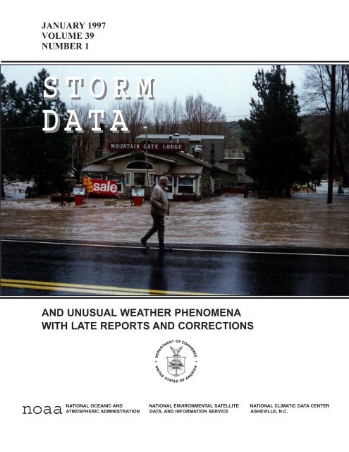
JANUARY 1997VOLUME 39NUMBER 1S T O R MD A T AAND UNUSUAL WEATHER PHENOMENAWITH LATE REPORTS AND CORRECTIONSnoaaNATIONAL OCEANIC AND NATIONAL ENVIRONMENTAL SATELLITE NATIONAL CLIMATIC DATA CENTERATMOSPHERIC ADMINISTRATION DATA, AND INFORMATION SERVICE ASHEVILLE, N.C.
Cover: The Mountain Gate Lodge in Mono County, CA is adjacent to the Walker River which overflowed it's banks due to the largeamounts of rain received in late December <strong>and</strong> early January. Also, rising temperatures in early January caused the deep snowpack inthe Sierra Nevada Mountains to melt. The Reno, NV <strong>and</strong> Lake Tahoe areas received extensive flood damage to roadways, bridges <strong>and</strong>structures near the river banks. (Photo courtesy of Mono County Sheriffs Dept., Bridgeport, CA)PageOutst<strong>and</strong>ing <strong>Storm</strong>s of the Month ................................................ 5<strong>Storm</strong> <strong>Data</strong> <strong>and</strong> <strong>Unusual</strong> <strong>Weather</strong> <strong>Phenomena</strong> ......................................... 8Annual Flood Summary ......................................................140Annual Lightning Summary ....................................................143Annual Tornado Summary ....................................................152Annual Hurricane Summary ...................................................163Reference Notes ..........................................................164STORM DATA(ISSN 0039-1972)National Climatic <strong>Data</strong> CenterEditor: Stephen A. Del GrecoPublication Staff: Stuart Hinson, William AngelSTORM DATA is prepared, funded, <strong>and</strong> distributed by the National Oceanic <strong>and</strong> Atmospheric Administration (NOAA). The Outst<strong>and</strong>ing <strong>Storm</strong>s of theMonth section is prepared by the <strong>Data</strong> Operations Branch of the National Climatic <strong>Data</strong> Center.The <strong>Storm</strong> <strong>Data</strong> <strong>and</strong> <strong>Unusual</strong> <strong>Weather</strong> <strong>Phenomena</strong> narratives <strong>and</strong> Hurricane/Tropical <strong>Storm</strong> summaries are prepared by the National <strong>Weather</strong> Service.Monthly <strong>and</strong> annual statistics <strong>and</strong> summaries of tornado <strong>and</strong> lightning events resulting in deaths, injuries, <strong>and</strong> damage are compiled by cooperative effortsbetween the National Climatic <strong>Data</strong> Center <strong>and</strong> the National Severe <strong>Storm</strong>s Forecast Center.STORM DATA contains all confirmed information on storms available to our staff at the time of publication. However, due to difficulties inherent in thecollection of this type of data, it is not all-inclusive. Late reports <strong>and</strong> corrections are printed in each edition.Maps of the National <strong>Weather</strong> Service Forecast Zones which are used in the <strong>Storm</strong> <strong>Data</strong> <strong>and</strong> <strong>Unusual</strong> <strong>Weather</strong> <strong>Phenomena</strong> section will be printed in alleditions.Except for limited editing to correct grammatical errors, materials submitted are generally published as received.Subscription, pricing, <strong>and</strong> ordering information is available from:CONTENTSNational Climatic <strong>Data</strong> Center151 Patton AvenueAsheville, NC 28801-5001(704) 271-4800 or (704) CLIMATEThe editor of STORM DATA solicits your help in acquiring photographs (prints or slides; black <strong>and</strong> white, or color), maps, clippings, etc. of significantor unusual weather events (past or present). These could be for use in the "Outst<strong>and</strong>ing <strong>Storm</strong>s of the Month'' or "Et Cetera'' sections of STORM DATA.We request our subscribers or other interested persons to mail such items to:Stuart HinsonNational Climatic <strong>Data</strong> Center151 Patton AvenueAsheville, NC 28801-5001Any such items received by the editor will be for use in STORM DATA only. Any other use will be with the permission of the owner of said items.Materials submitted will be returned if requested in the original submission."I certify that this is an official publication of the National Oceanic <strong>and</strong> Atmospheric Administration <strong>and</strong> is compiledfrom information received at the National Climatic <strong>Data</strong> Center, Asheville, North Carolina 28801-2733."Acting Director,National Climatic <strong>Data</strong> Center2
January 1997 Confirmed Tornadoes4F ScaleF = 0F = 1F = 2F = 3F = 4F = 5F Scale F0 F1 F2 F3 F4 F5 TotalNum ber 13 23 17 0 1 0 54
OUTSTANDING STORMS OF THE MONTH1. SEVERE FLOODING IN NORTHWEST CAUSES EXTENSIVE DAMAGEThe first month of 1997 was not a good one for western Nevada <strong>and</strong> east-central California. Excessiveamounts of rainfall coupled with the melting of the deep snowpack in the Sierra Nevada Mountains, causedmany rivers <strong>and</strong> their tributaries to flow out of their banks. A winter storm in late December depositedup to 8 feet of snow at the higher elevations <strong>and</strong> up to three feet in the valleys (See December 1996 issueof <strong>Storm</strong> <strong>Data</strong>). A 968 mb (28.59" Hg) low pressure system moved northeast over southern Canada,trailing a long b<strong>and</strong> of moisture which streamed southwest to the Hawaiian Isl<strong>and</strong>s. The “PineappleExpress” dumped up to 8 inches of rain in northern California during the last week of December 1996 <strong>and</strong>the first week of January 1997. Warm air moved over California ahead of the front <strong>and</strong> raised surfacetemperatures into the low to mid 60's by Jan 1 <strong>and</strong> caused a rapid melting of the snowpack <strong>and</strong> anincreased runoff in the mountains. The Susan, Truckee <strong>and</strong> Walker Rivers exceeded their banks <strong>and</strong>covered the low-lying valley floors <strong>and</strong> river canyons. Thous<strong>and</strong>s of residential <strong>and</strong> commercial buildingswere damaged or destroyed by the swift moving waters. The floods caused almost $1 Billion in damageto the area. Most damage occurred to roads <strong>and</strong> bridges when they were washed away as the rivers roseto record levels. Only two deaths <strong>and</strong> 50 injuries resulted from the massive flooding event.Right: Heavy rain <strong>and</strong> melting snowcaused the Walker River inMono County, CA to flowout of it’s banks near theMountain Gate community. Ittook 6 months to rebuild 14miles of US Highway 395 inWalker Canyon.(Photos courtesy of Mono CountySheriffs Department, Bridgeport, CA)5Left: A GOES-9 (GeostationaryOrbiting EnvironmentalSatellite) enhanced infraredimage of the PacificOcean <strong>and</strong> the Northwestcoast of the US. Theclouds associated with twostrong low pressuresystems are visible with acontinuous stream ofmoisture being pulled intothe Northwest US fromwest of Hawaii.(Image courtesy of the NationalClimatic <strong>Data</strong> Center, Asheville,NC)
Left:A different view of the samestore that was featured on thecover. This photo was takenafter the flood waters hadreceded. Most of the debrisleft by the flood was in theform of tree branches, brush<strong>and</strong> garbage. It took manymonths to clean up the debris<strong>and</strong> rebuild the roadway.(Photo courtesy of Mono CountySheriffs Department, Bridgeport, CA)2. F4 TORNADO DAMAGES BARFIELD TENNESSEEOn January 24th, a warm front moved northward through the state of Tennessee during the early afternoonhours. Two hours of surface heating caused the atmosphere to rapidly de-stabilize. Temperatures in thearea were in the mid 60's with dewpoints in the mid 50's. A strong surface low pressure system locatedin the Great Lakes Region pulled cold air southward from Canada <strong>and</strong> it’s associated cold front paralleledthe Mississippi River Valley. Temperatures behind the front were in the low 40's <strong>and</strong> dewpointtemperatures in the 30's <strong>and</strong> 40's. As the cold front moved through central Tennessee, a line of severethunderstorms formed <strong>and</strong> produced heavy rainfall (1.12" at Nashville), frequent cloud-to-ground lightning<strong>and</strong> spawned a tornado near Barfield at 5:03 PM CST. Barfield is located 35 miles southeast of Nashville,TN. The tornado was rated an F4 (wind speeds 207 - 260 mph) by the National <strong>Weather</strong> Service <strong>and</strong> hada path length of 6.5 miles <strong>and</strong> a width of 300 yards. The tornado completely destroyed many homes,leaving only the foundations intact <strong>and</strong> debris scattered throughout the subdivision.Left:The F4 tornado in Barfield leftthe Southridge subdivision inruins. There were 44 homesdestroyed <strong>and</strong> another 47damaged by the tornadic winds.Damage was estimated at $4.7million dollars. There were nodeaths <strong>and</strong> only 18 people injuredas there was a 41 minuteadvanced warning for the severeweather.6(Photo courtesy of HenrySteigerwaldt, Science OperationsOfficer (SOO), NWS, Nashville,TN)
3. LARGE HAIL, STRONG WINDS AND HEAVY RAIN DAMAGE FLORIDAA severe thunderstorm struck Pasco County, near the town of Zephyrhills in west-central Florida onJanuary 29. The thunderstorm produced heavy rain, dime-sized hail <strong>and</strong> a downburst which created 60mph wind gusts. The high winds <strong>and</strong> heavy rain moved the hail on the ground into the low lying area <strong>and</strong>filled shallow ravines with up to four feet of hail. The downburst was confirmed by a damage surveyshortly after the storm. Trees <strong>and</strong> debris were blown in different directions, called a “starburst pattern”,indicating a strong outflow had occurred . There were no deaths or injuries reported due to the storm <strong>and</strong>damage was light with estimates near $10 thous<strong>and</strong> dollars.Left:A map of the affected area.The storm track is indicatedin bold arrows. The higherground is shown in thehatched area. Note thesmall arrows indicating thedirection of the fallen trees<strong>and</strong> the debris field.(Map courtesy of Walt Zaleski,WCM, NWS, Tampa, FL)Right: Mr. Chuck Tear, the PascoCounty, FL EmergencyManagement Coordinator, isst<strong>and</strong>ing knee deep in the hailwhich was washed into shallowravines. He is scooping ah<strong>and</strong>ful of dime-sized hail outof the hail drift which was alsocovered by a layer of strawfrom nearby fields.(Photo courtesy of Walt Zaleski, WCM,NWS, Tampa, FL)7
ALABAMA, North CentralALZ006Madison<strong>Storm</strong> <strong>Data</strong> <strong>and</strong> <strong>Unusual</strong> <strong>Weather</strong> <strong>Phenomena</strong>TimeLocal/PathLengthPathWidthNumber ofPersonsEstimatedDamageLocation Date St<strong>and</strong>ard (Miles) (Yards) Killed Injured Property Crops Character of <strong>Storm</strong>02 1200CST1700CST0 0 0 0 Excessive HeatThe record high of 68 degrees was tied at the Huntsville airport.ALZ024Jefferson03 1200CST1700CST0 0 0 0 Excessive HeatThe record high of 72 degrees was tied at the Birmingham airport.ALZ006Madison03 1200CST1700CST0 0 0 0 Excessive HeatThe record high of 68 degrees was tied at the Huntsville airport.Colbert County9 SW Cherokee 04 2143CST0 0 5K 0 Thunderstorm Wind (G52)A 60 mph wind gust was reported in Allsboro in the western part of the county.Lauderdale County14 NW Florence 04 2150CST0 0 5K 1K Thunderstorm Wind (G50)Trees were blown down in Threet in the western part of the county.Morgan CountyDecatur 04 2330CST0 0 15K 3K Thunderstorm Wind (G50)A tree was blown onto a house <strong>and</strong> a garage <strong>and</strong> six tree were downed in the area southwest of Decatur.Madison County9 E Huntsville 04 2350CST0 1 15K 1K Thunderstorm Wind (G50)A mobile home was damaged during a thunderstorm in Brownsboro in the eastern part of the county. There was one minor injury.Jackson County10 SE Stevenson to 05 0030CST 2.7 50 0 0 60K 5K Tornado (F0)11.5 SE Stevenson0035CSTA thunderstorm hit the Flat Rock area at exactly 12:30 am with what was probably a weak tornado. A church sustained heavydamage; the west wall collapsed <strong>and</strong> the roof fell in. Forty to 50 -foot oak trees near the church were downed. About a mile downthe path of damage, a roof had shingles lifted off <strong>and</strong> several large trees were downed. About two miles from the church, 15 to 20large pine trees were downed. The damage was very isolated to the path. A house 100 feet from the church sustained no damage.Dekalb CountyHenagar 05 0044CST0 0 0 0 Thunderstorm WindStrong wind estimated at 72 mph with several gusts to 62 mph were reported in the Henagar area.Marshall CountyArab 05 0105CST0145CST0 0 5K 2K Flash FloodSeveral roads were reported underwater in the town of Arab in the southwestern part of the county.Jefferson CountyPinson 05 0114CST0 0 10K 0 Thunderstorm Wind (G50)Several trees were downed along with some power lines in the Pinson area.Etowah CountyGadsden 05 0117CST0 0 10K 2K Thunderstorm Wind (G65)A wind gust between 55 <strong>and</strong> 75 mph was reported by Gadsden-Etowah County EMA by their measuring equipment at the EOC inGadsden. Trees <strong>and</strong> power lines were downed across the county with about 2,500 customers without power for up to 11 hours.St. Clair CountyCountywide 05 0130CST0 0 7K 2K Thunderstorm Wind (G50)Several trees <strong>and</strong> power lines were downed in Wolf Creek in the southern part of the county. Several trees were also reporteddowned near Whitney in the northern part of the county.Blount CountyOneonta 05 0145CST0 0 80K 0 Thunderstorm Wind (G55)Straight-line wind damaged two hangars <strong>and</strong> three airplanes at the Oneonta Municipal Airport. The roof was town off one hangar,<strong>and</strong> a door was torn off another.R<strong>and</strong>olph CountyWedowee 05 0315CST0 0 5K 0 Thunderstorm Wind (G50)A few trees were downed just north <strong>and</strong> just west of Wedowee in the central part of the county.Autauga County17 N Prattville 08 0925CST0 0 3K 0 Hail (0.75)Dime sized hail was reported in Marbury in the northeast part of Autauga County.18January 1997
ALABAMA, North CentralCoosa County<strong>Storm</strong> <strong>Data</strong> <strong>and</strong> <strong>Unusual</strong> <strong>Weather</strong> <strong>Phenomena</strong>TimeLocal/PathLengthPathWidthNumber ofPersonsEstimatedDamageLocation Date St<strong>and</strong>ard (Miles) (Yards) Killed Injured Property Crops Character of <strong>Storm</strong>11 SE Rockford 08 0945CST0 0 3K 0 Hail (0.75)A storm spotter reported seeing dime size hail piled up along the road near Equality in the southeast part of the county.Elmore County5 NW Eclectic 08 0945CST0 0 3K 0 Hail (0.75)A spotter reported seeing dime size hail along the road near Central in the northern part of the county.Tallapoosa CountyDadeville 08 1005CST0 0 5K 1K Hail (0.75)Dime size hail was reported to be three inches deep <strong>and</strong> was on the ground for several hours.Chambers County9 NE Lafayette 08 1035CST0 0 5K 1K Hail (0.75)Dime size hail was reported near Five Points in the northeast part of the county. The hail was still on the ground at 11:00 am.Winston CountyHaleyville 08 1845CST0 0 10K 0 LightningA lightning bolt struck a tree outside a house <strong>and</strong> traveled into the house. A hole went through the vinyl siding <strong>and</strong> damaged thewood. Several windows were shattered.Jackson County10 NE Scottsboro 09 0000CST0 0 18K 0 Thunderstorm Wind (G50)Several trees were blown down in Martintown in the central part of the county. One tree l<strong>and</strong>ed on top of a car. An equipmenttrailer was picked up <strong>and</strong> moved about 30 yards.ALZ001>010 Lauderdale - Colbert - Franklin - Lawrence - Limestone - Madison - Morgan - Marshall - Jackson - Dekalb10 1000CST2000CST0 0 64K 0 Winter <strong>Storm</strong>One to two inches of snow fell during a snowstorm that entered into northwestern Alabama before noon. It snarled traffic <strong>and</strong> icyroadways were blamed for dozens of accidents including two deaths due to cars skidding off roads <strong>and</strong> into other cars. The stormexited the eastern part of the state around 8:00 pm CST. One of the factors that caused problems was the rapid entry of Arctic airwhich helped to create icy conditions as the precipitation was ending especially in the area from Florence to Huntsville.Autauga CountyPrattville 24 0720CST0 0 15K 0 Thunderstorm Wind (G52)Trees were reported across roads in Prattville. <strong>Storm</strong> spotters estimated wind gusts to 60 mph.Montgomery CountyMontgomery 24 0725CST0 0 6K 0 Thunderstorm Wind (G50)Trees <strong>and</strong> power lines were downed in Montgomery.Montgomery CountyMontgomery 24 0726CST0 0 0 0 Funnel CloudA funnel cloud was reported along Mobile Avenue in Montgomery.Elmore CountyMillbrook 24 0730CST0 0 15K 1K Thunderstorm Wind (G55)Four mobile homes were damaged including two the were totally destroyed. Trees <strong>and</strong> power lines also down.Elmore County1 N Elmore to 24 0737CST 1.5 50 0 0 45K 0 Tornado (F1)1.5 NNE Elmore0740CSTA small tornado occurred on the northeast side of Elmore in southwest Elmore County damaging several house roofs <strong>and</strong> twomobile homes. At least one shed was destroyed.Elmore CountySantuck 24 0752CST0 0 18K 2K Thunderstorm Wind (G50)A trailer <strong>and</strong> a barn were damaged at Santuck in central Elmore County by damaging wind.Coosa CountyRockford 24 0800CST0 0 7K 0 Thunderstorm Wind (G50)Trees were reported down near Rockford in the central part of the county.Pike County11 SW Troy 24 0845CST0 0 5K 0 Hail (0.75)Dime size hail was reported at Henderson in the southwest part of the county.Lee County10 SE Auburn 24 0900CST0 0 7K 1K Thunderstorm Wind (G50)A couple of trees were reported down in southern Lee County.Pike CountyBrundidge 24 0901CST0 0 15K 0 Thunderstorm Wind (G50)Power lines were reported down in Brundidge in the southeast part of the county.29January 1997
ALABAMA, North CentralBarbour County<strong>Storm</strong> <strong>Data</strong> <strong>and</strong> <strong>Unusual</strong> <strong>Weather</strong> <strong>Phenomena</strong>TimeLocal/PathLengthPathWidthNumber ofPersonsEstimatedDamageLocation Date St<strong>and</strong>ard (Miles) (Yards) Killed Injured Property Crops Character of <strong>Storm</strong>January 1997Eufaula 24 0955CST0 0 5K 0 Hail (0.75)Dime sized hail was reported in Eufaula.Marion CountyHamilton 24 1345CST0 0 5K 0 Hail (0.75)Dime sized hail was reported in Hamilton.Marion CountyHackleburg 24 1355CST0 0 10K 3K Hail (1.00)Hail the size of quarters was reported in Hackelburg in the northern part of the county.Marion County9 E Hamilton 24 1405CST0 0 12K 4K Hail (2.00)The ground was covered by hail up to 2 inches in diameter east of Hamilton.Winston County4 S Haleyville 24 1415CST0 0 10K 3K Hail (2.00)Two inch hail was reported near Delmar in the western part of the county.Marion CountyBear Creek 24 1425CST0 0 8K 2K Hail (1.00)Hail about the size of quarters was reported at Bear Creek in the northeast part of Marion County.Winston CountyHaleyville 24 1435CST0 0 5K 0 Hail (0.75)Hail ranging in size up to dimes was reported at Haleyville.Winston CountyDouble Springs 24 1450CST0 0 10K 3K Hail (2.00)Two inch hail was reported just west of Double Springs along US 278 in the central part of the county.Lawrence County10 S Moulton 24 1450CST1455CST3 75 0 0 40K 8K Tornado (F1)A weak tornado touched down in the William B. Bankhead National Forest <strong>and</strong> tracked across Highway 33 at the lookout tower.The majority of damage was done to trees <strong>and</strong> some damage was done to the Forest Service buildings at the tower.Winston CountyAddison 24 1507CST0 0 10K 3K Hail (2.00)Two inch hail was reported near Addison in northeast Winston County.Winston County4 ESE Addison 24 1508CST0 0 4K 0 Thunderstorm Wind (G50)Several trees were blown down near the Winston/Cullman county line just off U. S. 278 east-southeast of Addison.Cullman County15 W Good Hope to 24 1510CST0 0 22K 5K Thunderstorm Wind (G50)13 W Good Hope1515CSTWind damage started about 100 yards east of the Winston/Cullman county line near U. S. 278. A shed was damaged along with afew trees. The tin roof of a barn was peeled off <strong>and</strong> several more trees were uprooted. Another swath of damage from straightline wind occured about one mile east near the White Oak Creek community. A small house was moved off its foundation <strong>and</strong>several trees were uprooted.Tuscaloosa CountyTuscaloosa 24 1515CST0 0 7K 0 Hail (1.00)Hail the size of quarters was reported in downtown Tuscaloosa.Cullman County15 W Cullman 24 1517CST0 0 5K 0 Hail (0.75)Dime size hail was reported along the Cullman/Winston county line.Tuscaloosa CountyTuscaloosa 24 1530CST0 0 7K 0 Hail (1.50)Hail larger than half dollars was reported in Tuscaloosa.Cullman County12 NW Cullman 24 1530CST0 0 9K 3K Hail (1.75)Golf ball size hail was reported in Jones Chapel in the northwest part of the county.Lauderdale County10 E Florence to 24 1537CST0 0 5K 0 Hail (0.75)FlorenceDime size hail was reported along County Road 72 east of Florence.310
ALABAMA, North CentralLauderdale County<strong>Storm</strong> <strong>Data</strong> <strong>and</strong> <strong>Unusual</strong> <strong>Weather</strong> <strong>Phenomena</strong>TimeLocal/PathLengthPathWidthNumber ofPersonsEstimatedDamageLocation Date St<strong>and</strong>ard (Miles) (Yards) Killed Injured Property Crops Character of <strong>Storm</strong>January 1997Killen 24 1542CST0 0 5K 0 Hail (0.75)Dimes size hail was reported at Killen.Morgan CountyHartselle 24 1545CST0 0 5K 0 Hail (0.75)Dime size hail fell at Hartselle.Cullman County6 E Cullman 24 1553CST0 0 80K 5K Thunderstorm Wind (G60)Four mobile homes were destroyed, two permanent homes sustained minor damage, <strong>and</strong> one permanent home had major damagewhen straight line wind occurred along U. S. 278 in the Berlin <strong>and</strong> Oak Level communities in the eastern part of Cullman County.Lauderdale CountyLexington 24 1600CST0 0 5K 0 Hail (0.75)Dime size hail was reported in Lexington.Morgan County18 SE Falkville 24 1605CST0 0 7K 2K Hail (1.00)One inch hail was reported in the Hulaco community in the southeast part of the county.Blount County7 N Snead 24 1610CST0 0 20K 2K Thunderstorm Wind (G55)Two mobile homes on Highway 79 south of the Marshall County line were shifted off their foundations. Two metal outbuildingswere destroyed, <strong>and</strong> trees <strong>and</strong> power lines were down in the area of Snead in the northern part of Blount County.Marion CountyHamilton 24 1617CST0 0 5K 0 Hail (0.75)Dime size hail was reported in southwest Hamilton.Marshall CountyArab 24 1620CST0 0 8K 2K Hail (1.50)Hail an inch <strong>and</strong> a half in diameter fell in the area east of Arab.Tuscaloosa County10 W Tuscaloosa 24 1620CST0 0 5K 2K Hail (0.75)Dime size hail was reported at Coker in western Tuscaloosa County.Jefferson CountyMidfield 24 1623CST0 0 5K 0 Hail (0.75)Marshall CountyDouglas 24 1640CST0 0 7K 1K Thunderstorm Wind (G50)Trees were downed in the Douglas community in the southern part of the county.Jefferson CountyVestavia Hills 24 1644CST0 0 5K 0 Hail (0.75)Morgan CountyTrinity 24 1645CST0 0 7K 1K Hail (1.00)Quarter size hail was reported in Trinity in the northwest part of the county.Marshall CountyAlbertville to 24 1649CST0 0 7K 0 Hail (0.75)Guntersville1655CSTDime size hail was reported along Highway 431 from Albertville to Guntersville.Jefferson CountyLiberty Park 24 1653CST0 0 7K 0 Hail (1.25)Jefferson CountyHomewood 24 1655CST0 0 15K 0 Hail (1.75)Morgan CountyDecatur 24 1658CST0 0 5K 0 Hail (0.75)Dime size hail was reported on the west side of Decatur.Marshall County3 W Douglas 24 1700CST0 0 8K 1K Thunderstorm Wind (G50)Large trees were downed west of Douglas near the Blount County line.Marshall CountyGuntersville 24 1700CST0 0 10K 3K Hail (1.75)Golf ball size hail fell at Guntersville <strong>and</strong> at several other locations across the county.411
ALABAMA, North CentralShelby County<strong>Storm</strong> <strong>Data</strong> <strong>and</strong> <strong>Unusual</strong> <strong>Weather</strong> <strong>Phenomena</strong>TimeLocal/PathLengthPathWidthNumber ofPersonsEstimatedDamageLocation Date St<strong>and</strong>ard (Miles) (Yards) Killed Injured Property Crops Character of <strong>Storm</strong>January 19973 N Indian Springs 24 1700CST0 0 7K 0 Hail (1.00)Quarter size hail was reported in Meadowbrook.Limestone County12 NW Athens 24 1700CST0 0 14K 2K Thunderstorm Wind (G50)Two barns were destroyed <strong>and</strong> the West Limestone County High School press box was damage in Salem.Madison CountyHuntsville 24 1700CST0 1 10K 0 LightningA news reporter with a Huntsville television station was slightly injured when lightning struck a pole near him <strong>and</strong> traveledthrough the ground <strong>and</strong> through him. He was covering a weather story at the time.Tuscaloosa County5 S Tuscaloosa to 24 1700CST 10 200 1 10 5M 5K Tornado (F2)8 ENE Tuscaloosa1715CSTAt approximately 5:00 pm CST, a tornado began on the east side of the Warrior River, south of Interstate 59 <strong>and</strong> west of CountyRoad 95. Besides trees, the initial damage was to shingles of an apartment complex in the Crabtree area.The tornado moved on a northeasterly track crossing U.S. 82 <strong>and</strong> Interstate 59. Two large businesses in a shopping center on thesouth side of I-59 sustained roof damage.The tornado became stronger after crossing I-59 with significantly greater damage from this point to the end of the path.Numerous trees were downed, some house roofs were damage, <strong>and</strong> several outbuildings were destroyed in the Woodl<strong>and</strong> Hillsresidential area.Several buildings were damaged at Five Points East, the intersection of State Roads 215 <strong>and</strong> 216, including a Food World <strong>and</strong> aBig-B Drug Store, among others. Cars were tossed about like toys. One was tossed from the parking lot through the roof of theFood World. Another car was carried from the Food World parking lot into the backyard of a house immediately northeast of theFood World, a distance of between 300 <strong>and</strong> 400 feet.The tornado continued northeast through the Lynn Haven residential area causing significant damage to numerous homes, muchof it strong F2 damage. Many houses in this section sustained damage that ranged from minor roof damage to total roof loss.The tornado continued across Tuscaloosa Memorial Gardens Cemetary, paralleling <strong>and</strong> crossing State Road 216. Six to eighthomes in the Summerfield sub-division sustained light to moderate damage. A couple of mobile homes <strong>and</strong> several otherbuildings including a small corner grocery business were destroyed. The tornado dissipated in a wooded area just north of StateRoad 216 shortly after that around 5:15 pm CST.Tuscaloosa EMA estimated that there were 150 structures with some damage. Total tornado path length was 10 miles with a pathwidth of 200 yards.There was one fatality, an elderly man in a vehicle in the Woodl<strong>and</strong> Hills area, <strong>and</strong> ten injuries. Eight of the injuries were treated<strong>and</strong> released while 2 others were hospitalized. M71VEMadison CountyHuntsville 24 1706CST0 0 10K 0 Thunderstorm Wind (G50)Several signs were downed along with traffic lights in Huntsville during strong wind with a thunderstorm.Morgan County7 SW Hartselle 24 1708CST0 0 5K 0 Hail (0.75)Dime size hail was reported in Massey in southwest Morgan County.Jefferson CountyLeeds 24 1715CST0 0 5K 0 Hail (0.75)Madison CountyHuntsville 24 1715CST0 0 5K 0 Hail (0.75)Dime size hail was reported at the Redstone Arsenal.Madison CountyHuntsville 24 1715CST0 0 0 0 Funnel CloudA funnel cloud was reported in southeast Huntsville.Lawrence County8 SE Moulton 24 1730CST0 0 7K 1K Hail (1.00)One inch hail was reported in Speake in southeast Lawrence County.Jefferson CountyBessemer 24 1745CST0 0 5K 0 Hail (0.75)Jefferson CountyHueytown 24 1745CST0 0 5K 0 Hail (0.75)Jefferson CountyTrussville 24 1745CST0 0 5K 0 Hail (0.75)Hail fell across the Birmingham area ranging in size from dimes up to golf balls.512
ALABAMA, North CentralLamar County<strong>Storm</strong> <strong>Data</strong> <strong>and</strong> <strong>Unusual</strong> <strong>Weather</strong> <strong>Phenomena</strong>TimeLocal/PathLengthPathWidthNumber ofPersonsEstimatedDamageLocation Date St<strong>and</strong>ard (Miles) (Yards) Killed Injured Property Crops Character of <strong>Storm</strong>January 1997Millport 24 1755CST0 0 5K 0 Hail (0.75)Hail ranging in size from pea to dime was reported in southern Lamar County.Calhoun County10 SW Anniston 24 1800CST0 0 5K 0 Hail (0.75)Dime size hail was reported on U. S. 78 near the Talladega County line.Talladega County11 NE Talladega 24 1805CST0 0 5K 2K Hail (0.75)Pea to dime size hail fell near Munford in eastern Talladega County.Fayette CountyFayette 24 1805CST0 0 5K 1K Hail (0.75)Dime size hail covered the ground in Fayette.Shelby CountyHoover 24 1810CST0 0 5K 0 Hail (0.88)Hail around nickel size was reported at Interstate 65 <strong>and</strong> Valleydale Road. This is part of the city of Hoover in Shelby County.Franklin CountyRed Bay 24 1813CST0 0 8K 2K Hail (1.50)Hail up to one <strong>and</strong> a half inches in diameter was reported at Red Bay in the extreme western part of the county.Jackson CountyStevenson 24 1815CST0 0 6K 0 Thunderstorm Wind (G50)A few trees were downed in Stevenson in central Jackson County.Jackson CountySection 24 1850CST0 0 5K 0 Hail (0.75)Dime size hail was reported at Section.Morgan County7 SW Hartselle 24 1853CST0 0 5K 0 Hail (0.75)Dime size hail fell just south of Massey in the southwest part of Morgan County.Walker County6 E Jasper 24 1853CST0 0 6K 1K Hail (0.88)Nickel size hail was reported in the Baldo area in eastern Walker County.St. Clair CountyLogan Martin Dam 24 1900CST0 0 5K 0 Hail (0.75)Dime size hail was reported near Logan Martin Dam in eastern St. Clair County.Morgan County3 N Eva 24 1914CST0 0 5K 0 Hail (0.75)Dime size hail fell at Oden Ridge in southern Morgan County.Dekalb CountyHenager 24 1917CST0 0 5K 0 Hail (0.75)Dime size hail was reported at Henager in northern Dekalb County.Dekalb CountyGeraldine 24 1917CST0 0 5K 0 Hail (0.75)Dime size hail was reported in Geraldine in southern Dekalb County.Blount County5 W Hayden 24 1920CST0 0 5K 0 Hail (0.75)Dime size hail was reported on Interstate 65 at exit 284 in the western part of Blount County.Dekalb County3 W Geraldine 24 1922CST0 0 9K 0 Thunderstorm Wind (G50)Numerous trees were downed in the western part of the county.Blount CountyNectar 24 1930CST0 0 15K 0 Thunderstorm Wind (G50)One home was damaged <strong>and</strong> one outbuilding was destroyed near Nectar in central Blount County.Calhoun CountyAnniston 24 1940CST0 0 9K 0 Hail (1.75)Golf ball sized hail was reported near Anniston.Madison County9 SE Huntsville 24 1946CST0 0 5K 0 Hail (0.75)Dime size hail was reported at Farley.613
ALABAMA, North CentralCalhoun County<strong>Storm</strong> <strong>Data</strong> <strong>and</strong> <strong>Unusual</strong> <strong>Weather</strong> <strong>Phenomena</strong>TimeLocal/PathLengthPathWidthNumber ofPersonsEstimatedDamageLocation Date St<strong>and</strong>ard (Miles) (Yards) Killed Injured Property Crops Character of <strong>Storm</strong>January 1997Anniston 24 1950CST0 0 10K 0 Thunderstorm Wind (G50)Several trees were downed in Anniston <strong>and</strong> a sporting goods store had its front windows blown out.Etowah CountyAttalla 24 2030CST0 0 0 0 Funnel CloudA funnel cloud ws reported in Attalla in central Etowah County.Jefferson County9 NW Pleasant Grove 24 2050CST0 0 5K 0 Hail (0.75)Dime size hail was reported at Birmingport in western Jefferson County.Tuscaloosa CountyNorthport 24 2104CST0 0 5K 0 Hail (0.75)Dime size hail was reported at Northport.Jefferson CountyHueytown 24 2107CST0 0 9K 0 Hail (1.75)Golf ball size hail was reported at Hueytown.Etowah CountyGadsden 24 2143CST0 0 9K 0 Hail (1.75)Golf ball size hail was reported just north of Gadsden.Jefferson CountyVestavia Hills 24 2147CST0 0 5K 0 Hail (0.75)Dime size hail was reported at Vestavia Hills.St. Clair CountyPell City 24 2150CST0 0 5K 0 Hail (0.75)Dime size hail was reported in Pell City.Shelby CountyPelham 24 2154CST0 0 5K 0 Hail (0.75)Dime size hail was reported in Greystone <strong>and</strong> near Oak Mountain State Park.Shelby County6 SSE Alabaster to 24 2215CST0 0 5K 0 Hail (0.75)6 SE AlabasterDime size hail was reported just south of the Shelby County Airport.Calhoun CountyJacksonville 24 2221CST0 0 5K 0 Hail (0.75)Dime size hail was reported in Jacksonville.Calhoun County9 W Oxford 24 2228CST0 0 7K 1K Hail (0.88)Nickel size hail wass reported in Bynum in southwest Calhoun County.Bibb CountyCentreville 24 2230CST0 0 5K 0 Hail (0.75)Pea to dime size hail covered the ground at Centreville.Talladega County3 NE Lincoln 24 2230CST0 0 7K 1K Hail (1.00)Nickel to quarter size hail was reported near Lincoln in the northern part of the county.Calhoun CountyAnniston 24 2230CST0 0 5K 0 Hail (0.75)Dime size hail was reported in Anniston.Talladega County8 NW Talladega 24 2235CST0 0 5K 0 Hail (0.75)Dime size hail was reported near Stemly in western Talladega County.Tuscaloosa County5 N Coker to 28 0008CST 2 75 0 1 85K 2K Tornado (F2)5.5 NNE Coker0011CSTA small tornado that apparently formed on the north side of a bow echo touched down in a lightly populated area just north ofLake Lurleen State Park <strong>and</strong> just west of State Road 171 in west central Tuscaloosa County. Damage was primarily to downedtrees, however, several structures sustained minor damage with the exception of one house that was completely deroofed. Thefamily in the house was asleep when the tornado struck <strong>and</strong> one young girl sustained a minor injury in the storm.EMA officials reported that three mobile homes were damaged along with the one house that was deroofed <strong>and</strong> at least two barns<strong>and</strong> several storage buildings were damaged.714
ALABAMA, North CentralHale CountyGreensboro 28 0100CST0 0 10K 1KThe Sheriff's office reported several trees <strong>and</strong> power lines down near Greensboro.Shelby CountyPelham 28 0130CST0 0 0 4KSeveral trees were blown down by thunderstorm wind in Oak Mountain State Park.ALABAMA, SoutheastThunderstorm Wind (G50)Thunderstorm Wind (G50)Houston CountyCountywide 05 0650CST0715CST0 0 150K 0 Thunderstorm WindA church steeple was toppled in Wicksburg in western Houston County. A short time later, trees were snapped <strong>and</strong> a Sony plantreceived some roof damage. The storm continued across the northern side of Dothan downing many trees <strong>and</strong> damaging numeroushomes <strong>and</strong> other buildings. Finally, in the northeast part of the county, near Columbia, the storm damaged a mobile home <strong>and</strong>downed several trees.Henry County2.5 N Newville to 05 0655CST 6 100 0 0 180K 0 Tornado (F2)8 NE Newville0705CSTA tornado touched down north of Newville, knocking a small wood frame house off its blocks. Two miles further east the tornadocaused extensive damage to a home <strong>and</strong> destroyed another unoccupied home. A barn was destroyed <strong>and</strong> several vehicles weredamaged. The tornado then damaged a house two miles further east. Finally, another two miles east it damaged a house.Geneva CountyHartford 24 2030CST0 0 150K 0 Thunderstorm WindA severe thunderstorm caused widespread damage across Hartford. An awning to a store was shredded <strong>and</strong> a roof to a shed wasblown off <strong>and</strong> l<strong>and</strong>ed on a fire truck. Numerous trees were downed causing power outages. Parts of a flat roof were blown off ofthe National Guard armory. One home lost most of its roof <strong>and</strong> several stores in town lost windows. A satellite dish, a pool <strong>and</strong> atrampoline were damaged or destroyed at one home.Houston CountyDothan 24 2118CST0 0 30K 0 Thunderstorm WindSeveral homes <strong>and</strong> businesses were damaged by strong winds. Several large trees were downed along with some power lines.ALABAMA, Southwest<strong>Storm</strong> <strong>Data</strong> <strong>and</strong> <strong>Unusual</strong> <strong>Weather</strong> <strong>Phenomena</strong>TimeLocal/PathLengthPathWidthNumber ofPersonsEstimatedDamageLocation Date St<strong>and</strong>ard (Miles) (Yards) Killed Injured Property Crops Character of <strong>Storm</strong>January 1997Choctaw CountyArarat08 0650CST0 0Hail (0.50)Marble size hail covered the ground near Ararat. The hail stayed on the ground for about ten minutes before melting.Mobile CountyWilmer08 1230CST0 0Hail (0.75)Dime size hail was reported just northwest of Wilmer.Choctaw CountyBolinger15 1900CST0 0 1.5KThunderstorm Wind (G50)Trees <strong>and</strong> power lines were blown down along US Hwy 84 just east of Bolinger.Baldwin CountyMagnolia Spgs15 2055CST0 0 0.50KThunderstorm Wind (G52)A spotter reported 60 mph winds near Magnolia Springs. A few trees were also blown down.Choctaw CountyBolinger24 0600CST0 0 1.5KThunderstorm Wind (G50)Trees <strong>and</strong> power lines were blown down along US Highway 84 just east of Bolinger.Mobile County2 W Citronelle to 24 0605CST0 0 1.5KThunderstorm Wind (G50)1 W Citronelle0606CSTSeveral trees were blown down just west of Citronelle.Clarke CountyGrove Hill24 0620CST0 0 1.5KThunderstorm Wind (G50)Trees <strong>and</strong> power lines were blown down near Grove Hill.Washington CountyTibbie24 0625CST0 0 1.5KThunderstorm Wind (G50)Several trees were blown down near Tibbie.Washington CountyChatom24 0630CST0 0 30KLightningThe library in Chatom was struck by lightning. The library suffered mayor damage from the resulting fire.815
ALABAMA, SouthwestBaldwin County<strong>Storm</strong> <strong>Data</strong> <strong>and</strong> <strong>Unusual</strong> <strong>Weather</strong> <strong>Phenomena</strong>TimeLocal/PathLengthPathWidthNumber ofPersonsEstimatedDamageLocation Date St<strong>and</strong>ard (Miles) (Yards) Killed Injured Property Crops Character of <strong>Storm</strong>January 1997Blacksher24 0640CST0 0 1.5KThunderstorm Wind (G50)Several trees were blown down near Blacksher.Monroe CountyFrisco City24 0655CST0 0 1.5KThunderstorm Wind (G50)Several trees were blown down near Frisco City.Monroe County4 W Uriah to 24 0655CST0 0 10KThunderstorm Wind (G55)3 W Uriah0656CSTSeveral trees along with power lines were blown down along State Highway 59 <strong>and</strong> county road 11 near Palmers Crossroadswhich is west of Uriah. A home in the same area suffered roof damage <strong>and</strong> damage was also done to Bib Mim's hog parlor.Monroe CountyOllie24 0656CST0657CST0 0 25KThunderstorm Wind (G55)Shingles were blown from a motel near Ollie. A few storage buildings <strong>and</strong> signs in the area also suffered damage. Some skirtingwas blown from mobile homes at a dealership.Monroe CountyMonroeville24 0700CST0 0 1.5KThunderstorm Wind (G50)Several trees <strong>and</strong> power lines were blown down near Monroeville.Wilcox CountyCamden to24 0700CST0 0 2KThunderstorm Wind (G50)FatamaSeveral trees were blown down along State Highway 265 between Fatama <strong>and</strong> Camden.Butler CountyGeorgiana24 0700CST0 0 3KThunderstorm Wind (G50)Some large tree limbs were blown down near Georgiana. A house also suffered minor damage to the roof.Conecuh CountyBurnt Corn24 0730CST0 0 1.5KThunderstorm Wind (G50)Several trees were blown down near Burnt Corn.Conecuh CountyOwassa24 0745CST0746CST0 0 15KThunderstorm Wind (G55)Several trees <strong>and</strong> power lines were blown down near Owassa. A trailer was also damaged. No injuries were reported.Crenshaw CountyLuverne24 0830CST0 0Hail (0.75)Dime size hail was reported in Luverne.Crenshaw CountyGlenwood24 0830CST0 0 1.5KThunderstorm Wind (G50)Several trees were blown down near Glenwood.Mobile CountyTillmans Corner 24 0840CST0 0 10KThunderstorm Wind (G50)Several trailers had skirting <strong>and</strong> loose objects blown from around them by high winds. A few trees near the trailer park were alsoblown down.Baldwin CountyMalbis24 0900CST0 1 15KThunderstorm Wind (G55)High winds damaged a construction site near Malbis. One person was injured but refused treatment. Several trees were alsoblown down.Escambia CountyAtmore24 0930CST0 0 1.5KThunderstorm Wind (G50)Several trees were blown down near Atmore.Escambia CountyMc Cullough24 0930CST0 0 1.5KThunderstorm Wind (G50)Several trees <strong>and</strong> power lines were blown down near McCullough.Mobile CountyGr<strong>and</strong> Bay24 1710CST0 0Hail (0.75)Dime size hail was reported in Gr<strong>and</strong> Bay.916
ALABAMA, SouthwestMobile CountyTheodore toBellefontaine24 1723CST01725CSTLarge hail was reported in Theodore <strong>and</strong> also near Bellefontaine.0Hail (2.00)Baldwin CountyFairhope24 1800CST0 0Hail (1.75)Golfball size hail was reported in Fairhope.Baldwin CountySilverhill24 1815CST0 0Hail (1.75)Golfball size hail was reported near Silverhill.Baldwin CountyRobertsdale24 1850CST0 0Hail (1.75)Golfball size hail was reported near Robertsdale.Mobile CountyBellefontaine24 1900CST0 0Hail (0.75)Dime size hail was reported near Bellefontaine.Mobile County2 SE Mobile Bates Fld 24 1958CST0 0Hail (0.75)Dime size hail was reported just southeast of the Mobile airport.Baldwin CountyOrange Beach24 2000CST0 0Hail (0.75)Dime size hail was reported near Orange Beach.Baldwin CountyFairhope24 2003CST0 0Hail (0.75)Dime size hail was reported in Fairhope.Mobile CountyBellefontaine24 2015CST0 0 75KLightningLightning struck a large home near Bellefontaine during the height of thunderstorm activity Friday evening. The home washeavily damaged <strong>and</strong> residents around the area could see the blaze for miles.Baldwin CountyFairhope24 2045CST0 0Hail (0.75)Dime size hail was reported just southeast of Fairhope.Mobile CountyMobile Brookley Fld 24 2105CST0 0Hail (0.75)Dime size hail was reported just south of downtown Mobile.Mobile CountyDauphin Is24 2130CST0 0Hail (0.75)Dime size hail was reported near Dauphin Isl<strong>and</strong>.Baldwin CountyOrange Beach24 2200CST2203CST0 0Hail (0.75)Dime size hail was reported around Orange Beach.Baldwin CountyLoxley24 2330CST0 0 90KLightningLightning triggered from thunderstorms moving through the area struck a home in Loxley. The home was totally destroyed <strong>and</strong> a60 year old male asleep in the home was killed.Mobile CountyCitronelle28 0500CST0 0 1.5KThunderstorm Wind (G50)Several large limbs were blown down in Citronelle.ALASKA, NorthernAKZ002-005>007<strong>Storm</strong> <strong>Data</strong> <strong>and</strong> <strong>Unusual</strong> <strong>Weather</strong> <strong>Phenomena</strong>TimeLocal/PathLengthPathWidthNumber ofPersonsEstimatedDamageLocation Date St<strong>and</strong>ard (Miles) (Yards) Killed Injured Property Crops Character of <strong>Storm</strong>January 1997North Slopes Of Brooks Range - Lower Kobuk Valley-Northern Seward Peninsula - Southern SewardPeninsula-Eastern Norton Sound - Tanana Valley07 0100AST0 0Extreme Windchill09 1100ASTStrong high pressure built over Alaska. A weak low pressure center moving northeast to the Seward Peninsula but increased windsto at least 20 mph in a cold airmass producing wind chills to 70 to 80 below across Zone 5 at mainly Kotzebu <strong>and</strong> Selawik. Thelow center dissipated but high pressure continued to build <strong>and</strong> drift east into Canada, causing locally windy conditions atUnalakleet (Zone 6), Anaktuvuk Pass (Zone 2), <strong>and</strong> Delta Junction (Zone 7), with wind chills of 80 to 100 below at Anaktuvuk10 17
ALASKA, NorthernAKZ024AKZ007AKZ008AKZ024AKZ001AKZ001AKZ007AKZ024ALASKA, Southeast<strong>Storm</strong> <strong>Data</strong> <strong>and</strong> <strong>Unusual</strong> <strong>Weather</strong> <strong>Phenomena</strong>TimeLocal/PathLengthPathWidthNumber ofPersonsEstimatedDamageLocation Date St<strong>and</strong>ard (Miles) (Yards) Killed Injured Property Crops Character of <strong>Storm</strong>January 1997Pass, <strong>and</strong> 70 to 90 below at Unalakleet <strong>and</strong> Delta Junction.St. Lawrence Isl<strong>and</strong>-Bering Strait Coast08 1835AST0 0High Wind (G45)10 1615ASTStrong high pressure over Russia Far East persisted while a trough of low pressure developed over the inner West Coast of Alaska,causing strong winds at Zone 24, namely Gambell <strong>and</strong> Tin City. Peak Wind: Gambell 40 kts g45 kts.Tanana Valley09 0000AST0 0High Wind (G55)10 0300ASTVery strong high pressure over western Canada (1047 mb) produced a strong pressure gradient across the Tanana Valley whichincreased even more when an occluded front moved north over the area from the gulf of Alaska. PABI, Delta Junction, was theonly reporting site in the affected area with max wind 44g55 kts. Nearby areas close to the Tanana River may well have receivedsimilar winds.Lower Yukon Valley10 1200AST0 0Heavy Snow11 1200ASTA moist flow of air over an existing cold airmass produced snow in locally heavy amounts over Zone 8, notably Nulato with 10.5"(Galena received only 2.6"). Heavy snow may have also been received over western Zone 4, but verification not available.St. Lawrence Isl<strong>and</strong>-Bering Strait Coast10 2035AST0 0Blizzard12 2235ASTA weather front moving over an existing strong pressure gradient across the outer West Coast of Alaska produced high winds <strong>and</strong>blizzard conditions. Winds at Tin City peaked at 40 kts sustained, at Gambell 45 kts sustained, gust 55 kts. Visibility sensor notworking at Gambell to indicate period of blizzard, but at Tin City blizzard conditions likely from 11th 1000am to 12th 0235am.Arctic Slope Coastal13 0216AST0 0Blizzard1746ASTStationary strong high pressure over the Arctic Ocean <strong>and</strong> the slow movement north of a weather front over the Interior of Alaskaproduced blizzard conditions across the eastern Arctic coast...at Deadhorse, Prudhoe Bay, Kuparuk, <strong>and</strong> Barter Isl<strong>and</strong>.Arctic Slope Coastal18 0000AST0 0Winter <strong>Storm</strong>19 2120ASTBuilding high pressure <strong>and</strong> increasing cold air over the Arctic Ocean <strong>and</strong> Arctic Slope Coastal Zone produced increasing windswith blizzard conditions over far western zone 1 (Point Lay) during the entire time. Wind chills of 70 to 80 below were commonover the remainder of the Arctic Coast during much of this time.Tanana Valley27 0000AST0 0 0.50KHigh Wind (G51)28 0700ASTStrong high pressure over western Canada <strong>and</strong> the development of a trough of low pressure over the central Interior created astrong pressure gradient across the Tanana Valley, resulting in locally strong winds: PABI 38g54 kts, Minchumina BLM's RemoteAutomatic <strong>Weather</strong> Station (RAWS) g51 kts. Damage at the village of Minchumina involved one home where the door wasblown off the hinges, <strong>and</strong> insulation was blown out around newly installed windows. Co-op observer there estimated winds at 70mph.St. Lawrence Isl<strong>and</strong>-Bering Strait Coast28 0700AST0 0High Wind (G49)29 0300ASTStrong high pressure over Far East Russia <strong>and</strong> a storm moving into the Gulf of Alaska caused strong winds at Zone 24: Gambell37 kts, g48 kts; Tin City 38 kts, g 49 kts.ALASKA, SouthernKodiak Isl<strong>and</strong>(C) E.Ak PeninKodiakNONE REPORTED.08 1200AST0 0Lightning1800ASTAn unusual cold air outbreak <strong>and</strong> incoming front produced thunderstorms at Kodiak, which knocked out power <strong>and</strong> causedelectrical surges which damaged some equipment for short periods of time.11 18
ALASKA, SouthernAKZ010-019>021 Yukon-Kuskokwim Delta - Central Gulf Coast - Kodiak Isl<strong>and</strong>-Eastern Alaska Peninsula - Western AlaskaPeninsula26270000AST2359AST0 0High Wind (G50)A moderate 967mb low moved northwest through the Gulf of Alaska toward Kodiak where it began to weaken early Tuesday.Easterly wind gusts to the north <strong>and</strong> northeast of the low reached close to 60 mph just offshore from Prince William SoundMonday. The storm also caused 10 inches of new snow at Kodiak, a record for the date.AMERICAN SAMOANOT RECEIVED.ARIZONA, Central <strong>and</strong> NortheastAZZ004AZZ015>017AZZ015-018AZZ004-006-009>011-015>018<strong>Storm</strong> <strong>Data</strong> <strong>and</strong> <strong>Unusual</strong> <strong>Weather</strong> <strong>Phenomena</strong>TimeLocal/PathLengthPathWidthNumber ofPersonsEstimatedDamageLocation Date St<strong>and</strong>ard (Miles) (Yards) Killed Injured Property Crops Character of <strong>Storm</strong>January 1997Kaibab Plateau02 2230MST0 0Heavy Snow03 1300MSTA quick storm dropped heavy wet snow overnight on the Kaibab Plateau. The deepest snowfall amount was reported 18 milessouth of Jacob Lake where 16 inches of snow fell at about 8500 feet MSL.Western Mogollon Rim - Eastern Mogollon Rim - White Mountains06 0500MST0 0Winter <strong>Storm</strong>07 1000MSTA major winter storm brought heavy snow mainly along the Mogollon Rim <strong>and</strong> the White Mountains. In the Western MogollonRim (AZZ015) Doney Park (eastern Flagstaff) received 7 inches of snow with some blowing snow <strong>and</strong> the Arizona Snowbowl skiarea (7 N ofFlagstaff) received 14 inches of new snow at 10,800 feet. In the Eastern Mogollon rim (AZZ016) Happy Jack received8 inches of new snow. In the White Mountains (AZZ018) Alpine received 14 inches <strong>and</strong> the Sunrise ski area on Baldy Peakreported 24 inches of new snow. This storm brought some high winds with areas of blowing <strong>and</strong> drifting snow which closed somestate roads in the Mogollon Rim i southern Coconino <strong>and</strong> Navajo Counties.Western Mogollon Rim - Northern Gila06 1800MST0 0High Wind (G54)2200MSTHigh winds, associated with the January 06-07 winter storm, were reported in Pine, in Northwestern Gila County. A peak gust of62 MPH/54 Knots was recorded at 6:53 PM MST. Law enforcement reported many trees knocked over causing power <strong>and</strong>telephone outages. Trees blocked a dozen roads <strong>and</strong> fell on 2 houses causing minor damage. A tree fell on one car causingsignificant damage. Similiarly, in the Arizona Snowbowl ski area, just north of Flagstaff, high winds occurred around 9:00 PMcausing trees to fall on powerlines. No wind speed was recorded, but the winds were estimated in excess of 50 knots.Kaibab Plateau - Gr<strong>and</strong> Canyon Country - Northeast Plateaus And Mesas - Chinle Valley - ChuskaMountains And Defiance Plateau - Western Mogollon Rim - Eastern Mogollon Rim - White Mountains -Northern Gila12 0800MST4 0Winter <strong>Storm</strong>14 2300MSTPerhaps the largest snow storm of the decade brought heavy snow to most of northern Arizona. Heavy snow fell from earlySunday morning, the 12th, through last Tuesday night, the 14th. Four deaths from exposure occurred during, or immediately afterthe storm, on the Navajo Nation Reservation <strong>and</strong> were directly related to this catastropic winter storm. The Governor of Arizonadeclared a State of Emergency for Coconino, Gila <strong>and</strong> Navajo counties on Tuesday the 14th.Following the storm, National Guard trucks <strong>and</strong> helicopters were needed to evacuate people on the Navajo Nation who requiredmedical attention due to chronic medical problems <strong>and</strong> who were unable to obtain needed medication. National Guard helicoptersalso dropped food to people <strong>and</strong> livestock who were str<strong>and</strong>ed for several days following the storm.Unofficial snow accumulations up to 6 feet were reported along the Mogollon Rim in extreme southeastern Coconino county.Very strong winds created drifts as high as 10 feet at many wind-prone areas across northern Arizona.Numerous trees fell on cars, houses <strong>and</strong> roads causing power outages <strong>and</strong> property damage. Hundreds of miles of major highwayswere closed mainly along the Mogollon Rim <strong>and</strong> the White Mountains area. Highways surrounding Flagstaff were the mostaffected. Interstate 40 from Winslow to Ashfork <strong>and</strong> Interstate 17 from Cordes Junction to Flagstaff were closed from noonMonday, Jan. 13 through 6 AM MST, Wednesday, Jan. 15. Over 200 vehicles were str<strong>and</strong>ed on these two highways.The heavy snow in Flagstaff caused Northern Arizona University to close for the first time in 20 years. Flagstaff public schoolswere closed for five days. This was the 12th biggest snow storm in Flagstaff's 100 years of weather records.In the Western Mogollon Rim (AZZ015): unofficial snowfall of 38 inches was reported in Flagstaff. Official amounts included30.8 inches at Bellemont, 26 inches in Doney Park with 5 foot drifts, 25 inches in Sunset Crater <strong>and</strong> 28 inches at Walnut Canyon.A higher elevations, Hart Prairie received 42 inches <strong>and</strong> the local ski area reported 51 inches of new snow. Winds as high as 50MPH caused considerable blowing <strong>and</strong> drifting snow.12 19
ARIZONA, Central <strong>and</strong> NortheastARIZONA, NorthwestAZZ031AZZ003ARIZONA, SouthAZZ019-026>030AZZ028ARIZONA, Southwest<strong>Storm</strong> <strong>Data</strong> <strong>and</strong> <strong>Unusual</strong> <strong>Weather</strong> <strong>Phenomena</strong>TimeLocal/PathLengthPathWidthNumber ofPersonsEstimatedDamageLocation Date St<strong>and</strong>ard (Miles) (Yards) Killed Injured Property Crops Character of <strong>Storm</strong>January 1997In the Eastern Mogollon Rim (AZZ016): between 5 to 6 feet of snow fell according to unofficial reports from Forest LakesEstates. Official reports included 52 inches at Happy Jack <strong>and</strong> Lake Mary reported 33 inches of snow. Snow accumulations of 52inches were reported at Heber <strong>and</strong> Overgaard, with an unofficial report from the public of 5 feet of snow.In Northern Gila County (AZZ018): the Christopher Creek area in NW Gila county reported 4 feet of snow. Lower elevationstations such as Strawberry reported 2 1/2 feet of snow. Many trees fell due to strong winds <strong>and</strong> heavy wet snow causing propertydamage <strong>and</strong> power outages that lasted 72 hours.In the White Mountains (AZZ017): Greer reported 28 inches of snow while Show Low reported 18 inches. Pinetop received 24inches with 18 inches accumulating in Lakeside.In the Chuska Mountains/Defiance Plateau (AZZ011): Window Rock reported 18 inches of snow with 5 foot drifts. There wereunofficial reports of up to 36 inches on snow in the Black Mesa areas on the Navajo Nation (northern Navajo <strong>and</strong> Apachecounties). A 63 year old man died of exposure 10 miles SE of Chinle.In the Chinle Valley (AZZ010): up to 3 feet of snow was reported unofficially in the higher mesas. One 37 year old male died ofexposure near Many Farms.In the Northeast Mesas <strong>and</strong> Plateaus (AZZ009): unofficial reports of up to 3 feet of snow fell on the higher mesas. A 50 year oldman died of exposure 3/4 mile west of Steamboat. A 64 year old infirm man died in his home in Indian Wells when he was unableto start a fire in his wood stove.In the Gr<strong>and</strong> Canyon Country (AZZ006): one foot of snow was reported at the South Rim of the Gr<strong>and</strong> Canyon. While in theKaibab Plateau (AZZ004) there were unofficial reports of up to two feet of snow. M63OU, M64PH, M50OU, M37OULake Mead/Lake Mohave National Recreation Area06 1145PST0 0High Wind (G50)Strong gradient winds resulted in numerous reports of sustained winds of 30 to 40 mph <strong>and</strong> a peak gust at Laughlin-BullheadAirport of 58 mph.Northwest Deserts12132000MST2000MST0 0Heavy SnowUp to 12 inches of snow fell on the Northwest Arizona plateau <strong>and</strong> deserts above 4000 feet during a 24 hour period. Chloridereported a foot of snow on the ground <strong>and</strong> 15 to 18 inches fell on Hualapai Mountain above 6000 feet.Northern Greenlee - Tohono O/Odham And Organ Pipe National Monument - Southeast Pinal - Santa CruzValley - Upper Gila River Valley - Cochise06070800MST0800MST0 0 100KWinter <strong>Storm</strong>A cold winter storm created snowfall at unusually low elevations. A trace of snow was recorded at Tucson, <strong>and</strong> 4 to 10 inches atelevations between 4000 <strong>and</strong> 6000 feet. This storm closed schools, str<strong>and</strong>ed many motorists, caused broken water pipes, <strong>and</strong>caused the death of many ostriches at commercial farms.Santa Cruz Valley30 0105MST0 0 5KHigh Wind (G51)0110MSTSurface high pressure caused strong gusty easterly winds across southeast Arizona.NONE REPORTED.ARKANSAS, Central <strong>and</strong> North CentralArkansas County3 SE Almyra 04 1735CST0 0Thunderstorm Wind (G50)Thunderstorm winds downed some large tree limbs.ARZ003>007-012>016- Boone - Marion - Baxter - Fulton - Sharp - Newton - Searcy - Stone - Izard - Independence - Franklin -020>025-030>034- Johnson - Pope - Van Buren - Cleburne - Jackson - Logan - Conway - Faulkner - White - Woodruff - Scott -037>047-052>056 Yell - Perry - Polk - Montgomery - Garl<strong>and</strong> - Saline - Pulaski - Lonoke - Prairie - Monroe - Pike - Clark - HotSpring - Grant - Jefferson08 0600CST0 0Winter <strong>Storm</strong>09 0800CSTA combination of snow, sleet <strong>and</strong> freezing rain fell across parts of North-Central <strong>and</strong> Central Arkansas beginning on the morning13 20
ARKANSAS, Central <strong>and</strong> North Centralof the 8th <strong>and</strong> continuing into the morning hours on the 9th. Snow accumulated to between 3 <strong>and</strong> 6 inches over portions ofNorthern Arkansas, with some isolated amounts up to 8 inches in the higher elevations. Sleet <strong>and</strong> freezing rain fell acrossWest-Central <strong>and</strong> Central Arkansas where the precipitation accumulated on mainly trees <strong>and</strong> grassy areas. There was some iceaccumulation on a number of secondary roadways <strong>and</strong> overpasses for a period of time. Numerous traffic accidents occurred as aresult of the wintry weather.Yell County4 N Danville 22 0115CST0 0Thunderstorm Wind (G50)Thunderstorm winds caused roof damage to a house 4 miles north of Danville.Faulkner CountyGreenbrier22 0235CST0240CST0 0Hail (1.00)The roofs of several buildings were damaged by hail up to quarter size in Greenbrier.White CountySearcy22 0320CST0 0Hail (1.00)Hail up to quarter size damaged the roofs of a few buildings in Searcy.Ouachita County4 SE Chidester 27 1740CST0 0Thunderstorm Wind (G50)Thunderstorm winds knocked down some large tree limbs.Ouachita County4 SE Chidester 27 1740CST0 0LightningLightning struck a tree that some cows were huddled under. Five of the cows were killed as a result.ARKANSAS, EastARZ008>009-017>018 R<strong>and</strong>olph - Clay - Lawrence - Greene08091600CST0200CST0 0 0.04KWinter <strong>Storm</strong>A mix of sleet <strong>and</strong> snow fell across parts of northwest Tennessee, the Missouri bootheel <strong>and</strong> northeast Arkansas. Between 1 to 3inches of sleet <strong>and</strong> snow across the area with 3 inches reported at Union City in Obion county, Tennessee.Mississippi CountyLeachville to22 0520CST0 0 10KThunderstorm WindManila0525CSTA few houses suffered roof damage <strong>and</strong> some outbuildings were damaged near Leachville. Trees <strong>and</strong> power lines were blowndown in Leachville <strong>and</strong> Manila.ARKANSAS, NorthwestARZ001>002-010>011Crawford CountyArtist PointARKANSAS, SoutheastARKANSAS, Southwest<strong>Storm</strong> <strong>Data</strong> <strong>and</strong> <strong>Unusual</strong> <strong>Weather</strong> <strong>Phenomena</strong>TimeLocal/PathLengthPathWidthNumber ofPersonsEstimatedDamageLocation Date St<strong>and</strong>ard (Miles) (Yards) Killed Injured Property Crops Character of <strong>Storm</strong>Benton - Carroll - Washington - Madison08 1000CST2345CST0 0Heavy Snow3 to 6 inches of snow fell across much of northwest Arkansas on January 8th <strong>and</strong> resulted in several traffic accidents.22 0045CST0A severe thunderstorm produced dime size hail at Artist Point.NONE REPORTED.0Hail (0.75)January 1997Union County3 S El Dorado 04 1850CST0 0Hail (0.50)ARZ050>051-059>061- Sevier - Howard - Little River - Hempstead - Nevada - Miller - Lafayette - Columbia - Union070>07306 1200CST0 0Ice <strong>Storm</strong>08 1800CSTAn artic cold front swept southeastward from the northern Plains into the lower Mississippi Valley on January 6 bringing icytemperatures across the region while an upper level low over the 4 corners region pumped moisture northward across the regionfrom the Gulf of Mexico. This warm moisture laden air rode up over the freezing ground temperatures resulting in widespreadfreezing rain, sleet, <strong>and</strong> snow northeast Texas, extreme southeast Oklahoma, southwest Arkansas, <strong>and</strong> northwest Louisiana.Overall accumulations of ice <strong>and</strong> sleet was generally one to two inches along a 45 mile wide b<strong>and</strong> from Reader <strong>and</strong> Lewisville,Arkansas to Marshall <strong>and</strong> Jacksonville, Texas. Numerous power outages occurrerd from iced power lines <strong>and</strong> tree limbs acrosspower lines. The icy mixture moved into northwest Louisiana by the night of the 8th. Little accumulations were noted.14 21
ARKANSAS, SouthwestARZ050>051-059>061- Sevier - Howard - Little River - Hempstead - Nevada - Miller070Lafayette CountyBradleyColumbia CountyTaylor14 0600CST0 0Ice <strong>Storm</strong>15 1200CSTFor the second time in this month another surge of Artic air plunged southward. The cold front responsible for the Artic air stalledalong the Gulf Coast states <strong>and</strong> a low pressure system formed along the front in the northwestern Gulf of Mexico. The stormpushed warm moist air northward up <strong>and</strong> over the freezing ground temperatures resulting in an overrunning condition withwidespread precipitation in the form of freezing rain mixed with sleet <strong>and</strong> snow. Significant ice accumulations led to highwayclosings in some areas. Interstate I-49 was completely iced over <strong>and</strong> closed from Shreveport to Lafayette, Louisiana.27271715CST1732CSTCALIFORNIA, Extreme Southeast<strong>Storm</strong> <strong>Data</strong> <strong>and</strong> <strong>Unusual</strong> <strong>Weather</strong> <strong>Phenomena</strong>TimeLocal/PathLengthPathWidthNumber ofPersonsEstimatedDamageLocation Date St<strong>and</strong>ard (Miles) (Yards) Killed Injured Property Crops Character of <strong>Storm</strong>0000Hail (0.75)Hail (0.50)NONE REPORTED.CALIFORNIA, North CentralCAZ013>019-063>064- Shasta Lake/North Shasta County - Burney Basin/Eastern Shasta County - Northern Sacramento Valley -066>069Central Sacramento Valley - Southern Sacramento Valley - Carquinez Strait And Delta - Northern SanJoaquin Valley - Mountains Southwest Shasta County To Northern Lake County - Clear Lake/BerryessaHighl<strong>and</strong>s - Northeast Foothills/Sacramento Valley - Motherlode/Camptonville To Goverl<strong>and</strong> - MtShasta/Western Plumas County - West Slope Northern Sierra Nevada/Sierra County South01 0001PST0 0Flood27 2100PSTSeveral periods of rain (with snow to unusually low elevations in the mountains) beginning December 20, 1996, set up saturatedconditions that finally gave way on the 1st as subtropical air moved in <strong>and</strong> melted snow up to the 8000-foot level. The moistairmass also left huge amounts of additional rain in the valley, foothills, <strong>and</strong> mountains with its nearly ideal orographicenhancement conditions. Some of the higher amounts from December 26 to January 3 follow:Shasta Lake inflow area: Stouts Meadow 36.39 inchesShasta Dam 23.70Feather River basin: Four Trees 41.32Bucks Lake 42.16Yuba River basin: Strawberry Vly 32.80American River basin: Blue Canyon 29.73Stanislaus River basin: Gianelli 18.66Sacramento River valley: Redding 5.29Sacramento 3.71January 1997At Bucks Lake, rainfall rates were 6.94 inches in 12 hours,12.16 inches in 24 hours, 20.72 inches in 48 hours, <strong>and</strong>27.56 inches in 72 hours. At most locations, the highest rates occurred on the 1st <strong>and</strong> 2nd.A dry spell from the 3rd to the 11th allowed the flooding to subside in the Shasta-Cascades <strong>and</strong> the Sierra Nevada mountains, butflooding worsened in the valley below. As the runoff moved downstream <strong>and</strong> flood control dams operated at near maximumreleases, stress on the Sacramento River <strong>and</strong> San Joaquin River levees resulted in numerous levee breaks, especially from the 4thto the 10th. The result was considerable inundation of the areas near the break. The major breaks for which separate damagefigures were available are broken out below. Heavy rains returned at the end of the month, beginning on the 22nd <strong>and</strong> lastingthrough the 27th. These storms were colder in nature, with flooding problems mainly in the foothills <strong>and</strong> valley floor. Leveescontinued to break in the Sacramento-San Joaquin River delta as the floodwaters headed out to San Francisco Bay.Preliminary data indicated record peak stages were set at nine river gages in the Sacramento-San Joaquin river system. Theparticular rivers include the Sacramento, San Joaquin, San Joaquin Eastside Bypass, Feather, <strong>and</strong> especially the Cosumnes <strong>and</strong>Tuolumne Rivers.The variety <strong>and</strong> magnitude of the damage were huge. Besides 5 deaths (all accounted for in the entries which follow) in interiornorthern California, at least 120,000 total people were evacuated. The flooding damaged or destroyed 20,000 homes <strong>and</strong> 1500businesses, at a minimum, in the estimated 250 square miles that were inundated. The toll in dollars will be measured in thebillions; early estimates put the total bill for the state at $1.6 billion, much of it in interior northern California. Infrastructure tookthe hardest hit, conservatively estimated at $400 million for roads <strong>and</strong> $300 million for flood control facilities. Agriculturaldamage estimates of $250 million is expected to increase. Hardest hit included the artichoke <strong>and</strong> winter wheat crops, <strong>and</strong> thedairy industry, losing thous<strong>and</strong>s of livestock drowned. The flooding also virtually destroyed two large fish hatcherys, the FeatherRiver fish hatchery <strong>and</strong> the San Joaquin fish hatchery. The American Red Cross labeled the flooding a level 5 disaster--their15 22
CALIFORNIA, North Centralhighest rating.Shasta CountyBurneyEl Dorado CountyAmerican RiverSacramento CountyWiltonYuba CountyArbogaSan Joaquin CountyTracyCAZ013-068>069Colusa CountyLadogaButte CountyPalermoYolo CountyEspartoSacramento CountySacramentoButte CountyChicoButte CountyButte Creek Canyon<strong>Storm</strong> <strong>Data</strong> <strong>and</strong> <strong>Unusual</strong> <strong>Weather</strong> <strong>Phenomena</strong>TimeLocal/PathLengthPathWidthNumber ofPersonsEstimatedDamageLocation Date St<strong>and</strong>ard (Miles) (Yards) Killed Injured Property Crops Character of <strong>Storm</strong>01 0600PST1 0Flash Flood1600PSTFlooding due to snow melt <strong>and</strong> heavy rain on Burney Creek swept a vehicle off the road, drowning the driver. M36VE01 0900PST0 0 10MFlash Flood1900PSTHeavy rains <strong>and</strong> melting snow caused flooding <strong>and</strong> a massive mudslide near the town of Kyburz. US route 50, the main routefrom California to the south Lake Tahoe area, was closed for 17 days due to the mudslide <strong>and</strong> additional washouts. Numeroushomes, cabins, resorts, <strong>and</strong> bridges sustained heavy damage or were destroyed completely. Small communities were isolated <strong>and</strong>without power for several days afterward.02 1200PST1 0 2.4MFlash Flood2200PSTThe heavy rains brought the Cosumnes River to record flows above designed limits for the protective levees. Twenty breaksoccurred, with the largest near the town of Wilton in the southern end of the county. The surging floodwaters inundated 33,000acres of cropl<strong>and</strong> <strong>and</strong> 84 homes. Emergency workers effected several roof-top <strong>and</strong> car-top rescues by boat <strong>and</strong> helicopter. Thesingle death occurred at the Cosumnes River bridge near the town of McConnel. M26VE02032030PST0230PST3 0Flash FloodA large levee break on the Feather River occurred as river flows equaled or exceeded the design parameters for the levee system.The results were 900 flooded homes <strong>and</strong> many people str<strong>and</strong>ed on the roofs of homes <strong>and</strong> other high areas. Emergency crewsmade numerous boat <strong>and</strong> helicopter rescues during the morning of the 3rd. F55VE, M86PH, F85VE10 1420PST0 0Flash Flood2200PSTA levee on the Thom Paine Slough broke, forcing some residents of the city of Tracy to evacuateShasta Lake/North Shasta County - Mt Shasta/Western Plumas County - West Slope Northern SierraNevada/Sierra County South20 0001PST0 0Winter <strong>Storm</strong>22 2300PSTA winter storm left two to three feet of snow at elevations as low as 3,000 feet in the Shasta-Cascades region (Burney Basin) <strong>and</strong>four to five feet at Donner Summit. The snow was enough to shut down Interstate 80 <strong>and</strong> US highway 50 for much of the 22nd.11,000 homes <strong>and</strong> businesses lost power in Plumas County, 5000 homes <strong>and</strong> businesses in eastern Shasta County, <strong>and</strong> 10,500customers in the tri-county region of Tuolumne/Calaveras/Amador Counties.22 1000PST1500PSTOverflow from Indian Creek damaged six houses.22 1300PST0 01700PSTHeavy rains brought two small creeks in the town above their banks, damaging 10 homes.22 1300PST0 01900PSTFlooding from Lamb Valley Slough damaged several businesses <strong>and</strong> homes.00Flash FloodFlash FloodFlash Flood22 1400PST0 0 1.5MFlash Flood2000PSTLocalized heavy rain brought Chicken Ranch Slough out of its banks, flooding the Arden-Arcade area of the city. At least 1,000homes <strong>and</strong> apartment buildings were flooded.22 1400PST0 0Flash Flood1800PSTFlooding damaged 20 homes as heavy rains overflowed in more urbanized areas <strong>and</strong> along the city's creeks.221400PST1800PST16 2300Flash FloodJanuary 1997
CALIFORNIA, North CentralFlooding from Butte Creek damaged 20 homes <strong>and</strong> buildings.Solano CountyCountywidePlacer CountyRosevilleEl Dorado CountyAmerican RiverLake CountyClear Lake RegionPlumas CountyQuincySacramento CountySacramentoPlacer CountyRosevillePlacer CountyGranite BaySacramento CountyRio LindaCALIFORNIA, NortheastCAZ070>073Mono CountyMammoth LakesCAZ073CAZ070>073<strong>Storm</strong> <strong>Data</strong> <strong>and</strong> <strong>Unusual</strong> <strong>Weather</strong> <strong>Phenomena</strong>TimeLocal/PathLengthPathWidthNumber ofPersonsEstimatedDamageLocation Date St<strong>and</strong>ard (Miles) (Yards) Killed Injured Property Crops Character of <strong>Storm</strong>22 1400PST0 0Flash Flood1800PSTCreek <strong>and</strong> stream flooding due to heavy rain damaged several buildings, including the Solano county courthouse in Fairfield. Atnearby Travis Air Force Base, 70 homes were damaged in base family housing.22 1500PST0 0Flash Flood2000PSTHeavy rains on saturated soil caused flooding on Dry Creek <strong>and</strong> Linda Creek, damaging 21 homes.24251900PST0500PST0 0 5MFlash FloodThe return of rain to the Sierra Nevada caused another, larger, mudslide on US highway 50 at 2330 PST on the 24th near the townof White Hall. The slide was 800 feet wide <strong>and</strong> reached heights of 70 feet <strong>and</strong> contained a total of 500,000 cubic yards of earth.One home was destroyed in the slide. The south fork of the American River was temporarily dammed but broke through the slideslowly.25 0400PST0800PSTSmall creek flooding damaged 5 homes.26 0100PST00200PSTA small weir broke, causing damage in a shopping center.000Flash FloodFlash Flood26 0200PST0 0 500KFlash Flood0500PSTHeavy showers <strong>and</strong> thunderstorms moved over the metro area, re-flooding the neighborhoods surrounding Chicken Ranch Slough,which had just experienced flooding the previous 22nd. The flooding was higher <strong>and</strong> caused additional damage to 500 morehomes.26 0400PST0 00700PSTLinda <strong>and</strong> Dry Creeks once again flooded the city, damaging 21 buildings.Flash Flood26 0500PST0 0 150KFlash Flood1000PSTMiners Ravine Creek overflowed from rains left by heavy showers <strong>and</strong> thunderstorms. The water damaged 15 structures.26 0800PST0 0Flash Flood1400PSTHeavy thunderstorm activity during the morning, upstream on Dry Creek, reached the city later in the day. The water inundated36 homes.Surprise Valley - Lassen/Eastern Plumas/Eastern Sierra - Greater Lake Tahoe Area - Mono01170000PST0000PST0 2 330MFloodPlease see flood summary under Nevada zones from 1/01/97 to 1/17/97.01021230PST1830PST0 0Heavy RainA weather spotter in the town of Mammoth Lakes measured 7.39 inches of rain in a 36 hour period.Mono12 1910PST0 0Heavy Snow13 0710PSTA weather observer in the town of Mammoth Lakes measured 12 inches of snow in about a 12 hour period.Surprise Valley - Lassen/Eastern Plumas/Eastern Sierra - Greater Lake Tahoe Area - Mono13 0000PST0 0Extreme Cold15 0000PSTPlease see narrative under NVZ001-005 for the same time period.17 24January 1997
CALIFORNIA, NortheastCAZ073MonoCAZ072CAZ072CAZ072CAZ072CAZ072CAZ072CAZ071CAZ072CAZ072CAZ071CAZ072CAZ073<strong>Storm</strong> <strong>Data</strong> <strong>and</strong> <strong>Unusual</strong> <strong>Weather</strong> <strong>Phenomena</strong>TimeLocal/PathLengthPathWidthNumber ofPersonsEstimatedDamageLocation Date St<strong>and</strong>ard (Miles) (Yards) Killed Injured Property Crops Character of <strong>Storm</strong>January 199719212340PST0640PST0 0Heavy SnowA weather spotter in the town of Mammoth Lakes reported a storm total of 2 feet of snow in a 36 hour period.Greater Lake Tahoe Area20 0350PST1350PST0 0Heavy Snow10 inches of snow fell at Truckee in about a 10 hour period.Greater Lake Tahoe Area20 0515PST0 0Heavy Snow1715PSTThe California Department of Transportation measured about 15 inches of snow over Donner Summit (near 7200 feet) in about a12 hour period.Greater Lake Tahoe Area20 0710PST0 0Heavy Snow21 0710PSTThe California Department of Transportation measured 22 inches of snow in a 24 hour period at Kingvale.Greater Lake Tahoe Area21 1855PST0 0Heavy Snow22 0455PSTA weather spotter near the Sugar Bowl Ski Resort measured 12 inches of snow at the 7,000 foot level in about a 10 hour period.Greater Lake Tahoe Area21 2145PST0 0Heavy Snow22 0345PSTThe California Department of Transportation measured about 7 inches of snow in 6 hours at Kingvale. Snow was falling at therate of about 1 inch an hour.Greater Lake Tahoe Area22 0100PST0 0Heavy Snow1300PSTA weather spotter in the Olympic Valley (Placer County) measured 15 inches of snow in a 12 hour period.Lassen/Eastern Plumas/Eastern Sierra22 0600PST0 0 200KHeavy Snow1700PSTSeveral power poles <strong>and</strong> lines were reported snapped from heavy wet snow in Lassen, eastern Plumas, <strong>and</strong> eastern SierraCounties. Approximately 11,000 customers lost power throughout this region. Some trees had fallen on some structures as well.Greater Lake Tahoe Area22 0630PST0 0Heavy Snow23 0630PSTHeavy wet snow fell on many ski resorts in the Lake Tahoe area. Some 24 hour storm totals were as follows: 3 feet at Mt. Rose,3.5 feet at Sierra at Tahoe, 4 feet at Kirkwood, <strong>and</strong> 3 feet at Alpine Meadows.Greater Lake Tahoe Area22 0745PST0 0Heavy Snow1345PSTA weather spotter along Brockway Pass (Placer County) reported 11 inches of snow in a 6 hour duration.Lassen/Eastern Plumas/Eastern Sierra22 0810PST0 0Heavy Snow2010PSTA weather spotter reported 16 inches of snow in Susanville in a 12 hour period.Greater Lake Tahoe Area22 0825PST0 0Heavy Snow2025PSTA weather spotter along Brockway Pass measured 2 feet of snow in a 12 hour period. Also, 12-24 inch snowfall amounts werecommon around Lake Tahoe during the same time frame. Several avalanches occurred over a few roads <strong>and</strong> highways aroundLake Tahoe, but there was no damage to vehicles. Interstate 80, Highway 431 (Mt. Rose Highway), <strong>and</strong> U.S. Highway 50 wereclosed at times Wednesday afternoon <strong>and</strong> evening due to the heavy wet snowfall.Mono22 1305PST0 0Heavy Snow23 0105PSTA weather spotter in the town of Mammoth Lakes measured 12 inches of snow in a 6 hour period. The storm total over a 12 hourduration was 16 inches.18 25
CALIFORNIA, NortheastCAZ071Lassen/Eastern Plumas/Eastern SierraCAZ073CAZ072CAZ072CAZ072CAZ072CALIFORNIA, NorthwestCAZ001CAZ003CAZ004<strong>Storm</strong> <strong>Data</strong> <strong>and</strong> <strong>Unusual</strong> <strong>Weather</strong> <strong>Phenomena</strong>TimeLocal/PathLengthPathWidthNumber ofPersonsEstimatedDamageLocation Date St<strong>and</strong>ard (Miles) (Yards) Killed Injured Property Crops Character of <strong>Storm</strong>January 199724251630PST1030PST0 0Heavy SnowA weather spotter in the town of Susanville reported 10 inches of snow in an 18 hour period.Mono24251830PST0630PST0 0Heavy SnowA weather observer in the town of Mammoth Lakes measured 12 inches of snow in a 12 hour period.Greater Lake Tahoe Area24 2030PST0 0Heavy Snow25 0830PSTA weather observer along Brockway Pass (Placer County) reported 17 inches of snow in about a 12 hour duration. At the sametime, a weather spotter in Incline Village (7,000 feet) measured 16 inches.Greater Lake Tahoe Area25 0340PST0 0Heavy Snow26 0340PSTThe California Department of Transportation measured 18 inches of snow over a 24 hour period at Kingvale.Greater Lake Tahoe Area25 0600PST0 0Heavy Snow26 0600PSTSeveral Lake Tahoe ski resorts reported heavy snow over a 24 hour period. Some reports were as follows: 30 inches at AlpineMeadows, 30 inches at Sierra at Tahoe, <strong>and</strong> 24 inches at Kirkwood.Greater Lake Tahoe Area25 0930PST0 0Heavy Snow26 0930PSTThe California Department of Transportation reported 23 inches of snow in a 24 hour period at Donner Summit (near 7200 feet).Redwood Coast01 0000PST0 0 30.3MFlood03 0600PSTWidespread flooding of streams, creeks <strong>and</strong> rivers caused extensive damage. The hardest hit towns were Klamath <strong>and</strong> Stafford.Klamath was flooded by the Klamath River which crested 11.22 feet above flood stage. Stafford was virtually wiped out by amudslide. Other major rivers that flooded <strong>and</strong> their crests were: the Eel River near Scotia (3.97 ft above flood stage), Eel River atFernbridge (5.22 above FS), Eel River at Mir<strong>and</strong>a (0.64 above FS), Mad River at Arcata (3.46 above FS) <strong>and</strong> the Van DuzenRiver near Bridgeville (0.91 above FS). Numerous road closures due to flooding <strong>and</strong> mudslides. The Northwest Pacific Railwaywas closed due to extensive damage to sections of track.North Coast Interior01 0000PST0 0Flood03 0800PSTWidespread flooding including the Klamath River at Orleans which crested approximately 0.23 feet above flood stage. This crestis estimated due to a gage outage. Many roads were close in the area due to flooding <strong>and</strong> mudslides.Upper Trinity River01 0000PST0 0 5MFlood02 1200PSTMany streams <strong>and</strong> rivers in Trinity County flooded, especially in the north half of the county. These streams included CoffeeCreek, Canyon Creek, Trinity River, Mumbo Creek, East Weaver Creek <strong>and</strong> Stuart's Fork. Many roads were washed out or closedby mudslides. Numerous homes <strong>and</strong> cabins were damaged.CAZ001CAZ004Redwood Coast01 0000PST1500PST0 0High Wind (G51)The powerful Pacific storm that brought the devastating floods also carried strong winds. The highest recorded gust was 59 mphat Cooskie Mountain near Cape Mendocino.Upper Trinity River20 0600PST0 0Heavy Snow21 2200PSTTwo cold Pacific storms passed through Northwest California within 48 hours of each other. The first storm dropped around 6inches of snow in the coastal mountains. The second brought an additional 8 to 10 inches. The two day total in Kettenpom insouthwest Trinity County was 13 inches.19 26
CALIFORNIA, NorthwestCAZ003North Coast InteriorMendocino CountyNumerousCAZ001CAZ003Mendocino CountyNumerousCAZ001CALIFORNIA, South CentralCAZ022CAZ023<strong>Storm</strong> <strong>Data</strong> <strong>and</strong> <strong>Unusual</strong> <strong>Weather</strong> <strong>Phenomena</strong>TimeLocal/PathLengthPathWidthNumber ofPersonsEstimatedDamageLocation Date St<strong>and</strong>ard (Miles) (Yards) Killed Injured Property Crops Character of <strong>Storm</strong>January 199720210600PST2200PST0 0Heavy SnowThe same series of storms that brought the snow to Zone 4 also affected Zone 3. A spotter north of Laytonville reported a stormtotal of 12 inches, 4 from the first storm <strong>and</strong> 8 from the second.22 1000PST0 0Urban/Sml Stream Fld1430PSTHeavy rains caused minor flooding of urban areas, coastal streams <strong>and</strong> rivers. The Garcia River flooded Highway 1 near PointArena. The urban flooding was mainly in the Ukiah area. At least one home was damaged in Talmage, southeast of Ukiah.Redwood Coast25 0000PST0 0High Wind (G63)26 0200PSTTwo surges of strong winds accompanied flood inducing rains. The first period occurred as the storm just began to reach shore.Cooskie Mountain reported a peak gust of 72 mph at 3 am 1/26. The wind subsided for a while during the middle of the daybefore increasing in the evening. Cooskie Mountain again reached a peak gust of 72 mph at 5 pm 1/26North Coast Interior25 0000PST0 0High Wind (G58)0300PSTHigh winds buffeted the coastal hills as a storm system approached. Maple Creek reported a peak gust of 67 mph at midnight <strong>and</strong>1 am.25 0300PST0 0Urban/Sml Stream Fld1100PSTAdditional rain caused several streams to spill their banks <strong>and</strong> close highways. Urban flooding was again reported in Ukiah.Redwood Coast28 0000PST0 0Strong Wind0300PSTStrong winds briefly blew across the coast as a storm system approached. A spotter 9 miles south of Honeydew reported 45 mphwinds shortly after midnight. Cooskie Mountain had a peak gust of 56 mph at 1 am.Southern Sierra Nevada Mountains01 1345PST1 0 190M 0 Flood03 2000PSTHeavy rainfall on a much above normal snowpack subsequently led to floods in the Southern Sierra Nevada as well as the adjacentSan Joaquin Valley. Especially hard hit was Yosemite National Park as the Merced River ran over 80-year historical record highwater marks. The water level reached 23.45' on the Pohono Bridge gauging station measuring 24,600 CFS of water discharge ascompared to a normal height for the time of year near 3.5'. The crest of the flooding occurred very late on January 2nd lingeringwell into the morning of the 3rd. One drowning fatality occurred in Mariposa County as a vehicle was swept from a roadwaythrough the Chowchilla River. Huge water flows, upward to 90,000 CFS, coursed through the streams <strong>and</strong> rivers leading intoMillerton Lake with similar amounts on the Merced River into Lake McClure during January 3rd. Damage by County <strong>and</strong> typewithin CA Zone 22:Yosemite National Park; Damage to park trails, roads, sewer <strong>and</strong> water systems, <strong>and</strong> housing $178M.Mariposa County; Damage to county roads <strong>and</strong> property $8.5M; one fatality at 7:20 PM PST on January 2nd.Madera County; No damage assessed in mountain areas.Fresno County; Highway 180 was damaged along 7 miles of road into Cedar Grove going into Kings National Park plus bridgedamage near Big Creek $1.8M.Kings Canyon National Park; Trail <strong>and</strong> road damage from high water. Specific damage amount listed under CA Zone 23. F33VETulare County Mountains02 0800PST0 0 1.6M 0 Flood03 2000PSTHeavy rainfall on a much above snowpack subsequently led to high runoff <strong>and</strong> floods throughout zone streams <strong>and</strong> rivers.Adversely impacted were Kings <strong>and</strong> Sequoia National Parks with substantial road <strong>and</strong> trail damage. Like CA Zone 22 the crest ofthe flood occurred late on the 2nd <strong>and</strong> lingered into the 3rd. However, the wet ground continued to give problems for the areauntil the end of January as continued rains gave rise to mudslides <strong>and</strong> further damage. Damage by County <strong>and</strong> type within CAZone 23:Kings Canyon National Park; Damage to trails, side roads, the General's Highway (Highway 198) inside the park $287K.Sequoia National Park; Washout damage to roads <strong>and</strong> trails inside the park $185K.Tulare County; Damage to bridges <strong>and</strong> approach to bridges, especially upstream of Three Rivers on the Kaweah River <strong>and</strong> theSpringville area $1.1M20 27
CALIFORNIA, South CentralCAZ024Kern County Mountains<strong>Storm</strong> <strong>Data</strong> <strong>and</strong> <strong>Unusual</strong> <strong>Weather</strong> <strong>Phenomena</strong>TimeLocal/PathLengthPathWidthNumber ofPersonsEstimatedDamageLocation Date St<strong>and</strong>ard (Miles) (Yards) Killed Injured Property Crops Character of <strong>Storm</strong>January 199702032041PST2359PST0 0 50K 0 FloodLike other rivers in the Southern Sierra Nevada Mountains, the Kern River experienced much above normal water flow into LakeIsabella as heavy rain on a much above normal snow pack occurred. By late January 2nd the Kern River reached 42,000 CFSflowing by Kernville in Kern County. One mobile home very low in a riverside park was swept down river with a couple of othersdamaged. No injuries were reported.CAZ020Central San Joaquin Valley03040800PST2359PST0 0 3.5M 15M FloodHeavy rainfall on a much above normal snowpack led to flooding in California; <strong>and</strong> specifically the San Joaquin Valley floor <strong>and</strong>adjacent Southern Sierra Nevada Mountains. Central San Joaquin Valley agriculture suffered tremendously as farm l<strong>and</strong> wasinundated from runoff, uncontrolled small streams, <strong>and</strong> major river flooding thereby causing damage to permanent crops,irrigation equipment, <strong>and</strong> roads. Damage by County <strong>and</strong> type within CA Zone 20:Fresno County; Flooding along the San Joaquin River below Millerton Lake flooded houses, <strong>and</strong> farm l<strong>and</strong> adjacent to the river.Damage to agriculture $1.0M; other damage to houses, roads at $1.4M.Madera County; Flooding along the San Joaquin River below Millerton Lake flooded a mobile home park, <strong>and</strong> farm l<strong>and</strong> adjacentto the river. Damage to agriculture $5.1M; other damage $2M.Merced County; Flooding along the Merced River <strong>and</strong> especially along the confluence with the San Joaquin River causedsignificant problems to agriculture. Damage to agriculture $8.9M; other $0.1M.Flooding swept from the adjacent Southern Sierra Nevada early January 3rd <strong>and</strong> continued beyond the 4th. The peak flow in thisvalley floor zone rivers in the east occurred late on the 3rd with the crest reaching the west side of the zone late in the night / veryearly on the 4th.CAZ021Southern San Joaquin Valley04 0410PST2359PST0 0 150K 55.7M FloodHeavy rainfall on a much above normal snowpack led to flooding in Central California. Southern San Joaquin Valley agriculturesuffered as farml<strong>and</strong> was inundated, especially in Kings County as Tulare Lake reformed. Flooding continued to be a problemwell beyond January 4th. Damage by County <strong>and</strong> type within CA ZONE 21:Kings County; Tulare Lake reformation kept acreage from being farmed during the 1997 crop year. Damage to agriculture$50.3M; no other damage.Tulare County; Flooding on the San Joaquin Valley floor in the vicinity of Earlimart from the White River, Porterville from theTule River, <strong>and</strong> other east side communities along the South Sierra.Damage to agriculture $5.4M; other damage $0.1M.Kern County; A breach in Poso Creek levees early on the 4th through the 5th put water onto the valley floor near Wasco. Damageto agriculture unassessed. Other damage $50K to a couple of homes.Tulare County5 E Tulare 15 1610PST1625PST0 0 0 0 Funnel CloudA line of thunderstorms WNW-ESE through Northern Kings into Tulare County brought reports of funnel clouds...most notablyreports of two funnel clouds 5 miles east of Tulare at 1610 PST. The only other reports of consequence with this line were locallyheavy rain at Lemoore <strong>and</strong> Visalia, <strong>and</strong> pea-size hail in Porterville.Tulare CountyPorterville 15 1653PST1658PST0 0 0 0 Hail (0.33)With some late afternoon thunderstorm activity in Kings <strong>and</strong> Tulare Counties, pea-size hail was reported. No damage to areacrops or property was reported.Fresno County10 E San Joaquin 20 1200PST1205PST0 0 0 0 Funnel CloudFunnel cloud observed by Fresno County deputies from several miles away was first thought to have touched the ground.Post-storm interviews lead to the classification of funnel only. No damage reported.Fresno County8 N Hanford to 20 1330PST0 0 0 0 Funnel Cloud5 SW Kingsburg1340PSTSpotter reports <strong>and</strong> NWS staff observed this funnel during its life as it crossed the valley along the Kings/Fresno County line.Pea-sized hail also accompanied this storm <strong>and</strong> was reported 5 miles southwest of Kingsburg. No damage report was received.Tulare County8 NNW Visalia 20 1440PST1445PST0 0 0 0 Funnel CloudSpotter report of funnel cloud but no damage reported in the area.21 28
CALIFORNIA, South CentralTulare County<strong>Storm</strong> <strong>Data</strong> <strong>and</strong> <strong>Unusual</strong> <strong>Weather</strong> <strong>Phenomena</strong>TimeLocal/PathLengthPathWidthNumber ofPersonsEstimatedDamageLocation Date St<strong>and</strong>ard (Miles) (Yards) Killed Injured Property Crops Character of <strong>Storm</strong>January 19971 N Exeter to 20 1535PST 3 10 0 0 50K 0 Tornado (F0)3 ENE Exeter1545PSTFunnel presence with damage on the ground in the vicinity leads to the conclusion of a small F0 tornado. Roofs were damaged,fences <strong>and</strong> trees downed, <strong>and</strong> some debris lifted that caused power outages when striking power transmission lines in a 3 mile"path" for the funnel that only occasionally was on the ground. Severe weather reports from the general public in the area aroundExeter <strong>and</strong> another small Tulare County town of Farmersville are viewed as chaotic. However WSR-88D signatures indicate thepresence of outflow boundary interaction <strong>and</strong> subsequent thunderstorm re-development in the area.Tulare County3 NE Exeter to 20 1545PST0 0 0 0 Hail (0.75)3 ENE Exeter1547PST<strong>Storm</strong> spotter reports indicated that hail also occurred with funnel presence near Exeter in Tulare County (sizes from 1/2 to 3/4inch). Duration of the hail size at 3/4 inch in diameter was only for 2 minutes. No damage reported from the hail.Tulare County10 NNW Porterville to 20 1615PST0 0 0 0 Funnel Cloud10 N Porterville1620PSTOne of many funnel clouds reported this day. Unlike the Exeter area to the northwest, no damage was reported in the vicinity ofthis funnel. Law enforcement observed the funnel but verified that it did not touchdown.CAZ022Southern Sierra Nevada Mountains23261630PST2359PST0 0 2.1M 0 Heavy RainDamage was reported in Kings National Park where a rock <strong>and</strong> mud slide on Thursday, Jan 23rd, at 1630 PST took out GeneralsHighway just below Giant Village. Numerous trails <strong>and</strong> other roads were damaged within the Kings National Park boundary fromthe winter rains. Other damage from January rains resulted in Highway 180 being damaged near Boyden Cave in the FresnoCounty high country. The repair cost for seven miles of Highway 180 leading to Cedar Grove in the park alone is $1.8M.CAZ023Tulare County Mountains23261630PST2359PST0 0 190K 0 Heavy RainAcross the Fresno/Tulare County line south into Sequoia National Park January rain continued to bring rock <strong>and</strong> mudslides toareas of the park complex. Damage to the General's Highway (Highway 198) occurred just below Giant Village on Thursday, Jan23rd, at 1630 PST. In addition, high water from runoff resulted in damage to Highway 198 just above Three Rivers being washedaway outside the park. No vehicles or other damage was reported in that location.CAZ021Southern San Joaquin Valley24 1500PST2200PST0 0 25K 0 FloodA 10 foot section of the Jaye Street bridge in Porterville was washed away as the forecast for large amounts of mountain raincaused enough concern to force large water releases from Lake Success on the Tule River. No injuries were reported as the waterlevel stayed 9 feet below the bridge <strong>and</strong> the event was well anticipated.Madera CountyOakhurst24261700PST2359PST0 0Heavy RainFollowing the heavy rain <strong>and</strong> snowmelt floods of early January <strong>and</strong> another storm passage around Jan 20th, another period ofheavy rain occurred from the afternoon of Friday, Jan 24th, through Sunday Evening, January 26th. With moist antecedentconditions on Southern Sierra Nevada watersheds, saturated soils on the Central San Joaquin Valley floor, <strong>and</strong> water releases fromfilling mountain reservoirs into area rivers, small streams <strong>and</strong> urban areas experienced flooding. Doppler storm total precipitationfrom the period from the 24th through the 26th showed areas in the Southern Sierra getting from routinely 3-4 inches of rain, <strong>and</strong>areas in the Central San Joaquin Valley getting close to an inch of rain. A Madera County spotter at Oakhurst reported a stormtotal of 4.06 inches; a Fresno County spotter in the low foothills at Wonder Valley reported a storm total of 1.54 inches. Visaliastorm totals in Tulare County were close to 1.4 inches; Fresno .83 inches; Hanford .53 inches; <strong>and</strong> Bakersfield .31 inches. A NEFresno spotter reported a January rain total through the 26th of 4.60 inches. Tuolumne Meadows in the high Southern SierraNevada reported 115 inches of high water content snow on the ground.Madera CountyCoursegold to26 1206PST0 0Urban/Sml Stream Fld5 SE Madera2130PSTSmall stream flooding in many CA Zone 22 streams <strong>and</strong> ponding of water in low lying areas on the adjacent San Joaquin ValleyFloor (CA Zone 20). Spotter reports indicated some flooding in the Coursegold area from Coursegold Creek near Road 207. Inaddition, on the San Joaquin Valley floor, Cottonwood Creek west of Highway 99 to Highway, Coursegold Creek near Road 207in Eastern Madera County. This flooding continued on the San Joaquin Valley floor until 0600 PST, Monday, January 27th.Merced County2 WNW Le Gr<strong>and</strong> to 26 1536PST0 0Urban/Sml Stream Fld9 W Le Gr<strong>and</strong> 27 0600PSTFlooding in Merced County from South Sierra Nevada Mountain runoff produced minor flooding along small creeks such as22 29
CALIFORNIA, South CentralDeadman's Creek, Dutchman Creek, <strong>and</strong> Mariposa Creek from late on the 26th through early on the 27th.Tulare CountyLindsayFresno CountyMendotaCALIFORNIA, SoutheastCAZ026San BernardinoCountyNeedlesSan BernardinoCountyNeedlesCALIFORNIA, SouthwestCAZ055>056-060CAZ042>043-048>050-055>058-061>062<strong>Storm</strong> <strong>Data</strong> <strong>and</strong> <strong>Unusual</strong> <strong>Weather</strong> <strong>Phenomena</strong>TimeLocal/PathLengthPathWidthNumber ofPersonsEstimatedDamageLocation Date St<strong>and</strong>ard (Miles) (Yards) Killed Injured Property Crops Character of <strong>Storm</strong>26272110PST0600PST0 0Urban/Sml Stream FldSimilar to locations in CA Zones 20 <strong>and</strong> 22, CA Zones 21 <strong>and</strong> 23 experienced small stream <strong>and</strong> urban flooding on Sunday, Jan26th, until about 0600 PST Jan 27th. Tulare County reported numerous roads with ponded water. Lewis Creek flooded in thevicinity of Lindsay. Runoff <strong>and</strong> small stream flooding from Dry Creek affected the area around Woodlake near 0350 PST on themorning of the 27th. No damage reports were received.27 0350PST0 0Urban/Sml Stream Fld0600PSTPanoche <strong>and</strong> Silver Creek are frequent culprits of putting sheet flow onto western Fresno County resulting in flooding in the townof Mendota such as late in the evening of January 26th / early January 27th.Owens Valley25260500MST0500MST0 0Heavy SnowA Pacific <strong>Storm</strong> deposited 12 inches of snow on the community of Aspendell in the Sierra Nevada Mountains.26 1730PST0 0Hail (0.75)The San Bernardino County Sheriff reported hailstones up to three-quarters of an inch in the city of Needles.January 199726 1745PST0 0 10KFlash Flood1815PSTHeavy rain from severe thunderstorms produced flash flooding around Needles str<strong>and</strong>ing two cars in flood waters <strong>and</strong> leavingmud <strong>and</strong> debris on highway 95 south of town.San Bernardino County Mountains - Riverside County Mountains - Apple And Yucca Valleys05 0600PST0 0Winter <strong>Storm</strong>06 0600PSTA rapidly deepening upper low over over southern California produced snow <strong>and</strong> strong winds in the mountains <strong>and</strong> high deserts.Snow was reported as low as 3200 feet in the Cajon Pass, along with wind gusts to 58 mph. Sleet, snow pellets, <strong>and</strong> thunderaccompanied the snow at many locations. At least 7500 customers lost power throughout the region, as falling trees <strong>and</strong> branchessevered electric lines. Four to five inch snows were reported in the mountains, with two to three inches in the Apple Valley.Orange County Coastal Plain - San Diego County Coasts - San Bernardino County Valley/The Inl<strong>and</strong> Empire- Riverside County Valley/The Inl<strong>and</strong> Empire - San Diego County Valleys - San Bernardino CountyMountains - Riverside County Mountains - Santa Ana Mountains And Foothills - San Diego CountyMountains - Coachella Valley - San Diego County Deserts06 0000PST0 4High Wind (G86)07 1200PSTA deep cut-off low aloft, coupled with strong, surface high pressure over northern Nevada, funneled gusty Santa Ana windsthrough the passes <strong>and</strong> canyons of southern California. Wind gusts reached 99 mph through Fremont Canyon of Orange Countyon the morning of the sixth. The winds toppled trees onto homes, cars, <strong>and</strong> freeways, blew trucks off the road, <strong>and</strong> mowed downutility poles, shutting off electric <strong>and</strong> phone service to hundreds of thous<strong>and</strong>s. One 63 year old man suffered cuts to his head, afterhis pickup <strong>and</strong> trailer overturned. The CSU campus at San Bernardino was shut down for the first time in ten years, whenwindows shattered in the dormatory complex <strong>and</strong> three students suffered minor injuries when they were toppled by the wind.Mission Viejo, in Orange County, was particularly hard hit, with more than 1000 trees reported down, along with entire rows ofutility poles. The I-15 was closed for more than six hours between Corona <strong>and</strong> Devore, due to 14 tractor-trailer rigs which tippedover. Near Mecca, in the Coachella Valley, a s<strong>and</strong>storm contributed to a pile-up that left several people with minor injuries, <strong>and</strong>destroyed all vehicles involved. Southern California Edison reported over 900,000 customers lost electric power, which made itthe worst interruption of service since 1983. Several TV <strong>and</strong> radio stations were knocked off the air as well.CAZ058San Diego County Mountains07 0000PST14 0Cold And Snow18 2000PSTPersistent northerly flow <strong>and</strong> low pressure aloft along the west coast, resulted in a prolonged period of cold <strong>and</strong> snow for the SanDiego Mountains. Up to 18 inches of snow was reported over the higher elevations of the Laguna Mountains, with temperaturesdipping into the upper teens <strong>and</strong> twenties at night. Undocumented immigrants were caught unprepared for the harsh conditions,resulting in a rash of fatalities due to hypothermia. One man died on the seventh, while clinging to a tree in the Tijuana River.23 30
CALIFORNIA, SouthwestAnother was found on the Campo Indian Reservation on the tenth. Four more bodies were recovered near Pine Valley on thethirteenth <strong>and</strong> fourteenth. Elsewhere, a women in her late 20s died in rural Campo, <strong>and</strong> a 21 year old man died near Jamul. OnJanuary 16, four more undocumented immigrants died of exposure crossing the Laguna Mountains. Finally, on the seventeenth<strong>and</strong> eighteenth, a young male body was found in an open area near Campo <strong>and</strong> another was recovered near Potrero. M22IW,M?OU, M17OU, F28OU, M21OU, F20OU, M22OU, M36OU, M37OU, M?OU, M21OU, M19OU, M17OU, M23OUCAZ042>043-048>050-055>058-060San Diego County2.1 SW (San)San DiegoIntlCAZ042-048>049-055-057<strong>Storm</strong> <strong>Data</strong> <strong>and</strong> <strong>Unusual</strong> <strong>Weather</strong> <strong>Phenomena</strong>TimeLocal/PathLengthPathWidthNumber ofPersonsEstimatedDamageLocation Date St<strong>and</strong>ard (Miles) (Yards) Killed Injured Property Crops Character of <strong>Storm</strong>Orange County Coastal Plain - San Diego County Coasts - San Bernardino County Valley/The Inl<strong>and</strong> Empire- Riverside County Valley/The Inl<strong>and</strong> Empire - San Diego County Valleys - San Bernardino CountyMountains - Riverside County Mountains - Santa Ana Mountains And Foothills - San Diego CountyMountains - Apple And Yucca Valleys12 0900PST0 1Winter <strong>Storm</strong>13 1800PSTAn upper level trough, rotating around a strong upper low retrograding southwestward from Idaho into western Nevada, tappedconsiderable Pacific moisture <strong>and</strong> Arctic air, resulting in heavy precipitation, thunderstorms, <strong>and</strong> gusty winds across most ofsouthern California. On the coasts, waves up to 10 feet pounded west facing beaches, along with 1 to 2 inch rains. Inl<strong>and</strong>, 1 to 3inches of rain contributed to a multitude of automobile accidents <strong>and</strong> local flooding of roadways. Lightning from thunderstorms,<strong>and</strong> falling tree branches, severed electricity to thous<strong>and</strong>s. One storm, early on the thirteenth, left a 10 block area of Cypress <strong>and</strong>Buena Park, in Orange County, with dime size hail up to 1 foot deep. In the mountains, heavy snow, sleet, <strong>and</strong> wind combined tosnap trees <strong>and</strong> power lines. Snowfall of 1.5 to 3 feet was common on elevations above 2500 feet with amounts increasing above8000 feet. In the San Gorgonio Wilderness, blizzard conditions accompanied by single digit temperatures <strong>and</strong> 4 foot deep snow,str<strong>and</strong>ed a family of hikers who were later rescued. In the Cuyamaca Mountains of San Diego County, a 9 year old boy sufferedhypothermia while hiking with two other adults. It took up to a week to restore electric <strong>and</strong> phone service to some mountaincommunities. In the high deserts around the Yucca Valley, hundreds lost power <strong>and</strong> cable service, when a relay station wasdamaged by the wind.121500PST00WaterspoutJanuary 1997A cold upper low <strong>and</strong> surface cold front combined to spin up a waterspout off the San Diego County coast. The waterspout brieflycame ashore on Shelter Isl<strong>and</strong>, in San Diego Bay, damaging the Kona Kai Resort. The storm pulled up a wood walkway weighing2 tons, <strong>and</strong> slammed it back into the water. In addition, a water pipe was broken <strong>and</strong> electric power severed. A total of $65,000 indamage was reported.Orange County Coastal Plain - San Bernardino County Valley/The Inl<strong>and</strong> Empire - Riverside CountyValley/The Inl<strong>and</strong> Empire - San Bernardino County Mountains - Santa Ana Mountains And Foothills29 0000PST0 0High Wind (G86)30 0300PSTSurface high pressure building into the Great Basin, combined with favorable northeast winds aloft, to produce gusty offshorewinds through <strong>and</strong> below the Cajon Pass <strong>and</strong> Fremont Canyon. Wind gusts peaked at 100 mph through Fremont Canyon on themorning of January 29. Later that afternoon Rialto, in San Bernardino County, had sustained winds of 40 to 50 mph, with gusts to87. A big rig was toppled on a freeway entrance ramp in Ontario, <strong>and</strong> jets l<strong>and</strong>ing at the Ontario International Airport reportedsome difficulties.CALIFORNIA, UpperCAZ011CAZ011>012Siskiyou01030600PST1730PST0Siskiyou - Modoc County Except Surprise Valley0High Wind (G61)01030800PST0800PST0 0 11MFloodA warm southwest flow pushed temperatures into the mid 50s to lower 60s New Years Eve Day with the freezing level rising toabove 10,000 ft. Melting snow <strong>and</strong> moderate rain drove streams <strong>and</strong> rivers to flood stage. Strong winds spread across northernCalifornia...spotters in Siskiyou County reported winds of 35-55 mph with gusts to 70 mph New Years Day..CALIFORNIA, West South CentralLos Angeles CountyRedondo Beach01 1300PST0 27<strong>Storm</strong> SurgeAt the King Harbor Breakwater, two 12 foot waves swept 27 people off the breakwater into the Pacific Ocean.The high waves were produced by a strong Eastern Pacific storm.24 31
<strong>Storm</strong> <strong>Data</strong> <strong>and</strong> <strong>Unusual</strong> <strong>Weather</strong> <strong>Phenomena</strong>TimeLocal/PathLengthPathWidthNumber ofPersonsEstimatedDamageLocation Date St<strong>and</strong>ard (Miles) (Yards) Killed Injured Property Crops Character of <strong>Storm</strong>January 1997CALIFORNIA, West South CentralCAZ040>041-044>047- Ventura County Coast - Los Angeles County Coasts Including Downtown Los Angeles - Ventura County053>054Interior Valleys - Ventura County Coastal Valleys - Santa Monica Mountains Recreation Area - Los AngelesCounty Valleys - Ventura County Mountains - Los Angeles County Mountains Excluding The Santa MonicaRange05072100PST1200PST1 0High Wind (G86)Strong Santa Ana winds pummelled Southern California. Northeast winds 40 to 60 mph with gusts to 99 mphwere reported. In Shadow Hills, a 55 year-old man was killed when the winds blew down a 70 foot tree ontohim. At Burbank Airport, the winds flipped over several small planes. Eleven cities: Arcadia, Claremont,Duarte, LaCanada Flintridge, LaVerne, monrovia, Pasadena, San Dimas, Temple City, San Fern<strong>and</strong>o <strong>and</strong>Walnut declared local states of emergency due to wind damage. M55OTCAZ039>041 Santa Barbara County South Coast - Ventura County Coast - Los Angeles County Coasts IncludingDowntown Los Angeles12141000PST1200PST0 0Heavy SurfA strong Eastern Pacific storm produced heavy surf along the beaches of Southern California. On west facingbeaches, 8 to 12 foot surf was reported.CAZ035>036-038>041-044>047-052>054Santa Barbara County Central Coast - Santa Ynez Valley - Cuyama Valley - Santa Barbara County SouthCoast - Ventura County Coast - Los Angeles County Coasts Including Downtown Los Angeles - VenturaCounty Interior Valleys - Ventura County Coastal Valleys - Santa Monica Mountains Recreation Area - LosAngeles County Valleys - Santa Barbara County Mountains - Ventura County Mountains - Los AngelesCounty Mountains Excluding The Santa Monica Range12 1400PST0 0Winter <strong>Storm</strong>13 1000PSTA cold Pacific storm system produced a mixed bag of weather across Southern California. Over the coasts<strong>and</strong> valleys, the strom dumped between 0.50 <strong>and</strong> 1.50 inches of rain. the rain caused mudslides in Playadel Rey <strong>and</strong> numerous urban flooding. In Anaheim, the rain collapsed the roof of an office building. In themountains, snow combined with west winds 25 to 35 mph to produce blizzard conditions. Mount Wilsonreported 10 inches of snowfall while Crystal Lake reported 6 inches.CAZ053>054-059Ventura County Mountains - Los Angeles County Mountains Excluding The Santa Monica Range - AntelopeValley14 1800PST0 0Winter <strong>Storm</strong>15 2100PSTA cold Pacific storm produced more snow across the mountains <strong>and</strong> high deserts of Southern California. In themountains, 4 to 8 inches of snow fell. The snow forced the closure of Highway 39 north of Coldbrook <strong>and</strong>portions of Interstate 5 in northern Los Angeles county. Across the Antelope Valley, the storm dropped snowlevels down to 2500 feet. Anywhere from 3 to 5 inches of snowfall were reprted over the Antelope Valley.Los Angeles CountyPoint Fermin20 0850PST0 00915PSTA strong cold front produced a waterspout near Point Fermin in the San Pedro Bay.WaterspoutLos Angeles CountyNorwalkCALIFORNIA, WesternCAZ00520 1352PST0 4Flash Flood1500PST<strong>Storm</strong> runoff produced a four-foot high wall of water that swept down the Los Angeles River riverbed. Fourconstruction workers, working on the concrete riverbed, were trapped by the water <strong>and</strong> had to be rescued byhelicopter. Several construction vehicles were swept down the river.Sonoma / Marin03 2000PST1 0FloodA 33 year old male dove into the high water of the Sonoma Creek to avoid the police <strong>and</strong> drowned.M33IW25 32
<strong>Storm</strong> <strong>Data</strong> <strong>and</strong> <strong>Unusual</strong> <strong>Weather</strong> <strong>Phenomena</strong>TimeLocal/PathLengthPathWidthNumber ofPersonsEstimatedDamageLocation Date St<strong>and</strong>ard (Miles) (Yards) Killed Injured Property Crops Character of <strong>Storm</strong>January 1997COLORADO, Central <strong>and</strong> NortheastCOZ035-038-042>043-050Northern Front Range Foothills/Upper Laramie And Cache La Poudre River Basins - Eastern Larimer AndNorthwestern Weld Counties - Northeastern Weld County - Southern Weld County/Greeley And Vicinity -Sedgwick And Phillips Counties04 0020MST1240MST0 00 High Wind (G70)High winds gusting to 81 mph developed along portions of the Front Range Foothills <strong>and</strong> spread into the adjacent plains. Some ofthe stronger gusts included: 81 mph (70 kts) 9 miles west-southwest of Rustic, 71 mph (62 kts) at Wellington, 70 mph (61 kts) 4miles east of Haxtun, 67 mph (58 kts) 21 miles north of New Raymer <strong>and</strong> 61 mph (53 kts) at Greeley.COZ035-038-043 Northern Front Range Foothills/Upper Laramie And Cache La Poudre River Basins - Eastern Larimer AndNorthwestern Weld Counties - Southern Weld County/Greeley And Vicinity10 0000MST0800MST0 0 0 0 Heavy SnowA strong upper level jet brought b<strong>and</strong>s of heavy snow showers to portions of the Front Range Foothills <strong>and</strong> adjacent plains. Someof the snowfall totals included: 11 inches 1 mile east of Buckhorn Mountain, 10 inches at Silver Spruce Ranch north of Ward, 7inches at Evans, 6 inches at Greeley <strong>and</strong> Lovel<strong>and</strong>, with 4 inches at Fort Collins, New Raymer <strong>and</strong> 5 miles west-southwest ofWellington.COZ033>034 Rabbit Ears & Medicine Bow Ranges/Rocky Mountain National Park - Summit County/MosquitoRange/Indian Peaks10110000MST1200MST0 00 Heavy SnowMore heavy snow fell in the northern mountains over a 36-hr period. Some of the more impressive amounts included: 35 inchesat Eldora Ski Area, 25 inches at Copper Mountain, 22 inches at Lovel<strong>and</strong> Ski Area, 16 inches at Arapahoe Basin <strong>and</strong>Breckenridge, with 13 inches at Winter Park.COZ032-036 Middle Park - Southern Front Range Foothills/Clear Creek Basin10111800MST0600MST0 00 Heavy SnowA foot of new snow fell at Blackhawk overnight while Kremmling received 9 inches.COZ033>035 Rabbit Ears & Medicine Bow Ranges/Rocky Mountain National Park - Summit County/MosquitoRange/Indian Peaks - Northern Front Range Foothills/Upper Laramie And Cache La Poudre River Basins11121800MST0600MST0 00 Heavy SnowHeavy snow continued in portions of the northern mountains <strong>and</strong> northeast foothills. Some of the totals included: 14 inches atAllens Park, 7 inches at Coal Creek Canyon, 6 inches at Keystone <strong>and</strong> Silver Spruce Ranch, with 5 inches reported at Estes Park<strong>and</strong> Winter Park.COZ044>050 Morgan County/Fort Morgan And Vicinity - Eastern Adams And Eastern Arapahoe Counties - EasternElbert And Northern Lincoln Counties/Limon And Vicinity - Southern Lincoln County - LoganCounty/Sterling And Vicinity - Washington County/Akron And Vicinity - Sedgwick And Phillips Counties13141800MST0600MST0 0Extreme WindchillA combination of brisk northerly winds <strong>and</strong> a bitter cold Arctic airmass allowed for dangerous wind chill temperatures to developover a large portion of the northeast plains. Wind chill readings generally ranged from 25 below zero to 40 below zero.COZ048>050 Logan County/Sterling And Vicinity - Washington County/Akron And Vicinity - Sedgwick And PhillipsCounties15161800MST0600MST0 0Extreme WindchillBrisk northerly winds combined with frigid Arctic air to create another round of dangerous wind chill temperatures over extremenortheast Colorado. Wind chill readings generally ranged from 25 below zero to 50 below zero.COZ035>036 Northern Front Range Foothills/Upper Laramie And Cache La Poudre River Basins - Southern Front RangeFoothills/Clear Creek Basin21 1400MST1900MST0 20 High Wind (G77)High winds along the Front Range Foothills caused an empty 18-wheeler to overturn on I-70, near the Morrison <strong>and</strong> C-470 exits.The truck l<strong>and</strong>ed on top of a passenger car traveling beside it. The drivers received only minor injuries. A peak gust to 89 mph(77 kts) was reported 1 mile east of Buckhorn while a gust to 62 mph (54 kts) was registered 9 miles west-southwest of Rustic.COZ035Northern Front Range Foothills/Upper Laramie And Cache La Poudre River Basins23 0800MST0 00 High Wind (G67)A peak wind gust to 78 mph (67 kts) was reported at Estes Park.COZ035Northern Front Range Foothills/Upper Laramie And Cache La Poudre River Basins24 0805MST0 00 High Wind (G86)A peak wind gust to 99 mph (86 kts) was recorded 1 mile east of Buckhorn Mountain.26 33
COLORADO, Central <strong>and</strong> NortheastCOZ034Summit County/Mosquito Range/Indian PeaksCOLORADO, East Central26270600MST0600MST0 00 Heavy SnowUp to a foot of heavy snow fell across portions of the north central mountains. Snowfall totals included: 12 inches at Klondike, 8to 10 inches at Arapahoe Basin, the Eisenhower Tunnel, Keystone <strong>and</strong> Lovel<strong>and</strong> Ski Area, with 7 inches reported at Winter Park.NONE REPORTED.COLORADO, South Central <strong>and</strong> SoutheastCOZ060>061La Garita Mountains - Eastern San Juan Mountains03 1200MST1800MST0 0Heavy SnowA fast moving storm system brought 3 to 6 inches of snow to parts of the La Garita <strong>and</strong> Eastern San Juan mountains during theafternoon hours.COZ060>062- La Garita Mountains - Eastern San Juan Mountains - Northern San Luis Valley/Del Norte And Vicinity -065>066-070-072-074 Northern Sangre De Cristo Mountains - Southern Sangre De Cristo Mountains - Wet Mountains - NorthernEl Paso County/Monument Ridge - Upper Huerfano River Basin/Walsenburg And Vicinity05 1200MST0 0Heavy Snow06 1200MSTA storm system brought heavy snows to south central <strong>and</strong> southeast Colorado. Snowfall amounts ranged from 4 to 6 inches inNorthern El Paso county, north of Colorado Springs, the Wet Mountains, <strong>and</strong> in the northern San Luis Valley. Amounts of 6 to 12inches occurred in the Eastern San Juan, La Garita, Sangre de Cristo, <strong>and</strong> Spanish Peaks Mountains. Pueblo, Colorado Springs,<strong>and</strong> parts of the southeast plains received significantly less snowfall, ranging from 1 to 4 inches. Walsenburg, in Huerfano countyreceived nearly 9 inches of snow. Wolf Creek Pass, in southwest Colorado received over one foot of snow <strong>and</strong> was closed for atime.COZ060>066-068- La Garita Mountains - Eastern San Juan Mountains - Northern San Luis Valley/Del Norte And Vicinity -070>072-074>075 Alamosa County/Alamosa And Vicinity - Southern San Luis Valley - Northern Sangre De Cristo Mountains -Southern Sangre De Cristo Mountains - Western Fremont And Northern Custer Counties - Wet Mountains -Southern El Paso County/Colorado Springs And Vicinity - Northern El Paso County/Monument Ridge -Upper Huerfano River Basin/Walsenburg And Vicinity - Upper Purgatoire River Basin/Trinidad AndVicinity11 1700MST0 0Heavy Snow14 1600MSTA Pacific storm system moved across southern Nevada, pumping moisture into Colorado. This produced heavy amounts of snowin the mountains statewide, <strong>and</strong> across most areas of southwest <strong>and</strong> south central Colorado. Most areas received 4 to 10 inches ofsnow, with the mountains <strong>and</strong> ski areas receiving 2 to 3 feet of new snow. The Wolf Creek Pass area received the most snow, with80 inches or more (more than 6 feet) recorded over a span of 60 hours.COZ071>081 Southern El Paso County/Colorado Springs And Vicinity - Northern El Paso County/Monument Ridge -Pueblo And Eastern Fremont Counties/Pueblo And Vicinity - Upper Huerfano River Basin/Walsenburg AndVicinity - Upper Purgatoire River Basin/Trinidad And Vicinity - Crowley And Otero Counties/La Junta AndVicinity - Eastern Las Animas County - Kiowa County - Bent County/Las Animas And Vicinity - ProwersCounty/Lamar And Vicinity - Baca County/Springfield And Vicinity11 1900MST0 0Extreme Windchill12 0500MSTArctic air in combination with strong winds produced wind chills of 20 to 35 degrees below zero across the southeast plains ofColorado, <strong>and</strong> the foothills.COZ076-079 Crowley And Otero Counties/La Junta And Vicinity - Bent County/Las Animas And VicinityCOZ071>072<strong>Storm</strong> <strong>Data</strong> <strong>and</strong> <strong>Unusual</strong> <strong>Weather</strong> <strong>Phenomena</strong>TimeLocal/PathLengthPathWidthNumber ofPersonsEstimatedDamageLocation Date St<strong>and</strong>ard (Miles) (Yards) Killed Injured Property Crops Character of <strong>Storm</strong>January 199714151800MST0000MST0 0Heavy SnowHeavy snow fell across Crowley, Otero, <strong>and</strong> Bent counties in the southeast plains of Colorado the evening of the 14th, producingrapid snowfall accumulations of 4 to 10 inches. Ordway, in Crowley county, picked up 8 to 10 inches of snow, while the city ofLa Junta received 4 to 6 inches of new snow.Southern El Paso County/Colorado Springs And Vicinity - Northern El Paso County/Monument Ridge16 0330MST0 0Heavy Snow0900MSTAn area of snow moved across El Paso county early on the morning of the 16th, producing accumulations of 3 to 6 inches <strong>and</strong>causing widespread traffic problems across Colorado Springs for the morning commute. The heaviest accumulations were in theMonument Ridge area of northern El Paso county, where around 6 inches of snow fell in many locations.27 34
COLORADO, South Central <strong>and</strong> SoutheastCOZ060>061-065 La Garita Mountains - Eastern San Juan Mountains - Northern Sangre De Cristo MountainsCOZ060>061COLORADO, WestCOZ004>005-009>010-012-018COZ002>005-007>012-015COZ019-021>023COZ002COZ004>005-010-018COZ004-009>010-012<strong>Storm</strong> <strong>Data</strong> <strong>and</strong> <strong>Unusual</strong> <strong>Weather</strong> <strong>Phenomena</strong>TimeLocal/PathLengthPathWidthNumber ofPersonsEstimatedDamageLocation Date St<strong>and</strong>ard (Miles) (Yards) Killed Injured Property Crops Character of <strong>Storm</strong>January 199722231800MST1800MST0 0Heavy SnowA Pacific storm system brought heavy snow to the Eastern San Juan, La Garita <strong>and</strong> northern Sangre de Cristo Mountains from theevening of the 22nd through the 23rd. Snow amounts ranged from 5 to 10 inches in parts of the Eastern San Juan Mountains, <strong>and</strong>3 to 6 inches in the La Garita <strong>and</strong> northern sections of the Sangre de Cristo Mountains.La Garita Mountains - Eastern San Juan Mountains25261800MST1500MST0 0Heavy SnowAnother Pacific storm system brought heavy snow amounts to the Eastern San Juan <strong>and</strong> La Garita Mountains of southwest <strong>and</strong>south central Colorado. Snow amounts in parts of the area ranged from 6 to 12 inches.Elkhead And Park Mountains/Flat Tops/White River Plateau - Upper Yampa River Basin/Steamboat SpringsAnd Vicinity - Gr<strong>and</strong> And Battlement Mesas - Gore And Elk Mountains/Central Mountain Valleys/AspenAnd Vicinity - West Elk And Sawatch Mountains/Taylor Park - Northwestern San Juan Mountains03 0500MST0 0Heavy Snow04 1000MSTA moist west to northwest flow aloft brought 6 to 12 inches of new snow to the northern <strong>and</strong> central mountains of westernColorado, as well as the northwest San Juan Mountains in southwest Colorado. Heavier amounts included 14 inches at theMarvine Ranch in the Flat Tops Mountains <strong>and</strong> 13 inches at Snowmass.Central Yampa River Basin/Craig-Hayden And Vicinity - Roan And Tavaputs Plateaus - Elkhead And ParkMountains/Flat Tops/White River Plateau - Upper Yampa River Basin/Steamboat Springs And Vicinity -Debeque Rifle Glenwood Springs Corridor - Central Colorado River Basin/Eagle And Vicinity - Gr<strong>and</strong> AndBattlement Mesas - Gore And Elk Mountains/Central Mountain Valleys/Aspen And Vicinity - CentralGunnison And Uncompahgre River Basin/Montrose And Vicinity - West Elk And Sawatch Mountains/TaylorPark - Leadville And Vicinity09 0400MST0 0Heavy Snow11 2000MSTA persistent moist northwest flow aloft resulted in snowfall totals of 3 to 5 feet in the northern mountains <strong>and</strong> 2 to 4 feet in thecentral mountains of western Colorado. Lower elevation snowfall totals of 12 inches or more were common. Steamboat Springsreceived 37 inches, while the adjacent mountains picked up 45 to 60 inches.Southwestern San Juan Mountains - Four Corners/Upper Dolores River/Cortez And Vicinity - Animas RiverBasin/Durango And Vicinity - San Juan River Basin/Pagosa Springs And Vicinity11 1500MST0 0Winter <strong>Storm</strong>14 2100MSTA persistent southwest flow aloft ahead of an upper low over the Great Basin resulted in a total of 3 to 5 feet of snowfall in thesouthwest San Juan Mountains <strong>and</strong> generally 1 to 3 feet of snow at elevations below the 8000 foot level. Some of the heaviestsnowfall amounts included 60 inches at Tall Timber Resort just north of Rockwood, 60 inches at Lemon Reservoir (20 milesnortheast of Durango), 46 inches at Pagosa Springs, <strong>and</strong> 41 inches at Durango. Strong winds in portions of Montezuma <strong>and</strong> LaPlata counties resulted in blizzard-like conditions, with snow drifts up to 6 feet deep. Many roads became impassable during thisstorm.Central Yampa River Basin/Craig-Hayden And Vicinity12 1200MST0 0 3KHigh Wind1210MSTA sudden gust of wind picked up hundreds of plastic squares off the ground which had just been delivered for use in constructionat a coal burning power plant located 5 miles south of Craig. Each square was 12 inches thick <strong>and</strong> 3 feet square. Some of theplastic squares were impaled on louvers of the cooling tower as high as 60 feet above the ground.Elkhead And Park Mountains/Flat Tops/White River Plateau - Upper Yampa River Basin/Steamboat SpringsAnd Vicinity - Gore And Elk Mountains/Central Mountain Valleys/Aspen And Vicinity - Northwestern SanJuan Mountains14 1900MST0 0Heavy Snow15 0600MSTA moist northwest flow aloft returned to the area <strong>and</strong> generally deposited 6 to 12 inches of snow in many mountain areas ofwestern Colorado. 13 inches of new snow was reported at Steamboat Ski Area.Elkhead And Park Mountains/Flat Tops/White River Plateau - Gr<strong>and</strong> And Battlement Mesas - Gore And ElkMountains/Central Mountain Valleys/Aspen And Vicinity - West Elk And Sawatch Mountains/Taylor Park21 0400MST0 0Heavy Snow1400MSTA moist westerly flow brought 5 to 10 inches of new snow to most northern <strong>and</strong> central mountains of western Colorado.28 35
COLORADO, WestCOZ004>005-009>010-012-018>019-021>022COZ002>005-008>010-012-014>015-017>019-021>023COZ009>010-012-017>019CONNECTICUT, NortheastCTZ002>004CONNECTICUT, Northwest<strong>Storm</strong> <strong>Data</strong> <strong>and</strong> <strong>Unusual</strong> <strong>Weather</strong> <strong>Phenomena</strong>TimeLocal/PathLengthPathWidthNumber ofPersonsEstimatedDamageLocation Date St<strong>and</strong>ard (Miles) (Yards) Killed Injured Property Crops Character of <strong>Storm</strong>January 1997Elkhead And Park Mountains/Flat Tops/White River Plateau - Upper Yampa River Basin/Steamboat SpringsAnd Vicinity - Gr<strong>and</strong> And Battlement Mesas - Gore And Elk Mountains/Central Mountain Valleys/AspenAnd Vicinity - West Elk And Sawatch Mountains/Taylor Park - Northwestern San Juan Mountains -Southwestern San Juan Mountains - Four Corners/Upper Dolores River/Cortez And Vicinity - Animas RiverBasin/Durango And Vicinity23 0400MST2100MST0 0Heavy SnowA moist westerly flow generally produced 5 to 10 inches of new snow in many mountain areas of western Colorado, as well as thelower elevations in extreme southwest Colorado. 12 inches were reported on the Gr<strong>and</strong> Mesa.Central Yampa River Basin/Craig-Hayden And Vicinity - Roan And Tavaputs Plateaus - Elkhead And ParkMountains/Flat Tops/White River Plateau - Upper Yampa River Basin/Steamboat Springs And Vicinity -Central Colorado River Basin/Eagle And Vicinity - Gr<strong>and</strong> And Battlement Mesas - Gore And ElkMountains/Central Mountain Valleys/Aspen And Vicinity - West Elk And Sawatch Mountains/Taylor Park -Upper Gunnison River Valley/Gunnison And Vicinity - Leadville And Vicinity - Uncompahgre Plateau -Northwestern San Juan Mountains - Southwestern San Juan Mountains - Four Corners/Upper DoloresRiver/Cortez And Vicinity - Animas River Basin/Durango And Vicinity - San Juan River Basin/PagosaSprings And Vicinity25 0800MST0 0Heavy Snow26 1200MSTA westerly flow of Pacific moisture brought another round of heavy snow to the mountains <strong>and</strong> some valleys of western Colorado,with 6 to 12 inches common. Some of the heaviest amounts included 24 inches in the mountains above Marble, 18 inches atCrested Butte, 17 inches at Rico, 16 inches over Monarch Pass, <strong>and</strong> 13 inches on Coal Bank Pass.Gr<strong>and</strong> And Battlement Mesas - Gore And Elk Mountains/Central Mountain Valleys/Aspen And Vicinity -West Elk And Sawatch Mountains/Taylor Park - Uncompahgre Plateau - Northwestern San Juan Mountains- Southwestern San Juan Mountains26 1200MST0 0Heavy Snow27 0500MSTA surge of Pacific moisture in a westerly flow produced an additional 5 to 10 inches of new snow in the central <strong>and</strong> southernmountains of western Colorado. The Gr<strong>and</strong> Mesa was the exception with 12 inches.Hartford - Toll<strong>and</strong> - Windham24 1800EST0 0Freezing Rain25 0600ESTLight freezing rain created very treacherous driving conditions <strong>and</strong> caused numerous skidding accidents, including manymultiple-car accidents. State police at the Toll<strong>and</strong> barracks reported 60-80 accidents, mostly minor, late Friday night, January24th. Several bridges had to be closed in the Hartford area when more than a dozen cars collided. Several other highways alsowere closed in northern Connecticut due to icing conditions. A spotter in Windsor reported 1/4" to 1/3" of ice on trees during theearly morning hours on January 25th.CONNECTICUT, SouthernNONE REPORTED.New Haven CountyMilford09 2325EST00Coastal FloodA low pressure system intensified as it moved north along the coast.High astronomical tides combined with brief easterly gales that developed across Long Isl<strong>and</strong> Sound during Thursday evening onJanuary 9th <strong>and</strong> caused water to pile-up in the city of Milford at high tide.DELAWAREDEZ001Tidal flooding submerged cars <strong>and</strong> inundated parts of low-lying areas.New Castle01 1900EST2000EST0 0Freezing DrizzleFreezing drizzle caused slippery roads to develop across New Castle County the evening of the 1st. Three multivehicle accidentsincluding one 8 car pile-up occurred on Delaware State Route 141 in Newport within a ten minute span. Three accidents alsooccurred in Newark.29 36
DELAWAREDEZ001>004DEZ001DEZ002DEZ001>002DEZ001>004DEZ001DISTRICT OF COLUMBIADCZ001<strong>Storm</strong> <strong>Data</strong> <strong>and</strong> <strong>Unusual</strong> <strong>Weather</strong> <strong>Phenomena</strong>TimeLocal/PathLengthPathWidthNumber ofPersonsEstimatedDamageLocation Date St<strong>and</strong>ard (Miles) (Yards) Killed Injured Property Crops Character of <strong>Storm</strong>January 1997New Castle - Kent - Inl<strong>and</strong> Sussex - Delaware Beaches03061000EST2300EST0 0Unseasonably WarmA persistent west to southwest flow throughout the start of 1997 led to unseasonably warm weather from the 3rd through the 6thacross Delaware. The warmest days statewide were the 3rd <strong>and</strong> the 5th. A weak backdoor cold front brought mostly cloudy skies<strong>and</strong> slightly cooler temperatures to the northern part of the state on the 4th. In spite of a cold frontal passage, during the 6th, someplaces in Sussex County still managed to reach into the 60s. A record breaking high of 62 degrees was set at the New CastleCounty Airport on the 3rd. The warmest day though was the 5th when the high reached 65 degrees, but was not a record.Georgetown reached 69 degrees on the 4th.New Castle09 1000EST2200EST0 0Sleet/Freezing RainKent09 1000EST0 0Freezing Rain1700ESTDouble barrel low pressure systems spread a mixture of sleet <strong>and</strong> freezing rain across the northern half of Delaware. Precipitationstarted briefly as light snow across northern New Castle County. Precipitation spread across the area by noon on the 9th. Strongeast winds helped change it from sleet <strong>and</strong> freezing rain to plain rain from southeast to northwest across the state. Very littlefreezing precipitation occurred in Sussex County. The significant precipitation ended by the late evening of the 9th. The wintrymix of sleet <strong>and</strong> freezing rain did cause slippery roads <strong>and</strong> contributed to a fatal accident just west of Dover. A 49-year-old <strong>and</strong>66-year-old woman were both killed when they collided head-on with another vehicle. Farther north along Interstate 495 trafficwas stopped for "miles" during rush hour due to the combination of slippery roads <strong>and</strong> accidents., The lows went from thecentral Ohio Valley <strong>and</strong> Georgia the morning of the 9th to Lake Huron (the former) <strong>and</strong> Boston (the latter) the morning of the10th. Keeping separate identities prevented these lows from dropping heavier precipitation across the area.New Castle - Kent11 0100EST0 0Snow0800ESTA weak low pressure system developed over Virginia the night of the 10th along a secondary cold front. As the low movednortheast <strong>and</strong> reached Block Isl<strong>and</strong> Rhode Isl<strong>and</strong> during the morning of the 11th, a swath of light snow accompanied it during thepre-dawn hours. For most places across central <strong>and</strong> northern Delaware, this was the first measurable snowfall of the season.Accumulations though were light, mainly between 1 <strong>and</strong> 2 inches across Kent <strong>and</strong> New Castle Counties. Just a trace of snow fellat Lewes. Since the snow fell very early on a Saturday morning, few accidents occurred.New Castle - Kent - Inl<strong>and</strong> Sussex - Delaware Beaches17 0100EST0 0Extreme Cold20 0900ESTThe coldest air mass of the winter season moved into Delaware on Friday the 17th. The high pressure system came straight fromthe arctic tundra <strong>and</strong> moved southeast reaching the Middle <strong>and</strong> South Atlantic States on the 19th <strong>and</strong> 20th. Strong gustynorthwest winds brought wind chill factors well below zero on the 17th <strong>and</strong> 18th.The coldest morning was the 19th. For most locations this was the coldest day of the winter season. Low temperatures thatmorning included 2F in Georgetown, 4F in Prices Corner (New Castle County), 5F in Pennyhill (New Castle County), 6F at theNew Castle County Airport <strong>and</strong> Bridgeville (Sussex County) <strong>and</strong> 7F in Lewes. No new record lows were set.New Castle22 0500EST0 0Black Ice0800ESTA moist south to southeast flow from Delaware Bay passing over road surfaces that were very cold from the recent deep freezehelped black ice to form on roadways, bridges <strong>and</strong> overpasses the morning of the 22nd. This thin layer of ice that is virtuallyimpossible to detect helped contribute to three traffic fatalities <strong>and</strong> over 100 injuries in the Greater Philadelphia MetropolitanArea. All the fatalities occurred in Pennsylvania <strong>and</strong> New Jersey.District Of Columbia09 0700EST1600EST0 0Winter <strong>Weather</strong>The first city-wide winter weather event of the 1996/97 season spread a mix of snow, sleet, <strong>and</strong> freezing rain across the city duringthe daylight hours of the 9th. Before the precipitation ended, a crusty coating of 2 or 3 inches of snow <strong>and</strong> sleet had fallen.The event was the result of subtropical moisture rapidly overrunning a dome of cold air, causing a period of moderate snow <strong>and</strong>sleet. A secondary wave of low pressure developed along the North Carolina coast, locking the low-level cold air in place overinl<strong>and</strong> locations.Precipitation had an immediate impact on the morning commute, causing numerous fender-benders <strong>and</strong> a several more seriousaccidents in the metropolitan area. One of the more notable accidents occurred in Southeast, where a 10-car pileup was noted on30 37
DISTRICT OF COLUMBIAthe 11th Street bridge.<strong>Storm</strong> <strong>Data</strong> <strong>and</strong> <strong>Unusual</strong> <strong>Weather</strong> <strong>Phenomena</strong>TimeLocal/PathLengthPathWidthNumber ofPersonsEstimatedDamageLocation Date St<strong>and</strong>ard (Miles) (Yards) Killed Injured Property Crops Character of <strong>Storm</strong>January 1997The changeover to mixed precipitation, combined with widespread road treatments, allowed for a more benign evening commute.Residential roads remained treacherous until the following day, when afternoon temperatures rose well above freezing.Late on the 10th <strong>and</strong> early on the 11th, a b<strong>and</strong> of moderate snow developed along an arctic front, producing 1 to 2 inches acrossthe city. There was negligible human impact with this event, since it occurred overnight on a weekend.FLORIDA, East CentralMartin CountyStuartFLORIDA, NortheasternSuwannee County10 NW Live Oak to 09 0820EST11.5 NNW Live Oak0830ESTFLORIDA, Northwest25 1500EST0 0 0WaterspoutA waterspout in the North Fork of the St. Lucie River flipped three small boats. No one was injured.1.5 30 00100KTornado (F0)Tornado moved across the northern portion of Suwannee County. One singlewide unoccupied mobile home on 48th Street (offNobles Ferry road) was destroyed. Five barns were damaged <strong>and</strong> numerous trees were downed.Holmes CountyWestville08 0715CST0 0Hail (0.75)Dime sized hail was reported by county Emergency Management.Jackson CountyGraceville08 0730CST0 0Hail (1.00)Graceville Police Department reported nickel sized hail.Holmes CountyBonifay08 0745CST0 0Hail (1.00)Nickel sized hail was reported by county Emergency Management.Calhoun CountyCountywide08 0830CST0 0Hail (0.75)Dime sized hail covered the ground in places across the county according to county Emergency Management.Leon CountyTallahassee08 1035EST0 0Hail (0.75)Hail up to dime size was reported by NWS personnel <strong>and</strong> a Florida State University meteorologist over northern sections ofTallahassee.Taylor County1 SE Perry 09 0725EST0 0 20K 0 Thunderstorm WindDonwburst winds blew a mobile home just off its blocks toppled a large shed. Several other sheds <strong>and</strong> out buildings weredamaged or destroyed. Numerous trees, mainly oaks <strong>and</strong> pines, were blown down or damaged.Walton County3 N Mossy Head 15 2222CST0 0 5K 0 Thunderstorm WindSeveral trees were blown down <strong>and</strong> a home sustained minor damage.Walton County6 SW De Funiak Spgs 15 2249CST 0.2 75 0 0 10K 0 Tornado (F1)A barn was destroyed <strong>and</strong> power poles were snapped by a tornado according to county Emergency Management.Washington CountyHinsons Xrds 15 2312CST 0.2 50 0 3 30K 0 Tornado (F1)A tornado destroyed a mobile home injuring 3 people.Washington CountyVernon 15 2314CST 0.2 50 0 0 50K 0 Tornado (F1)A tornado damaged four homes.Calhoun County5 W Camps Head 15 2343CST 0.5 150 0 1 50K 0.50K Tornado (F2)A tornado completely destroyed a frame home badly injuring a man. Other nearby homes received minor damage. Scores of treeswere snapped or uprooted.31 38
FLORIDA, NorthwestCalhoun County2 SW Camps Head 15 2345CST 0.5 50 0 0 50K 0 Tornado (F1)A tornado pushed one mobile home over, damaged another <strong>and</strong> destroyed a shed. Numerous trees were snapped or uprooted.Jackson CountyMarianna 15 2345CST0 0 5K 0 Thunderstorm WindA few trees <strong>and</strong> power lines were reported blown down over the western parts of Marianna.Calhoun County6 SW Altha 15 2350CST0 0 10K 0 Thunderstorm WindSeveral homes <strong>and</strong> other buildings received minor damage. A few trees were snapped.Gadsden County3 W Greensboro 16 0120EST 0.5 75 0 0 0.50K 0 Tornado (F1)A tornado touched down in a church cemetary downing trees <strong>and</strong> knocking over 20 or so tombstones. The church was onlyslightly damaged. The tornado crossed the road <strong>and</strong> snapped hundreds of trees in some thick woods to the east of the cemetary.Walton CountyDe Funiak Spgs 24 2100CST0 0 1K 0 Thunderstorm WindPower lines were blown down near De Funiak Springs.FLORIDA, SouthernBroward County10-15Nm E KfllCollier CountyNear Naples03 0701EST0710ESTTwo waterspouts sighted by aircraft092100EST2110EST0000WaterspoutFunnel CloudPalm Beach CountyNorth Of Gun Club Rd 09 2340EST 1 25 0 0 75KTornado (F1)to2359ESTSouth Of Gun Club RdOne trailer destroyed...several with major damageFLZ063-066>070-073>074Glades - Hendry - Inl<strong>and</strong> Palm Beach - Coastal Palm Beach - Coastal Collier - Inl<strong>and</strong> Collier - Inl<strong>and</strong> Dade -Coastal Dade19 0300EST0700EST0 0200M Extreme ColdPalm Beach CountyW. Boyton Bch to 25 1540EST0 0Thunderstorm Wind (G50)W.Boyton Bchroof blown off trailerPalm Beach CountyCentral P.B. County 28 1706EST1715EST0.5 25 0 0Tornado (F0)Pilot reported between Lion Country Safari <strong>and</strong> PahokeeFLORIDA, West CentralFLZ039-042>043- Levy - Citrus - Sumter - Hern<strong>and</strong>o - Pasco - Pinellas - Hillsborough048>051FLZ039-042>043-048>051FLZ039-042>043-048>051<strong>Storm</strong> <strong>Data</strong> <strong>and</strong> <strong>Unusual</strong> <strong>Weather</strong> <strong>Phenomena</strong>TimeLocal/PathLengthPathWidthNumber ofPersonsEstimatedDamageLocation Date St<strong>and</strong>ard (Miles) (Yards) Killed Injured Property Crops Character of <strong>Storm</strong>January 199701 0100EST1000EST0 0 0 0 FogDense fog reduced visibilities to less than one quarter mile mainly west of the I-75 corridor from the Tampa Bay metropolitan areanorth to Wildwood.Levy - Citrus - Sumter - Hern<strong>and</strong>o - Pasco - Pinellas - Hillsborough03 0100EST1000EST0 0 0 0 FogDense fog reduced visibilities to less than one quarter mile, mainly west of the I-75 corridor, from the Tampa metropolitan areanorth to Wildwood.Levy - Citrus - Sumter - Hern<strong>and</strong>o - Pasco - Pinellas - Hillsborough04 0100EST1000EST0 0 0 0 FogDense fog reduced visibilities to less than a quarter mile, mainly west of the I-75 corridor, from the Tampa Bay metropolitan area32 39
FLORIDA, West Centralnorth to Wildwood.FLZ039-042>043-048>052-055>057-060>061FLZ050>052-055>057-060>062-065Levy - Citrus - Sumter - Hern<strong>and</strong>o - Pasco - Pinellas - Hillsborough - Polk - Manatee - Hardee - Highl<strong>and</strong>s -Sarasota - De Soto07 0400EST1000EST0 0 0 0 FogDense fog reduced visibilities to less than a quarter mile over most of West Central Florida for several hours.Pinellas - Hillsborough - Polk - Manatee - Hardee - Highl<strong>and</strong>s - Sarasota - De Soto - Charlotte - Lee08 0400EST0900EST0 0 0 0 FogDense fog reduced visibilities to less than one quarter mile over most of West Central <strong>and</strong> Southwest Florida for several hours.Levy County32 SE Chiefl<strong>and</strong> 09 1108EST0 0 1K 0 Tstm Wind 40Thunderstorm winds of 45 mph caused minor wind damage to a mobile home porch at a Department of Forestry Youth Camp nearthe intersection of State Road 337 <strong>and</strong> County Road 336.Pinellas County3 E Clearwater 09 1245EST0 0 10K 0 Tstm Wind 45Thunderstorm winds of 50 mph caused minor damage to seven mobile homes at the Twin Palms Mobile Home Park on thenortheast intersection of State Road 60 <strong>and</strong> Belcher Avenue. The damage was confined to broken windows <strong>and</strong> wind rippedaluminum siding along the corners of the mobile homes.Pasco CountyZephyrhills 09 1337EST0 0 0 0 Thunderstorm Wind (G60)A thunderstorm wind gust of 69 mph was observed at the Zephyrhills Weightman Middle School.Hillsborough CountyTampa to 09 1340EST0 0 10K 0 Thunderstorm Wind8 E TampaThunderstorm winds downed several power lines <strong>and</strong> a few trees throughout the city of Tampa east to Br<strong>and</strong>on. Nearly 2,000residents lost power for up to two hours.Manatee CountyAnna Maria 09 1435EST 0.1 5 0 0 3K 0 Tornado (F0)A brief short-lived tornado touched down <strong>and</strong> removed the roof of a mobile home <strong>and</strong> snapped a telephone pole in the ParadiseBay Mobile Home Park on Anna Maria Isl<strong>and</strong> before it receded <strong>and</strong> dissipated.Sarasota CountySarasota 09 1612EST 0.1 5 0 0 0 0 Tornado (F0)A brief short-lived tornado touched down in Sarasota <strong>and</strong> quickly receded without producing damage.FLZ039-043-048>049-051>052-055>057-060>062-065<strong>Storm</strong> <strong>Data</strong> <strong>and</strong> <strong>Unusual</strong> <strong>Weather</strong> <strong>Phenomena</strong>TimeLocal/PathLengthPathWidthNumber ofPersonsEstimatedDamageLocation Date St<strong>and</strong>ard (Miles) (Yards) Killed Injured Property Crops Character of <strong>Storm</strong>Levy - Sumter - Hern<strong>and</strong>o - Pasco - Hillsborough - Polk - Manatee - Hardee - Highl<strong>and</strong>s - Sarasota - De Soto- Charlotte - Lee19 0200EST0 0 0 12.9M Hard Freeze0800ESTA hard freeze produced temperatures that dropped into the low to middle 20's across most of West Central Florida <strong>and</strong> SouthwestFlorida for durations of up to six to eight hours. Freeze damage to crops over the region was estimated to be 12.9 million dollars.Nearly 90 percent of Southwest Florida's winter crop was severely damaged by the freeze.Primary crops severely damaged by the freeze were beans, squash, tomatoes, sweet corn, zucchini, peppers, eggplant, cucumbers,cabbage, watermelons <strong>and</strong> strawberries. Exotic fruit <strong>and</strong> plants were also damaged by the freeze, primarily over SouthwestFlorida.Crop losses in Lee county were reported at $9.8 million dollars, Charlotte county reported $2.2 million dollars, Highl<strong>and</strong>s county$583,000 dollars, <strong>and</strong> $294,000 dollars. Freeze damage to other counties inWest Central <strong>and</strong> Southwest Florida was minimal.Citrus damage was concentrated over Lee, Charlotte, De Soto, Hardee, Sarasota, Manatee, Highl<strong>and</strong>s <strong>and</strong> Polk counties indescending order. Lee county reported citrus fruit losses of nearly 50 percent while Charlotte county reported a 45 percent loss.Citrus fruit damage in De Soto county was estimated at 35 percent, Sarasota <strong>and</strong> Manatee counties 30 percent, Hardee county 25percent, while Highl<strong>and</strong>s <strong>and</strong> Polk counties estimated nearly 20 percent. Wood damage to citrus trees in De Soto county wasreported as serious while Highl<strong>and</strong>s county reported moderate to heavy damage. Freeze damage to the wood of citrus trees, to alessor extent, was also reported in Hardee, Sarasota, Manatee, Charlotte <strong>and</strong> Lee counties.The freeze also caused a major power outage in the city of Arcadia in Hardee county where nearly 7,000January 199733 40
FLORIDA, West Centralresidents were without electricity for at least eight hours.FLZ039-042Levy - Citrus23 0300EST1000EST0 0 0 0 FogDense fog reduced visibilities to less than a quarter mile, mainly west of the U.S. Highway 19 corridor, from Crystal River north toChiefl<strong>and</strong>.Polk CountyLakel<strong>and</strong> 25 1405EST0 0 8K 0 Tstm Wind (41)Thunderstorm winds of 46 mph downed a few rotted trees which caused minor to moderate damage to the walls <strong>and</strong> roofs of twohomes near the intersection of Jefferson Street <strong>and</strong> Lexington in Lakel<strong>and</strong>.Hillsborough County6 NW Tampa 29 1851EST0 0 3K 0 Thunderstorm WindThunderstorm winds downed three power poles <strong>and</strong> lines along Memorial Highway in the Town-in-Country area of northwestTampa.Pasco County7 SW Zephyrhills 29 2015EST2020EST0 0 6K 0 Thunderstorm WindThunderstorm winds caused moderate damage to the roofs of two mobile homes, minor damage to three additional mobile homes<strong>and</strong> toppled then destroyed a few sheds along State Road 54, four miles west of I-75 near Wesley Chapel.Pasco County2.5 N Zephyrhills 29 2110EST0 0 0 0 Hail (0.75)2130ESTDime sized hail, driven by a 60 mph northeast wind, combined with a gentle northeast to southwest sloping terrain, <strong>and</strong> falling intorrential rain of four inches in less than 30 minutes, allowed hail to accumulate to depths of up to four feet in shallow ravines <strong>and</strong>low-lying areas in the hill country of eastern Pasco county.Most of the accumulated hail occurred one-quarter mile west of U.S. Highway 301 <strong>and</strong> Bailey Hill Road intersection, 2.5 milesnorth of Zephyrhills.Pasco County2.5 N Zephyrhills to 29 2125EST0 0 40K 0 Thunderstorm Wind (G52)5 NE ZephyrhillsThunderstorm winds caused minor roof damage to the roofs of a few brick homes, a few mobile homes, <strong>and</strong> a commercial building<strong>and</strong> shed. Several large trees <strong>and</strong> power lines were also downed within one square mile along U.S. Highway 301, two miles northof Zephyrhills.Pasco County2.5 N Zephyrhills 29 2125EST0 0 75K 0 Urban/Sml Stream FldHeavy rain of four inches in less than a half hour caused localized flooding of up to four feet deep at a low-lying area near theintersection of U.S. Highway 301 <strong>and</strong> Bailey Hill Road. Three vehicles suffered major water damage at the low-lying intersectionwhile a few mobile homes at an adjacent mobile home park received minor water damage.FLORIDA, West Panh<strong>and</strong>le<strong>Storm</strong> <strong>Data</strong> <strong>and</strong> <strong>Unusual</strong> <strong>Weather</strong> <strong>Phenomena</strong>TimeLocal/PathLengthPathWidthNumber ofPersonsEstimatedDamageLocation Date St<strong>and</strong>ard (Miles) (Yards) Killed Injured Property Crops Character of <strong>Storm</strong>January 1997Three to four secondary <strong>and</strong> gravel roads near the U.S. Highway 301 <strong>and</strong> Bailey Hill Road intersection were washed out from theheavy rains.Okaloosa CountyDestin08 0600CST0 0Hail (0.75)Dime to penny size hail was reported offshore just south of Destin.Santa Rosa CountyAvalon Beach09 0005CST0 0 2KThunderstorm Wind (G50)0006CSTHigh winds blew a car off of I-10 near the Avalon Blvd exit. Several trees were also blown down in the area.Santa Rosa CountyPace15 2130CST0 0 3KThunderstorm Wind (G50)Several trees <strong>and</strong> large limbs were blown down just east of Pace High School. One house had some minor roof damage.Santa Rosa County.4 W Milton T Fld to 15 2145CST 1.1 50 0 0 100KTornado (F1).3 NE Milton T Fld2147CSTA weak F1 tornado touched down just northeast of Wright Basin. Numerous trees were blown down <strong>and</strong> several homes weredamaged. One home had most of its roof taken off. Numerous boathouses were destroyed with several boats torn from theirmoorings. The tornado then skipped northeast <strong>and</strong> damaged two hangars at Milton airport. Two ultra light planes inside one ofthe hangars suffered damage. The tornado continued northeast <strong>and</strong> again touched down along Stagecoach Road. A chain-link34 41
FLORIDA, West Panh<strong>and</strong>lefence <strong>and</strong> several trees were blown down. A travel trailer was moved three feet with pots <strong>and</strong> pans inside the trailer sucked out ofthe cabinets <strong>and</strong> thrown onto the floor. The tornado then blew shingles from a couple of homes as it moved northeast. Just beforelifting back into the cloud, the tornado flipped two vehicles parked at a home. The first, a pickup truck, was flipped two times <strong>and</strong>came to rest in a field on its wheels. The second, a Lincoln Continental, was flipped over on its top <strong>and</strong> came to rest against atree. Both vehicles were destroyed. A couple of residents referred to the tornado sound as a sonic boom.Okaloosa CountyBakerOkaloosa CountyBakerEscambia CountyWalnut HillOkaloosa CountyShalimarEscambia CountyCantonmentEscambia CountyEnsley toCantonmentSanta Rosa CountyHaroldSanta Rosa CountyPea RidgeSanta Rosa CountyBagdad toMiltonOkaloosa CountyBakerEscambia CountyCantonmentOkaloosa CountyCrestviewSanta Rosa CountyNavarreEscambia CountyWarringtonEscambia CountyEnsley<strong>Storm</strong> <strong>Data</strong> <strong>and</strong> <strong>Unusual</strong> <strong>Weather</strong> <strong>Phenomena</strong>TimeLocal/PathLengthPathWidthNumber ofPersonsEstimatedDamageLocation Date St<strong>and</strong>ard (Miles) (Yards) Killed Injured Property Crops Character of <strong>Storm</strong>15 2205CST0 0 1.5KSeveral trees <strong>and</strong> power lines were blown down along State Highway 4, just west of Baker.Thunderstorm Wind (G50)15 2210CST0 0 20KThunderstorm Wind (G60)Wind blew part of a roof from a residence. The person in the home is deaf <strong>and</strong> did not hear anything. She was able to take shelteras part of the roof was blown from her home. She then rode her bicycle to a nearby relatives home. The lady was not injured.Trees were also blown down in the area.24 0920CST0 0 1.5KSeveral trees were blown down near Walnut Hill. Marble size hail was also reported.24 1130CSTDime size hail was reported near Shalimar.24 1855CST0Dime size hail was reported in Cantonment <strong>and</strong> Beulah.241902CSTLarge hail was reported in Ensley <strong>and</strong> also Cantonment.00000Thunderstorm Wind (G50)Hail (0.75)Hail (0.75)Hail (1.00)24 1923CST0 0 5KLightningLightning struck the Harold Assembly of God Church <strong>and</strong> caused a small fire. A woman getting out of her car near the church feltthe effects of the lightning, but did not require medical treatment.24 1925CSTDime size hail was reported near Pea Ridge.00Hail (0.75)24 1930CST0 0Hail (1.75)1934CSTGolfball size hail was reported in Bagdad <strong>and</strong> Milton. The hail lasted for several minutes. The ground was covered with LiveOak leaves that had been beat out of the trees by the large hail.24 1945CST0Dime size hail was reported near Baker <strong>and</strong> also Paxton.24 2000CSTDime size hail was reported in Cantonment.24 2000CST0Dime size hail was reported just northeast of Crestview.0000Hail (0.75)Hail (0.75)Hail (0.75)24 2055CST0 0 75KLightningLightning was blamed for a house fire along Santa Rosa Sound in the Navarre area. Lightning evidently hit near a utility room. Afire started in the utility room <strong>and</strong> spread up along a wall onto a portion of the roof. It took firefighters almost an hour toextinguish the blaze. No injuries were reported.24 2115CSTGolfball size hail was reported near Warrington.00Hail (1.75)January 199728 0645CST0 0 100KThunderstorm Wind (G80)An intense microburst struck a hardware store in the Ensley area near the intersections of US Highway 90 <strong>and</strong> US Highway 29.Estimated wind speed of the microburst was 90 mph. Most of the roof was peeled from the building. After the wind got inside35 42
<strong>Storm</strong> <strong>Data</strong> <strong>and</strong> <strong>Unusual</strong> <strong>Weather</strong> <strong>Phenomena</strong>TimeLocal/PathLengthPathWidthNumber ofPersonsEstimatedDamageLocation Date St<strong>and</strong>ard (Miles) (Yards) Killed Injured Property Crops Character of <strong>Storm</strong>January 1997FLORIDA, West Panh<strong>and</strong>lethe building through the roof it caused the inside of the building to bow out on three sides. One side of the concrete block buildingpartially collapsed. Insulation <strong>and</strong> debris were blown in a fan-like pattern for about 200 yards south through west throughnorthwest of the microburst. Several people reported seeing what looked like a funnel cloud moving along above the tree topsbefore the wind damaged the building. Nothing else in the area was damaged.GEORGIA, East CentralGEORGIA, LowerNONE REPORTED.NONE REPORTED.GEORGIA, North <strong>and</strong> CentralFayette CountyBrooks01 1448EST1504EST0 0 5KLightningLIghtning struck three homes causing minor damage.Polk CountyCountywide05 0310EST0 0 0.50KThunderstorm WindThunderstorm winds knocked a few trees <strong>and</strong> a power line down.Bartow CountyCartersville05 0330EST0 0 20KThunderstorm WindThunderstorm winds caused roof damage to an apartment complex.Macon County2 SE Montezuma to 05 0800EST0 0 20KThunderstorm Wind4 SE Montezuma0810ESTThunderstorm winds damaged a mobile home, partially blowing it off its leveling blocks. The home was not on tie-downs. Theroof was torn off <strong>and</strong> insulation was strewn in a 360 degree pattern around the home. Large trees were blown over with topspointing at angles towards each other. There was an unconfirmed report of a funnel cloud. Sight survey indicated there wasprobably a circulation beneath a severe thunderstorm, but there was no evidence that a funnel reached the ground. This storm waspart of a long line of thunderstorms that passed from northwest to southeast across Georgia during the morning hours.Dooly County7 NW Byromville 05 0810EST0 0 1KThunderstorm WindThe line of thunderstorms continued moving to the southeast. The same storm that produced damage in Macon county causeddamage in Dooly county. Numerous medium to large trees were blown over just inside the Macon-Dooly county line.Troup CountyLa Grange to08 1154EST0 0Hail (1.75)4 E La Grange1204ESTA deputy reported golf ball size hail just west of LaGrange <strong>and</strong> a HAM operator reported pea to dime size hail east of LaGrange.The county 911 reported a tree <strong>and</strong> a power line were blown down.Webster CountyWeston08 1215EST0 0Hail (0.75)The public reported 3/4 inch hail covering the road.Sumter CountyPlains08 1225EST0 0Hail (0.75)Dime size hail was reported at a convenience store.Meriwether County5 S Primrose to 08 1225EST0 0Hail (1.75)Greenville1233ESTGolf ball size hail was reported 5 miles south of Primrose by the Luthersville Police Department. Dime size hail was observed atthe sheriff's office in Greenville.Sumter County4.5 SW Americus 08 1245EST0The sheriff's office reported 3/4 inch hail.Dooly CountyUnadilla08 1325EST01335ESTThe Unadilla Police Department reported dime to nickel sizehail.00Hail (0.75)Hail (0.75)36 43
<strong>Storm</strong> <strong>Data</strong> <strong>and</strong> <strong>Unusual</strong> <strong>Weather</strong> <strong>Phenomena</strong>TimeLocal/PathLengthPathWidthNumber ofPersonsEstimatedDamageLocation Date St<strong>and</strong>ard (Miles) (Yards) Killed Injured Property Crops Character of <strong>Storm</strong>GEORGIA, North <strong>and</strong> CentralGAZ005>009- Murray - Fannin - Gilmer - Union - Towns - Pickens - Dawson - Lumpkin - White - Cherokee - Forsyth - Hall013>016-021>024-027 - Banks - Madison08091900EST1100EST0 0 15KIce <strong>Storm</strong>Freezing rain coated trees <strong>and</strong> power lines in northeast Georgiaas far south as northern Fulton county. About 25,000 northeast Georgians were without power <strong>and</strong> schools in 7 counties wereclosed.Roads remained in fairly good shape over the area although there were a few traffic accidents with cars sliding off the road in icyareas or encountering fallen trees on the roadways. The hardest hit counties were Hall <strong>and</strong> Forsyth.Cobb CountyAcworth24 2115EST0 0Hail (0.75)The Cobb county sheriff's office reported dime size hail.Paulding CountyDallas24 2117EST0 0Hail (0.75)Paulding county 911 reported dime size hail.Cherokee CountyWoodstock24 2130EST0 0Hail (0.75)Dime size hail was reported.Floyd CountyRome24 2230EST0 0Hail (0.75)Floyd county 911 reported dime size hail.Bartow CountyAdairsville24 2300EST0 0 2KThunderstorm WindThe Adairsville police reported a tree knocked down on a house<strong>and</strong> several large limbs blown down. Pea size hail was also reported.Cherokee CountyWaleska24 2315EST2320EST0 0Hail (1.75)The Cherokee county EMA reported dime to golfball size hail.Dawson CountyCountywide24 2347EST0 0Hail (0.75)Dawson county 911 reported dime size hail just about everywhere in the county.Lumpkin CountyDahlonega24 2350EST0 0Hail (1.00)A spotter reported quarter size hail.Haralson CountyTallapoosa to25 0014EST0 0Hail (0.75)Buchanan0025ESTHaralson county 911 reported dime size hail.White CountyClevel<strong>and</strong>25 0020EST0 0Hail (0.75)White county 911 received several reports of dime size hail allaround the Clevel<strong>and</strong> area.Cobb County5 WSW Marietta 25 0035EST0 0Hail (0.75)A spotter reported dime size hail.Fulton CountyRoswell25 0035EST0 0Hail (0.75)Roswell police received a report of dime size hail.Douglas County5 W Winston 25 0035EST0 0Hail (0.75)Carroll CountyBowdon Jct to25 0040EST0 0Hail (0.75)Mt Zion0045ESTCarroll county 911 received a report from a motorist who encountered dime size hail all along a route from just inside Douglascounty into Carroll county from Villa Rica to Bowden Junction to Mount Zion.Paulding CountyDallas25 0045EST0 0Hail (0.75)A <strong>Weather</strong> Channel employee reported dime size hail.37 44January 1997
GEORGIA, North <strong>and</strong> CentralHeard County2 N Franklin 28 0411EST0Heard county 911 received a report of quarter size hail.GEORGIA, NortheastGAZ010-017GAZ010-017GEORGIA, SoutheastBulloch CountyRegisterGEORGIA, Southwest0Hail (1.00)Rabun - Habersham09 0000EST0 0 100KIce <strong>Storm</strong>1000ESTHeavy rain began to freeze around midnight resulting in very damaging accumulations of ice. Serious power outages occurred <strong>and</strong>numerous roads were blocked by downed trees in both Habersham <strong>and</strong> Rabun counties. Damage likely was considerably higherthan what is listed.Rabun - Habersham10 2100EST11 0200ESTOne to two inches of snow fell.005 1015EST 0.5 25 0 4 25KTornado (F0)1020ESTA mobile home was lifted off its foundation <strong>and</strong> demolished. A small utility trailer was thrown some distance into a plowed field.Terrell CountyDawson08 1718EST0 0The Sheriffs Office reported dime sized hail.Early CountyBlakely 24 1100EST0 0 1K 0Trees <strong>and</strong> power lines were downed.GEORGIA, West Central<strong>Storm</strong> <strong>Data</strong> <strong>and</strong> <strong>Unusual</strong> <strong>Weather</strong> <strong>Phenomena</strong>TimeLocal/PathLengthPathWidthNumber ofPersonsEstimatedDamageLocation Date St<strong>and</strong>ard (Miles) (Yards) Killed Injured Property Crops Character of <strong>Storm</strong>0SnowHail (0.75)Thunderstorm WindJanuary 1997HAWAIIHIZ004Maui CountyOlowaluHIZ001HIZ002Kauai CountyHanalei toLihueNONE REPORTED.Isl<strong>and</strong> Of Hawaii01 1700HST0 002 0200HSTSouthwest winds gusting to 60 mph were recorded near the summit of Mauna Kea.High Wind (G52)02 0000HST0 0Urban/Sml Stream Fld0600HSTRoads ponded with water briefly closed one lane of the highway near Olowalu, West Maui.Kauai02 2315HST0 0High Wind (G52)03 1500HSTSouth <strong>and</strong> southwest winds with gusts estimated near 60 mph by weather spotters in Kapaa <strong>and</strong> Kilauea. WSR-88D velocity datafrom the south coast radar indicated winds of 40 to 50 mph at 2 <strong>and</strong> 3 thous<strong>and</strong> feet. above ground level.Oahu03 0600HST0 01500HSTSouth to southwest wind gusts estimated near 60 mph by weather spotters in Kaneohe.High Wind (G52)03 0700HST0 0Urban/Sml Stream Fld1000HSTHeavy showers caused streams to rise over north <strong>and</strong> northeast parts of the isl<strong>and</strong>. The Hanalei Bridge was closed <strong>and</strong> roadponding occurred along the east side of the isl<strong>and</strong> to Lihue.Honolulu CountyWaianae toWaimanalo03 0900HST01930HSTHeavy showers produced ponding on roads in many locations.0Urban/Sml Stream Fld38 45
HAWAIIHIZ003Kauai CountyHanalei toKapaaKauai CountyHanaleiMaui CountyLanai CityMaui CountyWest PortionMaui CountyKaunakakaiHIZ004Hawaii CountyCaptain CookHIZ001>006HIZ001>006HIZ001>006<strong>Storm</strong> <strong>Data</strong> <strong>and</strong> <strong>Unusual</strong> <strong>Weather</strong> <strong>Phenomena</strong>TimeLocal/PathLengthPathWidthNumber ofPersonsEstimatedDamageLocation Date St<strong>and</strong>ard (Miles) (Yards) Killed Injured Property Crops Character of <strong>Storm</strong>Maui03051500HST0600HST0 0High Wind (G56)South to southwest winds with gusts estimated near 60 mph over areas from Pukulani to Ulumalu to Kailua. Winds diminished atlower elevations by 2030 HST on the 3rd, but persisted over the upper slopes <strong>and</strong> summit areas of Haleakala.04 0130HST0 0Urban/Sml Stream Fld0430HSTKeapona <strong>and</strong> Hanalei Bridges closed. Roads ponded <strong>and</strong> the Waiole Stream overflowed causing minor flooding.04 0915HST0 0Urban/Sml Stream Fld1500HST2.28 inches of rain in three hours at Kokee was representative of heavy showers over north central Kauai. Saturated soils increasedrunoff from the rainfall, flooding some roadways in the Hanalei area.04 0930HST0 0Flash FloodA stalled cold front brought heavy showers to Lanai, Maui, <strong>and</strong> Molokai during the morning <strong>and</strong> afternoon hours. Flooding waswidespread in Lanai City with many roads closed <strong>and</strong> the airport runway was inundated with up to 2 feet of water.04 0930HST0 0Flash Flood1730HSTWidespread flooding of the Mokulele Highway from Kahului to Kihei <strong>and</strong> the Honoapiilani Highway from Lahaina to Kaanapalioccurred. L<strong>and</strong>slides blocked parts of the Kahekili Highway near Kahakuloa. One home was flooded in the Wailuku/HappyValley area when an irrigation ditch overflowed.04 1530HST0 0Flash Flood1830HSTFlooding reported along the Kawela <strong>and</strong> Kaunakakai Streams <strong>and</strong> along the Maunaloa <strong>and</strong> Kamehameha Roads.Isl<strong>and</strong> Of Hawaii04 1900HST0 0High Wind (G52)05 0800HSTJanuary 199705 0200HST0 0Urban/Sml Stream Fld0500HSTA stationary b<strong>and</strong> of heavy showers produced widespread flooding of streets <strong>and</strong> low lying areas from Captain Cook toKailua-Kona <strong>and</strong> in the Waikoloa Village area of South Kohala.Kauai - Oahu - Maui - Isl<strong>and</strong> Of Hawaii - Molokai - Lanai08 1600HST0 0High Surf09 0730HSTA storm low far northwest of the Hawaiian Isl<strong>and</strong>s generated swell that produced surf of 8 to 12 feet along the north facing shoresof the isl<strong>and</strong>s.Kauai - Oahu - Maui - Isl<strong>and</strong> Of Hawaii - Molokai - Lanai10 0730HST0 0High Surf12 0530HSTA storm low far north of the Hawaiian Isl<strong>and</strong>s generated swell that produced surf of 10 to 15 feet along north facing shores <strong>and</strong> 6to 10 feet along west facing shores of the isl<strong>and</strong>s.Kauai - Oahu - Maui - Isl<strong>and</strong> Of Hawaii - Molokai - Lanai12 1200HST0 0High Surf14 0730HSTA storm low far north of the Hawaiian Isl<strong>and</strong>s generated swell that produced surf of 10 to 15 feet along north facing shores <strong>and</strong> 6to 10 feet along west facing shores of the isl<strong>and</strong>s.Maui County.5 W Kihei 15 1520HST0 0WaterspoutThree waterspouts observed may have formed along a cloud plume originating from Kahoolawe.HIZ001>006 Kauai - Oahu - Maui - Isl<strong>and</strong> Of Hawaii - Molokai - Lanai16170800HST0500HST0 0High SurfA gale low northwest of the Hawaiian Isl<strong>and</strong>s generated swell that produced surf of 8 to 12 feet along north facing shores of theisl<strong>and</strong>s.39 46
HAWAIIHIZ004Kauai CountyHanapepe toWailuaHonolulu CountyWaianae toWahiawaMaui CountyKaunakakai toLahainaHawaii CountyKailua Kona toPahoaHIZ004HIZ001HIZ002HIZ003-005>006HIZ001>006HIZ001HIZ002<strong>Storm</strong> <strong>Data</strong> <strong>and</strong> <strong>Unusual</strong> <strong>Weather</strong> <strong>Phenomena</strong>TimeLocal/PathLengthPathWidthNumber ofPersonsEstimatedDamageLocation Date St<strong>and</strong>ard (Miles) (Yards) Killed Injured Property Crops Character of <strong>Storm</strong>Isl<strong>and</strong> Of Hawaii16172000HST1800HST0 0High Wind (G61)West to southwest winds of 50 to 70 mph along the summits <strong>and</strong> upper slopes of Mauna Kea <strong>and</strong> Mauna Loa.19 1700HST1900HSTMinor flooding of roads from Hanapepe to Kapaa00Urban/Sml Stream Fld19 1900HST0 0Urban/Sml Stream Fld2300HSTNumerous roads were briefly impassable due to ponding. Water <strong>and</strong> debris closed the Kirsten Thot Bridge in Wahiawa.January 199719202000HST0400HST0 0 24KUrban/Sml Stream FldDrainageways overflowed in Lahaina flooding an underground parking lot <strong>and</strong> damaging several cars. Flooding closed a sectionof Kamehameha V Highway two miles east of Kaunakakai.20 0130HST0 0Urban/Sml Stream Fld0800HSTHeavy showers produced minor flooding of roads in the Kona, South Kohala, <strong>and</strong> Puna Districts. Six homes had minor floodingin Waikoloa.Isl<strong>and</strong> Of Hawaii20 1200HST0 0High Wind (G97)24 0800HSTWesterly winds of 50 to 80 mph occurred along the summits <strong>and</strong> upper slopes of Mauna Kea <strong>and</strong> Mauna Loa. Wind gusts of 112mph were recorded at the site of the United Kingdom Infrared Telescope atop Mauna Kea at 8 p.m. on the 21st.Kauai21 1600HST0 0High Wind (G52)1815HSTSouthwest winds near 40 mph with gusts to 60 mph occurred ahead of a rapidly moving cold front along the north <strong>and</strong> east sidesof terrain.Oahu21 1600HST0 0High Wind (G52)2030HSTSouthwest winds near 40 mph with gusts to 60 mph occurred ahead of a rapidly moving cold front along the north <strong>and</strong> east sidesof terrain.Maui - Molokai - Lanai21 1815HST0 0High Wind (G52)2115HSTSouthwest winds of 40 mph with gusts to 60 mph occurred ahead of a rapidly moving cold front along the north <strong>and</strong> east sides ofterrain.Kauai - Oahu - Maui - Isl<strong>and</strong> Of Hawaii - Molokai - Lanai23 0800HST0 0High Surf26 2000HSTA series of storm lows far to the north <strong>and</strong> northwest of the Hawaiian Isl<strong>and</strong>s generated swell that produced surf of 10 to 15 feetalong north facing shores <strong>and</strong> 6 to 10 feet along west facing shores of the isl<strong>and</strong>s.Kauai27 1600HST0 0High Wind (G52)28 2200HSTWind gusts of 60 mph were estimated near Kapaa <strong>and</strong> Anahola.Oahu27 2300HST0 0High Wind (G52)29 0600HSTWind gusts to 60 mph buffeted the communities of Kailua <strong>and</strong> Kaneohe <strong>and</strong> other areas on the east side of the Koolau Range.HIZ003Maui28290830HST0600HST0 0Winds from 45 to 55 mph were reported near the summit of Haleakala.High Wind (G44)40 47
HAWAIIHIZ004Kauai CountyKekahaHIZ001>006IDAHO, Extreme Southeast<strong>Storm</strong> <strong>Data</strong> <strong>and</strong> <strong>Unusual</strong> <strong>Weather</strong> <strong>Phenomena</strong>TimeLocal/PathLengthPathWidthNumber ofPersonsEstimatedDamageLocation Date St<strong>and</strong>ard (Miles) (Yards) Killed Injured Property Crops Character of <strong>Storm</strong>Isl<strong>and</strong> Of Hawaii28 1400HST0 02000HSTWinds estimated at 60 mph blew several trees down in the Puna District.High Wind (G52)January 199729 0445HST0 0 10KThunderstorm Wind (G65)0530HSTWinds estimated at 75 mph associated with a thunderstorm ahead of an eastward moving cold front damaged a metal building at aseed corn company in Kekaha. Wind gusts to 53 mph were recorded at Lihue.Kauai - Oahu - Maui - Isl<strong>and</strong> Of Hawaii - Molokai - Lanai30 0800HST4 0High Surf31 1600HSTSeveral low pressure centers moving across the north central Pacific generated swell that produced surf of 8 to 12 feet withoccasional sets to 15 feet along the north <strong>and</strong> west facing shores of the isl<strong>and</strong>s. Four tourists, 3 from Georgia <strong>and</strong> 1 from Utah,drowned in the high surf at Keanae Point, Maui at approximately 2 p.m. HST January 30, 1997. One person was swept into theocean while taking pictures of the high surf. He was pulled from the water <strong>and</strong> given CPR by a visiting paramedic. Whileperforming CPR, a second wave swept both individuals <strong>and</strong> six other people into the ocean. Four of the eight people wererescued by local residents, while the other four drowned. M32IW, M50IW, M30IW, M33IWIDAHO, NorthIDAHO, NorthwestIDAHO, SoutheastIDAHO, SouthwestIDZ001-003>008-011>013NONE REPORTED.NONE REPORTED.NONE REPORTED.NONE REPORTED.Northern Panh<strong>and</strong>le - Lewiston And The Palouse - Shoshone - Northern Clearwater Mountains - SouthernClearwater Mountains - Orofino/Grangeville Region - Lower Hells Canyon/Salmon River Region - WestCentral Mountains - Lower Treasure Valley - Boise Mountains/Camas Prairie01 0400MST0 0Flood03 2330MSTIn Northern Idaho, November <strong>and</strong> December brought above normal snowfall. From 11/16/96 through the end of December mostlocations had over 2 to 3 feet of snow with higher amounts at higher elevations. High temperatuers remained in the 30s or below<strong>and</strong> some of the time rain fell saturating the snow <strong>and</strong> the soil. This persistant weather pattern brought a series of stormsthroughout this time period. Considerable snow amounts also fell in Southern <strong>and</strong> Central Idaho. Wet pacific storm systemsbrought precipitation totals 3 to 5 times their normal for December. A rapid warming began 12/25/96 as the weather patternshifted <strong>and</strong> a southwesterly moist flow extending past the Hawaiian Isl<strong>and</strong>s bringing warm, wet storms through the state. Thispattern persisted through 1/3/97. The previous heavy snow pack, well above normal temperatures into the 50s <strong>and</strong> days ofmoderate rain brought significant runoff in all southern basins. This combination brought rapid river flooding <strong>and</strong> mud slidesfrom the supersaturated soils. Heavy rain <strong>and</strong> mild temperatures continued the first two days of January...many locations receivedtheir normal precipitation for the month in those two days! Mid-elevation snow melt continued, with reports of 20 inches of low<strong>and</strong> mid elevation snow melt in 4 days! A colder, drier airmass moved in on 1/3/97 ending the precipitation <strong>and</strong> snow melt.Record flooding occurred in these basins on 1/1/97 with peak flows occurring on 1/2/97.The Weiser River at Cambridge crested at 14.26 ft. Flood stage is 12.0 ft. <strong>and</strong> the previous flood of record was 13.9 ft. on12/22/55 <strong>and</strong> 8/22-24/77.The Weiser River at Weiser's crest was estimated at 16.5 ft. (the gage was damaged during the event.) Flood stage is 9.5 ft. <strong>and</strong>the previous flood of record was 16.0 ft. on 12/14/79 due to ice jams.The Payette River at Emmett crested at 32,300 cfs. Flood flow is 16,000 cfs <strong>and</strong> the previous flood of record was 32,700 cfs on12/23/64.The Snake River at Weiser crested at 14.47 ft. Flood stage is 12 ft. <strong>and</strong> the previous flood of record is 15.55 ft.The major impacts due to the flooding included many road closures from the flooding <strong>and</strong> mud slides. Many communities wereevacuated from their flooded homes causing overflow at many shelters. Many small communities were isolated by the roadclosures, several towns had to have medical supplies <strong>and</strong> food flown in by helicopter. Major flood damage occurred in the citiesof Weiser, Emmett, Payette, Cambridge, Council <strong>and</strong> others. In Payette county, the Payette River <strong>and</strong> its tributaries flooded41 48
IDAHO, SouthwestIDZ001>002IDZ017-021IDZ019>020-022>023IDZ004IDZ016>017-020>021ILLINOIS, CentralILZ027>031-036>038-040>057-061>063-066>068-071>073ILZ027>031-036>038-040>057-061>063-066>068-071>073<strong>Storm</strong> <strong>Data</strong> <strong>and</strong> <strong>Unusual</strong> <strong>Weather</strong> <strong>Phenomena</strong>TimeLocal/PathLengthPathWidthNumber ofPersonsEstimatedDamageLocation Date St<strong>and</strong>ard (Miles) (Yards) Killed Injured Property Crops Character of <strong>Storm</strong>January 1997causing severe damage to farms, homes, <strong>and</strong> businesses. Nine levees on the Payette failed, HWY 52 <strong>and</strong> 95 covered, 15 head oflivestock were lost in the flood, crop loss of winter wheat, no more topsoil, <strong>and</strong> 600 ton of hay lost. Expected recovery period is10 years for housing, agricultural, l<strong>and</strong>, livestock <strong>and</strong> crop repair. In Washington <strong>and</strong> Adams counties, six bridges to the outerareas were lost, substantial damage to residences <strong>and</strong> farm l<strong>and</strong>, crop production was affected <strong>and</strong> these fields may not producefor several years, 100-120 homes flooded, severe levee <strong>and</strong> dike damage, <strong>and</strong> the estimated recovery period is 2 to 3 years. InCanyon county, banks of Boise river were washed away <strong>and</strong> one dike was broken. In Gem, Boise, <strong>and</strong> Valley counties financial<strong>and</strong> environmental problems from the flooding <strong>and</strong> mud slides occurred, emergency feeds of 100 ton, the winter wheat <strong>and</strong> barleycrops were damaged. Nez Perce experienced collasping buildings due to the heavy snow. Runoff caused road washouts <strong>and</strong>erosion to conservation structures. Other counties affected saw property <strong>and</strong> home damage, road damage <strong>and</strong> missing cattle.Only three injuries occurred with this event.The State of Idaho was declared a major disaster area by President Clinton on 1/4/97. Several counties were declared disasterareas. They included: Gem, Adams, Washington, Idaho, Clearwater, Valley, Payette, Elmore, Latah, Boundary, Bonner,Shoshone, <strong>and</strong> Boise. The total flood damage was 25 million dollars.Northern Panh<strong>and</strong>le - Coeur D'Alene Area06071600MST0900MST0 0Winter <strong>Storm</strong>Overnight, a winter storm moved through Northern Idaho dropping 3 to 12 inches. Silver City reported 12 inches <strong>and</strong> 6 inches fellat Wallace in Shoshone county. All other reports were around 3 inches of new snow.Eastern Magic Valley - Lower Snake River Plain11 1200MST1900MST0 0BlizzardBlizzard conditions occurred in Southeast Idaho due to strong winds <strong>and</strong> 1-3 inches of new snow. Several communities inBannock, Bingham, Minidoka <strong>and</strong> Lincoln counties reported 30 to 45 mph winds <strong>and</strong> visiblities at 1/4 mile or less. In Springfield,winds were sustained to 60 mph. Wind chills fell to 45 degrees below zero due to the wind <strong>and</strong> several pipes were frozen as well.Upper Snake Highl<strong>and</strong>s - Upper Snake River Plain - South Central Highl<strong>and</strong>s - Caribou Highl<strong>and</strong>s23 0100MST0 0Heavy Snow0900MSTA pacific storm system moved through the state overnight. The southeast was hit hardest with heavy snow. Fremont <strong>and</strong> Cariboucounties reported the most with 10 to 13 inches of snow falling. Many reports from Teton, Madison, Bonneville, Cassia,Bingham, Power, Clark, Jefferson, Oneida, <strong>and</strong> Bingham counties had reports from 3 to 7 inches.Shoshone24 0600PST0 0Heavy Snow1230PSTShoshone county was hardest hit as another weather system moved through Northern Idaho. At Mullan 20 inches of new snowfell in less than 6 hours. 16 inches fell at Osburn <strong>and</strong> 13 inches fell at Kellogg.Western Magic Valley - Eastern Magic Valley - Upper Snake River Plain - Lower Snake River Plain26 0800MST0 0Heavy Snow1700MSTAs a winter storm moved through the state, the storm brought 7 to 16 inches of new snow to many locations in the southeast.Many of these being valley locations. Burley, Paul, Jerome <strong>and</strong> Isl<strong>and</strong> Park reported 7 inches new. Eight to nine inches fell at St.Anthony, Shoshone, <strong>and</strong> Downey. At Stanley, 12-16 inches fell.Knox - Stark - Peoria - Marshall - Woodford - Fulton - Tazewell - Mclean - Schuyler - Mason - Logan - DeWitt - Piatt - Champaign - Vermilion - Cass - Menard - Scott - Morgan - Sangamon - Christian - Macon -Moultrie - Douglas - Coles - Edgar - Shelby - Cumberl<strong>and</strong> - Clark - Effingham - Jasper - Crawford - Clay -Richl<strong>and</strong> - Lawrence08 2100CST0 6Heavy Snow09 1300CSTA winter storm developed over the southern Plains <strong>and</strong> tracked to the northeast across southern Illinois. The storm dumpedbetween 3 <strong>and</strong> 11 inches of snow over central Illinois. The heaviest snow fell in a corridor just north of I-70. Charleston in ColesCounty reported the most snow with 11 inches. Numerous accidents were reported throughout central Illinois. However, only 6minor injuries were reported.Knox - Stark - Peoria - Marshall - Woodford - Fulton - Tazewell - Mclean - Schuyler - Mason - Logan - DeWitt - Piatt - Champaign - Vermilion - Cass - Menard - Scott - Morgan - Sangamon - Christian - Macon -Moultrie - Douglas - Coles - Edgar - Shelby - Cumberl<strong>and</strong> - Clark - Effingham - Jasper - Crawford - Clay -Richl<strong>and</strong> - Lawrence15 0300CST1 7Winter <strong>Storm</strong>17 0400CSTA winter storm developed over the central Rockies <strong>and</strong> moved east into the Midwest. The storm brought between 4 <strong>and</strong> 6 inches42 49
ILLINOIS, CentralILZ027>031-036>038-040>043-047>053ILZ027>031-036>038-040>057-061>063-066>068-071>073ILLINOIS, NortheastILZ014ILZ005>006-012>014-022>023ILZ005ILZ014ILZ014ILZ014ILZ003>006-008-010>014-019>023-032>033-039<strong>Storm</strong> <strong>Data</strong> <strong>and</strong> <strong>Unusual</strong> <strong>Weather</strong> <strong>Phenomena</strong>TimeLocal/PathLengthPathWidthNumber ofPersonsEstimatedDamageLocation Date St<strong>and</strong>ard (Miles) (Yards) Killed Injured Property Crops Character of <strong>Storm</strong>of snow to a large part of central Illinois north of I-70. South of I-70 a mixture of freezing rain, sleet, <strong>and</strong> snow occurred withsnow totals of 1 to 3 inches. After the snow stopped, the winds picked up to between 20 <strong>and</strong> 30 mph with higher gusts, causingnear whiteout conditions. Also, temperatures fell below zero across the entire area, so with the strong winds <strong>and</strong> coldtemperatures, wind chill readings dipped well below minus 40 degrees in many locations. Numerous accidents were reportedthough only 6 minor injuries <strong>and</strong> one person with serious injuries was reported. A 78 year old man died of exposure afterapparently trying to walk a short distance to his brother's house <strong>and</strong> his body was not discovered for over 24 hours. M78OUKnox - Stark - Peoria - Marshall - Woodford - Fulton - Tazewell - Mclean - Schuyler - Mason - Logan - DeWitt - Cass - Menard - Scott - Morgan - Sangamon - Christian - Macon24 0700CST0 0Winter <strong>Storm</strong>1600CSTA winter storm developed over the central Rockies <strong>and</strong> moved into southern Illinois on the 24th. Central Illinois received a mix ofrain, freezing rain, sleet, <strong>and</strong> snow with the system which caused numerous accidents though no injuries were reported. Snowamounts were on the light side, up to 2 inches. However, some scattered areas in west central Illinois reported up to half an inchof ice accumulation.Knox - Stark - Peoria - Marshall - Woodford - Fulton - Tazewell - Mclean - Schuyler - Mason - Logan - DeWitt - Piatt - Champaign - Vermilion - Cass - Menard - Scott - Morgan - Sangamon - Christian - Macon -Moultrie - Douglas - Coles - Edgar - Shelby - Cumberl<strong>and</strong> - Clark - Effingham - Jasper - Crawford - Clay -Richl<strong>and</strong> - Lawrence26 0500CST0 9Winter <strong>Storm</strong>27 2100CSTA winter storm developed over the southern Plains <strong>and</strong> moved east, to the south of Illinois. One area of snow moved throughcentral Illinois on the 26th with snow amounts ranging from 1 to 4 inches. Then the snow let up around 4 pm on the 26th. Amixed bag of precipitation began to fall over the southern areas of central Illinois around 4 am on the 27th <strong>and</strong> spread north intothe rest of central Illinois. By the time the precipitation ended in the evening of the 27th, another 1 to 5 inches of snow had fallen.Numerous accidents were reported, especially in the morning hours on the 27th. Nine minor injuries were reported.Cook04 0900CST1 0A woman living in an unheated house died of cold exposure <strong>and</strong> heart disease. F58PHMchenry - Lake - Kane - Du Page - Cook - Will - KankakeeExtreme ColdJanuary 199709 0000CST0 0Winter <strong>Storm</strong>1800CSTOn January 9th, 5 to 7 inches of snow fell over much of the Chicago area. The heaviest snow was reported in the north suburbs ofChicago, with 9 inches reported in Barrington <strong>and</strong> Waukegan, 5.6 inches at O'hare, <strong>and</strong> 7.7 inches at Midway.Mchenry10 0658CST1 0Extreme ColdA man died while clearing snow at a High School. M58OUCook12 0600CST1 0Extreme ColdA man found on his driveway, died of cold exposure <strong>and</strong> chronic alcoholism. M79OUCook14 0600CST1 0Extreme ColdThe frozen body of a man was found in a ditch covered with snow.Time of death is unknown. M35OUCook14 1930CST1 0Extreme ColdA woman was found dead on the back patio of her home after being exposed to the cold. F74OUWinnebago - Boone - Mchenry - Lake - Ogle - Lee - De Kalb - Kane - Du Page - Cook - La Salle - Kendall -Grundy - Will - Kankakee - Livingston - Iroquois - Ford15 0600CST5 0Winter <strong>Storm</strong>18 1200CSTOn January 15th, 4 to 6 inches of snow fell across much of northern Illinois. A narrow b<strong>and</strong> of heavy snow fell from Aurora, insoutheast Kane County, to southern Lake County Illinois. Snowfall totals: officially 4.2 inches fell at O'hare, 8.5 inches at Aurora,10 inches at Lincolnshire, 5.3 inches at Midway, 5.5 inches at Rockford, <strong>and</strong> 5 inches at the NWS in Romeoville. The snow wasfollowed by windy <strong>and</strong> bitter cold weather on the 16th <strong>and</strong> 17th. High wind gusts recorded: at O'hare, 39 knots, <strong>and</strong> at Rockford,39 knots on the 16th. The coldest wind chill recorded at Chicago during this time was -42 degrees at 10am on the 16th. Thecoldest low temperatures were as follows: at O'hare, -4 on the 16th <strong>and</strong> -9 on the 17th. At Rockford, -6 on the 16th <strong>and</strong> -13 on the17th <strong>and</strong> at the NWS in Romeoville, -6 on the 16th <strong>and</strong> -3 on the 17th. The combination of severe wind chill <strong>and</strong> blowing <strong>and</strong>43 50
ILLINOIS, NortheastILZ014ILZ014ILLINOIS, NorthwestILZ001>002-007-009-015>018-024>026-034>035ILZ001>002-007-009-015>018-024>026-034>035ILZ001>002-007-009-015>018-024>026-034>035<strong>Storm</strong> <strong>Data</strong> <strong>and</strong> <strong>Unusual</strong> <strong>Weather</strong> <strong>Phenomena</strong>TimeLocal/PathLengthPathWidthNumber ofPersonsEstimatedDamageLocation Date St<strong>and</strong>ard (Miles) (Yards) Killed Injured Property Crops Character of <strong>Storm</strong>drifting snow caused many schools to close.January 1997There were 5 deaths in Cook County. A 75 year old man collapsed in his house after shoveling snow. An 85 year old Tinley Parkwoman died in her unheated home, a 39 year old man was found dead in his backyard, an 80 year old woman died outside aftershoveling snow, a 71 year old man died of exposure outside.F85PH, M71OU, M75PH, F80OU, M39OUCook28 0500CST1 0Extreme ColdA homeless man found in an ab<strong>and</strong>oned building, died of hypothermia <strong>and</strong> cold exposure. M?OTCook28 1000CST1 0Extreme ColdA woman died in her home from exposure to the cold. Her home had no heat. F53PHJo Daviess - Stephenson - Carroll - Whiteside - Rock Isl<strong>and</strong> - Henry - Bureau - Putnam - Mercer - Henderson- Warren - Hancock - Mcdonough09100400CST0400CST0 0Winter <strong>Storm</strong>Three to five inches of snow fell across the area <strong>and</strong> caused numerous accidents.Jo Daviess - Stephenson - Carroll - Whiteside - Rock Isl<strong>and</strong> - Henry - Bureau - Putnam - Mercer - Henderson- Warren - Hancock - Mcdonough10 0400CST0 1Extreme Windchill12 2000CSTStrong winds <strong>and</strong> temperatures in the single digits, above <strong>and</strong> belowzero, caused many schools to close Friday, January 10. This wasalso associated with snow <strong>and</strong> blowing snow, but the most significant element was the cold. One person was treated for exposurein the Mc Donough district hospital.Jo Daviess - Stephenson - Carroll - Whiteside - Rock Isl<strong>and</strong> - Henry - Bureau - Putnam - Mercer - Henderson- Warren - Hancock - Mcdonough15170400CST2000CST0 0Winter <strong>Storm</strong>A winter storm hit the area just before the beginning of the Martin Luther King Jr. weekend. This meant that many schools <strong>and</strong>other businesses were closed for six days. Strong winds <strong>and</strong> sub-zero temperatures accompanied three to seven inches of snowwith the storm of January 15 <strong>and</strong> 16. Schools were closed due to icy roads <strong>and</strong> snowfall on the 15th <strong>and</strong> due to considerableblowing <strong>and</strong> drifting on the 16th <strong>and</strong> 17th.Drifting of snow was so great in rural areas that state roads <strong>and</strong> major highways were closed through much of the weekend.Interstate 80 was closed to one lane of traffic for some time across northwest Illinois because the road continued to blow shut. Nomail was delivered in some areas Friday the 17th or Saturday the 18th due to closed roads.Numerous accidents occurred across the area on the 15th <strong>and</strong> 16th, but the most serious calls came on the 17th. Most of theSheriff Department calls, on the 17th, came from motorists in ditches or otherwise str<strong>and</strong>ed asking for assistance home. One manin Bureau County, Illinois was trapped for seven hours on highway 34 from 3 AM to 10 AM.ILZ001>002-007-009-015>018-024>026-034>035Winds averaged 20 to 25 mph with gusts to 45 mph <strong>and</strong> temperatures were below zero through much of the weekend. Thisproduced dangerous windchill temperatures.Jo Daviess - Stephenson - Carroll - Whiteside - Rock Isl<strong>and</strong> - Henry - Bureau - Putnam - Mercer - Henderson- Warren - Hancock - Mcdonough17190400CST1000CST0 0Extreme windchill followed the winter storm of the 15th through the17th. Temperatures ranged in the single digits, above <strong>and</strong> belowzero, combined with winds which ranged from 20 to 25 mph with guststo 45 mph.Extreme Windchill44 51
ILLINOIS, NorthwestILZ001>002-007-009-015>018-024>026-Jo Daviess - Stephenson - Carroll - Whiteside - Rock Isl<strong>and</strong> - Henry - Bureau - Putnam - Mercer - Henderson- Warren - Hancock - Mcdonough034>03524 0400CST2000CST0 0Winter <strong>Storm</strong>ILLINOIS, SouthILZ075>078-080>094ILZ075>078-080>094ILZ075>078-080>094ILZ081-084>085ILZ083ILZ087-092>094ILLINOIS, SouthwestILZ058>060-064>065-069>070-074-079-095>102<strong>Storm</strong> <strong>Data</strong> <strong>and</strong> <strong>Unusual</strong> <strong>Weather</strong> <strong>Phenomena</strong>TimeLocal/PathLengthPathWidthNumber ofPersonsEstimatedDamageLocation Date St<strong>and</strong>ard (Miles) (Yards) Killed Injured Property Crops Character of <strong>Storm</strong>January 1997Freezing drizzle <strong>and</strong> sleet coated streets <strong>and</strong> highways during the early morning hours, followed by 2 to 4 inches of snow. Thismix caused very slick roads <strong>and</strong> exterior surfaces. Over 100 vehicle accidents were reported across southeast Iowa <strong>and</strong>northwestern Illinois. Numerous accidents were reported elsewhere, among them; one woman killed near Little York, Illinoiswhen her vehicle side-swiped a semi-truck.Jefferson - Wayne - Edwards - Wabash - Perry - Franklin - Hamilton - White - Jackson - Williamson - Saline- Gallatin - Union - Johnson - Pope - Hardin - Alex<strong>and</strong>er - Pulaski - Massac08 1300CST0 0Winter <strong>Storm</strong>09 0200CSTA low pressure system moved northeast across the Tennessee River Valley, producing up to 7 inches of snow in southern Illinois.Generally 5 or 6 inches fell north of Marion <strong>and</strong> Carbondale to Mt. Vernon <strong>and</strong> Fairfield. South of the Marion-Carbondale area<strong>and</strong> in the Wabash River Valley, snowfall amounts were 3 to 4 inches. Most schools closed due to the storm.Jefferson - Wayne - Edwards - Wabash - Perry - Franklin - Hamilton - White - Jackson - Williamson - Saline- Gallatin - Union - Johnson - Pope - Hardin - Alex<strong>and</strong>er - Pulaski - Massac10 1000CST1 0Extreme Windchill11 0500CSTArctic air blew into the region in the wake of a departing snowstorm. A wind chill advisory was issued for wind chills as low asminus 30. A woman in her 60s froze to death after she slipped <strong>and</strong> fell outside her home near Orient in Franklin County. The cityof Murphysboro recommended letting faucets drip to prevent pipes from freezing. F65OUJefferson - Wayne - Edwards - Wabash - Perry - Franklin - Hamilton - White - Jackson - Williamson - Saline- Gallatin - Union - Johnson - Pope - Hardin - Alex<strong>and</strong>er - Pulaski - Massac15 0400CST0 0Ice <strong>Storm</strong>1300CSTFreezing rain coated surfaces with around a half inch of ice. Travel became very difficult in a short period of time. The weatherprompted Southern Illinois University in Carbondale to shut down for the fourth time in 30 years. The freezing rain virtually shutdown several counties, closing schools, government offices, <strong>and</strong> health facilities. Franklin County was nearly paralyzed by thestorm. Most Franklin County businesses <strong>and</strong> public offices closed for the day. A large number of vehicle accidents occurred, butno serious injuries were reported. State Route 13 in Jackson County <strong>and</strong> some county roads in Johnson, Pulaski, <strong>and</strong> UnionCounties were closed because vehicles were unable to climb hills. The Southern Illinois Airport was closed for two hours.Hospitals brought in extra staff to h<strong>and</strong>le an overload due to weather-related injuries. Mail delivery was cancelled in some areasdue to icy conditions.Franklin - Jackson - Williamson21 0800CST0 0Flood31 2359CSTHeavy rain <strong>and</strong> snowmelt late in the month sent the Big Muddy River above flood stage at Murphysboro on the 21st <strong>and</strong> atPlumfield on the 24th. The flooding was minor. The crest at Plumfield was less than a foot above flood stage on the 25th. AtMurphysboro, the crest was almost 6 feet above flood level on the 28th.White28 1000CST0 0Flood31 2359CSTHeavy rain <strong>and</strong> snowmelt late in the month sent the Little Wabash River above flood stage at Carmi on the 28th. The river did notcrest until early February. No flood-related damage was reported in January.Gallatin - Alex<strong>and</strong>er - Pulaski - Massac30 0900CST0 0Flood31 2359CSTHeavy rain <strong>and</strong> snowmelt late in the month sent the Ohio River above flood stage at Shawneetown, Brookport, <strong>and</strong> Gr<strong>and</strong> Chainon the 30th, <strong>and</strong> at Cairo on the 31st. The flooding was very minor. No damage was reported.Greene - Macoupin - Montgomery - Bond - Fayette - Clinton - Marion - Washington - R<strong>and</strong>olph - Adams -Brown - Pike - Calhoun - Jersey - Madison - St. Clair - Monroe08091800CST2300CST0 0Winter <strong>Storm</strong>A widespread winter storm affected the area from late afternoon on the 8th through the night of the 9th. Snow fall across the areawas mostly in the 5 to 8 inch range. Strong winds <strong>and</strong> very cold temperatures moved in on the evening of the 9th creating moreproblems. The winds caused drifting snow <strong>and</strong> very cold wind chills. Schools remained closed for several days.45 52
ILLINOIS, SouthwestILZ058>060-064>065- Greene - Macoupin - Montgomery - Bond - Fayette - Clinton - Marion - Washington - Adams - Brown - Pike069>070-074-095>102 - Calhoun - Jersey - Madison - St. Clair - MonroeINDIANA, CentralINZ044-048INZ021>023-028>031-035>049-051>057-060>065-067>072INZ051>053-056INZ021>023-028>031-035>049-051>052INDIANA, Northeast15162300CST1800CST0 0Winter <strong>Storm</strong>Freezing rain <strong>and</strong> sleet began falling late on the night of the 15th coating the area with a layer of ice by the morning rush.Numerous auto accidents occurred along with some power outages, <strong>and</strong> most area school were closed. Snow began bymid-morning of the 16th with 3 to 7 inches covering the area.Parke - Hancock08 2300EST0 0Winter <strong>Storm</strong>09 2300ESTCarroll - Cass - Miami - Warren - Tippecanoe - Clinton - Howard - Fountain - Montgomery - Boone - Tipton- Hamilton - Madison - Delaware - R<strong>and</strong>olph - Vermillion - Parke - Putnam - Hendricks - Marion - Hancock -Henry - Vigo - Clay - Owen - Morgan - Johnson - Shelby - Rush - Sullivan - Greene - Monroe - Brown -Bartholomew - Decatur - Knox - Daviess - Martin - Lawrence - Jackson - Jennings15 0700EST0 0Winter <strong>Storm</strong>16 2359ESTA winter storm in the plain states moved into Indiana on January 15th producing rain, freezing rain, sleet <strong>and</strong> snow across mostparts of the state. Freezing rain did not result in widespread power outages but did lead to numerous car accidents. Snowfallamounts averaged 3 to 5 inches across the central third of Indiana with most accumulation occurring just before the precipitationended. Bitter cold arctic air poured in behind this weather system producing wind chills to 30 below zero. Drifting <strong>and</strong> blowingsnow also caused several hours of white-out conditions on the 16th. Heavy lake effect snows associated with the arctic outbreakwere confined to Indiana counties near Lake Michigan.Vigo - Clay - Owen - Shelby24 0600EST0 0Winter <strong>Storm</strong>1800ESTCarroll - Cass - Miami - Warren - Tippecanoe - Clinton - Howard - Fountain - Montgomery - Boone - Tipton- Hamilton - Madison - Delaware - R<strong>and</strong>olph - Vermillion - Parke - Putnam - Hendricks - Marion - Hancock -Henry - Vigo - Clay27 1000EST0 0Winter <strong>Storm</strong>1900ESTYet another winter storm system followed by arctic high pressure impacted Indiana over a several day period. Beginning on the27th, central <strong>and</strong> northern Indiana experienced light freezing rain which caused some traffic problems but no major poweroutages. On the 28th, arctic air began filtering into the state producing 2 to 3 inch snow amounts across the north half of the state.As temperatures fell towards zero, wind chills dropped to between 20 <strong>and</strong> 30 below zero late on the 28th. Some drifting of snowalso occurred but did not cause any serious traffic problems.NONE REPORTED.INDIANA, NorthwestINZ001>005-010>016- Lake - Porter - La Porte - St. Joseph - Elkhart - Newton - Jasper - Starke - Pulaski - Marshall - Fulton -019>020Kosciusko - Benton - White09 0000EST0 0Winter <strong>Storm</strong>1800ESTOn January 9th 5 to 10 inches of snow fell across northwest <strong>and</strong> north central Indiana. Some snowfall ammounts were 7.5 inchesat South Bend, 6.8 inches at LaPorte <strong>and</strong> 10 inches at Monticello.INZ001>005-010>016- Lake - Porter - La Porte - St. Joseph - Elkhart - Newton - Jasper - Starke - Pulaski - Marshall - Fulton -019>020Kosciusko - Benton - White15 0600EST0 0Winter <strong>Storm</strong>18 1200ESTA winter storm brought 4 to 6 inches of snow to northern Indiana on January 15. The snow was followed by strong winds <strong>and</strong> coldtemperatures creating wind chills of 20 to 40 below zero. Lake effect snow developed in north central Indiana on the 16th. TheNWS office at South Bend recorded 8.6 inches of snow. The coldest low temperatures recorded at the NWS office at South Bendduring that time are as follows: -9 on the 17th <strong>and</strong> -4 on the 18th.INDIANA, South CentralINZ079<strong>Storm</strong> <strong>Data</strong> <strong>and</strong> <strong>Unusual</strong> <strong>Weather</strong> <strong>Phenomena</strong>TimeLocal/PathLengthPathWidthNumber ofPersonsEstimatedDamageLocation Date St<strong>and</strong>ard (Miles) (Yards) Killed Injured Property Crops Character of <strong>Storm</strong>Jefferson27282100EST2300EST0 0FloodThe Muscatatuck River at Deputy crested at 19.7 feet (flood stage is 15 feet) at 7 am est on January 28.January 199746 53
INDIANA, SoutheastRipley CountyMilanSwitzerl<strong>and</strong> CountyVevayINZ074>075-080INDIANA, SouthwestINZ081>082-085>088INZ081>082-085>088INZ081>082-085>088INZ085IOWA, CentralIAZ004>007-015>017-023>026-033>037-046>047IAZ004>007-015>017-023>028-033>039-044>050-057>062-070>075-081>086-092>097<strong>Storm</strong> <strong>Data</strong> <strong>and</strong> <strong>Unusual</strong> <strong>Weather</strong> <strong>Phenomena</strong>TimeLocal/PathLengthPathWidthNumber ofPersonsEstimatedDamageLocation Date St<strong>and</strong>ard (Miles) (Yards) Killed Injured Property Crops Character of <strong>Storm</strong>04 2325EST02335ESTPorch was separated from a house. Numerous trees downed.010KThunderstorm Wind (G50)04 2350EST0 0 5KThunderstorm Wind (G50)2355ESTNumerous trees downed.Dearborn - Ohio - Switzerl<strong>and</strong>24 0600EST0 0Ice <strong>Storm</strong>0900ESTA strong surge of moisture moved north into the Ohio Valley during the early morning hours. Temperatures were at or just belowthe freezing mark for several hours while rain fell. Roads quickly became icy <strong>and</strong> stayed slick for the morning rush hour causingnumerous traffic accidents.Gibson - Pike - Posey - V<strong>and</strong>erburgh - Warrick - Spencer08091800CST0500CST0 0Winter <strong>Storm</strong>A low pressure system moved northeast across the Tennessee River Valley, producing 3 to 4 inches of snow across southwestIndiana.Gibson - Pike - Posey - V<strong>and</strong>erburgh - Warrick - Spencer10111000CST0500CST0 0Extreme WindchillArctic air blew into the region in the wake of a departing snowstorm. A wind chill advisory was issued for wind chills as low asminus 30.Gibson - Pike - Posey - V<strong>and</strong>erburgh - Warrick - Spencer15 0800CST0 0Ice <strong>Storm</strong>1200CSTFreezing rain glazed many surfaces with around a quarter inch of ice.Posey27 0900CST0 0Flood31 2359CSTHeavy rain <strong>and</strong> snowmelt late in the month sent the Wabash River above flood stage at New Harmony on the 27th. The rivercrested less than a foot above flood stage on the 31st. Flooding was very minor, <strong>and</strong> no damage was reported.Emmet - Kossuth - Winnebago - Worth - Palo Alto - Hancock - Cerro Gordo - Pocahontas - Humboldt -Wright - Franklin - Sac - Calhoun - Webster - Hamilton - Hardin - Greene - Boone09101830CST1400CST0075KBlizzardJanuary 1997Emmet - Kossuth - Winnebago - Worth - Palo Alto - Hancock - Cerro Gordo - Pocahontas - Humboldt -Wright - Franklin - Butler - Bremer - Sac - Calhoun - Webster - Hamilton - Hardin - Grundy - Black Hawk -Crawford - Carroll - Greene - Boone - Story - Marshall - Tama - Audubon - Guthrie - Dallas - Polk - Jasper -Poweshiek - Cass - Adair - Madison - Warren - Marion - Mahaska - Adams - Union - Clarke - Lucas -Monroe - Wapello - Taylor - Ringgold - Decatur - Wayne - Appanoose - Davis09 2100CST0 0Extreme Windchill11 1200CSTA major blast of Arctic air roared into the state during the afternoon <strong>and</strong> evening of the 9th creating blizzard conditions over muchof the northwest half of Iowa. Low pressure moved north, passing to the east of Iowa as a massive Arctic high pressure centermoved from Alaska into the northern Rockies. Snowfall was on the light side with accumulations in the one to two inch range.Gusty northwest winds of 25 to 40 MPH with occasional gusts of 50 to 55 MPH buffetted the state for 36 hours. The highestwind reported in the state came from Estherville, where a 70 MPH gust was recorded at 0700 CST on the 10th. The windswhipped up the newly fallen snow reducing visibility to a few feet over parts of northwest Iowa. Visibilities were rarely greaterthan one quarter mile in open areas. Further to the southeast, conditions were not as bad, however the blowing snow did causetravel problems. Many roads were closed over the northwest half of the state with cars becoming str<strong>and</strong>ed in the snow drifts.Most schools <strong>and</strong> many businesses were closed on the 10th due to the blizzard conditons. Along with the winds <strong>and</strong> blowingsnow came rapidly falling temperatures. Readings fell below zero by sunrise on the 10th over a large part of the state. Coupledwith the strong northwest winds, wind chill indices were between 40 <strong>and</strong> 70 below zero over all of the state. Wind chill indicesremained in the 40 to 60 below zero range into the morning of the 11th before winds finally slackened off. Temperatures droppedfurther during the night of the 11th <strong>and</strong> morning of the 12th however. This kept wind chill values in the 40 to 55 below zero47 54
IOWA, CentralIAZ004>005-015-023>024IAZ004>007-015>017-023>026IAZ004>007-015>017-023>028-033>039-044>050-057>062-070>075-081>086-092>097range off <strong>and</strong> on through the mid day hours of the 12th. Though quite extreme, the situation was not the threat to life of theprevious day.Emmet - Kossuth - Palo Alto - Pocahontas - Humboldt15161800CST0200CST0 0 100KHigh Wind (G54)Emmet - Kossuth - Winnebago - Worth - Palo Alto - Hancock - Cerro Gordo - Pocahontas - Humboldt -Wright - Franklin15161800CST0200CSTIOWA, East Central <strong>and</strong> SoutheastIAZ040>042-051>054-063>068-076>078-087>089-098>099IAZ040>042-051>054-063>068-076>078-087>089-098>099IAZ040>042-051>054-063>068-076>078-087>089-098>099<strong>Storm</strong> <strong>Data</strong> <strong>and</strong> <strong>Unusual</strong> <strong>Weather</strong> <strong>Phenomena</strong>TimeLocal/PathLengthPathWidthNumber ofPersonsEstimatedDamageLocation Date St<strong>and</strong>ard (Miles) (Yards) Killed Injured Property Crops Character of <strong>Storm</strong>00BlizzardEmmet - Kossuth - Winnebago - Worth - Palo Alto - Hancock - Cerro Gordo - Pocahontas - Humboldt -Wright - Franklin - Butler - Bremer - Sac - Calhoun - Webster - Hamilton - Hardin - Grundy - Black Hawk -Crawford - Carroll - Greene - Boone - Story - Marshall - Tama - Audubon - Guthrie - Dallas - Polk - Jasper -Poweshiek - Cass - Adair - Madison - Warren - Marion - Mahaska - Adams - Union - Clarke - Lucas -Monroe - Wapello - Taylor - Ringgold - Decatur - Wayne - Appanoose - Davis15 2100CST0 0 750KExtreme Windchill16 1500CSTDuring the night of the 14th into the morning of the 15th a low pressure tracked east, then northeast across the central U.S. Thelow passed south of Iowa, leaving behind a fresh 2 to 5 inches of fluffy snow. There was no wind associated with this snowfall.On the 15th, an Arctic cold front dropped south out of Canada. It entered northwest Iowa during the mid afternoon hours <strong>and</strong>quickly swept southeast across the state. Behind in was sharply colder temperatures <strong>and</strong> very strong northwest winds. Highwinds moved into north central Iowa with wind gusts of 62 MPH recorded at Estherville in Emmet County <strong>and</strong> Emmetsburg inPalo Alto County. Sustained winds in those areas were between 45 <strong>and</strong> 50 MPH for a two hour period during the mid evening.Much of the state had winds of 30 to 40 MPH with frequent gusts to near 50 MPH. At the Des Moines Airport, a 52 MPH windgust was recorded. The high winds whipped the fluffy snow up across the state. Visibility was reduced to zero over the northwest<strong>and</strong> north central counties of the state. Further south, occasional whiteouts were reported, however visibility was generally aboveone half mile. Several roads were closed by the drifting statewide with most school districts calling off classes on the 16th.Several colleges in the state also cancelled classes. Fortunately, there was no falling snow at the time, so conditions improvedbefore dawn on the 16th. The winds <strong>and</strong> blowing snow produced drifts of 10 to 20 feet deep over northern Iowa. There werenumerous accounts of snow drifts to the second story of houses. The next problem was with the falling temperatures. Readingsfell below zero over most of the state. These readings, combined with the winds, produced wind chill values in the -50 to -60degree range statewide. The low wind chills persisted into the day on the 16th, however they were not as severe by mid day <strong>and</strong>were generally above -40 by the evening. Following the blizzard, Governor Branstad declared 11 Iowa counties disaster areas. Inthe Des Moines County Warning Area, this included Kossuth, Emmet, <strong>and</strong> Palo Alto Counties. The combination of blowingsnow, high winds, <strong>and</strong> extreme temperatures resulted on livestock loss across the state. There were cases of cattle frozen in thefields. On one case, a calf was found huddled next to its mother. Both were frozen to death. Several hundered head of cattlewere lost to the cold.Buchanan - Delaware - Dubuque - Benton - Linn - Jones - Jackson - Iowa - Johnson - Cedar - Clinton -Muscatine - Scott - Keokuk - Washington - Louisa - Jefferson - Henry - Des Moines - Van Buren - LeeJanuary 199709100400CST0400CST0 0Winter <strong>Storm</strong>Three to five of snow fell across the area causing numerous accidents. One man was killed when he lost control of his pickup <strong>and</strong>struck another vehicle near Wilton, Iowa. In another area, a semi-tractor trailer overturned east of Walcott, Iowa.Buchanan - Delaware - Dubuque - Benton - Linn - Jones - Jackson - Iowa - Johnson - Cedar - Clinton -Muscatine - Scott - Keokuk - Washington - Louisa - Jefferson - Henry - Des Moines - Van Buren - Lee10 0400CST0 0Extreme Windchill12 2000CSTStrong winds <strong>and</strong> temperatures in the single digits, above <strong>and</strong> below zero, caused many schools to close Friday, January 10. Thiswas also associated with snow <strong>and</strong> blowing snow, but the most significant element was the cold. Homecoming was cancelled forstudents of Andrew High School in Jackson County, Iowa, due to the dangerous windchill temperatures.Buchanan - Delaware - Dubuque - Benton - Linn - Jones - Jackson - Iowa - Johnson - Cedar - Clinton -Muscatine - Scott - Keokuk - Washington - Louisa - Jefferson - Henry - Des Moines - Van Buren - Lee15170400CST2000CST0 0Winter <strong>Storm</strong>A winter storm hit the area just before the beginning of the Martin Luther King Jr. weekend. This meant that many schools <strong>and</strong>other businesses were closed for six days. Strong winds <strong>and</strong> sub-zero temperatures accompanied three to seven inches of snowwith the storm of January 15 <strong>and</strong> 16. Schools were closed due to icy roads <strong>and</strong> snowfall on the 15th <strong>and</strong> due to considerableblowing <strong>and</strong> drifting on the 16th <strong>and</strong> 17th.48 55
IOWA, East Central <strong>and</strong> Southeast<strong>Storm</strong> <strong>Data</strong> <strong>and</strong> <strong>Unusual</strong> <strong>Weather</strong> <strong>Phenomena</strong>TimeLocal/PathLengthPathWidthNumber ofPersonsEstimatedDamageLocation Date St<strong>and</strong>ard (Miles) (Yards) Killed Injured Property Crops Character of <strong>Storm</strong>January 1997IAZ040>042-051>054-063>068-076>078-087>089-098>099IAZ040>042-051>054-063>068-076>078-087>089-098>099IOWA, NortheastIAZ008>011-018>019-029>030IAZ008>011-018>019-029>030IOWA, NorthwestIAZ001>003-012>014-020>022-031>032IAZ001>003-012>014-020>022-031>032IOWA, SouthwestIAZ043-055>056-069-079>080-090>091Winds averaged 20 to 25 mph with gusts to 45 <strong>and</strong> temperatures were below zero through much of the weekend. This produceddangerous windchill temperatures.Buchanan - Delaware - Dubuque - Benton - Linn - Jones - Jackson - Iowa - Johnson - Cedar - Clinton -Muscatine - Scott - Keokuk - Washington - Louisa - Jefferson - Henry - Des Moines - Van Buren - Lee17190400CST1000CST0 0Extreme WindchillExtreme windchill followed the winter storm of the 15th through the 17th. Temperatures ranged in the single digits, above <strong>and</strong>below zero, combined with winds which ranged from 20 to 25 mph with gusts to 45 mph.Buchanan - Delaware - Dubuque - Benton - Linn - Jones - Jackson - Iowa - Johnson - Cedar - Clinton -Muscatine - Scott - Keokuk - Washington - Louisa - Jefferson - Henry - Des Moines - Van Buren - Lee24 0400CST0 0Winter <strong>Storm</strong>2000CSTFreezing drizzle <strong>and</strong> sleet coated streets <strong>and</strong> highways during the early morning hours, followed by 2 to 4 inches of snow. Thismix caused very slick roads <strong>and</strong> exterior surfaces. Over 100 vehicle accidents were reported across southeast Iowa <strong>and</strong>northwestern Illinois. Elsewhere, numerous accidents were reported, among them; a woman injured when she lost control of hercar <strong>and</strong> struck a semi-tractor trailer near Maquoketa. In another accident a straight-truck <strong>and</strong> a car collided west of Lone Treecausing three people to be hospitalized.Several semi-trucks were reported to have jack-knifed on area roads <strong>and</strong> interstates causing roads to be closed. One accidentinvolved one semi-truck narrowly missing another which was jack-knifed in the road. This second semi-truck carried 4 - 7500 lbdrums of uraium hexafloride. None of the drums leaked, but they were jostled, <strong>and</strong> a section of Interstate 80 was closed for fourhours while the drums were lifted back into place aboard another truck <strong>and</strong> secured.Mitchell - Howard - Winneshiek - Allamakee - Floyd - Chickasaw - Fayette - Clayton15161900CST0400CST0 0Winter <strong>Storm</strong>Strong winds gusting to 40 mph caused considerable blowing <strong>and</strong> drifting snow. Travel was impossible in areas west of Decorah<strong>and</strong> West Union due to whiteout conditions.Mitchell - Howard - Winneshiek - Allamakee - Floyd - Chickasaw - Fayette - Clayton16 0400CST2100CST0 0Extreme WindchillWind chills of 35 below to 55 below persisted throughout the day, forcing schools to close across northeast Iowa.Lyon - Osceola - Dickinson - Sioux - O'Brien - Clay - Plymouth - Cherokee - Buena Vista - Woodbury - Ida04051100CST0600CST0 0BlizzardWinds gusting to 45 mph <strong>and</strong> 2 to 4 inches of snow combined with existing loose snow cover to produce widespread blizzardconditions with frequent zero visibilities. Travel <strong>and</strong> commerce were temporarily halted with roads made impassable by drifting<strong>and</strong> zero visibility.Lyon - Osceola - Dickinson - Sioux - O'Brien - Clay - Plymouth - Cherokee - Buena Vista - Woodbury - Ida09 0900CST0 3 80KBlizzard11 0400CSTStrong winds gusting as high as 60 mph combined with loose snow cover <strong>and</strong> 1 to 3 inches of new snow to produce widespread<strong>and</strong> prolonged blizzard conditions. Transportation, schools, <strong>and</strong> commerce were brought to a halt as roads were blocked by driftsas high as 15 feet <strong>and</strong> zero visibility made travel otherwise impossible. Wind chills as cold as 70 below zero occurred. There werea few str<strong>and</strong>ed motorists <strong>and</strong> weather related accidents, with some injuries from falls. The greatest damage was suspected to belong term economic loss from halted transportation <strong>and</strong> loss of commerce <strong>and</strong> farm services, <strong>and</strong> this damage could not beaccurately estimated.Monona - Harrison - Shelby - Pottawattamie - Mills - Montgomery - Fremont - Page09112200CST1400CST0 0Extreme WindchillStrong northwest winds combined with cold temperatures to generate wind chills of 40 to 70 below zero.49 56
IOWA, Southwest<strong>Storm</strong> <strong>Data</strong> <strong>and</strong> <strong>Unusual</strong> <strong>Weather</strong> <strong>Phenomena</strong>TimeLocal/PathLengthPathWidthNumber ofPersonsEstimatedDamageLocation Date St<strong>and</strong>ard (Miles) (Yards) Killed Injured Property Crops Character of <strong>Storm</strong>January 1997IAZ043-055>056-069IAZ043-055>056IAZ043IAZ055>056-069IAZ079>080-090>091IAZ043-055>056IAZ069-079Monona - Harrison - Shelby - Pottawattamie12 0100CST1200CST0 0Extreme WindchillStrong northwest winds combined with cold temperatures to produce wind chills of 40 to 50 below.Monona - Harrison - Shelby15162000CST0200CST0 0BlizzardA strong arctic cold front moved south from Canada through the central plains as low pressure moved east along theU.S./Canadian border into southeast Canada. Strong winds gusted over 60 mph. This produced considerable blowing <strong>and</strong> driftingsnow with visibilities reduced to less than 1/4 mile in open areas. Visibilities were not as low in sheltered areas, although therewas still extensive blowing <strong>and</strong> drifting. Snow showers did occur with the wind, but the low visibility was mainly caused byblowing snow.Monona15 2100CST0 0Extreme Windchill16 1100CSTStrong northwest winds gusting to 60 mph combined with cold temperatures to generate wind chills of 40 to 70 below zero.Harrison - Shelby - Pottawattamie16 0100CST1100CST0 0Extreme WindchillStrong northwest winds gusting to 55 mph combined with cold temperatures to generate wind chills in the 40 to 60 below zerorange.Mills - Montgomery - Fremont - Page16 0300CST0900CST0 0Extreme WindchillStrong northwest winds combined with cold temperatures to generate wind chills in the 40 to 55 below zero range.Monona - Harrison - Shelby24252000CST1100CST0 0Extreme WindchillStrong northwest winds combined with cold temperatures to generate wind chills of 40 to 50 below zero.Pottawattamie - Mills24252200CST0700CST0 0Extreme WindchillStrong northwest winds combined with cold temperatures to generate wind chills of 40 to 50 below zero.IAZ043-055>056-069IAZ079>080-090>091KANSAS, EastKSZ054-058KSZ039Monona - Harrison - Shelby - Pottawattamie27 0800CST1700CST0 0Extreme WindchillStrong northwest winds combined with cold temperatures to generate wind chills of 40 to 50 below zero.Mills - Montgomery - Fremont - Page27 1200CST1500CST0 0Extreme WindchillStrong northwest winds combined with cold temperatures to generate wind chills of 40 to 50 below.Lyon - Coffey10 0600CST1200CST0 0Extreme WindchillWind chills between 40 <strong>and</strong> 50 degrees below zero forced the closing of all school districts in Lyon County <strong>and</strong> several schooldistricts in Coffey County. John Redmond Reservoir recorded a wind chill of 47 degrees below zero at 805 AM.Shawnee10 0958CST0 0Extreme WindchillThe National <strong>Weather</strong> Service at Phillip Billard Airport in Topeka recorded a wind chill of 47 degrees below zero.50 57
<strong>Storm</strong> <strong>Data</strong> <strong>and</strong> <strong>Unusual</strong> <strong>Weather</strong> <strong>Phenomena</strong>TimeLocal/PathLengthPathWidthNumber ofPersonsEstimatedDamageLocation Date St<strong>and</strong>ard (Miles) (Yards) Killed Injured Property Crops Character of <strong>Storm</strong>January 1997KANSAS, EastKSZ040-055>056 Douglas - Osage - Franklin27 0900CST1300CST0 0Heavy SnowA burst of heavy snow accumulated 4 to 6 inches from mid morning into early afternoon. The precipitation began earlier thatmorning as a lighter mixture of snow, sleet <strong>and</strong> freezing rain. Some specific amounts include Lawrence 5 to 6 inches, Lyndon 4inches <strong>and</strong> Ottawa 4 inches.KANSAS, Extreme SoutheastKSZ073-097-101 Bourbon - Crawford - Cherokee08091200CST0600CST0 0 60KHeavy SnowSix inches or more of snow fell over extreme southeast Kansas from noon on the eighth until the early morning of the ninth. Thegreatest amount of snow was reported in Fort Scott, where eight inches of snow fell. Damage costs were due to the costs of snowremoval.KANSAS, North CentralKSZ005>007-017>019Phillips - Smith - Jewell - Rooks - Osborne - Mitchell09111600CST1600CST0 0Extreme ColdAn arctic air mass had its grip on North Central Kansas for several days. Winds to 30 mph <strong>and</strong> temperatures near zero forcedwind chill factors to 40 to 50 below zero at times.KSZ005>007-017>019KANSAS, NortheastKSZ060Phillips - Smith - Jewell - Rooks - Osborne - Mitchell15161200CST1200CST0 0Extreme WindchillA stiff north wind combined with plunging temperatures to force wind chill factors to near 35 below zero across North CentralKansas.Linn09 0000CST0700CST0 0Heavy SnowSnowfall during the overnight hours on the 9th from a fast moving Southwest U.S low produced 6 inches of snow at La Cygne, 5inches at Mound City <strong>and</strong> 4 inches at Centerville.Several school closings <strong>and</strong> minor traffic accidents were reported.KSZ025-057-060-102>105Atchison - Miami - Linn - Doniphan - Leavenworth - Wy<strong>and</strong>otte - Johnson10130000CST2359CST0 0Extreme ColdVery cold arctic air settled over Northeast Kansas <strong>and</strong> extreme Eastern Kansas on the 10th through the 13th. Daytime hightemperatures through the period were in the singles digits, almost 30 degrees below normal, <strong>and</strong> nighttime low temperatures werein the single digits below zero. No record low temperatures were set during the cold wave but winds gusting up to 30 MPH on the10th lowered wind chills to 30 to 50 below zero.Many school districts were closed on the 10th due to the bitterly cold wind chills. Several cases of frostbite <strong>and</strong> hypothermia werereported but there were no serious injuries or fatalities. Kansas Power <strong>and</strong> Light reported well above average uses of power but nowidespread outages.KSZ057KSZ103>105Miami15 0400CST1900CST0 0Winter <strong>Storm</strong>A mixture of snow <strong>and</strong> freezing rain resulted in slippery roadways across Miami County. A least 6 traffic accidents wereattributed to the icy roadways. Less than an inch of ice <strong>and</strong> snow accumulated.Leavenworth - Wy<strong>and</strong>otte - Johnson27 0400CST1900CST0 0Heavy SnowA b<strong>and</strong> of sleet <strong>and</strong> freezing rain developed just before daybreak <strong>and</strong> moved through the western half of the Kansas City Metro51 58
KANSAS, NortheastKANSAS, Northwest<strong>Storm</strong> <strong>Data</strong> <strong>and</strong> <strong>Unusual</strong> <strong>Weather</strong> <strong>Phenomena</strong>TimeLocal/PathLengthPathWidthNumber ofPersonsEstimatedDamageLocation Date St<strong>and</strong>ard (Miles) (Yards) Killed Injured Property Crops Character of <strong>Storm</strong>area during morning drivetime. A coating to an inch of ice built up on streets <strong>and</strong> roadways which significantly slowed morningtraffic <strong>and</strong> resulted in several minor traffic accidents. Later in the morning the mixed precipitation changed over to heavy snowwhich persisted into the early afternoon hours. Snowfall amounts ranged from 3 to 5 inches across Leavenworth County to 6inches at Bonner Springs, Olathe <strong>and</strong> Stanley, 6.5 inches Lenexa <strong>and</strong> Overl<strong>and</strong> Park <strong>and</strong> 7 inches in Kansas City, KS.Temperatures during the precipitation were in the 10 to 15 degree range which made salting efforts ineffective in breaking up icebuild up on roadways. Shortly after the snow ended, winds gusting up to 30 MPH pushed temperatures down close to zero withwind chills between 20 <strong>and</strong> 40 below zero <strong>and</strong> drifted the snow as deep as 2 to 4 feet in some locations.A 66 year old Olathe man died while refueling a snowblower in his garage. The cause of the death is not known.January 1997KANSAS, SoutheastKANSAS, SouthwestNONE REPORTED.NONE REPORTED.KENTUCKY, CentralNONE REPORTED.Clinton County.5 W Albany 04 2355EST2356EST0.3 100 1 2 50KTornado (F1)An F1 tornado destroyed a mobile home <strong>and</strong> parts of a radio station <strong>and</strong> church in an isolated area along Highway 1590, one halfmile west of Albany. The mobile home was thrown over 100 yards <strong>and</strong> 1 resident was killed <strong>and</strong> 2 others seriously injured. Thedeceased was a 39 year old male. The radio station lost its transmission tower as well as part of its roof. The tornado path was only500 yards long <strong>and</strong> lifted <strong>and</strong> touched down again at least 2 times along the path. The path width was approximately 100 yards.M39MHMarion CountyEastern Parts04 2355EST0 0Thunderstorm Wind (G50)Several trees down across eastern parts of the county.Bourbon CountyParis05 0030EST0 0Thunderstorm Wind (G50)Several trees were down in the Georgetown road area as reported by local residents.Fayette CountyLexington24 1748EST0 0Hail (0.75)Dime size hail was reported by a spotter.Green CountySummersville24 1750EST0 0Hail (1.75)Golf ball size hail reported by a spotter.Taylor County1 S Campbellsville 24 1830EST0 0 20KThunderstorm Wind (G60)A mobile home was overturned <strong>and</strong> destroyed. There was also some roof damage, <strong>and</strong> a porch was blown off a church. Powerlines <strong>and</strong> trees also were downed. Report was from the county dispatch.Barren CountyGlasgow to24 1840EST 5 600 0 2 1.8MTornado (F2)5 E Glasgow1850ESTMetcalfe County2 W Wisdom to 24 1850EST 2 500 0 0 20KTornado (F1)Wisdom1854ESTAn F2 tornado swept a 500-600 yard 7 mile path from just south of Glaskow to the small town of Wisdom, 5 miles west ofEdmonton. The tornado damaged over 40 homes <strong>and</strong> several mobile homes. 2 people were injured including one seriously in amobile home 1 mile southeast of Glaskow along Highway 90. One $275,000 home had its middle section completely destroyed. Inaddition, many large trees were downed in a convergent pattern. Residents <strong>and</strong> county DES said quarter to half a dollar size hailpreceded the tornado by only seconds. Total damage was estimated at 2 million dollars.Barren CountyGlasgow to24 1840EST0 0Hail (1.25)5 E Glasgow1850ESTQuarter to half dollar size hail just preceded an F1-F2 tornado.52 59
KENTUCKY, CentralGreen CountyAllendale24 1840EST0 0Hail (1.75)Golf ball size hail reported in Allendale.Barren CountyGlasgow24 1840EST0 0Tstm Wind/HailDime size hail reported along with power lines down.Metcalfe County2 W Wisdom to 24 1850EST0 0Hail (1.25)Wisdom1854ESTQuarter to half size hail just preceded an F1 tornado.Adair CountyCountywide24 1930EST0 0Thunderstorm Wind (G50)Trees reported down.KENTUCKY, Eastern<strong>Storm</strong> <strong>Data</strong> <strong>and</strong> <strong>Unusual</strong> <strong>Weather</strong> <strong>Phenomena</strong>TimeLocal/PathLengthPathWidthNumber ofPersonsEstimatedDamageLocation Date St<strong>and</strong>ard (Miles) (Yards) Killed Injured Property Crops Character of <strong>Storm</strong>Wayne County1 N Monticello 05 0016EST0 0 10K 0 Thunderstorm WindThe roof was blown off a building.Pulaski County5 S Somerset 05 0030EST0 0 5K 0 Thunderstorm WindTrees were blown down, <strong>and</strong> roofs were damaged.Pulaski CountyEubank 05 0030EST0 0 10K 0 Thunderstorm WindThree television antenna towers were downed, several trees were blown over, <strong>and</strong> a few homes received minor damage.Rockcastle CountyQuail 05 0035EST0 0 10K 0 Thunderstorm WindTrees were blown down <strong>and</strong> barns were damaged in the western part of the county.Mccreary County6 E Whitley City 05 0045EST0 0 15K 0 Thunderstorm WindTrees <strong>and</strong> power lines were downed. A large tree fell on a car <strong>and</strong> truck.Whitley CountyCorbin 05 0100EST0 0 20K 0 Thunderstorm WindNumerous trees were downed, <strong>and</strong> there was roof <strong>and</strong> garage damage.Laurel County8 S London 05 0110EST0 0 3K 0 Thunderstorm WindNumerous trees were blown down.Estill County2 N Irvine 05 0115EST0 0 5K 0 Thunderstorm WindTrees were downed, <strong>and</strong> buildings were damaged.January 1997Lee County7 N Beattyville 05 0145EST0 0 10K 0Trees were downed <strong>and</strong> the roof was blown off a barn.Breathitt CountyJackson 05 0150EST0 0 0 0Trees were downed.Wolfe CountyHazel Green 05 0155EST0 0 2K 0Numerous power lines blown down.Floyd County10 SE Prestonsburg 05 0200EST0 0 5K 0Damage to roof of house along with trees down.Magoffin CountySalyersville 05 0205EST0 0 3K 0Trees <strong>and</strong> a light pole were blown down.Thunderstorm WindThunderstorm WindThunderstorm WindThunderstorm WindThunderstorm Wind53 60
KENTUCKY, EasternHarlan CountyCranks 05 0210EST0 0 3K 0Trees were downed.Leslie CountyStinnett 05 0215EST0 0 3K 0Trees <strong>and</strong> power lines were downed.Thunderstorm WindThunderstorm WindBell County12 NW Middlesboro 05 0220EST0 0 0 0 Thunderstorm WindTrees were downed.Johnson CountyPaintsville 05 0230EST0 0 3K 0 Thunderstorm WindTrees down <strong>and</strong> roof blown off barn.Bell CountyMiddlesboro 05 0230EST0 0 0 0 Thunderstorm WindTrees were blown down.Letcher CountyJenkins 05 0240EST0 0 0 0 Thunderstorm WindTrees were blown down.Martin County5 N Inez 05 0240EST0 3 15K 0 Thunderstorm WindA house trailer was blown off its foundation. A man sustained shoulder injuries, <strong>and</strong> two childern received minor cuts.Martin CountyInez 05 0245EST0 0 1K 0 Thunderstorm WindTrees were blown down.Pike County7 NE Pikeville 05 0245EST0 0 20K 0 Thunderstorm WindA garage <strong>and</strong> portable building were destroyed. A trailer home <strong>and</strong> automobile were also damaged.Pike CountySouth Williamson 05 0300EST0 0 2K 0 Thunderstorm WindPower lines were blown down.Leslie CountyThous<strong>and</strong>sticks 24 2205EST0 0 0 0 Hail (0.75)KENTUCKY, NortheastKYZ101>103-105KYZ101>103-105KENTUCKY, NorthernKenton CountyLudlowKYZ090>096<strong>Storm</strong> <strong>Data</strong> <strong>and</strong> <strong>Unusual</strong> <strong>Weather</strong> <strong>Phenomena</strong>TimeLocal/PathLengthPathWidthNumber ofPersonsEstimatedDamageLocation Date St<strong>and</strong>ard (Miles) (Yards) Killed Injured Property Crops Character of <strong>Storm</strong>Greenup - Carter - Boyd - Lawrence01 0000EST0 005 1800ESTA prolong warm spell from late December carried over into thenew year. The warmest temperatures were on the 4th <strong>and</strong> 5th,with mid 60s to lower 70s. Overnight low readings were mostlyin the upper 40s <strong>and</strong> 50s.Greenup - Carter - Boyd - Lawrence16 1800EST0 020 0700ESTMinimum temperatures of 5 above zero to 5 below zero werecommon. Daytime high readings were in the teens on the18th <strong>and</strong> 19th. Winds of 10 to 20 mph prompted wind chilladvisories. Schools delayed or cancelled their openingson the coldest mornings. These readings are typical forthe coldest period of a nonsevere winter.8KRecord Warmth05 0010EST0 0 5KThunderstorm Wind (G50)0015ESTNumerous electrical poles downed.Gallatin - Boone - Kenton - Campbell - Owen - Grant - Pendleton24 0500EST0 0Ice <strong>Storm</strong>0900ESTA strong surge of moisture moved north into the Ohio Valley during the morning hours. Temperatures were at or just below the54 61ColdJanuary 1997
KENTUCKY, Northernfreezing mark for several hours while rain fell. Roads quickly became icy during the morning rush hour causing numerous trafficaccidents. Several roads were closed due to one-quarter inch of ice accumulation.KYZ091>093 Boone - Kenton - Campbell27 0600EST0 0Ice <strong>Storm</strong>0900ESTFreezing rain occurred during the morning rush hour icing over roads, bridges, <strong>and</strong> overpasses. Numerous accidents occurred.The most serious accident occurred in Campbell county on southbound I-471 at the Newport exit. Nine cars piled up on the icyroad <strong>and</strong> one person was trapped in a vehicle.KENTUCKY, SouthwestKYZ001>022 Fulton - Hickman - Carlisle - Ballard - Mccracken - Graves - Livingston - Marshall - Calloway - Crittenden -Lyon - Trigg - Caldwell - Union - Webster - Hopkins - Christian - Henderson - Daviess - Mclean -Muhlenberg - Todd08 1500CST0 0Winter <strong>Storm</strong>09 0300CSTA winter storm produced about 4 inches of snow in far western Kentucky, west of a line from Murray to Madisonville. Furthereast, from Owensboro to Murray, a mix of sleet <strong>and</strong> freezing rain limited accumulations to 1 to 3 inches. In the Hopkinsville area,mainly ice was reported, causing significant glazing of trees <strong>and</strong> power lines. In some counties, such as Union County, schoolswere closed for several days following the storm. No serious injuries were reported in weather-related accidents. A jackknifedtractor-trailer rig closed the Purchase Parkway for four hours. Snow-slickened highways were a factor in two fatal trafficaccidents. A woman was killed in a wreck in Caldwell County, <strong>and</strong> another woman died in a Graves County crash.KYZ001>022 Fulton - Hickman - Carlisle - Ballard - Mccracken - Graves - Livingston - Marshall - Calloway - Crittenden -Lyon - Trigg - Caldwell - Union - Webster - Hopkins - Christian - Henderson - Daviess - Mclean -Muhlenberg - Todd10 1000CST0 0Extreme Windchill11 0500CSTAn outbreak of arctic cold followed in the wake of a departing winter storm. Wind chills were occasionally minus 20 to minus 25.Area shelters reported a sharp rise in the number of homeless people checking in. Two vagrants were found by police sufferingfrom severe exposure. The high temperature of 10 degrees was the lowest on record for January 11 at Paducah.KYZ001>008-010>011-013>015-018>019Trigg CountyCadizTodd CountyTrentonBallard CountyBarlow toLovelacevilleMccracken County6 SW (Pah)BarkleyArpt PaCarlisle CountyCunninghamGraves CountyHickory<strong>Storm</strong> <strong>Data</strong> <strong>and</strong> <strong>Unusual</strong> <strong>Weather</strong> <strong>Phenomena</strong>TimeLocal/PathLengthPathWidthNumber ofPersonsEstimatedDamageLocation Date St<strong>and</strong>ard (Miles) (Yards) Killed Injured Property Crops Character of <strong>Storm</strong>Fulton - Hickman - Carlisle - Ballard - Mccracken - Graves - Livingston - Marshall - Crittenden - Lyon -Caldwell - Union - Webster - Henderson - Daviess15 0400CST0 0Ice <strong>Storm</strong>1200CSTA morning ice storm produced around a quarter inch of ice west of Kentucky Lake <strong>and</strong> from Paducah to Henderson. Ice causednumerous traffic accidents, especially on secondary roads. The temperature warmed above freezing by noon, changing thefreezing rain to plain rain. In McCracken County alone, there were at least 18 non-injury accidents from 7 A.M. to noon. Manyschools, churches, businesses, <strong>and</strong> government offices were closed. Local hospitals in the Paducah area reported a sharp increasein weather-related injuries, especially slips, falls, <strong>and</strong> accidents. Western Baptist Hospital reported four wrist fractures due to slips<strong>and</strong> falls.22221600CST1723CST0000Hail (1.00)Hail (0.75)22 1805CST0 0Hail (1.00)1812CSTA severe thunderstorm passed across central <strong>and</strong> eastern Ballard County from Barlow to Lovelaceville. Hailstones about the sizeof dimes were observed in Barlow. The storm intensified as it moved southeast, producing hail nearly the size of quarters inLovelaceville.221810CST00Hail (0.75)The southwest corner of McCracken County was grazed by a severe thunderstorm that tracked from western Ballard County tonorthern Graves County.22 1830CSTThe quarter size hail dented vehicles.221849CST000010KHail (1.00)Hail (0.88)January 199755 62
KENTUCKY, SouthwestGraves CountyFolsomdale to2 S KalerLOUISIANA, NortheastRichl<strong>and</strong> ParishRayville22 1905CST0 0Hail (0.88)1915CSTA severe thunderstorm passed across northern Graves County, producing a very narrow swath of hail only a couple miles wide.Hail up to the size of nickels covered the ground along U.S. Route 45 about 8 miles north of Mayfield.23 2210CSTNumerous large limbs were blown out of trees.001KThunderstorm WindEast Carroll Parish1 N Sondheimer 23 2240CST0 0Hail (1.00)Madison Parish5 N Tallulah 23 2245CST0 0Hail (1.00)Morehouse Parish1 S Log Cabin 27 1650CST0 0 30KThunderstorm WindOne mobile home was destroyed <strong>and</strong> two others were damaged. Several storage buildings were rolled over.Morehouse Parish6 S Beekman 27 1700CST0 0 10KThunderstorm WindOne home <strong>and</strong> a mobile home were damaged. Several trees were blown down.Morehouse ParishCollinston27 1900CST0 0Hail (1.00)LOUISIANA, Northwest<strong>Storm</strong> <strong>Data</strong> <strong>and</strong> <strong>Unusual</strong> <strong>Weather</strong> <strong>Phenomena</strong>TimeLocal/PathLengthPathWidthNumber ofPersonsEstimatedDamageLocation Date St<strong>and</strong>ard (Miles) (Yards) Killed Injured Property Crops Character of <strong>Storm</strong>Caddo ParishKeithville04 1910CST0 0Hail (0.50)Caddo ParishShreveport04 1913CST0 0Hail (0.75)De Soto ParishStonewall04 1920CST0 0Hail (0.88)Webster Parish3 SW Sibley 04 1935CST0 0Hail (0.50)Webster ParishDubberly04 1950CST0 0Hail (0.75)Bienville Parish6 SW Ringgold 04 2005CST0 0Hail (0.75)Lincoln ParishSimsboro04 2024CST0 0Hail (0.75)Lincoln ParishRuston04 2024CST0 0Hail (0.75)Lincoln Parish2 W Ruston 04 2032CST0 0Hail (0.75)Ouachita ParishCalhoun04 2115CST0 0Hail (0.75)Ouachita ParishMonroe04 2120CST0 0Hail (0.88)LAZ001>006-010>014- Caddo - Bossier - Webster - Claiborne - Lincoln - Union - De Soto - Red River - Bienville - Jackson -018>019-021 Ouachita - Natchitoches - Winn - Caldwell06 2300CST0 0Ice <strong>Storm</strong>08 2300CSTAn artic cold front swept southeast from the northern Plains into the lower Mississippi Valley on January 6 bringing icytemperatures across the region while an upper level low over the 4 corners area pumped moisture laden air northward from theGulf of Mexico. This warm moisture laden air rode up over the freezing ground temperatures resulting in widespread freezingrain, sleet, <strong>and</strong> snow. Overall accumulations was generally one to two inches along a 45 mile wide b<strong>and</strong> from Reader <strong>and</strong>Lewisville, Arkansas, to Marshall <strong>and</strong> Jacksonville, Texas. Numerous power outages occurred from iced power lines <strong>and</strong> treelimbs across power lines.LAZ003Webster07 0900CST1 0Extreme ColdGeorge Gantt died of hypothermia after being hospitalized from exposure. Temperatures were hovering near freezing when Gantt56 63January 1997
LOUISIANA, Northwestwas found. M92OULAZ001>006-010>014- Caddo - Bossier - Webster - Claiborne - Lincoln - Union - De Soto - Red River - Bienville - Jackson -017>022Ouachita - Sabine - Natchitoches - Winn - Grant - Caldwell - La Salle12150600CST1200CST0 0Ice <strong>Storm</strong>With Artic air over northern Louisiana an upper level storm system moved out of central Texas drawing copious amounts ofmoisture northward from the Gulf of Mexico. The moisture fell through the Artic air mass resulting in a significant ice storm withaccumulations of 1/4 to 1 inch across the region. Several interstates were closed including I-220 north of Shreveport <strong>and</strong> I-49from I-20 in Shreveport to Alex<strong>and</strong>ria, La. The ice led to numerous traffic accidents <strong>and</strong> a few isolated power outages.Jackson ParishHodge23 1700CST0 0Thunderstorm Wind (G60)Caddo ParishShreveport23 1850CST0 0LightningA water tank was hit by lighting near Wallace Lake damaging the pumps.De Soto Parish.5 SW Rambin to 23 1915CST 5 400 0 0Tornado (F2)5.5 NE Rambin1923CSTA tornado touched down in southwest Rambin, moved northeast through Rambin, then lifted. Damage consisted of numeroustrees twisted <strong>and</strong> snapped or completely uprooted. Four houses sustained major damage. Other houses were damaged from treesfalling into them. A mobile home was lifted <strong>and</strong> blown 100 yds. No injuries or deaths.De Soto ParishCarmel23 2000CST0 0Hail (0.88)De Soto ParishGloster23 2000CST0 0Thunderstorm Wind (G60)Bossier Parish4 E Plain Dealing 23 2010CST0 0Hail (0.88)Red River ParishHall Summit23 2015CST0 0Hail (1.00)Bienville ParishBienville23 2045CST0 0Thunderstorm Wind (G60)Jackson ParishQuitman23 2112CST0 0Thunderstorm Wind (G65)Trees down across power lines resulting in numerous power outages.Ouachita ParishWest Monroe23 2115CST0 0Thunderstorm Wind (G60)Numerous trees down across power lines causing power outages.Natchitoches Parish1 E Natchitoches 27 1720CST0 0Hail (0.50)Caddo ParishShreveport 27 1730CST0 1 0 0 LightningA mother, washing her daughters hair in the kitchen sink during a thunderstorm, was injured by a lighting strike to their home.Her left h<strong>and</strong>, which was on her daughters head received a jolt of electricity <strong>and</strong> threw her across the room. Paramedics arrivedshortly after the event but only numbness occurred in the womans arm. The child was not injured except for some tingling to herhead.Bossier ParishBenton27 1740CST0 0Hail (0.75)Sabine Parish2 NE Many 27 1746CST0 0Hail (0.75)Ouachita ParishCalhoun27 1857CST0 0Hail (0.75)Ouachita Parish1 W West Monroe 27 1905CST0 0Hail (1.00)LOUISIANA, SoutheastLivingston ParishLivingston<strong>Storm</strong> <strong>Data</strong> <strong>and</strong> <strong>Unusual</strong> <strong>Weather</strong> <strong>Phenomena</strong>TimeLocal/PathLengthPathWidthNumber ofPersonsEstimatedDamageLocation Date St<strong>and</strong>ard (Miles) (Yards) Killed Injured Property Crops Character of <strong>Storm</strong>January 199715 1559CST0 0Thunderstorm Wind (G65)A broadcast meteorologist reported a thunderstorm wind gust, estimated at 65 mph accompanied by pea size hail.57 64
LOUISIANA, SoutheastJefferson Parish5 N Metaire 15 1717CST0 0WaterspoutAn off-duty broadcast meteorologist reported a waterspout over Lake Pontchartrain near the Causeway Bridge.Jefferson Parish.5 W Jean Lafite to 24 0605CST 4 10 0 1 160KTornado (F1)Crown Pt0615CSTA tornado touched down several times along an intermittant patch. Five mobile homes were damaged, two sustained majordamage <strong>and</strong> were pushed off their foundation <strong>and</strong> three had minor damage to porches <strong>and</strong> roofs. One house's roof was damaged<strong>and</strong> three others had damage to porches, gutters or siding. A portion of the Jean Lafitte Auditorium's metal roof was ripped off at acost of $100,000 to repair.St. Charles ParishDestrehan to24 1220CST0 0Hail (1.00)LulingThe Office of Emergency Preparedness reported that quarter size hail fell along Interstate Highway 310.Jefferson ParishRiver Ridge24 1225CST0 0LightningThe Office of Emergency Preparedness reported a shed was damaged by lightning.Jefferson ParishMetairie24 1230CST0 0Hail (1.75)Golfball size hail was reported by the public on Homestead Avenue 1 mile east of Lakeside Mall.Orleans ParishNew OrleansLOUISIANA, Southwest<strong>Storm</strong> <strong>Data</strong> <strong>and</strong> <strong>Unusual</strong> <strong>Weather</strong> <strong>Phenomena</strong>TimeLocal/PathLengthPathWidthNumber ofPersonsEstimatedDamageLocation Date St<strong>and</strong>ard (Miles) (Yards) Killed Injured Property Crops Character of <strong>Storm</strong>24 1245CST0 01300CSTDime to nickel size hail was reported in the Lakefront <strong>and</strong> Lakeview areas of New Orleans.Hail (0.88)January 1997Calcasieu Parish20 N Sulphur 06 2150CST0 0 10KThunderstorm WindElectric company reported several trees <strong>and</strong> power lines blown down two miles east of DeQuincy.Jefferson Davis ParishJennings07 0450CST0 0 10KLightningLightning struck a motel, damaging its computer equipment. A small fire in the lobby caused minor damage, but fortunately noinjuries.LAZ029>031-041>042- Avoyelles - Beauregard - Allen - Calcasieu - Jefferson Davis - Lafayette04412 0800CST2 15 11.8MIce <strong>Storm</strong>14 0900CSTA record ice storm hit southwest Louisiana <strong>and</strong> southeast Texas. The hardest hit area was Calcasieu Parish. Over 40,000 electriccustomers were without power for up to six days due to the number of downed trees <strong>and</strong> power lines. Numerous traffic accidentswere attributed to icy roadways. One 54 year old woman was killed in an accident in Avoyelles Parish, <strong>and</strong> one 41 year old manwas killed in an accident in Beauregard Parish. Millions of tons of debris were removed, taking over two months to pick up insome areas. Hundreds of homes received minor roof damage due to trees <strong>and</strong> tree limbs falling on them. M41VE, F54VEIberia ParishLoreauville15 1430CST0 3 25KThunderstorm WindDownburst winds caused damage in the community of Loreauville. Two homes were pushed off their concrete foundations, <strong>and</strong>one barn was nearly destroyed. Three people received minor injuries - cuts <strong>and</strong> bruises. Two men were in the collapsed barn whenthe wind hit, <strong>and</strong> a woman was in one of the homes that was blown off its foundation. Debris was strewn across a field behind thehome for over one mile.Vernon ParishEvans23 1706CST0 0 10KThunderstorm WindA roof was blown off one barn <strong>and</strong> several trees were knocked down in the community of Evans.St. Mary ParishBerwick24 0228CST0 0 5KThunderstorm WindDuring a thunderstorm, wind equipment in the town of Berwick recorded nearly 60 mph wind gusts.Beauregard ParishMerryville27 1540CST0 0 10KThunderstorm WindSeveral trees were blown down near Merryville.Beauregard ParishLongville27 1555CST0 0 10KThunderstorm Wind58 65
LOUISIANA, SouthwestSeveral trees were blown down across power lines near Longville.MAINEMEZ001>006 Northwest Aroostook - Northeast Aroostook - Northern Somerset - Northern Piscataquis - NorthernPenobscot - Southeast AroostookMEZ001>014Cumberl<strong>and</strong> CountyCountywideHancock CountyCountywideKnox CountyCountywideLincoln CountyCountywideSagadahoc CountyCountywideWaldo CountyCountywideWashington CountyCountywideYork CountyCountywide<strong>Storm</strong> <strong>Data</strong> <strong>and</strong> <strong>Unusual</strong> <strong>Weather</strong> <strong>Phenomena</strong>TimeLocal/PathLengthPathWidthNumber ofPersonsEstimatedDamageLocation Date St<strong>and</strong>ard (Miles) (Yards) Killed Injured Property Crops Character of <strong>Storm</strong>05 1300EST0 0Winter <strong>Storm</strong>06 0200ESTThe circulation around an intense low pressure center over the Great Lakes, combined with a secondary low pressure system thatdeveloped over western New Engl<strong>and</strong>, brought more than 9 inches of snow to extreme northern Maine with heavy accumulationsof freezing rain farther south in northern Maine. Other areas of Maine had lesser accumulations of freezing rain.Northwest Aroostook - Northeast Aroostook - Northern Somerset - Northern Piscataquis - NorthernPenobscot - Southeast Aroostook - Northern Oxford - Northern Franklin - Central Somerset - SouthernPiscataquis - Central Penobscot - Southern Oxford - Southern Franklin - Southern Somerset10 0000EST0 0Winter <strong>Storm</strong>1800ESTA low pressure center that developed off the coast of Maine <strong>and</strong> New Hampshire brought mixed precipitation to coastal parts ofthe state with heavy snows in the north, western mountains, <strong>and</strong> foothills. Snow accumulations were over a foot in areas of thenorth <strong>and</strong> mountains.101010101010101030EST1330EST1030EST1330EST1030EST1330EST1030EST1330EST1030EST1330EST1030EST1330EST1030EST1330EST0000000000000037.5K37.5K37.5K37.5K37.5K37.5K37.5K<strong>Storm</strong> Surge<strong>Storm</strong> Surge<strong>Storm</strong> Surge<strong>Storm</strong> Surge<strong>Storm</strong> Surge<strong>Storm</strong> Surge<strong>Storm</strong> SurgeJanuary 199710 1030EST0 0 37.5K<strong>Storm</strong> Surge1330ESTLow pressure moving northeastward from Georgia intensified off the coast of New Engl<strong>and</strong> with storm force winds near thecenter <strong>and</strong> gale force winds extending to the Maine <strong>and</strong> New Hampshire coastlines. Astronomical high tides were occurringwhile the strong winds were hitting the coastline. At 11:26 EST, the Portl<strong>and</strong> tide gauge read 12.6 feet, a foot above normal, <strong>and</strong>.6 feet above flood stage.MEZ007>014-017>021-024>025Coastal flood damage due to the storm surge was light to moderate, but widespread, effecting the entire Maine <strong>and</strong> NewHampshire coastlines from the Merrimack River in Massachusetts to Eastport, Maine. Many piers in Maine were submerged.Route 1 at Lincolnville , Woolwich, Arrowsic, <strong>and</strong> Georgetown <strong>and</strong> Route 209 in Phippsburg, along with many other coastalroadways <strong>and</strong> causeways were flooded with up to 2 feet of water, temporarily closing the roads. Harbor towns, such as Camden,Chebeague Isle, Machias, <strong>and</strong> Kennebunkport reported wharf damage. In Kennebunkport, several inches of water filled thedowntown areas. In the Pine Point area of Scarborough, basements were flooded with salt water.Northern Oxford - Northern Franklin - Central Somerset - Southern Piscataquis - Central Penobscot -Southern Oxford - Southern Franklin - Southern Somerset - Interior Washington - Interior York - InteriorCumberl<strong>and</strong> - Androscoggin - Kennebec - Coastal Cumberl<strong>and</strong> - Sagadahoc28 0000EST0 0Winter <strong>Storm</strong>1500ESTStrong southerly winds from low pressure moving eastward from the Great Lakes combined with a stationary front along the coastto bring a mixture of precipitation to the state. Along the coast, the snow changed to rain with only a couple inches of snowaccumulation. Snowfall was generally 6 to 10 inches in southwestern inl<strong>and</strong> areas to about a foot in the western mountains <strong>and</strong>foothills. Downeast Maine had lesser amounts as the snow mixed with or changed to rain. Between 4 <strong>and</strong> 8 inches of snow fell in59 66
<strong>Storm</strong> <strong>Data</strong> <strong>and</strong> <strong>Unusual</strong> <strong>Weather</strong> <strong>Phenomena</strong>TimeLocal/PathLengthPathWidthNumber ofPersonsEstimatedDamageLocation Date St<strong>and</strong>ard (Miles) (Yards) Killed Injured Property Crops Character of <strong>Storm</strong>MAINEnorthern Maine.MARYLAND, CentralMDZ005>007-009>011-013>014-Carroll - Northern Baltimore - Harford - Montgomery - Howard - Southern Baltimore - Prince Georges -Anne Arundel - Charles - St. Mary'S - Calvert016>01809 0630EST1600EST0 0Winter <strong>Weather</strong>The first area-wide winter weather event of the 1996/97 season spread a mix of snow, sleet, <strong>and</strong> freezing rain across all ofnorthern <strong>and</strong> western Maryl<strong>and</strong> during the daylight hours of the 9th. Over the eastern Piedmont <strong>and</strong> coastal plain, 2 to 4 inches ofsnow <strong>and</strong> sleet fell before the changeover to freezing rain <strong>and</strong> rain.The event was the result of subtropical moisture rapidly overrunning a dome of cold air, causing a period of moderate snow <strong>and</strong>sleet. A secondary wave of low pressure developed along the North Carolina coast, locking cold air in place over inl<strong>and</strong> areas.Precipitation had an immediate impact on the morning commute, causing numerous fender-benders <strong>and</strong> several accidents. InAnne Arundel Co (MDZ014), a Maryl<strong>and</strong> State Highway Administration worker was struck by a vehicle while trying to aidanother crash victim.Fourteen of 23 school districts made early decisions to close (nearly all 14 districts were impacted by 2 or more inches of snow);only Montgomery Co (MDZ009) sent students to school on time. Three school buses were involved in accidents while travellingto their destinations; fortunately, there were no injuries.Morning flights were delayed at Baltimore/Washington International Airport.January 1997The changeover to mixed precipitation, combined with widespread road treatments, allowed for a more benign evening commute.Residential roads remained treacherous until the following day, when afternoon temperatures rose well above freezing.Late on the 10th through early on the 11th, a b<strong>and</strong> of moderate snow developed along an arctic front, producing 1 to 3 inchesacross much of the Piedmont through the western shore of the Chesapeake Bay. There was negligible human impact with thisevent, since it occurred around midnight on a Saturday.MDZ002>004Allegany - Washington - Frederick09 1100EST1700EST0 0Winter <strong>Storm</strong>A winter storm spread a mix of snow, sleet, <strong>and</strong> freezing rain across portions of western Maryl<strong>and</strong> during the daylight hours of the9th. Three to 5 inches of snow <strong>and</strong> sleet fell over the western Piedmont <strong>and</strong> Potomac highl<strong>and</strong>s before precipitation changed tofreezing rain.The event was the result of subtropical moisture rapidly overrunning a dome of cold air, causing a period of moderate snow <strong>and</strong>sleet. A secondary wave of low pressure developed along the North Carolina coast, locking cold air in place over inl<strong>and</strong> areas.Precipitation had an immediate impact on the morning commute, causing numerous fender-benders <strong>and</strong> several accidents. Twoindirect deaths occurred in Washington Co (MDZ003) when a couple was killed near Hagerstown after their late-model sedancollided head-on with a pickup truck. A man was struck by a careening car in Cumberl<strong>and</strong> (MDZ002) along federal highway 220.Another notable accident involved a Georgia-Pacific transport trailer <strong>and</strong> a trash hauler in Frederick Co (MDZ004). This accidentbriefly shut state route 85 when nearly 100 gallons of diesel fuel spilled into Ballenger Creek.The changeover to mixed precipitation, combined with widespread road treatments, allowed for a more benign evening commute.Residential roads remained treacherous until the following day, when afternoon temperatures rose well above freezing.MDZ002>003 Allegany - Washington24241200EST1900EST0 0Winter <strong>Weather</strong>A b<strong>and</strong> of light to moderate snow developed across the Potomac highl<strong>and</strong>s during the early afternoon of the 24th, dropping a quick1 to 3 inches of snow. Later that afternoon, some areas received additional sleet <strong>and</strong> freezing rain. Several accidents werereported in western Maryl<strong>and</strong>, but no structural or agricultural damage was noted.MARYLAND, NortheastMDZ008-012-015- Cecil - Kent - Queen Annes - Talbot - Caroline019>02003061000EST2300EST0 0Unseasonably WarmA persistent west to southwest flow throughout the start of 1997 led to unseasonably warm weather from the 3rd through the 6th60 67
MARYLAND, Northeastacross the Maryl<strong>and</strong> Eastern Shore. The warmest day was the 5th. A weak backdoor cold front brought mostly cloudy skies <strong>and</strong>slightly cooler temperatures to the northern part of the Eastern Shore on the 4th. In spite of a cold frontal passage on the 6th,some locations in the southern part of the Eastern Shore still managed to reach into the 60s. Warmest readings from around thearea included 70 degrees in Salisbury (on the 4th), 69 degrees in Georgetown (on the 4th) <strong>and</strong> at the Baltimore-WashingtonInternational Airport (on the 5th).MDZ008-012-015- Cecil - Kent - Queen Annes - Talbot - Caroline019>020MDZ008-012-015-019>020MDZ008-012-015-019>020<strong>Storm</strong> <strong>Data</strong> <strong>and</strong> <strong>Unusual</strong> <strong>Weather</strong> <strong>Phenomena</strong>TimeLocal/PathLengthPathWidthNumber ofPersonsEstimatedDamageLocation Date St<strong>and</strong>ard (Miles) (Yards) Killed Injured Property Crops Character of <strong>Storm</strong>January 199709 0900EST0 0Sleet/Freezing Rain1900ESTDouble barrel low pressure systems spread a mixture of sleet <strong>and</strong> freezing rain across the Maryl<strong>and</strong> Eastern Shore. Precipitationstarted briefly as light snow across northern Cecil County. Precipitation spread across the area by noon on the 9th. Strong eastwinds helped change it from sleet <strong>and</strong> freezing rain to plain rain from southeast to northwest across the area with the least amountof freezing precipitation across Caroline <strong>and</strong> Talbot Counties. Freezing rain persisted the longest <strong>and</strong> into the evening in CecilCounty. The significant precipitation ended by the late evening of the 9th. The wintry mix did cause slippery roads, but no veryserious accidents were reported. The lows went from the central Ohio Valley <strong>and</strong> Georgia the morning of the 9th to Lake Huron(the former) <strong>and</strong> Boston (the latter) the morning of the 10th. Keeping separate identities prevented these lows from droppingheavier precipitation across the area.Cecil - Kent - Queen Annes - Talbot - Caroline11 0100EST0 0Snow0700ESTA weak low pressure system developed over Virginia the night of the 10th along a secondary cold front. As the low movednortheast <strong>and</strong> reached Block Isl<strong>and</strong>, Rhode Isl<strong>and</strong> during the morning of the 11th, a swath of light snow accompanied it during thepre-dawn hours. For most places along the Maryl<strong>and</strong> Eastern Shore, this was the first measurable snow of the season.Accumulations though were light, mainly between 1.0 <strong>and</strong> 1.5 inches. Because snow fell during the pre-dawn hours of a Saturdaymorning, very few accidents occurred.Cecil - Kent - Queen Annes - Talbot - Caroline17200100EST0900EST0 0Extreme ColdThe coldest air mass of the winter season moved into the Maryl<strong>and</strong> Eastern Shore on Friday the 17th. The high pressure systemcame straight from the arctic tundra <strong>and</strong> moved southeast reaching the Middle <strong>and</strong> South Atlantic States on the 19th <strong>and</strong> 20th.Strong gusty northwest winds brought wind chill factors well below zero on the 17th <strong>and</strong> 18th.MARYLAND, SouthMDZ023MARYLAND, WestMDZ001The coldest morning was the 19th. For most places this was the coldest day of the winter season. Low temperatures that morningincluded 2F at the Baltimore-Washington International Airport, 5F in Salisbury <strong>and</strong> 6F in Bridgeville, DE. No new record lowswere set.Somerset09 0300EST1300EST0 0SnowLow pressure moved north along the eastern seaboard during Thursday, January 9, <strong>and</strong> spread 2 to 3 inches of snow across partsof Somerset county. Princess Anne reported 3 inches of snow.Garrett09 0400EST1400EST0 0 1KWinter <strong>Storm</strong>A strong winter storm developed across the Gulf of Mexico <strong>and</strong> moved quickly north into Ohio. The storm spread an icy wintrymix of precipitation into the mountainous area of the Western Maryl<strong>and</strong> Panh<strong>and</strong>le.MASSACHUSETTS, Central <strong>and</strong> EastMAZ020>022MAZ020>021Garrett County Maryl<strong>and</strong> reported 2 inches of snow, followed by a one-quarter inch coating of freezing rain. A few limbs werealso downed.Southern Bristol - Southern Plymouth - Barnstable10 0500EST1000EST0 0Strong WindSouthern Bristol - Southern Plymouth10 0600EST0 0Coastal Flood1000ESTA combination of a new-moon high tide <strong>and</strong> southeast winds that became southwest <strong>and</strong> gusting to 40 to 55 mph resulted in astorm tidal surge which reached 2 to 4 feet in Buzzards Bay <strong>and</strong> Mount Hope Bay. Some peak wind gusts included: 55 mph at61 68
<strong>Storm</strong> <strong>Data</strong> <strong>and</strong> <strong>Unusual</strong> <strong>Weather</strong> <strong>Phenomena</strong>TimeLocal/PathLengthPathWidthNumber ofPersonsEstimatedDamageLocation Date St<strong>and</strong>ard (Miles) (Yards) Killed Injured Property Crops Character of <strong>Storm</strong>MASSACHUSETTS, Central <strong>and</strong> EastPocasset; 47 mph on West Isl<strong>and</strong>, Fairhaven; <strong>and</strong> 44 mph at Fall River. Numerous roads, yards, <strong>and</strong> cellars were flooded inlow-lying waterfront areas. All communities from Wareham to Fall River <strong>and</strong> Westport along the south coast reported flooding.The most affected areas were along the waterfronts of Marion, Mattapoisett, Fairhaven, <strong>and</strong> Dartmouth. In Marion, water wasreported 4 feet above high tide. Some local residents said this was the highest coastal flooding they had seen outside of ahurricane. This was the worst flooding since Hurricane Bob in 1991. There is the possibility that a "gravity wave" (which resultsin rapid changes in wind <strong>and</strong> atmospheric pressure fields) may have played a part in this sudden <strong>and</strong> unexpected coastal floodingevent. Several small streams that empty into Mount Hope Bay rose up 3 feet out of their banks. Flooding occurred in severalBristol County towns. The Taunton <strong>and</strong> Assonet Rivers overflowed onto a few streets in Berkley as reported by local police. InSomerset, a beach entrance <strong>and</strong> a bridge were closed. Overall, the flooding was considered minor with no structural damage orroad washouts.MAZ004>005 Northern Worcester - Western Middlesex10 1630EST1730EST0 0Snow SquallA sudden snow squall, accompanied by thunder, hit parts of northern Worcester County <strong>and</strong> the Merrimack Valley just as the sunwas setting <strong>and</strong> deposited a quick one to two inches of snow. In Leominster, police closed a three-mile section of Route 2 for 45minutes as the sudden snow accumulation made the highway extremely icy <strong>and</strong> resulted in dozens of accidents. In the greaterLowell area, the late afternoon commute quickly became a grid-lock due to dozens of skidding accidents as roads became veryslippery. Cars were at a st<strong>and</strong>still due to spinning tires unable to grip the icy road surfaces. The traffic jams lasted for severalhours.MAZ013-016>024 Western Norfolk - Eastern Norfolk - Northern Bristol - Western Plymouth - Eastern Plymouth - SouthernBristol - Southern Plymouth - Barnstable - Dukes - Nantucket11 0500EST1300EST0 0Heavy SnowA developing low pressure system south of Long Isl<strong>and</strong> spread b<strong>and</strong>s of heavy snow across southeastern Massachusetts, CapeCod, <strong>and</strong> the Isl<strong>and</strong>s. Six to nine inches of snow fell from just south of Boston to northern Rhode Isl<strong>and</strong> <strong>and</strong> southeastward toCape Cod. This was a quick-hitting storm with snow accumulation rates up to 2 inches per hour. Most of the snowfall occurredduring a 6-hour period. Some snowfall amounts included: Cohasset, 9.5 inches; Norwell, 9 inches; Taunton, 8.6 inches;Hingham <strong>and</strong> Blue Hill in Milton, both 8.0 inches; North Quincy, Norwood, <strong>and</strong> Stoughton, 7 inches; Attleboro, 6.5 inches; WestDennis, 6.3 inches; <strong>and</strong> Yarmouth, Acushnet, <strong>and</strong> New Bedford, 6 inches. Numerous minor traffic accidents were reported. An18-car pile-up forced police to close Route 3 in Braintree for about 20 minutes. In another chain reaction collision, another 18-carpile-up on Route 3 in Duxbury closed the highway for 45 minutes. A 10-car collision closed a section of Interstate 95 nearDedham at 7 AM.MAZ016Eastern Norfolk16 1253EST0 0High Wind (G56)A peak gust to 65 mph from the south was recorded at the Blue Hill Observatory in Milton at an elevation of 670 feet above sealevel.MAZ016Eastern Norfolk17 0924EST0 0High Wind (G52)The Blue Hill Observatory recorded a peak wind gust of 60 mph from the west-northwest.MAZ005Western Middlesex17 1030EST0 0High Wind (G65)The Littleton Fire Department reported winds of 55 mph with a peak gust to 75 mph. Tree limbs were blown down <strong>and</strong> therewere scattered power outages. The strong west winds accompanied the arrival of an Arctic airmass.MAZ007Eastern Essex17 1030EST0 0 2KStrong WindStrong west-northwest winds blew several sections of siding from a house in Lynnfield.MAZ024Nantucket17182000EST0700EST0 0Heavy Snow SquallsSix to eight inches of "ocean-effect" snow fell across Nantucket Isl<strong>and</strong> as west-southwest winds transported Arctic air across therelatively warmer ocean waters. Several inches of snow also fell on the nearby isl<strong>and</strong> of Martha's Vineyard.MAZ016-022 Eastern Norfolk - Barnstable28 0600EST1030EST0 0High Wind (G54)Strong south winds were reported from the eastern part of the state. Sustained south winds of nearly40 mph with a gust to 60 mph was reported at Blue Hill, just south of Boston, in Milton. A peak gust to62 mph was reported at Eastham on Cape Cod Bay. Pocasset reported a peak gust to 51 mph.MAZ013>019 Western Norfolk - Southeast Middlesex - Suffolk - Eastern Norfolk - Northern Bristol - Western Plymouth -Eastern Plymouth31 1900EST2359EST0 0Freezing DrizzleLight freezing drizzle coated highways with a thin layer of glaze <strong>and</strong> caused dozens of crashes including a series of pile-ups on62 69January 1997
MASSACHUSETTS, Central <strong>and</strong> Eastboth sides of Route 495 in Franklin, which involved 40 cars. The crashes resulted in both Routes 495 <strong>and</strong> 140 being shut downfor more than an hour after 8 PM. There also were numerous accidents in the Boston area <strong>and</strong> as far south as Pembroke <strong>and</strong>Duxbury, where there was a 15-car pile-up on Route 3. A 16-car pile-up was reported in Canton near the junction of Route 128<strong>and</strong> Route 95. A 4-car pile-up was reported in Quincy. Only minor injuries resulted from the automobile crashes.MASSACHUSETTS, WestMAZ001BerkshireMICHIGAN, EastMIZ047>049-053>055-060-062MIZ047>049-053>055-060>063-068>070-075>076-082>083MICHIGAN, Extreme Southwest<strong>Storm</strong> <strong>Data</strong> <strong>and</strong> <strong>Unusual</strong> <strong>Weather</strong> <strong>Phenomena</strong>TimeLocal/PathLengthPathWidthNumber ofPersonsEstimatedDamageLocation Date St<strong>and</strong>ard (Miles) (Yards) Killed Injured Property Crops Character of <strong>Storm</strong>27281900EST1200EST0 0Winter <strong>Storm</strong>On January 27 <strong>and</strong> 28, a winter storm tracked from northern Indiana northeast to the Saint Lawrence Valley. A general snowaccumulation of 4 to 7 inches fell across Berkshire County. The precipitation changed to sleet <strong>and</strong> freezing rain during themorning of January 28, then briefly to light rain before ending.Midl<strong>and</strong> - Bay - Huron - Saginaw - Tuscola - Sanilac - Shiawassee - LapeerJanuary 199709 0800EST0 0Heavy Snow2200ESTLow pressure tracked northeast from the Ohio valley across extreme southeast Michigan on the 9th. The result was snow acrossall of southeast Michigan, with the heaviest amounts falling from the Flint area north through the upper thumb <strong>and</strong> Saginawvalley. Some accumulations on the 9th included 10 inches at the Tri Cities airport near Saginaw, 8.5 inches at Cass City, 8 inchesin Vassar <strong>and</strong> Owosso <strong>and</strong> 7 inches at Flint's Bishop airport. Farther south across the Detroit Metropolitan area accumulationsranged from 2 to 6 inches. <strong>Unusual</strong>ly heavy lake effect snow followed the storm on the 10th, bringing an additional 1 to 4 inchesof snow to most areas. Numerous auto accidents <strong>and</strong> school closings were reported.Midl<strong>and</strong> - Bay - Huron - Saginaw - Tuscola - Sanilac - Shiawassee - Genesee - Lapeer - St. Clair - Livingston- Oakl<strong>and</strong> - Macomb - Washtenaw - Wayne - Lenawee - Monroe17190000EST1200EST2 0Extreme ColdThe coldest weather of the winter occurred from the 17th through the 19th. During that period, lows reached as low as -6 atDetroit's metro airport, <strong>and</strong> -9 at Flint's Bishop airport <strong>and</strong> the National <strong>Weather</strong> Service forecast office at White Lake. One m<strong>and</strong>ied of hypothermia in Bay City. A few days earlier, on the 12th, another man died of hypothermia in Warren, when thetemperature at metro airport fell to 2 above zero. Several other less severe cases of hypothermia were reported throughmid-January. M33OU, M41OUMICHIGAN, NorthMIZ008MIZ015NONE REPORTED.Chippewa04 0800EST0 0Winter <strong>Storm</strong>05 0800ESTLOW PRESSURE TRACKING NORTHEASTWARD ACROSS WISCONSIN ALLOWED WARM AIR TO OVERRUN ASHALLOW LAYER OF COLD AIR AT THE SURFACE. PRECIPITATION STARTED AS SNOW ON THE MORNING OFTHE 4TH...WITH 4 TO 6 INCHES OF ACCUMULATION BY EARLY EVENING. THE SNOW THEN CHANGED TOFREEZING RAIN LATER IN THE EVENING. FREEZING RAIN...OCCASIONALLY HEAVY...CONTINUED OVERNIGHT.ICE ACCUMULATED UP TO AN INCH ON EXPOSED SURFACES IN MANY AREAS BY THE TIME PRECIPITATIONENDED.THE COMBINATION OF HEAVY WET SNOW AND ICE ACCUMULATION BROUGHT DOWN MANY BRANCHESAND POWERLINES. NUMEROUS ACCIDENTS WERE REPORTED DUE TO THE HAZARDOUS DRIVINGCONDITIONS.Mackinac04 0800EST0 0Winter <strong>Storm</strong>05 0800ESTLOW PRESSURE TRACKING NORTHEASTWARD ACROSS WISCONSIN ALLOWED WARM AIR TO OVERRUN ASHALLOW LAYER OF COLD AIR AT THE SURFACE. PRECIPITATION STARTED AS SNOW ON THE MORNING OFTHE 4TH...WITH 4 TO 6 INCHES OF ACCUMULATION BY EARLY EVENING. THE SNOW THEN CHANGED TOFREEZING RAIN LATER IN THE EVENING. FREEZING RAIN...OCCASIONALLY HEAVY...CONTINUED OVERNIGHT.ICE ACCUMULATED UP TO AN INCH ON EXPOSED SURFACES IN MANY AREAS BY THE TIME PRECIPITATIONENDED. THE COMBINATION OF HEAVY WET SNOW AND ICE ACCUMULATION BROUGHT DOWN MANYBRANCHES AND POWERLINES. NUMEROUS ACCIDENTS WERE REPORTED DUE TO THE ADVERSE DRIVINGCONDITIONS.63 70
MICHIGAN, NorthMIZ016MIZ017<strong>Storm</strong> <strong>Data</strong> <strong>and</strong> <strong>Unusual</strong> <strong>Weather</strong> <strong>Phenomena</strong>TimeLocal/PathLengthPathWidthNumber ofPersonsEstimatedDamageLocation Date St<strong>and</strong>ard (Miles) (Yards) Killed Injured Property Crops Character of <strong>Storm</strong>January 1997Emmet04 0800EST0 0Ice <strong>Storm</strong>05 0800ESTLOW PRESSURE TRACKING NORTHEASTWARD ACROSS WISCONSIN ALLOWED WARM AIR TO OVERRUN ASHALLOW LAYER OF COLD AIR AT THE SURFACE. FREEZING RAIN BEGAN DURING THE MORNING OF THE 4THAND CONTINUED...HEAVY AT TIMES...INTO THE MORNING OF THE 5TH. ICE ACCUMULATED 1 TO 2 INCHESON EXPOSED SURFACES IN MOST AREAS...WITH LOCALIZED REPORTS OF IN EXCESS OF 3 INCHES OF ICE.MANY TREES...BRANCHES AND POWERLINES WERE DOWNED. WIDESPREAD POWER OUTAGES ALSOOCCURRED...WITH SOME AREAS REMAINING WITHOUT POWER FOR 2 TO 3 DAYS AFTER THE EVENT.NUMEROUS ACCIDENTS WERE ALSO REPORTED DUE TO THE ADVERSE DRIVING CONDITIONS.Cheboygan04 0800EST0 0Ice <strong>Storm</strong>05 0800ESTLOW PRESSURE TRACKING NORTHEASTWARD ACROSS WISCONSIN ALLOWED WARM AIR TO OVERRUN ASHALLOW LAYER OF COLD AIR AT THE SURFACE. FREEZING RAIN BEGAN DURING THE MORNING OF THE 4THAND CONTINUED...HEAVY AT TIMES...INTO THE MORNING OF THE 5TH. ICE ACCUMULATED 1 TO 2 INCHESON EXPOSED SURFACES IN MOST AREAS...WITH LOCALIZED REPORTS OF IN EXCESS OF 3 INCHES OF ICE.MANY TREES...BRANCHES AND POWERLINES WERE DOWNED. WIDESPREAD POWER OUTAGES ALSOOCCURRED...WITH SOME AREAS REMAINING WITHOUT POWER FOR 2 TO 3 DAYS AFTER THE EVENT.NUMEROUS ACCIDENTS WERE REPORTED DUE TO THE ADVERSE DRIVING CONDITIONS.MIZ018MIZ008MIZ016MIZ019MIZ021Presque Isle04 0800EST0 0Ice <strong>Storm</strong>05 0800ESTLOW PRESSURE TRACKING NORTHEASTWARD ACROSS WISCONSIN ALLOWED WARM AIR TO OVERRUN ASHALLOW LAYER OF COLD AIR AT THE SURFACE. FREEZING RAIN BEGAN DURING THE MORNING OF THE 4THAND CONTINUED...HEAVY AT TIMES...INTO THE MORNING OF THE 5TH. ICE ACCUMULATED 1 TO 2 INCHESON EXPOSED SURFACES IN MOST AREAS...WITH LOCALIZED REPORTS OF IN EXCESS OF 3 INCHES OF ICE.MANY TREES...BRANCHES AND POWERLINES WERE DOWNED. WIDESPREAD POWER OUTAGES ALSOOCCURRED...WITH SOME AREAS REMAINING WITHOUT POWER FOR 2 TO 3 DAYS FOLLOWING THE EVENT.NUMEROUS ACCIDENTS WERE REPORTED DUE TO THE ADVERSE DRIVING CONDITIONS.Chippewa05 1700EST0 0Heavy Snow06 0700ESTLOCALLY HEAVY LAKE EFFECT SNOWS DEVELOPED BEHIND EXITING LOW PRESSURE DURING THE EVENINGOF THE 5TH AND CONTINUED INTO THE MORNING OF THE 6TH. LOCALIZED ACCUMULATIONS OF 6 TO 8INCHES WERE REPORTED...PARTICULARLY ACROSS NORTHWEST PORTIONS OF THE COUNTY NEAR THELAKE SUPERIOR SHORELINE IN THE VICINITY OF WHITEFISH POINT.Emmet05061700EST0700EST0 0Heavy SnowLOCALLY HEAVY LAKE EFFECT SNOWS DEVELOPED BEHIND EXITING LOW PRESSURE DURING THE EVENINGOF THE 5TH AND CONTINUED INTO THE MORNING OF THE 6TH. LOCALIZED ACCUMULATIONS OF UP TO 6 TO8 INCHES WERE REPORTED ACROSS THE COUNTY.Charlevoix05 1700EST0 0Heavy Snow06 0700ESTLOCALLY HEAVY LAKE EFFECT SNOWS DEVELOPED BEHIND EXITING LOW PRESSURE DURING THE EVENINGOF THE 5TH AND CONTINUED INTO THE MORNING OF THE 6TH. LOCALIZED ACCUMULATIONS OF UP TO 4 TO6 INCHES OF SNOW WERE REPORTED ACROSS THE COUNTY.Antrim05 1700EST0 0Heavy Snow06 0700ESTLOCALLY HEAVY LAKE EFFECT SNOWS DEVELOPED BEHIND EXITING LOW PRESSURE DURING THE EVENINGOF THE 5TH AND CONTINUED INTO THE MORNING OF THE 6TH. LOCALIZED ACCUMULATIONS OF UP TO 4 TO6 INCHES WERE REPORTED ACROSS THE COUNTY.64 71
MICHIGAN, NorthMIZ022<strong>Storm</strong> <strong>Data</strong> <strong>and</strong> <strong>Unusual</strong> <strong>Weather</strong> <strong>Phenomena</strong>TimeLocal/PathLengthPathWidthNumber ofPersonsEstimatedDamageLocation Date St<strong>and</strong>ard (Miles) (Yards) Killed Injured Property Crops Character of <strong>Storm</strong>January 1997Otsego05061700EST0700EST0 0Heavy SnowLOCALLY HEAVY LAKE EFFECT SNOWS DEVELOPED BEHIND EXITING LOW PRESSURE DURING THE EVENINGOF THE 5TH AND CONTINUED INTO THE MORNING OF THE 6TH. LOCALIZED ACCUMULATIONS OF UP TO 5 TO7 INCHES WERE REPORTED ACROSS THE COUNTY.MIZ026MIZ027MIZ028MIZ018MIZ023MIZ024MIZ029MIZ030Gr<strong>and</strong> Traverse05061700EST0700EST0 0Heavy SnowLOCALLY HEAVY LAKE EFFECT SNOWS DEVELOPED BEHIND EXITING LOW PRESSURE DURING THE EVENINGOF THE 5TH AND CONTINUED INTO THE MORNING OF THE 6TH. LOCALIZED ACCUMULATIONS OF UP TO 4 TO7 INCHES WERE REPORTED ACROSS THE COUNTY.Kalkaska05061700EST0700EST0 0Heavy SnowLOCALLY HEAVY LAKE EFFECT SNOWS DEVELOPED BEHIND EXITING LOW PRESSURE DURING THE EVENINGOF THE 5TH AND CONTINUED INTO THE MORNING OF THE 6TH. LOCALIZED ACCUMULATIONS OF UP TO 4 TO6 INCHES WERE REPORTED ACROSS THE COUNTY.Crawford05 1700EST0 0Heavy Snow06 0700ESTLOCALLY HEAVY LAKE EFFECT SNOWS DEVELOPED BEHIND EXITING LOW PRESSURE DURING THE EVENINGOF THE 5TH AND CONTINUED INTO THE MORNING OF THE 6TH. LOCALIZED ACCUMULATIONS OF UP TO 4 TO6 INCHES WERE REPORTED ACROSS THE COUNTY.Presque Isle09 1400EST0 0Winter <strong>Storm</strong>10 0700ESTLOW PRESSURE TRACKING ACROSS THE GREAT LAKES REGION SPREAD LOCALLY HEAVY SNOWS ACROSSMUCH OF NORTHEAST LOWER MICHIGAN. ADDITIONAL ENHANCEMENT OF THE SNOW WAS PROVIDED BYEASTERLY WINDS OFF OF LAKE HURON. SNOWFALL TOTALS ACROSS THE COUNTY RANGED FROM 8 TO 10INCHES.Montmorency09 1400EST0 0Winter <strong>Storm</strong>10 0700ESTLOW PRESSURE TRACKING ACROSS THE GREAT LAKES REGION SPREAD LOCALLY HEAVY SNOWS ACROSSMUCH OF NORTHEAST LOWER MICHIGAN. ADDITIONAL ENHANCEMENT OF THE SNOW WAS PROVIDED BYEASTERLY WINDS OFF OF LAKE HURON. SNOWFALL TOTALS ACROSS THE COUNTY RANGED FROM 4 TO 8INCHES.Alpena09 1400EST0 0Winter <strong>Storm</strong>10 0700ESTLOW PRESSURE TRACKING ACROSS THE GREAT LAKES REGION SPREAD LOCALLY HEAVY SNOWS ACROSSMUCH OF NORTHEAST LOWER MICHIGAN. ADDITIONAL ENHANCEMENT OF THE SNOW WAS PROVIDED BYEASTERLY WINDS OFF OF LAKE HURON. SNOWFALL TOTALS ACROSS THE COUNTY RANGED FROM 8 TO 12INCHES.Oscoda09 1400EST0 0Winter <strong>Storm</strong>10 0700ESTLOW PRESSURE TRACKING ACROSS THE GREAT LAKES SPREAD LOCALLY HEAVY SNOWS ACROSS MUCH OFNORTHEAST LOWER MICHIGAN. ADDITIONAL ENHANCEMENT OF THE SNOW WAS PROVIDED BY EASTERLYWINDS OFF OF LAKE HURON. SNOWFALL TOTALS ACROSS THE COUNTY RANGED FROM 6 TO 8 INCHES.Alcona09101400EST0700EST0 0Winter <strong>Storm</strong>LOW PRESSURE TRACKING ACROSS THE GREAT LAKES SPREAD LOCALLY HEAVY SNOWS ACROSS MUCH OFNORTHEAST LOWER MICHIGAN. ADDITIONAL ENHANCEMENT OF THE SNOW WAS PROVIDED BY EASTERLYWINDS OFF OF LAKE HURON. SNOWFALL TOTALS ACROSS THE COUNTY RANGED FROM 8 TO 12 INCHES.65 72
MICHIGAN, NorthMIZ034MIZ035MIZ036MIZ041MIZ042MIZ017MIZ020<strong>Storm</strong> <strong>Data</strong> <strong>and</strong> <strong>Unusual</strong> <strong>Weather</strong> <strong>Phenomena</strong>TimeLocal/PathLengthPathWidthNumber ofPersonsEstimatedDamageLocation Date St<strong>and</strong>ard (Miles) (Yards) Killed Injured Property Crops Character of <strong>Storm</strong>January 1997Roscommon09101400EST0700EST0 0Winter <strong>Storm</strong>LOW PRESSURE TRACKING ACROSS THE GREAT LAKES SPREAD LOCALLY HEAVY SNOWS ACROSS MUCH OFNORTHEAST LOWER MICHIGAN. ADDITIONAL ENHANCEMENT OF THE SNOW WAS PROVIDED BY EASTERLYWINDS OFF OF LAKE HURON. SNOWFALL TOTALS ACROSS THE COUNTY RANGED FROM 5 TO 6 INCHES.Ogemaw09101400EST0700EST0 0Winter <strong>Storm</strong>LOW PRESSURE TRACKING ACROSS THE GREAT LAKES SPREAD LOCALLY HEAVY SNOWS ACROSS MUCH OFNORTHEAST LOWER MICHIGAN. ADDITIONAL ENHANCEMENT OF THE SNOW WAS PROVIDED BY EASTERLYWINDS OFF OF LAKE HURON. SNOWFALL TOTALS ACROSS THE COUNTY RANGED FROM 8 TO 10 INCHES.Iosco09 1400EST0 0Winter <strong>Storm</strong>10 0700ESTLOW PRESSURE TRACKING ACROSS THE GREAT LAKES SPREAD LOCALLY HEAVY SNOWS ACROSS MUCH OFNORTHEAST LOWER MICHIGAN. ADDITIONAL ENHANCEMENT OF THE SNOW WAS PROVIDED BY EASTERLYWINDS OFF OF LAKE HURON. SNOWFALL TOTALS ACROSS THE COUNTY RANGED FROM 8 TO 12 INCHES.Gladwin09 1400EST0 0Winter <strong>Storm</strong>10 0700ESTLOW PRESSURE TRACKING ACROSS THE GREAT LAKES SPREAD LOCALLY HEAVY SNOWS ACROSS MUCH OFNORTHEAST LOWER MICHIGAN. ADDITIONAL ENHANCEMENT OF THE SNOW WAS PROVIDED BY EASTERLYWINDS OFF OF LAKE HURON. SNOWFALL TOTALS ACROSS THE COUNTY RANGED FROM 5 TO 7 INCHES.Arenac09 1400EST0 0Winter <strong>Storm</strong>10 0700ESTLOW PRESSURE TRACKING ACROSS THE GREAT LAKES SPREAD LOCALLY HEAVY SNOWS ACROSS MUCH OFNORTHEAST LOWER MICHIGAN. ADDITIONAL ENHANCEMENT OF THE SNOW WAS PROVIDED BY EASTERLYWINDS OFF OF LAKE HURON. SNOWFALL TOTALS ACROSS THE COUNTY RANGED FROM 8 TO 12 INCHES.Cheboygan09 1400EST0 0Winter <strong>Storm</strong>10 0700ESTLOW PRESSURE TRACKING ACROSS THE GREAT LAKES SPREAD LOCALLY HEAVY SNOWS ACROSS MUCH OFNORTHEAST LOWER MICHIGAN. ADDITIONAL ENHANCEMENT OF THE SNOW WAS PROVIDED BY EASTERLYWINDS OFF OF LAKE HURON. SNOWFALL TOTALS ACROSS THE COUNTY RANGED FROM 8 TO 10 INCHES.Leelanau09 1400EST0 0Winter <strong>Storm</strong>10 0700ESTLOW PRESSURE TRACKING ACROSS THE GREAT LAKES SPREAD LOCALLY HEAVY SNOWS ACROSS PORTIONSOF NORTHERN LOWER MICHIGAN. SNOWFALL TOTALS ACROSS THE COUNTY WERE AROUND 6 INCHES.MIZ031MIZ020MIZ021Manistee09101400EST0700EST0 0Winter <strong>Storm</strong>LOW PRESSURE TRACKING ACROSS THE GREAT LAKES SPREAD LOCALLY HEAVY SNOWS ACROSS PORTIONSOF NORTHERN LOWER MICHIGAN. SNOWFALL TOTALS ACROSS THE COUNTY RANGED FROM 6 TO 8 INCHES.Leelanau10 1200EST0 0Heavy Snow11 1900ESTLOCALLY HEAVY LAKE EFFECT SNOWS DEVELOPED BEHIND EXITING LOW PRESSURE DURING THEAFTERNOON OF THE 10TH AND CONTINUED THROUGH MUCH OF THE 11TH. LOCALIZED ACCUMULATIONS OFUP TO 10 TO 12 INCHES WERE REPORTED ACROSS THE COUNTY.Antrim10 1200EST0 0Heavy Snow11 1900ESTLOCALLY HEAVY LAKE EFFECT SNOWS DEVELOPED BEHIND EXITING LOW PRESSURE DURING THEAFTERNOON OF THE 10TH AND CONTINUED THROUGH MUCH OF THE 11TH. LOCALIZED ACCUMULATIONS OFUP TO 6 TO 10 INCHES WERE REPORTED ACROSS THE COUNTY.66 73
MICHIGAN, NorthMIZ025MIZ026MIZ027MIZ022MIZ035<strong>Storm</strong> <strong>Data</strong> <strong>and</strong> <strong>Unusual</strong> <strong>Weather</strong> <strong>Phenomena</strong>TimeLocal/PathLengthPathWidthNumber ofPersonsEstimatedDamageLocation Date St<strong>and</strong>ard (Miles) (Yards) Killed Injured Property Crops Character of <strong>Storm</strong>January 1997Benzie10111200EST1900EST0 0Heavy SnowLOCALLY HEAVY LAKE EFFECT SNOWS DEVELOPED BEHIND EXITING LOW PRESSURE DURING THEAFTERNOON OF THE 10TH AND CONTINUED THROUGH MUCH OF THE 11TH. LOCALIZED ACCUMULATIONS OFUP TO 6 TO 10 INCHES WERE REPORTED ACROSS THE COUNTY.Gr<strong>and</strong> Traverse10111200EST1900EST0 0Heavy SnowLOCALLY HEAVY LAKE EFFECT SNOWS DEVELOPED BEHIND EXITING LOW PRESSURE DURING THEAFTERNOON OF THE 10TH AND CONTINUED THROUGH MUCH OF THE 11TH. LOCALIZED ACCUMULATIONS OFUP TO 12 TO 18 INCHES WERE REPORTED ACROSS THE COUNTY.Kalkaska10 1200EST0 0Heavy Snow11 1900ESTLOCALLY HEAVY LAKE EFFECT SNOWS DEVELOPED BEHIND EXITING LOW PRESSURE DURING THEAFTERNOON OF THE 10TH AND CONTINUED THROUGH MUCH OF THE 11TH. LOCALIZED ACCUMULATIONSOF UP TO 8 TO 10 INCHES WERE REPORTED ACROSS THE COUNTY.Otsego15 1200EST0 0Winter <strong>Storm</strong>16 0400ESTLOW PRESSURE CROSSING THE GREAT LAKES BROUGHT ISOLATED AREAS OF HEAVIER SNOW TONORTHERN LOWER MICHIGAN FROM THE AFTERNOON OF THE 15TH INTO THE EARLY MORNING HOURS OFTHE 16TH. SNOWFALL TOTALS ACROSS THE COUNTY RANGED FROM 6 TO 9 INCHES.Ogemaw15 1200EST0 0Winter <strong>Storm</strong>16 0400ESTLOW PRESSURE CROSSING THE GREAT LAKES BROUGHT ISOLATED AREAS OF HEAVIER SNOW TO PORTIONSOF NORTHERN LOWER MICHIGAN FROM THEAFTERNOON OF THE 15TH INTO THE EARLY MORNING HOURS OF THE 16TH. SNOWFALL TOTALS ACROSS THECOUNTY RANGED FROM 6 TO 10 INCHES.MIZ042MIZ008MIZ015MIZ016Arenac15 1200EST0 0Winter <strong>Storm</strong>16 0400ESTLOW PRESSURE CROSSING THE GREAT LAKES BROUGHT ISOLATED AREAS OF HEAVIER SNOW TONORTHERN LOWER MICHIGAN FROM THE AFTERNOON OF THE 15TH INTO THE EARLY MORNING HOURS OFTHE 16TH. SNOWFALL TOTALS ACROSS THE COUNTY RANGED FROM 6 TO 8 INCHES.Chippewa16 0800EST0 0Blizzard1800ESTBLIZZARD CONDITIONS DEVELOPED AS MERGING LOWS RAPIDLY INTENSIFIED NORTHEAST OF THE STATE.AS THE LOW DEEPENED...NORTHWEST WINDS INCREASED TO SUSTAINED SPEEDS OF 25 TO 35 MPH WITHHIGHER GUSTS. WIDESPREAD BLOWING AND DRIFTING SNOW PRODUCED WHITEOUT CONDITIONS. MANYSECONDARY ROADS BECAME IMPASSABLE AT TIMES...RESULTING IN THE CLOSURE OF SOME ROADWAYS.WIND CHILL VALUES DROPPED TO 30 TO 50 DEGREES BELOW ZERO AT TIMES. TOTAL SNOWFALL ACROSSTHE COUNTY RANGED FROM 8 TO 12 INCHES.Mackinac16 0800EST0 0Blizzard1800ESTBLIZZARD CONDITIONS DEVELOPED AS MERGING LOWS RAPIDLY INTENSIFIED NORTHEAST OF THE STATE.AS THE LOW DEEPENED...NORTHWEST WINDS INCREASED TO SUSTAINED SPEEDS OF 25 TO 35 MPH WITHHIGHER GUSTS. WIDESPREAD BLOWING AND DRIFTING SNOW PRODUCED WHITEOUT CONDITIONS. MANYSECONDARY ROADS BECAME IMPASSABLE AT TIMES...RESULTING IN THE CLOSURE OF SOME ROADWAYS.WIND CHILL VALUES DROPPED TO 30 TO 50 DEGREES BELOW ZERO AT TIMES. SNOWFALL ACCUMULATIONSACROSS THE COUNTY RANGED UP TO 8 TO 12 INCHES.Emmet16 0800EST0 0Blizzard1800ESTBLIZZARD CONDITIONS DEVELOPED AS MERGING LOWS RAPIDLY INTENSIFIED NORTHEAST OF THE STATE.AS THE LOW DEEPENED...NORTHWEST WINDS INCREASED TO SUSTAINED SPEEDS OF 25 TO 35 MPH WITH67 74
MICHIGAN, NorthMIZ017MIZ018MIZ019MIZ020<strong>Storm</strong> <strong>Data</strong> <strong>and</strong> <strong>Unusual</strong> <strong>Weather</strong> <strong>Phenomena</strong>TimeLocal/PathLengthPathWidthNumber ofPersonsEstimatedDamageLocation Date St<strong>and</strong>ard (Miles) (Yards) Killed Injured Property Crops Character of <strong>Storm</strong>January 1997HIGHER GUSTS.WIND GUSTS IN EXCESS OF 50 MPH WERE REPORTED NEAR THE LAKE MICHIGAN SHORELINE. WIDESPREADBLOWING AND DRIFTING SNOW PRODUCED WHITEOUT CONDITIONS. MANY SECONDARY ROADS BECAMEIMPASSABLE AT TIMES... RESULTING IN THE CLOSURE OF SOME ROADWAYS. WIND CHILL VALUES DROPPEDTO 30 TO 50 DEGREES BELOW ZERO AT TIMES. SNOWFALL ACCUMULATIONS ACROSS THE COUNTY RANGEDUP TO 10 TO 14 INCHES.Cheboygan16 0800EST0 0Blizzard1800ESTBLIZZARD CONDITIONS DEVELOPED AS MERGING LOWS RAPIDLY INTENSIFIED NORTHEAST OF THE STATE.AS THE LOW DEEPENED...NORTHWEST WINDS INCREASED TO SUSTAINED SPEEDS OF 25 TO 35 MPH WITHHIGHER GUSTS.WIDESPREAD BLOWING AND DRIFTING SNOW PRODUCED WHITEOUT CONDITIONS. MANY SECONDARYROADS BECAME IMPASSABLE AT TIMES...RESULTING IN THE CLOSURE OF SOME ROADWAYS. WIND CHILLVALUES DROPPED TO 30 TO 50 DEGREES BELOW ZERO AT TIMES. SNOWFALL ACCUMULATED UP TO 8 TO 12INCHES ACROSS THE COUNTY.Presque Isle16 0800EST0 0Blizzard1800ESTBLIZZARD CONDITIONS DEVELOPED AS MERGING LOWS RAPIDLY INTENSIFIED NORTHEAST OF THE STATE.AS THE LOW DEEPENED...NORTHWEST WINDS INCREASED TO SUSTAINED SPEEDS OF 25 TO 35 MPH WITHHIGHER GUSTS. WIDESPREAD BLOWING AND DRIFTING SNOW PRODUCED WHITEOUT CONDITIONS. MANYSECONDARY ROADS BECAME IMPASSABLE AT TIMES...RESULTING IN THE CLOSURE OF SOME ROADWAYS.WIND CHILL VALUES DROPPED TO 30 TO 50 DEGREES BELOW ZERO AT TIMES. SNOWFALL ACCUMULATIONSACROSS THE COUNTY RANGED FROM 2 TO 4 INCHES.Charlevoix16 0800EST0 0Blizzard1800ESTBLIZZARD CONDITIONS DEVELOPED AS MERGING LOWS RAPIDLY INTENSIFIED NORTHEAST OF THE STATE.AS THE LOW DEEPENED...NORTHWEST WINDS INCREASED TO SUSTAINED SPEEDS OF 25 TO 35 MPH WITHHIGHER GUSTS.WIND GUSTS IN EXCESS OF 50 MPH WERE REPORTED NEAR THE LAKE MICHIGAN SHORELINE. WIDESPREADBLOWING AND DRIFTING SNOW PRODUCED WHITEOUT CONDITIONS. MANY SECONDARY ROADS BECAMEIMPASSABLE AT TIMES... RESULTING IN THE CLOSURE OF SOME ROADWAYS. WIND CHILL VALUES DROPPEDTO 30 TO 50 DEGREES BELOW ZERO AT TIMES. SNOWFALL ACCUMULATIONS ACROSS THE COUNTY RANGEDFROM 8 TO 12 INCHES.Leelanau16 0800EST0 0Blizzard1800ESTBLIZZARD CONDITIONS DEVELOPED AS MERGING LOWS RAPIDLY INTENSIFIED NORTHEAST OF THE STATE.AS THE LOW DEEPENED...NORTHWEST WINDS INCREASED TO SUSTAINED SPEEDS OF 25 TO 35 MPH WITHHIGHER GUSTS. WIND GUSTS IN EXCESS OF 50 MPH...WERE REPORTED NEAR THE LAKE MICHIGANSHORELINE. WIDESPREAD BLOWING AND DRIFTING SNOW PRODUCED WHITEOUT CONDITIONS. MANYSECONDARY ROADS BECAME IMPASSABLE AT TIMES...RESULTING IN THE CLOSURE OF SOME ROADWAYS.WIND CHILL VALUES DROPPED TO 30 TO 50 DEGREES BELOW ZERO AT TIMES. SNOWFALL ACCUMULATIONSACROSS THE COUNTY RANGED FROM 8 TO 12 INCHES.MIZ021MIZ022Antrim16 0800EST1800EST0 0BlizzardBLIZZARD CONDITIONS DEVELOPED AS MERGING LOWS RAPIDLY INTENSIFIED NORTHEAST OF THE STATE.AS THE LOW DEEPENED...NORTHWEST WINDS INCREASED TO SUSTAINED SPEEDS OF 25 TO 35 MPH WITHHIGHER GUSTS. WIDESPREAD BLOWING AND DRIFTING SNOW PRODUCED WHITEOUT CONDITIONS. MANYSECONDARY ROADS BECAME IMPASSABLE AT TIMES...RESULTING IN THE CLOSURE OF SOME ROADWAYS.WIND CHILL VALUES DROPPED TO 30 TO 50 DEGREES BELOW ZERO AT TIMES. SNOWFALL ACCUMULATIONSACROSS THE COUNTY RANGED FROM 12 TO 18 INCHES.Otsego16 0800EST1800EST0 0BlizzardBLIZZARD CONDITIONS DEVELOPED AS MERGING LOWS RAPIDLY INTENSIFIED NORTHEAST OF THE STATE.AS THE LOW DEEPENED...NORTHWEST WINDS INCREASED TO SUSTAINED SPEEDS OF 25 TO 35 MPH WITHHIGHER GUSTS. WIDESPREAD BLOWING AND DRIFTING SNOW PRODUCED WHITEOUT CONDITIONS. MANY68 75
MICHIGAN, North<strong>Storm</strong> <strong>Data</strong> <strong>and</strong> <strong>Unusual</strong> <strong>Weather</strong> <strong>Phenomena</strong>TimeLocal/PathLengthPathWidthNumber ofPersonsEstimatedDamageLocation Date St<strong>and</strong>ard (Miles) (Yards) Killed Injured Property Crops Character of <strong>Storm</strong>January 1997SECONDARY ROADS BECAME IMPASSABLE AT TIMES...RESULTING IN THE CLOSURE OF SOME ROADWAYS.THIS INCLUDED THE CLOSURE OF I-75 FOR SEVERAL HOURS. WIND CHILL VALUES DROPPED TO 30 TO 50DEGREES BELOW ZERO AT TIMES. SNOWFALL ACCUMULATIONS ACROSS THE COUNTY RANGED FROM 8 TO12 INCHES.MIZ023MIZ024MIZ025MIZ026MIZ027MIZ028Montmorency16 0800EST0 0Blizzard1800ESTBLIZZARD CONDITIONS DEVELOPED AS MERGING LOWS RAPIDLY INTENSIFIED NORTHEAST OF THE STATE.AS THE LOW DEEPENED...NORTHWEST WINDS INCREASED TO SUSTAINED SPEEDS OF 25 TO 35 MPH WITHHIGHER GUSTS. WIDESPREAD BLOWING AND DRIFTING SNOW PRODUCED WHITEOUT CONDITIONS. MANYSECONDARY ROADS BECAME IMPASSABLE AT TIMES...RESULTING IN THE CLOSURE OF SOME ROADWAYS.WIND CHILL VALUES DROPPED TO 30 TO 50 DEGREES BELOW ZERO AT TIMES. SNOWFALL ACCUMULATIONSACROSS THE COUNTY RANGED FROM 2 TO 4 INCHES.Alpena16 0800EST0 0Blizzard1800ESTBLIZZARD CONDITIONS DEVELOPED AS MERGING LOWS RAPIDLY INTENSIFIED NORTHEAST OF THE STATE.AS THE LOW DEEPENED...NORTHWEST WINDS INCREASED TO SUSTAINED SPEEDS OF 25 TO 35 MPH WITHHIGHER GUSTS. WIDESPREAD BLOWING AND DRIFTING SNOW PRODUCED WHITEOUT CONDITIONS. MANYSECONDARY ROADS BECAME IMPASSABLE AT TIMES...RESULTING IN THE CLOSURE OF SOME ROADWAYS.WIND CHILL VALUES DROPPED TO 30 TO 50 DEGREES BELOW ZERO AT TIMES. SNOWFALL ACCUMULATIONSSACROSS THE COUNTY RANGED FROM 2 TO 4 INCHES.Benzie16 0800EST0 0Blizzard1800ESTBLIZZARD CONDITIONS DEVELOPED AS MERGING LOWS RAPIDLY INTENSIFIED NORTHEAST OF THE STATE.AS THE LOW DEEPENED...NORTHWEST WINDS INCREASED TO SUSTAINED SPEEDS OF 25 TO 35 MPH WITHHIGHER GUSTS.WIND GUSTS IN EXCESS OF 50 MPH WERE REPORTED NEAR THE LAKE MICHIGAN SHORELINE. WIDESPREADBLOWING AND DRIFTING SNOW PRODUCED WHITEOUT CONDITIONS. MANY SECONDARY ROADS BECAMEIMPASSABLE AT TIMES... RESULTING IN THE CLOSURE OF SOME ROADWAYS. WIND CHILL VALUES DROPPEDTO 30 TO 50 DEGREES BELOW ZERO AT TIMES. SNOWFALL ACCUMULATIONS ACROSS THE COUNTY RANGEDFROM 4 TO 8 INCHES.Gr<strong>and</strong> Traverse16 0800EST0 0Blizzard1800ESTBLIZZARD CONDITIONS DEVELOPED AS MERGING LOWS RAPIDLY INTENSIFIED NORTHEAST OF THE STATE.AS THE LOW DEEPENED...NORTHWEST WINDS INCREASED TO SUSTAINED SPEEDS OF 25 TO 35 MPH WITHHIGHER GUSTS. WIDESPREAD BLOWING AND DRIFTING SNOW PRODUCED WHITEOUT CONDITIONS. MANYSECONDARY ROADS BECAME IMPASSABLE AT TIMES...RESULTING IN THE CLOSURE OF SOME ROADWAYS.WIND CHILL VALUES DROPPED TO 30 TO 50 DEGREES BELOW ZERO AT TIMES. SNOWFALL ACCUMULATIONSACROSS THE COUNTY RANGED FROM 6 TO 10 INCHES.Kalkaska16 0800EST0 0Blizzard1800ESTBLIZZARD CONDITIONS DEVELOPED AS MERGING LOWS RAPIDLY INTENSIFIED NORTHEAST OF THE STATE.AS THE LOW DEEPENED...NORTHWEST WINDS INCREASED TO SUSTAINED SPEEDS OF 25 TO 35 MPH WITHHIGHER GUSTS. WIDESPREAD BLOWING AND DRIFTING SNOW PRODUCED WHITEOUT CONDITIONS.MANY SECONDARY ROADS BECAME IMPASSABLE AT TIMES...RESULTING IN THE CLOSURE OF SOMEROADWAYS. WIND CHILL VALUES DROPPED TO 30 TO 50 DEGREES BELOW ZERO AT TIMES. SNOWFALLACCUMULATIONS ACROSS THE COUNTY RANGED FROM 12 TO 18 INCHES.Crawford16 0800EST0 0Blizzard1800ESTBLIZZARD CONDITIONS DEVELOPED AS MERGING LOWS RAPIDLY INTENSIFIED NORTHEAST OF THE STATE.AS THE LOW DEEPENED...NORTHWEST WINDS INCREASED TO SUSTAINED SPEEDS OF 25 TO 35 MPH WITHHIGHER GUSTS. WIDESPREAD BLOWING AND DRIFTING SNOW PRODUCED WHITEOUT CONDITIONS. MANYSECONDARY ROADS BECAME IMPASSABLE AT TIMES...RESULTING IN THE CLOSURE OF SOME ROADWAYS.THIS INCLUDED THE CLOSURE OF I-75 FOR SEVERAL HOURS. WIND CHILL VALUES DROPPED TO 30 TO 5069 76
MICHIGAN, North<strong>Storm</strong> <strong>Data</strong> <strong>and</strong> <strong>Unusual</strong> <strong>Weather</strong> <strong>Phenomena</strong>TimeLocal/PathLengthPathWidthNumber ofPersonsEstimatedDamageLocation Date St<strong>and</strong>ard (Miles) (Yards) Killed Injured Property Crops Character of <strong>Storm</strong>January 1997DEGREES BELOW ZERO AT TIMES. SNOWFALL ACCUMULATIONS ACROSS THE COUNTY RANGED FROM 12 TO18 INCHES.MIZ029MIZ030MIZ031MIZ032MIZ033MIZ034Oscoda16 0800EST1800EST0 0BlizzardBLIZZARD CONDITIONS DEVELOPED AS MERGING LOWS RAPIDLY INTENSIFIED NORTHEAST OF THE STATE.AS THE LOW DEEPENED...NORTHWEST WINDS INCREASED TO SUSTAINED SPEEDS OF 25 TO 35 MPH WITHHIGHER GUSTS. WIDESPREAD BLOWING AND DRIFTING SNOW PRODUCED WHITEOUT CONDITIONS. MANYSECONDARY ROADS BECAME IMPASSABLE AT TIMES...RESULTING IN THE CLOSURE OF SOME ROADWAYS.WIND CHILL VALUES DROPPED TO 30 TO 50 DEGREES BELOW ZERO AT TIMES. SNOWFALL ACCUMULATIONSACROSS THE COUNTY RANGED FROM 2 TO 4 INCHES.Alcona16 0800EST0 0Blizzard1800ESTBLIZZARD CONDITIONS DEVELOPED AS MERGING LOWS RAPIDLY INTENSIFIED NORTHEAST OF THE STATE.AS THE LOW DEEPENED...NORTHWEST WINDS INCREASED TO SUSTAINED SPEEDS OF 25 TO 35 MPH WITHHIGHER GUSTS. WIDESPREAD BLOWING AND DRIFTING SNOW PRODUCED WHITEOUT CONDITIONS. MANYSECONDARY ROADS BECAME IMPASSABLE AT TIMES...RESULTING IN THE CLOSURE OF SOME ROADWAYS.WIND CHILL VALUES DROPPED TO 30 TO 50 DEGREES BELOW ZERO AT TIMES. SNOWFALL ACCUMULATIONSACROSS THE COUNTY RANGED FROM 2 TO 4 INCHES.Manistee16 0800EST0 0Blizzard1800ESTBLIZZARD CONDITIONS DEVELOPED AS MERGING LOWS RAPIDLY INTENSIFIED NORTHEAST OF THE STATE.AS THE LOW DEEPENED...NORTHWEST WINDS INCREASED TO SUSTAINED SPEEDS OF 25 TO 35 MPH WITHHIGHER GUSTS. WIND GUSTS IN EXCESS OF 50 MPH WERE REPORTED ALONG THE LAKE MICHIGANSHORELINE. WIDESPREAD BLOWING AND DRIFTING SNOW PRODUCED WHITEOUT CONDITIONS. MANYSECONDARY ROADS BECAME IMPASSABLE AT TIMES...RESULTING IN THE CLOSURE OF SOME ROADWAYS.WIND CHILL VALUES DROPPED TO 30 TO 50 DEGREES BELOW ZERO AT TIMES. SNOWFALL ACCUMULATIONSACROSS THE COUNTY RANGED FROM 8 TO 12 INCHES.Wexford16 0800EST0 0Blizzard1800ESTBLIZZARD CONDITIONS DEVELOPED AS MERGING LOWS RAPIDLY INTENSIFIED NORTHEAST OF THE STATE.AS THE LOW DEEPENED...NORTHWEST WINDS INCREASED TO SUSTAINED SPEEDS OF 25 TO 35 MPH WITHHIGHER GUSTS. WIDESPREAD BLOWING AND DRIFTING SNOW PRODUCED WHITEOUT CONDITIONS.MANY SECONDARY ROADS BECAME IMPASSABLE AT TIMES...RESULTING IN THE CLOSURE OF SOMEROADWAYS. WIND CHILL VALUES DROPPED TO 30 TO 50 DEGREES BELOW ZERO AT TIMES. SNOWFALLACCUMULATIONS ACROSS THE COUNTY RANGED FROM 3 TO 6 INCHES.Missaukee16 0800EST0 0Blizzard1800ESTBLIZZARD CONDITIONS DEVELOPED AS MERGING LOWS RAPIDLY INTENSIFIED NORTHEAST OF THE STATE.AS THE LOW DEEPENED...NORTHWEST WINDS INCREASED TO SUSTAINED SPEEDS OF 25 TO 35 MPH WITHHIGHER GUSTS. WIDESPREAD BLOWING AND DRIFTING SNOW PRODUCED WHITEOUT CONDITIONS. MANYSECONDARY ROADS BECAME IMPASSABLE AT TIMES...RESULTING IN THE CLOSURE OF SOME ROADWAYS.WIND CHILL VALUES DROPPED TO 30 TO 50 DEGREES BELOW ZERO AT TIMES. SNOWFALL ACCUMULATIONSACROSS THE COUNTY RANGED FROM 2 TO 4 INCHES.Roscommon16 0800EST0 0Blizzard1800ESTBLIZZARD CONDITIONS DEVELOPED AS MERGING LOWS RAPIDLY INTENSIFIED NORTHEAST OF THE STATE.AS THE LOW DEEPENED...NORTHWEST WINDS INCREASED TO SUSTAINED SPEEDS OF 25 TO 35 MPH WITHHIGHER GUSTS. WIDESPREAD BLOWING AND DRIFTING SNOW PRODUCED WHITEOUT CONDITIONS. MANYSECONDARY ROADS BECAME IMPASSABLE AT TIMES...RESULTING IN THE CLOSURE OF SOME ROADWAYS.WIND CHILL VALUES DROPPED TO 30 TO 50 DEGREES BELOW ZERO AT TIMES. SNOWFALL ACCUMULATIONSACROSS THE COUNTY RANGED FROM 2 TO 4 INCHES.70 77
MICHIGAN, NorthMIZ035<strong>Storm</strong> <strong>Data</strong> <strong>and</strong> <strong>Unusual</strong> <strong>Weather</strong> <strong>Phenomena</strong>TimeLocal/PathLengthPathWidthNumber ofPersonsEstimatedDamageLocation Date St<strong>and</strong>ard (Miles) (Yards) Killed Injured Property Crops Character of <strong>Storm</strong>January 1997Ogemaw16 0800EST0 0Blizzard1800ESTBLIZZARD CONDITIONS DEVELOPED AS MERGING LOWS RAPIDLY INTENSIFIED NORTHEAST OF THE STATE.AS THE LOW DEEPENED...NORTHWEST WINDS INCREASED TO SUSTAINED SPEEDS OF 25 TO 35 MPH WITHHIGHER GUSTS. WIDESPREAD BLOWING AND DRIFTING SNOW PRODUCED WHITEOUT CONDITIONS. MANYSECONDARY ROADS BECAME IMPASSABLE AT TIMES...RESULTING IN THE CLOSURE OF SOME ROADWAYS.WIND CHILL VALUES DROPPED TO 30 TO 50 DEGREES BELOW ZERO AT TIMES. SNOWFALL ACCUMULATIONSACROSS THE COUNTY RANGED FROM 2 TO 4 INCHES.MIZ036MIZ041MIZ042MIZ016MIZ017MIZ018MIZ019Iosco16 0800EST1800EST0 0BlizzardBLIZZARD CONDITIONS DEVELOPED AS MERGING LOWS RAPIDLY INTENSIFIED NORTHEAST OF THE STATE.AS THE LOW DEEPENED...NORTHWEST WINDS INCREASED TO SUSTAINED SPEEDS OF 25 TO 35 MPH WITHHIGHER GUSTS. WIDESPREAD BLOWING AND DRIFTING SNOW PRODUCED WHITEOUT CONDITIONS. MANYSECONDARY ROADS BECAME IMPASSABLE AT TIMES...RESULTING IN THE CLOSURE OF SOME ROADWAYS.WIND CHILL VALUES DROPPED TO 30 TO 50 DEGREES BELOW ZERO AT TIMES. SNOWFALL ACCUMULATIONSACROSS THE COUNTY RANGED FROM 2 TO 4 INCHES.Gladwin16 0800EST0 0Blizzard1800ESTBLIZZARD CONDITIONS DEVELOPED AS MERGING LOWS RAPIDLY INTENSIFIED NORTHEAST OF THE STATE.AS THE LOW DEEPENED...NORTHWEST WINDS INCREASED TO SUSTAINED SPEEDS OF 25 TO 35 MPH WITHHIGHER GUSTS. WIDESPREAD BLOWING AND DRIFTING SNOW PRODUCED WHITEOUT CONDITIONS. MANYSECONDARY ROADS BECAME IMPASSABLE AT TIMES...RESULTING IN THE CLOSURE OF SOME ROADWAYS.WIND CHILL VALUES DROPPED TO 30 TO 50 DEGREES BELOW ZERO AT TIMES. SNOWFALL ACCUMULATIONSACROSS THE COUNTY RANGED FROM 2 TO 4 INCHES.Arenac16 0800EST0 0Blizzard1800ESTBLIZZARD CONDITIONS DEVELOPED AS MERGING LOWS RAPIDLY INTENSIFIED NORTHEAST OF THE STATE.AS THE LOW DEEPENED...NORTHWEST WINDS INCREASED TO SUSTAINED SPEEDS OF 25 TO 35 MPH WITHHIGHER GUSTS. WIDESPREAD BLOWING AND DRIFTING SNOW PRODUCED WHITEOUT CONDITIONS. MANYSECONDARY ROADS BECAME IMPASSABLE AT TIMES...RESULTING IN THE CLOSURE OF SOME ROADWAYS.WIND CHILL VALUES DROPPED TO 30 TO 50 DEGREES BELOW ZERO AT TIMES. SNOWFALL ACCUMULATIONSACROSS THE COUNTY RANGED FROM 2 TO 4 INCHES.Emmet24252100EST0900EST0 0Winter <strong>Storm</strong>A WINTER STORM TRACKING ACROSS THE LOWER GREAT LAKES SPREAD LOCALLY HEAVY SNOWS ACROSSNORTHERN LOWER MICHIGAN. TOTAL SNOWFALL ACROSS THE COUNTY RANGED FROM 5 TO 7 INCHES.Cheboygan24 2100EST0 0Winter <strong>Storm</strong>25 0900ESTA WINTER STORM TRACKING ACROSS THE LOWER GREAT LAKES SPREAD LOCALLY HEAVY SNOWS ACROSSNORTHERN LOWER MICHIGAN. TOTAL SNOWFALL ACROSS THE COUNTY RANGED FROM 6 TO 10 INCHES.Presque Isle24 2100EST0 0Winter <strong>Storm</strong>25 0900ESTA WINTER STORM TRACKING ACROSS THE LOWER GREAT LAKES SPREAD LOCALLY HEAVY SNOWS ACROSSNORTHERN LOWER MICHIGAN. TOTAL SNOWFALL ACROSS THE COUNTY RANGED FROM 5 TO 7 INCHES.Charlevoix24252100EST0900EST0 0Winter <strong>Storm</strong>A WINTER STORM TRACKING ACROSS THE LOWER GREAT LAKES SPREAD LOCALLY HEAVY SNOWS ACROSSNORTHERN LOWER MICHIGAN. TOTAL SNOWFALL ACROSS THE COUNTY RANGED FROM 5 TO 7 INCHES.71 78
MICHIGAN, NorthMIZ021MIZ022<strong>Storm</strong> <strong>Data</strong> <strong>and</strong> <strong>Unusual</strong> <strong>Weather</strong> <strong>Phenomena</strong>TimeLocal/PathLengthPathWidthNumber ofPersonsEstimatedDamageLocation Date St<strong>and</strong>ard (Miles) (Yards) Killed Injured Property Crops Character of <strong>Storm</strong>January 1997Antrim24252100EST0900EST0 0Winter <strong>Storm</strong>A WINTER STORM TRACKING ACROSS THE LOWER GREAT LAKES SPREAD LOCALLY HEAVY SNOWS ACROSSNORTHERN LOWER MICHIGAN. TOTAL SNOWFALL ACROSS THE COUNTY RANGED FROM 6 TO 10 INCHES.Otsego24252100EST0900EST0 0Winter <strong>Storm</strong>A WINTER STORM TRACKING ACROSS THE LOWER GREAT LAKES SPREAD LOCALLY HEAVY SNOWS ACROSSNORTHERN LOWER MICHIGAN. TOTAL SNOWFALL ACROSS THE COUNTY RANGED FROM 6 TO 10 INCHES.MIZ023MIZ024MIZ025MIZ026MIZ027MIZ028MIZ029MIZ030MIZ034Montmorency24252100EST0900EST0 0Winter <strong>Storm</strong>A WINTER STORM TRACKING ACROSS THE LOWER GREAT LAKES SPREAD LOCALLY HEAVY SNOWS ACROSSNORTHERN LOWER MICHIGAN. TOTAL SNOWFALL ACROSS THE COUNTY RANGED FROM 5 TO 7 INCHES.Alpena24 2100EST0 0Winter <strong>Storm</strong>25 0900ESTA WINTER STORM TRACKING ACROSS THE LOWER GREAT LAKES SPREAD LOCALLY HEAVY SNOWS ACROSSNORTHERN LOWER MICHIGAN. TOTAL SNOWFALL ACROSS THE COUNTY RANGED FROM 5 TO 7 INCHES.Benzie24252100EST0900EST0 0Winter <strong>Storm</strong>A WINTER STORM TRACKING ACROSS THE LOWER GREAT LAKES SPREAD LOCALLY HEAVY SNOWS ACROSSNORTHERN LOWER MICHIGAN. TOTAL SNOWFALL ACROSS THE COUNTY RANGED FROM 5 TO 7 INCHES.Gr<strong>and</strong> Traverse24 2100EST0 0Winter <strong>Storm</strong>25 0900ESTA WINTER STORM TRACKING ACROSS THE LOWER GREAT LAKES SPREAD LOCALLY HEAVY SNOWS ACROSSNORTHERN LOWER MICHIGAN. TOTAL SNOWFALL ACROSS THE COUNTY RANGED FROM 5 TO 7 INCHES.Kalkaska24 2100EST0 0Winter <strong>Storm</strong>25 0900ESTA WINTER STORM TRACKING ACROSS THE LOWER GREAT LAKES SPREAD LOCALLY HEAVY SNOWS ACROSSNORTHERN LOWER MICHIGAN. TOTAL SNOWFALL ACROSS THE COUNTY RANGED FROM 6 TO 10 INCHES.Crawford24 2100EST0 0Winter <strong>Storm</strong>25 0900ESTA WINTER STORM TRACKING ACROSS THE LOWER GREAT LAKES SPREAD LOCALLY HEAVY SNOWS ACROSSNORTHERN LOWER MICHIGAN. TOTAL SNOWFALL ACROSS THE COUNTY RANGED FROM 6 TO 8 INCHES.Oscoda24252100EST0900EST0 0Winter <strong>Storm</strong>A WINTER STORM TRACKING ACROSS THE LOWER GREAT LAKES SPREAD LOCALLY HEAVY SNOWS ACROSSNORTHERN LOWER MICHIGAN. TOTAL SNOWFALL ACROSS THE COUNTY RANGED FROM 5 TO 7 INCHES.Alcona24 2100EST0 0Winter <strong>Storm</strong>25 0900ESTA WINTER STORM TRACKING ACROSS THE LOWER GREAT LAKES SPREAD LOCALLYHEAVY SNOWS ACROSS NORTHERN LOWER MICHIGAN. TOTAL SNOWFALL ACROSS THE COUNTY RANGEDFROM 5 TO 7 INCHES.Roscommon24252100EST0900EST0 0Winter <strong>Storm</strong>A WINTER STORM TRACKING ACROSS THE LOWER GREAT LAKES SPREAD LOCALLY HEAVY SNOWS ACROSSNORTHERN LOWER MICHIGAN. TOTAL SNOWFALL ACROSS THE COUNTY RANGED FROM 6 TO 8 INCHES.72 79
MICHIGAN, North<strong>Storm</strong> <strong>Data</strong> <strong>and</strong> <strong>Unusual</strong> <strong>Weather</strong> <strong>Phenomena</strong>TimeLocal/PathLengthPathWidthNumber ofPersonsEstimatedDamageLocation Date St<strong>and</strong>ard (Miles) (Yards) Killed Injured Property Crops Character of <strong>Storm</strong>January 1997MIZ035MIZ036MIZ041MIZ042MICHIGAN, UpperMIZ001>007-009Ogemaw24252100EST0900EST0 0Winter <strong>Storm</strong>A WINTER STORM TRACKING ACROSS THE LOWER GREAT LAKES SPREAD LOCALLYHEAVY SNOWS ACROSS NORTHERN LOWER MICHIGAN. TOTAL SNOWFALL ACROSS THE COUNTY RANGEDFROM 6 TO 8 INCHES.Iosco24252100EST0900EST0 0Winter <strong>Storm</strong>A WINTER STORM TRACKING ACROSS THE LOWER GREAT LAKES SPREAD LOCALLYHEAVY SNOWS ACROSS NORTHERN LOWER MICHIGAN. TOTAL SNOWFALL ACROSS THE COUNTY RANGEDFROM 5 TO 7 INCHES.Gladwin24 2100EST0 0Winter <strong>Storm</strong>25 0900ESTA WINTER STORM TRACKING ACROSS THE LOWER GREAT LAKES SPREAD LOCALLY HEAVY SNOWS ACROSSNORTHERN LOWER MICHIGAN. TOTAL SNOWFALL ACROSS THE COUNTY RANGED FROM 5 TO 7 INCHES.Arenac24252100EST0900EST0 0Winter <strong>Storm</strong>A WINTER STORM TRACKING ACROSS THE LOWER GREAT LAKES SPREAD LOCALLY HEAVY SNOWS ACROSSNORTHERN LOWER MICHIGAN. TOTAL SNOWFALL ACROSS THE COUNTY RANGED FROM 5 TO 7 INCHES.Keweenaw - Ontonagon - Houghton - Baraga - Marquette - Alger - Luce - Gogebic04 0700EST0 0Winter <strong>Storm</strong>07 1600ESTLow pressure moved northeast from Iowa on the morning of Jan 4 to northern Lake Huron on the morning of the 5th. Heavy snowoverspread the west half of Upper Michigan during the morning of the 4th. East of Iron Mountain <strong>and</strong> Marquette, a mix of sleet,freezing rain <strong>and</strong> snow fell. Between midnight <strong>and</strong> 6 am on the 5th, the synoptic scale snow ended <strong>and</strong> lake effect snow from LakeSuperior developed. Cold northerly winds over the relatively warmer waters of Lake Superior kept the lake effect snow going untilthe morning of the 7th. Then, high pressure moved in cutting off the north winds <strong>and</strong> lake effect snows.The highest snow totals were 38 inches at Phoenix in Keweenaw County, 29 inches at Wakefield in Gogebic County <strong>and</strong> 25inches at Ontonagon <strong>and</strong> Houghton.Other snow totals were...Alger CountyShingleton....19 inchesMunising......17 inchesBaraga CountyWatton........16 inchesHoughton CountyChassell......17 inchesLuce CountyTwo Heart.....14 inchesMarquette CountyNegaunee......23 inchesMarquette.....21 inches.MIZ001-004>006-009Keweenaw - Baraga - Marquette - Alger - Gogebic09111200EST2300EST0 0Winter <strong>Storm</strong>An Alberta Clipper type low pressure system moved southeast from Alberta on the evening of the 8th to Lake Erie on the eveningof the 9th. Northeast winds developed across Lake Superior <strong>and</strong> Upper Michigan around 4 pm on the 9th producing heavy lake73 80
MICHIGAN, Upper<strong>Storm</strong> <strong>Data</strong> <strong>and</strong> <strong>Unusual</strong> <strong>Weather</strong> <strong>Phenomena</strong>TimeLocal/PathLengthPathWidthNumber ofPersonsEstimatedDamageLocation Date St<strong>and</strong>ard (Miles) (Yards) Killed Injured Property Crops Character of <strong>Storm</strong>effect snow across Marquette <strong>and</strong> Baraga Counties in north central Upper Michigan. The winds backed to the north thennorthwest during the evening of the 10th shifting the lake effect snows to west Upper Michigan, the Keweenaw Peninsula <strong>and</strong>Alger County in north central Upper Michigan. The snow diminished to flurries during the evening of the 11th.The highest snow totals were Herman in Baraga County with 29 inches <strong>and</strong> Ironwood in Gogebic County with 23 inches. Othersnow totals wereAlger CountyMelstr<strong>and</strong>....16 inchesKeweenaw CountyMohawk.......18 inchesMarquette CountyNegaunee.....20 inchesMarquette....18 inchesIshpeming....16 inchesGwinn........15 inches.January 1997MIZ001>007-009>014 Keweenaw - Ontonagon - Houghton - Baraga - Marquette - Alger - Luce - Gogebic - Iron - Dickinson -Menominee - Delta - Schoolcraft15161630EST2100EST0 0BlizzardStrong northwest winds between low pressure moving to the east of Upper Michigan <strong>and</strong> high pressure in the Plains combinedwith deep snow cover to produce blizzard conditions between the evening of the 15th <strong>and</strong> the afternoon of the 16th. Winds of upto 40 mph were recorded at several locations including Houghton, Marquette, Ironwood, Iron Mountain, Escanaba <strong>and</strong>Menominee during the morning of the 16th.MIZ001>005-009MIZ001>006-010The blizzard subsided during the afternoon of the 16th <strong>and</strong> was followed by lake effect snow. The snow lasted through the eveningof the 17th. Most of the snow fell within 25 miles of Lake Superior. The highest snow total was 18 inches at Phoenix inKeweenaw County. Other heavy snow totals were 15 inches at Two Heart in Luce County <strong>and</strong> 12 inches at Calumet <strong>and</strong> Chassellin Houghton County.Keweenaw - Ontonagon - Houghton - Baraga - Marquette - Gogebic22 0700EST0 0Heavy Snow23 0100ESTLow pressure moved east across Upper Michigan on the 22nd <strong>and</strong> much colder air entered West Upper Michigan behind it.Northerly winds across Lake Superior produced heavy lake enhanced snow across Baraga County where 14 inches fell at L'anse<strong>and</strong> 13 inches fell at Herman, most of which occurred in a 12 hour period between 8 am <strong>and</strong> 8 pm. Most of Northwest UpperMichigan including Marquette, Houghton <strong>and</strong> Ontonagon received 8 inches from this storm.Keweenaw - Ontonagon - Houghton - Baraga - Marquette - Alger - Iron24 2200EST0 0 750KHeavy Snow27 0700ESTAnother heavy lake enhanced snow took aim at northern Upper Michigan as low pressure moved northeast across Lower Michigan<strong>and</strong> Lake Huron on the 25th. With north winds, the maximum snowfall this time occured at the Marquette County Airport with 20inches. Other heavy snow totals were:MICHIGAN, WestMIZ043-050-056>057-064>065-071>074-077>080Phoenix......18 inchesHerman.......17 inchesMunising.....16 inchesShingleton...15 inchesIronwood.....15 inchesMarquette....13 inches (city)Paint Lake...13 inches (25 NW Iron River).Heavy snow accumulation during this storm contributed to 2 roof collaspes. One was at the Iron River Reporter, a weeklynewspaper in Iron River, which completely distroyed the building. The other occurred at a vacant commercial building inMarquette.Oceana - Muskegon - Ottawa - Kent - Allegan - Barry - Van Buren - Kalamazoo - Calhoun - Jackson -Berrien - Cass - St. Joseph - Branch10120200EST0900EST0 0Heavy SnowA lake effect snow storm tied up all activities for over 3 days. Some schools closed early on Friday, the 10th. Numerous shift74 81
MICHIGAN, WestMIZ039-043-050-056>057-064-071-077MIZ043-064-077MINNESOTA, Central <strong>and</strong> South CentralMNZ041>045-047>061-063<strong>Storm</strong> <strong>Data</strong> <strong>and</strong> <strong>Unusual</strong> <strong>Weather</strong> <strong>Phenomena</strong>TimeLocal/PathLengthPathWidthNumber ofPersonsEstimatedDamageLocation Date St<strong>and</strong>ard (Miles) (Yards) Killed Injured Property Crops Character of <strong>Storm</strong>January 1997workers were told not to report for 2nd <strong>and</strong> 3rd shifts. Heavy snow continued through Saturday <strong>and</strong> tapered off to flurries onSunday morning. All areas reported new snowfall of 12 inches or more. In central Allegan county the snow was measured at 28inches on Friday evening <strong>and</strong> 40 inches by Saturday afternoon. Schools were used as emergency shelters for str<strong>and</strong>ed motoriststhroughout the affected area. Secondary roads across all of Central Lower <strong>and</strong> Southwest Lower Michigan were blocked fromFriday night into Saturday <strong>and</strong> interstates were also closed for a few hours late Friday into Saturday. Accidents occurred at therate of 50 to 100 per county per day from the 10th through the 12th. Some secondary roads remained plugged on Sunday but wereopen by Monday morning.Osceola - Oceana - Muskegon - Ottawa - Kent - Allegan - Van Buren - Berrien15162300EST2200EST0 0Heavy SnowIn a 23 hour period lake effect snows piled up at depths of 9 to 12 inches throughout the affected area. High winds of 20 to 30mph with gusts to 40 mph created blizzard conditions for most of the day. Schools were closed as highways were quickly blockedby the blowing <strong>and</strong> drifting. Road crews worked through the night of the 16th to have most roads cleared by daybreak on the17th.Oceana - Allegan - Berrien25260300EST0100EST0 0Heavy SnowLake effect snow fell in intense narrow b<strong>and</strong>s causing 8 to 12 inch accumulations in the counties affected. Other surroundingcounties received lesser amounts. Road crews were able to keep up with this event <strong>and</strong> only secondary roads were partiallyblocked for a few hours. Some rural schools were affected but most remained open.Douglas - Todd - Morrison - Mille Lacs - Kanabec - Stevens - Pope - Stearns - Benton - Sherburne - Isanti -Chisago - Lac Qui Parle - Swift - Chippewa - K<strong>and</strong>iyohi - Meeker - Wright - Hennepin - Anoka - Washington03 1700CST0 0Winter <strong>Storm</strong>05 1700CSTA storm system which passed through the central U.S. resulted in a major snow storm over central Minnesota. Snowfall exceededa foot <strong>and</strong> a half in many central Minnesota locations including 21 inches at Alex<strong>and</strong>ria <strong>and</strong> Glenwood, 20 inches at Long Prairie,19 inches at Little Falls <strong>and</strong> Milaca <strong>and</strong> 18 inches at Collegeville. Snow accumulations dropped off rapidly towards the TwinCities where 4 inches was recorded. Other snowfall amounts included 12 inches at St. Cloud <strong>and</strong> St. Francis, 10 inches atCambridge <strong>and</strong> Benson, 8 inches at Forest Lake, Canby <strong>and</strong> Montevideo. Strong winds gusting to 40 mph at times developed inthe evening on 1/4 resulted in near blizzard conditions over west central Minnesota. Drifts of 5 to 7 feet were reported in theMadison area. Interstate 94 remained closed for a 24 hour period from Sauk Centre northward. West central Minnesota alsoreceived a period of freezing rain which preceeded the snow late in the day on 1/3. Numerous highways were closed across westcentral Minnesota due to the combination of ice, snow <strong>and</strong> blowing snow. Highway 10 closed west of Staples for a time. Theadditional snow <strong>and</strong> ice from this snowstorm in combination with previously fallen accumulations resulted in numerous roofscollapsing over west central Minnesota. Seven cows perished under a collapsed barn, south of the town of Br<strong>and</strong>on. A partialroof collapse occurred at the Belgrade Fire Department <strong>and</strong> a marine business in New London suffered a roof collapse. A grocerystore lost its roof in Glenwood. Several structures also collapsed in the Staples area.MNZ041-047>048-054>057-064>065-073>075-082>083-091>092Douglas - Stevens - Pope - Lac Qui Parle - Swift - Chippewa - K<strong>and</strong>iyohi - Yellow Medicine - Renville -Redwood - Brown - Nicollet - Watonwan - Blue Earth - Martin - Faribault09 1500CST0 0Blizzard10 2100CSTSustained winds of 30 to 45 mph with gusts to 50 mph at times produced blizzard conditions for over a 24 hour period <strong>and</strong>paralyzed much of west central into portions of south central Minnesota. The winds in combination with cold temperaturesproduced windchills in the 40 to 70 degree below range. Wind chills of 71 degrees below zero were reported west of St. James at8 am on 1/10. Interstate 94 was closed north of Sauk Centre <strong>and</strong> Interstate 90 was closed west of Fairmont. Most roads wereclosed from Morris <strong>and</strong> Appleton to Fairmont west to the Dakota border. Visibilities were frequently near zero <strong>and</strong> many roadswere blown shut. A number of locations near Clarkfield, Madison, Dawson, <strong>and</strong> Minneota lost electrical power due to the strongwinds. The winds finally began to diminish late in the day on 1/10, but extreme wind chills lingered over the area into themorning hours of 1/12.One man str<strong>and</strong>ed in his vehicle for 43 hours near the town of Renville. Numerous schools closed on 1/9 <strong>and</strong> 1/10.75 82
<strong>Storm</strong> <strong>Data</strong> <strong>and</strong> <strong>Unusual</strong> <strong>Weather</strong> <strong>Phenomena</strong>TimeLocal/PathLengthPathWidthNumber ofPersonsEstimatedDamageLocation Date St<strong>and</strong>ard (Miles) (Yards) Killed Injured Property Crops Character of <strong>Storm</strong>January 1997MINNESOTA, Central <strong>and</strong> South CentralMNZ041-047>048-054>057-064>065-Douglas - Stevens - Pope - Lac Qui Parle - Swift - Chippewa - K<strong>and</strong>iyohi - Yellow Medicine - Renville -Redwood - Brown - Nicollet - Watonwan - Blue Earth - Waseca - Steele - Martin - Faribault - Freeborn073>075-082>085-091>09315161600CST1000CST0 0BlizzardA strong cold front swept through the area increasing wind speeds to 25 to 40 mph with occasional gusts to 50 mph.Simultaneouly, temperatures plummeted well below zero resulting in wind chills of 40 to 65 below zero. The strong windsdropped visibilities to near zero at times in blowing snow. Interstates 90 <strong>and</strong> 35 closed in vicinity of Albert Lea. Interstate 35 wasclosed north of Albert Lea. Highway 67 closed between Clarkfield <strong>and</strong> Granite Falls.MNZ041>045-047>070-073>078-082>085-091>093MNZ041>042-047>048-054>057-064>065-073>074-082>085-091>093Douglas - Todd - Morrison - Mille Lacs - Kanabec - Stevens - Pope - Stearns - Benton - Sherburne - Isanti -Chisago - Lac Qui Parle - Swift - Chippewa - K<strong>and</strong>iyohi - Meeker - Wright - Hennepin - Anoka - Ramsey -Washington - Yellow Medicine - Renville - Mcleod - Sibley - Carver - Scott - Dakota - Redwood - Brown -Nicollet - Le Sueur - Rice - Goodhue - Watonwan - Blue Earth - Waseca - Steele - Martin - Faribault -Freeborn15 1700CST0 0Extreme Windchill16 2000CSTGovernor of Minnesota canceled school on 1/16 due to extreme wind chills. Wind chills in 40 to 60 below range much of period.Coldest wind chill noted was 63 below at Alex<strong>and</strong>ria at 7 am on 1/16.Douglas - Todd - Stevens - Pope - Lac Qui Parle - Swift - Chippewa - K<strong>and</strong>iyohi - Yellow Medicine - Renville- Redwood - Brown - Watonwan - Blue Earth - Waseca - Steele - Martin - Faribault - Freeborn22 0400CST0 0Winter <strong>Storm</strong>2200CSTStrong winds of 20 to 35 mph restricted visibilities to zero at times due to blowing snow <strong>and</strong> additional 1 to 3 inch fresh snowfall.Drifts reached 15 feet in some parts of west central Minnesota due to previous snowfall <strong>and</strong> strong winds. Interstate 35 nearAlbert Lea closed temporarily due to multiple vehicle accidents from blowing snow. Nearly a dozen highways closed over westcentral <strong>and</strong> southwest Minnesota. 250 students spent the night at school in the Belview, Danube, Renville, <strong>and</strong> Sacred Heartschool district.MINNESOTA, NortheastMNZ010>012-018>021-025>026MNZ010>012-018>021-025>026-033>038MNZ010>012-018>021-025>026-033>038Koochiching - Northern St. Louis - Northern Cook / Northern Lake - Northern Itasca - Central St. Louis -Southern Lake - Southern Cook - Northern Cass - Southern Itasca01 1830CST0 0Ice <strong>Storm</strong>02 0500CSTFreezing rain left up to a quarter inch of ice on area roads. There were numerous traffic accidents, but no reported injuries. InLake County, vehicles could not get up hills <strong>and</strong> were blocking roads. State Highway 61 along the North Shore between TwoHarbors <strong>and</strong> Silver Bay was closed for several hours.Koochiching - Northern St. Louis - Northern Cook / Northern Lake - Northern Itasca - Central St. Louis -Southern Lake - Southern Cook - Northern Cass - Southern Itasca - Southern Cass - Crow Wing - NorthernAitkin - Southern Aitkin - Southern St. Louis / Carlton - Pine04 0400CST0 0Winter <strong>Storm</strong>05 1600CSTA strong winter storm moved across southern Wisconsin to northern Lake Michigan, producing a variety of precipitation typesover northeastern Minnesota. Mainly snow fell north of Duluth, with a mixture of snow, sleet, <strong>and</strong> freezing rain to the south. Someof the heavier snowfalls were 23 inches at Pequot Lakes, 17-21 inches in the Duluth metro area, 19 in Crosby, 18 in Finlayson, 16in Two Harbors, <strong>and</strong> 12 in Babbitt.Koochiching - Northern St. Louis - Northern Cook / Northern Lake - Northern Itasca - Central St. Louis -Southern Lake - Southern Cook - Northern Cass - Southern Itasca - Southern Cass - Crow Wing - NorthernAitkin - Southern Aitkin - Southern St. Louis / Carlton - Pine15 0330CST0 0Extreme Windchill16 0500CSTTemperatures in the teens below zero combined with winds gusting to 30 mph to create life-threatening wind chills of 60 to 70degrees below zero. This prompted the governor to close all Minnesota schools on the 15th. The winds also caused travelproblems due to blowing <strong>and</strong> drifting of snow.76 83
MINNESOTA, NortheastMNZ012-019>021-026- Northern Cook / Northern Lake - Central St. Louis - Southern Lake - Southern Cook - Southern Itasca -035>037Northern Aitkin - Southern Aitkin - Southern St. Louis / CarltonMINNESOTA, NorthwestMNZ002>003-022>024-027>032-040MNZ002>003-027-029>031-040MNZ001>009-013>017-022>024-024-027>032-040MNZ001>005-007>008-013>015-022-027>031-040MNZ001>005-007>008-013>015-022-027>031-040MNZ001>005-007>008-013>015-022-027-029>030<strong>Storm</strong> <strong>Data</strong> <strong>and</strong> <strong>Unusual</strong> <strong>Weather</strong> <strong>Phenomena</strong>TimeLocal/PathLengthPathWidthNumber ofPersonsEstimatedDamageLocation Date St<strong>and</strong>ard (Miles) (Yards) Killed Injured Property Crops Character of <strong>Storm</strong>23241600CST0400CST0 0Heavy SnowHeavy snow fell across the Iron Range <strong>and</strong> Arrowhead regions of northeastern Minnesota. Some of the greater amounts were 9.5inches near Two Harbors, 9 on the Gunflint Trail, <strong>and</strong> 6-8 in the Duluth metro area. Other locations had around 6 inches.Norman - Clay - Mahnomen - South Clearwater - Hubbard - West Becker - East Becker - Wilkin - WestOtter Tail - East Otter Tail - Wadena - Grant04 0000CST0 0Heavy Snow2100CSTA strong low pressure system tracked across southern Minnesota into Wisconsin, producing a b<strong>and</strong> of heavy snow across westcentral Minnesota. 27 inches fell near Wadena, 24 inches at Orwell Dam, 20 inches in Elbow Lake, Fergus Falls, <strong>and</strong> New YorkMills, 17 inches in Nevis, 15 inches in Detroit Lakes, <strong>and</strong> 13 inches fell in Dent. Due to the weight of the snow, numerous reportsof collapsed roofs were received.Norman - Clay - West Becker - Wilkin - West Otter Tail - East Otter Tail - Grant04051800CST1000CST0 0BlizzardAfter the heavy snow had fallen across the area, strong north winds increased, producing blizzard conditions. Numerous gusts to40 knots occurred during the course of the night. Interstate 94 was closed from Moorhead to Sauk Centre <strong>and</strong> US Highway 10was closed from Moorhead to Staples. The strong winds produced huge snowdrifts from the fresh snow, hampering snowplowsonce the storm was over.West Polk - Norman - Clay - Kittson - Roseau - Lake Of The Woods - West Marshall - East Marshall - NorthBeltrami - Pennington - Red Lake - East Polk - North Clearwater - South Beltrami - Mahnomen - SouthClearwater - Hubbard - West Becker - East Becker - Wilkin - West Otter Tail - East Otter Tail - Wadena -Grant09 1400CST1 0Blizzard10 1700CSTAn Alberta Clipper raced across northeast North Dakota <strong>and</strong> then stalled over the Red River Valley, due to a blocking lowpressure system over the Great Lakes. Strong winds <strong>and</strong> snow produced blizzard conditions across the area. A total of 8.8 inchesof snow was reported in Gr<strong>and</strong> Forks, while Fargo reported 7.5 inches. The heaviest snow fell across the Red River Valleybetween Crookston <strong>and</strong> Moorhead. Many schools across the area were closed on the 9th <strong>and</strong> 10th. Transportation officials closedInterstate 94 from Moorhead to Sauk Centre, US Highway 10 from Moorhead to Detroit Lakes, <strong>and</strong> US Highway 2 from EastGr<strong>and</strong> Forks to Crookston. Despite the road closures, many motorists did attempt to travel, <strong>and</strong> had to be rescued duringdangerous rescue attempts. One man, who left his str<strong>and</strong>ed car, died in the storm. M57OUWest Polk - Norman - Clay - Kittson - Roseau - West Marshall - East Marshall - Pennington - Red Lake -East Polk - Mahnomen - West Becker - East Becker - Wilkin - West Otter Tail - East Otter Tail - Grant15 0900CST0 0Blizzard2200CSTAn arctic front plunged south across the area, bringing less than an inch of snow to northwest Minnesota. However, strong windscreated blizzard conditions across the area. Fergus Falls reported a wind gust to 55 knots <strong>and</strong> Hallock reported a gust to 45 knots.These gusty winds produced wind chills from 50 to 70 below zero. The governor ordered all schools in the state to close on the16th, <strong>and</strong> many also were closed on the 15th. Interstate 94 was closed from Moorhead to Sauk Centre <strong>and</strong> US Highway 2 wasclosed from East Gr<strong>and</strong> Forks to Crookston. At the governor's request, President Clinton declared Becker, Clay, Clearwater,Grant, Kittson, Mahnomen, Marshall, Norman, Otter Tail, Pennington, Polk, Red Lake, Roseau, <strong>and</strong> Wilkin counties disasterareas, due to the stress the heavy amounts of snow had brought to these counties during the course of the winter.West Polk - Norman - Clay - Kittson - Roseau - West Marshall - East Marshall - Pennington - Red Lake -East Polk - Mahnomen - West Becker - East Becker - Wilkin - West Otter Tail - East Otter Tail - Grant21 2200CST0 0Blizzard22 1500CSTA combination of strong winds <strong>and</strong> snow created another blizzard across northwest Minnesota. 2 to 5 inches of new snow wasreported. Many schools were forced to close on the 22nd, with some reporting this to be the 8th closure so far this winter. Severalmotorists that became str<strong>and</strong>ed in the snow had to be rescued.West Polk - Norman - Clay - Kittson - Roseau - West Marshall - East Marshall - Pennington - Red Lake -East Polk - Mahnomen - West Becker - Wilkin - West Otter Tail30 1900CST2359CST0 0Ice <strong>Storm</strong>0.05 inches of freezing rain fell across northwest Minnesota, causing numerous vehicle accidents. Many vehicles slid off roads,77 84January 1997
MINNESOTA, Northwestwhile others could not travel up slopes. Emergency officials could not reach accident scenes or help str<strong>and</strong>ed motorists.MINNESOTA, SoutheastMNZ079-086>088- Wabasha - Dodge - Olmsted - Winona - Mower - Fillmore - Houston094>096MNZ079-086>088-094>096<strong>Storm</strong> <strong>Data</strong> <strong>and</strong> <strong>Unusual</strong> <strong>Weather</strong> <strong>Phenomena</strong>TimeLocal/PathLengthPathWidthNumber ofPersonsEstimatedDamageLocation Date St<strong>and</strong>ard (Miles) (Yards) Killed Injured Property Crops Character of <strong>Storm</strong>January 199715161900CST0400CST0 0Winter <strong>Storm</strong>Strong winds gusting to 40 mph caused considerable blowing <strong>and</strong> drifting snow. Travel was impossible in areas west of Rochesterdue to whiteout conditions.Wabasha - Dodge - Olmsted - Winona - Mower - Fillmore - Houston16 0400CST2100CST0 0Extreme WindchillWind chills of 40 below to 60 below persisted during the day, prompting the closure of schools throughout southeast Minnesota.MNZ079-086>088-095 Wabasha - Dodge - Olmsted - Winona - Fillmore24 0000CST0 0Heavy Snow1200CST6 to 8 inches of accumulation was the rule as a slow moving b<strong>and</strong> of snow advanced across southeast Minnesota.MINNESOTA, SouthwestMNZ071>072- Lincoln - Lyon - Murray - Cottonwood - Nobles - Jackson - Pipestone080>081-089>090-09703 1700CST0 0Ice <strong>Storm</strong>04 0400CSTFreezing rain caused ice accumulation on trees, power lines, <strong>and</strong> roads. The ice produced widespread tree <strong>and</strong> power line damage,although the amount of damage could not be determined.MNZ071>072-080>081-089>090-097>098MNZ071>072-080>081-089>090-097>098MINNESOTA, WestLincoln - Lyon - Murray - Cottonwood - Nobles - Jackson - Pipestone - Rock04 1000CST0 0 130KBlizzard05 0800CSTWinds gusting to 45 mph combining with 2 to 4 inches of new snow <strong>and</strong> existing loose snow cover produced widespread blizzardconditions with frequent zero visibilities. Several people were str<strong>and</strong>ed, some overnight, several vehicles slid into ditches, <strong>and</strong>businesses were closed. The snow <strong>and</strong> winds combined with freezing rain which fell just before the blizzard to produceconsiderable tree <strong>and</strong> power line damage, <strong>and</strong> resulting power outages. Otherwise, damage was mainly economic <strong>and</strong> long term incombination with other storms during the winter; <strong>and</strong> could not be determined for this storm alone.Lincoln - Lyon - Murray - Cottonwood - Nobles - Jackson - Pipestone - Rock09 0800CST0 0 80KBlizzard11 0400CSTStrong winds gusting as high as 60 mph combined with loose heavy snow cover <strong>and</strong> 1 to 3 inches of new snow to producewidespread <strong>and</strong> prolonged blizzard conditions. Transportation, schools, <strong>and</strong> commerce were brought to a halt for almost two fulldays. Roads were blocked by drifts as high as 20 feet, <strong>and</strong> travel was otherwise made impossible by zero visibility. Wind chills ascold as 80 below zero accompanied the blizzard. Several people were str<strong>and</strong>ed <strong>and</strong> at least two suffered frostbite while waiting invehicles. Several power outages occurred from fallen poles <strong>and</strong> broken lines. Roofs collapsed from the weight of snow, mainly onfarm buildings. The greatest damage was long term economic loss from the loss of commerce <strong>and</strong> transportation, <strong>and</strong> could not beaccurately estimated.MINNESOTA, West CentralMNZ039-046NONE REPORTED.Traverse - Big Stone03 1600CST1 1Winter <strong>Storm</strong>05 0700CSTA powerful area of low pressure <strong>and</strong> a deep Arctic High brought all winter elements to Big Stone <strong>and</strong> Traverse counties. TheWinter storm first began with widespread freezing rain, where significant accmumlations of ice occurred on roads, trees, <strong>and</strong>power lines. Late in the evening of the 3rd, the freezing rain changed to sleet <strong>and</strong> then snow, with substantial snowfallaccumulations of 15 to 27 inches by storm's end. As the Arctic High pushed in on the morning of the 4th, northwest windsincreased to 25 to 45 mph gusting to 55 mph, creating blizzard conditions, drifts up to 15 feet, <strong>and</strong> wind chills of 40 to 80 below.78 85
MINNESOTA, West CentralThe heavy accumulation of ice <strong>and</strong> snow resulted in the roof collapse of over fifty, mainly rural, buildings. The roofs collapsedonto farm machinery <strong>and</strong> onto livestock, damaging the machinery <strong>and</strong> injuring or killing the livestock. Due to possible damage orcollapse, the snow was shoveled off most other buildings across the counties. One man was killed when he fell through a skylightwhile shoveling his roof <strong>and</strong> another man was injured when he was electrocuted clearing his roof. Also, due to the heavy iceaccumulation, some power outages occurred across Big Stone <strong>and</strong> Traverse counties. For some people in the area, the power wasout for as much as 8 hours. Emergencies were difficult to respond to, taking up to several hours to go short distances. Throughoutthe area, many businesses <strong>and</strong> grocery stores were closed. Most roads were blocked, closed, or had one-lane traffic with snowplows called back in. Many vehicles went into the ditch <strong>and</strong> there were some accidents, with mainly minor injuries. Some peoplehad to be rescued. The National Guard helped to clear roads of the huge snowdrifts. This storm was described by some as theworst ever winter storm here. Some snowfall amounts include, 15 inches at Ortonville, 16 inches at Browns Valley, <strong>and</strong> 27 inchesat Wheaton.M?LSMNZ039-046 Traverse - Big StoneMNZ039-046MNZ039-046MISSISSIPPI, Central<strong>Storm</strong> <strong>Data</strong> <strong>and</strong> <strong>Unusual</strong> <strong>Weather</strong> <strong>Phenomena</strong>TimeLocal/PathLengthPathWidthNumber ofPersonsEstimatedDamageLocation Date St<strong>and</strong>ard (Miles) (Yards) Killed Injured Property Crops Character of <strong>Storm</strong>09110600CST0400CST0 0BlizzardA powerful Alberta Clipper <strong>and</strong> a deep Arctic High brought widespread <strong>and</strong> prolonged blizzard conditions, heavy drifting snow,<strong>and</strong> dangerous wind chills of 40 to 70 below to Big Stone <strong>and</strong> Traverse counties. North winds were from 30 to 50 mph gusting to60 mph. The clipper dropped from 3 to 5 inches of snow, adding to the already expansive <strong>and</strong> deep snowpack of 2 to 4 feet.As with previous storms, most roads again became blocked by huge snowdrifts resulting in road closures, leaving people str<strong>and</strong>edto wait out the storm. Some people became stuck in snowdrifts or went off the road because of low visibilities, <strong>and</strong> had to berescued. Emergency personnel again had a difficult time responding to emergencies, taking up to several hours to go shortdistances. All schools were closed, with the amount of days missed accumulating for the winter season. Many businesses wereclosed, with some grocery stores running low on milk, bread, <strong>and</strong> other food necessities. Ranchers were running out of or wereunable to access food for their livestock. As a result of the extreme conditions <strong>and</strong> lack of food, many livestock died. Some peoplewere trapped in their homes, <strong>and</strong> had to climb out their windows. Snow removal budgets in both counties were being depleted. Inthe middle of January, President Clinton declared the counties a disaster area. The total damage estimate for this January blizzard<strong>and</strong> for the previous January winter storm is 5 million dollars. This includes the added snow removal costs, livestock losses,building damages, <strong>and</strong> other economic losses.Traverse - Big Stone15 1600CST0 0Blizzard16 0200CSTAn intense Arctic High brought widespread blizzard conditions <strong>and</strong> dangerous wind chills to Big Stone <strong>and</strong> Traverse counties.One to 3 inches of snow fell on top of an already deep snowpack of 2 to 4 feet. The blizzard winds created another round ofwidespread heavy drifting, blocking area roads <strong>and</strong> highways. Also, many area shcools were closed once again. Fortunately, thisblizzard as compared to previous blizzards was short-lived <strong>and</strong> the people were better prepared.Traverse - Big Stone22 0700CST0 0Blizzard1400CSTNorth winds of 25 to 40 mph along with the existing snow cover resulted in blizzard conditions <strong>and</strong> extreme wind chills acrossBig Stone <strong>and</strong> Traverse counties. The low visibilities <strong>and</strong> drifting snow made travel almost impossible with many schools againclosed.Copiah CountyGeorgetown08 0635CSTSimpson County1 S Harrisville 08 0650CSTSimpson CountyD Lo08 1010CSTAdams CountyNatchez08 1105CSTHinds CountyJackson08 1248CSTMarion CountyColumbia15 1645CSTA couple of trees were blown down.0000000000001KHail (1.75)Hail (0.75)Hail (0.75)Hail (1.25)Hail (1.00)Thunderstorm WindLamar County9 S Sumrall to 15 1649CST 7 80 0 2 100KTornado (F1)4 NW Oak Grove1702CSTSix houses were damaged by this tornado. One grocery store had major damage. Two people inside the grocery store had minor79 86January 1997
<strong>Storm</strong> <strong>Data</strong> <strong>and</strong> <strong>Unusual</strong> <strong>Weather</strong> <strong>Phenomena</strong>TimeLocal/PathLengthPathWidthNumber ofPersonsEstimatedDamageLocation Date St<strong>and</strong>ard (Miles) (Yards) Killed Injured Property Crops Character of <strong>Storm</strong>MISSISSIPPI, Centralinjuries. One mobile home was destroyed. Three cars were blown off of Highway 98. Numerous trees were blown down.Jones CountyJanuary 1997Laurel15 1725CST0 0 10KThunderstorm WindThe windows were blown out of several police vehicles at at police firing range. Several trees were blown down.Leake County4 SW Edinburg 23 1730CST0 0Hail (0.75)Issaquena CountyValley Park23 2310CST0 0Hail (0.75)Warren CountyEagle Bend23 2315CST0 0 3KThunderstorm WindSeveral trees were blown down on power lines.Yazoo CountyYazoo City23 2330CST0 0 3KThunderstorm WindSeveral trees were blown down at several locations throughout the county.Madison County4 W Canton 23 2345CST0 0 2KThunderstorm WindSeveral trees <strong>and</strong> numerous large limbs were blown down.Attala County2 S Sallis 24 0030CST0 0 1KThunderstorm WindSeveral trees were blown across a road.Leake CountyMadden24 1900CST0 0Hail (0.88)Neshoba CountyPhiladelphia24 1910CST0 0Hail (0.75)Neshoba County7 SE Philadelphia 24 1943CST0 0Hail (0.88)Noxubee CountyShuqualak24 1956CST0 0Hail (0.75)Kemper CountyScooba24 2011CST0 0Hail (0.75)Rankin County2 SE Br<strong>and</strong>on 24 2043CST0 0Hail (1.75)Scott CountyHomewood24 2115CST0 0Hail (0.75)Issaquena CountyFitler27 1630CST0 0Hail (0.75)Marion CountyGoss27 1830CST0 0Hail (0.88)Sunflower CountyMoorhead27 1945CST0 0 10KThunderstorm WindA roof <strong>and</strong> a brick wall was damaged at Moorhead Junior College. Some cars were also damaged.Leflore CountyGreenwood27 2038CST0 0Hail (0.75)Montgomery CountyDuck Hill27 2125CST2127CST1 40 0 0Tornado (F0)This weak tornado was sighted by a spotter. It touched down briefly <strong>and</strong> moved through an open area where no damaged occurred.Webster County3 SW Eupora 27 2200CST0 0 1KThunderstorm WindSeveral trees were blown down.Choctaw County8 NE Ackerman 27 2225CST0 0 1KThunderstorm WindSeveral trees were blown along Highway 9.Oktibbeha County8 S Starkville 27 2235CST0 0 1KThunderstorm WindSeveral trees were blown down along Highway 25.80 87
MISSISSIPPI, CentralNoxubee County1 E Macon 27 2315CST0 0 3KSeveral trees <strong>and</strong> power lines were blown down. The windows of one house were blown out.Copiah CountyHazlehurst27 2355CST0 0Neshoba CountyStallo27 2355CST0 0Rankin CountyPearl28 0010CST0 0Smith CountyTaylorsville28 0100CST0 0 1KSeveral trees were blown down.Jasper CountyHeidelberg28 0155CST0 0 1KA few trees were blown down along Highway 11.MISSISSIPPI, NorthDe Soto CountyHern<strong>and</strong>o<strong>Storm</strong> <strong>Data</strong> <strong>and</strong> <strong>Unusual</strong> <strong>Weather</strong> <strong>Phenomena</strong>TimeLocal/PathLengthPathWidthNumber ofPersonsEstimatedDamageLocation Date St<strong>and</strong>ard (Miles) (Yards) Killed Injured Property Crops Character of <strong>Storm</strong>041900CST1905CSTPrentiss CountyBooneville04 2104CST2109CST0 0An awning that was covering some gas pumps was blown off.Lee County3 W Nettleton to 24 1547CST0 0Nettleton1553CSTItawamba CountyEvergreen24 1608CST0 01613CSTLafayette CountyTaylor24 1632CST0 01637CSTUnion County3 W New Albany 24 1650CST0 01655CSTYalobusha CountyCoffeeville to24 1700CST0 0Water Vly1710CSTPontotoc CountyLongview24 1716CST0 01721CSTPontotoc CountySherman24 1717CST0 01722CSTLee CountyBelden24 1724CST0 01729CSTMonroe CountyAmory to24 1731CST0 0Aberdeen1741CSTMonroe CountyAmory to24 1731CST0 0Aberdeen1741CSTSeveral tress were knocked down between Amory <strong>and</strong> Aberdeen.Lee County2 N Tupelo to 24 1735CST0 05 N Tupelo1741CST000.01K1K0.51K0.01K0.50K0.10K0.20K0.02K0.02K0.10K0.02K1K0.75KThunderstorm WindHail (1.00)Hail (0.75)Hail (0.75)Thunderstorm WindThunderstorm WindHail (0.75)Thunderstorm WindHail (1.75)Hail (0.75)Hail (1.75)Hail (0.75)Hail (0.75)Hail (0.75)Hail (0.75)Hail (1.00)Hail (0.75)Thunderstorm WindHail (1.75)January 199781 88
MISSISSIPPI, NorthLee CountyMoorevilleItawamba CountyMantachie24241811CST1816CST1815CST1820CST00000.01K0.25KHail (0.75)Hail (0.88)Calhoun County3 NE Banner 24 1820CST1822CST0.1 10 0 0 0.01KTornado (F0)A tornado briefly touched down in a open field with little damage reported.Itawamba CountyFulton24 1840CST1845CST0 0 0.01KHail (0.75)Clay County12 W West Pt 27 2235CST2240CST0 0 0.50KThunderstorm WindFive trees were blown down.Lowndes CountyColumbus27 2315CST2320CST0 0 10KThunderstorm WindThree businesses were damaged <strong>and</strong> several highway signs were blown down. The tin roof from the fire station was peeled back.A beam was blown through a car window.MISSISSIPPI, South<strong>Storm</strong> <strong>Data</strong> <strong>and</strong> <strong>Unusual</strong> <strong>Weather</strong> <strong>Phenomena</strong>TimeLocal/PathLengthPathWidthNumber ofPersonsEstimatedDamageLocation Date St<strong>and</strong>ard (Miles) (Yards) Killed Injured Property Crops Character of <strong>Storm</strong>Jackson County2 SE Ocean Spgs 08 0110CST0 0Hail (0.75)Marble to dime size hail covering the ground along U.S. Highway 90 was reported by off-duty military personnel.Pearl River CountyPoplarville08 1740CST0 0Hail (0.88)Nickel size hail was reported by the Sheriff's Office.Pearl River County6 NE Poplarville 15 1730CST 0.1 10 0 0Tornado (F1)The Office of Emergency Preparedness reported that a tin roof was blown off a house on Ott Davis Road. Downed power linescaused a house fire. A large tree was uprooted <strong>and</strong> a short swath of pine trees were snapped off.Pearl River County13 N Picayune 24 0520CST0 0 0.50KThunderstorm WindCity Police reported trees downed near Interstate Hightway 59.Jackson County5 N Pascagoula 24 0955CST0 0 1KThunderstorm WindTwo barns were destroyed on Pollack Ferry Road.Hancock CountyLakeshore24 1320CST0 0Hail (1.75)The Sheriff's Office reported golfball size hail.Harrison County5 NW Biloxi 24 1655CST0 0Hail (2.75)Radio station personnel reported that baseball size hail fell at the Menge Avenue exit of Interstate Highway 10.Harrison CountyGulfport24 1710CST0 0Hail (1.75)The Sheriff's Office reported golfball size hail at U.S. Highway 49 <strong>and</strong> Mississippi State Highway 53.Harrison CountySaucier24 1840CST0 0Hail (1.75)The Sheriff's Office reported golfball size hail.Harrison CountyLyman24 1840CST0 0 0.50KThunderstorm WindThe Sheriff's Office reported trees downed.Amite County10 NNE Gloster to 27 1555CST0 0 0.50KThunderstorm WindGlosterThe Sheriff's Office reported thunderstorm winds downed trees.82 89January 1997
MISSISSIPPI, SouthPike County10 W Magnolia 27 1700CST0 0The Office of Emergency Preparedness reported golfball size hail.Pike County5 W Magnolia 27 1708CST0 0The Office of Emergency Preparedness reported dime size hail.Pike CountyMagnolia27 1715CST0 0The Office of Emergency Preparedness reported golfball size hail.MISSISSIPPI, SoutheastGeorge CountyAgricola08 1245CST0 0Dime size hail was reported in Agricola. Marble size hail was reported in Lucedale.Wayne CountyMulberry15 1745CST0 0 1.5KTrees <strong>and</strong> power lines were blown down in the southwest part of the county near Mulberry.Greene CountyLeakesville15 1845CST0 0 1.5KTrees <strong>and</strong> power lines were blown down just north of Leakesville.Stone County5 W Wiggins to 24 0505CST0 0 2K5 E Wiggins0510CSTSeveral trees <strong>and</strong> power lines were blown down along State Hwy 26.Perry CountyOak Grove24 0515CST0 0 1.5KSeveral trees were blown down near Oak Grove.George County2 NE Lucedale 24 0600CST0 0 3KSeven greenhouses were destroyed by high winds at a nursery just north of Lucedale.Wayne CountyWaynesboro28 0300CST0 0 2KMISSOURI, EastMOZ009>010-018>019-026>027-034>036-041>042-047>052-059>065-072>075-084>085-099<strong>Storm</strong> <strong>Data</strong> <strong>and</strong> <strong>Unusual</strong> <strong>Weather</strong> <strong>Phenomena</strong>TimeLocal/PathLengthPathWidthNumber ofPersonsEstimatedDamageLocation Date St<strong>and</strong>ard (Miles) (Yards) Killed Injured Property Crops Character of <strong>Storm</strong>Hail (1.75)Hail (0.75)Hail (1.75)Hail (0.75)January 1997Thunderstorm Wind (G50)Thunderstorm Wind (G50)Thunderstorm Wind (G50)Thunderstorm Wind (G50)Thunderstorm Wind (G50)Thunderstorm Wind (G52)Several trees were blown down during the passage of a squall line. The thunderstorms caused winds of around 60 mph. Thedamage was confined to a small area along US Highway 45, just northwest of Waynesboro.Scotl<strong>and</strong> - Clark - Knox - Lewis - Shelby - Marion - Monroe - Ralls - Pike - Boone - Audrain - Moniteau -Cole - Osage - Callaway - Montgomery - Lincoln - Gasconade - Warren - St. Charles - Franklin - St. Louis -St. Louis (C) - Jefferson - Crawford - Washington - St. Francois - Ste. Genevieve - Iron - Madison - Reynolds08091500CST2300CST0 0Winter <strong>Storm</strong>A winter storm affected much of central, east <strong>and</strong> northeast Missouri on the 8th <strong>and</strong> 9th. Snow began falling from mid to lateafternoon on the 8th <strong>and</strong> continued into the afternoon on the 9th. Snowfall amounts ranged from 3 to around 8 inches, with theheaviest snow. a general area of 5 to 7 inches, falling from Columbia east across the St. Louis area.MOZ009>010-018>019-026>027-034>036-041>042-047>052-059>065-072>073Besides the snow, strong winds <strong>and</strong> very cold temperatures moved in on the night of the 9th, causing drifting snow <strong>and</strong> very coldwind chills. Schools remained closed for several days.Scotl<strong>and</strong> - Clark - Knox - Lewis - Shelby - Marion - Monroe - Ralls - Pike - Boone - Audrain - Moniteau -Cole - Osage - Callaway - Montgomery - Lincoln - Gasconade - Warren - St. Charles - Franklin - St. Louis -St. Louis (C) - Jefferson - Crawford - Washington15162200CST1800CST0 0Winter <strong>Storm</strong>A winter storm started the night of the 15th with a mix of freezing rain <strong>and</strong> sleet across much of central, east <strong>and</strong> northeastMissouri. from 1/4 to 1/2 inch of ice was left on area roads by the morning of the 16th, creating a mess for the morning commute.By mid-morning of the 16th, snow began falling, with amounts ranging from 3 to 8 inches.83 90
MISSOURI, EastSt. Louis CountyFentonMOZ009>010-018>019-026>027-034>036-041>042-047>052-059>065-072>073MISSOURI, LowerMOZ113-115MISSOURI, Northwest<strong>Storm</strong> <strong>Data</strong> <strong>and</strong> <strong>Unusual</strong> <strong>Weather</strong> <strong>Phenomena</strong>TimeLocal/PathLengthPathWidthNumber ofPersonsEstimatedDamageLocation Date St<strong>and</strong>ard (Miles) (Yards) Killed Injured Property Crops Character of <strong>Storm</strong>22 0220CST0 0 100KThunderstorm Wind (G70)0225CSTA downburst, generating winds estimated around 80 mph, caused damage in an industrial area of Fenton. The corner of a factorywas destroyed, numerous loading dock doors was blown out, some windows broken, <strong>and</strong> a couple of roofs damaged. An emptytruck trailer was blown across a road, downing power lines, <strong>and</strong> then crashing into other empty trailers.Scotl<strong>and</strong> - Clark - Knox - Lewis - Shelby - Marion - Monroe - Ralls - Pike - Boone - Audrain - Moniteau -Cole - Osage - Callaway - Montgomery - Lincoln - Gasconade - Warren - St. Charles - Franklin - St. Louis -St. Louis (C) - Jefferson - Crawford - Washington27 0400CST2200CST0 0Winter <strong>Storm</strong>A winter storm first produced freezing rain from central into northeast Missouri the morning of the 27th. A coating of 1/2 to 1inch of ice was reported by mid-morning from Columbia northeast toward Hannibal. Trees <strong>and</strong> power lines were reported down inBoone, Moniteau, <strong>and</strong> Pike counties. By mid-afternoon, the colder temperatures had moved south into the St. Louis area. Rainquickly changed to freezing rain <strong>and</strong> sleet, creating a traffic nightmare during the afternoon rush hour.Dunklin - Pemiscot08 1600CST09 0200CST000.02KWinter <strong>Storm</strong>January 1997MOZ045>046-053>054 Pettis - Cooper - Bates - Henry09 0000CST0800CST0 0Heavy SnowSnow during the overnight <strong>and</strong> early morning hours on the 9th, several b<strong>and</strong>s of snow with a fast moving Southwestern U.Ssystem produced up to 7 inches of snow in Boonville, Sedalia <strong>and</strong> Clinton. Snowfall amounts of 4 to 6 inches were measured atButler, Blairstown <strong>and</strong> Windsor.MOZ001>008-011>017-020>025-028>033-037>040-043>046-053>054Many school districts canceled classes on the 9th <strong>and</strong> there were several reports of minor traffic accidents.Atchison - Nodaway - Worth - Gentry - Harrison - Mercer - Putnam - Schuyler - Holt - Andrew - De Kalb -Daviess - Grundy - Sullivan - Adair - Buchanan - Clinton - Caldwell - Livingston - Linn - Macon - Platte -Clay - Ray - Carroll - Chariton - R<strong>and</strong>olph - Jackson - Lafayette - Saline - Howard - Cass - Johnson - Pettis -Cooper - Bates - Henry10 0000CST0 0Extreme Cold13 2359CSTVery cold arctic air settled over Northwest <strong>and</strong> West Central Missouri from the 10th through the 13th. Daytime temperaturesthrough the period only reached the single digits which is almost 30 degrees below normal. Nightime low temperatures were in thesingle digits below zero. No record low temperatures were recordedbut, winds gusting up to 30 MPH on the afternoon of the 10th produced wind chills as low as 30 to 50 below zero.In Kansas City, homeless shelters were full to overcrowded <strong>and</strong> there were several reports of frozen water pipes throughout theKansas City metro area. Schools throughout much of Western Missouri closed on the 10th due to the bitterly cold wind chills.There were reports of frostbite <strong>and</strong> hypothermia but no serious injuries or fatalities.In Chillicothe, Municipal Utilites workers were called out on the evening of the 12th to repair a leaking 4 inch water line leadinginto a private residence that was damaged from the cold.MOZ021>025-028>033-037>040-043Clinton - Caldwell - Livingston - Linn - Macon - Platte - Clay - Ray - Carroll - Chariton - R<strong>and</strong>olph - Jackson- Lafayette - Saline - Howard - Cass27 0400CST0 0Heavy Snow2200CSTA b<strong>and</strong> of sleet <strong>and</strong> freezing rain moved through the Kansas City Metro area during morning rush hour producing a 1 to 2 inchbuild up of ice on roadways. There were numerous minor traffic accidents resulting from the slippery highways. During the latemorning hours, the precipitation changed to heavy snow which accumulated 5 to 7 inches across the Kansas City Metro area.Many schools <strong>and</strong> businesses closed early.Officially, 5 inches of snow was recorded at Kansas City International Airport. KCI was closed for 2 hours during the storm whichmarked only the second time in the 25 year history of the airport that operations were shut down due to winter weather. Theheaviest snowfall was measured in Kearney at 7.5 inches. Elsewhere, 7 inches of snow were measured at Raytown <strong>and</strong>Gr<strong>and</strong>view, 6.5 inches at Blue Springs <strong>and</strong> 5 inches at Platte City <strong>and</strong> Lee's Summit.84 91
MISSOURI, Northwest<strong>Storm</strong> <strong>Data</strong> <strong>and</strong> <strong>Unusual</strong> <strong>Weather</strong> <strong>Phenomena</strong>TimeLocal/PathLengthPathWidthNumber ofPersonsEstimatedDamageLocation Date St<strong>and</strong>ard (Miles) (Yards) Killed Injured Property Crops Character of <strong>Storm</strong>January 1997Temperatures during the precipitation were in the 10 to 15 degree range which made salting efforts ineffective. After the snowended, winds gusting to 25 to 30 MPH pushed temperatures down close to zero with wind chills of 20 to 40 below zero. Thewinds also drifted the snow as deep as 2 to 4 feet.Further to the east from the Kansas City area along <strong>and</strong> north of the Missouri River, a mixture of sleet <strong>and</strong> freezing rain fellthroughout the morning hours depositing 1 to 2 inches of ice before changing to snow. The snow fell heavy at times through theearly aftenroon before tapering off. Snowfall amounts of 8 inches were measured at Carrollton, 7 inches at Lexington, <strong>and</strong> 6inches at Plattsburg, Kingston, Richmond, Chillicothe, Brookfield <strong>and</strong> Long Branch. Most schools were closed or closed early <strong>and</strong>there were reports of minor traffic accidents.Temperatures fell from around 20 degrees in the morning into the single digits above zero by late afternoon. Strong winds gustingup to 30 MPH produced 1 to 3 foot snow drifts which made snow removal difficult for road crews. Also the very coldtemperatures reduced the effectiveness of salting efforts.MISSOURI, SoutheastWayne CountyPiedmont toPattersonBollinger CountyDongolaBollinger CountyDongolaMOZ076-086>087-100-107>112-114MOZ076-086>087-100-107>112-114MOZ076-086>087-100-107>112-114MISSOURI, SouthwestMOZ055>058-066>071-077>083-088>096-101>104041650CST1655CST04 1745CSTTrees were blown down.0000Hail (0.75)Thunderstorm Wind (G52)04 1745CST0 0Hail (1.00)Perry - Bollinger - Cape Girardeau - Wayne - Carter - Ripley - Butler - Stoddard - Scott - Mississippi - NewMadrid08 1300CST0 0Winter <strong>Storm</strong>09 0100CSTA low pressure system that moved northeast across the Tennessee River Valley produced 4 to 7 inches of snow across southeastMissouri. Generally 5 or 6 inches fell, with the exception of New Madrid <strong>and</strong> Mississippi Counties, where a little sleet limitedtotals to 4 inches. Most schools closed due to the storm. Treacherous road conditions were blamed for numerous vehicle accidents.Two fatal weather-related traffic accidents occurred in southeast Missouri. One teenage female was killed in an accident inBollinger County. A 53-year-old female was killed in an accident in Butler County.Perry - Bollinger - Cape Girardeau - Wayne - Carter - Ripley - Butler - Stoddard - Scott - Mississippi - NewMadrid10 1000CST0 0Extreme Windchill11 0500CSTArctic air invaded the region in the wake of a departing snowstorm. Wind chill advisories were issued for wind chills as low as 30below zero.Perry - Bollinger - Cape Girardeau - Wayne - Carter - Ripley - Butler - Stoddard - Scott - Mississippi - NewMadrid15 0100CST0 0Ice <strong>Storm</strong>1400CSTAn ice storm coated surfaces with up to an inch of ice. The worst icing was around Dexter <strong>and</strong> Bloomfield, where an inch of icewas reported. Elsewhere across southeast Missouri, around a half inch of ice accumulated. Slightly warmer temperatures in NewMadrid <strong>and</strong> Mississippi Counties limited ice accumulations to a quarter inch or less. In regions of heavier icing, scattered poweroutages resulted from tree limbs falling on power lines. About 3,000 customers near Fruitl<strong>and</strong> lost power. A communicationstower in Cape Girardeau was snapped by the ice <strong>and</strong> wind. Parts of southeast Missouri were nearly paralyzed. Schools,businesses, <strong>and</strong> courthouses shut down. So many accidents occurred that the wait for a wrecker was as long as 4 hours. CapeGirardeau police suspended road patrols due to extremely slippery roads. Chains were placed on the tires of emergency vehicles.Local hospitals reported over 120 weather-related injuries, especially slip-<strong>and</strong>-fall injuries <strong>and</strong> auto accidents.Benton - Morgan - Miller - Maries - Vernon - St. Clair - Hickory - Camden - Pulaski - Phelps - Barton -Cedar - Polk - Dallas - Laclede - Texas - Dent - Jasper - Dade - Greene - Webster - Wright - Newton -Lawrence - Christian - Douglas - Mcdonald - Barry - Stone - Taney08 1200CST0 0 670KHeavy Snow09 1200CSTSix inches or more of snow fell over much southwest, south central <strong>and</strong> central Missouri from noon on the eighth to noon on theninth. The heaviest snow fell in a b<strong>and</strong> from Cassville to Springfield north to Hermitage where up to ten inches was recorded.Damage estimates were due to the cost of snow removal.85 92
MISSOURI, Southwest<strong>Storm</strong> <strong>Data</strong> <strong>and</strong> <strong>Unusual</strong> <strong>Weather</strong> <strong>Phenomena</strong>TimeLocal/PathLengthPathWidthNumber ofPersonsEstimatedDamageLocation Date St<strong>and</strong>ard (Miles) (Yards) Killed Injured Property Crops Character of <strong>Storm</strong>January 1997Newton CountySaginaw21 2335CST0 0 0Hail (1.75)Jasper CountyDuenweg21 2340CST0 0Hail (1.00)Jasper CountyFidelity21 2345CST0 0Hail (1.00)Dade County3 E Greenfield 21 2345CST0 0Hail (1.00)Lawrence County2 W Mt Vernon 22 0011CST0 0 0Hail (1.75)Greene CountySpringfield22 0055CST0 0Hail (1.00)MONTANA, CentralMTZ015Gallatin/Madison01 0100MST2000MST0 0Heavy SnowBig Sky ski resort received 8 inches of new snow.MTZ014Broadwater/Jefferson/Meagher Central And Southern Lewis And Clark01 0600MST1800MST0 0Heavy SnowLincoln received 4 inches of new snow.MTZ011Blaine/Hill01 0915MST0 0High Wind (G64)A spotter 11 miles south of Chinook reported a wind gust of 73 mph.MTZ011Blaine/Hill01 1952MST0 0High Wind (G65)A spotter 11 miles south of Chinook reported a wind gust of 74 mph.MTZ015Gallatin/Madison03 0100MST2000MST0 0Heavy SnowWest Yellowstone received 6 inches of new snow.MTZ009Rocky Mountain Front06 0632MST0 0High Wind (G69)A spotter in Heart Butte reported a gust of 79 mph.MTZ014>015 Broadwater/Jefferson/Meagher Central And Southern Lewis And Clark - Gallatin/Madison07 0600MST1800MST0 0Heavy SnowA few spots in the mountains of southwest Montana received 6 to 10 inches of snow.MTZ010>014 Eastern Glacier/Eastern Pondera/Toole/Liberty - Blaine/Hill - Cascade/Eastern Teton/Judith Basin -Fergus/Chouteau - Broadwater/Jefferson/Meagher Central And Southern Lewis And Clark08091200MST1800MST0 0Winter <strong>Storm</strong>Most of central <strong>and</strong> southwest Montana received 4 to 7 inches of snow. Both Roy <strong>and</strong> Grassrange received 12 inches.MTZ012-014>015 Cascade/Eastern Teton/Judith Basin - Broadwater/Jefferson/Meagher Central And Southern Lewis AndClark - Gallatin/Madison10 0000MST2000MST0 0Heavy SnowMany locations in southwest Montana received 5 to 8 inches of new snow with over a foot in the mountains.MTZ015Gallatin/Madison11 0000MST1700MST0 0Heavy SnowEnnis received 7 inches of new snow <strong>and</strong> Alder received 6 inches.MTZ015Gallatin/Madison13 0400MST2000MST0 0Heavy SnowBig Sky ski resort received 7 inches of new snow.86 93
<strong>Storm</strong> <strong>Data</strong> <strong>and</strong> <strong>Unusual</strong> <strong>Weather</strong> <strong>Phenomena</strong>TimeLocal/PathLengthPathWidthNumber ofPersonsEstimatedDamageLocation Date St<strong>and</strong>ard (Miles) (Yards) Killed Injured Property Crops Character of <strong>Storm</strong>January 1997MONTANA, CentralMTZ012>014 Cascade/Eastern Teton/Judith Basin - Fergus/Chouteau - Broadwater/Jefferson/Meagher Central AndSouthern Lewis And Clark15 0000MST2000MST0 0Heavy Snow4 to 6 inches of snow fell over central Montana in <strong>and</strong> around the Little Belt, Big Belt, <strong>and</strong> Highwood mountains.MTZ011Blaine/Hill18 0300MST0 0High Wind (G55)A gust of 63 mph was reported at Fort Belknap.MTZ015Gallatin/Madison19 0000MST2200MST0 0Heavy SnowA foot of new snow fell at Big Sky ski resort.MTZ011-013>014 Blaine/Hill - Fergus/Chouteau - Broadwater/Jefferson/Meagher Central And Southern Lewis And Clark21 0000MST2300MST0 0Heavy Snow4 to 7 inches of snow fell over central Montana...mostly over the north central portion. Havre received 9 inches.MTZ011Blaine/Hill21 1100MST0 0High Wind (G52)A gust of 60 mph was reported at Fort Belknap.MTZ009-014 Rocky Mountain Front - Broadwater/Jefferson/Meagher Central And Southern Lewis And Clark24 0000MST2300MST0 0Heavy SnowA few spots near the continental divide received heavy snow. Austin <strong>and</strong> St. Mary reported 6 inches while E. Glacier received 8inches.MTZ012-014>015 Cascade/Eastern Teton/Judith Basin - Broadwater/Jefferson/Meagher Central And Southern Lewis AndClark - Gallatin/Madison25261700MST1200MST0 0Heavy Snow6 to 8 inches of new snow fell across portions of southwest Montana.MTZ009>011 Rocky Mountain Front - Eastern Glacier/Eastern Pondera/Toole/Liberty - Blaine/Hill29 0800MST2030MST0 0High Wind (G83)Strong winds were reported along the front range of the Rockies, mostly during thr late afternoon hours. Several gusts of 70 to 85mph were reported. Heart Butte had the highest wind gust at 96 mph. Further east, a spotter 11 miles south of Chinook alsoreported high winds with a gust of 64 mph.MTZ009>013 Rocky Mountain Front - Eastern Glacier/Eastern Pondera/Toole/Liberty - Blaine/Hill - Cascade/EasternTeton/Judith Basin - Fergus/Chouteau30 0700MST1800MST0 0High Wind (G116)Widespread high winds occurred across north central Montana. Many locations reported wind gusts of 60 to 80 mph with a fewspots reporting gust over 90 mph. A spotter at Heart Butte, along the front range of the rockies, reported a wind gust of 133 mph.Also in Heart Butte, a 5 year old boy fractured his skull when winds blew him down. In additon, there were numerous reports ofdamage along the front range of the rockies. Sections of roofs were blown off in Heart Butte <strong>and</strong> Dupuyer. In the Choteau area,windows were broken, farm equipment was damaged, an empty grain bin was blown off it's foundation, <strong>and</strong> seven power poleswere snapped.MONTANA, EastMTZ016>027 Phillips - Valley - Daniels - Sheridan - Roosevelt - Petroleum - Garfield - Mccone - Richl<strong>and</strong> - Dawson -Prairie - Wibaux08102100MST0455MST1 0Extreme WindchillVery strong winds <strong>and</strong> extremely cold temperatures dropped wind chills to colder than 80 below zero at times. The strong windsalso caused blowing <strong>and</strong> drifting snow which made travel trecherous. One man died when his vehicle became stuck in a snowdrift. After staying with his car until it ran out of gas, he decided to walk for help. He was found dead 500 feet from his car.M87OUMTZ016>020 Phillips - Valley - Daniels - Sheridan - Roosevelt21 0900MST2300MST0 0Winter <strong>Storm</strong>A winter storm produced winds 0f 25 to 35 miles an hour. The winds in combination with some newly fallen snow causedblowing <strong>and</strong> drifting. Visibilities dropped to zero at times <strong>and</strong> snow drifts as high as three feet formed on roads in some areas.Travel was not recommended.87 94
<strong>Storm</strong> <strong>Data</strong> <strong>and</strong> <strong>Unusual</strong> <strong>Weather</strong> <strong>Phenomena</strong>TimeLocal/PathLengthPathWidthNumber ofPersonsEstimatedDamageLocation Date St<strong>and</strong>ard (Miles) (Yards) Killed Injured Property Crops Character of <strong>Storm</strong>January 1997MONTANA, EastMTZ017>020-024 Valley - Daniels - Sheridan - Roosevelt - Richl<strong>and</strong>22231600MST0400MST0 0Winter <strong>Storm</strong>After a brief break in the weather during the day, more strong winds <strong>and</strong> light snow moved into northeast Montana during theevening again causing reduced visibilities <strong>and</strong> blowing <strong>and</strong> drifting snow. Snow drifts of 2 to 3 feet formed on area highways <strong>and</strong>travel again was not recommended.MTZ016>027 Phillips - Valley - Daniels - Sheridan - Roosevelt - Petroleum - Garfield - Mccone - Richl<strong>and</strong> - Dawson -Prairie - Wibaux28 1100MST2000MST0 0Winter <strong>Storm</strong>A winter storm with 20 to 30 mile an hour winds <strong>and</strong> 1 to 2 inches of new snow caused areas of white out conditions.MONTANA, SouthSweet Grass County1 N Melville 01 1000MST1900MST0 0Urban/Sml Stream FldThe bridge on the Lower Sweet Grass Creek was completely washed out just south of Melville on the Sweet Grass River.Stillwater County2.5 SW Columbus 01 1300MST2200MST0 0Flash FloodAn ice jam break 2 miles southwest of Columbus on the Stillwater River flooded a ranch. The flood str<strong>and</strong>ed two people who hadto be rescued by emergency personel.Yellowstone County1 N Worden 02 1030MST1500MST0 0Urban/Sml Stream FldIce jam on the Yellowstone River near the city of Worden flooding two mobile homes there.Yellowstone County6 W Billings 03 1530MST2230MST0 0Flash FloodIce jam on Yellowstone river broke causing rapid rise in River which flooded at least 4 mobile homes <strong>and</strong> several cars in Blains'sMobile Home Court in Billings.Stillwater County3 SE Columbus 08 1800MST2200MST0 0Flash FloodAn ice jam broke loose causing waters to rise 3 to 4 feet quickly on the Yellowstone River 3 miles southeast of the city ofColumbus. A house was damaged as well as some farm equipment.MTZ028Wheatl<strong>and</strong>/Park/Sweet Grass30 1157MST1159MST0 0High Wind (G74)85 mph wind gust recorded at airport in Livingston.MONTANA, WestMTZ001Kootenai/Cabinet Region01030000MST2359MST0 0Heavy SnowContinued heavy snowpack from the previous month (see December storm data) caused more collapsed buildings, including manybusinesses <strong>and</strong> logging shops, Libby Middle School, <strong>and</strong> "Shed Six," the largest building in Lincoln County at more than 4 acres.At least 37 buildings in Lincoln County alone fell under the weight of snow not including dozens of carports <strong>and</strong> otheroutbuildings. One insurance company spokesman has estimated between $3 million <strong>and</strong> $4 million in insurance claims in LincolnCounty. Other buildings collapsed in Flathead <strong>and</strong> S<strong>and</strong>ers counties, <strong>and</strong> many others were saved through agressive snowremoval. The snow removal bill for Tidyman's grocery store was $40,000 while costs throughout the area ran up to 3 times that ofnormal.MTZ002West Glacier/Bob Marshall Region06070830MST0830MST0 0Heavy SnowTen inches of new snow at Big Mountain Ski ResortMTZ004Lower Clark Fork/Bitterroot Mountains08090400MST0400MST0 0Heavy SnowTen to twelve inches of new snow at Lookout Pass Ski Area.88 95
MONTANA, WestMTZ006Blackfoot/Pintlar Region10 0001MST11 0001MSTTen inches new snow at Discovery Ski Area.00Heavy SnowMTZ004Lower Clark Fork/Bitterroot Mountains23250001MST0400MST0 0Heavy SnowSix inches of snow in 6 hours at Noxon, ending 845 pm on the 23rd, with 11 inches since midnight. Other reports include 5inches at Haugan in 4 hours ending at 715 am, 9 inches at De Borgia in 24 hours ending 800 am <strong>and</strong> another 6 inches thefollowing night.Lookout Pass Ski Area reported snow in excess of 2 feet for the 24 hours ending 400 am on the 24th, <strong>and</strong> more than 2 feet againfor 24 hours ending 400 am on the 25th.NEBRASKA, CentralNEZ006>010-026>029 Keya Paha - Boyd - Brown - Rock - Holt - Blaine - Loup - Garfield - Wheeler04 1300CST2130CST1 0BlizzardNEBRASKA, EastNEZ011>012-016>018<strong>Storm</strong> <strong>Data</strong> <strong>and</strong> <strong>Unusual</strong> <strong>Weather</strong> <strong>Phenomena</strong>TimeLocal/PathLengthPathWidthNumber ofPersonsEstimatedDamageLocation Date St<strong>and</strong>ard (Miles) (Yards) Killed Injured Property Crops Character of <strong>Storm</strong>January 199745-55 mph winds created blizzard conditions across northcentral Nebraska. Blowing <strong>and</strong> drifting snow caused icy roads <strong>and</strong>visibilities near zero. A storm-related fatality occurred when an 18 year-old male was struck <strong>and</strong> killed by a passing vehicle.M18VEKnox - Cedar - Antelope - Pierce - Wayne09111600CST1400CST0 0Extreme WindchillStrong northwest winds gusting to 55 mph combined with cold temperatures to generate wind chills of 40 to 75 below zero.NEZ030>034-042>045-050>053-065>068-078NEZ088>093NEZ011>012-015-031>033Boone - Madison - Stanton - Cuming - Burt - Platte - Colfax - Dodge - Washington - Butler - Saunders -Douglas - Sarpy - Seward - Lancaster - Cass - Otoe - Saline09112200CST1400CST0 0Extreme WindchillStrong northwest winds gusting to 55 mph combined with cold temperatures to generate wind chills of 40 to 70 below zero.Jefferson - Gage - Johnson - Nemaha - Pawnee - Richardson09 2200CST0 0Extreme Windchill10 1800CSTStrong northwest winds combined with cold temperatures to generate wind chills of 40 to 65 below zero.Knox - Cedar - Thurston - Madison - Stanton - Cuming11122000CST1500CST0 0Extreme WindchillStrong northwest winds combined with cold temperatures to generate wind chills of 40 to 50 below zero.NEZ030-034-042>045-050>053NEZ011>012-015-018Boone - Burt - Platte - Colfax - Dodge - Washington - Butler - Saunders - Douglas - Sarpy12 0100CST1200CST0 0Extreme WindchillStrong northwest winds combined with cold temperatures to generate wind chills of 40 to 50 below zero.Knox - Cedar - Thurston - Wayne15 2000CST0 0Blizzard16 0200CSTA strong arctic cold front moved south from Canada through the central plains as low pressure moved east along theU.S./Canadian border into southeast Canada. Strong winds gusted over 60 mph. This produced considerable blowing <strong>and</strong> driftingsnow with visibilities reduced to less than 1/4 mile in open areas. Visibilities were not as low in sheltered areas, although therewas still extensive blowing <strong>and</strong> drifting. Snow showers did occur with the wind, but the low visibility was mainly caused byblowing snow.89 96
NEBRASKA, East<strong>Storm</strong> <strong>Data</strong> <strong>and</strong> <strong>Unusual</strong> <strong>Weather</strong> <strong>Phenomena</strong>TimeLocal/PathLengthPathWidthNumber ofPersonsEstimatedDamageLocation Date St<strong>and</strong>ard (Miles) (Yards) Killed Injured Property Crops Character of <strong>Storm</strong>January 1997NEZ011>012-016>018-031>034NEZ030-042>045-050>053NEZ065>068-078-088>093NEZ011>012-016>018-031>033NEZ030-034-042>045-050>053NEZ011>012-016>018-031>034Knox - Cedar - Antelope - Pierce - Wayne - Madison - Stanton - Cuming - Burt15162100CST1100CST0 0Extreme WindchillA strong arctic cold front raced south from southern Canada through the central plains behind low pressure that moved east alongthe U.S. Canadian border. Strong northwest winds gusting as high as60 mph combined with cold temperatures to generate wind chills of 40 to 70 degrees below zero.Boone - Platte - Colfax - Dodge - Washington - Butler - Saunders - Douglas - Sarpy16 0100CST1100CST0 0Extreme WindchillStrong northwest winds gusting to 55 mph combined with cold temperatures to generate wind chills of 40 to 65 below zero.Seward - Lancaster - Cass - Otoe - Saline - Jefferson - Gage - Johnson - Nemaha - Pawnee - Richardson16 0300CST0900CST0 0Extreme WindchillStrong northwest winds combined with cold temperatures to generate wind chills of 40 to 55 below zero.Knox - Cedar - Antelope - Pierce - Wayne - Madison - Stanton - Cuming24252000CST1100CST0 0Extreme WindchillStrong northwest winds combined with cold temperatures to generate wind chills of 40 to 50 below zero.Boone - Burt - Platte - Colfax - Dodge - Washington - Butler - Saunders - Douglas - Sarpy24252200CST0700CST0 0Extreme WindchillStrong northwest winds combined with cold temperatures to generate wind chills of 40 to 50 below zero.Knox - Cedar - Antelope - Pierce - Wayne - Madison - Stanton - Cuming - Burt27 0300CST1800CST0 0Extreme WindchillStrong northwest winds combined with cold temperatures to generate wind chills of 40 to 50 below zero.NEZ030-042>045-050>053-065>066Boone - Platte - Colfax - Dodge - Washington - Butler - Saunders - Douglas - Sarpy - Seward - Lancaster27 0800CST1700CST0 0Extreme WindchillStrong northwest winds combined with cold temperatures to generate wind chills of 40 to 50 below zero.NEZ067>068-078-088>093Cass - Otoe - Saline - Jefferson - Gage - Johnson - Nemaha - Pawnee - Richardson27 1200CST1500CST0 0Extreme WindchillStrong northwest winds combined with cold temperatures to generate wind chills of 40 to 50 below zero.NEBRASKA, Extreme NortheastNEZ013>014Dixon - Dakota04051500CST0400CST0 0BlizzardWinds gusting to 45 mph combined with 1 to 3 inches of snow <strong>and</strong> existing loose snow cover to produce blizzard conditions withfrequent zero visibilities. Travel <strong>and</strong> commerce were temporarily brought to a halt, with the zero visibility <strong>and</strong> roads closed by90 97
NEBRASKA, Extreme Northeastdrifting.NEZ013>014 Dixon - DakotaNEBRASKA, Extreme SouthwestNEBRASKA, South CentralNEZ063<strong>Storm</strong> <strong>Data</strong> <strong>and</strong> <strong>Unusual</strong> <strong>Weather</strong> <strong>Phenomena</strong>TimeLocal/PathLengthPathWidthNumber ofPersonsEstimatedDamageLocation Date St<strong>and</strong>ard (Miles) (Yards) Killed Injured Property Crops Character of <strong>Storm</strong>09110900CST0400CST0 0BlizzardStrong winds gusting as high as 50 mph combined with loose snow cover <strong>and</strong> 1 to 3 inches of new snow to produce prolongedblizzard conditions. Transportation, schools, <strong>and</strong> commerce were halted as many roads were blocked by drifting <strong>and</strong> zero visibilitymade travel otherwise impossible. The greatest damage was suspected to be long term economic loss from the loss oftransportation, commerce, <strong>and</strong> farm services; <strong>and</strong> the amount of this damage could not be accurately estimated.NONE REPORTED.January 1997Hamilton07 1200CST1600CST0 0Ice <strong>Storm</strong>A disturbance in the upper atmosphere moved quickly across a part of South Central Nebraska producing a brief period offreezing rain <strong>and</strong> depositing a layer of ice on local roads.Near Aurora, a two car accident occurred when the driver of an eastbound car lost control, crossed the median <strong>and</strong> hit a westbound vehicle head on. Near that accident, another driver lost control of his vehicle, slid into the median <strong>and</strong> into a crossoverroad. No serious injuries were reported in either case.NEZ039>041-046>049-060>064-072>077-082>087NEZ039>041-046>049-060>064-072>077-082>087Valley - Greeley - Nance - Sherman - Howard - Merrick - Polk - Dawson - Buffalo - Hall - Hamilton - York -Gosper - Phelps - Kearney - Adams - Clay - Fillmore - Furnas - Harlan - Franklin - Webster - Nuckolls -Thayer09111600CST1600CST0 0Extreme ColdAn arctic air mass was the source for extremely cold temperatures <strong>and</strong> wind chill factors. Temperatures below zero <strong>and</strong> a stiffnorthwest breeze combined to drop wind chill factors to 60 below zero in some areas.Valley - Greeley - Nance - Sherman - Howard - Merrick - Polk - Dawson - Buffalo - Hall - Hamilton - York -Gosper - Phelps - Kearney - Adams - Clay - Fillmore - Furnas - Harlan - Franklin - Webster - Nuckolls -Thayer15160400CST1200CST0 0Extreme WindchillBitterly cold wind chills returned to South Central Nebraska again aboard strong north winds. Temperatures dropped sharply intothe single digits. In turn, wind chill factors ranged from 35 to 50 below zero for much of a two day period.NEBRASKA, WestNEZ002NEZ003NEVADA, NorthNVZ011NVZ012The strong winds may have played a role in a one vehichle accident near on Interstate 80 near Aurora. No injuries were reported.Dawes04 0900MST1400MST0 0Blowing SnowWhiteout conditions created by blowing snow caused a two-vehicle collision 15 miles south of Chadron on Nebraska Highway385. A 13-year-old female was hospitalized as a result.Box Butte15 1000MST0 0High Wind (G36)1300MSTStrong winds occurred over the northern Nebraska panh<strong>and</strong>le. Sustained winds were around 40 MPH <strong>and</strong> Alliance reported asustained wind of 41 MPH at 1053 AM.White Pine12131800PST1800PST0 0Heavy SnowA strong winter storm dropped heavy snow over parts of East Central Nevada. 24 hour totals were: 12 inches at Ruth...10 mileswest of Ely, <strong>and</strong> 7 inches in the city of Ely.L<strong>and</strong>er/Eureka13 1500PST0 0Heavy SnowA winter storm dropped heavy snow over parts of East Central Nevada. 24 hour totals at Eureka were 8 inches.91 98
NEVADA, NorthNVZ011>012 White Pine - L<strong>and</strong>er/Eureka13 1800PST0 0Heavy SnowA strong winter storm dropped heavy snow over parts of East Central Nevada. 24 hour snowfall totals ending at 6:00 pm included:12 inches at Ruth...10 miles west of Ely, 8 inches at Eureka <strong>and</strong> 7 inches at Ely.NVZ006-008>009-012 Humboldt - Southwest And South Central Elko - Southeast Elko - L<strong>and</strong>er/Eureka23 0800PST0 0Heavy SnowA winter storm dropped heavy snow over parts of northern <strong>and</strong> central Nevada. 24 hour amounts ending at 08:00 included: 11inches at Wells, 10 inches at Carlin, 12 inches at McCoy MIne...32 miles south of Battle Mountain, <strong>and</strong> 10 inches atNVZ007-009 Northern Elko - Southeast Elko24 0700PST0 0Heavy SnowA winter storm dropped heavy snow over parts of northern Nevada. 24 hour totals ending at 07:00 included: 10 inches at GibbsRanch...50 miles northeast of Elko, 8 inches at Wildhorse Resevoir <strong>and</strong> 11 inches at Wells.NVZ006>009-011>012 Humboldt - Northern Elko - Southwest And South Central Elko - Southeast Elko - White Pine -L<strong>and</strong>er/Eureka24 0800PST0 0Heavy SnowA winter storm dropped heavy snow over parts of Northern <strong>and</strong> East Central Nevada. 24 hour totals ending at 0800 included: 12inches at McCoy mine...32 miles south of Battle Mountain, 11 inches at Wells, 10 inches at Carlin, Gibbs Ranch...50 milesnortheast of Elko, <strong>and</strong> Winnemucca <strong>and</strong> 8 inches at Wildhorse Reservoir.NEVADA, SouthNVZ019NVZ015NEVADA, WestNVZ001>005<strong>Storm</strong> <strong>Data</strong> <strong>and</strong> <strong>Unusual</strong> <strong>Weather</strong> <strong>Phenomena</strong>TimeLocal/PathLengthPathWidthNumber ofPersonsEstimatedDamageLocation Date St<strong>and</strong>ard (Miles) (Yards) Killed Injured Property Crops Character of <strong>Storm</strong>Spring Mountains12131000PST2000PST0 0Heavy SnowA powerful winter storm blanketed the Spring Mountains west of Las Vegas with deep snow. Kyle Canyon received 14 inchesaccumulation in 12 hours <strong>and</strong> had a storm total of 22 inches. The ski area in Lee Canyon reported a total of 30 to 36 inches ofsnowfall. State routes 157 <strong>and</strong> 158 were closed for several hours as a result.Lincoln County Except The Sheep Range12 1100PST0 0Heavy Snow13 1700PSTSignificant snowfall occurred across Lincoln County. Pioche <strong>and</strong> Rachel received at least 12 inches in 24 hours <strong>and</strong> the stormtotal at Pioche was 16 inches.Mineral/Southern Lyon - Greater Lake Tahoe Area - Greater Reno/Carson City/Minden Area - WesternNevada Basin And Range - Northern Washoe01 0000PST2 50 640MFlood17 0000PSTThe floods of January l997 were caused by several factors. First, the Sierra <strong>and</strong> western Nevada had experienced two abovenormal precipitation years (1995, 1996). Second, a major winter storm December 21st <strong>and</strong> 22nd 1996 deposited heavy snow inthe Sierra <strong>and</strong> western Nevada. Four to six feet of snow was common below 7000 feet in the Sierra with up to eight feet at thehigher elevations. One to three feet of snow was found across the valleys of western Nevada. The following week into NewYears' Day showed a dramatic change in the weather pattern. Copious amounts of moisture <strong>and</strong> warm air were transported fromthe subtropics into the Sierra <strong>and</strong> western Nevada. The heaviest rainfall occurred Janaury lst <strong>and</strong> 2nd, <strong>and</strong> snow levels were ashigh as 11,700 feet on the 1st.An incredible amount of rainfall <strong>and</strong> snowmelt runoff poured out of the Sierra Nevada from December 30, 1996 to January 6,1997. For example, an estimated 25 inches of rain <strong>and</strong> snowmelt runoff occurred during the period on the Squaw Creek Basin (inthe upper Truckee River Basin in Placer County, California) during this period. This scenario was typical throughout the region<strong>and</strong> resulted in extensive flooding on the Truckee, Carson, Walker, <strong>and</strong> Susan Rivers. Record flooding occurred on much of theTruckee, Carson, <strong>and</strong> Walker Basins. This flooding caused tremendous amounts of public <strong>and</strong> private damage throughout theeastern Sierra <strong>and</strong> extreme western Nevada.A winter storm on January 22nd again dropped heavy amounts of snow in the Sierra <strong>and</strong> the valleys of western Nevada but not asmuch as the December storm. This storm was followed by another significant storm January 24th through the 26th whichaggravated flooding along the Truckee <strong>and</strong> Carson Rivers. However, this storm system was much colder than the New Years'storm. Snow levels were around 6500-7000 feet in the Sierra <strong>and</strong> western Nevada, minimizing the amount of snowmelt from thehigher elevations. Thus, river stages were much lower than the New Years' flooding. The main result was urban <strong>and</strong> small streamflooding.The following information provides details of damages, deaths, <strong>and</strong> injuries caused by flooding in the Reno County WarningForecast Area (CWFA). The CWFA includes parts of the eastern Sierra <strong>and</strong> western Nevada.NVZ005-CAZ070 Northern Washoe County Nevada <strong>and</strong> Surprise Valley CaliforniaJanuary 199792 99
<strong>Storm</strong> <strong>Data</strong> <strong>and</strong> <strong>Unusual</strong> <strong>Weather</strong> <strong>Phenomena</strong>TimeLocal/PathLengthPathWidthNumber ofPersonsEstimatedDamageLocation Date St<strong>and</strong>ard (Miles) (Yards) Killed Injured Property Crops Character of <strong>Storm</strong>NEVADA, West CWFA includes parts of the eastern Sierra <strong>and</strong> western Nevada.NVZ005-CAZ070 Northern Washoe County Nevada <strong>and</strong> Surprise Valley CaliforniaThere were no reports of damage in Northern Washoe County Nevada. However, parts of Surprise Valley California wereinundated by heavy rainfall, causing mud <strong>and</strong> debris from mountain <strong>and</strong> hill sides to slide into homes in the community of LakeCity (north of Cedarville). Also, parts of County Road One were either covered by mud or washed out. Estimated damage to theroad was about $1.5 million. Estimated damage to area homes was about $500,000.CAZ071 Lassen...Eastern Plumas...<strong>and</strong> Eastern Sierra CountiesThe greatest damage due to flooding occurred in Plumas County. $90,000 in damage was done in the city of Portola alone. Themost extensive damage was to homes, bridges, <strong>and</strong> roadways. Flooding <strong>and</strong> rain caused a 50 foot section of Highway 70 tocrumble between Blairsden <strong>and</strong> Sloat. There was also extensive damage to railroad infrastructure. Damage amounts were asfollows: 1) public facilities $60 million, 2) private owners <strong>and</strong> businesses $10 million (50 homes reported damage), <strong>and</strong> 3) FederalHighway System $21.2 million (which includes severe damage to Highway 70). For Lassen County, damage amounts were asfollows: 1) public facilites not available, 2) private owners <strong>and</strong> businesses $500,000, <strong>and</strong> 3) Federal Highway System $1 million.Finally, there was one injury reported in Sierra County. Sierra County estimated damage to private owners, businesses, <strong>and</strong> publicfacilities at $2 million. The Federal Highway System destruction was near $25.6 million (incudes damage to Highway 49).NVZ002-CAZ072 The Greater Lake Tahoe AreaThe Greater Lake Tahoe experienced extensive damage due to flooding rivers, streams, <strong>and</strong> mudslides. There was so much rain<strong>and</strong> melted snow that Lake Tahoe was pushed over its legal limit by 3.5 inches, reaching an altitude of 6,229.39 feet on January5th. This was the highest elevation of the lake since July 17, 1917. Each county that lies within this zone is examined below:Placer County: Flooding in this county eroded away mountain sides which broke sewer <strong>and</strong> power lines. Serious damageoccurred at Squaw Valley Lodge, a separately owned facility behind the Squaw Valley Ski Area main entrance. The south fork ofSquaw Creek jumped its bank <strong>and</strong> burst through the lodge. This destroyed many units in the lodge as well as depositing thickmud. Many public roads, bridges, <strong>and</strong> other infrastructure were affected by the floods, especially along the Truckee River. Allbridges across Highway 89 were destroyed or severely damaged. Damage estimates for public property was near $11 million.137 homes <strong>and</strong> 22 businesses were damaged. Total damage to private homes, businesses, agricultural losses, <strong>and</strong> private roadswas near $10 million. Destruction to the Federal Highway System was near $7.7 million which includes widespread damage toHighway 89.Nevada County: Property along the Truckee River, Donner Creek, <strong>and</strong> Trout Creek was severely damaged. On the TruckeeRiver, two small bridges were ripped out <strong>and</strong> several others were under water. Mudslides closed several major roads <strong>and</strong> UnionPacific railroad tracks. Estimated damage to public facilities was $5 million. 100 homes <strong>and</strong> 40 businesses were damaged,costing an estimated $20 million. Federal Highway System damage was about $3.9 million.El Dorado County: The Upper Truckee River reached its highest level ever on January 2nd. The National <strong>Weather</strong> Service doesnot have a flood stage here, <strong>and</strong> there is no telemetry on the gage. The American River west of Echo Summit tore away a numberof bridges that provided access to summer homes. U.S. Highway 50 received extensive damage from water undermining sections<strong>and</strong> also from mud slides. One injury was reported when a boulder dislodged by a saturated hillside slammed into a truck. A 43year old woman received serious head injuries. Estimated damage in El Dorado County was as follows: 1) public facilites $17million, 2) private owners <strong>and</strong> businesses $5 million, <strong>and</strong> 3) Federal Highway System $40.5 million. This incudes severe damageto U.S. Highway 50. Most of the damage was not in the Reno CWFA.Alpine County: The most damage in this county was to the Federal Highway System which was estimated at $5.5 million. Publicdamage was projected to be near $400,000.The following shows selected crests at certain sites along the Truckee River in Placer <strong>and</strong> Nevada Counties <strong>and</strong> the east <strong>and</strong> westforks of the Carson River in Alpine County:River/Location Flood State Maximum Crest (feet) <strong>and</strong> DateTruckee River near 4.5 ft 9.97 ft (11,900 cfs) onTruckee, CA1/2/97*. The United StatesGeological Survey (USGS)estimated this to be anew record stage/flowhere. USGS estimated thisto be greater than a100-year flood at thislocation.January 1997100 93
NEVADA, West<strong>Storm</strong> <strong>Data</strong> <strong>and</strong> <strong>Unusual</strong> <strong>Weather</strong> <strong>Phenomena</strong>TimeLocal/PathLengthPathWidthNumber ofPersonsEstimatedDamageLocation Date St<strong>and</strong>ard (Miles) (Yards) Killed Injured Property Crops Character of <strong>Storm</strong>d at thislocation.Truckee River at 11.0 ft 13.17 ft (14,800 cfs) onFarad, CA1/2/97. This was short ofthe record stage of 14.50feet (17,500 cfs) set11/21/50. This wasestimated by the USGSto be less than a 50 yearflood.East Fork Carson 7.0 ft* 11.78 ft (21,000 cfs) onRiver near1/2/97. This was a newMarkleeville, CArecord stage/flow forthis location. This wasestimated by the USGS tobe greater than a 100 yearflood.West Fork Carson 6.0 ft Estimated greater thanRiver at Woodsfords,11.0 ft (8,000 cfs) sinceCAriver diverted away fromgage on 1/2/97. This wasa new record stage/flowhere. This was estimatedby the USGS to be greaterthan a 100 year flood.*Telemetry inoperative or unreliable during most of the flood event.NVZ001-003-004 MINERAL AND SOUTHERN LYON COUNTIES...THE GREATER RENO-CARSON CITY-MINDENAREA...WESTERN NEVADA BASIN AND RANGEFlood devastation was widespread across western Nevada. Most of the damage occurred from the Truckee, Carson, <strong>and</strong> WalkerRivers early in January. As reported by the American Red Cross, two deaths <strong>and</strong> at least 50 injuries occurred in western Nevada(four of the injuries required hospitalization). The Truckee <strong>and</strong> Carson Rivers crested above flood stage again later in the month(Janaury 25th <strong>and</strong> 26th), but the flooding was much less than the record flooding at the beginning of the month. Each countywithin Nevada zones one, three, <strong>and</strong> four is analyzed below:Mineral County: Only minor damage occurred here. Estimated cost was $2,400.Pershing County: No damage was reported here as the flooding rivers mentioned above do not flow into this county.January 1997Churchill County: Damage to the public facilities (including public buildings, utilities, <strong>and</strong> roads) was about $30,000. Totalprivate damage was estimated at $315,000 of which $267,000 was to the Truckee-Carson Irrigation District facilties.Carson City: The mainstem Carson river in combination with swollen creeks <strong>and</strong> streams flowing from the eastern Sierra causedextensive damage in the Carson City area. The heavy rains of January 1st <strong>and</strong> 2nd deluged parts of Carson City, forcing theclosure of roads <strong>and</strong> businesses. Damage to public facilities was about $6.4 million. Damage to homes <strong>and</strong> businesses was notavailable at the time of this documentation.Storey County: There was damage done to public <strong>and</strong> private property in Storey County, both on the mainstem Truckee <strong>and</strong> onsmall streams. Estimated public damage was about $2 million. This includes the destruction of five bridges on the Truckee, twomiles of levees, <strong>and</strong> Six Mile Canyon Road. Damage to private owners <strong>and</strong> businesses was about $1 million. This includes$500,000 to the Mustang Ranch <strong>and</strong> $125,000 to three homes.Lyon County: Widespread devastation occurred in the towns of Dayton (from the Carson River), Wellington <strong>and</strong> Smith (from theWest Walker River), <strong>and</strong> Yerington (from the mainstem Walker River). The greatest destruction was inflicted on the town ofYerington. Over 250 homes received extensive damage from flood waters. Estimated damage for private property in Yeringtonalone was near $15 million. Over 30 homes were damaged in the Wellington <strong>and</strong> Smith areas, bringing damage estimates here to$1.5 million. Damage to public facilities in the county was over $3 million. Parts of Highway 208 <strong>and</strong> 339 in the Wilson Canyonarea were completely washed away. Damage to agricultural l<strong>and</strong> was widespread, but losses will not be known for some time.Douglas County: The raging Carson River caused massive destruction to homes <strong>and</strong> levees. Over 75 homes in theMinden/Gardnerville area were known to receive damage estimated at $5 million. Public damage, especially to the Carson Valley101 94
NEVADA, West<strong>Storm</strong> <strong>Data</strong> <strong>and</strong> <strong>Unusual</strong> <strong>Weather</strong> <strong>Phenomena</strong>TimeLocal/PathLengthPathWidthNumber ofPersonsEstimatedDamageLocation Date St<strong>and</strong>ard (Miles) (Yards) Killed Injured Property Crops Character of <strong>Storm</strong>everal days. There was one death attributed to the flooding in Gardnerville. A 59 year old man was swept into the East CarsonRiver while operating a front-end loader near its banks.Washoe County: Devastation was immense in this county due to the concentration of businesses <strong>and</strong> homes along the TruckeeRiver. Estimated damage to 1,420 businesses <strong>and</strong> homes in the city of Reno was near $200 million. Four major casinos had toclose during the climax of the flood, including the Reno Hilton which received $15 million in damage (a part of the total $200million calculated for the city). Parks <strong>and</strong> recreational facilities along the Truckee River in Washoe County were either damagedor ruined, costing about $3.2 million. The Reno-Tahoe International Airport also took a heavy blow from flooding. Runways <strong>and</strong>parts of the terminal building were submerged in water. Consequently, there was extensive damage to the east-west runway <strong>and</strong>the terminal building. Cost to repair the airport was calculated near $32 million. Sparks, just east of Reno, was also devastated.The Sparks industrial park was flooded by the Truckee River. In some parts of the industrial area, st<strong>and</strong>ing water reached as highas six feet. Damage to homes <strong>and</strong> businesses in the city of Sparks was estimated near $300 million. One death occurred inSparks. A 53 year old man was believed to have been swept into the Truckee River. He apparently went to his place of businessin order to retrieve some personal belongings. The road to his business was washed away, <strong>and</strong> it was surmised that he <strong>and</strong> histruck were swept into the Truckee River.In addition to the homes <strong>and</strong> businesses damaged, roads in Washoe County were also affected by erosion <strong>and</strong> mudslides. Threemudslides closed Highway 43l (Mt. Rose Highway) between the Mt. Rose Ski area <strong>and</strong> the 8,9ll foot summit for several days.Interstate 80 near the California border was smothered by a mudslide, closing the area to commuters for a period of time onJanuary 2nd. A part of the westbound lane of Interstate 80 in Sparks was closed for several days when flood waters eroded thesouth wall of the nearby Helm's Gravel Pit. Heavy flooding on the south side of the interstate forced water to flow in the oppositedirection <strong>and</strong> into the Helm's Gravel Pit, eroding the banks of the pit to a depth exceeding one hundred feet. This caused thenearby westbound lane to collapse. Cost to repair the interstate was near $2.5 million. Finally, U.S. Highway 395 in WashoeValley was covered by water for two days, closing the main link between Reno <strong>and</strong> Carson City. Total damage to the FederalHighway System in Washoe County alone was about $5 million. Overall damage to the Federal Highway System in the state ofNevada was estimated over $13 million.The following shows selected crests along the Truckee, Carson, <strong>and</strong> Walker Rivers in western Nevada:River/Location Flood Stage Maximum Crest (feet) <strong>and</strong> DateTruckee River at 12.0 ft Estimated at 14.94 ftReno, NV (18,200 cfs) on 1/2/97.This was short of therecord flow of 20,800cfs set 12/23/55. Thiswas estimated by the USGSto be less than a 50 yearflood.Truckee River at 11.5 ft Estimated over 17.5 ftSparks, NV(over 19,000 cfs). Thiswas a new record stage/flow for this location.Truckee River at 14.0 ft 24.04 ft (flow unknown)Vista, NVon 1/2/97 which was anew record stage/flowfor this location.Truckee River at 10.0 ft 16.08 ft (22,000 cfs) onNixon, NVl/3/97 which was a newrecord stage/flow forthis location.East Carson River 7.0 ft Estimated at 12.8 ftnear Gardnerville, NV (20,000 cfs) on 1/2/97which was a new recordstage/flow for thislocation. This wasestimated by the USGSas a greater than 100year flood.Mainstem Carson 10.0 ft 18.4 ft (27,500 cfs) onRiver near Carsonl/3/97 which was a newJanuary 1997102 95
<strong>Storm</strong> <strong>Data</strong> <strong>and</strong> <strong>Unusual</strong> <strong>Weather</strong> <strong>Phenomena</strong>TimeLocal/PathLengthPathWidthNumber ofPersonsEstimatedDamageLocation Date St<strong>and</strong>ard (Miles) (Yards) Killed Injured Property Crops Character of <strong>Storm</strong>NEVADA, West River near Carson l/3/97 which was a newCity, NVrecord stage/flow. Thiswas a 100 year flood bythe USGS estimates.Mainstem Carson 10.0 ft Estimated at 15.2 ftRiver near Fort (25,000 cfs) on 1/3/97Churchill, NVwhich was a new recordstage/flow. The USGSestimated this a greaterthan 100 year flood.West Walker River 8.0 ft Estimated at 13.6 ftnear Wellington,NV(5,800 cfs) on 1/3/97 whichwas a new record stage/flow. The USGS estimatedthis as a greater than 100year flood.Mainstem Walker River 11.3 ft 14.47 ft (flow unknown)at Yerington, NVon 1/4/97 which was anew record stage/flow.CAZ073 MONO COUNTY CALIFORNIAThe floods of January l997 did not spare Mono County. Heavy rains with high snow levels produced disastrous results. Forexample, the town of Mammoth Lakes reported about eight inches of rain in a 36 hour period (January lst <strong>and</strong> 2nd). This sameintensity was common across the eastern Sierra in Mono County, causing a rapid rise to rivers, creeks, <strong>and</strong> streams. In fact, theWest Walker River became a powerful torrent of water which caused massive destruction. Damage from flooding was found inthe towns of Mammoth Lakes, Coleville, Walker, <strong>and</strong> Topaz. 111 homes <strong>and</strong> 4 businesses were destroyed by the floods, totalingat least $25 million in damage. Destruction to public facilities (including national monuments) was near $5 million. Above all,extensive damage was done to the Federal Highway System. In fact, a 12 mile stretch of U.S. Highway 395 (roughly betweenTopaz <strong>and</strong> Sonora Junction at Highway 108) was completely destroyed by the West Walker River. The cost for repairs wasestimated at $20 million. Total damage to the Federal Highway System in the county was near $48 million.The following shows river information near Coleville, California for the West Walker River:River/Location Flood Stage Maximum Stage <strong>and</strong> CrestWest Walker below 5.5 ft 10.06 ft (11,700 cfs) onLittle Walker near1/2/97 was a recordColeville, CAstage/flow. The USGSestimated this to be agreater than 100 yearfloodJanuary 1997NVZ003NVZ003West Walker near 7.0 ft 9.12 ft was the highestColeville, CAstage recorded before thegage was washed away on1/2/97. Crest wasestimated over 12 feet.This was considered agreater than 100 yearflood.M53VE, M59VEGreater Reno/Carson City/Minden Area01 0144PST0 0High Wind (G81)0145PSTA weather spotter in southwest Reno reported a wind gust of 81 kts.Greater Reno/Carson City/Minden Area01 0235PST0 0 3KHigh Wind (G55)0240PSTA weather spotter in southwest Reno measured sustained winds of 50-60 kts. Damage was done to shingles in the area. Awindow was reported broken.103 96
NEVADA, WestNVZ003Greater Reno/Carson City/Minden Area01 0259PST0300PST0 0 1KHigh Wind (G70)A weather spotter in southwest Reno reported a wind gust of about 70 kts. A fence was blown over. Also, several large treeswere uprooted.NVZ003Greater Reno/Carson City/Minden Area01 0314PST0315PST0 0High Wind (G70)A weather spotter in Gardnerville recorded a wind gust of 70 kts.NVZ003Greater Reno/Carson City/Minden Area01 0359PST0400PST0 0High Wind (G64)A weather spotter in Gardnerville measured a wind gust of 64 kts.Washoe County15 SW Reno 01020840PST2040PST0 0Heavy RainA weather spotter in Galena Forest measured 7.7 inches of rain in a 36 hour period.NVZ003Greater Reno/Carson City/Minden Area12 0830PST1830PST0 0Heavy SnowA weather spotter 6 miles north of Topaz Lake in Douglas County reported 5 inches of snow in about a 10 hour period.NVZ003Greater Reno/Carson City/Minden Area12 0830PST1830PST0 0Heavy SnowA weather spotter in Minden reported 5 inches of snow in about a 10 hour period.NVZ001Mineral/Southern Lyon12 1020PST2020PST0 0Heavy Snow6 inches of snow fell in the town of Wellington in approximately 10 hours.NVZ001Mineral/Southern Lyon12 1020PST2020PST0 0Heavy Snow6 inches of snow fell in the town of Hawthorne in about a 10 hour period.NVZ001>005 Mineral/Southern Lyon - Greater Lake Tahoe Area - Greater Reno/Carson City/Minden Area - WesternNevada Basin And Range - Northern Washoe13150000PST0000PST0 0 50KExtreme ColdAn arctic airmass settled in over the eastern Sierra <strong>and</strong> western Nevada during a 48 hour period. High temperatures acrosswestern Nevada on Monday (1/13) peaked only in the teens. In fact, the Reno Airport recorded a high of 17 degrees for the date.This broke the low maximum for the date (previous record 24 degrees in 1917). Temperatures across the eastern Sierra <strong>and</strong>western Nevada dropped below zero overnight (1/14), causing pipes to freeze.NVZ003Greater Reno/Carson City/Minden AreaNVZ003NVZ003>004NVZ003<strong>Storm</strong> <strong>Data</strong> <strong>and</strong> <strong>Unusual</strong> <strong>Weather</strong> <strong>Phenomena</strong>TimeLocal/PathLengthPathWidthNumber ofPersonsEstimatedDamageLocation Date St<strong>and</strong>ard (Miles) (Yards) Killed Injured Property Crops Character of <strong>Storm</strong>January 199721 2135PST2140PST0 0High Wind (G50)A wind sensor in Washoe Valley measured sustained winds of 50 kts with a wind gust of 63 kts.Greater Reno/Carson City/Minden Area22 1400PST0 0Heavy Snow23 0000PST4-8 inches of heavy wet snow covered parts of extreme Western Nevada (including the Reno-Carson City-Minden Area). Thissnow fell in about a 10 hour period.Greater Reno/Carson City/Minden Area - Western Nevada Basin And Range25 1200PST0 0Flood26 2300PSTThe East Carson River <strong>and</strong> the mainstem Truckee in western Nevada rose above flood stage for a short period of time. Urban <strong>and</strong>small stream flooding occurred in parts of western Nevada as well. For a better description, please see storm entry for floods inNevada zones from 1/01/97 to 1/17/97.Greater Reno/Carson City/Minden Area25 1959PST0 0High Wind (G55)2000PSTThe NWSFO in Reno measured a wind gust of 55 kts.104 97
NEVADA, WestNVZ003Greater Reno/Carson City/Minden Area25 2149PST2150PST0 0High Wind (G53)A wind sensor in Washoe Valley reported a wind gust of 53 kts.NEW HAMPSHIRE, North <strong>and</strong> CentralNHZ001>005 Northern Coos - Southern Coos - Northern Grafton - Northern Carroll - Southern Grafton09102200EST2200EST0 0Winter <strong>Storm</strong>A low pressure center that developed off the coast of Maine <strong>and</strong> New Hampshire brought mixed precipitation to the state.Snowfall accumulations ranged from about an inch along the immediate coast to up to a foot in parts of Coos County.Rockingham CountyCountywide10 1030EST1330EST0 0 50K<strong>Storm</strong> SurgeLow pressure moving northeastward from Georgia intensified off the coast of New Engl<strong>and</strong> with storm force winds near thecenter <strong>and</strong> gale force winds extending to the Maine <strong>and</strong> New Hampshire coastlines. Astronomical high tides were occurringwhile the strong winds were hitting the coastline.NHZ004>005NHZ001>009NEW HAMPSHIRE, SouthernNHZ012NHZ011NEW JERSEY, NortheastCoastal flood damage due to the storm surge was light to moderate, but widespread, effecting the entire Maine <strong>and</strong> NewHampshire coastlines from the Merrimack River in Massachusetts to Eastport, Maine. Plows were required to clear seawater onRoute 1 near Rye Beach. Restaurants along Route 1 in Portsmouth had to be bailed out. In Ester, 4 to 6 feet of soil was erodedaround area homes. Roads <strong>and</strong> parking lots were flooded in the Hamptons.Northern Carroll - Southern Grafton24 1900EST0 0Winter <strong>Storm</strong>25 0700ESTA low pressure center that tracked up the Mississippi Valley across the Great Lakes combined with a secondary low pressurecenter that developed off the New Engl<strong>and</strong> coast to bring mixed precipitation to southern <strong>and</strong> central parts of the state with lightsnow to the north. Snowfall ranged from several inches in the north to more than 7 inches in parts of central New Hampshire.Coastal areas had about an inch of mixed precipitation.Northern Coos - Southern Coos - Northern Grafton - Northern Carroll - Southern Grafton - SouthernCarroll - Sullivan - Merrimack - Belknap27 2200EST0 0Winter <strong>Storm</strong>28 1100ESTStrong southerly winds from low pressure moving eastward from the Great Lakes combined with a stationary front along the coastto bring a mixture of precipitation to the state. Along the coast, the snow changed to rain with only a couple inches of snowaccumulation. Snowfall was generally 6 to 12 inches in central areas with more than a foot in the north, except in the ConnecticutRiver Valley where lesser amounts fell.Hillsborough10 1630EST1700EST0 0Snow SquallA sudden snow squall, accompanied by thunder, hit the Merrimack Valley just as the sun was setting <strong>and</strong> deposited a quick one totwo inches of snow. In the greater Nashua area, the late afternoon commute quickly became a grid-lock of stalled automobilesunable to move on icy streets. Nashua police reported more than 70 accidents. Traffic jams lasted for several hours.Cheshire28 0000EST0 0Heavy Snow0800ESTA total snowfall of 7.5 inches was reported from the town of Westmorel<strong>and</strong> <strong>and</strong> about 6 inches fell in Alstead before precipitationchanged to sleet <strong>and</strong> freezing rain.NONE REPORTED.NEW JERSEY, South <strong>and</strong> NorthwestNJZ009>010-012>026<strong>Storm</strong> <strong>Data</strong> <strong>and</strong> <strong>Unusual</strong> <strong>Weather</strong> <strong>Phenomena</strong>TimeLocal/PathLengthPathWidthNumber ofPersonsEstimatedDamageLocation Date St<strong>and</strong>ard (Miles) (Yards) Killed Injured Property Crops Character of <strong>Storm</strong>January 1997Hunterdon - Somerset - Middlesex - Western Monmouth - Eastern Monmouth - Mercer - Salem - Gloucester- Camden - Burlington - Western Ocean - Cumberl<strong>and</strong> - Western Atlantic - Western Cape May - EasternCape May - Eastern Atlantic - Eastern Ocean03 1000EST0 0Unseasonably Warm05 2300ESTA persistent west to southwest flow throughout the start of 1997 led to unseasonably warm weather from the 3rd through the 5thacross Central <strong>and</strong> Southern New Jersey. The warmest days were the 3rd <strong>and</strong> the 5th. A weak backdoor cold front broughtmostly cloudy skies <strong>and</strong> slightly cooler temperatures on the 4th. A record tieing high of 56 degrees was set at the Marina within105 98
<strong>Storm</strong> <strong>Data</strong> <strong>and</strong> <strong>Unusual</strong> <strong>Weather</strong> <strong>Phenomena</strong>TimeLocal/PathLengthPathWidthNumber ofPersonsEstimatedDamageLocation Date St<strong>and</strong>ard (Miles) (Yards) Killed Injured Property Crops Character of <strong>Storm</strong>January 1997NEW JERSEY, South <strong>and</strong> NorthwestCity on the 3rd. Nearby record breaking high temperatures of 63 degrees were set at the Lehigh Valley International Airport onthe 3rd <strong>and</strong> 66 degrees at the Philadelphia International Airport on the 5th. Other high temperatures through this period included64 degrees in New Brunswick (on the 3rd), 63 degrees in Wertsville (on the 3rd) <strong>and</strong> Mount Holly (on both the 3rd <strong>and</strong> 5th), 62degrees in Cherry Hill (on the 5th), 61 degrees at the Atlantic City International Airport in Pomona (on the 3rd) <strong>and</strong> 60 degrees inMillville (on the 5th).NJZ007>010 Warren - Morris - Hunterdon - Somerset09 1000EST0 0Winter <strong>Storm</strong>2200ESTA double barrel low pressure system brought a mixture of snow, sleet <strong>and</strong> freezing rain across the region. This caused numerousaccidents. Snow overspread the region during the late morning on the 9th <strong>and</strong> started mixing with <strong>and</strong> changing over to sleet <strong>and</strong>freezing rain by the early evening commute home. Snowfall accumulations averaged between 1 <strong>and</strong> 2 inches. This was topped bya layer of sleet <strong>and</strong> freezing rain which made travel extremely hazardous on untreated roadways. Over thirty separate accidentswere reported by the New Jersey State Police in Warren <strong>and</strong> Hunterdon Counties. Farther east numerous crashes snarled trafficfor hours along Interstate 287 in Morris <strong>and</strong> Somerset Counties.The two low pressure systems responsible for the wintry mix moved from the Ohio Valley <strong>and</strong> Georgia the morning of the 9th toLake Huron (the former) <strong>and</strong> Boston (the latter) the morning of the 10th. Since these lows kept their separate identities <strong>and</strong> didnot merge into one, precipitation amounts were not as heavy as they could have been. All of the significant precipitation wasover by the late evening of the 9th.NJZ001NJZ010-012>013-015>023NJZ009>010-012>022-026NJZ001-007Sussex09 1100EST0 0Snow2200ESTDouble barrel low pressure systems spread snow across Sussex County from the late morning through the evening on the 9th.Precipitation ended as a brief period of sleet <strong>and</strong> freezing rain. Accumulations averaged between two <strong>and</strong> three inches. The lowswent from the central Ohio Valley <strong>and</strong> Georgia the morning of the 9th to Lake Huron (the former) <strong>and</strong> Boston (the latter) themorning of the 10th. Keeping separate identities prevented these lows from dropping heavier snow across the area.Somerset - Middlesex - Western Monmouth - Mercer - Salem - Gloucester - Camden - Burlington - WesternOcean - Cumberl<strong>and</strong> - Western Atlantic - Western Cape May09 1100EST0 0Wintry Mix2100ESTDouble barrel low pressure systems spread a mixture of snow, sleet <strong>and</strong> freezing rain across Central <strong>and</strong> Southern New Jerseyfrom the late morning through the evening on the 9th. Precipitation started as snow by noon on the 9th <strong>and</strong> changed from snow tosleet <strong>and</strong> freezing rain during the late afternoon. Strong east winds from the relatively warm Atlantic Ocean raised temperaturesabove the freezing mark <strong>and</strong> changed precipitation to plain rain during the early evening. The significant precipitation ended bythe late evening of the 9th. Accumulations were light, mainly an inch or less. For most, this was the first measurable snowfallof the season. Although the wintry mix of precipitation did cause slippery roads, no serious accidents or traffic tie-ups werereported. The lows went from the central Ohio Valley <strong>and</strong> Georgia the morning of the 9th to Lake Huron (the former) <strong>and</strong> Boston(the latter) the morning of the 10th. Keeping separate identities prevented these lows from dropping heavier precipitation acrossthe area.Hunterdon - Somerset - Middlesex - Western Monmouth - Eastern Monmouth - Mercer - Salem - Gloucester- Camden - Burlington - Western Ocean - Cumberl<strong>and</strong> - Western Atlantic - Eastern Ocean11 0200EST0 0Snow1000ESTA weak low pressure system developed over Virginia the night of the 10th along a secondary cold front. As the low movednortheast <strong>and</strong> reached Block Isl<strong>and</strong> Rhode Isl<strong>and</strong> during the morning of the 11th, a swath of light snow accompanied it during thepre-dawn <strong>and</strong> morning hours. Accumulations averaged between two <strong>and</strong> four inches, except around one inch fell in WesternAtlantic <strong>and</strong> Hunterdon Counties. The highest accumulations (all near 4 inches) fell in a b<strong>and</strong> across Eastern Burlington,Northwest Ocean <strong>and</strong> Southern Monmouth Counties. Since the snow fell into the Saturday morning, several accidents werereported especially across Central New Jersey. The most serious occurred along The Garden State Parkway in Woodbridge wherea two car collision caused a serious injury.Sussex - Warren16 0300EST0 0Winter <strong>Storm</strong>1000ESTA large high pressure system brought a cold <strong>and</strong> dry air mass into Northwest New Jersey. As the high drifted off the MiddleAtlantic Coast, a slow moving cold front tapped the moisture in the Gulf of Mexico <strong>and</strong> dropped heavy precipitation across thearea. Precipitation started briefly as snow across the area during the early morning of the 16th, but then changed over to aprolonged period of sleet <strong>and</strong> freezing rain that lasted through the morning commute. Snow accumulations averaged an inch orless. Ice accretions averaged between one-quarter to one-half of an inch across most of the area <strong>and</strong> made travelling extremelyhazardous on untreated roadways <strong>and</strong> surfaces. As precipitation was ending the morning of the 16th, temperatures rose above thefreezing mark <strong>and</strong> helped melt the ice <strong>and</strong> snow.106 99
NEW JERSEY, South <strong>and</strong> NorthwestNJZ008>010-015 Morris - Hunterdon - Somerset - MercerNJZ001-007>010-012>026<strong>Storm</strong> <strong>Data</strong> <strong>and</strong> <strong>Unusual</strong> <strong>Weather</strong> <strong>Phenomena</strong>TimeLocal/PathLengthPathWidthNumber ofPersonsEstimatedDamageLocation Date St<strong>and</strong>ard (Miles) (Yards) Killed Injured Property Crops Character of <strong>Storm</strong>January 199716 0300EST0 0Freezing Rain0700ESTA large high pressure system brought a cold <strong>and</strong> dry air mass into New Jersey. As the high drifted off the Middle Atlantic Coast,a slow moving cold front tapped the moisture in the Gulf of Mexico <strong>and</strong> dropped heavy precipitation across the area. Since the airmass was so dry <strong>and</strong> cold to start, temperatures dropped below the freezing mark as the rain began during the early morning of the16th. But winds were blowing strongly from the southeast <strong>and</strong> warmer air took temperatures above the freezing mark in all areasby the end of the morning commute. There were some locally slippery spots during the predawn hours in Hunterdon, Mercer,Morris <strong>and</strong> Somerset Counties. The rain ended by noon on the 16th.Sussex - Warren - Morris - Hunterdon - Somerset - Middlesex - Western Monmouth - Eastern Monmouth -Mercer - Salem - Gloucester - Camden - Burlington - Western Ocean - Cumberl<strong>and</strong> - Western Atlantic -Western Cape May - Eastern Cape May - Eastern Atlantic - Eastern Ocean17 0100EST0 0Extreme Cold20 0900ESTThe coldest air mass of the winter season moved into New Jersey on Friday the 17th. The high pressure system came straightfrom the arctic tundra <strong>and</strong> moved southeast reaching the Middle <strong>and</strong> South Atlantic States on the 19th <strong>and</strong> 20th. Strong gustynorthwest winds brought wind chill factors well below zero on the 17th <strong>and</strong> 18th.NJZ015>022NJZ001-007>008Burlington CountyCountywideCamden CountyCountywideHunterdon CountyCountywideMercer CountyCountywideMiddlesex CountyCountywideNJZ010The coldest morning was the 19th. For most places this was the coldest day of the winter season. Low temperatures that morningincluded -4F in Wantage (Sussex County), -2F in Long Valley (Morris County), -1F in Estell Manor (Atlantic County), 1F inWertsville (Hunterdon County) 2F at the Atlantic City International Airport, 3F in Mount Laurel (Burlington County) <strong>and</strong>Millville (Cumberl<strong>and</strong> County), 5F in Mount Holly (Burlington County) <strong>and</strong> 8F at Pennsauken (Camden County) <strong>and</strong> the Marinain Atlantic City. No new record lows were set.Mercer - Salem - Gloucester - Camden - Burlington - Western Ocean - Cumberl<strong>and</strong> - Western Atlantic22 0500EST0 0Black Ice0800ESTA moist south to southeast flow from Delaware Bay passing over road surfaces that were very cold from the recent deep freezehelped black ice to form on roadways, bridges <strong>and</strong> overpasses the morning of the 22nd. This thin layer of ice is virtuallyimpossible to detect <strong>and</strong> helped contribute to three traffic fatalities <strong>and</strong> over 100 injuries in the Greater Philadelphia MetropolitanArea. More than 80 of the injuries occurred within Southern New Jersey as medivac helicopters were used in Burlington,Camden, Gloucester, Ocean <strong>and</strong> Salem Counties. In Southern New Jersey one fatality occurred, a 23-year-old man was killed in acollision in Winslow Township (Camden County).Sussex - Warren - Morris24 1700EST0 0Wintry Mix25 0400ESTA high pressure system moved across nearby Canada on the 23rd <strong>and</strong> 24th. It pushed down a wedge of cold air into NorthernNew Jersey. Meanwhile, a low pressure system developed over the lower Tennessee Valley the morning of the 24th <strong>and</strong> movednortheast passing through the eastern Great Lakes by the morning of the 25th. This placed New Jersey "on the warm side" of thelow pressure system <strong>and</strong> southeast winds eventually brought warmer air at both the surface <strong>and</strong> aloft into the region. Precipitationstarted as snow during the evening commute on the 24th, but quickly changed over to freezing rain during the evening hours. Achange to plain rain laboriously took place overnight starting in Southeast Morris County first <strong>and</strong> taking until the early morning ofthe 25th to scour the last vestiges of cold air in the deeper valleys of northwest Sussex County. Snowfall accumulations weregenerally less than an inch. Untreated roadways, bridges <strong>and</strong> overpasses were slippery before the change to plain rain.24252425242524251900EST0500EST1900EST0500EST1900EST0500EST1900EST0500EST00000000Heavy RainHeavy RainHeavy RainHeavy Rain24251900EST0500EST0 0Heavy RainSomerset25 1115EST0 0Flood1700ESTA low pressure system developed over the lower Tennessee Valley the morning of the 24th <strong>and</strong> moved northeast passing through100 107
NEW JERSEY, South <strong>and</strong> Northwestthe eastern Great Lakes by the morning of the 25th. It tapped moisture over the Gulf of Mexico <strong>and</strong> Western Atlantic <strong>and</strong>produced heavy rain across Central New Jersey. The heaviest rain fell from the evening of the 24th through the pre-dawn hourson the 25th. <strong>Storm</strong> totals averaged one inch to one <strong>and</strong> a half inches with the heaviest rain falling in Hunterdon County. Theground was still saturated from the heavy rains of the previous month <strong>and</strong> this led to river flooding in Somerset County as well asthe usual urban <strong>and</strong> poor drainage flooding in low-lying areas in other counties.NJZ001-007>008NEW MEXICO, Central <strong>and</strong> NorthNMZ004NMZ017NMZ002>006-008-010>014-016>018-020>021NMZ008NMZ002>007-009>013-017>018-021<strong>Storm</strong> <strong>Data</strong> <strong>and</strong> <strong>Unusual</strong> <strong>Weather</strong> <strong>Phenomena</strong>TimeLocal/PathLengthPathWidthNumber ofPersonsEstimatedDamageLocation Date St<strong>and</strong>ard (Miles) (Yards) Killed Injured Property Crops Character of <strong>Storm</strong>January 1997The Raritan River at Manville exceeded its 12 foot flood stage from 1115 a.m. EST through 5 p.m. EST on the 25th. It crested at12.7 feet at 2 p.m. EST. <strong>Storm</strong> totals included 1.63 inches in Flemington (Hunterdon County), 1.58 inches in Lebanon Township(Hunterdon County), 1.39 inches in New Brunswick (Middlesex County), 1.32 inches in South Plainfield (Middlesex County),1.28 inches in Hightstown (Mercer County), 1.2 inches in Blackwells Mills (Somerset County), 1.19 inches at McGuire AFB <strong>and</strong>1.13 inches in Cherry Hill (Camden County).Sussex - Warren - Morris27 1900EST0 0Snow28 0400ESTA low pressure system developed to the lee of the Rocky Mountains on the 26th. It moved east to the lower Tennessee Valley themorning of the 27th <strong>and</strong> then northeast <strong>and</strong> reached the central Saint Lawrence Valley the morning of the 28th. This once againplaced New Jersey on the relative warm side of the storm. The atmosphere was cold enough at the start though for precipitation tostart as snow during the latter stages of the evening commute on the 27th. Warmer air moved in from the southeast <strong>and</strong>precipitation changed over to rain by a little after midnight on the 28th in Morris County <strong>and</strong> before dawn on the 28th in Warren<strong>and</strong> Sussex Counties. Accumulations averaged from 2 inches in Western Morris County <strong>and</strong> Eastern Warren County to nearly 4inches in Northwest Sussex County. Wantage reported 3.5 inches <strong>and</strong> Long Valley reported 2 inches of new snow. Precipitationalso started as snow farther south in New Jersey. But accumulating snows (around an inch) at the start were confined to locationsnorth of Interstate 195.Sangre De Cristo Mountains03 1000MST0 0 3KHigh Wind1100MSTThe Angel Fire Police reported that five parked vehicles were damaged when the wind blew them across an icy parking lot.Capitan/Northern Sacramento Mountains03 1200MST0 0High Wind (G50)1500MSTSustained wind reached 40 to 44 mph with gusts to 58 mph for several hours at the Sierra Blanca airport.Northwest Mountains Including Jemez - Upper Rio Gr<strong>and</strong>e Valley - Sangre De Cristo Mountains - NortheastHighl<strong>and</strong>s - Harding - Westcentral Mountains - S<strong>and</strong>ia/Manzano Mountains - Central High Plains/EstanciaValley County - Conchas Lake/Guadalupe - Quay - Southwest Mountains/Upper Gila Region - LincolnCounty High Plains/Hondo Valley - Capitan/Northern Sacramento Mountains - De Baca - Roosevelt - Curry05 0600MST2 0Winter <strong>Storm</strong>06 1800MSTA winter storm produced widespread heavy snow <strong>and</strong> icy roads across much of New Mexico. Icy roads were the direct cause ofnumerous auto mishaps as many drivers failed to reduce speed in the early hours of the storm as road conditions deteriorated veryquickly. At least two fatal accidents were directly related to the weather, with weather an indirect cause of a third fatal crash. A carspun while in snow south of Carrizozo <strong>and</strong> collided with a school bus killing a 27 year old passenger. A passenger was also killednear Tucumcari when a van slid off the road in a snow storm <strong>and</strong> overturned several times. A 30 year old woman <strong>and</strong> her 3 yearold son were also killed when their automobile crashed into the rear a semi-truck stopped at the end of traffic tie-up about 15 mileswest of Grants. The interstate had been closed 3 miles ahead to clear other accidents. Roads were snow packed <strong>and</strong> icy. <strong>Weather</strong><strong>and</strong> visibility at the site were unknown. Snow totals in many areas averaged 7 inches with amounts of 10 to 19 inches reported onthe Highl<strong>and</strong>s between Edgewood <strong>and</strong> Santa Rosa <strong>and</strong> south to Carrizozo. Amounts of 14 inches were also recorded near Zuni<strong>and</strong> Pietown in west central sections of the state. Many rural roads remained snow clogged for several days <strong>and</strong> large sections ofthe interstate highways leading to Albuquerque in all directions were closed overnight until late on the 6th. M57VE, M27VEWestcentral Mountains11 0000MST1 0Hypothermia/Exposure0830MSTA man from Gamerco died from exposure in west Gallup. Overnight weather was clear <strong>and</strong> cold with a low of 16 degrees.M33OUNorthwest Mountains Including Jemez - Upper Rio Gr<strong>and</strong>e Valley - Sangre De Cristo Mountains - NortheastHighl<strong>and</strong>s - Harding - Far Northeast Plains - Middle Rio Gr<strong>and</strong>e Valley - S<strong>and</strong>ia/Manzano Mountains -Central High Plains/Estancia Valley County - Conchas Lake/Guadalupe - Quay - Capitan/NorthernSacramento Mountains - De Baca - Curry11 0600MST1 0Winter <strong>Storm</strong>14 0600MSTThe second winter storm in less than a week dumped another 20 to 45 inches of fresh snow across northern New Mexico in aperiod of 48 to 72 hours. <strong>Storm</strong> totals included 29 inches at Chama, 30 inches at Brazos Lodge, <strong>and</strong> nearly 4 feet of new snow at101 108
NEW MEXICO, Central <strong>and</strong> Norththe ski resorts in Taos county. One man died of exposure near Embudo on the 12th after running off the road in his vehicle <strong>and</strong>trying to walk for help. His snow covered body was found two days later within several hundred yards of the automobile. Snowcame too often <strong>and</strong> heavy to avoid more widespread shutdown of rural roads <strong>and</strong> the interstate highways crossing New Mexico.Interstate 40 east <strong>and</strong> west of Albuquerque was closed one period for 17 consecutive hours. Strong winds of 35 to 45 mphaccompanied this storm producing blizzard-like white out across the open Highl<strong>and</strong>s east of Albuquerque. Some roads acrosssouthern Santa Fe <strong>and</strong> northern Torrance counties had not yet fully reopened from the previous storm <strong>and</strong> highway crews werecaught in a futile effort to keep state highways <strong>and</strong> county roads open. Some roads north of Edgewood were blocked by 20 footsnow drifts <strong>and</strong> rural residents were locked into homes by road closures through the 18th. No significant injuries or fatalities werereported during the storm. County <strong>and</strong> state highway snow removal funds <strong>and</strong> resources were near depletion after this lasteststorm as overtime <strong>and</strong> other costs escalated. M35OUNMZ008Westcentral MountainsNMZ001>002-004-008-010NMZ001-008<strong>Storm</strong> <strong>Data</strong> <strong>and</strong> <strong>Unusual</strong> <strong>Weather</strong> <strong>Phenomena</strong>TimeLocal/PathLengthPathWidthNumber ofPersonsEstimatedDamageLocation Date St<strong>and</strong>ard (Miles) (Yards) Killed Injured Property Crops Character of <strong>Storm</strong>January 199719 0500MST1 0Hypothermia/ExposureExposure was listed as the cause of death for a man found near Tsayatoh. Overnight temperatures were in the single digits over a3 to 5 inch snow cover. M33OUNorthwest Plateau - Northwest Mountains Including Jemez - Sangre De Cristo Mountains - WestcentralMountains - S<strong>and</strong>ia/Manzano Mountains25 1800MST0 0Heavy Snow27 0900MSTHeavy snow of 6 to 10 inches was reported from Farmington east across Rio Arriba county <strong>and</strong> southeast into open mesas ofnorthern McKinley county. Isolated heavier amounts included 17 inches at Tres Piedras, 10 inches at Wolf Canyon east of Cuba<strong>and</strong> 7 inches at Zuni Pueblo.Northwest Plateau - Westcentral Mountains27 0000MST2 0Hypothermia/Exposure0700MSTOne man was found in Gallup covered in frost <strong>and</strong> lying in a sleeping position. Another man, found near Shiprock, died ofhypothermia or exposure. Overnight low temperature from both Gallup <strong>and</strong> Farmington was near 32 degrees. Intermittent lightsnow was reported the previous evening, but produced no snow cover. M52OU, M30OUNEW MEXICO, South Central <strong>and</strong> SouthwestNMZ022>025-030>032 Southwest Mountains/Lower Gila Region - Sierra County Lakes Region - Tularosa Basin/Southern Desert -Southern Sacramento Mountains - Southwest Desert/Boothill - Southwest Desert Mimbres Basin - SouthernDesert06070800MST2000MST0 0Winter <strong>Storm</strong>A major winter storm brought snow to most of New Mexico with 3 to 6 inches of snow common at valley locations in the localarea <strong>and</strong> significantly heavier amounts in the mountains. 1280 motorests were str<strong>and</strong>ed in Truth or Consequences as Interstate 25was closed for most of the distance between Las Cruces <strong>and</strong> a point about 30 miles north of Socorro. Interstate 10 was also closedbetween El Paso, Texas <strong>and</strong> the Arizona border. Several other state or U.S. highways were either closed due to the storm orpartially blocked due to traffic accidents. As a result of these road closures, an estimated 400 people were forced stay overnight inthe Pan American Center on the Campus of New Mexico State University after a concert.NEW MEXICO, SoutheastNMZ027>029Guadalupe Mountains Of Eddy County - Eddy County Plains - Lea06 0600MST0 0Heavy Snow08 1500MSTAn upper level storm system that parked itself over Baja California sent waves of energy that helped to produce heavy periods ofsnow over a three day period. Several places in Eddy County received heavy snow (see below) with Hobbs leading the way in LeaCounty with 5". Numerous traffic accidents were reported during the three days. Heavy snows also extended into adjacentcounties in New Mexico <strong>and</strong> West Texas.Heaviest snows included :Hope 12"Artesia 7"Carlsbad 5"Hobbs 5"NEW YORK, CentralNYZ009-018-036>037- Northern Onedia - Onondaga - Madison - Southern Oneida - Otsego04606082100EST0 0Heavy Snow0400ESTA strong cold front crossed the region on the morning of the 6th. An arctic air mass in the wake of this front brought locally102 109
NEW YORK, Central<strong>Storm</strong> <strong>Data</strong> <strong>and</strong> <strong>Unusual</strong> <strong>Weather</strong> <strong>Phenomena</strong>TimeLocal/PathLengthPathWidthNumber ofPersonsEstimatedDamageLocation Date St<strong>and</strong>ard (Miles) (Yards) Killed Injured Property Crops Character of <strong>Storm</strong>January 1997heavy lake effect snow to portions of central New York from late at night on the 6th into the very early morning hours of the 8th.An intense single b<strong>and</strong> first developed off Lake Ontario on the evening of the 6th <strong>and</strong> dropped into northern Oneida countybefore midnight. For the next 24 hours or so, the b<strong>and</strong> edged very slowly southward. This eventually brought heavy squalls tomuch of Oneida county <strong>and</strong> northern sections of Onondaga, Madison, <strong>and</strong> Otsego counties. Some specific amounts for this eventare as follows:Camden (northern Oneida) - 12 inchesCazenovia (Madison) - 12 inchesForestport <strong>and</strong> Boonville (northern Oneida) - 9-10 inchesCooperstown (Otsego) - 8 inchesThe snow b<strong>and</strong> weakened <strong>and</strong> ultimately dissipated early in the morning of the 8th as a ridge of high pressure moved in.NYZ009-037NYZ009-018-037NYZ009-015>018-022>025-036>037-044>046-055>057-062NYZ009-037-046-057Northern Onedia - Southern Oneida12 0300EST0 0Heavy Snow14 0900ESTA strong push of cold air from central Canada invaded central New York on the evening of the 11th. By the early morninghours of the 12th, this cold air was interacting with the relatively warm waters of Lake Ontario to produce heavy lake effect snow.A narrow but intense single b<strong>and</strong> formed just after midnight on the 12th <strong>and</strong> moved into northern Oneida county prior todaybreak.For approximately the next 48 hours, this b<strong>and</strong> fluctuated through central <strong>and</strong> northern portions of Oneida county. Very heavyamounts were observed in these areas. Boonville received just under 30 inches of snow, while Point Rock tallied around 21inches. Many other localities picked up between 14 <strong>and</strong> 18 inches of snow.The b<strong>and</strong> finally weakened by mid morning on the 14th.Northern Onedia - Onondaga - Southern Oneida16 2200EST0 0Heavy Snow17 1700ESTA surge of cold air across Lake Ontario produced yet another round of heavy lake effect snow for sections of central NewYork.A well organized single b<strong>and</strong> marched into northern portions of Onondaga <strong>and</strong> Oneida counties late on the evening of the 16th<strong>and</strong> basically remained about stationary until later in the afternoon of the 17th. Heavy squalls occasionally migrated into centralOneida county during this time frame. Northern Onondaga county took the brunt of the heavy accumulations, with Baldwinsvillereceivingabout 14 inches of snow. Generally, 6 to 10 inches fell in northern <strong>and</strong> central portions of Oneida county.The b<strong>and</strong> quickly dissipated late in the day on the 17th.Northern Onedia - Yates - Seneca - Southern Cayuga - Onondaga - Steuben - Schuyler - Chemung -Tompkins - Madison - Southern Oneida - Cortl<strong>and</strong> - Chenango - Otsego - Tioga - Broome - Delaware -Sullivan17 0400EST0 0Extreme Windchill18 1200ESTA bitterly cold arctic air mass invaded central New York <strong>and</strong> northeast Pennsylvania during the evening hours of the 16th <strong>and</strong>remained over the area through the 18th.Air temperatures dropped to near zero degrees over much of the region by early morning of the 17th. During the day, readingsonly managed to reach the single digits <strong>and</strong> lower teens. That night, temperatures from 5 to 15 below zero were observed in manyareas. In some of the remote colder valleys in Oneida county, 25 to 30 below zero temperatures were seen.Perhaps the biggest problem, though, was the strong winds accompanying this cold snap. Wind chills of 35 to 55 below zerowere common over central New York <strong>and</strong> the northern tier of Pennsylvania on the morning of the 17th. This prompted manyschool districts to cancel classes that day.Northern Onedia - Southern Oneida - Otsego - Delaware27 2100EST0 0Heavy Snow28 0800ESTA strong low pressure system brought a mixed bag of wintery precipitation to central New York from the evening of the 27thinto the morning hours of the 28th. Although the storm center tracked to our north <strong>and</strong> west through the Great Lakes region, aperiod of heavy snow did develop from the higher terrain of the Catskills through Otsego <strong>and</strong> Oneida counties. Generally,accumulations ranged from 6 to 10 inches in these areas during the overnight <strong>and</strong> early morning hours on the 28th. Stamford inDelaware county picked up about 10 inches of new snow while Boonville in northern Oneida county received 9 inches.Snow mixed with sleet, freezing rain, <strong>and</strong> rain by mid morning on the 28th <strong>and</strong> eventually tapered off by midday.NEW YORK, CoastalRockl<strong>and</strong> CountyCountywide091400EST2200EST03Mixed Precip103 110
NEW YORK, CoastalNassau CountyCountywideSuffolk CountyCountywideNassau CountyCoastQueens CountyCoastSuffolk CountyCoast<strong>Storm</strong> <strong>Data</strong> <strong>and</strong> <strong>Unusual</strong> <strong>Weather</strong> <strong>Phenomena</strong>TimeLocal/PathLengthPathWidthNumber ofPersonsEstimatedDamageLocation Date St<strong>and</strong>ard (Miles) (Yards) Killed Injured Property Crops Character of <strong>Storm</strong>09 1600EST2300ESTM10VE091010101600EST2300EST0900EST1100EST0900EST1100EST0900EST1100ESTA low pressure system intensified as it moved north along the coast.1000001000Mixed PrecipMixed PrecipCoastal FloodCoastal FloodCoastal FloodHigh astronomical tides combined with brief easterly gales that developed in advance of the approaching low <strong>and</strong> caused water topile-up along sections of the coast during Friday morning's high tide.Tidal flooding submerged cars under 2 feet of water along Rockaway Blvd. in Brookville. Moderate tidal flooding was alsoreported at Howard Beach in Queens.In Nassau County, moderate tidal flooding occurred in Freeport.In Suffolk County, moderate flooding caused some road closures in Southampton.January 1997Nassau CountyEast Meadow161545EST10WindNYZ077Suffolk CountyCountywideNEW YORK, EastNYZ032NYZ032>033NYZ065A strong gust of wind blew a teenage boy off the side of the roof of United Artists Plaza in East Meadow around 3:45 pm.M19LSNassau19 2035EST1 0Extreme ColdA man was found dead in a 100 foot long tunnel under Arterial Highway in Glen Cove of Nassau County. It was determined thathe died from exposure to cold temperatures. M40OU220500EST0800EST124Black IceBlack ice formed <strong>and</strong> was widespread across Suffolk County roads. Numerous traffic accidents resulted in "dozens" of injuries,where people were treated at local area hospitals. M63VENorthern Herkimer06071800EST1000EST0 0Heavy SnowOn January 6 <strong>and</strong> 7, a westerly flow of arctic air moving across the relatively warm waters of Lake Ontario produced heavy lakeeffect snow over northern Herkimer County. Snowfall totals included 7 inches at Stillwater Reservoir <strong>and</strong> 8 inches at Old Forge.Locally over a foot of snow was reported in the most persistent b<strong>and</strong>s.Northern Herkimer - Hamilton09 1800EST0 0Heavy Snow10 1000ESTOn January 9 <strong>and</strong> 10, a low pressure system tracked from the Tennessee Valley north across the Great Lakes. The storm dumpedheavy snow across parts of the southern Adirondacks. Snowfall reached 7 inches at Stillwater Reservoir in northern HerkimerCounty <strong>and</strong> 7 inches at Piseco in Hamilton County. Most locations in eastern New York, received 2 to 5 inches of snow.Western Dutchess09 2000EST0 0 8KHigh Wind2200ESTDuring the evening of January 9, damaging winds associated with an intensifying low pressure system downed several trees at104 111
NEW YORK, EastNYZ032-038NYZ032-038NYZ032>033-042NYZ032>033-038>043-048>054-061-063NEW YORK, NorthNYZ026>031-034>035<strong>Storm</strong> <strong>Data</strong> <strong>and</strong> <strong>Unusual</strong> <strong>Weather</strong> <strong>Phenomena</strong>TimeLocal/PathLengthPathWidthNumber ofPersonsEstimatedDamageLocation Date St<strong>and</strong>ard (Miles) (Yards) Killed Injured Property Crops Character of <strong>Storm</strong>January 1997Beacon in southern Dutchess County. The high winds were the result of a gravity wave which moved across eastern New Yorkthat evening.Northern Herkimer - Southern Herkimer16 2000EST0 0Heavy Snow17 0800ESTDuring January 16 <strong>and</strong> 17, arctic air moving across the open waters of Lake Ontario produced heavy lake effect snow in HerkimerCounty. Snowfall totals ranged from 5 to 10 inches in many locations with accumulations over one foot in the most persistent lakesnows. Strong winds also caused blowing <strong>and</strong> drifting snow with whiteout conditions. The Thruway was closed during part ofthe storm in southern Herkimer County.Northern Herkimer - Southern Herkimer21 2200EST0 0 35KFreezing Rain22 0900ESTLight sleet <strong>and</strong> freezing rain caused treacherous driving conditions in Herkimer County on the morning of January 22. Manyschools were closed throughout the county <strong>and</strong> numerous cars slid off the roadways. State Route 28 in northern Herkimer Countywas closed from McKeever to Old Forge until late morning.Northern Herkimer - Hamilton - Warren24 1700EST0 0 15KWinter <strong>Storm</strong>25 0500ESTOn January 24 <strong>and</strong> 25, low pressure moved from northern Indiana northeast to the Saint Lawrence Valley. The winter stormproduced heavy snow over the southern Adirondacks, which occasionally mixed with sleet <strong>and</strong> freezing rain. Snowfall totals inWarren, Hamilton <strong>and</strong> northern Herkimer Counties ranged from 5 to 7 inches. Toward the end of the storm, the precipitationchanged to a mix of freezing rain <strong>and</strong> sleet which caused icing on top of the snow pack.Northern Herkimer - Hamilton - Southern Herkimer - Fulton - Montgomery - Northern Saratoga - Warren -Washington - Western Schenectady - Eastern Schenectady - Southern Saratoga - Western Albany - EasternAlbany - Western Rensselaer - Eastern Rensselaer - Eastern Columbia - Western Ulster27281900EST1200EST0 0Winter <strong>Storm</strong>On January 27 <strong>and</strong> 28, a winter storm tracked from northern Indiana northeast to the Saint Lawrence Valley. Heavy snow fellacross much of eastern New York. The precipitation changed to sleet <strong>and</strong> freezing rain during the morning of January 28, thenbriefly to light rain south of the Adirondacks before ending. Some specific snowfall totals included: 7 inches at Albany, 11 inchesat Gloversville in Fulton County, 9 inches at Piseco in Hamilton County, 8 inches at Tribes Hill in Montgomery County, 9 inchesat Ballston Spa in Saratoga County, 7 inches at Phoenecia in Ulster County <strong>and</strong> 10 inches at Warrensburg in Warren County.Northern St. Lawrence - Northern Franklin - Northeast Clinton - Southern St. Lawrence - Southern Franklin- Southwest Clinton - Western Essex - Eastern Essex09102200EST1200EST0 0 60KLight SnowA storm system off the North Carolina coast Thursday afternoon (1/9/97) moved north across Long Isl<strong>and</strong> NY Friday (1/10/97)<strong>and</strong> into Maine Friday night. Generally 3 to 6 inches of snow fell across Northern New York.NYZ026>031-034>035Northern St. Lawrence - Northern Franklin - Northeast Clinton - Southern St. Lawrence - Southern Franklin- Southwest Clinton - Western Essex - Eastern Essex10 2200EST0 0 50KLake Effect Snow11 1800ESTCold air blowing across Lake Ontario resulted in Lake Effect Snow across portions of the following New York counties: St.Lawrence, Franklin, Essex <strong>and</strong> Clinton. The heaviest snow...with accumulations of 12 to 18 inches...fell across extreme southernSt Lawrence County, extreme Southern Franklin County <strong>and</strong> extreme western Essex County. Elsewhere, accumulations were 4 to8 inches.The heaviest reported snowfalls reported were:NYZ026>031-034>035Oswegatchie (St Lawrence County).........12 inchesLake Placid (Essex County)...............8 inchesNorthern St. Lawrence - Northern Franklin - Northeast Clinton - Southern St. Lawrence - Southern Franklin- Southwest Clinton - Western Essex - Eastern Essex17 0000EST0 0Extreme Windchill2359ESTAn outbreak of arctic air resulted in extreme windchills across much of Northern New York. The windchills frequently rangedbetween 30 <strong>and</strong> 60 below zero.105 112
NEW YORK, NorthNYZ029>030-034NYZ026>031-034>035<strong>Storm</strong> <strong>Data</strong> <strong>and</strong> <strong>Unusual</strong> <strong>Weather</strong> <strong>Phenomena</strong>TimeLocal/PathLengthPathWidthNumber ofPersonsEstimatedDamageLocation Date St<strong>and</strong>ard (Miles) (Yards) Killed Injured Property Crops Character of <strong>Storm</strong>Southern St. Lawrence - Southern Franklin - Western Essex17 1700EST2359EST0 0Lake Effect SnowA flow of arctic air across Lake Ontario resulted in localized Lake Effect Snow across southern St Lawrence County, SouthernFranklin County <strong>and</strong> Western Essex County in New York. Generally 4 to 8 inches of snow fell in these areas.Northern St. Lawrence - Northern Franklin - Northeast Clinton - Southern St. Lawrence - Southern Franklin- Southwest Clinton - Western Essex - Eastern Essex19 0000EST1000EST0 0Extreme ColdAn arctic airmass centered over the Northeast resulted in bitterly cold early morning low temperatures on Sunday January 19,1997. A few of the colder readings were:Newcomb (Essex County)...........minus 34Gouverneur (St Lawrence County).....minus 28Raybrook (Essex County)...........minus 27January 1997NYZ026>031-034>035NYZ029>031-034Northern St. Lawrence - Northern Franklin - Northeast Clinton - Southern St. Lawrence - Southern Franklin- Southwest Clinton - Western Essex - Eastern Essex22 0300EST0 0 60KMixed Precipitation1200ESTCold air remained entrenched at the surface as a warm front moved north across the area into Canada. A mixture of light snow,sleet <strong>and</strong> freezing rain resulted in slippery roads <strong>and</strong> numerous traffic accidents. In Jay, New York (Essex County) a 5 car pile upresulted in traffic backups on Route 9N.Southern St. Lawrence - Southern Franklin - Southwest Clinton - Western Essex24 1800EST0 0 30KWinter <strong>Storm</strong>25 0600ESTAn area of low pressure moved through the Eastern Great Lakes Friday night (1/24/97) <strong>and</strong> then into Canada on Saturday(1/25/97).Snowfall across the region ranged from 3 to 7 inches.A few of the heaviest snowfall reports were:NewcombGouverneur(Essex County).........6 inches(St Lawrence County)...5 inchesNYZ029>030-034Southern St. Lawrence - Southern Franklin - Western Essex27281800EST1000EST0 0 30KWinter <strong>Storm</strong>A low pressure system moved east from the Great Lakes region Monday (1/27/97) <strong>and</strong> up the St Lawrence Valley Monday night<strong>and</strong> then into Canada Tuesday morning (1/28/97).Across much of Northern New York...between 3 <strong>and</strong> 7 inches of snow.The heaviest snowfall reports were as follows:Newcomb (Essex County)........6 inchesCanton (St Lawrence).........4.5 inchesNEW YORK, WestNYZ010-012-019>020NYZ005>008Erie - Wyoming - Chautauqua - Cattaraugus06070300EST2200EST0 0 28KHeavy SnowCold air crossing the warmer waters of Lake Erie produced multiple b<strong>and</strong>s of lake effect snow which persisted for nearly 36 hours.Numerous accidents were blames on the snow <strong>and</strong> whiteouts. Specific reports included: 17" in Sinclairville, 15" in New Albion,12" in Arcade <strong>and</strong> 11" in SpringvilleNorthern Cayuga - Oswego - Jefferson - Lewis06 0300EST0 0 35KHeavy Snow08 0900ESTCold air crossing the warmer waters of Lake Ontario produced a single, intense b<strong>and</strong> of lake effect snow which remained nearlystationary for almost two days. The snow totalled more than 24" in a few spots. Numerous accidents were blamed on the snow <strong>and</strong>whiteouts. Specific reports included: Lowville 30"; Redfield 25"; Montague 24"; Adams 12"; <strong>and</strong> Fair Haven 7".106 113
<strong>Storm</strong> <strong>Data</strong> <strong>and</strong> <strong>Unusual</strong> <strong>Weather</strong> <strong>Phenomena</strong>TimeLocal/PathLengthPathWidthNumber ofPersonsEstimatedDamageLocation Date St<strong>and</strong>ard (Miles) (Yards) Killed Injured Property Crops Character of <strong>Storm</strong>January 1997NEW YORK, WestNYZ001>002-010>012- Niagara - Orleans - Erie - Genesee - Wyoming - Chautauqua - Cattaraugus019>02010121000EST2200EST0 0 58KHeavy SnowLake effect snowb<strong>and</strong>s set up Friday morning over the Niagara peninsula <strong>and</strong> Niagara county before shifting south to the Buffalometro area during the afternoon. Although the b<strong>and</strong> at times drifted north <strong>and</strong> south, the Buffalo metro area bore the brunt of thestorm receiving near record snowfall. Some Buffalo suburbs received 24-30" ofsnow. During Saturday morning, over a foot ofsnow fell in just four hours over Amherst <strong>and</strong> Tonaw<strong>and</strong>a. Numerous accidents were blamed on the storm, several of which werefatal. Specific snow totals included: Hamburg <strong>and</strong> Orchard Park 24-30"; Tonaw<strong>and</strong>a 20"; Boston, Gr<strong>and</strong> Isl<strong>and</strong> <strong>and</strong> Varysburg18"; Buffalo <strong>and</strong> Niagara Falls 12-18"; Silver Creek, Batavia <strong>and</strong> Perrsyburg 10".NYZ006>008 Oswego - Jefferson - Lewis10142000EST1900EST0 0 47KHeavy SnowAn intense b<strong>and</strong> of lake effect snow brought unprecedented amount of snow to the eastern Lake Ontario region. Snowfall rates ofthree to six inches per hour were received. Snow totals for the four day event ranged from five to seven feet! Isolated areasexceeded 84". Specific snow totals for the storm included: Montague 95"; North Osceola 75"; Redfield 67"; Highmarket 50", <strong>and</strong>Mannsville 28".NYZ010>012-019>020 Erie - Genesee - Wyoming - Chautauqua - Cattaraugus16180700EST0500EST0 0 31KHeavy SnowLake effect snows dropped between six <strong>and</strong> twelve inches of snow in intense b<strong>and</strong>s off Lake Erie. The snows combined withstrong winds to produce hazardous conditions. The New York State Thruway was closed between Henrietta <strong>and</strong> Depew for a goodportion of the 17th. Numerous auto accidents, several fatal, were blamed on the snow <strong>and</strong> frequent whiteouts. Specific amountsincluded: Orchard Park <strong>and</strong> Dunkirk 12"; Silver Creek 11"; Perrysburg 8"; <strong>and</strong> Arcade <strong>and</strong> Batavia 6".NYZ006>008 Oswego - Jefferson - Lewis16191900EST0600EST0 0 21KHeavy SnowLake effect snows dropped up to two feet of snow downwind of Lake Ontario. Highest amounts were along the immediateOswego county shore. Specific reports included: Oswego 24"; Adams <strong>and</strong> Montague 18"; Fulton 17"; <strong>and</strong> Watertown 10".Erie CountyEvans to23 1030EST0 0 3KFlash FloodBuffalo1145ESTWarm temperatures resulted in enough melting <strong>and</strong> runoff to cause ice jams on Muddy Creek in the Town of Evans <strong>and</strong> alongCazenovia Creek near Cazenovia Park in Buffalo. Several dozen homes were evacuated.Erie CountyEvans toBuffaloErie CountyEvans toBuffaloErie CountyEvans toBuffaloNYZ006>008NYZ00623 1145EST01700ESTFlooding continued along Muddy <strong>and</strong> Cazenovia Creeks.23 1700EST2300ESTFlooding continued along Cazenovia Creek.0007K10KFlash FloodFlash Flood23242300EST0400EST0 0 3KFlash FloodFlooding continued along Cazenovia Creek.Oswego - Jefferson - Lewis24 2300EST0 0 15KHeavy Snow25 0600ESTLow pressure brought snow to the region during the overnight hours. Over the higher elevations east of Lake Ontario, the coldertemperatures resulted in heavy snow amounts. Several auto accidents were blamed on the snow <strong>and</strong> slippery conditions. Specificreports included: Highmarket 11"; Carthage 8"; <strong>and</strong> Redfield 7".Oswego27 2000EST0 0 5KHeavy Snow28 0815ESTLow pressure tracking northeast from the midwest U.S. brought snow to the western half of New York. The snow was enhancedby moisture from Lake Ontario resulting in higher amounts downwind of the lake. In Redfield, seven inches of snow wasmeasured.107 114
NORTH CAROLINA, CentralNCZ021>022-038 Forsyth - Guilford - DavidsonNORTH CAROLINA, Central CoastalPitt CountyBruceNORTH CAROLINA, Extreme Southwest08 1300EST0 0Winter <strong>Storm</strong>09 1500ESTSLEET AND FREEZING RAIN DEVELOPED ACROSS THE WESTERN PIEDMONT OF NORTH CAROLINA DURINGTHE MID AFTERNOON HOURS THEN SPREAD ACROSS THE NORTHERN PIEDMONT BY SUNSET, BECOMING AMAJOR ICE STORM OVERNIGHT. THE HARDEST HIT AREAS EXTENDED FROM THE WINSTON-SALEMAND GREENSBORO AREAS EAST TO NEAR BURLINGTON WHERE 1 TO 2 INCHES OF SLEET FELL BEFORE THEPRECIPITATION CHANGED TO FREEZING RAIN. FREEZING RAIN ACCUMULATED TO BETWEEN 1/4 TO 3/8 OF ANINCH ON TOP OF THE SLEET. THIS CAUSED MAJOR TRAVEL PROBLEMS WITH SOME ROAD CLOSURES MAINLYIN DAVIDSON, FORSYTH, AND GUILFORD COUNTIES. TWO TRAFFIC FATALITIES OCCURRED IN DAVIDSONCOUNTY DURING THE EVENING OF THE 8TH. TEN THOUSAND RESIDENTS LOST POWER DURING THE STORMIN THE PIEDMONT TRIAD AREA. TEMPERATURES REMAINED IN THE 25 TO 30 DEGREE RANGE THROUGHOUTTHE STORM.OVER THE EASTERN AND SOUTHERN PIEDMONT FROM ALBEMARLE AND TROY NORTHEAST TORALEIGH/DURHAM TO WARRENTON, A NARROW BAND OF MIXED FREEZING RAIN AND RAIN FELL WITH ALITTLE SLEET AT THE ONSET. TEMPERATURES REMAINED IN THE LOW TO MID 30S DURING THE EVENT,PREVENTING A MAJOR ICE STORM. THERE WERE SOME ICY BRIDGES AND OVERPASSES REPORTED BUTGLAZE ACCUMULATIONS WERE LIMITED TO METALOBJECTS AND IN THE TREE TOPS. A FEW TREE LIMBS FELL MAINLY IN DURHAM AND ROXBORO WHICHCAUSED SOME POWER OUTAGES, BUT THESE PROBLEMS WERE MINOR COMPARED TO THE AREAS TO THEWEST.16 0640EST0 0Roof damage to two houses <strong>and</strong> irrigation system twisted on farm complex.40KThunderstorm WindCherokee CountyMurphy05 0345EST0 0Hail (0.75)3/4 inch hail reported by local sheriff.Clay CountyBrasstown05 0350EST0 0Hail (0.75)3/4 inch hail reported by county sheriff.NCZ060>061 Cherokee - Clay10 1100EST0 0Winter <strong>Storm</strong>2300ESTAn arctic cold front <strong>and</strong> associated upper level disturbance swept through the southern Appalachians. Snowfall amounts rangedbetween 2 <strong>and</strong> 3 inches.Cherokee CountyCountywide24 2130EST0 0Hail (1.00)3/4 inch to 1 inch hail <strong>and</strong> 74 mph wind gust reported by ham radio operators in the towns of Murphy, Marble <strong>and</strong> Andrews.Cherokee County5 W Murphy 24 2135EST0 0Hail (1.00)1 inch hail on ground.NORTH CAROLINA, North CoastalPasquotank County(Ecg)Elizabeth City160755ESTNORTH CAROLINA, Northwest <strong>and</strong> North CentralNCZ001>002-018NCZ002-019<strong>Storm</strong> <strong>Data</strong> <strong>and</strong> <strong>Unusual</strong> <strong>Weather</strong> <strong>Phenomena</strong>TimeLocal/PathLengthPathWidthNumber ofPersonsEstimatedDamageLocation Date St<strong>and</strong>ard (Miles) (Yards) Killed Injured Property Crops Character of <strong>Storm</strong>00January 1997Thunderstorm Wind (G55)Ashe - Alleghany - Watauga10112000EST0230EST0 0Heavy SnowHeavy snow developed across the mountains of northwestern North Carolina during the evening hours on the 10th. Snowfallaccumulations ranged from 3 to 6 inches across Watauga, Ashe, <strong>and</strong> Alleghany Counties. Snow covered <strong>and</strong> slippery roadconditions resulted in several accidents.Alleghany - Wilkes23 0230EST0 0Black Ice1300ESTMoist air with temperatures from the upper 30s to the mid 40s moved across a frozen ground <strong>and</strong> resulted in black ice in Wilkes<strong>and</strong> Alleghany Counties during the morning <strong>and</strong> early afternoon hours on the 23rd. Numerous traffic accidents occurred <strong>and</strong> 10injuries were reported.108 115
NORTH CAROLINA, South CoastalGraham CountyCountywideNONE REPORTED.NORTH CAROLINA, SouthwestJackson CountyCountywideSwain CountyWhittierMacon CountyFranklinMacon CountyHighl<strong>and</strong>sNCZ033>035-048>055-058>059-062>067NCZ033>037-048>055-058>059-062>067-069NCZ068-070>071NCZ033-048>053-058>059-062>065NCZ057NCZ034>037-055>057-068>072NCZ033-048>049<strong>Storm</strong> <strong>Data</strong> <strong>and</strong> <strong>Unusual</strong> <strong>Weather</strong> <strong>Phenomena</strong>TimeLocal/PathLengthPathWidthNumber ofPersonsEstimatedDamageLocation Date St<strong>and</strong>ard (Miles) (Yards) Killed Injured Property Crops Character of <strong>Storm</strong>050505050330EST0400EST0415EST0445EST0415EST0430EST0430EST0445ESTRutherford08 1200EST2359EST0000000000Thunderstorm Wind (G50)Thunderstorm Wind (G50)Thunderstorm Wind (G52)Thunderstorm Wind (G50)05 0445EST0 0Thunderstorm Wind (G50)0500ESTSevere thunderstorms moved in from Tennessee <strong>and</strong> caused damaging winds. Most locations above had trees down along withsome downed power lines <strong>and</strong> power outages. At Whittier a resident reported their home shook violently in the wind for about 15minutes. At Dillsboro, near Sylva, the carts in a discount store's parking lot were scattered.Avery - Caldwell - Alex<strong>and</strong>er - Madison - Yancey - Mitchell - Swain - Haywood - Buncombe - Mcdowell -Burke - Graham - Northern Jackson - Macon - Southern Jackson - Transylvania - Henderson - Polk -Polk - Rutherford - Lincoln09 0000EST1200ESTClevel<strong>and</strong> - Gaston - Mecklenburg002MSnow And SleetAvery - Caldwell - Alex<strong>and</strong>er - Iredell - Davie - Madison - Yancey - Mitchell - Swain - Haywood - Buncombe- Mcdowell - Burke - Graham - Northern Jackson - Macon - Southern Jackson - Transylvania - Henderson -Ice <strong>Storm</strong>January 199709 0000EST1200EST0 0Freezing RainA light mix of snow <strong>and</strong> sleet accumulated to an inch or two in parts of the mountains <strong>and</strong> foothills during the day. Freezing rain<strong>and</strong> sleet became predominant during the night <strong>and</strong> caused fairly widespread damage. Power outages extended for a day or two insome cases. The hardest hit counties were Transylvania <strong>and</strong> Henderson where up to 3 inches of ice was reported to haveaccumulated on trees. Trees fell for hours after the freezing rain ended. In the northern mountains there was more sleet - up to 2 to3 inches accumulation. Light icing conditions extended well into the piedmont after 6 am with fairly good coatings of ice on treesas far southeast as Monroe. True damage estimates were not available.Avery - Madison - Yancey - Mitchell - Swain - Haywood - Buncombe - Graham - Northern Jackson - Macon -Southern Jackson - Transylvania - Henderson10 2000EST0 0Heavy Snow11 0300ESTHeavy snow fell in the mountains resulting in accumulations of 3 to 6 inches. The highest totals were reported from Graham <strong>and</strong>Jackson counties. Over 200 car wrecks were reported in western North Carolina during the snow. Icy roads the next morningcontributed to many accidents with one indirect fatality near Statesville, well away from the high accumulations of precipitation.Rowan11 0600EST1 0Extreme ColdA man died outside his home, at least in part because of exposure to the cold. M42OUCaldwell - Alex<strong>and</strong>er - Iredell - Davie - Burke - Catawba - Rowan - Clevel<strong>and</strong> - Lincoln - Gaston -Mecklenburg - Cabarrus15 1400EST0 0Snow1900ESTAvery - Madison - Yancey15 2100EST0 0Freezing Rain2359EST<strong>Unusual</strong> thunder snowshowers moved across the foothills <strong>and</strong> piedmont during the afternoon causing rapid accumulations rangingfrom 1/2 inch to 3 inches. Freezing rain followed in the northern mountains with several accidents reported. Icy roads the next109 116
NORTH CAROLINA, Southwestmorning caused many accidents - over 20 McDowell county alone.NCZ034CaldwellNCZ034>035-054>056-066>07023 0600EST0900EST0 0Icy RoadsSo called "black ice" developed from fog apparently, <strong>and</strong> caused at least one accident with a fatality (indirect).Caldwell - Alex<strong>and</strong>er - Mcdowell - Burke - Catawba - Polk - Rutherford - Clevel<strong>and</strong> - Lincoln - Gaston31 0500EST0900EST0 0FogDense fog developed in the pre-dawn hours <strong>and</strong> became widespread over portions of the foothills <strong>and</strong> western piedmont.Numerous traffic accidents resulted from the poor visibility.NORTH DAKOTA, Central <strong>and</strong> WestNDZ017>023-025-031>037-040>048-050>051Mckenzie - Dunn - Mercer - Oliver - Mclean - Sheridan - Wells - Foster - Golden Valley - Billings - Stark -Morton - Burleigh - Kidder - Stutsman - Slope - Hettinger - Grant - Bowman - Adams - Sioux - Emmons -Logan - La Moure - Mcintosh - Dickey04050600CST1800CST0 10 6.5MBlizzardThe first blizzard of 1997 hit east-central North Dakota on the morning of the 4th. The blizzard was preceeded by freezing rainthat lasted most of the day before switching over to snow. The snow became so heavy that the highway department pulled theplows off of the roads the evening of the 4th <strong>and</strong> all day on the 5th. It was during the evening of the 4th that the northwest windsbegan to blow. Winds of 25 to 35 mph were common. Some of the higher snow amounts include 14 inches of snow at Ellendale(Dickey Co) <strong>and</strong> Linton(Emmons Co), 11 inches at Hague(Emmons Co) <strong>and</strong> 18 inches of snow at Oakes(Dickey Co). The roofcollapsed at the Lull plant in Oakes from the weight of the snow. Although the snow was not as heavy in the western part of NorthDakota, the freezing rain made travel very hazardous. A Greyhound bus slid into the ditch on I-94 near New Salem. This wouldturn out to be the first of 4 major snow events that would hit western <strong>and</strong> central North Dakota during January. Injuries <strong>and</strong> dollardamage amounts estimated.NDZ001>005-009>013-017>023-031>037-040>048-050>051NDZ001>005-009>013-017>023-025-031>037-040>048-050>051<strong>Storm</strong> <strong>Data</strong> <strong>and</strong> <strong>Unusual</strong> <strong>Weather</strong> <strong>Phenomena</strong>TimeLocal/PathLengthPathWidthNumber ofPersonsEstimatedDamageLocation Date St<strong>and</strong>ard (Miles) (Yards) Killed Injured Property Crops Character of <strong>Storm</strong>January 1997Divide - Burke - Renville - Bottineau - Rolette - Williams - Mountrail - Ward - Mchenry - Pierce - Mckenzie -Dunn - Mercer - Oliver - Mclean - Sheridan - Wells - Golden Valley - Billings - Stark - Morton - Burleigh -Kidder - Stutsman - Slope - Hettinger - Grant - Bowman - Adams - Sioux - Emmons - Logan - La Moure -Mcintosh - Dickey04220600CST1700CST0 0Blizzard SummaryThe economic impact these 4 blizzards had on North Dakota were staggering. On the agricultural side alone, it is estimated thatover 6 million was lost for buildings <strong>and</strong> machinery, 4.7 million in livestock deaths, 21.7 million for extra feed consumption, <strong>and</strong>$50,000 worth of dumped milk when transporters couldn't get to the farms. In addition, its estimated that $600,000 was spent bythe Game <strong>and</strong> Fish Dept. to help farmers battle the deer that was eating their hay reserves. Also, its estimated thta the NationalGuard spent $800,000 in January to help with snow removal. Many communities spent up to 10 times their snow removal budgetjust in January alone, with the state itself spending an estimated additional $125,000 in salaries <strong>and</strong> operating expenses. Damagetotals are still coming in as of this writing. The January of 1997 will be long remembered in the minds of many North Dakotans.Divide - Burke - Renville - Bottineau - Rolette - Williams - Mountrail - Ward - Mchenry - Pierce - Mckenzie -Dunn - Mercer - Oliver - Mclean - Sheridan - Wells - Foster - Golden Valley - Billings - Stark - Morton -Burleigh - Kidder - Stutsman - Slope - Hettinger - Grant - Bowman - Adams - Sioux - Emmons - Logan - LaMoure - Mcintosh - Dickey09110400CST1800CST2 45 55.1MBlizzardThe second blizzard in less than 1 week brought North Dakota to a virtual st<strong>and</strong>still. This blizzard didn't bring as much snow asthe first storm, but the winds gusted from the northwest as high at 40 mph <strong>and</strong> they lasted for 3 days. Snowfall amounts from thisstorm varied from 1-2 inches in the southwest to 2-4 inches in the central. But the strong winds combined with this snow as wellas the snow from the blizzard a few days earlier created widespread whiteout conditions that lasted for 3 days. There werenumerous communities that halted mail delivery <strong>and</strong> cancelled school. In Emmons Co. every road was blocked by drifts, some ashigh as 18 feet. In McLean Co. there was a drift at the intersection of highways 83 <strong>and</strong> 37 that was 12 feet high <strong>and</strong> 150 yardslong. It took snow plow operators working from both directions 10 hours to open. The St<strong>and</strong>ing Rock Indian Reservation hadsevere hardship with snow drifts taller than buses blocking all the entrance roads. Most of the people on the reservation ran out ofpropane to heat their homes, <strong>and</strong> food shortages were widespread. Again, almost every major road in North Dakota was closed<strong>and</strong> plows pulled off. In Foster Co., the county road department had to ab<strong>and</strong>on some roads because they no longer had to moneyor equipment to open them back up. When plows were running, the operators were putting in 12-14 hours days. The drifts were sobig that 2 coal trains got str<strong>and</strong>ed in the blizzard <strong>and</strong> an Amtrack train was str<strong>and</strong>ed in Stanley. Many buildings were beginning tofail from the weight of the snow of this storm <strong>and</strong> the previous one. There were reports of people getting str<strong>and</strong>ed in vehicles forup to 40 hours. Those that stayed with the vehicle survived, but those that didn't either perished or suffered 2nd <strong>and</strong> 3rd degreeburns over 70-90 percent of their body. A 41 year old Carrington man died from exposure when he tried to walk from his str<strong>and</strong>edcar to his parents farm house 1/2 mile away. A 66 yr. old Dunseith man died of hypothermia when he fell off of his porch when110 117
NORTH DAKOTA, Central <strong>and</strong> Westthe railing gave way <strong>and</strong> couldn't get back up. As the storm was winding down on the 11th <strong>and</strong> 12th, bitter cold air moved in, <strong>and</strong>with the strong northwest winds still blowing, wind chills plummeted to 85-90 below with actual air temperatures 20-30 below. InElgin(Grant Co), the water tower froze <strong>and</strong> broke open due to the cold temperatures. With the amount of suffering <strong>and</strong> hardshipgoing on, Gov. Schafer of North Dakota declared the state a disaster area. This was followed on the 12th with President Clintonapproaving the 1st ever request to declare a major statewide disaster. The national guard was called in to help with snow removalas many communities had already spent their snow removal money before this storm. Injuries <strong>and</strong> dollar damage amountsestimated. M66PH, M41OUNDZ025-036>037- Foster - Kidder - Stutsman - Logan - La Moure - Mcintosh - Dickey047>048-050>051NDZ023-025-036>037-047>048-050>051<strong>Storm</strong> <strong>Data</strong> <strong>and</strong> <strong>Unusual</strong> <strong>Weather</strong> <strong>Phenomena</strong>TimeLocal/PathLengthPathWidthNumber ofPersonsEstimatedDamageLocation Date St<strong>and</strong>ard (Miles) (Yards) Killed Injured Property Crops Character of <strong>Storm</strong>January 199715 0600CST2 10 6.3MBlizzard16 1800CSTThe 3rd blizzard to hit North Dakota in less than 3 weeks affected mainly the east-central <strong>and</strong> eastern part of the state. Again, likethe previous blizzard, the winds was the major weather factor. Wind gusts at times were over 50 mph. This created widespreadblowing <strong>and</strong> drifting snow. All major roads in the area were closed again for the 3rd time this year. In Logan Co. the machine shedthat is used by the Logan Co. Historical Society to store antiques was damaged by the roof falling in. With the severity of theblowing <strong>and</strong> drifting snow, roads that were just opened from the last storm were once again blown shut. This lead to the death of a71 yr. old Fredonia(Logan Co.) man. He suffered a heart attack at his farm, <strong>and</strong> was able to call 911 for help. However, theambulance couldn't get to him because of the blocked roads. A 57 yr old man from Napoleon(Logan Co.) also suffered a heartattack on his farm <strong>and</strong> passed away before assistance could get to him. Injuries <strong>and</strong> dollar damage amounts estimated. M71PH,M57PHWells - Foster - Kidder - Stutsman - Logan - La Moure - Mcintosh - Dickey21222300CST1700CST0 10 6.3M 0 BlizzardThe last in a string of 4 blizzards to hit North Dakota struck in the morning of the 22nd. Snow amounts with this storm rangedfrom 2-4 inches, but northwest winds gusted to near 45 mph. Again, east-central <strong>and</strong> eastern North Dakota were hardest hit. I-29in North Dakota <strong>and</strong> I-94 from Bismarck to Fargo were closed again. Injuries <strong>and</strong> damage amounts estimated.NORTH DAKOTA, EastNDZ039-049-052>053NDZ028>030-038>039-049-052>053NDZ006>008-014>016-024-026>030-038>039-049-052>053Cass - Ransom - Sargent - Richl<strong>and</strong>04 0000CST0 0Heavy Snow2100CSTA strong low pressure system tracking through southern Minnesota into Wisconsin produced a heavy snow b<strong>and</strong> across southeastNorth Dakota. 11 inches of snow fell in Fargo <strong>and</strong> 12 inches fell in Forman. Falling on top of an already deep snow cover,numerous reports of roofs collapsing under the weight of the snow were received.Griggs - Steele - Traill - Barnes - Cass - Ransom - Sargent - Richl<strong>and</strong>04 1800CST0 0Blizzard05 1000CSTAfter the heavy snow had fallen across parts of the area, strong north winds increased, producing blizzard conditions. Numerousgusts to 40 knots occurred across the area. Once again, many roads were closed, including Interstate 29 from Gr<strong>and</strong> Forks to theSouth Dakota border <strong>and</strong> Interstate 94 from Jamestown to Fargo. A snowplow, clearing Interstate 29 before it was closed, rescuedabout a dozen vehicles <strong>and</strong> cleared a path for them to a casino near Hankinson to wait out the storm.Towner - Cavalier - Pembina - Benson - Ramsey - Walsh - Eddy - Nelson - Gr<strong>and</strong> Forks - Griggs - Steele -Traill - Barnes - Cass - Ransom - Sargent - Richl<strong>and</strong>09 1400CST1 0Blizzard10 1700CSTAn Alberta clipper raced across northeast North Dakota <strong>and</strong> then stalled over the Red River Valley, due to a blocking low pressuresystem over the Great Lakes. Strong winds <strong>and</strong> snow produced blizzard conditions across the area. A total of 8.8 inches of snowwas reported in Gr<strong>and</strong> Forks, while Fargo reported 7.5 inches. The heaviest snow fell across the Red River Valley between Gr<strong>and</strong>Forks <strong>and</strong> Fargo. Many schools across the area were forced to close on the 9th <strong>and</strong> 10th. Transportation officials closedInterstates 29 <strong>and</strong> 94 in North Dakota, reporting it to be the 6th time that one or both interstates had been closed so far this winter.US Highway 2 was also closed from Lakota to Gr<strong>and</strong> Forks. Despite the road closures, many motorists did attempt to travel, <strong>and</strong>had to be rescued during dangerous rescue attempts. One woman, whose car got stuck in the snow, died in the storm. At thegovernor's request, President Clinton declared the state a disaster area, the first statewide wintertime disaster declaration for NorthDakota. F40VE111 118
NORTH DAKOTA, EastNDZ006>008-014>016- Towner - Cavalier - Pembina - Benson - Ramsey - Walsh - Eddy - Nelson - Gr<strong>and</strong> Forks - Griggs - Steele -024-026>030-038>039- Traill - Barnes - Cass - Ransom - Sargent - Richl<strong>and</strong>049-052>05315 0900CST0 0Blizzard2200CSTAn arctic front plunged south across the area, bringing less than an inch of snow to eastern North Dakota. However, strong windscreated blizzard conditions across the area. Fargo reported a peak wind of 49 knots <strong>and</strong> Devils Lake had a gust to 44 knots. Thesegusty winds produced wind chills from 50 to 70 below zero. Some schools closed on the 15th <strong>and</strong> 16th. Interstates 29 <strong>and</strong> 94were again shut down in North Dakota, as well as US Highway 2 from Gr<strong>and</strong> Forks to Lakota. At the governor's request, theNational Guard <strong>and</strong> US Air Force loaned troops <strong>and</strong> snow removal equipment to help clear roads. A heavy buildup of snow overthe course of the winter led to the collapse of the large North Dakota Winter Show building in Valley City on January 20th.NDZ006>008-014>016-024-026>030-038>039-049-052>053NDZ006>008-014>016-024-026>030-038>039-049-052>053OHIO, EastCoshocton CountyWarsawCoshocton CountyWarsawCoshocton CountyWarsawCoshocton CountyWarsawCoshocton CountyWarsawOHZ048OHIO, NorthTowner - Cavalier - Pembina - Benson - Ramsey - Walsh - Eddy - Nelson - Gr<strong>and</strong> Forks - Griggs - Steele -Traill - Barnes - Cass - Ransom - Sargent - Richl<strong>and</strong>21 2200CST0 0Blizzard22 1500CSTA combination of strong winds <strong>and</strong> snow produced another blizzard across eastern North Dakota. Snow totals included 5 inchesin Devils Lake, 4 inches in Gr<strong>and</strong> Forks, <strong>and</strong> 2 inches in Fargo. Interstate 29 was closed in North Dakota, Interstate 94 was closedfrom Jamestown to Fargo, <strong>and</strong> US Highway 2 was closed from Lakota to Gr<strong>and</strong> Forks. Some schools closed on the 22nd, withsome reporting this to be the 8th time they had been forced to close this winter. Several str<strong>and</strong>ed motorists had to be rescued.Towner - Cavalier - Pembina - Benson - Ramsey - Walsh - Eddy - Nelson - Gr<strong>and</strong> Forks - Griggs - Steele -Traill - Barnes - Cass - Ransom - Sargent - Richl<strong>and</strong>30 1900CST2359CST0 0Ice <strong>Storm</strong>0.05 inches of freezing rain fell across eastern North Dakota, causing numerous vehicle accidents. Many vehicles slid off roads,while others could not travel up slopes. Emergency officials could not reach accident scenes or help str<strong>and</strong>ed motorists.23242200EST0900EST0 0 5KFlash FloodAn ice jam on the Walhonding River, about 5 miles west-northwest of Warsaw, near the Mohawk Dam, caused flood waters torise behind the jam. Three vacant summer homes were affected. Evacuations were also ordered from Nellie Bridge to Six-mileDam. The flooding continued for several days.242425250900EST1900EST1900EST0800EST0800EST1900EST25 1900EST26 0800ESTCoshocton26290800EST0800ESTWayne County2.5 N Kidron 05 0320EST0323ESTOHZ008<strong>Storm</strong> <strong>Data</strong> <strong>and</strong> <strong>Unusual</strong> <strong>Weather</strong> <strong>Phenomena</strong>TimeLocal/PathLengthPathWidthNumber ofPersonsEstimatedDamageLocation Date St<strong>and</strong>ard (Miles) (Yards) Killed Injured Property Crops Character of <strong>Storm</strong>0.2 50 00000000000050KFlash FloodFlash FloodFlash FloodFlash FloodFloodTornado (F1)January 1997A rare winter tornado touched down on a farm on Baumgartner Road, throwing a 40 x 80 foot machine shed through the roof of abarn 300 feet away. A house trailer was knocked off its foundation <strong>and</strong> the garage door of the house was damaged. Two silos <strong>and</strong>attached building were also damaged.S<strong>and</strong>usky05 1400EST0 0 500KHigh WindOne side of a manufacturing building under construction on State Route 53 N. in Fremont was brought down. The store windowof a pharmacy in Clyde was blown out.112 119
OHIO, NorthOHZ012>014OHZ011OHZ002>003-005>014-017>023-027>033-036>038-047OHZ011>014OHZ009-020>023-031>032-036OHZ009OHZ007OHIO, Northwest<strong>Storm</strong> <strong>Data</strong> <strong>and</strong> <strong>Unusual</strong> <strong>Weather</strong> <strong>Phenomena</strong>TimeLocal/PathLengthPathWidthNumber ofPersonsEstimatedDamageLocation Date St<strong>and</strong>ard (Miles) (Yards) Killed Injured Property Crops Character of <strong>Storm</strong>January 1997Lake - Geauga - Ashtabula07 0300EST0 0Heavy Snow1900ESTHeavy lake effect snow fell across extreme Northeast Ohio. Whiteouts occurred countywide in Geauga County where Montville<strong>and</strong> Chesterl<strong>and</strong> each received six inches of snow <strong>and</strong> Chester Township received 7 inches. In Lake County, Madison receivedsix inches of snow <strong>and</strong> Pierpont, in Ashtabula County, received nine inches.Cuyahoga09 1200EST1 0Extreme ColdA 97 year old white female died of hypothermia in her home. F97PHFulton - Lucas - Henry - Wood - Ottawa - S<strong>and</strong>usky - Erie - Lorain - Cuyahoga - Lake - Geauga - Ashtabula -Hancock - Seneca - Huron - Medina - Summit - Portage - Trumbull - Wy<strong>and</strong>ot - Crawford - Richl<strong>and</strong> -Ashl<strong>and</strong> - Wayne - Stark - Mahoning - Marion - Morrow - Holmes - Knox10 0000EST4 0 195KExtreme Cold19 2359ESTLow temperatures were in the single digits or below zero across all of Northern Ohio, causing frozen <strong>and</strong> ruptured water pipes.With wind chills of 40 to 50 below zero, many schools were forced to close. On the 19th, Possum Run (Richl<strong>and</strong> County), justsouth of Mansfield, reported a temperature of minus 15 degrees. Also, on the 19th, Toledo (Lucas) had a low temperature ofminus 10 degrees <strong>and</strong> Wauseon (Fulton) had a low of minus eight degrees. There were four hypothermia deaths reported inCuyahoga County during this time period. A 66 year old black male, <strong>and</strong> an 83 year old white female died in their homes on the13th of the month. A 67 year old black female, <strong>and</strong> another female, age <strong>and</strong> race unknown, died in their homes on the 14th.M66PH, F83PH, F67PH, F?PHCuyahoga - Lake - Geauga - Ashtabula16 1000EST0 0Heavy Snow17 1300ESTHeavy lake effect snow fell over Northeast Ohio, with locally heavy squalls of six to eight inches occurring during the day onThursday the 16th. Total storm accumulations of up to 10 inches were reported in Southern Geauga County. Also, in GeaugaCounty, Burton <strong>and</strong> Newbury each received six inches. In Cuyahoga County, Old Brooklyn, North Royalton, Rocky River,Bedford, Garfield Heights <strong>and</strong> Brecksville all received six inches of snow. Heavy snow caused whiteout conditions in Lake <strong>and</strong>Ashtabula Counties.Erie - Medina - Summit - Portage - Trumbull - Wayne - Stark - Marion16171000EST1300EST0 1 25KSnowA burst of heavy snow, although accumulating only one to three inches, caused whiteout conditions in many locations, resulting innumerous vehicular accidents. In Akron (Summit County), there were dozens of car crashes <strong>and</strong> one person was injured in a ninecar pile-up. In Marion County, an ODOT truck was overturned <strong>and</strong>, in Erie County, whiteout conditions caused a 16 vehicle crashon State Route 2.Erie22 2000EST0 0Flood2315ESTThe Huron River at Milan exceeded its flood stage of 14 feet <strong>and</strong> crested at 15.8 feet at 2221 EST on January 22. Minor floodingoccurred in some lagoon communities <strong>and</strong> access roads.Ottawa30 1130EST0 0IceThirty fishermen were stuck on two ice floes that formed about 1/4 mile off of Catawba Peninsula when a small crack in the iceturned into a 450 foot chasm in about an hour. All were rescued by the Coast Guard <strong>and</strong> the Catawba Fire Department.OHIO, SoutheastOHZ066>067-075>076-083>087Athens CountyNew MarshfieldNONE REPORTED.Perry - Morgan - Athens - Washington - Jackson - Vinton - Meigs - Gallia - Lawrence01050000EST1800EST0A prolong warm spell carried over into the new year from lateDecember. The warm weather peaked on the 4th, with 60scommon. Overnight low readings were unusally mild, withreadings of 45 to 55 common.05 0320EST0The fire department reported several large trees were fallen.003KRecord WarmthThunderstorm Wind113 120
OHIO, SoutheastOHZ066>067-075>076-083>087OHIO, SouthwestHamilton CountyCincinnatiButler CountyHanover Twp toMonroeHamilton CountyCincinnatiWarren CountyCountywideClermont CountyGoshenMontgomery CountyEnglewoodGreene CountyBellbrook toWilberforceClark CountyEnon toSouth ViennaChampaign CountyUrbanaMiami CountyFletcherMadison CountyBig Plain<strong>Storm</strong> <strong>Data</strong> <strong>and</strong> <strong>Unusual</strong> <strong>Weather</strong> <strong>Phenomena</strong>TimeLocal/PathLengthPathWidthNumber ofPersonsEstimatedDamageLocation Date St<strong>and</strong>ard (Miles) (Yards) Killed Injured Property Crops Character of <strong>Storm</strong>Power outages also occurred.Perry - Morgan - Athens - Washington - Jackson - Vinton - Meigs - Gallia - Lawrence16 1800EST0 0 16KCold20 0700ESTMinimum temperatures of 5 above zero to 5 below zero werecommon. The coldest reading from preliminary data wasminus 12 in rural western Gallia County near Patriot.These readings are typical for the coldest temperaturesof a nonsevere winter. Winds of 10 to 20 mph prompted wind chill advisories. Schools delayed or cancelled their openings on thecoldest mornings.05 0000EST0 0 70KThunderstorm Wind (G65)0020ESTSeveral roofs were blown off homes. A roof was peeled off of an apartment building. Numerous downed trees fell acrosselectrical wires causing power outages.05 0010EST0 0 1MThunderstorm Wind (G85)0030ESTA three mile path received extensive damage. Numerous buildings were damaged with a trucking company building being nearlydestroyed. A trailer was thrown into a fence <strong>and</strong> several tractor trailers were overturned. High school bleachers were blown 50feet which caused damage. Several homes received minor roof damage. Numerous trees were downed with a few electrical polesbeing snapped.05 0015EST0 0 50KLightning struck a home, which started a fire. The fire caused major damage to the home.05 0020EST0040ESTNumerous trees downed.05 0025EST0030ESTNumerous large tree branches downed.05 0025EST0030ESTNumerous electrical poles downed.05 0035EST0045ESTNumerous trees downed.0000000010K5K5K5KLightningThunderstorm Wind (G50)Thunderstorm Wind (G50)Thunderstorm Wind (G50)Thunderstorm Wind (G50)05 0035EST0 1 75KThunderstorm Wind (G60)0055ESTA tractor trailer was blown over on I-70. The driver was treated with minor injuries. Numerous homes received light structuraldamage. Several trees were downed.05 0040EST00045EST58 mph wind gust recorded with an automated wind sensor.0Thunderstorm Wind (G50)05 0040EST0 0 15KThunderstorm Wind (G50)0045ESTWinds blew the roofs off both a camper <strong>and</strong> a truck. The roofs l<strong>and</strong>ed on some cars causing damage to the cars.05 0110EST00115ESTTool shed destroyed <strong>and</strong> numerous large branches downed.05KJanuary 1997Thunderstorm Wind (G50)114 121
OHIO, SouthwestHighl<strong>and</strong> CountyCountywideFranklin CountyDublinRoss CountyAustin toClarksburgDelaware CountyGenoa TwpFairfield CountyRoyaltonLicking CountyHartford TwpOHZ042-051>056-060>065-070>072-077>07805 0115EST0125ESTNumerous trees downed.005KThunderstorm Wind (G50)05 0130EST0 1 1MThunderstorm Wind (G85)0140ESTA three block area of a neighborhood received extensive damage from a downburst. Major structural damage occurred to 8 homeswhile 37 other homes received minor damage. Numerous trees were downed. One injury occurred when debris was blownthrough a window into a child's bedroom.05 0140EST0150ESTNumerous trees downed.05 0150EST00200ESTDamage occurred to one home. Numerous trees downed.05 0210EST0215ESTNumerous trees downed.000005K10K5KThunderstorm Wind (G50)Thunderstorm Wind (G50)Thunderstorm Wind (G50)05 0235EST0 0 10KThunderstorm Wind (G50)0240ESTRoof blown off home <strong>and</strong> numerous trees downed.Darke - Miami - Champaign - Clark - Madison - Franklin - Licking - Preble - Montgomery - Greene - Fayette- Pickaway - Fairfield - Butler - Warren - Clinton - Hamilton - Clermont24 0700EST1100EST0 0Ice <strong>Storm</strong>A strong surge of moisture moved north into the Ohio valley during the morning hours. Temperatures were at or just below thefreezing mark for several hours while rain fell. Roads quickly became icy during the morning rush hour causing numerous trafficaccidents. Several roads were closed due to one-quarter inch of ice accumulation. In Montgomery county alone, over 80accidents were reported.OHZ073-077>082 Ross - Hamilton - Clermont - Brown - Highl<strong>and</strong> - Adams - Pike27 0700EST0 0Ice <strong>Storm</strong>0900ESTFreezing rain occurred during the morning rush icing over roads, bridges, <strong>and</strong> overpasses. Numerous accidents occurred acrossthe region.OKLAHOMA, EasternOKZ054>070 Osage - Washington - Nowata - Craig - Ottawa - Pawnee - Tulsa - Rogers - Mayes - Delaware - Creek -Okfuskee - Okmulgee - Wagoner - Cherokee - Adair - Muskogee08 0900CST0 0Heavy Snow2300CST5 to 7 inches of snow fell in extreme northeast Oklahoma on January 8th, with 3 to 5 inches of snow falling across much of therest of northeast Oklahoma. The snow resulted in several traffic accidents throughout northeast Oklahoma.Ottawa CountyMiami21 2250CST0 0Hail (1.00)Ottawa CountyAfton21 2300CST0 0Hail (0.75)A severe thunderstorm produced quarter size hail at Miami <strong>and</strong> dime size hail at Afton.Le Flore CountyBig Cedar22 0030CST0 0Hail (0.88)A severe thunderstorm produced dime to nickel size hail at Big Cedar.OKLAHOMA, Extreme SoutheastOKZ077<strong>Storm</strong> <strong>Data</strong> <strong>and</strong> <strong>Unusual</strong> <strong>Weather</strong> <strong>Phenomena</strong>TimeLocal/PathLengthPathWidthNumber ofPersonsEstimatedDamageLocation Date St<strong>and</strong>ard (Miles) (Yards) Killed Injured Property Crops Character of <strong>Storm</strong>Mccurtain06081200CST1800CST0 0Ice <strong>Storm</strong>An artic cold front swept southeast from the northern Plains into the lower Mississippi Valley bringing icy temperatures across the115 122January 1997
OKLAHOMA, Extreme Southeastregion while an upper level low over the 4 corners area pumped moisture laden air northward from the Gulf of Mexico. The warmmoisture laden air rode up over the freezing ground temperatures resulting in widespread freezing rain, sleet, <strong>and</strong> snow. Overallice accumulations ranged from 2 to 4 inches. Several county roads were closed due to ice accumulations.OKZ077MccurtainOKZ077OKLAHOMA, Panh<strong>and</strong>le<strong>Storm</strong> <strong>Data</strong> <strong>and</strong> <strong>Unusual</strong> <strong>Weather</strong> <strong>Phenomena</strong>TimeLocal/PathLengthPathWidthNumber ofPersonsEstimatedDamageLocation Date St<strong>and</strong>ard (Miles) (Yards) Killed Injured Property Crops Character of <strong>Storm</strong>January 199712150600CST1200CST0 0Ice <strong>Storm</strong>For the second time this month another surge of Artic air plunged southward across the region. The cold front responsible for theArtic air stalled along the Gulf Coast states <strong>and</strong> a low pressure system formed along the front in the nothwest Gulf of Mexico. Thestorm pushed warm moist air northward up <strong>and</strong> over the freezing ground temperatures resulting in an overrunning condition withwidesparead precipitation in the form of freezing rain mixed with sleet <strong>and</strong> snow. Significant ice accumulatiions led to highwayclosings in some areas.Mccurtain14150600CST1200CST0 0Ice <strong>Storm</strong>Abundant low level moisture pumped northward from the Gulf of Mexico resulted in ice accumulations of 1/4 to 1/2 inch.Several traffic accidents was a result.OKZ001Cimarron11121000CST1000CST0 0Heavy SnowSnowfall across the western Oklahoma panh<strong>and</strong>le ranged from 4 to 5 inches.OKLAHOMA, Western, Central <strong>and</strong> SoutheastOKZ004>053 Harper - Woods - Alfalfa - Grant - Kay - Ellis - Woodward - Major - Garfield - Noble - Roger Mills - Dewey -Custer - Blaine - Kingfisher - Logan - Payne - Beckham - Washita - Caddo - Canadian - Oklahoma - Lincoln -Grady - Mcclain - Clevel<strong>and</strong> - Pottawatomie - Seminole - Hughes - Harmon - Greer - Kiowa - Jackson -Tillman - Comanche - Stephens - Garvin - Murray - Pontotoc - Coal - Cotton - Jefferson - Carter - Johnston -Atoka - Pushmataha - Love - Marshall - Bryan - Choctaw08 2350CST0 0Heavy Snow09 2100CSTSnow began to fall across most of Oklahoma Tuesday night (January 8) <strong>and</strong> fell through Wednesday evening. Around 4 inches ofsnow blanketed western Oklahoma with about 2 inches across central <strong>and</strong> southeastern portions of the state. An isolated area ofheavy snow fell across Beckham County, where 7 <strong>and</strong> 8 inches were reported in Elk City <strong>and</strong> Sayre, respectively. A second b<strong>and</strong>of heavy snow extended across the southeastern half of Oklahoma County from Tinker AFB to Luther, with a bullseye of 9.5inches of snow reported in Choctaw.Interstate 40 through Oklahoma City was closed for a time due to heavy snow, treacherous driving conditions, <strong>and</strong> reducedvisibilities. One fatality <strong>and</strong> numerous injury accidents were attributed to the heavy snow <strong>and</strong> poor driving conditions. Thefatality occurred in Stephens County when a 25-year-old woman lost control of her car on an icy patch of road.OKZ019>020-023-025-027>029-033>040-045Logan - Payne - Caddo - Oklahoma - Grady - Mcclain - Clevel<strong>and</strong> - Harmon - Greer - Kiowa - Jackson -Tillman - Comanche - Stephens - Garvin - Jefferson11122000CST2100CST0 0SnowOn January 11, a Sunday, 2 to 3 inches of snow fell over southwest Oklahoma with a b<strong>and</strong> of heavy snow over Altus where snowmeasured 4 inches. Elsewhere, one to two inches of snow blanketed parts of central <strong>and</strong> south-central Oklahoma with a b<strong>and</strong> ofheavier snow over Oklahoma City, where 2.5 inches fell.OKZ007>008-012>013-019>020-025>026One traffic accident in rural Payne County resulted in an injury <strong>and</strong> a fatality when the driver lost control of his car on a patch ofice on the road. The 17-year-old driver was killed <strong>and</strong> his passenger was injured in the crash. Numerous other traffic accidentsthroughout central <strong>and</strong> southern Oklahoma were attributed to icy road conditions; however, law enforcement officials stated thatthe rate of accidents was much lower than could have been expected if the snow had occurred on a work day.Grant - Kay - Garfield - Noble - Logan - Payne - Oklahoma - Lincoln14 0230CST0900CST00Heavy SnowHeavy snow fell throughout the morning of January 14th over north-central Oklahoma. Areas from Enid to Mulhall <strong>and</strong> eastward116 123
OKLAHOMA, Western, Central <strong>and</strong> Southeastreceived upwards of 2 inches, with a maximum of 4 inches from Perry to Stillwater. Other portions of central Oklahoma,including the Oklahoma City metro area, received around 1 inch of snow.OREGON, Central <strong>and</strong> EastORZ013North Central OregonORZ019ORZ019ORZ016ORZ019ORZ019ORZ019ORZ019ORZ010ORZ013ORZ014ORZ016>017-019ORZ018ORZ016>017<strong>Storm</strong> <strong>Data</strong> <strong>and</strong> <strong>Unusual</strong> <strong>Weather</strong> <strong>Phenomena</strong>TimeLocal/PathLengthPathWidthNumber ofPersonsEstimatedDamageLocation Date St<strong>and</strong>ard (Miles) (Yards) Killed Injured Property Crops Character of <strong>Storm</strong>01020000PST1000PST0 0FloodMinor flooding in Maupin <strong>and</strong> Dufur.Northeast Oregon01020000PST1800PST0 0FloodSeveral roads closed, s<strong>and</strong> bagging in progress, at least one house damaged by a mud slide.Northeast Oregon01 0000PST0 0 2.7MFlood04 0000PSTRoad damage in the Imnaha area estimated at $ 2.7 million dollars.Lower Columbia Basin01 0000PST0 0Flood06 0000PSTCreek flooded tree nursery, no major damage.Northeast Oregon01 0000PST0 0 9.9MFlood05 0000PST$4.5 million damage to public <strong>and</strong> private l<strong>and</strong> in Wallowa County. Over $5 million in road damage.Northeast Oregon01 0500PST0 0Flood02 1600PSTMany bridges out, some evacuations, some houses partly taken away by mud slides, many power outages.Northeast Oregon01 0800PST0 0Flood02 1800PSTSeveral roads closed due to mud slides <strong>and</strong> partial washouts.Northeast Oregon01 1200PST0 0Flood1800PSTA 3000-square-foot building was destroyed by a torrent of mud, logs, <strong>and</strong> boulders.Eastern Columbia River Gorge16 1400PST0 0Flood1530PSTNumerous vehichle accidents on I-84.North Central Oregon16 1800PST0 0Ice <strong>Storm</strong>17 1200PSTSchools closed becouse of ice storm.Central Oregon16 1800PST0 0Ice <strong>Storm</strong>17 1000PSTHead-on collision between two slow moving vehicles on icy highway, numerous cars slid off road, at least two cars rolled on totheir sides.Lower Columbia Basin - Foothills Of The Blue Mountains - Northeast Oregon17 1600PST0 5Ice <strong>Storm</strong>19 0900PSTIcy roads caused several traffic accidents <strong>and</strong> injuries on I-84.Columbia Deschutes Plateau31 1300PST0 0Flood2359PSTHigh river caused water to seep into houses <strong>and</strong> knocked an AM radio station off the air. About 400 feet of a road washed <strong>and</strong>two other roads received a little damage. John Day river breached a levy flooding Grant County Fairgrounds.Lower Columbia Basin - Foothills Of The Blue Mountains31 1600PST0 0Flood2330PSTAdams <strong>and</strong> Helix had up to six inches of mud was deposited on town streets as creeks overflowed through town. Up to two feet117 124January 1997
OREGON, Central <strong>and</strong> Eastof mud was left in a house <strong>and</strong> shed when a creek overflowed in northern Umatilla County. An eighteen mile streach of highway37 was closed due to flood water <strong>and</strong> mud.OREGON, NorthwestORZ001>002-004>006 Northern Coast - Central Coast - Northern Willamette Valley Including Prtl<strong>and</strong> Metro Area - CentralWillamette Valley Including Salem - Southern Willamette Valley Including Eugene01090000PST1200PST0 0 200KFloodHeavy rainfall over Northwest Oregon during the last week of December caused 16 rivers in Northwestern Oregon to flood.Dozens of homes were flooded on various rivers <strong>and</strong> numerous highways were inundated throughout the region.ORZ001>002-004>006 Northern Coast - Central Coast - Northern Willamette Valley Including Prtl<strong>and</strong> Metro Area - CentralWillamette Valley Including Salem - Southern Willamette Valley Including Eugene01070000PST2300PST0 0MudslidesHeavy rains during the last week of December continued into January <strong>and</strong> caused numerous mudslides throughout NorthwesternOregon. A few homes <strong>and</strong> businesses were damaged with many roads <strong>and</strong> highways temporarily cut by mudslides.ORZ009-011 Western Columbia River Gorge - Northern Cascades16171200PST1700PST0 0Ice <strong>Storm</strong>Freezing rain produced significant accumulations of ice <strong>and</strong> disrupted traffic through the Columbia Gorge <strong>and</strong> over the passes ofthe North Oregon Cascades. Pockets of light freezing rain were also reported in the Willamette Valley at Albany <strong>and</strong> Eugene aswell as the eastern parts of the Portl<strong>and</strong> metropolitan area.Lincoln CountyYachats17181800PST0600PST0 0Urban/Sml Stream FldA localized area of heavy rain on the Central Oregon Coast near Yachats caused small stream flooding <strong>and</strong> mudslides whichdamaged several homes <strong>and</strong> flooded Highway 101 with 3 to 4 feet of water during the night of January 17.ORZ004-009 Northern Willamette Valley Including Prtl<strong>and</strong> Metro Area - Western Columbia River Gorge27281200PST1200PST0 0Ice <strong>Storm</strong>Heavy freezing rain disrupted travel in the Columbia River Gorge. Ice accumulation was also reported in the Portl<strong>and</strong> metropolitanarea as far south as Clackamas.ORZ004-006 Northern Willamette Valley Including Prtl<strong>and</strong> Metro Area - Southern Willamette Valley Including Eugene31 0000PST2359PST0 0FloodHeavy rain from a Pacific storm system caused minor flooding on 3 rivers in the Willamette Valley. Most inundation was confinedto agricultural l<strong>and</strong> <strong>and</strong> secondary roads.OREGON, SoutheastNONE REPORTED.OREGON, SouthwestORZ003-007>008-012- Southern Coast - Umpqua Basin - Rogue Basin - Southern Cascades And Siskiyou Mountains - South Central015Oregon01 0000PST0 0High Wind (G86)2200PSTORZ003-008-015 Southern Coast - Rogue Basin - South Central Oregon01 0000PST0 0 76.6M 13.4M Flood05 0000PSTA warm southwest flow pushed temperatures into the 60s New Years Eve Day with the freezing lifting to above 10,000 ft.Melting snow <strong>and</strong> copious amount of rain drove rivers <strong>and</strong> streams well above flood stageacross Southern Oregon New Years Day with wide spread flooding through Jan 3. The basin average storm total rainfall for theNew Years Day storm averaged 2-4 inches with rainfall amounts excess 8 inches. Strong winds spread across Southern Oregonwith Cape Blanco reporting 100+ mph winds...spotters in Klamath <strong>and</strong> Lake counties reported winds of 35-55 mph <strong>and</strong> gusts to70 mph New Years Day.PACIFIC<strong>Storm</strong> <strong>Data</strong> <strong>and</strong> <strong>Unusual</strong> <strong>Weather</strong> <strong>Phenomena</strong>TimeLocal/PathLengthPathWidthNumber ofPersonsEstimatedDamageLocation Date St<strong>and</strong>ard (Miles) (Yards) Killed Injured Property Crops Character of <strong>Storm</strong>NOT RECEIVED.January 1997118 125
PENNSYLVANIA, CentralPAZ042SullivanLancaster CountyNorthern HalfWarren CountyTidioutePAZ005PAZ041>042PENNSYLVANIA, EastPAZ060>062-067>071PAZ060>062<strong>Storm</strong> <strong>Data</strong> <strong>and</strong> <strong>Unusual</strong> <strong>Weather</strong> <strong>Phenomena</strong>TimeLocal/PathLengthPathWidthNumber ofPersonsEstimatedDamageLocation Date St<strong>and</strong>ard (Miles) (Yards) Killed Injured Property Crops Character of <strong>Storm</strong>15161200EST1200EST0 0Heavy SnowSnow fell heavily over Sullivan County with as much as 8.0 inches at LaPorte. Elsewhere, snowfall was much lighter,accumulating 1 to 3 inches.25 0345EST0 01200ESTA number of roads were flooded due to ice jams after 1/2 to 1 inch of rain fell across the area.Flash FloodJanuary 199726 0215EST0 0Flash Flood0900ESTIce jams formed after rain <strong>and</strong> snowmelt caused streams to rise. Residents of a trailer park were evacuated.Mckean26 1200EST0 0Heavy Snow2359ESTA narrow b<strong>and</strong> of Lake Effect Snow dumped 7 inches of snow on Kane in McKean County.Northern Lycoming - Sullivan27 1200EST0 0Heavy Snow3 to 6 inches of snow fell across Lycoming <strong>and</strong> Sullivan Counties eastward into the Poconos. Elsewhere, 1 to 3 inches of snowfell.Berks - Lehigh - Northampton - Chester - Montgomery - Bucks - Delaware - Philadelphia03 1000EST0 0Unseasonably Warm05 2300ESTA persistent west to southwest flow throughout the start of 1997 led to unseasonably warm weather from the 3rd through the 5thacross Southeast Pennsylvania. The warmest days were the 3rd <strong>and</strong> the 5th. A weak backdoor cold front brought mostly cloudyskies <strong>and</strong> slightly cooler temperatures on the 4th. A record breaking high of 63 degrees was set at the Lehigh Valley InternationalAirport on the 3rd <strong>and</strong> a record breaking high temperature of 66 degrees was set at the Philadelphia International Airport on the5th. Other high temperatures through this period included 66 degrees at Neshaminy Falls, 65 degrees at Reading <strong>and</strong> 64 degreesat the Willow Grove NAS (All occurred on the 3rd.).Berks - Lehigh - Northampton09 0900EST0 0Winter <strong>Storm</strong>2100ESTA double barrel low pressure system brought a mixture of snow, sleet <strong>and</strong> freezing rain across the region. This caused numerousaccidents <strong>and</strong> helped contribute to at least one fatality in Berks County. Snow overspread the region during the late morning onthe 9th <strong>and</strong> started mixing with <strong>and</strong> changing over to sleet <strong>and</strong> freezing rain during the early evening commute home. Snowfallaccumulations averaged between 1.5 <strong>and</strong> 3 inches. This was topped by a layer of sleet <strong>and</strong> freezing rain which made travelextremely hazardous on untreated roadways.In Berks County, a bus driver <strong>and</strong> two school children were injured the morning of the 9th when the bus they were on skidded intoa ditch in Douglass Township. That same afternoon in Douglass Township, a Good Samaritan was critically injured by a car afterhe left his own car to help a str<strong>and</strong>ed motorist. Around noon, a 34-year-old woman was critically hurt after she drove into a housein Longswamp Township. A 21-year-old male was killed later that day in Longswamp Township after his vehicle spun out ofcontrol <strong>and</strong> was struck by a pickup truck. Numerous accidents were reported around Hamburg <strong>and</strong> in Cumru, Exeter <strong>and</strong>Ontelaunee Townships. Many accidents were also reported in the Lehigh Valley as roadways became skating rinks. In Bethlehemalone there were two dozen minor accidents.The two low pressure systems responsible for the wintry mix moved from the Ohio Valley <strong>and</strong> Georgia the morning of the 9th toLake Huron (the former) <strong>and</strong> Boston (the latter) the morning of the 10th. The lows kept their separate identities <strong>and</strong> did not mergeinto one. This kept precipitation from becoming heavier. All of the significant precipitation was over by the late evening of the9th.PAZ067>071Chester - Montgomery - Bucks - Delaware - Philadelphia09 1000EST0 0Wintry Mix2200ESTDouble barrel low pressure systems spread a mixture of snow, sleet <strong>and</strong> freezing rain across Southeast Pennsylvania from the latemorning through the evening on the 9th. Precipitation started as snow by noon on the 9th <strong>and</strong> changed from snow to sleet <strong>and</strong>freezing rain during the early evening hours. Precipitation went over to plain rain for a while near the Delaware River.Accumulations were light, mainly two inches or less. For extreme Southeast Pennsylvania, this was the first measurable snowfallof the season. Although the wintry mix of precipitation did cause slippery roads, no serious accidents or traffic tie-ups werereported. The lows went from the central Ohio Valley <strong>and</strong> Georgia the morning of the 9th to Lake Huron (the former) <strong>and</strong> Boston119 126
<strong>Storm</strong> <strong>Data</strong> <strong>and</strong> <strong>Unusual</strong> <strong>Weather</strong> <strong>Phenomena</strong>TimeLocal/PathLengthPathWidthNumber ofPersonsEstimatedDamageLocation Date St<strong>and</strong>ard (Miles) (Yards) Killed Injured Property Crops Character of <strong>Storm</strong>January 1997PENNSYLVANIA, East(the latter) the morning of the 10th. Keeping separate identities prevented these lows from dropping heavier precipitation acrossthe area.PAZ054>055 Carbon - Monroe09 1100EST0 0Snow2100ESTA double barrel low pressure system brought snow that mixed in with some sleet <strong>and</strong> freezing rain toward the end on the 9th.Accumulations averaged between 2.5 <strong>and</strong> 4 inches across the Southern Poconos. Snow overspread the region during the latemorning on the 9th <strong>and</strong> ended during that evening. The two low pressure systems responsible for the snow moved from the OhioValley <strong>and</strong> Georgia the morning of the 9th to Lake Huron (the former) <strong>and</strong> Boston (the latter) the morning of the 10th. Keepingtheir separate identities prevented these lows from dropping heavier snow across the area.PAZ067>071PAZ054>055-061>062PAZ060-067>069PAZ054>055-060>062-067>071PAZ067>071Chester - Montgomery - Bucks - Delaware - Philadelphia11 0200EST0 0Snow0900ESTA low pressure system developed over Virginia along a secondary cold front the evening of the 10th. It spread a swath of lightsnow across Southeast Pennsylvania during the predawn <strong>and</strong> morning hours of the 11th. Accumulations averaged between 1.0<strong>and</strong> 2.5 inches. Accumulations were less than an inch in the far northwestern parts of Chester, Montgomery <strong>and</strong> Bucks Counties.The highest accumulations occurred across southeast Bucks County: 2.5 inches fell at Southampton. Since the snow lingered intothe morning, several accidents were reported. The greatest concentration of reported accidents were in Lower Makefield <strong>and</strong>Northampton Townships in Bucks County.Carbon - Monroe - Lehigh - Northampton16 0100EST0 0Winter <strong>Storm</strong>1000ESTA large high pressure system brought a cold <strong>and</strong> dry air mass into Eastern Pennsylvania. As the high drifted off the MiddleAtlantic Coast, a slow moving cold front tapped the moisture in the Gulf of Mexico <strong>and</strong> dropped heavy precipitation across thearea. Precipitation started briefly as snow across the area during the early morning of the 16th, but then changed over to aprolonged period of sleet <strong>and</strong> freezing rain that lasted through the morning commute. Snow accumulations averaged around twoinches in the Poconos <strong>and</strong> an inch or less in the Lehigh Valley. Ice accretions averaged around one-quarter of an inch across mostof the area <strong>and</strong> made travelling extremely hazardous on untreated roadways <strong>and</strong> surfaces. As precipitation was ending themorning of the 16th, temperatures rose above the freezing mark <strong>and</strong> helped melt the ice <strong>and</strong> snow.Berks - Chester - Montgomery - Bucks16 0200EST0 0Freezing Rain0700ESTA large high pressure system brought a cold <strong>and</strong> dry air mass into Eastern Pennsylvania. As the high drifted off the MiddleAtlantic Coast, a slow moving cold front tapped the moisture in the Gulf of Mexico <strong>and</strong> dropped heavy precipitation across thearea. Since the air mass was so dry <strong>and</strong> cold to start, temperatures dropped below the freezing mark as the rain began during theearly morning hours of the 16th. Since winds were blowing strongly from the southeast, warmer air took temperatures above thefreezing mark in all areas by the end of the morning commute. But there were some locally slippery spots during the predawnhours in Berks County <strong>and</strong> northwestern sections of Chester, Montgomery <strong>and</strong> Bucks Counties. The rain ended by noon on the16th.Carbon - Monroe - Berks - Lehigh - Northampton - Chester - Montgomery - Bucks - Delaware - Philadelphia17 0100EST3 0Extreme Cold20 0900ESTThe coldest air mass of the winter season moved into Eastern Pennsylvania on Friday the 17th. The high pressure system camestraight from the arctic tundra <strong>and</strong> moved southeast reaching the Middle <strong>and</strong> South Atlantic States on the 19th <strong>and</strong> 20th. Stronggusty northwest winds brought wind chill factors well below zero on the 17th <strong>and</strong> 18th. Three men within Philadelphia died ofhypothermia on the 17th <strong>and</strong> 18th. A 75-year-old man was found dead within his unheated house the night of the 17th. A48-year-old man was found dead behind a church on the afternoon of the 18th. A third man was found dead in his parked car in agas station in West Philadelphia.The coldest morning was the 19th. For most places this was the coldest day of the winter season. Low temperatures that morningincluded -7F in East Stroudsburg (Monroe County), -6F in Long Pond (Monroe County), 0F in Sellersville (Bucks County), 1F atthe Lehigh Valley International Airport, 2F in Reading, 3F in Valley Forge (Montgomery County) <strong>and</strong> 8F at the PhiladeIphiaInternational Airport. No new record lows were set. M75PH, M?VE, M48OUChester - Montgomery - Bucks - Delaware - Philadelphia22 0500EST0 0Black Ice0800ESTA moist south to southeast flow from Delaware Bay passing over road surfaces that were very cold from the recent deep freezehelped black ice to form on roadways, bridges <strong>and</strong> overpasses the morning of the 22nd. This thin layer of ice that is virtuallyimpossible to detect helped contribute to three traffic fatalities <strong>and</strong> over 100 injuries in the Greater Philadelphia MetropolitanArea. In Southeast Pennsylvania, a 26-year-old woman was killed in West Pikel<strong>and</strong> Township (Chester County) when her vehiclehit a patch of ice on Pennsylvania State Route 113, spun out of control <strong>and</strong> flipped over. Within Philadelphia a 39-year-old male120 127
PENNSYLVANIA, Eastpassenger (the driver was critically injured) was killed as the car he was riding in spun out of control <strong>and</strong> crashed into another car<strong>and</strong> school bus. In Wrightstown (Bucks County), a 36-year-old female was critically injured after her 4-wheel-drive vehicleskidded on a patch of ice.PAZ054>055-060>062 Carbon - Monroe - Berks - Lehigh - NorthamptonBucks CountyCountywideMontgomery CountySoutheasternPhiladelphia CountyCountywideChester CountyCountywidePAZ067-070<strong>Storm</strong> <strong>Data</strong> <strong>and</strong> <strong>Unusual</strong> <strong>Weather</strong> <strong>Phenomena</strong>TimeLocal/PathLengthPathWidthNumber ofPersonsEstimatedDamageLocation Date St<strong>and</strong>ard (Miles) (Yards) Killed Injured Property Crops Character of <strong>Storm</strong>24 1600EST0 0Wintry Mix25 0300ESTA high pressure system moved across nearby Canada on the 23rd <strong>and</strong> 24th. It pushed down a wedge of cold air into EasternPennsylvania. Meanwhile, a low pressure system developed over the lower Tennessee Valley the morning of the 24th <strong>and</strong> movednortheast passing through the eastern Great Lakes by the morning of the 25th. This placed Eastern Pennsylvania "on the warmside" of the low pressure system <strong>and</strong> southeast winds eventually brought warmer air at both the surface <strong>and</strong> aloft into the region.Precipitation started as snow during the late afternoon of the 24th, but quickly changed over to freezing rain in Berks County <strong>and</strong>the Lehigh Valley. Accumulations were less than an inch. Precipitation turned over to plain rain during the evening of the 24th.The changeover to both freezing rain <strong>and</strong> plain rain took longer in the Poconos. Consequently 1 or 2 inches of snow accumulatedthrough the early evening commute before changing to sleet <strong>and</strong> freezing rain. The highest reported accumulation was 3 inches inTobyhanna. The transition to plain rain took about six hours from about 9 p.m. EST on the 24th through 3 a.m. EST on the 25thbefore the last vestiges of cold air were scoured from the deeper valleys. Untreated roadways, bridges <strong>and</strong> overpasses wereslippery.242525252000EST0400EST0030EST0330EST0030EST0230EST000000Heavy RainUrban/Sml Stream FldUrban/Sml Stream FldJanuary 199725 0230EST0 0Flood0830ESTChester - Delaware25 1030EST0 0Flood1600ESTA low pressure system developed over the lower Tennessee Valley the morning of the 24th <strong>and</strong> moved northeast passing throughthe eastern Great Lakes by the morning of the 25th. It tapped moisture over the Gulf of Mexico <strong>and</strong> Western Atlantic <strong>and</strong>produced heavy rain across Southeast Pennsylvania. The heaviest rain fell from the evening of the 24th through the pre-dawnhours on the 25th. <strong>Storm</strong> totals averaged one inch to one <strong>and</strong> a half inches. The ground was still saturated from the heavy rains ofthe previous month <strong>and</strong> this led to the flooding of some of the streams <strong>and</strong> creeks in Southeast Pennsylvania along with the usualurban <strong>and</strong> poor drainage flooding.In Chester County, the East Branch of the Br<strong>and</strong>ywine Creek at Downingtown was above its 7 foot flood stage from 230 a.m.through 830 a.m. EST on the 25th. It crested at 9.2 feet at 530 a.m. EST. The West Branch of the Br<strong>and</strong>ywine Creek atCoatesville crested at 6.6 feet at 8 a.m. EST on the 25th. Flood stage is 6.5 feet. Later in the day the main stem of theBr<strong>and</strong>ywine Creek at Chadds Ford (Along the Delaware/Chester County border) was above its 9 foot flood stage from 1030 a.m.EST through 4 p.m. EST. It crested at 9.4 feet at 1 p.m. EST. Within Philadelphia, the Frankford Creek at Caster Avenue crestedat 6.0 feet at 115 a.m. EST on the 25th. Flood stage is 5 feet. In Montgomery County, the Valley Creek near Valley Forge crestedat 7.4 feet at 145 a.m. EST on the 25th. Flood stage is 7 feet.PAZ054>055-061>062<strong>Storm</strong> totals included 1.61 inches in Glenmoore (Chester County), 1.48 inches in Fricks, 1.45 inches in Perkasie (both in BucksCounty), 1.45 inches in Green Lane (Montgomery County), 1.41 inches in Honey Brook (Chester County), 1.31 inches in ValleyForge (Montgomery County) <strong>and</strong> 1.14 inches at the Willow Grove NAS (Montgomery County).Carbon - Monroe - Lehigh - Northampton27 1800EST0 0Snow28 0400ESTA low pressure system developed to the lee of the Rocky Mountains on the 26th. It moved east to the lower Tennessee Valley themorning of the 27th <strong>and</strong> then northeast <strong>and</strong> reached the central Saint Lawrence Valley the morning of the 28th. This once againplaced Eastern Pennsylvania on the relative warm side of the storm. The atmosphere was cold enough at the start for precipitationto start as snow during the early evening commute on the 27th. Warmer air from the southeast changed the precipitation over torain a little after midnight on the 28th in the Lehigh Valley <strong>and</strong> before dawn on the 28th in the Poconos. Accumulations averaged2 to 4 inches with the highest amounts in the Poconos. Jundale reported 4 inches <strong>and</strong> Long Pond reported 3.5 inches.Precipitation also started as snow farther southeast in Pennsylvania. But accumulating snows (around an inch) were limited toBerks County <strong>and</strong> the northern parts of Chester, Montgomery <strong>and</strong> Bucks Counties.121 128
PENNSYLVANIA, NortheastPAZ038>040-043>044- Bradford - Susquehanna - Wayne - Wyoming - Lackawanna - Luzerne - Pike047>0481718PENNSYLVANIA, NorthwestPAZ001>003PAZ001>003PAZ001>003PAZ001>003PENNSYLVANIA, WestPAZ008-016<strong>Storm</strong> <strong>Data</strong> <strong>and</strong> <strong>Unusual</strong> <strong>Weather</strong> <strong>Phenomena</strong>TimeLocal/PathLengthPathWidthNumber ofPersonsEstimatedDamageLocation Date St<strong>and</strong>ard (Miles) (Yards) Killed Injured Property Crops Character of <strong>Storm</strong>0400EST1200EST00Extreme WindchillJanuary 1997A bitterly cold arctic air mass invaded northeast Pennsylvania during the evening hours of the 16th <strong>and</strong> remained over the areathrough the 18th.Air temperatures dropped to near zero degrees over much of the region by early morning of the 17th. During the day, readingsonly managed to reach the single digits <strong>and</strong> lower teens. That night, temperatures from 5 to 15 below zero were observed in manyareas.Perhaps the biggest problem, though, was the strong winds accompanying this cold snap. Wind chills of 35 to 55 below zerowere common over the northern tier of Pennsylvania on the morning of the 17th. This prompted many school districts to cancelclasses that day.Northern Erie - Southern Erie - Crawford06 1300EST0 0Heavy Snow08 0700ESTHeavy lake effect snow, with locally heavy squalls of six to eight inches occurring during the day on the 7th, brought total snowaccumulations of six to sixteen inches to many locations. In Erie County, Franklin Center received 15 inches, Union City 14inches, Corry 9 inches, Edinboro 14 inches, Albion 6 inches, <strong>and</strong> Waterford 9 inches. In Crawford County, Cambridge Springsreceived 16 inches, Meadville 6 inches, <strong>and</strong> Spartansburg 7 inches.Northern Erie - Southern Erie - Crawford10 0000EST0 0 25KExtreme Cold20 2359ESTLow temperatures were in the single digits or below zero across Northwest Pennsylvania, causing numerous water pipes to freeze<strong>and</strong> break. With wind chills of 40 to 50 below zero, many schools were forced to close. In Jamestown (Crawford County), thetemperature was minus 15 on the 19th. Union City (Erie) had a low of minus 16 on the 19th <strong>and</strong> Corry (Erie) reported a lowtemperature of minus 18 on the 19th. Titusville (Crawford) had a low of minus 15 on the 19th <strong>and</strong> minus 14 on the 20th.Northern Erie - Southern Erie - Crawford16 1000EST0 0Heavy Snow17 1300ESTHeavy lake effect snow, primarily occurring during the day on the 16th, accumulated up to seven inches in many locations. InErie County, Green Township, Albion, Waterford, Edinboro <strong>and</strong> Corry received 6 inches, while Union City <strong>and</strong> Hatch Holloweach received 7 inches. In Crawford County, Summit Township <strong>and</strong> Meadville received 6 inches.Northern Erie - Southern Erie - Crawford26 0100EST0 0Heavy Snow28 0500ESTLake effect snow occurred, with heavy squalls of six to eight inches on Saturday night <strong>and</strong> a total storm accumulation of 13 inchesin some places. In Erie County, Edinboro received 13 inches of snow, Corry 12 inches, Union City 8 inches, Franklin Center 9inches, Waterford 6 inches <strong>and</strong> French Creek 6 inches. In Crawford County, Cambridge Springs received 6 inches of snow,Spartansburg 7 inches, Titusville 6 inches <strong>and</strong> Meadville 10 inches.Venango - Jefferson09 0400EST1400EST0 0Winter <strong>Storm</strong>A strong winter storm developed across the Gulf of Mexico <strong>and</strong> moved quickly north into Ohio. The storm brought an icy wintrymix of precipitation to parts of western Pennsylvania.Venango County Pennsylvania reported 2 to 3 inches of snow followed by a quarter inch coating of ice. One-quarter inchaccumulation of freezing rain was also reported in Jefferson County Pennsylvania.PAZ008>009Venango - Forest16170100EST1700EST0 0Heavy SnowCold arctic winds, blowing across partially open waters of Lake Erie, contributed to lake effect snow that piled heavy snow acrossparts of northwest Pennsylvania.A total of 6 inches fell in Franklin, Venango County. Seven inches was reported just north of Marienville in Forest County.122 129
PENNSYLVANIA, WestPAZ015ClarionPAZ008PAZ022<strong>Storm</strong> <strong>Data</strong> <strong>and</strong> <strong>Unusual</strong> <strong>Weather</strong> <strong>Phenomena</strong>TimeLocal/PathLengthPathWidthNumber ofPersonsEstimatedDamageLocation Date St<strong>and</strong>ard (Miles) (Yards) Killed Injured Property Crops Character of <strong>Storm</strong>January 199716 0400EST0 0 2KHigh Wind (G52)Strong, gusty winds associated with a sharp cold frontal passage were estimated around 60 miles per hour. A garage wall, 8 milessouth-southeast of Clarion, was blown in by the wind.Venango23 0700EST0 0 8KFlood1300ESTIce began to build up on the Allegheny Rivers <strong>and</strong> its tributaries since January 11th. Below zero temperatures on the 18th <strong>and</strong> 19thrapidly increased ice development. On the morning of the 23rd, ice began to move out of Oil Creek, a tributary of the AlleghenyRiver, <strong>and</strong> became jammed downstream near the mouth of the Allegheny River. Low-lying areas <strong>and</strong> some basements in Oil Cityflooded as water levels behind the jam rose. Three homes <strong>and</strong> a couple of businesses were also evacuated. The ice began to breakup <strong>and</strong> water levels fell early in the afternoon.Armstrong25 2300EST0 0 1KFlood27 1000ESTIce began building up on the Allegheny River <strong>and</strong> its tributaries since the 11th of January. Below zero temperatures on the 18th<strong>and</strong> 19th rapidly increased ice development. Ice movement on the Allegheny River upstream of Parker began to affect the stage atParker <strong>and</strong> a large ice jam formed from near Parker downstream for several miles to Miller's Eddy.PAZ008PAZ022PAZ022PUERTO RICOGuayanilla YaucoSabana Gr<strong>and</strong>ePonce Juana DiazVillalbaVega Baja ManatiCiales MorovisVega Baja ManatiBarcelonetaIt wasn't until late on the 25th that the stage at Parker went above its 20 foot flood stage. Only very minimal property damageoccurred. The river crested at 20.8 feet early on the morning of the 26th. Ice continued to move <strong>and</strong> then re-jam downstreamcausing fluctuations in the river level. The river went below flood stage on the morning of the 27th, but had two subsequent risesjust above flood stage.Venango27 1500EST0 0Heavy Snow2230ESTA winter storm moving through Pennsylvania quickly dumped heavy snow in Venango County. Heavy, wet snow accumulated 7.2inches in Oil City. Much of the area received less snow. The snow then changed over to rain or freezing rain.Armstrong27 1700EST1900EST0 0FloodThe Allegheny River at Parker rose again due to ice jam flooding. The river went above flood stage <strong>and</strong> crested at 20.4 feet, 0.4feet above flood stage.Armstrong28 2000EST0 0Flood2200ESTThe Allegheny River at Parker once again rose to flood stage due to the effects of ice on the river. The river crested at its 20 footflood stage on the evening of the 28th.Gradual thawing of the jams along the Allegheny River allowed the ice to soften <strong>and</strong> rot. By late February, after a couple of lightrain events <strong>and</strong> a period of above normal temperatures, the ice broke free <strong>and</strong> moved downstream uneventfully.02 1430AST01530ASTCivil Defense reported heavy rains in Sabana Gr<strong>and</strong>e.02 1430AST1530ASTPolice department reported heavy rains in Villalba.03 1447AST01800ASTCivil Defense reported heavy rains in Ciales <strong>and</strong> Morovis.03 1835AST02130ASTCivil Defense reported a small stream out of its banks.00000Heavy RainHeavy RainHeavy RainUrban/Sml Stream Fld123 130
PUERTO RICOSan JuanSan JuanVega Baja ManatiVega AltaVega Baja ManatiBarceloneta ManatiVega Baja ManatiManatiCarolinaCarolina LoizaVega Baja ManatiVega AltaAguadillaAguadilla Moca San SAguadillaIsabelaMayaguez AnascoAnascoAguadillaAguadillaAguadillaSan SebastianLa Plato DoradoNaranjito ComerioFajardo Rio Gr<strong>and</strong>eLuquillo FajardoVega Baja ManatiOrocovis<strong>Storm</strong> <strong>Data</strong> <strong>and</strong> <strong>Unusual</strong> <strong>Weather</strong> <strong>Phenomena</strong>TimeLocal/PathLengthPathWidthNumber ofPersonsEstimatedDamageLocation Date St<strong>and</strong>ard (Miles) (Yards) Killed Injured Property Crops Character of <strong>Storm</strong>07 0100AST0 0 10KFlash Flood0500ASTThe remnants of a cold front produced heavy rains across the San Juan metropolitan area. Civil Defense reported flooding inOcean Park <strong>and</strong> Punta Las Marias sectors in the San juan metropolitan area <strong>and</strong>over the municipalities of Dorado <strong>and</strong> Toa Baja.20 1215AST0 0Flash Flood2330ASTCivil Defense reported that the Cibuco River went out of its banks flooding roads 620 <strong>and</strong> 647. An automobile <strong>and</strong> its occupantswere swept when the river crested but they were rescued. Roads Trio de 6 in Manati, <strong>and</strong> 647, 677, <strong>and</strong> 620 in Vega Alta wereimpassable.20 1720AST0 0Flash Flood2330ASTCivil Defense reported that river Rio Gr<strong>and</strong>e de Manati was out of its banks at the Cachete sector. Also Barrio Cortez in Manatiwas reported flooded, as well as road 642 <strong>and</strong> the Montebello bridge.20 2230AST0 0Flash Flood2330ASTCivil Defense indicated that flooding was still occuring across Manati, <strong>and</strong> that most of the rivers were near bankful.21 0003AST0 0Urban/Sml Stream Fld0600ASTCivil Defense reported small streams out of their banks along road 951 in Carolina <strong>and</strong> along road 187, Halcon Viejo sector inLoiza.21 0040AST0 00600ASTRiver Cibuco was reported out of its banks along roads 620, 647, 675 <strong>and</strong> 676.21 0150AST0 0Civil Defense reported heavy rains in Aguadilla, Moca <strong>and</strong> San Sebastian.FloodHeavy Rain21 0150AST0 0Urban/Sml Stream Fld0750ASTCivil Defense reported that a small stream went out of its banks flooding roads 2 <strong>and</strong> 113 in Isabela.21 0150AST0750ASTCivil Defense reported heavy rains in Anasco.21 1305AST01905ASTCivil Defense reported flooding continued in Aguadilla.21 1305ASTLanslides were reported in San Sebastian.00000Heavy RainFloodL<strong>and</strong>slides21 2000AST1 1 5KL<strong>and</strong>slidesOne person died Tuesday night <strong>and</strong> another lost his leg when a rock slid off a mountain <strong>and</strong> crashed into the pickup these personswere riving along highway 156 heading from Naranjito to Comerio in Puerto Rico. Although the area where this incident occurredwas not affected by significant flooding, the terrain was saturated due to the rains. This area is along the interior mountaineoussection, an area where l<strong>and</strong>slides, mudslides or rockslides are very common during or after heavy rains.M33VE23 0105AST00405ASTCivil Defense rported heavy rains in the Fajardo Luquillo area.24 0815AST1215ASTCivil Defense reported heavy rains in Orocovis0124 13100Heavy RainHeavy RainJanuary 1997
<strong>Storm</strong> <strong>Data</strong> <strong>and</strong> <strong>Unusual</strong> <strong>Weather</strong> <strong>Phenomena</strong>TimeLocal/PathLengthPathWidthNumber ofPersonsEstimatedDamageLocation Date St<strong>and</strong>ard (Miles) (Yards) Killed Injured Property Crops Character of <strong>Storm</strong>January 1997PUERTO RICORHODE ISLANDRIZ006>007Washington - Newport10 0500EST1000EST0 0Strong WindRIZ005>007Bristol - Washington - Newport10 0600EST1000EST0 0Coastal FloodA combination of a new-moon high tide <strong>and</strong> southeast winds that became southwest <strong>and</strong> gusted to 40 to 50 mph resulted in astorm tidal surge which reached 2 to 4 feet on Narragansett <strong>and</strong> Mount Hope Bays. There is the possibility that a "gravity wave"(which results in rapid changes in wind <strong>and</strong> atmospheric pressure fields) may have played a part in this sudden <strong>and</strong> unexpectedflooding event. In Newport, where high tide occurred at 8:21 AM, two <strong>and</strong> one-half feet of water was reported on streets <strong>and</strong>there was basement flooding. In Barrington, the Palmer River flooded some streets, <strong>and</strong> in Providence a park was reportedflooded. Also, in Providence, the tide came within a foot of topping the hurricane barrier. In Tiverton <strong>and</strong> Portsmouth, the tidecovered parts of several roads <strong>and</strong> parking lots. Overall, the flooding was considered minor <strong>and</strong> there was no structural damage orroad washouts.RIZ001>005Northwest Providence - Southeast Providence - Western Kent - Eastern Kent - Bristol11 0400EST1200EST0 0Heavy SnowA developing low pressure system south of Long Isl<strong>and</strong> spread snow across the entire state. Snowfall totals ranged from about 4inches along the south coast to 7 inches in the northwest corner of the state. The maximum total was 7.4 inches at North Foster.Some other totals included: Warwick, 7.1 inches; Scituate <strong>and</strong> Burrillville, 7.0 inches; East Providence, 6.7 inches; Pawtucket,6.5 inches; <strong>and</strong> Glocester, Lincoln, <strong>and</strong> downtown Providence, 6.0 inches. This was a quick-hitting storm system with snowfallrates up to two inches per hour. Most of the snowfall lasted only 6 hours. Since this snow fell on a Saturday morning. there wereminimal effects on highway travel, but there were the usual spinouts <strong>and</strong> minor collisions on the highways.RIZ007Newport25 0617EST0 0High Wind (G55)A peak wind gust to 63 mph from the south was recorded at 6:17 AM <strong>and</strong> the tide was reported to be 3.6 feet above normal at theFox Point Barrier in Providence. There were no reports of significant flooding.RIZ001>005Northwest Providence - Southeast Providence - Western Kent - Eastern Kent - Bristol31 1600EST2359EST0 0Freezing DrizzleLight freezing drizzle coated roads with a thin layer of glaze, resulting in treacherous driving conditions. Countless skiddingaccidents occurred throughout the area. The Jamestown Bridge was closed temporarily. Mostly only minor injuries were reportedbut one man was killed in Lincoln when the jeep he was driving skidded off Route 99 <strong>and</strong> rolled down an embankment.SOUTH CAROLINA, CentralKershaw CountyCassatt16 0330EST0 0Thunderstorm Wind (G50)A severe thunderstorm took down some trees in Cassatt with minordamage to utility poles <strong>and</strong> powerlines.Aiken County2 S Aiken 24 1522EST0 0Thunderstorm Wind (G50)A severe storm took down trees <strong>and</strong> powerlines just south of Aiken.Richl<strong>and</strong> County3 NNW Columbia to 24 1550EST0 0Thunderstorm Wind (G50)4 NNW Columbia1555ESTA severe storm took down a few trees just east of Irmo.Aiken CountyAiken24 1550EST0 0Thunderstorm Wind (G50)A severe storm broke large tree branches which took down powerlines.Lexington CountySwansea24 1615EST0 0Hail (0.75)A severe storm produced 3/4 inch hail in swansea.Richl<strong>and</strong> CountyColumbia24 1625EST0 0Hail (0.75)A severe storm produced 3/4 inch hail in East Columbia.Bamberg CountyBamberg24 1625EST0 0Thunderstorm Wind (G50)A severe storm took down a few trees in <strong>and</strong> around Bamberg.125 132
SOUTH CAROLINA, CentralOrangeburg CountyCope24 1625EST0 0A severe storm took down several trees <strong>and</strong> produced 3/4 inch hailin <strong>and</strong> around Cope.Orangeburg CountyOrangeburg24 1630EST0 0A severe storm took down several trees in <strong>and</strong> around Orangeburg.Calhoun County4 SSW St Matthews 24 1645EST0 0A severe storm produced 3/4 inch hail between Jamison <strong>and</strong>St. Mathews.Sumter CountySumter24 1710EST0 0A severe storm produce 3/4 inch hail in Sumter.SOUTH CAROLINA, North CoastalFlorence CountyLake CitySOUTH CAROLINA, NorthwestOconee CountyWalhallaOconee CountySeneca<strong>Storm</strong> <strong>Data</strong> <strong>and</strong> <strong>Unusual</strong> <strong>Weather</strong> <strong>Phenomena</strong>TimeLocal/PathLengthPathWidthNumber ofPersonsEstimatedDamageLocation Date St<strong>and</strong>ard (Miles) (Yards) Killed Injured Property Crops Character of <strong>Storm</strong>Tstm Wind/HailThunderstorm Wind (G50)Hail (0.75)Hail (0.75)24 1800EST0 0Thunderstorm Wind (G60)1805ESTIn addition to wind gusts estimated at 60 kts, this storm also produced pea size hail <strong>and</strong> heavy rain causing minor street flooding.Reported by Fire Department Chief.05050520EST0530EST0530EST0545EST0000Hail (0.75)January 1997Thunderstorm Wind (G50)Anderson CountyIva05 0600EST0615EST0 0Thunderstorm Wind (G58)Thunderstorms became severe as they moved in from the Georgia mountains <strong>and</strong> caused a few reports of large hail <strong>and</strong> damagingwind.SCZ001>007 Northern Oconee - Northern Pickens - Northern Greenville - Southern Oconee - Southern Pickens - SouthernGreenville - Spartanburg08 1300EST2359EST0 0Wintry MixSCZ001>008 Northern Oconee - Northern Pickens - Northern Greenville - Southern Oconee - Southern Pickens - SouthernGreenville - Spartanburg - Cherokee09 0000EST1200EST0 0 200KIce <strong>Storm</strong>SCZ009-012>013 York - Laurens - Union09 0000EST1200EST0 0Freezing RainA light mix of wintry precipitation began during the day near the mountains <strong>and</strong> gradually increased in intensity. Mostprecipitation was originally moderate to heavy rain in the piedmont <strong>and</strong> foothills but changed over to freezing rain, primarily along<strong>and</strong> north of Interstate 85, as the night wore on. Ice storm conditions developed during the night with a number of downed trees<strong>and</strong> power lines causing power outages which lasted into the next day. The greatest accumulations of ice were in <strong>and</strong> near themountains with significant damage also noted around Anderson, Greenville, <strong>and</strong> in northern Spartanburg county. Numerous treescontinued to fall after the precipitation ended causing enormous work for road crews in Oconee, Pickens, <strong>and</strong> Greenville counties.Damage could be considerably higher than the amount listed.Laurens County6 W Laurens 24 2331EST2346EST0 0Hail (0.75)Chester CountyRichburg25 0225EST0235EST0 0Hail (0.75)Marginally severe thunderstorms caused a couple of reports of large hail.126 133
SOUTH CAROLINA, NorthwestSCZ005>008 Southern Pickens - Southern Greenville - Spartanburg - CherokeeSOUTH CAROLINA, South Coastal31 0500EST0900EST0 0FogDense fog developed in the pre-dawn hours <strong>and</strong> became widespread across much of the foothills region. Numerous trafficaccidents resulted from the poor visibility. A woman in Spartanburg county was killed (indirect) when the car she was driving washit by a train.NONE REPORTED.SOUTH DAKOTA, Central <strong>and</strong> NorthSDZ003>011-015>023- Corson - Campbell - Mcpherson - Brown - Marshall - Roberts - Walworth - Edmunds - Day - Dewey - Potter033>037-045-048-051 - Faulk - Spink - Clark - Codington - Grant - Hamlin - Deuel - Stanley - Sully - Hughes - Hyde - H<strong>and</strong> - Jones- Lyman - Buffalo03 1200CST0 3Winter <strong>Storm</strong>05 0400CSTA powerful area of low pressure <strong>and</strong> deep Arctic high pressure brought almost all winter elements to central <strong>and</strong> northeast SouthDakota from the afternoon of the 3rd to the early morning of the 5th. The storm first began with widespread freezing rain,especially over northeast South Dakota, where significant accumulations of ice occurred on roads, trees, <strong>and</strong> power lines. Late inthe evening of the 3rd, the freezing rain changed to sleet <strong>and</strong> then snow, with substantial snowfall accumulations of 6 to as muchas 26 inches by late on the 4th. As the deep Arctic high pressure pushed in through the morning <strong>and</strong> afternoon of the 4th,northwest winds increased to 25 to 45 mph gusting to 55 mph creating widespread blizzard conditions, drifts up to 20 feet, <strong>and</strong>wind chills from 40 to 70 below.SDZ003>011-015>023-033>037-045-048-051<strong>Storm</strong> <strong>Data</strong> <strong>and</strong> <strong>Unusual</strong> <strong>Weather</strong> <strong>Phenomena</strong>TimeLocal/PathLengthPathWidthNumber ofPersonsEstimatedDamageLocation Date St<strong>and</strong>ard (Miles) (Yards) Killed Injured Property Crops Character of <strong>Storm</strong>January 1997The heavy accumulation of ice <strong>and</strong> snow across parts of central <strong>and</strong> mainly across northeast South Dakota resulted in the roofcollapse of over 100, mainly rural, buildings. The roofs collapsed onto farm machinery <strong>and</strong> livestock with a lot of the machinerydamaged <strong>and</strong> a lot of livestock injured or killed. The collapse of so many buildings from snow <strong>and</strong> ice was believed to be the firstin this area. On most other buildings, the snow had to be shoveled or blown off. One roof collapse near Lake Poinsett, 7 west ofEstelline, killed four horses, damaged a boat, <strong>and</strong> flattened a car. A few homes during the storm were buried by the hugesnowdrifts.Many power outages also occurred across parts of central <strong>and</strong> northeast South Dakota as power lines <strong>and</strong> poles were downed fromthe heavy ice accumulation. Some people were without power for several days in the extreme cold conditions. The cities ofMir<strong>and</strong>a, Rockham, Zell, Garden City, Bryant, Vienna, Glenham, Hazel as well as other cities were without power for manyhours. Some of the communities were out of power for up to 2 days.In Aberdeen, heavy snow blocking a furnace exhaust vent, sent 3 family members to the hospital for carbon monoxide poisoning.Also, in Aberdeen, the snowmobile club, the driftbusters, were called upon for the first time in several years to deliver medicine,take patients to the hospital, <strong>and</strong> carry essential workers to work <strong>and</strong> home. Emergencies were difficult to respond to, taking manyhours to short distances. Throughout central <strong>and</strong> northeast South Dakota, many businesses <strong>and</strong> grocery stores were closed.Interstates 29 <strong>and</strong> 90 were both closed for a few days along with most state highways. The rest of the roads were either blocked byhuge drifts or had one-lane traffic. Snow plows were called off the roads until conditions improved <strong>and</strong> when they did start to clearthe roads, they worked 12 to 18 hour days. Many vehicles went into the ditch, with mainly minor injuries. Some people had to berescued. Travelers <strong>and</strong> truckers were str<strong>and</strong>ed for several days until the roads opened. When Interstate-29 was opened, there was alog jam of vehicles for 3 miles. One Watertown policeman said he has never seen a log jam as bad as this in 28 years. Areaairports were closed or flights were canceled or delayed. The mail was delayed for several days, most activities were canceled orpostponed, <strong>and</strong> many schools closed on the 6th.The heavy snowfall from this storm brought the widespread snowpack up to 2 to 5 feet. For the winter season so far, the area hadrecord snowfall <strong>and</strong> record cold. Some of the snowfall amounts include, 6 inches at Mclaughlin, 8 inches 22 SSW Keldron <strong>and</strong> 4NW Onida, 9 inches at Pollock, Timber Lake, Highmore, Mobridge, <strong>and</strong> Kennebec, 10 inches at Castlewood, Clear Lake, Miller,Fort Thompson, <strong>and</strong> Clark. Snowfall amounts of 1 to over 2 feet include, 12 inches at Eureka, <strong>and</strong> Redfield, 13 inches at Selby<strong>and</strong> Aberdeen, 14 inches at Pierre <strong>and</strong> Roscoe, 16 inches at Mellette, 18 inches at Faulkton <strong>and</strong> 1 ENE Stephan, 20 inches atWebster, 22 inches at Britton, 24 inches at Sisseton, <strong>and</strong> 26 inches 10 NW Britton.Corson - Campbell - Mcpherson - Brown - Marshall - Roberts - Walworth - Edmunds - Day - Dewey - Potter- Faulk - Spink - Clark - Codington - Grant - Hamlin - Deuel - Stanley - Sully - Hughes - Hyde - H<strong>and</strong> - Jones- Lyman - Buffalo09 0300CST2 3Blizzard10 2100CSTA powerful Alberta Clipper <strong>and</strong> a deep Arctic High brought widespread <strong>and</strong> prolonged blizzard conditions, heavy drifting snow,<strong>and</strong> dangerous wind chills of 40 to 80 below to central <strong>and</strong> northeast South Dakota. North winds were from 30 to 50 mph gustingto 60 mph. The clipper dropped from 2 to 7 inches of snowfall on top of an already solid 2 to 5 foot snowpack.127 134
SOUTH DAKOTA, Central <strong>and</strong> NorthSDZ003>011-015>023-033>037-045-048-051SDZ007>008-011-021SOUTH DAKOTA, SoutheastSDZ039>040-055>056SDZ038>040-050-052>071<strong>Storm</strong> <strong>Data</strong> <strong>and</strong> <strong>Unusual</strong> <strong>Weather</strong> <strong>Phenomena</strong>TimeLocal/PathLengthPathWidthNumber ofPersonsEstimatedDamageLocation Date St<strong>and</strong>ard (Miles) (Yards) Killed Injured Property Crops Character of <strong>Storm</strong>January 1997As with previous storms, most roads again became blocked by huge snowdrifts. As a result of the blockage <strong>and</strong> the blizzardconditions, both Interstates 29 <strong>and</strong> 90 were closed along with all state highways leaving hundreds of people str<strong>and</strong>ed to wait outthe storm. This winter has been the worst for road closings. Many people became stuck in snowdrifts or went off the road becauseof low visibilities, <strong>and</strong> had to be rescued. One dramatic rescue near Webster, involving tens of rescue workers, occurred after awoman was str<strong>and</strong>ed in her vehicle for nearly 40 hours. A couple with a one year old child were rescued after spending a night intheir car <strong>and</strong> they were unharmed. A Wakpala women died from carbon monoxide poisoning in her stalled pickup on Highway1806 near Wakpala. Emergency personnel had a very difficult time responding to emergencies. Some emergencies took up toseveral hours to go short distances. A rural Leola man died, when emergency workers could not get to him in time. In Mclaughlin,seven people had to be taken by air ambulance, because their was no way out.All area schools were closed the 9th <strong>and</strong> 10th with most schools at this point in the winter season missing over 7 days. A staterecord was set when Faulkton School had closed for its 13th day. Mail was delayed <strong>and</strong> area airports had flight delays or wereclosed. Many businesses were also closed <strong>and</strong> were suffering economic losses as a result of this storm <strong>and</strong> previous stormsbecause customers could not get to them. Many grocery stores ran low or out of bread, milk, <strong>and</strong> other food necessities. Therewere some power outages across the area, but were not widespread. The power was out at Isabel, Timber Lake, <strong>and</strong> Firesteel, foras much as 8 hours. The power outage in Isabel resulted in extensive water pipe breaks at the Isabel School. Willow Lake waswithout power for over 2 days. Some homes across the area were also without heat for several days in the bitter cold.The majority of ranchers were running out of or were unable to access feed for cattle, sheep, <strong>and</strong> hogs. As a result of the extremeconditions <strong>and</strong> lack of food, over fifty thous<strong>and</strong> livestock died. In addition, many livestock suffered frostbite <strong>and</strong> weresignificantly weakened. There was also a lot of wildlife <strong>and</strong> pheasants killed. As a result, the Emergency Feed Grain DonationProgram was activated for the ranchers. One rancher said that he had been ranching in this area for 34 years <strong>and</strong> had never lostcattle before. Also, some dairy farmers had to dump their milk because trucks could not get them in time.Some people were trapped in their homes up to several days as snowdrifts buried their homes <strong>and</strong> blocked the roads with somepeople having to crawl out their windows. In Wilmot, a 12 foot drift covered the community home, where residents had to turn thelights on during the day. As a result of snow removal budget depletions <strong>and</strong> other storm damages, President Clinton declared all ofthe counties a disaster area. Snowplows from Iowa, Nebraska, <strong>and</strong> plows <strong>and</strong> manpower from the South Dakota National Guardhelped to break through hundreds of roads. The snowdrifts in some places were packed so hard <strong>and</strong> were measured at 300 poundsper sqare inch. Some long time residents said this has been the worst winter they had seen in their lifetimes. The total damageestimate for this January blizzard <strong>and</strong> for the previous January winter storm is 50 million dollars. This includes the added snowremoval costs, livestock losses, building damages, <strong>and</strong> other economic losses. F35VE, M?PHCorson - Campbell - Mcpherson - Brown - Marshall - Roberts - Walworth - Edmunds - Day - Dewey - Potter- Faulk - Spink - Clark - Codington - Grant - Hamlin - Deuel - Stanley - Sully - Hughes - Hyde - H<strong>and</strong> - Jones- Lyman - Buffalo15 0900CST0 0Blizzard2200CSTAn intense Arctic High brought widespread blizzard conditions <strong>and</strong> dangerous wind chills of 40 to 70 below to central <strong>and</strong>northeast South Dakota. One to 3 inches of snow fell on top of the already deep snowpack of 2 to 5 feet. The blizzard windsbrought another round of widespread heavy drifting, blocking area roads <strong>and</strong> highways. Also, many area schools were closed onceagain to add to their large number of days missed for the winter season. Fortunately, this blizzard as compared to previousblizzards was short-lived <strong>and</strong> the people were better prepared.Marshall - Roberts - Day - Grant22 0700CST0 0Blizzard1300CSTNorth winds of 25 to 40 mph along with the existing snow cover resulted in blizzard conditions <strong>and</strong> extreme wind chills across farnortheast South Dakota. The low visibilities <strong>and</strong> drifting snow made travel almost impossible resulting in some road <strong>and</strong> schoolclosures.Kingsbury - Brookings - Lake - Moody03 1600CST0 0Ice <strong>Storm</strong>04 0400CSTFreezing rain caused ice accumulations on surfaces including trees, power lines, <strong>and</strong> roads. The ice caused snapped power lines<strong>and</strong> broken trees, although the amount of damage could not be determined.Beadle - Kingsbury - Brookings - Gregory - Jerauld - Sanborn - Miner - Lake - Moody - Brule - Aurora -Davison - Hanson - Mccook - Minnehaha - Charles Mix - Douglas - Hutchinson - Turner - Lincoln - BonHomme - Yankton - Clay - Union04 0900CST0 5 180KBlizzard05 0600CSTWinds gusting to 45 mph combined with 2 to 4 inches of new snow <strong>and</strong> existing loose snow cover to cause widespread blizzardconditions in blowing snow. Visibility was frequently reduced to near zero, roads were blocked, <strong>and</strong> businesses were closed. Therewas damage to trees <strong>and</strong> power lines, mainly north of Sioux Falls <strong>and</strong> east of Huron where freezing rain preceded the blizzard.128 135
SOUTH DAKOTA, SoutheastScattered power outages occurred, mainly in rural areas. Near Lake Preston a train was derailed <strong>and</strong> str<strong>and</strong>ed. Livestock loss wassuspected. The amount of most of the damage could not be determined as much of the economic impact was long term <strong>and</strong> couldneither be accurately estimated nor separated well from other events during the winter.SDZ038>040-050-052>071SDZ038>040-050-052>071SOUTH DAKOTA, WestSDZ001>002-012>014-024>025-028-031>032-043>044-046>047-049SDZ001>002-012>014-024>026-030>032-042>044-046>047-049SDZ001>002-012>014-024>032-041>044-046>047-049SDZ001>002-012>014-024>025-031>032-043TENNESSEE, Central<strong>Storm</strong> <strong>Data</strong> <strong>and</strong> <strong>Unusual</strong> <strong>Weather</strong> <strong>Phenomena</strong>TimeLocal/PathLengthPathWidthNumber ofPersonsEstimatedDamageLocation Date St<strong>and</strong>ard (Miles) (Yards) Killed Injured Property Crops Character of <strong>Storm</strong>January 1997Beadle - Kingsbury - Brookings - Gregory - Jerauld - Sanborn - Miner - Lake - Moody - Brule - Aurora -Davison - Hanson - Mccook - Minnehaha - Charles Mix - Douglas - Hutchinson - Turner - Lincoln - BonHomme - Yankton - Clay - Union09 0600CST0 6 210KBlizzard11 0400CSTStrong winds, gusting as high as 60 mph, combined with loose heavy snow cover <strong>and</strong> 1 to 3 inches of new snow to producewidespread <strong>and</strong> prolonged blizzard conditions. Wind chills as cold as 80 below zero also occurred. Transportation, schools, <strong>and</strong>commerce were halted as roads were blocked by drifting <strong>and</strong> zero visibility otherwise made travel impossible. Drifts as high as 20feet were reported. Livestock losses were suspected to be in the thous<strong>and</strong>s as many died during the blizzard <strong>and</strong> stress wasexpected to produce additional losses with time. Some roofs collapsed from the weight of snow, especially on farm buildings.Some power outages occurred from broken lines <strong>and</strong> poles, mainly in rural areas. Several accidents occurred including an 18vehicle accident just north of Sioux Falls shortly after the onset of the blizzard. The greater part of the damage was suspected to belong term economic damage from the transportation shutdown <strong>and</strong> the resulting loss of commerce <strong>and</strong> farm services such as milkpickup, from snow removal costs, <strong>and</strong> from the livestock losses. The amount of most of this damage could not be determined.Beadle - Kingsbury - Brookings - Gregory - Jerauld - Sanborn - Miner - Lake - Moody - Brule - Aurora -Davison - Hanson - Mccook - Minnehaha - Charles Mix - Douglas - Hutchinson - Turner - Lincoln - BonHomme - Yankton - Clay - Union15 1600CST2 2Extreme Windchill16 1500CSTTemperatures a few degrees below zero were accompanied by wind gusts over 40 mph creating wind chills as cold as 70 belowzero. Drifting snow <strong>and</strong> areas of low visibility in blowing snow also occurred in open areas. Two men str<strong>and</strong>ed in a car overnightnear Pukwana froze to death while a third man str<strong>and</strong>ed with them survived. M59VE, M63VEHarding - Perkins - Butte - Meade Co. Plains - Ziebach - Northern Black Hills - Northern Foot Hills - CentralBlack Hills - Pennington Plains - Haakon - Jackson - Bennett - Mellette - Todd - Tripp04 0000MST0 0Blizzard05 1200MSTA mix of wintry precipitation changed to all snow. Across the plains of western South Dakota, two to six inches of snow fell withHarding <strong>and</strong> Perkins counties being the hardest hit. Up to nine inches fell in the central <strong>and</strong> northern Black Hills. Strong northwestwinds, frequently to 40 mph, caused near zero visibility in blowing <strong>and</strong> drifting snow. Most roads, along <strong>and</strong> north of Interstate 90<strong>and</strong> in the northern Black Hills, were closed or blocked by drifted snow. Numerous auto accidents <strong>and</strong> isolated power outageswere reported.Harding - Perkins - Butte - Meade Co. Plains - Ziebach - Northern Black Hills - Northern Foot Hills - CentralFoot Hills - Custer Plains - Pennington Plains - Haakon - Shannon - Jackson - Bennett - Mellette - Todd -Tripp09 0400MST0 0Blizzard10 2000MSTA surge of arctic air with 40 to 60 mph winds created deadly wind chill indices to 80 below. Snowfall amounts were light over theplains, but winds lifted snow already on the ground resulting in zero visibility. Most roads, including Interstate 90, were closedalong <strong>and</strong> north of a line from Belle Fourche to Wall to Winner. Heavy snow occurred in the northern Black Hills with amaximum of 12 inches near Lead. Numerous automobile accidents <strong>and</strong> scattered power outages were reported.Harding - Perkins - Butte - Meade Co. Plains - Ziebach - Northern Black Hills - Northern Foot Hills - CentralFoot Hills - Southern Foot Hills - Central Black Hills - Southern Black Hills - Custer Plains - PenningtonPlains - Haakon - Fall River Co. - Shannon - Jackson - Bennett - Mellette - Todd - Tripp09 1200MST0 0Extreme Cold12 1200MSTArctic air lowered temperatures into the ten to 30 below zero range for overnight lows with highs remaining below zero. Apersistent northwest wind produced wind chill indices from 30 to 70 below zero through the period. The bitter cold made diggingout from the recent blizzard difficult. Also, the cold contributed to damage <strong>and</strong> loss of livestock.Harding - Perkins - Butte - Meade Co. Plains - Ziebach - Northern Black Hills - Northern Foot Hills -Pennington Plains - Haakon - Jackson15 0300MST0 0Blizzard16 1200MSTHouston County5 E Erin 04 2015CST1 0 30K 0 Thunderstorm Wind (G95)Strong thunderstorm winds picked up a mobile home <strong>and</strong> wrapped the mobile home around a tree. A 58 year old white male was129 136
TENNESSEE, Central<strong>Storm</strong> <strong>Data</strong> <strong>and</strong> <strong>Unusual</strong> <strong>Weather</strong> <strong>Phenomena</strong>TimeLocal/PathLengthPathWidthNumber ofPersonsEstimatedDamageLocation Date St<strong>and</strong>ard (Miles) (Yards) Killed Injured Property Crops Character of <strong>Storm</strong>January 1997killed instantly inside his mobile home. The mobile home was thrown a 100 feet. It was located on Jo Adams Rd. off Highway 49North. M58MHCheatham CountySoutheast Section 04 2055CST0 0Thunderstorm Wind (G50)Large pine tree uprooted in a yard.Cheatham County2 E Mt Zion 04 2055CST0 0 10K 0 Thunderstorm WindA horse barn on Johns Rd. was destroyed. A roof was damaged to a nearby home. A swing set <strong>and</strong> trampoline were alsodemolished outside this home.Davidson CountyMadison 04 2120CST0 2 500K 0 Thunderstorm Wind (G50)Severe property damage in Madison near Gallatin Rd. <strong>and</strong> Myatt Dr.Parts of roofs were ripped off several buildings including the Olive Garden restaurant. About 200 people scurried under tableswhen the Olive Garden lost part of its roof. The facade of a Blockbuster Music store was also destroyed. Other businesses thatsustained heavy damage were Audio Video Environments, Bow Boot Store, Picture Frame Warehouse, Rio Bravo Restaurant, <strong>and</strong>Doctor's ValuVision.Several homes in Madison had roof damage. A power pole was knocked down on Jannette Ave. Several trees were blown down inthe Madison area. An outdoor satellite dish was blown over.A total of 12 businesses <strong>and</strong> 6 homes received some damage. There were 2 minor injuries. Both individuals were treated <strong>and</strong>released.Sumner CountyHendersonville 04 2140CST0 0 5K 0 Thunderstorm WindSheriff's office reported a roof blown off a house on New Shackle Isl<strong>and</strong> Rd.Sumner CountyGallatin04 2140CST0 0Hail (0.75)NWS employee reported dime size hail.Sumner CountyBethpage04 2150CST0 0Thunderstorm Wind (G50)Sheriff's office reported widespread trees <strong>and</strong> power lines down.Macon CountyCountywide04 2215CST0 0Thunderstorm Wind (G50)Sheriff's office reported downed trees <strong>and</strong> power lines across the county.Lawrence CountyLawrenceburg04 2218CST0 0Thunderstorm Wind (G50)SKYWARN Spotter reported a tree blown down in Lawrenceburg.Trousdale CountyCato04 2220CST0 0Thunderstorm Wind (G50)Local power company reported tress <strong>and</strong> power lines down in Cato <strong>and</strong> near the Sumner county line.TNZ033Overton10 0600CST1800CST0 0Heavy SnowThe Overton County News reported more than 4 inches of snow fell in some areas in Overton county. This caused hazardousdriving conditions <strong>and</strong> several traffic accidents Friday evening.Decatur CountyDecaturville24 1422CST0 0Hail (0.75)0.75 inch hail reported by local law enforcement.Perry CountyPine View24 1445CST0 0Hail (0.75)Report was by sheriff's office.Benton CountyCamden24 1450CST0 0Hail (0.88)0.88 inch hail reported by local law enforcement.Stewart CountyDover24 1452CST0 0Hail (0.75)Local law enforcement reported 0.75 inch hail.Humphreys CountyNorthern Sections 24 1505CST0 0Hail (0.75)130 137
<strong>Storm</strong> <strong>Data</strong> <strong>and</strong> <strong>Unusual</strong> <strong>Weather</strong> <strong>Phenomena</strong>TimeLocal/PathLengthPathWidthNumber ofPersonsEstimatedDamageLocation Date St<strong>and</strong>ard (Miles) (Yards) Killed Injured Property Crops Character of <strong>Storm</strong>TENNESSEE, CentralLocal law enforcement reported hail covering the ground.Hickman CountyCenterville24 1520CST0 0Hail (0.75)Report was by local law enforcement.Lewis CountyGordonsburg24 1520CST0 0Hail (1.75)Local law enforcement reported hail covering the ground.Perry CountyLobelville24 1525CST0 0Hail (0.75)Report was by sheriff's office.Montgomery County1 E Clarksville 24 1540CST0 0Hail (0.75)Report was by sheriff's office.Hickman County5 N Centerville 24 1545CST0 0Hail (0.75)Report was by local law enforcement.Maury CountyWilliamsport24 1552CST0 0Hail (0.75)Hail report was given by weather spotter.Maury CountyColumbia24 1600CST0 0Hail (0.75)Report was given by sheriff's department.Maury County10 NE Columbia 24 1610CST0 0Hail (0.75)Report was by local law enforcement.Williamson County15 SW Franklin 24 1610CST0 0Hail (0.75)Local law enforcement reported hail covering the ground.Giles CountyGood Spg24 1615CST0 0Thunderstorm Wind (G50)Power lines were blown down.Williamson CountyNolensville24 1625CST0 0Hail (1.75)Hail was reported by weather spotter <strong>and</strong> local law enforcement.Rutherford CountySmyrna to24 1637CST 4.8 440 0 0 500KTornado (F2)4.8 E Smyrna1648CSTThe tornado downed trees, ripped off roofs from homes locatedat Waller Estates <strong>and</strong> Young Subdivision. Smyrna Middle School sustained roof damage. 4 apartments, 2 mobile homes <strong>and</strong> 3homes were damaged in the Smyrna area. One person hid in a bathtub when the tornado struck. Another person left his mobilehome <strong>and</strong> went into a ditch. The tornado width <strong>and</strong> length are approximations.Marshall County5.4 E Lewisburg to 24 1638CST 2.4 60 0 0 100KTornado (F1)7.4 NE Lewisburg1648CSTMobile homes were damaged by the tornado in the Belfast area <strong>and</strong> a home <strong>and</strong> a barn were damaged in the Endsley-Rankin Rd.region.Rutherford CountyLa Vergne24 1645CST0 0Hail (1.75)Hail was reported by local law enforcement.Lincoln County2.4 NE Dellrose to 24 1650CST 4.2 200 0 0 250KTornado (F2)6.3 NE Dellrose1658CSTHot Rock area was hardest hit. 3 homes were totally destroyed <strong>and</strong> 9 more were damaged by the tornado. 14 outbuildings <strong>and</strong> onehouse trailer were damaged.Tornado path width <strong>and</strong> length are approximations.January 1997131 138
TENNESSEE, CentralWilson CountyVine to2 W Watertown<strong>Storm</strong> <strong>Data</strong> <strong>and</strong> <strong>Unusual</strong> <strong>Weather</strong> <strong>Phenomena</strong>TimeLocal/PathLengthPathWidthNumber ofPersonsEstimatedDamageLocation Date St<strong>and</strong>ard (Miles) (Yards) Killed Injured Property Crops Character of <strong>Storm</strong>241653CST1715CST10.7 440 002MTornado (F2)A tornado in Wilson county started near Vine at Fall Creek Rd. <strong>and</strong> Hwy 231. The tornado moved northeast <strong>and</strong> affected the areaof Norene especially on Sherrilltown Rd. <strong>and</strong> Phillips Rd. <strong>Storm</strong> damage for Wilson county was 2 million dollars. The tornadowent from Norene to 2 miles west of Watertown. 100 hogs were killed near Norene on Blue Well Rd. when a barn collapsed onthe hogs.7 homes <strong>and</strong> 7 mobile homes were destroyed. 40 other homes sustained damage. A dozen barns were destroyed.Bedford County.3 E Wheel to 24 1653CST 2.8 400 0 3 250KTornado (F2)3 NE Wheel1700CSTMost of the damage from the tornado occurred in Wheel <strong>and</strong> just to the east of Wheel. 1 home was destroyed <strong>and</strong> 3 homes weredamaged. Also a general store was damaged along with one mobile home. 2 mobile homes were destroyed. There were 3 minorinjuries.Tornado path width <strong>and</strong> length are approximations.January 1997Wilson CountyBairds Mills24 1700CSTSeveral telephone poles <strong>and</strong> power lines were down.0010KThunderstorm WindRutherford County6 SW Murfreesboro to 24 1700CST 6.5 300 0 18 4.7MTornado (F4)4.8 NE Barfield1712CSTThis was one of those extraordinary cases where the National <strong>Weather</strong> Service had a 41 minute lead time on a tornado warning .The F4 tornado struck the Southridge Subdivision, near Barfield, TN, at 503 PM. The tornado caused 18 injuries <strong>and</strong> 4.7 milliondollars in property damages. One person had to be hospitalized overnight. The last time an F4 tornado struck Middle Tennesseewas on May 18, 1995. The path length of the tornado was 6.5 miles with its intensity reaching F4 <strong>and</strong> its maximum width of 300yards.44 homes were destroyed <strong>and</strong> 47 other homes were damaged in the Barfield area. There was also damage to a Middle School,Food Lion Supermarket <strong>and</strong> to the Chalet Apartments.The tornado first touched down on Yeargan Road, about 6 miles southwest of Murfreesboro, with an intensity of F1 <strong>and</strong> pathwidth of 100 yards. At this location, a sheet metal roof was peeled back off a barn <strong>and</strong> a couple of trees were broken off. Alsoclose by, a trailer was lifted off its foundation <strong>and</strong> overturned. Several trees were uprooted in the area. The tornado proceedednortheast <strong>and</strong> increased to F2 intensity with a width of 300 yards. As it struck the community of Barfield, an entire roof was liftedoff a house, several homes were partially destroyed, <strong>and</strong> a barn was totally destroyed. The tornado crossed the West Fork of theStones River <strong>and</strong> struck the Southridge Subdivision. At this time the tornado increased to a maximum intensity of F4 with itswidth remaining at 300 yards. About half a dozen homes were totally destroyed. The tornado then struck a large apartmentcomplex just west of U.S. Hwy 231 on the south side of Murfreesboro. The tornado produced some structural damage <strong>and</strong>extensive roof damage as it weakened to F1 intensity <strong>and</strong> its width decreased to 150 yards. The tornado then crossed U.S. Hwy231 <strong>and</strong> the Indian Wells Golf Course. Large trees were uprooted <strong>and</strong> structural damage occurred to several businesses as itapproached I-24. The tornado continued moving to the northeast across I-24 snapping <strong>and</strong> uprooting trees as it narrowed to 50yards wide. On the southeast side of Murfreesboro near the intersection of Elam Road <strong>and</strong> U.S. Hwy 41, <strong>and</strong> near Br<strong>and</strong>yvilleRoad <strong>and</strong> East Rutherford Boulevard, the tornado uprooted numerous trees <strong>and</strong> damaged the roofs of several homes. It was at thispoint the track of the tornado ended as it lifted back into the clouds. Newspaper accounts told stories of people going to abasement, or an interior room of a house such as a bathroom or closet for safety. The low casualties from this tornado indicated allthe preparedness activities of the National <strong>Weather</strong> Service for many years certainly paid off.Franklin County7 NE Winchester 24 1800CSTDime size hail was reported.Grundy County3 W Altamont 24 1820CSTDime size hail was reported.Overton County10 SE Livingston 24 1830CSTSheriff's office reported quarter size hail.000000Hail (0.75)Hail (0.75)Hail (1.00)White County5 N Sparta 24 1830CSTA few power lines were blown down.001KThunderstorm Wind (G50)132 139
TENNESSEE, CentralJackson County<strong>Storm</strong> <strong>Data</strong> <strong>and</strong> <strong>Unusual</strong> <strong>Weather</strong> <strong>Phenomena</strong>TimeLocal/PathLengthPathWidthNumber ofPersonsEstimatedDamageLocation Date St<strong>and</strong>ard (Miles) (Yards) Killed Injured Property Crops Character of <strong>Storm</strong>January 19975 SE Gainesboro 24 1910CST0 0 1KThunderstorm Wind (G50)Power lines were blown down.Overton County10 E Livingston 24 1920CST0 0Hail (0.75)Dime size hail reported.De Kalb CountyAlex<strong>and</strong>ria to24 1723CST 2 220 0 1 5KTornado (F2)2 NE Alex<strong>and</strong>ria1728CSTOne woman was injured by flying glass when the tornado turned her car around on US RT 70 at Alex<strong>and</strong>ria <strong>and</strong> the windowspopped out. Tornado path width <strong>and</strong> length are approximations.Sumner CountyWhite House24 1725CST0 0Thunderstorm Wind (G50)Power lines were down.Smith CountyBrush Creek to24 1728CST 14 440 0 6 1MTornado (F2)4 NE Club Spgs1738CST6 people were injured, none seriously, in the tornado that struck Smith county. 11 vehicles were destroyed <strong>and</strong> 7 vehiclesdamaged, 5 livestock killed, 22 outbuildings destroyed <strong>and</strong> one cattle trailer was destroyed. 7 houses <strong>and</strong> 7 mobile homes weredestroyed <strong>and</strong> 43 buildings received some damage from the tornado. Most of the damage occurred in the Brush Creek area.Numerous trees <strong>and</strong> power lines were down in southern Smith county. Tornado path length <strong>and</strong> width are approximations.Smith CountyGordonsville24 1730CST0 0Hail (0.88)Report was given by weather spotter.Cannon County1.5 SE Pleasant Ridge 24 1733CST 3.2 440 0 2 150KTornado (F2)to1738CST1.5 S GassawayThe tornado destroyed 1 home <strong>and</strong> damaged 10 others. 2 mobile homes were damaged. 2 people were injured, but they weretreated <strong>and</strong> released. Many barns <strong>and</strong> outbuildings were damaged. Numerous trees were down on State Rt 53 causing portions ofthe road to be blocked. Tornado path width <strong>and</strong> length are approximations.Sumner County2 W Portl<strong>and</strong> to 24 1736CST 0.3 10 0 0Tornado (F0)1.7 W Portl<strong>and</strong>1737CSTSKYWARN Spotter observed the tornado. It did no damage. Path length<strong>and</strong> width are approximations.De Kalb CountyLiberty24 1745CST0 0Hail (0.75)Putnam CountyBuffalo Vly to24 1745CST 13 200 0 0 1KTornado (F1)Bloomington Spgs1800CST8 structures received damage from the tornado. The tornado travelled from the Buffalo Valley area to Gentry <strong>and</strong> Gentry toBloomington Springs. Tornado path width <strong>and</strong> length are approximations.De Kalb CountySmithville to24 1748CST 7.3 440 0 0 250KTornado (F2)7.3 NE Smithville1754CSTThe tornado caused structural damage to 12 homes. 3 barns were alsodamaged along with many sheds <strong>and</strong> outbuildings. Most of the damage to homes were on Allens Ferry Rd., Cordell Love Rd. <strong>and</strong>Big Hurricane Rd. Tornado path width <strong>and</strong> length are approximations.Putnam County9 W Baxter 24 1800CST0 0 20KThunderstorm WindWind damage occurred to a house.Franklin CountyPleasant Ridge24 1800CST0 0Hail (0.75)Jackson County1 SW Mt Union to 24 1808CST 3.2 70 0 0 500K 0 Tornado (F2)2.4 NE Mt Union1813CSTThe tornado destroyed 4 homes <strong>and</strong> damaged 6 others. It also destroyed 6 mobile homes <strong>and</strong> damaged 2 others. Numerous barns<strong>and</strong> outbuildings were destroyed. Most of the damage occurred on Mayberry School Road <strong>and</strong> Dodson Branch Road.133 140
<strong>Storm</strong> <strong>Data</strong> <strong>and</strong> <strong>Unusual</strong> <strong>Weather</strong> <strong>Phenomena</strong>TimeLocal/PathLengthPathWidthNumber ofPersonsEstimatedDamageLocation Date St<strong>and</strong>ard (Miles) (Yards) Killed Injured Property Crops Character of <strong>Storm</strong>TENNESSEE, CentralThe tornado path length <strong>and</strong> width are approximations.January 1997Putnam County4 N Cookeville 24 1840CSTReport was given by sheriff's office.Putnam County6 N Cookeville 24 1850CSTNumerous trees were blown down.0000Hail (0.75)Thunderstorm Wind (G50)TENNESSEE, EastCumberl<strong>and</strong> County10 N Crossville 05 0054CST0 0 10K 4K Thunderstorm WindTree <strong>and</strong> a powerline downed in northern part of county. Reported by sheriff's office.Fentress CountyCountywide 05 0058CST0 05K Thunderstorm WindTrees downed all across the county. Reported by sheriff's office.Scott CountyWest Part Of County 05 0105EST0 08K Thunderstorm WindTrees downed <strong>and</strong> winds estimated at 45 to 65 mph across western part of county. Reported by a ham radio operator.Morgan CountySunbright 05 0110EST0 05K Thunderstorm WindSeveral trees downed in <strong>and</strong> around Sunbright. Reported by the sheriff's office.Roane CountyHarriman05 0130EST0 0 15KThunderstorm WindRoof of a lumber company building was blown off by high winds. Reported by the sheriff's office.Rhea CountyCountywide 05 0145EST0 03K Thunderstorm WindNumerous trees downed all across the county. Reported by the sheriff's office.Meigs CountyCountywide 05 0145EST0 07K Thunderstorm WindNumerous trees downed all across county. Reported by the sheriff's office.Anderson CountyMarlow05 0155EST0 0 25KThunderstorm WindA mobile home was overturned by high winds in the community of Marlow, north of Oak Ridge. Reported by a ham radiooperator.Campbell CountyJacksboro/Lafollette 05 0200EST0 010K Thunderstorm WindNumerous trees downed in <strong>and</strong> around the Jacksboro <strong>and</strong> LaFollette areas. Reported by the sheriff's office.Hamilton CountyCountywide05 0205EST0 0Hail (0.75)Several reports of 3/4 inch hail across the county <strong>and</strong> reports of winds estimated at 50 mph.Claiborne CountyCountywide 05 0208EST0 09K Thunderstorm WindTrees downed all across county. Reported by the sheriff's office.Knox CountyFountain City05 0209EST0 0Thunderstorm Wind (G55)Wind gust to 58 mph recorded on an anemometer. Reported by a ham radio operator.Union CountyMaynardville 05 0210EST0 05K Thunderstorm WindSeveral trees downed in <strong>and</strong> around the Maynardville area with a few trees across roads. Reported by the sheriff's office.Loudon CountyLoudon 05 0215EST0 02K Thunderstorm WindOne tree downed in the city of Loudon. A few power outages reported across the western portion of the county. Reported by thesheriff's office.Mcminn CountyAthens And Niota 05 0225EST0 09K Thunderstorm WindNumerous trees downed all over the Athens <strong>and</strong> Niota areas. Reported by the sheriff's office.134 141
<strong>Storm</strong> <strong>Data</strong> <strong>and</strong> <strong>Unusual</strong> <strong>Weather</strong> <strong>Phenomena</strong>TimeLocal/PathLengthPathWidthNumber ofPersonsEstimatedDamageLocation Date St<strong>and</strong>ard (Miles) (Yards) Killed Injured Property Crops Character of <strong>Storm</strong>January 1997TENNESSEE, EastMonroe CountyMadisonville 05 0230EST0 02K Thunderstorm WindOne tree downed in Madisonville area. Reported by the sheriff's office.Blount CountyWest Part Of County 05 0230EST0 04K Thunderstorm WindSeveral trees downed, mainly across western part of county.Grainger CountyBean Station 05 0235EST0 02K Thunderstorm WindOne tree downed across Highway 375. Reported by the sheriff's office.Hancock CountySneedville05 0235EST0 0Thunderstorm Wind (G52)Winds estimated at 60 mph in the Sneedville area. Reported by the sheriff's office.Bradley CountyClevel<strong>and</strong>05 0245EST0 0Hail (0.75)3/4 inch hail reported in the Clevel<strong>and</strong> area. Reported by the sheriff's office.Polk County5 N Benton 05 0255EST0 0 19K 8K Thunderstorm WindPowerlines <strong>and</strong> large tree limbs downed in the northwest part of the county. Reported by the sheriff's office.Jefferson CountyWhite Pine 05 0310EST0 02K Thunderstorm WindLarge tree limbs downed on power lines. Reported by the sheriff's office.Hawkins CountyChurch Hill 05 0310EST0 05K Thunderstorm WindSeveral trees downed in <strong>and</strong> around the Church Hill area. Reported by the sheriff's office.Hamblen CountyMorristown 05 0310EST0 07K Thunderstorm WindTrees down on South Fairmont Road <strong>and</strong> Lakeway Road. Reported by the sheriff's office.Blount CountyCountywide 05 0315EST0 011K Thunderstorm WindNumerous trees down all over the county. Reported by the sheriff's office.Sevier CountyGatlinburg 05 0325EST0 04K Thunderstorm WindA few trees downed in the Gatlinburg area. Reported by the Gatlinburg Fire Dept.Cocke CountyCountywide 05 0330EST0 02K Thunderstorm WindTree down on State Highway 107. Reported by the sheriff's office.Greene CountyCountywide 05 0338EST0 0 21K 8K Thunderstorm WindTrees <strong>and</strong> powerlines downed all across the county. Reported by the sheriff's office.Sullivan CountyCountywide 05 0345EST0 010K Thunderstorm WindTrees down across entire county. Reported by local dispatch.Unicoi CountyErwin 05 0430EST0 07K Thunderstorm WindA few trees down across the county. Reported by the sheriff's office.Carter CountyCountywide 05 0430EST0 02K Thunderstorm WindTree down near lake. Reported by sheriff's office.TNZ012>018-034>047- Scott - Campbell - Claiborne - Hancock - Hawkins - Sullivan - Johnson - Fentress - Morgan - Anderson -066>074-083>087-099>102Union - Grainger - Hamblen - Northwest Cocke - Cocke/Smoky Mountains - Northwest Greene - SoutheastGreene - Washington - Unicoi - Northwest Carter - Southeast Carter - Cumberl<strong>and</strong> - Roane - Loudon - Knox- Jefferson - Northwest Blount - Blount/Smoky Mountains - North Sevier - Sevier/Smoky Mountains - Rhea -Meigs - Mcminn - Northwest Monroe - Southeast Monroe - Hamilton - Bradley - West Polk - East Polk10 1100EST2300EST0 0Winter <strong>Storm</strong>An arctic cold front <strong>and</strong> associated upper level disturbance swept through the southern Appalachians. Snowfall amounts were 1-3inches in southeast Tennessee, 2-4 inches across the northern Cumberl<strong>and</strong> plateau <strong>and</strong> central east Tennessee, <strong>and</strong> 3-5 inches in135 142
TENNESSEE, EastTENNESSEE, WestShelby CountyMillington toBoltonGibson CountyGibson toMilanShelby CountyRosemarkTNZ001>004TNZ019>020-048>053-088>090TEXAS, CentralTXZ073-077-154-168-170TXZ154>155-168>170<strong>Storm</strong> <strong>Data</strong> <strong>and</strong> <strong>Unusual</strong> <strong>Weather</strong> <strong>Phenomena</strong>TimeLocal/PathLengthPathWidthNumber ofPersonsEstimatedDamageLocation Date St<strong>and</strong>ard (Miles) (Yards) Killed Injured Property Crops Character of <strong>Storm</strong>northeast Tennessee.041815CST1833CST000.02KHail (0.75)04 1830CST0 0 25KThunderstorm Wind1845CSTIn Gibson, the town's municipal auditorium lost half of its roof. One home was blown off its foundation. One home had a tree fallthrough its roof. Five families were left homeless. Numerous trees <strong>and</strong> power lines were blown down. In downtown Milan, abusiness had a plate glass window blown out. The police <strong>and</strong> fire department building suffered roof damage.04 1840CST1845CSTLake - Obion - Weakley - Henry000.10KHail (1.00)08091800CST0200CST0 0 0.04KWinter <strong>Storm</strong>Dyer - Gibson - Lauderdale - Tipton - Haywood - Crockett - Madison - Chester - Shelby - Fayette -Hardeman10 0400CST0 0 0.11KHeavy Snow1400CSTSnow fell across much of southwest Tennessee with accumulations of 3 to 5 inches over most of the area.Concho - Schleicher - Mcculloch - Menard - MasonJanuary 199706071100CST0600CST0 0Heavy SnowBetween two <strong>and</strong> five inches of snow fell over parts of the southern Heartl<strong>and</strong>, the northern Edwards Plateau, the northwest HillCountry, <strong>and</strong> the eastern Concho Valley. Five inches of snow was reported at Eden in Concho County. The snow cover on theroads caused hazardous driving conditions <strong>and</strong> many schools were closed.Mcculloch - San Saba - Menard - Kimble - Mason12 1200CST0 0Winter <strong>Storm</strong>14 0800CSTCold arctic air settled over west central Texas on the 11th. Warm <strong>and</strong> moist air from the Gulf of Mexico moved northwest abovethe frigid air on the night of the 11th. This combination produced snow, sleet, temperatures in the teens, <strong>and</strong> wind chills to 15below over the area on the 12th, 13th, <strong>and</strong> morning of the 14th.Two to three inches of snow fell over most of the northwest Hill Country <strong>and</strong> the southern Heartl<strong>and</strong>. This was followed by aboutone inch of sleet on top of the snow. The sleet <strong>and</strong> snow formed a thick ice cover on roads <strong>and</strong> highways which caused manywrecks. On the afternoon of the 13th, Interstate 10 was closed for 200 miles from Junction to Fort Stockton <strong>and</strong> not reopeneduntil the next day.TEXAS, Central SoutheastTXZ163>164-176>179- Houston - Trinity - Madison - Walker - San Jacinto - Polk - Burleson - Brazos - Washington - Grimes -195>200-210>214-226>227-235>238Montgomery - Liberty - Colorado - Austin - Waller - Harris - Chambers - Wharton - Fort Bend - Jackson -Matagorda - Brazoria - Galveston12130600CST2359CST3 0Ice <strong>Storm</strong>Freezing rain/sleet event occured on the 12th-13th. Trees, powerlines <strong>and</strong> roadways were all effected. The weight of the icecaused trees <strong>and</strong> powerlines to snap/fall. Glazed roadways posed hazardous driving conditions. Over 1100 traffic accidents werereported in Southeast Texas which accounted for 3 deaths. Estimated damage was set at $800,000. F32VE, M34VE, M?VEHouston County2 N Crockett 23 1750CST0 0 5KThunderstorm WindTrees <strong>and</strong> powerlines blown down along HWY 287.Brazoria CountyManvel27 1500CST0 0 5KThunderstorm WindTrees <strong>and</strong> powerlines blown down near Manvel.Harris CountySouth Houston27 1510CST0 0 5KHail (0.75)136 143
TEXAS, Central SoutheastHarris CountyPasadena<strong>Storm</strong> <strong>Data</strong> <strong>and</strong> <strong>Unusual</strong> <strong>Weather</strong> <strong>Phenomena</strong>TimeLocal/PathLengthPathWidthNumber ofPersonsEstimatedDamageLocation Date St<strong>and</strong>ard (Miles) (Yards) Killed Injured Property Crops Character of <strong>Storm</strong>271539CST1544CST1.5 30 0012MTornado (F1)January 1997A F1 tornado (1.5 mi long/30 yd wide) touched down in Pasadena. It destroyed a temporary school building, damagagedapartment roofs, destroyed a stormage facility, severly damaged an office building <strong>and</strong> parked cars, caused minor roof damage to aDairy Queen <strong>and</strong> moderate structural damage to a church. Damage was set at $12 million <strong>and</strong> no injuries were reported.Harris County7 NE Crosby 27 1540CST 0.1 10 0 0 5KTornado (F0)Several trees blown down by brief touchdown of F0 tornado 7 miles NE of Crosby.Harris CountyDeer Park27 1549CST 0.1 10 0 0 15KTornado (F0)F0 tornado touched down in Deer Park causing minor roof damage <strong>and</strong> trees blown down.Harris County6 NE Deer Park 27 1553CST 0.1 10 0 0 20KTornado (F0)F0 tornado tore half a barn roof off 6 miles NE of Deer Park.Harris County19 E Houston 27 1615CST0 0 5KHail (0.75)Fort Bend CountyArcola27 1650CST1651CST0.1 30 0 0 5KTornado (F0)Brief tornado touchdown near Arcola. Trees blown down.Polk County2 S Corrigan 27 1723CST0 0 5KThunderstorm WindTrees blown down <strong>and</strong> blocked HWY 94E.Polk CountyCorrigan27 1726CST0 0 5KHail (1.00)Liberty CountyLiberty27 1730CST0 0 5KThunderstorm Wind6" diameter limbs blown down.Trinity CountyTrinity27 1730CST0 0 5KThunderstorm WindTrees blown down blocking HWY 94.Harris CountyHouston27 1737CST0 0 5KHail (0.75)3/4" hail at HWY 288 & Beltway 8.Harris CountyAddicks27 1816CST0 0 5KHail (0.75)Brazoria CountyManvel27 1855CST0 0 5KHail (0.75)Harris CountyBaytown27 1915CST1916CST0.2 20 0 0 15KTornado (F0)Brief F0 tornado touchdown in Baytown. Trees, fences <strong>and</strong> a shed blown down.Chambers CountyAnahuac27 1925CST0 0 5KThunderstorm WindTruck blown off road into ditch.Galveston CountyDickinson27 1930CST0 0 5KHail (0.75)Brazoria CountyAlvin27 1940CST0 0 5KHail (0.75)Galveston CountyLeague City27 1945CST0 0 5KHail (0.75)Galveston CountyCountywide27 2024CST2330CST0 0 5KFlash FloodWidespread street flooding.137 144
TEXAS, Central SoutheastPolk County5 E Camden 27 2035CSTTrees blown down at FM 942 just east of FM 350.Polk County5 SW Livingston 27 2040CST3/4" hail at Lake Livingston Dam.Polk County5 SW Livingston 27 2040CST50 kt wind gusts at Lake Livivngston Dam.Brazoria CountyCountywide27 2103CST2359CSTWidespread street flooding.Chambers CountyCountywide27 2103CST2359CSTWidespread street flooding.Fort Bend CountySe County27 2103CST2359CSTWidespread street flooding.Harris CountySe County27 2103CST2359CSTWidespread street flooding.Liberty CountyCountywide27 2103CST2350CSTWidespread street flooding.TEXAS, Extreme WestTXZ055>056TEXAS, Mid - South<strong>Storm</strong> <strong>Data</strong> <strong>and</strong> <strong>Unusual</strong> <strong>Weather</strong> <strong>Phenomena</strong>TimeLocal/PathLengthPathWidthNumber ofPersonsEstimatedDamageLocation Date St<strong>and</strong>ard (Miles) (Yards) Killed Injured Property Crops Character of <strong>Storm</strong>00000000000000005K5K5K5K5K5K5K5KThunderstorm WindHail (0.75)Thunderstorm Wind (G50)Flash FloodFlash FloodFlash FloodFlash FloodFlash FloodJanuary 1997El Paso - Far West Plateau06 0800MST3 0Winter <strong>Storm</strong>07 2000MSTA major winter storm brought relatively heavy snow to Far West Texas. By more northerly st<strong>and</strong>ards, the 3 to 6 inches of snowthat fell was not great however it produced significant problems for the local area. Interstate 10 between El Paso <strong>and</strong> Las Cruces,New Mexico was closed <strong>and</strong> numerous traffic accidents were reported including three fatalities.M77VE, F18VE, F73VETEXAS, NorthTXZ132TXZ131NONE REPORTED.Somervell06 0950CST0 0Winter <strong>Storm</strong>07 0000CSTAn arctic front pushed through North Texas late on the 4th. The cold air deepened over the area on the 5th <strong>and</strong> 6th as a secondarysurge of arctic air spread southward from the northern <strong>and</strong> central plains. While the cold air established itself over the southernplains, a strong upper level storm organized over the southwestern United States. Several upper level disturbances moved from thedeveloping storm across northern Texas on the 6th. Relatively warm, moist air was lifted over the shallow arctic air near thesurface, resulting in the formation of precipitation. By the time this precipitation developed, the atmosphere over much of NorthTexas was cold enough for snow. A b<strong>and</strong> of one to three inch snows fell from Goldthwaite <strong>and</strong> Brownwood, across southernTarrant <strong>and</strong> Dallas Counties, <strong>and</strong> into northeastern Texas. Within this 50-mile wide b<strong>and</strong> there were areas of heavier snowfalls offour to six inches. Travel problems resulted in traffic accidents <strong>and</strong> school closures.Four inches of snow fell across the county between 1000 am <strong>and</strong> midnight.Hood06071000CST0000CST0 0Heavy SnowTwo inches of snow fell between 1000 am <strong>and</strong> midnight. (See paragraph 1 under Somervell County for meteorological discussionof the event.)138 145
TEXAS, NorthTXZ142TXZ143TXZ159TXZ129Eastl<strong>and</strong>TXZ104Mc KinneyTXZ121TXZ134TXZ133TXZ144TXZ130TXZ145TXZ118<strong>Storm</strong> <strong>Data</strong> <strong>and</strong> <strong>Unusual</strong> <strong>Weather</strong> <strong>Phenomena</strong>TimeLocal/PathLengthPathWidthNumber ofPersonsEstimatedDamageLocation Date St<strong>and</strong>ard (Miles) (Yards) Killed Injured Property Crops Character of <strong>Storm</strong>Mills06071200CST0000CST00Heavy SnowJanuary 1997Two inches of snow accumulated on grassy areas but the snow melted on road surfaces. (See paragraph 1 under Somervell Countyfor a meteorological discussion of the event.)Hamilton06071200CST0000CST0 0Heavy SnowTwo to three inches of snow accumulated across the county. Heavier amounts were reported in Hamilton <strong>and</strong> in Hico where fourto five inches fell. (See paragraph 1 under Somervell County for a meteorological discussion of the event.)Mclennan06 1200CST0 0Heavy Snow07 0000CSTSleet fell during the afternoon across the county resulting in a light accumulation. The sleet changed to snow during the eveningwith three inches accumulating in the town of West. (See paragraph 1 under Somervell County for a meteorological discussion ofthe event.)Eastl<strong>and</strong>06 1200CST0 0Winter <strong>Weather</strong>07 0000CSTLight snow during the afternoon produced a dusting on the ground across the southern portion of the county while melting oncontact elsewhere. (See paragraph 1 under Somervell County for a meteorological discussion of the event.)Collin06 1200CST0 0Winter <strong>Weather</strong>07 0000CSTSnow during the afternoon <strong>and</strong> evening produced mainly trace amounts across the county, although around one half inch wasreported in the southern portions. (See paragraph 1 under Somervell County for a meteorological discussion of the event.)Kaufman06 1200CST0 0Heavy Snow07 0000CSTSnow during the afternoon <strong>and</strong> evening accumulated to one to two inches in Forney <strong>and</strong> Terrell. Between two <strong>and</strong> three incheswere reported in Kaufman <strong>and</strong> across the southern portion of the county. (See paragraph 1 under Somervell County for ameteorological discussion of the event.)Ellis06 1200CST0 0Heavy Snow07 0000CSTTwo to three inches of snow accumulated during the afternoon <strong>and</strong> evening across much of the county. (See paragraph 1 underSomervell County for a meteorological discussion of the event.)Johnson06 1200CST0 0Heavy Snow07 0000CSTTwo to three inches of snow accumulated during the afternoon <strong>and</strong> evening across much of the county. (See paragraph 1 underSomervell County for a meteorological discussion of the event.)Bosque06 1200CST0 0Heavy Snow07 0000CSTBetween three <strong>and</strong> five inches of snow fell during the afternoon <strong>and</strong> evening at Meridian <strong>and</strong> Cranfills Gap. (See paragraph 1under Somervell County for a meteorological discussion of the event.)Erath06 1200CST0 0Heavy Snow07 0000CSTOne to three inches of snow fell across much of the county during the afternoon <strong>and</strong> evening. Three to five inches were reported inthe southern portion of the county. (See paragraph 1 under Somervell County for a meteorological discussion of the event.)Hill06 1200CST0 0Heavy Snow07 0000CSTBetween two <strong>and</strong> four inches of snow fell across the northern portion of the county during the afternoon <strong>and</strong> evening. (Seeparagraph 1 under Somervell County for a meteorological discussion of the event.)Tarrant06 1200CST0 0Heavy Snow07 0000CSTTwo inches of snow fell in southeastern Tarrant County, including Arlington, during the afternoon <strong>and</strong> evening hours with trace139 146
TEXAS, NorthTXZ119TXZ146TXZ135TXZ120TXZ105TXZ123TXZ122TXZ107TXZ159<strong>Storm</strong> <strong>Data</strong> <strong>and</strong> <strong>Unusual</strong> <strong>Weather</strong> <strong>Phenomena</strong>TimeLocal/PathLengthPathWidthNumber ofPersonsEstimatedDamageLocation Date St<strong>and</strong>ard (Miles) (Yards) Killed Injured Property Crops Character of <strong>Storm</strong>January 1997amounts occurring elsewhere across the county. (See paragraph 1 under Somervell County for a meteorological discussion of theevent.)Dallas06 1200CST0 0Heavy Snow07 0000CSTTwo to four inches of snow fell across the southeastern half of the county during the afternoon <strong>and</strong> evening hours. Two inchesoccurred in south Dallas, Gr<strong>and</strong> Prairie, <strong>and</strong> Mesquite; three inches fell in Lancaster; <strong>and</strong> four inches fell in Seagoville. Less thanone inch occurred in the northwestern half of the county. (See paragraph 1 under Somervell County for a meteorologicaldiscussion of the event.)Navarro06 1200CST0 0Heavy Snow07 0000CSTOne to two inches of snow fell across the northwest half of the county, including Corsicana, during the afternoon <strong>and</strong> evening.(See paragraph 1 under Somervell County for a meteorological discussion of the event.)Henderson06 1200CST0 0Heavy Snow07 0000CSTOne to three inches of sleet <strong>and</strong> snow accumulated in the northwestern half of the county during the afternoon <strong>and</strong> evening. (Seeparagraph 1 under Somervell County for a meteorological discussion of the event.)Rockwall06 1200CST0 0Heavy Snow07 0000CSTTwo to four inches of snow fell across the county during the afternoon <strong>and</strong> evening. (See paragraph 1 under Somervell County fora meteorological discussion of the event.)Hunt06 1200CST0 0Heavy Snow07 0000CSTTwo to three inches of snow fell in the southern portion of the county while up to an inch accumulated across the northern half.(See paragraph 1 under Somervell County for a meteorological discussion of the event.)Rains06 1200CST0 0Heavy Snow07 0000CSTTwo to four inches of snow fell across the county during the afternoon <strong>and</strong> evening. (See paragraph 1 under Somervell County fora meteorological discussion of the event.)Van Z<strong>and</strong>t06 1200CST0 0Heavy Snow07 0000CSTTwo to four inches of snow fell across the county during the afternoon <strong>and</strong> evening. (See paragraph 1 under Somervell County fora meteorological discussion of the event.)Hopkins06 1200CST0 0Heavy Snow07 0000CSTThree to five inches of snow occurred in the southern two thirds of the county while the northern third received one to threeinches. (See paragraph 1 under Somervell County for a meteorological discussion of the event.)Mclennan07 2150CST0 0Ice <strong>Storm</strong>08 0600CSTDuring the overnight hours on the 7th <strong>and</strong> the early morning hours of the 8th, the upper level storm that had been nearly stationaryover the southwestern U.S. for several days, finally moved across Texas. Ahead of the storm, strong southerly winds above thesurface brought warmer air into North Texas. This layer of above freezing temperatures aloft caused the ensuing precipitation tofall in the form of freezing rain <strong>and</strong> sleet. Accumulations of ice were heaviest in the south central counties where up to an inch ofglaze accumulated on trees <strong>and</strong> power lines. Widespread power outages occurred in Bell, Falls, Limestone, <strong>and</strong> southernMclennan Counties. The precipitation changed back to light snow before it ended late on the 8th, as cold air spread back into thearea behind the exitting storm system.TXZ158Freezing rain during the night <strong>and</strong> early morning hours produced up to one inch of ice on trees <strong>and</strong> power wires across thesouthern half of the county. Widespread power outages <strong>and</strong> travel problems occurred due to heavy icing.Bell07082200CST0600CST0 0Ice <strong>Storm</strong>Freezing rain during the night <strong>and</strong> early morning hours made travel hazardous across the county. (See paragraph 1 under140 147
TEXAS, NorthTXZ157TXZ160TXZ122TXZ091>095-098>107-115>123-129>135-141>148-156>162-174>175DallasTXZ091>095-102>107-117>123-131>135Bell CountyNolanville23 1420CSTBell County4 N Belton 23 1435CSTLeon CountyBuffalo23 1650CSTAnderson CountyElkhart23 1723CSTAnderson County4 S Elkhart to 23 1723CST4 SE Elkhart1725CST<strong>Storm</strong> <strong>Data</strong> <strong>and</strong> <strong>Unusual</strong> <strong>Weather</strong> <strong>Phenomena</strong>TimeLocal/PathLengthPathWidthNumber ofPersonsEstimatedDamageLocation Date St<strong>and</strong>ard (Miles) (Yards) Killed Injured Property Crops Character of <strong>Storm</strong>Mclennan County for a meteorological discussion of the event.)Coryell07 2200CST0 0Ice <strong>Storm</strong>08 0600CSTFreezing rain during the night <strong>and</strong> early morning hours made travel hazardous across mainly the northern half of the county. (Seeparagraph 1 under Mclennan County for a meteorological discussion of the event.)Falls07 2200CST0 0Ice <strong>Storm</strong>08 0600CSTFreezing rain during the night <strong>and</strong> early morning hours made travel hazardous across much of the county. (See paragraph 1 underMclennan County for a meteorological discussion of the event.)Van Z<strong>and</strong>t07 2200CST0 0Ice <strong>Storm</strong>08 0600CSTFreezing rain during the night <strong>and</strong> early morning hours made travel hazardous. (See paragraph 1 under Mclennan County for ameteorological discussion of the event.)Montague - Cooke - Grayson - Fannin - Lamar - Haskell - Throckmorton - Young - Jack - Wise - Denton -Collin - Hunt - Delta - Hopkins - Stephens - Palo Pinto - Parker - Tarrant - Dallas - Rockwall - Kaufman -Van Z<strong>and</strong>t - Rains - Eastl<strong>and</strong> - Erath - Hood - Somervell - Johnson - Ellis - Henderson - Comanche - Mills -Hamilton - Bosque - Hill - Navarro - Freestone - Anderson - Lampasas - Coryell - Bell - Mclennan - Falls -Limestone - Leon - Milam - Robertson12 2000CST0 0Winter <strong>Weather</strong>13 0800CSTAnother major winter storm developed into the southwestern United States on the 11th <strong>and</strong> 12th while arctic air remainedentrenched over the southern plains. An upper level disturbance moved away from the developing storm <strong>and</strong> toward Texas late onthe 12th. Precipitation developed over North Texas ahead of this disturbance as relatively warm <strong>and</strong> moist air was lifted over theshallow arctic air near the surface. Over the northwestern sections, specifically northwest of the Dallas/Fort Worth Metroplex, theatmosphere was cold enough for snow. One to two inches accumulated by daybreak on the 13th across much of Montague, Jack,Wise, Cooke, Denton, <strong>and</strong> northeastern Parker Counties. A shallow layer of above freezing air aloft caused the precipitation to fallas a mixture of sleet <strong>and</strong> snow over much of the remainder of northern Texas. This wintry mixture covered the ground in mostplaces <strong>and</strong> accumulated up to half an inch deep in some areas. Travel problems developed, mainly on bridges <strong>and</strong> overpasses,across much of North Texas.Montague - Cooke - Grayson - Fannin - Lamar - Wise - Denton - Collin - Hunt - Delta - Hopkins - Parker -Tarrant - Dallas - Rockwall - Kaufman - Van Z<strong>and</strong>t - Rains - Hood - Somervell - Johnson - Ellis - Henderson14 2300CST0 0Glaze15 1000CSTDuring the late night hours of the 14th <strong>and</strong> early morning hours of the 15th, the upper level storm moved across the southernplains. Strong southerly winds ahead of the storm brought warmer temperatures into the area a few thous<strong>and</strong> feet above thesurface. The arctic air mass remained intact at the surface across the north central <strong>and</strong> northeastern areas but surface temperatureswarmed above freezing across the south. When the precipitation developed early on the 15th, it therefore was able to fall as a coldrain over the entire area with the exception of north central <strong>and</strong> northeastern areas. Below freezing temperatures remained in theseareas until mid-morning on the 15th <strong>and</strong> therefore light freezing rain produced a light glaze on exposed surfaces, <strong>and</strong> bridges <strong>and</strong>overpasses. The commute to work was treacherous for morning motorists <strong>and</strong> numerous traffic accidents resulted.1 30 000000000450KHail (0.75)Hail (0.75)Hail (1.00)Hail (1.00)Tornado (F1)January 1997A tornado destroyed a mobile home <strong>and</strong> injured its four occupants. Another home received minor roof damage. Trees weresnapped <strong>and</strong> uprooted by the tornado.141 148
TEXAS, North Panh<strong>and</strong>leTXZ001>004-006>009- Dallam - Sherman - Hansford - Ochiltree - Hartley - Moore - Hutchinson - Roberts - Potter - Gray - Wheeler012-014>01511121000CST1000CST0 0Heavy SnowSnowfall across the northern <strong>and</strong> eastern Texas panh<strong>and</strong>le ranged from 4 inches at Dalhart <strong>and</strong> Miami to 8 inches at Shamrock.TEXAS, NortheastTXZ096>097-108>112- Red River - Bowie - Franklin - Titus - Camp - Morris - Cass - Wood - Upshur - Marion - Smith - Gregg -124>126-136>138- Harrison - Cherokee - Rusk - Panola149>15106081200CST1800CST0 0Ice <strong>Storm</strong>Abundant low level moisture was pumped northward across the region from low pressure over the northwest Gulf of Mexico. Themoisture overran a freezing airmass across northeast Texas. The result was 2 to 4 inches of freezing rain <strong>and</strong> sleet across the area.Numerous accidents were reported along with power outages. Several highways were closed.TXZ136>138-149>153- Smith - Gregg - Harrison - Cherokee - Rusk - Panola - Nacogdoches - Shelby - Angelina - San Augustine -165>167Sabine12151200CST0600CST0 0Ice <strong>Storm</strong>Freezing rain with sleet accumulated to depths of 1/4 to 1/2 inch across the region. Several highways were closed <strong>and</strong> numeroustraffic accidents occurred. Isolated power outages from fallen power lines also occurred.TXZ096>097-108>112- Red River - Bowie - Franklin - Titus - Camp - Morris - Cass - Wood12414150600CST1200CST0 0Ice <strong>Storm</strong>Ice accumulations of 1/4 to 1/2 inch occurred across portions of northeast Texas. Several traffic accidents resulted.Cherokee CountyMaydelle23 1748CST0 0Thunderstorm Wind (G60)Several trees blown down across powerlines resulting in numerous power outages.Rusk CountyPleasant Grove23 1830CST0 0Hail (0.50)Panola CountyLake Murvaul23 1910CST0 0Hail (0.75)Reported near Lake Murval.Smith CountyFlint27 1505CST0 0Hail (0.50)San Augustine CountySan Augustine27 1645CST0 0Hail (0.75)Angelina CountyLufkin27 1755CST0 1LightningA 13 year old boy was injured when he was sitting next to a window in his house <strong>and</strong> lightning struck the home. He sufferedminor burns.Angelina CountyLufkin27 1806CST0 0Hail (1.00)Angelina CountyZavalla27 2215CST0 0Hail (1.00)Angelina CountyZavalla27 2215CST0 0Thunderstorm Wind (G65)Several trees were blown down across powerlines resulting in power outages.TEXAS, SouthTXZ252>255<strong>Storm</strong> <strong>Data</strong> <strong>and</strong> <strong>Unusual</strong> <strong>Weather</strong> <strong>Phenomena</strong>TimeLocal/PathLengthPathWidthNumber ofPersonsEstimatedDamageLocation Date St<strong>and</strong>ard (Miles) (Yards) Killed Injured Property Crops Character of <strong>Storm</strong>January 1997Starr - Hidalgo - Willacy - Cameron12141400CST1300CST0 0Extreme ColdTemperatures in the upper 20s to near 30 <strong>and</strong> extensive freezing drizzle caused damage to tropical ornamental plants, sugar cane,aloe, <strong>and</strong> some citrus.142 149
TEXAS, South CentralTXZ183>184-202>206- Val Verde - Edwards - Kinney - Uvalde - Medina - Bexar - Comal - Maverick - Zavala - Frio - Atascosa -217>222-228 Wilson - Karnes - DimmitTXZ183>192TXZ183>192-202>209-217>225TEXAS, South Panh<strong>and</strong>leTXZ031-036-041>042TEXAS, SoutheastTXZ201-215>216<strong>Storm</strong> <strong>Data</strong> <strong>and</strong> <strong>Unusual</strong> <strong>Weather</strong> <strong>Phenomena</strong>TimeLocal/PathLengthPathWidthNumber ofPersonsEstimatedDamageLocation Date St<strong>and</strong>ard (Miles) (Yards) Killed Injured Property Crops Character of <strong>Storm</strong>January 199701 0001CST0 0 8M 15M Drought31 2359CSTDrought persisted through January across the southwestern half of South Central Texas. Brief periods of light rain, sleet <strong>and</strong> snowduring the month again added some moisture to soils across the area. Monthly damages are based on the estimated annual loss toagriculture across all of Texas through this year. Property damages do not include business or commercial revenue losses.Val Verde - Edwards - Real - Kerr - B<strong>and</strong>era - Gillespie - Kendall - Blanco - Hays - Travis07 0800CST0 0 5M 100K Winter <strong>Storm</strong>08 1000CSTA strong cold front moved southward into central Texas on the evening of Saturday, January 4th, <strong>and</strong> for the next three days,colder air continued to filter southward into the area. By early Tuesday morning, an upper level system to the west had begun aslow approach toward south Texas, <strong>and</strong> widespread light rain began changing into sleet across the western part of the Texas HillCountry. The sleet developed into a wintery precipitation mixture of sleet, freezing rain <strong>and</strong> snow across the Hill Country byTuesday evening as the upper level system continued to draw closer. The only reports of sleet across the remainder of SouthCentral Te3xas were very r<strong>and</strong>om <strong>and</strong> indicated no significant accumulations. The upper level system passed across the area earlythe next morning. By 1000 on the morning of Wednesday, January 8th, the sleet <strong>and</strong> snow had changed back into light rain <strong>and</strong>all winter advisories <strong>and</strong> warnings were cancelled. Residents of the area from Burnet to Austin <strong>and</strong> Georgetown reported theheaviest accumulations of ice <strong>and</strong> sleet. Over 60,000 residents suffered power outabes across the area due to tree limbs fallingonto power lines. Many of the outages continued for as long as five days. One sentimental casualty of the storm in WilliamsonCounty was a large oak tree located in front of the county courthouse <strong>and</strong> known as the "courthouse oak." Its actual age was notknown, but it was estimated to have been several centuries old. The tree, weakened several years earlier by disease, drought <strong>and</strong>earlier storms, lost all its limbs in this event, <strong>and</strong> was destroyed. Hundreds to thous<strong>and</strong>s of limbs were lost across central Texasdue to the weight of ice, sleet <strong>and</strong> snow. Many residents referred to this storm as the "worst winter storm in the past 25 years orVal Verde - Edwards - Real - Kerr - B<strong>and</strong>era - Gillespie - Kendall - Blanco - Hays - Travis - Kinney - Uvalde- Medina - Bexar - Comal - Guadalupe - Caldwell - Fayette - Maverick - Zavala - Frio - Atascosa - Wilson -Karnes - Gonzales - De Witt - Lavaca11142000CST1100CST0 0 1M 20K Winter <strong>Storm</strong>A second strong cold front moved into central Texas on the evening of Friday, January 10th, <strong>and</strong> again temperatures began to dropsteadily across the area. Again, an upper level disturbance moving through the southwestern U.S. began to form widespread rain<strong>and</strong> showers as it approached south Texas on Saturday the 11th. By that evening, rain had begun to change to freezing rain acrossthe Hill Country. By early Sunday morning, driving had become hazardous across the Hill Country. By Sunday evening, thewintery mixture of sleet <strong>and</strong> freezing rain had spread across the Austin <strong>and</strong> San Antonio metropolitan area. By early on themorning of Monday, Jnauary 13th, the precipitation had become primarily snow across the Hill Country <strong>and</strong> Austin area withfreezing rain <strong>and</strong> sleet continuing over the Del Rio <strong>and</strong> San Antonio areas <strong>and</strong> eastward. Precipitation began to taper off duringMonday evening, with only very light amounts of sleet or freezing rain being reported in South Central Texas from Mondayevening into Tuesday morning. Many schools <strong>and</strong> businesses from the Hill Country eastward past San Marcos, Austin <strong>and</strong>Georgetown <strong>and</strong> southeastward as far as Giddings, Luling, Gonzales, LaGrange, <strong>and</strong> Cuero were closed on Monday, with someschools remaining closed again on Tuesday. Ice caused problems on bridges <strong>and</strong> overpasses as far south as Interstate 10 eastwardfrom San Antonio beyond Luling to the Schulenburg area, with many automobile <strong>and</strong> truck accidents reported. However, ingeneral, ice accumulations in this storm were lower than with the earlier storm this month. Power outages were reported byaround 2000 residents, with power generally restored the same day.Motley - Crosby - Lynn - Garza07081700CST1200CST0 0 0 0 Heavy SnowHeavy snow fell across parts of the South Plains late on the 7th into the first half of the 8th. Lynn, Crosby, Garza, <strong>and</strong> MotleyCounties received the most snow. Crosbyton reported over 6 inches, Tahoka <strong>and</strong> Post had 5, <strong>and</strong> Matador received 6.5 inches.Hardin - Jefferson - Orange12 0800CST1 20 18MIce <strong>Storm</strong>14 0900CSTA record ice storm paralyzed southeast Texas <strong>and</strong> southwest Louisiana. Around 90,000 electric customers across southeast Texaswere without power for up to six days. Emergency shelters were opended for several nights due to the cold weather following theice storm. More trees <strong>and</strong> power lines were knocked down in this ice storm than what came down during Hurricane Bonnie in1986. Hundreds of homes received minor damage due to trees or tree limbs falling on roofs. Several house fires were directly orindirectly related to the ice storm, but fortunately there were only no injuries. Numerous traffic accidents attributed to icy roads ledto several minor injuries. One death was indirectly attributed to the ice storm. Two men were electrocuted on Tuesday, January21st, while doing cleanup work for a local electric company. One 48 year old man died, <strong>and</strong> a 19 year old man was seriouslyinjured in the accident. M48VE143 150
TEXAS, SoutheastHardin CountySour LakeTEXAS, WestTXZ045>046-050-060<strong>Storm</strong> <strong>Data</strong> <strong>and</strong> <strong>Unusual</strong> <strong>Weather</strong> <strong>Phenomena</strong>TimeLocal/PathLengthPathWidthNumber ofPersonsEstimatedDamageLocation Date St<strong>and</strong>ard (Miles) (Yards) Killed Injured Property Crops Character of <strong>Storm</strong>27 2030CST0Several trees were blown down on power lines near Sour Lake.010KThunderstorm WindJanuary 1997Gaines - Dawson - Andrews - Winkler06 0600CST0 0Heavy Snow09 0400CSTA snowstorm that sputtered much of its three day life eventually dumped heavy snow in a b<strong>and</strong> from Kermit, through Andrews,<strong>and</strong> to Lamesa. Numerous traffic accidents were reported during the three days in these counties <strong>and</strong> surrounding counties withlesser amounts of snow. There were four fatal accidents during the inclement weather--each with one fatality. Three of the deathswere on the 7th <strong>and</strong> one on the 8th. The deaths will not be recorded in the statistics, since the weather was only considered partlyto blame.The culprit of the snow was an upper level storm system that parked itself over Baja California. The heaviest snow fell on theevening of the 7th, after frustrating forecasters for two days with lack of snowfall. Adjacent areas of New Mexico had heavysnows as well.TEXAS, Western NorthTXZ083>090Heaviest Snows :Andrews 7.5"Lamesa 6.0"Seminole 5.5"Hardeman - Foard - Wilbarger - Wichita - Knox - Baylor - Archer - Clay08092300CST2200CST0 0SnowUTAH, North, Central <strong>and</strong> SouthUTZ007>009Washington CountySt GeorgeUTZ019UTZ002>004-006>018-020>021-023-025Snow began to fall across north Texas Tuesday night (January 8) <strong>and</strong> fell through the day Wednesday. By Wednesday evening,around 2 inches of snow blanketed western portions of north Texas.Wasatch Mountains I80 North - Wasatch Mountains South Of I80 - Western Unita Mountains02031800MST1800MST0 0 20KHeavy SnowThe subtropical moisture in a southwesterly flow led to heavy snow in Utah's northern mountains. Generally 10-20 inches of snowfell during this time. The Alta ski resort measured the most with 20 inches. A rock slide closed Ogden canyon for awhile on themorning of the 3rd. No other significant damage was reported.03 0100MST0 11 5MFlash Flood1200MSTSubtropical moisture brought heavy rains to southwest Utah to kick-off the new year. Washington county had hundreds of reportsof flood damage. Most Streets <strong>and</strong> basements were flooded in the towns of St. George <strong>and</strong> Bloomington. Total rainfall amountsduring this time were 2.38 inches in St. George <strong>and</strong> 2.42 inches in Bloomington. Damage in Washington county was estimated at5 million dollars, worst in its history.Utah'S Dixie And Zion National Park06 1600MST0 0High Wind (G57)1601MSTA strong north-south pressure gradient caused local north winds to blow in Washington county on this date. Generally sustainedwind speeds of 40-50 mph occurred, especially near the mouths of canyons. In the town of Virgin a peak wind gust of 66 mphwas measured. No significant damage was reported.Northern Wasatch Front/Brigham City/Ogden Bountiful - Salt Lake And Toole Valleys - Southern WasatchFront/Lehi/Provo/Nephi - Wasatch Mountain Valleys/Huntsville/Park City/Heber - Wasatch Mountains I80North - Wasatch Mountains South Of I80 - Western Unita Mountains - Wasatch Plateau/Book Cliffs -Western Unita Basin - Castle Country/Price/Castle/Dale/Emery - San Rafael Swell/Greene River/Hanksville -Sanpete/Sevier Valleys - West Central Utah/Delta - Southwest Utah/Cedar City/Milford - Central AndSouthwest Mountains - Southeast Mountains/Canyonl<strong>and</strong>s - South Central Utah/Kanab/Escalante - GlenCanyon Recreation Area/Lake Powell - Eastern Uinta Mountains - Tavaputs Plateau11 0200MST3 50 40MBlizzard14 1400MSTA historic winter storm brought death <strong>and</strong> destruction to Utah during this 3 day period in January. Initially a moist westerly flowwas in place over the state. Then a strong arctic front blew through on the 12th creating blizzard conditions. High northeast- eastwinds were reported along <strong>and</strong> behind the arctic front. Peak gusts occurred on the Bountiful Bench at 77 mph <strong>and</strong> East MillcreekCanyon at 66 mph. Deadly wind chill temperatures of 40-50 below zero developed across northern Utah. Some snow fell just144 151
UTAH, North, Central <strong>and</strong> Southabout everywhere in the state. From 1-4 feet of snow fell in the mountains <strong>and</strong> 2-18 inches in the valleys. The highest storm totalof 54 inches was reported at the Skyline Mine (at about 9,000 feet) in northwest Carbon county. Several avalances occurredduring this storm. One near Logan Peak in Cache county killed 3 men. Avalanches also damaged vehicles <strong>and</strong> closed roadsstr<strong>and</strong>ing vacationers at the various ski resorts. The high winds downed power lines <strong>and</strong> large trees. There was numerous reportsUTZ006>008UTZ001>003-006>008-017UTZ006>008-010-012UTAH, Northeastof waterlines <strong>and</strong> pipes bursting causing extensive water damage throughout the state. Hundreds of flights were cancelled to <strong>and</strong>from the Salt Lake International Airport. This was indeed the Blizzard of '97. M29OT, M36OT, M38OTWasatch Mountain Valleys/Huntsville/Park City/Heber - Wasatch Mountains I80 North - WasatchMountains South Of I8021 0100MST1200MST00Heavy SnowAn upper-level disturbance moved over northern Utah with just enough moisture for warning criteria snow to fall. The northernmountains received from 12-17 inches. The highest mountain report of 17 inches came from Alta. In the mountain valleys,Kimball Junction measured 7 inches.Cache Valley/Utah Portion - Northern Wasatch Front/Brigham City/Ogden Bountiful - Salt Lake And TooleValleys - Wasatch Mountain Valleys/Huntsville/Park City/Heber - Wasatch Mountains I80 North - WasatchMountains South Of I80 - Central And Southwest Mountains22232100MST2100MST0 10 0.50KHeavy SnowA fast-moving storm system left northern Utah <strong>and</strong> the southern mountains with warning criteria snowfall. The Snowbasin skiresort received the most snow with 22 inches. A record for the highest daily snowfall occurred in Logan with 14 inches. 6-10inches fell in Utah's southern mountains. Avalanches again were a problem in the northern mountains. Several vacation cabinswere hit with the occupants being injured. Fortunately there were no deaths. Numerous traffic accidents <strong>and</strong> road closures werethe other main problems.Wasatch Mountain Valleys/Huntsville/Park City/Heber - Wasatch Mountains I80 North - WasatchMountains South Of I80 - Wasatch Plateau/Book Cliffs - Castle Country/Price/Castle/Dale/Emery25 0800MST1 20 300KWinter <strong>Storm</strong>27 0400MSTA strong winter storm hit Utah during this time. Winds of 50-70 mph were common in the mountains. Hidden peak at theSnowbird ski resort measured a wind gust of 100 mph. Heavy snowfall generally left the mountains with 1-2 feet. 2-5 incheswere common in the northern valleys. The Sundance ski resort measured the most snowfall from this storm with 42 inches.Several avalanches occurred during this storm. One in Provo canyon claimed the life of a 27 year old male ice climber. Twovacation houses were damaged in other avalanches. Numerous traffic accidents occurred with at least 20 know injuries. M27OTNONE REPORTED.VERMONT, North <strong>and</strong> CentralVTZ001>012<strong>Storm</strong> <strong>Data</strong> <strong>and</strong> <strong>Unusual</strong> <strong>Weather</strong> <strong>Phenomena</strong>TimeLocal/PathLengthPathWidthNumber ofPersonsEstimatedDamageLocation Date St<strong>and</strong>ard (Miles) (Yards) Killed Injured Property Crops Character of <strong>Storm</strong>Gr<strong>and</strong> Isle - Franklin - Orleans - Essex - Chittenden - Lamoille - Caledonia - Washington - Addison - Orange- Rutl<strong>and</strong> - Windsor09102200EST1800EST0 0 180KWinter <strong>Storm</strong>A storm system off the North Carolina coast Thursday afternoon (1/9/97) moved north across Long Isl<strong>and</strong> NY on Friday (1/10/97)<strong>and</strong> into Maine Friday night.Generally 6 to 12 inches of snow fell across northern Vermont with 4 to 8 inches in Rutl<strong>and</strong> <strong>and</strong> Windsor counties of Vermont. Afew of the heavier snowfall reports were as follows:Eden (Lamoille County)............12 inchesBrookfield (Orange County)..............10 inchesBurlington (Chittenden County)..........9.5 inchesAlbany (Orleans County).............9.2 inchesWaitsfield (Washington County)..........8 inchesBethel (Windsor County).............7.5 inchesSutton (Caledonia County)...........7.5 inchesSt. Albans (Franklin County).............7 inchesEast Haven (Essex County)................7 inchesShoreham (Addison County)..............6 inchesJanuary 1997VTZ002-006-008-010-012Franklin - Lamoille - Washington - Orange - Windsor16 0300EST1000EST0 0 25KMixed PrecipitationA cold front moved across the northeast during Thursday, January 16, 1997. Gusty winds <strong>and</strong> a mixture of light snow, sleet <strong>and</strong>145 152
<strong>Storm</strong> <strong>Data</strong> <strong>and</strong> <strong>Unusual</strong> <strong>Weather</strong> <strong>Phenomena</strong>TimeLocal/PathLengthPathWidthNumber ofPersonsEstimatedDamageLocation Date St<strong>and</strong>ard (Miles) (Yards) Killed Injured Property Crops Character of <strong>Storm</strong>January 1997VERMONT, North <strong>and</strong> Centralfreezing rain preceded <strong>and</strong> accompanied the front. Snow squalls followed the front. The heaviest accumulation of frozenprecipitation fell in the higher terrain of the following Vermont counties; Franklin, Washington, Lamoille, Windsor <strong>and</strong> Orangewhere 3 to 6 inches accumulated. Elsewhere, 3 inches or less fell.VTZ001>010VTZ001>012VTZ001>010VTZ003-005>008-010>012Gr<strong>and</strong> Isle - Franklin - Orleans - Essex - Chittenden - Lamoille - Caledonia - Washington - Addison - Orange17 0000EST2359EST0 0Extreme WindchillAn outbreak of arctic air resulted in extreme wind chills across much of Vermont. These wind chills frequently ranged frombetween 30 <strong>and</strong> 60 below zero.Gr<strong>and</strong> Isle - Franklin - Orleans - Essex - Chittenden - Lamoille - Caledonia - Washington - Addison - Orange- Rutl<strong>and</strong> - Windsor19 0000EST1000EST0 0Extreme ColdAn arctic airmass centered over the Northeast resulted in bitterly cold early morning low temperatures on Sunday, January 19,1997. A few of the coldest locations were:Canaan (Essex County)............minus 38Morrisville (Lamoille County).........minus 36West Burke (Caledonia County)........minus 35Albany (Orleans County)..........minus 32Bethel (Windsor County)..........minus 32Westford (Chittenden County).......minus 29Montpelier (Washington County).......minus 27South Lincoln (Addison County)..........minus 25Gr<strong>and</strong> Isle - Franklin - Orleans - Essex - Chittenden - Lamoille - Caledonia - Washington - Addison - Orange22 0300EST1200EST0 0 150KMixed PrecipitationCold air was entrenched at the surface as a warm front moved north across the region into Canada. A mixture of light snow, sleet<strong>and</strong> freezing rain fell across the area.There were numerous automobile <strong>and</strong> truck accidents. Portions of Interstate 89 were closed in Washington <strong>and</strong> ChittendenCounties due to extremely slippery conditions. Burlington International Airport was closed during part of the morning withnumerous flight delays.Orleans - Chittenden - Lamoille - Caledonia - Washington - Orange - Rutl<strong>and</strong> - Windsor24251800EST0600EST0 0 85KWinter <strong>Storm</strong>An area of low pressure moved through the eastern Great Lakes region Friday night (1/24/97) <strong>and</strong> then into Canada on Saturday(1/25/97). Snowfall across the region ranged from 3 to 8 inches, with the heaviest snowfall in southeast portions of the area.The heaviest snowfall reports received were:VTZ002>004-006>008-010>012Springfield (Windsor County)............8 inchesAlbany (Orleans County)............6 inchesBrookfield (Orange County).............5 inchesEast Wallingford (Rutl<strong>and</strong> County)............5 inchesMorrisville (Lamoille County)...........4 inchesWaitsfield (Washington County).........4 inchesBurlington (Chittenden County).........4 inchesFranklin - Orleans - Essex - Lamoille - Caledonia - Washington - Orange - Rutl<strong>and</strong> - Windsor27281800EST1000EST0 0 110KWinter <strong>Storm</strong>A low pressure system moved east from the Great Lakes region Monday (1/27/97) <strong>and</strong> up the St Lawrence Valley Monday night<strong>and</strong> then into Canada Tuesday morning (1/28/97).Across Central <strong>and</strong> Northeast Vermont between 6 <strong>and</strong> 12 inches of snow fell...except in the Champlain Valley where between 2<strong>and</strong> 6 inches of snow fell. The heaviest snowfall reports were as follows:CanaanLudlowSutton(Essex County).........12.5 inches(Windsor County).......11.8 inches(Caledonia County)......9.1 inches146 153
VERMONT, North <strong>and</strong> CentralVERMONT, SouthVTZ013>014VIRGIN ISLANDSNewport (Orleans County)........9.0 inchesMarshfield (Washington County).....8.1 inchesEast Wallingford (Rutl<strong>and</strong> County)........6.5 inchesUnion Village (Orange County).........6.0 inchesEast Berkshire (Franklin County).......6.0 inchesBennington - Windham27 1900EST0 0Winter <strong>Storm</strong>28 1200ESTOn January 27 <strong>and</strong> 28, a winter storm tracked from northern Indiana northeast to the Saint Lawrence Valley. This storm producedheavy snow in southern Vermont. A general accumulation of 7 to 10 inches with locally high amounts fell across Bennington <strong>and</strong>Windham Counties. The precipitation changed to sleet <strong>and</strong> freezing rain during the morning of January 28, then briefly to lightrain before ending. Snowfall totals included, 11 inches at Townsend <strong>and</strong> 14 inches at West Wardsboro in Windham County.St. Thomas CountySt. Thomas to08 1320AST0 0WaterspoutCoastal Waters1335ASTA waterspout was reported 14 miles southeast of St. Thomas.St. Thomas CountySt. Thomas08 1550AST0 0Funnel Cloud1605ASTA funnel cloud was reported by a pilot 50 miles south of St. Thomas moving west.St. Croix CountySt. Croix24 1300AST0 0Heavy Rain1600ASTA storm spotter from St. Croix reported one to three inches of st<strong>and</strong>ing water on road.VIRGINIA, EastVAZ048>049-061>064- Fluvanna - Louisa - Cumberl<strong>and</strong> - Goochl<strong>and</strong> - Hanover - Caroline - King And Queen - Essex -073>074-077 Northumberl<strong>and</strong>09 0200EST0 0Snow1200ESTLow pressure moved north along the eastern seaboard during Thursday, January 9, <strong>and</strong> spread 2 to 3 inches of snow acrossportions of the central piedmont <strong>and</strong> northern neck of Virginia. Between 3 <strong>and</strong> 4 inches of snow was reported at Palmyra inFluvanna county <strong>and</strong> at Ashl<strong>and</strong> in Hanover county.VIRGINIA, Extreme Southwest<strong>Storm</strong> <strong>Data</strong> <strong>and</strong> <strong>Unusual</strong> <strong>Weather</strong> <strong>Phenomena</strong>TimeLocal/PathLengthPathWidthNumber ofPersonsEstimatedDamageLocation Date St<strong>and</strong>ard (Miles) (Yards) Killed Injured Property Crops Character of <strong>Storm</strong>January 1997Lee CountyWest Part Of County 05 0235EST0 02K Thunderstorm WindTree downed in western part of county near Cumberl<strong>and</strong> Gap. Reported by the sheriff's office.Wise CountyCountywide 05 0315EST0 08K Thunderstorm WindSeveral large trees blown down in the town of Wise. Numerous large limbs down throughout the county. Reported by thesheriff's office.Scott CountyWeber City05 0320EST0 0 8KThunderstorm WindSeveral signs blown down by high winds. Also winds estimated at60 mph.Washington CountyCountywide 05 0415EST0 08K Thunderstorm WindA few trees down throughout county. Reported by local dispatch.VAZ001>002-005>006- Lee - Wise - Scott - Russell - Washington00810 1100EST0 0Winter <strong>Storm</strong>2300ESTAn arctic cold front <strong>and</strong> associated upper level disturbance swept across the southern Appalachians. Snowfall amounts acrosssouthwest Virginia ranged from 2 to 5 inches.147 154
VIRGINIA, NorthVAZ026-029>031-036>040-042-050>057<strong>Storm</strong> <strong>Data</strong> <strong>and</strong> <strong>Unusual</strong> <strong>Weather</strong> <strong>Phenomena</strong>TimeLocal/PathLengthPathWidthNumber ofPersonsEstimatedDamageLocation Date St<strong>and</strong>ard (Miles) (Yards) Killed Injured Property Crops Character of <strong>Storm</strong>January 1997Rockingham - Page - Warren - Clarke - Nelson - Albemarle - Greene - Madison - Rappahannock - Loudoun -Orange - Culpeper - Prince William - Fairfax - Arlington - Stafford - Spotsylvania - King George09 0600EST0 0Winter <strong>Weather</strong>1600ESTThe first area-wide winter weather event of the 1996/97 season spread a mix of snow, sleet, <strong>and</strong> freezing rain across all ofnorthern <strong>and</strong> western Virginia during the daylight hours of the 9th. From the Piedmont through the coastal plain, 2 to 4 inches ofsnow <strong>and</strong> sleet fell before the changeover to rain <strong>and</strong> freezing rain. Several school jurisdictions closed prior to the event.The event was the result of subtropical moisture rapidly overrunning a dome of cold air, causing a period of moderate snow <strong>and</strong>sleet. A secondary wave of low pressure developed along the North Carolina coast, locking the low-level cold air in place overinl<strong>and</strong> locations.Precipitation had an immediate impact on the morning commute, causing numerous fender-benders <strong>and</strong> several more seriousaccidents. A serious accident occurred in Arlington Co (VAZ054) when a tractor-trailer flipped over an exit ramp on interstate395 near Washington, DC.The changeover to mixed precipitation, combined with widespread road treatments, allowed for a somewhat more benign eveningcommute. Residential roads remained treacherous until the following day, when afternoon temperatures rose well above freezing.Late on the 10th <strong>and</strong> early on the 11th, a b<strong>and</strong> of moderate snow developed along an arctic front, producing 1 to 3 inches acrossmuch of northern Virginia from the Blue Ridge east. There was negligible human impact with this event, since it occurredovernight on a weekend.VAZ021-025-027>028-041Highl<strong>and</strong> - Augusta - Shen<strong>and</strong>oah - Frederick - Fauquier09 0900EST1600EST0 0Winter <strong>Storm</strong>A winter storm spread a mix of snow, sleet, <strong>and</strong> freezing rain across all of northern <strong>and</strong> western Virginia during the daylight hoursof the 9th. From the Blue Ridge to points west, between 3 <strong>and</strong> 5 inches of snow fell before precipitation changed to mixed sleet<strong>and</strong> freezing rain. Many area schools closed prior to the storm.The event was the result of subtropical moisture rapidly overrunning a dome of cold air, causing a period of moderate snow <strong>and</strong>sleet. A secondary wave of low pressure developed along the North Carolina coast, locking the low-level cold air in place overinl<strong>and</strong> locations.Precipitation had an immediate impact on the morning commute, causing numerous fender-benders <strong>and</strong> several more seriousaccidents. A serious accident occurred in the northern Shen<strong>and</strong>oah Valley, when a tractor trailer jackknifed along interstate 81,closing the highway for at least an hour.The changeover to mixed precipitation, combined with widespread road treatments, allowed for a somewhat more benign eveningcommute. Residential roads remained treacherous until the following day, when afternoon temperatures rose well above freezing.VAZ021Highl<strong>and</strong>24 1200EST1900EST0 0Winter <strong>Weather</strong>A b<strong>and</strong> of light to moderate snow, followed by freezing rain, caused several accidents <strong>and</strong> slippery roads across Highl<strong>and</strong> Coduring the afternoon of the 24th. Countywide accumulations were around 2 inches, with a coating of freezing rain on top. Nodamage was reported.VIRGINIA, NorthwestVAZ003>004Dickenson - Buchanan01050000EST1800EST0 0A prolong warm spell from late December carried over into thenew year. The warmest temperatures occurred on the 4th <strong>and</strong> 5th,with 60s common. Overnight low readings of 45 to 55 were felt.Record WarmthVAZ003>004Dickenson - Buchanan08092200EST0700EST0Snow <strong>and</strong> sleet changed to freezing rain, leaving an ice010KIce <strong>Storm</strong>148 155
VIRGINIA, Northwestdeposit of 1/4 to 1/2 inch. No widespread power outageswere reported.VAZ003>004 Dickenson - BuchananVIRGINIA, SouthwestVAZ024VAZ044VAZ007-009WASHINGTON, NortheastWASHINGTON, NorthwestWAZ003>010WAZ013>016WAZ006>008WAZ032-034<strong>Storm</strong> <strong>Data</strong> <strong>and</strong> <strong>Unusual</strong> <strong>Weather</strong> <strong>Phenomena</strong>TimeLocal/PathLengthPathWidthNumber ofPersonsEstimatedDamageLocation Date St<strong>and</strong>ard (Miles) (Yards) Killed Injured Property Crops Character of <strong>Storm</strong>16201800EST0700EST0Minimum temperatures of 5 above zero to 5 below zero werecommon. Daytime high readings on the 18th <strong>and</strong> 19th werein the teens. Winds of 10 to 20 mph prompted wind chilladvisories.Rockbridge08 2330EST0 0Heavy Snow09 0830ESTSnow developed across west-central Virginia during the late evening hours on the 8th. The snow mixed with sleet before endingduring the morning hours on the 8th. Snow accumulations ranged from 4 to 5 inches in Rockbridge County. Slippery roadconditions resulted in several traffic accidents.Pittsylvania09 0800EST1500EST0 0Ice <strong>Storm</strong>Freezing rain on the 9th in Pittsylvania County resulted in downed tree limbs <strong>and</strong> power lines <strong>and</strong> power outages.Tazewell - Smyth10 2230EST0 0Heavy Snow11 0300ESTHeavy snow during the late evening hours on the 10th <strong>and</strong> the early morning hours on the 11th deposited 4 to 5 inches of snow inSmyth <strong>and</strong> Tazewell Counties. Slippery road condition resulted in several traffic accidents.NONE REPORTED.Northern Casade Foothills - Central Casade Foothills - Northwest Interior - Everett And Vicinity - SeattleMetropolitan Area - Tacoma Area - Admiralty Inlet Area - Hood Canal/Kitsap Peninsula01 0000PST0 0High Wind (G56)1100PSTSustained winds of 40 mph with gusts to 65 mph were reported in Mukilteo. The Hood Canal Bridge was closed for severalhours. Winds to 60 mph in Arlington destroyed two airplanes that were tied down. In the Seattle area winds were a bit less, butstill knocked down trees <strong>and</strong> cut off power to 113,000 homes.In Granite Falls, NE of Everett, a gustnado blew down nearly 200 trees which destroyed a car <strong>and</strong> killed a dog.In Colfax (eastern WA) winds blew over a radio tower that cost 40,000 to replace.Eastern Strait Of Juan De Fuca - Western Strait Of Juan De Fuca - North Coast - Central Coast01 0000PST0 0High Wind (G69)0900PSTWinds on the Olympic Penisula gusted to 80 mph, downing trees <strong>and</strong> cutting off power to some residents. Tatoosh Isl<strong>and</strong>, just offthe coast, had sustained winds of 69 mph. Highway 101 was impassable at several spots due to flooding, mudslides <strong>and</strong> fallentrees. Highway 101 near Blyn was covered with 4 feet of water, mainly due to melting snow.Everett And Vicinity - Seattle Metropolitan Area - Tacoma Area01 2000PST1 0 20MFlood03 2000PSTMelting snow <strong>and</strong> rain caused mudslides <strong>and</strong> sinkholes in conjuction with the late December storms. Redmond got an inch of rainin 12 hrs. About 30 roads in King County were closed due to flooding or mudslides. A 58 year old woman died under a collapsedroof from the weight of the snow. Mercer Isl<strong>and</strong> had 7 major mudslides causing 1 million in damage. Some main roads wereclosed for the first week of the new year <strong>and</strong> cleanup from the mudslides <strong>and</strong> repairs to roads <strong>and</strong> bridges will cost around 20million. In Lynnwood there were dozens of homes flooded some with up to 6 feet of flood water. On Camano isl<strong>and</strong> some homeswere inaccessible due to slides. In Seattle, a mudslide knocked out secondary supports to the Magnolia bridge. The bridge carriesabout 17,000 cars a day <strong>and</strong> was closed for many weeks. In Shoreline a 100' long sinkhole engulfed an intersection into a steepravine that would cost 2 million to repair. All in all about 50 homes around the Seattle area had to be evacuated due to mudslides.Lake Sammamish was at its highest level since 1962. The lake was about 7 feet above normal which flooded many lawns <strong>and</strong>docks. F58PHPalouse - Spokane02 0100PST0 0Flood2200PSTThe towns of Rosalia, Rockford, Tekoa <strong>and</strong> Oaksdale all flooded as Hangman <strong>and</strong> Rock Creek overflowed. Buses <strong>and</strong> trucks05KColdJanuary 1997149 156
WASHINGTON, Northwestbanned from all Whitman County roads. Most flooded homes <strong>and</strong> businesses had two feet or three feet of water in them.King CountyMaple VlyWAZ004Snohomish CountyEdmondsWAZ027WAZ010Kitsap CountyBremertonWAZ002-005>006WASHINGTON, SoutheastWAZ028WAZ029WAZ028WAZ028WASHINGTON, Southwest<strong>Storm</strong> <strong>Data</strong> <strong>and</strong> <strong>Unusual</strong> <strong>Weather</strong> <strong>Phenomena</strong>TimeLocal/PathLengthPathWidthNumber ofPersonsEstimatedDamageLocation Date St<strong>and</strong>ard (Miles) (Yards) Killed Injured Property Crops Character of <strong>Storm</strong>January 199702 1330PST0 0LightningLightning struck a home knocking gutters off, blew the electric box out of the wall, left burn marks across the floor <strong>and</strong> melted asewing machine. The lightning also affected two other homes, disabling a garage door <strong>and</strong> blacking out a computer.Central Casade Foothills11 1200PST3 0AvalancheAn avalanche killed 3 hikers. The hikers left on Dec. 27th, didn't return on the 29th as expected <strong>and</strong> weren't found until Jan 11th.They were found buried in an avalanche near Index. M31OU, M31OU, M28OU15 2230PST0 0MudslideA mudslide in Edmonds covered 200 feet of railroad track, went 900 feet into Puget Sound, <strong>and</strong> was up to 25 feet deep. The slideknocked 5 cars from a passing train into Puget Sound, some with second class mail. Amtrak suspended passenger service alongthe tracks <strong>and</strong> it cost them money in passengers cancelling. Round the clock maintanence was kept on the tracks from Everett toSeattle as nearly 100 slides effected the tracks since the first of the year.East Yakima/East Klickitat17 0500PST0 0Ice <strong>Storm</strong>18 1900PSTIcy roads were a factor in the automobile death of a 69 year old man. The man lost control of his car <strong>and</strong> rolled it, the death wasnot directly related to the weather. Freezing rain was reported over much of the central basin, including the Tri-Cities, <strong>and</strong> forcedthe closure of I-82 eastbound for most of the day <strong>and</strong> was a factor in another multiple car pileup. 2 inches of snow was alsoreported in Vantage. The next day 9 inches of new snow was reported in Mazama bringing the total on the ground to 53".Hood Canal/Kitsap Peninsula19 0800PST4 0MudslideA mudslide kills a family of four while they were sleeping in their home. The house, on Bainbridge Isl<strong>and</strong>, slid down a hill intoPuget Sound. 20 other homes in the vicinity were evacuated. Two days before the slide, the nearby city of Hoodsport received2.91 inches of rain in 24 hours. M43PH, F36PH, M2PH, M1PH21 0600PST0 0MudslideIn Bremerton, an important road to Brownsville Elementary was closed for four days <strong>and</strong> the school closed for one as a mudslidewiped out powerlines to the area.Western Whatcom - Northwest Interior - Everett And Vicinity30 0010PST0 0High Wind (G51)0600PSTIn Mukilteo winds gusted to 59 mph <strong>and</strong> in Bellingham winds gusted to 54 mph, however sustained winds were much less <strong>and</strong>only 2100 people lost power.Lower Columbia Basin01030000PST1800PST0 0FloodMinor flooding in the flood plain, high school parking lot partially flood.Blue Mountain Foothills01 0000PST0 0Flood09 0000PSTSeveral roads <strong>and</strong> levees damaged by mud slids <strong>and</strong> washouts.Lower Columbia Basin16 1600PST1 5Ice <strong>Storm</strong>17 1400PSTOne traffic fatality, numerous traffic accidents, several personal injuries from slipping on ice. M69VELower Columbia Basin31 0800PST0 0Flood2000PSTWater <strong>and</strong> mud covered many streets in Connell. Several downtown businesses had flooded basements. Significant road damageto some area roads.WAZ020>022-039>040 Southwest Interior - South Coast - Lower Columbia - Vancouver Area - Southern Cascade Foothills01090000PST1200PST0 0FloodHeavy rains during the last week of December caused 4 major rivers <strong>and</strong> numerous smaller streams throughout SouthwestWashington to flood. Most damage was confined to roads <strong>and</strong> farml<strong>and</strong> with a few homes <strong>and</strong> businesses inundated.150 157
<strong>Storm</strong> <strong>Data</strong> <strong>and</strong> <strong>Unusual</strong> <strong>Weather</strong> <strong>Phenomena</strong>TimeLocal/PathLengthPathWidthNumber ofPersonsEstimatedDamageLocation Date St<strong>and</strong>ard (Miles) (Yards) Killed Injured Property Crops Character of <strong>Storm</strong>WASHINGTON, SouthwestWAZ020>023-039>040 Southwest Interior - South Coast - Lower Columbia - West Columbia River Gorge - Vancouver Area -Southern Cascade Foothills01310000PST2300PST0 0MudslidesHeavy rains from a series of strong Pacific storms during the last week of December loosened hillsides throughout SouthwestWashington. Numerous mudslides cut roads <strong>and</strong> threatened homes during the first week of January. A large slide near BattleGround slowly flowed down a hillside <strong>and</strong> threatened nearby homes through the month of January.WAZ021South Coast01 0600PST1800PST0 0High Wind (G35)Cape Dissappointment reported sustained winds of 40 mph.WAZ023West Columbia River Gorge16171200PST1700PST0 0Ice <strong>Storm</strong>Freezing rain in the Columbia River Gorge resulted in significant ice accumulation. Scattered power outages <strong>and</strong> numerous minortraffic accidents were reported.WAZ021South Coast18 1100PST2000PST0 0High Wind (G37)A Pacific weather system produced sustained winds of 43 mph along the Southwest Washington Coast at Cape Disappointment.WAZ023-039 West Columbia River Gorge - Vancouver Area27281200PST1600PST0 0Ice <strong>Storm</strong>Rain falling through cold air in the Columbia River Gorge produced significant accumulations of ice on roads <strong>and</strong> surfaces in theGorge <strong>and</strong> near the western end of the gorge at Vancouver.WEST VIRGINIA, EastWVZ048>049-054>055 Grant - Mineral - Pendleton - Hardy09 0700EST1600EST0 0Winter <strong>Weather</strong>Subtropical moisture, rapidly overrunning a dome of cold air, produced an area of 1 to 3 inches of snow across portions of thePotomac highl<strong>and</strong>s during the daylight hours of the 9th.WVZ050>053 Hampshire - Morgan - Berkeley - Jefferson09 1100EST1600EST0 0Winter <strong>Storm</strong>Subtropical moisture, rapidly overrunning a dome of cold air, produced a swath of 4 to 5 inches of snow <strong>and</strong> sleet over the easternpanh<strong>and</strong>le of West Virginia during the daylight hours of the 9th. A secondary wave of low pressure developed along the NorthCarolina coast, locking subfreezing air in place.Although some freezing rain fell towards the end of the event, no damage was noted.January 1997WVZ048>052-054>055 Grant - Mineral - Hampshire - Morgan - Berkeley - Pendleton - Hardy24 1200EST0 0Winter <strong>Weather</strong>1900ESTA b<strong>and</strong> of light to moderate snow developed across the Potomac highl<strong>and</strong>s during the early afternoon of the 24th, dropping a quick1 to 2 inches of snow, with isolated areas receiving 3 inches. Later that afternoon, some areas received additional sleet <strong>and</strong>freezing rain. Some accidents were reported in eastern West Virginia, but no structural or agricultural damage was noted. Severalschool districts closed early.WEST VIRGINIA, NorthWVZ023WEST VIRGINIA, SoutheastWVZ045Preston09 0400EST1400EST0 0 1KWinter <strong>Storm</strong>A strong winter storm developed across the Gulf of Mexico <strong>and</strong> moved quickly north into Ohio. The storm spread an icy wintrymix of precipitation into the mountainous area of northern West Virginia.Preston county reported up to one inch accumulation of sleet <strong>and</strong> freezing rain. A few limbs were also downed.Greenbrier08092230EST0630EST0 0Heavy SnowSnow developed across southeast West Virginia during the evening hours on the 8th <strong>and</strong> continued into the morning hours on the151 158
WEST VIRGINIA, Southeast9th. Snowfall amounts in Greenbrier County ranged from 2 to 5 inches. Slippery road conditions resulted in several trafficaccidents.WVZ043SummersWEST VIRGINIA, WestWVZ005>011-013>020-024>040-046>047Mingo CountyBreedenLogan CountyHoldenWVZ033>036WVZ005>011-013>020-024>040-046>047WISCONSIN, Extreme Southwest<strong>Storm</strong> <strong>Data</strong> <strong>and</strong> <strong>Unusual</strong> <strong>Weather</strong> <strong>Phenomena</strong>TimeLocal/PathLengthPathWidthNumber ofPersonsEstimatedDamageLocation Date St<strong>and</strong>ard (Miles) (Yards) Killed Injured Property Crops Character of <strong>Storm</strong>19202000EST0010EST0 0Heavy SnowSnowfall during the evening hours on the 19th <strong>and</strong> into the early morning hours on the 20th deposited 2 to 5 inches of snow inSummers County.Wayne - Cabell - Mason - Jackson - Wood - Pleasants - Tyler - Lincoln - Putnam - Kanawha - Roane - Wirt -Calhoun - Ritchie - Doddridge - Mingo - Logan - Boone - Clay - Braxton - Gilmer - Lewis - Harrison - Taylor- Mcdowell - Wyoming - Raleigh - Fayette - Nicholas - Webster - Upshur - Barbour - Pocahontas - R<strong>and</strong>olph01 0000EST0 0Record Warmth05 1800ESTA unusually long warm spell carried over into the new year fromlate December. The warmest temperatures were on the 4th <strong>and</strong>5th, with afternoon readings in the 60s <strong>and</strong> lower 70s. Overnightreadings were unusually mild too, with upper 40s to upper 50scommon.05 0300EST0 0Several trees were knocked down on the ridges around the community.1KThunderstorm WindJanuary 199705 0305EST0 0 1KThunderstorm WindTrees were blown down across roads.Mcdowell - Wyoming - Raleigh - Fayette08 2200EST0 0 20KIce <strong>Storm</strong>09 0700ESTSnow <strong>and</strong> sleet changed to freezing rain, leaving an icedeposit of 1/4 to 1/2 inch. No widespread power outagesoccurred.Wayne - Cabell - Mason - Jackson - Wood - Pleasants - Tyler - Lincoln - Putnam - Kanawha - Roane - Wirt -Calhoun - Ritchie - Doddridge - Mingo - Logan - Boone - Clay - Braxton - Gilmer - Lewis - Harrison - Taylor- Mcdowell - Wyoming - Raleigh - Fayette - Nicholas - Webster - Upshur - Barbour - Pocahontas - R<strong>and</strong>olph16 2200EST0 0 25KCold20 0700ESTMinimum temperatures of 5 above zero to 5 below zero were common.Daytime readings were in the teens on the 18th <strong>and</strong> 19thfor the lowl<strong>and</strong>s, with single digits across the mountains.Preliminary data indicates Glady of R<strong>and</strong>olph County had thecoldest reading on the 19th. The cooperative observer had19 below zero. These temperatures are fairly typical for thecoldest period of a nonsevere winter. No records were set.Winds of 10 to 20 mph prompted wind chill advisories.A few shelters were set-up, but not many individuals came.Schools delayed or cancelled their openings on the coldestmornings.NONE REPORTED.WISCONSIN, NortheastWIZ005-010>013- Vilas - Oneida - Forest - Florence - Marinette - Lincoln - Langlade - Menominee - Oconto - Door - Marathon018>022-030>031- - Shawano - Wood - Portage - Waupaca - Outagamie - Brown - Kewaunee - Waushara - Winnebago -035>040-045-048>050 Calumet - Manitowoc01 0100CST0 0Glaze0630CSTA narrow b<strong>and</strong> of freezing rain <strong>and</strong> sleet moved southeast across the region, depositing a glaze of ice on the roadways. Theice-covered roads made early morning travel hazardous.152 159
WISCONSIN, NortheastWIZ013-020>022-030>031-035>040-045-Marinette - Menominee - Oconto - Door - Marathon - Shawano - Wood - Portage - Waupaca - Outagamie -Brown - Kewaunee - Waushara - Winnebago - Calumet - Manitowoc048>05002 0400CST1300CST0 0FogDense fog reduced visibilities to one-quarter mile or less across much of northeast, central <strong>and</strong> east central Wisconsin. Warm airadvecting over the top of a snow covered ground led to the fog development.WIZ005Vilas04060900CST1100CST0 0Heavy SnowA two-punch combination brought heavy snow to Vilas county over a 50 hour period. Low pressure tracking through southernWisconsin brought up to eight inches of snow to the area on the 4th. As the low pushed to the east, cold arctic air poured into theregion, causing lake-effect snows to develop. On January 5th <strong>and</strong> the morning of the 6th up to an additional 8 inches oflake-effect snow fell. Total storm accumulations of 16 inches were measured in the Boulder Junction area, with 11 inchesreported at Manitowish Waters. Accumulations of 6 to 10 inches were common across the southern <strong>and</strong> eastern portions of theWIZ040-050Kewaunee - Manitowoc09 0700CST2100CST0 0Heavy SnowLow pressure tracking through southern Lake Michigan brought 3 to 5 inches of snow to much of east central Wisconsin.Northeast winds off of Lake Michigan enhanced the snowfall in Kewaunee <strong>and</strong> Manitowoc counties, with 7 inch amounts reportedin Kewaunee, Two Rivers <strong>and</strong> Manitowoc.WIZ005-010>013-018>021-030>031-035>036WIZ005-010>013-018>019-021-030-035WISCONSIN, NorthwestWIZ001>004-006>009WIZ002>004WIZ001>004WIZ001>004-006>009<strong>Storm</strong> <strong>Data</strong> <strong>and</strong> <strong>Unusual</strong> <strong>Weather</strong> <strong>Phenomena</strong>TimeLocal/PathLengthPathWidthNumber ofPersonsEstimatedDamageLocation Date St<strong>and</strong>ard (Miles) (Yards) Killed Injured Property Crops Character of <strong>Storm</strong>Vilas - Oneida - Forest - Florence - Marinette - Lincoln - Langlade - Menominee - Oconto - Marathon -Shawano - Wood - PortageJanuary 199721221500CST1200CST0 0GlazeLight rain froze on road surfaces across much of north central, central <strong>and</strong> northeast Wisconsin. The resulting ice-coveredroadways led to numerous accidents <strong>and</strong> some school closures.Vilas - Oneida - Forest - Florence - Marinette - Lincoln - Langlade - Oconto - Marathon - Wood24250000CST0600CST0 0Heavy SnowHeavy snow fell across all of north central Wisconsin, as well as parts of central <strong>and</strong> northeast Wisconsin. The heaviest amountswere found in western Vilas <strong>and</strong> northwest Oneida counties, where 10 to 12 inches of snow were measured. Six to nine inchamounts were common across the rest of the region.Douglas - Bayfield - Ashl<strong>and</strong> - Iron - Burnett - Washburn - Sawyer - Price04050400CST0400CST0 0Heavy SnowA strong winter storm moved across southern Wisconsin to northern Lake Michigan producing sleet <strong>and</strong> freezing rain followed byheavy snow across northern Wisconsin. Several roads were closed. Snow amounts ranged from about half a foot in the Phillipsarea to over 2.5 feet on the Bayfield Peninsula. Some specific totals were 33 inches in Cornucopia, 22 at Superior, 17 in Ashl<strong>and</strong>,13 in Hurley, <strong>and</strong> 12 in Bayfield.Bayfield - Ashl<strong>and</strong> - Iron05 0400CST0 0Heavy Snow06 1145CSTThis was a continuation of the previous event. As the winter storm moved to the northeast from southern Wisconsin, winds overthe Lake Superior snow belt shifted to the northwest, beginning a period of heavy lake effect snow. Additional amounts rangedfrom around 9 inches in the Apostle Isl<strong>and</strong>s to about 10 inches in the Hurley area.Douglas - Bayfield - Ashl<strong>and</strong> - Iron10 1600CST0 0Heavy Snow12 1600CSTWisconsin's snow belt received over two feet of lake effect snow. The heavier amounts were in Iron County where 26 inches fell atHurley <strong>and</strong> 18 at Saxon. The rest of the lake shore received between 8 <strong>and</strong> 14 inches.Douglas - Bayfield - Ashl<strong>and</strong> - Iron - Burnett - Washburn - Sawyer - Price15 0500CST0 0Extreme Windchill16 0930CSTTemperatures in the teens below zero combined with winds gusting to 30 mph to create life-threatening wind chills of 60 to 70degrees below zero. The winds also caused travel problems due to blowing <strong>and</strong> drifting of snow.153 160
WISCONSIN, NorthwestWIZ001>003 Douglas - Bayfield - Ashl<strong>and</strong>WIZ003>004WISCONSIN, SoutheastWIZ052-059>060WIZ071WIZ052-058>060-063>066-069>072WIZ046>047-051>052-056>060-062>072WISCONSIN, SouthwestWIZ017-029-032>034-041>044-053>055-061WIZ017-029-032>034-041>044-053>055-061<strong>Storm</strong> <strong>Data</strong> <strong>and</strong> <strong>Unusual</strong> <strong>Weather</strong> <strong>Phenomena</strong>TimeLocal/PathLengthPathWidthNumber ofPersonsEstimatedDamageLocation Date St<strong>and</strong>ard (Miles) (Yards) Killed Injured Property Crops Character of <strong>Storm</strong>January 199722230430CST0845CST0 0Heavy SnowStrong winds off Lake Superior dumped up to 10 inches of snow on the Wisconsin snow belt. Cornucopia reported 10 inches, with8 at Pattison State Park <strong>and</strong> Ashl<strong>and</strong>. Blowing <strong>and</strong> drifting of snow by the strong winds prompted the closure of U.S. Highway 2in Ashl<strong>and</strong>, which had 4-5 foot drifts.Ashl<strong>and</strong> - Iron25 0000CST0600CST0 0Heavy SnowStrong northwest winds created heavy lake effect snow along the Lake Superior shoreline of Ashl<strong>and</strong> <strong>and</strong> Iron Counties. Hurleyreceived 17.5 inches <strong>and</strong> Saxon had 15 inches.Sheboygan - Washington - Ozaukee09 0600CST0 0Heavy Snow10 0600CSTLow pressure moving northeast through Illinois <strong>and</strong> Indiana produced a prolonged period of snow over a part of eastcentral <strong>and</strong>southeast Wisconsin. The system's snow was enhanced by moisture input from Lake Michigan due to a northeast flow of air inthe lower atmosphere. Newburg (Washington co.) picked up 8.2 inches, while both Sheboygan (Sheboygan co.) <strong>and</strong> PortWashington gathered 8 inches. Otherwise 4 to 7 inches fell east of a line from Green Bay to Janesville. Interstate-43 inSheboygan county was closed for 1.5 hours in the morning due to the intense snowfall at that time. Many vehicles ended up inroadside ditches <strong>and</strong> there were many accidents. There were 10 indirectly-related deathes due to the accidents. The 6.5 inches atMilwaukee was the first substantial snowfall of the season.Racine15 0000CST0 0Heavy Snow2359CSTTwo upper-level weather disturbances swept across southeast Wisconsin <strong>and</strong> produced two separate periods of snow. Eventually8 inches was recorded in the city of Racine. There was no snowfall in the 3 hour period of 1200-1500 CST. Outside of Racinecounty snow amounts of 4 to 7 inches were noted southeast of a line from Janesville to Sheboygan.Sheboygan - Dodge - Washington - Ozaukee - Dane - Jefferson - Waukesha - Milwaukee - Rock - Walworth -Racine - Kenosha16 0200CST0 0Other1700CSTFrequent ground blizzard conditions affected the rural areas of southcentral <strong>and</strong> southeast Wisconsin as bitter cold air poured intothis area on northwest winds gusting to 40 mph. Whiteout conditions, due to blowing snow, stopped traffic on I-94 in Kenoshacounty before daybreak. Traffic was also brought to a st<strong>and</strong>still in rural points of Racine county during the late afternoon hours.Elsewhere, whiteout conditions slowed or stopped traffic at times. Temperatures plunged from 22 degrees in Milwaukee at 1am toonly 4 above by the noon hour. Madison dropped to 2 above by noon. Wind chills fell to 25 below to 40 below. Many ruralschools were closed.Marquette - Green Lake - Fond Du Lac - Sheboygan - Sauk - Columbia - Dodge - Washington - Ozaukee -Iowa - Dane - Jefferson - Waukesha - Milwaukee - Lafayette - Green - Rock - Walworth - Racine - Kenosha17 0000CST0 3 20KExtreme Cold2359CSTThe coldest arctic air of the winter season enveloped southeast <strong>and</strong> southcentral Wisconsin, resulting in many school closings <strong>and</strong>cancellation of evening activities. There were 3 frostbite injury cases reported in Milwaukee county. Maximum temperaturesonly reached zero at Madison <strong>and</strong> 5 above at Milwaukee, roughly 20 degrees below normal. Morning lows in the 7 below to 14below range, coupled with northwest winds of 10 to 20 mph, generated wind chills of 30 below to 50 below zero. A water pipefroze in a Watertown (Dodge county) church. The resulting flooding damaged the building's 2nd <strong>and</strong> 3rd floors. Electrical linesin the cities of North Fond du Lac (Fond du Lac county), <strong>and</strong> Sheboygan (Sheboygan county) contracted <strong>and</strong> snapped due to theextreme cold air. About 2000 customers were without power for about 1 hour.Taylor - Clark - Buffalo - Trempealeau - Jackson - La Crosse - Monroe - Juneau - Adams - Vernon -Crawford - Richl<strong>and</strong> - Grant15161900CST0400CST0 0Winter <strong>Storm</strong>Winds of 20 to 30 mph caused considerable blowing <strong>and</strong> drifting snow. Travel became nearly impossible in open country <strong>and</strong>higher terrain where visibility was reduced to less than 1/4 mile.Taylor - Clark - Buffalo - Trempealeau - Jackson - La Crosse - Monroe - Juneau - Adams - Vernon -Crawford - Richl<strong>and</strong> - Grant16 0400CST0 0Extreme Windchill2100CSTWind chills of 30 below to 50 below forced the closure of schools throughout western <strong>and</strong> central Wisconsin.154 161
WISCONSIN, SouthwestWIZ017-029-032>033 Taylor - Clark - Buffalo - TrempealeauWISCONSIN, WestWIZ014>015WIZ014>016-023>028WYOMING, Central <strong>and</strong> WestWYZ015WYZ005-009-026WYZ018-022>024WYZ001-006WYZ001-006WYOMING, Extreme SouthwestWYOMING, North CentralWYOMING, NortheastWYZ054>058WYZ054>058WYZ054>058<strong>Storm</strong> <strong>Data</strong> <strong>and</strong> <strong>Unusual</strong> <strong>Weather</strong> <strong>Phenomena</strong>TimeLocal/PathLengthPathWidthNumber ofPersonsEstimatedDamageLocation Date St<strong>and</strong>ard (Miles) (Yards) Killed Injured Property Crops Character of <strong>Storm</strong>24 0200CST1400CST0 0Heavy SnowA slow moving b<strong>and</strong> of snow brought 6 to 9 inches of accumulation from Alma <strong>and</strong> Fountain City to Whitehall, Neillsville <strong>and</strong>Medford.Polk - Barron04050500CST1500CST0 0Heavy SnowStrong storm system passing through the central U.S. deposited heavy snow over northwest Wisconsin. 9 inches was reported inLuck while 13 inches was reported near Cushing. Other snowfall reports include 6 inches at Cumberl<strong>and</strong> <strong>and</strong> St. Croix Falls.Polk - Barron - Rusk - St. Croix - Pierce - Dunn - Pepin - Chippewa - Eau Claire15 1700CST0 0Extreme Windchill16 2000CSTStrong northwest winds of 25 to 40 mph in combination with temperatures around or below zero dropped windchills into the 40 tothe 40 to 60 below zero range.Natrona01 1200MST2300MST0 0High Wind (G56)Gust to 64 mph reported in downtown Casper.North Big Horn Basin - South Big Horn Basin - Western Big Horn Mountains09 1800MST0 0Heavy Snow10 1400MSTUp to 18 inches of snow in the Big Horn Basin <strong>and</strong> western slopes of the Big Horn Mountains.Kemmerer - Rock Springs/Green River - Red Desert - Flaming Gorge11 1700MST0 0Blizzard12 1800MSTBlizzard conditions over Sweetwater <strong>and</strong> southern Lincoln counties. Sustained winds of 40 mph <strong>and</strong> visibilities less than 100 feetat times.Yellowstone National Park Mt Id - Teton/Moutains22 2000MST0 0Heavy Snow23 0800MSTOver a foot of snow in northwest mountains.Yellowstone National Park Mt Id - Teton/Moutains25 1300MST0 0Heavy Snow26 1300MSTOver a foot of snow northwest mountains.NONE REPORTED.NONE REPORTED.Gillette - South Campbell - Moorcroft - Wyoming Black Hills - Weston04 0000MST1800MST0 0BlizzardThree to five inches of snow combined with 40 mph winds created hazardous travel conditions. Visibility was near zero at timeswith blowing <strong>and</strong> drifting snow.Gillette - South Campbell - Moorcroft - Wyoming Black Hills - Weston09 0200MST0 0Blizzard10 0600MSTTwo to eight inches of snow combined with 50 mph winds to reduce visibilities to zero. Along with hazardous travel conditions,wind chill indices dropped to 60 below zero.Gillette - South Campbell - Moorcroft - Wyoming Black Hills - Weston09 1200MST0 0Extreme Cold12 1200MSTArctic air brought temperatures into the 15 to 35 below zero range for overnight lows with daytime highs only near zero. Persistent155 162January 1997
WYOMING, Northeastnorthwest winds kept wind chill indices between 30 <strong>and</strong> 60 below zero through the period.WYOMING, SoutheastWYZ061>063- Southwest Carbon - North Carbon - Snowy Range - Laramie Valley - Laramie Range - Cheyenne Foothills -065>066-069>070 Pine BluffsWYZ061>063-065>066-069WYZ062>064-066>067-069WYZ061WYZ059-064-066>067-069WYZ062>067<strong>Storm</strong> <strong>Data</strong> <strong>and</strong> <strong>Unusual</strong> <strong>Weather</strong> <strong>Phenomena</strong>TimeLocal/PathLengthPathWidthNumber ofPersonsEstimatedDamageLocation Date St<strong>and</strong>ard (Miles) (Yards) Killed Injured Property Crops Character of <strong>Storm</strong>January 199709 1800MST0 0Blowing Snow11 2200MSTHeavy snow that began January 9 <strong>and</strong> ended January 10 combined with strong winds to create whiteout conditions in southeast<strong>and</strong> south central Wyoming <strong>and</strong> the Nebraska panh<strong>and</strong>le. Interstate 80 was closed between Cheyenne <strong>and</strong> Big Springs, NE due toblowing <strong>and</strong> drifting snow January 10 from 100 AM to 645 AM, <strong>and</strong> Nebraska Highway 71 was closed between Scottsbluff <strong>and</strong>Kimball January 10 from 100 AM until 830 AM. Some snowfall totals include three inches at Scottsbluff NE, four inches atKimball NE, seven inches at Sidney NE, five inches at Potter NE, six inches at La Grange, four inches at Cheyenne, <strong>and</strong> eightinches at Snowy Range Ski Area.Additionally, Interstate 80 was closed January 11 for a few hours at night between Rawlins <strong>and</strong> Laramie, <strong>and</strong> for almost 24hours between Laramie <strong>and</strong> Cheyenne.Southwest Carbon - North Carbon - Snowy Range - Laramie Valley - Laramie Range - Cheyenne Foothills12 0400MST0 0Extreme Windchill13 0000MSTStrong winds of 30 to 40 MPH combined with temperatures around zero degrees to create dangerously cold wind chills insoutheast Wyoming. Wind chills of 70 below zero were recorded at Arlington as well as at the summit of Interstate 80 betweenCheyenne <strong>and</strong> Laramie at 1050 AM. A wind chill of 65 below was recorded at Laramie at 1100 PM, <strong>and</strong> a wind chill of 60 belowwas recorded at Rawlins at 1050 AM. Cheyenne recorded a wind chill of 45 below at 1050 AM.North Carbon - Snowy Range - North Laramie Range - Laramie Range - Platte - Cheyenne Foothills17182200MST1600MST0 0High Wind (G74)Strong winds occurred over <strong>and</strong> adjacent to the Snowy Range <strong>and</strong> Laramie Range. Sustained winds were 40 to 50 MPH with agust to 85 MPH ten miles south of Wheatl<strong>and</strong> at 423 AM.Southwest Carbon25 1400MST0 0Blizzard2300MSTStrong winds combined with snow to create whiteout conditions in south central Wyoming. Highway 287 was closed north ofRawlins by 700 PM due to blowing <strong>and</strong> drifting snow. Sustained winds were 40 to 45 MPH with a gust to 63 MPH at Rawlins at950 PM.Converse - North Laramie Range - Laramie Range - Platte - Cheyenne Foothills26 0900MST1500MST0 0High Wind (G52)Strong winds occurred over <strong>and</strong> east of the Laramie Range. Sustained winds were 40 to 50 MPH with gusts of 60 to 70 MPH.North Carbon - Snowy Range - North Laramie Range - Laramie Valley - Laramie Range - Platte30 2100MST0 0High Wind (G61)31 2100MSTStrong winds occurred over <strong>and</strong> adjacent to the Snowy Range <strong>and</strong> Laramie Range. Sustained winds were 40 to 50 MPH withgusts to 70 MPH ten miles south of Wheatl<strong>and</strong> at 538 AM <strong>and</strong> 1008 PM.156 163
Flood/Flash Flood Fatalities - 1960 through 1996United States, Puerto Rico <strong>and</strong> the Virgin Isl<strong>and</strong>sYear by Year / State by StateCompiled by Richard A. Wood, Ph.D.Research Meteorologist, Tucson, AZFrom 1960 through 1996, a total of 4,629 people have lost their lives in the United States <strong>and</strong> it’sterritories due to floods <strong>and</strong> flash floods. Most flash flood fatalities (56%) are vehicle related.Texas leads the nation with the most flood/flash flood deaths during the past 37 years with 619,followed by Puerto Rico (367), California, West Virginia, Virginia <strong>and</strong> South Dakota.In 1996, 164 people died in floods/flash floods, the greatest total since 1985. Of the 164 deaths, 59%were vehicle related. Pennsylvania had 17% of the 1996 fatalities, occurring mostly in January.All but 11 of the 248 fatalities in South Dakota occurred during the flash floods in the Rapid City areaon June 9-10, 1972. More than half of the Virginia deaths occurred during the August 1969 floodsassociated with Hurricane Camille in the western portion of the state. Most of the Colorado deaths(81%) happened during the Big Thompson Canyon flash flood of August 1, 1976.The top fifteen flood/flash flood fatality states during 1960 - 1996 are:1. Texas 619 6. Pennsylvania 216 11. New York 1192. California 258 7. Mississippi 187 12. Georgia 1123. West Virginia 252 8. Colorado 171 13. Ohio 1054. Virginia 251 9. Louisiana 149 14. North Carolina 975. South Dakota 248 10. Missouri 130 15. Arizona 961996 fatalities by month: 1996 fatalities by locations:Jan. 38 Jul. 18 59% in a vehicleFeb. 13 Aug. 3 26% in or near a waterwayMar. 0 Sep. 51 9% in a permanent homeApr. 2 Oct. 3 3% in a mobile homeMay 12 Nov. 7 2% in boats or boatingJun. 16 Dec. 1 1% unknown/otherTotal 164Sources: Dr. Richard Wood, National <strong>Weather</strong> Service, Office of Hydrology, National Climatic <strong>Data</strong>Center “<strong>Storm</strong> <strong>Data</strong>” Publications.164
U.S. Flood/Flash Flood Fatalities 1960 - 1996 (AL - NH)AL AZ AR CA CO CT DE FL GA ID IL IN IA KS KY LA ME MD MA MI MN MS MO MT NE NV NH1960 7 1 3 2 2 31961 4 1 1 5 51962 2 1 7 1 1 41963 1 1 3 1 1 1 2 2 1 11964 19 4 5 10 28 1 36 11965 2 8 22 5 2 4 58 1 12 1 5 2 11966 6 1 1 2 11967 7 4 3 1 1 3 1 1 11968 4 1 1 1 5 2 2 2 4 11969 1 2 58 1 2 4 1 3 3 4 6 132 2 11970 1 23 1 21 1 1 3 11971 1 1 16 11972 2 8 1 1 1 2 11 19 4 3 31973 2 4 5 1 1 11 4 3 3 3 19 12 1 81974 3 3 5 1 5 3 1 3 1 5 1 9 4 2 91975 2 3 1 1 2 2 1 2 1 2 7 2 1 1 3 1 31976 2 1 4 139 1 11 31977 1 39 1 6 8 1 261978 1 17 10 26 2 2 2 6 1 13 11979 15 2 1 1 5 3 4 4 6 4 1 4 31980 3 5 6 1 4 2 1 2 11981 8 8 1 3 2 3 2 2 1 1 1 11982 2 11 4 5 1 5 1 5 2 6 1 61983 1 15 2 7 2 2 6 1 6 2 1 5 11984 1 1 2 7 1 4 2 2 81985 1 2 6 4 1 41986 13 1 1 1 1 2 1 4 2 11987 4 4 1 2 1 2 1 1 21988 1 1 3 4 2 51989 4 1 3 1 2 2 3 3 7 11990 16 3 1 3 14 5 3 3 2 4 1 2 5 1 21991 1 1 1 1 3 3 3 3 1 2 1 11992 1 2 2 2 1 1 5 1 5 11993 3 2 17 2 2 1 1 3 2 2 2 1 30 41994 2 28 2 1 1 1 31995 1 2 7 1 2 2 6 1 21996 1 3 3 1 2 2 2 2 1 3 2 7 4 1Totals 64 96 48 258 171 9 17 29 112 12 44 48 36 49 95 149 8 68 14 15 46 187 130 49 14 26 10165
1960196119621963196419651966196719681969197019711972197319741975197619771978197919801981198219831984198519861987198819891990199119921993199419951996TotalsU.S. Flood/Flash Flood Fatalities 1960 - 1996 (NJ - VI)NJ NM NY NC ND OH OK OR PA RI SC SD TN TX UT VT VA WA WV WI WY AK HI PR VI TOTALS9 7 3 1 1 15 1 1 1 111 1681 1 2 36 6 1 22 8 9315 7 3 2 4 4 1 1 532 4 4 2 12 3 413 8 18 2 5 1 1 1423 1 1 9 6 28 7 1 2 1 6 1881 4 36 2 2 561 7 3 1 3 3 10 3 538 3 2 16 5 571 2 30 1 2 2 3 2 12 153 4 2 10 1 4451 3 17 2 55 1 1313 2 17 23 1 2 1 682 5 21 2 7 51 237 1 24 20 4 125 1 5559 2 16 1 10 7 3 11 27 5 3 3 4 1783 2 1 1 1 9 1 2 22 5 9 1116 6 4 5 2 4 1 5 13 2 3 41 1272 3 4 1 3 1 2 1 9 2 1 1 2 1936 11 1 5 78 11 5 4 1 2 4 2107 1 3 2 1 40 1 2 1 1 3 1433 5 6 1 3 2 28 8 2 1 9 1216 3 2 2 9 3 6 1 2 1 2 622 4 4 3 36 1 1 841 6 1 1 1 1 604 1 1 4 2 3 5 19 1 5 1 976 4 5 15 5 2 3 7 5 2 1 838 3 16 19 38 12 52 1662 4 1 2 9 4 1 18 1 3 3 1 1 1 2 8011 3 1 1 1 3 17 1 3 3 9 713 7 5 312 4 6 4 1 1 12 17 6 4 1 852 1 32 1 1 9 5 14 1 2 7 2 1424 1 1 1 1 2 16 2 2 7 3 612 2 3 2 3 4 2 398 2 1 5 5 6 1 1 1 1 1031 2 1 5 1 3 28 5 2 3 899 5 2 1 3 26 1 5 1 1 1 791 5 12 14 2 3 5 7 28 2 7 1 2 10 12 19 16461 57 119 97 15 105 87 58 216 17 43 248 91 619 16 24 251 22 252 11 15 1 29 367 4 4629166
National Summary of Lightning, 1996Stuart Hinson <strong>and</strong> William AngelNational Oceanic <strong>and</strong> Atmospheric AdministrationNational Environmental, Satellite, <strong>Data</strong> <strong>and</strong> Information ServiceNational Climatic <strong>Data</strong> Center, Asheville, NCThere were 52 lightning deaths in 1996, which is 42% below the annual national average of 89. A 33%increase of deaths in open areas such as parks <strong>and</strong> fields was reported while there was a 50% decrease invarious/other unknown locations. This is most likely due to the increased accuracy in the definition ofdeath/injury locations. There were 309 injuries reported in 1996, 10% above the national average of280. In 1996, Florida ranked number 1 in both lightning deaths with 10 (19%) <strong>and</strong> injuries with 85(27.5%)PercentageFrequency5040302010042281718Lightning Deaths613126 4 4 41 2 3 4 5 6 7Place of Occurrence119961959 - 19961530PercentageFrequency6050403020100Lightning Injuries19961960 - 19965042292115 137 6 4 3 14 2 31 2 3 4 5 6 7Place of OccurrencePlace of Occurrence:1. Open fields, ball fields, parks, etc.2. Under trees3. Boating, fishing, water related, etc.4. Golf courses5. Farming, construction, near heavy machinery, etc.6. On telephones, radios, electronics, etc.7. Various other/unknown167
TOTAL DEATHSBY STATE AND NATIONFOR YEAR 1996ALABAMA 0 0 0 0 0 1 0 0 0 0 0 0 1ALASKA 0 0 0 0 0 0 0 0 0 0 0 0 0ARIZONA 0 0 0 0 0 0 0 0 0 0 0 0 0ARKANSAS 0 0 0 0 0 0 0 0 0 0 0 0 0CALIFORNIA 0 0 0 0 0 0 0 0 0 0 0 0 0COLORADO 0 0 0 0 0 1 1 0 1 0 0 0 3CONNECTICUT 0 0 0 0 0 0 0 0 0 0 0 0 0DELAWARE 0 0 0 0 0 0 0 0 0 0 0 0 0DISTRICT OF COLUMBIA 0 0 0 0 0 0 0 0 0 0 0 0 0FLORIDA 0 0 0 1 0 3 2 3 1 0 0 0 10GEORGIA 0 0 0 0 0 0 0 0 0 0 0 0 0HAWAII 0 0 0 0 0 0 0 0 0 0 0 0 0IDAHO 0 0 0 0 0 0 1 0 0 0 0 0 1ILLINOIS 0 0 0 0 1 1 0 0 0 0 0 0 2INDIANA 0 0 0 0 1 0 0 0 0 0 0 0 1IOWA 0 0 0 0 1 0 0 0 0 0 0 0 1KANSAS 0 0 0 0 0 2 0 0 0 0 0 0 2KENTUCKY 0 0 0 0 0 0 0 0 1 0 0 0 1LOUISIANA 1 0 0 1 0 0 0 0 0 0 0 1 3MAINE 0 0 0 0 0 0 0 0 0 0 0 0 0MARYLAND 0 0 0 0 0 1 0 0 0 0 0 0 1MASSACHUSETTS 0 0 0 0 0 0 0 0 0 0 0 0 0MICHIGAN 0 0 0 0 0 0 1 0 0 0 0 0 1MINNESOTA 0 0 0 0 0 1 0 1 0 0 0 0 2MISSISSIPPI 0 0 0 0 0 1 0 0 0 0 0 0 1MISSOURI 0 0 0 0 0 1 0 0 0 0 0 0 1MONTANA 0 0 0 0 0 0 0 0 0 0 0 0 0NEBRASKA 0 0 0 0 0 0 0 0 0 0 0 0 0NEVADA 0 0 0 0 0 0 0 0 0 0 0 0 0NEW HAMPSHIRE 0 0 0 0 0 0 0 0 0 0 0 0 0NEW JERSEY 0 0 0 0 0 0 0 0 0 0 0 0 0NEW MEXICO 0 0 0 0 0 0 0 3 0 0 0 0 3NEW YORK 0 0 0 0 0 0 0 1 0 0 0 0 1NORTH CAROLINA 0 0 0 0 0 0 0 1 0 0 0 0 1NORTH DAKOTA 0 0 0 0 0 0 0 0 0 0 0 0 0OHIO 0 0 0 0 0 2 0 1 0 0 0 0 3OKLAHOMA 0 0 0 0 0 0 1 0 0 0 0 0 1OREGON 0 0 0 0 0 0 0 0 0 0 0 0 0PENNSYLVANIA 0 0 0 0 0 0 0 0 0 0 0 0 0PUERTO RICO 0 0 0 0 0 0 0 0 0 0 0 0 0RHODE ISLAND 0 0 0 0 0 0 0 0 0 0 0 0 0SOUTH CAROLINA 0 0 0 0 0 0 0 0 0 0 0 0 0SOUTH DAKOTA 0 0 0 0 0 0 0 0 0 0 0 0 0TENNESSEE 0 0 0 0 0 0 1 0 0 0 0 0 1TEXAS 0 0 0 1 0 3 0 2 0 0 0 0 6UTAH 0 0 0 0 0 0 0 1 0 0 0 0 1VERMONT 0 0 0 0 0 1 0 0 0 0 0 0 1VIRGINIA 0 0 0 0 0 0 1 0 0 0 0 0 1WASHINGTON 0 0 0 1 0 0 0 0 1 0 0 0 2WEST VIRGINIA 0 0 0 0 0 0 0 0 0 0 0 0 0WISCONSIN 0 0 0 0 0 0 0 0 0 0 0 0 0WYOMING 0 0 0 0 0 0 0 0 0 0 0 0 0TOTAL: UNITED STATES 1 0 0 4 3 18 8 13 4 0 0 1 52168
TOTAL INJURIESBY STATE AND NATIONFOR YEAR 1996ALABAMA 0 0 1 1 0 2 1 0 0 0 0 0 5ALASKA 0 0 0 0 0 0 0 1 0 0 0 0 1ARIZONA 0 1 0 0 0 2 0 1 2 0 0 0 6ARKANSAS 0 0 0 0 0 2 3 0 0 0 0 0 5CALIFORNIA 0 0 1 0 0 0 0 2 0 0 0 0 3COLORADO 0 0 0 0 0 2 3 5 2 3 0 0 15CONNECTICUT 0 1 0 0 0 0 0 0 0 0 0 0 1DELAWARE 0 0 0 0 0 0 0 0 0 0 0 0 0DISTRICT OF COLUMBIA 0 0 0 0 0 1 0 0 0 0 0 0 1FLORIDA 0 0 1 10 12 16 24 10 12 0 0 0 85GEORGIA 0 0 0 0 1 1 0 0 0 0 0 0 2HAWAII 0 0 0 0 0 0 0 0 0 0 0 0 0IDAHO 0 0 0 0 0 0 1 0 0 0 0 0 1ILLINOIS 0 1 0 0 2 0 0 1 3 0 0 0 7INDIANA 0 0 0 0 5 1 0 1 1 0 0 0 8IOWA 0 0 0 0 1 0 0 1 0 0 0 0 2KANSAS 0 0 0 0 0 0 1 0 0 0 0 0 1KENTUCKY 0 0 0 0 2 0 0 0 0 0 0 0 2LOUISIANA 1 0 0 0 0 0 1 1 0 0 0 2 5MAINE 0 0 0 0 0 0 0 1 0 0 0 0 1MARYLAND 1 0 0 0 0 2 0 0 0 0 0 0 3MASSACHUSETTS 0 0 0 0 0 12 2 3 0 0 0 0 17MICHIGAN 0 0 0 0 1 0 0 0 0 0 0 0 1MINNESOTA 0 0 1 0 0 1 3 1 0 0 0 0 6MISSISSIPPI 0 0 0 0 0 0 0 0 0 0 5 0 5MISSOURI 0 0 0 0 0 0 0 1 0 0 0 0 1MONTANA 0 0 0 0 0 0 0 0 0 0 0 0 0NEBRASKA 0 0 0 0 2 0 0 3 0 0 0 0 5NEVADA 0 0 0 0 0 0 1 0 0 0 0 0 1NEW HAMPSHIRE 0 0 0 0 0 0 5 0 0 0 0 0 5NEW JERSEY 0 0 0 0 0 0 2 1 1 0 0 0 4NEW MEXICO 0 0 0 0 0 0 0 0 0 1 0 0 1NEW YORK 0 0 0 0 1 2 3 6 0 0 0 0 12NORTH CAROLINA 0 0 0 0 0 20 2 4 0 0 0 0 26NORTH DAKOTA 0 0 0 0 0 0 0 0 0 0 0 0 0OHIO 0 0 0 0 2 13 5 0 0 0 0 0 20OKLAHOMA 0 0 0 0 0 0 2 0 0 0 0 0 2OREGON 0 0 0 0 0 0 0 0 0 0 0 0 0PENNSYLVANIA 0 0 0 0 1 7 5 0 0 0 0 0 13PUERTO RICO 0 0 0 0 0 0 0 0 0 0 0 0 0RHODE ISLAND 0 0 0 0 0 0 0 0 0 0 0 0 0SOUTH CAROLINA 0 0 0 0 3 1 0 1 0 0 0 0 5SOUTH DAKOTA 0 0 0 0 0 0 0 0 0 0 0 0 0TENNESSEE 0 0 0 0 0 0 0 0 0 0 0 0 0TEXAS 0 0 0 0 0 4 0 2 0 1 0 0 7UTAH 0 0 0 0 0 0 0 0 0 0 0 0 0VERMONT 0 0 0 0 0 1 0 0 0 0 0 0 1VIRGINIA 0 0 0 0 3 1 0 3 0 0 0 0 7WASHINGTON 0 0 0 0 0 0 0 0 0 0 1 0 1WEST VIRGINIA 0 0 0 0 0 0 0 0 0 0 0 0 0WISCONSIN 0 0 0 1 0 11 2 0 0 1 0 0 15WYOMING 0 0 0 0 0 0 0 0 0 0 0 0 0TOTAL: UNITED STATES 2 3 4 12 36 102 66 49 21 6 6 2 309169
TOTAL DEATHSBY STATE AND NATIONFOR PERIOD 1959-96ALABAMA 0 0 2 3 5 25 31 20 2 1 0 0 89ALASKA 0 0 0 0 0 0 0 0 0 0 0 0 0ARIZONA 0 0 0 0 4 1 23 17 14 1 0 0 60ARKANSAS 0 0 8 0 13 33 29 20 6 0 0 1 110CALIFORNIA 1 0 0 0 0 2 8 5 5 0 0 0 21COLORADO 0 0 0 4 10 22 42 17 6 1 0 0 102CONNECTICUT 0 0 0 0 0 4 5 3 1 0 0 0 13DELAWARE 0 0 0 0 3 2 7 3 0 0 0 0 15DISTRICT OF COLUMBIA 0 0 0 0 1 2 1 1 0 0 0 0 5FLORIDA 0 1 5 5 30 86 97 92 47 4 1 1 369GEORGIA 0 0 2 5 7 18 34 12 3 1 0 0 82HAWAII 0 0 0 0 0 0 0 0 0 0 0 0 0IDAHO 0 0 0 1 1 7 9 5 1 0 0 0 24ILLINOIS 0 0 0 4 12 27 16 16 11 2 0 0 88INDIANA 0 0 1 3 9 25 20 16 5 2 0 0 81IOWA 0 0 1 3 12 22 7 14 5 4 0 0 68KANSAS 0 0 0 4 10 10 15 12 4 2 2 0 59KENTUCKY 1 0 0 3 10 22 19 15 13 0 0 0 83LOUISIANA 2 0 1 7 11 22 42 18 11 0 4 2 120MAINE 0 0 0 0 0 3 7 9 0 3 0 0 22MARYLAND 0 0 0 0 5 7 10 11 2 1 0 81* 117MASSACHUSETTS 0 0 0 1 3 4 6 9 1 0 0 0 24MICHIGAN 0 0 0 1 7 23 31 24 7 0 0 0 93MINNESOTA 0 0 0 3 3 13 12 15 10 1 0 0 57MISSISSIPPI 1 0 4 2 12 15 29 22 6 0 0 0 91MISSOURI 0 0 5 4 21 21 14 12 3 1 0 0 81MONTANA 0 0 0 0 2 10 6 2 1 0 0 0 21NEBRASKA 0 0 0 1 4 16 10 6 4 0 0 0 41NEVADA 0 0 0 0 1 2 0 2 1 0 0 0 6NEW HAMPSHIRE 0 0 0 0 0 5 3 0 0 0 0 0 8NEW JERSEY 0 0 0 1 3 8 23 14 6 0 0 0 55NEW MEXICO 0 0 0 1 8 12 23 33 8 0 0 0 85NEW YORK 0 0 0 0 9 21 64 27 6 2 0 0 129NORTH CAROLINA 0 1 6 3 23 38 55 36 7 0 0 0 169NORTH DAKOTA 0 0 0 0 0 4 4 3 0 0 0 0 11OHIO 0 0 1 4 12 28 46 21 11 2 2 0 127OKLAHOMA 1 1 1 10 15 17 8 20 13 3 2 0 91OREGON 0 0 0 0 2 0 0 1 3 1 0 0 7PENNSYLVANIA 0 1 0 2 8 28 36 28 10 1 0 0 114PUERTO RICO 0 0 0 0 0 3 9 9 6 3 0 0 30RHODE ISLAND 0 0 0 0 0 1 1 0 2 0 0 0 4SOUTH CAROLINA 0 0 1 1 8 12 34 18 8 0 0 0 82SOUTH DAKOTA 0 0 0 0 4 2 6 2 3 3 0 0 20TENNESSEE 0 1 1 8 17 32 28 21 14 2 3 0 127TEXAS 0 1 1 18 32 22 45 30 17 8 1 0 175UTAH 0 0 0 3 1 5 8 13 6 1 0 0 37VERMONT 0 0 0 0 0 5 5 4 0 0 0 0 14VIRGINIA 0 0 0 0 11 15 13 12 3 0 0 0 54WASHINGTON 0 0 0 1 0 1 1 1 1 0 0 0 5WEST VIRGINIA 0 0 0 0 4 4 10 5 1 0 0 0 24WISCONSIN 0 0 1 1 2 9 13 17 2 1 1 1 48WYOMING 0 0 0 0 2 4 7 6 2 0 0 0 21TOTAL: UNITED STATES 6 6 41 107 357 720 972 719 298 51 16 86 3379* ON DECEMBER 8, 1963 THE CRASH OF AJETLINER KILLING 81 PEOPLE NEAR ELKTON, MARYLAND,WAS ATTRIBUTED TO LIGHTNING BY THE CIVIL AERONAUTICS BOARD INVESTIGATION.170
TOTAL INJURIESBY STATE AND NATIONFOR PERIOD1959-96ALABAMA 6 2 13 5 14 28 83 57 5 7 0 0 220ALASKA 0 0 0 0 0 0 1 1 0 0 0 0 2ARIZONA 2 4 0 0 6 5 34 51 22 3 1 0 128ARKANSAS 2 2 3 28 32 54 45 71 13 1 0 2 253CALIFORNIA 1 0 4 13 0 2 15 10 15 1 1 1 63COLORADO 0 0 0 7 44 99 87 82 21 3 0 0 343CONNECTICUT 0 1 2 1 7 21 20 17 6 3 0 0 78DELAWARE 0 0 0 0 8 12 5 1 2 0 0 0 28DISTRICT OF COLUMBIA 0 0 0 0 10 9 1 1 0 0 1 0 22FLORIDA 0 8 28 33 69 295 358 263 212 46 1 3 1316GEORGIA 2 0 5 9 29 99 151 42 5 6 0 1 349HAWAII 0 1 0 0 0 0 0 3 1 0 2 0 7IDAHO 0 0 0 1 6 20 28 21 4 1 0 0 81ILLINOIS 12 1 2 2 25 61 79 56 41 7 0 0 286INDIANA 0 0 2 7 32 42 51 37 8 0 0 0 179IOWA 0 0 2 9 24 50 40 22 19 3 1 0 170KANSAS 0 0 5 11 20 29 47 31 33 5 1 0 182KENTUCKY 0 0 0 2 25 65 65 37 11 1 0 0 206LOUISIANA 2 0 6 4 25 26 106 48 15 2 2 3 239MAINE 0 0 0 0 4 13 39 55 0 0 1 0 112MARYLAND 1 0 0 0 36 25 42 25 8 3 0 0 140MASSACHUSETTS 0 0 1 11 24 62 119 103 26 4 2 1 353MICHIGAN 0 0 2 10 43 160 167 215 51 6 0 0 654MINNESOTA 0 0 1 0 15 35 36 30 10 4 0 0 131MISSISSIPPI 1 2 9 3 13 15 111 40 10 2 8 1 215MISSOURI 0 1 3 16 20 17 8 21 10 2 4 0 102MONTANA 0 0 0 1 5 15 10 11 2 0 0 0 44NEBRASKA 0 0 0 4 17 10 15 24 7 0 0 0 77NEVADA 0 0 0 0 3 2 3 4 1 0 0 0 13NEW HAMPSHIRE 0 0 0 0 2 21 39 9 2 0 0 0 73NEW JERSEY 0 0 0 0 5 18 77 28 17 0 0 0 145NEW MEXICO 0 0 1 1 25 19 64 62 8 1 0 0 181NEW YORK 0 0 0 1 22 91 173 165 25 4 1 0 482NORTH CAROLINA 0 2 29 17 42 102 179 136 33 2 1 0 543NORTH DAKOTA 0 0 0 0 2 5 10 6 5 0 0 0 28OHIO 0 0 33 6 63 99 91 119 57 4 12 0 484OKLAHOMA 1 1 3 20 33 43 65 49 26 20 7 3 271OREGON 0 0 0 1 2 2 0 12 5 0 0 0 22PENNSYLVANIA 1 6 0 0 25 155 176 155 50 3 0 0 571PUERTO RICO 0 0 0 0 0 0 4 0 2 1 0 0 7RHODE ISLAND 0 2 0 0 2 13 12 12 3 0 1 0 45SOUTH CAROLINA 0 0 2 6 26 33 118 43 24 1 1 0 254SOUTH DAKOTA 0 0 0 1 5 19 21 12 1 2 0 0 61TENNESSEE 1 1 4 26 52 64 129 54 23 5 1 0 360TEXAS 2 2 7 40 55 55 42 74 40 48 2 0 367UTAH 0 0 0 1 12 19 18 24 10 3 0 0 87VERMONT 0 0 0 0 0 4 11 4 0 0 0 0 19VIRGINIA 0 0 4 5 15 26 113 48 11 0 0 0 222WASHINGTON 0 0 0 0 5 13 9 8 0 1 1 1 38WEST VIRGINIA 0 0 0 11 3 6 50 29 1 1 0 0 101WISCONSIN 0 1 2 5 21 44 81 48 10 3 2 0 217WYOMING 0 0 0 1 4 32 19 21 7 0 0 0 84TOTAL: UNITED STATES 34 37 173 319 977 2154 3267 2497 918 209 54 16 10655171
NATIONAL TOTAL DEATHS BY YEAR FOR PERIOD 1959-961959 1 0 1 4 18 25 50 39 13 7 0 0 1581960 0 0 1 5 7 33 25 17 9 0 0 0 971961 0 0 1 2 9 23 47 20 10 1 0 0 1131962 0 0 3 6 27 20 26 28 9 1 0 0 1201963 0 0 4 3 11 37 42 20 10 2 0 81* 2101964 0 0 9 6 15 21 29 19 7 1 1 0 1081965 0 0 2 4 12 34 39 28 4 2 0 0 1251966 0 0 1 1 8 15 21 16 11 3 0 0 761967 1 0 1 2 3 26 21 14 1 2 1 1 731968 0 0 0 1 5 24 30 29 9 3 1 1 1031969 0 0 1 5 13 17 27 13 14 3 0 0 931970 0 0 0 1 17 25 27 19 21 1 0 0 1111971 0 0 2 1 12 27 33 19 19 0 0 0 1131972 0 0 1 1 5 21 31 28 3 1 0 0 911973 0 1 2 3 10 24 31 18 13 2 1 0 1051974 0 2 0 7 12 21 28 24 6 0 2 0 1021975 0 1 3 3 11 19 28 18 6 2 0 0 911976 0 0 0 1 9 19 19 19 3 2 0 0 721977 0 0 0 4 9 19 16 35 14 1 0 0 981978 0 0 1 1 9 26 24 22 3 1 0 1 881979 0 0 0 3 11 4 20 16 4 3 2 0 631980 0 0 0 0 7 16 27 20 5 1 0 0 761981 0 0 0 4 5 13 19 19 5 0 2 0 671982 1 0 0 3 5 14 29 18 4 3 0 0 771983 0 0 1 2 4 8 28 23 8 1 2 0 771984 0 0 1 3 10 14 20 10 7 1 1 0 671985 0 0 0 5 12 12 26 8 8 1 1 0 731986 0 0 0 2 9 13 21 17 5 1 0 0 681987 0 0 0 2 14 18 28 15 7 2 0 0 861988 0 0 0 3 9 17 21 14 2 1 2 0 691989 0 0 1 1 9 14 19 18 4 1 0 0 671990 1 0 3 1 3 18 22 15 10 0 0 1 741991 0 0 0 2 8 15 23 19 6 0 0 0 731992 0 0 0 2 6 6 9 10 8 0 0 0 411993 1 0 0 0 6 9 11 12 4 0 0 0 431994 0 2 2 3 7 24 17 8 10 1 0 0 741995 0 0 0 6 7 11 30 19 12 0 0 0 851996 1 0 0 4 3 18 8 13 4 0 0 1 52TOTAL 6 6 41 107 357 720 972 719 298 51 16 86 3379MEAN 0 0 1 3 9 19 26 19 8 1 0 2 89* ON DECEMBER 8, 1963 THE CRASH OF A JETLINER KILLING 81 PEOPLE NEAR ELKIN, MARYLAND,WAS ATTRIBUTED TO LIGHTNING BY THE CIVIL AERONAUTICS BOARD INVESTIGATORS.172
NATIONAL TOTAL INJURIES BY YEAR FOR PERIOD 1959-961959 0 0 0 5 27 52 110 103 23 3 1 1 3251960 0 0 2 11 12 70 28 50 16 9 4 0 2021961 0 0 7 14 15 49 83 50 31 5 1 1 2561962 0 0 3 5 39 38 90 49 12 6 0 0 2421963 7 0 0 6 14 64 55 44 18 1 0 0 2091964 0 0 10 15 14 38 99 53 8 1 1 0 2391965 3 2 2 4 26 42 59 59 19 1 0 0 2171966 0 2 1 2 37 39 42 44 15 1 0 0 1831967 0 0 0 4 7 35 59 33 4 2 0 1 1451968 0 0 4 2 16 52 117 155 14 9 1 0 3701969 0 0 0 4 19 75 39 23 12 0 0 1 1731970 0 0 1 5 40 40 82 43 43 4 1 0 2591971 0 1 0 1 24 71 79 54 22 1 1 0 2541972 0 0 8 6 12 24 72 54 24 2 1 0 2031973 0 0 10 2 20 23 74 59 29 9 2 0 2281974 1 9 1 3 12 27 56 51 12 1 0 0 1731975 0 3 0 1 30 60 107 154 42 1 0 1 3991976 0 1 0 7 16 39 73 68 13 1 0 1 2191977 0 0 0 3 35 58 58 67 62 4 4 0 2911978 0 0 5 3 19 100 73 54 42 5 0 0 3011979 0 2 4 26 32 73 55 49 9 2 2 0 2541980 0 1 2 11 11 49 50 134 16 1 0 0 2751981 1 0 2 9 34 60 108 52 9 3 13 0 2911982 1 0 2 6 38 20 54 32 11 4 4 2 1741983 0 0 24 3 25 24 87 113 30 31 0 0 3371984 0 0 7 5 13 43 80 53 44 7 1 0 2531985 0 0 29 4 42 48 61 33 27 4 0 0 2481986 0 2 4 2 15 68 112 43 22 3 0 0 2711987 0 0 2 8 66 49 121 70 43 3 1 1 3641988 0 0 1 14 22 53 133 63 19 5 1 0 3111989 1 0 8 16 23 70 135 51 12 4 2 0 3221990 12 0 4 6 10 43 88 62 25 1 0 1 2521991 0 0 2 30 48 111 94 107 37 3 0 0 4321992 0 0 4 10 41 38 80 46 31 42 0 0 2921993 1 0 4 4 15 75 103 65 20 5 0 3 2951994 1 7 6 32 39 151 156 106 55 19 4 1 5771995 4 4 10 18 33 81 229 102 26 0 3 0 5101996 2 3 4 12 36 102 66 49 21 6 6 2 309TOTAL 34 37 173 319 977 2154 3267 2497 918 209 54 16 10655MEAN 1 1 5 8 26 57 86 66 24 6 1 0 280173
LIGHTNING DEATHS BY STATE, RANK, AND LOCATION OF OCCURRENCE1959-1996 1996STATE NO. % NO. NO. % % NO. % NO. % NO. % NO. % % NO. % NO. % NO. % NO. % NO.%ALABAMA 15 21 24 24 27 10 11 4 4 1 1 2 2 27 30 1 100 0 0 0 0 0 0 0 0 0 0 0 0ALASKA 51 0 0 0 0 0 0 0 0 0 0 0 0 0 0 0 0 0 0 0 0 0 0 0 0 0 0 0 0ARIZONA 24 27 45 8 13 5 8 0 0 4 7 3 5 13 22 0 0 0 0 0 0 0 0 0 0 0 0 0 0ARKANSAS 10 35 32 22 20 11 10 8 7 3 3 0 0 31 28 0 0 0 0 0 0 0 0 0 0 0 0 0 0CALIFORNIA 39 6 29 3 14 2 10 3 14 0 0 0 0 7 33 0 0 0 0 0 0 0 0 0 0 0 0 0 0COLORADO 11 50 49 19 19 5 5 3 3 7 7 0 0 18 18 2 67 0 0 0 0 0 0 0 0 0 0 1 33CONNECTICUT 43 3 23 2 15 0 0 0 0 3 23 0 0 5 38 0 0 0 0 0 0 0 0 0 0 0 0 0 0DELAWARE 41 5 33 0 0 4 27 1 7 0 0 0 0 5 33 0 0 0 0 0 0 0 0 0 0 0 0 0 0DIST.OF COLUMBIA 49 2 40 2 40 0 0 0 0 1 20 0 0 0 0 0 0 0 0 0 0 0 0 0 0 0 0 0 0FLORIDA 1 101 27 48 13 88 24 26 7 11 3 0 0 95 26 4 40 3 30 0 0 2 20 0 0 0 0 1 10GEORGIA 20 23 28 21 26 12 15 1 1 5 6 2 2 18 22 0 0 0 0 0 0 0 0 0 0 0 0 0 0HAWAII 52 0 0 0 0 0 0 0 0 0 0 0 0 0 0 0 0 0 0 0 0 0 0 0 0 0 0 0 0IDAHO 35 12 50 3 13 2 8 4 17 1 4 0 0 2 8 0 0 0 0 0 0 1 100 0 0 0 0 0 0ILLINOIS 16 23 26 16 18 3 3 8 9 7 8 1 1 30 34 2 100 0 0 0 0 0 0 0 0 0 0 0 0INDIANA 21 13 16 24 30 7 9 7 9 1 1 2 2 27 33 1 100 0 0 0 0 0 0 0 0 0 0 0 0IOWA 23 9 13 9 13 3 4 7 10 2 3 0 0 38 56 0 0 0 0 1 100 0 0 0 0 0 0 0 0KANSAS 25 17 29 1 2 5 8 10 17 2 3 0 0 24 41 2 100 0 0 0 0 0 0 0 0 0 0 0 0KENTUCKY 18 25 30 12 14 4 5 4 5 2 2 1 1 35 42 1 100 0 0 0 0 0 0 0 0 0 0 0 0LOUISIANA 7 15 13 36 30 37 31 8 7 0 0 0 0 24 20 0 0 2 67 0 0 0 0 0 0 0 0 1 33MAINE 36 0 0 3 14 7 32 0 0 0 0 0 0 12 55 0 0 0 0 0 0 0 0 0 0 0 0 0 0MARYLAND 8 10 9 6 5 16 14 1 1 0 0 0 0 84 72 0 0 0 0 0 0 1 100 0 0 0 0 0 0MASSACHUSETTS 33 4 17 3 13 1 4 0 0 1 4 1 4 14 58 0 0 0 0 0 0 0 0 0 0 0 0 0 0MICHIGAN 12 25 27 26 28 11 12 2 2 10 11 2 2 17 18 0 0 1 100 0 0 0 0 0 0 0 0 0 0MINNESOTA 26 18 32 14 25 5 9 6 11 2 4 2 4 10 18 2 100 0 0 0 0 0 0 0 0 0 0 0 0MISSISSIPPI 13 29 32 21 23 12 13 6 7 0 0 0 0 23 25 0 0 0 0 0 0 0 0 0 0 0 0 1 100MISSOURI 22 18 22 18 22 12 15 5 6 5 6 2 2 21 26 0 0 1 100 0 0 0 0 0 0 0 0 0 0MONTANA 37 7 33 2 10 2 10 5 24 0 0 0 0 5 24 0 0 0 0 0 0 0 0 0 0 0 0 0 0NEBRASKA 30 18 44 2 5 4 10 10 24 0 0 0 0 7 17 0 0 0 0 0 0 0 0 0 0 0 0 0 0NEVADA 47 0 0 0 0 1 17 0 0 1 17 0 0 4 67 0 0 0 0 0 0 0 0 0 0 0 0 0 0NEW HAMPSHIRE 45 2 25 0 0 3 38 0 0 1 13 0 0 2 25 0 0 0 0 0 0 0 0 0 0 0 0 0 0NEW JERSEY 27 19 35 5 9 13 24 2 4 4 7 2 4 10 18 0 0 0 0 0 0 0 0 0 0 0 0 0 0NEW MEXICO 17 39 46 14 16 8 9 0 0 1 1 2 2 21 25 1 33 0 0 0 0 0 0 0 0 2 67 0 0NEW YORK 4 21 16 31 24 17 13 5 4 7 5 1 1 47 36 0 0 0 0 0 0 1 100 0 0 0 0 0 0NORTH CAROLINA 3 36 21 25 15 22 13 6 4 8 5 1 1 71 42 1 100 0 0 0 0 0 0 0 0 0 0 0 0NORTH DAKOTA 44 2 18 0 0 0 0 3 27 0 0 0 0 6 55 0 0 0 0 0 0 0 0 0 0 0 0 0 0OHIO 5 36 28 22 17 16 13 6 5 9 7 1 1 37 29 0 0 0 0 0 0 0 0 1 33 0 0 2 67OKLAHOMA 14 31 34 11 12 15 16 7 8 3 3 2 2 22 24 0 0 0 0 0 0 0 0 0 0 0 0 1 100OREGON 46 3 43 1 14 0 0 0 0 0 0 0 0 3 43 0 0 0 0 0 0 0 0 0 0 0 0 0 0PENNSYLVANIA 9 33 29 16 14 4 4 5 4 12 11 2 2 42 37 0 0 0 0 0 0 0 0 0 0 0 0 0 0PUERTO RICO 32 12 40 8 27 1 3 0 0 0 0 0 0 9 30 0 0 0 0 0 0 0 0 0 0 0 0 0 0RHODE ISLAND 50 0 0 0 0 1 25 0 0 0 0 0 0 3 75 0 0 0 0 0 0 0 0 0 0 0 0 0 0SOUTH CAROLINA 19 17 21 16 20 10 12 10 12 1 1 4 5 24 29 0 0 0 0 0 0 0 0 0 0 0 0 0 0SOUTH DAKOTA 40 6 30 1 5 2 10 8 40 1 5 0 0 2 10 0 0 0 0 0 0 0 0 0 0 0 0 0 0TENNESSEE 6 35 28 32 25 9 7 10 8 7 6 2 2 32 25 0 0 0 0 0 0 1 100 0 0 0 0 0 0TEXAS 2 68 39 27 15 28 16 11 6 5 3 0 0 36 21 1 17 1 17 2 33 0 0 1 17 0 0 1 17UTAH 31 15 41 11 30 2 5 1 3 1 3 1 3 6 16 1 100 0 0 0 0 0 0 0 0 0 0 0 0VERMONT 42 2 14 1 7 4 29 0 0 0 0 0 0 7 50 1 100 0 0 0 0 0 0 0 0 0 0 0 0VIRGINIA 28 12 22 15 28 6 11 3 6 2 4 0 0 16 30 1 100 0 0 0 0 0 0 0 0 0 0 0 0WASHINGTON 48 3 60 1 20 0 0 1 20 0 0 0 0 0 0 1 50 1 50 0 0 0 0 0 0 0 0 0 0WEST VIRGINIA 34 7 29 6 25 2 8 1 4 1 4 0 0 7 29 0 0 0 0 0 0 0 0 0 0 0 0 0 0WISCONSIN 29 9 19 3 6 9 19 5 10 6 13 0 0 16 33 0 0 0 0 0 0 0 0 0 0 0 0 0 0WYOMING 38 11 52 2 10 3 14 1 5 0 0 0 0 4 19 0 0 0 0 0 0 0 0 0 0 0 0 0 0UNITED STATES 0 935 28 593 18 444 13 214 6 138 4 36 1 1019 30 22 42 9 17 3 6 6 12 2 4 2 4 8 15* ON DECEMBER 8, 1963 THE CRASH OF A JETLINER KILLING 81 PEOPLE NEAR ELTON,MARYLAND, WAS ATTRIBUTED TO LIGHNING BY THE CIVIL AERONAUTICS INVESTIGATORS.174
LIGHTNING INJURIES BY STATE, RANK, AND LOCATION OF OCCURRENCE1959-1996 1996STATE NO. % NO. NO. % % NO. % NO. % NO. % NO. % % NO. % NO. % NO. % NO. % NO.%ALABAMA 18 63 29 51 23 4 2 1 0 1 0 12 5 88 40 2 40 1 20 0 0 0 0 0 0 1 20 1 20ALASKA 52 1 50 0 0 0 0 0 0 0 0 0 0 1 50 1 100 0 0 0 0 0 0 0 0 0 0 0 0ARIZONA 29 65 51 8 6 2 2 6 5 1 1 0 0 46 36 0 0 0 0 0 0 0 0 0 0 0 0 6 100ARKANSAS 15 59 23 37 15 14 6 9 4 4 2 13 5 117 46 1 20 0 0 0 0 2 40 0 0 0 0 2 40CALIFORNIA 39 13 21 10 16 6 10 2 3 0 0 1 2 31 49 0 0 0 0 0 0 0 0 0 0 0 0 3 100COLORADO 11 136 40 36 10 20 6 8 2 18 5 6 2 119 35 6 40 4 27 0 0 1 7 0 0 0 0 4 27CONNECTICUT 36 6 8 25 32 4 5 0 0 3 4 4 5 36 46 0 0 0 0 0 0 0 0 0 0 0 0 1 100DELAWARE 45 9 32 10 36 0 0 0 0 0 0 3 11 6 21 0 0 0 0 0 0 0 0 0 0 0 0 0 0DIST.OF COLUMBIA 46 11 50 6 27 0 0 1 5 1 5 0 0 3 14 0 0 0 0 0 0 0 0 0 0 0 0 1 100FLORIDA 1 391 30 125 9 173 13 56 4 41 3 30 2 500 38 26 31 33 39 10 12 3 4 0 0 0 0 13 15GEORGIA 10 127 36 52 15 27 8 3 1 21 6 5 1 114 33 0 0 0 0 1 50 0 0 0 0 0 0 1 50HAWAII 51 2 29 0 0 0 0 0 0 0 0 2 29 3 43 0 0 0 0 0 0 0 0 0 0 0 0 0 0IDAHO 35 13 16 7 9 2 2 3 4 2 2 4 5 50 62 0 0 0 0 0 0 1 100 0 0 0 0 0 0ILLINOIS 12 98 34 70 24 4 1 10 3 17 6 10 3 77 27 0 0 0 0 2 29 0 0 0 0 0 0 5 71INDIANA 24 30 17 33 18 16 9 11 6 8 4 7 4 74 41 0 0 1 13 0 0 0 0 0 0 0 0 7 88IOWA 25 30 18 20 12 5 3 1 1 3 2 3 2 108 64 0 0 0 0 1 50 0 0 0 0 0 0 1 50KANSAS 22 27 15 14 8 2 1 9 5 10 5 7 4 113 62 0 0 0 0 0 0 0 0 0 0 0 0 1 100KENTUCKY 21 55 27 24 12 9 4 4 2 14 7 9 4 91 44 0 0 0 0 0 0 0 0 0 0 0 0 2 100LOUISIANA 16 98 41 41 17 26 11 4 2 0 0 3 1 67 28 0 0 1 20 0 0 0 0 0 0 0 0 4 80MAINE 30 4 4 39 35 4 4 0 0 2 2 2 2 61 54 0 0 0 0 0 0 0 0 1 100 0 0 0 0MARYLAND 27 48 34 17 12 18 13 5 4 3 2 1 1 48 34 0 0 0 0 1 33 0 0 0 0 0 0 2 67MASSACHUSETTS 9 65 18 14 4 11 3 5 1 10 3 9 3 239 68 7 41 0 0 2 12 0 0 0 0 1 6 7 41MICHIGAN 2 228 35 103 16 26 4 17 3 35 5 19 3 226 35 0 0 0 0 0 0 0 0 0 0 0 0 1 100MINNESOTA 28 16 12 22 17 7 5 11 8 14 11 11 8 50 38 1 17 2 33 0 0 0 0 0 0 0 0 3 50MISSISSIPPI 20 76 35 38 18 31 14 2 1 4 2 15 7 49 23 5 100 0 0 0 0 0 0 0 0 0 0 0 0MISSOURI 31 40 39 17 17 1 1 2 2 4 4 3 3 35 34 0 0 1 100 0 0 0 0 0 0 0 0 0 0MONTANA 42 14 32 5 11 8 18 2 5 4 9 0 0 11 25 0 0 0 0 0 0 0 0 0 0 0 0 0 0NEBRASKA 37 25 32 2 3 1 1 5 6 6 8 5 6 33 43 0 0 1 20 0 0 0 0 0 0 0 0 4 80NEVADA 49 4 31 1 8 0 0 0 0 1 8 0 0 7 54 0 0 0 0 0 0 0 0 0 0 0 0 1 100NEW HAMPSHIRE 38 15 21 1 1 0 0 1 1 4 5 1 1 51 70 1 20 0 0 0 0 0 0 0 0 0 0 4 80NEW JERSEY 26 58 40 14 10 8 6 1 1 5 3 2 1 57 39 0 0 0 0 0 0 0 0 0 0 0 0 4 100NEW MEXICO 23 98 54 23 13 3 2 4 2 11 6 2 1 40 22 0 0 0 0 0 0 0 0 0 0 0 0 1 100NEW YORK 6 58 12 109 23 28 6 24 5 8 2 11 2 244 51 0 0 0 0 0 0 0 0 0 0 0 0 12 100NORTH CAROLINA 4 147 27 38 7 28 5 44 8 27 5 11 2 248 46 1 4 0 0 0 0 1 4 0 0 1 4 23 88NORTH DAKOTA 44 7 25 1 4 1 4 5 18 0 0 1 4 13 46 0 0 0 0 0 0 0 0 0 0 0 0 0 0OHIO 5 97 20 91 19 17 4 4 1 40 8 12 2 223 46 0 0 0 0 2 10 0 0 3 15 0 0 15 75OKLAHOMA 13 89 33 15 6 9 3 10 4 6 2 17 6 125 46 0 0 0 0 0 0 0 0 0 0 0 0 2 100OREGON 47 9 41 0 0 0 0 1 5 0 0 1 5 11 50 0 0 0 0 0 0 0 0 0 0 0 0 0 0PENNSYLVANIA 3 192 34 34 6 5 1 8 1 14 2 8 1 310 54 6 46 0 0 0 0 3 23 0 0 0 0 4 31PUERTO RICO 50 1 14 1 14 0 0 0 0 0 0 0 0 5 71 0 0 0 0 0 0 0 0 0 0 0 0 0 0RHODE ISLAND 41 10 22 15 33 0 0 0 0 2 4 0 0 18 40 0 0 0 0 0 0 0 0 0 0 0 0 0 0SOUTH CAROLINA 14 61 24 21 8 11 4 7 3 4 2 7 3 143 56 0 0 0 0 0 0 0 0 0 0 1 20 4 80SOUTH DAKOTA 40 13 21 5 8 2 3 9 15 0 0 2 3 30 49 0 0 0 0 0 0 0 0 0 0 0 0 0 0TENNESSEE 8 133 37 80 22 4 1 7 2 8 2 16 4 112 31 0 0 0 0 0 0 0 0 0 0 0 0 0 0TEXAS 7 165 45 41 11 36 10 11 3 4 1 7 2 103 28 0 0 0 0 2 29 0 0 0 0 0 0 5 71UTAH 33 30 34 18 21 4 5 4 5 5 6 5 6 21 24 0 0 0 0 0 0 0 0 0 0 0 0 0 0VERMONT 48 5 26 1 5 0 0 0 0 0 0 0 0 13 68 0 0 0 0 0 0 0 0 0 0 0 0 1 100VIRGINIA 17 24 11 43 19 8 4 2 1 9 4 4 2 132 59 1 14 3 43 0 0 0 0 0 0 0 0 3 43WASHINGTON 43 15 39 4 11 0 0 1 3 0 0 3 8 15 39 0 0 0 0 0 0 0 0 0 0 1 100 0 0WEST VIRGINIA 32 26 26 12 12 3 3 2 2 2 2 1 1 55 54 0 0 0 0 0 0 0 0 0 0 0 0 0 0WISCONSIN 19 76 35 8 4 7 3 7 3 10 5 6 3 103 47 8 53 0 0 2 13 0 0 0 0 0 0 5 33WYOMING 34 39 46 3 4 13 15 9 11 4 5 0 0 16 19 0 0 0 0 0 0 0 0 0 0 0 0 0 0UNITED STATES 0 3122 29 1405 13 608 6 338 3 390 4 301 3 4491 42 66 21 47 15 23 7 11 4 4 1 5 2 153 50175
National Summary of Tornadoes, 1996Stuart Hinson <strong>and</strong> William AngelNational Oceanic <strong>and</strong> Atmospheric AdministrationNational Environmental, Satellite, <strong>Data</strong> <strong>and</strong> Information ServiceNational Climatic <strong>Data</strong> Center, Asheville, NCThere were 1174 tornadoes reported in 1996. This was 45.3% above the national average of 808. The nationalaverage figure is computed over a 46 year period from 1950 – 1996. There has been a steady increase in thenumber of confirmed tornadoes due to recent advances in technology <strong>and</strong> meteorological instrumentation.Tornadoes were the direct cause of 25 fatalities <strong>and</strong> 686 injuries. Alabama <strong>and</strong> Arkansas accounted for 18 ofthe 25 fatalities (72%). Alabama had 7 (28%) <strong>and</strong> Arkansas had 11 (44%).TABLE ILOCATION OF KILLER TORNADOESDate Begin Time Zone State County Name Length Width F-Scale Injured Deaths(miles) (yards)01/26/96 5:27 PM CST AL Mobile 2.0 500 1 3 102/02/96 6:15 PM EST FL Putnam 6.5 10 0 0 103/06/96 3:42 AM CST AL Dallas 19.0 400 3 40 403/06/96 5:20 AM CST AL Montgomery 4.0 200 2 17 204/14/96 6:10 PM CST AR Stone 16.0 880 4 5 504/14/96 6:39 PM CST AR Izard 28.0 880 4 30 204/19/96 7:55 PM CST IL Champaign 2.0 1500 3 13 104/21/96 10:12 PM CST AR Sebastian 4.0 1050 2 40 204/21/96 11:15 PM CST AR Madison 15.0 1050 3 6 205/12/96 9:10 PM EST FL Okeechobee 0.1 20 0 0 107/18/96 6:07 PM CST WI Fond du Lac 4.4 200 2 1 111/08/96 5:35 AM EST GA Dodge 4.0 50 2 6 111/30/96 2:14 PM CST LA Lincoln 10.0 250 2 9 112/07/96 2:58 PM EST FL Hillsborough 2.0 83 2 0 1TABLE II NEW MONTHLY RECORDS (SINCE 1953)Month State Record # of Tornadoes Previous Record (Year)April Illinois 40 21 (1974)April North Carolina 24 11 (1974)May Kentucky 11 8 (1989)May Utah 3 2 (1993)June Virginia 8 4 (1975)July Maryl<strong>and</strong> 12 6 (1975)July North Carolina 6 4 (1977)July Pennsylvania 12 10 (1976)July Puerto Rico 1July Virginia 12 5 (1994)August Colorado 17 6 (1992)September Arkansas 8 2 (1973)September North Carolina 8 3 (1963)September North Dakota 4 2 (1956)September South Carolina 9 5 (1963)September Tennessee 3 1 (1970)October Florida 19 18 (1995)October Minnesota 13 2 (1973)October South Dakota 10 3 (1971)November Arizona 4 1 (1968)November Pennsylvania 8 5 (1989)176
TABLE III NEW ANNUAL RECORDS (SINCE 1953)State Record # of Tornadoes Previous Record (Year)California 22 20 (1992)Colorado 98 81 (1992)North Carolina 53 38 (1973)TABLE IVSTATE-TO-STATE BORDER CROSSINGSDate Time State State04/21/96 10:12 PM CST Oklahoma into Arkansas05/17/96 5:06 PM CST South Dakota into Minnesota07/19/96 2:24 PM EST Maryl<strong>and</strong> into Virginia07/19/96 2:50 PM EST Maryl<strong>and</strong> into VirginiaMore detailed information about tornado activity can be obtained from the monthly <strong>Storm</strong> <strong>Data</strong>publications. The annual tornado statistics from 1950 – 1996 have been compiled by the <strong>Storm</strong>Prediction Center (SPC), formerly know as the National Severe <strong>Storm</strong>s Forecast Center (NSSFC), <strong>and</strong>the National Climatic <strong>Data</strong> Center (NCDC). The statistics in raw format are available in various mediatypes. For more information regarding raw data, please contact the National Climatic <strong>Data</strong> Center at(704) 271-4800.Definition of the Fujita Tornado Scale *(F0)(F1)(F2)(F3)(F4)(F5)Gale Tornado (40 - 72 mph): Light DamageSome damage to chimneys; break branches off trees; push over shallow-rooted trees; damagesign boards.Moderate Tornado (73 – 112 mph): Moderate DamageThe lower limit (73 mph) is the beginning of hurricane wind speed; peel surface off roofs;mobile homes pushed off foundations or overturned; moving auto pushed off the road.Significant Tornado (112 – 157 mph): Considerable DamageRoofs torn off frame houses; mobile home demolished; boxcars pushed over; large treessnapped or uprooted; light-objects missiles are generated.Severe Tornado (158 – 206 mph): Severe DamageRoof <strong>and</strong> some walls are torn off well-constructed houses; trains overturned; most trees inforest uprooted; heavy cars are lifted off ground <strong>and</strong> thrown.Devastating Tornado (207 – 260 mph): Devastating DamageWell-constructed houses are leveled; structures with weak foundations are blown off somedistance; cars thrown <strong>and</strong> large missiles generated.Incredible Tornado (261 – 318 mph): Incredible DamageStrong frame houses are lifted off foundations <strong>and</strong> carried a considerable distance todisintegrate; automobile-sized missiles fly through the air in excess of 100 meters; treesdebarked. Incredible phenomenon will occur.(F6 +) (319 – Mach 1, the speed of sound) The maximum wind speed of tornadoes is not expected toreach the F6 wind speeds.F0 – F1 Weak Tornado * From J. Atmos. Sci.,August 1981, p.1517 – 1519F2 – F3 Strong TornadoF4 – F5 Violent Tornado177
1996 Confirmed Tornadoes178F ScaleF0F1F2F3F4F5F Scale F0 F1 F2 F3 F4 F5 TotalNumber 745 314 93 18 3 1 1174
ALABAMANUMBER 2 1 20 2 0 0 0 0 4 0 3 1 33DAYS 2 1 3 2 0 0 0 0 2 0 2 1 13DEATHS 1 0 6 0 0 0 0 0 0 0 0 0 7INJURIES 3 0 82 0 0 0 0 0 0 0 2 0 87ARIZONANUMBER 0 0 0 0 2 0 1 1 1 0 4 0 9DAYS 0 0 0 0 1 0 1 1 1 0 1 0 5DEATHS 0 0 0 0 0 0 0 0 0 0 0 0 0INJURIES 0 0 0 0 0 0 0 0 0 0 0 0 0ARKANSASNUMBER 4 0 7 8 4 0 1 0 8 0 0 0 32DAYS 1 0 3 3 1 0 1 0 2 0 0 0 11DEATHS 0 0 0 11 0 0 0 0 0 0 0 0 11INJURIES 3 0 2 138 0 0 0 0 15 0 0 0 158CALIFORNIANUMBER 2 1 2 8 0 0 0 0 0 1 4 4 22DAYS 1 1 1 2 0 0 0 0 0 1 1 3 10DEATHS 0 0 0 0 0 0 0 0 0 0 0 0 0INJURIES 0 0 0 0 0 0 0 0 0 0 0 1 1COLORADONUMBER 0 0 0 0 22 7 48 17 4 0 0 0 98DAYS 0 0 0 0 3 5 9 7 2 0 0 0 26DEATHS 0 0 0 0 0 0 0 0 0 0 0 0 0INJURIES 0 0 0 0 0 0 0 0 0 0 0 0 0CONNECTICUTNUMBER 0 0 0 0 0 0 2 0 0 0 0 0 2DAYS 0 0 0 0 0 0 2 0 0 0 0 0 2DEATHS 0 0 0 0 0 0 0 0 0 0 0 0 0INJURIES 0 0 0 0 0 0 0 0 0 0 0 0 0FLORIDANUMBER 3 4 9 3 3 4 5 7 4 19 2 3 66DAYS 2 1 4 1 3 4 5 5 4 2 2 2 35DEATHS 0 1 0 0 1 0 0 0 0 0 0 1 3INJURIES 9 0 18 0 0 0 2 0 0 1 7 0 37GEORGIANUMBER 0 1 8 0 0 1 0 0 1 0 7 0 18DAYS 0 1 2 0 0 1 0 0 1 0 3 0 8DEATHS 0 0 0 0 0 0 0 0 0 0 1 0 1INJURIES 0 0 6 0 0 0 0 0 0 0 18 0 24IDAHONUMBER 0 0 0 0 2 1 1 0 0 0 0 0 4DAYS 0 0 0 0 1 1 1 0 0 0 0 0 3DEATHS 0 0 0 0 0 0 0 0 0 0 0 0 0INJURIES 0 0 0 0 0 0 0 0 0 0 0 0 0ILLINOISNUMBER 0 1 0 40 11 3 2 2 0 1 0 1 61DAYS 0 1 0 2 7 2 2 1 0 1 0 1 17DEATHS 0 0 0 1 0 0 0 0 0 0 0 0 1INJURIES 0 0 0 79 0 0 0 0 0 1 0 0 80INDIANANUMBER 1 0 0 13 12 2 2 0 0 0 0 0 30DAYS 1 0 0 2 4 2 2 0 0 0 0 0 11DEATHS 0 0 0 0 0 0 0 0 0 0 0 0 0INJURIES 0 0 0 6 0 0 0 0 0 0 0 0 6IOWANUMBER 0 0 1 2 9 4 4 2 0 0 0 0 22DAYS 0 0 1 1 4 2 4 2 0 0 0 0 14DEATHS 0 0 0 0 0 0 0 0 0 0 0 0 0INJURIES 0 0 0 0 2 0 0 0 0 0 0 0 2KANSASNUMBER 0 0 2 0 30 11 20 4 1 0 0 0 68DAYS 0 0 1 0 6 5 7 3 1 0 0 0 23DEATHS 0 0 0 0 0 0 0 0 0 0 0 0 0INJURIES 0 0 0 0 0 0 0 0 0 0 0 0 0KENTUCKYNUMBER 1 0 0 9 11 1 0 0 0 0 3 0 25DAYS 1 0 0 1 3 1 0 0 0 0 1 0 7DEATHS 0 0 0 0 0 0 0 0 0 0 0 0 0INJURIES 2 0 0 21 20 0 0 0 0 0 5 0 48* CORRECTED FOR BOUNDARY-CROSSING TORNADOES.& TORNADO DAYS FOR COUNTRY AS AWHOLE.179
LOUISIANANUMBER 2 0 1 5 1 0 0 1 0 0 7 1 18DAYS 2 0 1 4 1 0 0 1 0 0 3 1 13DEATHS 0 0 0 0 0 0 0 0 0 0 1 0 1INJURIES 33 0 0 1 0 0 0 0 0 0 9 0 43MAINENUMBER 0 0 0 0 0 0 1 0 0 0 0 0 1DAYS 0 0 0 0 0 0 1 0 0 0 0 0 1DEATHS 0 0 0 0 0 0 0 0 0 0 0 0 0INJURIES 0 0 0 0 0 0 0 0 0 0 0 0 0MARYLANDNUMBER 0 0 0 0 0 3 13 2 1 0 2 0 21DAYS 0 0 0 0 0 2 3 2 1 0 2 0 10DEATHS 0 0 0 0 0 0 0 0 0 0 0 0 0INJURIES 0 0 0 0 0 0 3 0 0 0 1 0 4MICHIGANNUMBER 1 0 0 1 0 8 1 2 0 0 0 0 13DAYS 1 0 0 1 0 4 1 2 0 0 0 0 9DEATHS 0 0 0 0 0 0 0 0 0 0 0 0 0INJURIES 0 0 0 0 0 0 0 0 0 0 0 0 0MINNESOTANUMBER 0 0 0 0 6 5 6 0 1 13 0 0 31DAYS 0 0 0 0 4 2 5 0 1 2 0 0 14DEATHS 0 0 0 0 0 0 0 0 0 0 0 0 0INJURIES 0 0 0 0 0 0 0 0 0 10 0 0 10MISSISSIPPINUMBER 3 5 9 5 0 0 0 0 2 0 3 0 27DAYS 1 1 2 5 0 0 0 0 2 0 2 0 13DEATHS 0 0 0 0 0 0 0 0 0 0 0 0 0INJURIES 1 14 5 0 0 0 0 0 3 0 2 0 25MISSOURINUMBER 2 0 2 9 10 1 2 0 1 0 0 2 29DAYS 1 0 1 3 4 1 2 0 1 0 0 1 14DEATHS 0 0 0 0 0 0 0 0 0 0 0 0 0INJURIES 1 0 0 12 1 0 0 0 0 0 0 0 14MONTANANUMBER 0 0 0 0 1 6 1 0 0 0 0 0 8DAYS 0 0 0 0 1 6 1 0 0 0 0 0 8DEATHS 0 0 0 0 0 0 0 0 0 0 0 0 0INJURIES 0 0 0 0 0 0 0 0 0 0 0 0 0NEBRASKANUMBER 0 0 0 0 12 22 15 7 1 3 0 0 60DAYS 0 0 0 0 4 5 5 3 1 1 0 0 19DEATHS 0 0 0 0 0 0 0 0 0 0 0 0 0INJURIES 0 0 0 0 15 0 0 0 0 4 0 0 19NEVADANUMBER 0 0 0 0 1 0 0 0 0 0 0 0 1DAYS 0 0 0 0 1 0 0 0 0 0 0 0 1DEATHS 0 0 0 0 0 0 0 0 0 0 0 0 0INJURIES 0 0 0 0 0 0 0 0 0 0 0 0 0NEW JERSEYNUMBER 0 0 0 0 0 1 0 0 1 0 0 0 2DAYS 0 0 0 0 0 1 0 0 1 0 0 0 2DEATHS 0 0 0 0 0 0 0 0 0 0 0 0 0INJURIES 0 0 0 0 0 0 0 0 0 0 0 0 0NEW MEXICONUMBER 0 0 0 0 3 6 5 1 1 0 0 0 16DAYS 0 0 0 0 2 3 4 1 1 0 0 0 11DEATHS 0 0 0 0 0 0 0 0 0 0 0 0 0INJURIES 0 0 0 0 0 0 5 0 0 0 0 0 5NEW YORKNUMBER 0 0 0 1 0 1 3 1 1 0 1 0 8DAYS 0 0 0 1 0 1 2 1 1 0 1 0 7DEATHS 0 0 0 0 0 0 0 0 0 0 0 0 0INJURIES 0 0 0 0 0 0 3 0 1 0 0 0 4NORTH CAROLINANUMBER 1 0 0 24 4 0 6 1 8 7 1 1 53DAYS 1 0 0 4 3 0 3 1 3 1 1 1 18DEATHS 0 0 0 0 0 0 0 0 0 0 0 0 0INJURIES 0 0 0 36 0 0 0 0 2 1 0 0 39* CORRECTED FOR BOUNDARY-CROSSING TORNADOES.& TORNADO DAYS FOR COUNTRY AS AWHOLE.180
NORTH DAKOTANUMBER 0 0 0 0 5 6 8 2 4 0 0 0 25DAYS 0 0 0 0 2 4 4 2 1 0 0 0 13DEATHS 0 0 0 0 0 0 0 0 0 0 0 0 0INJURIES 0 0 0 0 0 0 0 0 0 0 0 0 0OHIONUMBER 0 0 0 1 6 1 1 1 0 0 0 0 10DAYS 0 0 0 1 3 1 1 1 0 0 0 0 7DEATHS 0 0 0 0 0 0 0 0 0 0 0 0 0INJURIES 0 0 0 0 2 0 0 0 0 0 0 0 2OKLAHOMANUMBER 0 0 1 18 9 7 0 6 7 0 1 0 49DAYS 0 0 1 1 4 4 0 5 2 0 1 0 18DEATHS 0 0 0 0 0 0 0 0 0 0 0 0 0INJURIES 0 0 0 9 1 0 0 0 0 0 0 0 10OREGONNUMBER 0 0 0 0 1 0 0 0 1 1 0 1 4DAYS 0 0 0 0 1 0 0 0 1 1 0 1 4DEATHS 0 0 0 0 0 0 0 0 0 0 0 0 0INJURIES 0 0 0 0 0 0 0 0 1 0 0 0 1PENNSYLVANIANUMBER 0 0 0 0 2 2 12 0 2 0 8 0 26DAYS 0 0 0 0 1 2 3 0 2 0 1 0 9DEATHS 0 0 0 0 0 0 0 0 0 0 0 0 0INJURIES 0 0 0 0 0 0 0 0 0 0 2 0 2PUERTO RICONUMBER 0 0 0 0 0 0 1 0 0 0 0 0 1DAYS 0 0 0 0 0 0 1 0 0 0 0 0 1DEATHS 0 0 0 0 0 0 0 0 0 0 0 0 0INJURIES 0 0 0 0 0 0 0 0 0 0 0 0 0SOUTH CAROLINANUMBER 2 0 4 1 4 0 3 0 9 1 0 0 24DAYS 1 0 2 1 2 0 2 0 1 1 0 0 10DEATHS 0 0 0 0 0 0 0 0 0 0 0 0 0INJURIES 0 0 0 0 0 0 0 0 2 0 0 0 2SOUTH DAKOTANUMBER 0 0 0 0 23 0 8 4 0 10 0 0 45DAYS 0 0 0 0 4 0 2 2 0 2 0 0 10DEATHS 0 0 0 0 0 0 0 0 0 0 0 0 0INJURIES 0 0 0 0 1 0 0 0 0 0 0 0 1TENNESSEENUMBER 1 0 3 4 1 1 0 0 3 0 2 0 15DAYS 1 0 1 1 1 1 0 0 2 0 1 0 8DEATHS 0 0 0 0 0 0 0 0 0 0 0 0 0INJURIES 0 0 2 12 0 0 0 0 0 0 1 0 15TEXASNUMBER 9 1 2 24 36 8 3 8 34 8 4 1 138DAYS 1 1 1 7 8 5 3 6 10 1 3 1 47DEATHS 0 0 0 0 0 0 0 0 0 0 0 0 0INJURIES 6 1 0 0 0 0 3 0 2 8 2 0 22UTAHNUMBER 0 0 0 0 3 0 0 0 0 0 0 0 3DAYS 0 0 0 0 2 0 0 0 0 0 0 0 2DEATHS 0 0 0 0 0 0 0 0 0 0 0 0 0INJURIES 0 0 0 0 1 0 0 0 0 0 0 0 1VIRGINIANUMBER 1 0 1 1 0 8 12 0 1 1 0 0 25DAYS 1 0 1 1 0 3 4 0 1 1 0 0 12DEATHS 0 0 0 0 0 0 0 0 0 0 0 0 0INJURIES 0 0 0 0 0 1 9 0 0 0 0 0 10WASHINGTONNUMBER 0 0 0 0 0 1 0 0 0 0 0 0 1DAYS 0 0 0 0 0 1 0 0 0 0 0 0 1DEATHS 0 0 0 0 0 0 0 0 0 0 0 0 0INJURIES 0 0 0 0 0 0 0 0 0 0 0 0 0WEST VIRGINIANUMBER 0 0 0 0 0 0 3 0 0 0 0 0 3DAYS 0 0 0 0 0 0 2 0 0 0 0 0 2DEATHS 0 0 0 0 0 0 0 0 0 0 0 0 0INJURIES 0 0 0 0 0 0 0 0 0 0 0 0 0* CORRECTED FOR BOUNDARY-CROSSING TORNADOES.& TORNADO DAYS FOR COUNTRY AS AWHOLE.181
WISCONSINNUMBER 0 0 0 1 0 4 12 3 0 0 0 0 20DAYS 0 0 0 1 0 3 2 1 0 0 0 0 7DEATHS 0 0 0 0 0 0 1 0 0 0 0 0 1INJURIES 0 0 0 0 0 0 14 0 0 0 0 0 14WYOMINGNUMBER 0 0 0 0 2 2 2 0 0 0 0 0 6DAYS 0 0 0 0 2 1 2 0 0 0 0 0 5DEATHS 0 0 0 0 0 0 0 0 0 0 0 0 0INJURIES 0 0 0 0 0 0 0 0 0 0 0 0 0UNITED STATESNUMBER 35 14 72 180* 236* 127 204* 72 101 65 52 15 1170*DAYS 10 5 10 16 29 27 28 25 20 10 8 8 196DEATHS 1 1 6 12 1 0 1 0 0 0 2 1 25INJURIES 58 15 115 314 43 1 39 0 26 25 49 1 686* CORRECTED FOR BOUNDARY-CROSSING TORNADOES.& TORNADO DAYS FOR COUNTRY AS AWHOLE.182
NATION SUMMARY OF TORNADOES, TORNADO DAYS AND DEATHS BY MONTH AND ANNUAL, 1953-96JANUARYFEBRUARYMARCHAPRILMAYJUNEJULYAUGUSTSEPTEMBER OCTOBERNOVEMBERDECEMBERANNUALYEAR1953 14 6 0 16 3 3 40 10 24 47 16 34 94 21 161 111 24 244 31 19 0 24 15 0 5 4 0 6 4 0 12 6 0 21 8 49 421 136 5151954 2 1 0 17 9 2 63 13 10 112 22 3 101 22 9 107 26 5 45 23 0 49 21 1 21 10 3 14 8 2 2 2 0 17 3 1 550 160 361955 3 2 0 4 3 0 43 15 5 99 18 7 147 26 103 154 28 2 49 21 5 33 18 0 15 8 2 23 7 1 20 4 1 3 2 0 593 152 1261956 2 2 0 47 12 8 31 7 1 85 15 67 79 24 4 65 21 0 91 26 1 43 20 2 16 10 0 29 8 0 7 6 0 9 4 0 504 155 831957 17 3 13 5 3 0 38 7 1 216 21 29 227 26 87 147 25 14 55 19 0 20 14 0 17 10 2 18 11 2 58 11 25 38 4 19 856 154 1921958 12 7 0 20 5 13 15 10 0 76 19 4 68 21 0 127 27 42 121 30 1 46 20 1 24 14 1 9 6 4 45 6 0 1 1 0 564 166 661959 16 2 3 20 5 21 43 11 9 30 12 1 226 28 8 73 25 2 63 24 0 38 18 0 58 15 14 24 10 0 11 4 0 2 2 0 604 156 581960 9 4 0 28 10 0 28 10 0 70 20 7 201 26 34 124 27 3 43 22 0 47 23 1 22 13 0 18 10 1 25 6 0 1 1 0 616 172 461961 1 1 0 31 8 0 124 17 7 74 19 3 137 25 23 107 23 2 77 27 0 27 16 0 53 16 15 14 5 0 36 7 1 16 5 0 697 169 511962 12 3 1 25 7 0 37 9 17 41 8 1 200 22 3 171 29 0 78 26 0 51 21 6 24 11 0 11 10 0 5 4 0 2 2 0 657 152 281963 15 5 1 6 3 0 48 12 8 84 14 16 71 21 1 91 23 0 62 26 0 26 13 2 33 13 3 13 5 0 15 6 0 0 0 0 464 141 311964 14 3 10 2 2 0 36 11 6 157 23 15 135 20 16 136 24 0 63 23 0 79 23 2 25 10 0 22 4 22 17 8 0 18 5 2 704 156 731965 21 11 0 32 4 0 34 9 2 129 20 267 275 25 17 147 28 6 86 26 0 61 23 1 64 21 0 16 4 1 34 6 5 7 4 0 906 181 2991966 1 1 0 28 5 0 12 6 58 80 20 12 98 17 0 126 28 19 100 27 3 58 21 0 22 13 0 29 6 6 20 3 0 11 3 0 585 150 981967 39 4 7 8 5 0 42 14 3 149 18 73 116 25 3 210 28 6 90 25 1 28 16 2 139 16 5 36 7 4 8 5 0 61 10 10 926 173 1141968 5 3 0 7 3 0 28 8 0 102 15 40 145 26 72 136 27 11 56 22 2 66 23 2 25 14 0 14 9 0 44 12 3 32 9 1 660 171 1311969 3 1 32 5 5 0 8 2 1 68 15 2 145 25 4 137 28 7 99 27 0 69 21 19 20 11 0 26 10 0 5 3 0 23 7 1 608 155 661970 9 5 0 16 3 0 25 12 2 117 16 29 88 19 26 134 24 6 81 26 3 55 21 0 54 20 0 50 13 6 10 4 0 14 8 0 653 171 721971 18 7 1 83 12 131 40 13 2 75 14 11 166 24 7 199 28 1 100 30 1 50 21 0 47 15 0 38 12 0 16 7 0 56 9 2 888 192 1561972 33 10 5 7 4 0 69 17 0 96 20 16 140 27 0 114 25 2 115 29 0 59 23 2 49 19 0 34 10 0 17 4 2 8 6 0 741 194 271973 33 7 1 10 4 0 80 16 17 150 22 10 250 26 35 224 26 2 80 26 0 51 23 4 69 22 3 25 11 0 81 11 12 49 12 3 1102 206 871974 24 8 2 23 9 0 36 12 1 269 22 313 144 28 10 194 26 31 59 19 0 107 26 0 25 11 0 45 10 4 13 8 0 8 5 0 947 184 3611975 52 7 12 45 12 7 84 16 12 108 20 13 188 30 5 196 28 6 79 26 2 60 25 2 34 17 0 12 7 0 40 8 0 22 8 1 920 204 601976 12 5 0 37 6 5 180 18 21 113 23 1 155 24 8 169 26 3 84 28 2 38 18 1 35 15 3 11 5 0 0 0 0 1 1 0 835 169 441977 5 4 0 17 3 2 64 15 0 88 15 26 228 29 4 132 27 0 99 27 1 82 26 6 65 21 1 25 5 1 24 10 0 23 7 2 852 189 431978 23 7 2 6 3 0 17 8 0 107 17 4 213 27 7 148 28 17 143 30 11 65 24 1 20 10 6 7 5 0 9 5 0 30 9 5 788 173 531979 16 9 0 4 3 0 53 13 1 120 17 58 112 23 2 150 24 8 132 30 1 127 27 5 68 19 2 47 12 7 21 8 0 2 1 0 852 186 841980 5 4 0 11 9 0 41 15 2 137 16 4 203 25 8 217 30 7 95 26 5 73 27 0 37 14 1 43 7 1 3 2 0 1 1 0 866 176 281981 3 3 0 25 5 2 33 13 1 84 18 13 187 24 0 223 29 8 98 27 0 64 22 0 26 16 0 32 12 0 7 5 0 1 1 0 783 175 241982 18 8 1 3 2 0 60 15 6 150 20 30 327 28 14 198 30 4 95 29 0 34 15 0 38 12 2 9 4 0 19 6 0 95 13 7 1046 182 641983 13 2 2 41 7 1 71 21 0 65 15 6 249 26 14 178 27 2 99 27 4 76 21 0 20 15 0 12 5 0 49 11 0 58 13 5 931 190 341984 1 1 0 27 4 0 73 15 64 176 22 33 169 27 6 242 25 14 72 21 0 47 20 0 17 12 0 49 12 4 30 5 1 4 2 0 907 166 1221985 2 2 0 7 4 0 38 12 2 134 19 5 182 28 78 82 24 3 51 19 0 108 26 3 40 16 0 18 8 0 19 8 3 3 2 0 684 168 941986 0 0 0 30 11 2 75 9 6 84 17 2 173 25 1 134 25 0 88 24 3 67 23 1 65 17 0 26 7 0 17 8 0 5 2 0 764 168 151987 6 3 0 19 4 6 38 11 1 20 8 1 126 25 31 132 29 2 163 28 0 63 24 1 19 10 0 1 1 0 55 5 11 14 3 6 656 151 591988 17 3 5 4 3 0 28 10 1 58 16 4 132 24 3 63 21 0 103 23 0 61 13 3 76 16 1 19 8 0 121 13 14 20 6 1 702 156 321989 15 6 0 18 3 0 44 14 1 82 13 0 234 28 9 253 27 5 59 19 0 36 20 0 31 12 0 30 7 4 58 10 31 3 1 0 856 160 501990 11 7 0 57 10 1 88 8 3 108 17 0 243 27 5 335 28 11 106 26 0 60 22 29 45 15 0 35 9 2 18 5 0 35 7 2 1133 181 531991 29 6 1 11 5 0 159 16 13 206 20 21 335 30 0 216 30 1 65 22 1 46 17 0 26 16 0 22 9 0 20 5 2 3 3 0 1132 179 391992 15 6 0 29 9 0 55 17 5 53 11 0 137 21 0 400 29 1 214 30 0 115 22 3 82 17 0 34 10 4 149 14 26 20 9 0 1298 195 391993 17 8 0 34 7 3 49 11 5 85 15 10 179 26 2 316 27 1 242 31 0 112 26 6 65 17 2 55 9 4 19 6 0 6 3 0 1176 186 331994 13 5 0 9 7 0 61 12 40 206 23 12 161 27 0 236 29 3 155 27 3 120 24 4 30 17 0 51 15 0 42 10 7 4 3 0 1082 199 691995 36 9 3 7 4 6 49 11 0 130 17 1 394 28 16 219 25 0 163 28 0 53 22 0 19 11 0 74 11 1 79 5 2 19 7 1 1235 178 301996 35 10 1 14 5 1 72 10 6 180 16 12 236 29 1 127 27 0 204 28 1 72 25 0 101 20 0 65 10 0 52 8 2 15 8 1 1170 196 25POR 647 211 103 895 250 214 2352 531 364 4820 764 1216 7816 1105 837 7400 1165 501 4253 1119 51 2666 929 110 1786 631 66 1191 358 81 1352 290 148 781 220 119 35914 7573 3810MEAN 15 5 2 20 6 5 53 12 8 110 17 28 178 25 19 168 26 11 97 25 1 61 21 3 41 14 2 27 8 2 31 7 3 18 5 3 816 172 87183
STATETOTALTORNADOESDAYSDEATHSPER #PER 'AVERAGEGREATESTYEARLEAST10,000 SQ. TOTAL AVERAGETOTAL AVERAGE10,000 SQ.MI.MI.ALABAMA 938 21 45 1983+ 5 1956 4.07 480 10 280 6 54ALASKA 1 0 1 1959 0 1989+ .00 1 0 0 0 0ARIZONA 167 3 17 1972 0 1965 .27 131 2 3 0 0ARKANSAS 870 19 78 1982 2 1987+ 3.58 401 9 178 4 34CALIFORNIA 240 5 22 1996 0 1968+ .32 168 3 0 0 0COLORADO 1246 28 98 1996 1 1959 2.69 623 14 2 0 0CONNECTICUT 60 1 8 1973 0 1988+ 2.00 53 1 4 0 8DELAWARE 54 1 6 1992 0 1987+ 4.86 43 0 2 0 10DISTRICT OF COLUMBIA 1 0 1 1995 0 0+ .00 1 0 0 0 0FLORIDA 2145 48 97 1975 10 1956 8.20 1329 30 86 1 15GEORGIA 910 20 52 1994 2 1987 3.40 475 10 108 2 18HAWAII 27 0 4 1971 0 1987+ .00 23 0 0 0 0IDAHO 127 2 11 1991+ 0 1977+ .24 102 2 0 0 0ILLINOIS 1256 28 107 1974 4 1953 4.96 547 12 178 4 32INDIANA 921 20 49 1990 4 1984 5.51 420 9 221 5 61IOWA 1422 32 71 1990 7 1956 5.69 611 13 60 1 11KANSAS 2123 48 116 1991 14 1976 5.83 868 19 190 4 23KENTUCKY 421 9 34 1974 0 1953 2.23 219 4 104 2 26LOUISIANA 1117 25 79 1992 3 1955 5.15 623 14 103 2 21MAINE 83 1 11 1971 0 1987+ .30 73 1 1 0 0MARYLAND 185 4 24 1995 0 1988+ 3.78 109 2 2 0 2MASSACHUSETTS 131 2 12 1958 0 1988+ 2.42 93 2 102 2 124MICHIGAN 727 16 39 1974 2 1959 2.75 408 9 236 5 41MINNESOTA 885 20 47 1993 5 1988+ 2.38 454 10 81 1 10MISSISSIPPI 1077 24 62 1988 1 1979 5.03 513 11 369 8 77MISSOURI 1208 27 79 1973 6 1987+ 3.88 529 12 137 3 20MONTANA 257 5 30 1991 0 1974+ .34 177 4 1 0 0NEBRASKA 1735 39 88 1990 10 1966 5.05 759 17 51 1 7NEVADA 50 1 8 1987 0 1985+ .09 45 1 0 0 0NEW HAMPSHIRE 72 1 9 1963 0 1987+ 1.07 63 1 0 0 0NEW JERSEY 116 2 17 1989 0 1984+ 2.55 87 1 0 0 0NEW MEXICO 411 9 31 1991 0 1953 .74 295 6 3 0 0NEW YORK 262 5 25 1992 0 1953 1.01 178 4 21 0 4NORTH CAROLINA 652 14 53 1996 2 1970 2.66 368 8 82 1 16NORTH DAKOTA 823 18 52 1976 2 1961 2.55 435 9 21 0 3OHIO 658 14 61 1992 0 1988 3.40 330 7 171 3 41OKLAHOMA 2339 53 107 1957 17 1988 7.58 915 20 213 4 30OREGON 51 1 5 1991 0 1988+ .10 45 1 0 0 0PENNSYLVANIA 467 10 33 1985+ 0 1959 2.21 278 6 77 1 17PUERTO RICO 10 0 2 1979 0 1989+ .00 9 0 0 0 0RHODE ISLAND 8 0 3 1986 0 1988+ .00 7 0 0 0 0SOUTH CAROLINA 497 11 54 1995 1 1986+ 3.54 285 6 45 1 14SOUTH DAKOTA 1187 26 85 1993 1 1958 3.37 527 11 8 0 1TENNESSEE 529 12 44 1974 1 1987+ 2.84 270 6 97 2 23TEXAS 5812 132 232 1967+ 32 1953 4.94 2103 47 458 10 17UTAH 80 1 6 1984+ 0 1989+ .12 69 1 0 0 0VERMONT 32 0 5 1962 0 1985+ .00 29 0 0 0 0VIRGINIA 306 6 28 1993 1 1982+ 1.47 186 4 23 0 6VIRGIN ISLANDS 2 0 1 1979+ 0 1989+ .00 2 0 0 0 0WASHINGTON 56 1 4 1989+ 0 1988+ .15 48 1 6 0 1WEST VIRGINIA 84 1 6 1980+ 0 1988+ .41 65 1 2 0 1WISCONSIN 859 19 43 1980 3 1953 3.44 429 9 82 1 15WYOMING 445 10 42 1977 0 1970 1.02 290 6 2 0 0PACIFIC ISLANDS 2 0 1 1981+ 0 1989+ .00 2 0 0 0 0TOTAL: UNITED STATES 35914* 816 1298 1992 421 1953 2.26 7573& 172 3810 86 11+ ALSO IN EARLIER YEAR(S).* CORRECTED FOR BOUNDARY-CROSSING TORNADOES.& TORNADO DAYS FOR COUNTRY AS A WHOLE.# MEAN ANNUAL TORNADOES PER10,000 SQUARE MILES.' NUMBER OF DEATHS PER10,000 SQUARE MILES.184
YEARNUMBERTORNADOESTORNADODAYSTOTALDEATHSMOST DEATHSIN SINGLETORNADOTOTALPROPERTYLOSSES $CATEGORY5PROPERTY LOSS FREQUENCY *CATEGORY6CATEGORY7 AND OVER1916 90 36 150 30 6 7 1 01917 121 38 551 101 7 21 9 01918 81 45 136 36 7 20 5 01919 64 35 206 59 7 10 2 01920 87 50 499 87 7 14 10 01921 105 55 202 61 7 22 3 01922 108 64 135 16 7 27 5 01923 102 59 110 23 6 21 1 01924 130 57 376 85 7 26 11 11925 119 65 794 689 7 34 2 11926 111 57 144 23 6 28 0 01927 163 62 540 92 7 42 9 11928 203 79 95 14 7 40 7 01929 197 74 274 40 7 48 4 01930 192 72 179 41 7 38 6 01931 94 57 36 6 6 14 1 01932 151 67 394 37 7 23 1 11933 258 96 362 34 7 46 9 01934 147 77 47 6 6 10 3 01935 180 77 71 11 6 29 0 01936 151 71 552 216 7 17 5 11937 147 75 29 5 6 24 0 01938 213 76 183 32 7 29 6 01939 152 75 91 27 7 21 3 01940 124 62 65 18 7 13 2 01941 118 57 53 25 6 24 1 01942 167 66 384 65 7 42 10 01943 152 61 58 5 7 28 8 01944 169 68 275 100 7 50 9 01945 121 66 210 69 7 21 10 11946 106 65 78 15 7 29 7 01947 165 78 313 169 7 46 7 11948 183 68 139 33 7 62 11 21949 249 80 211 58 7 54 13 01950 200 88 70 18 7 47 9 01951 262 113 34 6 7 35 11 21952 240 98 229 57 7 53 19 01953 421 136 515 116 8 63 18 71954 550 160 36 6 7 63 8 11955 593 152 126 80 7 74 13 11956 504 155 83 25 7 83 24 11957 856 154 192 44 8 129 26 31958 564 166 66 19 7 70 8 11959 604 156 58 21 7 70 4 11960 616 172 46 16 7 65 11 11961 697 169 51 16 7 103 21 11962 657 152 28 17 7 51 10 01963 464 141 31 5 7 77 15 11964 704 156 73 22 7 113 17 51965 906 181 299 44 8 126 30 111966 585 150 98 58 8 79 13 41967 926 173 114 33 8 125 33 81968 660 171 131 34 8 82 26 61969 608 155 66 32 8 98 16 31970 653 171 72 26 8 97 24 61971 888 192 156 58 8 71 30 51972 741 194 27 6 8 100 28 11973 1102 206 87 7 9 219 67 91974 947 184 361 34 9 166 82 251975 920 204 60 9 9 189 31 111976 835 169 44 5 8 145 41 51977 852 189 43 22 8 173 40 61978 788 173 53 16 9 153 53 61979 852 186 84 42 9 169 62 111980 866 176 28 5 9 201 79 131981 783 175 24 5 9 144 43 121982 1046 182 64 10 9 254 79 131983 931 190 34 3 9 211 85 101984 907 166 122 16 9 193 90 351985 684 168 94 18 9 114 55 14NOTE:-THEABOVEESTIMATEDLOSSESAREBASEDONVALUESATTIMEOFOCCURRENCE.MEANWASDERIVEDFROMDATAFORPERIOD 1953-1992$STORMDAMEGESINCATEGORIES:5. $50,000TO$500,000 8. $50MILLIONTO$500MILLION6. $500,000TO$5MILLION 9. $500MILLIONANDOVER7. $5MILLIONTO$50MILLION*NUMBEROFTIMESPROPERTYLOSSESREPORTEDINSTORMDATA INCATEGORIES5,6,7ANDOVER.185
YEARNUMBERTORNADOESTORNADODAYSTOTALDEATHSMOST DEATHSIN SINGLETORNADOTOTALPROPERTYLOSSES $CATEGORY5PROPERTY LOSS FREQUENCY *CATEGORY6CATEGORY7 AND OVER1986 764 168 15 3 9 157 66 91987 656 151 59 30 8 112 32 61988 702 156 32 5 9 148 48 171989 856 160 50 21 9 133 60 181990 1133 181 53 29 8 215 91 181991 1132 179 39 17 8 194 49 151992 1298 195 39 12 8 212 83 251993 1176 186 33 7 8 186 59 131994 1082 199 69 22 8 194 68 151995 1235 178 30 6 8 203 52 111996 1170 196 25 5 8 224 86 22MEAN 816 172 87 - - 137 43 9NOTE:-THEABOVEESTIMATEDLOSSESAREBASEDONVALUESATTIMEOFOCCURRENCE.MEANWASDERIVEDFROMDATAFORPERIOD 1953-1992$STORMDAMEGESINCATEGORIES:5. $50,000TO$500,000 8. $50MILLIONTO$500MILLION6. $500,000TO$5MILLION 9. $500MILLIONANDOVER7. $5MILLIONTO$50MILLION*NUMBEROFTIMESPROPERTYLOSSESREPORTEDINSTORMDATA INCATEGORIES5,6,7ANDOVER.186
Annual Hurricane & Tropical <strong>Storm</strong> Summary - 1996Name Type Dates Max. Winds Min. Pressure Areas Affected Fatalities Injured DamageUS Other USArthur Tropical <strong>Storm</strong> 6/17-6/21 45 knots 992 mb NC Coast 0 0 0 2 M(52 mph) (29.29 inches Hg)N. SC CoastBertha Hurricane 7/5-7/14 100 knots 960 mb NC Coast 5 2 13 270 MCategory 3 (115 mph) (28.35 inches Hg) Mid-Atlantic StatesCosta RicaCesar Hurricane 7/24-7/29 70 knots 990 mb Caribbean 0 51 N/A N/ACategory 1 (81 mph) (29.23 inches Hg) NicaraguaDolly Hurricane 8/19-8/25 70 knots 989 mb Yucatan Peninsula 0 14 N/A N/ACategory 1 (81 mph) (29.21 inches Hg) NE MexicoEdouard Hurricane 8/19-9/3 125 knots 933 mb NE United States 0 0 2 N/ACategory 4 (144 mph) (27.55 inches Hg)N. SC CoastFran Hurricane 8/23-9/8 105 knots 946 mb NC Coast 14 6 19 3.2 BCategory 3 (121 mph) (27.94 inches Hg) Mid-Atlantic StatesGustav Tropical <strong>Storm</strong> 8/26-9/2 40 knots 1005 mb Atlantic Ocean 0 0 0 0(46 mph) (29.68 inches Hg)Puerto RicoHortense Hurricane 9/3-9/16 120 knots 935 mb Caribbean 18 3 N/A 250 MCategory 4 (138 mph) (27.61 inches Hg) CanadaIsidore Hurricane 9/24-10/1 100 knots 960 mb Atlantic Ocean 0 0 0 0Category 3 (115 mph) (28.35 inches Hg)Josephine Tropical <strong>Storm</strong> 10/4-10/8 60 knots 981 mb SE United States 0 0 1 130 M(69 mph) (28.97 inches Hg) Mid-Atlantic StatesKyle Tropical <strong>Storm</strong> 10/11-10/12 45 knots 1001 mb Guatemala 0 0 0 0(52 mph) (29.56 inches Hg) HondurasLili Hurricane 10/14-10/27 100 knots 960 mb Cuba 0 14 N/A N/ACategory 3 (115 mph) (28.35 inches Hg) N CaribbeanMarco Hurricane 11/16-11/24 65 knots 983 mb N. Caribbean 0 8 N/A N/ACategory 1 (75 mph) (29.03 inches Hg)Totals 37 98 32 3.852 B187
STORM DAMAGE CATEGORIESREFERENCE NOTES1 Less than $50 0 / Blank None reported.2 $50 to $500 * Miles instead of yards.3 $500 to $5,000 ** Yards instead of miles.4 $5,000 to $50,000 @ Includes heavy sleet storm.5 $50,000 to $500,000 # Freezing drizzle <strong>and</strong> freezing6 $500,000 to $5 Million rain, commonly known as glaze.7 $5 Million to $50 Million = Report incomplete.8 $50 Million to $500 Million = = Report not received.9 $500 Million to $5 Billion o/c Indicates Crop Damage amountis included in the value give forproperty damage.When reports are not received or are incomplete, the <strong>Storm</strong> Summary National Death<strong>and</strong> Injury totals may also be incomplete.Definition of Fujita Tornado Scale ( F Scale )(F0) Gale tornado (40-72 mph) : Light damage;Some damage to chimneys; break branches offtrees; push over shallow-rooted trees; signs <strong>and</strong>billboards damaged.(F1) Moderate tornado (73-112 mph): Moderatedamage; The lower limit (73 mph) is the beginningof hurricane wind speed; peel surface off roofs;mobile homes pushed off foundations or overturned;moving autos pushed off the roads.(F2) Significant tornado (113-157 mph): Considerabledamage; Roofs torn from frame houses; mobilehomes demolished; boxcars pushed over; large treessnapped or uprooted; light-object missiles generated.(F3) Severe tornado (158-206 mph): Severe damage;Roofs <strong>and</strong> some walls torn from well-constructedhouses; trains overturned; most trees in forestuprooted; heavy cars lifted off ground <strong>and</strong> thrown.(F4) Devastating tornado (207-260 mph): Devastatingdamage; Well-constructed houses leveled; structurewith weak foundations blown off some distance; carsthrown <strong>and</strong> large missiles generated.(F5) Incredible tornado (261-318 mph): Incredibledamage; Strong frame houses lifted from foundation<strong>and</strong> carried considerable distance to disintegrate;automobile-sized missiles fly through the air in excessof 100 meters; trees debarked; incredible phenomenawill occur.(F6-F12) (319 mph to Mach 1, the speed of sound):The maximum wind speeds of tornadoes are notexpected to reach the F6 wind speeds.(F0+F1) Weak Tornado(F2+F3) Strong Tornado(F4+F5) Violent TornadoFrom J. Atmos. Sci., August 1981, p. 1517-1519
To change your address, please return a copy of the mailing label with your newaddress to: National Climatic <strong>Data</strong> Center (Subscription Services).Inquiries/Comments Call: (704) 271-4800 (Voice)(704) 271-4010 (TDD)(704) 271-4876 (Fax)National Climatic <strong>Data</strong> CenterRoom 120151 Patton AvenueAsheville, NC 28801-5001OFFICIAL BUSINESSPENALTY FOR PRIVATE USE $300ADDRESS CORRECTION REQUESTEDBULK RATEPOSTAGE & FEES PAIDUnited States Department of CommerceNOAA Permit No. G - 19BOUND PRINTED MATTER


