Storm Data and Unusual Weather Phenomena - CIG
Storm Data and Unusual Weather Phenomena - CIG
Storm Data and Unusual Weather Phenomena - CIG
- No tags were found...
Create successful ePaper yourself
Turn your PDF publications into a flip-book with our unique Google optimized e-Paper software.
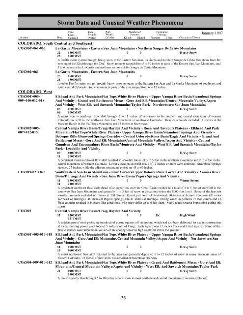
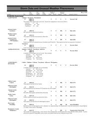
COLORADO, South Central <strong>and</strong> SoutheastCOZ060>061-065 La Garita Mountains - Eastern San Juan Mountains - Northern Sangre De Cristo MountainsCOZ060>061COLORADO, WestCOZ004>005-009>010-012-018COZ002>005-007>012-015COZ019-021>023COZ002COZ004>005-010-018COZ004-009>010-012<strong>Storm</strong> <strong>Data</strong> <strong>and</strong> <strong>Unusual</strong> <strong>Weather</strong> <strong>Phenomena</strong>TimeLocal/PathLengthPathWidthNumber ofPersonsEstimatedDamageLocation Date St<strong>and</strong>ard (Miles) (Yards) Killed Injured Property Crops Character of <strong>Storm</strong>January 199722231800MST1800MST0 0Heavy SnowA Pacific storm system brought heavy snow to the Eastern San Juan, La Garita <strong>and</strong> northern Sangre de Cristo Mountains from theevening of the 22nd through the 23rd. Snow amounts ranged from 5 to 10 inches in parts of the Eastern San Juan Mountains, <strong>and</strong>3 to 6 inches in the La Garita <strong>and</strong> northern sections of the Sangre de Cristo Mountains.La Garita Mountains - Eastern San Juan Mountains25261800MST1500MST0 0Heavy SnowAnother Pacific storm system brought heavy snow amounts to the Eastern San Juan <strong>and</strong> La Garita Mountains of southwest <strong>and</strong>south central Colorado. Snow amounts in parts of the area ranged from 6 to 12 inches.Elkhead And Park Mountains/Flat Tops/White River Plateau - Upper Yampa River Basin/Steamboat SpringsAnd Vicinity - Gr<strong>and</strong> And Battlement Mesas - Gore And Elk Mountains/Central Mountain Valleys/AspenAnd Vicinity - West Elk And Sawatch Mountains/Taylor Park - Northwestern San Juan Mountains03 0500MST0 0Heavy Snow04 1000MSTA moist west to northwest flow aloft brought 6 to 12 inches of new snow to the northern <strong>and</strong> central mountains of westernColorado, as well as the northwest San Juan Mountains in southwest Colorado. Heavier amounts included 14 inches at theMarvine Ranch in the Flat Tops Mountains <strong>and</strong> 13 inches at Snowmass.Central Yampa River Basin/Craig-Hayden And Vicinity - Roan And Tavaputs Plateaus - Elkhead And ParkMountains/Flat Tops/White River Plateau - Upper Yampa River Basin/Steamboat Springs And Vicinity -Debeque Rifle Glenwood Springs Corridor - Central Colorado River Basin/Eagle And Vicinity - Gr<strong>and</strong> AndBattlement Mesas - Gore And Elk Mountains/Central Mountain Valleys/Aspen And Vicinity - CentralGunnison And Uncompahgre River Basin/Montrose And Vicinity - West Elk And Sawatch Mountains/TaylorPark - Leadville And Vicinity09 0400MST0 0Heavy Snow11 2000MSTA persistent moist northwest flow aloft resulted in snowfall totals of 3 to 5 feet in the northern mountains <strong>and</strong> 2 to 4 feet in thecentral mountains of western Colorado. Lower elevation snowfall totals of 12 inches or more were common. Steamboat Springsreceived 37 inches, while the adjacent mountains picked up 45 to 60 inches.Southwestern San Juan Mountains - Four Corners/Upper Dolores River/Cortez And Vicinity - Animas RiverBasin/Durango And Vicinity - San Juan River Basin/Pagosa Springs And Vicinity11 1500MST0 0Winter <strong>Storm</strong>14 2100MSTA persistent southwest flow aloft ahead of an upper low over the Great Basin resulted in a total of 3 to 5 feet of snowfall in thesouthwest San Juan Mountains <strong>and</strong> generally 1 to 3 feet of snow at elevations below the 8000 foot level. Some of the heaviestsnowfall amounts included 60 inches at Tall Timber Resort just north of Rockwood, 60 inches at Lemon Reservoir (20 milesnortheast of Durango), 46 inches at Pagosa Springs, <strong>and</strong> 41 inches at Durango. Strong winds in portions of Montezuma <strong>and</strong> LaPlata counties resulted in blizzard-like conditions, with snow drifts up to 6 feet deep. Many roads became impassable during thisstorm.Central Yampa River Basin/Craig-Hayden And Vicinity12 1200MST0 0 3KHigh Wind1210MSTA sudden gust of wind picked up hundreds of plastic squares off the ground which had just been delivered for use in constructionat a coal burning power plant located 5 miles south of Craig. Each square was 12 inches thick <strong>and</strong> 3 feet square. Some of theplastic squares were impaled on louvers of the cooling tower as high as 60 feet above the ground.Elkhead And Park Mountains/Flat Tops/White River Plateau - Upper Yampa River Basin/Steamboat SpringsAnd Vicinity - Gore And Elk Mountains/Central Mountain Valleys/Aspen And Vicinity - Northwestern SanJuan Mountains14 1900MST0 0Heavy Snow15 0600MSTA moist northwest flow aloft returned to the area <strong>and</strong> generally deposited 6 to 12 inches of snow in many mountain areas ofwestern Colorado. 13 inches of new snow was reported at Steamboat Ski Area.Elkhead And Park Mountains/Flat Tops/White River Plateau - Gr<strong>and</strong> And Battlement Mesas - Gore And ElkMountains/Central Mountain Valleys/Aspen And Vicinity - West Elk And Sawatch Mountains/Taylor Park21 0400MST0 0Heavy Snow1400MSTA moist westerly flow brought 5 to 10 inches of new snow to most northern <strong>and</strong> central mountains of western Colorado.28 35


