Storm Data and Unusual Weather Phenomena - CIG
Storm Data and Unusual Weather Phenomena - CIG
Storm Data and Unusual Weather Phenomena - CIG
- No tags were found...
You also want an ePaper? Increase the reach of your titles
YUMPU automatically turns print PDFs into web optimized ePapers that Google loves.
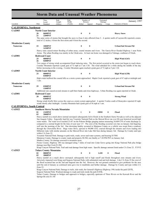
CALIFORNIA, NorthwestCAZ003North Coast InteriorMendocino CountyNumerousCAZ001CAZ003Mendocino CountyNumerousCAZ001CALIFORNIA, South CentralCAZ022CAZ023<strong>Storm</strong> <strong>Data</strong> <strong>and</strong> <strong>Unusual</strong> <strong>Weather</strong> <strong>Phenomena</strong>TimeLocal/PathLengthPathWidthNumber ofPersonsEstimatedDamageLocation Date St<strong>and</strong>ard (Miles) (Yards) Killed Injured Property Crops Character of <strong>Storm</strong>January 199720210600PST2200PST0 0Heavy SnowThe same series of storms that brought the snow to Zone 4 also affected Zone 3. A spotter north of Laytonville reported a stormtotal of 12 inches, 4 from the first storm <strong>and</strong> 8 from the second.22 1000PST0 0Urban/Sml Stream Fld1430PSTHeavy rains caused minor flooding of urban areas, coastal streams <strong>and</strong> rivers. The Garcia River flooded Highway 1 near PointArena. The urban flooding was mainly in the Ukiah area. At least one home was damaged in Talmage, southeast of Ukiah.Redwood Coast25 0000PST0 0High Wind (G63)26 0200PSTTwo surges of strong winds accompanied flood inducing rains. The first period occurred as the storm just began to reach shore.Cooskie Mountain reported a peak gust of 72 mph at 3 am 1/26. The wind subsided for a while during the middle of the daybefore increasing in the evening. Cooskie Mountain again reached a peak gust of 72 mph at 5 pm 1/26North Coast Interior25 0000PST0 0High Wind (G58)0300PSTHigh winds buffeted the coastal hills as a storm system approached. Maple Creek reported a peak gust of 67 mph at midnight <strong>and</strong>1 am.25 0300PST0 0Urban/Sml Stream Fld1100PSTAdditional rain caused several streams to spill their banks <strong>and</strong> close highways. Urban flooding was again reported in Ukiah.Redwood Coast28 0000PST0 0Strong Wind0300PSTStrong winds briefly blew across the coast as a storm system approached. A spotter 9 miles south of Honeydew reported 45 mphwinds shortly after midnight. Cooskie Mountain had a peak gust of 56 mph at 1 am.Southern Sierra Nevada Mountains01 1345PST1 0 190M 0 Flood03 2000PSTHeavy rainfall on a much above normal snowpack subsequently led to floods in the Southern Sierra Nevada as well as the adjacentSan Joaquin Valley. Especially hard hit was Yosemite National Park as the Merced River ran over 80-year historical record highwater marks. The water level reached 23.45' on the Pohono Bridge gauging station measuring 24,600 CFS of water discharge ascompared to a normal height for the time of year near 3.5'. The crest of the flooding occurred very late on January 2nd lingeringwell into the morning of the 3rd. One drowning fatality occurred in Mariposa County as a vehicle was swept from a roadwaythrough the Chowchilla River. Huge water flows, upward to 90,000 CFS, coursed through the streams <strong>and</strong> rivers leading intoMillerton Lake with similar amounts on the Merced River into Lake McClure during January 3rd. Damage by County <strong>and</strong> typewithin CA Zone 22:Yosemite National Park; Damage to park trails, roads, sewer <strong>and</strong> water systems, <strong>and</strong> housing $178M.Mariposa County; Damage to county roads <strong>and</strong> property $8.5M; one fatality at 7:20 PM PST on January 2nd.Madera County; No damage assessed in mountain areas.Fresno County; Highway 180 was damaged along 7 miles of road into Cedar Grove going into Kings National Park plus bridgedamage near Big Creek $1.8M.Kings Canyon National Park; Trail <strong>and</strong> road damage from high water. Specific damage amount listed under CA Zone 23. F33VETulare County Mountains02 0800PST0 0 1.6M 0 Flood03 2000PSTHeavy rainfall on a much above snowpack subsequently led to high runoff <strong>and</strong> floods throughout zone streams <strong>and</strong> rivers.Adversely impacted were Kings <strong>and</strong> Sequoia National Parks with substantial road <strong>and</strong> trail damage. Like CA Zone 22 the crest ofthe flood occurred late on the 2nd <strong>and</strong> lingered into the 3rd. However, the wet ground continued to give problems for the areauntil the end of January as continued rains gave rise to mudslides <strong>and</strong> further damage. Damage by County <strong>and</strong> type within CAZone 23:Kings Canyon National Park; Damage to trails, side roads, the General's Highway (Highway 198) inside the park $287K.Sequoia National Park; Washout damage to roads <strong>and</strong> trails inside the park $185K.Tulare County; Damage to bridges <strong>and</strong> approach to bridges, especially upstream of Three Rivers on the Kaweah River <strong>and</strong> theSpringville area $1.1M20 27


