HAWAIIHIZ004Kauai CountyKekahaHIZ001>006IDAHO, Extreme Southeast<strong>Storm</strong> <strong>Data</strong> <strong>and</strong> <strong>Unusual</strong> <strong>Weather</strong> <strong>Phenomena</strong>TimeLocal/PathLengthPathWidthNumber ofPersonsEstimatedDamageLocation Date St<strong>and</strong>ard (Miles) (Yards) Killed Injured Property Crops Character of <strong>Storm</strong>Isl<strong>and</strong> Of Hawaii28 1400HST0 02000HSTWinds estimated at 60 mph blew several trees down in the Puna District.High Wind (G52)January 199729 0445HST0 0 10KThunderstorm Wind (G65)0530HSTWinds estimated at 75 mph associated with a thunderstorm ahead of an eastward moving cold front damaged a metal building at aseed corn company in Kekaha. Wind gusts to 53 mph were recorded at Lihue.Kauai - Oahu - Maui - Isl<strong>and</strong> Of Hawaii - Molokai - Lanai30 0800HST4 0High Surf31 1600HSTSeveral low pressure centers moving across the north central Pacific generated swell that produced surf of 8 to 12 feet withoccasional sets to 15 feet along the north <strong>and</strong> west facing shores of the isl<strong>and</strong>s. Four tourists, 3 from Georgia <strong>and</strong> 1 from Utah,drowned in the high surf at Keanae Point, Maui at approximately 2 p.m. HST January 30, 1997. One person was swept into theocean while taking pictures of the high surf. He was pulled from the water <strong>and</strong> given CPR by a visiting paramedic. Whileperforming CPR, a second wave swept both individuals <strong>and</strong> six other people into the ocean. Four of the eight people wererescued by local residents, while the other four drowned. M32IW, M50IW, M30IW, M33IWIDAHO, NorthIDAHO, NorthwestIDAHO, SoutheastIDAHO, SouthwestIDZ001-003>008-011>013NONE REPORTED.NONE REPORTED.NONE REPORTED.NONE REPORTED.Northern Panh<strong>and</strong>le - Lewiston And The Palouse - Shoshone - Northern Clearwater Mountains - SouthernClearwater Mountains - Orofino/Grangeville Region - Lower Hells Canyon/Salmon River Region - WestCentral Mountains - Lower Treasure Valley - Boise Mountains/Camas Prairie01 0400MST0 0Flood03 2330MSTIn Northern Idaho, November <strong>and</strong> December brought above normal snowfall. From 11/16/96 through the end of December mostlocations had over 2 to 3 feet of snow with higher amounts at higher elevations. High temperatuers remained in the 30s or below<strong>and</strong> some of the time rain fell saturating the snow <strong>and</strong> the soil. This persistant weather pattern brought a series of stormsthroughout this time period. Considerable snow amounts also fell in Southern <strong>and</strong> Central Idaho. Wet pacific storm systemsbrought precipitation totals 3 to 5 times their normal for December. A rapid warming began 12/25/96 as the weather patternshifted <strong>and</strong> a southwesterly moist flow extending past the Hawaiian Isl<strong>and</strong>s bringing warm, wet storms through the state. Thispattern persisted through 1/3/97. The previous heavy snow pack, well above normal temperatures into the 50s <strong>and</strong> days ofmoderate rain brought significant runoff in all southern basins. This combination brought rapid river flooding <strong>and</strong> mud slidesfrom the supersaturated soils. Heavy rain <strong>and</strong> mild temperatures continued the first two days of January...many locations receivedtheir normal precipitation for the month in those two days! Mid-elevation snow melt continued, with reports of 20 inches of low<strong>and</strong> mid elevation snow melt in 4 days! A colder, drier airmass moved in on 1/3/97 ending the precipitation <strong>and</strong> snow melt.Record flooding occurred in these basins on 1/1/97 with peak flows occurring on 1/2/97.The Weiser River at Cambridge crested at 14.26 ft. Flood stage is 12.0 ft. <strong>and</strong> the previous flood of record was 13.9 ft. on12/22/55 <strong>and</strong> 8/22-24/77.The Weiser River at Weiser's crest was estimated at 16.5 ft. (the gage was damaged during the event.) Flood stage is 9.5 ft. <strong>and</strong>the previous flood of record was 16.0 ft. on 12/14/79 due to ice jams.The Payette River at Emmett crested at 32,300 cfs. Flood flow is 16,000 cfs <strong>and</strong> the previous flood of record was 32,700 cfs on12/23/64.The Snake River at Weiser crested at 14.47 ft. Flood stage is 12 ft. <strong>and</strong> the previous flood of record is 15.55 ft.The major impacts due to the flooding included many road closures from the flooding <strong>and</strong> mud slides. Many communities wereevacuated from their flooded homes causing overflow at many shelters. Many small communities were isolated by the roadclosures, several towns had to have medical supplies <strong>and</strong> food flown in by helicopter. Major flood damage occurred in the citiesof Weiser, Emmett, Payette, Cambridge, Council <strong>and</strong> others. In Payette county, the Payette River <strong>and</strong> its tributaries flooded41 48
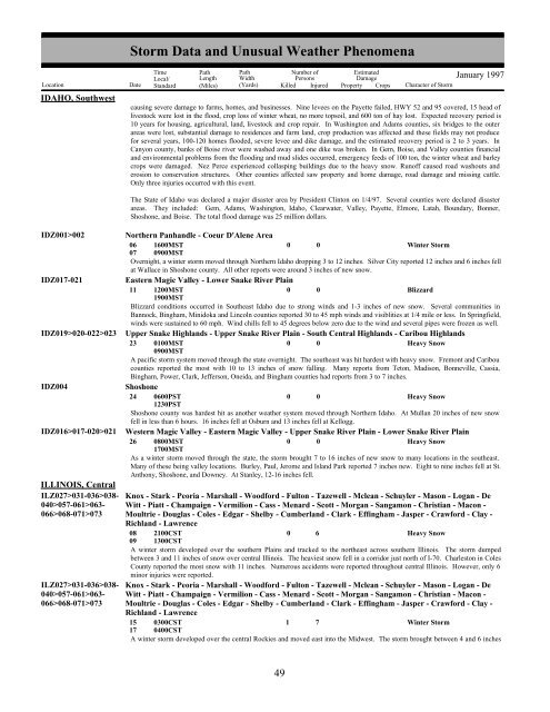
IDAHO, SouthwestIDZ001>002IDZ017-021IDZ019>020-022>023IDZ004IDZ016>017-020>021ILLINOIS, CentralILZ027>031-036>038-040>057-061>063-066>068-071>073ILZ027>031-036>038-040>057-061>063-066>068-071>073<strong>Storm</strong> <strong>Data</strong> <strong>and</strong> <strong>Unusual</strong> <strong>Weather</strong> <strong>Phenomena</strong>TimeLocal/PathLengthPathWidthNumber ofPersonsEstimatedDamageLocation Date St<strong>and</strong>ard (Miles) (Yards) Killed Injured Property Crops Character of <strong>Storm</strong>January 1997causing severe damage to farms, homes, <strong>and</strong> businesses. Nine levees on the Payette failed, HWY 52 <strong>and</strong> 95 covered, 15 head oflivestock were lost in the flood, crop loss of winter wheat, no more topsoil, <strong>and</strong> 600 ton of hay lost. Expected recovery period is10 years for housing, agricultural, l<strong>and</strong>, livestock <strong>and</strong> crop repair. In Washington <strong>and</strong> Adams counties, six bridges to the outerareas were lost, substantial damage to residences <strong>and</strong> farm l<strong>and</strong>, crop production was affected <strong>and</strong> these fields may not producefor several years, 100-120 homes flooded, severe levee <strong>and</strong> dike damage, <strong>and</strong> the estimated recovery period is 2 to 3 years. InCanyon county, banks of Boise river were washed away <strong>and</strong> one dike was broken. In Gem, Boise, <strong>and</strong> Valley counties financial<strong>and</strong> environmental problems from the flooding <strong>and</strong> mud slides occurred, emergency feeds of 100 ton, the winter wheat <strong>and</strong> barleycrops were damaged. Nez Perce experienced collasping buildings due to the heavy snow. Runoff caused road washouts <strong>and</strong>erosion to conservation structures. Other counties affected saw property <strong>and</strong> home damage, road damage <strong>and</strong> missing cattle.Only three injuries occurred with this event.The State of Idaho was declared a major disaster area by President Clinton on 1/4/97. Several counties were declared disasterareas. They included: Gem, Adams, Washington, Idaho, Clearwater, Valley, Payette, Elmore, Latah, Boundary, Bonner,Shoshone, <strong>and</strong> Boise. The total flood damage was 25 million dollars.Northern Panh<strong>and</strong>le - Coeur D'Alene Area06071600MST0900MST0 0Winter <strong>Storm</strong>Overnight, a winter storm moved through Northern Idaho dropping 3 to 12 inches. Silver City reported 12 inches <strong>and</strong> 6 inches fellat Wallace in Shoshone county. All other reports were around 3 inches of new snow.Eastern Magic Valley - Lower Snake River Plain11 1200MST1900MST0 0BlizzardBlizzard conditions occurred in Southeast Idaho due to strong winds <strong>and</strong> 1-3 inches of new snow. Several communities inBannock, Bingham, Minidoka <strong>and</strong> Lincoln counties reported 30 to 45 mph winds <strong>and</strong> visiblities at 1/4 mile or less. In Springfield,winds were sustained to 60 mph. Wind chills fell to 45 degrees below zero due to the wind <strong>and</strong> several pipes were frozen as well.Upper Snake Highl<strong>and</strong>s - Upper Snake River Plain - South Central Highl<strong>and</strong>s - Caribou Highl<strong>and</strong>s23 0100MST0 0Heavy Snow0900MSTA pacific storm system moved through the state overnight. The southeast was hit hardest with heavy snow. Fremont <strong>and</strong> Cariboucounties reported the most with 10 to 13 inches of snow falling. Many reports from Teton, Madison, Bonneville, Cassia,Bingham, Power, Clark, Jefferson, Oneida, <strong>and</strong> Bingham counties had reports from 3 to 7 inches.Shoshone24 0600PST0 0Heavy Snow1230PSTShoshone county was hardest hit as another weather system moved through Northern Idaho. At Mullan 20 inches of new snowfell in less than 6 hours. 16 inches fell at Osburn <strong>and</strong> 13 inches fell at Kellogg.Western Magic Valley - Eastern Magic Valley - Upper Snake River Plain - Lower Snake River Plain26 0800MST0 0Heavy Snow1700MSTAs a winter storm moved through the state, the storm brought 7 to 16 inches of new snow to many locations in the southeast.Many of these being valley locations. Burley, Paul, Jerome <strong>and</strong> Isl<strong>and</strong> Park reported 7 inches new. Eight to nine inches fell at St.Anthony, Shoshone, <strong>and</strong> Downey. At Stanley, 12-16 inches fell.Knox - Stark - Peoria - Marshall - Woodford - Fulton - Tazewell - Mclean - Schuyler - Mason - Logan - DeWitt - Piatt - Champaign - Vermilion - Cass - Menard - Scott - Morgan - Sangamon - Christian - Macon -Moultrie - Douglas - Coles - Edgar - Shelby - Cumberl<strong>and</strong> - Clark - Effingham - Jasper - Crawford - Clay -Richl<strong>and</strong> - Lawrence08 2100CST0 6Heavy Snow09 1300CSTA winter storm developed over the southern Plains <strong>and</strong> tracked to the northeast across southern Illinois. The storm dumpedbetween 3 <strong>and</strong> 11 inches of snow over central Illinois. The heaviest snow fell in a corridor just north of I-70. Charleston in ColesCounty reported the most snow with 11 inches. Numerous accidents were reported throughout central Illinois. However, only 6minor injuries were reported.Knox - Stark - Peoria - Marshall - Woodford - Fulton - Tazewell - Mclean - Schuyler - Mason - Logan - DeWitt - Piatt - Champaign - Vermilion - Cass - Menard - Scott - Morgan - Sangamon - Christian - Macon -Moultrie - Douglas - Coles - Edgar - Shelby - Cumberl<strong>and</strong> - Clark - Effingham - Jasper - Crawford - Clay -Richl<strong>and</strong> - Lawrence15 0300CST1 7Winter <strong>Storm</strong>17 0400CSTA winter storm developed over the central Rockies <strong>and</strong> moved east into the Midwest. The storm brought between 4 <strong>and</strong> 6 inches42 49
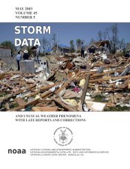
- Page 1 and 2: JANUARY 1997VOLUME 39NUMBER 1S T O
- Page 4 and 5: January 1997 Confirmed Tornadoes4F
- Page 6 and 7: Left:A different view of the samest
- Page 8 and 9: ALABAMA, North CentralALZ006Madison
- Page 10 and 11: ALABAMA, North CentralBarbour Count
- Page 12 and 13: ALABAMA, North CentralShelby County
- Page 14 and 15: ALABAMA, North CentralCalhoun Count
- Page 16 and 17: ALABAMA, SouthwestBaldwin CountySto
- Page 18 and 19: ALASKA, NorthernAKZ024AKZ007AKZ008A
- Page 20 and 21: ARIZONA, Central and NortheastARIZO
- Page 22 and 23: ARKANSAS, SouthwestARZ050>051-059>0
- Page 24 and 25: CALIFORNIA, North CentralFlooding f
- Page 26 and 27: CALIFORNIA, NortheastCAZ071Lassen/E
- Page 28 and 29: CALIFORNIA, South CentralCAZ024Kern
- Page 30 and 31: CALIFORNIA, South CentralDeadman's
- Page 32 and 33: Storm Data and Unusual Weather Phen
- Page 34 and 35: COLORADO, Central and NortheastCOZ0
- Page 36 and 37: COLORADO, WestCOZ004>005-009>010-01
- Page 38 and 39: DISTRICT OF COLUMBIAthe 11th Street
- Page 40 and 41: FLORIDA, West Centralnorth to Wildw
- Page 42 and 43: FLORIDA, West Panhandlefence and se
- Page 44 and 45: Storm Data and Unusual Weather Phen
- Page 46 and 47: HAWAIIHIZ003Kauai CountyHanalei toK
- Page 50 and 51: ILLINOIS, CentralILZ027>031-036>038
- Page 52 and 53: ILLINOIS, NorthwestILZ001>002-007-0
- Page 54 and 55: INDIANA, SoutheastRipley CountyMila
- Page 56 and 57: IOWA, East Central and SoutheastSto
- Page 58 and 59: Storm Data and Unusual Weather Phen
- Page 60 and 61: KENTUCKY, CentralGreen CountyAllend
- Page 62 and 63: KENTUCKY, Northernfreezing mark for
- Page 64 and 65: LOUISIANA, Northwestwas found. M92O
- Page 66 and 67: LOUISIANA, SouthwestSeveral trees w
- Page 68 and 69: MARYLAND, Northeastacross the Maryl
- Page 70 and 71: MASSACHUSETTS, Central and Eastboth
- Page 72 and 73: MICHIGAN, NorthMIZ022Storm Data and
- Page 74 and 75: MICHIGAN, NorthMIZ025MIZ026MIZ027MI
- Page 76 and 77: MICHIGAN, NorthStorm Data and Unusu
- Page 78 and 79: MICHIGAN, NorthMIZ035Storm Data and
- Page 80 and 81: MICHIGAN, NorthStorm Data and Unusu
- Page 82 and 83: MICHIGAN, WestMIZ039-043-050-056>05
- Page 84 and 85: MINNESOTA, NortheastMNZ012-019>021-
- Page 86 and 87: MINNESOTA, West CentralThe heavy ac
- Page 88 and 89: MISSISSIPPI, CentralNoxubee County1
- Page 90 and 91: MISSISSIPPI, SouthPike County10 W M
- Page 92 and 93: MISSOURI, NorthwestStorm Data and U
- Page 94 and 95: Storm Data and Unusual Weather Phen
- Page 96 and 97: MONTANA, WestMTZ006Blackfoot/Pintla
- Page 98 and 99:
NEBRASKA, Extreme Northeastdrifting
- Page 100 and 101:
Storm Data and Unusual Weather Phen
- Page 102 and 103:
NEVADA, WestStorm Data and Unusual
- Page 104 and 105:
NEVADA, WestNVZ003Greater Reno/Cars
- Page 106 and 107:
Storm Data and Unusual Weather Phen
- Page 108 and 109:
NEW JERSEY, South and Northwestthe
- Page 110 and 111:
NEW YORK, CentralStorm Data and Unu
- Page 112 and 113:
NEW YORK, EastNYZ032-038NYZ032-038N
- Page 114 and 115:
Storm Data and Unusual Weather Phen
- Page 116 and 117:
NORTH CAROLINA, South CoastalGraham
- Page 118 and 119:
NORTH DAKOTA, Central and Westthe r
- Page 120 and 121:
OHIO, NorthOHZ012>014OHZ011OHZ002>0
- Page 122 and 123:
OHIO, SouthwestHighland CountyCount
- Page 124 and 125:
OKLAHOMA, Western, Central and Sout
- Page 126 and 127:
PENNSYLVANIA, CentralPAZ042Sullivan
- Page 128 and 129:
PENNSYLVANIA, Eastpassenger (the dr
- Page 130 and 131:
PENNSYLVANIA, WestPAZ015ClarionPAZ0
- Page 132 and 133:
Storm Data and Unusual Weather Phen
- Page 134 and 135:
SOUTH CAROLINA, NorthwestSCZ005>008
- Page 136 and 137:
SOUTH DAKOTA, SoutheastScattered po
- Page 138 and 139:
Storm Data and Unusual Weather Phen
- Page 140 and 141:
TENNESSEE, CentralJackson CountySto
- Page 142 and 143:
Storm Data and Unusual Weather Phen
- Page 144 and 145:
TEXAS, Central SoutheastHarris Coun
- Page 146 and 147:
TEXAS, NorthTXZ142TXZ143TXZ159TXZ12
- Page 148 and 149:
TEXAS, NorthTXZ157TXZ160TXZ122TXZ09
- Page 150 and 151:
TEXAS, South CentralTXZ183>184-202>
- Page 152 and 153:
UTAH, North, Central and Southabout
- Page 154 and 155:
VERMONT, North and CentralVERMONT,
- Page 156 and 157:
VIRGINIA, Northwestdeposit of 1/4 t
- Page 158 and 159:
Storm Data and Unusual Weather Phen
- Page 160 and 161:
WISCONSIN, NortheastWIZ013-020>022-
- Page 162 and 163:
WISCONSIN, SouthwestWIZ017-029-032>
- Page 164 and 165:
Flood/Flash Flood Fatalities - 1960
- Page 166 and 167:
19601961196219631964196519661967196
- Page 168 and 169:
TOTAL DEATHSBY STATE AND NATIONFOR
- Page 170 and 171:
TOTAL DEATHSBY STATE AND NATIONFOR
- Page 172 and 173:
NATIONAL TOTAL DEATHS BY YEAR FOR P
- Page 174 and 175:
LIGHTNING DEATHS BY STATE, RANK, AN
- Page 176 and 177:
National Summary of Tornadoes, 1996
- Page 178 and 179:
1996 Confirmed Tornadoes178F ScaleF
- Page 180 and 181:
LOUISIANANUMBER 2 0 1 5 1 0 0 1 0 0
- Page 182 and 183:
WISCONSINNUMBER 0 0 0 1 0 4 12 3 0
- Page 184 and 185:
STATETOTALTORNADOESDAYSDEATHSPER #P
- Page 186 and 187:
YEARNUMBERTORNADOESTORNADODAYSTOTAL
- Page 188:
STORM DAMAGE CATEGORIESREFERENCE NO


