

Storm Data and Unusual Weather Phenomena - CIG
Storm Data and Unusual Weather Phenomena - CIG
Storm Data and Unusual Weather Phenomena - CIG

Create successful ePaper yourself
Turn your PDF publications into a flip-book with our unique Google optimized e-Paper software.
JULY 1998<br />
VOLUME 40<br />
NUMBER 7<br />
STORM<br />
DATA<br />
AND UNUSUAL WEATHER PHENOMENA<br />
WITH LATE REPORTS AND CORRECTIONS<br />
noaa<br />
NATIONAL OCEANIC AND NATIONAL ENVIRONMENTAL SATELLITE NATIONAL CLIMATIC DATA CENTER<br />
ATMOSPHERIC ADMINISTRATION DATA, AND INFORMATION SERVICE ASHEVILLE, N.C.
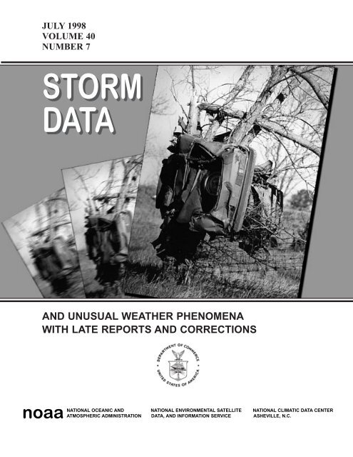
Cover: An F5 tornado wrapped this car around a tree along the Kansas Turnpike (Interstate 35) near Wichita, Kansas. The photograph<br />
was taken during a tornado outbreak on April 26, 1991 when 55 tornadoes killed 21 people, injured hundreds <strong>and</strong> caused millions in<br />
property <strong>and</strong> crop damage. (Photograph courtesy of The Wichita Capital-Journal)<br />
TABLEOF CONTENTS<br />
Page<br />
Outst<strong>and</strong>ing <strong>Storm</strong>s of the Month ……………………………………………………………………………………….. 5<br />
<strong>Storm</strong> <strong>Data</strong> <strong>and</strong> <strong>Unusual</strong> <strong>Weather</strong> <strong>Phenomena</strong> ………………………………………………………………………….. 6<br />
Reference Notes …………………………………………………………………………………………………………. 250<br />
STORM DATA<br />
(ISSN 0039-1972)<br />
National Climatic <strong>Data</strong> Center<br />
Editor: Stephen Del Greco<br />
Assistant Editor: Stuart Hinson<br />
The <strong>Storm</strong> <strong>Data</strong> Publication can be accessed in PDF format via the WWW at:<br />
http://www.ncdc.noaa.gov/ol/climate/climateproductsstormdata.html<br />
STORM DATA is prepared, funded, <strong>and</strong> distributed by the National Oceanic <strong>and</strong> Atmospheric Administration (NOAA). The<br />
Outst<strong>and</strong>ing <strong>Storm</strong>s of the Month section is prepared by the <strong>Data</strong> Operations Branch of the National Climatic <strong>Data</strong> Center.<br />
The <strong>Storm</strong> <strong>Data</strong> <strong>and</strong> <strong>Unusual</strong> <strong>Weather</strong> <strong>Phenomena</strong> narratives <strong>and</strong> Hurricane/Tropical <strong>Storm</strong> summaries are prepared by the<br />
National <strong>Weather</strong> Service. Monthly <strong>and</strong> annual statistics <strong>and</strong> summaries of tornado <strong>and</strong> lightning events resulting in deaths,<br />
injuries, <strong>and</strong> damage are compiled by cooperative efforts between the National Climatic <strong>Data</strong> Center <strong>and</strong> the <strong>Storm</strong> Prediction<br />
Center.<br />
STORM DATA contains all confirmed information on storms available to our staff at the time of publication. However, due to<br />
difficulties inherent in the collection of this type of data, it is not all-inclusive. Late reports <strong>and</strong> corrections are printed in each<br />
edition.<br />
Maps of the National <strong>Weather</strong> Service County Warning Areas which are used in the <strong>Storm</strong> <strong>Data</strong> <strong>and</strong> <strong>Unusual</strong> <strong>Weather</strong><br />
<strong>Phenomena</strong> section will be printed in all editions.<br />
Except for limited editing to correct grammatical errors, materials submitted are generally published as received.<br />
Note: "None Reported" means that no severe weather occurred <strong>and</strong> "Not Received" means that no reports were received for this<br />
region at the time of printing.<br />
Subscription, pricing, <strong>and</strong> ordering information is available from:<br />
National Climatic <strong>Data</strong> Center<br />
151 Patton Avenue<br />
Asheville, NC 28801<br />
(828) 271-4800 or (828) CLIMATE<br />
The editors of STORM DATA solicits your help in acquiring photographs (prints or slides; black <strong>and</strong> white, or color), maps,<br />
clippings, etc. of significant or unusual weather events (past or present). These could be for use in the "Outst<strong>and</strong>ing <strong>Storm</strong>s of<br />
the Month'' section of STORM DATA. We request our subscribers or other interested persons to mail such items to:<br />
Stuart Hinson<br />
National Climatic <strong>Data</strong> Center<br />
151 Patton Avenue<br />
Asheville, NC 28801<br />
Any such items received by the editor will be for use in STORM DATA only. Any other use will be with the permission of<br />
the owner of said items. Materials submitted will be returned if requested in the original submission.<br />
"I certify that this is an official publication of the National Oceanic <strong>and</strong> Atmospheric Administration <strong>and</strong> is compiled from<br />
information received at the National Climatic <strong>Data</strong> Center Asheville, North Carolina 28801-2733."<br />
2<br />
Thomas R. Karl<br />
Director,<br />
National Climatic <strong>Data</strong> Center
The Cyclone Track Map which usually appears<br />
on this page is not available for July 1998.<br />
Should the data become available in the future, a<br />
cyclone track map will be produced <strong>and</strong> printed<br />
in a subsequent issue.<br />
3
July 1998 Confirmed Tornadoes<br />
4<br />
F Scale<br />
F Scale F0 F1 F2 F3 F4 F5 Total<br />
Number 65 15 0 0 0 0 80<br />
F0<br />
F1<br />
F2<br />
F3<br />
F4<br />
F5
OUTSTANDING STORMS OF THE MONTH<br />
The “Outst<strong>and</strong>ing <strong>Storm</strong> of the Month” which usually appears on Page 5 is<br />
not available for this month.<br />
The Editors of the <strong>Storm</strong> <strong>Data</strong> Publication solicit your help acquiring<br />
materials such as photographs, newspaper articles, graphs, charts, maps, etc.<br />
of severe weather events or any unusual weather phenomena. Any such items<br />
received by the editors may be for use in the “Outst<strong>and</strong>ing <strong>Storm</strong> of the<br />
Month” section. Materials will be returned if requested in the original<br />
submission. Please send any such materials to the address below. If you have<br />
any questions, comments or suggestions, please feel free to contact us at the<br />
address below.<br />
Editor: <strong>Storm</strong> <strong>Data</strong><br />
National Climatic <strong>Data</strong> Center<br />
Federal Building - Room 420<br />
151 Patton Avenue<br />
Asheville, NC 28730<br />
Ph: (704)271-4437<br />
Fax: (704)271-4022<br />
E-Mail: <strong>Storm</strong>Dat@ncdc.noaa.gov<br />
5
ALABAMA, North Central<br />
Jefferson County<br />
<strong>Storm</strong> <strong>Data</strong> <strong>and</strong> <strong>Unusual</strong> <strong>Weather</strong> <strong>Phenomena</strong><br />
Time<br />
Local/<br />
Path<br />
Length<br />
Path<br />
Width<br />
Number of<br />
Persons<br />
Estimated<br />
Damage<br />
Location Date St<strong>and</strong>ard (Miles) (Yards) Killed Injured Property Crops Character of <strong>Storm</strong><br />
Homewood to 26 1950CST<br />
0 0 650K 0<br />
Vestavia Hills<br />
July 1998<br />
Thunderstorm Wind (G65)<br />
2000CST<br />
A downburst with a late evening thunderstorm damaged trees, downed powerlines, <strong>and</strong> damaged several structures in a path about 3<br />
miles long. The wind damage began near Oxmoor Road <strong>and</strong> I-65 where about 20 feet of decorative facia on a Comfort Inn motel<br />
was ripped off the roof <strong>and</strong> thrown onto about 10 cars. In the residential section of Southwood <strong>and</strong> Oak Grove Estates a number of<br />
trees were downed along with large limbs. The damaging wind crossed I-65 <strong>and</strong> damaged a number of apartments in the<br />
Woodmere Creek area where chimneys were ripped from the roofs. A number of trees <strong>and</strong> powerlines were also downed in this<br />
area. A double billboard which also served as a cellular telephone site was destroyed when three of the five telephone poles<br />
comprising the billboard were broken off. Additional trees were reported downed along Tyler Road which runs from Vestavia Hills<br />
into Hoover.<br />
Hale County<br />
2.6 W Havana 26 2053CST<br />
2058CST<br />
0 3 120K 0 Thunderstorm Wind (G75)<br />
A strong downburst apparently occurred when a thunderstorm developed <strong>and</strong> collapsed rapidly upon the interaction with an outflow<br />
boundary from other nearby convection in the area about 2.6 miles west of Havana in northern Hale County. One business (a small<br />
grocery) was partially deroofed (essentially destroyed), four mobile homes were damaged including one that was completely flipped<br />
over, one that lost shingles, one that was pushed off it's blocks, <strong>and</strong> one that was sliced by a falling tree. The three injuries, all<br />
minor, occurred in the mobile home that flipped. Numerous trees were downed including some that were estimated to be over 200<br />
years old. Trees were downed in an area that extended for about 2.5 miles west <strong>and</strong> southwest of the heaviest damage.<br />
Clay County<br />
8 SE Ashl<strong>and</strong> 03 1900CST<br />
2000CST<br />
1 0 15K 0 Flash Flood<br />
A flash flood, about 3 inches in an hour, washed out sections of Fuller Road in Mellow Valley. A 51 year-old man drove into the<br />
washed out area <strong>and</strong> was severely injured. He died the next day in the hospital from his injuries.<br />
M51VE<br />
Jackson County<br />
Hytop 04 1310CST<br />
0 0 5K 0 Thunderstorm Wind (G50)<br />
A few trees were down in the Hytop area.<br />
Marshall County<br />
Arab 07 1730CST<br />
0 0 30K 0 Lightning<br />
Lightning was blamed for three house fires in Arab. Each of the fires were in the attics <strong>and</strong> didn't affect the rest of the house.<br />
Jefferson County<br />
Birmingham Arpt to 09 1215CST<br />
0 0 3K 0 Thunderstorm Wind (G51)<br />
Birmingham<br />
A gust to 59 mph was reported at the airport by the Birmingham ASOS.<br />
Jefferson County<br />
4 NE Birmingham 09 1300CST<br />
0 1 0 0 Lightning<br />
A firefighter was injured when he was st<strong>and</strong>ing in some water. Lightning struck nearby <strong>and</strong> traveled through the water <strong>and</strong> he was<br />
struck. He was taken to the hospital <strong>and</strong> was in stable condition.<br />
Marion County<br />
Hamilton 09 1110CST<br />
0 0 5K 0 Thunderstorm Wind (G50)<br />
Numerous trees <strong>and</strong> power lines were down in Hamilton, including a tree on a home.<br />
Bibb County<br />
3 NE Centreville 09 1315CST<br />
0 0 10K 0 Thunderstorm Wind (G60)<br />
A roof was damaged on a house on SR 25, northeast of Centreville.<br />
Montgomery County<br />
Montgomery 09 1500CST<br />
0 0 10K 0 Thunderstorm Wind (G55)<br />
Trees <strong>and</strong> power lines were down in Montgomery. One tree fell on a home <strong>and</strong> damaged part of the roof. Also 13,000 residents<br />
were without power.<br />
Lee County<br />
Auburn 11 1450CST<br />
0 0 10K 0 Lightning<br />
A bolt of lightning struck an apartment building on campus <strong>and</strong> did minor damage to the attic.<br />
Lee County<br />
Auburn 11 1450CST<br />
0 0 20K 0 Thunderstorm Wind (G55)<br />
Trees <strong>and</strong> power lines were down in Auburn. A tractor trailer was blown over in the wind <strong>and</strong> did significant damage to a building.<br />
Lauderdale County<br />
7 NW Killen 14 0900CST<br />
1400CST<br />
0 2 30K 10K Flash Flood<br />
16
<strong>Storm</strong> <strong>Data</strong> <strong>and</strong> <strong>Unusual</strong> <strong>Weather</strong> <strong>Phenomena</strong><br />
Time<br />
Local/<br />
Path<br />
Length<br />
Path<br />
Width<br />
Number of<br />
Persons<br />
Estimated<br />
Damage<br />
Location Date St<strong>and</strong>ard (Miles) (Yards) Killed Injured Property Crops Character of <strong>Storm</strong><br />
July 1998<br />
ALABAMA, North Central<br />
More than three inches of rain forced Shoal Creek out of its banks. Two men were injured when they drove around barricades <strong>and</strong><br />
onto flooded CR 8. Their truck was washed off the road <strong>and</strong> two of the three men jumped into the water <strong>and</strong> were injured. Most of<br />
the flooding was contained to the Shoal Creek area near Goose Shoals. Several people were forced out of their homes due to the<br />
rising water.<br />
Jefferson County<br />
Birmingham 20 1130CST<br />
0 0 5K 0 Thunderstorm Wind (G50)<br />
About 3000 residents lost power after power lines were knocked down.<br />
Shelby County<br />
Alabaster 20 1310CST<br />
0 0 0 0 Hail (0.75)<br />
Dime size hail was reported in Alabaster.<br />
Bibb County<br />
West Blocton 20 1345CST<br />
0 0 8K 0 Thunderstorm Wind (G60)<br />
Trees were blown down <strong>and</strong> a few shingles were blown off.<br />
Calhoun County<br />
9 NW Jacksonville 20 1350CST<br />
0 0 5K 0 Thunderstorm Wind (G50)<br />
Trees were down in Duke <strong>and</strong> Read Mills, in the northern part of the county.<br />
Clay County<br />
Ashl<strong>and</strong> 20 1415CST<br />
0 0 10K 0 Thunderstorm Wind (G50)<br />
A few trees were down, including one on a house, which did minor roof damage.<br />
Tuscaloosa County<br />
Tuscaloosa 20 1438CST<br />
0 0 20K 0 Thunderstorm Wind (G50)<br />
Trees <strong>and</strong> power lines were down in Tuscaloosa. One fell on a home. About 1200 residents were without power.<br />
Marshall County<br />
7 SW Albertville 20 1450CST<br />
0 0 10K 0 Thunderstorm Wind (G55)<br />
There were several trees down <strong>and</strong> several chicken houses were damaged.<br />
Marion County<br />
Winfield 20 1620CST<br />
0 0 5K 0 Thunderstorm Wind (G50)<br />
Numerous trees <strong>and</strong> power lines were down.<br />
Winston County<br />
Arley 20 1615CST<br />
0 0 5K 0 Thunderstorm Wind (G50)<br />
Several trees were down in the southern Arley area.<br />
Elmore County<br />
Deatsville 20 1545CST<br />
0 0 20K 0 Thunderstorm Wind (G55)<br />
A mobile home was damaged <strong>and</strong> another was pushed off its blocks in the Deatsville community.<br />
Madison County<br />
Huntsville 20 1315CST<br />
0 1 75K 0 Lightning<br />
Lightning struck a tree outside the Huntsville city hall. The tree split in half <strong>and</strong> collapsed, falling on four city vehicles. A man was<br />
struck by lightning while doing yard work, he was transported to the hospital in critical condition.<br />
Madison County<br />
Huntsville 20 1320CST<br />
0 0 25K 0 Thunderstorm Wind (G60)<br />
Wind knocked out several windows in the Huntsville Stars baseball stadium sky box. It also knocked over several signs in the<br />
outfield <strong>and</strong> the Marlboro Man was "decapitated." Several large limbs were also down in the area.<br />
Chilton County<br />
6 E Thorsby 20 1330CST<br />
0 0 30K 0 Lightning<br />
Six horses were killed by lightning in the Mineral Springs community.<br />
Perry County<br />
Marion 20 1330CST<br />
0 0 10K 0 Thunderstorm Wind (G60)<br />
A roof of a downtown building was damaged, blowing debris over the area. Several large trees were also uprooted as well.<br />
Chambers County<br />
Lafayette 20 1600CST<br />
0 0 5K 0 Thunderstorm Wind (G50)<br />
A few trees were down in the Five Points area of Lafayette.<br />
Lauderdale County<br />
4 N Florence 23 1545CST<br />
0 0 5K 0 Thunderstorm Wind (G50)<br />
Several trees were down in the Petersville area.<br />
Marshall County<br />
7 NE Guntersville 23 1800CST<br />
0 0 5K 0 Thunderstorm Wind (G50)<br />
Several trees were down just west of the Guntersville State Park along SR 227.<br />
Tuscaloosa County<br />
Tuscaloosa 24 1726CST<br />
0 0 10K 0 Lightning<br />
A downtown framing store was struck by lightning, causing a fire in the attic. The building had some water damage as well.<br />
27
ALABAMA, North Central<br />
Marshall County<br />
Boaz 24 1430CST<br />
0 0 5K 0<br />
A few trees were down in the Boaz community.<br />
Marion County<br />
3 W Hamilton 26 1750CST<br />
0 0 5K 0<br />
Power lines were reported down just west of Hamilton.<br />
Barbour County<br />
Clayton 29 1505CST<br />
0 0 5K 0<br />
Numerous power outages were reported in Clayton due to downed trees.<br />
Dallas County<br />
5 SE Selma 29 1445CST<br />
0 0 20K 0<br />
Thunderstorm Wind (G50)<br />
Thunderstorm Wind (G50)<br />
Thunderstorm Wind (G50)<br />
Thunderstorm Wind (G65)<br />
A downburst hit Craig Field <strong>and</strong> knocked down numerous trees, a few doors were blown out, there was roof damage to a few<br />
buildings <strong>and</strong> tractor trailer was over turned.<br />
R<strong>and</strong>olph County<br />
5 E Roanoke 31 1653CST<br />
0 0 0 0<br />
Dime size hail was reported at Rock Mills.<br />
Chambers County<br />
Lanett 31 1735CST<br />
0 0 0 0<br />
Dime size hail was reported in Lanett.<br />
Tallapoosa County<br />
Dadeville 31 1820CST<br />
0 0 2K 0<br />
Quarter size hail was reported in Dadeville.<br />
ALABAMA, Southeast<br />
Coffee County<br />
Southwest Portion<br />
Houston County<br />
Cowarts<br />
ALABAMA, Southwest<br />
Baldwin County<br />
Seminole<br />
Escambia County<br />
Nokomis<br />
Baldwin County<br />
Perdido<br />
Crenshaw County<br />
Petrey<br />
Escambia County<br />
Atmore<br />
Escambia County<br />
Huxford<br />
09 2000EST<br />
Three trees down <strong>and</strong> one roof damaged on CR 14.<br />
0<br />
0<br />
5K<br />
Hail (0.75)<br />
Hail (0.75)<br />
Hail (1.00)<br />
Thunderstorm Wind<br />
27 1800EST<br />
0 0 25K<br />
Thunderstorm Wind<br />
1815EST<br />
Straight-line winds damaged at least 10 mobile homes at the Avon Trailer Court, several by downed trees. A portion of a mobile<br />
home roof in Cowarts was torn off after the structure was moved more than three feet.<br />
05 1600CST<br />
1602CST<br />
Trees were blown down near Seminole.<br />
26<br />
<strong>Storm</strong> <strong>Data</strong> <strong>and</strong> <strong>Unusual</strong> <strong>Weather</strong> <strong>Phenomena</strong><br />
Time<br />
Local/<br />
Path<br />
Length<br />
Path<br />
Width<br />
Number of<br />
Persons<br />
Estimated<br />
Damage<br />
Location Date St<strong>and</strong>ard (Miles) (Yards) Killed Injured Property Crops Character of <strong>Storm</strong><br />
1910CST<br />
1912CST<br />
0<br />
0<br />
0<br />
0<br />
3K<br />
5K<br />
Thunderstorm Wind (G50)<br />
Thunderstorm Wind (G50)<br />
26 1912CST<br />
0 0 5K<br />
Thunderstorm Wind (G50)<br />
1915CST<br />
Trees <strong>and</strong> power lines were blown down along U. S. Highway 31 near the Escambia <strong>and</strong> Baldwin county line from Nokomis to just<br />
south of Perdido.<br />
31 2050CST<br />
2051CST<br />
Dime size hail was reported near Petrey.<br />
0<br />
0<br />
Hail (0.75)<br />
July 1998<br />
29 1850CST<br />
0 0 20K<br />
Flash Flood<br />
2015CST<br />
Heavy rainfall caused several streets in the Atmore area to flood. The streets had to be closed for a couple of hours because of<br />
motorists driving through them <strong>and</strong> creating wakes. The wakes caused water to enter some homes in low lying areas. Radar <strong>and</strong><br />
surface reports estimated that around five inches of rain fell in a three hour period across the area.<br />
05 1445CST<br />
0 0 3K<br />
Thunderstorm Wind (G50)<br />
1446CST<br />
A couple of trees were blown down near Huxford. Emergency management officials estimated that winds were 50 to 55 mph.<br />
38
ALABAMA, Southwest<br />
Choctaw County<br />
Butler<br />
Mobile County<br />
Mobile<br />
Baldwin County<br />
Bay Minette<br />
ALASKA, Northern<br />
Upper Yukon Valley<br />
Livengood<br />
Upper Yukon Valley<br />
Central<br />
Tanana Valley<br />
Healy<br />
ALASKA, Southeast<br />
<strong>Storm</strong> <strong>Data</strong> <strong>and</strong> <strong>Unusual</strong> <strong>Weather</strong> <strong>Phenomena</strong><br />
Time<br />
Local/<br />
Path<br />
Length<br />
Path<br />
Width<br />
Number of<br />
Persons<br />
Estimated<br />
Damage<br />
Location Date St<strong>and</strong>ard (Miles) (Yards) Killed Injured Property Crops Character of <strong>Storm</strong><br />
20 1630CST<br />
1631CST<br />
Trees <strong>and</strong> power lines were blown down near Butler.<br />
0<br />
0<br />
3K<br />
Thunderstorm Wind (G50)<br />
25 1430CST<br />
0 0 10K<br />
Lightning<br />
Lightning struck an apartment complex on Airport Blvd. just west of I-65. Minor damage was done to the apartments.<br />
July 1998<br />
24 1305CST<br />
0 0 60K<br />
Lightning<br />
1315CST<br />
Lightning struck three homes <strong>and</strong> a business in the Bay Minette area. The business caught fire <strong>and</strong> was completely destroyed.<br />
01<br />
02<br />
1800AST<br />
0800AST<br />
0 0 3K<br />
Flash Flood<br />
Heavy Rain from Thunderstorms caused washouts of the Dalton Highway, notably at 29.5 mile, (29.5 miles from Livengood)<br />
where the Dalton was reduced to one-lane travel until an Alaska Department of Transportation Maintenance crew repaired the road.<br />
12<br />
13<br />
2145AST<br />
0515AST<br />
0 0<br />
Flash Flood<br />
Several stationary showers <strong>and</strong> thundershowers over the Central area produced enough rain to cause minor flooding of Crooked<br />
Creek just east of Central , where about 150 feet of the road was restricted to one lane of traffic until repairs were made.<br />
23<br />
24<br />
1500AST<br />
1000AST<br />
0 0<br />
Flash Flood<br />
Heavy rains during the 23rd caused some mudslides on the Parks Highway south of Healy, <strong>and</strong> possibly on the road into Denali<br />
National Park. Short delays were imposed on traffic on the Parks Highway, but the highway was not closed.<br />
ALASKA, Southern<br />
AKZ017<br />
NOT RECEIVED.<br />
Central Gulf Coast<br />
11 0000AST<br />
0 0<br />
High Wind (G51)<br />
A small low deepened to a 997mb center near Middleton Isl<strong>and</strong>...then moved west northwest into the Kenai Peninsula where t<br />
weakened rapidly. The system brought southeasterly wind gusts up to 51 mph, as reported by the Middleton Isl<strong>and</strong> AWOS systems.<br />
AKZ015<br />
AKZ020<br />
AMERICAN SAMOA<br />
Cook Inlet<br />
25 0000AST<br />
2200AST<br />
0 0<br />
High Wind (G39)<br />
A weakening front, moving into Prince William Sound early Saturday, brought channelled wind gusts of 45 mph to Upper<br />
Anchorage hillside areas.<br />
Aleutian Isl<strong>and</strong>s<br />
29 0000AST<br />
0 0<br />
High Wind (G40)<br />
30 1200AST<br />
A moderate, slowly moving frontal system brought brisk southeasterly winds to the western Aleutians Wednesday <strong>and</strong> Thursday.<br />
Gusts reached 46 mph at Shemya Air Force Base.<br />
NOT RECEIVED.<br />
ARIZONA, Central <strong>and</strong> Northeast<br />
Coconino County<br />
2 E Flagstaff to 06 1520MST<br />
0 0 0 0 Urban/Sml Stream Fld<br />
9 E Flagstaff<br />
1646MST<br />
Observed rainfall amounts of 1 inch per hour came in from east Flagstaff. Local street flooding was reported in this area.<br />
Doppler radar indicated a severe thunderstorm producing 0.75 inch hail.<br />
Coconino County<br />
Supai 05 1630MST<br />
0 0 0 0 Urban/Sml Stream Fld<br />
1730MST<br />
A preliminary evacuation of the Supai Campground occurred due to rises in Supai Creek <strong>and</strong> its tributary Cataract Creek.<br />
49
ARIZONA, Central <strong>and</strong> Northeast<br />
Yavapai County<br />
<strong>Storm</strong> <strong>Data</strong> <strong>and</strong> <strong>Unusual</strong> <strong>Weather</strong> <strong>Phenomena</strong><br />
Time<br />
Local/<br />
Path<br />
Length<br />
Path<br />
Width<br />
Number of<br />
Persons<br />
Estimated<br />
Damage<br />
Location Date St<strong>and</strong>ard (Miles) (Yards) Killed Injured Property Crops Character of <strong>Storm</strong><br />
Bagdad 06 0000MST<br />
0 0 1K 0<br />
July 1998<br />
Urban/Sml Stream Fld<br />
0200MST<br />
Three homes <strong>and</strong> a few streets in low lying areas of Bagdad were damaged by mud <strong>and</strong> water. Observed rainfall amounts of 2<br />
inches during the event period were reported.<br />
Coconino County<br />
Flagstaff 06 1520MST<br />
1646MST<br />
0 0 0 0 Urban/Sml Stream Fld<br />
A rainfall amount of 1 inch in 60 minutes was measured in east Flagstaff. Local street flooding was reported in this area.<br />
Coconino County<br />
10 SW The Gap 06 1545MST<br />
0 0 0 0 Funnel Cloud<br />
An Arizona Dept. of Public Safety worker <strong>and</strong> a Gr<strong>and</strong> Canyon Park Ranger independently reported a funnel cloud between<br />
Highway 89 <strong>and</strong> the Gr<strong>and</strong> Canyon.<br />
Coconino County<br />
Flagstaff 19 1325MST<br />
1350MST<br />
0 0 0 0 Hail (1.00)<br />
A NWS employee reported 1 inch diameter hail in the vicinity of the Flagstaff Medical Center. Several<br />
reports of marble sized hail were received during the event time.<br />
Yavapai County<br />
Dewey 19 1602MST<br />
1604MST<br />
0 0 0 0 Hail (0.75)<br />
A weather spotter reported 0.75 inch diameter hail covering the ground.<br />
Coconino County<br />
70 SE Flagstaff 19 1705MST<br />
1750MST<br />
0 0 46.8K 0 Hail (3.00)<br />
Hail from 1.75 to 3.0 inches in diameter fell during a 45 minute period at the Chevelon Ranger Station. 13 vehicles sustained broken<br />
windows <strong>and</strong> severe denting with a damage total of $14,800. Damage to three metal roofs totalled $32,000. Trees were stripped of<br />
needles <strong>and</strong> small branches. The hail accumulated to a depth of three inches.<br />
Yavapai County<br />
15 SE Camp Verde 19 1759MST<br />
0 0 1K<br />
Thunderstorm Wind<br />
A weather spotter reported down power lines due to thunderstorm outflow winds.<br />
Coconino County<br />
45 SE Flagstaff 19 1900MST<br />
0 0 0 0 Hail (1.75)<br />
A weather spotter reported 1.75 inch diameter hail at Clints Well.<br />
Yavapai County<br />
Camp Verde 20 2045MST<br />
0 0 0 0 Hail (1.25)<br />
A weather spotter reported 1.25 inch diameter hail in Camp Verde.<br />
Navajo County<br />
Dilkon 21 2025MST<br />
2125MST<br />
0 0 0 0 Urban/Sml Stream Fld<br />
The Dilkon Police Department reported water one foot deep across the intersection of highway 87 <strong>and</strong> Navajo Route 15 as Coyote<br />
Wash flooded. Minor road damage was also reported.<br />
Yavapai County<br />
Chino Vly 22 1230MST<br />
0 0 0 0 Urban/Sml Stream Fld<br />
Street flooding occurred in Chino after an estimated 5 inches of rain fell between 0930 <strong>and</strong> 1200.<br />
Coconino County<br />
Cosnino 22 1440MST<br />
0 0 0 0 Funnel Cloud<br />
Two separate spotter reports of a funnel cloud in the Cosnino Road/ Walnut Canyon area were received.<br />
Coconino County<br />
Sedona 22 1545MST<br />
1830MST<br />
0 0 0 0 Flash Flood<br />
Highway 89a just north of Sedona was closed due to mudslides <strong>and</strong> 3 feet of water across the roadway.<br />
Highway 179 in Sedona was closed due to flooding.<br />
Coconino County<br />
9 NE Flagstaff 22 1750MST<br />
0 0 0 0 Funnel Cloud<br />
The public reported a "low, fast rotating cloud about 100 to 200 feet above ground level, showing no other movement."<br />
510
ARIZONA, Central <strong>and</strong> Northeast<br />
Coconino County<br />
15 WSW Flagstaff 24 1027MST<br />
0 0 0 0<br />
An Arizona Department of Public Safety helicopter pilot reported a funnel cloud.<br />
Coconino County<br />
4 NE Flagstaff 24 1100MST<br />
0 0 0 0<br />
A weather spotter reported a short lived funnel cloud.<br />
Yavapai County<br />
Paulden 28 1415MST<br />
0 0 7K 0<br />
A mobile home was destroyed by thunderstorm outflow winds estimated at 58 mph.<br />
Apache County<br />
14 SW Navajo 31 1510MST<br />
0 0 0 0<br />
Funnel Cloud<br />
Funnel Cloud<br />
Thunderstorm Wind<br />
Hail (1.75)<br />
1520MST<br />
A park ranger at Petrified Forest National Park reported 1.75 inch diameter hail. They also reported 2.53 inches of rain in a two<br />
hour period that afternoon.<br />
Navajo County<br />
Joseph City 31 1610MST<br />
1900MST<br />
0 0 0 0 Flash Flood<br />
Afternoon thunderstorms dropped heavy rain in the Joseph City area. A rain gage in the area measured 3.23 inches of rain from<br />
3:00 pm to 4:23 pm. Forty four homes in Joseph City were damaged by flood waters, with fourteen homes deemed receiving major<br />
damage. Interstate 40 at mile post 277 was closed for one hour as two feet of water rested on the roadway.<br />
ARIZONA, Northwest<br />
Mohave County<br />
15 W Kingman 18 1825MST<br />
0 0<br />
Thunderstorm Wind (G55)<br />
Mohave County<br />
Bullhead City<br />
18 1830PST<br />
0 0 2K<br />
Thunderstorm Wind<br />
Thunderstorms in central Mohave County produced strong wind gusts which caused widespread blowing dust. A 63 mph wind gust<br />
was recorded in the Golden Valley west of Kingman. The winds also reached Bullhead City causing some roof <strong>and</strong> awning damage<br />
at a car dealership.<br />
ARIZONA, South<br />
AZZ035<br />
Pima County<br />
Tucson to<br />
Three Pts<br />
Pima County<br />
Tucson<br />
Cochise County<br />
Bisbee to<br />
Sierra Vista<br />
Cochise County<br />
Bisbee<br />
Pima County<br />
Tucson to<br />
Vail<br />
<strong>Storm</strong> <strong>Data</strong> <strong>and</strong> <strong>Unusual</strong> <strong>Weather</strong> <strong>Phenomena</strong><br />
Time<br />
Local/<br />
Path<br />
Length<br />
Path<br />
Width<br />
Number of<br />
Persons<br />
Estimated<br />
Damage<br />
Location Date St<strong>and</strong>ard (Miles) (Yards) Killed Injured Property Crops Character of <strong>Storm</strong><br />
July 1998<br />
Cochise County<br />
01 1730MST<br />
1850MST<br />
0 0<br />
Dust <strong>Storm</strong><br />
Outflow winds from nearby thunderstorms kicked up dust that reduced visibility to less than 1/4 mile at times along interstate 10<br />
between San Simon <strong>and</strong> the New Mexico state line.<br />
05 0730MST<br />
0 0<br />
Flash Flood<br />
1000MST<br />
Thunderstorms dumping up to 3.5 inches of rain pounded an area extending from the western portion of the Tucson Metro area<br />
westward to around Three Points. Spotters reported flooding of washes <strong>and</strong> roadways.<br />
06 0730MST<br />
0 0<br />
Flash Flood<br />
1000MST<br />
Thunderstorm dumping up to 2.5 inches of rain across the west <strong>and</strong> northwest portion of the Tucson metro area caused flooding of<br />
washes <strong>and</strong> roadways.<br />
06 1100MST<br />
0 0<br />
Flash Flood<br />
1300MST<br />
Thunderstorms dumping heavy rain caused flooding in downtown bisbee with reports of water up to bumpers on cars with many<br />
street closures. Washes were reported running full in the Sierra Vista area.<br />
07 1410MST<br />
0 0<br />
Flash Flood<br />
1500MST<br />
A thunderstorm dumping over an inch of rain in one hour caused flooding of roads <strong>and</strong> streets in Bisbee making them impassable.<br />
07 1800MST<br />
0 0<br />
Flash Flood<br />
2100MST<br />
Thunderstorms dumping up to 3.5 inches of rain caused flooding of washes <strong>and</strong> roadways over the far eastern portion of the Tucson<br />
Metro area southeastward to the Vail area. A stream gage on Pantano wash reported a rise of 5 feet.<br />
611
ARIZONA, South<br />
Cochise County<br />
7 N Willcox 10 1910MST<br />
2000MST<br />
0 0<br />
Flash Flood<br />
The Cochise county sheriff reported Apache Pass closed due to flooding.<br />
Pinal County<br />
Eloy to<br />
16 2020MST<br />
0 0 50K<br />
Thunderstorm Wind (G65)<br />
Picacho<br />
2055MST<br />
A line of severe thunderstorms moving through south-central Pinal county knocked down several power poles <strong>and</strong> power lines.<br />
Pima County<br />
10 SW Tucson to 17 1800MST<br />
0 0<br />
Thunderstorm Wind (G82)<br />
Tuscon Ryan Fld Arpt<br />
1810MST<br />
A mobile home in the Tucson Estates had its roof ripped off. At the Ryan Field airport winds gusting up to 94 mph partially ripped<br />
the roof off of a hanger <strong>and</strong> flipped over several small planes.<br />
Cochise County<br />
6 SE Sierra Vista 19 1545MST<br />
1700MST<br />
0 0<br />
Flash Flood<br />
<strong>Weather</strong> spotter reported wash rose 2 feet in 20 minutes due to very heavy rainfall. Street flooding was reported in residential areas.<br />
Pima County<br />
Green Vly<br />
19 1815MST<br />
1845MST<br />
0 0<br />
Urban/Sml Stream Fld<br />
Street flooding was reported in Green Valley after 1.75 inches of rain fell in about 1 hour.<br />
Pima County<br />
12 SE Tucson to 19 1845MST<br />
0 0<br />
Thunderstorm Wind (G56)<br />
Davis Monthan Afb<br />
1900MST<br />
A wind gust of 64 mph was reported at Davis Monthan AFB <strong>and</strong> a spotter at Rita road <strong>and</strong> interstate 10 reported 50-60 mph winds<br />
<strong>and</strong> some wind damage.<br />
Pima County<br />
Vail<br />
19 1855MST<br />
2000MST<br />
0 0<br />
Flash Flood<br />
An automata gage near Vail reported a 3 foot rise in water in about 1 hour in the Pantano wash.<br />
Pima County<br />
2 N Sasabe 20 1220MST<br />
1230MST<br />
0 0<br />
Funnel Cloud<br />
Custom officials at the Port of Customs in Sasabee reported several funnel clouds.<br />
Pima County<br />
Tucson<br />
21 0400MST<br />
0500MST<br />
0 0<br />
Urban/Sml Stream Fld<br />
Low water crossing along the Canada Del Oro wash were reported flooded.<br />
Santa Cruz County<br />
Nogales<br />
21 1515MST<br />
1600MST<br />
0 0 30K<br />
Flash Flood<br />
2-3 feet of water flooded the Monta Carlo neighborhood damaging many houses. The Nogales sheriff also reported flooding of<br />
South River Road <strong>and</strong> along highway 82 in Nogales.<br />
Graham County<br />
2 E Ft Thomas 21 1730MST<br />
0 0 15K<br />
Thunderstorm Wind<br />
Thunderstorm winds blew the roof off a bar <strong>and</strong> destroyed the north wall. Also a roof was taken off a storage shed <strong>and</strong> some trees<br />
were blown down.<br />
Pima County<br />
10 W Tucson 21 1745MST<br />
0 0<br />
Flash Flood<br />
Four vehicles were rescued out of a flooded low water crossing at S<strong>and</strong>ario <strong>and</strong> Mile Wide road.<br />
Pima County<br />
Tucson<br />
22 0430MST<br />
1300MST<br />
0 0<br />
Flash Flood<br />
Up to 3 inches of rain in <strong>and</strong> around the Tucson area caused widespread flooding of roads <strong>and</strong> washes. A 1-2 foot wall of water<br />
rushed over Sabino Dam.<br />
Santa Cruz County<br />
Nogales<br />
Cochise County<br />
10 W Douglas 23 1155MST<br />
1200MST<br />
<strong>Storm</strong> <strong>Data</strong> <strong>and</strong> <strong>Unusual</strong> <strong>Weather</strong> <strong>Phenomena</strong><br />
Time<br />
Local/<br />
Path<br />
Length<br />
Path<br />
Width<br />
Number of<br />
Persons<br />
Estimated<br />
Damage<br />
Location Date St<strong>and</strong>ard (Miles) (Yards) Killed Injured Property Crops Character of <strong>Storm</strong><br />
22 1015MST<br />
0<br />
1230MST<br />
Thunderstorms dumping heavy rain caused flooding of roadways.<br />
0<br />
0<br />
0<br />
Flash Flood<br />
Funnel Cloud<br />
July 1998<br />
712
ARIZONA, South<br />
A funnel cloud was observed from Cochise college.<br />
Cochise County<br />
5 E Sierra Vista 23 1650MST<br />
1730MST<br />
0 0<br />
Flash Flood<br />
Mosen road closed due to 3 feet of water across roadway. Washes running bankfull.<br />
Pima County<br />
Marana<br />
23 2200MST<br />
2315MST<br />
0 0 5K<br />
Flash Flood<br />
Three homes sustained water damage <strong>and</strong> the occupants had to be temporarily evacuated. A couple of streets were also flooded.<br />
Cochise County<br />
Sierra Vista<br />
28 1820MST<br />
1900MST<br />
0 0 10K<br />
Thunderstorm Wind<br />
Cochise County<br />
Sierra Vista<br />
28 1845MST<br />
2100MST<br />
0 0<br />
Flash Flood<br />
Thunderstorm winds blew the metal roof off a garage <strong>and</strong> into the windshield of a nearby truck, shattering the windshield <strong>and</strong><br />
causing extensive damage to the garage. A few trees were also blown down <strong>and</strong> several power poles <strong>and</strong> lines were damaged<br />
causing electrical outage to 1200 customers. Heavy rains caused high flows in area washes.<br />
Cochise County<br />
8 W Benson 30 1640MST<br />
1830MST<br />
0 0<br />
Flash Flood<br />
Thunderstorms dumping up to 2 inches of rain in 1 hour caused flooding of washes with a weather spotter reporting a 11/2 foot rise<br />
in a nearby wash.<br />
Cochise County<br />
Ft Huachuca<br />
31 1917MST<br />
1920MST<br />
0 0<br />
Thunderstorm Wind (G50)<br />
Cochise County<br />
Sierra Vista<br />
31 1955MST<br />
0 0<br />
Hail (1.25)<br />
Severe thunderstorms produced 50kt winds <strong>and</strong> golf ball size hail.<br />
ARIZONA, Southwest<br />
La Paz County<br />
23 E Quartzsite 06 1913MST<br />
0 0<br />
Thunderstorm Wind (G55)<br />
Semi blew off Interstate 10.<br />
Maricopa County<br />
Phoenix<br />
06 2100MST<br />
0 0<br />
Thunderstorm Wind (G50)<br />
Trees down on Union Hills between 7th <strong>and</strong> 19th Ave.<br />
Maricopa County<br />
Phoenix<br />
06 2100MST<br />
0 0<br />
Urban/Sml Stream Fld<br />
2158MST<br />
Widespread very heavy rainfall caused street flooding <strong>and</strong> flowing washes. A house in North Phoenix was damaged by water. One<br />
of the heaviest amounts was 1.45 inches in 50 minutes.<br />
Gila County<br />
1 WNW Roosevelt 07 1410MST<br />
0 0<br />
Heavy Rain<br />
One inch rainfall in 20 minutes.<br />
Maricopa County<br />
Phoenix<br />
07 1757MST<br />
0 0<br />
Thunderstorm Wind (G50)<br />
Power poles down on 19th Ave between Bell <strong>and</strong> Union Hills.<br />
Pinal County<br />
Countywide<br />
Maricopa County<br />
Sunnyslope<br />
Maricopa County<br />
Phoenix<br />
Gila County<br />
Roosevelt<br />
16 1955MST<br />
0 0<br />
2035MST<br />
Numerous power poles down in Florence, Coolidge, Casa Gr<strong>and</strong>e, Picacho <strong>and</strong> Eloy.<br />
17 1823MST<br />
Power lines down.<br />
17 2030MST<br />
0<br />
Large tree, carport, <strong>and</strong> fences blown down in North Phoenix.<br />
17<br />
<strong>Storm</strong> <strong>Data</strong> <strong>and</strong> <strong>Unusual</strong> <strong>Weather</strong> <strong>Phenomena</strong><br />
Time<br />
Local/<br />
Path<br />
Length<br />
Path<br />
Width<br />
Number of<br />
Persons<br />
Estimated<br />
Damage<br />
Location Date St<strong>and</strong>ard (Miles) (Yards) Killed Injured Property Crops Character of <strong>Storm</strong><br />
2122MST<br />
0<br />
0<br />
0<br />
0<br />
0<br />
July 1998<br />
Thunderstorm Wind (G50)<br />
Thunderstorm Wind (G50)<br />
Thunderstorm Wind (G50)<br />
Thunderstorm Wind (G61)<br />
813
ARIZONA, Southwest<br />
Pinal County<br />
<strong>Storm</strong> <strong>Data</strong> <strong>and</strong> <strong>Unusual</strong> <strong>Weather</strong> <strong>Phenomena</strong><br />
Time<br />
Local/<br />
Path<br />
Length<br />
Path<br />
Width<br />
Number of<br />
Persons<br />
Estimated<br />
Damage<br />
Location Date St<strong>and</strong>ard (Miles) (Yards) Killed Injured Property Crops Character of <strong>Storm</strong><br />
5 NE Apache Jct 17 2140MST<br />
0 0<br />
Trees <strong>and</strong> cacti blown down, shingles blown off.<br />
Pinal County<br />
Apache Jct<br />
17 2228MST<br />
0 0<br />
Sixty foot paging tower blown down.<br />
Maricopa County<br />
Gilbert<br />
17 2231MST<br />
0 0<br />
Two TV antennas blown down, street signs blown down.<br />
Maricopa County<br />
Scottsdale<br />
17 2242MST<br />
0 0<br />
Power lines down, numerous trees down.<br />
Maricopa County<br />
Mesa<br />
17 2252MST<br />
0 0<br />
Trees downed on Hwy 60.<br />
Pinal County<br />
Apache Jct<br />
17 2252MST<br />
0 0<br />
Trees downed on Hwy 60.<br />
Maricopa County<br />
Wickenburg<br />
19 2054MST<br />
0 0<br />
Strong winds toppled a few trees <strong>and</strong> power lines.<br />
Maricopa County<br />
Buckeye<br />
19 2230MST<br />
0 0<br />
Ham radio tower blown over by winds, power lines down.<br />
Pinal County<br />
Casa Gr<strong>and</strong>e<br />
22 0730MST<br />
0 0<br />
1000MST<br />
Widespread flooding of streets with rainfall up to 2.82 inches in about 3 hours.<br />
Thunderstorm Wind (G50)<br />
Thunderstorm Wind (G50)<br />
Thunderstorm Wind (G50)<br />
Thunderstorm Wind (G50)<br />
Thunderstorm Wind (G50)<br />
Thunderstorm Wind (G50)<br />
Thunderstorm Wind (G52)<br />
Thunderstorm Wind (G55)<br />
Flash Flood<br />
July 1998<br />
Pinal County<br />
8 E Apache Jct 22 1225MST<br />
1253MST<br />
0 0<br />
Flash Flood<br />
Wall of water 8 to 10 feet high on golf course. Roads flooded.<br />
La Paz County<br />
Parker<br />
22 1445MST<br />
0 0<br />
Thunderstorm Wind (G55)<br />
Trees <strong>and</strong> power lines down.<br />
Yuma County<br />
Wellton<br />
22 1750MST<br />
2100MST<br />
0 0<br />
Flash Flood<br />
Streets flooded after 1.23 inches of rain fell in about an hour.<br />
Yuma County<br />
Wellton<br />
22 1750MST<br />
0 0<br />
Thunderstorm Wind (G60)<br />
Winds overturned a fifth wheel trailer <strong>and</strong> blew down power poles.<br />
La Paz County<br />
Vicksburg<br />
22 2102MST<br />
0 0<br />
Flash Flood<br />
Washes flooded.<br />
La Paz County<br />
Vicksburg<br />
28 2202MST<br />
2245MST<br />
0 0<br />
Flash Flood<br />
Highway 72 flooded between Vicksburg <strong>and</strong> Hope.<br />
Gila County<br />
Globe<br />
31 1120MST<br />
1200MST<br />
0 0<br />
Flash Flood<br />
Rock slides in Icehouse Canyon resulted from very heavy rains totalling as much as 3.7 inches. Streets in Globe flooded.<br />
Maricopa County<br />
3 NE Mesa 31 2211MST<br />
0 0<br />
Thunderstorm Wind (G55)<br />
Airplane parked at Falcon Field blown through fence <strong>and</strong> into nearby street.<br />
Maricopa County<br />
5 E Mesa 31 2304MST<br />
2339MST<br />
0 0 500K<br />
Thunderstorm Wind<br />
About 60 power poles damaged or destroyed by winds gusting to at least 60 mph. Along Power Road some lines fell onto several<br />
cars.<br />
914
ARKANSAS, Central <strong>and</strong> North Central<br />
Dallas County<br />
Ivan<br />
01 1225CST<br />
Clevel<strong>and</strong> County<br />
Kingsl<strong>and</strong><br />
01 1250CST<br />
Lincoln County<br />
Star City<br />
01 1318CST<br />
Lincoln County<br />
6 SE Star City 01 1318CST<br />
Drew County<br />
Monticello<br />
Drew County<br />
Collins<br />
Garl<strong>and</strong> County<br />
Hot Spgs<br />
01 1340CST<br />
Thunderstorm winds knocked down several trees.<br />
01<br />
1350CST<br />
Independence County<br />
4 N Pleasant Plains 05 1200CST<br />
White County<br />
Bradford<br />
05 1215CST<br />
Pike County<br />
1 W Daisy 09 1330CST<br />
<strong>Storm</strong> <strong>Data</strong> <strong>and</strong> <strong>Unusual</strong> <strong>Weather</strong> <strong>Phenomena</strong><br />
Time<br />
Local/<br />
Path<br />
Length<br />
Path<br />
Width<br />
Number of<br />
Persons<br />
Estimated<br />
Damage<br />
Location Date St<strong>and</strong>ard (Miles) (Yards) Killed Injured Property Crops Character of <strong>Storm</strong><br />
02 1405CST<br />
0 0<br />
Thunderstorm winds knocked down large tree limbs <strong>and</strong> numerous power lines.<br />
0<br />
0<br />
0<br />
0<br />
0<br />
0<br />
0<br />
0<br />
0<br />
0<br />
0<br />
0<br />
0<br />
0<br />
0<br />
0<br />
Hail (0.75)<br />
Hail (0.75)<br />
Hail (0.75)<br />
Hail (1.00)<br />
Thunderstorm Wind (G50)<br />
Hail (0.75)<br />
Thunderstorm Wind (G50)<br />
Hail (0.75)<br />
Hail (0.75)<br />
July 1998<br />
0 0 100K<br />
Thunderstorm Wind (G50)<br />
Thunderstorm winds overturned a boat dock, damaged some boats, <strong>and</strong> sent other boats adrift at the Self Creek Marina on Lake<br />
Greeson.<br />
Pulaski County<br />
Protho Jct<br />
09 1430CST<br />
0 0<br />
Thunderstorm Wind (G50)<br />
Thunderstorm winds caused some roof damage at a truck stop.<br />
Pulaski County<br />
Jacksonville<br />
09 2047CST<br />
0 0<br />
Hail (0.75)<br />
Pulaski County<br />
Jacksonville<br />
09 2047CST<br />
0 0<br />
Thunderstorm Wind (G52)<br />
Thunderstorm winds estimated at 60 mph downed large limbs at Jacksonville. Dime size hail was also produced.<br />
Hot Spring County<br />
11 S Malvern 09 1435CST<br />
0 0<br />
Thunderstorm Wind (G50)<br />
Thunderstorm winds tore a roof from a mobile home.<br />
Grant County<br />
Sheridan<br />
09 1520CST<br />
0 0<br />
Thunderstorm Wind (G50)<br />
Thunderstorm winds knocked down several trees. One tree fell on a mobile home.<br />
Jefferson County<br />
1 NE Pine Bluff 09 1450CST<br />
0 0<br />
Thunderstorm Wind (G50)<br />
Jefferson County<br />
Pine Bluff<br />
09 1510CST<br />
0 0<br />
Thunderstorm Wind (G50)<br />
Thunderstorm winds damaged several roofs on homes <strong>and</strong> businesses in Pine Bluff <strong>and</strong> tore a roof from a house just northeast of<br />
town.<br />
Drew County<br />
Monticello<br />
09 1508CST<br />
0 0<br />
Thunderstorm Wind (G50)<br />
Thunderstorm winds knocked down a few trees.<br />
Grant County<br />
Grapevine<br />
09 1600CST<br />
0 0<br />
Thunderstorm Wind (G50)<br />
Thunderstorm winds knocked down several trees <strong>and</strong> power lines.<br />
Calhoun County<br />
1 E Hampton 09 1615CST<br />
0 0<br />
Thunderstorm Wind (G50)<br />
Thunderstorm winds knocked down a tree onto a road.<br />
Pulaski County<br />
Little Rock<br />
10 1130CST<br />
0 0<br />
Hail (0.75)<br />
Pulaski County<br />
Cammack Vlg<br />
10 1145CST<br />
0 0<br />
Thunderstorm Wind (G50)<br />
10 15
ARKANSAS, Central <strong>and</strong> North Central<br />
Pulaski County<br />
<strong>Storm</strong> <strong>Data</strong> <strong>and</strong> <strong>Unusual</strong> <strong>Weather</strong> <strong>Phenomena</strong><br />
Time<br />
Local/<br />
Path<br />
Length<br />
Path<br />
Width<br />
Number of<br />
Persons<br />
Estimated<br />
Damage<br />
Location Date St<strong>and</strong>ard (Miles) (Yards) Killed Injured Property Crops Character of <strong>Storm</strong><br />
July 1998<br />
Little Rock<br />
10 1145CST<br />
0 0<br />
Hail (0.88)<br />
Pulaski County<br />
Little Rock<br />
10 1145CST<br />
0 0<br />
Thunderstorm Wind (G50)<br />
Pulaski County<br />
North Little Rock 10 1145CST<br />
0 0<br />
Thunderstorm Wind (G50)<br />
Thunderstorm winds downed numerous trees <strong>and</strong> large tree limbs in Little Rock, North Little Rock <strong>and</strong> Cammack Village. A tent<br />
was also blown down (Little Rock), with a roof partially removed from an apartment complex (North Little Rock). Windows were<br />
also blown out of cars in some areas. Large hail was also produced, with up to nickel size hail reported (Little Rock).<br />
Baxter County<br />
5 SE Mountain Home 10 1217CST<br />
0 0<br />
Thunderstorm Wind (G50)<br />
Thunderstorm winds knocked a tree down on a boat dock. The dock was partially damaged.<br />
Jackson County<br />
Newport<br />
10 1350CST<br />
0 0<br />
Flash Flood<br />
Jackson County<br />
Newport<br />
10 1350CST<br />
0 0<br />
Lightning<br />
Jackson County<br />
Newport<br />
10 1350CST<br />
0 0<br />
Thunderstorm Wind (G50)<br />
Thunderstorm winds knocked down a few tree limbs <strong>and</strong> power lines at Newport. 3 to 4 inches of rain was produced at Newport in<br />
less than an hour, with flooding reported along several city streets. There were also several fires started around the city by lightning.<br />
Saline County<br />
Avilla<br />
11 1627CST<br />
0 0<br />
Hail (0.75)<br />
Montgomery County<br />
1 W Pencil Bluff 11 1700CST<br />
0 0<br />
Thunderstorm Wind (G50)<br />
Thunderstorm winds knocked a few trees down onto U.S. Highway 270.<br />
Faulkner County<br />
Palarm<br />
11 1700CST<br />
0 0<br />
Thunderstorm Wind (G50)<br />
Thunderstorm winds knocked down a few trees.<br />
Drew County<br />
9 S Monticello 11 1700CST<br />
0 0<br />
Thunderstorm Wind (G50)<br />
Thunderstorm winds knocked a few trees down onto Highway 172.<br />
Grant County<br />
3 NW Belfast 11 1700CST<br />
0 0<br />
Hail (0.75)<br />
Marion County<br />
1 N Rea Vly 12 0140CST<br />
0 0<br />
Flash Flood<br />
Marion County<br />
Flippin<br />
12 0210CST<br />
0 0<br />
Flash Flood<br />
Rainfall amounts of 3 to 5 inches in less than 3 hours brought flash flooding to parts of Marion County. A car was flooded at a low<br />
water crossing near Flippin. Also, Crooked Creek overflowed its banks just north of Rea Valley with roads under water or washed<br />
away.<br />
Sharp County<br />
5 S Evening Shade 12 0430CST<br />
0 0<br />
Flash Flood<br />
Rainfall amounts of 3 to 5 inches in less than 3 hours brought flash flooding to extreme southwest Sharp County. Several gravel<br />
roads were under water or washed away, with a concrete bridge damaged.<br />
Independence County<br />
4 NE Cushman 12 0430CST<br />
0 0<br />
Flash Flood<br />
Independence County<br />
Batesville<br />
12 0440CST<br />
0 0<br />
Flash Flood<br />
Independence County<br />
Thida<br />
12 0440CST<br />
0 0<br />
Flash Flood<br />
Rainfall amounts of 3 to 5 inches in less than 3 hours brought flash flooding to much of Independence County. Roads were under<br />
water at Thida <strong>and</strong> just northeast of Batesville with a gravel road washed away between Cushman <strong>and</strong> S<strong>and</strong>town.<br />
Izard County<br />
East Portion<br />
12 0700CST<br />
0 0<br />
Flash Flood<br />
Rainfall amounts of 3 to 5 inches in less than 3 hours brought flash flooding to much of eastern Izard County. Several roads were<br />
under water, with some roads washed away.<br />
Polk County<br />
Grannis<br />
12 1648CST<br />
0 0<br />
Thunderstorm Wind (G50)<br />
11 16
<strong>Storm</strong> <strong>Data</strong> <strong>and</strong> <strong>Unusual</strong> <strong>Weather</strong> <strong>Phenomena</strong><br />
Time<br />
Local/<br />
Path<br />
Length<br />
Path<br />
Width<br />
Number of<br />
Persons<br />
Estimated<br />
Damage<br />
Location Date St<strong>and</strong>ard (Miles) (Yards) Killed Injured Property Crops Character of <strong>Storm</strong><br />
ARKANSAS, Central <strong>and</strong> North Central<br />
Thunderstorm winds knocked down a few trees.<br />
Ouachita County<br />
July 1998<br />
5 N Stephens 12 2145CST<br />
0 0<br />
Thunderstorm Wind (G50)<br />
Ouachita County<br />
Stephens<br />
12 2150CST<br />
0 0<br />
Thunderstorm Wind (G50)<br />
Thunderstorm winds knocked down a few trees in Stephens <strong>and</strong> blew a tree down on Highway 79 north of Stephens.<br />
Marion County<br />
5 W Yellville 22 1300CST<br />
0 0<br />
Thunderstorm Wind (G50)<br />
Marion County<br />
Summit<br />
22 1310CST<br />
0 0<br />
Thunderstorm Wind (G50)<br />
Marion County<br />
Yellville<br />
22 1310CST<br />
0 0<br />
Thunderstorm Wind (G50)<br />
Thunderstorm winds downed trees in Yellville...one on a home. A tin roof was also torn from a barn west of Yellville. Trees were<br />
downed in Summit.<br />
Baxter County<br />
2 E Bigflat 22 1335CST<br />
0 0<br />
Thunderstorm Wind (G50)<br />
Thunderstorm winds knocked down a few large tree limbs.<br />
Clark County<br />
8 NE Alpine 22 1400CST<br />
0 0<br />
Hail (0.88)<br />
Hot Spring County<br />
Marcus<br />
22 1405CST<br />
0 0<br />
Thunderstorm Wind (G50)<br />
Thunderstorm winds knocked a few large limbs onto Highway 84.<br />
Cleburne County<br />
2 S Hopewell 22 1450CST<br />
0 0<br />
Hail (0.88)<br />
White County<br />
Rose Bud<br />
22 1452CST<br />
0 0<br />
Thunderstorm Wind (G50)<br />
Thunderstorm winds removed a roof from a house.<br />
Jefferson County<br />
2 W Whitehall 22 1555CST<br />
0 0<br />
Thunderstorm Wind (G50)<br />
Thunderstorm winds knocked down trees <strong>and</strong> power lines.<br />
Cleburne County<br />
2 N Drasco 22 1525CST<br />
0 0<br />
Hail (1.00)<br />
Cleburne County<br />
2 N Drasco 22 1525CST<br />
0 0<br />
Thunderstorm Wind (G50)<br />
Thunderstorm winds knocked down a few large tree limbs north of Drasco. Quarter size hail was also produced.<br />
Sharp County<br />
5 S Wirth 22 1600CST<br />
0 0<br />
Thunderstorm Wind (G50)<br />
Sharp County<br />
5 S Wirth to 22 1630CST<br />
0 0<br />
Flash Flood<br />
8 S Wirth<br />
A nearly stationary cluster of thunderstorms produced up to 5 inches of rain in about an hour in northern Sharp County. Several<br />
roads were under water between Sellers Store <strong>and</strong> Wirth. Before the flooding occurred, thunderstorm winds knocked down several<br />
trees.<br />
Polk County<br />
3 SE Mena 22 1550CST<br />
0 0<br />
Thunderstorm Wind (G50)<br />
Thunderstorm winds damaged a barn.<br />
Hot Spring County<br />
3 S Donaldson 22 1555CST<br />
0 0<br />
Thunderstorm Wind (G50)<br />
Thunderstorm winds knocked down a few large tree limbs.<br />
Pulaski County<br />
5 SW Little Rock 22 1655CST<br />
0 0<br />
Thunderstorm Wind (G50)<br />
Thunderstorm winds damaged several homes <strong>and</strong> buildings in Lawrence Road area.<br />
White County<br />
7 W Beebe 22 1705CST<br />
0 0<br />
Thunderstorm Wind (G50)<br />
Thunderstorm winds tore a roof from a storage building.<br />
Lonoke County<br />
5 W Ward 22 1705CST<br />
0 0<br />
Hail (1.00)<br />
12 17
ARKANSAS, Central <strong>and</strong> North Central<br />
Lonoke County<br />
5 W Ward 22 1705CST<br />
<strong>Storm</strong> <strong>Data</strong> <strong>and</strong> <strong>Unusual</strong> <strong>Weather</strong> <strong>Phenomena</strong><br />
Time<br />
Local/<br />
Path<br />
Length<br />
Path<br />
Width<br />
Number of<br />
Persons<br />
Estimated<br />
Damage<br />
Location Date St<strong>and</strong>ard (Miles) (Yards) Killed Injured Property Crops Character of <strong>Storm</strong><br />
July 1998<br />
0 0<br />
Thunderstorm Wind (G50)<br />
Thunderstorm winds damaged the roof of a church west of Ward <strong>and</strong> knocked down a few trees. Quarter size hail was also<br />
produced.<br />
Grant County<br />
5 S Crossroad 22 1720CST<br />
0 0<br />
Thunderstorm Wind (G50)<br />
Thunderstorm winds knocked down a few large tree limbs.<br />
Van Buren County<br />
Scotl<strong>and</strong><br />
23 1335CST<br />
0 0<br />
Hail (0.75)<br />
Van Buren County<br />
Scotl<strong>and</strong><br />
23 1335CST<br />
0 0<br />
Thunderstorm Wind (G50)<br />
Thunderstorm winds knocked down a few trees at Scotl<strong>and</strong>. Dime size hail was also produced.<br />
Conway County<br />
5 W Center Ridge 23 1355CST<br />
0 0<br />
Thunderstorm Wind (G50)<br />
Thunderstorm winds knocked down a few trees.<br />
White County<br />
Bald Knob<br />
23 1405CST<br />
0 0<br />
Thunderstorm Wind (G50)<br />
White County<br />
1 E Bald Knob 23 1410CST<br />
0 0<br />
Thunderstorm Wind (G50)<br />
White County<br />
Worden<br />
23 1420CST<br />
0 0<br />
Thunderstorm Wind (G50)<br />
Thunderstorm winds knocked down large tree limbs in Worden <strong>and</strong> blew down several trees <strong>and</strong> power lines in the Bald Knob area.<br />
Pulaski County<br />
5 W Cammack Vlg 23 1350CST<br />
0 0<br />
Hail (0.75)<br />
Garl<strong>and</strong> County<br />
Lonsdale<br />
23 1430CST<br />
0 0<br />
Thunderstorm Wind (G50)<br />
Thunderstorm winds knocked down a few large tree limbs.<br />
Hot Spring County<br />
5 NW Malvern 23 1445CST<br />
0 0<br />
Hail (0.88)<br />
Faulkner County<br />
5 N Mt Vernon 23 1500CST<br />
0 0<br />
Thunderstorm Wind (G50)<br />
Thunderstorm winds knocked down several trees.<br />
Clevel<strong>and</strong> County<br />
4 W Pansy 23 1500CST<br />
0 0<br />
Thunderstorm Wind (G50)<br />
Thunderstorm winds tore a tin roof from a barn <strong>and</strong> knocked down several trees.<br />
Drew County<br />
7 S Selma 23 1500CST<br />
0 0<br />
Thunderstorm Wind (G50)<br />
Thunderstorm winds knocked down several trees.<br />
White County<br />
Rose Bud<br />
23 1510CST<br />
0 0<br />
Thunderstorm Wind (G50)<br />
Thunderstorm winds damaged a barn <strong>and</strong> caused some roof damage.<br />
Saline County<br />
Haskell<br />
23 1510CST<br />
0 0<br />
Thunderstorm Wind (G50)<br />
Thunderstorm winds knocked down trees <strong>and</strong> power lines.<br />
Polk County<br />
Mena<br />
23 1515CST<br />
0 0<br />
Hail (0.75)<br />
Polk County<br />
Mena<br />
23 1515CST<br />
0 0<br />
Thunderstorm Wind (G50)<br />
Polk County<br />
2 S Mena 23 1515CST<br />
0 0<br />
Thunderstorm Wind (G50)<br />
Thunderstorm winds knocked down trees in Mena <strong>and</strong> heavily damaged a barn to the southwest of town. Dime size hail was also<br />
produced in Mena.<br />
Montgomery County<br />
2 W Oden 23 1535CST<br />
0 0<br />
Thunderstorm Wind (G50)<br />
Thunderstorm winds knocked down a few large tree limbs.<br />
Dallas County<br />
Bunn<br />
23 1545CST<br />
0 0<br />
Thunderstorm Wind (G50)<br />
Thunderstorm winds knocked down several trees.<br />
13 18
ARKANSAS, Central <strong>and</strong> North Central<br />
Clevel<strong>and</strong> County<br />
10 NW Kingsl<strong>and</strong> 23 1545CST<br />
0 0<br />
Hail (0.88)<br />
Clevel<strong>and</strong> County<br />
10 NW Kingsl<strong>and</strong> 23 1545CST<br />
0 0<br />
Thunderstorm Wind (G50)<br />
Thunderstorm winds knocked down several trees northwest of Kingsl<strong>and</strong> in Clevel<strong>and</strong> County. Nickel size hail was also produced.<br />
Drew County<br />
7 W Jerome 23 1545CST<br />
0 0<br />
Thunderstorm Wind (G50)<br />
Thunderstorm winds knocked down a few trees.<br />
Jefferson County<br />
Whitehall<br />
23 1605CST<br />
0 0<br />
Thunderstorm Wind (G50)<br />
Thunderstorm winds caused some roof damage.<br />
Lonoke County<br />
5 N Humnoke 23 1720CST<br />
0 0<br />
Hail (1.75)<br />
Lonoke County<br />
Humnoke<br />
23 1735CST<br />
0 0<br />
Hail (0.88)<br />
Newton County<br />
2 NW Swain 24 1235CST<br />
0 0<br />
Thunderstorm Wind (G50)<br />
Thunderstorm winds knocked down a few trees.<br />
Perry County<br />
7 S Hollis 24 1345CST<br />
0 0<br />
Thunderstorm Wind (G50)<br />
Thunderstorm winds blew down large tree limbs <strong>and</strong> knocked out a few tree tops.<br />
Garl<strong>and</strong> County<br />
2 N Jessieville 24 1350CST<br />
0 0<br />
Thunderstorm Wind (G50)<br />
Thunderstorm winds blew down large tree limbs <strong>and</strong> knocked out a few tree tops.<br />
Garl<strong>and</strong> County<br />
5 SW Hot Spgs 24 1510CST<br />
0 0<br />
Thunderstorm Wind (G50)<br />
Thunderstorm winds removed a roof from a business <strong>and</strong> knocked down a few trees.<br />
Grant County<br />
5 SW Sheridan 24 1540CST<br />
0 0<br />
Hail (0.75)<br />
Grant County<br />
Crossroad<br />
24 1545CST<br />
0 0<br />
Thunderstorm Wind (G50)<br />
Thunderstorm winds knocked down a few large tree limbs at Cross Roads. The same storm produced dime size hail to the southwest<br />
of Sheridan.<br />
Calhoun County<br />
Tinsman<br />
Ouachita County<br />
Amy<br />
Calhoun County<br />
Thornton<br />
Bradley County<br />
Hermitage<br />
<strong>Storm</strong> <strong>Data</strong> <strong>and</strong> <strong>Unusual</strong> <strong>Weather</strong> <strong>Phenomena</strong><br />
Time<br />
Local/<br />
Path<br />
Length<br />
Path<br />
Width<br />
Number of<br />
Persons<br />
Estimated<br />
Damage<br />
Location Date St<strong>and</strong>ard (Miles) (Yards) Killed Injured Property Crops Character of <strong>Storm</strong><br />
24 1645CST<br />
0<br />
Thunderstorm winds knocked down trees <strong>and</strong> power lines.<br />
24 1725CST<br />
Thunderstorm winds knocked down a few trees.<br />
24 1745CST<br />
0<br />
Thunderstorm winds knocked down trees <strong>and</strong> power lines.<br />
24 1830CST<br />
0 0<br />
Thunderstorm winds damaged a roof at a school library <strong>and</strong> knocked down a few trees.<br />
0<br />
0<br />
0<br />
0<br />
July 1998<br />
Thunderstorm Wind (G50)<br />
Thunderstorm Wind (G50)<br />
Thunderstorm Wind (G50)<br />
Thunderstorm Wind (G50)<br />
Newton County<br />
7 S Jasper 25 1330CST<br />
0 0<br />
Hail (0.88)<br />
Newton County<br />
7 S Jasper 25 1330CST<br />
0 0<br />
Thunderstorm Wind (G56)<br />
Thunderstorm winds were estimated at 65 mph south of Jasper. Nickel size hail was also produced.<br />
Pulaski County<br />
5 W Little Rock 25 1618CST<br />
0 0<br />
Hail (0.88)<br />
Pulaski County<br />
5 W Little Rock 25 1630CST<br />
0 0<br />
Hail (0.88)<br />
Scott County<br />
Waldron Muni Arpt 25 1725CST<br />
0 0<br />
Thunderstorm Wind (G50)<br />
A hangar was blown down at the Waldron Municipal Airport. Power lines were also knocked down.<br />
14 19
ARKANSAS, Central <strong>and</strong> North Central<br />
Pike County<br />
Daisy<br />
25 1750CST<br />
Pike County<br />
2 N Kirby 25 1825CST<br />
Pike County<br />
<strong>Storm</strong> <strong>Data</strong> <strong>and</strong> <strong>Unusual</strong> <strong>Weather</strong> <strong>Phenomena</strong><br />
Time<br />
Local/<br />
Path<br />
Length<br />
Path<br />
Width<br />
Number of<br />
Persons<br />
Estimated<br />
Damage<br />
Location Date St<strong>and</strong>ard (Miles) (Yards) Killed Injured Property Crops Character of <strong>Storm</strong><br />
0<br />
0<br />
0<br />
0<br />
Hail (0.75)<br />
Hail (0.75)<br />
July 1998<br />
2 N Kirby 25 1825CST<br />
0 0<br />
Thunderstorm Wind (G50)<br />
Thunderstorm winds knocked down a few large tree limbs north of Kirby. Dime size hail was also produced.<br />
Pike County<br />
Delight<br />
25 1940CST<br />
0 0<br />
Thunderstorm Wind (G50)<br />
Thunderstorm winds knocked down a few trees.<br />
Pulaski County<br />
5 W Little Rock 26 1720CST<br />
0 0<br />
Thunderstorm Wind (G50)<br />
Pulaski County<br />
North Little Rock 26 1720CST<br />
0 0<br />
Thunderstorm Wind (G50)<br />
Thunderstorm winds knocked down a few large tree limbs in North Little Rock <strong>and</strong> blew down several trees in West Little Rock.<br />
Izard County<br />
1 E Melbourne 27 2003CST<br />
0 0<br />
Hail (0.88)<br />
Izard County<br />
1 E Melbourne 27 2003CST<br />
0 0<br />
Thunderstorm Wind (G50)<br />
Izard County<br />
2 S Melbourne 27 2011CST<br />
0 0<br />
Hail (0.88)<br />
Izard County<br />
3 E Melbourne 27 2017CST<br />
0 0<br />
Hail (0.75)<br />
Izard County<br />
Melbourne<br />
27 2017CST<br />
0 0<br />
Thunderstorm Wind (G50)<br />
Thunderstorm winds knocked down trees <strong>and</strong> power lines around Melbourne, with dime to nickel size hail in town <strong>and</strong> in<br />
surrounding areas.<br />
Sharp County<br />
Evening Shade 27 2045CST<br />
0 0<br />
Hail (0.75)<br />
Independence County<br />
8 N Batesville 27 2045CST<br />
0 0<br />
Thunderstorm Wind (G50)<br />
Thunderstorm winds knocked down large tree limbs <strong>and</strong> power lines.<br />
Jackson County<br />
4 N Grubbs 27 2145CST<br />
0 0<br />
Thunderstorm Wind (G50)<br />
Jackson County<br />
Grubbs<br />
27 2155CST<br />
0 0<br />
Thunderstorm Wind (G50)<br />
Thunderstorm winds knocked a tree down onto Highway 37 north of Grubbs with a few trees <strong>and</strong> power lines down at Grubbs.<br />
Baxter County<br />
10 W Clarkridge 28 0605CST<br />
0 0<br />
Thunderstorm Wind (G50)<br />
Baxter County<br />
Gamaliel<br />
28 0615CST<br />
0 0<br />
Thunderstorm Wind (G50)<br />
Thunderstorm winds knocked down trees at Gamaliel <strong>and</strong> west of Clarkridge on Highway 5.<br />
White County<br />
Searcy<br />
29 1430CST<br />
0 0<br />
Hail (0.75)<br />
White County<br />
Searcy<br />
29 1500CST<br />
0 0<br />
Thunderstorm Wind (G50)<br />
White County<br />
Searcy<br />
29 1500CST<br />
0 0<br />
Urban/Sml Stream Fld<br />
White County<br />
Searcy<br />
29 1549CST<br />
0 0<br />
Thunderstorm Wind (G50)<br />
Thunderstorm winds knocked down trees <strong>and</strong> power lines at Searcy. Dime size hail was also produced, with some street flooding<br />
reported in town.<br />
White County<br />
El Paso<br />
29 1510CST<br />
0 0<br />
Thunderstorm Wind (G50)<br />
Thunderstorm winds knocked down a few trees.<br />
Cleburne County<br />
Drasco<br />
29 1515CST<br />
0 0<br />
Thunderstorm Wind (G50)<br />
Thunderstorm winds knocked down some trees.<br />
15 20
ARKANSAS, Central <strong>and</strong> North Central<br />
Van Buren County<br />
Morganton<br />
29 1612CST<br />
0 0<br />
Hail (0.75)<br />
Ouachita County<br />
Camden<br />
12 2200CST<br />
0 0<br />
Urban/Sml Stream Fld<br />
A thunderstorm brought between 2 <strong>and</strong> 3 inches of rain in less than an hour with some street flooding reported.<br />
Marion County<br />
Yellville<br />
22 1310CST<br />
0 0<br />
Lightning<br />
Lightning struck a hay barn which started a fire. The barn was destroyed.<br />
Grant County<br />
5 N Sheridan 02 1600CST<br />
0 0<br />
Lightning<br />
Lightning struck a hay barn on Grant County Highway 52. The barn was destroyed by fire.<br />
Pulaski County<br />
Jacksonville<br />
08 1730CST<br />
0 0 50K<br />
Lightning<br />
Lightning struck the 911 call center, burning 4 computer boards <strong>and</strong> knocking out service for the day.<br />
Sharp County<br />
Cherokee Vlg<br />
31 0500CST<br />
0 0<br />
Lightning<br />
Lightning struck the ground outside of a home, sending a chunk of the concrete driveway through the front door frame <strong>and</strong> into an<br />
interior wall.<br />
ARKANSAS, East<br />
Cross County<br />
1 W Cherry Vly 23 2150CST<br />
2155CST<br />
0 0<br />
Several trees <strong>and</strong> power lines were knocked down.<br />
Poinsett County<br />
Lepanto<br />
27 2252CST<br />
0 0<br />
2300CST<br />
Crittenden County<br />
6 W Marion 27 2325CST<br />
0 0<br />
2330CST<br />
Crittenden County<br />
Crawfordsville 27 2330CST<br />
0 0<br />
2335CST<br />
Several trees were knocked down.<br />
Crittenden County<br />
Marion<br />
29 0450CST<br />
0 0<br />
0500CST<br />
Three homes <strong>and</strong> one business caught on fire due to lightning strikes.<br />
Crittenden County<br />
West Memphis 29 0450CST<br />
0 0<br />
0455CST<br />
Several trees were knocked down.<br />
R<strong>and</strong>olph County<br />
Pocahontas<br />
30 0100CST<br />
0 0<br />
0200CST<br />
Several roads had water over them.<br />
Mississippi County<br />
Huffman<br />
30 0230CST<br />
0 0<br />
0235CST<br />
A factory lost part of its roof.<br />
ARKANSAS, Northwest<br />
Sebastian County<br />
Ft Smith<br />
Sebastian County<br />
Ft Smith<br />
Sebastian County<br />
Ft Smith<br />
09<br />
09<br />
<strong>Storm</strong> <strong>Data</strong> <strong>and</strong> <strong>Unusual</strong> <strong>Weather</strong> <strong>Phenomena</strong><br />
Time<br />
Local/<br />
Path<br />
Length<br />
Path<br />
Width<br />
Number of<br />
Persons<br />
Estimated<br />
Damage<br />
Location Date St<strong>and</strong>ard (Miles) (Yards) Killed Injured Property Crops Character of <strong>Storm</strong><br />
1839CST<br />
1840CST<br />
09 1841CST<br />
Location: Fort Smith Police Department<br />
Summary of events for July 9 1998:<br />
0<br />
0<br />
0<br />
0<br />
0<br />
0<br />
10K<br />
0.01K<br />
0.01K<br />
5K<br />
10K<br />
5K<br />
1K<br />
10K<br />
Thunderstorm Wind<br />
Hail (0.75)<br />
Hail (0.75)<br />
Thunderstorm Wind<br />
Lightning<br />
Thunderstorm Wind<br />
Urban/Sml Stream Fld<br />
Thunderstorm Wind<br />
Hail (0.75)<br />
Hail (1.00)<br />
Hail (1.75)<br />
July 1998<br />
An isolated, stationary severe thunderstorm developed over the city of Fort Smith around 730 PM CDT on July 9. This storm<br />
16 21
ARKANSAS, Northwest<br />
produced hail as large as golfballs before weakening below severe limits by 800 PM CDT.<br />
Washington County<br />
(Fyv)Fayetteville Ar<br />
ARZ001>002-010>011-<br />
019>020-029<br />
ARKANSAS, Southeast<br />
12 0116CST<br />
0 0<br />
Tstm Wind/Hail<br />
The ASOS at Drake Field in Fayetteville measured a wind gust of 52 mph at 216 AM CDT with a passing thunderstorm. This was<br />
one in a series of thunderstorms that moved across the area during the early morning hours along a nearly stationary line. Rainfall at<br />
Drake Field totalled 2.26 inches from this event. (No hail was reported with this storm.)<br />
Benton - Carroll - Washington - Madison - Crawford - Franklin - Sebastian<br />
20<br />
31<br />
0000CST<br />
2359CST<br />
2 0<br />
Excessive Heat<br />
A blistering heat wave struck the south-central part of the nation in July 1998, including much of western <strong>and</strong> northwestern<br />
Arkansas. The second half of the month also saw little, if any, rainfall in northwest Arkansas. This was all brought about by a<br />
persistent upper level ridge of high pressure over the south-central <strong>and</strong> southwestern parts of the nation.<br />
In the Arkansas River valley at Fort Smith, the temperature rose to at least 100 degrees Fahrenheit on 12 of the last 14 days of the<br />
month <strong>and</strong> reached as high as 107 on the 30th. Further north at Fayetteville, the temperature rose to at least 95 degrees on 12 of the<br />
last 14 days of the month <strong>and</strong> reached as high as 101 on the 30th. 100+ degree temperatures are certainly unusual in the higher<br />
elevations of northwest Arkansas. Neither Fort Smith nor Fayetteville saw measurable rainfall from the 13th through the end of the<br />
month.<br />
Two deaths in northwest Arkansas are blamed on the heat. According the Arkansas Department of Health's Center for Health<br />
Statistics, two Benton County infants died from the heat. Newspaper articles did not list the gender of the victims, nor did they list<br />
the date or location of their deaths. 0OT, 0OT<br />
Ashley County<br />
4 E Hamburg 01 1345CST<br />
Several trees were blown down.<br />
ARKANSAS, Southwest<br />
Miller County<br />
1 NW Fouke 23 1745CST<br />
Trees <strong>and</strong> powerlines down.<br />
Howard County<br />
5 SW Galena 23 1730CST<br />
Several trees down.<br />
Hempstead County<br />
2 N Hope 02 1625CST<br />
Large trees down across County Roads 16 <strong>and</strong> 19.<br />
Sevier County<br />
4 E Gillham 09 1430CST<br />
Howard County<br />
Dierks<br />
11 1615CST<br />
Miller County<br />
1 N Fouke 12 1925CST<br />
Sevier County<br />
Gillham<br />
12 1655CST<br />
Numerous trees down.<br />
Howard County<br />
5 SW Galena 22 1730CST<br />
Several large trees toppled.<br />
CALIFORNIA, Extreme Southeast<br />
CALIFORNIA, North Central<br />
<strong>Storm</strong> <strong>Data</strong> <strong>and</strong> <strong>Unusual</strong> <strong>Weather</strong> <strong>Phenomena</strong><br />
Time<br />
Local/<br />
Path<br />
Length<br />
Path<br />
Width<br />
Number of<br />
Persons<br />
Estimated<br />
Damage<br />
Location Date St<strong>and</strong>ard (Miles) (Yards) Killed Injured Property Crops Character of <strong>Storm</strong><br />
NONE REPORTED.<br />
0<br />
0<br />
0<br />
0<br />
0<br />
0<br />
0<br />
0<br />
0<br />
0<br />
0<br />
0<br />
0<br />
0<br />
0<br />
0<br />
0<br />
0<br />
2K<br />
25K<br />
Thunderstorm Wind<br />
July 1998<br />
Thunderstorm Wind (G52)<br />
Thunderstorm Wind (G52)<br />
Thunderstorm Wind (G52)<br />
Thunderstorm Wind (G52)<br />
Thunderstorm Wind (G52)<br />
Thunderstorm Wind (G55)<br />
Thunderstorm Wind (G52)<br />
Thunderstorm Wind (G52)<br />
CALIFORNIA, Northeast<br />
Lassen County<br />
Plumas<br />
NONE REPORTED.<br />
30<br />
1454PST<br />
1455PST<br />
0<br />
0<br />
Funnel Cloud<br />
17 22
CALIFORNIA, Northeast<br />
NWS Spotter reported a funnel cloud above Hallaujah Junction, CA at intersection of U.S. 395 <strong>and</strong> California Route 70. Also<br />
present were very heavy rain <strong>and</strong> gusty winds from a thunderstorm.<br />
CALIFORNIA, Northwest<br />
CAZ002<br />
CALIFORNIA, South Central<br />
CAZ025<br />
Mendocino Coast<br />
08 0500PST<br />
1000PST<br />
0 0<br />
Fog<br />
Widespread visibility was reduced to between zero <strong>and</strong> 1/4 mile from Point Arena to Shelter Cove.<br />
Kern County Desert<br />
24 0830PST<br />
1 0<br />
Excessive Heat<br />
While the temperature was not high on July 24, there had been a stretch of days from the 16th through the 20th that were quite hot<br />
in Central California, including the Kern Deserts. The fatality was reported on 7/24/98 but death occurred sometime earlier in the<br />
week (when warmer).<br />
Record delays in reaching triple-digit temperatures occurred this year in Central California (records for the latest 100-degree<br />
occurrence were reset to July 16th in both Fresno <strong>and</strong> Bakersfield ... eclipsing records of the 6th <strong>and</strong> 5th in Fresno <strong>and</strong> Bakersfield,<br />
respectively). However, the onset of the "normal" summer temperatures began in earnest in mid-July with 9 of the last 15 days of<br />
the month 100 deg.F. or greater. M86PH<br />
CALIFORNIA, Southeast<br />
San Bernardino<br />
County<br />
Barstow<br />
San Bernardino<br />
County<br />
Twenty Nine Palms<br />
San Bernardino<br />
County<br />
Twenty Nine Palms<br />
CALIFORNIA, Southwest<br />
San Diego County<br />
Mission Beach<br />
San Diego County<br />
Pacific Beach<br />
San Diego County<br />
5 NW Agua Caliente<br />
Spgs<br />
San Diego County<br />
5 NW Agua Caliente<br />
Spgs<br />
CALIFORNIA, Upper<br />
22 1700PST<br />
0 0<br />
Flash Flood<br />
2100PST<br />
Heavy rain showers around Barstow produced flash flooding making several streets impassable due to water <strong>and</strong> debris. One<br />
vehicle was str<strong>and</strong>ed on Interstate 40 east of Montera Road. The passengers were assisted by officers from the California Highway<br />
Patrol.<br />
22 1830PST<br />
0 0<br />
Flash Flood<br />
2000PST<br />
The Twentynine Palms Police Department reported several streets <strong>and</strong> roads flooded. Over one inch (1.07) of rain was reported in<br />
less than three hours by the weather observer at the Marine Corps Base.<br />
28 1531PST<br />
0 0 10K<br />
Thunderstorm Wind<br />
Thunderstorm winds snapped two power poles knocking electricity out in a two block area. Also, a storage shed was blown onto a<br />
roof of a nearby house <strong>and</strong> caught in electrical wires.<br />
20<br />
1300PST<br />
1430PST<br />
0<br />
0<br />
Urban/Sml Stream Fld<br />
20 1300PST<br />
0 0<br />
Urban/Sml Stream Fld<br />
1430PST<br />
An easterly wave moving over southern California helped to initiate rare thunderstorm activity along the San Diego County coast.<br />
The storms developed near Vista <strong>and</strong> moved south-southwest to coastal areas from LaJolla to Point Loma. Urban flooding was<br />
reported at Mission Beach <strong>and</strong> Pacific Beach. In addition, lightning strikes set several trees ablaze <strong>and</strong> knocked out power to 21,000<br />
homes <strong>and</strong> businesses in Clairemont <strong>and</strong> Point Loma.<br />
07<br />
<strong>Storm</strong> <strong>Data</strong> <strong>and</strong> <strong>Unusual</strong> <strong>Weather</strong> <strong>Phenomena</strong><br />
Time<br />
Local/<br />
Path<br />
Length<br />
Path<br />
Width<br />
Number of<br />
Persons<br />
Estimated<br />
Damage<br />
Location Date St<strong>and</strong>ard (Miles) (Yards) Killed Injured Property Crops Character of <strong>Storm</strong><br />
1415PST<br />
1445PST<br />
0<br />
0<br />
Hail (1.00)<br />
07 1430PST<br />
0 0<br />
Urban/Sml Stream Fld<br />
1600PST<br />
Moist southeast flow aloft <strong>and</strong> unstable conditions resulted in scattered thunderstorms over the mountains <strong>and</strong> deserts of southern<br />
California. A particularly heavy cell northwest of Agua Caliente produced hail around one inch in diameter <strong>and</strong> local flooding.<br />
NONE REPORTED.<br />
July 1998<br />
18 23
CALIFORNIA, West South Central<br />
Los Angeles County<br />
West Covina<br />
CALIFORNIA, Western<br />
20 0700PST<br />
0 1<br />
Lightning<br />
Lightning struck a 40 year-old woman at her home in West Covina. The lightning struck a antenna on the roof of her home, travelled<br />
down a wire attached to a plumbing vent, <strong>and</strong> then to the kitchen sink where she was st<strong>and</strong>ing. The woman sustained minor injuries.<br />
NONE REPORTED.<br />
COLORADO, Central <strong>and</strong> Northeast<br />
Weld County<br />
26 N Greeley 01 1643MST<br />
0 0<br />
Hail (1.00)<br />
Adams County<br />
8 NNW Bennett 01 1648MST<br />
0 0<br />
Hail (1.50)<br />
Weld County<br />
8 NNE Nunn 01 1650MST<br />
0 0<br />
Hail (0.75)<br />
1710MST<br />
Adams County<br />
16 N Bennett 01 1700MST<br />
0 0<br />
Hail (1.00)<br />
Lincoln County<br />
4 SE Karval 01 1710MST<br />
0 0<br />
Hail (1.75)<br />
Elbert County<br />
6 E Kutch 01 1745MST<br />
0 0<br />
Hail (1.50)<br />
Lincoln County<br />
15 NW Karval 01 1745MST<br />
0 0<br />
Thunderstorm Wind (G61)<br />
Lincoln County<br />
25 S Limon 01 1745MST<br />
0 0<br />
Hail (1.50)<br />
Weld County<br />
5 E Cornish 01 1825MST<br />
0 0<br />
Hail (1.00)<br />
Morgan County<br />
Wiggins<br />
01 2055MST<br />
0 0<br />
Hail (0.75)<br />
Adams County<br />
2 SE Barr Lake 02 1710MST 0.1 25 0 0 0 0 Tornado (F0)<br />
A small l<strong>and</strong>spout touched down briefly but did no damage.<br />
Weld County<br />
21 N New Raymer 02 1850MST<br />
0 0<br />
Thunderstorm Wind (G50)<br />
Sedgwick County<br />
Ovid to<br />
02 2115MST<br />
0 0<br />
Thunderstorm Wind (G51)<br />
Julesburg<br />
2125MST<br />
Weld County<br />
10 E Gill 04 1612MST 0.1 25 0 0 0 0 Tornado (F0)<br />
A small l<strong>and</strong>spout touched down briefly but did no damage.<br />
Weld County<br />
8 SE Roggen 04 1615MST<br />
0 0 0<br />
Urban/Sml Stream Fld<br />
1815MST<br />
Heavy rain, up to 2.75 inches, combined with marble size hail to flood local roads <strong>and</strong> fields.<br />
Denver County<br />
South Denver 08 2000MST<br />
0 0<br />
0 Urban/Sml Stream Fld<br />
2115MST<br />
Heavy rain forced the closure of Hampden Avenue between Interstate 25 <strong>and</strong> Havana Street as high water made two of three lanes<br />
impassable.<br />
Lincoln County<br />
Hugo<br />
08 2030MST<br />
0 0<br />
Flash Flood<br />
2230MST<br />
Heavy rain caused a small creek in the town of Hugo to jump its banks. Several streets <strong>and</strong> buildings were flooded. A trained<br />
spotter measured 2.74 inches of rainfall in Hugo.<br />
Elbert County<br />
Matheson<br />
09 1448MST<br />
0 0<br />
Hail (1.50)<br />
Arapahoe County<br />
12 SW Byers 09 1520MST<br />
1525MST<br />
<strong>Storm</strong> <strong>Data</strong> <strong>and</strong> <strong>Unusual</strong> <strong>Weather</strong> <strong>Phenomena</strong><br />
Time<br />
Local/<br />
Path<br />
Length<br />
Path<br />
Width<br />
Number of<br />
Persons<br />
Estimated<br />
Damage<br />
Location Date St<strong>and</strong>ard (Miles) (Yards) Killed Injured Property Crops Character of <strong>Storm</strong><br />
0.1 50 0<br />
0<br />
10K<br />
Tornado (F1)<br />
July 1998<br />
19 24
COLORADO, Central <strong>and</strong> Northeast<br />
A tornado touched down <strong>and</strong> partially lifted a wood <strong>and</strong> metal barn off its foundation. As a result one third of the structure was<br />
destroyed. A large garage door to the main house was also buckled. A neighbour who lived just north of the farmstead measured a<br />
peak wind gust to 71 mph (62 kts).<br />
Arapahoe County<br />
11 SW Byers 09 1520MST<br />
Weld County<br />
<strong>Storm</strong> <strong>Data</strong> <strong>and</strong> <strong>Unusual</strong> <strong>Weather</strong> <strong>Phenomena</strong><br />
Time<br />
Local/<br />
Path<br />
Length<br />
Path<br />
Width<br />
Number of<br />
Persons<br />
Estimated<br />
Damage<br />
Location Date St<strong>and</strong>ard (Miles) (Yards) Killed Injured Property Crops Character of <strong>Storm</strong><br />
2 S Nunn 14 1250MST<br />
1251MST<br />
0.1 25 0 0 0 0<br />
Weld County<br />
10 SW Nunn 14 1315MST 0.1 25 0 0 0 0<br />
Two small l<strong>and</strong>spouts touched down briefly but did no damage.<br />
Adams County<br />
Brighton<br />
14 1645MST<br />
0 0<br />
1700MST<br />
0<br />
0<br />
Thunderstorm Wind (G62)<br />
Tornado (F0)<br />
Tornado (F0)<br />
Dry Microburst<br />
Dry microburst winds estimated to 70 mph (61 kts) snapped branches 4 inches in diameter. In addition, some road signs in<br />
Brighton were twisted <strong>and</strong> blown down.<br />
Denver County<br />
(Den)Denver Intl Arp 14 1706MST<br />
0 0<br />
Dry Microburst<br />
Dry microburst winds to 61 mph (53 kts) were measured at Denver International Airport.<br />
Arapahoe County<br />
17 W Byers 15 1350MST 0.1 25 0 0 0 0 Tornado (F0)<br />
Arapahoe County<br />
12 WSW Deer Trail 15 1401MST 0.1 25 0 0 0 0 Tornado (F0)<br />
Two small l<strong>and</strong>spouts touched down briefly but did no damage.<br />
Weld County<br />
5 NW Keenesburg 15 1655MST<br />
0 0<br />
Hail (0.88)<br />
Weld County<br />
9 ENE Grover 15 1725MST<br />
0 0<br />
Hail (1.00)<br />
Weld County<br />
9 ENE Grover 15 1725MST<br />
0 0<br />
Thunderstorm Wind (G56)<br />
Strong thunderstorm winds to 64 mph (53 kts) <strong>and</strong> large hail did an undetermined amount of damage to cropl<strong>and</strong> in the area.<br />
Morgan County<br />
3 NW Orchard 15 1745MST<br />
0 0<br />
Hail (0.75)<br />
Morgan County<br />
Ft Morgan<br />
15 1820MST<br />
0 0<br />
Hail (0.88)<br />
Morgan County<br />
3 E Weldona 15 1825MST<br />
0 0<br />
Thunderstorm Wind (G61)<br />
Weld County<br />
5 NE Nunn 19 1401MST<br />
1402MST<br />
0.1 25 0 0 0 0 Tornado (F0)<br />
A small l<strong>and</strong>spout touched down briefly but did no damage.<br />
Logan County<br />
6 W Peetz 21 1455MST<br />
0 0<br />
Hail (1.75)<br />
Logan County<br />
6 W Peetz 21 1455MST<br />
0 0<br />
Thunderstorm Wind (G61)<br />
Weld County<br />
20 NNW New Raymer 21 1544MST<br />
0 0<br />
Thunderstorm Wind (G51)<br />
Logan County<br />
8 SW Sterling 21 1717MST<br />
0 0<br />
Hail (1.00)<br />
Logan County<br />
18 N Sterling 21 1717MST<br />
0 0<br />
Hail (1.75)<br />
Logan County<br />
8 SW Sterling 21 1717MST<br />
0 0<br />
Thunderstorm Wind (G61)<br />
Logan County<br />
Atwood<br />
21 1727MST<br />
0 0<br />
Hail (1.75)<br />
Washington County<br />
(Ako)Akron <strong>Weather</strong> S 21 1728MST<br />
0 0<br />
Thunderstorm Wind (G50)<br />
Logan County<br />
Iliff<br />
21 1735MST<br />
0 0<br />
Hail (1.75)<br />
July 1998<br />
20 25
COLORADO, Central <strong>and</strong> Northeast<br />
Logan County<br />
Iliff<br />
21 1735MST<br />
Logan County<br />
10 NNE Sterling 21 1741MST<br />
Washington County<br />
20 NW Akron 21 1745MST<br />
Logan County<br />
10 NE Sterling 21 1750MST<br />
Logan County<br />
1 W Sterling 21 1805MST<br />
Logan County<br />
1 W Sterling 21 1805MST<br />
Washington County<br />
Otis<br />
21 1825MST<br />
Washington County<br />
17 NNE Platner 21 1842MST<br />
0<br />
0<br />
0<br />
0<br />
0<br />
0<br />
0<br />
0<br />
0<br />
0<br />
0<br />
0<br />
0<br />
0<br />
2.5K<br />
Hail (2.50)<br />
Hail (2.50)<br />
Thunderstorm Wind (G51)<br />
Hail (2.50)<br />
Hail (0.75)<br />
Thunderstorm Wind (G61)<br />
Thunderstorm Wind (G51)<br />
0 0<br />
Thunderstorm Wind (G51)<br />
Damaging hail, severe thunderstorm winds <strong>and</strong> heavy rain hammered extreme northeast Colorado. Tennis ball size hail caused<br />
extensive roof damage in Iliff <strong>and</strong> some windows were broken. A state trooper on patrol had his windshield shattered.<br />
Thunderstorm winds gusting to 70 mph downed trees <strong>and</strong> power lines. Up to 2.5 inches of rain also fell in the area. Lightning<br />
sparked several small fires along State Highway 61.<br />
Arapahoe County<br />
6 N Deer Trail 23 1453MST 0.1 25 0 0 0 0 Tornado (F0)<br />
Arapahoe County<br />
5 N Deer Trail 23 1515MST 0.1 25 0 0 0 0 Tornado (F0)<br />
Two small l<strong>and</strong>spouts touched down briefly but did no damage.<br />
Arapahoe County<br />
15 E Byers 23 1630MST<br />
1815MST<br />
0 0<br />
Flash Flood<br />
Heavy rain flooded some local arroyos as they swelled to 5 feet in depth. Some cattle were caught in the high water <strong>and</strong> carried<br />
downstream.<br />
Phillips County<br />
Amherst<br />
23 1900MST<br />
2200MST<br />
0 0<br />
Flash Flood<br />
Flash flooding forced the closure of U.S. Highway 385 south of Julesburg <strong>and</strong> State Highway 176 from Amherst northeast to the<br />
Nebraska border as over 3.5 inches of rain/3.61/ reportedly fell in the area.<br />
Sedgwick County<br />
10 S Julesburg 23 1900MST<br />
2200MST<br />
0 0<br />
Flash Flood<br />
Weld County<br />
5 NW Carr 25 1337MST 0.1 25 0 0 0 0 Tornado (F0)<br />
A small l<strong>and</strong>spout touched down briefly but did no damage.<br />
Arapahoe County<br />
Deer Trail 25 1530MST<br />
0 0<br />
0 Lightning<br />
A telephone switchboard was damaged by lightning. Long distance service was knocked out for approximately 18 hours.<br />
Logan County<br />
Crook<br />
<strong>Storm</strong> <strong>Data</strong> <strong>and</strong> <strong>Unusual</strong> <strong>Weather</strong> <strong>Phenomena</strong><br />
Time<br />
Local/<br />
Path<br />
Length<br />
Path<br />
Width<br />
Number of<br />
Persons<br />
Estimated<br />
Damage<br />
Location Date St<strong>and</strong>ard (Miles) (Yards) Killed Injured Property Crops Character of <strong>Storm</strong><br />
July 1998<br />
25 1530MST<br />
0 0<br />
Flash Flood<br />
1830MST<br />
Heavy rain, up to 4.5 inches, caused flash flooding problems in <strong>and</strong> around Crook. Extensive flooding was reported as parts of the<br />
town were under 2 feet of water. In addition, several county roads in the immediate area were washed out.<br />
Clear Creek County<br />
Idaho Spgs 25 1600MST<br />
1700MST<br />
0 0<br />
0 Flash Flood<br />
Torrential rainfall, 2 to 3 inches in less than an hour, triggered a flash flood in Virginia Canyon. County Road 279 between Idaho<br />
Springs <strong>and</strong> Central City, was closed for 2 days to clear off debris from mudslides. Several cars in Idaho Springs were washed off<br />
the road <strong>and</strong> numerous basements in town flooded.<br />
Adams County<br />
Aurora 25 1700MST<br />
1900MST<br />
0 0<br />
0 Flash Flood<br />
21 26
COLORADO, Central <strong>and</strong> Northeast<br />
Arapahoe County<br />
<strong>Storm</strong> <strong>Data</strong> <strong>and</strong> <strong>Unusual</strong> <strong>Weather</strong> <strong>Phenomena</strong><br />
Time<br />
Local/<br />
Path<br />
Length<br />
Path<br />
Width<br />
Number of<br />
Persons<br />
Estimated<br />
Damage<br />
Location Date St<strong>and</strong>ard (Miles) (Yards) Killed Injured Property Crops Character of <strong>Storm</strong><br />
Englewood 25 1700MST<br />
1900MST<br />
0 0<br />
0<br />
Denver County<br />
Denver 25 1700MST<br />
0 0<br />
0<br />
1900MST<br />
Denver County<br />
Denver 25 1700MST<br />
0 0<br />
0<br />
Flash Flood<br />
Flash Flood<br />
July 1998<br />
Lightning<br />
1900MST<br />
Heavy rain caused flooding <strong>and</strong> flash flooding in eastern <strong>and</strong> southern sections of Denver, Englewood <strong>and</strong> Aurora as approximately<br />
2 to 3 inches of rain inundated the area . Interstates 25 <strong>and</strong> 70 were closed for 2 to 3 hours as several low lying areas became<br />
impassable due to the highwaters. The water level was estimated to be 15 feet deep in one flooded underpass along I-25. As a<br />
result the interstate was closed from south of 6th Avenue to University Blvd. St<strong>and</strong>ing water forced the closure of I-70 at the Gun<br />
Club Road exit. Lightning also knocked out 11 transformers across Denver causing several small fires <strong>and</strong> scattered power outages.<br />
In Englewood, U.S. Highway 385 was closed when highwater made it impassable. Several cars were reportedly floating down the<br />
roadway near Sheridan Blvd. In Aurora, the intersection at Yale <strong>and</strong> Chambers was flooded by highwater, up to 4 feet deep, when a<br />
spillway on High Line Canal was breached.<br />
Adams County<br />
1 N Strasburg 25 1720MST<br />
0 0<br />
Flash Flood<br />
1820MST<br />
Flood <strong>and</strong> flash flooding occurred north of Strasburg as 2.51 inches of rain fell in an hour. The deluge resulted in considerable<br />
flooding of local streets <strong>and</strong> county roads.<br />
Arapahoe County<br />
Deer Trail 25 1945MST<br />
0 1<br />
0 Lightning<br />
A woman was injured when lightning struck a nearby telephone pole. She sustained burns to her head <strong>and</strong> right shoulder.<br />
Arapahoe County<br />
Englewood 22 1800MST<br />
0 0<br />
0 Lightning<br />
Lightning sparked a fire which caused extensive damage. Most of the second floor was destroyed.<br />
Arapahoe County<br />
4 W Byers 24 1450MST 0.2 25 0 0 0 0 Tornado (F0)<br />
1453MST<br />
A small l<strong>and</strong>spout touched down but did no damage.<br />
Arapahoe County<br />
3 N Deer Trail 24 1730MST<br />
0 0<br />
Flash Flood<br />
2100MST<br />
Heavy rain caused flooding <strong>and</strong> flash flooding problems along small creeks <strong>and</strong> streams near Deer Trail. Some local roads <strong>and</strong><br />
bridges were covered by the highwaters. A trained spotter, 3 miles north of Deer Trail, measured 3.5 inches of rainfall.<br />
Washington County<br />
5 S Last Chance 29 1440MST<br />
0 0<br />
Hail (1.00)<br />
Washington County<br />
18 S Akron 29 1645MST<br />
0 0<br />
Hail (1.75)<br />
1656MST<br />
Washington County<br />
18 S Akron 29 1647MST<br />
0 0<br />
Thunderstorm Wind (G58)<br />
Washington County<br />
1 SW Elba 29 1648MST<br />
0 0<br />
Hail (1.00)<br />
Douglas County<br />
Castle Rock to 30 1330MST<br />
0 0<br />
Flash Flood<br />
Parker<br />
1430MST<br />
Heavy rain, up to 3 inches in an hour, caused flash flooding problems from Castle Rock to Parker. Interstate 25, north of Castle<br />
Rock, was closed as highwaters covered sections of the highway. Some cars were left floating in the floodwaters.<br />
Elbert County<br />
Elizabeth<br />
30 1500MST<br />
0 0<br />
Thunderstorm Wind (G70)<br />
Damaging thunderstorm winds, estimated to be at least 80 mph (70 kts) knocked over several 70-foot ponderosa pines. A 10-foot<br />
cement wall was also blown over <strong>and</strong> a garage door blown in.<br />
Lincoln County<br />
10 NW Karval to 30 1530MST<br />
0 0<br />
Flash Flood<br />
25 SE Karval<br />
22 27
COLORADO, Central <strong>and</strong> Northeast<br />
Torrential rain, between 3 <strong>and</strong> 5 inches, along with hail caused flooding <strong>and</strong> flash flooding across southern Lincoln County. Hail,<br />
up to 8 inches deep, covered the roadway just east of Karval. Snowplows had to the called out to clear the road. Portions of the<br />
roadway were impassable due to floodwaters. Flash flooding also occurred along State Highway 71, 10 miles northwest of Karval.<br />
The highway had to be closed until the floodwaters safely receded.<br />
Clear Creek County<br />
2 W Idaho Spgs 31 1414MST<br />
0 0<br />
0<br />
Gilpin County<br />
Black Hawk 31 1415MST<br />
0 0 500K 0<br />
Hail (1.75)<br />
Flash Flood<br />
1515MST<br />
Heavy rain triggered a mudslide in Blackhawk. The mudslide blocked Main Street <strong>and</strong> caused an estimated $500,000 in damage to<br />
the Golden Gate Casino.<br />
Jefferson County<br />
Buffalo Creek 31 1620MST<br />
1730MST<br />
0 0<br />
0 Flash Flood<br />
Heavy rain, up to 3 inches in an hour, caused a flash flood along Buffalo Creek, Portions of County Road 126, just south of the<br />
town of Buffalo Creek, were washed out. The floodwaters near washed away the bridge as mud <strong>and</strong> debris slammed into the<br />
structure. It was almost 2 years to the day that a deadly flash flood rushed through the small town killing 2 residents.<br />
COLORADO, East Central<br />
<strong>Storm</strong> <strong>Data</strong> <strong>and</strong> <strong>Unusual</strong> <strong>Weather</strong> <strong>Phenomena</strong><br />
Time<br />
Local/<br />
Path<br />
Length<br />
Path<br />
Width<br />
Number of<br />
Persons<br />
Estimated<br />
Damage<br />
Location Date St<strong>and</strong>ard (Miles) (Yards) Killed Injured Property Crops Character of <strong>Storm</strong><br />
Yuma County<br />
5 N Wray 01 2315MST<br />
0 0<br />
Yuma County<br />
2.5 N Yuma 01 2320MST<br />
0 0<br />
Law enforcement estimated 60 mph wind.<br />
Kit Carson County<br />
5.5 S Seibert 09 1738MST<br />
0 0<br />
Yuma County<br />
4 SE Eckley 11 1810MST<br />
0 0<br />
Yuma County<br />
2 N Wray 11 1830MST<br />
0 0<br />
Kit Carson County<br />
7 N Flagler 13 1230MST<br />
0 0<br />
Kit Carson County<br />
3 NW Flagler 13 1300MST<br />
0 0<br />
Cheyenne County<br />
16 NNE Kit Carson 13 1500MST<br />
0 0<br />
Also, nickel sized hail reported 14 NNE Kit Carson at 1500 MST.<br />
Cheyenne County<br />
6 NW Cheyenne Wells 13 1815MST<br />
0 0 6K<br />
A possible heat burst from high altitude blew a roof from a shed.<br />
Cheyenne County<br />
6 E Kit Carson 13 1815MST<br />
0 0 3K<br />
A possible heat burst from high altitude blew a roof from a shed.<br />
Kit Carson County<br />
4 NNW Seibert 15 1935MST<br />
0 0<br />
Yuma County<br />
10 S Eckley 15 2018MST<br />
0 0<br />
Wind estimated at 60 mph or greater brought down limbs 3 to 4 inches in diameter.<br />
Cheyenne County<br />
7.5 N Wild Horse 25 1945MST<br />
0 0<br />
Estimated 60 to 70 mph winds.<br />
Kit Carson County<br />
14 N Burlington 25 2052MST<br />
0 0<br />
Cheyenne County<br />
Kit Carson<br />
25 2146MST<br />
0 0<br />
26 0045MST<br />
Two to three feet of water west of Highway 287 junction.<br />
Yuma County<br />
2 S Hale 29 1535MST<br />
0 0<br />
Funnel Cloud<br />
Thunderstorm Wind (G52)<br />
Hail (0.75)<br />
Hail (1.00)<br />
Hail (1.00)<br />
Hail (0.75)<br />
Hail (0.75)<br />
Hail (1.00)<br />
Dry Microburst<br />
Dry Microburst<br />
Hail (0.75)<br />
Thunderstorm Wind (G52)<br />
Thunderstorm Wind (G57)<br />
Thunderstorm Wind (G52)<br />
Flash Flood<br />
Hail (0.75)<br />
July 1998<br />
23 28
<strong>Storm</strong> <strong>Data</strong> <strong>and</strong> <strong>Unusual</strong> <strong>Weather</strong> <strong>Phenomena</strong><br />
Time<br />
Local/<br />
Path<br />
Length<br />
Path<br />
Width<br />
Number of<br />
Persons<br />
Estimated<br />
Damage<br />
Location Date St<strong>and</strong>ard (Miles) (Yards) Killed Injured Property Crops Character of <strong>Storm</strong><br />
COLORADO, East Central<br />
Kit Carson County<br />
7 N Burlington 29 1745MST<br />
2045MST<br />
Water over U.S. Highway 385 from heavy rainfall.<br />
0<br />
0<br />
Flash Flood<br />
July 1998<br />
COLORADO, South Central <strong>and</strong> Southeast<br />
Pueblo County<br />
5 WNW Pueblo West to 01 1645MST<br />
2 ESE Pueblo West<br />
1741MST<br />
7 50 0<br />
0<br />
7K<br />
Tornado (F0)<br />
A tornado touched down 5 miles west-northwest of Pueblo West <strong>and</strong> tracked east-southeast, finally dissipating 2 miles<br />
east-southeast of Pueblo West. The tornado tossed two overhead campers at a dealership into the air but produced little damage<br />
elsewhere.<br />
Crowley County<br />
15 W Ordway 01 1756MST<br />
1801MST<br />
0 0<br />
Hail (0.75)<br />
Kiowa County<br />
Haswell<br />
01 1900MST<br />
1905MST<br />
0 0<br />
Hail (1.00)<br />
Kiowa County<br />
9 E Haswell 01 2025MST<br />
2030MST<br />
0 0<br />
Hail (1.00)<br />
Kiowa County<br />
13 SW Haswell 01 2110MST<br />
2115MST<br />
0 0<br />
Hail (0.75)<br />
El Paso County<br />
5 W Colorado Spgs 01 1532MST<br />
1605MST<br />
0 0<br />
Funnel Cloud<br />
A long-lived funnel cloud was seen descending about 1/2 way to the ground by people in Colorado Springs as a thunderstorm moved<br />
off the mountains west of the city.<br />
Kiowa County<br />
Haswell<br />
01 2030MST<br />
2115MST<br />
0 0<br />
Flood<br />
1.43 inches of rain fell in one hour, causing flooding of Highway 96 <strong>and</strong> several roads in the town of Haswell.<br />
Pueblo County<br />
5 W Pueblo West 01 1648MST<br />
1653MST<br />
0 0<br />
Hail (0.75)<br />
El Paso County<br />
3 E Colorado Spgs 03 1458MST<br />
1503MST<br />
0 0<br />
Hail (0.75)<br />
El Paso County<br />
5 NE Colorado Spgs 03 1420MST<br />
1425MST<br />
0 0<br />
Hail (1.50)<br />
El Paso County<br />
5 NE Colorado Spgs 03 1425MST<br />
1430MST<br />
0 0<br />
Hail (1.00)<br />
El Paso County<br />
7 NE Colorado Spgs 03 1428MST<br />
1433MST<br />
0 0<br />
Hail (0.75)<br />
El Paso County<br />
2 E Colorado Spgs 03 1430MST<br />
1435MST<br />
0 0<br />
Hail (0.75)<br />
El Paso County<br />
6 NE Colorado Spgs 03 1431MST<br />
1436MST<br />
0 0<br />
Hail (0.75)<br />
El Paso County<br />
5 E Colorado Spgs 03 1432MST<br />
1437MST<br />
0 0<br />
Hail (0.75)<br />
Kiowa County<br />
3 N Towner 06 1409MST<br />
1414MST<br />
0 0<br />
Hail (1.00)<br />
24 29
COLORADO, South Central <strong>and</strong> Southeast<br />
Huerfano County<br />
3 SW Cuchara<br />
El Paso County<br />
3 SSW Colorado Spgs<br />
06<br />
06<br />
1417MST<br />
1422MST<br />
1600MST<br />
0<br />
0<br />
0<br />
0 50K<br />
Hail (0.75)<br />
Lightning<br />
Lightning struck a roof <strong>and</strong> ignited a two-alarm fire in the attic of a second floor apartment unit. No one was injured.<br />
Prowers County<br />
26 SSW Holly 07 1605MST<br />
0 0<br />
Thunderstorm Wind (G70)<br />
Prowers County<br />
28 S Holly 07 1635MST<br />
1640MST<br />
0 0<br />
Hail (1.50)<br />
Baca County<br />
30 ENE Springfield 07 1655MST<br />
1700MST<br />
0 0<br />
Hail (1.25)<br />
Baca County<br />
25 ENE Springfield 07 1805MST<br />
1810MST<br />
0 0<br />
Hail (0.75)<br />
Baca County<br />
Vilas to<br />
07 1830MST<br />
0 0<br />
Flood<br />
Walsh<br />
2030MST<br />
Slow moving thunderstorms produced 2 to 6 inches of rainfall across Baca county, causing flooding of low-lying areas, ditches, <strong>and</strong><br />
roads near the towns of Vilas <strong>and</strong> Walsh. Water 200 to 300 yards wide was moving across county roads near Vilas, <strong>and</strong> private<br />
homes, basements, <strong>and</strong> the high school in both Vilas <strong>and</strong> Walsh were flooded.<br />
Crowley County<br />
12 NW Ordway 09 1545MST<br />
Crowley County<br />
14 NNW Ordway 09 1620MST<br />
El Paso County<br />
5 NE Colorado Spgs 10 1300MST<br />
Baca County<br />
15 ENE Two Buttes 12 1640MST<br />
1645MST<br />
Baca County<br />
Bartlett<br />
12 1720MST<br />
1725MST<br />
Baca County<br />
13 E Two Buttes 13 1556MST<br />
1601MST<br />
Baca County<br />
Two Buttes<br />
13 1725MST<br />
1730MST<br />
Bent County<br />
5 WSW Mc Clave 14 2033MST<br />
2038MST<br />
El Paso County<br />
2 SE Peyton 15 1425MST<br />
1430MST<br />
Las Animas County<br />
1 E Stonewall 16 1207MST<br />
1212MST<br />
Las Animas County<br />
Hoehne<br />
16 1435MST<br />
1440MST<br />
Las Animas County<br />
Hoehne<br />
16 1500MST<br />
1505MST<br />
<strong>Storm</strong> <strong>Data</strong> <strong>and</strong> <strong>Unusual</strong> <strong>Weather</strong> <strong>Phenomena</strong><br />
Time<br />
Local/<br />
Path<br />
Length<br />
Path<br />
Width<br />
Number of<br />
Persons<br />
Estimated<br />
Damage<br />
Location Date St<strong>and</strong>ard (Miles) (Yards) Killed Injured Property Crops Character of <strong>Storm</strong><br />
0<br />
0<br />
0<br />
0<br />
Thunderstorm Wind (G52)<br />
Thunderstorm Wind (G52)<br />
0 0 85K<br />
Lightning<br />
Two houses were damaged due to fires caused by lightning strikes. The strikes occurred between 2 p.m. <strong>and</strong> 2:45 p.m. One strike<br />
caused $10,000 worth of damage; <strong>and</strong> the other caused $75,000 worth of damage.<br />
0<br />
0<br />
0<br />
0<br />
0<br />
0<br />
0<br />
0<br />
0<br />
0<br />
0<br />
0<br />
0<br />
0<br />
0<br />
0<br />
0<br />
0<br />
Hail (1.00)<br />
Hail (0.88)<br />
Hail (1.00)<br />
Hail (0.75)<br />
Hail (0.88)<br />
Hail (1.00)<br />
Hail (0.75)<br />
Hail (0.75)<br />
Hail (1.75)<br />
July 1998<br />
25 30
COLORADO, South Central <strong>and</strong> Southeast<br />
Crowley County<br />
15 NW Crowley 16 1610MST<br />
1615MST<br />
Saguache County<br />
3 S Crestone 16 1630MST<br />
1635MST<br />
Pueblo County<br />
18 E Pueblo 16 1705MST<br />
1710MST<br />
Otero County<br />
1 NW Timpas 16 1758MST<br />
1803MST<br />
Alamosa County<br />
18 NE Alamosa 18 1656MST<br />
1701MST<br />
Otero County<br />
Timpas<br />
23 1400MST<br />
1405MST<br />
Bent County<br />
5 ESE Mc Clave 23 1830MST<br />
Prowers County<br />
2 WNW Wiley 23 1835MST<br />
1840MST<br />
50 50 0<br />
0<br />
0<br />
0<br />
0<br />
0<br />
0<br />
0<br />
0<br />
0<br />
0<br />
0<br />
0<br />
0<br />
0<br />
0<br />
Hail (1.75)<br />
Hail (0.75)<br />
Hail (0.88)<br />
Hail (0.75)<br />
Hail (0.75)<br />
Hail (0.75)<br />
Thunderstorm Wind (G52)<br />
Tornado (F0)<br />
A tornado briefly touched down 2 miles west northwest of the town of Wiley. No known damage occurred.<br />
Prowers County<br />
1 E Lamar 23 1855MST<br />
1900MST<br />
0 0<br />
Hail (0.75)<br />
Prowers County<br />
Holly<br />
23 1935MST<br />
0 0<br />
Thunderstorm Wind (G52)<br />
Bent County<br />
9 S Caddoa 24 1420MST<br />
0 0<br />
Thunderstorm Wind (G61)<br />
Prowers County<br />
Lamar<br />
24 1527MST<br />
1532MST<br />
0 0<br />
Hail (0.88)<br />
El Paso County<br />
Security<br />
24<br />
<strong>Storm</strong> <strong>Data</strong> <strong>and</strong> <strong>Unusual</strong> <strong>Weather</strong> <strong>Phenomena</strong><br />
Time<br />
Local/<br />
Path<br />
Length<br />
Path<br />
Width<br />
Number of<br />
Persons<br />
Estimated<br />
Damage<br />
Location Date St<strong>and</strong>ard (Miles) (Yards) Killed Injured Property Crops Character of <strong>Storm</strong><br />
1824MST<br />
1829MST<br />
0<br />
0<br />
Hail (0.75)<br />
July 1998<br />
Prowers County<br />
4 NW Lamar 24 2100MST<br />
2200MST<br />
0 0<br />
Flash Flood<br />
Scattered thunderstorms produced rainfall rates of 1 to 2 inches per hour over previously saturated ground. At least 6 inches of water<br />
was reported flowing across parts of highway 196 northwest of Lamar.<br />
Otero County<br />
Timpas<br />
25 1719MST<br />
1724MST<br />
0 0<br />
Hail (0.75)<br />
Otero County<br />
La Junta Arpt<br />
25 1758MST<br />
0 0<br />
Thunderstorm Wind (G52)<br />
Kiowa County<br />
1 W Haswell 25 1857MST<br />
1902MST<br />
0 0<br />
Hail (0.75)<br />
Baca County<br />
Walsh<br />
26 1800MST<br />
2100MST<br />
0 0<br />
Urban/Sml Stream Fld<br />
Slow moving thunderstorms produced 3 to 5 inches of rain near the town of Walsh. Due to the already saturated ground from<br />
previous storms, the heavy rainfall produced flooding in basements <strong>and</strong> low lying areas in town.<br />
Rio Gr<strong>and</strong>e County<br />
Del Norte<br />
29 1205MST<br />
1210MST<br />
0 0<br />
Hail (1.00)<br />
26 31
COLORADO, South Central <strong>and</strong> Southeast<br />
El Paso County<br />
<strong>Storm</strong> <strong>Data</strong> <strong>and</strong> <strong>Unusual</strong> <strong>Weather</strong> <strong>Phenomena</strong><br />
Time<br />
Local/<br />
Path<br />
Length<br />
Path<br />
Width<br />
Number of<br />
Persons<br />
Estimated<br />
Damage<br />
Location Date St<strong>and</strong>ard (Miles) (Yards) Killed Injured Property Crops Character of <strong>Storm</strong><br />
7 NNE Colorado Spgs 29 1400MST<br />
1405MST<br />
0 0<br />
El Paso County<br />
4 ENE Colorado Spgs 29 1404MST<br />
0 0<br />
1409MST<br />
El Paso County<br />
6 ENE Colorado Spgs 29 1410MST<br />
0 0<br />
1415MST<br />
El Paso County<br />
5 ENE Colorado Spgs 29 1413MST<br />
0 0<br />
1418MST<br />
Kiowa County<br />
1 S Eads 29 1815MST<br />
0 0<br />
1820MST<br />
A funnel cloud was spotted by law enforcement 1 mile south of Eads crossing Highway 287.<br />
Saguache County<br />
10 WNW Saguache 31 1315MST<br />
0 0<br />
1320MST<br />
Custer County<br />
5 NE Westcliffe 31 1535MST<br />
0 0<br />
1540MST<br />
Custer County<br />
5 NE Westcliffe 31 1600MST<br />
0 0<br />
1920MST<br />
Hail (0.75)<br />
Hail (1.00)<br />
Hail (1.00)<br />
Hail (0.75)<br />
Funnel Cloud<br />
Hail (0.75)<br />
Hail (1.75)<br />
Flash Flood<br />
July 1998<br />
Slow moving thunderstorms brought heavy rain to parts of Custer county in the evening. Radar-estimated rainfall rates of 3 to 5<br />
inches fell near the town of Westcliffe, washing out parts of Highway 255, 5 miles northeast of Westcliffe. In addition, heavy rain<br />
<strong>and</strong> 1/2 inch diameter hail, 5 inches deep on the ground, closed Highway 165 between mile marker 8 <strong>and</strong> 10 in eastern Custer<br />
county.<br />
Custer County<br />
10 ENE Westcliffe 30 1325MST<br />
1330MST<br />
0 0<br />
Hail (0.75)<br />
Custer County<br />
10 SE Westcliffe 30 1435MST<br />
1440MST<br />
0 0<br />
Hail (0.75)<br />
Kiowa County<br />
Galatea<br />
30 1830MST<br />
1840MST<br />
0 0<br />
Hail (1.00)<br />
Pueblo County<br />
Pueblo Muni Arpt 30 1801MST<br />
1806MST<br />
0 0<br />
Hail (1.00)<br />
Bent County<br />
5 WNW Las Animas 30 1925MST<br />
1935MST<br />
200 50 0 0<br />
Tornado (F0)<br />
A fire department in Bent county reported a tornado touchdown 5 miles northwest of Las Animas. No known damage occurred.<br />
Saguache County<br />
Saguache<br />
30 1135MST<br />
1155MST<br />
0 0<br />
Small Hail<br />
Pea to marble-sized hail fell, creating a 1 inch layer of hail on the ground on Highway 285 across Poncha Pass. The hail caused a<br />
car to slide off the highway.<br />
El Paso County<br />
Central Portion to 30 1500MST<br />
0 0<br />
Flash Flood<br />
Colorado Spgs<br />
2000MST<br />
Slow moving thunderstorms produced an estimated 4 to 5 inches of rainfall in central El Paso county <strong>and</strong> in Security in the<br />
afternoon <strong>and</strong> early evening. Flooding began at 4 pm when Brackett Creek, 3 miles southwest of Peyton, flowed out of its banks.<br />
At 5:15 pm numerous intersections in Security were reported flooded with as much as 2 to 3 feet of water. Many vehicles were<br />
stalled <strong>and</strong> businesses flooded as well. Flood waters left up to a foot of mud in low lying areas, swept away fencing <strong>and</strong> washed<br />
away l<strong>and</strong>scaping. At 6:45 pm a 10-foot section of the on-ramp to the Hamisch-Ramah Highway, 2 miles north of Calhan, was<br />
reported washed out. At 6:49 pm a rock <strong>and</strong> mud slide caused by heavy rains blocked Highway 24, one mile north of Manitou<br />
Springs.<br />
27 32
COLORADO, South Central <strong>and</strong> Southeast<br />
Bent County<br />
4 NE Hasty 01 2005MST<br />
2007MST<br />
El Paso County<br />
5 ENE Colorado Spgs 03 1437MST<br />
0<br />
0<br />
Funnel Cloud<br />
0.1 50 0 0<br />
Tornado (F0)<br />
1438MST<br />
A brief tornado touched down at Henry Elementary School on the east side of Colorado Springs. A heating unit on the roof was<br />
knocked over, opening a large hole in the roof. Heavy rain then came in through the roof <strong>and</strong> caused some minor flood damage in<br />
the school.<br />
Prowers County<br />
1 N Lamar 27 1125MST<br />
1130MST<br />
0.5 25 0 0<br />
Tornado (F0)<br />
A brief tornado was witnessed slowly moving south through open country <strong>and</strong> between two mobile homes on separate properties.<br />
El Paso County<br />
10 SE Colorado Spgs 29 1352MST<br />
1357MST<br />
0 0<br />
Funnel Cloud<br />
COLORADO, West<br />
<strong>Storm</strong> <strong>Data</strong> <strong>and</strong> <strong>Unusual</strong> <strong>Weather</strong> <strong>Phenomena</strong><br />
Time<br />
Local/<br />
Path<br />
Length<br />
Path<br />
Width<br />
Number of<br />
Persons<br />
Estimated<br />
Damage<br />
Location Date St<strong>and</strong>ard (Miles) (Yards) Killed Injured Property Crops Character of <strong>Storm</strong><br />
July 1998<br />
Garfield County<br />
3 SE Parachute 22 1800MST<br />
0 0 50K<br />
Lightning<br />
Lightning struck the swamp cooler on a house, blowing holes in the water pipe connected to the swamp cooler. The perforated<br />
water pipe resulted in extensive damage to the interior of the house.<br />
Ouray County<br />
3 SW Ouray to 26 1600MST<br />
0 0 20K<br />
Flash Flood<br />
.5 SW Ouray<br />
1630MST<br />
Heavy rainfall caused a wall of water filled with boulders, logs, <strong>and</strong> sediment to race down Weehawken Creek, then into Canyon<br />
Creek, <strong>and</strong> finally into Box Canyon. A parked car near the Weehawken trailhead was half buried in mud <strong>and</strong> a 20-foot section of<br />
catwalk near Box Canyon Falls was destroyed. The flash flood also cut out a new channel near Box Canyon Falls.<br />
Delta County<br />
10 NW Delta 06 1415MST<br />
0 0<br />
Funnel Cloud<br />
1430MST<br />
Mesa County<br />
4 E Molina 30 1235MST<br />
0 0<br />
Funnel Cloud<br />
1310MST<br />
Three funnel clouds spawned by the same thunderstorm cell developed over the same general location. The first funnel cloud was<br />
described by many eyewitnesses as a "midwest type" funnel cloud, unusually large for western Colorado. The duration of the first<br />
funnel cloud was 18 minutes <strong>and</strong> it extended no more than a third of the way to the ground. The first funnel cloud was followed<br />
immediately by two smaller funnel clouds occurring simultaneously <strong>and</strong> close together. The hang distance of the two smaller funnel<br />
clouds was about the same as the first. The duration of the smaller funnel clouds was 12 minutes for one <strong>and</strong> 17 minutes for the<br />
other.<br />
Archuleta County<br />
15 ENE Chromo 07 1900MST<br />
0 0 1K<br />
Flash Flood<br />
1930MST<br />
Heavy rainfall resulted in flash flooding <strong>and</strong> mudslides which damaged two roads on private l<strong>and</strong>.<br />
Eagle County<br />
4.5 E Basalt 25 1500MST<br />
0 0 40K<br />
Flash Flood<br />
1530MST<br />
Monsoonal rains produced a ten foot wall of silt-laden water down Seven castles Creek. <strong>and</strong> into the Fryingpan River. The large<br />
quantity of silt in the river suffocated an undetermined amount of rainbow trout in the Fryingpan River in the five-mile stretch<br />
between the Seven Castles Creek <strong>and</strong> the Fryingpan's confluence with the Roaring Fork River. Several sediment traps were<br />
inundated with debris.<br />
Lake County<br />
Leadville<br />
19 1310MST<br />
0 0 10K<br />
Lightning<br />
Lightning struck a shed behind Westpark School initiating a fire. The fire consumed the shed <strong>and</strong> its contents.<br />
Lake County<br />
Leadville<br />
04 1400MST<br />
0 2 1K<br />
Lightning<br />
Lightning struck a telephone junction box <strong>and</strong> traveled through the phone lines into two residences, destroying the phones <strong>and</strong><br />
scorching the interior walls near the phones. One person in each residence was knocked down by the lightning strike, each<br />
receiving only very minor injuries.<br />
Mesa County<br />
4 SW Gr<strong>and</strong> Jct 23 1600MST<br />
0 0 1K<br />
Flash Flood<br />
1640MST<br />
28 33
<strong>Storm</strong> <strong>Data</strong> <strong>and</strong> <strong>Unusual</strong> <strong>Weather</strong> <strong>Phenomena</strong><br />
Time<br />
Local/<br />
Path<br />
Length<br />
Path<br />
Width<br />
Number of<br />
Persons<br />
Estimated<br />
Damage<br />
Location Date St<strong>and</strong>ard (Miles) (Yards) Killed Injured Property Crops Character of <strong>Storm</strong><br />
July 1998<br />
COLORADO, West<br />
About two inches of rain fell within a 40 minute period near the east entrance of the Colorado National Monument. A wall of water<br />
<strong>and</strong> debris came down a canyon, damaging 80 percent of Serpent's Trail in the National Park as well as the front yard of a residence.<br />
Rio Blanco County<br />
5 SW Rangely to 14 1700MST<br />
0 0<br />
Wild/Forest Fire<br />
17 W Meeker<br />
1730MST<br />
Lightning sparked at least a dozen fires primarily on public l<strong>and</strong>s.<br />
Archuleta County<br />
12 NW Pagosa Spgs 24 2000MST<br />
2200MST<br />
0 0<br />
Heavy Rain<br />
1.75 inches of rain fell within a two hour period.<br />
Mesa County<br />
Gr<strong>and</strong> Jct<br />
29 1830MST<br />
1930MST<br />
0 0 400K<br />
Heavy Rain<br />
Heavy rainfall estimated from radar to be about two inches within an hour fell in the downtown area of Gr<strong>and</strong> Junction. Water<br />
accumulated up to three feet deep in places, resulting in flooding of many homes <strong>and</strong> businesses, as well as some damage to streets.<br />
Garfield County<br />
2 S Rifle 22 1600MST<br />
1620MST<br />
0 0<br />
Wild/Forest Fire<br />
Lightning ignited several forest <strong>and</strong> brush fires on Grass Mesa.<br />
Pitkin County<br />
8.5 SSW Aspen 21 1620MST<br />
1640MST<br />
0 0<br />
Flash Flood<br />
Heavy rainfall resulted in a flow of mud <strong>and</strong> debris several feet deep across a 25 foot stretch of Maroon Creek Road.<br />
Pitkin County<br />
4 S Aspen 27 0800MST<br />
0830MST<br />
0 0<br />
Flash Flood<br />
Heavy rainfall over a two to three hour period caused a flow of mud <strong>and</strong> rock several feet deep to cover a 50 foot stretch of Castle<br />
Creek Road.<br />
La Plata County<br />
2 N Durango 08 1430MST<br />
1530MST<br />
0 0<br />
Heavy Rain<br />
1.34 of an inch of rain fell within an hour.<br />
Mesa County<br />
1 S Fruita 10 1930MST<br />
2010MST<br />
0 0<br />
Thunderstorm Wind (G50)<br />
An intense thunderstorm produced 1.12 inches of rain within 40 minutes as well as a gust to 50 knots (58 MPH). The storm<br />
knocked out electrical power for a while in Fruita, Glade Park <strong>and</strong> in the Redl<strong>and</strong>s .<br />
Montezuma County<br />
15 W Cortez to 19 1340MST<br />
0 0<br />
Wild/Forest Fire<br />
10 NW Cortez<br />
Lightning ignited two brush <strong>and</strong> forest fires.<br />
Mesa County<br />
4 W Gr<strong>and</strong> Jct 23 1730MST<br />
1735MST<br />
0 0 0.30K<br />
Thunderstorm Wind<br />
A microburst near the Redl<strong>and</strong>s Parkway Bridge blew down large tree branches <strong>and</strong> a power line. The wind also blew over<br />
construction equipment <strong>and</strong> sent a large industrial dumpster rolling across a road.<br />
Delta County<br />
Crawford<br />
25 1300MST<br />
1340MST<br />
0 0<br />
Heavy Rain<br />
1.10 inches of rain fell within 40 minutes.<br />
Montrose County<br />
Paradox<br />
26 1615MST<br />
1630MST<br />
0 0<br />
Heavy Rain<br />
0.75 of an inch of rain fell within 15 minutes resulting in minor flooding of streets <strong>and</strong> small streams in the area.<br />
Montezuma County<br />
8 E Cortez 18 1712MST<br />
0 0 2K<br />
Lightning<br />
Lightning struck a transformer bank resulting in a power loss to nearly 1500 consumers in the east part of Cortez for about an hour.<br />
Pitkin County<br />
4 NE Redstone to 31 1400MST<br />
0 0<br />
Flash Flood<br />
5 N Redstone<br />
1430MST<br />
A four foot wall of water came roaring down Avalanche Creek <strong>and</strong> washed out a section of a trail near a campground.<br />
29 34
COLORADO, West<br />
Montezuma County<br />
8 NE Dolores 16 1430MST<br />
0 0<br />
Wild/Forest Fire<br />
Lightning ignited a fire in the San Juan National Forest. Ten acres of Gambel Oak <strong>and</strong> Ponderosa Pine were burned.<br />
Montezuma County<br />
Towaoc<br />
31 1658MST<br />
0 0<br />
Lightning<br />
Lightning struck a substation, knocking out power to the entire town of Cortez <strong>and</strong> Towaoc for about one-half hour.<br />
Montezuma County<br />
Cortez<br />
16 1435MST<br />
1445MST<br />
0 0<br />
Thunderstorm Wind (G50)<br />
A tree was blown against a power line, knocking out power to more than 400 consumers for about 45 minutes.<br />
Montezuma County<br />
1 SE Cortez 19 1300MST<br />
1305MST<br />
0 0<br />
Thunderstorm Wind (G50)<br />
Power lines were blown together which knocked out power to 580 consumers for about 1.5 hours.<br />
CONNECTICUT, Northeast<br />
Hartford County<br />
Hartford<br />
Hartford County<br />
Southington<br />
Hartford County<br />
Windsor<br />
Hartford County<br />
Suffield<br />
Hartford County<br />
East Windsor<br />
Hartford County<br />
New Britain<br />
Litchfield County<br />
Washington<br />
01 0000EST<br />
South Branch of Park River<br />
0<br />
01 0000EST<br />
0 0<br />
Flood<br />
0740EST<br />
Quinnipiac River<br />
Heavy rain which fell on June 30th resulted in the continued flooding of two small streams in Hartford County into July 1st. The<br />
South Branch of the Park River in Hartford had reached flood stage at 9:45 PM on June 30th, crested at 9.85 feet at 10:30 PM, <strong>and</strong><br />
then fell back below flood stage right at midnight at the start of July 1st. The Quinnipiac River in Southington had reached flood<br />
stage at 6:10 PM on June 30th, crested at 4.24 feet at 8:39 PM, then fell below flood stage at 8:40 AM on July 1st. No other<br />
flooding was reported during the rest of the month of July.<br />
20 1645EST<br />
0 0<br />
Nickel size hail was reported during a late afternoon thunderstorm. Time approximate.<br />
23<br />
23<br />
CONNECTICUT, Northwest<br />
Litchfield County<br />
Barkhamsted<br />
Litchfield County<br />
Colebrook<br />
Litchfield County<br />
Falls Vlg<br />
New Haven County<br />
Wallingford<br />
1158EST<br />
1210EST<br />
0<br />
0<br />
0<br />
0<br />
0<br />
Flood<br />
Hail (0.88)<br />
Hail (0.88)<br />
Thunderstorm Wind (G50)<br />
23 1245EST<br />
0 0 8K<br />
Lightning<br />
A severe thunderstorm produced nickel size hail in Suffield in Hartford County. Lightning hit a chimney in New Britain, starting a<br />
fire. The fire was quickly extinguished <strong>and</strong> confined to the attic, but two third floor apartments were rendered uninhabitable.<br />
Thunderstorms brought large tree limbs down onto wires in East Windsor. Power outages affected up to 1,500 customers in the<br />
Hartford area.<br />
17 1945EST<br />
0 0 9K<br />
Thunderstorm Wind<br />
A cold front moving east from New York State touched off a severe thunderstorm in Litchfield County. Wind blew down trees in in<br />
the town of Washington.<br />
20<br />
20<br />
CONNECTICUT, Southern<br />
<strong>Storm</strong> <strong>Data</strong> <strong>and</strong> <strong>Unusual</strong> <strong>Weather</strong> <strong>Phenomena</strong><br />
Time<br />
Local/<br />
Path<br />
Length<br />
Path<br />
Width<br />
Number of<br />
Persons<br />
Estimated<br />
Damage<br />
Location Date St<strong>and</strong>ard (Miles) (Yards) Killed Injured Property Crops Character of <strong>Storm</strong><br />
1700EST<br />
1700EST<br />
0<br />
0<br />
0<br />
0<br />
2.5K<br />
3K<br />
Thunderstorm Wind<br />
Thunderstorm Wind<br />
July 1998<br />
20 1700EST<br />
0 0 2K<br />
Thunderstorm Wind<br />
A cold front moving east from New York State produced widely scattered severe thunderstorms across Litchfield County. The<br />
storms produced winds strong enough to down trees <strong>and</strong> power lines. Torrential rain also accompanied these storms.<br />
01 0000EST<br />
0 0<br />
Flood<br />
1235EST<br />
Heavy rain from thunderstorms caused the Quinnipiac River at Wallingford to rise above its' flood stage from June 30th at 2:20 pm<br />
EST until July 1st at 12:35 pm EST. The crest stage of 7.60 feet occurred at midnight <strong>and</strong> was 0.60 feet above flood stage.<br />
30 35
CONNECTICUT, Southern<br />
New Haven County<br />
Wolcott<br />
New Haven County<br />
Meriden<br />
Fairfield County<br />
Bridgeport<br />
DELAWARE<br />
17 2030EST<br />
0 0<br />
Lightning<br />
As thunderstorms moved across the area, they produced frequent lightning <strong>and</strong> heavy rain. Lightning struck a chimney at 42 Paul<br />
Street in Wolcott. The chimney exploded causing bricks to fall on the front yard. Lightning also ignited a fire that spread to a wall<br />
closest to the chimney.<br />
20 1816EST<br />
0 0<br />
Thunderstorm Wind (G56)<br />
As a severe thunderstorm moved across the area, a weather station at the School of Our Lady of Mt. Carmel (WxNet) measured a<br />
wind gust to 64 mph.<br />
23 1310EST<br />
0 0<br />
Lightning<br />
As thunderstorms moved across the area, they produced frequent lightning along with heavy rain. Lightning struck a house on<br />
Magnolia Street in Bridgeport. The extent of the damage is unknown.<br />
New Castle County<br />
Wilmington 21 1750EST<br />
0 0<br />
0 Thunderstorm Wind<br />
A severe thunderstorm knocked down a few trees across New Castle County. The worst damage occurred within Wilmington where<br />
downed trees blocked at least one roadway.<br />
DEZ001>004 New Castle - Kent - Inl<strong>and</strong> Sussex - Delaware Beaches<br />
20 0900EST<br />
0 8<br />
Excessive Heat<br />
24 1700EST<br />
A heat wave affected Delaware during the work week of July 20th. The hottest day for the heat wave <strong>and</strong> the summer (in central<br />
<strong>and</strong> southern Delaware) was the 22nd. There were at least eight heat related injuries throughout the state. A weak trough brought<br />
in slightly cooler air on the 23rd. A strong cold front that moved through the Delmarva Peninsula early in the day on the 24th<br />
brought in a much drier <strong>and</strong> cooler air mass for the upcoming weekend (July 25th <strong>and</strong> 26th). The highest temperatures included<br />
100 degrees in Lewes (Sussex County), 99 degrees in Georgetown (Sussex County), 98 degrees in Bridgeville (Sussex County), 96<br />
degrees in Dover (Kent County), 94 degrees in Odessa (New Castle County) <strong>and</strong> 92 degrees at the New Castle County Airport. For<br />
three consecutive days, customers of Delmarva Power <strong>and</strong> Light set power usage records <strong>and</strong> reached 3,053 megawatts at 6 p.m.<br />
EDT on the 22nd.<br />
DEZ001>004 New Castle - Kent - Inl<strong>and</strong> Sussex - Delaware Beaches<br />
31 2359EST<br />
0 0 0<br />
Unseasonably Dry<br />
July 1998 started a run of drier than normal weather across much of Delaware. On a county weighted average, rainfall totals for the<br />
month of July were between 1.7 <strong>and</strong> 2.4 inches <strong>and</strong> averaged about half of normal. The driest conditions occurred across Sussex<br />
County. In Sussex County, only 45 percent of the normal July rainfall fell. The monthly rainfall total at the New Castle County<br />
Airport was 2.18 inches.<br />
DISTRICT OF COLUMBIA<br />
DCZ001<br />
<strong>Storm</strong> <strong>Data</strong> <strong>and</strong> <strong>Unusual</strong> <strong>Weather</strong> <strong>Phenomena</strong><br />
Time<br />
Local/<br />
Path<br />
Length<br />
Path<br />
Width<br />
Number of<br />
Persons<br />
Estimated<br />
Damage<br />
Location Date St<strong>and</strong>ard (Miles) (Yards) Killed Injured Property Crops Character of <strong>Storm</strong><br />
July 1998<br />
District Of Columbia<br />
20 1100EST<br />
0 0<br />
Excessive Heat<br />
23 1700EST<br />
After an unusually pleasant start to the month, a singular heat wave affected the Washington metropolitan region during the<br />
climatological peak of highest annual temperatures. The heat wave, caused by the combination of of hot <strong>and</strong> humid air associated<br />
with "Bermuda" high pressure <strong>and</strong> increasingly dry ground, caused temperatures to soar into the mid <strong>and</strong> upper 90s. The heat<br />
index, however, equalled or exceeded 100 each afternoon.<br />
Urban heat advisories were in effect in advance of the episode; the city employed a task force to operate emergency cooling centers<br />
<strong>and</strong> check on the at-risk elderly in un-air conditioned homes. This heat wave was less tolerable than those in recent years since<br />
much of the summer had been cooler <strong>and</strong> less humid than normal.<br />
District Of Columbia<br />
Northwest Portion to<br />
Northeast Portion<br />
21 1745EST<br />
0 0 20K<br />
Thunderstorm Wind<br />
1755EST<br />
A potent strong to severe thunderstorm whipped through the District of Columbia during the early evening, knocking down dozens<br />
of large limbs, some trees, <strong>and</strong> numerous wires from upper Northwest through portions of Northeast. Tens of trees were knocked<br />
down at the National Arboretum. Potomac Electric Power Co reported 95,000 customers were without power in the metropolitan<br />
region, 7,500 within the city proper.<br />
FLORIDA, East Central<br />
Orange County<br />
2 SW Bithlo 03 1630EST<br />
0<br />
0<br />
Hail (0.75)<br />
31 36
FLORIDA, East Central<br />
Volusia County<br />
Orange City<br />
<strong>Storm</strong> <strong>Data</strong> <strong>and</strong> <strong>Unusual</strong> <strong>Weather</strong> <strong>Phenomena</strong><br />
Time<br />
Local/<br />
Path<br />
Length<br />
Path<br />
Width<br />
Number of<br />
Persons<br />
Estimated<br />
Damage<br />
Location Date St<strong>and</strong>ard (Miles) (Yards) Killed Injured Property Crops Character of <strong>Storm</strong><br />
19 1330EST<br />
Thunderstorm winds blew down trees in Orange City.<br />
July 1998<br />
0 0<br />
Thunderstorm Wind (G50)<br />
Seminole County<br />
Sanford Arpt<br />
Osceola County<br />
Kissimmee<br />
19 1350EST<br />
0 0<br />
Thunderstorm winds flipped a small airplane at the Sanford Airport.<br />
19 1535EST<br />
0 0<br />
A trained spotter measured wind gusts of 59 mph in Kissimmee.<br />
5K<br />
Thunderstorm Wind (G50)<br />
Thunderstorm Wind (G50)<br />
Seminole County<br />
Longwood<br />
03 1630EST<br />
0 0 65K<br />
Thunderstorm Wind (G65)<br />
Severe thunderstorm winds blew down trees <strong>and</strong> power lines, overturned 7 tractor trailer trucks <strong>and</strong> damaged the doors on a large<br />
warehouse near Longwood.<br />
Volusia County<br />
Port Orange<br />
28 1450EST 0.3 50 0 0 100K<br />
Tornado (F0)<br />
An F0 tornado touched down in a mobile community near Port Orange damaging 33 mobile homes <strong>and</strong> producing severe damage to<br />
two. The tornado also blew down trees <strong>and</strong> power lines.<br />
Volusia County<br />
New Smyrna Beach<br />
28 1530EST<br />
0 0<br />
Strong thunderstorm winds blew down a large tree in New Smyrna Beach.<br />
Thunderstorm Wind (G50)<br />
Orange County<br />
6 SW Orl<strong>and</strong>o 31 1740EST<br />
Orange County<br />
6 SW Orl<strong>and</strong>o 31 1740EST<br />
0<br />
0<br />
Hail (0.75)<br />
0 0 80K<br />
Thunderstorm Wind (G70)<br />
Strong thunderstorm winds blew down hundreds of trees <strong>and</strong> damaged the roof of a Mc Donalds fast food store at the Disney area<br />
of southwest Orange County. The roof of a Hyatt Hotel was also damaged.<br />
Brevard County<br />
Countywide<br />
Seminole County<br />
Countywide<br />
Volusia County<br />
Countywide<br />
01<br />
10<br />
01<br />
10<br />
0000EST<br />
0000EST<br />
0000EST<br />
0000EST<br />
0<br />
0<br />
52<br />
2<br />
200M<br />
30M<br />
Wild/Forest Fire<br />
Wild/Forest Fire<br />
01 0000EST<br />
0 11 150M<br />
Wild/Forest Fire<br />
10 0000EST<br />
The excessive heat <strong>and</strong> lack of rain that existed over east central Florida for much of June <strong>and</strong> July resulted in wild fires beginning<br />
in June <strong>and</strong> spreading over huge areas of Volusia <strong>and</strong> Brevard counties in late June <strong>and</strong> early July. Wild fires were also reported in<br />
Orange <strong>and</strong> Seminole counties. Hundreds of firefighters were called in from all over the Nation to help battle the fires. No major<br />
population centres were threatened but a huge battle was waged to keep the fires out of the towns of Mims <strong>and</strong> Scottsmoor.<br />
Residents of the area suffered may days of breathing heavy smoke that significantly reduced visibility. At one point Interstate 95<br />
was closed through northern Brevard <strong>and</strong> Volusia counties. Little could be done except to protect homes <strong>and</strong> populated areas until<br />
rains began to fall after the first week in July. In east central Florida about 300,000 acres of l<strong>and</strong> burned including 62 homes <strong>and</strong> 7<br />
businesses. About 70 people were injured while fighting or fleeing the fires. There were no fatalities. Total damages were estimated<br />
at $300 million.<br />
FLORIDA, Northeastern<br />
Putnam County<br />
Buffalo Bluff<br />
06<br />
1500EST<br />
0<br />
0<br />
Hail (0.75)<br />
32 37
FLORIDA, Northeastern<br />
Putnam County<br />
Palatka<br />
Alachua County<br />
Santa Fe<br />
Marion County<br />
Ocala<br />
Duval County<br />
Arlington<br />
Putnam County<br />
Melrose<br />
St. Johns County<br />
St Augustine<br />
Duval County<br />
1 E Jacksonville Beach<br />
to<br />
1 NE Jacksonville<br />
Beach<br />
Putnam County<br />
Welaka<br />
Putnam County<br />
East Palatka<br />
St. Johns County<br />
Hastings<br />
St. Johns County<br />
Hastings<br />
St. Johns County<br />
Hastings<br />
St. Johns County<br />
Switzerl<strong>and</strong><br />
Duval County<br />
Bayard<br />
Union County<br />
Worthington Spgs to<br />
Worthington<br />
Duval County<br />
Jacksonville<br />
Nassau County<br />
Yulee<br />
Suwannee County<br />
Live Oak<br />
St. Johns County<br />
St Augustine<br />
06 1530EST<br />
Large trees were uprooted.<br />
06 1645EST<br />
Large trees <strong>and</strong> power lines were blown down.<br />
05 1800EST<br />
0<br />
Large trees were blown down between 8th <strong>and</strong> 10th Street.<br />
31 1900EST<br />
Large trees were blown down near the Regency Mall.<br />
31 2000EST<br />
0<br />
Large trees <strong>and</strong> power lines were blown down SR-207.<br />
31 2015EST<br />
Large trees <strong>and</strong> power lines were blown down.<br />
28<br />
1830EST<br />
1835EST<br />
26 1630EST<br />
Roof was blown off a bakery.<br />
22<br />
22<br />
1410EST<br />
1440EST<br />
21 1445EST<br />
0<br />
Large trees <strong>and</strong> power lines were blown down along CR-207.<br />
20 1500EST<br />
0<br />
Storage building <strong>and</strong> fence destroyed. Two semi's were moved.<br />
19 1515EST<br />
Large trees <strong>and</strong> power lines were blown down.<br />
19<br />
19<br />
<strong>Storm</strong> <strong>Data</strong> <strong>and</strong> <strong>Unusual</strong> <strong>Weather</strong> <strong>Phenomena</strong><br />
Time<br />
Local/<br />
Path<br />
Length<br />
Path<br />
Width<br />
Number of<br />
Persons<br />
Estimated<br />
Damage<br />
Location Date St<strong>and</strong>ard (Miles) (Yards) Killed Injured Property Crops Character of <strong>Storm</strong><br />
1545EST<br />
1411EST<br />
Barn damaged. Large trees <strong>and</strong> power lines were blown down.<br />
0<br />
0<br />
0<br />
0<br />
0<br />
0<br />
0<br />
0<br />
0<br />
0<br />
0<br />
0<br />
0<br />
0<br />
0<br />
0<br />
0<br />
0<br />
0<br />
0<br />
0<br />
0<br />
0<br />
0<br />
0<br />
0<br />
2K<br />
2K<br />
3.5K<br />
2.5K<br />
1.5K<br />
2.5K<br />
5.5K<br />
1.5K<br />
4.5K<br />
1.5K<br />
15K<br />
19 1435EST<br />
0 0 3K<br />
Large trees <strong>and</strong> power lines were blown down along Phillips HWY on the Southside.<br />
19 1440EST<br />
Large trees <strong>and</strong> power lines were blown down.<br />
15 1850EST<br />
2000EST<br />
Flooding caused a sink hole on CR-49.<br />
0<br />
0<br />
0<br />
0<br />
1K<br />
15K<br />
Thunderstorm Wind<br />
Thunderstorm Wind<br />
Thunderstorm Wind<br />
Thunderstorm Wind<br />
Thunderstorm Wind<br />
Thunderstorm Wind<br />
Waterspout<br />
Thunderstorm Wind<br />
Hail (0.75)<br />
Hail (0.75)<br />
Thunderstorm Wind<br />
Thunderstorm Wind<br />
Thunderstorm Wind<br />
Hail (0.88)<br />
Thunderstorm Wind<br />
Thunderstorm Wind<br />
Thunderstorm Wind<br />
16 0824EST<br />
0 0 10K<br />
Flood<br />
San Carlos Avenue between San Marco <strong>and</strong> Ponce... Marine <strong>and</strong> King Streets, <strong>and</strong> portions of Old A1A from near SR-3 to SR-312<br />
were closed.<br />
Flood<br />
July 1998<br />
33 38
FLORIDA, Northeastern<br />
Putnam County<br />
<strong>Storm</strong> <strong>Data</strong> <strong>and</strong> <strong>Unusual</strong> <strong>Weather</strong> <strong>Phenomena</strong><br />
Time<br />
Local/<br />
Path<br />
Length<br />
Path<br />
Width<br />
Number of<br />
Persons<br />
Estimated<br />
Damage<br />
Location Date St<strong>and</strong>ard (Miles) (Yards) Killed Injured Property Crops Character of <strong>Storm</strong><br />
1 S Bostwick 11 1533EST<br />
0 0 15K<br />
Downbust. Porch roof ripped off a home along HWY 17. Trees were broken off <strong>and</strong> twisted.<br />
Nassau County<br />
1 SW American Beach 12 1900EST<br />
0 0<br />
to<br />
American Beach<br />
Columbia County<br />
Lake City<br />
12 1300EST<br />
0 0 1.5K<br />
Large trees <strong>and</strong> power lines were blown down.<br />
St. Johns County<br />
Hastings<br />
03 1720EST<br />
0 0 25K<br />
Six homes with roof damage.<br />
Putnam County<br />
East Palatka<br />
03 1735EST<br />
0 0 1.5K<br />
Large trees <strong>and</strong> power lines were blown down.<br />
Clay County<br />
Penney Farms<br />
03 1834EST<br />
0 0 1.5K<br />
Large trees <strong>and</strong> power lines were blown down.<br />
Putnam County<br />
Palatka<br />
03 1834EST<br />
0 0 2.5K<br />
Large trees <strong>and</strong> power lines were blown down.<br />
Flagler County<br />
4 S Bunnell 03 1730EST<br />
0 0 2.5K<br />
Large trees <strong>and</strong> power lines were blown down.<br />
Clay County<br />
Middleburg<br />
02 1730EST<br />
0 0<br />
Duval County<br />
Ft George Is<br />
02 1830EST<br />
0 0 3K<br />
Large trees were blown down.<br />
Nassau County<br />
Yulee<br />
02 1830EST<br />
0 0 1.5K<br />
Large trees <strong>and</strong> power lines were blown down.<br />
Hamilton County<br />
White Spgs<br />
01 1855EST<br />
0 0<br />
Hamilton County<br />
Jasper<br />
01 1857EST<br />
0 0<br />
Suwannee County<br />
Live Oak<br />
01 1603EST<br />
0 0<br />
Alachua County<br />
Gainesville<br />
10 0001EST<br />
0 0<br />
7205 acres, One business destroyed.<br />
Baker County<br />
Macclenny<br />
10 0001EST<br />
0 0<br />
105 acres.<br />
Bradford County<br />
Starke<br />
10 0001EST<br />
0 0<br />
2100 acres, two homes destroyed, four vehicles destroyed or damaged.<br />
Clay County<br />
Green Cove Spgs 10 0001EST<br />
0 2<br />
6,700 acres, two homes destroyed.<br />
Columbia County<br />
Lake City<br />
10 0001EST<br />
0 4<br />
19,500 acres<br />
Duval County<br />
Jacksonville<br />
10 0001EST<br />
0 0<br />
5,975 acres, one home <strong>and</strong> one business destroyed.<br />
Flagler County<br />
Bunnell<br />
10 0001EST<br />
0 2<br />
July 1998<br />
Thunderstorm Wind<br />
Waterspout<br />
Thunderstorm Wind<br />
Thunderstorm Wind<br />
Thunderstorm Wind<br />
Thunderstorm Wind<br />
Thunderstorm Wind<br />
Thunderstorm Wind<br />
Thunderstorm Wind (G60)<br />
Thunderstorm Wind<br />
Thunderstorm Wind<br />
Hail (0.88)<br />
Hail (0.88)<br />
Hail (1.00)<br />
Wild/Forest Fire<br />
Wild/Forest Fire<br />
Wild/Forest Fire<br />
Wild/Forest Fire<br />
Wild/Forest Fire<br />
Wild/Forest Fire<br />
Wild/Forest Fire<br />
34 39
FLORIDA, Northeastern<br />
75,000 acres, 51 homes destroyed, 179 damaged. Twelve vehicles destroyed or damaged. M<strong>and</strong>atory evacuation.<br />
Gilchrist County<br />
Trenton<br />
Hamilton County<br />
Jasper<br />
Marion County<br />
Ocala<br />
Nassau County<br />
Yulee<br />
Putnam County<br />
Palatka<br />
St. Johns County<br />
St Augustine<br />
Suwannee County<br />
Live Oak<br />
Union County<br />
Lake Butler<br />
St. Johns County<br />
Ponte Vedra<br />
St. Johns County<br />
1 E Ponte Vedra Beach<br />
to<br />
1.2 E Ponte Vedra<br />
Beach<br />
Suwannee County<br />
10 0001EST<br />
40 acres.<br />
10 0001EST<br />
0 0<br />
125 acres, 5 homes destroyed <strong>and</strong> two vehicles destroyed or damaged.<br />
10 0001EST<br />
3,000 acres, 4 homes <strong>and</strong> one business destroyed.<br />
10 0001EST<br />
2,727 acres, 6 homes <strong>and</strong> 12 businesses destroyed.<br />
10 0001EST<br />
7,800 acres, four businesses destroyed, one vehicle.<br />
10 0001EST<br />
10,440 acres, 8 homes <strong>and</strong> three businesses destoyed<br />
10<br />
0001EST<br />
0<br />
0<br />
0<br />
0<br />
0<br />
0<br />
0<br />
0<br />
0<br />
5<br />
1<br />
0<br />
Wild/Forest Fire<br />
Wild/Forest Fire<br />
Wild/Forest Fire<br />
Wild/Forest Fire<br />
Wild/Forest Fire<br />
Wild/Forest Fire<br />
Wild/Forest Fire<br />
10 0001EST<br />
0 0<br />
Wild/Forest Fire<br />
13,000 acres.<br />
Flordia's wildfires began on May 25, 1998 <strong>and</strong> burnt parts of Northeast Florida. A large area of high pressure settled over Florida in<br />
the late Spring, keeping the traditional thunderstorms from forming. Lightning sparked most of the brush fires in hard to reach dry<br />
woods. Total cost across Northeast Florida will exceed $200 million.<br />
02 1835EST<br />
0 0 50K<br />
Thunderstorm Wind<br />
More than a dozen large trees were snapped off by the wind on Creek's Edge Court in Sawgrass Players Club. Several homes were<br />
damaged by falling trees <strong>and</strong> wind.<br />
02<br />
1840EST<br />
8 N Branford 09 1345EST<br />
Duval County<br />
Arlington<br />
FLORIDA, Northwest<br />
Liberty County<br />
Bristol<br />
Madison County<br />
Sirmans<br />
Leon County<br />
Killearn Estates<br />
Madison County<br />
Greenville<br />
Jefferson County<br />
Waukeenah<br />
Washington County<br />
Northeast Portion<br />
0<br />
0<br />
Funnel Cloud<br />
0 0 60K<br />
Thunderstorm Wind<br />
A thunderstorm downburst damaged several mobile homes in the Suwannee Rachettes subdivision. One mobile home was cut in<br />
half by a large pine trees, while other received structural or roof damage.<br />
11 2259EST<br />
0 0 60K<br />
Lightning<br />
Five families were evacuated from an apartment complex after a lightning strike. The six units at the third story, cinder block <strong>and</strong><br />
stucco complex sustained, fire, water <strong>and</strong> smoke damage.<br />
01<br />
01<br />
01<br />
01<br />
01<br />
01<br />
<strong>Storm</strong> <strong>Data</strong> <strong>and</strong> <strong>Unusual</strong> <strong>Weather</strong> <strong>Phenomena</strong><br />
Time<br />
Local/<br />
Path<br />
Length<br />
Path<br />
Width<br />
Number of<br />
Persons<br />
Estimated<br />
Damage<br />
Location Date St<strong>and</strong>ard (Miles) (Yards) Killed Injured Property Crops Character of <strong>Storm</strong><br />
1418EST<br />
1521EST<br />
1540EST<br />
1540EST<br />
1610EST<br />
1705EST<br />
0<br />
0<br />
0<br />
0<br />
0<br />
0<br />
0<br />
0<br />
0<br />
0<br />
0<br />
0<br />
2K<br />
15K<br />
40K<br />
1K<br />
1K<br />
5K<br />
Thunderstorm Wind<br />
Thunderstorm Wind<br />
Thunderstorm Wind<br />
Thunderstorm Wind<br />
Thunderstorm Wind<br />
Thunderstorm Wind<br />
July 1998<br />
35 40
FLORIDA, Northwest<br />
Estimated 60 to 70 mph winds downed numerous power lines in Bristol (Liberty County). Several large<br />
trees <strong>and</strong> power lines down along Thomasville Road near Lake Hall <strong>and</strong> Forsythe Roads (Leon County).<br />
One fallen tree damaged a vehicle <strong>and</strong> another a home in the Killearn Lakes subdivision <strong>and</strong> several homes were damaged by fallen<br />
trees in the Lenox Mills <strong>and</strong> Highl<strong>and</strong>s subdivisions (Leon County). Numerous downed trees along Interstate Highway 10 in the<br />
eastbound lane near exit 36 (Madison County). A few large trees down five miles west of Waukeenah on Upper Cody Road near<br />
U.S. Highway 27 (Jefferson County). Numerous trees <strong>and</strong> power lines down <strong>and</strong> roof damage to a home on CR 273 in<br />
the South Orange Hill Corners area (Washington County). Five large trees down near Alford (Jackson County).<br />
Jackson County<br />
Alford<br />
01 1721EST<br />
0 0 1K<br />
Thunderstorm Wind<br />
FLZ019<br />
Madison<br />
02 1521EST<br />
0 0 1K<br />
High Wind<br />
Few large trees down near Sirmans on U.S. Highway 221.<br />
Jefferson County<br />
Northeast Portion 29 1430EST<br />
0 0<br />
5K Thunderstorm Wind<br />
A thunderstorm microburst uprooted 10 to 20 two-foot diameter trees including five pecan trees, <strong>and</strong> damaged several others. The<br />
damage path was divergent, centered along CR 149A about six miles northeast of Monticello. Electricity was interrupted due to<br />
fallen power lines. One cow was trapped, but uninjured.<br />
Leon County<br />
Tallahassee<br />
13 1600EST<br />
0 0 500K<br />
Urban/Sml Stream Fld<br />
1900EST<br />
Dixie County<br />
Cross City<br />
Jackson County<br />
Graceville<br />
Gadsden County<br />
Countywide<br />
Leon County<br />
Tallahassee<br />
Leon County<br />
Tallahassee<br />
Franklin County<br />
Carrabelle<br />
Bay County<br />
Southport<br />
<strong>Storm</strong> <strong>Data</strong> <strong>and</strong> <strong>Unusual</strong> <strong>Weather</strong> <strong>Phenomena</strong><br />
Time<br />
Local/<br />
Path<br />
Length<br />
Path<br />
Width<br />
Number of<br />
Persons<br />
Estimated<br />
Damage<br />
Location Date St<strong>and</strong>ard (Miles) (Yards) Killed Injured Property Crops Character of <strong>Storm</strong><br />
Thunderstorms produced torrential rainfall amounts from 3 to 8 inches within a two-hour period. 35 homes <strong>and</strong> businesses along<br />
Eppes, Hern<strong>and</strong>o, <strong>and</strong> Pepper Streets in South Tallahassee sustained significant stormwater damage. 54 apartments at the Seminole<br />
Apartment Complex near Florida State University reported water levels up to one foot deep. Several low-lying intersections, poor<br />
drainage areas, <strong>and</strong> underpasses were flooded. The Tallahassee Fire <strong>and</strong> Police Departments responded to numerous calls of<br />
str<strong>and</strong>ed motorists <strong>and</strong> downed power lines. About 4,000 customers in Northeast Tallahassee were without power for two hours<br />
when a falling tree shorted out a Centerville Road substation.<br />
20 1430EST<br />
0 0<br />
Nickel sized hail in Cross City. High winds toppled a few trees in Old Town.<br />
27 1815EST<br />
0 0 35K<br />
1820EST<br />
Thunderstorm winds destroyed a barn off CR 169 about four miles southeast of Graceville.<br />
28 1945EST<br />
0 0<br />
Several trees down countywide. A power outage reported in Quincy.<br />
5K<br />
Hail (0.88)<br />
Thunderstorm Wind<br />
Thunderstorm Wind<br />
July 1998<br />
30 1630EST<br />
0 0 50K<br />
Urban/Sml Stream Fld<br />
1830EST<br />
Thunderstorms produced torrential rainfall over much of Tallahassee. Radar estimates of two to three inches fell from the<br />
Tallahassee Regional Airport to Monroe Street. Numerous low-lying areas, underpasses <strong>and</strong> businesses were flooded.<br />
27 1530EST<br />
0 0 100K<br />
Urban/Sml Stream Fld<br />
Torrential rainfall inundates portions of Tallahassee with two to three inches of rain. <strong>Storm</strong>waters seeped<br />
into low-lying homes <strong>and</strong> businesses <strong>and</strong> knocked out power to nearly 5,000 households scattered across the city. Two dozen city<br />
streets were flooded str<strong>and</strong>ing numerous motorists.<br />
01<br />
03<br />
1400EST<br />
1800EST<br />
0 0<br />
Wild/Forest Fire<br />
A 100+ acre wildfire erupted on the Franklin-Liberty County line, 12 miles north of Carrabelle off SR 67. Two homes were<br />
protected. The DOF, Carrabelle FD <strong>and</strong> Florida National Guard supported the firefighting efforts.<br />
03<br />
14<br />
1500EST<br />
1700EST<br />
0 0<br />
Wild/Forest Fire<br />
A 800+ acre wildfire (through the merging of three separate fires), the "Hot Water Fire", located at intersection of CR 388 West <strong>and</strong><br />
SH 77 North near Southport forced the m<strong>and</strong>atory evacuation of 150 residents in the Newpoint subdivision of Southport. A<br />
voluntary evacuation was implemented for areas east of SH 77, north of Deer Point Dam Rd, west of Resota Beach Rd <strong>and</strong> south of<br />
Edwards Rd. A Fire Supression Grant was awarded. Four air tankers, DOF <strong>and</strong> Bay County FD battled the blazes.<br />
36 41
FLORIDA, Southern<br />
Broward County<br />
Davie<br />
Collier County<br />
Golden Gate<br />
Broward County<br />
Countywide<br />
Dade County<br />
Homestead<br />
Monroe County<br />
Marathon<br />
Broward County<br />
Hollywood<br />
Broward County<br />
Hollywood<br />
Broward County<br />
Coral Spgs<br />
Broward County<br />
Pembroke Pines<br />
Broward County<br />
Pompano Beach<br />
Dade County<br />
(Hst)Homestead Afb<br />
Monroe County<br />
Key West<br />
Monroe County<br />
Key West<br />
Monroe County<br />
Key West<br />
Dade County<br />
Surfside<br />
01 1800EST<br />
0 0<br />
Tstm Wind/Hail<br />
1830EST<br />
Three quarter inch hail was reported in the City of Weston. Wind gusts estimated near 60 knots cause some roof damage. Half inch<br />
hail was also reported in Dania near Federal Highway <strong>and</strong> Sheridan St.<br />
02 1740EST<br />
0 0<br />
Tstm Wind/Hail<br />
1800EST<br />
Golf ball size hail(1.75 inch) was reported near SR 951 <strong>and</strong> Everglades Blvd. A Collier County employee reported his car was<br />
blown adrift while driving due to winds estimated to be in excess of 60 knots.<br />
03 1611EST<br />
0 0<br />
Hail (1.75)<br />
1640EST<br />
Golf ball size hail was reported in Weston. Pea size hail was reported in Silver Lakes <strong>and</strong> Pembroke Pines.<br />
Most of the hail was west of I75.<br />
03 1735EST<br />
0 0<br />
Thunderstorm Wind (G52)<br />
1740EST<br />
52 knot winds reported by ranger at Everglades National Park west of Homestead. 2-3 inch diameter trees downed in the Pinel<strong>and</strong>s<br />
area of the park. This is located 4 miles south of the Royal Palm ranger station.<br />
The downed trees blocked the roadway <strong>and</strong> marble size hail was also reported.<br />
04 1620EST<br />
1 0<br />
Thunderstorm Wind (G65)<br />
1640EST<br />
ASOS at Marathon Airport recorded 50 knots at 1620 EDT. The C-MAN at Sombrero Key recorded 59 knots. A storm spotter<br />
estimated wind gusts of 65 knots. Signs <strong>and</strong> trees were downed throughout the Marathon area. Several boats were swamped. Five<br />
people were knocked overboard from their sailboat. Four were rescued by the USCG. A 34 year old man was found drowned two<br />
days later.<br />
M34IW<br />
07 1255EST<br />
0 0<br />
Wind gust recorded at uncommissioned HWO ASOS at North Perry Field.<br />
07 1320EST<br />
0<br />
1330EST<br />
Three quarter inch hail reported along Hollywood Blvd near I95.<br />
07 1420EST<br />
0<br />
Funnel cloud sighted east of University Dr on Sample Rd.<br />
07<br />
<strong>Storm</strong> <strong>Data</strong> <strong>and</strong> <strong>Unusual</strong> <strong>Weather</strong> <strong>Phenomena</strong><br />
Time<br />
Local/<br />
Path<br />
Length<br />
Path<br />
Width<br />
Number of<br />
Persons<br />
Estimated<br />
Damage<br />
Location Date St<strong>and</strong>ard (Miles) (Yards) Killed Injured Property Crops Character of <strong>Storm</strong><br />
1500EST<br />
07 1501EST<br />
0<br />
Waterspout just offshore Pompano Beach near Atlantic Blvd.<br />
10 1000EST<br />
Waterspout 13nm east southeast of Homestead.<br />
10 1346EST<br />
0<br />
Waterspout observed several miles southeast of Key West.<br />
10 1635EST<br />
0<br />
1645EST<br />
Three funnel clouds were observed 3 nm north of Key West.<br />
10 1702EST<br />
1740EST<br />
Observed just north northwest of Key West.<br />
11 1345EST<br />
Pilot reported Waterspout 10nm east of Surfside.<br />
0<br />
0<br />
0<br />
0<br />
0<br />
0<br />
0<br />
0<br />
0<br />
0<br />
0<br />
0<br />
0<br />
Thunderstorm Wind (G56)<br />
Hail (0.75)<br />
Funnel Cloud<br />
Funnel Cloud<br />
Waterspout<br />
Waterspout<br />
Waterspout<br />
Funnel Cloud<br />
Waterspout<br />
Waterspout<br />
July 1998<br />
37 42
FLORIDA, Southern<br />
Collier County<br />
Marco<br />
Collier County<br />
Marco<br />
Palm Beach County<br />
West Central Portion<br />
Monroe County<br />
Key West<br />
Monroe County<br />
Big Pine Key<br />
Monroe County<br />
Key West<br />
Collier County<br />
Naples Park<br />
Monroe County<br />
Key West<br />
Palm Beach County<br />
Boynton Beach<br />
Collier County<br />
Immokalee<br />
Glades County<br />
Moore Haven<br />
Hendry County<br />
La Belle<br />
Dade County<br />
Miami Beach<br />
Dade County<br />
Miami Beach<br />
Dade County<br />
Miami<br />
Broward County<br />
Ft Lauderdale<br />
Dade County<br />
Miami Beach<br />
Palm Beach County<br />
Mangonia Park<br />
12 0918EST<br />
Observed 1nm west southwest of Marco Isl<strong>and</strong>.<br />
12 1015EST<br />
1030EST<br />
One inch of rain fell in 15 minutes.<br />
12 1600EST<br />
1830EST<br />
Six inches of rain fell in two <strong>and</strong> one half hours.<br />
14 0710EST<br />
0716EST<br />
Waterspout observed 5nm southeast of Key West.<br />
14 1630EST<br />
Funnel cloud observed northwest of Sugarloaf Key.<br />
14<br />
1657EST<br />
1659EST<br />
15 0923EST<br />
Pilot reported 15nm west.<br />
15 1515EST<br />
Oberved 7-8 nm northwest of Key West.<br />
16 0835EST<br />
0 0<br />
USCG reported three waterspouts 20 to 30 nm east of Boynton Beach.<br />
17 1815EST<br />
1825EST<br />
Funnel cloud observed south of Immokalee.<br />
17 1815EST<br />
1825EST<br />
Funnel cloud observed south of Moore Haven.<br />
17<br />
1815EST<br />
1825EST<br />
18 0810EST<br />
0<br />
Funnel cloud observed by Beach Patrol offshore 80th St.<br />
18 0821EST<br />
0 0<br />
0830EST<br />
Waterspout observed about one <strong>and</strong> one half miles offshore 100th St.<br />
18 0900EST<br />
0 0<br />
Funnel reported by Miami International Airport tower personnel 12nm east northeast of KMIA.<br />
0<br />
0<br />
0<br />
0<br />
0<br />
0<br />
0<br />
0<br />
0<br />
0<br />
0<br />
0<br />
0<br />
0<br />
0<br />
0<br />
0<br />
0<br />
0<br />
0<br />
0<br />
0<br />
0<br />
Funnel Cloud<br />
Heavy Rain<br />
Flood<br />
Waterspout<br />
Funnel Cloud<br />
Waterspout<br />
Waterspout<br />
Funnel Cloud<br />
Waterspout<br />
Funnel Cloud<br />
Funnel Cloud<br />
Funnel Cloud<br />
Funnel Cloud<br />
Waterspout<br />
Funnel Cloud<br />
18 1120EST<br />
0 0<br />
Funnel Cloud<br />
1130EST<br />
Florida Highway Patrol reported the funnel near the ground at SR 441 <strong>and</strong> Orange Dr. Controller at Fort Lauderdale International<br />
Airport reported the funnel cloud on final approach.<br />
19 0740EST<br />
0 0<br />
Waterspout observed by Miami Beach Patrol 2nm offshore from 74th St.<br />
19<br />
<strong>Storm</strong> <strong>Data</strong> <strong>and</strong> <strong>Unusual</strong> <strong>Weather</strong> <strong>Phenomena</strong><br />
Time<br />
Local/<br />
Path<br />
Length<br />
Path<br />
Width<br />
Number of<br />
Persons<br />
Estimated<br />
Damage<br />
Location Date St<strong>and</strong>ard (Miles) (Yards) Killed Injured Property Crops Character of <strong>Storm</strong><br />
0915EST<br />
0<br />
0<br />
Waterspout<br />
Funnel Cloud<br />
July 1998<br />
38 43
FLORIDA, Southern<br />
Dade County<br />
Florida City<br />
Collier County<br />
Marco Is Arpt<br />
Monroe County<br />
Key Largo<br />
Dade County<br />
Countywide<br />
Broward County<br />
Hollywood<br />
<strong>Storm</strong> <strong>Data</strong> <strong>and</strong> <strong>Unusual</strong> <strong>Weather</strong> <strong>Phenomena</strong><br />
Time<br />
Local/<br />
Path<br />
Length<br />
Path<br />
Width<br />
Number of<br />
Persons<br />
Estimated<br />
Damage<br />
Location Date St<strong>and</strong>ard (Miles) (Yards) Killed Injured Property Crops Character of <strong>Storm</strong><br />
Funnel cloud observed east of US1.<br />
19 0930EST<br />
0 0<br />
Waterspout observed by Everglades National Park ranger offshore Turkey Point.<br />
Waterspout<br />
20 1345EST<br />
0 0<br />
Heavy Rain<br />
1411EST<br />
Rainfall was estimated at three inches in one half hour. Pea size hail <strong>and</strong> wind gust to 48 knots were also observed.<br />
22 0044EST<br />
0<br />
Wind sustained 42 gusting to 52 knots at Molasses Reef C-MAN.<br />
0<br />
July 1998<br />
Thunderstorm Wind (G52)<br />
22 0130EST<br />
0 0<br />
Thunderstorm Wind (G64)<br />
0200EST<br />
Wind gusted to 64 knots at Fowey Rocks C-MAN at 0131 AM EST. Wind gusted to 53 knots at Miami Beach (MIBF). Miami Pilot<br />
reporded wind gusts to 62 knots. Virginia Key recorded a wind gust of 47 knots. Trees were downed along Coral Way <strong>and</strong> SW 27th<br />
Ave. A church steeple was damaged by lightning <strong>and</strong> trees were uprooted in Coconut Grove. Downed powerlines in Miami Beach<br />
caused a fire that destroyed two cars. Wind gust recorded at HRD(Huricane Reasearch Division) of 50 knots. 55,000 customers lost<br />
commercial power.<br />
22 0200EST<br />
0 0<br />
Thunderstorm Wind (G55)<br />
0300EST<br />
Tree branches four to five inches in diameter downed.<br />
Tropical wave was passing south of Florida. Strong outflow boundary moved north from Cuba. Areas along the immediate coastline<br />
<strong>and</strong> over the coastal waters were affected by the strongest winds.<br />
Palm Beach County<br />
Delray Beach<br />
Palm Beach County<br />
Jupiter<br />
Monroe County<br />
Key West Intl Arpt to<br />
Key West<br />
Monroe County<br />
Big Pine Key<br />
Dade County<br />
Miami Beach<br />
Monroe County<br />
Key West<br />
Collier County<br />
Marco<br />
Monroe County<br />
Key West<br />
Monroe County<br />
Key West<br />
Dade County<br />
South Miami<br />
24 1748EST<br />
Waterspout just offshore Delray Beach.<br />
26 0935EST<br />
0 0<br />
Waterspout sighted 3nm east of Jupiter. Also reported in a Pilot Report.<br />
26 1209EST<br />
0 0<br />
1230EST<br />
Waterspout observed 3nm west of KEYW with little movement noted.<br />
26 1405EST<br />
Two waterspouts were observed over Florida Bay.<br />
26 1830EST<br />
0 0<br />
1930EST<br />
Pilot reported several waterspouts had formed over waters west of the Bimini Isl<strong>and</strong>s.<br />
29 1830EST<br />
Funnel cloud observed just northwest of Key West.<br />
30 1350EST<br />
Funnel cloud observed 1nm east of Marco Isl<strong>and</strong>.<br />
0<br />
0<br />
0<br />
0<br />
0<br />
0<br />
0<br />
0<br />
Waterspout<br />
Waterspout<br />
Waterspout<br />
Waterspout<br />
Waterspout<br />
Funnel Cloud<br />
Funnel Cloud<br />
30 1515EST<br />
0 0<br />
Waterspout<br />
1540EST<br />
Waterspout observed 5nm north of Key West. Also reported as large waterspout north of Key West at 1330 EST by Monroe County<br />
Sheriffs office.<br />
31 1925EST<br />
Waterspout observed 7nm northwest of Key West.<br />
07 1400EST<br />
0<br />
Female was injured by lightning strike at SW 152 St <strong>and</strong> 99 Ct.<br />
0<br />
0<br />
1<br />
Waterspout<br />
Lightning<br />
39 44
FLORIDA, Southern<br />
Broward County<br />
West Hollywood<br />
Broward County<br />
Sunrise Golf Vlg<br />
31 1600EST<br />
0 1<br />
55 year old male was injured while inspecting roof for leaks in Weston.<br />
21<br />
FLORIDA, West Central<br />
<strong>Storm</strong> <strong>Data</strong> <strong>and</strong> <strong>Unusual</strong> <strong>Weather</strong> <strong>Phenomena</strong><br />
Time<br />
Local/<br />
Path<br />
Length<br />
Path<br />
Width<br />
Number of<br />
Persons<br />
Estimated<br />
Damage<br />
Location Date St<strong>and</strong>ard (Miles) (Yards) Killed Injured Property Crops Character of <strong>Storm</strong><br />
1630EST<br />
1640EST<br />
0.2 20 0<br />
0<br />
30K<br />
Lightning<br />
Tornado (F1)<br />
July 1998<br />
Brief F1 tornado touched down near the Sawgrass Mills Mall damaging roofs, fences <strong>and</strong> awnings. A wall cloud was observed west<br />
of the city prior to the event. Some street flooding resulted from heavy rainfall.<br />
Manatee County<br />
Bradenton 02 1420EST<br />
0 0 0 0 Hail (1.00)<br />
Quarter sized hail was observed on the 7000 block of 211th Street in the Panther Ridge subdivision in Bradenton.<br />
Polk County<br />
Bradley Jct 02 1515EST<br />
0 0 0 0 Hail (1.00)<br />
Lee County<br />
Buckingham 02 1527EST<br />
0 0 0 0 Hail (0.88)<br />
Sumter County<br />
Wildwood to 04 1900EST<br />
0 0 10K 0 Urban/Sml Stream Fld<br />
Bushnell<br />
2000EST<br />
Heavy rainfall of up to four inches in less than an hour caused localized flooding of low lying areas between Wildwood <strong>and</strong><br />
Bushnell. A few vehicles incurred water damage along U.S. Highway 301 in Wildwood from the heavy rain.<br />
Hillsborough County<br />
Lutz 05 1400EST<br />
0 0 100K 0 Lightning<br />
Lightning struck <strong>and</strong> caused $100,000 dollars worth of fire damage to an apartment complex on the 14000 block of Turtle Creek<br />
Circle in Lutz.<br />
Pinellas County<br />
St Petersburg 05 1520EST<br />
0 0 50K 0 Thunderstorm Wind<br />
1530EST<br />
Thunderstorm winds damaged the roof of a commercial building, a few mobile homes <strong>and</strong> carports on 28th Street <strong>and</strong> downed a<br />
few large trees on 31st Street, 46th <strong>and</strong> 54 Avenues in St. Petersburg.<br />
Pinellas County<br />
St Petersburg 05 1520EST<br />
0 0 0 0 Hail (0.75)<br />
Dime sized hail was reported at the corner of 28th Street <strong>and</strong> 58th Avenue. Also, dime sized hail was observed on Chrissman Road<br />
in St. Petersburg.<br />
Hillsborough County<br />
14 NE Tampa 06 1345EST<br />
0 0 0 0 Lightning<br />
Lightning ignited <strong>and</strong> burned twelve acres of woodl<strong>and</strong>s in New Tampa.<br />
Polk County<br />
2 N Lakel<strong>and</strong> 06 1400EST<br />
2 0 0 0 Lightning<br />
Two men were killed, aged 43 <strong>and</strong> 37, while st<strong>and</strong>ing under a tree that was struck by lightning at the Huntington Hills Golf Club in<br />
North Lakel<strong>and</strong>. The lightning strike occurred near a grove of eight trees near the 12th hole of the golf course. Light rain had been<br />
falling prior to the lightning strike.<br />
M43UT, M37UT<br />
Pasco County<br />
7 E New Port Richey 06 1415EST<br />
0 0 0 0 Lightning<br />
Lightning ignited <strong>and</strong> burned 1,500 acres of woodl<strong>and</strong>s in the Jay B. Starkey Wilderness Park between State Roads 52 <strong>and</strong> 54, east<br />
of County Road 587.<br />
Polk County<br />
2 N Lakel<strong>and</strong> 06 1600EST<br />
0 0 6K 0 Lightning<br />
Lightning struck a tree <strong>and</strong> killed three Appaloosa horses that were st<strong>and</strong>ing under it.<br />
Polk County<br />
4 S Lakel<strong>and</strong> 07 1235EST<br />
0 0 80K 0 Lightning<br />
Lightning struck <strong>and</strong> burned to the ground a four bedroom home off West Alamo Road near State Road 37 in Lakel<strong>and</strong>.<br />
Pinellas County<br />
5 S Indian Rocks Beach 07 1915EST<br />
0 0 0 0 Waterspout<br />
Pasco County<br />
New Port Richey 09 0130EST<br />
0 0 25K 0 Urban/Sml Stream Fld<br />
0400EST<br />
Heavy rainfall caused localized flooding of intersections <strong>and</strong> a few homes in low-lying areas of New Port Richey.<br />
40 45
FLORIDA, West Central<br />
Sarasota County<br />
<strong>Storm</strong> <strong>Data</strong> <strong>and</strong> <strong>Unusual</strong> <strong>Weather</strong> <strong>Phenomena</strong><br />
Time<br />
Local/<br />
Path<br />
Length<br />
Path<br />
Width<br />
Number of<br />
Persons<br />
Estimated<br />
Damage<br />
Location Date St<strong>and</strong>ard (Miles) (Yards) Killed Injured Property Crops Character of <strong>Storm</strong><br />
1 W Venice 09 0744EST<br />
0 0 0 0<br />
An aircraft reported a waterspout one mile west of Venice.<br />
Pinellas County<br />
Clearwater to 10 0800EST<br />
0 0 50K 0<br />
Dunedin<br />
Waterspout<br />
July 1998<br />
Urban/Sml Stream Fld<br />
1100EST<br />
Six to eight inches of heavy rain in less than three hours caused localized flooding of roadways <strong>and</strong> low lying areas from Clearwater<br />
to Dunedin. A few vehicles incurred water damage in the Doral Village mobile home park <strong>and</strong> the Meese Dunedin Hospital<br />
suffered minor damage from the floodwaters.<br />
Citrus County<br />
Crystal River to 10 0800EST<br />
0 0 10K 0 Urban/Sml Stream Fld<br />
Chassahowitzka<br />
1100EST<br />
Hern<strong>and</strong>o County<br />
Spring Hill to 10 0800EST<br />
0 0 10K 0 Urban/Sml Stream Fld<br />
Brooksville<br />
1100EST<br />
Five to six inches of rain in less than two hours caused localized flooding of roadways <strong>and</strong> low lying areas from Crystal River<br />
southeast to Brooksville. A few vehicles <strong>and</strong> homes incurred water damage in low lying areas along the U.S. Highway 19 <strong>and</strong> 41<br />
corridors in Citrus <strong>and</strong> Hern<strong>and</strong>o counties.<br />
Pinellas County<br />
6 NW St Petersburg 10 1029EST 0.1 5 0 0 0 0 Tornado (F0)<br />
A weak tornado briefly touched down six miles northwest of St. Petersburg.<br />
Hillsborough County<br />
Citrus Park 10 1030EST<br />
1215EST<br />
0 0 50K 0 Flood<br />
Pinellas County<br />
Safety Harbor to 10 1030EST<br />
0 0 200K 0 Flood<br />
Tarpon Spgs<br />
1215EST<br />
Seven to eight inches of heavy rainfall caused flooding of low lying areas of northern Pinellas county from Safety Harbor northwest<br />
to Tarpon Springs. Several mobile homes <strong>and</strong> vehicles incurred water damage from floodwaters near the intersection of County<br />
Roads 611 (Mc Mullen-Booth Road) <strong>and</strong> 638 (Enterprise Road).<br />
In Hillsborough county, up to five inches of heavy rainfall caused flooding of homes, vehicles <strong>and</strong> low lying areas along County<br />
Roads 589 <strong>and</strong> 587 near Citrus Park.<br />
Lee County<br />
17 WNW Cape Coral 11 1130EST<br />
0 1 0 0 Lightning<br />
Lightning struck <strong>and</strong> injured a 42 year old man that was boating near Cabbage Key. The man suffered full cardiac arrest from the<br />
lightning strike <strong>and</strong> was later resuscitated with CPR administered by a nurse.<br />
Polk County<br />
Auburndale 12 1320EST<br />
0 0 1K 0 Thunderstorm Wind<br />
Thunderstorm winds downed a few large branches in Auburndale.<br />
Polk County<br />
1 S Winter Haven 12 1330EST<br />
0 0 2K 0 Thunderstorm Wind<br />
A few large trees were downed by thunderstorm winds on Eagle Lake Road in Winter Haven.<br />
Polk County<br />
2 N Frostproof 12 1400EST<br />
0 0 0 0 Thunderstorm Wind (G52)<br />
A thunderstorm wind gust of 60 mph was observed by a Skywarn Spotter.<br />
Hillsborough County<br />
Br<strong>and</strong>on 12 1437EST<br />
0 0 15K 0 Thunderstorm Wind<br />
Thunderstorm winds downed several large trees <strong>and</strong> power lines on Lithia Pinecrest Road in Br<strong>and</strong>on.<br />
De Soto County<br />
Arcadia 12 1513EST<br />
0 0 5K 0 Thunderstorm Wind<br />
A downburst removed a large portion of the roof of a home at the corner of Garvin <strong>and</strong> Horshoe Roads in Arcadia.<br />
De Soto County<br />
Ft Ogden 12 1520EST<br />
0 2 0 0 Lightning<br />
Lightning struck the ground <strong>and</strong> injured a nearby female adult <strong>and</strong> a male child that were st<strong>and</strong>ing outdoors in the rain.<br />
De Soto County<br />
Arcadia 12 1530EST<br />
0 0 0 0 Thunderstorm Wind (G52)<br />
A thunderstorm wind gust of 60 mph was reported near the Arcadia Airport.<br />
De Soto County<br />
Arcadia to 12 1530EST<br />
0 0 2K 0 Urban/Sml Stream Fld<br />
10 W Arcadia<br />
1830EST<br />
41 46
<strong>Storm</strong> <strong>Data</strong> <strong>and</strong> <strong>Unusual</strong> <strong>Weather</strong> <strong>Phenomena</strong><br />
Time<br />
Local/<br />
Path<br />
Length<br />
Path<br />
Width<br />
Number of<br />
Persons<br />
Estimated<br />
Damage<br />
Location Date St<strong>and</strong>ard (Miles) (Yards) Killed Injured Property Crops Character of <strong>Storm</strong><br />
July 1998<br />
FLORIDA, West Central<br />
Three to six inches of heavy rain caused localized flooding of roadways over rural portions of western De Soto county from Arcadia<br />
west to the county line.<br />
Charlotte County<br />
Charlotte Harbor 12 1545EST<br />
0 0 75K 0 Lightning<br />
Lightning struck <strong>and</strong> burned to the ground a home on the 4300 block of U.S. Highway 41 (Kings Highway) in Charlotte Harbor.<br />
Charlotte County<br />
Port Charlotte 12 1630EST<br />
0 0 10K 0 Urban/Sml Stream Fld<br />
1930EST<br />
Four to eight inches of heavy rain in less than three hours caused localized street flooding in Port Charlotte. A few vehicles incurred<br />
water damage at low lying areas in Port Charlotte.<br />
Sarasota County<br />
Sarasota 13 1630EST<br />
1900EST<br />
0 0 15K 0 Urban/Sml Stream Fld<br />
Heavy rain of five to seven inches in less than three hours caused localized flooding of roads between the Interstate 75 <strong>and</strong> U.S.<br />
Highway 41 corridors north of County Road 780. A few vehicles incurred water damage at low lying areas in Sarasota.<br />
Highl<strong>and</strong>s County<br />
Sebring to 13 1730EST<br />
0 0 10K 0 Urban/Sml Stream Fld<br />
Lake Placid<br />
1900EST<br />
Heavy rain of up to three inches caused localized flooding of roadways <strong>and</strong> low lying areas along the U.S. Highway 27 corridor<br />
between Sebring <strong>and</strong> Lake Placid.<br />
Lee County<br />
25 SW Ft Myers 15 0905EST<br />
0 0 0 0 Waterspout<br />
A waterspout was observed 25 miles southwest of Ft. Myers by the pilot of a DC-9 aicraft.<br />
Citrus County<br />
Crystal River to 16 0930EST<br />
0 0 5K 0 Urban/Sml Stream Fld<br />
Homosassa<br />
1230EST<br />
Two to four inches of heavy rain fell in less than two hours <strong>and</strong> caused localized flooding of low lying areas west of U.S. Highway<br />
19 between Crystal River <strong>and</strong> Homosassa.<br />
Highl<strong>and</strong>s County<br />
Avon Park to 18 1800EST<br />
0 0 50K 0 Urban/Sml Stream Fld<br />
Sebring<br />
2100EST<br />
Four to six inches of heavy rain fell in less than three hours <strong>and</strong> caused localized flooding of low lying areas along the U.S. Highway<br />
17 corridor between Avon Park <strong>and</strong> Sebring. A few homes <strong>and</strong> several vehicles incurred water damage in the Highl<strong>and</strong> Lakes area<br />
near Avon Park.<br />
Lee County<br />
Ft Myers to 19 1400EST<br />
0 0 20K 0 Urban/Sml Stream Fld<br />
Bonita Beach<br />
1500EST<br />
Three to five inches of heavy rain fell in less than two hours <strong>and</strong> caused localized flooding of low lying areas west of the Interstate<br />
75 corridor between Ft Myers <strong>and</strong> Bonita Beach. A few vehicles <strong>and</strong> homes in low lying areas incurred water damage in Ft Myers<br />
<strong>and</strong> Bonita Beach.<br />
Lee County<br />
Cape Coral 19 1400EST<br />
0 0 1K 0 Lightning<br />
Lightning struck a vehicle <strong>and</strong> damaged its onboard computer system near the intersection of Miracle Parkway <strong>and</strong> Chiquita<br />
Boulevard in Cape Coral. Two passengers inside the vehicle struck by lightning were uninjured.<br />
Charlotte County<br />
Punta Gorda to 19 1430EST<br />
0 0 10K 0 Urban/Sml Stream Fld<br />
Port Charlotte<br />
1600EST<br />
Two to four inches of heavy rain fell in less than two hours <strong>and</strong> caused localized flooding of low lying areas between Interstate 75<br />
<strong>and</strong> U.S. Highway 41 from Punta Gorda to Port Charlotte. A few vehicles <strong>and</strong> homes incurred water damage in low lying areas of<br />
Punta Gorda <strong>and</strong> Port Charlotte.<br />
Hillsborough County<br />
Tampa to 19 1600EST<br />
0 0 10K 0 Urban/Sml Stream Fld<br />
Lutz<br />
1800EST<br />
Pasco County<br />
Dade City to 19 1600EST<br />
0 0 10K 0 Urban/Sml Stream Fld<br />
Wesley Chapel<br />
1800EST<br />
Polk County<br />
Lakel<strong>and</strong> to 19 1600EST<br />
0 0 10K 0 Urban/Sml Stream Fld<br />
Socrum<br />
1800EST<br />
Three to five inches of heavy rain fell in less than two hours <strong>and</strong> caused localized flooding of homes <strong>and</strong> vehicles between Interstate<br />
75 <strong>and</strong> U.S. Highway 98 from Tampa northeast to Dade City.<br />
42 47
FLORIDA, West Central<br />
Polk County<br />
<strong>Storm</strong> <strong>Data</strong> <strong>and</strong> <strong>Unusual</strong> <strong>Weather</strong> <strong>Phenomena</strong><br />
Time<br />
Local/<br />
Path<br />
Length<br />
Path<br />
Width<br />
Number of<br />
Persons<br />
Estimated<br />
Damage<br />
Location Date St<strong>and</strong>ard (Miles) (Yards) Killed Injured Property Crops Character of <strong>Storm</strong><br />
5 SSE Lakel<strong>and</strong> 19 1533EST<br />
1558EST<br />
0 0 0 0<br />
Dime sized hail was reported at the intersection of County Roads 37B <strong>and</strong> 540 by a Skywarn Spotter.<br />
Hail (0.75)<br />
July 1998<br />
Polk County<br />
6 S Lakel<strong>and</strong> 19 1540EST<br />
0 0 15K 0 Thunderstorm Wind<br />
Thunderstorm winds downed several large trees <strong>and</strong> power lines along State Road 37 between Scott Lake Road <strong>and</strong> Lake Miriam<br />
Drive.<br />
Lee County<br />
5 SW Ft Myers 20 1450EST<br />
0 0 0 0 Hail (0.75)<br />
Dime sized hail was reported near Cypress Lake Drive <strong>and</strong> Macgregor Boulevard by a Skywarn Spotter.<br />
Charlotte County<br />
Englewood to 20 1600EST<br />
0 0 10K 0 Urban/Sml Stream Fld<br />
Port Charlotte<br />
1830EST<br />
Heavy rain of three to four inches in less than two hours caused localized flooding of a few homes <strong>and</strong> vehicles in Englewood <strong>and</strong><br />
Port Charlotte.<br />
Lee County<br />
Sanibel to 20 1615EST<br />
0 0 0 0 Urban/Sml Stream Fld<br />
Cape Coral<br />
1900EST<br />
Heavy rain of three to four inches in less than three hours caused localized flooding of low lying areas from Sanibel to Cape Coral.<br />
A few vehicles incurred water damage at low lying intersections in Cape Coral.<br />
Pinellas County<br />
Clearwater 20 1650EST<br />
0 0 0 0 Hail (0.75)<br />
Dime sized hail was reported on Curlew Road between U.S. Highway 19 <strong>and</strong> Belcher Road by a Skywarn Spotter.<br />
Pinellas County<br />
Dunedin 20 1700EST<br />
0 1 20K 0 Lightning<br />
Lightning struck a building <strong>and</strong> injured a 44 year-old firefighter while indoors near the intersection of U.S. Highway 19 <strong>and</strong><br />
Republic Drive. The firefighter suffered muscle <strong>and</strong> nerve damage in his right arm <strong>and</strong> shoulder from the lightning shock.<br />
The lightning injury occurred while the firefighter was holding open an elevator door when lightning struck <strong>and</strong> travelled through<br />
the elevator shaft of the building. The lightning also damaged electrical equipment within the building.<br />
Pinellas County<br />
Clearwater to 20 1730EST<br />
0 0 15K 0 Urban/Sml Stream Fld<br />
Tarpon Spgs<br />
1900EST<br />
Heavy rain of three to four inches in less than two hours caused localized flooding of low lying areas along the U.S. Highway 19<br />
corridor from Clearwater north to Tarpon Springs.<br />
Hillsborough County<br />
14 NE Tampa to 20 1800EST<br />
0 0 10K 0 Urban/Sml Stream Fld<br />
Temple Terrace<br />
1930EST<br />
Pasco County<br />
L<strong>and</strong> O Lakes to 20 1800EST<br />
0 0 10K 0 Urban/Sml Stream Fld<br />
Wesley Chapel<br />
1930EST<br />
Heavy rain of three to five inches in less than two hours caused localized flooding of low lying areas from Tampa's northern suburbs<br />
to L<strong>and</strong> O' Lakes in southern Pasco county.<br />
Lee County<br />
Boca Gr<strong>and</strong>e 20 1515EST<br />
0 0 25K 0 Thunderstorm Wind<br />
Thunderstorm winds downed power lines, trees <strong>and</strong> large branches <strong>and</strong> slightly damaged roofs <strong>and</strong> windows in Boca Gr<strong>and</strong>e.<br />
Pinellas County<br />
Gulfport 21 1540EST<br />
0 2 5K 0 Lightning<br />
Two police officers were shocked <strong>and</strong> slightly injured when lightning struck the Gulfport City Hall. The officers had their h<strong>and</strong>s on<br />
pieces of metal attached to an office cubicle when lightning struck the exterior of the building. The lightning strike damaged two<br />
surveillance cameras <strong>and</strong> temporarily disabled the City Hall computers.<br />
Pasco County<br />
Jasmine Estates 21 1611EST<br />
0 0 1K 0 Tstm Wind (G45)<br />
Thunderstorm winds estimated at 50 mph downed a tree onto powerlines at Osceola <strong>and</strong> Star Roads.<br />
Charlotte County<br />
Port Charlotte 22 1600EST<br />
0 0 90K 0 Lightning<br />
Lightning struck <strong>and</strong> ignited a home on the 18,000 block of Klinger Circle in Port Charlotte.<br />
Charlotte County<br />
Punta Gorda 22 1730EST<br />
0 0 110K 0 Lightning<br />
Lightning struck <strong>and</strong> ignited a home on the 2900 block of Valolla Street in Punta Gorda.<br />
43 48
FLORIDA, West Central<br />
Highl<strong>and</strong>s County<br />
Sebring 22 1900EST<br />
0 0 3K 0<br />
Lightning struck <strong>and</strong> damaged the transmitter of station WOCX-TV (Channel 5) in Sebring.<br />
Hillsborough County<br />
Br<strong>and</strong>on 26 1430EST<br />
0 0 10K 0<br />
Lightning<br />
Tstm Wind (G45)<br />
1445EST<br />
Thunderstorm winds estimated at up to 50 mph removed the tin roof of a automotive body shop, downed a tree atop a vehicle <strong>and</strong><br />
blew an empty 18-wheel moving truck on its side near the intersection of Adamo Drive <strong>and</strong> 50th Street.<br />
Manatee County<br />
12.5 NW Myakka City 30 1515EST<br />
0 0 0 0 Lightning<br />
Lightning struck, ignited <strong>and</strong> burned 50 acres of brush near the Saddlehorn Estates in the 22,000 block area of State Road 64 <strong>and</strong><br />
County Road 675.<br />
FLORIDA, West Panh<strong>and</strong>le<br />
Okaloosa County<br />
Crestview<br />
Okaloosa County<br />
Crestview<br />
Okaloosa County<br />
Crestview<br />
Santa Rosa County<br />
Gulf Breeze<br />
Okaloosa County<br />
Ft Walton Beach<br />
Santa Rosa County<br />
Navarre<br />
GEORGIA, East Central<br />
<strong>Storm</strong> <strong>Data</strong> <strong>and</strong> <strong>Unusual</strong> <strong>Weather</strong> <strong>Phenomena</strong><br />
Time<br />
Local/<br />
Path<br />
Length<br />
Path<br />
Width<br />
Number of<br />
Persons<br />
Estimated<br />
Damage<br />
Location Date St<strong>and</strong>ard (Miles) (Yards) Killed Injured Property Crops Character of <strong>Storm</strong><br />
03 1735CST<br />
0<br />
1736CST<br />
Trees <strong>and</strong> power lines were blown down just east of Crestview.<br />
0<br />
3K<br />
Thunderstorm Wind (G50)<br />
29 1900CST<br />
0 0 4K<br />
Flash Flood<br />
2015CST<br />
Heavy rains caused flooding of several secondary roads around the Crestview area. The roads had to be closed for about an hour.<br />
Radar estimated that four to five inches of rainfall fell across the area in a two to three hour period.<br />
07 1330CST<br />
0 0 10K<br />
Lightning<br />
Lightning struck a water tower <strong>and</strong> blew a hole in it. Lightning also hit a home in the same area <strong>and</strong> started a fire. The fire was<br />
quickly put out.<br />
16 1500CST<br />
0 0 40K<br />
Lightning<br />
Lightning started a fire in a wooded area around Gulf Breeze. The fire burned for about five hours <strong>and</strong> destroyed 150 acres of l<strong>and</strong>.<br />
No one was injured <strong>and</strong> no homes were damaged.<br />
21 1400CST<br />
0 0 3K<br />
Lightning<br />
1401CST<br />
Lightning struck a vacant house in Fort Walton Beach. The strike started a fire in the home that was quickly extinguished.<br />
July 1998<br />
29 1830CST<br />
0 0<br />
Waterspout<br />
1832CST<br />
A waterspout was observed in the sound, just west of Navarre Bridge. The waterspout was observed for a couple of minutes before<br />
dissipating. No damage was found.<br />
GEORGIA, Lower<br />
Camden County<br />
St Marys<br />
Glynn County<br />
Arco<br />
Appling County<br />
Baxley<br />
Atkinson County<br />
Pearson<br />
Ware County<br />
Waycross<br />
Pierce County<br />
Bristol<br />
NONE REPORTED.<br />
05 2300EST<br />
0<br />
Roof blown off house.<br />
27 1430EST<br />
0<br />
Downbust uprooted large trees <strong>and</strong> damaged 10 homes.<br />
31 1700EST<br />
0<br />
Large trees <strong>and</strong> power lines were blown down.<br />
31 1755EST<br />
0<br />
Large trees <strong>and</strong> power lines were blown down.<br />
31 1800EST<br />
0<br />
Large trees <strong>and</strong> power lines were blown down.<br />
31 1815EST<br />
0<br />
0<br />
0<br />
0<br />
0<br />
0<br />
0<br />
5K<br />
100K<br />
2.5K<br />
1.5K<br />
1.5K<br />
2.5K<br />
Thunderstorm Wind<br />
Thunderstorm Wind<br />
Thunderstorm Wind<br />
Thunderstorm Wind<br />
Thunderstorm Wind<br />
Thunderstorm Wind<br />
44 49
GEORGIA, Lower<br />
<strong>Storm</strong> <strong>Data</strong> <strong>and</strong> <strong>Unusual</strong> <strong>Weather</strong> <strong>Phenomena</strong><br />
Time<br />
Local/<br />
Path<br />
Length<br />
Path<br />
Width<br />
Number of<br />
Persons<br />
Estimated<br />
Damage<br />
Location Date St<strong>and</strong>ard (Miles) (Yards) Killed Injured Property Crops Character of <strong>Storm</strong><br />
Large trees <strong>and</strong> power lines were blown down.<br />
Ware County<br />
8 N Waycross 31 1820EST<br />
0 0 2.5K<br />
Large trees <strong>and</strong> power lines were blown down.<br />
Brantley County<br />
Hortense<br />
31 1845EST<br />
0 0 1.5K<br />
Large trees <strong>and</strong> power lines were blown down.<br />
Atkinson County<br />
Willacoochee<br />
29 1848EST<br />
0 0 1.5K<br />
Large trees <strong>and</strong> power lines were blown down.<br />
Brantley County<br />
Hickox<br />
29 2000EST<br />
0 0 2.5K<br />
Large trees <strong>and</strong> power lines were blown down.<br />
Camden County<br />
Woodbine<br />
28 1500EST<br />
0 0 2.5K<br />
Large trees <strong>and</strong> power lines were blown down.<br />
Charlton County<br />
Folkston to<br />
28 1630EST<br />
0 0 1.5K<br />
3 W Folkston<br />
Large trees <strong>and</strong> power lines were blown down along HWY 121.<br />
Coffee County<br />
5 SW Douglas 28 1800EST<br />
0 6 250K<br />
Three mobile homes destroyed, eight damaged. Large trees <strong>and</strong> power lines were blown down.<br />
Atkinson County<br />
Pearson<br />
28 1815EST<br />
0 0 2.5K<br />
Large trees <strong>and</strong> power lines were blown down.<br />
Ware County<br />
Waycross<br />
28 1840EST<br />
0 0 1.5K<br />
Large trees <strong>and</strong> power lines were blown down.<br />
Clinch County<br />
Homerville<br />
28 1850EST<br />
0 0 1K<br />
Large trees <strong>and</strong> power lines were blown down.<br />
Wayne County<br />
Mc Kinnon<br />
27 1230EST<br />
0 0<br />
Camden County<br />
Woodbine<br />
23 1530EST<br />
0 0 2.5K<br />
Large trees <strong>and</strong> power lines were blown down.<br />
Charlton County<br />
Folkston<br />
22 1525EST<br />
0 0 1.5K<br />
Large trees <strong>and</strong> power lines were blown down.<br />
Camden County<br />
Woodbine<br />
22 1536EST<br />
0 0 2K<br />
Large trees <strong>and</strong> power lines were blown down.<br />
Glynn County<br />
Brunswick<br />
18 1645EST<br />
0 0 5K<br />
1845EST<br />
Flooding closed portions of Beach Street <strong>and</strong> Sea Gate Subdivision.<br />
Camden County<br />
5 E Kingsl<strong>and</strong> 03 1903EST<br />
0 0<br />
Bacon County<br />
Alma<br />
03 1849EST<br />
0 0 1.5K<br />
Large trees <strong>and</strong> power lines were blown down.<br />
Pierce County<br />
Blackshear<br />
03 1905EST<br />
0 0 2.5K<br />
Large trees <strong>and</strong> power lines were blown down.<br />
Appling County<br />
Baxley<br />
03 1842EST<br />
0 0 1.5K<br />
Large trees <strong>and</strong> power lines were blown down.<br />
Appling County<br />
Baxley<br />
03 1900EST<br />
0 0<br />
Thunderstorm Wind<br />
Thunderstorm Wind<br />
Thunderstorm Wind<br />
Thunderstorm Wind<br />
Thunderstorm Wind<br />
Thunderstorm Wind<br />
Thunderstorm Wind<br />
Thunderstorm Wind<br />
Thunderstorm Wind<br />
Thunderstorm Wind<br />
Hail (0.75)<br />
Thunderstorm Wind<br />
Thunderstorm Wind<br />
Thunderstorm Wind<br />
Flood<br />
Funnel Cloud<br />
Thunderstorm Wind<br />
Thunderstorm Wind<br />
Thunderstorm Wind<br />
Hail (0.75)<br />
July 1998<br />
45 50
GEORGIA, North <strong>and</strong> Central<br />
Butts County<br />
Jackson<br />
03 1430EST<br />
0 0 0.50K<br />
Thunderstorm Wind<br />
Butts county 911 reported trees were blown down.<br />
Pickens County<br />
3 S Jasper 08 1355EST<br />
0 0<br />
Hail (0.75)<br />
Cobb County<br />
Dobbins Afb<br />
08 1404EST<br />
1407EST<br />
0 0<br />
Thunderstorm Wind (G58)<br />
Wind gusts to 52 <strong>and</strong> 58 knots were recorded at Dobbins ARB.<br />
Crisp County<br />
Cordele to<br />
09 1615EST<br />
0 0 2K<br />
Thunderstorm Wind<br />
Arabi<br />
Crisp county 911 reported trees <strong>and</strong> power lines were knocked down by thunderstorm winds in Cordele. Crisp county power<br />
reported a pecan tree down in Arabi.<br />
Dodge County<br />
5 W Eastman 19 1650EST<br />
0 0 0.50K<br />
Thunderstorm Wind<br />
Dodge county 911 reported several trees down across secondary roads near highway 341.<br />
Cherokee County<br />
2 W Free Home 19 1723EST<br />
0 0<br />
Hail (0.75)<br />
Cherokee County<br />
2 W Free Home 19 1723EST<br />
0 0 0.50K<br />
Thunderstorm Wind<br />
The public reported dime size hail <strong>and</strong> several trees blown down.<br />
Dodge County<br />
3 W Rhine 19 1725EST<br />
0 0 0.50K<br />
Thunderstorm Wind<br />
Dodge county 911 reported several trees were blown down.<br />
Walker County<br />
Rock Spg to<br />
19 1730EST<br />
0 0 1K<br />
Thunderstorm Wind<br />
La Fayette<br />
1800EST<br />
Walker county 911 reported trees down.<br />
Whitfield County<br />
Dalton<br />
19 1740EST<br />
0 0<br />
Hail (0.75)<br />
Gordon County<br />
Fairmount<br />
19 1755EST<br />
0 0<br />
Hail (1.25)<br />
The public reported half dollar size hail.<br />
Catoosa County<br />
7 W Ringgold 19 1806EST<br />
0 0<br />
Hail (1.00)<br />
Fayette County<br />
Inman to<br />
19 1815EST<br />
0 0 1K<br />
Thunderstorm Wind<br />
Woolsey<br />
The public reported several trees were blown down.<br />
Wilcox County<br />
Countywide<br />
19 1815EST<br />
1830EST<br />
0 0 5K<br />
Thunderstorm Wind<br />
Wilcox County<br />
Rochelle<br />
Walker County<br />
Rock Spg to<br />
La Fayette<br />
Walker County<br />
Rock Spg to<br />
La Fayette<br />
WMGX radio station reported dime size hail <strong>and</strong> numerous trees down in Rochelle. One tree was blocking Georgia highway 215. A<br />
Dairy Queen sign was also blown down. Wilcox county 911 reported trees down <strong>and</strong> power outages countywide.<br />
19<br />
19<br />
1815EST<br />
1820EST<br />
1845EST<br />
1900EST<br />
Cherokee County<br />
5 S Canton to 19 1850EST<br />
Woodstock<br />
1900EST<br />
<strong>Storm</strong> <strong>Data</strong> <strong>and</strong> <strong>Unusual</strong> <strong>Weather</strong> <strong>Phenomena</strong><br />
Time<br />
Local/<br />
Path<br />
Length<br />
Path<br />
Width<br />
Number of<br />
Persons<br />
Estimated<br />
Damage<br />
Location Date St<strong>and</strong>ard (Miles) (Yards) Killed Injured Property Crops Character of <strong>Storm</strong><br />
0<br />
0<br />
0<br />
0<br />
Hail (0.75)<br />
Hail (0.75)<br />
19 1845EST<br />
0 0 5K<br />
Thunderstorm Wind<br />
1900EST<br />
A spotter reported trees <strong>and</strong> power lines down. Dime size hail was also reported. The 911 office reported trees down <strong>and</strong> numerous<br />
power outages.<br />
0<br />
0<br />
Hail (1.00)<br />
July 1998<br />
46 51
GEORGIA, North <strong>and</strong> Central<br />
Cherokee County<br />
7 W Woodstock to 19 1855EST<br />
Woodstock<br />
Chattooga County<br />
Countywide<br />
Wilkinson County<br />
Countywide<br />
Cobb County<br />
Acworth to<br />
Kennesaw<br />
Cobb County<br />
Acworth to<br />
Kennesaw<br />
Hall County<br />
Gainesville<br />
Henry County<br />
Stockbridge<br />
De Kalb County<br />
Decatur<br />
De Kalb County<br />
Stone Mtn to<br />
Decatur<br />
Clayton County<br />
Lovejoy<br />
Clayton County<br />
Lovejoy<br />
0 0 20K<br />
Thunderstorm Wind<br />
1920EST<br />
A public report indicated a quarter-mile long path of straight-line wind damage about 3 miles west of Woodstock. Numerous large<br />
trees were downed <strong>and</strong> one inch hail fell. Other public <strong>and</strong> spotter reports indicated dime to nickel size hail <strong>and</strong> trees down. A<br />
mobile home was damaged by a falling tree <strong>and</strong> another home sustained roof damage.<br />
19 1900EST<br />
0 0 5K<br />
Thunderstorm Wind<br />
1930EST<br />
The Chattooga county sheriff's office reported trees <strong>and</strong> power lines were knocked down county-wide.<br />
19 1900EST<br />
0 0 5K<br />
The Wilkinson county sheriff's office reported trees <strong>and</strong> power lines down county-wide.<br />
19<br />
1910EST<br />
1930EST<br />
0<br />
0<br />
Thunderstorm Wind<br />
Hail (0.88)<br />
19 1910EST<br />
0 0 20K<br />
Thunderstorm Wind<br />
1930EST<br />
Several public reports indicated dime to nickel size hail fell. At least a couple of homes sustained roof <strong>and</strong> chimney damage from<br />
falling trees.<br />
19 1920EST<br />
0 0 50K<br />
Thunderstorm Wind<br />
1945EST<br />
Thunderstorm winds knocked trees <strong>and</strong> power lines down. Some trees fell on houses, causing damage. A church steeple collapsed, a<br />
car was turned upside down, <strong>and</strong> the awning at a service station was damaged. Hall county 911 reported trees were knocked down<br />
from Gainesville to the Forsyth county line, with debris all along the route. A 175 foot tower was knocked down.<br />
19 2000EST<br />
0 0<br />
2020EST<br />
Several public reports indicated dime to golf ball size hail fell in <strong>and</strong> around Stockbridge.<br />
19<br />
19<br />
19<br />
2015EST<br />
2028EST<br />
2029EST<br />
2030EST<br />
2030EST<br />
2100EST<br />
19 2030EST<br />
0<br />
2100EST<br />
Clayton county 911 reported golf ball size hail <strong>and</strong> trees down.<br />
0<br />
0<br />
0<br />
0<br />
0<br />
0<br />
0<br />
1K<br />
Hail (1.75)<br />
Hail (0.75)<br />
Hail (0.88)<br />
Hail (1.75)<br />
Thunderstorm Wind<br />
Henry County<br />
5 S Stockbridge 19 2030EST<br />
0 0<br />
Hail (0.88)<br />
Henry County<br />
5 S Stockbridge 19 2030EST<br />
0 0 1K<br />
Thunderstorm Wind<br />
The public reported nickel size hail. Several trees were blown down <strong>and</strong> power outages were also reported.<br />
Monroe County<br />
Forsyth<br />
Jackson County<br />
Center to<br />
Arcade<br />
Clayton County<br />
Jonesboro to<br />
Riverdale<br />
19 2050EST<br />
0<br />
2054EST<br />
A HAM operator reported trees down just north of Forsyth.<br />
19<br />
2100EST<br />
Jackson county 911 reported trees down in the south half of the county.<br />
19<br />
<strong>Storm</strong> <strong>Data</strong> <strong>and</strong> <strong>Unusual</strong> <strong>Weather</strong> <strong>Phenomena</strong><br />
Time<br />
Local/<br />
Path<br />
Length<br />
Path<br />
Width<br />
Number of<br />
Persons<br />
Estimated<br />
Damage<br />
Location Date St<strong>and</strong>ard (Miles) (Yards) Killed Injured Property Crops Character of <strong>Storm</strong><br />
2104EST<br />
2120EST<br />
0<br />
0<br />
0<br />
0<br />
0<br />
1K<br />
1K<br />
Thunderstorm Wind<br />
Thunderstorm Wind<br />
Hail (0.88)<br />
July 1998<br />
47 52
GEORGIA, North <strong>and</strong> Central<br />
Clayton County<br />
Jonesboro to<br />
Riverdale<br />
<strong>Storm</strong> <strong>Data</strong> <strong>and</strong> <strong>Unusual</strong> <strong>Weather</strong> <strong>Phenomena</strong><br />
Time<br />
Local/<br />
Path<br />
Length<br />
Path<br />
Width<br />
Number of<br />
Persons<br />
Estimated<br />
Damage<br />
Location Date St<strong>and</strong>ard (Miles) (Yards) Killed Injured Property Crops Character of <strong>Storm</strong><br />
19 2104EST<br />
0 0 1K<br />
2120EST<br />
HAM radio operators <strong>and</strong> the public reported nickel size hail <strong>and</strong> several trees blown down.<br />
Thunderstorm Wind<br />
July 1998<br />
Monroe County<br />
Berner to<br />
19 2105EST<br />
0 0 3K<br />
Thunderstorm Wind<br />
Blount<br />
The Monroe county sheriff's office reported trees <strong>and</strong> power lines were knocked down in the north half of the county.<br />
Clarke County<br />
5 N Athens 19 2115EST<br />
0 0 1K<br />
Thunderstorm Wind<br />
The Athens Police reported trees were knocked down in the north half of Clarke county.<br />
Houston County<br />
Warner Robins 19 2120EST<br />
0 0 1K<br />
Thunderstorm Wind<br />
Houston county 911 reported trees down.<br />
Lamar County<br />
Barnesville<br />
19 2130EST<br />
0 0 15K<br />
Thunderstorm Wind<br />
Lamar county 911 reported numerous trees were blown down by thunderstorms winds. There were numerous power outages as well.<br />
Fulton County<br />
Hapeville<br />
19 2140EST<br />
0 0 1K<br />
Thunderstorm Wind<br />
Fulton county 911 reported trees down in south Fulton county.<br />
Spalding County<br />
Griffin<br />
19 2200EST<br />
0 0 2K<br />
Thunderstorm Wind<br />
The public reported several trees were blown down <strong>and</strong> numerous power outages.<br />
Morgan County<br />
Bostwick to<br />
19 2230EST<br />
0 0 2K<br />
Thunderstorm Wind<br />
Madison<br />
Morgan county 911 reported trees were knocked down along highway 83 between Bostwick <strong>and</strong> Madison.<br />
Clayton County<br />
3 N Riverdale to 19 2314EST<br />
0 0<br />
Hail (0.88)<br />
Riverdale<br />
2315EST<br />
Cobb County<br />
2 NW Austell to 20 0017EST<br />
0 0 2K<br />
Hail (2.75)<br />
Marietta<br />
0025EST<br />
Numerous public reports indicated hail ranging from dime size to as large as baseball size fell in Cobb county. The hail covered the<br />
ground in some areas. One large tree was also reportedly blown down.<br />
Dawson County<br />
Dawsonville<br />
20 1344EST<br />
0 0 2K<br />
Thunderstorm Wind<br />
Dawson county 911 reported several trees down <strong>and</strong> power outages.<br />
Hall County<br />
Lula to<br />
20 1405EST<br />
0 0 1K<br />
Thunderstorm Wind<br />
7 NW Gainesville<br />
1410EST<br />
The public reported dime size hail <strong>and</strong> trees blown down across a road.<br />
Hall County<br />
7 NW Gainesville 20 1410EST<br />
0 0<br />
Hail (0.75)<br />
Dade County<br />
Rising Fawn<br />
20 1412EST<br />
0 0 1K<br />
Thunderstorm Wind<br />
Dade county 911 reported trees down <strong>and</strong> power outages.<br />
Clarke County<br />
Athens<br />
20 1530EST<br />
0 0<br />
Hail (0.88)<br />
Clarke County<br />
Athens<br />
20 1530EST<br />
0 0 5K<br />
Thunderstorm Wind<br />
The Flight Service Station in Athens reported nickel size hail <strong>and</strong> several 100 foot oak trees down. Winds were estimated at 80 mph.<br />
Douglas County<br />
Lithia Spgs to<br />
20 1530EST<br />
0 0 20K<br />
Thunderstorm Wind<br />
2 S Douglasville<br />
1535EST<br />
The Douglas county EMA director reported lots of damage to several homes <strong>and</strong> 1 church. The public reported dime size hail <strong>and</strong> a<br />
few trees blown down.<br />
Douglas County<br />
Lithia Spgs to<br />
20 1533EST<br />
0 0<br />
Hail (0.75)<br />
Douglasville<br />
1555EST<br />
48 53
GEORGIA, North <strong>and</strong> Central<br />
Cobb County<br />
Powder Spgs<br />
Gwinnett County<br />
Duluth<br />
Carroll County<br />
Villa Rica<br />
De Kalb County<br />
Brookhaven<br />
Fulton County<br />
S<strong>and</strong>y Spgs to<br />
5 SW S<strong>and</strong>y Spgs<br />
20<br />
1536EST<br />
20 1555EST<br />
0<br />
The public reported 3 trees blown down by thunderstorm winds.<br />
0<br />
0<br />
0<br />
1K<br />
Hail (0.75)<br />
Thunderstorm Wind<br />
20 1615EST<br />
0 0 10K<br />
Thunderstorm Wind<br />
1620EST<br />
A HAM operator <strong>and</strong> the public reported trees <strong>and</strong> power lines down <strong>and</strong> damage to the roof of a house.<br />
20<br />
<strong>Storm</strong> <strong>Data</strong> <strong>and</strong> <strong>Unusual</strong> <strong>Weather</strong> <strong>Phenomena</strong><br />
Time<br />
Local/<br />
Path<br />
Length<br />
Path<br />
Width<br />
Number of<br />
Persons<br />
Estimated<br />
Damage<br />
Location Date St<strong>and</strong>ard (Miles) (Yards) Killed Injured Property Crops Character of <strong>Storm</strong><br />
1615EST<br />
1630EST<br />
20 1615EST<br />
1630EST<br />
The public reported dime to half dollar size hail.<br />
0<br />
0<br />
0<br />
0<br />
Hail (0.75)<br />
Hail (1.25)<br />
July 1998<br />
Lamar County<br />
Barnesville<br />
20 1615EST<br />
0 0 2K<br />
Thunderstorm Wind<br />
The public reported trees knocked down.<br />
Putnam County<br />
Eatonton to<br />
20 1640EST<br />
0 0 2K<br />
Thunderstorm Wind<br />
Willard<br />
The Eatonton Fire department reported several power lines were blown down, causing widespread power outages.<br />
Baldwin County<br />
7 NW Milledgeville 20 1700EST<br />
0 0 2K<br />
Thunderstorm Wind<br />
The Baldwin county sheriff's office reported a few trees were knocked down in the northwest part of the county, causing power<br />
outages.<br />
Lamar County<br />
Aldora to<br />
20 1715EST<br />
0 0 50K<br />
Thunderstorm Wind<br />
Milner<br />
A slow moving thunderstorm continued to produce damaging winds over Lamar county. High winds caused a tractor-trailer to<br />
jacknife <strong>and</strong> overturn at Aldora near the intersection of highways 341 <strong>and</strong> 18. Road signs were twisted <strong>and</strong> nearly toppled. Several<br />
people in the area reported seeing a funnel cloud. The winds also toppled a brick sign <strong>and</strong> damaged the roof at a grocery store. A<br />
greenhouse at a nursery was also destroyed.<br />
Putnam County<br />
Eatonton<br />
20 1735EST<br />
0 0 0.50K<br />
Thunderstorm Wind<br />
The Eatonton fire department reported large limbs were blown down <strong>and</strong> blocked traffic.<br />
Coweta County<br />
Thomas Xrds<br />
20 1740EST<br />
0 0<br />
Hail (0.75)<br />
Coweta County<br />
Sharpsburg<br />
20 1745EST<br />
0 0<br />
Hail (1.75)<br />
The public reported ping pong to golf ball size hail.<br />
Jasper County<br />
5 W Monticello to 20 1745EST<br />
0 0 2K<br />
Thunderstorm Wind<br />
Monticello<br />
1800EST<br />
Jasper county 911 reported trees were knocked down along highway 16 between Monticello <strong>and</strong> Jackson.<br />
Fayette County<br />
Peachtree City 20 1750EST<br />
0 0<br />
Hail (0.75)<br />
Coweta County<br />
4 S Newnan 20 1752EST<br />
0 0<br />
Thunderstorm Wind (G62)<br />
The public reported a wind gust of 72 mph.<br />
Coweta County<br />
Newnan<br />
20 1800EST<br />
1815EST<br />
0 0 200K<br />
Lightning<br />
Fires started by lightning damaged residences in Olympia Park subdivision, on Summers-McKoy Road, <strong>and</strong> on Westside School<br />
Road. Also a mobile home on highway 29 was slightly damaged. A shop building <strong>and</strong> a utility building also suffered damage.<br />
Taylor County<br />
Butler<br />
20 1800EST<br />
0 0 2K<br />
Thunderstorm Wind<br />
The Taylor county sheriff reported a few trees were downed by thunderstorm winds.<br />
49 54
GEORGIA, North <strong>and</strong> Central<br />
Jasper County<br />
Monticello to<br />
5 N Monticello<br />
Houston County<br />
Warner Robins<br />
Houston County<br />
Warner Robins<br />
Hall County<br />
Flowery Branch<br />
Jackson County<br />
Maysville<br />
Jackson County<br />
Maysville<br />
Wilkinson County<br />
Mc Intyre<br />
Dade County<br />
Trenton<br />
Peach County<br />
Byron<br />
20 1801EST<br />
0 0 2K<br />
1815EST<br />
Jasper county 911 reported trees down along highway 11 <strong>and</strong> on some back roads.<br />
20<br />
2000EST<br />
2015EST<br />
20 2000EST<br />
0 0<br />
2015EST<br />
Houston county 911 reported dime size hail <strong>and</strong> trees <strong>and</strong> power lines down.<br />
22 1358EST<br />
0 0<br />
Hall county 911 reported trees were knocked down on a mobile home.<br />
22<br />
1400EST<br />
22 1400EST<br />
0<br />
The public reported golf ball size hail <strong>and</strong> 3 trees down.<br />
0<br />
0<br />
0<br />
0<br />
0<br />
2K<br />
5K<br />
1K<br />
Thunderstorm Wind<br />
Hail (0.75)<br />
Thunderstorm Wind<br />
Thunderstorm Wind<br />
Hail (1.75)<br />
Thunderstorm Wind<br />
23 1330EST<br />
0 0 10K<br />
Lightning<br />
A lightning strike started a fire in the ceiling of a building that houses training center facilities at the Englehard's Edgars plant.<br />
23<br />
1440EST<br />
0<br />
0<br />
Hail (0.75)<br />
24 1330EST<br />
0 0 10K<br />
Thunderstorm Wind<br />
1345EST<br />
WMAZ TV in Macon reported thunderstorm winds damaged outbuildings in a mobile home park on White Road. The winds also<br />
blew a hole in a storage shed <strong>and</strong> damaged trees.<br />
Henry County<br />
2 NE Stockbridge 24 1832EST<br />
0 0<br />
Hail (0.75)<br />
Coweta County<br />
2 N Newnan 27 1030EST<br />
0 0 3K<br />
Lightning<br />
Lightning hit a home on highway 29 <strong>and</strong> knocked a hole in the roof. There was no fire, just damage from the force of the lightning.<br />
Laurens County<br />
4 W Dublin 27 1415EST<br />
0 0<br />
Hail (0.75)<br />
Dade County<br />
7 NE Trenton 28 1740EST<br />
0 0 1K<br />
Thunderstorm Wind<br />
A Trenton fire station reported several trees blown down.<br />
Coweta County<br />
Grantville<br />
29 1310EST<br />
0 0<br />
Hail (0.88)<br />
Harris County<br />
Mulberry Grove 29 1410EST<br />
0 0 1K<br />
Thunderstorm Wind<br />
The public reported 5 trees down.<br />
Harris County<br />
4 NE Hamilton 29 1420EST<br />
0 0<br />
Hail (0.75)<br />
Harris county 911 reported dime size hail <strong>and</strong> several large trees down.<br />
Bibb County<br />
Macon<br />
30 1545EST<br />
0 0 1K<br />
Thunderstorm Wind<br />
Bibb county 911 reported several trees downed on the east side of Macon.<br />
Bibb County<br />
Macon<br />
30 1615EST<br />
0 0 2K<br />
Thunderstorm Wind<br />
Bibb county 911 reported more trees down on the east side of Macon.<br />
GEORGIA, Northeast<br />
<strong>Storm</strong> <strong>Data</strong> <strong>and</strong> <strong>Unusual</strong> <strong>Weather</strong> <strong>Phenomena</strong><br />
Time<br />
Local/<br />
Path<br />
Length<br />
Path<br />
Width<br />
Number of<br />
Persons<br />
Estimated<br />
Damage<br />
Location Date St<strong>and</strong>ard (Miles) (Yards) Killed Injured Property Crops Character of <strong>Storm</strong><br />
July 1998<br />
Habersham County<br />
7 SW Clarkesville 20 1415EST<br />
0 2<br />
Thunderstorm Wind (G50)<br />
In a cluster of thunderstorms across extreme northeast Georgia, one pulsed upward quickly <strong>and</strong> became severe. A damaging<br />
downburst caused a house under construction to collapse. Two people seeking shelter in the house, sustained minor injuries.<br />
50 55
GEORGIA, Northeast<br />
GAZ010-017>018-026- Rabun - Habersham - Stephens - Franklin - Hart - Elbert<br />
028>029<br />
01<br />
0 0<br />
GEORGIA, Southeast<br />
Chatham County<br />
Pooler<br />
0000EST<br />
2300EST<br />
Dry <strong>Weather</strong><br />
31<br />
Dry weather continued through much of the month of July, affecting crops during the critical part of the growing season. Corn <strong>and</strong><br />
other vegetable sustained the most damage, but a dollar amount was not available at the time of this writing.<br />
04 1510EST<br />
1514EST<br />
Trees <strong>and</strong> powerlines down.<br />
Chatham County<br />
14 S Savannah 04 1600EST<br />
1604EST<br />
Trees down.<br />
Effingham County<br />
Clyo<br />
11 1610EST<br />
1613EST<br />
Powerlines down<br />
Bulloch County<br />
Leefield<br />
11 1700EST<br />
1704EST<br />
Trees <strong>and</strong> powerlines down countywide.<br />
Bulloch County<br />
5 S Stilson 11 1714EST<br />
1718EST<br />
Tree fell on a car <strong>and</strong> injured 1 person.<br />
Effingham County<br />
Eden<br />
11 1715EST<br />
1718EST<br />
Bryan County<br />
5 NW Lanier 11 1723EST<br />
1728EST<br />
Effingham County<br />
Egypt<br />
31 1510EST<br />
1513EST<br />
Trees down.<br />
Bulloch County<br />
5 SE Stilson 31 1530EST<br />
1534EST<br />
Trees down.<br />
Effingham County<br />
Clyo<br />
31 1540EST<br />
1544EST<br />
Trees down.<br />
Chatham County<br />
Savannah<br />
31 1630EST<br />
1633EST<br />
Powerlines down.<br />
GEORGIA, Southwest<br />
Decatur County<br />
Bainbridge<br />
Dougherty County<br />
Albany<br />
Grady County<br />
Countywide<br />
<strong>Storm</strong> <strong>Data</strong> <strong>and</strong> <strong>Unusual</strong> <strong>Weather</strong> <strong>Phenomena</strong><br />
Time<br />
Local/<br />
Path<br />
Length<br />
Path<br />
Width<br />
Number of<br />
Persons<br />
Estimated<br />
Damage<br />
Location Date St<strong>and</strong>ard (Miles) (Yards) Killed Injured Property Crops Character of <strong>Storm</strong><br />
0<br />
0<br />
0<br />
0<br />
0<br />
0<br />
0<br />
0<br />
0<br />
0<br />
0<br />
0<br />
0<br />
0<br />
0<br />
1<br />
0<br />
0<br />
0<br />
0<br />
0<br />
0<br />
Thunderstorm Wind (G50)<br />
Thunderstorm Wind (G50)<br />
Thunderstorm Wind (G50)<br />
Thunderstorm Wind (G50)<br />
Thunderstorm Wind (G50)<br />
Thunderstorm Wind (G50)<br />
Hail (1.25)<br />
Thunderstorm Wind (G50)<br />
Thunderstorm Wind (G55)<br />
Thunderstorm Wind (G50)<br />
Thunderstorm Wind (G50)<br />
13 1630EST<br />
0 0<br />
Urban/Sml Stream Fld<br />
1645EST<br />
Thunderstorms produced torrential rainfall with NWS Doppler radar three-hour estimates of 4 to 5 inches across south-central <strong>and</strong><br />
southeast portions of the county. Numerous streets, low-lying areas, <strong>and</strong> intersections were flooded in Bainbridge.<br />
28 1705EST<br />
0 0<br />
Quarter size hail in the vicinity of Georgia Highway 300 <strong>and</strong> U.S. Highway 82.<br />
28 1850EST<br />
Power lines down countywide.<br />
0<br />
0<br />
10K<br />
Hail (1.00)<br />
Thunderstorm Wind<br />
July 1998<br />
51 56
GEORGIA, Southwest<br />
Dougherty County<br />
Putney<br />
Tift County<br />
Tifton<br />
GEORGIA, West Central<br />
<strong>Storm</strong> <strong>Data</strong> <strong>and</strong> <strong>Unusual</strong> <strong>Weather</strong> <strong>Phenomena</strong><br />
Time<br />
Local/<br />
Path<br />
Length<br />
Path<br />
Width<br />
Number of<br />
Persons<br />
Estimated<br />
Damage<br />
Location Date St<strong>and</strong>ard (Miles) (Yards) Killed Injured Property Crops Character of <strong>Storm</strong><br />
30 1925EST<br />
0<br />
Dime size hail reported by a WALB-TV meteorologist in Albany.<br />
0<br />
Hail (0.75)<br />
28 1800EST<br />
0 1 75K<br />
Lightning<br />
Lightning struck the Tift County E911 tower, briefly knocking out emergency radio communications during a severe thunderstorm.<br />
Lightning struck several trees <strong>and</strong> a gymnasium in Tifton causing minor damage.<br />
A woman was injured when lightning struck her Tifton home.<br />
Muscogee County<br />
Columbus 20 1605EST<br />
0 0 2K 0 Hail (1.00)<br />
Quarter size hail was reported in Columbus.<br />
HAWAII<br />
HIZ002>005<br />
Oahu - Maui - Isl<strong>and</strong> Of Hawaii - Molokai<br />
01 0000HST<br />
0 0<br />
Drought<br />
31 2359HST<br />
Rainfall amounts were generally less than average across the state. This was after two months of near to above average precipitation<br />
in many locations. This is a dry time of year in most areas, with the main exception being the Kona section of the Big Isl<strong>and</strong> of<br />
Hawaii where July is usually one of the wetter months. The Kona area was the place in July, however, having the greatest negative<br />
precipitation anomaly in the state. Since this a drier time of year for most locales in Hawaii, it does not take too much rainfall to<br />
make average. Therefore, those sections that were below average were often receiving very small amounts of rain. Also, in those<br />
areas where dependence on catchment water is critical, such as windward parts of Maui <strong>and</strong> the Big Isl<strong>and</strong>, below average rainfall<br />
occurred. Reports from other locations, however, indicated that sufficient precipitation fell to avoid serious short term water<br />
deficits.<br />
During the month, a ridge of high pressure remained strong north-northwest of the state. The position of the high was more to the<br />
northwest than average for July, <strong>and</strong> this kept Hawaii in an average, to slightly above average, trade wind regime for the month.<br />
Some locales received higher the average amounts of rainfall, while others were missed by most of the precipitation. One tropical<br />
system, the remnants of Hurricane Darby, moved by about 100 miles north of the isl<strong>and</strong>s as a disturbance. This increased showers<br />
in the state, with Kauai receiving the most rain.<br />
Below are rainfall statistics for selected locations from around the state. The first column is rainfall for July. The second has the<br />
30-year average for each location, while the third column is the percent of average rainfall for the month of July.<br />
July 98 Avg. %Avg.<br />
Oahu<br />
Honolulu 0.19 0.59 32<br />
Waianae 0.03 0.3 10<br />
Hawaii Kai 0.80 0.8 100<br />
Manoa Lyon A. 6.59 13.2 50<br />
Waialua 0.19 1.3 15<br />
Ahuimanu (windward) 3.45 4.9 70<br />
Maui<br />
Kahului 0.18 0.4 45<br />
Hana M 5.6 M<br />
Kihei 0.02 0.1 20<br />
Lahainaluna 0.00 0.3 0<br />
Wailuku 1.32 1.5 88<br />
Isl<strong>and</strong> of Hawaii<br />
Hilo 6.09 9.7 63<br />
Pahala 0.01 2.1 0<br />
Honaunau (Captain Cook) 2.49 7.3 34<br />
Kamuela (Higher Elev.) 9.08 4.4 206<br />
Kamuela 6.02 3.7 163<br />
Laupahoehoe M 10.0 M<br />
Molokai<br />
Kaunakakai 0.09 0.2 45<br />
July 1998<br />
52 57
HAWAII<br />
HIZ001>006<br />
Honolulu County<br />
Makakilo City<br />
IDAHO, Extreme Southeast<br />
IDAHO, North<br />
Idaho County<br />
Kooskia<br />
Idaho County<br />
Grangeville<br />
Idaho County<br />
Lowell<br />
Idaho County<br />
Lowell<br />
Idaho County<br />
Keuterville<br />
Clearwater County<br />
Orofino<br />
IDAHO, Northwest<br />
<strong>Storm</strong> <strong>Data</strong> <strong>and</strong> <strong>Unusual</strong> <strong>Weather</strong> <strong>Phenomena</strong><br />
Time<br />
Local/<br />
Path<br />
Length<br />
Path<br />
Width<br />
Number of<br />
Persons<br />
Estimated<br />
Damage<br />
Location Date St<strong>and</strong>ard (Miles) (Yards) Killed Injured Property Crops Character of <strong>Storm</strong><br />
Kauai - Oahu - Maui - Isl<strong>and</strong> Of Hawaii - Molokai - Lanai<br />
11<br />
13<br />
1200HST<br />
0500HST<br />
0 0<br />
High Surf<br />
<strong>Storm</strong> low east of New Zeal<strong>and</strong> caused surf of 4 to 6 feet along south shores of all Hawaiian Isl<strong>and</strong>s.<br />
05<br />
07<br />
1500HST<br />
2200HST<br />
0 0<br />
Wild/Forest Fire<br />
A brush fire burned an estimated 2000 acres from Makakilo to Nanakuli in Leeward Oahu. Firefighters were able to prevent any<br />
structure damage, <strong>and</strong> there were no serious injuries. Several families near Kahe Point briefly fled their homes as the flames moved<br />
into their vicinity.<br />
NONE REPORTED.<br />
03 2230PST<br />
0<br />
Thunderstorm winds blew down a 4 foot diameter tree.<br />
04 1655PST<br />
0 0<br />
1658PST<br />
Two reports of nickle to quarter sized hail were received during a thunderstorm.<br />
08 1545PST<br />
0 0<br />
Hail to 1.5 inches in diameter occurred at Coolwater Ridge, 7 miles east of Lowell.<br />
0<br />
Thunderstorm Wind (G52)<br />
Hail (1.25)<br />
Hail (1.50)<br />
10 1520PST<br />
0 0<br />
Thunderstorm Wind (G52)<br />
Many trees were blown down from Lolo Pass to 18 miles west on US Highway 12...which is around 65 miles northeast of Lowell.<br />
11 1115PST<br />
0 0<br />
Hail (2.50)<br />
1130PST<br />
Up to tennis ball sized hail broke windows west of Cottonwood, at Keuterville. Trees were down, <strong>and</strong> grain fields were totally<br />
destroyed.<br />
10 2330PST<br />
0 0<br />
Thunderstorm winds blew down trees near Ahsahka on Sunnyside Ridge.<br />
Thunderstorm Wind (G52)<br />
Benewah County<br />
St Maries 02 1710PST<br />
1900PST<br />
0 0 20K 0 Wild/Forest Fire<br />
a 2 acre wildfire threatened St. Maries High School.<br />
Benewah County<br />
2 S Santa 02 2153PST<br />
0 0 0 0 Hail (0.75)<br />
three quarter inch diameter hail<br />
Nez Perce County<br />
Lapwai 09 1814PST<br />
0 1 25K 0 Thunderstorm Wind<br />
power lines down <strong>and</strong> trees blown down. one tree blown down onto trailer house. 1 male injured.<br />
Nez Perce County<br />
Kendrick 09 1832PST<br />
0 0 0 0 Thunderstorm Wind<br />
strong wind bending large tree branches <strong>and</strong> trees blown down.<br />
Latah County<br />
Juliaetta 09 1840PST<br />
0 0 20K 0 Thunderstorm Wind<br />
trees <strong>and</strong> power lines blown down. small fire started from downed power line.<br />
Latah County<br />
Moscow 09 1857PST<br />
0 0 5K 0 Thunderstorm Wind<br />
8 inch diameter trees snapped. many power lines down.<br />
Benewah County<br />
Emida 09 1931PST<br />
0 0 0 0 Hail (1.00)<br />
1 inch diameter hail.<br />
July 1998<br />
53 58
IDAHO, Northwest<br />
Benewah County<br />
St Maries 09 1945PST<br />
1950PST<br />
0 0 50K 0 Thunderstorm Wind<br />
numerous trees down along St. Joe River. tree down on pickup truck. high winds forced car off the road into a sewer pond.<br />
Latah County<br />
Potlatch 09 1955PST<br />
1958PST<br />
0 0 20K 0 Thunderstorm Wind<br />
many power lines <strong>and</strong> trees down. possible funnel cloud.<br />
Kootenai County<br />
Cataldo 09 2020PST<br />
2045PST<br />
0 0 20K 0 Thunderstorm Wind (G52)<br />
60 mph wind gust at 4th of July Pass. Highway 3 closed from Cataldo to Medimont due to downed trees.<br />
Kootenai County<br />
Spirit Lake 09 2050PST<br />
0 0 10K 0 Thunderstorm Wind<br />
small fire started from trees blowing onto power lines.<br />
Boundary County<br />
Bonners Ferry 10 1405PST<br />
1408PST<br />
0 0 0 0 Tstm Wind/Hail<br />
half inch diameter hail <strong>and</strong> wind estimated to 60 mph.<br />
Boundary County<br />
Copel<strong>and</strong> 10 1430PST<br />
1435PST<br />
0 0 5K 0 Thunderstorm Wind (G52)<br />
60 mph wind gust with small trees down.<br />
Nez Perce County<br />
(Lws)Nez Perce Muni 10 1850PST<br />
0 0 40K 0 Thunderstorm Wind (G55)<br />
63 mph wind gust at the airport while 15 - 12 inch diameter trees blown down crushing a car. a roof of a shed was torn off.<br />
Latah County<br />
Genesee 10 1900PST<br />
1930PST<br />
0 0 10K 5M Tstm Wind/Hail<br />
heavy rain, large hail <strong>and</strong> winds over 60 mph wiped out 50% of wheat, peas <strong>and</strong> lentil crops.<br />
Nez Perce County<br />
Lewiston 10 1900PST<br />
2000PST<br />
0 0 100K 0 Flood<br />
an inch of rain in 30 minutes caused several streets to flood in downtown Lewiston. a couple of basements were flooded as up to a<br />
foot of water flowed in the streets.<br />
Nez Perce County<br />
Lewiston Orchards 10 2000PST<br />
2003PST<br />
0 0 5K 0 Thunderstorm Wind<br />
power lines blown down.<br />
Shoshone County<br />
Kellogg 30 1200PST<br />
1230PST<br />
0 0 5K 0 Tstm Wind/Hail<br />
marble size hail <strong>and</strong> wind gusts to 60 mph in downtown Kellogg.<br />
Shoshone County<br />
Kellogg 30 1230PST<br />
1335PST<br />
0 0 100K 0 Flood<br />
over 2 inches in less than an hour lead to locally flooding in the city of Kellogg with I90 temporarily shut down between Kellogg <strong>and</strong><br />
Cataldo. Main Street was flooding including many businesses, the library, the police department <strong>and</strong> the fire station.<br />
Kootenai County<br />
Coeur D Alene 31 1645PST<br />
1715PST<br />
0 0 5K 0 Flood<br />
heavy rains <strong>and</strong> local flooding in downtown Coeur d'Alene.<br />
IDAHO, Southeast<br />
Bingham County<br />
Blackfoot<br />
Bingham County<br />
Springfield<br />
<strong>Storm</strong> <strong>Data</strong> <strong>and</strong> <strong>Unusual</strong> <strong>Weather</strong> <strong>Phenomena</strong><br />
Time<br />
Local/<br />
Path<br />
Length<br />
Path<br />
Width<br />
Number of<br />
Persons<br />
Estimated<br />
Damage<br />
Location Date St<strong>and</strong>ard (Miles) (Yards) Killed Injured Property Crops Character of <strong>Storm</strong><br />
01 2035MST<br />
2100MST<br />
Trees blown down.<br />
30 2030MST<br />
Harvested hay stack destoryed.<br />
0<br />
0<br />
0<br />
0<br />
Thunderstorm Wind (G58)<br />
Lightning<br />
July 1998<br />
54 59
IDAHO, Southeast<br />
Bannock County<br />
Pocatello to<br />
30 2145MST<br />
2 E Pocatello<br />
Ignited brush fire that burned several hundred acres.<br />
Bingham County<br />
5 W Blackfoot 31 1400MST<br />
Ignited brush fire that burned 23,360 acres.<br />
Butte County<br />
15 SE Arco 31 1700MST<br />
IDAHO, Southwest<br />
<strong>Storm</strong> <strong>Data</strong> <strong>and</strong> <strong>Unusual</strong> <strong>Weather</strong> <strong>Phenomena</strong><br />
Time<br />
Local/<br />
Path<br />
Length<br />
Path<br />
Width<br />
Number of<br />
Persons<br />
Estimated<br />
Damage<br />
Location Date St<strong>and</strong>ard (Miles) (Yards) Killed Injured Property Crops Character of <strong>Storm</strong><br />
0<br />
0<br />
0<br />
0<br />
Lightning<br />
Lightning<br />
July 1998<br />
0 0 20K<br />
Flash Flood<br />
BLM reported road washed out on Big Southern Butte by 1 to 2 inches of rain from a thunderstorm. BLM estimated the storm<br />
caused a 50 year flood on the butte.<br />
Elmore County<br />
Glenns Ferry<br />
02 1740MST<br />
0 0<br />
Hail (1.25)<br />
Boise County<br />
1 W Garden Vly 02 2002MST<br />
0 0<br />
Hail (0.75)<br />
Scattered thunderstorms developed over south west Idaho during the afternoon <strong>and</strong> evening hours. A thunderstorm produced 3/4<br />
inch hail near Garden Valley. Another thunderstorm dropped 1.25 inch hailstones at Glenns Ferry.<br />
Valley County<br />
25 SE Cascade 03 1830MST<br />
0 2<br />
Lightning<br />
On the evening of July 3rd two men were struck by lightning while fishing in a boat on Deadwood Reservoir. The men, ages 32 <strong>and</strong><br />
44 were flown to a hospital in Boise. Both men survived <strong>and</strong> were released from the hospital by the next day.<br />
Payette County<br />
Payette to 04 1845MST<br />
0 0<br />
200K Tstm Wind/Hail<br />
Fruitl<strong>and</strong><br />
1910MST<br />
During the evening of July 4th a thunderstorm produced damaging winds in Payette <strong>and</strong> Fruitl<strong>and</strong>. Winds officially measured from<br />
45 to 50 mph uprooted trees <strong>and</strong> downed power lines while small hail damaged potato <strong>and</strong> onion crops.<br />
Twin Falls County<br />
Filer<br />
Canyon County<br />
Melba<br />
Ada County<br />
Kuna<br />
Owyhee County<br />
Homedale<br />
07 1900MST<br />
0 0 25K<br />
A strong thunderstorm produced wind gusts which peeled the roof off of a business in Filer.<br />
09<br />
1550MST<br />
0<br />
0<br />
Thunderstorm Wind (G50)<br />
Thunderstorm Wind (G50)<br />
09 1555MST<br />
0 0<br />
Thunderstorm Wind (G52)<br />
A severe thunderstorm produced damaging winds in southern Canyon <strong>and</strong> Ada counties. Trees were uprooted in Melba <strong>and</strong> a<br />
spotter in Kuna reported a 60 mph wind gust.<br />
09 1535MST<br />
0<br />
Severe thunderstorm winds downed trees in Homedale.<br />
0<br />
Thunderstorm Wind (G50)<br />
Boise County<br />
20 SE Idaho City 27 2000MST<br />
Owyhee County<br />
10 S Reynolds 27 2020MST<br />
Owyhee County<br />
Oreana<br />
Ada County<br />
Boise<br />
Ada County<br />
Boise<br />
0<br />
0<br />
Flash Flood<br />
0 0<br />
Flash Flood<br />
Scattered thunderstorms dumped local heavy rains over south west Idaho, producing two flash floods. In Owyhee County a spotter<br />
reported part of Reynolds Creek Road washed out. In Boise County the Forest Service reported evidence that a flood had occurred<br />
on the Middle Fork of the Boise Road.<br />
29<br />
1800MST<br />
0<br />
0<br />
Tstm Wind/Hail<br />
29 1845MST<br />
0 0<br />
Thunderstorm Wind (G50)<br />
During the afternoon of July 29th scattered thunderstorms produced damaging winds over south west Idaho. In Oreana pieces of<br />
siding were stripped off of a house <strong>and</strong> in Boise a few trees were knocked over.<br />
30 1450MST<br />
0 0<br />
Hail (0.88)<br />
1521MST<br />
A severe thunderstorm produced 3/4 to 7/8 inch hail in Boise. 7/8 inch hail was observed at the Boise National <strong>Weather</strong> Service<br />
Office.<br />
55 60
IDAHO, Southwest<br />
Elmore County<br />
<strong>Storm</strong> <strong>Data</strong> <strong>and</strong> <strong>Unusual</strong> <strong>Weather</strong> <strong>Phenomena</strong><br />
Time<br />
Local/<br />
Path<br />
Length<br />
Path<br />
Width<br />
Number of<br />
Persons<br />
Estimated<br />
Damage<br />
Location Date St<strong>and</strong>ard (Miles) (Yards) Killed Injured Property Crops Character of <strong>Storm</strong><br />
July 1998<br />
Glenns Ferry<br />
30 1455MST<br />
0 0<br />
Funnel Cloud<br />
A spotter reported a brief funnel cloud near Glenns Ferry. The Funnel Cloud lasted only a minute or so.<br />
Twin Falls County<br />
Filer to<br />
30 1514MST<br />
0 0 200K<br />
Thunderstorm Wind (G61)<br />
Twin Falls<br />
1615MST<br />
Jerome County<br />
Jerome Co Arpt 30 1735MST<br />
0 0<br />
Thunderstorm Wind (G50)<br />
Outflow winds from nearby thunderstorms gusted up to 70 mph across Twin Falls <strong>and</strong> Jerome Counties on the evening of July 30th.<br />
Numerous trees were uprooted <strong>and</strong> power was cut to about 15,000 customers. Twenty storm related fires were caused, one of<br />
which destroyed a home in Twin Falls. A few sheds <strong>and</strong> outbuildings around the Magic Valley were damaged <strong>and</strong> destroyed by the<br />
winds.<br />
Canyon County<br />
Caldwell<br />
29 1748MST<br />
0 0 3K<br />
Tstm Wind/Hail<br />
A thunderstorm produced gusty winds which knocked out power to over a thous<strong>and</strong> customers in Caldwell. A tree was knocked<br />
onto a house causing moderate damage to the structure.<br />
Boise County<br />
20 SE Idaho City to 31 1800MST<br />
0 0<br />
Flash Flood<br />
20 SW Idaho City<br />
A National <strong>Weather</strong> Service storm survey team found evidence of a flash flood across the Middle Fork of the Boise River Road<br />
which happened on the evening of the 31st. A small creek flowing under the road through a culvert apparently swelled to over 30<br />
feet wide <strong>and</strong> 10 feet deep depositing debris over the road.<br />
Owyhee County<br />
Oreana<br />
ILLINOIS, Central<br />
10 1600MST 0.2 50 0 1 30K<br />
Tornado (F0)<br />
During the evening of July 10th a manufactured home was flipped over in the town of Oreana. One man inside the home was<br />
slightly injured. A NWS storm survey team determined that the damage was caused by an F0 tornado. The tornado was short lived<br />
<strong>and</strong> did no other significant damage.<br />
Effingham County<br />
3 SW Moccasin to 07 1250CST<br />
0 0<br />
0 Thunderstorm Wind<br />
Effingham<br />
1315CST<br />
As a severe thunderstorm moved through Effingham county, numerous trees were blown down, some of which fell across roadways<br />
in the area. Also, one tree fell onto an unoccupied mobile home in Effingham causing moderate damage. No injuries were reported<br />
<strong>and</strong> no damage estimate was available.<br />
Richl<strong>and</strong> County<br />
1 W Olney 07 1405CST<br />
0 0<br />
0 Thunderstorm Wind<br />
Thunderstorm winds blew down several power lines 1 mile west of Olney.<br />
Lawrence County<br />
St Francisville<br />
07 1435CST<br />
0 0<br />
Thunderstorm Wind (G61)<br />
As a severe thunderstorm moved through the St. Francisville area, the winds blew the roofs off of several hangers at the local<br />
airport. No injuries were reported <strong>and</strong> no damage estimate was available.<br />
Richl<strong>and</strong> County<br />
Countywide<br />
07 1400CST<br />
0 0<br />
Flash Flood<br />
1600CST<br />
Lawrence County<br />
Countywide<br />
07 1415CST<br />
0 0<br />
Flash Flood<br />
1600CST<br />
A series of thunderstorms moved across Richl<strong>and</strong> <strong>and</strong> Lawrence counties over a three hour period. Between 3 to 6 inches of rain<br />
fell causing isolated flash flooding in both counties. Water was over numerous roads, including Highway 130 in Richl<strong>and</strong> county.<br />
No property damage was reported.<br />
Douglas County<br />
Tuscola to 20 0958CST<br />
0 0<br />
0 Thunderstorm Wind<br />
Camargo<br />
1017CST<br />
As a severe thunderstorm moved across Douglas County, several trees were blown down in Tuscola <strong>and</strong> Camargo. One tree fell<br />
through the roof of a home in Camargo. Some tree limbs <strong>and</strong> power lines were blown down as well. No injuries were reported <strong>and</strong><br />
no damage estimate was available.<br />
Coles County<br />
Oakl<strong>and</strong> 20 1025CST<br />
0 0<br />
0 Thunderstorm Wind<br />
56 61
ILLINOIS, Central<br />
<strong>Storm</strong> <strong>Data</strong> <strong>and</strong> <strong>Unusual</strong> <strong>Weather</strong> <strong>Phenomena</strong><br />
Time<br />
Local/<br />
Path<br />
Length<br />
Path<br />
Width<br />
Number of<br />
Persons<br />
Estimated<br />
Damage<br />
Location Date St<strong>and</strong>ard (Miles) (Yards) Killed Injured Property Crops Character of <strong>Storm</strong><br />
July 1998<br />
Trees, tree limbs, <strong>and</strong> power lines were blown down in Oakl<strong>and</strong> as a severe thunderstorm moved through the area. On one building<br />
a portion of the tin roof was blown off <strong>and</strong> one tree fell against a home causing little damage. No injuries were reported <strong>and</strong> no<br />
damage estimate was available.<br />
Vermilion County<br />
Hoopeston 20 1400CST<br />
0 0<br />
0 Thunderstorm Wind<br />
Thunderstorm winds blew some siding off of one house <strong>and</strong> blew down several small trees <strong>and</strong> tree limbs. Also, the post office<br />
window was pushed out slightly but not blown out from the winds. No injuries were reported <strong>and</strong> no damage estimate was<br />
available.<br />
Mason County<br />
Havana to 22 0800CST<br />
0 0<br />
0 Thunderstorm Wind<br />
Bath<br />
0805CST<br />
Thunderstorm winds blew down trees <strong>and</strong> power lines down in Bath, along Route 78 between Bath <strong>and</strong> Havana, <strong>and</strong> in Havana.<br />
Also, a grain wagon was blown across the road in Havana <strong>and</strong> the shed doors were blown in at the Havana city disposal plant. No<br />
injuries were reported.<br />
Schuyler County<br />
Rushville<br />
22 1030CST<br />
0 0<br />
Thunderstorm Wind (G52)<br />
Thunderstorm winds blew down trees, tree limbs, <strong>and</strong> power lines down in Rushville. Some of the trees caused minor structural<br />
damage to a few homes <strong>and</strong> outbuildings. No injuries were reported.<br />
Cass County<br />
Newmansville 22 1125CST<br />
0 0<br />
0 Thunderstorm Wind<br />
Thunderstorm winds blew down 4 large trees in Newmansville.<br />
Menard County<br />
Petersburg to 22 1144CST<br />
0 0<br />
0 Thunderstorm Wind<br />
3 N Athens<br />
1155CST<br />
Thunderstorm winds blew down several trees <strong>and</strong> numerous tree limbs in an area between Petersburg <strong>and</strong> 3 miles north of Athens.<br />
No injuries were reported.<br />
Logan County<br />
Mt Pulaski to 22 1235CST<br />
0 0<br />
0 Thunderstorm Wind<br />
Beason<br />
1240CST<br />
Several trees, numerous tree limbs, <strong>and</strong> power lines were blown down in Mt. Pulaski, Chestnut, <strong>and</strong> Beason. No injuries were<br />
reported.<br />
De Witt County<br />
Wapella 22 1305CST<br />
0 0<br />
0 Thunderstorm Wind<br />
Large tree limbs were blown down in Wapella.<br />
Champaign County<br />
Tolono to 22 1342CST<br />
0 0<br />
0 Thunderstorm Wind<br />
Sidney<br />
1405CST<br />
Several trees <strong>and</strong> power lines were blown down in Tolono <strong>and</strong> Sidney.<br />
Edgar County<br />
Chrisman 22 1420CST<br />
0 0<br />
0 Thunderstorm Wind<br />
Thunderstorm winds blew down numerous large tree limbs in Chrisman.<br />
Sangamon County<br />
Divernon 22 1420CST<br />
0 0<br />
0 Thunderstorm Wind<br />
Several large trees were blown down <strong>and</strong> a grain bin was moved off its foundation in Divernon.<br />
Vermilion County<br />
1 E Danville 22 1420CST<br />
1430CST<br />
0 0<br />
0 Thunderstorm Wind<br />
Thunderstorm winds blew down several trees, took part of a tin roof off of a building, <strong>and</strong> blew a garage off its foundation <strong>and</strong><br />
destroyed it one mile east of Danville. Also, a barn door was blown in <strong>and</strong> a grain trailer was blown over.<br />
Christian County<br />
Kincaid to 22 1427CST<br />
0 0<br />
0 Thunderstorm Wind<br />
Morrisonville<br />
1457CST<br />
Several trees were blown over in Kincaid <strong>and</strong> Morrisonville, some of which knocked down a few power lines.<br />
Edgar County<br />
1 WNW Bell Ridge to 22 1507CST<br />
0 0<br />
0 Thunderstorm Wind<br />
1 SE Bell Ridge<br />
1512CST<br />
Thunderstorm winds blew down numerous trees in the Bell Ridge area. Two homes sustained minor to moderate damage from the<br />
fallen trees. Also, a barn was destroyed <strong>and</strong> a chimney was knocked down through the roof of a home one mile southeast of Bell<br />
Ridge. The south wall of the house was pushed out <strong>and</strong> a garage door was blown in. Nearby a mobile home sustained moderate<br />
damage. No injuries were reported.<br />
57 62
ILLINOIS, Central<br />
Clark County<br />
2.5 NE Clarksville 22 1517CST<br />
0 0<br />
0 Thunderstorm Wind<br />
Thunderstorm winds blew down several trees <strong>and</strong> power lines 2.5 miles northeast of Clarksville. Also, an old school house was<br />
moved three feet off its foundation. No injuries were reported.<br />
Clark County<br />
Casey to 22 1648CST<br />
0 0<br />
0 Thunderstorm Wind<br />
Martinsville<br />
1705CST<br />
Thunderstorm winds blew down several trees <strong>and</strong> power lines in the Casey <strong>and</strong> Martinsville areas.<br />
Effingham County<br />
Countywide 22 1658CST<br />
1733CST<br />
0 0<br />
0 Thunderstorm Wind<br />
Numerous trees <strong>and</strong> power lines were blown down throughout the county.<br />
Champaign County<br />
Rantoul 22 1712CST<br />
0 0<br />
0 Thunderstorm Wind<br />
Thunderstorm winds blew down numerous tree limbs <strong>and</strong> power lines in Rantoul.<br />
Crawford County<br />
Robinson 22 1715CST<br />
0 0<br />
0 Thunderstorm Wind<br />
A large section of a tree was blown down in Robinson, it blocked a nearby street for a time. No structural damage was reported.<br />
Clay County<br />
Sailor Spgs to 22 1911CST<br />
0 0<br />
0 Thunderstorm Wind<br />
Clay City<br />
1922CST<br />
Several large trees were blown down in the Sailor Springs <strong>and</strong> Clay City areas.<br />
ILLINOIS, Northeast<br />
Mchenry County<br />
Woodstock to<br />
Mc Henry<br />
Kane County<br />
Maple Park to<br />
Elburn<br />
Kane County<br />
Batavia<br />
Kane County<br />
Aurora<br />
Ford County<br />
Countywide<br />
Iroquois County<br />
Countywide<br />
La Salle County<br />
Countywide<br />
Livingston County<br />
Countywide<br />
Boone County<br />
Belvidere<br />
Winnebago County<br />
Rockford<br />
03 1749CST<br />
0 0<br />
Thunderstorm Wind (G50)<br />
1800CST<br />
Trees were blown down in Woodstock. Trees were uprooted <strong>and</strong> limbs blown down in Mc Henry. One tree fell through the roof of a<br />
house. A metal shed was blown 150 yards.<br />
03<br />
03<br />
1800CST<br />
1810CST<br />
1835CST<br />
0<br />
0<br />
0<br />
0<br />
Thunderstorm Wind (G50)<br />
Thunderstorm Wind (G50)<br />
03 1854CST<br />
0 0<br />
Thunderstorm Wind (G50)<br />
Trees, li9mbs <strong>and</strong> power lines were downed throughout Kane County. A tree fell on a house at Maple Park. Lightning started a fire<br />
at a house in Batavia, causing $100,000 in damage.<br />
06<br />
06<br />
06<br />
0500CST<br />
0800CST<br />
0500CST<br />
0800CST<br />
0500CST<br />
0800CST<br />
0<br />
0<br />
0<br />
0<br />
0<br />
0<br />
Urban/Sml Stream Fld<br />
Urban/Sml Stream Fld<br />
Urban/Sml Stream Fld<br />
06 0500CST<br />
0 0<br />
Urban/Sml Stream Fld<br />
0800CST<br />
A narrow b<strong>and</strong> of thunderstorms dumped between three <strong>and</strong> four inches of rain in less than three hours over parts of north central<br />
<strong>and</strong> east central Illinois. In La Salle County the heavy rain caused a portion of the Spring Valley Road to collapse, leaving a hole<br />
about 12 feet wide <strong>and</strong> 10 feet deep. Street <strong>and</strong> basement flooding <strong>and</strong> flooding of farm fields occured in Streator, Piper City,<br />
Chatsworth, Onarga, <strong>and</strong> Cissna Park. State Road 115 was closed in Piper City. Some rainfall amounts included 3.25 inches at Piper<br />
City, 3.2 inches at Pontiac, 3.8 inches at Cissna Park <strong>and</strong> 3.1 inches at Streator.<br />
07 0500CST<br />
0 0<br />
Urban/Sml Stream Fld<br />
0800CST<br />
Heavy rain from thunderstorms caused flooding in a trailer park on the southeast side of Belvidere. A cooperative observer on the<br />
southwest side of Belvidere recorded 1.3 inches of rain.<br />
19<br />
<strong>Storm</strong> <strong>Data</strong> <strong>and</strong> <strong>Unusual</strong> <strong>Weather</strong> <strong>Phenomena</strong><br />
Time<br />
Local/<br />
Path<br />
Length<br />
Path<br />
Width<br />
Number of<br />
Persons<br />
Estimated<br />
Damage<br />
Location Date St<strong>and</strong>ard (Miles) (Yards) Killed Injured Property Crops Character of <strong>Storm</strong><br />
0302CST<br />
0<br />
0<br />
July 1998<br />
Thunderstorm Wind (G53)<br />
58 63
ILLINOIS, Northeast<br />
Boone County<br />
Countywide<br />
De Kalb County<br />
Kirkl<strong>and</strong> to<br />
Sycamore<br />
Du Page County<br />
Lombard<br />
Cook County<br />
Chicago Midway Arpt<br />
Mchenry County<br />
Mc Henry<br />
Boone County<br />
Countywide<br />
Mchenry County<br />
Woodstock to<br />
Lakemoor<br />
Lake County<br />
Volo to<br />
Mundelein<br />
Boone County<br />
Poplar Grove<br />
Kane County<br />
Carpentersville<br />
Mchenry County<br />
Harvard to<br />
Woodstock<br />
Lake County<br />
Fox Lake<br />
Kane County<br />
Elgin<br />
ILZ014<br />
ILZ014<br />
ILLINOIS, Northwest<br />
Stephenson County<br />
Freeport to<br />
German Vly<br />
A 61 mph wind gust was recorded at the airport. A barn was leveled <strong>and</strong> a house roof damaged near Winnebago.<br />
19 0330CST<br />
Trees <strong>and</strong> power lines were downed.<br />
19 0320CST<br />
0330CST<br />
Trees <strong>and</strong> limbs were blown down.<br />
19 0400CST<br />
A wall was blown down at a construction site.<br />
19<br />
0438CST<br />
19 0345CST<br />
Two trees were blown down.<br />
20<br />
20<br />
1820CST<br />
1834CST<br />
1849CST<br />
0<br />
0<br />
0<br />
0<br />
0<br />
0<br />
0<br />
0<br />
0<br />
0<br />
0<br />
0<br />
0<br />
0<br />
Thunderstorm Wind (G50)<br />
Thunderstorm Wind (G50)<br />
Thunderstorm Wind (G50)<br />
Thunderstorm Wind (G50)<br />
Thunderstorm Wind (G50)<br />
Thunderstorm Wind (G50)<br />
Thunderstorm Wind (G58)<br />
20 1848CST<br />
0 0<br />
Thunderstorm Wind (G61)<br />
1900CST<br />
Thunderstorms produced damaging winds. Power lines were downed in Boone County. A 67 mph wind gust was reported at<br />
Woodstock, 60 mph at Volo Bog, 68 mph at Lake Villa <strong>and</strong> 65 to 70 mph at Mundelein. In Antioch a 4 foot diameter tree fell on a<br />
house <strong>and</strong> four 50 foot, 60 year old ash trees were blown down. At Fox Lake two 85 foot poplar trees were downed. In Mundelein<br />
branches were knocked down.<br />
20 1910CST<br />
0<br />
Estimated 65 mph winds snapped 2 to 3 foot diameter trees.<br />
20<br />
21<br />
<strong>Storm</strong> <strong>Data</strong> <strong>and</strong> <strong>Unusual</strong> <strong>Weather</strong> <strong>Phenomena</strong><br />
Time<br />
Local/<br />
Path<br />
Length<br />
Path<br />
Width<br />
Number of<br />
Persons<br />
Estimated<br />
Damage<br />
Location Date St<strong>and</strong>ard (Miles) (Yards) Killed Injured Property Crops Character of <strong>Storm</strong><br />
1852CST<br />
1210CST<br />
1217CST<br />
0<br />
0<br />
0<br />
0<br />
0<br />
July 1998<br />
Thunderstorm Wind (G50)<br />
Thunderstorm Wind (G52)<br />
Thunderstorm Wind (G54)<br />
21 1235CST<br />
0 3<br />
Thunderstorm Wind (G50)<br />
Trees, branches <strong>and</strong> power lines were downed at Harvard <strong>and</strong> the roof of a house was damaged. Trees were uprooted at Hebron. A<br />
gust to 62 mph was recorded by a spotter. Trees <strong>and</strong> power lines were blown down at Fox Lake. A wall fell on a man at a<br />
construction site. Two women were injured, one of them seriously, by a falling tree at a Lake Villa park.<br />
19 0345CST<br />
0 0<br />
Thunderstorm Wind (G50)<br />
Thunderstorm winds knocked down trees <strong>and</strong> limbs. A large limb crushed a parked car.<br />
Cook<br />
01 2000CST<br />
2 0<br />
Excessive Heat<br />
02 0020CST<br />
A heat wave in late June caused 10 heat deaths between June 26 <strong>and</strong> June 29 in Chicago. Tow more deaths occurred in early July<br />
even though the heat had subsided.<br />
M75PH, M55PH<br />
Cook<br />
14 1200CST<br />
3 0<br />
Excessive Heat<br />
15 2000CST<br />
A minor heat wave with heat indices in the middel 90s resulted in 3 heat related deaths in suburban Cook County.<br />
F40PH, M55PH, M75PH<br />
03 1810CST<br />
0 0<br />
Thunderstorm Wind (G52)<br />
1820CST<br />
Gusty thunderstorm winds downed branches causing power outages from Freeport through Eastern Stephenson County.<br />
59 64
ILLINOIS, Northwest<br />
Stephenson County<br />
7 NW Freeport to 20 1813CST<br />
2 W Cedarville<br />
Bureau County<br />
Countywide<br />
21 2257CST<br />
22 0300CST<br />
Henry County<br />
Countywide<br />
Mercer County<br />
Countywide<br />
Putnam County<br />
Countywide<br />
Rock Isl<strong>and</strong> County<br />
Countywide<br />
ILLINOIS, South<br />
ILZ087-092<br />
ILZ092<br />
ILZ084<br />
Pulaski County<br />
Countywide<br />
ILLINOIS, Southwest<br />
St. Clair County<br />
(Cps)East Stl Arpt C<br />
St. Clair County<br />
Cahokia<br />
Fayette County<br />
V<strong>and</strong>alia<br />
Macoupin County<br />
Atwater<br />
Fayette County<br />
Ramsey<br />
21<br />
22<br />
21<br />
22<br />
21<br />
22<br />
2257CST<br />
0300CST<br />
2257CST<br />
0300CST<br />
2257CST<br />
0300CST<br />
0<br />
0<br />
0<br />
0<br />
0<br />
0<br />
0<br />
0<br />
0<br />
0<br />
Funnel Cloud<br />
Urban/Sml Stream Fld<br />
Urban/Sml Stream Fld<br />
Urban/Sml Stream Fld<br />
Urban/Sml Stream Fld<br />
21<br />
22<br />
2257CST<br />
0300CST<br />
0 0<br />
Urban/Sml Stream Fld<br />
Thunderstorms with heavy rain developed <strong>and</strong> moved across rainsoaked areas overnight. Ponding of water on roadways <strong>and</strong><br />
flooded drainage ditches were reported in Putnam County. From midnight to 3 AM a swath of 2 inch rainfall with isolated 3 inch<br />
amounts fell across Southern Rock Isl<strong>and</strong>, central Henry, Southern Bureau <strong>and</strong> most of Putnam Counties.<br />
Gallatin - Alex<strong>and</strong>er<br />
01<br />
09<br />
0001CST<br />
2200CST<br />
0 0<br />
Flood<br />
The Ohio River, which had been above flood stage at Cairo in late June, finally fell below flood stage there on the 9th of July. The<br />
flood stage at Cairo is 40 feet, <strong>and</strong> a crest of 42.6 feet was observed on the 6th. Further upstream at Shawneetown, the Ohio River<br />
was above flood stage from the 3rd to the 7th as a result of heavy rain on the 3rd. Flood stage at Shawneetown is 33 feet, <strong>and</strong> a crest<br />
of 35.8 feet was observed on the 5th. This resulted in minor flooding of agricultural bottoml<strong>and</strong>.<br />
Alex<strong>and</strong>er<br />
04 0200CST<br />
0 0<br />
Flood<br />
06 2200CST<br />
The Mississippi River crested just a few inches above the flood stage of 33 feet at Thebes. The crest occurred late in the evening of<br />
the 5th. Very minor flooding of low-lying agricultural bottoml<strong>and</strong> occurred.<br />
Jackson<br />
01 0001CST<br />
0 0 5K<br />
Flood<br />
15 1000CST<br />
The Big Muddy River, which had been above flood stage since mid June, crested at 23.8 feet at Murphysboro on the 4th. Flood<br />
stage at Murphysboro is 16 feet. Flooding was mainly confined to low-lying farm fields <strong>and</strong> parks near the river. Backwater from<br />
flooding on the Mississippi River contributed to the high levels on the Big Muddy River.<br />
03 1140CST<br />
0 0 10K<br />
Urban/Sml Stream Fld<br />
1300CST<br />
A slow-moving area of thunderstorms dumped very heavy rain across the county. A spotter reported up to 5 inches of rain in the<br />
Mound City area.<br />
03<br />
1555CST<br />
0<br />
0<br />
Hail (0.75)<br />
03 1555CST<br />
0 0<br />
Thunderstorm Wind (G50)<br />
Thunderstorm wind gusts downed a few trees along Highway 157. 3/4 inch hail was reported at Bi-State Parks Airport.<br />
07 1310CST<br />
0<br />
Thunderstorm wind gusts downed a few trees <strong>and</strong> utility lines.<br />
22 1630CST<br />
0<br />
Thunderstorm wind gusts damaged trees <strong>and</strong> outbuildings.<br />
22<br />
<strong>Storm</strong> <strong>Data</strong> <strong>and</strong> <strong>Unusual</strong> <strong>Weather</strong> <strong>Phenomena</strong><br />
Time<br />
Local/<br />
Path<br />
Length<br />
Path<br />
Width<br />
Number of<br />
Persons<br />
Estimated<br />
Damage<br />
Location Date St<strong>and</strong>ard (Miles) (Yards) Killed Injured Property Crops Character of <strong>Storm</strong><br />
1715CST<br />
0<br />
0<br />
0<br />
0<br />
July 1998<br />
Thunderstorm Wind (G52)<br />
Thunderstorm Wind (G56)<br />
Thunderstorm Wind (G61)<br />
60 65
ILLINOIS, Southwest<br />
Fayette County<br />
V<strong>and</strong>alia<br />
Fayette County<br />
Brownstown<br />
22<br />
1715CST<br />
22 1717CST<br />
0 0<br />
Thunderstorm wind gusts downed trees in the Ramsey, V<strong>and</strong>alia <strong>and</strong> Brownstown areas.<br />
0<br />
0<br />
Thunderstorm Wind (G61)<br />
Thunderstorm Wind (G61)<br />
Madison County<br />
7 N Edwardsville 22 1748CST<br />
0 0<br />
Thunderstorm Wind (G58)<br />
Madison County<br />
Troy<br />
22 1750CST<br />
0 0<br />
Thunderstorm Wind (G58)<br />
Madison County<br />
Marine<br />
22 1752CST<br />
0 0<br />
Thunderstorm Wind (G58)<br />
Madison County<br />
St Jacob<br />
22 1752CST<br />
0 0<br />
Thunderstorm Wind (G58)<br />
Thunderstorm wind gusts downed trees, utility lines <strong>and</strong> caused minor damage to roofs in the area. A couple of vehicles were also<br />
damaged in St. Jacob by falling trees.<br />
Bond County<br />
Greenville<br />
22 1750CST<br />
0 0<br />
Thunderstorm Wind (G56)<br />
Thunderstorm wind gusts downed several trees,<br />
St. Clair County<br />
Fairview Hgts<br />
22 1825CST<br />
0 0<br />
Thunderstorm Wind (G55)<br />
Thunderstorm wind gusts downed several trees.<br />
St. Clair County<br />
Dupo<br />
22 1835CST<br />
0 0<br />
Thunderstorm Wind (G55)<br />
Thunderstorm wind gusts downed some trees.<br />
Madison County<br />
Granite City<br />
22 1913CST<br />
0 0<br />
Thunderstorm Wind (G55)<br />
Madison County<br />
Mitchell<br />
22 1915CST<br />
0 0<br />
Thunderstorm Wind (G55)<br />
Madison County<br />
Edwardsville<br />
22 1917CST<br />
0 0<br />
Thunderstorm Wind (G55)<br />
Thunderstorm wind gusts downed some trees <strong>and</strong> power lines across east <strong>and</strong> central Madison County.<br />
Madison County<br />
Countywide<br />
St. Clair County<br />
Countywide<br />
ILZ100>101<br />
INDIANA, Central<br />
Tippecanoe County<br />
West Lafayette<br />
Daviess County<br />
Countywide<br />
Greene County<br />
Countywide<br />
Knox County<br />
Countywide<br />
30<br />
0900CST<br />
1200CST<br />
0<br />
0<br />
Urban/Sml Stream Fld<br />
30 0900CST<br />
0 0<br />
Urban/Sml Stream Fld<br />
1200CST<br />
Rainfall of 2 to 3 inches caused some minor flooding across the area. A few roads were closed for short periods due to the flooding.<br />
One of the harder hit areas was the town of Mitchell, in Madison County. Several roads had to be closed into the next day due to an<br />
overflowing drainage creek.<br />
Madison - St. Clair<br />
18 1200CST<br />
0 19<br />
Excessive Heat<br />
22 1800CST<br />
High temperatures in the middle to upper 90s along with Heat Index readings around 110 resulted in some heat related injuries in<br />
Madison <strong>and</strong> St. Clair counties.<br />
04 0130EST 8 120 0 0 200K<br />
Tornado (F1)<br />
0140EST<br />
Tornado damaged several houses <strong>and</strong> blew down numerous trees <strong>and</strong> power lines near North River Road <strong>and</strong> Happy Hollow Road.<br />
07<br />
07<br />
07<br />
<strong>Storm</strong> <strong>Data</strong> <strong>and</strong> <strong>Unusual</strong> <strong>Weather</strong> <strong>Phenomena</strong><br />
Time<br />
Local/<br />
Path<br />
Length<br />
Path<br />
Width<br />
Number of<br />
Persons<br />
Estimated<br />
Damage<br />
Location Date St<strong>and</strong>ard (Miles) (Yards) Killed Injured Property Crops Character of <strong>Storm</strong><br />
0600EST<br />
1100EST<br />
0600EST<br />
1100EST<br />
0600EST<br />
1100EST<br />
0<br />
0<br />
0<br />
0<br />
0<br />
0<br />
Urban/Sml Stream Fld<br />
Urban/Sml Stream Fld<br />
Urban/Sml Stream Fld<br />
July 1998<br />
61 66
INDIANA, Central<br />
Sullivan County<br />
Countywide<br />
Knox County<br />
Vincennes<br />
Daviess County<br />
Countywide<br />
Knox County<br />
Countywide<br />
Sullivan County<br />
Countywide<br />
Hendricks County<br />
Brownsburg<br />
Hamilton County<br />
Arcadia<br />
Marion County<br />
Oakl<strong>and</strong>on<br />
Marion County<br />
Beech Grove<br />
Clinton County<br />
Forest<br />
Tipton County<br />
Windfall<br />
Howard County<br />
Russiaville<br />
Boone County<br />
Lebanon<br />
Hamilton County<br />
Sheridan<br />
07 0600EST<br />
0 0<br />
Urban/Sml Stream Fld<br />
1100EST<br />
Rain amounts of two to four inches caused widespread street flooding <strong>and</strong> brought many streams above bankfull.<br />
07 0745EST<br />
1 0<br />
Lightning<br />
Lighning struck <strong>and</strong> killed a 45 year old male in a parking lot at the Southwest Indiana Regional Youth Village.<br />
M45OU<br />
07<br />
07<br />
1700EST<br />
1900EST<br />
1700EST<br />
1900EST<br />
0<br />
0<br />
07 1700EST<br />
0 0<br />
Flood<br />
1900EST<br />
A second round of thunderstorms during the afternoon added several more inches of rainfall to these counties which experienced<br />
two to four inch rains that morning. This resulted in a round of flash flooding that placed many streams out of their banks <strong>and</strong> across<br />
roadways. County sheriffs reported many roads under water during the early evening. Several other roads running near streams<br />
were also washed out by high water levels, especially in Knox County.<br />
19 0900EST<br />
Lightning struck a man at a golf course.<br />
19<br />
0919EST<br />
19 0940EST<br />
Reported by TV meteorologist.<br />
19<br />
0950EST<br />
19 1830EST<br />
1835EST<br />
Hail reportedly covered the ground.<br />
19<br />
19<br />
<strong>Storm</strong> <strong>Data</strong> <strong>and</strong> <strong>Unusual</strong> <strong>Weather</strong> <strong>Phenomena</strong><br />
Time<br />
Local/<br />
Path<br />
Length<br />
Path<br />
Width<br />
Number of<br />
Persons<br />
Estimated<br />
Damage<br />
Location Date St<strong>and</strong>ard (Miles) (Yards) Killed Injured Property Crops Character of <strong>Storm</strong><br />
1855EST<br />
1857EST<br />
1847EST<br />
1850EST<br />
19 1900EST<br />
0 1<br />
Tree blown down on house trapped man underneath, seriously injuring him.<br />
19 1935EST<br />
0 2 5K<br />
1937EST<br />
Thunderstorm winds blew down the second story of a building under construction injuring two.<br />
Hamilton County<br />
2 W Noblesville 19 2019EST<br />
2020EST<br />
0<br />
Rush County<br />
Rushville<br />
19 2034EST<br />
0<br />
2040EST<br />
Thunderstorm winds to 60 mph blew down trees <strong>and</strong> power lines.<br />
Delaware County<br />
Central Portion 19 2114EST<br />
0<br />
2119EST<br />
Hamilton County<br />
Cicero<br />
19 2204EST<br />
0<br />
2206EST<br />
0<br />
0<br />
0<br />
0<br />
0<br />
0<br />
0<br />
0<br />
0<br />
1<br />
0<br />
0<br />
0<br />
0<br />
0<br />
0<br />
0<br />
0<br />
0<br />
0<br />
10K<br />
1K<br />
Flood<br />
Flood<br />
Lightning<br />
Thunderstorm Wind (G65)<br />
Hail (0.75)<br />
Hail (1.75)<br />
Hail (1.75)<br />
Hail (1.00)<br />
Hail (0.75)<br />
Thunderstorm Wind<br />
Thunderstorm Wind<br />
Hail (0.75)<br />
Thunderstorm Wind (G51)<br />
Hail (1.75)<br />
Hail (0.88)<br />
July 1998<br />
62 67
INDIANA, Central<br />
Henry County<br />
Middletown<br />
19 2222EST<br />
2224EST<br />
Two foot diameter tree blown down.<br />
0<br />
0<br />
0.50K<br />
Thunderstorm Wind<br />
Hancock County<br />
Westl<strong>and</strong> to<br />
19 2310EST<br />
0 0<br />
Hail (1.00)<br />
6 W Westl<strong>and</strong><br />
Rush County<br />
1 E Arlington 19 2343EST<br />
2345EST<br />
0 0 0.50K<br />
Thunderstorm Wind<br />
Trees blown down.<br />
Rush County<br />
Central Portion 20 0004EST<br />
0014EST<br />
0 0 5K<br />
Thunderstorm Wind<br />
Gas pumps blown over in Rushville while trees were blown down in Arlington.<br />
Marion County<br />
(Ind)Indnpls Intl Ar 20 0117EST<br />
0 0<br />
Thunderstorm Wind (G52)<br />
Johnson County<br />
Greenwood<br />
20 0130EST<br />
0132EST<br />
0 0<br />
Thunderstorm Wind (G52)<br />
Marion County<br />
Beech Grove<br />
20 0145EST<br />
0 0 1K<br />
Thunderstorm Wind<br />
Trees <strong>and</strong> power lines blown down.<br />
Morgan County<br />
Countywide<br />
20 0140EST<br />
0145EST<br />
0 0 3K<br />
Thunderstorm Wind<br />
Numerous trees <strong>and</strong> power lines downed.<br />
Shelby County<br />
Central Portion 20 0200EST<br />
0205EST<br />
0 0 2K<br />
Thunderstorm Wind<br />
Tree limbs <strong>and</strong> power lines taken down.<br />
Bartholomew County<br />
Countywide<br />
20 0228EST<br />
0245EST<br />
0 0 3K<br />
Thunderstorm Wind<br />
Trees <strong>and</strong> power lines blown down.<br />
Johnson County<br />
Central Portion 20 0225EST<br />
0 0 2K<br />
Thunderstorm Wind<br />
Trees downed.<br />
Decatur County<br />
Greensburg<br />
20 0220EST<br />
0240EST<br />
0 0 3K<br />
Thunderstorm Wind<br />
Trees blown down. Windows in apartments blown out.<br />
Decatur County<br />
Greensburg<br />
20 0300EST<br />
0 0 1K<br />
Thunderstorm Wind<br />
More trees downed by another storm.<br />
Bartholomew County<br />
Hope<br />
20 0330EST<br />
0332EST<br />
0 0 0.50K<br />
Thunderstorm Wind<br />
Several trees blown down again.<br />
Johnson County<br />
Countywide<br />
20 0300EST<br />
0700EST<br />
0 0<br />
Urban/Sml Stream Fld<br />
Thunderstorms occurring over a 5 hour period producing up to 4 inches of rain caused widespread ponding of water on county<br />
roads.<br />
Johnson County<br />
Countywide<br />
Bartholomew County<br />
Countywide<br />
20 0330EST<br />
0<br />
0335EST<br />
Yet another round of storms brought down trees <strong>and</strong> power lines.<br />
20<br />
<strong>Storm</strong> <strong>Data</strong> <strong>and</strong> <strong>Unusual</strong> <strong>Weather</strong> <strong>Phenomena</strong><br />
Time<br />
Local/<br />
Path<br />
Length<br />
Path<br />
Width<br />
Number of<br />
Persons<br />
Estimated<br />
Damage<br />
Location Date St<strong>and</strong>ard (Miles) (Yards) Killed Injured Property Crops Character of <strong>Storm</strong><br />
0600EST<br />
1700EST<br />
0<br />
0<br />
0<br />
1K<br />
Thunderstorm Wind<br />
Flash Flood<br />
July 1998<br />
63 68
INDIANA, Central<br />
Decatur County<br />
Southwest Portion to<br />
Countywide<br />
Jackson County<br />
Countywide<br />
Jennings County<br />
West Portion<br />
Vermillion County<br />
Cayuga<br />
Hancock County<br />
New Palestine<br />
Howard County<br />
Countywide<br />
Carroll County<br />
Countywide<br />
Delaware County<br />
Countywide<br />
Madison County<br />
Countywide<br />
R<strong>and</strong>olph County<br />
Countywide<br />
20<br />
20<br />
0600EST<br />
1700EST<br />
0600EST<br />
1700EST<br />
0<br />
0<br />
0<br />
0<br />
Flash Flood<br />
Flash Flood<br />
20 0600EST<br />
0 0<br />
Flash Flood<br />
1700EST<br />
Rainfall amounts of two to over eight inches falling in a four to six hour time frame resulted in widespread flash flooding across<br />
these counties. The heaviest rainfall was near Columbus where over eight inches of rain fell during the early morning hours of the<br />
20th. This turned out to be the worst flooding ever for parts of Bartholomew County. In Columbus, numerous homes <strong>and</strong><br />
businesses were flooded, requiring evacuations in some cases. Despite the rapid <strong>and</strong> significant flooding, no injuries or deaths were<br />
reported. The rapid runoff also led to very quick flooding of the East Fork White River tributaries in the area.<br />
19 1800EST<br />
0 0 2K<br />
1808EST<br />
Thunderstorm winds blew down trees <strong>and</strong> power lines in Cayuga <strong>and</strong> neighboring Eugene.<br />
19 2000EST<br />
0 0 1.5K<br />
2008EST<br />
Thunderstorm winds blew down several trees, one which l<strong>and</strong>ed on a pickup truck.<br />
Thunderstorm Wind<br />
Thunderstorm Wind<br />
22 0430EST<br />
0 0<br />
Flood<br />
0700EST<br />
Rapid rainfall amounts of 1 to 3 inches quickly flooded streets <strong>and</strong> smaller streams across the county, especially in Greentown.<br />
22<br />
22<br />
22<br />
22<br />
<strong>Storm</strong> <strong>Data</strong> <strong>and</strong> <strong>Unusual</strong> <strong>Weather</strong> <strong>Phenomena</strong><br />
Time<br />
Local/<br />
Path<br />
Length<br />
Path<br />
Width<br />
Number of<br />
Persons<br />
Estimated<br />
Damage<br />
Location Date St<strong>and</strong>ard (Miles) (Yards) Killed Injured Property Crops Character of <strong>Storm</strong><br />
0430EST<br />
0930EST<br />
0500EST<br />
0930EST<br />
0500EST<br />
0930EST<br />
0500EST<br />
0830EST<br />
0<br />
0<br />
0<br />
0<br />
0<br />
0<br />
0<br />
0<br />
Urban/Sml Stream Fld<br />
Urban/Sml Stream Fld<br />
Urban/Sml Stream Fld<br />
Urban/Sml Stream Fld<br />
July 1998<br />
Tipton County<br />
Countywide<br />
22 0500EST<br />
0930EST<br />
0 0<br />
Urban/Sml Stream Fld<br />
Rainfall up to two inches in less than two hours resulted in rapid flooding of streets in these counties. This was the south extent of a<br />
more significant rain across Wabash county. Many streams overtopped their banks due to rain within their county <strong>and</strong> due to water<br />
levels from upstream rains.<br />
Madison County<br />
4 S Anderson 22 0430EST<br />
0435EST<br />
0 0 0.50K<br />
Thunderstorm Wind<br />
Thunderstorm winds blew down trees <strong>and</strong> blew the roof off a lean-to.<br />
Vermillion County<br />
Eugene<br />
22 1456EST<br />
0 0 0.50K<br />
Thunderstorm Wind<br />
Tree blown down across road.<br />
Delaware County<br />
5 SE Muncie 22 0500EST<br />
1 0<br />
Lightning<br />
Man fatally struck by lightning while fishing at Prairie Creek Reservoir during pre-dawn hours.<br />
M71BO<br />
Parke County<br />
Marshall<br />
22 1605EST<br />
1607EST<br />
0 0<br />
Thunderstorm Wind (G56)<br />
64 69
INDIANA, Central<br />
INZ028>029-035-<br />
043>044-051-060-<br />
067>068<br />
INZ028>029-035-<br />
043>044-051-060<br />
INZ064-071<br />
INDIANA, Northeast<br />
Marshall County<br />
Plymouth<br />
<strong>Storm</strong> <strong>Data</strong> <strong>and</strong> <strong>Unusual</strong> <strong>Weather</strong> <strong>Phenomena</strong><br />
Time<br />
Local/<br />
Path<br />
Length<br />
Path<br />
Width<br />
Number of<br />
Persons<br />
Estimated<br />
Damage<br />
Location Date St<strong>and</strong>ard (Miles) (Yards) Killed Injured Property Crops Character of <strong>Storm</strong><br />
Warren - Tippecanoe - Fountain - Vermillion - Parke - Vigo - Sullivan - Knox - Daviess<br />
July 1998<br />
01 0000EST<br />
0 0<br />
Flood<br />
12 0700EST<br />
Flooding continued from the end of June in these counties. Additional rainfall of several inches occurring on both the 4th <strong>and</strong> the<br />
7th kept the Wabash <strong>and</strong> River <strong>and</strong> lower portions of the White River anywhere from one to over six foot above flood stage. This<br />
again affected mainly agricultural l<strong>and</strong>s <strong>and</strong> low lying roads near the rivers. Once again, as in June, these high water levels impacted<br />
the same crop areas either destroying or significantly impacting the eventual harvests this year.<br />
Warren - Tippecanoe - Fountain - Vermillion - Parke - Vigo - Sullivan<br />
22 0000EST<br />
0 0<br />
Flood<br />
31 0700EST<br />
Heavy rainfall from two to ten inches on the 22nd in the Eel River basin of North Central Indiana resulted in another round of<br />
flooding of the Wabash River from Lafayette to Sullivan. Water levels reached up to six foot over flood stage <strong>and</strong> were comparable<br />
to the June 1998 floods along this stretch of river. Once again, agricultural l<strong>and</strong>s <strong>and</strong> low lying roads were the only areas affected.<br />
And once again, the flooded crops were either destroyed or severely damaged. Fortunately, the affected crops only account for a<br />
small percentage of Indiana's tillable l<strong>and</strong>s.<br />
Bartholomew - Jackson<br />
20 1500EST<br />
0 0<br />
Flood<br />
22 0700EST<br />
Rainfall amounts from two to nearly ten inches across Bartholomew <strong>and</strong> northern Jackson Counties resulted initially in flash<br />
flooding, particularily in Columbus, as described in an associated Flash Flood entry. This water quickly brought the East Fork<br />
White River <strong>and</strong> many of its tributaries up to as much as six feet above flood stage impacting agriculural lowl<strong>and</strong>s <strong>and</strong> low lyine<br />
roads along these streams. As in other cases this summer, this did impact crop yields but this floods duration was rather short <strong>and</strong><br />
had a lesser affect than did the June 1998 floods in these counties.<br />
03<br />
04<br />
2130EST<br />
2130EST<br />
0 0<br />
Thunderstorm Wind (G50)<br />
SEVERAL TREES DOWN IN COUNTY WITH SOME MINOR ROOF DAMAGE MAINLY NORTHEAST THROUGH<br />
SOUTHEAST OF PLYMOUTH.<br />
St. Joseph County<br />
3 NW Walkerton 03 2130EST 0.1 10 0 0<br />
Tornado (F0)<br />
ST JOSEPH COUNTY POLICE REPORTED TORNADO TOUCHDOWN AT ROUTE 104 AND BARLEY ROAD. SHED WAS<br />
BLOWN APART AND A BOAT WAS BLOWN ACROSS A FIELD WHICH WAS LATER CONFIRMED BY A NWS<br />
EMPLOYEE.<br />
St. Joseph County<br />
1 N Mishawaka 03 2138EST<br />
0 0<br />
Thunderstorm Wind (G50)<br />
NUMEROUS TREES DOWN ALONG WITH POWER OUTAGES.<br />
La Porte County<br />
La Porte<br />
03 2141EST<br />
0 0<br />
Thunderstorm Wind (G50)<br />
WIND DAMAGE - POWER LINES DOWN.<br />
La Porte County<br />
South Center<br />
03 2142EST<br />
0 0<br />
Thunderstorm Wind (G50)<br />
POWER LINES DOWN.<br />
Kosciusko County<br />
3 SW Warsaw 03 2244EST<br />
0 0<br />
Thunderstorm Wind (G50)<br />
WIND DAMAGE - POWER LINES DOWN AT SR-25 AND CR-100 SOUTH AND NEAR ETNA GREEN.<br />
Noble County<br />
1 N Ligonier 03 2319EST<br />
0 0<br />
Thunderstorm Wind (G50)<br />
2 TREES DOWN.<br />
Kosciusko County<br />
Beaver Dam<br />
03 2345EST<br />
0 0<br />
Thunderstorm Wind (G50)<br />
POWER LINES DOWN.<br />
Cass County<br />
Countywide to 04 0444EST<br />
0 0<br />
Flood<br />
Adamsboro<br />
COUNTY ROADS UNDER WATER.<br />
65 70
INDIANA, Northeast<br />
Fulton County<br />
Countywide<br />
Miami County<br />
Countywide<br />
<strong>Storm</strong> <strong>Data</strong> <strong>and</strong> <strong>Unusual</strong> <strong>Weather</strong> <strong>Phenomena</strong><br />
Time<br />
Local/<br />
Path<br />
Length<br />
Path<br />
Width<br />
Number of<br />
Persons<br />
Estimated<br />
Damage<br />
Location Date St<strong>and</strong>ard (Miles) (Yards) Killed Injured Property Crops Character of <strong>Storm</strong><br />
04 0444EST<br />
0 0<br />
MANY COUNTY ROADS UNDER WATER. STATE ROAD 25 IMPASSABLE.<br />
04 0444EST<br />
0 0 51K<br />
Flash Flood<br />
HOMES EVACUATED IN PERU WITH WATER UP TO CAR ROOFTOPS. FLOODING IN MACY IN NORTHWEST PART<br />
OF COUNTY AS WELL AS IN DENVER AND JUST NORTHWEST OF MEXICO.<br />
Flood<br />
July 1998<br />
Blackford County<br />
Hartford City to<br />
Countywide<br />
04 0454EST<br />
0 0<br />
Flash Flood<br />
RESIDENCES FLOODED. WATER 1 TO 2 FEET DEEP ON ROADS WITH STALLED VEHICLES.<br />
Synoptic <strong>and</strong> mesoscale conditions for July 4th...<br />
A cold front moved into southern Michigan <strong>and</strong> northern Indiana early in the morning on July 4th. Severe thunderstorms developed<br />
along this front over the southern part of lake Michigan <strong>and</strong> quickly transformed into a bow echo as the system raced southeastward<br />
at 50 mph. Most unstable parcel Cape values exceeded 2500 J/kg. Deep layer shear was impressive but unidirectional as a mid<br />
level speed max of 60 knots <strong>and</strong> left over mesoscale vorticity max moved out of northeast Illinois that morning. Deviant storm<br />
motions to the southeast produced impressive storm relative helicity values but the elevated nature of the convection <strong>and</strong> stable<br />
boundary layer helped to prevent most of the rear inflow jet momentum from mixing down to the surface. Where the rear flank<br />
downdraft was able to mix to the surface... one weak, brief tornado touchdown was observed near Walkerton.<br />
As the outflow along the western edge of the bow became stationary... thunderstorms with heavy rain redeveloped <strong>and</strong> trained<br />
southeast producing flash flooding across a few counties.<br />
Starke County<br />
2 N Toto 19 1618EST<br />
0 0<br />
Thunderstorm Wind (G57)<br />
La Porte County<br />
2 S South Center 19 1625EST<br />
0 0<br />
Thunderstorm Wind (G50)<br />
TREES DOWN REPORTED BY SHERIFFS DEPT.<br />
Marshall County<br />
5 S Culver 19 1639EST<br />
0 0<br />
Thunderstorm Wind (G52)<br />
Marshall County<br />
1 S Bourbon 19 1645EST<br />
0 0<br />
Thunderstorm Wind (G56)<br />
TREES DOWN NEAR BOURBON 1 TO 2 AND A HALF FEET IN DIAMETER. TREES AND POWER LINES DOWN<br />
COUNTYWIDE.<br />
Kosciusko County<br />
Warsaw<br />
19 1708EST<br />
0 0<br />
Thunderstorm Wind (G52)<br />
NUMEROUS TREES DOWN THROUGHOUT WARSAW AND ALONG STATE ROAD 15 FROM WARSAW TO<br />
LEESBURG.<br />
Fulton County<br />
Akron<br />
19 1715EST<br />
0 0<br />
Thunderstorm Wind (G52)<br />
Wabash County<br />
North Manchester 19 1720EST<br />
0 0<br />
Thunderstorm Wind (G52)<br />
TREES DOWN.<br />
Whitley County<br />
6 N Columbia City 19 1735EST<br />
0 0<br />
Thunderstorm Wind (G52)<br />
Miami County<br />
Peru<br />
19 1737EST<br />
0 0<br />
Hail (0.75)<br />
Allen County<br />
(Fwa)Baer Fld Ft Way 19 1738EST<br />
0 0<br />
Thunderstorm Wind (G60)<br />
Jay County<br />
5 W Center 19 1738EST<br />
0 0<br />
Thunderstorm Wind (G50)<br />
TREES DOWN NEAR STATE ROAD 26 AND STATE ROAD 1.<br />
Allen County<br />
Ft Wayne<br />
19 1746EST<br />
0 0<br />
Thunderstorm Wind (G50)<br />
TREES DOWN IN CITY.<br />
Adams County<br />
.5 W Decatur 19 1801EST<br />
0 0<br />
Thunderstorm Wind (G52)<br />
ROOF DAMAGE JUST WEST OF DECATUR.<br />
66 71
INDIANA, Northeast<br />
Grant County<br />
Marion<br />
19 1819EST<br />
0 0<br />
HAIL IN MARION AND ON NORTH SIDE OF CITY.<br />
Blackford County<br />
.5 N Hartford City 19 1838EST<br />
0 0<br />
HAIL JUST NORTH OF CITY ALONG WITH TREES DOWN.<br />
Grant County<br />
Swayzee<br />
19 1928EST<br />
0 0<br />
Grant County<br />
Gas City<br />
19 1930EST<br />
0 0<br />
ONE TO ONE AND A QUARTER INCH MEASURED IN GAS CITY.<br />
Grant County<br />
3 E Gas City 19 1935EST<br />
0 0<br />
GOLFBALL SIZE HAIL NEAR I-69 AND STATE ROADS 22 AND 35.<br />
La Porte County<br />
1 S La Crosse 19 2025EST 1.5 25 0 0<br />
St. Joseph County<br />
Granger<br />
La Porte County<br />
La Porte<br />
St. Joseph County<br />
Mishawaka<br />
St. Joseph County<br />
New Carlisle<br />
St. Joseph County<br />
South Bend<br />
Lagrange County<br />
Shipshewana<br />
Kosciusko County<br />
Syracuse<br />
Kosciusko County<br />
Warsaw<br />
Elkhart County<br />
Goshen<br />
INZ007-007<br />
Kosciusko County<br />
Pierceton<br />
Steuben County<br />
Angola<br />
Steuben County<br />
Fremont<br />
Hail (1.00)<br />
Hail (0.75)<br />
Hail (0.75)<br />
Hail (1.25)<br />
Hail (1.75)<br />
Tornado (F0)<br />
2027EST<br />
TORNADO DAMAGE RECORDED BY CHANNEL 16 IN SOUTH BEND. PATH WAS 1 MILE SOUTH OF LA CROSSE<br />
AND EASTWARD NEAR STATE ROAD 421 AND COUNTY ROAD 2100 SOUTH. 2 FARMS WERE DAMAGED; ONE<br />
BARN LOST A ROOF, A SILO WAS DESTROYED, AND A TREE FELL ON A HOUSE.<br />
21 1902EST<br />
SKYWARN SPOTTER REPORT.<br />
21 1930EST<br />
NUMEROUS TREES DOWN ACROSS COUNTY.<br />
21<br />
21<br />
1930EST<br />
1930EST<br />
0<br />
0<br />
0<br />
0<br />
0<br />
0<br />
0<br />
0<br />
Hail (0.88)<br />
Thunderstorm Wind (G52)<br />
Thunderstorm Wind (G52)<br />
Thunderstorm Wind (G61)<br />
21 1930EST<br />
0 1 500K<br />
Thunderstorm Wind (G60)<br />
SEVERAL REPORTS OF HIGH WINDS AND WIND DAMAGE. ONE WOMAN WAS SERIOUSLY INJURED WHEN A<br />
LARGE TREE FELL ON HER CAR.<br />
21<br />
1955EST<br />
21 2010EST<br />
TREES DOWN.<br />
0<br />
0<br />
0<br />
0<br />
Hail (0.75)<br />
Thunderstorm Wind (G50)<br />
21 2010EST<br />
0 0 500K<br />
Thunderstorm Wind (G50)<br />
NUMEROUS TREES DOWN IN TOWN. ONE HOME COMPLETELY DESTROYED BY LARGE FALLEN TREE WHICH<br />
CRUSHED THE THEN UNOCCUPIED HOME. A TENTS AT THE COOK CHAPEDL CHURCH WERE BLOWN AWAY<br />
AND NEVER FOUND. SEVERAL OTHER HOMES SUFFERED MINOR TO MODERATE DAMAGE ESPECIALLY TO<br />
ROOFS FROM FALLEN TREES AND LIMBS.<br />
21 2015EST<br />
0 0 300K<br />
NUMEROUS TREES AND POWER LINES DOWN. SIDING RIPPED OFF HOUSES.<br />
Steuben<br />
21 2015EST<br />
0 0<br />
2020EST<br />
OVER 2 INCHES OF RAIN IN 35 TO 40 MINUTES IN FREMONT AND HAMILTON.<br />
Thunderstorm Wind (G56)<br />
Flood<br />
21 2015EST<br />
0 0 200K<br />
Thunderstorm Wind<br />
A HOUSE WAS FLATTENED BY A LARGE OAK TREE. NO ONE WAS HOME AT THE TIME FORTUNATELY.<br />
21 2015EST<br />
TREES AND LARGE LIMBS DOWN.<br />
21<br />
<strong>Storm</strong> <strong>Data</strong> <strong>and</strong> <strong>Unusual</strong> <strong>Weather</strong> <strong>Phenomena</strong><br />
Time<br />
Local/<br />
Path<br />
Length<br />
Path<br />
Width<br />
Number of<br />
Persons<br />
Estimated<br />
Damage<br />
Location Date St<strong>and</strong>ard (Miles) (Yards) Killed Injured Property Crops Character of <strong>Storm</strong><br />
2015EST<br />
0<br />
0<br />
0<br />
0<br />
312K<br />
Thunderstorm Wind (G50)<br />
Lightning<br />
July 1998<br />
67 72
INDIANA, Northeast<br />
Lagrange County<br />
Lagrange<br />
De Kalb County<br />
Waterloo<br />
Kosciusko County<br />
Warsaw<br />
Steuben County<br />
Angola<br />
Marshall County<br />
Plymouth<br />
Fulton County<br />
Rochester<br />
Kosciusko County<br />
Pierceton<br />
Whitley County<br />
South Whitley<br />
Huntington County<br />
Huntington<br />
LIGHTNING INDUCED FIRES DESTROYED A BARN AND KENNEL AT 3580 S CR RD 800 E. ANOTHER LIGHTNING<br />
INDUCED FIRE DESTROYED ANOTHER BARN AND FARM TRACTORS AT 3285 N CR RD 650 E WHICH TOOK FIRE<br />
FIGHTERS 40 MINUTES TO GET UNDER CONTROL.<br />
21 2030EST<br />
0<br />
NUMEROUS TREES AND POWER LINES DOWN.<br />
21<br />
2040EST<br />
21 2042EST<br />
NUMEROUS TREES DOWN.<br />
0<br />
0<br />
0<br />
0<br />
0<br />
Thunderstorm Wind (G50)<br />
Thunderstorm Wind (G55)<br />
Thunderstorm Wind (G64)<br />
21 2050EST<br />
0 4 250K<br />
Thunderstorm Wind (G50)<br />
WIND DAMAGE TO 4-H BUILDING AND STRUCTURE HIT BY LIGHTNING. SEVERAL PEOPLE WERE INJURED<br />
WHEN LIGHTNING STRUCK THE 4-H BUILDING.<br />
21 2055EST<br />
0 0<br />
TREES AND POWER LINES DOWN THROUGHOUT THE COUNTY.<br />
21<br />
<strong>Storm</strong> <strong>Data</strong> <strong>and</strong> <strong>Unusual</strong> <strong>Weather</strong> <strong>Phenomena</strong><br />
Time<br />
Local/<br />
Path<br />
Length<br />
Path<br />
Width<br />
Number of<br />
Persons<br />
Estimated<br />
Damage<br />
Location Date St<strong>and</strong>ard (Miles) (Yards) Killed Injured Property Crops Character of <strong>Storm</strong><br />
2100EST<br />
21 2100EST<br />
0 0<br />
TREE FELL ON HOME AND DAMAGED ROOF AND PORCH.<br />
0<br />
0<br />
10K<br />
Thunderstorm Wind (G50)<br />
Thunderstorm Wind (G52)<br />
Thunderstorm Wind (G50)<br />
21 2100EST<br />
0 0<br />
Thunderstorm Wind (G50)<br />
MANY LIMBS DOWN IN COLLAMER AND SOUTH WHITLEY. 2 TREES DOWN IN SOUTH WHITLEY.<br />
21 2135EST<br />
0 0<br />
2250EST<br />
NUMEROUS TREES AND POWER LINES DOWN IN COUNTY.<br />
July 1998<br />
Thunderstorm Wind (G52)<br />
Wabash County<br />
North Manchester 21 2145EST<br />
0 0 100K<br />
Thunderstorm Wind (G50)<br />
TREE FELL ON HOME AND DESTROYED PORCH. COAST TO COAST STORE LOST THEIR GREEN HOUSE AND<br />
SECURITY FENCE AS IT BECAME AIRBORNE IN THE HIGH WINDS.<br />
Miami County<br />
Peru<br />
21 2150EST<br />
0 0<br />
Hail (0.75)<br />
Allen County<br />
Ft Wayne<br />
21 2155EST<br />
0 0<br />
Thunderstorm Wind (G52)<br />
NUMEROUS TREES AND POWER LINES DOWN IN CITY.<br />
Kosciusko County<br />
Packerton to<br />
21 2200EST<br />
0 0 250K<br />
Lightning<br />
(Fwa)Baer Fld Ft Way<br />
A LIGHTNING INDUCED FIRE COMPLETELY DESTROYED THE PACKERTON FOREST PRODUCTS PLANT.<br />
Miami County<br />
Denver<br />
21 2200EST<br />
0 0<br />
Hail (1.75)<br />
Adams County<br />
Monroe<br />
21 2210EST<br />
0 0<br />
Hail (0.75)<br />
Miami County<br />
1 N Mexico 21 2213EST<br />
0 0<br />
Hail (0.88)<br />
Cass County<br />
Logansport<br />
21 2215EST<br />
0 0<br />
Thunderstorm Wind (G50)<br />
NUMEROUS TREES AND POWER LINES DOWN ACROSS COUNTY.<br />
Wells County<br />
Bluffton<br />
21 2230EST<br />
0 0<br />
Hail (0.75)<br />
Blackford County<br />
Hartford City<br />
21 2300EST<br />
0 0<br />
Thunderstorm Wind (G50)<br />
NUMEROUS TREES AND POWER LINES DOWN THROUGHOUT COUNTY.<br />
Grant County<br />
Marion<br />
21 2300EST<br />
0 0<br />
Thunderstorm Wind (G52)<br />
TREES DOWN IN TOWN.<br />
68 73
INDIANA, Northeast<br />
Jay County<br />
Portl<strong>and</strong><br />
21 2300EST<br />
0 0<br />
NUMEROUS TREES AND POWER LINES DOWN THROUGHOUT COUNTY.<br />
Noble County<br />
Albion<br />
21 2300EST<br />
0 0<br />
NUMEROUS TREES DOWN THROUGHOUT COUNTY.<br />
Whitley County<br />
2 SW Laud to 21 2328EST<br />
0 0<br />
2 NE Laud<br />
Adams County<br />
Decatur<br />
22 0030EST<br />
0 0 50K<br />
Thunderstorm Wind (G52)<br />
Thunderstorm Wind (G50)<br />
Hail (0.75)<br />
Lightning<br />
A DOUBLE WIDE TRAILER AT THE CALVARY WORSHIP CENTER BURNED TO THE GROUND DUE TO A<br />
LIGHTNING STRIKE.<br />
Huntington County<br />
Huntington 22 0100EST<br />
0 0 1.5M 500K Flood<br />
TWO INCHES OF RAIN FELL IN LESS THEN 40 MINUTES IN HUNTINGTON WHICH FLOODED MANY BASEMENTS<br />
IN TOWN. A TREE FELL ONTO A VAN CRUSHING IT SEVERLY. MANY COUNTY ROADS WERE COMPLETELY<br />
WASHED OUT AS WELL INCLUDING US 24.<br />
Wabash County<br />
Wabash 22 0130EST<br />
0 0 6M 2M Flood<br />
6 TO 8 INCHES OF RAIN FELL ACROSS THE SOUTHERN HALF OF WABASH COUNTY SENDING THE NORMALLY<br />
DOCILE CHARLEY CREEK INTO A RAGING ONE-HALF MILE WIDE TORRENT THROUGH TOWN. MANY PEOPLE<br />
WHO WERE NOT STRANDED BY THE FLOOD WATERS WERE EVACUATED TO HIGHER GROUND. TWO BRIDGES<br />
AND 15 COUNTY ROADS WERE COMPLETELY WASHED OUT. MANY HOMES ALONG THE EEL AND SALAMONIE<br />
RIVERS WERE EVACUATED AS WELL AS THOSE RIVERS APPROACHED RECORD FLOOD LEVELS. DAMAGE<br />
ESTIMATES WERE IN THE MILLIONS DUE TO COUNTLESS FLOODED HOMES... BASEMENTS AND VEHICLES.<br />
Fulton County<br />
Grass Creek<br />
22 0200EST<br />
0 1 150K<br />
Flood<br />
40 PERCENT OF THE COUNTIES ROADS WERE REPORTED WASHED OUT. ONE MAN WAS INJURED WHEN HE<br />
DROVE HIS VEHICLE INTO A FALLEN TREE LIMB. HE SUFFERED CUTS AND BRUISES.<br />
Miami County<br />
Peru 22 0200EST<br />
0 0 1M 500K Flood<br />
MAUGANS ROAD MOBILE HOME PARK SUSTAINED SEVERE FLOODING. SEVERAL MOBILE HOMES WERE<br />
INUNDATED WITH WATER UP TO 4 FEET DEEP. MANY OF THE RESIDENTS SUFFERED FLOODED VEHICLES<br />
INCLUDING ONE MAN WHO LOST A VAN, A TRUCK AND A HARLEY DAVIDSON MOTORCYCLE. MANY HOMES<br />
IN PERU WERE FLOODED WITH RAW SEWAGE AS STORM SEWERS FLOODED AND BACKED UP INTO HOMES.<br />
Wells County<br />
Bluffton<br />
22 0200EST<br />
0 0 250K<br />
Flood<br />
MANY ROADS AND BASEMENTS WERE FLOODED IN BLUFFTON AND WELLS AS 6 INCHES OF RAIN FELL IN LESS<br />
THEN 5 HOURS.<br />
Adams County<br />
Geneva<br />
Cass County<br />
Logansport<br />
Jay County<br />
Portl<strong>and</strong> to<br />
2 S Bryant<br />
INDIANA, Northwest<br />
22 0230EST<br />
0 0 150K<br />
Flood<br />
35 MOBILE HOMES IN A TRAILER PARK SUSTAINED MINOR TO MODERATE FLOODING. 200 PEOPLE WERE<br />
EVACUATED ALONG THE UPPER WABASH RIVER.<br />
22 0300EST<br />
0 0 500K<br />
Flood<br />
THE LOGANSPORT IMPLEMENT STORE WAS INUNDATED WITH WATER UP TO FOUR FEET DEEP. SEVERAL<br />
HOMES IN TOWN SUSTAINED FLOODED BASEMENTS. ONE RESIDENT IN THE TOWN OF GALVESTON HAD<br />
THEIR BASEMENT WALL COLLAPSE DUE TO THE PRESSURE OF THE WATER.<br />
22<br />
<strong>Storm</strong> <strong>Data</strong> <strong>and</strong> <strong>Unusual</strong> <strong>Weather</strong> <strong>Phenomena</strong><br />
Time<br />
Local/<br />
Path<br />
Length<br />
Path<br />
Width<br />
Number of<br />
Persons<br />
Estimated<br />
Damage<br />
Location Date St<strong>and</strong>ard (Miles) (Yards) Killed Injured Property Crops Character of <strong>Storm</strong><br />
0300EST<br />
0<br />
SEVERAL ROADS ACROSS THE COUNTY SUSTAINED DAMAGE DUE TO PARTIAL OR COMPLETE WASHOUTS.<br />
MANY HOMES IN LOW LYING AREAS HAD THEIR BASEMENTS FLOODED ESPECIALLY SOUTH OF BRYANT.<br />
NONE REPORTED.<br />
0<br />
500K<br />
Flood<br />
July 1998<br />
69 74
INDIANA, South Central<br />
Dubois County<br />
Countywide<br />
Crawford County<br />
Countywide<br />
Perry County<br />
Countywide<br />
Harrison County<br />
Countywide<br />
Clark County<br />
Jeffersonville<br />
INDIANA, Southeast<br />
Franklin County<br />
Countywide<br />
Union County<br />
Liberty to<br />
Countywide<br />
Fayette County<br />
Countywide<br />
Union County<br />
Countywide<br />
Wayne County<br />
Richmond<br />
Union County<br />
Countywide<br />
Union County<br />
Countywide<br />
Ripley County<br />
Napoleon<br />
Franklin County<br />
Brookville<br />
Dearborn County<br />
Countywide<br />
Ripley County<br />
Countywide<br />
07<br />
07<br />
07<br />
1600EST<br />
2000EST<br />
1730EST<br />
1900EST<br />
1730EST<br />
1900EST<br />
07 1900EST<br />
0<br />
2030EST<br />
State police reported several county roads were water covered.<br />
29<br />
30<br />
2200EST<br />
0000EST<br />
0 0<br />
Several streets were water covered as 4 inches of rain fell in less than 2 hours.<br />
19 2100EST<br />
2120EST<br />
Numerous trees downed.<br />
0<br />
0<br />
0<br />
0<br />
0<br />
0<br />
0<br />
0<br />
0<br />
10K<br />
Flash Flood<br />
Flash Flood<br />
Flash Flood<br />
Flash Flood<br />
Flash Flood<br />
Thunderstorm Wind (G60)<br />
19 2110EST<br />
2 6 25K<br />
Thunderstorm Wind (G60)<br />
2125EST<br />
Numerous trees downed across the county, one of which fell across a tent, injuring six campers. Also, two people were killed when<br />
a boat overturned in the storm on Brookville Lake. M46BO, F30BO<br />
19 2115EST<br />
2130EST<br />
Many trees downed across the county.<br />
19 2218EST<br />
2225EST<br />
Trees downed across the county.<br />
19 2225EST<br />
2235EST<br />
Numerous trees downed.<br />
20 0015EST<br />
0030EST<br />
Trees downed.<br />
20 0045EST<br />
0<br />
0200EST<br />
Heavy rainfall caused several county roads to be covered by water.<br />
20 0245EST<br />
0255EST<br />
Trees downed.<br />
20 0250EST<br />
0300EST<br />
Trees downed.<br />
20 0320EST<br />
0 0<br />
0500EST<br />
Heavy rainfall caused water to flood across county roads including US Rte 50.<br />
20<br />
<strong>Storm</strong> <strong>Data</strong> <strong>and</strong> <strong>Unusual</strong> <strong>Weather</strong> <strong>Phenomena</strong><br />
Time<br />
Local/<br />
Path<br />
Length<br />
Path<br />
Width<br />
Number of<br />
Persons<br />
Estimated<br />
Damage<br />
Location Date St<strong>and</strong>ard (Miles) (Yards) Killed Injured Property Crops Character of <strong>Storm</strong><br />
0410EST<br />
0800EST<br />
0<br />
0<br />
0<br />
0<br />
0<br />
0<br />
0<br />
0<br />
0<br />
0<br />
0<br />
0<br />
0<br />
0<br />
0<br />
10K<br />
10K<br />
10K<br />
5K<br />
5K<br />
5K<br />
5K<br />
Thunderstorm Wind (G60)<br />
Thunderstorm Wind (G60)<br />
Thunderstorm Wind (G60)<br />
Thunderstorm Wind (G50)<br />
Flood<br />
Thunderstorm Wind (G50)<br />
Thunderstorm Wind (G50)<br />
Flood<br />
Flood<br />
July 1998<br />
70 75
INDIANA, Southeast<br />
Switzerl<strong>and</strong> County<br />
Countywide<br />
INDIANA, Southwest<br />
Pike County<br />
Petersburg<br />
Pike County<br />
Winslow<br />
INZ087<br />
INZ085<br />
Persistent heavy rainfall caused water to flood across some county roads.<br />
20 0530EST<br />
0 0<br />
Flood<br />
0800EST<br />
Several hours of heavy rainfall caused some county creeks to rise out of their banks.<br />
A fast moving Mesoscale Convective System with numerous bow echo segments caused wind damage early in the event. However,<br />
the thunderstorms began to repeat across the same areas causing flooding.<br />
07<br />
<strong>Storm</strong> <strong>Data</strong> <strong>and</strong> <strong>Unusual</strong> <strong>Weather</strong> <strong>Phenomena</strong><br />
Time<br />
Local/<br />
Path<br />
Length<br />
Path<br />
Width<br />
Number of<br />
Persons<br />
Estimated<br />
Damage<br />
Location Date St<strong>and</strong>ard (Miles) (Yards) Killed Injured Property Crops Character of <strong>Storm</strong><br />
1450CST<br />
0<br />
0<br />
Hail (0.75)<br />
July 1998<br />
07 1515CST<br />
0 0<br />
Thunderstorm Wind (G55)<br />
1520CST<br />
Warrick<br />
04 1000CST<br />
0 0<br />
Flood<br />
2300CST<br />
The Ohio River crested just a few inches above the 38-foot flood stage at Newburgh. Very minor flooding of low lying agricultural<br />
bottoml<strong>and</strong> occurred.<br />
Posey<br />
01 0001CST<br />
0 0<br />
Flood<br />
03 1700CST<br />
The Wabash River, which had been above flood stage at New Harmony since June 19, fell below flood stage on July 3. The river<br />
was at 16.9 feet at New Harmony on July 1, about 2 feet above flood stage. Flooding was mainly confined to agricultural<br />
bottoml<strong>and</strong>s.<br />
Pike County<br />
Countywide<br />
07 1545CST<br />
0 0 20K<br />
Flash Flood<br />
1800CST<br />
Thunderstorms dumped very heavy rain over the county. Spotters reported 2 to 4 inches of rain fell within 3 hours, mainly over<br />
north portions of the county. Spotters reported 3 to 4 inches of water was over some roads in the Winslow area.<br />
Gibson County<br />
4 S Princeton 13 1730CST<br />
1900CST<br />
0 0<br />
Urban/Sml Stream Fld<br />
Thunderstorms produced over 2 inches of rain in parts of Gibson County. State police reported water across U.S. Highway 41 <strong>and</strong><br />
Highway 168.<br />
IOWA, Central<br />
Cass County<br />
Atlantic 05 0730CST<br />
1100CST<br />
0 0 100K 20K Flash Flood<br />
Adair County<br />
Greenfield 05 0930CST<br />
0 0 30K 5K Urban/Sml Stream Fld<br />
1400CST<br />
Guthrie County<br />
Guthrie Center 05 0930CST<br />
0 0 30K 5K Urban/Sml Stream Fld<br />
1400CST<br />
A relatively small mesoscale convective system drifted into Iowa from the southwest during the morning of the 5th. No severe<br />
weather occurred in the state, but a steady <strong>and</strong> heavy rain did. Flash flooding was reported in Cass County with many roads <strong>and</strong><br />
highways under water. Radio station KJAN in Atlantic reported about 5 inches of rain in a few hour period of time. As the storms<br />
moved east, they weakened somewhat. Even though they weakened, one to three inches of rain fell in a 2 to 3 hour time period<br />
across Guthrie <strong>and</strong> Adair Counties. The heavy rainfall resulted in urban flooding in those counties. Overall, damage was not all that<br />
severe.<br />
Mahaska County<br />
Oskaloosa 06 0330CST<br />
0 0 25K 5K Urban/Sml Stream Fld<br />
0800CST<br />
Marion County<br />
Knoxville 06 0330CST<br />
0 0 25K 5K Urban/Sml Stream Fld<br />
0800CST<br />
71 76
IOWA, Central<br />
Wapello County<br />
<strong>Storm</strong> <strong>Data</strong> <strong>and</strong> <strong>Unusual</strong> <strong>Weather</strong> <strong>Phenomena</strong><br />
Time<br />
Local/<br />
Path<br />
Length<br />
Path<br />
Width<br />
Number of<br />
Persons<br />
Estimated<br />
Damage<br />
Location Date St<strong>and</strong>ard (Miles) (Yards) Killed Injured Property Crops Character of <strong>Storm</strong><br />
Ottumwa 06 0330CST<br />
0800CST<br />
0 0 25K 5K<br />
Warren County<br />
Carlisle 06 0330CST<br />
0 0 25K 5K<br />
0800CST<br />
Urban/Sml Stream Fld<br />
Urban/Sml Stream Fld<br />
July 1998<br />
A fairly small area of thunderstorms moved across Wapello County during the early morning hours of the 6th. Though there was no<br />
severe weather associated with the storms, rainfall of 1 to 2 inches in under two hours time did produce urban flooding in the area as<br />
soil was nearly saturated before the rain fell. Isolated reports of up to 4 inches in three hours time were received as well. The<br />
storms did produce some minor urban <strong>and</strong> small stream flooding in the Warren, Marion, <strong>and</strong> Mahaska County areas as well.<br />
Carroll County<br />
Carroll 06 1800CST<br />
2200CST<br />
0 0 50K 10K Urban/Sml Stream Fld<br />
Sac County<br />
Sac City 06 1800CST<br />
2200CST<br />
0 0 50K 10K Urban/Sml Stream Fld<br />
Carroll County<br />
1 W Coon Rapids 06 1827CST 0.2 30 0 0 0.10K 0.20K Tornado (F0)<br />
Carroll County<br />
1 W Coon Rapids 06 1850CST<br />
0 0 2K<br />
Thunderstorm Wind (G50)<br />
Audubon County<br />
Audubon 06 1900CST<br />
0 0 20K 1K Thunderstorm Wind (G55)<br />
Greene County<br />
Jefferson 06 1900CST<br />
2100CST<br />
0 0 25K 5K Urban/Sml Stream Fld<br />
Dallas County<br />
Dallas Center 06<br />
07<br />
1930CST<br />
0200CST<br />
0 0 100K 25K Flash Flood<br />
Dallas County<br />
Waukee<br />
06 2000CST<br />
0 0 5K<br />
Thunderstorm Wind (G52)<br />
Guthrie County<br />
Guthrie Center 06<br />
07<br />
2000CST<br />
0200CST<br />
0 0 100K 20K Flash Flood<br />
Polk County<br />
Ankeny<br />
06 2015CST<br />
0 0 5K<br />
Thunderstorm Wind (G52)<br />
Polk County<br />
4 N Johnston 06 2016CST<br />
0 0 5K 0.50K Thunderstorm Wind (G56)<br />
Story County<br />
Slater 06 2025CST<br />
0 0 5K 1K Thunderstorm Wind (G57)<br />
Polk County<br />
Des Moines 06<br />
07<br />
2030CST<br />
0100CST<br />
0 0 150K 15K Flash Flood<br />
Polk County<br />
Ankeny 06 2036CST<br />
0 0 5K 0.50K Thunderstorm Wind (G55)<br />
Warren County<br />
Norwalk<br />
06 2052CST<br />
0 0 3K<br />
Thunderstorm Wind (G52)<br />
Polk County<br />
5 S Ankeny 06 2054CST<br />
0 0 5K 1K Thunderstorm Wind (G55)<br />
Black Hawk County<br />
Cedar Falls<br />
06 2100CST<br />
0 0 5K<br />
Lightning<br />
Polk County<br />
Des Moines<br />
06 2105CST<br />
0 0 5K<br />
Thunderstorm Wind (G52)<br />
Jasper County<br />
Colfax<br />
06 2118CST<br />
0 0 3K<br />
Thunderstorm Wind (G52)<br />
Very warm <strong>and</strong> humid air was in place over Iowa in advance of an approaching frontal system. Dew point temperatures were<br />
approaching 80 degrees F. over a large part of Iowa. Initially, a line of thunderstorms developed from southwest Minnesota,<br />
southwest into Nebraska. This line progressed southeast during the evening. A couple of things happened during the mid evening<br />
hours. The first was the formation of a line of thunderstorms from west central Iowa into central Iowa. The storms produced winds<br />
72 77
IOWA, Central<br />
<strong>Storm</strong> <strong>Data</strong> <strong>and</strong> <strong>Unusual</strong> <strong>Weather</strong> <strong>Phenomena</strong><br />
Time<br />
Local/<br />
Path<br />
Length<br />
Path<br />
Width<br />
Number of<br />
Persons<br />
Estimated<br />
Damage<br />
Location Date St<strong>and</strong>ard (Miles) (Yards) Killed Injured Property Crops Character of <strong>Storm</strong><br />
July 1998<br />
of up to 65 MPH as they moved across Audubon County during the initial development stage. The storms formed along a<br />
convergence zone <strong>and</strong> were slow moving. The second was an acceleration of the line moving in from the west as a speed max<br />
approached. During the mid <strong>and</strong> late evening hours, the portion of the northeast to southwest oriented line over northwest Iowa<br />
turned into a bow echo <strong>and</strong> raced southeast across the state. A small tornado touched down in Carroll County. The main severe<br />
weather feature with the storms was high winds as the bow echo advanced south <strong>and</strong> east across Iowa. Winds of 60 to 70 MPH<br />
were common along the line. Numerous trees <strong>and</strong> power lines were downed by the winds. The winds resulted in scattered power<br />
outages, the worst of which was in the Des Moines metropolitan area where 9000 were without power for several hours after the<br />
storms passed. The other problem was with flooding. The main problem was with the northwest to southeast oriented line since it<br />
was very slow moving. The airmass being fairly tropical in nature resulted in large amounts of rainfall over several counties. Flash<br />
flooding occurred in Dallas, Polk, <strong>and</strong> Guthrie Counties. Widespread rainfall of 2 to 3 inches occurred, with some areas receiving<br />
around 5 inches. Much of the rain fell in about an hour, causing very rapid rises in streams as the ground was saturated at the time<br />
it rained. In Guthrie County, evacuations took place in the Lake Panorama area as water overtopped the dam there. Rainfall of 2 to<br />
5 inches occurred in Sac, Carroll, <strong>and</strong> Greene Counties. This resulted in fairly widespread urban flooding, however rainfall in these<br />
areas took several hours to fall <strong>and</strong> with soils there not as saturated, flooding was not as serious. As the storms moved through<br />
Black Hawk County, lightning struck a house in Cedar Falls. Though no serious damage occurred, appliances were damaged <strong>and</strong><br />
the window frame of one window was blown out. Shreds of the frame flew across the room as the lightning struck.<br />
Jasper County<br />
6 NW Kellogg 09 1705CST 0.2 25 0 0<br />
0.50K Tornado (F0)<br />
The airmass over Iowa was very unstable with dew point temperatures in the low 70s F. <strong>and</strong> several weak surface boundaries in the<br />
area. A line of thunderstorms formed along one of the boundaries. Most of the storms were not severe, however several did exhibit<br />
rotation on the WSR-88D. One of the cells dropped a tornado briefly in Jasper County northwest of Kellogg. The tornado was<br />
actually more of a l<strong>and</strong>spout rather than a tornado. It touched down in a field, damaging part of the crop along its brief path.<br />
Kossuth County<br />
Algona 14 2300CST<br />
0 0 75K 15K Thunderstorm Wind (G61)<br />
Emmet County<br />
Wallingford 14 2310CST<br />
0 0 50K 5K Thunderstorm Wind (G72)<br />
Emmet County<br />
Estherville 14 2330CST<br />
0 0 15K 1K Thunderstorm Wind (G56)<br />
Kossuth County<br />
2 SW Swea City 14 2335CST<br />
0 0 20K 20K Thunderstorm Wind (G61)<br />
Winnebago County<br />
Buffalo Center 14 2355CST<br />
0 0 10K 2K Thunderstorm Wind (G52)<br />
Palo Alto County<br />
Graettinger 14 2356CST<br />
0 0 10K 1K Thunderstorm Wind (G59)<br />
Winnebago County<br />
1 NW Scarville 15 0010CST<br />
0 0 35K 5K Thunderstorm Wind (G78)<br />
Kossuth County<br />
Whittemore 15 0015CST<br />
0 0 30K 10K Thunderstorm Wind (G56)<br />
Palo Alto County<br />
Graettinger<br />
15 0029CST<br />
0 0 15K<br />
Thunderstorm Wind (G56)<br />
Palo Alto County<br />
Ruthven 15 0035CST<br />
0 0 20K 10K Thunderstorm Wind (G54)<br />
Pocahontas County<br />
Rolfe 15 0040CST<br />
0 0 75K 10K Thunderstorm Wind (G65)<br />
Humboldt County<br />
Pioneer<br />
15 0046CST<br />
0 0 3K<br />
Thunderstorm Wind (G52)<br />
Pocahontas County<br />
Pocahontas<br />
15 0050CST<br />
0 0 1K<br />
Thunderstorm Wind (G50)<br />
Wright County<br />
Belmond 15 0055CST<br />
0 0 30K 15K Thunderstorm Wind (G61)<br />
Carroll County<br />
2 NW Wiley 15 0100CST<br />
0 0 25K 5K Thunderstorm Wind (G56)<br />
Hancock County<br />
Britt 15 0105CST<br />
0 0 50K 10K Thunderstorm Wind (G56)<br />
Wright County<br />
Clarion Arpt 15 0105CST<br />
0 0 5K 0.50K Thunderstorm Wind (G60)<br />
Wright County<br />
Belmond<br />
15 0108CST<br />
0 0 3K<br />
Thunderstorm Wind (G52)<br />
73 78
IOWA, Central<br />
Wright County<br />
<strong>Storm</strong> <strong>Data</strong> <strong>and</strong> <strong>Unusual</strong> <strong>Weather</strong> <strong>Phenomena</strong><br />
Time<br />
Local/<br />
Path<br />
Length<br />
Path<br />
Width<br />
Number of<br />
Persons<br />
Estimated<br />
Damage<br />
Location Date St<strong>and</strong>ard (Miles) (Yards) Killed Injured Property Crops Character of <strong>Storm</strong><br />
Belmond<br />
15 0108CST<br />
0 0 3K<br />
Webster County<br />
Ft Dodge<br />
15 0109CST<br />
0 0 2K<br />
Calhoun County<br />
Rockwell City<br />
15 0115CST<br />
0 0 3K<br />
Hancock County<br />
Garner 15 0115CST<br />
0 0 10K 15K<br />
Hancock County<br />
1 E Goodell 15 0120CST<br />
0 0 10K 1K<br />
Worth County<br />
Manly<br />
15 0126CST<br />
0 0 1K<br />
Cerro Gordo County<br />
Mason City 15 0128CST<br />
0 0 10K 0.50K<br />
Greene County<br />
Jefferson 15 0130CST<br />
0 0 3K 0.50K<br />
Webster County<br />
Ft Dodge 15 0130CST<br />
0 0 10K 2K<br />
Crawford County<br />
Denison 15 0132CST<br />
0 0 20K 15K<br />
Cerro Gordo County<br />
Meservey 15 0135CST<br />
0 0 105K 30K<br />
Franklin County<br />
Hampton 15 0137CST<br />
0 0 5K 0.50K<br />
Franklin County<br />
Hampton 15 0200CST<br />
0 0 60K 10K<br />
Thunderstorm Wind (G52)<br />
Thunderstorm Wind (G50)<br />
Thunderstorm Wind (G52)<br />
Thunderstorm Wind (G56)<br />
Thunderstorm Wind (G61)<br />
Thunderstorm Wind (G50)<br />
Thunderstorm Wind (G52)<br />
Thunderstorm Wind (G52)<br />
Thunderstorm Wind (G52)<br />
Hail (1.75)<br />
July 1998<br />
Thunderstorm Wind (G61)<br />
Thunderstorm Wind (G54)<br />
Thunderstorm Wind (G56)<br />
A very unstable airmass was located over Iowa the afternoon temperatures near 90 degrees F. <strong>and</strong> dewpoint temperatures in the low<br />
70s. A cold front was located well to the north of the state across North Dakota <strong>and</strong> northern Minnesota. During the late afternoon<br />
<strong>and</strong> evening hours, thunderstorms fired along the cold frontal boundary. The storms initially moved east, but the entire line began<br />
sinking slowly south during the early evening. The flow aloft was northwest as Iowa was on the east side of a large upper level ridge<br />
of high pressure located in the southern <strong>and</strong> central Rockies. During the late evening hours, the line of thunderstorms turned nearly<br />
due south <strong>and</strong> advanced into Iowa. The event turned into a Derecho event as the line bowed south into the state. The first reports<br />
came from the far northern counties were high winds took the roof off of a house in Emmet County at Wallingford. Trees were<br />
downed in many areas from northwest, north central, into parts of central Iowa. Winds of 90 MPH were recorded in Winnebago<br />
County northwest of Scarville, with numerous reports of winds near 70 MPH as the storms moved south. A semi-tractortrailer truck<br />
was tipped over east of Goodell in Hancock County by the high winds. As the storms moved through the Algona area in Kossuth<br />
County, high winds did $10,000 to $15,000 damage at a golf course there. Winds lifted <strong>and</strong> destroyed two sheds there. Though<br />
some small hail was reported with many of the storms, very little of it was in the severe category. Golf ball size hail did fall in<br />
Crawford County at Denison however. The storm weakened rapidly once the approached central Iowa, however the line did move<br />
south well into Missouri by sunrise. The outflow boundary swept across much of the northwest <strong>and</strong> north central parts of Iowa.<br />
The reports mentioned above were from confirmed reports, however news reports indicate that vast areas of these counties were<br />
affected with widespread crop damage. Thous<strong>and</strong>s of acres of corn <strong>and</strong> soy beans were flattened by the high winds with damage in<br />
the millions of dollars. The corn was quite susceptible to damage due to where it was in the growing stage. Much of the damage<br />
was due to what is known as "green snap". Green snap is caused when high winds hit corn that is in a very rapid stage of its<br />
growth. Because of the high water content in the plant, is tends to break off more easily at this point in the growth cycle.<br />
Emmet County<br />
Estherville 18 2225CST<br />
0 0 200K 25K Thunderstorm Wind (G78)<br />
Kossuth County<br />
Algona 18 2250CST<br />
0 0 5K 10K Thunderstorm Wind (G52)<br />
A very stable airmass was located over iowa. A warm front extended from eastern South Dakota, southeast across southwest Iowa,<br />
into Missouri. Moisture pooled near the warm front with dew point temperatures in the mid 70s to low 80s quite common. A short<br />
wave dropped southeast through the Dakotas <strong>and</strong> set off thunderstorm development to the northwest of Iowa. As the mesoscale<br />
convective system advanced southeast, high winds entered northwest Iowa. Winds around 90 MPH ripped through the town of<br />
Estherville in Emmet County. The winds tore the roof off of a D.O.T. garage <strong>and</strong> partially destroyed a downtown business. The<br />
storms continued to move southeast, but weakened rapidly as they did. In Kossuth County, gusty winds caused tree damage in<br />
many areas of the county <strong>and</strong> flattened several corn st<strong>and</strong>s.<br />
Emmet County<br />
Estherville 21 0635CST<br />
0 0 100K 25K Thunderstorm Wind (G65)<br />
74 79
IOWA, Central<br />
Pocahontas County<br />
<strong>Storm</strong> <strong>Data</strong> <strong>and</strong> <strong>Unusual</strong> <strong>Weather</strong> <strong>Phenomena</strong><br />
Time<br />
Local/<br />
Path<br />
Length<br />
Path<br />
Width<br />
Number of<br />
Persons<br />
Estimated<br />
Damage<br />
Location Date St<strong>and</strong>ard (Miles) (Yards) Killed Injured Property Crops Character of <strong>Storm</strong><br />
Varina 21 0637CST<br />
0 0 10K 1K<br />
Pocahontas County<br />
Pocahontas Muni Arpt 21 0639CST<br />
0 0 1K<br />
Palo Alto County<br />
Ayrshire 21 0645CST<br />
0 0 5K 1K<br />
Emmet County<br />
Estherville 21 0649CST<br />
0 0<br />
5K<br />
Kossuth County<br />
Whittemore 21 0700CST<br />
0 0 35K 5K<br />
Kossuth County<br />
Algona 21 0701CST<br />
0 0 10K 1K<br />
Kossuth County<br />
Algona Muni Arpt 21 0708CST<br />
0 0 1K 1K<br />
Cerro Gordo County<br />
7 NE Mason City 21 0802CST<br />
0 0 5K 1K<br />
Thunderstorm Wind (G61)<br />
Thunderstorm Wind (G52)<br />
Thunderstorm Wind (G61)<br />
Hail (0.75)<br />
July 1998<br />
Thunderstorm Wind (G56)<br />
Thunderstorm Wind (G61)<br />
Thunderstorm Wind (G58)<br />
Thunderstorm Wind (G57)<br />
A very warm, humid, <strong>and</strong> unstable airmass was located over Iowa. Dew point temperatures were in the mid to upper 70s ahead of a<br />
weak windshift line. Thunderstorms erupted during the night over western Nebraska <strong>and</strong> advanced into Iowa. Though the storms<br />
were in the dissipating as they moved east, a bow echo formed on the east edge of the mesoscale convective system. High winds<br />
advanced into northwest Iowa as the bow echo raced quickly east across the north two to three tiers of counties. Though many areas<br />
reported winds of 50 to 55 MPH, only a few actually reached severe criteria. Seventy mile per hour winds occurred in Palo Alto <strong>and</strong><br />
Kossuth Counties for example. Numerous trees were downed by the winds, but no extreme damage occurred. High winds blew<br />
down trees <strong>and</strong> several grain bins in Pocahontas County at Varina. High winds blew over a heavy crane in Estherville in addition to<br />
other damage around the city. Two sheds were blown over in Kossuth County by highs winds in Whittenmore. Hail was limited<br />
with the storms. Numerous reports of pea size hail were received with a report of three quarter inch diameter hail in Emmet County<br />
at Estherville.<br />
Polk County<br />
West Des Moines 21 2140CST<br />
0 0<br />
1K Hail (1.00)<br />
Cass County<br />
Atlantic 21<br />
22<br />
2200CST<br />
0200CST<br />
0 0 50K 10K Flash Flood<br />
Adair County<br />
Adair 21<br />
22<br />
2230CST<br />
0030CST<br />
0 0 10K 5K Urban/Sml Stream Fld<br />
Audubon County<br />
Audubon 21<br />
22<br />
2230CST<br />
0030CST<br />
0 0 10K 5K Urban/Sml Stream Fld<br />
Dallas County<br />
Dallas Center 21<br />
22<br />
2230CST<br />
0100CST<br />
0 0 10K 5K Urban/Sml Stream Fld<br />
Guthrie County<br />
Guthrie Center 21<br />
22<br />
2230CST<br />
0030CST<br />
0 0 10K 5K Urban/Sml Stream Fld<br />
Polk County<br />
Des Moines 21<br />
22<br />
2230CST<br />
0100CST<br />
0 0 15K 5K Urban/Sml Stream Fld<br />
Mahaska County<br />
Oskaloosa 22 0000CST<br />
0230CST<br />
0 0 10K 5K Urban/Sml Stream Fld<br />
A rather complex weather situation was in place over Iowa. An outflow boundary drifted south across the state during the day from<br />
convection that had taken place earlier in the day. The boundary became stationary over the southern sections of the state. The<br />
airmass to the south of the boundary was extremely unstable. Thunderstorms developed explosively after sunset in a line from<br />
eastern Iowa all the way back to central Nebraska. The storms were moving east, however the line was moving only slowly<br />
southward. There was very little severe weather associated with the storms with only one report of one inch diameter hail in West<br />
Des Moines in Polk County. There were numerous reports of pea to marble size hail <strong>and</strong> 40 to 50 MPH winds however. Rainfall<br />
was very heavy with many areas receiving 2 to 3 inches in one to two hours time. This caused urban <strong>and</strong> small stream flooding in<br />
several counties along Interstate 80. The most significant flooding took place in Cass County where up to 5 inches of rain fell in<br />
less than three hours time. Flash flooding closed some highways <strong>and</strong> flooded numerous farm fields there.<br />
75 80
IOWA, Central<br />
IAZ034-037>038-<br />
045>046-049-058>062-<br />
073>075-084>086-095<br />
Worth County<br />
Northwood<br />
IOWA, East Central <strong>and</strong> Southeast<br />
Washington County<br />
Countywide<br />
Keokuk County<br />
Countywide<br />
Louisa County<br />
Countywide<br />
Muscatine County<br />
Countywide<br />
Washington County<br />
Countywide<br />
IOWA, Northeast<br />
Calhoun - Hardin - Grundy - Carroll - Greene - Marshall - Guthrie - Dallas - Polk - Jasper - Poweshiek -<br />
Warren - Marion - Mahaska - Lucas - Monroe - Wapello - Wayne<br />
06 0300CST<br />
0 0 900K 1.8M Flood<br />
10 1800CST<br />
For the most part, July was a welcome end to the very wet pattern that dominated Iowa during the month of June. However, during<br />
the first week of the month the wet pattern of June did continue. The heaviest rainfall occurred over west central Iowa with Atlantic<br />
picking up 5.07 inches of rain on the 5th. Surprisingly, the East Fork of the Nishnabotna River at Atlantic did not reach flood state<br />
from these rains. Rainfall from this system in the Raccoon River basin amounted to two to four niches, causing another significant<br />
rise on both the North <strong>and</strong> South branches of the Raccoon, <strong>and</strong> eventually downstream on the mainstem river. The crest at Van<br />
Meter was 18.83 feet on the 7th, quite respectable for an annual peak in most years, but almost 4.5 feet below the crest that occurred<br />
in June of 1998. Southwest 18th Street in Des Moines on the Raccoon River crested 14 hours later at 16.51 feet on the 8th, nearly<br />
closing Fleur Drive, a major artery into downtown Des Moines. Flood stages were also reached on numerous smaller tributaries in<br />
the Des Moines basin from this storm. Damage was relatively minor from this event. The rest of the month was relatively dry with<br />
no further flooding recorded.<br />
20 1430CST<br />
0 0 5K<br />
Thunderstorm Wind (G50)<br />
Thunderstorms moved across north central Iowa during the afternoon hours. For the most part, they were not severe, however one<br />
of the cells produced 58 MPH winds as it moved through the Northwood area. Some minor damage was reported.<br />
09 1644CST<br />
0 0<br />
Urban/Sml Stream Fld<br />
1830CST<br />
A ten mile wide b<strong>and</strong> of slow moving thunderstorms dumped 1.5 to 2.5 inches of rain over central <strong>and</strong> southern sections of<br />
Washington County. West of Crawfordsville, near the junction of the east <strong>and</strong> west branches of Crooked Creek, rainfall was<br />
estimated at 3 inches. Streets <strong>and</strong> ditches in <strong>and</strong> around the city of Washington were flooded.<br />
21<br />
22<br />
21<br />
22<br />
21<br />
22<br />
<strong>Storm</strong> <strong>Data</strong> <strong>and</strong> <strong>Unusual</strong> <strong>Weather</strong> <strong>Phenomena</strong><br />
Time<br />
Local/<br />
Path<br />
Length<br />
Path<br />
Width<br />
Number of<br />
Persons<br />
Estimated<br />
Damage<br />
Location Date St<strong>and</strong>ard (Miles) (Yards) Killed Injured Property Crops Character of <strong>Storm</strong><br />
2247CST<br />
0300CST<br />
2247CST<br />
0300CST<br />
2247CST<br />
0300CST<br />
0<br />
0<br />
0<br />
0<br />
0<br />
0<br />
Urban/Sml Stream Fld<br />
Urban/Sml Stream Fld<br />
Urban/Sml Stream Fld<br />
July 1998<br />
21<br />
22<br />
2247CST<br />
0300CST<br />
0 0<br />
Urban/Sml Stream Fld<br />
Heavy rain fell over sections of Southeast Iowa overnight. Over 4 inches of rain fell in the heaviest b<strong>and</strong> from east of Sigourney to<br />
Washington. Ponding of water on roadways <strong>and</strong> flooded drainage ditches were reported in Muscatine.<br />
Allamakee County<br />
Waukon<br />
07 1525CST<br />
0 0 20K<br />
Thunderstorm Wind (G52)<br />
Law enforcement officials reported winds gusting to 60 mph, which downed trees <strong>and</strong> power lines.<br />
Clayton County<br />
Garnavillo<br />
19 0120CST<br />
0 0 50K<br />
Thunderstorm Wind (G70)<br />
Winds gusting to 80 mph blew the topper off a pickup truck, tore a billboard in half <strong>and</strong> blew the porch off a house.<br />
Howard County<br />
Lime Spgs 20 1506CST<br />
0 0<br />
35K Hail (2.00)<br />
Howard County<br />
2 S Lime Spgs 20 1508CST<br />
0 0 15K 40K Hail (1.50)<br />
Howard County<br />
3 E Lime Spgs 20 1510CST<br />
0 0 30K 75K Hail (3.00)<br />
Winneshiek County<br />
7 N Decorah 20 1532CST<br />
0 0<br />
25K Hail (1.75)<br />
Allamakee County<br />
2 N Waukon 20 1550CST<br />
0 0 20K 55K Hail (1.00)<br />
76 81
IOWA, Northeast<br />
Allamakee County<br />
2 N Waukon 20 1550CST<br />
0 0<br />
35K Thunderstorm Wind (G61)<br />
Spotters <strong>and</strong> law enforcement officials reported hail ranging in size from golf balls to as large as baseballs along with 70 mph winds.<br />
IOWA, Northwest<br />
<strong>Storm</strong> <strong>Data</strong> <strong>and</strong> <strong>Unusual</strong> <strong>Weather</strong> <strong>Phenomena</strong><br />
Time<br />
Local/<br />
Path<br />
Length<br />
Path<br />
Width<br />
Number of<br />
Persons<br />
Estimated<br />
Damage<br />
Location Date St<strong>and</strong>ard (Miles) (Yards) Killed Injured Property Crops Character of <strong>Storm</strong><br />
July 1998<br />
Woodbury County<br />
Sloan<br />
06 1725CST<br />
0 0<br />
Thunderstorm Wind (G61)<br />
Woodbury County<br />
Sioux City<br />
09 1709CST 0.1 50 0 0<br />
Tornado (F0)<br />
1710CST<br />
A brief <strong>and</strong> weak tornado caused no reported damage. The tornado occurred in an area where numerous funnel clouds were sighted.<br />
Osceola County<br />
Melvin<br />
14 2345CST<br />
0 0<br />
Hail (0.75)<br />
Clay County<br />
Spencer<br />
14 2352CST<br />
0 0<br />
Thunderstorm Wind (G56)<br />
A thunderstorm wind gust to 64 mph was recorded by wind equipment at a radio station.<br />
O'Brien County<br />
Sanborn<br />
14 2330CST<br />
0 0 10K<br />
Thunderstorm Wind (G52)<br />
Thunderstorm winds caused tree damage, with some damage to roofs occurring when large tree limbs fell on houses.<br />
Sioux County<br />
Hull to<br />
18 2100CST<br />
0 0 50K<br />
Thunderstorm Wind (G61)<br />
5 E Boyden<br />
2120CST<br />
Thunderstorm winds caused widespread tree damage, including numerous large trees blown down, some of which blocked roads.<br />
The winds also blew the camper portion off a pickup.<br />
Lyon County<br />
Larchwood to<br />
18 2040CST<br />
0 0 10K<br />
Thunderstorm Wind (G61)<br />
6 NE George<br />
2110CST<br />
Thunderstorm winds caused tree damage, including a 20 inch diameter tree knocked down <strong>and</strong> numerous 4 to 5 inch limbs blown<br />
down. The winds also blew over outbuildings, partly tipped over a silo, <strong>and</strong> tore the door off a machine shed.<br />
O'Brien County<br />
Sanborn to<br />
18 2100CST<br />
0 0<br />
Thunderstorm Wind (G52)<br />
Archer<br />
2129CST<br />
Thunderstorm winds caused tree damage.<br />
Osceola County<br />
Sibley<br />
18 2100CST<br />
0 0 200K<br />
Thunderstorm Wind (G65)<br />
2115CST<br />
Thunderstorm winds caused extensive tree damage, blew down power lines, blew a garage off its foundation into another garage,<br />
<strong>and</strong> damaged playground equipment at the city park. Several vehicles <strong>and</strong> homes were damaged by wind blown tree debris <strong>and</strong> other<br />
wind blown objects.<br />
Dickinson County<br />
West Okoboji<br />
18 2145CST<br />
0 0<br />
Thunderstorm Wind (G52)<br />
Thunderstorm winds blew down large tree branches.<br />
Sioux County<br />
Sioux Center<br />
21 0500CST<br />
0 0<br />
Thunderstorm Wind (G57)<br />
0530CST<br />
Thunderstorm winds blew down trees, including one which was two feet in diameter.<br />
Lyon County<br />
6 S Rock Rapids 21 0525CST<br />
0 0<br />
Thunderstorm Wind (G57)<br />
Thunderstorm winds caused tree damage.<br />
Plymouth County<br />
3 N Le Mars 21 0535CST<br />
0 0<br />
Thunderstorm Wind (G65)<br />
Cherokee County<br />
Cherokee<br />
21 0530CST<br />
0 0 100K<br />
Thunderstorm Wind (G61)<br />
0600CST<br />
Thunderstorm winds blew down numerous trees, several of which were large. One large tree severely damaged the second floor of a<br />
house when it fell.<br />
Buena Vista County<br />
5 SW <strong>Storm</strong> Lake 21 0607CST<br />
0 0<br />
Thunderstorm Wind (G52)<br />
Clay County<br />
3 W Royal 21 0615CST<br />
0 0<br />
Hail (1.75)<br />
77 82
IOWA, Northwest<br />
Clay County<br />
Spencer Arpt<br />
Dickinson County<br />
Spirit Lake<br />
IOWA, Southwest<br />
Harrison County<br />
Little Sioux<br />
Monona County<br />
Turin<br />
Monona County<br />
Onawa<br />
Monona County<br />
Moorhead<br />
Harrison County<br />
Little Sioux<br />
21<br />
21<br />
03<br />
0621CST<br />
0626CST<br />
0555CST<br />
03 0630CST<br />
0 0<br />
Wall blown off restaurant. Grain elevators damaged. Double wide mobile home destroyed.<br />
03 0630CST<br />
Numerous trees downed.<br />
06 1745CST<br />
Trees blown down.<br />
06 1815CST<br />
Tree limbs downed.<br />
Harrison County<br />
3 NE Logan 06 1820CST<br />
Monona County<br />
Mapleton<br />
15 0230CST<br />
Tree fell on house.<br />
Pottawattamie County<br />
Avoca<br />
21 2040CST<br />
Monona County<br />
1.5 NE Blencoe 06 1740CST<br />
KANSAS, East<br />
<strong>Storm</strong> <strong>Data</strong> <strong>and</strong> <strong>Unusual</strong> <strong>Weather</strong> <strong>Phenomena</strong><br />
Time<br />
Local/<br />
Path<br />
Length<br />
Path<br />
Width<br />
Number of<br />
Persons<br />
Estimated<br />
Damage<br />
Location Date St<strong>and</strong>ard (Miles) (Yards) Killed Injured Property Crops Character of <strong>Storm</strong><br />
1741CST<br />
Brief tornado touchdown.<br />
0 50 0<br />
0<br />
0<br />
0<br />
0<br />
0<br />
0<br />
0<br />
0<br />
0<br />
0<br />
0<br />
0<br />
0<br />
0<br />
0<br />
0<br />
0<br />
0<br />
0<br />
Thunderstorm Wind (G53)<br />
Hail (1.25)<br />
Thunderstorm Wind (G56)<br />
Thunderstorm Wind (G60)<br />
Thunderstorm Wind (G60)<br />
Thunderstorm Wind (G55)<br />
Thunderstorm Wind (G52)<br />
Thunderstorm Wind (G52)<br />
Thunderstorm Wind (G52)<br />
Hail (1.75)<br />
Tornado (F0)<br />
July 1998<br />
Cloud County<br />
3 SE Glasco 12 2225CST<br />
0 0<br />
Hail (0.75)<br />
Ottawa County<br />
1 N Delphos 12 2251CST<br />
0 0<br />
Hail (1.25)<br />
Jefferson County<br />
Oskaloosa<br />
26 0430CST<br />
0 0<br />
Urban/Sml Stream Fld<br />
0700CST<br />
Sheriff's office reported that locally heavy rain between 3 <strong>and</strong> 4 inches in less than two hours time caused flooding of several rural<br />
roads in the county.<br />
Nemaha County<br />
Centralia<br />
29 2000CST<br />
0 0<br />
Urban/Sml Stream Fld<br />
2030CST<br />
County sheriff reported flooding on several county roads in rural areas surrounding the town of Centralia.<br />
Ottawa County<br />
Minneapolis<br />
29 2130CST<br />
0 0<br />
Flash Flood<br />
30 0500CST<br />
Heavy rain caused flooding of several lower lying areas in Minneapolis.<br />
Shawnee County<br />
4 N Topeka 30 0245CST<br />
0 0<br />
Flash Flood<br />
Widespread heavy rain in excess of 2 inches with local amounts over 4 inches produced flooding of several low lying areas.<br />
Flooding on roads was reported near the intersection of 39th Street <strong>and</strong> Green Hills Road north of Topeka.<br />
Dickinson County<br />
2.5 NE Abilene 30 0200CST<br />
0 0<br />
Flash Flood<br />
0400CST<br />
Flooding of roads was reported between Abilene <strong>and</strong> Chapman.<br />
Jefferson County<br />
Oskaloosa<br />
30 0345CST<br />
0 0<br />
Flash Flood<br />
Locally heavy rain in excess of three inches in the southern half of the county resulted in flooding of several roads...mainly south of<br />
78 83
KANSAS, East<br />
Riley County<br />
Manhattan<br />
Brown County<br />
Hiawatha<br />
Pottawatomie County<br />
St George<br />
Oskaloosa.<br />
KANSAS, Extreme Southeast<br />
Crawford County<br />
2 W Mc Cune 02 0950CST<br />
KANSAS, North Central<br />
06 0310CST<br />
0 0<br />
Lightning<br />
Two separate lightning strikes both hit power lines <strong>and</strong> briefly knocked out power to the police department <strong>and</strong> 1000 other<br />
residences in town.<br />
10 0550CST<br />
0 0<br />
A lightning strike left a large hole in the metal antenna of a radio station broadcast tower.<br />
15 0830CST<br />
0 0 218K<br />
Lightning ignited a fire which completely destroyed a house <strong>and</strong> its contents.<br />
0<br />
0<br />
Lightning<br />
Lightning<br />
Hail (0.88)<br />
Jewell County<br />
Formoso 04 1630CST<br />
0 0 12K 250K Thunderstorm Wind (G52)<br />
A severe thunderstorm struck the Formoso area near 530 p.m. CDT <strong>and</strong> dumped up to four inches of rain along with 60 mph winds.<br />
The wind tore a part of a porch roof from one home <strong>and</strong> downed numerous tree limbs. The wind teamed with nickel sized hail<br />
north of town to damage corn in the area.<br />
Smith County<br />
Womer 04 1830CST<br />
0 0 75K 200K Heavy Rain<br />
2200CST<br />
Smith County<br />
Womer 04 1830CST<br />
0 0 10K 50K Thunderstorm Wind (G52)<br />
A nearly stationary thunderstorm northeast of Smith Center dumped from 5 to 9 inches of rain in the Womer area of northern Smith<br />
county. The rain <strong>and</strong> resulting runoff into the Walnut Creek damaged at least 5 bridges <strong>and</strong> several roads were under water. Corn<br />
fields near the creek were damaged <strong>and</strong> under water for a time. No homes or other personal property were damaged due to the<br />
heavy rain. Early in the storms history, wind gusts to 60 mph caused some roof damage on the Womer church roof. A pole barn on<br />
a nearby farmstead was heavily damaged by the wind.<br />
Phillips County<br />
Phillipsburg 15 0830CST<br />
0 0 3K 0 Thunderstorm Wind (G52)<br />
Rooks County<br />
14 NW Stockton 15 0917CST<br />
0 0 2K 0 Hail (1.75)<br />
Smith County<br />
1 SW Smith Center 22 0900CST<br />
0 0 10K 0 Lightning<br />
A lightning bolt hit a barn <strong>and</strong> started it <strong>and</strong> hay on fire. A driver passing by, seeing the flames, called the fire department.<br />
Smith County<br />
North Portion 26 0316CST<br />
0 0 500K 250K Flash Flood<br />
0700CST<br />
Early morning thunderstorms dropped 3 to 6 inches of rain over the northern portions of Smith county. At a residence northwest of<br />
Smith Center, the five <strong>and</strong> a half inch rain gauge overflowed. Other reports include 4.75 at Athol <strong>and</strong> 3.68 in Smith Center. These<br />
heavy rains caused the Cedar <strong>and</strong> Beaver creeks to run out of their banks. The runoff caused damage to area roads <strong>and</strong> bridges.<br />
The rains appeared to weaken a section of rail track bed which lead to a train derailment. Twelve of the 61 car train were derailed<br />
which spilled an estimated 35,000 bushels of wheat.<br />
KANSAS, Northeast<br />
Johnson County<br />
Overl<strong>and</strong> Park<br />
Leavenworth County<br />
Lansing<br />
Wy<strong>and</strong>otte County<br />
Bonner Spgs<br />
<strong>Storm</strong> <strong>Data</strong> <strong>and</strong> <strong>Unusual</strong> <strong>Weather</strong> <strong>Phenomena</strong><br />
Time<br />
Local/<br />
Path<br />
Length<br />
Path<br />
Width<br />
Number of<br />
Persons<br />
Estimated<br />
Damage<br />
Location Date St<strong>and</strong>ard (Miles) (Yards) Killed Injured Property Crops Character of <strong>Storm</strong><br />
30 0441CST<br />
0 0<br />
Urban/Sml Stream Fld<br />
Heavy rains resulted in flooding of numerous streets <strong>and</strong> roadways across Overl<strong>and</strong> Park. Roe <strong>and</strong> Metcalf avenues were closed as<br />
a result of the high water.<br />
30 0500CST<br />
0 0<br />
The Leavenworth County Emergency Manager reported street flooding in sections of Lansing.<br />
Urban/Sml Stream Fld<br />
July 1998<br />
30 0500CST<br />
0 0<br />
Urban/Sml Stream Fld<br />
Heavy rains resulted in flooding of roadways <strong>and</strong> intersections across Wy<strong>and</strong>otte County. High water resulted in road closures in<br />
Bonner Springs at the intersection of Highways K7 <strong>and</strong> 32. In Kansas City, KS, high water closed the intersection of 14th Street<br />
<strong>and</strong> Washington Blvd.<br />
79 84
<strong>Storm</strong> <strong>Data</strong> <strong>and</strong> <strong>Unusual</strong> <strong>Weather</strong> <strong>Phenomena</strong><br />
Time<br />
Local/<br />
Path<br />
Length<br />
Path<br />
Width<br />
Number of<br />
Persons<br />
Estimated<br />
Damage<br />
Location Date St<strong>and</strong>ard (Miles) (Yards) Killed Injured Property Crops Character of <strong>Storm</strong><br />
KANSAS, Northeast<br />
KSZ103-105<br />
Leavenworth - Johnson<br />
30<br />
31<br />
0000CST<br />
2359CST<br />
0 0<br />
Flood<br />
Minor river flooding occurred in Northeast Kansas at the end of July as a result of heavy rainfall.<br />
July 1998<br />
Indian Creek<br />
Overl<strong>and</strong> Park, KS<br />
Flood Stage<br />
13 ft<br />
Above Flood Stage 7/30<br />
Crest<br />
14.02 ft<br />
Stranger Creek<br />
Eastern, KS<br />
Flood Stage<br />
17 ft<br />
Above Flood Stage 7/30 to 7/31<br />
Crest Estimated 18.0 ft on 7/30<br />
KANSAS, Northwest<br />
Cheyenne County<br />
13 NNE Wheeler 02 0005CST<br />
0 0<br />
Gove County<br />
2 E Grainfield 05 1652CST<br />
0 0<br />
Also, limbs down at rest stop.<br />
Gove County<br />
Grainfield<br />
05 1700CST<br />
0 0<br />
Sheridan County<br />
14.5 SSW Hoxie 05 1700CST<br />
0 0<br />
Limbs, 4 to 5 inches in diameter downed.<br />
Gove County<br />
Grainfield<br />
05 1715CST<br />
0 0<br />
Limbs, 4 to 5 inches in diameter downed.<br />
Gove County<br />
Quinter<br />
05 1820CST<br />
0 0<br />
Wichita County<br />
9.5 NNE Leoti 05 1930CST<br />
0 0<br />
Greeley County<br />
14 NNW Tribune 06 1430MST<br />
0 0<br />
Gove County<br />
23 S Quinter 06 1850CST<br />
0 0<br />
Sherman County<br />
Goodl<strong>and</strong><br />
08 2000MST<br />
0 0<br />
Sherman County<br />
4 S Goodl<strong>and</strong> to 08 2150MST<br />
0 0<br />
6 S Goodl<strong>and</strong> 09 0300MST<br />
Two feet of water reported over the state highway 27 from 6 to 7 inches of rainfall.<br />
Hail (1.25)<br />
Hail (1.00)<br />
Hail (0.75)<br />
Thunderstorm Wind (G52)<br />
Thunderstorm Wind (G52)<br />
Hail (0.75)<br />
Hail (0.88)<br />
Hail (0.88)<br />
Hail (1.75)<br />
Hail (0.75)<br />
Flash Flood<br />
KSZ013<br />
Sherman<br />
09 0600MST<br />
2100MST<br />
0<br />
Flood damaged bridges <strong>and</strong> road in southern Sherman County<br />
Logan County<br />
9 SW Winona 09 1830CST<br />
0<br />
Sherman County<br />
4 NW Goodl<strong>and</strong> 09 1905MST<br />
0<br />
Trailer home destroyed. Debris scattered 1/4 mile.<br />
0<br />
0<br />
0<br />
30K<br />
Flood<br />
Hail (0.75)<br />
Thunderstorm Wind (G70)<br />
80 85
KANSAS, Northwest<br />
Sherman County<br />
Goodl<strong>and</strong> Arpt 09 1910MST<br />
0 0<br />
Also, 65 mph wind gust at Goodl<strong>and</strong> CATV 2 miles south of Goodl<strong>and</strong>.<br />
Wallace County<br />
4 N Sharon Spgs 09 1950MST<br />
0 0<br />
10 0200MST<br />
Kansas highway 27 flooded from 2 to 4 inches of rainfall.<br />
Logan County<br />
Mc Allaster<br />
Thunderstorm Wind (G54)<br />
Flash Flood<br />
09 2125MST<br />
0 0<br />
Flash Flood<br />
2330MST<br />
Five inches of rain in northwest Logan county produced flash flooding. Water reported in a home near McAllaster.<br />
Logan County<br />
2 N Russell Spgs to 10 0100CST<br />
0 0<br />
8 N Russell Spgs<br />
0400CST<br />
Kansas highway 25 flooded. Rainfall of 5 inches or more reported in the Winona area.<br />
Sherman County<br />
Goodl<strong>and</strong><br />
12 0130MST<br />
0 0<br />
Estimated 60 mph thunderstorm wind gust brought down branches up to 2 inches in diameter.<br />
Cheyenne County<br />
17 NW St Francis 13 1610CST<br />
0 0<br />
Cheyenne County<br />
12 SW St Francis 29 1700CST<br />
0 0<br />
Norton County<br />
New Almelo<br />
29 1941CST<br />
0 0<br />
Thunderstorm winds brought down tree limbs that were three to five inches in diameter.<br />
Graham County<br />
16 NW Hill City 29 2000CST<br />
0 0<br />
Thunderstorm winds broke off tree limbs four inches in diameter.<br />
Greeley County<br />
8 NNE Whitelaw 29 2035MST<br />
Flash Flood<br />
Thunderstorm Wind (G52)<br />
Hail (0.75)<br />
Hail (1.00)<br />
Thunderstorm Wind (G55)<br />
Thunderstorm Wind (G55)<br />
0 0 0.50K<br />
Thunderstorm Wind (G61)<br />
Spotter estimated 70 MPH winds which blew a horse trailer into a shed <strong>and</strong> downed two sections of fence. Tree limbs up to eight<br />
inches in diameter were broken.<br />
Wichita County<br />
9 N Selkirk 29 2145CST<br />
0 0<br />
Thunderstorm Wind (G50)<br />
Thunderstorm winds brought down one inch diameter tree limbs.<br />
Decatur County<br />
Southwest Portion 29<br />
30<br />
1900CST<br />
2200CST<br />
0 0<br />
Flash Flood<br />
Two to four inches of rainfall produced flash flooding along Sappa Creek drainage.<br />
KSZ002>003 Rawlins - Decatur<br />
29<br />
31<br />
1900CST<br />
2359CST<br />
0 0 10K<br />
Flood<br />
Undermining of roads <strong>and</strong> washing of gravel from roads occurred due to flooding of Sappa Creek. Damage estimated at $5<br />
thous<strong>and</strong> each county by Road <strong>and</strong> Bridge Department. Flooding continued into August.<br />
KANSAS, Southeast<br />
Sumner County<br />
South Haven<br />
Ellsworth County<br />
10 E Lorraine 06 2240CST<br />
Kingman County<br />
6 E Cunningham 10 1420CST<br />
Kingman County<br />
Kingman<br />
10 1438CST<br />
Reno County<br />
Pretty Prairie<br />
10 1445CST<br />
<strong>Storm</strong> <strong>Data</strong> <strong>and</strong> <strong>Unusual</strong> <strong>Weather</strong> <strong>Phenomena</strong><br />
Time<br />
Local/<br />
Path<br />
Length<br />
Path<br />
Width<br />
Number of<br />
Persons<br />
Estimated<br />
Damage<br />
Location Date St<strong>and</strong>ard (Miles) (Yards) Killed Injured Property Crops Character of <strong>Storm</strong><br />
02 1033CST<br />
0 0 50K<br />
Lightning<br />
Lightning struck a small church, setting fire to the roof <strong>and</strong> rafters. Water <strong>and</strong> smoke also damaged the pulpit.<br />
0<br />
0<br />
0<br />
0<br />
0<br />
0<br />
0<br />
0<br />
Thunderstorm Wind (G52)<br />
Hail (0.75)<br />
Thunderstorm Wind (G52)<br />
Hail (1.00)<br />
July 1998<br />
81 86
KANSAS, Southeast<br />
Sedgwick County<br />
Cheney<br />
10 1456CST<br />
Reno County<br />
10 S Haven 10 1501CST<br />
Sedgwick County<br />
Goddard<br />
Sedgwick County<br />
Colwich<br />
Sedgwick County<br />
Mt Hope<br />
Sedgwick County<br />
Wichita<br />
10<br />
1506CST<br />
1525CST<br />
0<br />
0<br />
0<br />
0<br />
0<br />
0<br />
500K<br />
Thunderstorm Wind (G54)<br />
Thunderstorm Wind (G52)<br />
Thunderstorm Wind (G70)<br />
Severe thunderstorm winds, ranging from 51-70 KT, ripped across Goddard, inflicting widespread damage to trees, roofs, pwoer<br />
lines <strong>and</strong> power poles.<br />
10<br />
10<br />
<strong>Storm</strong> <strong>Data</strong> <strong>and</strong> <strong>Unusual</strong> <strong>Weather</strong> <strong>Phenomena</strong><br />
Time<br />
Local/<br />
Path<br />
Length<br />
Path<br />
Width<br />
Number of<br />
Persons<br />
Estimated<br />
Damage<br />
Location Date St<strong>and</strong>ard (Miles) (Yards) Killed Injured Property Crops Character of <strong>Storm</strong><br />
1509CST<br />
1515CST<br />
0<br />
0<br />
0<br />
0<br />
Thunderstorm Wind (G52)<br />
Hail (1.00)<br />
July 1998<br />
10 1516CST<br />
0 0 3M<br />
Thunderstorm Wind (G80)<br />
1541CST<br />
Severe thunderstorm winds, ranging from 52-80KT, ripped across the Wichita Metropolitan area, inflicting widespread damage to<br />
trees, roofs, power lines <strong>and</strong> power poles. Approximately 60,000 people lost power, about 15,000 of which remained without power<br />
for 3 days. While most of the reports were from off-duty NWS staff, reports were also received from law enforcement, trained<br />
spotters <strong>and</strong> amateur radio operators.<br />
Sedgwick County<br />
Valley Center<br />
10 1520CST<br />
0 0<br />
Thunderstorm Wind (G61)<br />
Sedgwick County<br />
Maize<br />
10 1522CST<br />
0 0<br />
Thunderstorm Wind (G64)<br />
Sedgwick County<br />
Valley Center<br />
10 1522CST<br />
0 0<br />
Thunderstorm Wind (G61)<br />
Butler County<br />
2 NE Rose Hill 10 1541CST<br />
0 0<br />
Thunderstorm Wind (G61)<br />
Butler County<br />
Benton<br />
10 1547CST<br />
0 0<br />
Thunderstorm Wind (G61)<br />
Numerous trees blown down.<br />
Butler County<br />
Potwin<br />
10 1601CST<br />
0 0<br />
Thunderstorm Wind (G52)<br />
Butler County<br />
5 E Potwin 10 1606CST<br />
0 0<br />
Hail (0.75)<br />
Butler County<br />
5 E Potwin 10 1606CST<br />
0 0<br />
Thunderstorm Wind (G65)<br />
Greenwood County<br />
10 S Neal 10 1645CST<br />
0 0<br />
Thunderstorm Wind (G70)<br />
Five hundred gallon tank blown over <strong>and</strong> numerous 3-inch diameter tree limbs blown down along northeast shore of Fall River<br />
Lake.<br />
Lincoln County<br />
1 N Shady Bend 12 2343CST<br />
0 0<br />
Hail (0.75)<br />
Lincoln County<br />
2 W Lincoln 13 0032CST<br />
0 0<br />
Hail (1.75)<br />
Lincoln County<br />
Vesper<br />
13 0032CST<br />
0 0<br />
Hail (0.88)<br />
Reno County<br />
2 NW Yoder 13 0415CST<br />
0 0<br />
Hail (0.75)<br />
Harper County<br />
2 SE Bluff City 25 2000CST<br />
0 0<br />
Thunderstorm Wind (G61)<br />
Power lines blown down.<br />
Kingman County<br />
2 E Norwich 25 2045CST<br />
0 0<br />
Thunderstorm Wind (G61)<br />
Sedgwick County<br />
2 N Viola 25 2046CST<br />
0 0<br />
Hail (1.25)<br />
Sedgwick County<br />
2 N Viola 25 2046CST<br />
0 0<br />
Thunderstorm Wind (G52)<br />
82 87
KANSAS, Southeast<br />
Sedgwick County<br />
4 NE Goddard 25 2120CST<br />
Sedgwick County<br />
2 NE Goddard 25 2122CST<br />
Sedgwick County<br />
5 SW Maize 25 2127CST<br />
Sedgwick County<br />
5 SW Maize 25 2127CST<br />
Sedgwick County<br />
Wichita<br />
25 2130CST<br />
Sedgwick County<br />
Wichita<br />
25 2132CST<br />
Sedgwick County<br />
3 S Maize 25 2137CST<br />
Sedgwick County<br />
3 NE Valley Center 25 2203CST<br />
KANSAS, Southwest<br />
<strong>Storm</strong> <strong>Data</strong> <strong>and</strong> <strong>Unusual</strong> <strong>Weather</strong> <strong>Phenomena</strong><br />
Time<br />
Local/<br />
Path<br />
Length<br />
Path<br />
Width<br />
Number of<br />
Persons<br />
Estimated<br />
Damage<br />
Location Date St<strong>and</strong>ard (Miles) (Yards) Killed Injured Property Crops Character of <strong>Storm</strong><br />
0<br />
0<br />
0<br />
0<br />
0<br />
0<br />
0<br />
0<br />
0<br />
0<br />
0<br />
0<br />
0<br />
0<br />
0<br />
0<br />
Hail (1.00)<br />
Hail (2.00)<br />
Hail (1.25)<br />
Thunderstorm Wind (G61)<br />
Hail (1.25)<br />
Hail (1.00)<br />
Hail (0.75)<br />
Hail (0.75)<br />
Finney County<br />
Garden City<br />
02 0204CST<br />
0 0<br />
Thunderstorm Wind (G55)<br />
Pawnee County<br />
10 NNW Rozel to 02 0215CST<br />
0 0<br />
Hail (1.00)<br />
11 SSW Rozel<br />
Rush County<br />
11 SSW La Crosse 02 0220CST<br />
0 0<br />
Hail (0.88)<br />
Stevens County<br />
11 SSW Feterita 05 1850CST<br />
0 0<br />
Thunderstorm Wind (G52)<br />
Ness County<br />
Utica<br />
05 1913CST<br />
0 0<br />
Thunderstorm Wind (G57)<br />
Five inch tree limbs blown down.<br />
Seward County<br />
15 NNW Liberal 05 2320CST<br />
0 0<br />
Thunderstorm Wind (G70)<br />
Hodgeman County<br />
5 W Hanston 06 1820CST<br />
0 0<br />
Thunderstorm Wind (G52)<br />
Hodgeman County<br />
2 E Hanston 06 1835CST<br />
0 0<br />
Hail (0.75)<br />
Kearny County<br />
Lakin<br />
06 1837CST<br />
0 0<br />
Thunderstorm Wind (G54)<br />
Trego County<br />
23 SSW Wakeeney 06 1930CST<br />
0 0<br />
Thunderstorm Wind (G65)<br />
Field cultivator blown over. Corn stripped.<br />
Kearny County<br />
12 N Deerfield 06 1932CST<br />
0 0<br />
Thunderstorm Wind (G53)<br />
Ness County<br />
5 NW Ransom 06 1950CST<br />
0 0<br />
Thunderstorm Wind (G52)<br />
Two to three inch tree limbs blown down.<br />
Ness County<br />
9 NE Ness City 06 2000CST<br />
0 0<br />
Thunderstorm Wind (G61)<br />
Trego County<br />
22 SSE Wakeeney 06 2030CST<br />
0 0<br />
Hail (0.75)<br />
Trego County<br />
22 SSE Wakeeney 06 2030CST<br />
0 0<br />
Thunderstorm Wind (G70)<br />
Four to six inch tree limbs blown down.<br />
Ellis County<br />
5 S Munjor 06 2130CST<br />
0 0<br />
Lightning<br />
Oil tank battery was struck by lightning <strong>and</strong> caught fire. It took fire fighters 3 1/2 hours to put the fire out.<br />
July 1998<br />
83 88
KANSAS, Southwest<br />
Rush County<br />
<strong>Storm</strong> <strong>Data</strong> <strong>and</strong> <strong>Unusual</strong> <strong>Weather</strong> <strong>Phenomena</strong><br />
Time<br />
Local/<br />
Path<br />
Length<br />
Path<br />
Width<br />
Number of<br />
Persons<br />
Estimated<br />
Damage<br />
Location Date St<strong>and</strong>ard (Miles) (Yards) Killed Injured Property Crops Character of <strong>Storm</strong><br />
1 S Otis 06 2130CST<br />
0<br />
Light caused a fire that destroyed 200 bales of hay.<br />
Morton County<br />
9 NW Richfield 07 2000CST<br />
0<br />
Crops shredded in a path 4 miles long <strong>and</strong> 1 mile wide.<br />
Stanton County<br />
17 SW Johnson 07 2000CST<br />
0<br />
Haskell County<br />
11 NNE Sublette 10 1620CST<br />
0<br />
Barber County<br />
3 E Kiowa 10 1700CST<br />
0<br />
Eight inch tree limbs blown down.<br />
0<br />
0<br />
0<br />
0<br />
0<br />
0.50K<br />
1K<br />
Lightning<br />
Hail (1.00)<br />
Hail (0.75)<br />
Thunderstorm Wind (G52)<br />
Thunderstorm Wind<br />
July 1998<br />
Finney County<br />
6 ESE Kalvesta 10 1730CST<br />
Large tree branch blown down.<br />
Hodgeman County<br />
13 W Jetmore 10 1745CST<br />
Lane County<br />
8 E Dighton 10 1812CST<br />
Clark County<br />
12 NE Ashl<strong>and</strong> 10 1820CST<br />
Comanche County<br />
8 N Protection 10 1840CST<br />
Kiowa County<br />
12 S Mullinville 10 1845CST<br />
Scott County<br />
13 NNW Scott City 10 1935CST<br />
Six inch tree limbs blown down.<br />
Pawnee County<br />
8 S Larned 10 2015CST<br />
Ford County<br />
Dodge City Arpt 10 2040CST<br />
Ness County<br />
1 S Beeler 12 1408CST<br />
Lane County<br />
2 S Alamota 12 1410CST<br />
Lane County<br />
2 S Alamota 12 1425CST<br />
Hamilton County<br />
Kendall<br />
12 1450MST<br />
Morton County<br />
16 N Rolla 12 1500CST<br />
Morton County<br />
12 ENE Richfield 12 1502CST<br />
Morton County<br />
14 N Rolla 12 1510CST<br />
Most windows broken out.<br />
Morton County<br />
12 N Rolla 12 1520CST<br />
Corn was stripped <strong>and</strong> broken over.<br />
Hamilton County<br />
15 SSE Syracuse 12 1530MST<br />
Morton County<br />
6 N Rolla 12 1542CST<br />
Hamilton County<br />
16 SW Syracuse 12 1553MST<br />
0<br />
0<br />
0<br />
0<br />
0<br />
0<br />
0<br />
0<br />
0<br />
0<br />
0<br />
0<br />
0<br />
0<br />
0<br />
0<br />
0<br />
0<br />
0<br />
0<br />
0<br />
0<br />
0<br />
0<br />
0<br />
0<br />
0<br />
0<br />
0<br />
0<br />
0<br />
0<br />
0<br />
0<br />
0<br />
0<br />
0<br />
0<br />
0<br />
0<br />
Thunderstorm Wind (G61)<br />
Thunderstorm Wind (G52)<br />
Thunderstorm Wind (G52)<br />
Hail (0.88)<br />
Hail (2.50)<br />
Hail (0.88)<br />
Thunderstorm Wind (G70)<br />
Thunderstorm Wind (G61)<br />
Thunderstorm Wind (G54)<br />
Hail (1.00)<br />
Hail (1.00)<br />
Hail (1.25)<br />
Hail (1.00)<br />
Hail (4.50)<br />
Hail (1.75)<br />
Hail (3.00)<br />
Hail (1.75)<br />
Hail (1.25)<br />
Hail (1.75)<br />
Hail (1.00)<br />
84 89
KANSAS, Southwest<br />
Kearny County<br />
11 SW Lakin to 12 1610CST<br />
11 SW Lake Mc Kinney<br />
Stevens County<br />
11 SW Hugoton 12 1630CST<br />
Stanton County<br />
6 NE Johnson 12 1656CST<br />
Stanton County<br />
8 N Johnson 12 1704CST<br />
Stanton County<br />
1 S Saunders 12 1815CST<br />
Morton County<br />
<strong>Storm</strong> <strong>Data</strong> <strong>and</strong> <strong>Unusual</strong> <strong>Weather</strong> <strong>Phenomena</strong><br />
Time<br />
Local/<br />
Path<br />
Length<br />
Path<br />
Width<br />
Number of<br />
Persons<br />
Estimated<br />
Damage<br />
Location Date St<strong>and</strong>ard (Miles) (Yards) Killed Injured Property Crops Character of <strong>Storm</strong><br />
16 N Rolla 15 1215CST<br />
0<br />
Water was over highway 27.<br />
Morton County<br />
16 N Rolla 15 1218CST<br />
0<br />
The north fork of the Cimarron river was 1.5 above the bridge.<br />
Morton County<br />
7 NE Elkhart 15 1230CST<br />
0<br />
Barber County<br />
9 N Sharon 15 1257CST<br />
0<br />
Gray County<br />
3 NNW Ingalls 15 1648CST<br />
0<br />
Ford County<br />
3 NW Dodge City 15 1711CST<br />
0<br />
Ford County<br />
3 NW Dodge City 15 1714CST<br />
0<br />
Finney County<br />
15 WSWNW Kalvesta 15 1732CST<br />
0<br />
Gray County<br />
Ingalls<br />
15 1733CST<br />
0<br />
Ford County<br />
3 N Howell 15 1735CST<br />
0<br />
Ford County<br />
1 NW Howell 15 1745CST<br />
0<br />
Gray County<br />
16 WSW Cimarron 15 1820CST<br />
0<br />
Several limbs broken.<br />
Haskell County<br />
13 N Sublette 15 1840CST<br />
0<br />
Clark County<br />
10 NW Englewood 22 1738CST<br />
0<br />
Many shingles blown off. Large tree blown down.<br />
Clark County<br />
9 NW Englewood 22 1743CST<br />
0<br />
Seward County<br />
5 E Liberal 23 1923CST<br />
0<br />
Meade County<br />
6 ESE Plains 23 2010CST<br />
0<br />
Meade County<br />
6 ESE Plains 23 2010CST<br />
0<br />
Meade County<br />
2 SE Missler 23 2025CST<br />
0<br />
Meade County<br />
Missler<br />
23 2025CST<br />
0<br />
Meade County<br />
Missler<br />
23 2025CST<br />
0<br />
0<br />
0<br />
0<br />
0<br />
0<br />
0<br />
0<br />
0<br />
0<br />
0<br />
0<br />
0<br />
0<br />
0<br />
0<br />
0<br />
0<br />
0<br />
0<br />
0<br />
0<br />
0<br />
0<br />
0<br />
0<br />
0<br />
0<br />
0<br />
0<br />
0<br />
0<br />
Hail (0.88)<br />
Hail (0.75)<br />
Hail (1.00)<br />
Hail (0.88)<br />
Hail (0.88)<br />
Flash Flood<br />
Flash Flood<br />
Hail (1.75)<br />
Hail (0.75)<br />
Hail (1.00)<br />
Hail (1.00)<br />
Hail (1.25)<br />
Hail (0.88)<br />
Hail (1.00)<br />
Hail (1.00)<br />
Hail (0.88)<br />
Thunderstorm Wind (G52)<br />
Thunderstorm Wind (G52)<br />
Thunderstorm Wind (G70)<br />
Hail (0.88)<br />
Hail (0.75)<br />
Hail (0.75)<br />
Thunderstorm Wind (G52)<br />
Hail (0.88)<br />
Hail (3.00)<br />
July 1998<br />
Thunderstorm Wind (G52)<br />
85 90
KANSAS, Southwest<br />
Clark County<br />
9 S Ashl<strong>and</strong> 25 1545CST<br />
Clark County<br />
8 S Minneola 25 1640CST<br />
Clark County<br />
7 S Minneola 25 1642CST<br />
Clark County<br />
7 S Minneola 25 1642CST<br />
Clark County<br />
7 S Minneola 25 1650CST<br />
Hail completely covered the ground.<br />
Ford County<br />
4 S Ft Dodge 25 1729CST<br />
Morton County<br />
3 S Wilburton 26 1634CST<br />
Clark County<br />
Ashl<strong>and</strong><br />
26 1742CST<br />
Clark County<br />
3 SSW Ashl<strong>and</strong> 26 1748CST<br />
Seward County<br />
Liberal<br />
26 1808CST<br />
Comanche County<br />
3 SW Protection 26 1835CST<br />
House was struck <strong>and</strong> blew out the television.<br />
Seward County<br />
18 N Liberal 26 1840CST<br />
Kiowa County<br />
5 S Greensburg 26 2321CST<br />
Hodgeman County<br />
7 S Jetmore 28 1725CST<br />
Ford County<br />
10 SSW Dodge City 28 1815CST<br />
Ford County<br />
10 S Dodge City 28 1838CST<br />
Ford County<br />
7 SSW Dodge City 28 1845CST<br />
Water was running out of a ditch <strong>and</strong> across a road.<br />
Ford County<br />
10 S Dodge City 28 1845CST<br />
Ford County<br />
Bloom<br />
28 1921CST<br />
Ford County<br />
3 E Bloom 28 1928CST<br />
Comanche County<br />
8 SE Protection 29 1557CST<br />
Scott County<br />
1 N Scott City 29 2235CST<br />
Ness County<br />
7 SSW Utica 29 2330CST<br />
Lane County<br />
12 SW Dighton 29 2345CST<br />
Lane County<br />
5 ESE Pendennis 30 0000CST<br />
Finney County<br />
1 W Kalvesta 30 0015CST<br />
Ellis County<br />
7 S Walker 30 0225CST<br />
<strong>Storm</strong> <strong>Data</strong> <strong>and</strong> <strong>Unusual</strong> <strong>Weather</strong> <strong>Phenomena</strong><br />
Time<br />
Local/<br />
Path<br />
Length<br />
Path<br />
Width<br />
Number of<br />
Persons<br />
Estimated<br />
Damage<br />
Location Date St<strong>and</strong>ard (Miles) (Yards) Killed Injured Property Crops Character of <strong>Storm</strong><br />
0<br />
0<br />
0<br />
0<br />
0<br />
0<br />
0<br />
0<br />
0<br />
0<br />
0<br />
0<br />
0<br />
0<br />
0<br />
0<br />
0<br />
0<br />
0<br />
0<br />
0<br />
0<br />
0<br />
0<br />
0<br />
0<br />
0<br />
0<br />
0<br />
0<br />
0<br />
0<br />
0<br />
0<br />
0<br />
0<br />
0<br />
0<br />
0<br />
0<br />
0<br />
0<br />
0<br />
0<br />
0<br />
0<br />
0<br />
0<br />
0<br />
0<br />
0<br />
0<br />
0<br />
0<br />
Hail (0.75)<br />
Hail (1.00)<br />
Hail (0.88)<br />
Thunderstorm Wind (G57)<br />
Hail (0.75)<br />
Hail (0.75)<br />
Hail (0.88)<br />
Hail (1.00)<br />
Hail (1.75)<br />
Hail (0.75)<br />
Lightning<br />
Hail (0.75)<br />
Thunderstorm Wind (G52)<br />
Thunderstorm Wind (G57)<br />
Hail (0.75)<br />
Hail (1.00)<br />
Flash Flood<br />
Hail (1.25)<br />
Hail (1.25)<br />
Thunderstorm Wind (G57)<br />
Hail (0.88)<br />
Thunderstorm Wind (G52)<br />
Thunderstorm Wind (G57)<br />
Thunderstorm Wind (G57)<br />
Thunderstorm Wind (G61)<br />
Thunderstorm Wind (G57)<br />
Flash Flood<br />
July 1998<br />
86 91
KANSAS, Southwest<br />
KENTUCKY, Central<br />
Bourbon County<br />
Clintonville<br />
Edmonson County<br />
Central Portion<br />
<strong>Storm</strong> <strong>Data</strong> <strong>and</strong> <strong>Unusual</strong> <strong>Weather</strong> <strong>Phenomena</strong><br />
Time<br />
Local/<br />
Path<br />
Length<br />
Path<br />
Width<br />
Number of<br />
Persons<br />
Estimated<br />
Damage<br />
Location Date St<strong>and</strong>ard (Miles) (Yards) Killed Injured Property Crops Character of <strong>Storm</strong><br />
Water was three feet over the road.<br />
19 1235EST<br />
Local dispatch reported dime size hail.<br />
16 0830EST<br />
0<br />
0930EST<br />
Minor street flooding reported across central parts of the county.<br />
0<br />
0<br />
0<br />
Hail (0.75)<br />
Urban/Sml Stream Fld<br />
July 1998<br />
Anderson County<br />
Countywide 20 0600EST<br />
0800EST<br />
0 0<br />
1M Flash Flood<br />
Bourbon County<br />
Countywide 20 0600EST<br />
1030EST<br />
0 0<br />
1M Flash Flood<br />
Clark County<br />
Countywide 20 0600EST<br />
1030EST<br />
0 0<br />
1M Flash Flood<br />
Franklin County<br />
Countywide 20 0600EST<br />
1030EST<br />
0 0<br />
1M Flash Flood<br />
Harrison County<br />
Countywide 20 0600EST<br />
0800EST<br />
0 0<br />
1M Flash Flood<br />
Jessamine County<br />
Countywide 20 0600EST<br />
0800EST<br />
0 0<br />
1M Flash Flood<br />
Nicholas County<br />
Countywide 20 0600EST<br />
1030EST<br />
0 0<br />
1M Flash Flood<br />
Woodford County<br />
Countywide 20 0600EST<br />
1030EST<br />
0 0<br />
1M Flash Flood<br />
Fayette County<br />
Countywide 20 0615EST<br />
1030EST<br />
0 0<br />
1M Flash Flood<br />
Scott County<br />
Countywide 20 0630EST<br />
1030EST<br />
0 0<br />
1M Flash Flood<br />
East central Kentucky saw widespread flooding as anywhere from 3 to 6 inches of rain fell over a 3 hour span. Numerous roads<br />
were closed due to high water across this area, <strong>and</strong> many basements were flooded as well. Over 100 evacuations were made to<br />
residence of mobile homes <strong>and</strong> apartments, <strong>and</strong> a few rescues were also made as motorists were trapped in high water.<br />
Henry County<br />
Countywide<br />
20 0900EST<br />
1000EST<br />
0 0<br />
Urban/Sml Stream Fld<br />
Jefferson County<br />
Countywide<br />
20 0900EST<br />
1000EST<br />
0 0<br />
Urban/Sml Stream Fld<br />
Oldham County<br />
Countywide<br />
20 0900EST<br />
1000EST<br />
0 0<br />
Urban/Sml Stream Fld<br />
Shelby County<br />
Countywide<br />
20 0900EST<br />
1000EST<br />
0 0<br />
Urban/Sml Stream Fld<br />
Spencer County<br />
Countywide<br />
20 0900EST<br />
1000EST<br />
0 0<br />
Urban/Sml Stream Fld<br />
1 to 2 inches of rain fell over a 2-3 hour period which caused minor street flooding.<br />
Jefferson County<br />
Countywide<br />
07 1900EST<br />
2100EST<br />
0 0<br />
Flash Flood<br />
87 92
KENTUCKY, Central<br />
Law enforcement, media <strong>and</strong> the public reported numerous water covered roads.<br />
KYZ042<br />
Bourbon<br />
Jefferson County<br />
Louisville<br />
Trimble County<br />
Milton<br />
KENTUCKY, Eastern<br />
20<br />
22<br />
0100EST<br />
0100EST<br />
0 0<br />
Flood<br />
Stoner Creek at Paris crested at 22.3 feet (flood stage is 18 feet) at 10 pm est on July 20. Moderate flooding occurred as a park <strong>and</strong><br />
several homes succombed to the advancing water.<br />
29<br />
30<br />
2200EST<br />
0000EST<br />
0 0<br />
Flash Flood<br />
4 inches of rain fell in less than 2 hours causing street flooding <strong>and</strong> water in the basements of the Palace Theater <strong>and</strong> the Browns<br />
Hotel.<br />
29 2200EST<br />
Numerous trees down in the Cutshaw Lane area.<br />
0<br />
0<br />
Thunderstorm Wind (G55)<br />
Menifee County<br />
8 SE Frenchburg 18 2105EST<br />
0 0 0 0 Hail (0.75)<br />
Johnson County<br />
South Portion 19 0030EST<br />
0 0 10K 0 Flash Flood<br />
0330EST<br />
Spotters indicated that up to 4.5 inches of rain fell over southern portions of the county during a three hour period. Many roads were<br />
water covered. One stream overflowed its banks onto Route 302 in Van Lear. Route 1750 was water covered near the East Point<br />
community, <strong>and</strong> the Greer Branch Road was washed out in the Hagerhill area. A few mudslides were also reported in these areas.<br />
The flash flooding led to evacuations in the Hagerhill <strong>and</strong> East Point communities.<br />
Letcher County<br />
Mayking 19 1430EST<br />
0 0 0 0 Hail (0.75)<br />
Breathitt County<br />
Clayhole 19 1355EST<br />
0 0 0 0 Hail (0.75)<br />
Estill County<br />
Palmer 19 1300EST<br />
0 0 0 0 Thunderstorm Wind (G52)<br />
Estill County<br />
West Irvine 20 0704EST<br />
0 0 5K 0 Lightning<br />
Windows were blown out <strong>and</strong> a tree was splintered. Some of the wood splinters pierced the garage door of a house.<br />
Whitley County<br />
Corbin 22 2200EST<br />
0 0 2K 0 Thunderstorm Wind<br />
A carport was damaged, <strong>and</strong> a tree was downed.<br />
Montgomery County<br />
Countywide 20 0545EST<br />
1240EST<br />
0 0 5K 0 Flash Flood<br />
Numerous county roads were water covered <strong>and</strong> closed.<br />
KENTUCKY, Northeast<br />
Greenup County<br />
Countywide<br />
19<br />
<strong>Storm</strong> <strong>Data</strong> <strong>and</strong> <strong>Unusual</strong> <strong>Weather</strong> <strong>Phenomena</strong><br />
Time<br />
Local/<br />
Path<br />
Length<br />
Path<br />
Width<br />
Number of<br />
Persons<br />
Estimated<br />
Damage<br />
Location Date St<strong>and</strong>ard (Miles) (Yards) Killed Injured Property Crops Character of <strong>Storm</strong><br />
2330EST<br />
2340EST<br />
0<br />
0<br />
5K<br />
Thunderstorm Wind<br />
July 1998<br />
Greenup County<br />
Greenup<br />
Boyd County<br />
Ashl<strong>and</strong><br />
The county sheriff reported trees or large branches down in scattered locations throughout the county.<br />
20 0128EST<br />
0 0<br />
Hail (0.88)<br />
20 0155EST<br />
0 0 15K<br />
Thunderstorm Wind<br />
KENTUCKY, Northern<br />
Campbell County<br />
Alex<strong>and</strong>ria<br />
Campbell County<br />
Highl<strong>and</strong> Hgts<br />
One building sustained minor wind damage.<br />
20<br />
20<br />
0130EST<br />
0135EST<br />
0200EST<br />
0<br />
0<br />
0<br />
0<br />
25K<br />
Hail (1.75)<br />
Lightning<br />
88 93
KENTUCKY, Northern<br />
Lightning struck an apartment building, causing the roof <strong>and</strong> top floor to catch on fire.<br />
Campbell County<br />
Newport<br />
Owen County<br />
Countywide<br />
Carroll County<br />
Countywide<br />
Gallatin County<br />
Countywide<br />
Owen County<br />
Countywide<br />
KENTUCKY, Southwest<br />
Mccracken County<br />
Paducah<br />
<strong>Storm</strong> <strong>Data</strong> <strong>and</strong> <strong>Unusual</strong> <strong>Weather</strong> <strong>Phenomena</strong><br />
Time<br />
Local/<br />
Path<br />
Length<br />
Path<br />
Width<br />
Number of<br />
Persons<br />
Estimated<br />
Damage<br />
Location Date St<strong>and</strong>ard (Miles) (Yards) Killed Injured Property Crops Character of <strong>Storm</strong><br />
20 0200EST<br />
0205EST<br />
Strong winds caused a roof to be blown off a structure.<br />
20 0400EST<br />
0420EST<br />
Numerous trees downed.<br />
0<br />
0<br />
0<br />
0<br />
20K<br />
5K<br />
Thunderstorm Wind (G50)<br />
Thunderstorm Wind (G50)<br />
20 0530EST<br />
0 0<br />
Flood<br />
0800EST<br />
Several hours of heavy rainfall caused county creeks to rise out of their banks. People were evacuated from a few mobile homes.<br />
Also, numerous county roads were covered by the high water.<br />
20 0600EST<br />
0 0<br />
0800EST<br />
Several hours of heavy rainfall left roads covered in water <strong>and</strong> some creeks out of their banks.<br />
20 0600EST<br />
0 0<br />
0800EST<br />
Heavy rainfall caused several county roads to be covered with water.<br />
30 1700CST<br />
0 0 20K<br />
Lightning<br />
Nearly continuous lightning from a very strong thunderstorm caused scattered damage in <strong>and</strong> near Paducah. Two direct lightning<br />
strikes on the runway lighting system at Barkley Regional Airport caused the cancellation of the only two evening commercial<br />
passenger flights. Small electrical fires were started by lightning at two separate houses in Paducah, <strong>and</strong> a tree was downed by<br />
lightning in the city.<br />
Flood<br />
Flood<br />
July 1998<br />
Mccracken County<br />
East Portion<br />
Graves County<br />
Mayfield<br />
Marshall County<br />
Calvert City<br />
Crittenden County<br />
South Portion<br />
Livingston County<br />
South Portion<br />
Lyon County<br />
North Portion<br />
15 1230CST<br />
0 0 50K<br />
Flash Flood<br />
1500CST<br />
Major flash flooding was reported in Reidl<strong>and</strong>. Three to four feet of water covered parts of Calvert Drive. An unofficial rainfall<br />
report of 11 inches was received from Reidl<strong>and</strong>, <strong>and</strong> at the Reidl<strong>and</strong> Sewer Plant, the rain gage overflowed at 5 inches. The<br />
Canterbury subdivision received considerable flooding. Two parking lots <strong>and</strong> other low-lying areas were flooded. Five cars were<br />
damaged after floating into each other in a parking lot.<br />
15<br />
1830CST<br />
2300CST<br />
0<br />
0<br />
30K<br />
Flash Flood<br />
15 1830CST<br />
0 0 10K<br />
Flash Flood<br />
2300CST<br />
Slow-moving thunderstorms dumped about one inch of rain per hour, <strong>and</strong> isolated locations received 2 inches of rain in 45 minutes.<br />
In Graves County, four families were evacuated from their homes in Mayfield. Two streets in Mayfield were closed for about two<br />
hours because they became impassable. Extensive flooding took place around bridges on Tenth <strong>and</strong> 12th Streets in Mayfield. At the<br />
Sedalia Y near Mayfield, three families were evacuated due to rapidly rising water. In the Symsonia area of Graves County, 3 to 4<br />
feet of water was over State Route 534. Rainfall totals ranged from 4 to 4.5 inches in many areas of Mayfield. In Marshall County,<br />
street flooding occurred in Calvert City.<br />
15<br />
15<br />
1830CST<br />
2100CST<br />
1830CST<br />
2100CST<br />
0<br />
0<br />
0<br />
0<br />
15K<br />
Flash Flood<br />
Flash Flood<br />
15 1900CST<br />
0 0<br />
Flash Flood<br />
2100CST<br />
Slow-moving thunderstorms dumped very heavy rain, with estimates of up to 2 inches in 45 minutes. Driveways were washed out in<br />
Livingston County.<br />
89 94
<strong>Storm</strong> <strong>Data</strong> <strong>and</strong> <strong>Unusual</strong> <strong>Weather</strong> <strong>Phenomena</strong><br />
Time<br />
Local/<br />
Path<br />
Length<br />
Path<br />
Width<br />
Number of<br />
Persons<br />
Estimated<br />
Damage<br />
Location Date St<strong>and</strong>ard (Miles) (Yards) Killed Injured Property Crops Character of <strong>Storm</strong><br />
KENTUCKY, Southwest<br />
July 1998<br />
Calloway County<br />
Countywide<br />
Mccracken County<br />
Countywide<br />
Calloway County<br />
Countywide<br />
Fulton County<br />
Countywide<br />
Marshall County<br />
Countywide<br />
15<br />
30<br />
30<br />
30<br />
2115CST<br />
2300CST<br />
1800CST<br />
2100CST<br />
1830CST<br />
2200CST<br />
1830CST<br />
2200CST<br />
0<br />
0<br />
0<br />
0<br />
0<br />
0<br />
0<br />
0<br />
50K<br />
20K<br />
Flash Flood<br />
Flash Flood<br />
Flash Flood<br />
Flash Flood<br />
30 1830CST<br />
0 0 20K<br />
Flash Flood<br />
2200CST<br />
Thunderstorms produced very heavy rain over parts of far west Kentucky. Rainfall rates at the National <strong>Weather</strong> Service in Paducah<br />
were close to 2.5 inches in one hour. Flooding occurred in the terminal building at Barkley Regional Airport. Water covered parts of<br />
U.S. Highway 60 near Barkley Airport. Culverts <strong>and</strong> streets were overflowing in Marshall County. Numerous roads were under<br />
water in Fulton County.<br />
Ballard County<br />
Wickliffe<br />
Ballard County<br />
Countywide<br />
Mccracken County<br />
Countywide<br />
LOUISIANA, Northeast<br />
Madison Parish<br />
Tallulah<br />
Franklin Parish<br />
Crowville<br />
West Carroll Parish<br />
Oak Grove<br />
Union Parish<br />
Marion<br />
03 1100CST<br />
0 0 30K<br />
Lightning<br />
A home burned after its radio antenna tower was struck by lightning, which ignited a blaze in the attic.<br />
03<br />
LOUISIANA, Northwest<br />
Caddo Parish<br />
Shreveport<br />
Jackson Parish<br />
Jonesboro<br />
Caddo Parish<br />
Hosston<br />
1145CST<br />
1300CST<br />
0<br />
0<br />
5K<br />
Urban/Sml Stream Fld<br />
03 1145CST<br />
0 0 5K<br />
Urban/Sml Stream Fld<br />
1300CST<br />
Thunderstorms dumped 2.8 inches of rain in three to four hours at the Paducah National <strong>Weather</strong> Service office. Minor street<br />
flooding occurred in the Paducah area, <strong>and</strong> some secondary roads were briefly flooded in Ballard County.<br />
01 1515CST<br />
Several trees were blown down.<br />
25 1615CST<br />
Several trees were blown down<br />
24 1715CST<br />
Wind destroyed mobile home injuring one person.<br />
02 0554CST<br />
Trees down along Hwy 33.<br />
0<br />
0<br />
0<br />
0<br />
0<br />
0<br />
1<br />
0<br />
1K<br />
2K<br />
30K<br />
Thunderstorm Wind<br />
Thunderstorm Wind<br />
Thunderstorm Wind<br />
Thunderstorm Wind (G52)<br />
04 1643CST<br />
0 3<br />
Lightning<br />
Lightning struck <strong>and</strong> injured three individuals st<strong>and</strong>ing under a tree while waiting for 4th of July celebration events. A woman, age<br />
33, was struck directly. The lighting struck her head travelling through the red barrette she had clasped around her ponytail, singed<br />
her hair near her left ear, hopped over to her left hip, jumped to her right leg, went down her right leg <strong>and</strong> <strong>and</strong> left a hole in her right<br />
foot as the lightning continued into the ground. Two other persons st<strong>and</strong>ing next to her were struck by the side flash <strong>and</strong><br />
hospitalised.<br />
10 1650CST<br />
0<br />
Trees down <strong>and</strong> two houses damaged from fallen trees.<br />
12 2000CST<br />
Numerous trees down.<br />
0<br />
0<br />
0<br />
25K<br />
Thunderstorm Wind (G52)<br />
Thunderstorm Wind (G52)<br />
90 95
LOUISIANA, Northwest<br />
Caddo Parish<br />
Oil City<br />
12 2008CST<br />
Bossier Parish<br />
1 NE Benton 12 2005CST<br />
Bossier Parish<br />
1 SW Plain Dealing 12 2007CST<br />
Webster Parish<br />
0<br />
0<br />
0<br />
0<br />
0<br />
0<br />
1K<br />
Thunderstorm Wind (G61)<br />
Thunderstorm Wind (G52)<br />
Thunderstorm Wind (G52)<br />
Leton<br />
13 2015CST<br />
0 0<br />
Thunderstorm Wind (G52)<br />
Caddo Parish<br />
Shreveport<br />
13 0115CST<br />
0 0 25K<br />
Thunderstorm Wind (G52)<br />
At Southpark Mall two large light poles <strong>and</strong> two cast iron walls were blown down. A few shingles were blown off a restaurant roof.<br />
A few fences were blown down <strong>and</strong> several large tree limbs were blown down.<br />
Caddo Parish<br />
Greenwood<br />
16 1650CST<br />
0 0<br />
Lightning<br />
Numerous grass fires ignited by lightning.<br />
Caddo Parish<br />
Bethany<br />
16 1655CST<br />
0 0<br />
Thunderstorm Wind (G55)<br />
Caddo Parish<br />
Shreveport Rgnl Arpt 25 1647CST<br />
0 0<br />
Thunderstorm Wind (G58)<br />
Wind gust from the south 180 degrees shifted to the east 080 degrees at 1655 CST. Both gusts 1647 CST <strong>and</strong> 1655 CST were at 58<br />
knots.<br />
Caddo Parish<br />
9 SW Shreveport 25 1700CST<br />
0 0 4K<br />
Thunderstorm Wind (G61)<br />
Several trees, well house, <strong>and</strong> fence blown over.<br />
Winn Parish<br />
Winnfield<br />
28 1710CST<br />
0 0 23K<br />
Thunderstorm Wind (G61)<br />
1715CST<br />
LAZ001>006-010>014-<br />
017>022<br />
LAZ001<br />
LAZ002<br />
LOUISIANA, Southeast<br />
Plaquemines Parish<br />
Empire<br />
Tangipahoa Parish<br />
Hammond<br />
Lafourche Parish<br />
Thibodaux<br />
<strong>Storm</strong> <strong>Data</strong> <strong>and</strong> <strong>Unusual</strong> <strong>Weather</strong> <strong>Phenomena</strong><br />
Time<br />
Local/<br />
Path<br />
Length<br />
Path<br />
Width<br />
Number of<br />
Persons<br />
Estimated<br />
Damage<br />
Location Date St<strong>and</strong>ard (Miles) (Yards) Killed Injured Property Crops Character of <strong>Storm</strong><br />
A new roof was ripped off of Deano's Sporting Goods Store <strong>and</strong> shingles were ripped from a Church <strong>and</strong> several other structures.<br />
Several large trees were also uprooted in downtown.<br />
Caddo - Bossier - Webster - Claiborne - Lincoln - Union - De Soto - Red River - Bienville - Jackson -<br />
Ouachita - Sabine - Natchitoches - Winn - Grant - Caldwell - La Salle<br />
01<br />
31<br />
0000CST<br />
0000CST<br />
0 0<br />
Caddo<br />
Drought<br />
01 0000CST<br />
6 0<br />
Excessive Heat<br />
31 2359CST<br />
July started off where June ended. Another month for the record book concerning the excessive heat wave of 1998. The average<br />
temperature was 88.5 degrees or the warmest July on record <strong>and</strong> the warmest month on record for any year. The previous record<br />
was 87.9 degrees in July 1984. Shreveport also set a record for the highest average monthly maximum temperature of 100.7<br />
degrees as well as any month. The previous record was 100.3 degrees set in July 1875. July in Shreveport reached or exceeded 27<br />
days greater than 100 degrees <strong>and</strong> 5 days equalled or exceeded 105 degrees.<br />
M92PH, F72PH, M58OU, F84PH, M84PH, M60OU<br />
Bossier<br />
01 0000CST<br />
2 0<br />
Excessive Heat<br />
31 2359CST<br />
July started off where June ended as yet another month for the record book with excessive heat. A total of 27 days were 100<br />
degrees or higher <strong>and</strong> 5 days reached 105 degrees or higher.<br />
F95PH, F87PH<br />
22 0730CST<br />
Lightning set two oil field water storage tanks on fire.<br />
28 1450CST<br />
0<br />
Thunderstorm winds blew down several trees around the city.<br />
25 1600CST<br />
Thunderstorm winds blew down several trees.<br />
0<br />
0<br />
0<br />
0<br />
0<br />
0.50K<br />
0.50K<br />
Lightning<br />
Thunderstorm Wind<br />
Thunderstorm Wind<br />
July 1998<br />
91 96
LOUISIANA, Southeast<br />
Ascension Parish<br />
Prairieville to<br />
Gonzales<br />
LAZ034>040-046>050-<br />
056>070<br />
St. Tammany Parish<br />
Covington<br />
Calcasieu Parish<br />
Lake Charles<br />
14<br />
LOUISIANA, Southwest<br />
Rapides Parish<br />
Alex<strong>and</strong>ria<br />
Iberia Parish<br />
New Iberia<br />
St. Mary Parish<br />
Centerville<br />
Acadia Parish<br />
Branch<br />
LAZ027>028-030>032-<br />
041>043<br />
MAINE<br />
<strong>Storm</strong> <strong>Data</strong> <strong>and</strong> <strong>Unusual</strong> <strong>Weather</strong> <strong>Phenomena</strong><br />
Time<br />
Local/<br />
Path<br />
Length<br />
Path<br />
Width<br />
Number of<br />
Persons<br />
Estimated<br />
Damage<br />
Location Date St<strong>and</strong>ard (Miles) (Yards) Killed Injured Property Crops Character of <strong>Storm</strong><br />
1000CST<br />
0<br />
0<br />
2K<br />
Thunderstorm Wind<br />
Thunderstorm winds blew down several trees <strong>and</strong> tree limbs.<br />
Pointe Coupee - West Feliciana - East Feliciana - St. Helena - Tangipahoa - Washington - St. Tammany -<br />
Iberville - West Baton Rouge - East Baton Rouge - Ascension - Livingston - Assumption - St. James - St. John<br />
The Baptist - Upper Lafourche - St. Charles - Upper Jefferson - Orleans - Upper Plaquemines - Upper St.<br />
Bernard - Upper Terrebonne - Lower Terrebonne - Lower Lafourche - Lower Jefferson - Lower<br />
Plaquemines - Lower St. Bernard<br />
01 0000CST<br />
0 0<br />
Drought<br />
31 2359CST<br />
<strong>Unusual</strong>ly hot <strong>and</strong> dry weather conditions continued across much of southeast Louisiana during July. Average temperature<br />
departures were around 3 degrees above normal across the region. Three daily maximum temperatures records were set at New<br />
Orleans International Airport <strong>and</strong> five were set or tied at New Orleans Audubon Park. Although increased precipitation across the<br />
region during July resulted in some improvement of the dry conditions from the past two months, drought conditions continued with<br />
the Palmer Drought Index placing most of southeast Louisiana in moderate to mild drought at the end of July. However, severe<br />
drought conditions persisted in the immediate Baton Rouge area <strong>and</strong> areas to the west. Below normal precipitation occurred south<br />
of Lake Pontchartrain <strong>and</strong> near the coast, where an average monthly rainfall of 5.73 inches was observed compared to the normal of<br />
6.82 inches. Near normal precipitation fell north of Lake Pontchartrain where an average monthly rainfall of 6.38 inches was<br />
measured. Damage estimates for crops will be described in a later issuance of <strong>Storm</strong> <strong>Data</strong> at the end of the growing season.<br />
14 0900CST<br />
0 0<br />
Urban/Sml Stream Fld<br />
1030CST<br />
A thunderstorm that produced 3.55 inches of rain in 90 minutes flooded 3 buildings <strong>and</strong> numerous streets in downtown Covington.<br />
17 1613CST<br />
0 0 150K<br />
Thunderstorm Wind<br />
A severe thunderstorm moving south across Calcasieu Parish resulted in wind damage in Lake Charles, DeQuincy <strong>and</strong> Sulphur.<br />
Trees <strong>and</strong> power lines were knocked down across a wide area. Four cows were electrocuted near DeQuincy when lightning struck a<br />
tree they were st<strong>and</strong>ing under.<br />
01 1800CST<br />
0 0 25K<br />
Thunderstorm Wind<br />
Local newspaper reported trees <strong>and</strong> power lines downed across Alex<strong>and</strong>ria <strong>and</strong> Pineville in northern Rapides Parish.<br />
03 1100CST<br />
0 1<br />
Lightning struck a crane in New Iberia, slightly injuring a man on the crane.<br />
Lightning<br />
14 0645CST<br />
0 0<br />
Lightning<br />
Lightning struck an oil storage tank near Centerville in St. Mary Parish, causing it to catch on fire. No injuries were reported.<br />
Barge traffic on the Intracoastal Waterway had to be halted for two hours while the fire was put out. The 25,000 barrel tank<br />
contained heavy oil, but none leaked into the water.<br />
13 2000CST<br />
0 0<br />
Lightning<br />
Lightning struck an oil storage tank near Branch. The lightning hit a fiberglass tank situated between two steel tanks. Firefighters<br />
had the fire out in two hours, <strong>and</strong> no injuries were reported.<br />
Vernon - Rapides - Beauregard - Allen - Evangeline - Calcasieu - Jefferson Davis - Acadia<br />
01<br />
31<br />
0000CST<br />
2359CST<br />
0 0<br />
Drought<br />
A mild to severe drought continued for the third straight month across southwest Louisiana. Most places only saw 2 to 3 inches of<br />
rain the entire month of July. Specific dollar figure damages will be listed in the August 1998 <strong>Storm</strong> <strong>Data</strong>.<br />
NOT RECEIVED.<br />
July 1998<br />
92 97
MARYLAND, Central<br />
MDZ003>007-<br />
009>011-013>014-<br />
016>017<br />
Washington - Frederick - Carroll - Northern Baltimore - Harford - Montgomery - Howard - Southern<br />
Baltimore - Prince Georges - Anne Arundel - Charles - St. Mary'S<br />
20 1100EST<br />
2 2<br />
Excessive Heat<br />
23 1700EST<br />
After an unusually pleasant start to the month, a singular heat wave affected much of Maryl<strong>and</strong> west of the Chesapeake Bay during<br />
the climatological peak of highest annual temperatures. The heat wave, caused by the combination of hot <strong>and</strong> humid air associated<br />
with "Bermuda" high pressure <strong>and</strong> increasingly dry ground, caused temperatures to soar into the mid <strong>and</strong> upper 90s. The heat<br />
index, however, equalled or exceeded 100 each afternoon. Highest temperatures were recorded in the Baltimore metropolitan<br />
region, with 99 degrees on the 22nd at Baltimore/Washington International Airport. This heat wave was less tolerable than those in<br />
recent years since much of the summer had been cooler <strong>and</strong> less humid than normal.<br />
Two deaths were reported by the Office of the Chief Medical Examiner - both in Baltimore City. One of the fatalities, a 47 year-old<br />
male, resulted from exposure (likely heat stroke) while working at the Bethlehem Steel plant near the shipyards. A 51 year-old male<br />
was found dead in his un-air conditioned home on South Parish Street.<br />
There were numerous cases of heat exhaustion, some requiring a brief hospital stay for observation. At least 12 persons checked<br />
into medical facilities in Anne Arundel Co (MDZ014) with heat exhaustion. A bigger outbreak of heat-related sickness occurred<br />
during the evening of the 20th, when 16 teenagers were treated after attending a scouting convention at the University of Maryl<strong>and</strong>'s<br />
Cole Field House in College Park (MDZ013). Four of the teens were hospitalized; two of them suffered heat stroke. The event<br />
was attended by 4,000 persons at the un-air conditioned hall on one of the hottest days of the summer. The problems were noted<br />
roughly between 1945EST <strong>and</strong> 2015EST.<br />
During the three-day episode, another 30 to 44 persons were treated for heat exhaustion in the county, <strong>and</strong> there were perhaps a<br />
dozen incidents of heart attacks which may have been heat-related.<br />
In Bethesda (MDZ009), a 37 year-old male perished after sustaining cardiac arrest (1420EST) following a 213-ft. climb up an<br />
inoperable escalator at a subway station. The heat may have been a contributing factor, though the escalators are partially enclosed<br />
in air-conditioned tunnels.<br />
The heat wave <strong>and</strong> attendant power usage allowed daily wattage to surpass previous records in the Baltimore Gas <strong>and</strong> Electric<br />
service area; an all-time record of 6,016 megawatts was used on the 22nd.<br />
M47OU, M51PH<br />
Washington County<br />
Clear Spg to 21 1645EST<br />
0 0 15K 5K Thunderstorm Wind<br />
Sharpsburg<br />
1656EST<br />
Frederick County<br />
Brunswick to<br />
Frederick<br />
Montgomery County<br />
Central Portion<br />
21<br />
21<br />
<strong>Storm</strong> <strong>Data</strong> <strong>and</strong> <strong>Unusual</strong> <strong>Weather</strong> <strong>Phenomena</strong><br />
Time<br />
Local/<br />
Path<br />
Length<br />
Path<br />
Width<br />
Number of<br />
Persons<br />
Estimated<br />
Damage<br />
Location Date St<strong>and</strong>ard (Miles) (Yards) Killed Injured Property Crops Character of <strong>Storm</strong><br />
1652EST<br />
1702EST<br />
1740EST<br />
1752EST<br />
0<br />
0<br />
0<br />
1<br />
90K<br />
Thunderstorm Wind (G52)<br />
Lightning<br />
July 1998<br />
Montgomery County<br />
Rockville to 21 1740EST<br />
0 0 150K 5K Thunderstorm Wind<br />
Silver Spg<br />
1752EST<br />
Prince George'S<br />
County<br />
North Portion<br />
21 1755EST<br />
1805EST<br />
0 0 15K<br />
Thunderstorm Wind (G52)<br />
Prince George'S<br />
County<br />
South Portion<br />
21 1808EST<br />
1816EST<br />
0 0 15K<br />
Thunderstorm Wind<br />
Anne Arundel County<br />
Waysons Corner to 21 1816EST<br />
0 0 2K<br />
Tstm Wind/Hail<br />
Southwest Portion<br />
1825EST<br />
A small but potent line of severe thunderstorms raced from western Maryl<strong>and</strong> through the Washington DC metropolitan region,<br />
producing wind gusts between 60 <strong>and</strong> 70 mph along the leading edge. The winds knocked down numerous trees <strong>and</strong> large limbs.<br />
Power was knocked out to near 90,000 Potomac Electric Power Co. customers, <strong>and</strong> many remained without electricity into the<br />
following day. Over 100,000 Maryl<strong>and</strong> utility customers lost power at some time during the storm.<br />
93 98
<strong>Storm</strong> <strong>Data</strong> <strong>and</strong> <strong>Unusual</strong> <strong>Weather</strong> <strong>Phenomena</strong><br />
Time<br />
Local/<br />
Path<br />
Length<br />
Path<br />
Width<br />
Number of<br />
Persons<br />
Estimated<br />
Damage<br />
Location Date St<strong>and</strong>ard (Miles) (Yards) Killed Injured Property Crops Character of <strong>Storm</strong><br />
MARYLAND, Central<br />
July 1998<br />
Frederick County<br />
New Market to<br />
2 E Kemptown<br />
Howard County<br />
North Portion<br />
Damage was first noted in Washington Co, where dozens of trees/large limbs <strong>and</strong> wires fell. Problems were concentrated across the<br />
southern portion of the county near Antietam <strong>and</strong> Sharpsburg, where some roads were temporarily closed. The storm gained<br />
strength as it plowed southeast into Frederick <strong>and</strong> Montgomery Cos. In Frederick Co, damage included felled scattered trees <strong>and</strong><br />
power lines in the Middletown/Braddock Heights area. More substantial damage occurred in the south portion of Frederick city,<br />
where two roofs partially collapsed at a shopping center near the intersection of state route 85 <strong>and</strong> Interstate 270. An unfastened<br />
trailer was flipped off cinder block supports <strong>and</strong> fell onto an automobile, pinning the car against a curb. Homes at a nearby<br />
neighborhood sustained minor damage, including one whose garage was partially destroyed.<br />
Damage in Montgomery Co began along state route 355 near the Gaithersburg/Rockville line, where a portion of an aluminum roof<br />
was lifted from a storage facility <strong>and</strong> blown across the top of an automobile dealership, destroying a satellite dish. Pieces of the roof<br />
then fell onto three vehicles below, causing extensive damage to one of them. On the west side of the highway, an unsecured trailer<br />
was blown down, <strong>and</strong> roofing material was peeled off a partially built apartment house. Bricks within the building's elevator shaft<br />
were shifted slightly. Four grounded pilots reported witnessing funnel clouds, but an actual tornado sighting could not be<br />
confirmed.<br />
Several large tree limbs were also blown down in the area. A bit farther east, in Derwood, the tops of several large tulip poplars<br />
were snapped; some of the debris caused damage to a resident's patio. More damage occurred in Kensington, when a large hickory<br />
tree fell onto a used book business (which was attached to a residence). The tree crushed the roof, scattering thous<strong>and</strong>s of books<br />
<strong>and</strong> destroying two personal computers. In all, there were hundreds of scattered large limbs <strong>and</strong>/or trees down between Rockville<br />
<strong>and</strong> Silver Spring, several which blocked area thoroughfares. Montgomery Co fire <strong>and</strong> rescue logged 300 calls between 1700 <strong>and</strong><br />
2000EST.<br />
The storm began weakening as it approached the eastern suburbs of Washington, DC. Still, damage to trees <strong>and</strong> power lines<br />
continued across much of Prince George's Co, especially between Bowie <strong>and</strong> Upper Marlboro. A few wires were blown down along<br />
the Prince George's/southern Anne Arundel Co line in Wayson's Corner.<br />
30<br />
30<br />
1930EST<br />
1940EST<br />
2000EST<br />
2015EST<br />
Harford County<br />
1 W Perryman to 30 2025EST<br />
Perryman<br />
2026EST<br />
Baltimore City (C)<br />
1 SW Highl<strong>and</strong>town 30 2030EST<br />
2130EST<br />
0.6 100 0<br />
0<br />
0<br />
0<br />
0<br />
0<br />
0<br />
0<br />
5K<br />
12K<br />
15K<br />
8K<br />
Thunderstorm Wind<br />
Thunderstorm Wind<br />
Tornado (F0)<br />
Urban/Sml Stream Fld<br />
An isolated rotating thunderstorm moved out of the eastern West Virginia panh<strong>and</strong>le <strong>and</strong> into north central Maryl<strong>and</strong>, producing<br />
some wind damage during the evening. Other storms developed later in the evening, including another very small supercell which<br />
dropped a brief tornado along the western shore of the Chesapeake Bay. The storms formed at the juxtaposition of a weak surface<br />
low pressure area along a stationary front parked over north central Maryl<strong>and</strong>.<br />
Some large limbs <strong>and</strong> numerous wires were blown down in southeastern Frederick Co along Penns Shop Road between New<br />
Market <strong>and</strong> Mt Airy. A swath of damage to trees <strong>and</strong> wires continued across northern Howard Co, with tree limbs blocking a<br />
portion of Interstate 70 <strong>and</strong> the intersection of state route(s) 97 <strong>and</strong> 144. More tree limbs <strong>and</strong> wires were reported down in Ellicott<br />
City.<br />
A small tornado developed along the northeast shoreline of the Bush River <strong>and</strong> moved along a main road near Perryman, snapping<br />
dozens of tree tops. One residence sustained damage when a large limb was driven through siding.<br />
Heavy rains of 1 to 2 inches, combined with poor drainage, caused sidewalk flooding in the Fells Point section of Baltimore City.<br />
At least two poorly draining intersections reported water "up to car windows" in the south portion of town.<br />
Baltimore Gas <strong>and</strong> Electric reported 15,000 customers lost power during the storm.<br />
MARYLAND, Northeast<br />
Cecil County<br />
Crystal Beach to 30<br />
Cecilton<br />
2105EST<br />
2120EST<br />
0<br />
0<br />
Thunderstorm Wind (G50)<br />
94 99
MARYLAND, Northeast<br />
A severe thunderstorm caused wind damage across southwestern areas of Cecil County from Crystal Beach to Cecilton. A few trees<br />
<strong>and</strong> numerous large limbs were knocked down. Hardest hit was Elkview Shores with moderate damage to three homes. One large<br />
tree limb crushed a trailer home. Downed limbs caused roof damage to one home in Crystal Beach. Fallen trees caused damage to<br />
one home near Cecilton. A second home near Cecilton was set on fire by a lightning strike. Choptank Electric reported about 1,100<br />
homes lost power for several hours.<br />
Cecil - Kent - Queen Annes - Talbot - Caroline<br />
MDZ008-012-015-<br />
019>020<br />
MDZ008-012-015-<br />
019>020<br />
MARYLAND, South<br />
<strong>Storm</strong> <strong>Data</strong> <strong>and</strong> <strong>Unusual</strong> <strong>Weather</strong> <strong>Phenomena</strong><br />
Time<br />
Local/<br />
Path<br />
Length<br />
Path<br />
Width<br />
Number of<br />
Persons<br />
Estimated<br />
Damage<br />
Location Date St<strong>and</strong>ard (Miles) (Yards) Killed Injured Property Crops Character of <strong>Storm</strong><br />
July 1998<br />
20 0900EST<br />
0 0<br />
Heat Wave<br />
24 1800EST<br />
A heat wave affected the Maryl<strong>and</strong> Eastern Shore during the work week of July 20th. The hottest day for the heat wave <strong>and</strong> the<br />
summer for most areas was the 22nd. A weak trough brought in slightly cooler air on the 23rd. A strong cold front that moved<br />
through the Delmarva Peninsula early in the day on the 24th brought in a much drier <strong>and</strong> cooler air mass for the upcoming weekend<br />
(July 25th <strong>and</strong> 26th). The highest temperatures included 99 degrees at the Baltimore-Washington International Airport <strong>and</strong><br />
Salisbury <strong>and</strong> 98 degrees in Bridgeville (Delaware). The combination of the heat <strong>and</strong> high ozone concentrations caused about a 30<br />
to 40 percent increase in cardiac <strong>and</strong> respiratory emergencies in Cecil County. For three consecutive days customers of Delmarva<br />
Power <strong>and</strong> Light set power usage records <strong>and</strong> reached 3,053 megawatts at 6 p.m. EDT on the 22nd.<br />
Cecil - Kent - Queen Annes - Talbot - Caroline<br />
31 2359EST<br />
0 0 0<br />
Unseasonably Dry<br />
July 1998 started a run of drier than normal weather across most of the Maryl<strong>and</strong> Eastern Shore. On a county weighted average,<br />
rainfall totals for the month of July were between 1.2 <strong>and</strong> 2.4 inches <strong>and</strong> were about half of normal. The driest conditions occurred<br />
across Talbot <strong>and</strong> Caroline Counties. In Talbot County, only 30 percent of the normal July rainfall fell. The lack of rain contributed<br />
to two small brush fires along U.S. Route 50 in Easton on July 24th <strong>and</strong> 25th.<br />
MARYLAND, West<br />
NONE REPORTED.<br />
Bristol County<br />
Norton<br />
NONE REPORTED.<br />
MASSACHUSETTS, Central <strong>and</strong> East<br />
Bristol County<br />
Taunton<br />
Franklin County<br />
Greenfield to<br />
Montague<br />
Franklin County<br />
Greenfield<br />
Franklin County<br />
Erving<br />
Hampden County<br />
West Springfield<br />
Hampden County<br />
Springfield<br />
01 0000EST<br />
02 1000EST<br />
Wading River<br />
0<br />
01 0000EST<br />
0 0<br />
Flood<br />
02 0700EST<br />
Ten Mile River<br />
Heavy rain fell on June 30th <strong>and</strong> resulted in the continued flooding of at least two small streams in Bristol County, which lasted into<br />
the first couple of days of July. The Ten Mile River in Taunton had reached flood stage at 1:30 PM on June 30th <strong>and</strong> then fell<br />
below flood stage at 8 AM on July 2nd. The Wading River in Norton had reached flood stage at 10:30 PM on June 30th, crested at<br />
10.35 feet at 10:15 PM on July 1st, <strong>and</strong> then fell below flood stage at 11 AM on July 2nd. No other flooding was reported during<br />
the rest of the month of July.<br />
16<br />
16<br />
1400EST<br />
1405EST<br />
1425EST<br />
0<br />
0<br />
0<br />
0<br />
0<br />
Flood<br />
Hail (1.00)<br />
Hail (0.75)<br />
16 1530EST<br />
0 0<br />
Thunderstorm Wind (G50)<br />
A severe thunderstorm affected several communities in Franklin County. Quarter size hail fell in Greenfield <strong>and</strong> Montague. About<br />
20 minutes later, dime size hail was reported in Greenfield. Local police reported that thunderstorm winds blew down some trees,<br />
which brought down wires in Erving.<br />
17<br />
2017EST<br />
0<br />
0<br />
Hail (0.75)<br />
17 2033EST<br />
0 0<br />
Hail (0.88)<br />
A mid-evening thunderstorm produced large hail in Springfield. Dime size hail was reported in West Springfield, while nickel size<br />
hail fell in the northeast part of Springfield.<br />
100 95
MASSACHUSETTS, Central <strong>and</strong> East<br />
Worcester County<br />
Millville to<br />
Milford<br />
Norfolk County<br />
Bellingham to<br />
Franklin<br />
Norfolk County<br />
Norfolk<br />
Norfolk County<br />
Plainville<br />
Norfolk County<br />
Wrentham<br />
Plymouth County<br />
West Bridgewater<br />
Plymouth County<br />
Pembroke to<br />
Marshfield<br />
Plymouth County<br />
Pembroke to<br />
Marshfield<br />
Barnstable County<br />
Provincetown<br />
20<br />
20<br />
20<br />
20<br />
20<br />
20<br />
20<br />
20<br />
<strong>Storm</strong> <strong>Data</strong> <strong>and</strong> <strong>Unusual</strong> <strong>Weather</strong> <strong>Phenomena</strong><br />
Time<br />
Local/<br />
Path<br />
Length<br />
Path<br />
Width<br />
Number of<br />
Persons<br />
Estimated<br />
Damage<br />
Location Date St<strong>and</strong>ard (Miles) (Yards) Killed Injured Property Crops Character of <strong>Storm</strong><br />
1120EST<br />
1130EST<br />
1130EST<br />
1130EST<br />
1130EST<br />
1205EST<br />
1210EST<br />
1215EST<br />
0<br />
0<br />
0<br />
0<br />
0<br />
0<br />
0<br />
0<br />
0<br />
0<br />
0<br />
0<br />
0<br />
0<br />
0<br />
0<br />
100K<br />
15K<br />
20K<br />
5K<br />
Lightning<br />
Thunderstorm Wind (G50)<br />
Lightning<br />
Lightning<br />
Lightning<br />
Hail (1.00)<br />
Lightning<br />
July 1998<br />
Thunderstorm Wind (G50)<br />
20 1245EST<br />
0 0<br />
Thunderstorm Wind (G50)<br />
Tree damage caused by severe thunderstorm winds resulted in power outages in the Norfolk County towns of Medway, Franklin,<br />
<strong>and</strong> Bellingham. In addition, many lightning strikes were reported, contributing to the power outages. As many as six buildings,<br />
including one house, were struck by lightning in Milford in extreme southeast Worcester County. In Norfolk County, lightning<br />
strikes resulted in some damage. In the town of Norfolk, a lightning strike caused an electrical surge which ignited a fire that caused<br />
an estimated $100,000 damage to a house. Lightning struck a public building in Wrentham, resulting in an estimated $20,000<br />
damage to equipment. A chapel was struck in Plainville <strong>and</strong> the resulting fire caused an estimated $10,000 to $15,000 damage. No<br />
injuries were reported from any of the lightning strikes, but up to 4,000 area electric customers lost service. Lightning also struck<br />
the Upton Town Hall <strong>and</strong> the Millville Fire Station, both towns in extreme southeast Worcester County. No serious damage was<br />
reported.<br />
Hampden County<br />
Holyoke<br />
Hampshire County<br />
Easthampton<br />
Hampden County<br />
Bl<strong>and</strong>ford<br />
Hampden County<br />
Springfield<br />
Hampden County<br />
Holyoke<br />
Hampden County<br />
Ludlow<br />
Middlesex County<br />
Acton<br />
Hampden County<br />
East Longmeadow<br />
In Plymouth County, 40 to 50 large tree branches were blown down in Marshfield. Also in Marshfield, lightning knocked out<br />
communications at the local fire department. In neighboring Pembroke, many trees were knocked down in the northern part of town<br />
<strong>and</strong> one tree crushed a parked automobile. Also, in Pembroke, a lightning strike set a garage afire <strong>and</strong> destroyed the car parked<br />
inside. Dime to quarter size hail was reported in West Bridgewater. At about 1:45 PM, thunderstorm winds overturned a small<br />
plane at Provincetown Airport on the outer tip of Cape Cod.<br />
20<br />
20<br />
20<br />
20<br />
20<br />
1558EST<br />
1559EST<br />
1600EST<br />
1613EST<br />
1615EST<br />
0<br />
0<br />
0<br />
0<br />
0<br />
0<br />
0<br />
0<br />
0<br />
0<br />
8K<br />
Thunderstorm Wind (G50)<br />
Thunderstorm Wind (G50)<br />
Lightning<br />
Hail (0.88)<br />
Thunderstorm Wind (G50)<br />
20 1621EST<br />
0 0<br />
Thunderstorm Wind (G50)<br />
In Hampden County, thunderstorm winds knocked down trees <strong>and</strong> wires in Holyoke. Also, the strong winds bent a 1.5 inch<br />
aluminum pipe on a ground plane antenna in Ludlow. Nickel size hail was reported in Springfield. In Hampshire County,<br />
numerous 4-inch diameter tree limbs were reported covering a road in Easthampton. Lightning strikes caused only minor damage,<br />
except in Bl<strong>and</strong>ford, where two buildings were set on fire. An apartment building sustained extensive damage to the attic <strong>and</strong> 2nd<br />
floor. A shed was set on fire, but was quickly extinguished.<br />
23<br />
23<br />
1212EST<br />
1218EST<br />
0<br />
0<br />
0<br />
0<br />
Hail (0.75)<br />
Thunderstorm Wind (G50)<br />
101 96
MASSACHUSETTS, Central <strong>and</strong> East<br />
Hampden County<br />
Monson<br />
Worcester County<br />
Spencer<br />
Worcester County<br />
Webster<br />
Worcester County<br />
Millbury to<br />
Grafton<br />
Worcester County<br />
Uxbridge<br />
Middlesex County<br />
Stow<br />
Middlesex County<br />
Stow<br />
Middlesex County<br />
Concord to<br />
Lincoln<br />
Middlesex County<br />
Hopkinton<br />
Middlesex County<br />
Lexington<br />
Essex County<br />
Marblehead<br />
Norfolk County<br />
Medway to<br />
Wrentham<br />
MAZ010<br />
23<br />
23<br />
23<br />
23<br />
23<br />
23<br />
23<br />
23<br />
23<br />
23<br />
23<br />
MASSACHUSETTS, West<br />
Berkshire County<br />
Lenox<br />
Berkshire County<br />
Pittsfield<br />
1235EST<br />
1240EST<br />
1240EST<br />
1255EST<br />
1301EST<br />
1310EST<br />
1315EST<br />
1315EST<br />
1320EST<br />
1320EST<br />
1320EST<br />
1330EST<br />
0<br />
0<br />
0<br />
0<br />
0<br />
0<br />
0<br />
0<br />
0<br />
0<br />
0<br />
0<br />
0<br />
0<br />
0<br />
0<br />
0<br />
1<br />
11<br />
0<br />
0<br />
0<br />
70K<br />
5K<br />
Thunderstorm Wind (G50)<br />
Thunderstorm Wind (G50)<br />
Thunderstorm Wind (G50)<br />
Thunderstorm Wind (G50)<br />
Thunderstorm Wind (G50)<br />
Hail (0.75)<br />
Lightning<br />
Lightning<br />
Thunderstorm Wind (G50)<br />
Hail (1.00)<br />
Lightning<br />
23 1335EST<br />
0 0<br />
Thunderstorm Wind (G50)<br />
1342EST<br />
An isolated early afternoon thunderstorm produced dime size hail in Acton in Middlesex County. Then, severe thunderstorms<br />
moved eastward across Massachusetts from Hampden County to Worcester, Middlesex, <strong>and</strong> Norfolk Counties during the afternoon.<br />
Severe weather was first reported in Hampden County where local law enforcement officials reported trees blown down in East<br />
Longmeadow. A short time later, trees <strong>and</strong> large tree limbs were blown down in Monson. In Worcester County, trees <strong>and</strong> power<br />
lines were downed in Spencer <strong>and</strong> small trees were downed in Webster. One tree <strong>and</strong> several large limbs were blown down in<br />
Grafton. Trees were reported down in Millbury. Large branches, 6 to 12 inches in diameter, were reported down in Uxbridge.<br />
Public reports of a possible tornado in Dudley were not confirmed.<br />
In Middlesex County, in West Concord, three campers were injured while seated in a tent at a local campsite. Six others in the tent<br />
were visibly shaken by the lightning strike <strong>and</strong> all were transported to the nearest hospital. One staff member <strong>and</strong> two campers were<br />
held at the hospital. None of the victims showed any burns <strong>and</strong> none was seriously injured. Lightning strikes caused some serious<br />
damage in Concord. A house sustained $20,000 damage when a chimney <strong>and</strong> a portion of the roof were blown off. A business<br />
establishment reported $50,000 damage to their alarm system. In Stow, a 7-year-old boy was injured by a bolt of lightning which<br />
struck his house while he was in contact with a dehumidifier. He was admitted for observation at the local hospital. In Lincoln, one<br />
person was struck by lightning at the airport at Hanscom Field while holding the ground wire for a blimp <strong>and</strong> was transported to the<br />
local hospital.<br />
Also, in Middlesex County, two to three foot diameter branches were blown down in Hopkinton. Dime size hail was observed at an<br />
apple orchard in Stow <strong>and</strong> quarter size hail was reported in Lexington. Farther east, in Essex County, the storms were not severe,<br />
but pea size hail fell at Manchester-by-the-Sea along with 2.85 inches of rain. Lightning struck the steeple of a church in<br />
Marblehead <strong>and</strong> started a fire which resulted in several thous<strong>and</strong> dollars in damage. Small limbs were downed on the<br />
Danvers-Middleton town line. Severe thunderstorms did continue east into western Norfolk County, where large branches were<br />
reported blown down in Medway, Franklin, <strong>and</strong> Wrentham. Large tree limbs were reported down on wires in Franklin.<br />
Eastern Hampshire<br />
29 1213EST<br />
0 0<br />
Strong Winds<br />
A thunderstorm produced a wind gust estimated at 50 mph. It blew down some small tree limbs <strong>and</strong> one power line.<br />
17<br />
17<br />
<strong>Storm</strong> <strong>Data</strong> <strong>and</strong> <strong>Unusual</strong> <strong>Weather</strong> <strong>Phenomena</strong><br />
Time<br />
Local/<br />
Path<br />
Length<br />
Path<br />
Width<br />
Number of<br />
Persons<br />
Estimated<br />
Damage<br />
Location Date St<strong>and</strong>ard (Miles) (Yards) Killed Injured Property Crops Character of <strong>Storm</strong><br />
1835EST<br />
1835EST<br />
0<br />
0<br />
0<br />
0<br />
5K<br />
Hail (0.88)<br />
Thunderstorm Wind<br />
July 1998<br />
102 97
MASSACHUSETTS, West<br />
Berkshire County<br />
Lenox<br />
Berkshire County<br />
Great Barrington<br />
Berkshire County<br />
Pittsfield<br />
MICHIGAN, East<br />
17<br />
<strong>Storm</strong> <strong>Data</strong> <strong>and</strong> <strong>Unusual</strong> <strong>Weather</strong> <strong>Phenomena</strong><br />
Time<br />
Local/<br />
Path<br />
Length<br />
Path<br />
Width<br />
Number of<br />
Persons<br />
Estimated<br />
Damage<br />
Location Date St<strong>and</strong>ard (Miles) (Yards) Killed Injured Property Crops Character of <strong>Storm</strong><br />
1848EST<br />
0<br />
0<br />
Hail (0.88)<br />
July 1998<br />
17 1855EST<br />
0 0 3K<br />
Thunderstorm Wind<br />
A cold front moving east into the Berkshires resulted in scattered severe thunderstorms. Wind from the storms downed powerlines<br />
<strong>and</strong> trees in Pittsfield <strong>and</strong> Great Barrington. Nickel size hail fell twice within thirteen minutes time in the town of Lenox.<br />
20 1512EST<br />
0 0 5K<br />
Thunderstorm Wind<br />
A cold front moving east into Berkshire County triggered widely scattered severe thunderstorms. The storms brought down large<br />
limbs <strong>and</strong> power lines in the town of Pittsfield.<br />
Wayne County<br />
1 E Belleville to 07 2030EST<br />
0 0 100K<br />
Flash Flood<br />
Taylor<br />
08 0430EST<br />
A stationary front was located across far southeast Michigan during the evening of the 7th. A weak area of low pressure was<br />
moving slowly east along the front, in response to a strong shortwave approaching the area. A very moist <strong>and</strong> unstable airmass was<br />
across the region, <strong>and</strong> a number of thunderstorms developed as a result. The stationary front acted as a focusing mechanism,<br />
allowing thunderstorms to move repeatedly over the same area.<br />
Heavy rain occurred in a b<strong>and</strong> from just east of Ypsilanti to east of Flat Rock, where an average of 2 to 3 inches of rain fell during<br />
the evening. This rain was not enough to cause significant flooding, although some st<strong>and</strong>ing water developed in places with poor<br />
drainage. However, a small area within this b<strong>and</strong> saw substantially more rainfall. The heaviest rain fell near the intersection of<br />
Interstate 275 <strong>and</strong> Eureka Road, on the southwest edge of Detroit Metropolitan Airport. Radar estimated 4.9 inches of rainfall near<br />
this location. On Metro Airport proper, 4.34 inches of rain fell.<br />
The resultant flash flooding caused substantial damage to the Davey Terminal at Metro Airport. The baggage h<strong>and</strong>ling area was<br />
flooded with 3 feet of water. In the parking area outside, water 6 feet deep floated some cars. An electrical room inside the terminal<br />
was flooded, cutting power to 19 gates. About fifty Northwest Airlines flights had to be cancelled as a result of the flooding <strong>and</strong><br />
electrical outage, <strong>and</strong> as Metro Airport is the largest hub for that airline, the effects rippled across the country.<br />
Flash flooding also occurred in the suburban communities around the airport. Some primary roads on the west side of Taylor were<br />
closed for hours, including Beech Daly <strong>and</strong> Monroe. Three feet of water covered parts of Telegraph Road (US-24) near Interstate<br />
94. Water was also several feet deep on Mayfair Street in Brownstown Township, Wayne Road in Romulus, <strong>and</strong> Belleville Road<br />
near Belleville. It took until the morning of the 8th for high water to recede.<br />
Midl<strong>and</strong> County<br />
Hope<br />
14 1350EST<br />
0 0<br />
Hail (1.00)<br />
Saginaw County<br />
3 S Freel<strong>and</strong> to 14 1640EST<br />
0 0<br />
Hail (1.00)<br />
2 NW Saginaw<br />
1645EST<br />
Saginaw County<br />
1 NW Saginaw to 14 1650EST<br />
0 0<br />
Flash Flood<br />
Saginaw<br />
1930EST<br />
Bay County<br />
1 NE Bay City 14 1710EST<br />
0 0<br />
Thunderstorm Wind (G51)<br />
Genesee County<br />
5 W Flint 14 1806EST<br />
0 0 3K<br />
Thunderstorm Wind (G52)<br />
A weakening cold front stretched from northern Wisconsin to central lower Michigan. A cluster of thunderstorms developed in<br />
northwest Wisconsin during the early morning hours. These storms moved southeast along the cold front, crossing Lake Michigan<br />
by early afternoon. Abundant sunshine allowed the atmosphere to become very unstable in southeast Michigan, <strong>and</strong> the storms<br />
pulsed to severe levels as they crossed the Saginaw Valley during the afternoon <strong>and</strong> early evening hours.<br />
Quarter sized hail was reported in Midl<strong>and</strong> <strong>and</strong> Saginaw Counties. A county sheriff reported 58 mph winds near Bay City. Along<br />
Corunna Road (M-21) in Flint Township, power lines were downed, <strong>and</strong> a construction trailer was moved off of its foundation.<br />
Training of thunderstorms produced some marginal flash flooding in <strong>and</strong> just west of the city of Saginaw. Up to three inches of rain<br />
fell in this area in less than two hours. Numerous underpasses <strong>and</strong> several city streets were flooded as a result.<br />
Lenawee County<br />
4 S Tecumseh 21 0705EST<br />
0 0 2K<br />
Thunderstorm Wind (G52)<br />
A warm front moved north into southeast Michigan during the early morning hours. The atmosphere in the area was already quite<br />
103 98
<strong>Storm</strong> <strong>Data</strong> <strong>and</strong> <strong>Unusual</strong> <strong>Weather</strong> <strong>Phenomena</strong><br />
Time<br />
Local/<br />
Path<br />
Length<br />
Path<br />
Width<br />
Number of<br />
Persons<br />
Estimated<br />
Damage<br />
Location Date St<strong>and</strong>ard (Miles) (Yards) Killed Injured Property Crops Character of <strong>Storm</strong><br />
MICHIGAN, East<br />
moist <strong>and</strong> unstable, <strong>and</strong> the front provided a focus for thunderstorm development.<br />
July 1998<br />
A tornadic supercell developed in Jackson County at around sunrise. This storm lost supercell characteristics as it moved into<br />
southeast Michigan, <strong>and</strong> evolved into a bow echo. The windows were blown out of a residence as the bow echo passed.<br />
Lenawee County<br />
Addison to<br />
21 1639EST<br />
0 1 65K<br />
Thunderstorm Wind (G58)<br />
1 NW Cambridge Jct<br />
Washtenaw County<br />
6 S Chelsea to 21<br />
1647EST<br />
1640EST<br />
0 0 22K<br />
Thunderstorm Wind (G55)<br />
Manchester<br />
1648EST<br />
Oakl<strong>and</strong> County<br />
Highl<strong>and</strong><br />
21 1645EST<br />
0 0 7K<br />
Thunderstorm Wind (G52)<br />
Shiawassee County<br />
3 NW Carl<strong>and</strong> 21 1645EST<br />
0 0 9K<br />
Thunderstorm Wind (G55)<br />
Lenawee County<br />
Hudson<br />
21 1646EST<br />
0 0 100K<br />
Thunderstorm Wind (G65)<br />
Lenawee County<br />
Adrian to<br />
21 1650EST<br />
0 0 145K<br />
Thunderstorm Wind (G58)<br />
Tecumseh<br />
1657EST<br />
Washtenaw County<br />
Chelsea to<br />
21 1650EST<br />
0 0 9K<br />
Thunderstorm Wind (G52)<br />
Dexter<br />
1657EST<br />
Washtenaw County<br />
4 SW Saline to 21 1650EST<br />
0 0 200K<br />
Thunderstorm Wind (G65)<br />
1.5 N Ann Arbor Arpt<br />
1657EST<br />
Oakl<strong>and</strong> County<br />
1 S Oakl<strong>and</strong> Pontiac 21 1700EST<br />
0 0 20K<br />
Thunderstorm Wind (G65)<br />
Arpt to<br />
1713EST<br />
1 NW Bloomfield Hills<br />
Oakl<strong>and</strong> County<br />
Waterford<br />
21 1700EST<br />
0 1<br />
Lightning<br />
Washtenaw County<br />
Ann Arbor to<br />
21 1702EST<br />
0 0 4.5M<br />
Thunderstorm Wind (G65)<br />
2 E Ypsilanti<br />
1712EST<br />
Lenawee County<br />
Ridgeway to<br />
21 1703EST<br />
0 0 40K<br />
Thunderstorm Wind (G55)<br />
Deerfield<br />
1712EST<br />
Oakl<strong>and</strong> County<br />
Farmington<br />
21 1705EST<br />
0 0 13K<br />
Thunderstorm Wind (G52)<br />
Lenawee County<br />
Britton<br />
21 1712EST<br />
0 0<br />
Hail (1.75)<br />
Washtenaw County<br />
Milan to<br />
21 1712EST<br />
0 0 65K<br />
Thunderstorm Wind (G58)<br />
3 S Ypsilanti<br />
1715EST<br />
Macomb County<br />
Sterling Hgts<br />
21 1713EST<br />
0 0<br />
Hail (0.75)<br />
Monroe County<br />
Azalia<br />
21 1715EST<br />
0 0 15K<br />
Thunderstorm Wind (G52)<br />
Macomb County<br />
Warren to<br />
21 1717EST<br />
0 0 5.8M<br />
Thunderstorm Wind (G70)<br />
Roseville<br />
1730EST<br />
Oakl<strong>and</strong> County<br />
Troy to<br />
21 1720EST<br />
0 0 35K<br />
Thunderstorm Wind (G55)<br />
Hazel Park<br />
1730EST<br />
Wayne County<br />
5 S Plymouth to 21 1722EST<br />
0 0 3.3M<br />
Thunderstorm Wind (G60)<br />
Detroit Metro Arpt<br />
1733EST<br />
Macomb County<br />
Sterling Hgts<br />
21 1724EST<br />
0 0 275K<br />
Lightning<br />
Separate lightning strikes started fires that destroyed a house <strong>and</strong> an apartment building. Sixteen people were left homeless.<br />
104 99
MICHIGAN, East<br />
Lenawee County<br />
Morenci<br />
21 1727EST<br />
0<br />
A barn burned to the ground after being struck by lightning.<br />
Monroe County<br />
3 NE Maybee to 21 1727EST<br />
0<br />
Carleton<br />
1732EST<br />
Macomb County<br />
Mt Clemens to 21 1728EST<br />
0<br />
St Clair Shrs<br />
1737EST<br />
Wayne County<br />
Garden City<br />
21 1731EST<br />
0<br />
Wayne County<br />
Redford to<br />
21 1731EST<br />
0<br />
Dearborn<br />
1740EST<br />
Wayne County<br />
Taylor to<br />
21 1731EST<br />
0<br />
River Rouge<br />
1745EST<br />
Monroe County<br />
2.5 SW Monroe to 21 1734EST<br />
0<br />
Stony Pt<br />
1737EST<br />
Wayne County<br />
Allen Park to<br />
21 1734EST<br />
0<br />
Dearborn<br />
1740EST<br />
Two homes burned after being struck by lightning.<br />
Monroe County<br />
Temperance<br />
21 1735EST<br />
0<br />
Wayne County<br />
Flat Rock to<br />
21 1735EST<br />
2<br />
Grosse Ile Nas<br />
1740EST<br />
M7OU, M30OU<br />
Wayne County<br />
Harper Woods to 21 1737EST<br />
0<br />
Grosse Pt Park<br />
1745EST<br />
Wayne County<br />
Detroit<br />
21 1740EST<br />
0<br />
1742EST<br />
Oakl<strong>and</strong> County<br />
Rochester Hills<br />
<strong>Storm</strong> <strong>Data</strong> <strong>and</strong> <strong>Unusual</strong> <strong>Weather</strong> <strong>Phenomena</strong><br />
Time<br />
Local/<br />
Path<br />
Length<br />
Path<br />
Width<br />
Number of<br />
Persons<br />
Estimated<br />
Damage<br />
Location Date St<strong>and</strong>ard (Miles) (Yards) Killed Injured Property Crops Character of <strong>Storm</strong><br />
0<br />
0<br />
1<br />
0<br />
0<br />
0<br />
0<br />
0<br />
0<br />
2<br />
0<br />
0<br />
18K<br />
50K<br />
1.4M<br />
18M<br />
4.5M<br />
315K<br />
200K<br />
9K<br />
825K<br />
250K<br />
200K<br />
Lightning<br />
Thunderstorm Wind (G60)<br />
Thunderstorm Wind (G70)<br />
Hail (0.75)<br />
Thunderstorm Wind (G68)<br />
Thunderstorm Wind (G62)<br />
Thunderstorm Wind (G60)<br />
Lightning<br />
July 1998<br />
Thunderstorm Wind (G52)<br />
Thunderstorm Wind (G55)<br />
Thunderstorm Wind (G65)<br />
Thunderstorm Wind (G55)<br />
21 1745EST<br />
0 0<br />
Thunderstorm Wind (G52)<br />
July 21st was one of the hottest days of the summer in southeast Michigan, as temperatures soared into the middle to upper 90s. An<br />
extremely humid airmass was also in place, with dew points in the upper 70s. The above produced an extraordinarily unstable<br />
atmosphere, with CAPE values approaching 7000 J/kg. A weak trough of low pressure moved east into western lower Michigan<br />
during the afternoon. It was on this trough that thunderstorms first developed. Thanks to the amount of instability present, these<br />
storms rapidly became severe. Winds aloft were rather strong for mid-summer, with 40 knot winds less than a mile above ground<br />
level (at 850 mb). Thus, the storms were prodigious producers of damaging wind gusts.<br />
Tragedy struck during the early evening in the downriver suburbs of Detroit. A family of four attempted to leave a video store in<br />
Woodhaven during the height of the storm. As the group left the building, a severe wind gust struck an awning located above the<br />
exit. The awning was ripped off the building, <strong>and</strong> the brickwork the awning was attached to came with it. The falling bricks proved<br />
deadly, as a young boy was killed instantly when his head was crushed. His father suffered serious injuries to internal organs <strong>and</strong><br />
his pelvic region, <strong>and</strong> succumbed to those injuries two <strong>and</strong> a half weeks later. The other two children in the group were treated at<br />
the scene for minor injuries.<br />
Three other individuals were injured during the severe thunderstorm episode. Ironically, the first injury of the event was also due to<br />
an awning collapse - this one in northwest Lenawee County. Severe winds struck a campground near Michigan Speedway, where a<br />
major auto race would take place during the upcoming weekend. The awning of a camper was blown down, injuring a byst<strong>and</strong>er.<br />
In Waterford (Oakl<strong>and</strong> County), a young woman was struck by lightning at a park. She required an overnight hospitalization. In<br />
Macomb County, a man in St Clair Shores was knocked unconscious when a falling tree struck the car he was in. His injuries also<br />
necessitated a brief hospital stay.<br />
The damage was almost exclusively confined to the southern three tiers of counties in southeast Michigan. The one exception was<br />
in extreme western Shiawassee County, just east of Elsie, where a thunderstorm outflow downed large limbs <strong>and</strong> power lines. Most<br />
100 105
MICHIGAN, East<br />
<strong>Storm</strong> <strong>Data</strong> <strong>and</strong> <strong>Unusual</strong> <strong>Weather</strong> <strong>Phenomena</strong><br />
Time<br />
Local/<br />
Path<br />
Length<br />
Path<br />
Width<br />
Number of<br />
Persons<br />
Estimated<br />
Damage<br />
Location Date St<strong>and</strong>ard (Miles) (Yards) Killed Injured Property Crops Character of <strong>Storm</strong><br />
July 1998<br />
of the damage was located in the heavily populated Detroit area. Downed trees <strong>and</strong> power lines were common, <strong>and</strong> there were a few<br />
reports of large hail.<br />
The first county in southeast Michigan to be affected by severe weather was Lenawee. Trees were downed in Ridgeway, Britton,<br />
Addison, <strong>and</strong> Deerfield. Britton also received the largest hail during the entire severe weather episode. In Tecumseh, two vehicles<br />
were damaged by fallen trees. Roof damage at Tecumseh City Hall led to computer systems inside being destroyed by exposure to<br />
the elements. Adrian was hit hard as well. Numerous homes were damaged by fallen trees, <strong>and</strong> a radio tower at the sheriff<br />
department was knocked out of service. Trees were downed just northeast of town. Many trees, limbs, <strong>and</strong> power lines were<br />
downed in Hudson, with numerous cars hit by debris, <strong>and</strong> the roof of a business destroyed. Amateur radio operators north of<br />
Addison <strong>and</strong> northeast of Adrian both estimated 65 mph winds.<br />
Severe thunderstorms struck Washtenaw County just minutes after first impacting Lenawee. The communities of Chelsea, Dexter,<br />
<strong>and</strong> Manchester all saw some tree damage, but wind damage was more extensive between Chelsea <strong>and</strong> Manchester. Thunderstorm<br />
winds laid over a corn field in Lodi Township, northwest of Saline. Saline itself saw substantial damage: many trees were downed,<br />
heavily damaging a home <strong>and</strong> a vehicle; store windows were blown out in town; <strong>and</strong>, a screened-in porch was removed from its<br />
house.<br />
The thunderstorms continued to intensify as they moved east into the densely populated Ann Arbor-Ypsilanti area. Ann Arbor<br />
Municipal Airport measured a 75 mph wind gust, which blew two hangars off their foundations, damaged the doors of three<br />
hangars, <strong>and</strong> damaged several planes. At least 75 trees were downed in Ann Arbor, most on the south side of town. Ypsilanti was<br />
hit even harder. Falling trees damaged numerous homes <strong>and</strong> vehicles, <strong>and</strong> several traffic signals came crashing down. Gas pumps<br />
just south of the city were blown over. Cleanup efforts in Ypsilanti took five weeks to complete. South of Ypsilanti, several trees<br />
were downed in Milan, one of which demolished a car. Many trees were uprooted in Augusta Township, just east of Milan.<br />
In Oakl<strong>and</strong> County, thunderstorm winds downed a traffic signal in Highl<strong>and</strong>. Trees, limbs, <strong>and</strong> power lines were downed in a<br />
number of suburban communities, including Farmington, Bloomfield Township, Royal Oak, Troy, Clawson, Madison Heights, <strong>and</strong><br />
Hazel Park. Power lines fell on Interstate 75 near Rochester Road, closing that busy highway for more than an hour. In Pontiac, a<br />
replica of the Vietnam Veterans Memorial Wall was toppled; it was constructed to withst<strong>and</strong> 80 mph gusts. A spotter in Rochester<br />
Hills estimated 60 mph winds with one thunderstorm.<br />
The south half of neighboring Macomb County was hit hard by severe thunderstorms. Spotters in the south part of Sterling Heights<br />
reported dime sized hail <strong>and</strong> 76 mph winds. In Warren, spotters reported gusts up to 75 mph. The stretch of county between 10 <strong>and</strong><br />
12 Mile Roads, from Warren east to St Clair Shores, took the brunt of the storms. Damage was extensive in Warren, Roseville, <strong>and</strong><br />
St Clair Shores, with hundreds of downed trees <strong>and</strong> power lines. Newspaper st<strong>and</strong>s <strong>and</strong> store signs were knocked over in Warren.<br />
In Roseville <strong>and</strong> Fraser, windows <strong>and</strong> roofs were removed from stores. Further north, an office building in Mt Clemens was<br />
declared a total loss after it was deroofed by severe winds. In nearby Harrison Township, power lines were downed.<br />
Damage was not quite as extensive in Monroe County. Trees <strong>and</strong> power lines were downed in several locations in the county. The<br />
electrical connections of several homes in Temperance were damaged. Many trees were downed in the city of Monroe, where a<br />
home was damaged by a falling tree, while another had its porch destroyed. A home was also heavily damaged by a falling tree in<br />
Stony Point. Barns were deroofed in both Carleton <strong>and</strong> Exeter Township, while a garage was moved off its foundation in Carleton.<br />
However, the most intense damage of the episode occurred in the most populated county in the state: Wayne County. The worst<br />
destruction was in Dearborn <strong>and</strong> Dearborn Heights. Between the two cities, over 500 trees were downed, almost a thous<strong>and</strong> homes<br />
suffered some sort of damage, <strong>and</strong> thirty vehicles were destroyed. In Dearborn, large chunks of the city were essentially defoliated,<br />
with over ten thous<strong>and</strong> trees damaged. The worst damage was around the Michigan Avenue/Cherry Hill Road intersection.<br />
Dearborn Heights reported over twelve hundred wires downed, <strong>and</strong> fifteen water mains were broken by uprooted trees. Cleanup in<br />
the Dearborns was expected to continue into October.<br />
Damage was widespread, but not quite as intense, in the communities surrounding the Dearborns. Some stores along Telegraph<br />
Road were damaged on the far northwest side of Detroit. Dozens of limbs <strong>and</strong> power lines were downed in Redford. The southeast<br />
part of Livonia saw trees uprooted, power lines down, <strong>and</strong> cars <strong>and</strong> homes damaged. In Westl<strong>and</strong>, forty trees were toppled, <strong>and</strong> the<br />
roof of an automobile showroom was blown away. Many trees were downed in Garden City, especially on the east side. Some<br />
roofs were damaged, windows were broken, <strong>and</strong> the deck of a home was destroyed. There were many downed lines in Canton<br />
Township, with downed trees <strong>and</strong> lines in the city of Wayne. In Inkster, one home was considered a total loss after a tree fell on it,<br />
<strong>and</strong> five other homes were damaged.<br />
Another swath of damaging winds began further south, around Detroit Metropolitan Airport. Wind gusts of 58 mph caused the<br />
control tower to be evacuated, resulting in dozens of flights being cancelled or rerouted. Two out of the three electrical feeds to the<br />
airport were disabled, resulting in continued problems into the next day. Substantial damage also took place in the nearby cities of<br />
Romulus <strong>and</strong> Taylor. This damage swath continued east to the Detroit River, with damage reported in the cities of Southgate,<br />
Lincoln Park, Ecorse, <strong>and</strong> River Rouge. Two homes suffered major damage in Allen Park, while in Wy<strong>and</strong>otte, thirty homes <strong>and</strong><br />
six businesses were damaged.<br />
An additional damage swath occurred across the far downriver suburbs. This included Woodhaven, where the two fatalities<br />
occurred. <strong>Storm</strong> damage also occurred in Flat Rock, Gibraltar, <strong>and</strong> Trenton. On Grosse Ile, one hundred homes suffered some sort<br />
101 106
MICHIGAN, East<br />
of damage, along with two businesses. An automated observing system on Grosse Ile recorded a 62 mph gust.<br />
Yet another area of storm damage was in <strong>and</strong> near downtown Detroit. At Wayne State University, windows were blown out at State<br />
Hall, <strong>and</strong> the press box of the football stadium collapsed into the st<strong>and</strong>s below. Many power lines were downed near Michigan <strong>and</strong><br />
Livernois Avenues. Downtown, a lawn chair was tossed up onto the track of the People Mover, a monorail system. The next train<br />
by ran the chair over, causing damage to both train <strong>and</strong> track. Also downtown, empty boxcars were rolled by the wind along a<br />
railroad track <strong>and</strong> into a building, causing significant structural damage.<br />
Finally, the far northeast part of Wayne County was on the fringe of the damage swath that hit southern Macomb County. Harper<br />
Woods <strong>and</strong> all five of the Grosse Pointes saw tree limbs <strong>and</strong> power lines come down. At Pier Park in Grosse Pointe Farms, several<br />
trees that had survived the 90+ mph winds of July 2, 1997, came crashing down.<br />
Overall, more than a thous<strong>and</strong> trees <strong>and</strong> five thous<strong>and</strong> power lines were downed in southeast Michigan. Over 600,000 businesses<br />
<strong>and</strong> residences lost power at some point. For Detroit Edison, this was the fourth worst weather system of all time regarding power<br />
outages. The power was out for over a week in spots. The storms also produced over 4300 cloud-to-ground lightning strikes.<br />
Wayne County <strong>and</strong> parts of Macomb County received both state <strong>and</strong> federal disaster declarations.<br />
Huron County<br />
2 E Port Hope to 25 0820EST<br />
0 0<br />
Waterspout<br />
2 E Harbor Beach<br />
Monroe County<br />
3 SW Stony Pt to 26<br />
0945EST<br />
0800EST<br />
0 0<br />
Waterspout<br />
3 SSW Stony Pt<br />
1000EST<br />
Great Lakes water temperatures were warmer than normal during the summer, thanks mainly to unusual warmth during the<br />
preceding winter <strong>and</strong> spring. A cool air mass moved over the lakes late in the month, <strong>and</strong> winds became light as high pressure<br />
settled into the area. The cool air, warm lakes, <strong>and</strong> light winds allowed the waterspout season to begin a little earlier than usual.<br />
MICHIGAN, Extreme Southwest<br />
<strong>Storm</strong> <strong>Data</strong> <strong>and</strong> <strong>Unusual</strong> <strong>Weather</strong> <strong>Phenomena</strong><br />
Time<br />
Local/<br />
Path<br />
Length<br />
Path<br />
Width<br />
Number of<br />
Persons<br />
Estimated<br />
Damage<br />
Location Date St<strong>and</strong>ard (Miles) (Yards) Killed Injured Property Crops Character of <strong>Storm</strong><br />
Both the Coast Guard <strong>and</strong> a trained spotter reported a waterspout between Port Hope <strong>and</strong> Harbor Beach on the morning of the 25th.<br />
The waterspout stayed a few miles offshore.<br />
The next morning, the public observed numerous waterspouts during the morning over western Lake Erie. At least five separate<br />
waterspouts were sighted, most staying about three miles offshore.<br />
Berrien County<br />
Sawyer<br />
03 2125EST<br />
0 0<br />
POWERS LINE DOWN IN SAWYER AND ACROSS COUNTY.<br />
Cass County<br />
Edwardsburg<br />
03 2152EST<br />
0 0<br />
TREES DOWNED.<br />
Cass County<br />
Cassopolis<br />
03 2207EST<br />
0 0<br />
MEAURED GUST.<br />
Hillsdale County<br />
Litchfield<br />
20 2250EST<br />
0 0<br />
POWER LINES DOWN<br />
Hillsdale County<br />
3 N Reading 20 2255EST<br />
0 0<br />
LARGE BRANCHES DOWN AND POWER LINES DOWN<br />
Hillsdale County<br />
Hillsdale<br />
21 0449EST<br />
0 0<br />
TREES DOWN IN TOWN<br />
Branch County<br />
Coldwater<br />
21 0450EST<br />
0 0<br />
WIDESPREAD TREE AND POWER LINE DAMAGE COUNTYWIDE<br />
Branch County<br />
Coldwater<br />
21 1625EST<br />
0 0<br />
WIND DAMAGE AND SEVERAL TREES DOWN IN TOWN.<br />
Branch County<br />
5 ESE Coldwater 21 1635EST<br />
0 0<br />
Hillsdale County<br />
Litchfield<br />
21 1635EST<br />
0 0<br />
TREES AND POWER LINES DOWN.<br />
Thunderstorm Wind (G50)<br />
Thunderstorm Wind (G50)<br />
Thunderstorm Wind (G52)<br />
Thunderstorm Wind (G50)<br />
Thunderstorm Wind (G50)<br />
Thunderstorm Wind (G50)<br />
Thunderstorm Wind (G52)<br />
Thunderstorm Wind (G50)<br />
Hail (0.75)<br />
July 1998<br />
Thunderstorm Wind (G50)<br />
102 107
MICHIGAN, Extreme Southwest<br />
Branch County<br />
Coldwater<br />
St. Joseph County<br />
Centreville<br />
Berrien County<br />
Bridgman<br />
Berrien County<br />
Sawyer<br />
Branch County<br />
Gilead<br />
Cass County<br />
Dowagiac<br />
Berrien County<br />
Buchanon<br />
MICHIGAN, North<br />
21<br />
21<br />
1836EST<br />
1836EST<br />
21 1910EST<br />
SHERIFF REPORT.<br />
21<br />
1910EST<br />
21 1913EST<br />
TREES DOWN THROUGHOUT COUNTY.<br />
21 1948EST<br />
0<br />
NUMEROUS LARGE TREES DOWN AROUND COUNTY.<br />
21 2015EST<br />
TREES AND POWER LINES DOWN.<br />
Chippewa County<br />
1 W Sault Ste Marie 19 1340EST<br />
0 0<br />
Wind gusts to 60 mph were reported by ships along the Soo Locks.<br />
Chippewa County<br />
Sault Ste Marie 19 1343EST<br />
0 0<br />
Chippewa County<br />
Sault Ste Marie 19 1344EST<br />
0 0<br />
Chippewa County<br />
Sault Ste Marie 19 1350EST<br />
0 0<br />
MICHIGAN, Upper<br />
Baraga County<br />
Watton<br />
Baraga County<br />
Covington<br />
Iron County<br />
Iron River to<br />
Crystal Falls<br />
<strong>Storm</strong> <strong>Data</strong> <strong>and</strong> <strong>Unusual</strong> <strong>Weather</strong> <strong>Phenomena</strong><br />
Time<br />
Local/<br />
Path<br />
Length<br />
Path<br />
Width<br />
Number of<br />
Persons<br />
Estimated<br />
Damage<br />
Location Date St<strong>and</strong>ard (Miles) (Yards) Killed Injured Property Crops Character of <strong>Storm</strong><br />
14 1755EST<br />
Two large trees downed. One l<strong>and</strong>ed on a garage.<br />
14 1830EST<br />
0<br />
65 mph wind gusts downed 18 to 24 inch diameter trees.<br />
14 1840EST<br />
0<br />
1845EST<br />
Several trees downed between Iron River <strong>and</strong> Crystal Falls.<br />
Marquette County<br />
(Mqt)Marquette Co Ar 14 1900EST<br />
0 0<br />
Marquette County<br />
2 W Ishpeming 14 1905EST<br />
0 0<br />
Several trees down along US 41 west of Ishpeming.<br />
Dickinson County<br />
7 N Iron Mtn 14 1911EST<br />
0 0<br />
Downed trees blocked several roads.<br />
Marquette County<br />
5 NW Big Bay 14 1912EST<br />
0 0<br />
70 mph wind gust.<br />
Marquette County<br />
Harvey<br />
14 1930EST<br />
0 0<br />
2 large trees downed.<br />
Marquette County<br />
3 SSE Marquette to 14 1940EST<br />
0 0<br />
6 SSE Marquette<br />
1945EST<br />
Funnel cloud extended 100-200 feet below cloud base on the edge of Marquette Bay.<br />
0<br />
0<br />
0<br />
0<br />
0<br />
0<br />
0<br />
0<br />
0<br />
0<br />
0<br />
0<br />
0<br />
0<br />
0<br />
0<br />
0<br />
10K<br />
Hail (1.75)<br />
Hail (1.75)<br />
Hail (0.75)<br />
Hail (0.75)<br />
Thunderstorm Wind (G50)<br />
Thunderstorm Wind (G52)<br />
Thunderstorm Wind (G50)<br />
Thunderstorm Wind (G52)<br />
Hail (0.75)<br />
Hail (0.75)<br />
Hail (0.75)<br />
Thunderstorm Wind (G55)<br />
Thunderstorm Wind (G59)<br />
Thunderstorm Wind (G55)<br />
Thunderstorm Wind (G53)<br />
Thunderstorm Wind (G53)<br />
Thunderstorm Wind (G55)<br />
Thunderstorm Wind (G62)<br />
Thunderstorm Wind (G55)<br />
Funnel Cloud<br />
July 1998<br />
103 108
MICHIGAN, West<br />
Clare County<br />
Harrison<br />
14 1505EST<br />
0 0 0<br />
Thunderstorm Wind<br />
Clare County Central Dispatch reported trees downed on north-bound interchange of U.S. Highway 27. A damage estimate was not<br />
available.<br />
Clare County<br />
9 N Harrison 14 1505EST<br />
0 0 0<br />
Thunderstorm Wind<br />
Clare County Central Dispatch reported trees downed at the intersection of Pierce <strong>and</strong> Mullett Roads, thus blocking the intersection.<br />
This is located in Frost Township, approximately 9 miles north of Harrison.A damage estimates was not available.<br />
Clare County<br />
Farwell<br />
14 1545EST<br />
0 0 0<br />
Thunderstorm Wind<br />
A trained weather spotter reported a large oak tree downed in Farwell. A damage estimate was not available.<br />
Isabella County<br />
Mt Pleasant<br />
14 1630EST<br />
0 0 0<br />
Thunderstorm Wind<br />
A meteorology student at Central Michigan University reported two 1.5-2 foot diameter trees downed in downtown Mount Pleasant.<br />
A damage estimate was not available.<br />
Clare County<br />
Farwell<br />
14 1630EST<br />
1715EST<br />
0 0<br />
Flood<br />
Spotters reported flooded roadways in the Farwell area <strong>and</strong> across portions of southwest Clare County between 5:30 <strong>and</strong> 6:15 pm<br />
EDT. National <strong>Weather</strong> Service doppler radar indicated rainfall estimates of nearly 3.5 inches over a one hour period from<br />
slow-moving thunderstorms. No injuries or property damage was reported with this flood event.<br />
Allegan County<br />
Allegan<br />
Ottawa County<br />
Hudsonville<br />
Van Buren County<br />
Bangor<br />
Barry County<br />
Gun Lake<br />
Kalamazoo County<br />
Vicksburg<br />
Calhoun County<br />
Battle Creek<br />
Muskegon County<br />
Muskegon<br />
Muskegon County<br />
Muskegon<br />
Kent County<br />
Kentwood<br />
20 2115EST<br />
0 0<br />
Thunderstorm Wind (G52)<br />
2125EST<br />
Trees <strong>and</strong> power lines down. No damage estimates available. Numerous reports across the southern half of Allegan County.<br />
20 2115EST<br />
0 0 0<br />
Thunderstorm Wind<br />
Power lines were downed near Hudsonville, in Georgetown Township. A damage estimate was not available.<br />
20 2120EST<br />
12 inch diameter tree limb down.<br />
20 2145EST<br />
Tree limb down.<br />
0<br />
0<br />
0<br />
0<br />
0<br />
0<br />
Thunderstorm Wind<br />
Thunderstorm Wind<br />
20 2145EST<br />
0 0 0<br />
Thunderstorm Wind<br />
Power lines <strong>and</strong> trees down around Vine <strong>and</strong> Pearl Streets. A damage estimate was not available.<br />
20 2220EST<br />
0 0 0<br />
Thunderstorm Wind<br />
Tree down on house, unknown property damage.<br />
A narrow line of thunderstorms developed ahead of an advancing warm front over southeast Wisconsin <strong>and</strong> northeast Illinois during<br />
the evening of Monday, July 20th. The thunderstorms moved east along the warm front around 35 mph <strong>and</strong> passed across southwest<br />
Lower Michigan between 8:00 pm <strong>and</strong> Midnight EDT. The thunderstorms produced scattered reports of wind damage across<br />
Allegan, Ottawa, Van Buren, Barry, Kalamazoo, <strong>and</strong> Calhoun Counties. A wind gust to 60 mph was measured in Allegan. Most<br />
reports consisted of downed trees <strong>and</strong> power lines with scattered power outages the result. No injuries were reported <strong>and</strong> the only<br />
structural damage reported took place in the City of Battle Creek, when a tree fell over onto a house.<br />
21 0313EST<br />
0 0<br />
A trained spotter measured a 60-mph wind gust with his local anemometer.<br />
Thunderstorm Wind (G52)<br />
21 0315EST<br />
0 0 40K<br />
Lightning<br />
The Muskegon Chronicle reported lightning strikes caused 2 separate fires in the area <strong>and</strong> resulted in power outages affecting 7,500<br />
people in the Muskegon service area. A house fire at 2862 Evanston Avenue in Muskegon Township was caused by a lightning<br />
strike. The fire burned the attic <strong>and</strong> damage was estimated at $40,000. Lightning was also the cause of a fire at an 18-unit storage<br />
building at Boxer Store <strong>and</strong> Lock in Egelston Township. The sheet metal <strong>and</strong> wood frame building <strong>and</strong> all of its contents were<br />
completely destroyed. A damage estimate for this fire was not available.<br />
21<br />
<strong>Storm</strong> <strong>Data</strong> <strong>and</strong> <strong>Unusual</strong> <strong>Weather</strong> <strong>Phenomena</strong><br />
Time<br />
Local/<br />
Path<br />
Length<br />
Path<br />
Width<br />
Number of<br />
Persons<br />
Estimated<br />
Damage<br />
Location Date St<strong>and</strong>ard (Miles) (Yards) Killed Injured Property Crops Character of <strong>Storm</strong><br />
0500EST<br />
0<br />
0<br />
500K<br />
Lightning<br />
July 1998<br />
104 109
MICHIGAN, West<br />
<strong>Storm</strong> <strong>Data</strong> <strong>and</strong> <strong>Unusual</strong> <strong>Weather</strong> <strong>Phenomena</strong><br />
Time<br />
Local/<br />
Path<br />
Length<br />
Path<br />
Width<br />
Number of<br />
Persons<br />
Estimated<br />
Damage<br />
Location Date St<strong>and</strong>ard (Miles) (Yards) Killed Injured Property Crops Character of <strong>Storm</strong><br />
July 1998<br />
The Gr<strong>and</strong> Rapids Press reported that a lightning strike at a Kentwood apartment building caused a fire that heavily damaged the<br />
building. Fire Chief Jim Carr said that the blaze was started by a lightning strike <strong>and</strong> caused more than $500,000 in structural<br />
damage to the complex. Six apartments, on the top floor of a building at Wingate Apartments on Schafer Avenue SE, were<br />
destroyed when the roof caved in <strong>and</strong> at least 10 more apartments were damaged. No injuries were reported. The thunderstorm<br />
knocked out electricity to about 15,000 homes in the Gr<strong>and</strong> Rapids metropolitan area, mostly caused by lightning strikes.<br />
Ottawa County<br />
Hudsonville<br />
21 0510EST<br />
0 0 0<br />
Lightning<br />
Lightning struck the roof of a three-bedroom home at 7836 Mooring Court in the Hidden Ridge Estate Complex in Georgetown<br />
Township at 6:10 am EDT. Most of the house was destroyed in the blaze touched off by the strike. No injuries were reported. A<br />
damage estimate was not available.<br />
Calhoun County<br />
6.7 S Battle Creek 21 0630EST<br />
0 0 0<br />
Thunderstorm Wind<br />
Trees <strong>and</strong> power lines were downed in Leroy Township near the intersection of Michigan Highway 66 <strong>and</strong> E Drive South <strong>and</strong> near<br />
4-Mile Road <strong>and</strong> F Drive South. Power outages were reported in the Battle Creek area, where approximately 1,180 residential <strong>and</strong><br />
business customers were affected. Most power loss was blamed on lightning strikes. Calhoun County Central Dispatch also reported<br />
several trees were downed in the eastern half of Calhoun County. No damage estimate was available.<br />
Jackson County<br />
Jackson<br />
21 0630EST<br />
0 0 0<br />
Thunderstorm Wind<br />
The Jackson Citizen Patriot newspaper reported tree limbs <strong>and</strong> power lines were downed across Jackson County. According to the<br />
Patriot, the Jackson County Road Commission reported tree limbs downed on Pulaski, Lansing, Sargent, <strong>and</strong> County Farm Roads,<br />
with most of the damage north of the city of Jackson in northern Jackson County. Approximately 1,500 homes lost power in the<br />
Jackson Area, including a section of N. West Avenue in the city. Damage estimates were not available.<br />
Thunderstorms developed along a nearly stationary warm frontal boundary across southern Lower Michigan during the early<br />
morning hours of Tuesday, July 21st. The most notable occurrence with these thunderstorms was the frequent lightning associated.<br />
Lightning strikes caused several major fires across Muskegon, Kent, <strong>and</strong> Ottawa Counties, causing over half a million dollars in<br />
damages. Winds gusted to 60-mph in Muskegon <strong>and</strong> wind gusts downed trees or limbs in Calhoun <strong>and</strong> Jackson Counties. No<br />
injuries were reported with any of these events.<br />
Allegan County<br />
Allegan<br />
21 1507EST<br />
0 0<br />
Thunderstorm Wind (G52)<br />
Allegan County<br />
Ganges<br />
21 1509EST<br />
0 0<br />
Thunderstorm Wind (G70)<br />
Allegan County Central Dispatch relayed a report from Ganges Township Fire Department of an 80-mph wind gust measured at the<br />
fire station on Lakeshore Drive in Ganges.<br />
Van Buren County<br />
Lawton<br />
21 1510EST<br />
0 0 0<br />
Thunderstorm Wind<br />
Trees downed in Lawton, with some minor structural damage to homes. No damage estimate was available.<br />
Allegan County<br />
Allegan<br />
21 1515EST<br />
0 0<br />
Thunderstorm Wind (G52)<br />
Amateur radio operators estimated winds gusted to 60-mph just south of the town of Allegan. Many trees <strong>and</strong> power lines were<br />
reportedly downed in the area. Approximately 6,400 people lost power in the immediate area. No damage estimate was available.<br />
Van Buren County<br />
Lawrence<br />
21 1520EST<br />
0 0 0<br />
Thunderstorm Wind<br />
Bloomingdale law enforcement reported trees <strong>and</strong> power lines were downed in Lawrence Township. A damage estimate was not<br />
available.<br />
Kalamazoo County<br />
Kalamazoo<br />
21 1540EST<br />
0 0<br />
Thunderstorm Wind (G52)<br />
Van Buren County<br />
Mattawan<br />
21 1540EST<br />
0 0<br />
Thunderstorm Wind (G52)<br />
Kalamazoo County<br />
Portage<br />
21 1542EST<br />
0 0<br />
Thunderstorm Wind (G61)<br />
Barry County<br />
Nashville<br />
21 1546EST<br />
0 0<br />
Thunderstorm Wind (G61)<br />
An amateur radio operator reported an estimated wind gust to 70-mph <strong>and</strong> pea-sized hail (1/8").<br />
Kalamazoo County<br />
Vicksburg<br />
21 1547EST<br />
0 0<br />
Thunderstorm Wind (G56)<br />
Amateur radio operators reported an estimated 65-mph wind gust in Vicksburg, which downed up to 10 trees. Two 24" diameter<br />
trees were snapped of 8 feet above the ground <strong>and</strong> l<strong>and</strong>ed on a bowling alley. A damage estimate was not available. This severe<br />
thunderstorm downed trees <strong>and</strong> power lines scattered across Kalamazoo County, which resulted in power outages for approximately<br />
26,000 customers of Consumers Energy.<br />
105 110
MICHIGAN, West<br />
Barry County<br />
Dowling<br />
Calhoun County<br />
(Btl)Kellog Arpt Btl<br />
Barry County<br />
Hastings<br />
Eaton County<br />
Bellevue<br />
Calhoun County<br />
Burlington<br />
Calhoun County<br />
Marshall<br />
Eaton County<br />
Charlotte<br />
Calhoun County<br />
Homer<br />
Ionia County<br />
Clarksville<br />
Ionia County<br />
Saranac<br />
Calhoun County<br />
Albion<br />
Jackson County<br />
Jackson<br />
Allegan County<br />
Plainwell<br />
Allegan County<br />
Plainwell<br />
21 1548EST<br />
0 0<br />
Thunderstorm Wind (G52)<br />
A local radio news announcer (also trained weather spotter) in Barry County reported a 60-mph wind gust in Dowling, located in<br />
Baltimore Township, 7 miles south of Hastings. Numerous trees were reportedly downed in the Dowling area. Approximately 4,600<br />
homes lost power at the height of the storm in Barry County.<br />
21 1552EST<br />
0 0<br />
Thunderstorm Wind (G50)<br />
The Automated Surface Observing System (ASOS) at Kellogg Regional Airport in Battle Creek recorded a 50-knot (58-mph) wind<br />
gust at 4:52 pm EDT.<br />
21<br />
1557EST<br />
21 1600EST<br />
0 0<br />
An amateur radio operator reported an estimated 60-mph wind gust.<br />
0<br />
0<br />
Hail (0.75)<br />
Thunderstorm Wind (G52)<br />
21 1601EST<br />
0 0<br />
Thunderstorm Wind (G56)<br />
Calhoun County Emergency Manager reported a 65-mph wind gust measured in Burlington, with significant wind damage across<br />
Calhoun County. The Calhoun County Road Commission reported many fallen trees <strong>and</strong> limbs blocked dozens of rural roads,<br />
mostly across the southern portion of the county including Union City, Burlington, Leroy Township, <strong>and</strong> Homer. The Battle Creek<br />
Enquirer reported 12,400 homes <strong>and</strong> businesses lost power during the storm, which downed over 100 power lines in the county.<br />
Damage estimates were not available.<br />
21 1605EST<br />
0 0 0<br />
Thunderstorm Wind<br />
The Battle Creek Enquirer reported tree damage on a house in the 500 block of North Marshall Street. A large tree fell down <strong>and</strong><br />
punched a hole in the roof of the home's front porch. No one was injured. A damage estimate was not available.<br />
21 1607EST<br />
0 0 0<br />
Thunderstorm Wind<br />
Eaton County Central Dispatch reported trees downed in the Charlotte area. Damage estimates were not available.<br />
21 1615EST<br />
0 0 0<br />
Thunderstorm Wind<br />
A local newspaper, the Homer Index, reported trees <strong>and</strong> power lines were downed across Homer Township in southeast Calhoun<br />
County. Power was out for up to 26 hours across portions of the township. Loss of power knocked out a pair of sewer system lift<br />
stations in Homer. Damage estimates were not available.<br />
21 1615EST<br />
0 0 0<br />
Thunderstorm Wind<br />
The Clarksville Record reported downed trees <strong>and</strong> power lines with widespread power outages. A tree fell on a 500 gallon propane<br />
gas tank at a residence on West Cross St. in the village of Clarksville. It punctured the tank <strong>and</strong> released 250 gallons of gas. The<br />
surrounding area was evacuated for fear of explosion. A tree fell on a residence on South Main St. <strong>and</strong> did considerable damage to<br />
the home. Damage estimates were not available.<br />
21 1619EST<br />
0 0<br />
An amateur radio operator reported an estimated 60-mph wind gust in Saranac.<br />
Thunderstorm Wind (G52)<br />
21 1620EST<br />
0 0 0<br />
Thunderstorm Wind<br />
The Albion Recorder reported downed trees <strong>and</strong> power lines in the city of Albion. One tree fell in front of the Masonic Temple at<br />
Center <strong>and</strong> Clinton Streets. The tree fell on a power line which sparked a small fire on the utility pole. Damage estimates were not<br />
available.<br />
21 1630EST<br />
0 0 0<br />
Thunderstorm Wind<br />
Jackson area law enforcement reported numerous trees <strong>and</strong> power lines downed in Blackman Township <strong>and</strong> the city of Jackson. The<br />
Jackson Citizen Patriot reported a Jackson woman was trapped when the wind dropped a large branch <strong>and</strong> live power lines over her<br />
car on Sixth Street, just north of W. Morrell. Damage to the car was minor <strong>and</strong> the woman was not injured. Over 200 power lines<br />
were downed by the storm <strong>and</strong> transformers were damaged by lightning strikes. Approximately 5,000 residents lost power in<br />
Jackson County. Damage estimates were not available.<br />
21 1635EST<br />
0 0 0<br />
Flood<br />
A trained spotter reported street flooding in the city of Plainwell, where 2.71 inches of rain had fallen in less than 2 hours. No<br />
injuries or property damage was reported.<br />
21<br />
<strong>Storm</strong> <strong>Data</strong> <strong>and</strong> <strong>Unusual</strong> <strong>Weather</strong> <strong>Phenomena</strong><br />
Time<br />
Local/<br />
Path<br />
Length<br />
Path<br />
Width<br />
Number of<br />
Persons<br />
Estimated<br />
Damage<br />
Location Date St<strong>and</strong>ard (Miles) (Yards) Killed Injured Property Crops Character of <strong>Storm</strong><br />
1635EST<br />
0<br />
0<br />
0<br />
Thunderstorm Wind<br />
July 1998<br />
106 111
MICHIGAN, West<br />
Ionia County<br />
Saranac<br />
Ionia County<br />
Portl<strong>and</strong><br />
Clinton County<br />
Elsie<br />
Clinton County<br />
St Johns<br />
Todd County<br />
Long Prairie<br />
A trained spotter reported numerous trees downed near the U.S. Highway 131 <strong>and</strong> Michigan Highway 89 interchange. A damage<br />
estimate was not available.<br />
21 1637EST<br />
0 0 0<br />
Thunderstorm Wind<br />
An amateur radio operator reported trees <strong>and</strong> power lines downed in Saranac. One tree was blocking Michigan Highway 21. A<br />
damage estimate was not available.<br />
21 1643EST<br />
0 0 0<br />
Numerous trees were downed in the Portl<strong>and</strong> area. Damage estimates were not available.<br />
21<br />
1645EST<br />
MINNESOTA, Central <strong>and</strong> South Central<br />
Morrison County<br />
Belle Prairie<br />
Douglas County<br />
Melby<br />
0<br />
0<br />
Thunderstorm Wind<br />
Thunderstorm Wind (G52)<br />
21 1706EST<br />
0 0 0<br />
Thunderstorm Wind<br />
An amateur radio operator reported thunderstorm wind gusts estimated at 50-mph tipped over a van <strong>and</strong> downed 2" diameter trees<br />
in St. Johns. A damage estimate was not available.<br />
A squall line developed ahead of a cold front which moved southeast across Lake Michigan <strong>and</strong> Michigan's Lower Peninsula during<br />
the afternoon <strong>and</strong> early evening hours of Tuesday, July 21st. A bow echo developed in this line <strong>and</strong> resulted in severe thunderstorm<br />
wind gusts across much of southwest <strong>and</strong> south central Lower Michigan. Wind gusts of 60 to 80 mph occurred across portions of<br />
Allegan, Van Buren, Kalamazoo, Barry, Eaton, Calhoun, Ionia, <strong>and</strong> Jackson Counties. Some minor structural damage to homes <strong>and</strong><br />
businesses was reported, mainly a result of downed trees <strong>and</strong> power lines. No injuries were reported. The most significant damage<br />
occurred across Calhoun County, south <strong>and</strong> east of Battle Creek. Power outages across southwest <strong>and</strong> south central Lower Michigan<br />
peaked at approximately 110,000. Statewide, some 400,000 people lost power, most of which occurred in the Detroit metropolitan<br />
area.<br />
14 1645CST<br />
Trees blown down. Estimated windspeed.<br />
14 1647CST<br />
Tree limbs blown down. Estimated windspeed.<br />
14<br />
<strong>Storm</strong> <strong>Data</strong> <strong>and</strong> <strong>Unusual</strong> <strong>Weather</strong> <strong>Phenomena</strong><br />
Time<br />
Local/<br />
Path<br />
Length<br />
Path<br />
Width<br />
Number of<br />
Persons<br />
Estimated<br />
Damage<br />
Location Date St<strong>and</strong>ard (Miles) (Yards) Killed Injured Property Crops Character of <strong>Storm</strong><br />
1725CST<br />
1815CST<br />
Douglas County<br />
2 NE Forada 14 1815CST<br />
0<br />
Trees blown down. Estimated windspeed.<br />
Stevens County<br />
Morris<br />
14 1845CST<br />
0<br />
Tree blown down on University campus. Estimated windspeed.<br />
Pope County<br />
Glenwood<br />
14 1900CST<br />
0<br />
2200CST<br />
Street <strong>and</strong> basement flooding.<br />
Pope County<br />
Glenwood<br />
14 1910CST<br />
0<br />
Trees blown down. Estimated windspeed.<br />
Swift County<br />
Benson<br />
14 1920CST<br />
0<br />
Trees blown down. Estimated windspeed.<br />
K<strong>and</strong>iyohi County<br />
Willmar<br />
14 1935CST<br />
0<br />
Trees blown down. Estimated windspeed.<br />
K<strong>and</strong>iyohi County<br />
Raymond<br />
14 1940CST<br />
0<br />
Tree blown down. Estimated windspeed.<br />
K<strong>and</strong>iyohi County<br />
Blomkest<br />
14 2014CST 0.1 50 0<br />
Chippewa County<br />
Montevideo<br />
14 2028CST<br />
0<br />
Power outages. Large branches down. Estimated windspeed.<br />
0<br />
0<br />
0<br />
0<br />
0<br />
0<br />
0<br />
0<br />
0<br />
0<br />
0<br />
0<br />
0<br />
0<br />
0<br />
Thunderstorm Wind (G50)<br />
Thunderstorm Wind (G50)<br />
Hail (1.00)<br />
Thunderstorm Wind (G50)<br />
Thunderstorm Wind (G50)<br />
Flash Flood<br />
Thunderstorm Wind (G50)<br />
Thunderstorm Wind (G50)<br />
Thunderstorm Wind (G50)<br />
Thunderstorm Wind (G50)<br />
Tornado (F0)<br />
July 1998<br />
Thunderstorm Wind (G50)<br />
107 112
MINNESOTA, Central <strong>and</strong> South Central<br />
Renville County<br />
Sacred Heart<br />
Anoka County<br />
Fridley<br />
Yellow Medicine<br />
County<br />
Clarkfield<br />
Yellow Medicine<br />
County<br />
Granite Falls<br />
Yellow Medicine<br />
County<br />
Echo<br />
Hennepin County<br />
Minnetonka<br />
Hennepin County<br />
Mound<br />
Carver County<br />
Waconia<br />
Ramsey County<br />
Vadnais Hgts<br />
Scott County<br />
Shakopee<br />
Dakota County<br />
Apple Vly<br />
Washington County<br />
Afton<br />
Brown County<br />
Comfrey<br />
K<strong>and</strong>iyohi County<br />
Willmar<br />
Faribault County<br />
Minnesota Lake<br />
Martin County<br />
Fairmont<br />
Redwood County<br />
Wabasso<br />
Redwood County<br />
Walnut Grove<br />
Watonwan County<br />
Lewisville<br />
14 2040CST<br />
Street lamps blown over. Estimated windspeed.<br />
14 2100CST<br />
0<br />
Tree blown down along East River Rd. Estimated windspeed.<br />
14<br />
2100CST<br />
14 2101CST<br />
0<br />
Trees <strong>and</strong> power lines blown down. Estimated windspeed.<br />
14<br />
14<br />
2110CST<br />
2113CST<br />
14 2118CST<br />
Trees <strong>and</strong> power lines blown down.<br />
14 2125CST<br />
0<br />
Golf dome blown down <strong>and</strong> deflated. Estimated windspeed.<br />
14 2125CST<br />
Trees blown down. Estimated windspeed.<br />
14 2135CST<br />
0 0<br />
Large branches <strong>and</strong> power lines down. Also reported in Savage. Estimated windspeed.<br />
14 2140CST<br />
Trees blown down. Estimated windspeed.<br />
14 2150CST<br />
Trees <strong>and</strong> power lines down. Estimated windspeed.<br />
14 2220CST<br />
0 0<br />
House under construction blown down. Large trees blown down. Estimated windspeed.<br />
14 2300CST<br />
House destroyed by fire caused by lightning strike.<br />
14 2330CST<br />
Trees down. Estimated windspeed.<br />
14 2330CST<br />
0<br />
Garage roof partially torn off. Trees down. Estimated windspeed.<br />
18<br />
18<br />
<strong>Storm</strong> <strong>Data</strong> <strong>and</strong> <strong>Unusual</strong> <strong>Weather</strong> <strong>Phenomena</strong><br />
Time<br />
Local/<br />
Path<br />
Length<br />
Path<br />
Width<br />
Number of<br />
Persons<br />
Estimated<br />
Damage<br />
Location Date St<strong>and</strong>ard (Miles) (Yards) Killed Injured Property Crops Character of <strong>Storm</strong><br />
2100CST<br />
2100CST<br />
18 2150CST<br />
2330CST<br />
Trees blown down. Estimated windspeed.<br />
Martin County<br />
9 N Fairmont 18 2203CST<br />
Trees <strong>and</strong> power lines down. Estimated windspeed.<br />
0<br />
0<br />
0<br />
0<br />
0<br />
0<br />
0<br />
0<br />
0<br />
0<br />
0<br />
0<br />
0<br />
0<br />
0<br />
0<br />
0<br />
0<br />
0<br />
0<br />
0<br />
0<br />
0<br />
0<br />
0<br />
0<br />
0<br />
0<br />
0<br />
0<br />
0<br />
0<br />
Thunderstorm Wind (G55)<br />
Thunderstorm Wind (G50)<br />
Thunderstorm Wind (G61)<br />
Thunderstorm Wind (G60)<br />
Hail (0.75)<br />
Thunderstorm Wind (G51)<br />
Thunderstorm Wind (G70)<br />
Thunderstorm Wind (G60)<br />
Thunderstorm Wind (G55)<br />
Thunderstorm Wind (G50)<br />
Thunderstorm Wind (G50)<br />
Thunderstorm Wind (G50)<br />
Thunderstorm Wind (G60)<br />
Lightning<br />
July 1998<br />
Thunderstorm Wind (G50)<br />
Thunderstorm Wind (G50)<br />
Thunderstorm Wind (G52)<br />
Thunderstorm Wind (G52)<br />
Thunderstorm Wind (G50)<br />
Thunderstorm Wind (G50)<br />
108 113
MINNESOTA, Central <strong>and</strong> South Central<br />
Rice County<br />
<strong>Storm</strong> <strong>Data</strong> <strong>and</strong> <strong>Unusual</strong> <strong>Weather</strong> <strong>Phenomena</strong><br />
Time<br />
Local/<br />
Path<br />
Length<br />
Path<br />
Width<br />
Number of<br />
Persons<br />
Estimated<br />
Damage<br />
Location Date St<strong>and</strong>ard (Miles) (Yards) Killed Injured Property Crops Character of <strong>Storm</strong><br />
Dundas<br />
18 2230CST<br />
0 0<br />
Power lines blown down. Estimated windspeed.<br />
Rice County<br />
15 SW Faribault 18 2230CST<br />
0 0<br />
Trees blown down. Estimated windspeed.<br />
Le Sueur County<br />
Elysian<br />
18 2245CST<br />
0 0<br />
Large branches <strong>and</strong> a power line down. Estimated windspeed.<br />
Redwood County<br />
8 S Milroy 20 0930CST<br />
0 0<br />
Large swath of hail damage across southern Redwood county.<br />
Redwood County<br />
3 NW Lamberton 20 0949CST<br />
0 0<br />
Redwood County<br />
Sanborn<br />
20 0955CST<br />
0 0<br />
Roof ripped off bldg. Severe hail damage to areas across southern Redwood county.<br />
Brown County<br />
Comfrey<br />
20 1000CST<br />
0 0<br />
New building construction blown down. Power poles snapped. Estimated windspeed.<br />
Redwood County<br />
3 NW Clements 20 1000CST<br />
0 0<br />
Trees blown onto houses <strong>and</strong> vehicles. Estimated windspeed.<br />
Redwood County<br />
Clements<br />
20 1000CST<br />
0 0<br />
Power lines down. Estimated windspeed.<br />
Brown County<br />
Springfield<br />
20 1008CST<br />
0 0<br />
Thunderstorm Wind (G50)<br />
Thunderstorm Wind (G50)<br />
Thunderstorm Wind (G50)<br />
Hail (1.75)<br />
Hail (0.75)<br />
July 1998<br />
Thunderstorm Wind (G52)<br />
Thunderstorm Wind (G60)<br />
Thunderstorm Wind (G65)<br />
Thunderstorm Wind (G65)<br />
Thunderstorm Wind (G75)<br />
Roof torn off several homes <strong>and</strong> businesses. Plate glass windows blown out of auto dealership. Torrential rainfall also resulted in<br />
street flooding. Estimated windspeed.<br />
Watonwan County<br />
Darfur<br />
20 1015CST<br />
0 0<br />
Thunderstorm Wind (G55)<br />
Large branches down. Estimated windspeed.<br />
Brown County<br />
New Ulm 20 1040CST<br />
0 0 7M 4M Thunderstorm Wind (G83)<br />
4,000 trees blown down. 10 businesses lost portions of their roof. Mobile home destroyed. Maintenance hangar at airport<br />
destroyed, damaging several airplanes. 400 ft TV tower blown down. Poultry bldg levelled at fairgrounds. Reception hall lost its<br />
roof. Large trees blown down at local cemeteries. The statue of Hermann the German damaged. Estimated 5% of crops or about<br />
50,000 acres in county destroyed. Damage estimate for entire county.<br />
Brown County<br />
1 SW New Ulm 20 1040CST<br />
0 0<br />
Thunderstorm Wind (G80)<br />
Windows blown out at Fl<strong>and</strong>reau State Park Bldg. 300 trees down. Two trees blown onto camper. Estimated windspeed.<br />
Nicollet County<br />
2 N Courtl<strong>and</strong> 20 1050CST<br />
0 0<br />
Thunderstorm Wind (G80)<br />
Garages <strong>and</strong> barns destroyed. Estimated windspeed.<br />
Nicollet County<br />
Courtl<strong>and</strong><br />
20 1050CST<br />
0 0<br />
Thunderstorm Wind (G80)<br />
Grain elevator sustained extensive damage. Apartment building garage damaged. Firehall damaged. Trees down. Estimated<br />
windspeed<br />
Nicollet County<br />
2 N Courtl<strong>and</strong> 20 1050CST<br />
0 0<br />
Thunderstorm Wind (G80)<br />
Extensive farm damage. Shed destroyed. Roof to chicken house blown off. Estimated windspeed.<br />
Nicollet County<br />
1.5 SE Courtl<strong>and</strong> 20 1051CST<br />
0 0<br />
Thunderstorm Wind (G75)<br />
Roof torn off barn. Shed destroyed. Estimated windspeed.<br />
Nicollet County<br />
2.5 N Nicollet 20 1100CST<br />
0 0<br />
Thunderstorm Wind (G75)<br />
Hog barn destroyed. 500 acres of corn flattened.<br />
Nicollet County<br />
Nicollet 20 1100CST<br />
0 0 4M 8M Thunderstorm Wind (G80)<br />
109 114
MINNESOTA, Central <strong>and</strong> South Central<br />
Roof torn off high school gymnasium resulting in water damage to floor. Garage walls blown down at pair of houses in<br />
northwestern part of town. High winds affected 100,000 to 115,000 acres across Nicollet county. 50,000 acres of crops severely<br />
damaged. Damage estimate for entire county. Estimated windspeed.<br />
Nicollet County<br />
2 E Nicollet 20 1104CST<br />
0 0<br />
Thunderstorm Wind (G80)<br />
Shingles off roof. Trees blown down. Estimated windspeed.<br />
Blue Earth County<br />
Lake Crystal<br />
20 1105CST<br />
0 0<br />
Thunderstorm Wind (G55)<br />
Trees blown down. Estimated windspeed.<br />
Nicollet County<br />
2.5 E Nicollet 20 1105CST<br />
0 0<br />
Thunderstorm Wind (G80)<br />
Barns <strong>and</strong> sheds blown down. Estimated windspeed.<br />
Nicollet County<br />
St Peter<br />
20 1110CST<br />
0 0<br />
Thunderstorm Wind (G52)<br />
Trees blown down. New roof construction destroyed. Several homes <strong>and</strong> businesses had roof damage. Mobile homes damaged<br />
in Summit Park. Windows broken at Gustavus Adolphus College. Stronger wind gusts in surrounding areas.<br />
Rice County<br />
5 NW Morristown 20 1125CST<br />
0 0<br />
Thunderstorm Wind (G55)<br />
Le Sueur County<br />
Clevel<strong>and</strong><br />
20 1130CST<br />
0 0<br />
Thunderstorm Wind (G65)<br />
Trees <strong>and</strong> power lines down.<br />
Le Sueur County<br />
Kasota<br />
20 1130CST<br />
0 0<br />
Thunderstorm Wind (G65)<br />
Trees <strong>and</strong> power lines down. Estimated windspeed.<br />
Rice County<br />
5 W Faribault 20 1138CST<br />
0 0<br />
Thunderstorm Wind (G52)<br />
Trees down across county per sheriffs department.<br />
MINNESOTA, Northeast<br />
<strong>Storm</strong> <strong>Data</strong> <strong>and</strong> <strong>Unusual</strong> <strong>Weather</strong> <strong>Phenomena</strong><br />
Time<br />
Local/<br />
Path<br />
Length<br />
Path<br />
Width<br />
Number of<br />
Persons<br />
Estimated<br />
Damage<br />
Location Date St<strong>and</strong>ard (Miles) (Yards) Killed Injured Property Crops Character of <strong>Storm</strong><br />
Itasca County<br />
Squaw Lake<br />
14 1218CST<br />
0 0<br />
Cass County<br />
Remer<br />
14 1342CST<br />
0 0<br />
Large trees were blown down. Wind speed is estimated.<br />
Cass County<br />
Longville<br />
14 1400CST<br />
0 0<br />
Cass County<br />
Walker<br />
14 1235CST<br />
0 0<br />
1243CST<br />
A waterspout was spotted over Leech Lake near Walker. No damage or injuries were reported.<br />
Cass County<br />
Remer<br />
14 1405CST<br />
0 0<br />
Large trees were blown down. The wind speed is estimated.<br />
Cass County<br />
Hackensack<br />
14 1500CST<br />
0 0<br />
Cass County<br />
Backus<br />
14 1500CST<br />
0 0<br />
St. Louis County<br />
14 W Duluth 14 1655CST<br />
0 0<br />
St. Louis County<br />
Saginaw<br />
14 1655CST<br />
0 0<br />
St. Louis County<br />
Saginaw<br />
14 1655CST<br />
0 0<br />
St. Louis County<br />
Hermantown<br />
14 1655CST<br />
0 0<br />
St. Louis County<br />
Hermantown<br />
14 1655CST<br />
0 0<br />
Lake County<br />
45 N Silver Bay 20 1500CST<br />
0 0<br />
Hail (0.75)<br />
Thunderstorm Wind (G50)<br />
Hail (1.25)<br />
Waterspout<br />
Thunderstorm Wind (G50)<br />
Hail (1.50)<br />
Hail (1.00)<br />
Thunderstorm Wind (G52)<br />
Thunderstorm Wind (G52)<br />
Hail (0.75)<br />
Thunderstorm Wind (G52)<br />
Hail (0.88)<br />
July 1998<br />
Thunderstorm Wind (G55)<br />
110 115
MINNESOTA, Northeast<br />
Ten-inch diameter trees <strong>and</strong> power lines were blown down. The wind speed is estimated.<br />
Crow Wing County<br />
6 N Pequot Lakes 20 1730CST<br />
0 0<br />
Eight-inch diameter trees were blown down. The wind speed is estimated.<br />
Crow Wing County<br />
5 N Crosby 20 1815CST<br />
0 0<br />
Crow Wing County<br />
5 N Crosby 20 1815CST<br />
0 0<br />
A few trees were blown down. The wind speed is estimated.<br />
Crow Wing County<br />
Crosby<br />
20 1835CST<br />
0 0<br />
Crow Wing County<br />
Cross Lake<br />
20 1715CST<br />
0 0<br />
St. Louis County<br />
Mountain Iron<br />
St. Louis County<br />
Ely<br />
St. Louis County<br />
Ely<br />
MINNESOTA, Northwest<br />
Thunderstorm Wind (G50)<br />
Hail (0.75)<br />
Thunderstorm Wind (G50)<br />
Hail (1.00)<br />
Thunderstorm Wind (G55)<br />
Hundreds of trees <strong>and</strong> power lines were blown down in the vicinity of Cross <strong>and</strong> Lower Whitefish Lakes. A few buildings, vehicles,<br />
<strong>and</strong> boats were also damaged, some by falling trees. The wind speed is estimated.<br />
14 1325CST<br />
0 0 400K<br />
Lightning<br />
Lightning struck the steeple of an 81-year-old wooden church, toppling the steeple <strong>and</strong> starting a fire that destroyed the building.<br />
20 1400CST<br />
0 0<br />
Thunderstorm Wind (G50)<br />
Many trees <strong>and</strong> power lines were blown down. There was also some roof <strong>and</strong> sign damage. The wind speed is estimated.<br />
20 1400CST<br />
0 1<br />
Lightning<br />
A 15-year-old boy was struck by lightning outside a cabin at Camp Widjiwagan. He had no heartbeat or respiration, so a group<br />
leader administered CPR. The boy was transported to an Ely hospital where he was treated <strong>and</strong> released the next day.<br />
Otter Tail County<br />
Battle Lake<br />
03 0040CST<br />
0 0 3K<br />
Thunderstorm Wind<br />
Trees were blown down <strong>and</strong> boats blown off lifts.<br />
Otter Tail County<br />
1 N Underwood 03 0044CST<br />
0 0 0.50K<br />
Thunderstorm Wind<br />
A tree was blown down across a road north of Underwood.<br />
Otter Tail County<br />
Pelican Rapids 03 0045CST<br />
0 0 3K<br />
Thunderstorm Wind<br />
The strong wind blew down power lines in Pelican Rapids.<br />
Becker County<br />
Detroit Lakes<br />
07 0300CST<br />
0 0 25K<br />
Urban/Sml Stream Fld<br />
0430CST<br />
1.6 inches of rain in 90 minutes flooded low spots around Detroit Lakes, including US Highway 10 <strong>and</strong> the industrial park. Several<br />
cars stalled in the deep water.<br />
Otter Tail County<br />
Pelican Rapids 07 0550CST<br />
0 0 75K<br />
Flash Flood<br />
Several basements in Pelican Rapids filled with up to 4 feet of water.<br />
Otter Tail County<br />
5 E Pelican Rapids 07 0550CST<br />
<strong>Storm</strong> <strong>Data</strong> <strong>and</strong> <strong>Unusual</strong> <strong>Weather</strong> <strong>Phenomena</strong><br />
Time<br />
Local/<br />
Path<br />
Length<br />
Path<br />
Width<br />
Number of<br />
Persons<br />
Estimated<br />
Damage<br />
Location Date St<strong>and</strong>ard (Miles) (Yards) Killed Injured Property Crops Character of <strong>Storm</strong><br />
0 0 100K<br />
Flash Flood<br />
Rain falling across the same track produced a b<strong>and</strong> of 3 to 5 inches of rain between Pelican Rapids <strong>and</strong> Dent. A section of the road<br />
bank along highway 108 east of Pelican Rapids washed out. Other mud slides occurred in the Lake Lida area on highway 108. The<br />
highway was closed for 2 days as the Minnesota DOT assessed the safety of the road. Resort lift stations failed, so vacationers<br />
could not use toilets <strong>and</strong> sinks.<br />
Norman County<br />
2 N Shelly 07 1805CST<br />
0 0<br />
Funnel Cloud<br />
A funnel cloud formed from a towering cumulus cloud <strong>and</strong> was visible from over 30 miles away.<br />
Hubbard County<br />
Park Rapids<br />
14 0210CST<br />
0 0<br />
Hail (0.75)<br />
Marshall County<br />
2 NW Holt 14 0620CST<br />
0 0<br />
Hail (0.75)<br />
Polk County<br />
3 N Gully 14 1033CST<br />
0 0<br />
Hail (0.75)<br />
July 1998<br />
111 116
<strong>Storm</strong> <strong>Data</strong> <strong>and</strong> <strong>Unusual</strong> <strong>Weather</strong> <strong>Phenomena</strong><br />
Time<br />
Local/<br />
Path<br />
Length<br />
Path<br />
Width<br />
Number of<br />
Persons<br />
Estimated<br />
Damage<br />
Location Date St<strong>and</strong>ard (Miles) (Yards) Killed Injured Property Crops Character of <strong>Storm</strong><br />
MINNESOTA, Northwest<br />
Beltrami County<br />
25 N Bemidji 14 1035CST<br />
Wilkin County<br />
5 SE Rothsay 14 1245CST<br />
Otter Tail County<br />
3 SE Elizabeth 14 1320CST<br />
Otter Tail County<br />
Phelps<br />
14 1335CST<br />
Otter Tail County<br />
5 W Phelps 14 1400CST<br />
Otter Tail County<br />
Phelps<br />
14 1416CST<br />
Otter Tail County<br />
5 W Phelps 14 1425CST<br />
Otter Tail County<br />
Phelps<br />
14 1435CST<br />
Otter Tail County<br />
5 W Phelps 14 1453CST<br />
Otter Tail County<br />
0<br />
0<br />
0<br />
0<br />
0<br />
0<br />
0<br />
0<br />
0<br />
0<br />
0<br />
0<br />
0<br />
0<br />
0<br />
0<br />
0<br />
0<br />
Hail (0.75)<br />
Hail (0.75)<br />
Hail (0.75)<br />
Hail (1.75)<br />
Hail (1.75)<br />
Hail (1.75)<br />
Flash Flood<br />
Hail (1.00)<br />
Hail (2.75)<br />
3 W Phelps 14 1453CST<br />
0 0<br />
Hail (4.00)<br />
Grapefruit-sized hail fell at West Lost Lake. As the hail hit the water, plumes jumped up 3 feet high.<br />
Otter Tail County<br />
Phelps<br />
14 1453CST<br />
0 0<br />
Hail (1.75)<br />
Otter Tail County<br />
5 N Battle Lake 14 1500CST<br />
0 0<br />
Hail (0.75)<br />
Otter Tail County<br />
4 W Pelican Rapids 14 1524CST<br />
0 0<br />
Hail (1.00)<br />
Otter Tail County<br />
Pelican Rapids 14 1525CST<br />
0 0<br />
Hail (0.75)<br />
Otter Tail County<br />
4 W Pelican Rapids 14 1530CST<br />
0 0<br />
Hail (0.75)<br />
Otter Tail County<br />
15 E Pelican Rapids 14 1530CST<br />
0 0<br />
Hail (0.75)<br />
Otter Tail County<br />
Pelican Rapids 14 1530CST<br />
0 0<br />
Hail (1.00)<br />
Otter Tail County<br />
5 NNE Phelps 14 1537CST<br />
0 0<br />
Hail (1.75)<br />
Otter Tail County<br />
Dent<br />
14 1540CST<br />
0 0<br />
Hail (1.00)<br />
Otter Tail County<br />
Dent<br />
14 1540CST<br />
0 0<br />
Hail (1.00)<br />
Otter Tail County<br />
15 E Pelican Rapids 14 1543CST<br />
0 0<br />
Hail (1.00)<br />
Otter Tail County<br />
Underwood<br />
14 1545CST<br />
0 0<br />
Flash Flood<br />
5 1/2 inches of rain flattened many crops <strong>and</strong> filled ditches around Underwood.<br />
Otter Tail County<br />
10 NE Fergus Falls 14 1600CST<br />
0 0<br />
Hail (1.75)<br />
Every car in the parking lot at Fish Lake Polaris was damaged by golfball-sized hail.<br />
Otter Tail County<br />
Underwood<br />
14 1600CST<br />
0 0<br />
Hail (0.75)<br />
Otter Tail County<br />
Phelps<br />
14 1605CST<br />
0 0<br />
Hail (0.75)<br />
Otter Tail County<br />
6 SW Fergus Falls 14 1615CST<br />
0 0<br />
Hail (1.00)<br />
Otter Tail County<br />
Dalton<br />
14 1640CST<br />
0 0<br />
Hail (1.00)<br />
July 1998<br />
112 117
MINNESOTA, Northwest<br />
Otter Tail County<br />
<strong>Storm</strong> <strong>Data</strong> <strong>and</strong> <strong>Unusual</strong> <strong>Weather</strong> <strong>Phenomena</strong><br />
Time<br />
Local/<br />
Path<br />
Length<br />
Path<br />
Width<br />
Number of<br />
Persons<br />
Estimated<br />
Damage<br />
Location Date St<strong>and</strong>ard (Miles) (Yards) Killed Injured Property Crops Character of <strong>Storm</strong><br />
Battle Lake<br />
14 1641CST<br />
0 0<br />
Hail (0.75)<br />
Grant County<br />
3 N Wendell 14 1645CST<br />
0 0 15K<br />
Thunderstorm Wind<br />
A trailer home was flipped over in the strong wind at Lightning Lake.<br />
Otter Tail County<br />
8 N Pelican Rapids 14 1645CST<br />
0 0<br />
Hail (1.50)<br />
Clearwater County<br />
Lake Itasca<br />
14 1650CST<br />
0 0 3K<br />
Thunderstorm Wind<br />
Trees were blown down at Lake Itasca.<br />
Otter Tail County<br />
9 N Pelican Rapids 14 1655CST<br />
0 0<br />
Hail (0.75)<br />
Grant County<br />
Ashby<br />
14 1700CST<br />
0 0<br />
Hail (0.75)<br />
Grant County<br />
Ashby<br />
14 1715CST<br />
0 0 10K<br />
Thunderstorm Wind<br />
Trees were blown down <strong>and</strong> a roof was blown off.<br />
Grant County<br />
6 S Elbow Lake 14 1715CST<br />
0 0 2K<br />
Thunderstorm Wind<br />
Large trees were blown down.<br />
Otter Tail County<br />
Dalton<br />
14 1715CST<br />
0 0<br />
Hail (1.00)<br />
Wilkin County<br />
Wolverton<br />
14 1720CST<br />
0 0<br />
Hail (1.75)<br />
Otter Tail County<br />
7 SW Battle Lake 14 1725CST<br />
0 0<br />
Hail (1.00)<br />
Wilkin County<br />
Kent<br />
14 1740CST<br />
0 0<br />
Hail (4.50)<br />
The large hail damaged a few vehicles <strong>and</strong> smashed some house windows.<br />
Grant County<br />
Hoffman<br />
14 1742CST<br />
0 0 1K<br />
Thunderstorm Wind<br />
A windmill was blown over in the strong wind.<br />
Grant County<br />
Elbow Lake<br />
14 1810CST<br />
0 0<br />
Hail (1.00)<br />
Grant County<br />
Elbow Lake<br />
14 1810CST<br />
0 0 3K<br />
Thunderstorm Wind<br />
Numerous trees around Elbow Lake were blown over in the strong wind.<br />
Wilkin County<br />
Breckenridge<br />
14 1814CST<br />
0 0<br />
Hail (0.75)<br />
Wilkin County<br />
Breckenridge<br />
14 1819CST<br />
0 0<br />
Hail (0.75)<br />
Wilkin County<br />
Kent<br />
14 1830CST<br />
0 0<br />
Hail (1.00)<br />
Grant County<br />
3 W Barrett 14 1850CST<br />
0 0<br />
Hail (0.75)<br />
Wilkin County<br />
Tenney<br />
18 1015CST<br />
0 0<br />
Hail (0.75)<br />
Kittson County<br />
Lancaster<br />
18 1036CST<br />
0 0<br />
Hail (0.75)<br />
Kittson County<br />
6 NW Lancaster 18 1045CST<br />
0 0<br />
Hail (0.75)<br />
Grant County<br />
Herman<br />
18 1049CST<br />
0 0<br />
Hail (0.75)<br />
Roseau County<br />
Badger<br />
18 1130CST<br />
0 0<br />
Hail (0.75)<br />
Marshall County<br />
Grygla<br />
18 1300CST<br />
0 0 10K<br />
Thunderstorm Wind<br />
Many trees were blown down in the strong wind, one l<strong>and</strong>ing on top of a house. A trailer home was moved off its foundation.<br />
July 1998<br />
113 118
MINNESOTA, Northwest<br />
Beltrami County<br />
Hines<br />
18 1427CST<br />
0<br />
Power lines were blown down at Hines.<br />
Beltrami County<br />
Tenstrike<br />
18 1427CST<br />
0<br />
Pennington County<br />
6 W Thief River Falls 18 1618CST 0.2 25 0<br />
A tornado touched down briefly in a field.<br />
Red Lake County<br />
5 N Oklee 18 1720CST<br />
0<br />
Polk County<br />
Gully<br />
18 1748CST<br />
0<br />
Clearwater County<br />
2 W Gonvick 18 1815CST<br />
0<br />
Polk County<br />
3 S Angus 20 1310CST<br />
0<br />
Red Lake County<br />
Red Lake Falls 20 1344CST<br />
0<br />
Polk County<br />
Maple Bay<br />
20 1405CST<br />
0<br />
Polk County<br />
7 NE Fertile 20 1428CST 0.2 25 0<br />
0<br />
0<br />
0<br />
0<br />
0<br />
0<br />
0<br />
0<br />
0<br />
5K<br />
Thunderstorm Wind<br />
Hail (0.75)<br />
Tornado (F0)<br />
Hail (1.75)<br />
Hail (1.00)<br />
Hail (0.75)<br />
Hail (1.00)<br />
Hail (0.75)<br />
Hail (1.75)<br />
0<br />
Tornado (F0)<br />
Norman County<br />
Ranum<br />
20 1430CST<br />
0 0<br />
Hail (1.00)<br />
Polk County<br />
5 NE Winger 20 1430CST 0.2 25 0 0<br />
Tornado (F0)<br />
Red Lake County<br />
Oklee<br />
20 1430CST<br />
0 0<br />
Hail (1.00)<br />
Polk County<br />
3 E Winger 20 1438CST<br />
0 0<br />
Hail (1.75)<br />
Polk County<br />
Fosston<br />
20 1443CST<br />
0 0<br />
Hail (0.75)<br />
Mahnomen County<br />
Mahnomen<br />
20 1450CST 0.5 25 0 0<br />
Tornado (F0)<br />
A tornado was picked up on video near the Shooting Star Casino in Mahnomen by a parking lot security camera.<br />
Mahnomen County<br />
6 NE Mahnomen 20 1455CST 0.3 25 0 0 30K<br />
Tornado (F0)<br />
A retired farmer was looking out his back door <strong>and</strong> saw a swirling cloud come down. He headed for the basement <strong>and</strong> was not hurt.<br />
His home lost power <strong>and</strong> his house <strong>and</strong> outbuildings were damaged. Witnesses said the tornado was a high-based rope tornado.<br />
Clearwater County<br />
Shevlin<br />
20 1500CST<br />
Lake Of The Woods<br />
County<br />
Williams<br />
20 1505CST<br />
Mahnomen County<br />
2 N Waubun 20 1520CST<br />
Becker County<br />
Ogema<br />
20 1530CST<br />
Becker County<br />
Ponsford<br />
20 1545CST<br />
Clearwater County<br />
10 S Zerkel 20 1545CST<br />
Becker County<br />
5 NE Rochert 20 1605CST<br />
1620CST<br />
<strong>Storm</strong> <strong>Data</strong> <strong>and</strong> <strong>Unusual</strong> <strong>Weather</strong> <strong>Phenomena</strong><br />
Time<br />
Local/<br />
Path<br />
Length<br />
Path<br />
Width<br />
Number of<br />
Persons<br />
Estimated<br />
Damage<br />
Location Date St<strong>and</strong>ard (Miles) (Yards) Killed Injured Property Crops Character of <strong>Storm</strong><br />
0.2 25 0<br />
0.5 25 0<br />
0.2 25 0<br />
1 25 0<br />
0<br />
0<br />
0<br />
0<br />
0<br />
0<br />
0<br />
0<br />
0<br />
0<br />
20K<br />
Hail (0.75)<br />
Hail (0.75)<br />
Tornado (F0)<br />
Tornado (F0)<br />
Hail (1.00)<br />
Tornado (F0)<br />
Tornado (F0)<br />
July 1998<br />
114 119
MINNESOTA, Northwest<br />
2 tornadoes touched down on the east side of Height of L<strong>and</strong> Lake, blowing down many trees <strong>and</strong> damaging 6 homes. 2 trees fell<br />
on one cabin <strong>and</strong> another tree fell on a garage. Boat lifts <strong>and</strong> docks were smashed <strong>and</strong> power was knocked out. One home reported<br />
several broken windows due to the tornadoes with everything in the house covered with fine s<strong>and</strong>. The tornadoes crossed highway<br />
34 <strong>and</strong> dissipated.<br />
Hubbard County<br />
5 N Park Rapids 20 1620CST<br />
Hubbard County<br />
Park Rapids<br />
Becker County<br />
2 S Osage 20 1630CST<br />
Wadena County<br />
Menahga<br />
20 1657CST<br />
Wadena County<br />
8 NE Sebeka 20 1710CST<br />
MINNESOTA, Southeast<br />
0<br />
0<br />
Hail (1.00)<br />
20 1620CST<br />
0 0<br />
Thunderstorm Wind (G52)<br />
Trees were blown down in the strong wind. One tree fell on a parked car. Park Rapids was without power for an hour.<br />
0<br />
0<br />
0<br />
0<br />
0<br />
0<br />
Hail (1.00)<br />
Hail (1.00)<br />
Hail (0.75)<br />
Dodge County<br />
1 N Mantorville 18 2312CST<br />
0 0<br />
Thunderstorm Wind (G52)<br />
Fillmore County<br />
Spring Vly<br />
18 2345CST<br />
0 0<br />
Thunderstorm Wind (G52)<br />
<strong>Storm</strong> spotters reported 60 mph wind gusts, but no structural or crop damage was observed.<br />
Olmsted County<br />
Oronoco<br />
20 1230CST<br />
0 0 15K<br />
Thunderstorm Wind (G52)<br />
Wabasha County<br />
Zumbro Falls<br />
20 1240CST<br />
0 0 27K<br />
Thunderstorm Wind (G52)<br />
Olmsted County<br />
2 W Potsdam 20 1245CST<br />
0 0 12K<br />
Thunderstorm Wind (G52)<br />
Winona County<br />
Minnesota City 20 1310CST<br />
0 0 18K<br />
Thunderstorm Wind (G52)<br />
Winona County<br />
Winona<br />
20 1315CST<br />
0 0 20K<br />
Thunderstorm Wind (G52)<br />
Olmsted County<br />
Predmore<br />
20 1320CST<br />
0 0<br />
Thunderstorm Wind (G52)<br />
Winona County<br />
1 W Winona 20 1338CST<br />
0 0 15K 25K Thunderstorm Wind (G74)<br />
Fillmore County<br />
Harmony 20 1520CST<br />
0 0<br />
30K Hail (0.88)<br />
Law enforcement <strong>and</strong> spotter groups reported winds gusts to 60 mph, with a gust to 85 mph on a ridgetop near Winona. Large trees<br />
<strong>and</strong> power lines were blown down.<br />
MINNESOTA, Southwest<br />
<strong>Storm</strong> <strong>Data</strong> <strong>and</strong> <strong>Unusual</strong> <strong>Weather</strong> <strong>Phenomena</strong><br />
Time<br />
Local/<br />
Path<br />
Length<br />
Path<br />
Width<br />
Number of<br />
Persons<br />
Estimated<br />
Damage<br />
Location Date St<strong>and</strong>ard (Miles) (Yards) Killed Injured Property Crops Character of <strong>Storm</strong><br />
July 1998<br />
Rock County<br />
2 N Hills 02 2010CST<br />
0 0<br />
Hail (0.75)<br />
Rock County<br />
Hills<br />
02 2019CST<br />
0 0<br />
Hail (1.00)<br />
Cottonwood County<br />
Mountain Lake to 14 2200CST<br />
0 0 150K<br />
Thunderstorm Wind (G61)<br />
5 SE Mountain Lake<br />
2215CST<br />
Thunderstorm winds destroyed small farm buildings, damaged a few homes, <strong>and</strong> caused widespread tree damage with some<br />
building damage resulting from wind blown tree debris. One of the farm buildings destroyed was a barn with an estimated 14<br />
thous<strong>and</strong> turkeys; 1 or 2 thous<strong>and</strong> of the turkeys perished. The winds also caused crop damage, but the amount of crop damage was<br />
not determined.<br />
Murray County<br />
3 NE Dovray 14 2215CST<br />
0 0<br />
Hail (0.75)<br />
Pipestone County<br />
Edgerton<br />
14 2239CST<br />
0 0<br />
Thunderstorm Wind (G52)<br />
Nobles County<br />
Rushmore<br />
14 2320CST<br />
0 0<br />
Hail (1.75)<br />
115 120
MINNESOTA, Southwest<br />
Cottonwood County<br />
Jeffers to<br />
Mountain Lake<br />
18<br />
2118CST<br />
2145CST<br />
0<br />
0<br />
50K<br />
Thunderstorm Wind (G61)<br />
Thunderstorm winds damaged many trees, some large, with at least one highway closed by tree debris. The winds also blew over 2<br />
empty 100,000 bushel grain bins, with one of the bins hitting <strong>and</strong> damaging a building. The winds also damaged farm buildings.<br />
Lincoln County<br />
Ivanhoe<br />
18 2000CST<br />
0 0<br />
Thunderstorm Wind (G52)<br />
Thunderstorm winds blew off numerous 3 to 5 inch tree branches <strong>and</strong> one 12 inch branch.<br />
Rock County<br />
Luverne to<br />
18 2035CST<br />
0 0 50K<br />
Thunderstorm Wind (G57)<br />
5 E Luverne<br />
2100CST<br />
Thunderstorm winds caused widespread tree damage, including 25 foot tall trees uprooted. the winds also damaged power lines,<br />
causing power outages.<br />
Pipestone County<br />
Pipestone<br />
18 2000CST<br />
0 0<br />
Thunderstorm Wind (G61)<br />
Thunderstorm winds caused widespread tree damage. The amount of damage was not determined.<br />
Rock County<br />
Luverne<br />
18 1700CST<br />
0 0 10K<br />
Lightning<br />
Lightning struck the Rock County agricultural building, damaging computers <strong>and</strong> the telephone system.<br />
Nobles County<br />
Ellsworth to<br />
18 2100CST<br />
0 0 100K<br />
Thunderstorm Wind (G52)<br />
Worthington<br />
2130CST<br />
Thunderstorm winds caused widespread tree damage <strong>and</strong> heavily damaged the top of a grain elevator.<br />
Lincoln County<br />
Arco<br />
20 0857CST<br />
0 0<br />
Hail (0.75)<br />
Lyon County<br />
4 N Balaton to 20 0910CST<br />
0 0<br />
Hail (1.00)<br />
3 SW Amiret<br />
0920CST<br />
Large hail broke windows in a house, covered the ground, <strong>and</strong> caused crop damage. The amount of damage was not determined.<br />
MINNESOTA, West<br />
MINNESOTA, West Central<br />
NONE REPORTED.<br />
Traverse County<br />
5 SE Collis 14 1810CST<br />
0 0<br />
Hail (1.75)<br />
Big Stone County<br />
1 NW Johnson 14 1815CST<br />
0 0<br />
Hail (2.75)<br />
Big Stone County<br />
2 W Johnson 14 1825CST<br />
0 0<br />
Hail (1.00)<br />
Big Stone County<br />
3 NE Clinton 14 1845CST<br />
0 0<br />
Hail (2.75)<br />
Traverse County<br />
7 SW Tintah 18 0945CST<br />
0 0<br />
Hail (1.00)<br />
Traverse County<br />
13 NE Wheaton 18 1030CST<br />
0 0<br />
Hail (1.75)<br />
Big Stone County<br />
Graceville<br />
18 2030CST<br />
0 0<br />
Thunderstorm Wind (G52)<br />
Winds gusting to 60 mph downed a large tree at Tocqua Park near Graceville. The tree fell on a camper <strong>and</strong> destroyed it.<br />
MISSISSIPPI, Central<br />
<strong>Storm</strong> <strong>Data</strong> <strong>and</strong> <strong>Unusual</strong> <strong>Weather</strong> <strong>Phenomena</strong><br />
Time<br />
Local/<br />
Path<br />
Length<br />
Path<br />
Width<br />
Number of<br />
Persons<br />
Estimated<br />
Damage<br />
Location Date St<strong>and</strong>ard (Miles) (Yards) Killed Injured Property Crops Character of <strong>Storm</strong><br />
July 1998<br />
Forrest County<br />
2 NE Petal 01 1325CST<br />
0 0<br />
Hail (0.88)<br />
Jefferson Davis County<br />
Bassfield<br />
01 1346CST<br />
0 0<br />
Hail (1.00)<br />
Washington County<br />
Greenville<br />
01 1455CST<br />
0 0 30K<br />
Thunderstorm Wind (G63)<br />
Several buildings sustained roof damage. A set of bleachers were destroyed at a race track. Several power lines <strong>and</strong> trees were<br />
blown down, <strong>and</strong> some trees fell on cars.<br />
116 121
MISSISSIPPI, Central<br />
Humphreys County<br />
<strong>Storm</strong> <strong>Data</strong> <strong>and</strong> <strong>Unusual</strong> <strong>Weather</strong> <strong>Phenomena</strong><br />
Time<br />
Local/<br />
Path<br />
Length<br />
Path<br />
Width<br />
Number of<br />
Persons<br />
Estimated<br />
Damage<br />
Location Date St<strong>and</strong>ard (Miles) (Yards) Killed Injured Property Crops Character of <strong>Storm</strong><br />
Belzoni<br />
01 1530CST<br />
0<br />
Several trees were blown down.<br />
Sunflower County<br />
Countywide<br />
01 1545CST<br />
0<br />
Numerous power lines <strong>and</strong> trees were blown down.<br />
Warren County<br />
Countywide<br />
01 1615CST<br />
0<br />
Several power lines were blown down.<br />
Holmes County<br />
Countywide<br />
01 1630CST<br />
0<br />
Several trees were blown down.<br />
Leake County<br />
1 N Carthage 01 1720CST<br />
0<br />
A few trees were blown down.<br />
Hinds County<br />
Jackson<br />
01 1730CST<br />
0<br />
Power lines were blown down near Terry <strong>and</strong> Mcdowell roads.<br />
Oktibbeha County<br />
Starkville<br />
09 1445CST<br />
0<br />
Several trees were blown down across Highway 82.<br />
0<br />
0<br />
0<br />
0<br />
0<br />
0<br />
0<br />
1K<br />
50K<br />
10K<br />
2K<br />
1K<br />
10K<br />
1K<br />
Thunderstorm Wind<br />
Thunderstorm Wind<br />
Thunderstorm Wind<br />
Thunderstorm Wind<br />
Thunderstorm Wind<br />
Thunderstorm Wind<br />
Thunderstorm Wind<br />
July 1998<br />
Grenada County<br />
Grenada<br />
09 1530CST<br />
0 0 35K<br />
Thunderstorm Wind<br />
A few cars were moved around at a dealership. A shed at a lumber company had its roof blown off. The wind picked up a truck <strong>and</strong><br />
threw it into a van. Cars were blown off the road. Numerous trees were blown down.<br />
Montgomery County<br />
Kilmichael<br />
09 1615CST<br />
0 0 2K<br />
Thunderstorm Wind<br />
Several trees were blown down.<br />
Kemper County<br />
Scooba<br />
09 1620CST<br />
0 0 2K<br />
Thunderstorm Wind<br />
Several trees were blown down.<br />
Carroll County<br />
7 NE Carrollton 09 1630CST<br />
0 0 2K<br />
Thunderstorm Wind<br />
Several trees were blown down.<br />
Montgomery County<br />
Duck Hill<br />
09 1630CST<br />
0 0 2K<br />
Thunderstorm Wind<br />
Several trees were blown down.<br />
Lauderdale County<br />
5 NE Meridian 09 1655CST<br />
0 0 2K<br />
Thunderstorm Wind<br />
Several trees were blown down.<br />
Choctaw County<br />
Weir<br />
09 1710CST<br />
0 0 2K<br />
Thunderstorm Wind<br />
Several trees were blown down.<br />
Carroll County<br />
Carrollton<br />
09 1745CST<br />
0 0 15K<br />
Thunderstorm Wind<br />
Several power lines <strong>and</strong> trees were blown down. Several cars were blown off the road.<br />
Leflore County<br />
Greenwood<br />
09 1810CST<br />
0 0 2K<br />
Thunderstorm Wind<br />
Several trees were blown down.<br />
Leake County<br />
3 SW Carthage 09 1820CST<br />
0 0 1K<br />
Thunderstorm Wind<br />
A few trees <strong>and</strong> large limbs were blown down.<br />
Holmes County<br />
Lexington<br />
09 1840CST<br />
0 0 2K<br />
Thunderstorm Wind<br />
Several trees were blown down along Highway 17.<br />
Madison County<br />
3 N Canton 09 1915CST<br />
0 0 2K<br />
Thunderstorm Wind<br />
Several trees were blown down.<br />
117 122
MISSISSIPPI, Central<br />
Rankin County<br />
Br<strong>and</strong>on<br />
09 2045CST<br />
0 0<br />
A few trees were blown down.<br />
Rankin County<br />
Florence<br />
09 2050CST<br />
0 0<br />
Wind blew a tree down onto a car. Several trees were blown down.<br />
Leake County<br />
3 SW Carthage 10 1700CST<br />
0 0<br />
A few trees <strong>and</strong> large limbs were blown down.<br />
Forrest County<br />
Fruitl<strong>and</strong> Park 10 1707CST<br />
0 0<br />
Several power lines were blown down.<br />
Forrest County<br />
3 NE Petal 10 1707CST<br />
0 0<br />
Several trees were blown down.<br />
Bolivar County<br />
Clevel<strong>and</strong><br />
10 1715CST<br />
0 0<br />
Several trees were blown down.<br />
Leflore County<br />
3 S Greenwood 10 1715CST<br />
0 0<br />
Wind removed a roof.<br />
Leflore County<br />
10 S Greenwood 10 1730CST<br />
0 0<br />
Several power lines <strong>and</strong> trees were blown down .<br />
Madison County<br />
Madison<br />
10 1900CST<br />
0 0<br />
A few trees were blown down.<br />
MSZ042-047>048 Yazoo - Warren - Hinds<br />
10 1910CST<br />
0 0<br />
1930CST<br />
Several trees were blown down.<br />
Simpson County<br />
Magee<br />
Warren County<br />
Vicksburg<br />
Jasper County<br />
Paulding<br />
Copiah County<br />
Crystal Spgs<br />
Copiah County<br />
Hazlehurst<br />
Washington County<br />
Greenville<br />
Hinds County<br />
Byram<br />
Warren County<br />
Vicksburg<br />
Hinds County<br />
Jackson<br />
Hinds County<br />
Raymond<br />
11 1445CST<br />
Several power lines blown down.<br />
11 1515CST<br />
A few store signs <strong>and</strong> several trees blown down.<br />
11 1545CST<br />
Several trees blown down.<br />
11 1645CST<br />
Several trees blown down.<br />
11 1735CST<br />
Several trees blown down.<br />
11<br />
1840CST<br />
12 1545CST<br />
Numerous trees were blown down.<br />
12 1545CST<br />
Numerous trees were blown down.<br />
12 1645CST<br />
Several trees were blown down.<br />
12<br />
<strong>Storm</strong> <strong>Data</strong> <strong>and</strong> <strong>Unusual</strong> <strong>Weather</strong> <strong>Phenomena</strong><br />
Time<br />
Local/<br />
Path<br />
Length<br />
Path<br />
Width<br />
Number of<br />
Persons<br />
Estimated<br />
Damage<br />
Location Date St<strong>and</strong>ard (Miles) (Yards) Killed Injured Property Crops Character of <strong>Storm</strong><br />
1700CST<br />
1800CST<br />
0<br />
0<br />
0<br />
0<br />
0<br />
0<br />
0<br />
0<br />
0<br />
0<br />
0<br />
0<br />
0<br />
0<br />
0<br />
0<br />
0<br />
0<br />
0<br />
0<br />
1K<br />
5K<br />
1K<br />
10K<br />
2K<br />
2K<br />
8K<br />
5K<br />
1K<br />
7K<br />
5K<br />
20K<br />
10K<br />
2K<br />
2K<br />
10K<br />
10K<br />
2K<br />
35K<br />
Thunderstorm Wind<br />
Thunderstorm Wind<br />
Thunderstorm Wind<br />
Thunderstorm Wind<br />
Thunderstorm Wind<br />
Thunderstorm Wind<br />
Thunderstorm Wind<br />
Thunderstorm Wind<br />
Thunderstorm Wind<br />
High Wind<br />
Thunderstorm Wind<br />
Thunderstorm Wind<br />
Thunderstorm Wind<br />
Thunderstorm Wind<br />
Thunderstorm Wind<br />
Thunderstorm Wind (G52)<br />
Thunderstorm Wind<br />
Thunderstorm Wind<br />
Thunderstorm Wind<br />
Flash Flood<br />
July 1998<br />
118 123
MISSISSIPPI, Central<br />
Water reported in several homes.<br />
Franklin County<br />
Meadville<br />
Hinds County<br />
Jackson<br />
Hinds County<br />
Jackson<br />
Hinds County<br />
Jackson<br />
Madison County<br />
Madison<br />
14 1200CST<br />
0<br />
1300CST<br />
Flooding occurred on Highway 84 causing an automobile accident.<br />
14 1400CST<br />
1600CST<br />
Water was reported in house <strong>and</strong> apartment complex.<br />
0<br />
0<br />
0<br />
25K<br />
14 1400CST<br />
0 0<br />
1600CST<br />
Hanging Moss <strong>and</strong> Purple creeks were in flood causing several roads to be flooded.<br />
14 1400CST<br />
0 0<br />
1600CST<br />
Numerous roads were flooded causing several automobile accidents.<br />
14 1400CST<br />
Ann<strong>and</strong>ale Country Club was flooded.<br />
Neshoba County<br />
6 SE Philadelphia 20 1758CST<br />
Neshoba County<br />
Countywide<br />
24 1715CST<br />
Several trees were blown down.<br />
Yazoo County<br />
Yazoo City<br />
24 1845CST<br />
A few trees were blown down.<br />
Madison County<br />
Madison<br />
25 1800CST<br />
Several trees were blown down.<br />
Hinds County<br />
Jackson<br />
Madison County<br />
Madison<br />
Madison County<br />
Ridgel<strong>and</strong><br />
Rankin County<br />
Flowood<br />
Hinds County<br />
Jackson<br />
MISSISSIPPI, North<br />
<strong>Storm</strong> <strong>Data</strong> <strong>and</strong> <strong>Unusual</strong> <strong>Weather</strong> <strong>Phenomena</strong><br />
Time<br />
Local/<br />
Path<br />
Length<br />
Path<br />
Width<br />
Number of<br />
Persons<br />
Estimated<br />
Damage<br />
Location Date St<strong>and</strong>ard (Miles) (Yards) Killed Injured Property Crops Character of <strong>Storm</strong><br />
25 1830CST<br />
0<br />
2000CST<br />
Several roads were flooded casing a few automobile accidents.<br />
25 1830CST<br />
0<br />
2000CST<br />
Several roads were flooded causing a few automobile accidents.<br />
25 1830CST<br />
0<br />
2000CST<br />
Several roads were flooded causing a few automobile accidents.<br />
25 1830CST<br />
A few trees were blown down.<br />
25 1845CST<br />
Several trees were blown down.<br />
Union County<br />
3 N New Albany 03 1630CST<br />
1635CST<br />
0 0 10K<br />
Several power poles were snapped. A kitchen stove was blown off a front porch.<br />
Union County<br />
5 N New Albany 03 1700CST<br />
0 0 1K<br />
A vehicle flipped over after a lightning strike occurred in front of it.<br />
Itawamba County<br />
Clay<br />
09 1100CST<br />
0 0 5K<br />
1105CST<br />
Several trees were blown down.<br />
0<br />
0<br />
0<br />
0<br />
0<br />
0<br />
0<br />
0<br />
0<br />
0<br />
0<br />
0<br />
0<br />
0<br />
0<br />
0<br />
0<br />
25K<br />
5K<br />
1K<br />
2K<br />
2K<br />
2K<br />
2K<br />
1K<br />
3K<br />
Flash Flood<br />
Flash Flood<br />
Flash Flood<br />
Flash Flood<br />
Flash Flood<br />
Hail (0.75)<br />
Thunderstorm Wind<br />
Thunderstorm Wind<br />
Thunderstorm Wind<br />
Flash Flood<br />
Flash Flood<br />
Flash Flood<br />
Thunderstorm Wind<br />
Thunderstorm Wind<br />
Thunderstorm Wind<br />
Lightning<br />
Thunderstorm Wind<br />
July 1998<br />
119 124
MISSISSIPPI, North<br />
Alcorn County<br />
Farmington<br />
Lee County<br />
Tupelo Arpt to<br />
Belden<br />
Chickasaw County<br />
Okolona<br />
Alcorn County<br />
Corinth<br />
Lee County<br />
Countywide<br />
Lee County<br />
Tupelo<br />
De Soto County<br />
South Haven<br />
Lafayette County<br />
Oxford<br />
MISSISSIPPI, South<br />
<strong>Storm</strong> <strong>Data</strong> <strong>and</strong> <strong>Unusual</strong> <strong>Weather</strong> <strong>Phenomena</strong><br />
Time<br />
Local/<br />
Path<br />
Length<br />
Path<br />
Width<br />
Number of<br />
Persons<br />
Estimated<br />
Damage<br />
Location Date St<strong>and</strong>ard (Miles) (Yards) Killed Injured Property Crops Character of <strong>Storm</strong><br />
10 1230CST<br />
0<br />
1235CST<br />
A front porch <strong>and</strong> one-third of a roof to a house was blown off.<br />
0<br />
25K<br />
Thunderstorm Wind<br />
10 1445CST<br />
0 0 20K<br />
Thunderstorm Wind (G55)<br />
1500CST<br />
Wind gusts to 64 mph were recorded at the Tupelo airport. A trailer was blown over <strong>and</strong> several cars <strong>and</strong> sheds were damaged. A<br />
few trees were knocked down as well.<br />
10 1500CST<br />
0 0<br />
1505CST<br />
A covered patio was destroyed. A large tree was also knocked down.<br />
10K<br />
14 0200CST<br />
0 0 0.50K<br />
0300CST<br />
Several ditches <strong>and</strong> underpasses were flooded after heavy rains hit the Corinth area.<br />
20 1730CST<br />
0 0<br />
1735CST<br />
A radio tower was toppled. A few trees were blown down across the county.<br />
24 1230CST<br />
0 0 1K<br />
1430CST<br />
Street flooding occurred in Tupelo after over 2 inches of rain fell in a 20 minute period.<br />
13 1200CST<br />
0<br />
1230CST<br />
One street had up to two feet of water accumulate on it.<br />
0<br />
5K<br />
1K<br />
Thunderstorm Wind<br />
Urban/Sml Stream Fld<br />
Tstm Wind/Hail<br />
Flash Flood<br />
Urban/Sml Stream Fld<br />
23 1701CST<br />
0 0 50K<br />
Lightning<br />
1740CST<br />
Two fires sparked by lightning within one block of each other occurred in a 40 minute time span. The two fires forced the<br />
evacuation of 20 apartments <strong>and</strong> three businesses in the area.<br />
Jackson County<br />
Escatawpa<br />
05 1710CST<br />
0 0 10K<br />
Lightning<br />
Lightning hit a church blowing out most of the lights, destroying the security system, <strong>and</strong> cracking windows.<br />
Harrison County<br />
2 W De Lisle to 01 1520CST<br />
0 0<br />
Funnel Cloud<br />
De Lisle<br />
Harrison County CD reported a funnel cloud near the Harrison County <strong>and</strong> Hancock County border.<br />
Pearl River County<br />
Poplarville to<br />
10 1830CST<br />
0 0 5K<br />
Thunderstorm Wind<br />
Picayune<br />
1900CST<br />
Thunderstorm winds knocked down trees across the county.<br />
Harrison County<br />
Gulfport<br />
16 1350CST<br />
0 0<br />
Lightning<br />
A lightning strike caused a fire that damaged four condominiums.<br />
Hancock County<br />
Bay St Louis<br />
14 1100CST<br />
0 0 0.50K<br />
Thunderstorm Wind<br />
Thumderstorms winds knocked down power lines.<br />
Pearl River County<br />
Poplarville<br />
10 1830CST<br />
0 0<br />
Hail (1.50)<br />
Hail up to the size of golfballs was reported near Poplarville <strong>and</strong> various other locations around the county.<br />
Amite County<br />
Liberty<br />
10 1600CST<br />
0 0 1K<br />
Thunderstorm Wind<br />
A large tree limb was blown down on a car.<br />
Jackson County<br />
Pascagoula<br />
16 1430CST<br />
0 0 5K<br />
Thunderstorm Wind<br />
Thunderstorm winds knocked down a large tree, destroyed a carport, blew shingles off roofs, <strong>and</strong> damaged a sign.<br />
July 1998<br />
120 125
MISSISSIPPI, South<br />
Pearl River County<br />
Picayune<br />
MISSISSIPPI, Southeast<br />
Greene County<br />
S<strong>and</strong> Hill<br />
Stone County<br />
Central Portion<br />
Wayne County<br />
Waynesboro<br />
MISSOURI, East<br />
St. Louis (C)<br />
St Louis<br />
St. Louis (C)<br />
St Louis<br />
St. Louis (C)<br />
St Louis<br />
St. Louis (C)<br />
St Louis<br />
St. Louis County<br />
Florissant<br />
Marion County<br />
West Portion<br />
Pike County<br />
West Portion<br />
Ralls County<br />
West Portion<br />
Knox County<br />
Countywide<br />
Monroe County<br />
Countywide<br />
Shelby County<br />
West Portion<br />
Boone County<br />
Central Portion<br />
24 1530CST<br />
0 0 0.50K<br />
Thunderstorm Wind<br />
1600CST<br />
Thunderstorm winds knocked down telephone poles, uprooted trees, <strong>and</strong> caused minor damage to a residence.<br />
06 1850CST<br />
0<br />
1852CST<br />
Trees <strong>and</strong> power lines were blown down near S<strong>and</strong> Hill.<br />
0<br />
5K<br />
Thunderstorm Wind (G50)<br />
03 1809CST<br />
0 0 7K<br />
Thunderstorm Wind (G50)<br />
1812CST<br />
Several trees were blown down in the central part of the county. One of the trees fell on a car <strong>and</strong> damaged it.<br />
22 1500CST<br />
Lightning struck a florist shop in Waynesboro.<br />
03<br />
03<br />
03<br />
1530CST<br />
1538CST<br />
1538CST<br />
0<br />
0<br />
0<br />
0<br />
0<br />
0<br />
0<br />
2<br />
10K<br />
Lightning<br />
Hail (0.75)<br />
Hail (0.88)<br />
Thunderstorm Wind (G50)<br />
03 1545CST<br />
0 0<br />
Thunderstorm Wind (G50)<br />
A severe thunderstorm blew into downtown St. Louis during the Fair St. Louis 4th of July celebration causing an estimated 200,000<br />
people to scurry for shelter. The wind <strong>and</strong> hail blew down tree branches, billboards, <strong>and</strong> destroyed numerous vendor booths set up<br />
on the Gateway Arch grounds for the Fair. Two people received minor burns when the wind blew over a fryer filled with hot oil.<br />
The Fair was cancelled for the remainder of the day, but re-opened the following day. Several windows on homes <strong>and</strong> vehicles were<br />
also broken by the wind <strong>and</strong> hail just south of the Arch grounds.<br />
04 1515CST<br />
0 0<br />
Thunderstorm Wind (G50)<br />
Thunderstorm wind gusts downed some trees <strong>and</strong> utility lines in parts of north St. Louis County. About 20,000 to 30,000 people lost<br />
electrical power.<br />
04<br />
04<br />
0200CST<br />
0530CST<br />
0200CST<br />
0530CST<br />
04 0200CST<br />
0 0<br />
0530CST<br />
Rainfall of 2 to 4 inches caused flooding of some roads across the west portion of the area.<br />
0<br />
0<br />
0<br />
0<br />
Flash Flood<br />
Flash Flood<br />
Flash Flood<br />
04 0200CST<br />
0 0<br />
Flash Flood<br />
0900CST<br />
Rainfall of 3 to 5 inches flooded roads across the county. Highway 151 east of Novelty had to be closed due to high water.<br />
04<br />
0200CST<br />
1230CST<br />
0<br />
0<br />
Flash Flood<br />
04 0200CST<br />
0 0<br />
Flash Flood<br />
1230CST<br />
Rainfall of 4 to 6 inches flooded roads across the area. Highway 151 had to be closed near Clarence <strong>and</strong> Leonard. Highway 15 north<br />
of the Audrain County line was also closed.<br />
04<br />
<strong>Storm</strong> <strong>Data</strong> <strong>and</strong> <strong>Unusual</strong> <strong>Weather</strong> <strong>Phenomena</strong><br />
Time<br />
Local/<br />
Path<br />
Length<br />
Path<br />
Width<br />
Number of<br />
Persons<br />
Estimated<br />
Damage<br />
Location Date St<strong>and</strong>ard (Miles) (Yards) Killed Injured Property Crops Character of <strong>Storm</strong><br />
0800CST<br />
1230CST<br />
0<br />
0<br />
Flash Flood<br />
July 1998<br />
121 126
MISSOURI, East<br />
Callaway County<br />
West Portion<br />
Cole County<br />
North Portion<br />
Moniteau County<br />
East Portion<br />
Osage County<br />
Southeast Portion<br />
Boone County<br />
Columbia<br />
04<br />
04<br />
04<br />
<strong>Storm</strong> <strong>Data</strong> <strong>and</strong> <strong>Unusual</strong> <strong>Weather</strong> <strong>Phenomena</strong><br />
Time<br />
Local/<br />
Path<br />
Length<br />
Path<br />
Width<br />
Number of<br />
Persons<br />
Estimated<br />
Damage<br />
Location Date St<strong>and</strong>ard (Miles) (Yards) Killed Injured Property Crops Character of <strong>Storm</strong><br />
0800CST<br />
1230CST<br />
0800CST<br />
1230CST<br />
0800CST<br />
1230CST<br />
0<br />
0<br />
0<br />
0<br />
0<br />
0<br />
Flash Flood<br />
Flash Flood<br />
Flash Flood<br />
July 1998<br />
04 0800CST<br />
0 0<br />
Flash Flood<br />
1230CST<br />
Rainfall of 2 to 6 inches caused scattered flooding across the area. Many county roads <strong>and</strong> low-water crossings became impassable.<br />
Several streets <strong>and</strong> intersections in Columbia were covered with water ranging from 6 inches to 2 feet.<br />
05 0650CST<br />
0 0 80K<br />
Lightning<br />
A lightning strike was blamed for a fire at a residence in southwest Columbia. Firefighters arrived to find flames shooting through a<br />
hole in the roof.<br />
Gasconade County<br />
4 SW Hermann 22 1725CST<br />
0 0<br />
Thunderstorm Wind (G61)<br />
Gasconade County<br />
Hermann<br />
22 1730CST<br />
0 0<br />
Thunderstorm Wind (G61)<br />
A severe thunderstorm packing wind gusts up to 70 mph damaged hundreds of trees <strong>and</strong> left most of the town without power for<br />
over 3 hours. Local officials commented that it was the worst tree damage they have seen in 10 years. Highways 100, 19 <strong>and</strong> Route<br />
H were temporarily blocked due to downed trees or limbs. The skirting on a portable building at the Hermann Middle School was<br />
also damaged.<br />
Franklin County<br />
Berger<br />
22 1738CST<br />
0 0<br />
Thunderstorm Wind (G61)<br />
Thunderstorm wind gusts downed numerous trees.<br />
Warren County<br />
Marthasville<br />
22 1745CST<br />
0 0<br />
Thunderstorm Wind (G60)<br />
Several large trees were downed by thunderstorm wind gusts.<br />
MOZ041-052- Boone - Lincoln - Warren - St. Charles - St. Louis - St. Louis (C) - Iron<br />
060>061-063>064-084<br />
18<br />
22<br />
1200CST<br />
1800CST<br />
0 137<br />
Excessive Heat<br />
High temperatures in the middle to upper 90s along with Heat Index readings around 110 resulted in numerous heat related injuries<br />
across the region. Fortunately, there were no deaths attributed to the heat.<br />
St. Louis County<br />
Lemay<br />
22 1750CST<br />
0 0<br />
Thunderstorm Wind (G51)<br />
Thunderstorm winds caused tree damage in south St. Louis County, specifically near Lemay Ferry <strong>and</strong> Butler Hill roads.<br />
Warren County<br />
Holstein<br />
22 1810CST<br />
0 0<br />
Thunderstorm Wind (G51)<br />
Thunderstorm wind gusts downed a few trees,<br />
St. Charles County<br />
Lake St Louis<br />
22 1810CST<br />
0 0<br />
Thunderstorm Wind (G52)<br />
St. Charles County<br />
St Peters<br />
22 1815CST<br />
0 0<br />
Thunderstorm Wind (G52)<br />
St. Charles County<br />
Portage Des Sioux 22 1817CST<br />
0 0<br />
Thunderstorm Wind (G52)<br />
Thunderstorm wind gusts downed trees <strong>and</strong> some power lines.<br />
St. Louis County<br />
Lemay<br />
22 1825CST<br />
0 0<br />
Thunderstorm Wind (G61)<br />
Jefferson County<br />
Arnold<br />
22 1830CST<br />
0 0 5K<br />
Thunderstorm Wind (G61)<br />
Thunderstorm wind gusts estimated near 70 mph downed numerous trees <strong>and</strong> power lines across parts of south St. Louis County<br />
<strong>and</strong> north Jefferson County. A local deli in Arnold lost about $4000 worth of food due to the length of the power outage. Over<br />
100,000 customers were without power in the area, with about 15,000 still without power 2 days later. Some minor structural<br />
damage also occurred. primarily to some roofs <strong>and</strong> carports.<br />
122 127
MISSOURI, East<br />
St. Louis County<br />
Bellefontaine Neighb<br />
Crawford County<br />
Countywide<br />
Iron County<br />
Countywide<br />
Madison County<br />
Countywide<br />
Reynolds County<br />
Countywide<br />
Cole County<br />
Countywide<br />
Moniteau County<br />
Countywide<br />
Osage County<br />
Countywide<br />
Reynolds County<br />
Countywide<br />
Franklin County<br />
Countywide<br />
Jefferson County<br />
North Portion<br />
St. Louis County<br />
South Portion<br />
St. Louis (C)<br />
South Portion<br />
22 1903CST<br />
0 0<br />
Thunderstorm Wind (G55)<br />
Thunderstorm winds downed trees along Chambers Road <strong>and</strong> also near I-270 <strong>and</strong> Lilac Avenue.<br />
26 0630CST<br />
0 0 100K<br />
Flash Flood<br />
1230CST<br />
Rainfall close to 6 inches caused widespread flooding across the county. Numerous roads were closed much of the day. Many roads<br />
<strong>and</strong> bridges were damaged from the runoff from the heavy rain. The Department of Natural Resources reported that Onondaga Cave<br />
State Park suffered significant damage from the rain as well.<br />
26<br />
26<br />
0800CST<br />
1300CST<br />
0800CST<br />
1300CST<br />
0<br />
0<br />
0<br />
0<br />
200K<br />
Flash Flood<br />
Flash Flood<br />
26 0800CST<br />
0 0 400K<br />
Flash Flood<br />
1300CST<br />
Rainfall of at least 6 inches caused widespread flooding across the area. Numerous roads <strong>and</strong> bridges were either washed out or<br />
damaged by the water. Preliminary estimates of damages to public facilities were around $200,000 in Iron County <strong>and</strong> close to<br />
$400,000 in Reynolds County. The Missouri Department of Conservation reported that the Logan Creek Conservation Area in<br />
Reynolds also suffered significant damage. In Ironton, Stout's Creek flooded part of Main Street <strong>and</strong> part of the Meadowbrook<br />
subdivision. The creek also flooded parts of the town of Arcadia Valley. The Governor declared a state of emergency for all 3<br />
counties.<br />
26<br />
26<br />
1030CST<br />
1300CST<br />
1030CST<br />
1300CST<br />
0<br />
0<br />
0<br />
0<br />
5K<br />
350K<br />
Flash Flood<br />
Flash Flood<br />
26 1030CST<br />
0 0<br />
Flash Flood<br />
1300CST<br />
Rainfall up to 6 inches caused widespread flooding across the area. Besides flooding of small streams <strong>and</strong> creeks, the Osage,<br />
Maries, <strong>and</strong> Gasconade Rivers all surged over their banks. A construction crane being used to build a new bridge over the Osage<br />
River was ripped from its moorings <strong>and</strong> washed about 2 miles downstream. Countless gravel roads across the area suffered<br />
significant wash-out damage.<br />
27 0400CST<br />
0 0<br />
Flash Flood<br />
1000CST<br />
Rainfall of 2 to 4 inches sent small creeks <strong>and</strong> streams, already full from the previous days rain, flowing over their banks again.<br />
Roads <strong>and</strong> bridges continued to suffer damage from the rapid runoff of water.<br />
30 0530CST<br />
0 0<br />
Flash Flood<br />
1730CST<br />
Heavy rainfall caused widespread flooding across Franklin County. Up to 35 roads were closed during the early morning hours due<br />
to the flooding. Meramec State Park suffered damage as did other recreation areas along the Meramec River. Farml<strong>and</strong> along the<br />
river was also flooded destroying much of the corn <strong>and</strong> soy bean crops.<br />
30<br />
30<br />
<strong>Storm</strong> <strong>Data</strong> <strong>and</strong> <strong>Unusual</strong> <strong>Weather</strong> <strong>Phenomena</strong><br />
Time<br />
Local/<br />
Path<br />
Length<br />
Path<br />
Width<br />
Number of<br />
Persons<br />
Estimated<br />
Damage<br />
Location Date St<strong>and</strong>ard (Miles) (Yards) Killed Injured Property Crops Character of <strong>Storm</strong><br />
0915CST<br />
1200CST<br />
0915CST<br />
1200CST<br />
0<br />
0<br />
0<br />
0<br />
Flash Flood<br />
Flash Flood<br />
July 1998<br />
30 0915CST<br />
0 0<br />
Flash Flood<br />
1200CST<br />
Rainfall ranging from 2 to 4 inches caused widespread flooding across the area. In south St. Louis City <strong>and</strong> County, the major<br />
problem was flooded basements from overflowing storm drainage systems. Up to 1300 homes or businesses were affected. In<br />
Jefferson County, the Meramec <strong>and</strong> Big rivers flooded, closing some roads <strong>and</strong> destroying crops planted in the floodplains.<br />
123 128
MISSOURI, East<br />
Cole County<br />
North Portion<br />
Moniteau County<br />
Countywide<br />
29<br />
29<br />
0500CST<br />
1100CST<br />
0500CST<br />
1100CST<br />
0<br />
0<br />
0<br />
0<br />
Flash Flood<br />
Flash Flood<br />
Osage County<br />
South Portion<br />
29 0500CST<br />
1100CST<br />
0 0<br />
Flash Flood<br />
Heavy rain returned to Central Missouri again causing flooding across the area. One of the hardest hit areas was the town of Elston,<br />
Cole County. Gray's Creek surged out of its banks sending a wall of water several feet deep through the town. Some vehicles were<br />
flooded, <strong>and</strong> a few outbuildings swept away. A few homes had water inside just under 1 foot deep. Otherwise, county roads<br />
suffered additional damage that was started during the heavy rain event on Sunday 7/26.<br />
Reynolds County<br />
1 N Ellington 30 0403CST<br />
0 0<br />
Thunderstorm Wind (G52)<br />
Thunderstorm wind gusts downed some trees near the intersection of Route K <strong>and</strong> Highway 21 just north of Ellington.<br />
MISSOURI, Lower<br />
Dunklin County<br />
Kennett<br />
Dunklin County<br />
Kennett<br />
Pemiscot County<br />
Caruthersville<br />
Pemiscot County<br />
Caruthersville<br />
Dunklin County<br />
Kennett<br />
Dunklin County<br />
Glennonville<br />
Pemiscot County<br />
Hayti<br />
MISSOURI, Northwest<br />
<strong>Storm</strong> <strong>Data</strong> <strong>and</strong> <strong>Unusual</strong> <strong>Weather</strong> <strong>Phenomena</strong><br />
Time<br />
Local/<br />
Path<br />
Length<br />
Path<br />
Width<br />
Number of<br />
Persons<br />
Estimated<br />
Damage<br />
Location Date St<strong>and</strong>ard (Miles) (Yards) Killed Injured Property Crops Character of <strong>Storm</strong><br />
24 0730CST<br />
0<br />
0800CST<br />
Some minor urban flooding occurred in the Kennett area.<br />
30 0215CST<br />
0400CST<br />
Numerous streets in Kennett were flooded.<br />
30 0215CST 0.1 10 0<br />
0220CST<br />
A tornado briefly touched producing little damage.<br />
0<br />
0<br />
0<br />
0<br />
0.05K<br />
5K<br />
0<br />
Urban/Sml Stream Fld<br />
Flash Flood<br />
Tornado (F0)<br />
30 0325CST<br />
0 0 10K<br />
Flash Flood<br />
0500CST<br />
Several businesses in Caruthersville had up to 6 inches of water in them. A few roads were flooded as well.<br />
30 1800CST<br />
0 0 5K<br />
Thunderstorm Wind<br />
1805CST<br />
An emergency management radio tower was blown over. Several power lines were knocked down.<br />
30 1820CST<br />
1825CST<br />
Some trees were blown down.<br />
30 1910CST<br />
1915CST<br />
A few trees were knocked down.<br />
0<br />
0<br />
0<br />
0<br />
5K<br />
5K<br />
Thunderstorm Wind<br />
Thunderstorm Wind<br />
July 1998<br />
Nodaway County<br />
Hopkins<br />
15 0515CST<br />
0 0<br />
Thunderstorm Wind (G60)<br />
Thunderstorm winds knocked down a tree two feet in diameter.<br />
Nodaway County<br />
Maryville<br />
15 0515CST<br />
0 0<br />
Hail (0.75)<br />
The Nodaway County Sheriff's Office reported dime-size hail at Maryville during a severe thunderstorm.<br />
Andrew County<br />
1.5 W Fillmore 15 0525CST<br />
0 0<br />
Thunderstorm Wind (G60)<br />
A storm spotter reported a 60 MPH wind gust during a severe thunderstorm 1.5 miles west of Fillmore.<br />
Jackson County<br />
Blue Spgs<br />
26 0400CST<br />
0 0<br />
Flash Flood<br />
Rainfall amounts of 2 to 5 inches resulted in numerous reports of flooded roads in Independence <strong>and</strong> Blue Springs. Kansas City<br />
Fire Department reported that a water rescues of a str<strong>and</strong>ed driver was need at Kingsridge apartments just east of Woods Chapel.<br />
124 129
MISSOURI, Northwest<br />
Pettis County<br />
Sedalia<br />
<strong>Storm</strong> <strong>Data</strong> <strong>and</strong> <strong>Unusual</strong> <strong>Weather</strong> <strong>Phenomena</strong><br />
Time<br />
Local/<br />
Path<br />
Length<br />
Path<br />
Width<br />
Number of<br />
Persons<br />
Estimated<br />
Damage<br />
Location Date St<strong>and</strong>ard (Miles) (Yards) Killed Injured Property Crops Character of <strong>Storm</strong><br />
July 1998<br />
26 0558CST<br />
0 0<br />
Flash Flood<br />
Between 4 <strong>and</strong> 6 inches of rain fell in the Sedalia area resulting in widespread flooding of streets <strong>and</strong> intersections. A driver had to<br />
be rescued when his car stalled in high water underneath an overpass along New York Avenue near the southern border of the city.<br />
Jackson County<br />
Kansas City<br />
26 0742CST<br />
0 0<br />
Flash Flood<br />
0803CST<br />
Rainfall amounts of 2 to 4 inches over the Northeast section of Kansas City resulted in numerous reports of flooded streets <strong>and</strong><br />
intersections. Kansas City Fire Department reported about a dozen water rescues of str<strong>and</strong>ed cars. Two rescues of note took place at<br />
9th <strong>and</strong> Hardesty <strong>and</strong> at Gardner <strong>and</strong> Chouteau Trafficway. No serious injuries were reported.<br />
Lafayette County<br />
Odessa<br />
Adair County<br />
Kirksville to<br />
10 SW Gibbs<br />
Macon County<br />
Macon to<br />
La Plata<br />
Adair County<br />
Kirksville to<br />
10 SW Gibbs<br />
Macon County<br />
Macon to<br />
La Plata<br />
26 0800CST<br />
0 0<br />
Flash Flood<br />
Between 2 <strong>and</strong> 4 inches of rain fell over much of Lafayette County resulting in several reports of flash flooding. In Odessa,<br />
Highway U which is just east of Highway M, was under 2 feet of water for a half mile stretch.<br />
04 0123CST<br />
0 0<br />
Flash Flood<br />
0230CST<br />
Rainfall amounts of 2 to 4 inches were recorded over portions of Adair County during the early morning hours. The heavy rainfall<br />
resulted in numerous reports of flash flooding <strong>and</strong> significant flooding of the roadway along Highway 63. Numerous rescues of<br />
people trapped in their cars were reported along Highway 63 where the water depth reached 3.5 feet at the junction of Route KK in<br />
Millard. Eventually Highway 63 was closed all the way from Kirksville to the county line about 10 miles southwest of Gibbs<br />
between 1:23 <strong>and</strong> 2:29 AM CST.<br />
04 0123CST<br />
0 0<br />
Flash Flood<br />
0230CST<br />
Rainfall amounts of 2 to 4 inches over sections of Macon County resulted in significant road flooding especially along Highway 63<br />
which was closed between 1:23 AM <strong>and</strong> 2:29 AM CST. Highway 63 was closed from Macon northward to the Adair County line.<br />
04 0430CST<br />
0 0<br />
Flash Flood<br />
0800CST<br />
A second round of heavy rain continued to produce flooding of roadways. Highway 63 was closed again until 8 AM <strong>and</strong> Highway<br />
11 was also shut down east of Kirksville due to high water. The Adair County Sheriffs Office reported that all roads were reopened<br />
after 8 AM.<br />
04 0430CST<br />
0 0<br />
Flash Flood<br />
0800CST<br />
Heavy rainfall continued through daybreak resulting in continued flooding of numerous roadways across Macon County, including<br />
Highway 63. The Macon County Sheriff's office reported a total of 5 road closures as a result of the flooding, including Highway<br />
165 west of La Platta. All roads were reopened after 8 AM.<br />
Pettis County<br />
Sedalia<br />
30 0300CST<br />
0 0<br />
Urban/Sml Stream Fld<br />
One to two inches of rain in less than two hours resulted in numerous reports of street flooding in Sedalia. Highway 50 was closed<br />
in both directions out of Sedalia until 415 AM CST.<br />
Cass County<br />
7 NE Harrisonville 30 0610CST<br />
0 0<br />
Urban/Sml Stream Fld<br />
A National <strong>Weather</strong> Service employee reported a water depth of approximately 3 feet covering Route P, 7 miles northeast of<br />
Harrisonville. The highwater was adjacent to the entrance of a public golf course.<br />
Jackson County<br />
Unity Vlg<br />
30 0622CST<br />
0 0<br />
Urban/Sml Stream Fld<br />
Very heavy rain resulted in the overtopping of several small lakes in Unity Village. The excess water from the overtopping lakes<br />
flowed into <strong>and</strong> contributed to the river flooding along the Blue River.<br />
Johnson County<br />
Knob Noster<br />
30 0840CST<br />
0 0<br />
Urban/Sml Stream Fld<br />
One to three inches of rain fell in less than 3 hours across much of Johnson County. This heavy rain resulted in numerous reports of<br />
flooded roadways <strong>and</strong> intersections. In Knob Nobster, Highway 23 was closed northward to the Blackwatrer River <strong>and</strong> Highway 50<br />
to the Lafayette County line were closed due to high water.<br />
MOZ037<br />
Jackson<br />
16<br />
21<br />
0800CST<br />
2359CST<br />
1 0<br />
Excessive Heat<br />
125 130
<strong>Storm</strong> <strong>Data</strong> <strong>and</strong> <strong>Unusual</strong> <strong>Weather</strong> <strong>Phenomena</strong><br />
Time<br />
Local/<br />
Path<br />
Length<br />
Path<br />
Width<br />
Number of<br />
Persons<br />
Estimated<br />
Damage<br />
Location Date St<strong>and</strong>ard (Miles) (Yards) Killed Injured Property Crops Character of <strong>Storm</strong><br />
MISSOURI, Northwest<br />
Temperatures climbed into the 90s for six straight days from July 16-21. Numerous hospitals in Kansas City reported treating heat<br />
related illnesses during this period. The temperature at the Downtown Kansas City airport reached 100, 102 <strong>and</strong> 101 degrees on<br />
July 19, 20 <strong>and</strong> 21 respectively with afternoon heat indices between 110 <strong>and</strong> 115 degrees. An 89 year old woman died in her home<br />
at the 4500 block of Forrest Avenue as a result of the heat.<br />
F89PH<br />
MOZ001-038 Atchison - Lafayette<br />
08<br />
12<br />
0000CST<br />
2359CST<br />
0 0<br />
Flood<br />
Heavy rains across Southeast Nebraska <strong>and</strong> Southern Iowa resulted in minor river flooding along the Tarkio <strong>and</strong> Missouri Rivers on<br />
July 8-12.<br />
Tarkio River<br />
Fairfax, MO<br />
Flood Stage<br />
17 ft<br />
Above Flood Stage 7/10<br />
Crest<br />
17.0 ft<br />
Missouri River<br />
Napoleon, MO<br />
Flood Stage<br />
17.0 ft<br />
Above Flood Stage 7/10 to 7/12<br />
Crest 17.28 ft on 7/11<br />
Waverly, MO<br />
Flood Stage<br />
20 ft<br />
Above Flood Stage 7/8 to 7/12<br />
Crest 20.37 ft on 7/8<br />
Miami, MO<br />
Flood Stage<br />
18.0 ft<br />
Above Flood Stage 7/8 to 7/12<br />
Crest 20.37 ft on 7/12<br />
July 1998<br />
MOZ020-032-040-046<br />
Buchanan - Chariton - Howard - Cooper<br />
04<br />
11<br />
0000CST<br />
2359CST<br />
0 0<br />
Minor to moderate river flooding occurred across Northern Missouri July 4-10.<br />
Petite Saline Creek<br />
Boonville, MO<br />
Flood Stage<br />
16 ft<br />
Above Flood Stage 7/6<br />
Crest<br />
18.27 ft<br />
Moniteau Creek<br />
Fayette, MO<br />
Flood Stage<br />
16 ft<br />
Above Flood Stage 7/4 to 7/5<br />
Crest 17.35 ft on 7/4<br />
Chariton River<br />
Prairire Hill, MO<br />
Flood Stage<br />
15 ft<br />
Above Flood Stage 7/4 to 7/5<br />
Flood<br />
126 131
<strong>Storm</strong> <strong>Data</strong> <strong>and</strong> <strong>Unusual</strong> <strong>Weather</strong> <strong>Phenomena</strong><br />
Time<br />
Local/<br />
Path<br />
Length<br />
Path<br />
Width<br />
Number of<br />
Persons<br />
Estimated<br />
Damage<br />
Location Date St<strong>and</strong>ard (Miles) (Yards) Killed Injured Property Crops Character of <strong>Storm</strong><br />
MISSOURI, Northwest<br />
Crest 19.27 ft on 7/4<br />
July 1998<br />
Gr<strong>and</strong> river<br />
Sumner, MO<br />
Flood Stage<br />
26 ft<br />
Above Flood Stage 7/5 to 7/6<br />
Crest 28.38 ft on 7/6<br />
Missouri River<br />
St. Joseph, MO<br />
Flood Stage<br />
17 ft<br />
Above Flood Stage 7/5 to 7/11<br />
Crest 19.5 ft on 7/11<br />
MOZ037>039-044-<br />
046-054<br />
Jackson - Lafayette - Saline - Johnson - Cooper - Henry<br />
27<br />
31<br />
0000CST<br />
2359CST<br />
0 0<br />
Flood<br />
A second episode of heavy rain in less than a week resulted in moderate river flooding at month's end.<br />
Petite Saline Creek<br />
Boonville, MO<br />
Flood Stage<br />
16 ft<br />
Above Flood Stage 7/30 to 7/31<br />
Crest 19.15 ft on 7/31<br />
Blackwater River<br />
Valley City, MO<br />
Flood Stage<br />
22 ft<br />
Above Flood Stage 7/29 to 7/31<br />
Crest 27.0 ft on 7/30<br />
Blue Lick, MO<br />
Flood Stage<br />
24 ft<br />
Above Flood Stage 7/27 to 7/31<br />
Crest 30.57 ft on 7/31<br />
Lamine River<br />
Otterville, MO<br />
Flood Stage<br />
15 ft<br />
Above Flood Stage 7/30 to 7/31<br />
Crest 20.71 ft on 7/31<br />
South Gr<strong>and</strong> River<br />
Urich, MO<br />
Flood Stage<br />
24 ft<br />
Above Flood Stage 7/31<br />
Crest<br />
24.8 ft<br />
Big Creek<br />
Blairstown, MO<br />
127 132
<strong>Storm</strong> <strong>Data</strong> <strong>and</strong> <strong>Unusual</strong> <strong>Weather</strong> <strong>Phenomena</strong><br />
Time<br />
Local/<br />
Path<br />
Length<br />
Path<br />
Width<br />
Number of<br />
Persons<br />
Estimated<br />
Damage<br />
Location Date St<strong>and</strong>ard (Miles) (Yards) Killed Injured Property Crops Character of <strong>Storm</strong><br />
MISSOURI, Northwest<br />
Flood Stage<br />
20 ft<br />
Above Flood Stage 7/30 to 7/31<br />
Crest 23.65 on 7/31<br />
July 1998<br />
Missouri River<br />
Sibley, MO<br />
Flood Stage<br />
22 ft<br />
Above Flood Stage 7/31<br />
Crest<br />
22.4 ft<br />
Napoleon, MO<br />
Flood Stage<br />
17 ft<br />
Above Flood Stage 7/30 to 7/31<br />
Crest<br />
17.77 ft<br />
Waverly, MO<br />
Flood Stage<br />
20 ft<br />
Above Flood Stage 7/30 to 7/31<br />
Crest<br />
20.94 ft<br />
Miami, MO<br />
Flood Stage<br />
18 ft<br />
Above Flood Stage 7/30 to 7/31<br />
Crest Estimated 19.4 ft on 7/31<br />
Blue River<br />
Bannister Rd, Kansas City, MO<br />
Flood Stage<br />
24 ft<br />
Above Flood Stage 7/30<br />
Crest<br />
29.01 ft<br />
Blue Parkway, Kansas City, MO<br />
Flood Stage<br />
33 ft<br />
Above Flood Stage 7/30<br />
Crest 36.4 ft on 7/30<br />
Little Blue River<br />
Lake City, MO<br />
Flood Stage<br />
18 ft<br />
Above Flood Stage 7/30<br />
Crest<br />
Estimated 20.0 ft<br />
MOZ038-046<br />
Lafayette - Cooper<br />
01 0000CST<br />
0 0<br />
2359CST<br />
Minor flooding along the Missouri River from late June lingered into the beginning of July.<br />
Missouri River<br />
Waverly, MO<br />
Flood Stage<br />
20 ft<br />
Above Flood Stage 7/1<br />
Crest<br />
20.63 ft<br />
Flood<br />
128 133
<strong>Storm</strong> <strong>Data</strong> <strong>and</strong> <strong>Unusual</strong> <strong>Weather</strong> <strong>Phenomena</strong><br />
Time<br />
Local/<br />
Path<br />
Length<br />
Path<br />
Width<br />
Number of<br />
Persons<br />
Estimated<br />
Damage<br />
Location Date St<strong>and</strong>ard (Miles) (Yards) Killed Injured Property Crops Character of <strong>Storm</strong><br />
MISSOURI, Northwest<br />
Boonville, MO<br />
July 1998<br />
Flood Stage<br />
21 ft<br />
Above Flood Stage 7/1<br />
Crest<br />
21.11 ft<br />
MOZ037-046<br />
Jackson - Cooper<br />
26<br />
27<br />
0000CST<br />
2359CST<br />
0 0<br />
Flood<br />
Up to 2 to 5 inches of rain fell on the morning of July 26 resulting in minor to moderate river flooding in parts of West Central<br />
Missouri.<br />
Lamine River<br />
Otterville, MO<br />
Flood Stage<br />
15 ft<br />
Above Flood Stage 7/26 to 7/27<br />
Crest 25.52 ft on 7/26<br />
Little Blue river<br />
Lake City, MO<br />
Flood Stage<br />
18 ft<br />
Above Flood Stage 7/26 to 7/27<br />
Crest<br />
Estimated 21.0 ft<br />
MOZ046<br />
Cooper<br />
29 0000CST<br />
2359CST<br />
0 0<br />
Flood<br />
After falling below flood stage on July 27, flooding re-occurred along the Lamine River at Otterville on July 29 after another round<br />
of heavy rain.<br />
Lamine River<br />
Otterville, MO<br />
Flood Stage<br />
15 ft<br />
Above Flood Stage 7/29<br />
Crest<br />
16.68 ft<br />
MISSOURI, Southeast<br />
Carter County<br />
Van Buren<br />
22 1438CST<br />
0 0<br />
Numerous trees were downed in Van Buren.<br />
Ripley County<br />
3 S Doniphan 22 1615CST<br />
0 0<br />
Two trees were down on Y Highway.<br />
Carter County<br />
Van Buren<br />
22 1510CST<br />
0 2<br />
Two river enthusiasts were injured by lightning on the Current River.<br />
Wayne County<br />
Greenville<br />
30 1630CST<br />
0 0<br />
A trailer was blown over, <strong>and</strong> trees were down.<br />
Wayne County<br />
5 E Williamsville 30 1639CST<br />
0 0<br />
Baseball size hail was reported by Wayne County Emergency Management.<br />
Butler County<br />
Poplar Bluff<br />
30 1751CST<br />
0 0<br />
Ripley County<br />
Gatewood<br />
30 1830CST<br />
0 0<br />
Trees were down across a road.<br />
3K<br />
20K<br />
3K<br />
Thunderstorm Wind (G52)<br />
Thunderstorm Wind (G50)<br />
Lightning<br />
Thunderstorm Wind (G55)<br />
Hail (2.75)<br />
Hail (1.00)<br />
Thunderstorm Wind (G52)<br />
129 134
MISSOURI, Southeast<br />
New Madrid County<br />
.5 W Risco 30 1800CST<br />
Wayne County<br />
Piedmont<br />
Butler County<br />
Poplar Bluff<br />
MOZ087<br />
Butler County<br />
Countywide<br />
Stoddard County<br />
Countywide<br />
<strong>Storm</strong> <strong>Data</strong> <strong>and</strong> <strong>Unusual</strong> <strong>Weather</strong> <strong>Phenomena</strong><br />
Time<br />
Local/<br />
Path<br />
Length<br />
Path<br />
Width<br />
Number of<br />
Persons<br />
Estimated<br />
Damage<br />
Location Date St<strong>and</strong>ard (Miles) (Yards) Killed Injured Property Crops Character of <strong>Storm</strong><br />
0 0<br />
Funnel Cloud<br />
Spotters indicated a funnel cloud came very near to touching ground. This funnel cloud was on the leading edge of a line of<br />
thunderstorms. This indicates it was a "gustnado" type of phenomenon.<br />
30 1645CST<br />
Trees were blown down.<br />
0<br />
0<br />
3K<br />
Thunderstorm Wind (G50)<br />
30 1730CST<br />
0 0<br />
Thunderstorm Wind (G52)<br />
Wind gusts near 60 MPH were reported by an off-duty National <strong>Weather</strong> Service meteorologist.<br />
Cape Girardeau<br />
01 0001CST<br />
0 0<br />
Flood<br />
16 0800CST<br />
The Mississippi River remained above flood stage at Cape Girardeau from late June through July 16. A crest of 33.8 feet on the 5th<br />
of July was less than two feet over flood stage. Flooding was generally limited to bottoml<strong>and</strong> agricultural areas <strong>and</strong> river roads.<br />
24 0630CST<br />
0 0<br />
Flash Flood<br />
0900CST<br />
At the Poplar Bluff automated observing station, 1.34 inches of rain fell in 40 minutes, with almost 2.5 inches in two hours.<br />
July 1998<br />
27 0500CST<br />
0 0 20K<br />
Flash Flood<br />
0930CST<br />
A b<strong>and</strong> of thunderstorms remained stationary from central Missouri to the Missouri Bootheel. Rain quickly flooded many low-lying<br />
parts of Stoddard County, especially the Dexter area. Water was over Business Route 60 in Dexter <strong>and</strong> Highway 25 south of Dexter.<br />
Some gravel roads were washed out west of Bloomfield. A weather watcher for a television station reported 4.25 inches of rain in<br />
Dexter.<br />
Butler County<br />
East Portion<br />
New Madrid County<br />
West Portion<br />
Wayne County<br />
South Portion<br />
Ripley County<br />
Countywide<br />
Butler County<br />
Countywide<br />
Ripley County<br />
Countywide<br />
27<br />
27<br />
0500CST<br />
0730CST<br />
0500CST<br />
0730CST<br />
0<br />
0<br />
0<br />
0<br />
20K<br />
Flash Flood<br />
Flash Flood<br />
27 0500CST<br />
0 0 20K<br />
Flash Flood<br />
0730CST<br />
A b<strong>and</strong> of thunderstorms persisted for several hours from central Missouri to the Bootheel of Missouri. This resulted in very heavy<br />
rainfall totals, with estimates of up to 1.5 inches per hour. Over some areas of eastern Butler County, rainfall estimates were as<br />
much as 4 to 5 inches within a 6 hour period. According to a local radio station in Poplar Bluff, 8.5 inches of rain was recorded<br />
within a 24 hour period. In eastern Butler County, some shoulders along roads were damaged, <strong>and</strong> secondary roads were water<br />
covered. In Wayne County, a section of T Highway <strong>and</strong> another secondary road near Wappapello were flooded. At Wappapello<br />
Lake, over 4.5 inches of rain fell, causing the lake level to rise fairly quickly. A beach on the lake was closed.<br />
29 0545CST<br />
0 0 10K<br />
Flash Flood<br />
0800CST<br />
Thunderstorms produced very heavy rainfall over much of the county. A cooperative observer in Doniphan recorded 1.26 inches of<br />
rain in 20 minutes. Up to 2 feet of water was reported over an extensive stretch of Highway 160 in western parts of the county.<br />
30<br />
1800CST<br />
2200CST<br />
0<br />
0<br />
Flash Flood<br />
30 1800CST<br />
0 0 20K<br />
Flash Flood<br />
2200CST<br />
Thunderstorms produced very heavy rain. A cooperative observer in Poplar Bluff measured 3.2 inches of rain in about two hours.<br />
Highway H in Ripley County was under water.<br />
130 135
MISSOURI, Southeast<br />
MOZ076-086>087- Perry - Bollinger - Cape Girardeau - Wayne - Carter - Ripley - Butler - Stoddard - Scott - Mississippi - New<br />
100-107>112-114 Madrid<br />
Perry County<br />
Perryville<br />
MISSOURI, Southwest<br />
<strong>Storm</strong> <strong>Data</strong> <strong>and</strong> <strong>Unusual</strong> <strong>Weather</strong> <strong>Phenomena</strong><br />
Time<br />
Local/<br />
Path<br />
Length<br />
Path<br />
Width<br />
Number of<br />
Persons<br />
Estimated<br />
Damage<br />
Location Date St<strong>and</strong>ard (Miles) (Yards) Killed Injured Property Crops Character of <strong>Storm</strong><br />
18<br />
21<br />
1200CST<br />
2200CST<br />
0 3<br />
Excessive Heat<br />
Several days of excessive heat <strong>and</strong> humidity caused heat stress on those who were unprepared. Daytime highs were in the middle<br />
90s with afternoon heat indicies up to 110 degrees. Three heat-related illnesses were reported at local hospitals. The Salvation Army<br />
distributed 20 fans at no charge to needy persons suffering from the heat.<br />
04 0020CST<br />
Trees were down in Perryville.<br />
0<br />
0<br />
July 1998<br />
Thunderstorm Wind (G52)<br />
Howell County<br />
Southwest Portion 12 0728CST<br />
1200CST<br />
0 0<br />
Flash Flood<br />
A slow moving thunderstorm dropped up to two <strong>and</strong> one half inches of rain near <strong>and</strong> just west of Caulfield in southwest Howell<br />
County. Highway 160 near Caulfield was reported flooded.<br />
Taney County<br />
3 SW Forsyth 20 1415CST<br />
0 0 5K<br />
Thunderstorm Wind<br />
1430CST<br />
Thunderstorm winds damaged trees <strong>and</strong> downed power lines. A small shed was also blown 100 feet just northwest of Forsyth.<br />
Ozark County<br />
Dora<br />
22 0258CST<br />
0 0 3K<br />
Thunderstorm Wind<br />
A cooperative observer reported trees <strong>and</strong> power lines down in Dora.<br />
Taney County<br />
Forsyth<br />
22 1305CST<br />
0 0 1K<br />
Thunderstorm Wind<br />
The sheriff's office reported that thunderstorm winds downed trees in Forsyth<br />
Ozark County<br />
12 SW Gainesville 28 0610CST<br />
0 0 1K<br />
Thunderstorm Wind<br />
The county sheriff's office reported trees down near the intersection of Hwy 5 <strong>and</strong> W Hwy.<br />
Ozark County<br />
Howards Ridge 28 0620CST<br />
0 0<br />
Thunderstorm Wind (G52)<br />
Thunderstorm winds estimated at 52 knots produced minor tree damage.<br />
MOZ055>058- Benton - Morgan - Miller - Maries - Hickory - Camden - Pulaski - Phelps - Dent - Shannon<br />
068>071-083-098<br />
26 0300CST<br />
0 0 2.3M 6.2M Flood<br />
30 0700CST<br />
A series of thunderstorm complexes over central <strong>and</strong> south central Missouri produced widespread flooding. Cooperative weather<br />
stations reported over 8 inches of rain at Versailles (Morgan County), Rolla (Phelps County, <strong>and</strong> Salem (Dent County). Flooding<br />
caused widespread damage to roads <strong>and</strong> low water crossings <strong>and</strong> bridges. The Missouri Governor declared a state of emergency for<br />
several counties in central Missouri including Benton, Dent, Maries, Miller, Morgan, Phelps, <strong>and</strong> Shannon.<br />
In Miller County, flooding caused widespread damage to roads <strong>and</strong> low water bridges. Significant damage occurred to corn (50%<br />
damaged), soybean (50% damaged), hay (35% damaged) crops. Cattle (300 head) <strong>and</strong> poultry (3000 turkeys or chickens) were lost.<br />
Extensive damage to farm property <strong>and</strong> equipment was also reported.<br />
In Morgan County, widespread flooding significantly damaged roads <strong>and</strong> bridges. One state bridge on Hwy TT (Gravois Mills<br />
Bridge) was destroyed. Several cars were washed off of roads. No injuries or deaths were reported. Homes <strong>and</strong> campgrounds near<br />
Versailles <strong>and</strong> Gravois Mills required evacuations. Some homes <strong>and</strong> businesses received flooding of lower floors or basements.<br />
Damage to crops included soybeans (20% loss), corn (20 to 30% loss), <strong>and</strong> hay. Some livestock was lost. There was also extensive<br />
damage to farml<strong>and</strong> <strong>and</strong> equipment. The Lamine River Conservation Area suffered some flood damage.<br />
In Phelps County, flooding damaged some roads <strong>and</strong> low water bridges. Some damage to the hay crop was reported. Flooding of<br />
basements <strong>and</strong> lower floors of some homes was reported in Rolla. The Meramec Spring Fish Hatchery suffered damage from<br />
flooding.<br />
In Maries County, three bridges were destroyed including a local l<strong>and</strong>mark "swinging rope" bridge near Vienna which was built in<br />
1930.<br />
In Shannon County, flooding caused widespread damage to roads <strong>and</strong> low water bridges. Flooding also washed away a large number<br />
of hay bails.<br />
131 136
<strong>Storm</strong> <strong>Data</strong> <strong>and</strong> <strong>Unusual</strong> <strong>Weather</strong> <strong>Phenomena</strong><br />
Time<br />
Local/<br />
Path<br />
Length<br />
Path<br />
Width<br />
Number of<br />
Persons<br />
Estimated<br />
Damage<br />
Location Date St<strong>and</strong>ard (Miles) (Yards) Killed Injured Property Crops Character of <strong>Storm</strong><br />
MISSOURI, Southwest<br />
July 1998<br />
MOZ090<br />
Greene<br />
21 2000CST<br />
1 0<br />
Excessive Heat<br />
An elderly women (exact age unknown) was overcome by excessive heat. She lived in Springfield, MO (Greene County) <strong>and</strong> had a<br />
history of health problems.<br />
F70PH<br />
MONTANA, Central<br />
Fergus County<br />
15 S Grassrange 01 1515MST<br />
0<br />
Judith Basin County<br />
Windham<br />
01 1515MST<br />
0<br />
Gallatin County<br />
Three Forks<br />
02 2000MST<br />
0<br />
GIANT COTTONWOOD TREES DOWNED<br />
Jefferson County<br />
3 E Cardwell to 02 2000MST<br />
0<br />
10 E Cardwell<br />
MILLIGAN CANYON AREA<br />
Glacier County<br />
Cutbank<br />
03 1810MST<br />
0<br />
Wind 70kt...Hail 2.00 inches<br />
Jefferson County<br />
2 N Clancy 03 1835MST<br />
0<br />
Lewis And Clark<br />
County<br />
5 W Helena 03 1830MST<br />
0<br />
Lewis And Clark<br />
County<br />
Helena<br />
03 1900MST<br />
0<br />
Gallatin County<br />
Bozeman<br />
03 1800MST<br />
0<br />
Cascade County<br />
.5 SW Vaughn to 03 1915MST 0.5 50 0<br />
Vaughn<br />
1 INCH HAIL<br />
Teton County<br />
8 N Fairfield 03 1857MST<br />
0<br />
Cascade County<br />
(Gfa)Malmstrom Afb 03 1921MST<br />
0<br />
Wind 54kt...hail 1.25 inches<br />
Meagher County<br />
40 NW White Sulphur 03 2000MST<br />
0<br />
Spgs<br />
Chouteau County<br />
1 W Loma 03 2020MST<br />
0<br />
Judith Basin County<br />
Stanford<br />
03 2050MST<br />
0<br />
Gallatin County<br />
16 S Three Forks 04 1508MST<br />
0<br />
Gallatin County<br />
Bozeman<br />
04 1544MST<br />
0<br />
Meagher County<br />
White Sulphur Spgs 04 1642MST<br />
0<br />
Meagher County<br />
White Sulphur Spgs 04 1805MST<br />
0<br />
Pondera County<br />
Brady<br />
04 1815MST<br />
0<br />
0<br />
0<br />
0<br />
0<br />
0<br />
0<br />
0<br />
0<br />
0<br />
0<br />
0<br />
0<br />
0<br />
0<br />
0<br />
0<br />
0<br />
0<br />
0<br />
0<br />
100K<br />
50K<br />
28K<br />
Hail (0.75)<br />
Hail (1.00)<br />
Thunderstorm Wind (G55)<br />
Flash Flood<br />
Tstm Wind/Hail<br />
Hail (1.75)<br />
Hail (1.00)<br />
Hail (1.75)<br />
Hail (1.75)<br />
Tornado (F1)<br />
Thunderstorm Wind (G65)<br />
Tstm Wind/Hail<br />
Hail (2.00)<br />
Thunderstorm Wind (G52)<br />
Hail (1.00)<br />
Hail (1.75)<br />
Hail (1.75)<br />
Thunderstorm Wind (G51)<br />
Thunderstorm Wind (G61)<br />
Hail (1.75)<br />
132 137
MONTANA, Central<br />
Toole County<br />
Shelby<br />
04 1832MST<br />
Fergus County<br />
Winifred<br />
04 1730MST<br />
Cascade County<br />
1 NE Simms 04 1800MST<br />
Toole County<br />
Shelby<br />
04 1900MST<br />
Toole County<br />
Galata<br />
04 2000MST<br />
Teton County<br />
8 N Fairfield 05 1537MST<br />
Teton County<br />
4 E Power 05 1615MST<br />
Teton County<br />
12 E Power 05 1625MST<br />
Liberty County<br />
Chester<br />
05 1640MST<br />
Chouteau County<br />
Floweree<br />
05 1700MST<br />
Hill County<br />
10 S Havre 05 1845MST<br />
Teton County<br />
10 W Bynum 09 1350MST<br />
Teton County<br />
Bynum<br />
05 1405MST<br />
Blaine County<br />
11 S Chinook 01 1351MST<br />
Blaine County<br />
11 S Chinook 03 2155MST<br />
Gallatin County<br />
Bozeman<br />
Madison County<br />
Virginia City<br />
Cascade County<br />
Great Falls<br />
Fergus County<br />
Valentine<br />
Jefferson County<br />
Jefferson City<br />
Beaverhead County<br />
Lima<br />
MONTANA, East<br />
11 1430MST<br />
Wind 55 kt...Hail 0.75 inches<br />
11<br />
1327MST<br />
10 1640MST<br />
Wind 57 kt...Hail 0.75 inches...garage destroyed<br />
10 1845MST<br />
GARAGE AND OLD BUILDING BLOWN OVER<br />
27<br />
11<br />
1140MST<br />
1300MST<br />
Phillips County<br />
25 S Malta 01 1535MST<br />
Petroleum County<br />
8 SW Flatwillow 01 1635MST<br />
Valley County<br />
46 SW Glasgow 01 1720MST<br />
1725MST<br />
Garfield County<br />
22 E Cohagen 01 1925MST<br />
Phillips County<br />
20 S Sun Prairie 03 2108MST<br />
<strong>Storm</strong> <strong>Data</strong> <strong>and</strong> <strong>Unusual</strong> <strong>Weather</strong> <strong>Phenomena</strong><br />
Time<br />
Local/<br />
Path<br />
Length<br />
Path<br />
Width<br />
Number of<br />
Persons<br />
Estimated<br />
Damage<br />
Location Date St<strong>and</strong>ard (Miles) (Yards) Killed Injured Property Crops Character of <strong>Storm</strong><br />
0<br />
0<br />
0<br />
0<br />
0<br />
0<br />
0<br />
0<br />
0<br />
0<br />
0<br />
0<br />
0<br />
0<br />
0<br />
0<br />
0<br />
0<br />
0<br />
0<br />
0<br />
0<br />
0<br />
0<br />
0<br />
0<br />
0<br />
0<br />
0<br />
0<br />
0<br />
0<br />
0<br />
0<br />
0<br />
0<br />
0<br />
0<br />
0<br />
0<br />
0<br />
0<br />
0<br />
0<br />
0<br />
0<br />
0<br />
0<br />
0<br />
0<br />
0<br />
0<br />
10K<br />
5K<br />
5K<br />
Hail (1.75)<br />
Thunderstorm Wind (G63)<br />
Hail (0.75)<br />
Flash Flood<br />
Flash Flood<br />
Hail (1.75)<br />
Thunderstorm Wind (G52)<br />
Hail (1.00)<br />
Hail (0.75)<br />
Hail (1.75)<br />
Hail (1.75)<br />
Hail (1.00)<br />
Hail (0.75)<br />
Thunderstorm Wind (G56)<br />
Thunderstorm Wind (G57)<br />
Tstm Wind/Hail<br />
Hail (1.75)<br />
Tstm Wind/Hail<br />
Thunderstorm Wind (G52)<br />
Hail (0.75)<br />
Hail (1.00)<br />
Hail (0.75)<br />
Hail (0.75)<br />
Hail (0.75)<br />
Thunderstorm Wind (G52)<br />
Hail (0.75)<br />
July 1998<br />
133 138
MONTANA, East<br />
Phillips County<br />
5 S Sun Prairie 03 2145MST<br />
Garfield County<br />
42 NW Jordan 03 2215MST<br />
Phillips County<br />
Content 03 2345MST<br />
0 0 5K 10K<br />
04 0100MST<br />
0<br />
0<br />
0<br />
0<br />
Hail (1.75)<br />
Hail (0.75)<br />
Flash Flood<br />
Coop observer <strong>and</strong> trained spotter in Content could not make it home the night of July 3rd due to the road being washed out from<br />
water running across it. When the observer arrived home, she found that 1400 pound hay bales had been moved by flowing water<br />
<strong>and</strong> a bundle of 200 wood fence posts had been swept away.<br />
Valley County<br />
45 SW Glasgow 04 0100MST<br />
0 0<br />
Valley County<br />
2 S Glasgow 04 0230MST<br />
0 0<br />
Daniels County<br />
Richl<strong>and</strong><br />
04 1610MST<br />
0 0<br />
Daniels County<br />
Richl<strong>and</strong><br />
04 1615MST<br />
0 0<br />
Valley County<br />
15 ESE Opheim 04 1630MST<br />
0 0<br />
6K<br />
Large hail destroyed a wheat field.<br />
Daniels County<br />
10 S Peerless 04 1639MST<br />
0 0<br />
Daniels County<br />
10 S Peerless 04 1700MST<br />
0 0<br />
Daniels County<br />
Peerless<br />
<strong>Storm</strong> <strong>Data</strong> <strong>and</strong> <strong>Unusual</strong> <strong>Weather</strong> <strong>Phenomena</strong><br />
Time<br />
Local/<br />
Path<br />
Length<br />
Path<br />
Width<br />
Number of<br />
Persons<br />
Estimated<br />
Damage<br />
Location Date St<strong>and</strong>ard (Miles) (Yards) Killed Injured Property Crops Character of <strong>Storm</strong><br />
Hail (0.75)<br />
Hail (0.75)<br />
Hail (0.75)<br />
Hail (0.88)<br />
Hail (1.00)<br />
Hail (2.00)<br />
Hail (2.75)<br />
04 1710MST<br />
0 0<br />
Flash Flood<br />
1830MST<br />
Businesses in Peerless reported Front Street, which is the main street in Peerless, under one foot of water.<br />
July 1998<br />
Daniels County<br />
5 W Richl<strong>and</strong> 04 1730MST<br />
0 0<br />
30K Hail (4.00)<br />
Tennis ball sized hail <strong>and</strong> severe thunderstorm winds levelled wheat fields.<br />
Daniels County<br />
3 E Richl<strong>and</strong> 04 1757MST<br />
1800MST<br />
0 0<br />
Flash Flood<br />
A section of Highway 248 under one foot of water.<br />
Roosevelt County<br />
25 N Wolf Pt 04 1815MST<br />
0 0<br />
Hail (1.00)<br />
Roosevelt County<br />
30 NE Wolf Pt to 04 1815MST 2 300 0 0 12K 30K Tornado (F1)<br />
29 ENE Wolf Pt<br />
1818MST<br />
Spotter reported winds over 100 miles an hour <strong>and</strong> damage to outbuildings .<br />
Roosevelt County<br />
18 NW Poplar to 04 1838MST 3 200 0 0 100K 50K Tornado (F1)<br />
15 NW Poplar<br />
Tornado damage was done to a ranch 18 miles northwest of Poplar. One steel pole barn was completely destroyed <strong>and</strong> farm<br />
equipment was tossed around <strong>and</strong> damaged. Windows were blown out of the house <strong>and</strong> the wheat crop was a total loss.<br />
Roosevelt County<br />
5 NE Wolf Pt 04 1845MST<br />
0 0<br />
Hail (1.00)<br />
Roosevelt County<br />
5 N Poplar 04 1850MST<br />
0 0<br />
Funnel Cloud<br />
Roosevelt County<br />
15 N Wolf Pt 04 1855MST<br />
0 0<br />
Hail (1.00)<br />
Roosevelt County<br />
22 N Wolf Pt 04 1929MST<br />
2130MST<br />
0 0<br />
Flash Flood<br />
Highway 13 north of Wolf Point under water <strong>and</strong> impassible.<br />
Mccone County<br />
5 S Vida 04 2004MST<br />
0 0<br />
Hail (1.75)<br />
134 139
MONTANA, East<br />
Roosevelt County<br />
Culbertson<br />
04 2007MST<br />
Roosevelt County<br />
Culbertson<br />
04 2007MST<br />
Roosevelt County<br />
Bainville<br />
04 2100MST<br />
Richl<strong>and</strong> County<br />
40 N Sidney 04 2101MST<br />
Roosevelt County<br />
Brockton<br />
04<br />
<strong>Storm</strong> <strong>Data</strong> <strong>and</strong> <strong>Unusual</strong> <strong>Weather</strong> <strong>Phenomena</strong><br />
Time<br />
Local/<br />
Path<br />
Length<br />
Path<br />
Width<br />
Number of<br />
Persons<br />
Estimated<br />
Damage<br />
Location Date St<strong>and</strong>ard (Miles) (Yards) Killed Injured Property Crops Character of <strong>Storm</strong><br />
2113MST<br />
2230MST<br />
0<br />
0<br />
0<br />
0<br />
0<br />
0<br />
0<br />
0<br />
0<br />
0<br />
Hail (0.75)<br />
Thunderstorm Wind (G52)<br />
Hail (0.88)<br />
Hail (0.88)<br />
Flash Flood<br />
July 1998<br />
Roosevelt County<br />
Culbertson 04 2113MST<br />
2245MST<br />
0 0 1M 300K Flash Flood<br />
Rain falling at the rate of more than 5 inches in an hour inundated the town of Culbertson. Forty-three homes sustained damage<br />
with 20 basements completely filled with water <strong>and</strong> sewage which backed up during the storm. Two homes were moved completely<br />
off of their foundations. Highway 2 was flooded <strong>and</strong> closed from Poplar to the North Dakota line until the next morning. At 11 PM<br />
local time, Highway 2 was under three feet of water which caused cars to float off of the road.<br />
Roosevelt County<br />
Bainville<br />
04 2150MST<br />
2300MST<br />
0 0<br />
Flash Flood<br />
Main street flooded in Bainville.<br />
Daniels County<br />
4 S Scobey 05 1254MST<br />
0 0<br />
Hail (0.75)<br />
Daniels County<br />
4 S Scobey 05 1305MST<br />
0 0<br />
Hail (0.88)<br />
Daniels County<br />
Scobey<br />
05 1305MST<br />
0 0<br />
Hail (0.75)<br />
Daniels County<br />
Scobey<br />
05 1315MST<br />
0 0<br />
Hail (0.75)<br />
Phillips County<br />
15 NE Loring 05 1455MST<br />
0 0<br />
Hail (1.50)<br />
Phillips County<br />
1 E Whitewater 05 1555MST<br />
0 0<br />
Hail (0.75)<br />
Valley County<br />
40 N Hinsdale 05 1630MST<br />
0 0<br />
Hail (0.88)<br />
Phillips County<br />
35 N Saco 05 1635MST<br />
0 0<br />
Hail (0.88)<br />
Roosevelt County<br />
25 N Poplar 05 1640MST<br />
0 0<br />
Hail (0.75)<br />
Roosevelt County<br />
15 N Poplar 05 1717MST<br />
0 0<br />
Hail (1.00)<br />
Roosevelt County<br />
15 N Brockton 05 1720MST<br />
0 0<br />
Hail (0.75)<br />
Roosevelt County<br />
14 N Brockton 05 1735MST<br />
0 0<br />
Hail (1.00)<br />
Roosevelt County<br />
10 N Brockton 05 1742MST<br />
2030MST<br />
0 0 10K<br />
Flash Flood<br />
Water was running over Highway 344. The highway was closed to traffic.<br />
Valley County<br />
19 N Glasgow 05 1807MST<br />
0 0<br />
Hail (1.00)<br />
Daniels County<br />
5 S Peerless 05 1820MST<br />
0 0<br />
Hail (1.00)<br />
Daniels County<br />
16 S Peerless 05 1855MST<br />
0 0<br />
Hail (1.00)<br />
Roosevelt County<br />
18 N Wolf Pt 05 1859MST<br />
0 0<br />
Hail (0.75)<br />
135 140
MONTANA, East<br />
Roosevelt County<br />
18 N Wolf Pt 05 1915MST<br />
Sheridan County<br />
Plentywood<br />
05 1920MST<br />
Daniels County<br />
10 S Scobey 05 2000MST<br />
Roosevelt County<br />
21 N Poplar 05 2000MST<br />
Roosevelt County<br />
1 E Froid 05 2010MST<br />
Roosevelt County<br />
Froid<br />
05 2015MST<br />
Sheridan County<br />
2 S Homestead 05 2030MST<br />
Roosevelt County<br />
10 N Bainville 05 2055MST<br />
Mccone County<br />
38 NW Weldon 06 1025MST<br />
Valley County<br />
1 S Ft Peck 06 1025MST<br />
Valley County<br />
3 SW Ft Peck 06 1030MST<br />
Richl<strong>and</strong> County<br />
3 S Fairview 06 1310MST<br />
Richl<strong>and</strong> County<br />
15 NW Sidney 06 1310MST<br />
Daniels County<br />
12 N Peerless 06 1355MST<br />
Daniels County<br />
5 N Peerless 06 1421MST<br />
Daniels County<br />
1 NW Peerless 06 1425MST<br />
Valley County<br />
1 NW Larslan 06 1440MST<br />
Mccone County<br />
Circle<br />
06 1450MST<br />
1520MST<br />
Mccone County<br />
4 SE Circle 06 1500MST<br />
Prairie County<br />
25 NW Terry 06 1510MST<br />
Dawson County<br />
5 NW Lindsay 06 1520MST<br />
1535MST<br />
Mccone County<br />
Circle<br />
06 1520MST<br />
Valley County<br />
13 N Glasgow 06 1530MST<br />
Richl<strong>and</strong> County<br />
10 W Crane 06 1535MST<br />
Richl<strong>and</strong> County<br />
Crane<br />
06 1600MST<br />
Richl<strong>and</strong> County<br />
Sidney<br />
06 1602MST<br />
<strong>Storm</strong> <strong>Data</strong> <strong>and</strong> <strong>Unusual</strong> <strong>Weather</strong> <strong>Phenomena</strong><br />
Time<br />
Local/<br />
Path<br />
Length<br />
Path<br />
Width<br />
Number of<br />
Persons<br />
Estimated<br />
Damage<br />
Location Date St<strong>and</strong>ard (Miles) (Yards) Killed Injured Property Crops Character of <strong>Storm</strong><br />
0<br />
0<br />
0<br />
0<br />
Thunderstorm Wind (G73)<br />
Hail (0.75)<br />
0 0<br />
Flash Flood<br />
2130MST<br />
Rain falling at the rate of three inches an hour caused the West Fork of the Poplar River to overflow its banks. A wagon train on its<br />
way to Wolf Point for the Wild Horse Stampede became bogged down. Water levels reached as high as the wagon's axles.<br />
0<br />
0<br />
0<br />
0<br />
0<br />
0<br />
0<br />
0<br />
0<br />
0<br />
0<br />
0<br />
0<br />
0<br />
0<br />
0<br />
0<br />
0<br />
0<br />
0<br />
0<br />
0<br />
0<br />
0<br />
0<br />
0<br />
0<br />
0<br />
0<br />
0<br />
0<br />
0<br />
0<br />
0<br />
0<br />
0<br />
0<br />
0<br />
0<br />
0<br />
0<br />
0<br />
0<br />
0<br />
0<br />
0<br />
Hail (1.75)<br />
Hail (1.50)<br />
Hail (0.75)<br />
Hail (0.75)<br />
Hail (0.75)<br />
Hail (0.75)<br />
Hail (0.75)<br />
Hail (0.88)<br />
Hail (1.75)<br />
Hail (0.75)<br />
Hail (0.75)<br />
Hail (0.75)<br />
Hail (1.00)<br />
Hail (0.75)<br />
Hail (0.75)<br />
Hail (1.00)<br />
Hail (0.88)<br />
Hail (0.88)<br />
Hail (0.75)<br />
Hail (0.75)<br />
Hail (0.75)<br />
Hail (1.25)<br />
Hail (1.00)<br />
July 1998<br />
136 141
MONTANA, East<br />
Prairie County<br />
11 SW Mildred 06 1606MST<br />
0 0<br />
Dawson County<br />
5 NW Lindsay to 06 1610MST<br />
0 0<br />
68K<br />
8 S Bloomfield<br />
Prairie County<br />
27 SE Terry Arpt 06 1610MST<br />
Prairie County<br />
<strong>Storm</strong> <strong>Data</strong> <strong>and</strong> <strong>Unusual</strong> <strong>Weather</strong> <strong>Phenomena</strong><br />
Time<br />
Local/<br />
Path<br />
Length<br />
Path<br />
Width<br />
Number of<br />
Persons<br />
Estimated<br />
Damage<br />
Location Date St<strong>and</strong>ard (Miles) (Yards) Killed Injured Property Crops Character of <strong>Storm</strong><br />
Hail (0.75)<br />
Hail (0.88)<br />
A hail storm moved from north of Lindsay to south of Bloomfield. Quarter sized hail pummelled area wheat fields. Two farms<br />
reported a 100% crop loss <strong>and</strong> as many as twelve crop insurance claims were filed.<br />
11 SW Mildred 06 1615MST<br />
0 0 12K 30K<br />
0<br />
0<br />
Hail (1.75)<br />
Hail (1.75)<br />
A severe thunderstorm produced golf ball sized hail <strong>and</strong> gusty winds. A large dead elm tree was blown down <strong>and</strong> a roof was blown<br />
off of a steel building. Several small trees were also blown down. Wheat crops in the area suffered devastating damage.<br />
Roosevelt County<br />
10 N Wolf Pt 08 1257MST<br />
0 0<br />
Roosevelt County<br />
2 NE Volt 08 1355MST<br />
0 0<br />
Daniels County<br />
5 NW Peerless 08 1503MST<br />
0 0<br />
Garfield County<br />
10 NNW Cohagen 09 1515MST<br />
0 0<br />
Wibaux County<br />
21 SSW Wibaux 09 1740MST<br />
0 0<br />
Wibaux County<br />
22 SW Wibaux 09 1900MST<br />
0 0<br />
Cedar Creek overflowed its banks for about 8 miles above Pine Unit Road.<br />
Petroleum County<br />
8 NNW Winnett 10 1800MST<br />
0 0<br />
Petroleum County<br />
18 NNW Winnett 10 1830MST<br />
0 0<br />
Richl<strong>and</strong> County<br />
18 N Sidney 11 1220MST<br />
0 0<br />
Garfield County<br />
40 WNW Jordan 11 1825MST<br />
0 0<br />
Valley County<br />
35 SW Glasgow 11 1851MST<br />
0 0<br />
Mccone County<br />
Brockway<br />
11 1903MST<br />
0 0<br />
Roof damage done to businesses in Brockway.<br />
Valley County<br />
Ft Peck<br />
11 1905MST<br />
0 0<br />
Shingles were ripped off of a roof in Fort Peck.<br />
Valley County<br />
Glasgow Intl Arpt 11 1914MST<br />
0 0<br />
Valley County<br />
2 W Ft Peck 11 1931MST<br />
0 0<br />
Roosevelt County<br />
Wolf Pt<br />
11 1949MST<br />
0 0<br />
Roosevelt County<br />
3 N Poplar 11 2027MST<br />
0 0<br />
Sheridan County<br />
10 N Raymond 13 1918MST<br />
0 0<br />
Dawson County<br />
Dawson Arpt Glendive 13 2214MST<br />
0 0<br />
Wibaux County<br />
8 S Wibaux 13 2305MST<br />
0 0<br />
Valley County<br />
Larslan<br />
18 1810MST<br />
0 0<br />
8K<br />
10K<br />
Hail (0.75)<br />
Flash Flood<br />
Hail (1.00)<br />
Hail (0.75)<br />
Hail (1.00)<br />
Flash Flood<br />
Hail (0.75)<br />
Thunderstorm Wind (G57)<br />
Thunderstorm Wind (G52)<br />
Thunderstorm Wind (G53)<br />
Thunderstorm Wind (G66)<br />
Thunderstorm Wind<br />
Thunderstorm Wind (G52)<br />
Thunderstorm Wind (G56)<br />
Thunderstorm Wind (G52)<br />
Thunderstorm Wind (G52)<br />
Thunderstorm Wind (G68)<br />
Hail (1.00)<br />
Thunderstorm Wind (G53)<br />
Thunderstorm Wind (G56)<br />
Hail (1.00)<br />
July 1998<br />
137 142
MONTANA, East<br />
Roosevelt County<br />
5 NE Volt 18 1825MST<br />
Roosevelt County<br />
24 N Wolf Pt 18 1830MST<br />
Valley County<br />
5 W Lustre 18 1850MST<br />
MONTANA, South<br />
Sweet Grass County<br />
Mc Leod<br />
01 1540MST<br />
1543MST<br />
A coop observer reported half dollar sized hail.<br />
Wheatl<strong>and</strong> County<br />
10 S Twodot 01 1653MST<br />
Stillwater County<br />
Columbus<br />
01 1657MST<br />
1700MST<br />
Powder River County<br />
12 SW Biddle 01 1701MST<br />
Stillwater County<br />
Park City<br />
01 1732MST<br />
Stillwater County<br />
Park City<br />
01 1745MST<br />
Two spotters reported dime sized hail in Park City.<br />
Yellowstone County<br />
5 S Billings 01 1809MST<br />
A farmer reported nickel sized hail.<br />
Rosebud County<br />
6 NE Ingomar 01 1900MST<br />
1915MST<br />
A spotter reported a half inch of rain in 15 minutes.<br />
0<br />
0<br />
0<br />
0<br />
0<br />
0<br />
0<br />
0<br />
0<br />
0<br />
0<br />
0<br />
0<br />
0<br />
0<br />
0<br />
0<br />
0<br />
0<br />
0<br />
0<br />
0<br />
Hail (1.00)<br />
Hail (0.75)<br />
Hail (0.75)<br />
Hail (1.25)<br />
Hail (0.88)<br />
Hail (0.88)<br />
Funnel Cloud<br />
Hail (0.75)<br />
Hail (0.75)<br />
Hail (0.88)<br />
Heavy Rain<br />
Custer County<br />
7.5 E Miles City 01 2044MST<br />
2105MST<br />
0 0 0.20K<br />
Tstm Wind/Hail<br />
A spotter reported 3/4 inch hail <strong>and</strong> 60 mph wind gusts from a thunderstorm which dropped 1.5 inches of rain in 30 minutes. The<br />
wind gusts picked up a swing set <strong>and</strong> bent a TV antenna.<br />
Custer County<br />
Mizpah<br />
01 2100MST<br />
0 0 1K<br />
Thunderstorm Wind (G52)<br />
A spotter reported winds gusts to 60 mph which blew branches off trees <strong>and</strong> shingles off of a roof.<br />
Custer County<br />
4 NW Mizpah 01 2104MST<br />
0 0 1K<br />
Thunderstorm Wind (G52)<br />
A spotter reported winds gusts to 60 mph which blew branches off trees <strong>and</strong> shingles off of a roof. This storm also produced 1.57<br />
inches of rainfall in 30 minutes.<br />
Wheatl<strong>and</strong> County<br />
6 E Harlowton 03 0230MST<br />
0330MST<br />
0 0<br />
Flash Flood<br />
A slow moving thunderstorm with heavy rain produced water up to a foot deep 6 miles east of Harlowton on Highway 12.<br />
Musselshell County<br />
Roundup<br />
03 0330MST<br />
0530MST<br />
0 0 200K<br />
Flash Flood<br />
A slow moving thunderstorm with heavy rain caused water to run over roads on the east end of Roundup. Over one inch of rain fell<br />
during a ten minute period. The Roundup Tribune reported that several basements were flooded.<br />
Wheatl<strong>and</strong> County<br />
Twodot<br />
Wheatl<strong>and</strong> County<br />
Harlowton<br />
Wheatl<strong>and</strong> County<br />
Twodot<br />
04<br />
04<br />
<strong>Storm</strong> <strong>Data</strong> <strong>and</strong> <strong>Unusual</strong> <strong>Weather</strong> <strong>Phenomena</strong><br />
Time<br />
Local/<br />
Path<br />
Length<br />
Path<br />
Width<br />
Number of<br />
Persons<br />
Estimated<br />
Damage<br />
Location Date St<strong>and</strong>ard (Miles) (Yards) Killed Injured Property Crops Character of <strong>Storm</strong><br />
1645MST<br />
1730MST<br />
1730MST<br />
0<br />
0<br />
0<br />
0<br />
Heavy Rain<br />
Funnel Cloud<br />
July 1998<br />
04 1730MST<br />
0 0<br />
Hail (0.88)<br />
A thunderstorm produced three quarters of an inch of rain in 15 minutes in <strong>and</strong> nickel sized hail in Twodot. This same storm<br />
produced a funnel cloud just to the north of Harlowton.<br />
138 143
MONTANA, South<br />
Yellowstone County<br />
Laurel to<br />
8 NE Laurel<br />
Rosebud County<br />
Forsyth<br />
04 1928MST<br />
0 0<br />
1956MST<br />
Several spotters <strong>and</strong> amateur radio operators reported funnel clouds in <strong>and</strong> around Laurel.<br />
Funnel Cloud<br />
04 2000MST<br />
0 0 10K<br />
Thunderstorm Wind<br />
2130MST<br />
A blowing tree branch severed a high voltage power line cutting off power to most of the Forsyth area for 90 minutes.<br />
Yellowstone County<br />
1 N Billings Hgts 04 2005MST<br />
2006MST<br />
0.1 5 0 0<br />
Tornado (F0)<br />
A spotter reported that a small tornado briefly touched down near the intersection of Alex<strong>and</strong>er Road <strong>and</strong> Highway 87.<br />
Yellowstone County<br />
2 E Billings Hgts to 04 2010MST<br />
0 0<br />
Funnel Cloud<br />
3 E Billings Hgts<br />
Several spotters <strong>and</strong> amateur radio operators reported funnel a funnel cloud to the east of Billings Heights.<br />
Yellowstone County<br />
2 E Shepherd 04 2010MST<br />
0 0<br />
Hail (0.75)<br />
Yellowstone County<br />
Billings<br />
04 2013MST<br />
0 0 1K<br />
Thunderstorm Wind (G52)<br />
An eight inch tree limb fell across the southbound lane on main street in Billings.<br />
Yellowstone County<br />
3.5 E Huntley 04 2013MST<br />
<strong>Storm</strong> <strong>Data</strong> <strong>and</strong> <strong>Unusual</strong> <strong>Weather</strong> <strong>Phenomena</strong><br />
Time<br />
Local/<br />
Path<br />
Length<br />
Path<br />
Width<br />
Number of<br />
Persons<br />
Estimated<br />
Damage<br />
Location Date St<strong>and</strong>ard (Miles) (Yards) Killed Injured Property Crops Character of <strong>Storm</strong><br />
2043MST<br />
1.5 inches of rain fell in 30 minutes.<br />
0<br />
0<br />
Heavy Rain<br />
July 1998<br />
Yellowstone County<br />
Billings 04 2015MST<br />
2035MST<br />
0 0 4M 1M Hail (1.75)<br />
Several reports of hail up to 1.75 inches in diameter were reported in <strong>and</strong> around Billings from spotters, amateur radio operators <strong>and</strong><br />
law enforcement. The hail severely damaged several cars <strong>and</strong> roofs. The hail also caused heavy damage to crops in the Billings<br />
area.<br />
Yellowstone County<br />
Lockwood<br />
04 2020MST<br />
2035MST<br />
0 0<br />
Hail (1.00)<br />
Several reports of quarter sized hail in the Lockwood area.<br />
Yellowstone County<br />
2 W Worden 04 2025MST<br />
0 0<br />
Funnel Cloud<br />
A 911 operator reported a funnel cloud two miles west of Worden.<br />
Yellowstone County<br />
3.5 E Huntley 04 2030MST<br />
2043MST<br />
0 0<br />
500K Hail (1.00)<br />
Nickel sized hail covered the ground two inches deep near the Osbourne Project. The hail also did crop damage to wheat, corn <strong>and</strong><br />
barley.<br />
Yellowstone County<br />
1 S Worden 04 2030MST<br />
0 0<br />
Hail (0.75)<br />
Custer County<br />
20 NW Miles City 04 2055MST<br />
2155MST<br />
0 0<br />
Flash Flood<br />
About an inch of rain in one hour caused water to cover Dead Mans Road in several places because of flash flooding.<br />
Custer County<br />
4 N Miles City 04 2055MST<br />
0 0<br />
Hail (0.75)<br />
Yellowstone County<br />
Huntley<br />
04 2100MST<br />
2130MST<br />
0 0 2M<br />
Hail (2.50)<br />
Numerous reports of tennis ball sized hail causing numerous damages to vehicles <strong>and</strong> homes in <strong>and</strong> around Huntley.<br />
Rosebud County<br />
20 S Rosebud 04 2120MST<br />
2140MST<br />
0 0<br />
Heavy Rain<br />
Close to two-thirds of an inch of rain fell in a 20 minute period.<br />
139 144
MONTANA, South<br />
Big Horn County<br />
Hardin<br />
Custer County<br />
Miles City<br />
<strong>Storm</strong> <strong>Data</strong> <strong>and</strong> <strong>Unusual</strong> <strong>Weather</strong> <strong>Phenomena</strong><br />
Time<br />
Local/<br />
Path<br />
Length<br />
Path<br />
Width<br />
Number of<br />
Persons<br />
Estimated<br />
Damage<br />
Location Date St<strong>and</strong>ard (Miles) (Yards) Killed Injured Property Crops Character of <strong>Storm</strong><br />
04 2130MST<br />
0 0<br />
2145MST<br />
Several reports of nickel to dime sized hail <strong>and</strong> heavy rains in Hardin.<br />
Hail (0.88)<br />
July 1998<br />
04 2130MST<br />
0 0 1M<br />
Flash Flood<br />
2230MST<br />
Several streets were closed in Miles City because of flash flooding. Basements of several homes <strong>and</strong> businesses were flooded.<br />
Rosebud County<br />
12 E Colstrip 04 2225MST<br />
0 0 1K<br />
Hail (1.50)<br />
Golf ball sized hail broke several windows in a house.<br />
Big Horn County<br />
Wyola<br />
05 1630MST<br />
0 0<br />
Hail (1.00)<br />
Carbon County<br />
Fromberg<br />
05 1730MST<br />
1737MST<br />
0 0<br />
Hail (1.25)<br />
Dime to quarter sized hail reported.<br />
Powder River County<br />
8 SW Biddle 05 1803MST<br />
1848MST<br />
0 0<br />
Heavy Rain<br />
A spotter reported 0.80 inches of rainfall in 45 minutes.<br />
Yellowstone County<br />
2 E Shepherd 05 1810MST<br />
0 0<br />
Hail (0.75)<br />
Big Horn County<br />
Pryor<br />
05 1830MST<br />
0 0<br />
Hail (0.75)<br />
Powder River County<br />
Biddle<br />
05 1830MST<br />
1856MST<br />
0 0<br />
Hail (1.00)<br />
Several reports of dime to quarter sized hail in <strong>and</strong> around Biddle.<br />
Powder River County<br />
8 SW Biddle 05 1848MST<br />
0 0<br />
Hail (0.75)<br />
Carter County<br />
Alzada<br />
05 1915MST<br />
0 0<br />
Hail (0.75)<br />
Big Horn County<br />
15 N Hardin 05 1928MST<br />
1935MST<br />
0 0 100K<br />
Hail (2.75)<br />
Baseball sized hail damaged numerous vehicles <strong>and</strong> broke several windows <strong>and</strong> yard lights.<br />
Rosebud County<br />
Forsyth<br />
05 2200MST<br />
2300MST<br />
0 0 10K<br />
Lightning<br />
Lightning hit a high voltage power line causing a one hour power outage in the Forsyth area.<br />
Carbon County<br />
Rockvale<br />
07 1930MST<br />
0 0<br />
Hail (0.88)<br />
Powder River County<br />
8 SW Biddle 09 1620MST<br />
1635MST<br />
0 0<br />
Heavy Rain<br />
A spotter reported an inch of rainfall in 15 minutes.<br />
Big Horn County<br />
Pryor<br />
11 1405MST<br />
0 0<br />
Hail (1.00)<br />
Big Horn County<br />
3 N Wyola 11 1610MST<br />
0 0<br />
Hail (1.00)<br />
Rosebud County<br />
Birney<br />
11 1710MST<br />
0 0<br />
Thunderstorm Wind (G52)<br />
A spotter reported thunderstorm wind gusts to 60 mph.<br />
Stillwater County<br />
Absarokee 13 1900MST<br />
2000MST<br />
0 0 25K 500K Thunderstorm Wind<br />
A strong microburst knocked down two 50 foot cottonwood trees. One tree hit power lines <strong>and</strong> cut power to two houses. The gusty<br />
winds caused considerable crop damage near Absarokee. Some minor damage was sustained by homes <strong>and</strong> businesses.<br />
140 145
MONTANA, South<br />
Carter County<br />
Ekalaka<br />
Carter County<br />
Ekalaka<br />
Carter County<br />
Ekalaka<br />
Carter County<br />
Alzada<br />
Yellowstone County<br />
Billings Logan Arpt to<br />
Billings<br />
13 2300MST<br />
0<br />
2345MST<br />
A spotter reported 0.72 inches of rainfall in 45 minutes.<br />
13<br />
2320MST<br />
13 2330MST<br />
0<br />
A spotter reported a thunderstorm with wind gusts to 60 mph.<br />
18 1610MST<br />
Two spotters reported golf ball sized hail.<br />
27<br />
1542MST<br />
0<br />
0<br />
0<br />
0<br />
0<br />
0<br />
0<br />
1<br />
Heavy Rain<br />
Hail (0.75)<br />
Thunderstorm Wind (G52)<br />
Hail (1.75)<br />
Thunderstorm Wind (G52)<br />
A 60 mph wind gust was reported by the ASOS at Logan International Airport. The storm also knocked down several branches.<br />
One of which injured a 16 year old girl. Some power outages were reported in Billings as well.<br />
Yellowstone County<br />
Billings<br />
27 1553MST<br />
0 0<br />
Hail (1.00)<br />
Golden Valley County<br />
Lavina<br />
27 1620MST<br />
0 0<br />
Thunderstorm Wind (G52)<br />
A spotter reported a 60 mph wind gust.<br />
Sweet Grass County<br />
9 N Greycliff 28 1513MST<br />
1613MST<br />
0 0<br />
Heavy Rain<br />
A spotter reported 2.60 inches of rainfall in one hour.<br />
Yellowstone County<br />
Billings<br />
30 1740MST<br />
1800MST<br />
0 0<br />
Urban/Sml Stream Fld<br />
A strong thunderstorm produced street flooding on 14th street between Lewis <strong>and</strong> Clark.<br />
Big Horn County<br />
Pryor<br />
31 1440MST<br />
0 0<br />
Hail (0.88)<br />
Yellowstone County<br />
Billings 31 1515MST<br />
1545MST<br />
0 0 8M 1M Hail (1.25)<br />
Numerous observations of large hail were reported by spotters, amateur radio operators <strong>and</strong> National <strong>Weather</strong> Service personnel.<br />
The hail damaged several vehicles in the Billings area, <strong>and</strong> also caused heavy damage to crops.<br />
Park County<br />
Wilsall<br />
31 1525MST<br />
0 0<br />
Hail (0.75)<br />
Yellowstone County<br />
Billings<br />
31 1530MST<br />
0 0<br />
Thunderstorm Wind (G52)<br />
A spotter estimated a 60 mph wind gust in Billings. The Billings communications center reported that a tree was downed at 15th<br />
<strong>and</strong> Poly, <strong>and</strong> an amateur radio operator reported several tree limbs were down at 17th <strong>and</strong> Lewis.<br />
Yellowstone County<br />
Billings<br />
31 1530MST<br />
1700MST<br />
0 0<br />
Urban/Sml Stream Fld<br />
Street flooding was reported throughout Billings. Several underpasses were flooded <strong>and</strong> about a dozed manhole covers were<br />
flooded off.<br />
Park County<br />
15 NE Livingston 31 1550MST<br />
0 0<br />
Hail (0.75)<br />
Rosebud County<br />
Birney<br />
31 1755MST<br />
0 0<br />
Hail (0.75)<br />
Rosebud County<br />
Ashl<strong>and</strong><br />
<strong>Storm</strong> <strong>Data</strong> <strong>and</strong> <strong>Unusual</strong> <strong>Weather</strong> <strong>Phenomena</strong><br />
Time<br />
Local/<br />
Path<br />
Length<br />
Path<br />
Width<br />
Number of<br />
Persons<br />
Estimated<br />
Damage<br />
Location Date St<strong>and</strong>ard (Miles) (Yards) Killed Injured Property Crops Character of <strong>Storm</strong><br />
31 1847MST<br />
0 0<br />
1915MST<br />
A spotter reported one inch of rainfall in 28 minutes from a thunderstorm.<br />
Heavy Rain<br />
Carbon County<br />
12 SW Red Lodge 17<br />
23<br />
1800MST<br />
1200MST<br />
0 0 525K<br />
Wild/Forest Fire<br />
Dry lightning set off a wildfire which burned 133 acres near the Parkside Campground in the Beartooth National Forest.<br />
July 1998<br />
141 146
MONTANA, South<br />
Rosebud County<br />
20 SW Colstrip 17<br />
19<br />
1800MST<br />
1200MST<br />
0 0 200K<br />
Wild/Forest Fire<br />
A wildfire which was believed to have been set by lightning burned 1850 acres on the Northern Cheyenne Reservation.<br />
MONTANA, West<br />
Missoula County<br />
Lolo Hot Spgs<br />
Missoula County<br />
Huson<br />
Missoula County<br />
Missoula<br />
Ravalli County<br />
Victor<br />
Ravalli County<br />
Hamilton<br />
Lake County<br />
St Ignatius<br />
Powell County<br />
Deer Lodge<br />
Granite County<br />
Nimrod<br />
Lake County<br />
Big Arm<br />
Missoula County<br />
Lolo to<br />
Missoula<br />
Missoula County<br />
Evaro<br />
Deer Lodge County<br />
Anaconda<br />
Powell County<br />
Central Portion<br />
S<strong>and</strong>ers County<br />
Noxon<br />
Missoula County<br />
Clinton<br />
<strong>Storm</strong> <strong>Data</strong> <strong>and</strong> <strong>Unusual</strong> <strong>Weather</strong> <strong>Phenomena</strong><br />
Time<br />
Local/<br />
Path<br />
Length<br />
Path<br />
Width<br />
Number of<br />
Persons<br />
Estimated<br />
Damage<br />
Location Date St<strong>and</strong>ard (Miles) (Yards) Killed Injured Property Crops Character of <strong>Storm</strong><br />
03 1425MST<br />
Golf ball sized hail was reported.<br />
03 1504MST<br />
0<br />
55-65 mph wind gusts were reported in a thunderstorm.<br />
0<br />
0<br />
0<br />
Hail (1.75)<br />
Thunderstorm Wind (G56)<br />
03 1507MST<br />
0 0<br />
Hail (2.50)<br />
1532MST<br />
A thunderstorm caused a 59 mph wind gust, recorded at the Missoula airport at 307 pm MST, <strong>and</strong> many reports of large hail were<br />
received, the largest being tennis ball sized in the Target Range area at 315 pm.<br />
Many trees were blown down, homes had extensive roofing damage, <strong>and</strong> vehicles had damage from the hail. Nine-tenths of an inch<br />
of rain was recorded at the airport in 20 minutes, causing flooding of low lying areas.<br />
03 1535MST<br />
A thunderstorm wind gust was reported to 60 mph.<br />
03 1540MST<br />
0 0<br />
A wind gust to 68 mph from a thunderstorm was reported in Hamilton.<br />
0<br />
0<br />
Thunderstorm Wind (G52)<br />
Thunderstorm Wind (G59)<br />
03 1640MST<br />
0 0<br />
Thunderstorm Wind (G52)<br />
Thunderstorm winds caused a Cottonwood tree to be blown onto an office building in St. Ignatius.<br />
03 1655MST<br />
Hail to 3/4 inch fell in a thunderstorm.<br />
0<br />
0<br />
Hail (0.75)<br />
03 1720MST<br />
0 0<br />
Thunderstorm Wind (G52)<br />
Thunderstorm winds caused fallen Cottonwood trees <strong>and</strong> Douglas Fir trees uprooted, occurred 13 miles southwest of Nimrod on<br />
Rock Creek. Lightning caused a brief fire in a yard after it hit a tree <strong>and</strong> downed a power line.<br />
04 1552MST<br />
Hail reported in a thunderstorm covered the ground.<br />
04 1710MST<br />
0<br />
1751MST<br />
Thunderstorms produced 3/4 inch hail from Lolo to Missoula.<br />
04 1943MST<br />
One inch diameter sized hail was reported.<br />
03 1630MST<br />
0 0<br />
1640MST<br />
Hail to one <strong>and</strong> a half inches in diameter fell 3 miles west of Anaconda.<br />
0<br />
0<br />
0<br />
0<br />
0<br />
Hail (0.75)<br />
Hail (0.75)<br />
Hail (1.00)<br />
Hail (1.50)<br />
03 1700MST<br />
0 0<br />
Flash Flood<br />
1800MST<br />
Thunderstorms caused 10 to 15 feet of water to wash out mainly dirt roads between Nevada Lake <strong>and</strong> Avon, with damage to<br />
Montana Highway 141.<br />
09 0535MST<br />
Hail to 3/4 inch occurred at Noxon.<br />
03 1715MST<br />
0<br />
Thunderstorm wind gusts were estimated to 65 mph at Clinton.<br />
0<br />
0<br />
0<br />
Hail (0.75)<br />
July 1998<br />
Thunderstorm Wind (G56)<br />
142 147
MONTANA, West<br />
Lincoln County<br />
Libby<br />
Ravalli County<br />
Darby<br />
Missoula County<br />
Missoula<br />
Ravalli County<br />
Hamilton<br />
Lake County<br />
Arlee to<br />
Polson<br />
Missoula County<br />
Seeley Lake<br />
Deer Lodge County<br />
Anaconda<br />
Powell County<br />
Deer Lodge<br />
Missoula County<br />
Missoula<br />
Mineral County<br />
Superior<br />
Silver Bow County<br />
Butte<br />
NEBRASKA, Central<br />
<strong>Storm</strong> <strong>Data</strong> <strong>and</strong> <strong>Unusual</strong> <strong>Weather</strong> <strong>Phenomena</strong><br />
Time<br />
Local/<br />
Path<br />
Length<br />
Path<br />
Width<br />
Number of<br />
Persons<br />
Estimated<br />
Damage<br />
Location Date St<strong>and</strong>ard (Miles) (Yards) Killed Injured Property Crops Character of <strong>Storm</strong><br />
10 1223MST<br />
0 0<br />
Tstm Wind/Hail<br />
Half inch hail <strong>and</strong> wind gusts in excess of 40 mph caused 2-foot diameter trees to be broken in half.<br />
10 1610MST<br />
0 0<br />
Thunderstorm Wind (G52)<br />
Thunderstorm winds caused structural damage inside a house as stress on the roof made its walls buckle.<br />
10 1625MST<br />
1 0 260K<br />
Thunderstorm Wind (G60)<br />
1645MST<br />
Thunderstorm wind gusts ranging from 55 to 69 mph were reported from Frenchtown through Missoula. A large portion of the roof<br />
of the fire lab at the Smokejumper Center was blown off with damage estimate of $250,000. One man died in Frenchtown as he<br />
sought shelter under a tree <strong>and</strong> it fell on him. A house trailer was blown on its side a half mile north of exit 96 of Interstate 90,<br />
while 8 or 9 power poles were broken in half near the Stone Container plant. A wind gust to 61 mph was recorded at Missoula<br />
Airport. M70UT<br />
10 1655MST<br />
A 68 mph thunderstorm wind gust was reported.<br />
0<br />
0<br />
Thunderstorm Wind (G59)<br />
10 1658MST<br />
0 0<br />
Thunderstorm Wind (G61)<br />
1919MST<br />
An estimated 60-70 mph wind gust blew an Elm tree down in Arlee while other trees had 4 inch diameter limbs broken off. Houses<br />
lost roofs in Ravalli <strong>and</strong> also near Polson. Thirty to forty boats were damaged or sunk on Flathead Lake along Rocky Point Rd<br />
between 515-530 PM MST.<br />
10 1715MST<br />
0<br />
Trees were blown down in Seeley Lake during a thunderstorm.<br />
0<br />
Thunderstorm Wind (G52)<br />
11 0345MST<br />
0 2<br />
Thunderstorm Wind (G60)<br />
Three cars were destroyed <strong>and</strong> two people hospitalized with minor injuries. About 20 trees were blown down in Washoe Park.<br />
11 1238MST<br />
Hail to 3/4 inch was reported in a thunderstorm.<br />
08 1155MST<br />
1 1<br />
Two people were struck by lightning on Blue Mountain <strong>and</strong> one died. M19UT<br />
22 1840MST<br />
0<br />
Hail to 1.75 inches in diameter fell in a thunderstorm<br />
0<br />
0<br />
0<br />
Hail (0.75)<br />
Lightning<br />
Hail (1.75)<br />
30 1500MST<br />
0 0<br />
Flash Flood<br />
Torrents of rain <strong>and</strong> hail fell on Butte in an hour-long thunderstorm which dumped over 2 inches of rain <strong>and</strong> hail over most of urban<br />
Butte. Blacktail Creek was over its banks in many areas. Silver Bow Creek, which normally has little or no water in the summer,<br />
was running like a river. Montana <strong>and</strong> Harrison Ave. streets were flooded <strong>and</strong> impassable during the peak of the storm. Debris from<br />
the hill washed down large rocks <strong>and</strong> boulders, which covered many of the streets in the up-town area. Underground power lines<br />
were washed out with residents without power for two to three days. Many private homes suffered flooded basements, yards <strong>and</strong><br />
garages. Two trailer parks, located at the bottom of hills, suffered major damage. Centerville Volunteer Fire Dept. had major water<br />
damage.<br />
Cherry County<br />
5 NNW Valentine 01 2104CST<br />
Cherry County<br />
Valentine<br />
01 2130CST<br />
Garden County<br />
4 N Oshkosh 02 2100MST<br />
Thunderstorm winds caused extensive tree damage.<br />
Blaine County<br />
9 NNW Brewster 03 0020CST<br />
Rock County<br />
6 SW Rose 03 0205CST<br />
0<br />
0<br />
0<br />
0<br />
0<br />
0<br />
0<br />
0<br />
0<br />
0<br />
5K<br />
10K<br />
Hail (1.75)<br />
Hail (0.75)<br />
Thunderstorm Wind<br />
Hail (0.75)<br />
Hail (1.00)<br />
July 1998<br />
143 148
NEBRASKA, Central<br />
Garfield County<br />
19 N Burwell 03 0240CST<br />
Several large trees blown down.<br />
Arthur County<br />
Arthur<br />
04 2230MST<br />
2345MST<br />
<strong>Storm</strong> <strong>Data</strong> <strong>and</strong> <strong>Unusual</strong> <strong>Weather</strong> <strong>Phenomena</strong><br />
Time<br />
Local/<br />
Path<br />
Length<br />
Path<br />
Width<br />
Number of<br />
Persons<br />
Estimated<br />
Damage<br />
Location Date St<strong>and</strong>ard (Miles) (Yards) Killed Injured Property Crops Character of <strong>Storm</strong><br />
0<br />
0<br />
0<br />
0<br />
5K<br />
50K<br />
Thunderstorm Wind<br />
Flash Flood<br />
Rainfall of approximately 2.50 inches in 20 minutes caused flash flooding in the coummunity of Arthur. There was extensive<br />
damage to streets <strong>and</strong> roads, basements flooded, <strong>and</strong> water in homes <strong>and</strong> businesses.<br />
Brown County<br />
9 SW Johnstown to 06 1312CST 10 200 0 0 15K<br />
Tornado (F1)<br />
9 SSE Johnstown<br />
1328CST<br />
Tornado traveled through open rangel<strong>and</strong>. damaging several windmills <strong>and</strong> trees.<br />
Brown County<br />
9 S Ainsworth 06 1340CST 0.1 25 0 0<br />
Tornado (F0)<br />
Brief tornado touch down in open rangel<strong>and</strong>.<br />
Brown County<br />
4 S Ainsworth 06 1355CST<br />
0 0<br />
Hail (0.88)<br />
Brown County<br />
12 S Long Pine 06 1400CST 0.1 25 0 0<br />
Tornado (F0)<br />
Brief tornado touch down in open rangel<strong>and</strong>.<br />
Holt County<br />
O Neill<br />
06 1515CST<br />
0 0 50K<br />
Thunderstorm Wind<br />
Thunderstorm downburst winds blew several large trees onto homes <strong>and</strong> vehicles. Several small buildings were damaged.<br />
Holt County<br />
11 E O Neill to 06 1530CST<br />
0 0 75K 50K<br />
18 ENE O Neill<br />
Thunderstorm Wind<br />
1545CST<br />
Thunderstorm winds damaged several farms. A large barn was destroyed, center pivot irrigation system destroyed. Extensive tree<br />
<strong>and</strong> crop damage.<br />
Garden County<br />
15 N Oshkosh 11 1815MST<br />
0 0 5K<br />
Several large trees blown down.<br />
Lincoln County<br />
5 N Wallace 14 1915CST<br />
0 0<br />
Lincoln County<br />
2 E North Platte 14 1935CST<br />
0 0<br />
Lincoln County<br />
10 S North Platte 14 1935CST<br />
0 0<br />
Lincoln County<br />
6 S North Platte 14 2000CST<br />
0 0<br />
Cherry County<br />
40 SSW Merriman 14 2020MST<br />
0 0<br />
Cherry County<br />
32 S Merriman 15 0115MST<br />
0 0 5K<br />
Large tree branches blown down.<br />
Cherry County<br />
39 SSE Merriman 15 0215MST<br />
0 0 10K<br />
Extensive tree damage due to thunderstorm winds. Tree blown onto roof of house.<br />
Hooker County<br />
Mullen<br />
15 0245MST<br />
0 0 10K<br />
Thunderstorm winds caused extensive tree damage in the community of Mullen.<br />
Logan County<br />
Stapleton<br />
15 0455CST<br />
0 0<br />
Lincoln County<br />
25 NE North Platte to 15 0510CST<br />
0 0 5K 75K<br />
25 NE Nichols<br />
Hail broke windows <strong>and</strong> damaged roof of house. Extensive crop damage.<br />
Cherry County<br />
Valentine Arpt 18 2021CST<br />
0 0<br />
Keya Paha County<br />
22 NW Springview 18 2040CST<br />
0 0 5K<br />
Thunderstorm Wind<br />
Hail (0.75)<br />
Hail (0.75)<br />
Hail (1.00)<br />
Hail (0.75)<br />
Hail (0.75)<br />
Thunderstorm Wind<br />
Hail (0.75)<br />
Thunderstorm Wind<br />
Hail (0.88)<br />
Hail (1.75)<br />
Thunderstorm Wind (G61)<br />
Thunderstorm Wind<br />
July 1998<br />
144 149
NEBRASKA, Central<br />
Several large tree limbs blown down.<br />
Keith County<br />
3 SSE Paxton 21 1852MST<br />
Lincoln County<br />
North Platte<br />
21 2015CST<br />
Lincoln County<br />
2 N North Platte 21 2035CST<br />
Custer County<br />
5 SW Merna 21 2105CST<br />
Lincoln County<br />
10 S North Platte 21 2118CST<br />
Lincoln County<br />
20 NE Maxwell 21 2130CST<br />
NEBRASKA, East<br />
<strong>Storm</strong> <strong>Data</strong> <strong>and</strong> <strong>Unusual</strong> <strong>Weather</strong> <strong>Phenomena</strong><br />
Time<br />
Local/<br />
Path<br />
Length<br />
Path<br />
Width<br />
Number of<br />
Persons<br />
Estimated<br />
Damage<br />
Location Date St<strong>and</strong>ard (Miles) (Yards) Killed Injured Property Crops Character of <strong>Storm</strong><br />
0<br />
0<br />
0<br />
0<br />
0<br />
0<br />
0<br />
0<br />
0<br />
0<br />
0<br />
0<br />
Hail (0.88)<br />
Hail (0.75)<br />
Hail (0.75)<br />
Hail (0.75)<br />
Hail (1.50)<br />
Hail (0.75)<br />
July 1998<br />
Colfax County<br />
Howells<br />
03 0457CST<br />
0 0<br />
Thunderstorm Wind (G56)<br />
Knox County<br />
Niobrara<br />
06 1535CST<br />
0 0<br />
Thunderstorm Wind (G52)<br />
Cedar County<br />
1 W Menominee 06 1605CST<br />
0 0<br />
Thunderstorm Wind (G61)<br />
Knox County<br />
Creighton<br />
06 1540CST<br />
0 0<br />
Thunderstorm Wind (G70)<br />
Part of firehall roof caved in. Silo destroyed. Grain bin destroyed. Numerous trees downed <strong>and</strong> some uprooted. A barn roof was<br />
damaged.<br />
Cedar County<br />
Bow Vly<br />
06 1610CST<br />
0 0<br />
Thunderstorm Wind (G60)<br />
Roofs damaged. Trees downed.<br />
Cedar County<br />
St Helena<br />
06 1612CST<br />
0 0<br />
Thunderstorm Wind (G61)<br />
Dog house destroyed.<br />
Pierce County<br />
5 NW Pierce 06 1615CST<br />
0 0<br />
Thunderstorm Wind (G52)<br />
Pierce County<br />
Osmond<br />
06 1630CST<br />
0 0 20K<br />
Thunderstorm Wind (G52)<br />
Large trees downed. One of the trees fell on a home. Barn damaged.<br />
Wayne County<br />
Wayne<br />
06 1646CST<br />
0 0<br />
Thunderstorm Wind (G61)<br />
Trees downed.<br />
Madison County<br />
6 W Norfolk 06 1700CST<br />
0 0<br />
Thunderstorm Wind (G58)<br />
At least one six inch diameter tree limb blown down.<br />
Cuming County<br />
Wisner<br />
06 1708CST<br />
0 0<br />
Thunderstorm Wind (G52)<br />
Thurston County<br />
Winnebago<br />
06 1722CST<br />
0 0<br />
Thunderstorm Wind (G65)<br />
Platte County<br />
9.5 SE Creston 06 1730CST<br />
0 0<br />
Thunderstorm Wind (G61)<br />
Cass County<br />
4 SSE Plattsmouth 16 1605CST<br />
0 0<br />
Hail (0.75)<br />
Cass County<br />
Elmwood<br />
16 1610CST<br />
0 0<br />
Hail (1.75)<br />
Cass County<br />
Weeping Water 16 1610CST<br />
0 0<br />
Hail (0.88)<br />
Otoe County<br />
Syracuse<br />
16 1620CST<br />
0 0<br />
Hail (1.75)<br />
Saunders County<br />
Wahoo<br />
16 1715CST<br />
0 0<br />
Hail (0.75)<br />
145 150
NEBRASKA, East<br />
Saunders County<br />
Wahoo<br />
16 1730CST<br />
Lancaster County<br />
Waverly<br />
16 1809CST<br />
Douglas County<br />
Valley<br />
16 1817CST<br />
Douglas County<br />
Elkhorn to<br />
16 1826CST<br />
1 E Elkhorn<br />
1835CST<br />
Otoe County<br />
1 W Syracuse 16 1921CST<br />
Cedar County<br />
3 S Obert 21 0500CST<br />
Douglas County<br />
1 NW Bennington 21 2242CST<br />
Stanton County<br />
1 N Stanton to 06 1710CST<br />
0<br />
.5 SE Stanton<br />
Trees downed just north of Stanton <strong>and</strong> in the Stanton city park.<br />
Knox County<br />
4 WSW Wausa to 06 1550CST 2 50 0<br />
2 WSW Wausa<br />
1552CST<br />
Windows blown out of pumper truck.<br />
Dodge County<br />
Countywide<br />
05<br />
<strong>Storm</strong> <strong>Data</strong> <strong>and</strong> <strong>Unusual</strong> <strong>Weather</strong> <strong>Phenomena</strong><br />
Time<br />
Local/<br />
Path<br />
Length<br />
Path<br />
Width<br />
Number of<br />
Persons<br />
Estimated<br />
Damage<br />
Location Date St<strong>and</strong>ard (Miles) (Yards) Killed Injured Property Crops Character of <strong>Storm</strong><br />
0330CST<br />
0830CST<br />
0<br />
0<br />
0<br />
0<br />
0<br />
0<br />
0<br />
0<br />
0<br />
0<br />
0<br />
0<br />
0<br />
0<br />
0<br />
0<br />
0<br />
0<br />
Hail (1.00)<br />
Hail (0.75)<br />
Thunderstorm Wind (G50)<br />
Hail (1.25)<br />
Hail (1.00)<br />
Hail (0.88)<br />
Hail (0.75)<br />
Thunderstorm Wind (G56)<br />
Tornado (F0)<br />
Flash Flood<br />
July 1998<br />
Washington County<br />
Countywide 05 0330CST<br />
0830CST<br />
0 0 240K 100K Flash Flood<br />
Heavy rain from thunderstorms produced flash flooding. Sewer systems in the Fremont area backed up into basements of homes<br />
causing damage. York Creek near Herman <strong>and</strong> Bell Creek just east of Arlington overflowed their banks. Some homes east of<br />
Arlington had to be evacuated. Eight of these homes were flooded. A portion of U.S. highway 30 near Arlington had to be closed<br />
for a period of time. Nearly 3000 acres of soybeans were destroyed near Arlington.<br />
Pierce County<br />
Mc Lean<br />
06 1643CST<br />
0 0<br />
Thunderstorm Wind (G57)<br />
Many trees downed.<br />
Pierce County<br />
3 N Plainview to 06 1615CST<br />
0 0 20K<br />
Thunderstorm Wind (G56)<br />
6 N Plainview<br />
One grain bin destroyed <strong>and</strong> another damaged.<br />
Cedar County<br />
R<strong>and</strong>olph<br />
06 1620CST<br />
0 0 70K<br />
Thunderstorm Wind (G64)<br />
50 X 80 foot honey storage barn on the west side of R<strong>and</strong>olph was destroyed. Roof on the R<strong>and</strong>olph High School was damaged.<br />
Knox County<br />
2 E Lindy to 06 1553CST<br />
0 0<br />
Thunderstorm Wind (G65)<br />
Crofton<br />
High winds caused some damage to farms. Trees downed.<br />
Washington County<br />
1.5 NE Arlington 05 0715CST<br />
0 0 20K<br />
Thunderstorm Wind (G55)<br />
Hog confinement building destroyed.<br />
Platte County<br />
6.5 NNE Columbus 07 2240CST<br />
0 0 20K<br />
Lightning<br />
Lightning struck a home causing a fire.<br />
Saline County<br />
Countywide 29 1840CST<br />
2300CST<br />
0 0 50K 80K Flash Flood<br />
Thunderstorm produced 5 to 7 inches of rain along the Turkey Creek just west of Wilber resulting in extensive agricultural damage<br />
<strong>and</strong> a number of secondary road closures. Some roads, bridges, <strong>and</strong> culverts were damaged.<br />
Stanton County<br />
11 NW Stanton 03 0400CST<br />
0 0<br />
Lightning<br />
146 151
NEBRASKA, East<br />
Saunders County<br />
Yutan<br />
Lightning struck a tree.<br />
15 0330CST<br />
Large tree downed.<br />
NEBRASKA, Extreme Northeast<br />
Dixon County<br />
6 S Maskell 06 1650CST<br />
Dixon County<br />
9 N Dixon 06 1700CST<br />
Thunderstorm winds caused tree damage.<br />
Dakota County<br />
2 S Hubbard 06 1710CST<br />
NEBRASKA, Extreme Southwest<br />
Hitchcock County<br />
8 SSE Culbertson 03 1650CST<br />
1655CST<br />
0 0<br />
Red Willow County<br />
6 N Danbury 15 0727CST<br />
0 0<br />
Hitchcock County<br />
4.5 S Culbertson 15 0753CST<br />
0 0<br />
Also, reported 2.5 South of Culbertson.<br />
Red Willow County<br />
4 WNW Lebanon 29 1530CST<br />
0 0<br />
Tree limbs one inch in diameter were also blown down in Lebanon at 1530 CST.<br />
NEBRASKA, South Central<br />
0<br />
0<br />
0<br />
0<br />
0<br />
0<br />
0<br />
0<br />
5K<br />
Thunderstorm Wind (G52)<br />
Thunderstorm Wind (G52)<br />
Thunderstorm Wind (G52)<br />
Thunderstorm Wind (G52)<br />
Hail (0.75)<br />
Hail (0.75)<br />
Hail (0.88)<br />
Hail (0.75)<br />
Thayer County<br />
Chester 04 1640CST<br />
0 0 0 75K Hail (0.88)<br />
Dawson County<br />
5 E Cozad 06 1525CST 0.5 20 0 0 0 20K Tornado (F0)<br />
Dawson County<br />
8 N Lexington to 06 1545CST 0.5 20 0 0 0 20K Tornado (F0)<br />
8.5 N Lexington<br />
Two small <strong>and</strong> short lived tornadoes were spawned from an isolated thunderstorm over central Dawson county. In each case,<br />
reports indicated the tornadoes lasted only a few seconds <strong>and</strong> touched down in the middle of cornfields.<br />
Dawson County<br />
Lexington Arpt 14 2330CST<br />
0 0 5K 0 Thunderstorm Wind (G61)<br />
Outflow winds from nearby decaying thunderstorms gusted to 70 mph at the Lexington airport causing minor tree <strong>and</strong> power line<br />
damage.<br />
Fillmore County<br />
Ohiowa 21 1850CST<br />
0 0 0 0 Thunderstorm Wind (G52)<br />
Greeley County<br />
4 E Greeley 21 2105CST<br />
0 0 0 0 Hail (0.75)<br />
Webster County<br />
6 S Blue Hill 21 1810CST<br />
1 0 0 0 Lightning<br />
A Hastings, NE man who died while working on a road construction project was killed by a lightning strike. He was operating an<br />
asphalt roller at the time of the strike. He was taken to a Hastings hospital where he was pronounced dead on arrival. M42EQ<br />
NEBRASKA, West<br />
<strong>Storm</strong> <strong>Data</strong> <strong>and</strong> <strong>Unusual</strong> <strong>Weather</strong> <strong>Phenomena</strong><br />
Time<br />
Local/<br />
Path<br />
Length<br />
Path<br />
Width<br />
Number of<br />
Persons<br />
Estimated<br />
Damage<br />
Location Date St<strong>and</strong>ard (Miles) (Yards) Killed Injured Property Crops Character of <strong>Storm</strong><br />
Dawes County<br />
Chadron Arpt 01 2357MST<br />
0 0 0 0 Thunderstorm Wind (G53)<br />
A storm produced a wind gust of 61 mph at the Chadron Airport.<br />
Scotts Bluff County<br />
Scottsbluff 02 1925MST<br />
0 0 0 0 Hail (0.75)<br />
1944MST<br />
Kimball County<br />
9 N Dix 02 1938MST<br />
0 0 3K 0 Thunderstorm Wind (G69)<br />
1939MST<br />
A storm produced a wind gust of 80 mph 9 miles north of Dix, which damaged a roof of a home.<br />
July 1998<br />
147 152
NEBRASKA, West<br />
Cheyenne County<br />
<strong>Storm</strong> <strong>Data</strong> <strong>and</strong> <strong>Unusual</strong> <strong>Weather</strong> <strong>Phenomena</strong><br />
Time<br />
Local/<br />
Path<br />
Length<br />
Path<br />
Width<br />
Number of<br />
Persons<br />
Estimated<br />
Damage<br />
Location Date St<strong>and</strong>ard (Miles) (Yards) Killed Injured Property Crops Character of <strong>Storm</strong><br />
Potter 02 0746MST<br />
0747MST<br />
0 0 0 0<br />
Cheyenne County<br />
Dalton 02 2017MST<br />
0 0 0 0<br />
2019MST<br />
Dawes County<br />
Whitney 02 2205MST<br />
0 0 6K 0<br />
2212MST<br />
A storm produced golfball size hail in Whitney.<br />
Thunderstorm Wind (G52)<br />
Thunderstorm Wind (G52)<br />
Hail (1.75)<br />
July 1998<br />
Kimball County<br />
Kimball 02 1918MST<br />
0 0 0 0 Thunderstorm Wind (G52)<br />
A wind gust of 60 mph occurred in a thunderstorm that moved through the town of Kimball.<br />
Morrill County<br />
15 SW Bridgeport 02 2002MST<br />
2004MST<br />
0.1 10 0 0 0 0 Tornado (F0)<br />
A tornado briefly touched down over open country 15 miles southwest of Bridgeport.<br />
Morrill County<br />
11 SE Redington 02 2025MST<br />
0 0 0 0 Thunderstorm Wind (G69)<br />
A thunderstorm produced a gust of 80 mph 11 miles southeast of Redington.<br />
Morrill County<br />
8 SE Broadwater 02 2039MST<br />
0 0 0 0 Thunderstorm Wind (G52)<br />
A storm produced wind gusts up to 60 mph 8 miles southeast of Broadwater.<br />
Dawes County<br />
3 W Whitney 02 2155MST<br />
2159MST<br />
0 0 5K 0 Hail (1.75)<br />
A storm produced golf ball size hail 3 miles west of Whitney.<br />
Kimball County<br />
12 W Kimball 05 1455MST<br />
1457MST<br />
0.5 10 0 0 0 0 Tornado (F0)<br />
A tornado touched down 12 miles west of Kimball over open country <strong>and</strong> quickly dissipated.<br />
Box Butte County<br />
15 W Hemingford 07 1655MST<br />
1659MST<br />
0 0 0 0 Hail (1.00)<br />
A storm produced quarter size hail 15 miles west of Hemmingford.<br />
Scotts Bluff County<br />
Scottsbluff 07 1820MST<br />
2015MST<br />
0 0 1K 0 Urban/Sml Stream Fld<br />
A thunderstorm moved through Scottsbluff <strong>and</strong> dropped 1 to 2 inches of rainfall in the area. Urban flooding was reported by the<br />
local law enforcement agency.<br />
Box Butte County<br />
15 WSW Alliance 07 1755MST<br />
0 0 0 0 Thunderstorm Wind (G50)<br />
Scotts Bluff County<br />
10 NE Scottsbluff 07 1955MST<br />
2005MST<br />
0 0 10K 0 Thunderstorm Wind (G50)<br />
Trees were blown down by thunderstorm winds along county roads 10 miles northeast of Scottsbluff.<br />
Dawes County<br />
20 SW Chadron 08 1148MST<br />
1153MST<br />
0.1 10 0 0 0 0 Tornado (F0)<br />
A tornado briefly touched down over open country 20 miles southwest of Chadron.<br />
Dawes County<br />
20 SW Chadron 08 1332MST<br />
1600MST<br />
0 0 0 0 Urban/Sml Stream Fld<br />
Up to 4 inches of rain fell from thunderstorms 20 miles southwest of Chadron, which caused local flooding of streams in the area.<br />
Kimball County<br />
Countywide 08 1842MST<br />
2040MST<br />
0 0 2K 0 Urban/Sml Stream Fld<br />
Stationary thunderstorms produced up to 2.5 inches of rain across Kimball County. Water was flowing over roads in northern<br />
Kimball County.<br />
Kimball County<br />
20 W Kimball to 11 1450MST<br />
0 0 0 0 Thunderstorm Wind (G56)<br />
13 E Kimball<br />
1457MST<br />
148 153
NEBRASKA, West<br />
Kimball County<br />
<strong>Storm</strong> <strong>Data</strong> <strong>and</strong> <strong>Unusual</strong> <strong>Weather</strong> <strong>Phenomena</strong><br />
Time<br />
Local/<br />
Path<br />
Length<br />
Path<br />
Width<br />
Number of<br />
Persons<br />
Estimated<br />
Damage<br />
Location Date St<strong>and</strong>ard (Miles) (Yards) Killed Injured Property Crops Character of <strong>Storm</strong><br />
Bushnell 11 1449MST<br />
1450MST<br />
0 0 0 0<br />
Banner County<br />
11 W Harrisburg 11 1632MST<br />
0 0 0 0<br />
1640MST<br />
Kimball County<br />
25 NW Kimball 15 1635MST<br />
0 0 4K 0<br />
1639MST<br />
A storm produced golfball size hail 25 miles northwest of Kimball.<br />
Thunderstorm Wind (G56)<br />
Hail (0.88)<br />
Hail (1.75)<br />
July 1998<br />
Kimball County<br />
15 W Kimball 15 1700MST<br />
1702MST<br />
0.1 10 0 0 0 0 Tornado (F0)<br />
A short lived-weak tornado occurred 15 miles west of Kimball.<br />
Kimball County<br />
12 NW Kimball 15 1754MST<br />
0 0 0 0 Thunderstorm Wind (G61)<br />
Kimball County<br />
17 SW Kimball 15 1720MST<br />
0 0 0 0 Thunderstorm Wind (G55)<br />
Kimball County<br />
12 NW Kimball 21 1455MST<br />
0 0 0 0 Thunderstorm Wind (G62)<br />
Kimball County<br />
5 N Kimball 21 1525MST<br />
1530MST<br />
0 0 7K 0 Hail (1.75)<br />
A thunderstorm produced golfball size hail, 5 miles north of Kimball.<br />
Kimball County<br />
Kimball Arpt 21 1550MST<br />
0 0 0 0 Thunderstorm Wind (G54)<br />
Kimball County<br />
7 S Dix to 21 1555MST<br />
0 0 0 0 Hail (1.00)<br />
11 S Dix<br />
1605MST<br />
Kimball County<br />
2 N Kimball to 21 1810MST<br />
0 0 15K 20K Flash Flood<br />
1 S Dix<br />
2205MST<br />
Thunderstorms produced rainfall amounts of 3 to 6 inches around the Kimball area. Flood waters covered roads from 2 miles north<br />
of Kimball to 1 mile south of Dix. The flood waters also damaged or destroyed bean, wheat <strong>and</strong> corn crops around the area.<br />
Banner County<br />
Countywide 21 1910MST<br />
2100MST<br />
0 0 2K 25K Urban/Sml Stream Fld<br />
Thunderstorms produced 2 to 4 inches of rain over Banner County, which resulted in small stream flooding <strong>and</strong> water flowing over<br />
county roads. The flood waters also damaged or destroyed sunflower, millet, corn, dry bean <strong>and</strong> wheat crops.<br />
Kimball County<br />
15 N Kimball 21 1525MST<br />
1529MST<br />
0 0 0 10K Tstm Wind/Hail<br />
A storm produced 70 mph wind gusts <strong>and</strong> quarter size hail 15 miles north of Kimball. The wind driven hail damaged or destroyed<br />
wheat, corn <strong>and</strong> bean crops in the area.<br />
Cheyenne County<br />
23 W Sidney 21 1655MST<br />
1705MST<br />
0 0 0 11K Tstm Wind/Hail<br />
A storm prduced a wind gust of 70 mph <strong>and</strong> walnut size hail 23 miles west of Sidney. The wind driven hail damaged wheat, beans<br />
<strong>and</strong> millert crops in the area.<br />
Banner County<br />
Countywide 25 1437MST<br />
1645MST<br />
0 0 3K 0 Urban/Sml Stream Fld<br />
Thunderstorms produced up to 2 inches of rainfalll across Banner County which resulted in flooding of some county roads.<br />
Mudslides were also reported in the Rocky Hollow Area.<br />
Cheyenne County<br />
Countywide 25 1655MST<br />
1900MST<br />
0 0 1K 0 Urban/Sml Stream Fld<br />
Thunderstorms produced 2 to 3 inches of rainfall over Cheyenne County, with isolated amounts of 4.5 inches. Some streets in<br />
Sidney were covered with 6 to 18 inches of water. Other roads around the county had water flowing over them.<br />
149 154
NEBRASKA, West<br />
Kimball County<br />
7.5 S Bushnell 29 1425MST<br />
1730MST<br />
0 0 0 0 Flash Flood<br />
Thunderstorms produced 1 to 2 inches of rainfall 7.5 miles south of Bushnell. County road 17 was closed in this area due to the<br />
flood waters.<br />
Cheyenne County<br />
Sidney 01 0030MST<br />
0 0 1K 0 Lightning<br />
Half of the town of Sidney was without power after a lightning bolt hit one of the main lines coming from a substation north of<br />
Sidney.<br />
Kimball County<br />
Kimball 15 1830MST<br />
1930MST<br />
0 0 15K 0 Flash Flood<br />
Thunderstorms produced up to 2 inches of rain in the Kimball area, resulting in the shutting down of the underpass of Highway 71<br />
<strong>and</strong> the Union Pacific tracks. A few local businesses received damage as well.<br />
Cheyenne County<br />
Countywide 21 1900MST<br />
2230MST<br />
0 0 2K 0 Urban/Sml Stream Fld<br />
Thunderstorms produced 3 inches of rain across Cheyenne County, which caused the flooding of two county roads.<br />
NEVADA, North<br />
Eureka County<br />
Eureka Arpt<br />
White Pine County<br />
Southwest Portion<br />
Elko County<br />
Jiggs<br />
White Pine County<br />
Ely<br />
23 1430PST<br />
0 0<br />
Flash Flood<br />
1530PST<br />
State Highway 278 was under water due to flash flooding at mile marker 27, north of Eureka in the Garden Pass area.<br />
23 1430PST<br />
0 0<br />
Flash Flood<br />
1530PST<br />
A 10 foot section of State Highway 379 (Duckwater Road) was washed out, 3 miles before the end of pavement.<br />
22<br />
26<br />
1600PST<br />
1600PST<br />
0 0<br />
Wild/Forest Fire<br />
A lightning caused wild fire on Cedar Ridge, just northwest of Jiggs burned 700 acres of a federally protected wild l<strong>and</strong> study area.<br />
23<br />
Humboldt County<br />
(Wmc)Winnemuca Muni 29<br />
31<br />
NEVADA, South<br />
Clark County<br />
Henderson<br />
Clark County<br />
Henderson<br />
Clark County<br />
Henderson<br />
Clark County<br />
Log<strong>and</strong>ale<br />
Clark County<br />
Mead Lake<br />
1155PST<br />
1200PST<br />
0.1 .1 0<br />
0<br />
Tornado (F0)<br />
A brief tornado touched down in Mosier Canyon, 5 miles southeast of Ely. No damage occurred as this tornado remained over open<br />
country.<br />
1600PST<br />
2000PST<br />
0<br />
0<br />
Wild/Forest Fire<br />
A lightning caused wild fire 7 miles north of Winnemucca airport burned 2700 acres <strong>and</strong> destroyed 1 outbuilding but no injuries<br />
were reported.<br />
09<br />
09<br />
1215PST<br />
1300PST<br />
1830PST<br />
0<br />
0<br />
0<br />
1<br />
1.5M<br />
10K<br />
Lightning<br />
Flash Flood<br />
09 1325PST<br />
0 0<br />
Flash Flood<br />
Heavy rain producing thunderstorms formed over the southeast side of the Las Vegas Valley during a two hour period. At the onset<br />
of the storms, a lightning strike set fire to a large house which completely destroyed the structure. Over one inch of rainfall led to<br />
flash flooding which forced the closure of several streets in Henderson <strong>and</strong> East Las Vegas. One car was str<strong>and</strong>ed <strong>and</strong> damaged by<br />
flood waters early in the afternoon <strong>and</strong> another car was caught in flood waters in the Las Vegas Wash during the evening, long after<br />
the thunderstorms had ended.<br />
19 2215PST<br />
0 0<br />
Thunderstorm Wind (G52)<br />
A weather spotter reported several tree limbs breaking off in thunderstorm winds estimated at 60 mph.<br />
19<br />
<strong>Storm</strong> <strong>Data</strong> <strong>and</strong> <strong>Unusual</strong> <strong>Weather</strong> <strong>Phenomena</strong><br />
Time<br />
Local/<br />
Path<br />
Length<br />
Path<br />
Width<br />
Number of<br />
Persons<br />
Estimated<br />
Damage<br />
Location Date St<strong>and</strong>ard (Miles) (Yards) Killed Injured Property Crops Character of <strong>Storm</strong><br />
2252PST<br />
0<br />
0<br />
1.3M<br />
Thunderstorm Wind<br />
July 1998<br />
150 155
NEVADA, South<br />
Clark County<br />
Las Vegas<br />
Clark County<br />
Las Vegas to<br />
Henderson<br />
Clark County<br />
Las Vegas<br />
Clark County<br />
Las Vegas<br />
Clark County<br />
Las Vegas<br />
Esmeralda County<br />
West Central Portion<br />
19<br />
20<br />
MVE<br />
20<br />
2315PST<br />
0030PST<br />
0630PST<br />
0100PST<br />
0<br />
1<br />
0<br />
0<br />
0<br />
0<br />
50K<br />
11M<br />
Thunderstorm Wind (G53)<br />
Flash Flood<br />
Heavy Rain<br />
20 0530PST<br />
0 0 250K<br />
Lightning<br />
Severe thunderstorms moved into the Las Vegas Valley <strong>and</strong> nearby Lake Mead bringing wind gusts in excess of 60 mph <strong>and</strong> heavy<br />
showers which dumped between 1.50 <strong>and</strong> 2.25 inches of rain overnight. Several marinas on Lake Mead suffered extensive wind<br />
damage <strong>and</strong> numerous roads were washed out. In the Las Vegas Valley, heavy rain <strong>and</strong> flooding produced the majority of damage.<br />
Major flooding began in the early morning of July 20 <strong>and</strong> kept washes filled for several hours with numerous swift water rescues<br />
performed during the period. One man apparently died of a heart attack while rescue personnel were trying to remove him from his<br />
car. Rapidly accumulating water <strong>and</strong> a clogged drainage system caused the roof of the Palace Station Hotel <strong>and</strong> Casino to<br />
collapse...causing millions of dollars in damage. A few hours later, the same hotel <strong>and</strong> casino caught fire when it was struck by<br />
lightning.<br />
21 1455PST<br />
0 0 30K<br />
Flash Flood<br />
1700PST<br />
A series of thunderstorms dumped heavy rain on the Las Vegas Valley producing significant street flooding <strong>and</strong> flowing washes.<br />
Three occupants of a car caught in flood waters at Desert Inn <strong>and</strong> Durango had to be rescued by the fire department. Another<br />
person drove a luxury car into deep water at the intersection of Pecos <strong>and</strong> Twain Avenue, essentially totalling the vehicle. She<br />
escaped without injury. Several other streets <strong>and</strong> intersections were inundated for a few hours.<br />
23 1750PST<br />
0 0 40K<br />
Flash Flood<br />
1900PST<br />
Strong thunderstorms with very heavy rain produced significant flooding which washed out several roads including Highway 266,<br />
between Lida <strong>and</strong> Palmetto, <strong>and</strong> Highway 264 in the Fish Lake Valley. Twelve people were rescued from str<strong>and</strong>ed vehicles <strong>and</strong> at<br />
least three cars were swept away by flood waters.<br />
Clark County<br />
Sloan<br />
24 1430PST<br />
0 5<br />
Lightning<br />
Clark County<br />
8 S Las Vegas 24 1445PST<br />
0 0<br />
Thunderstorm Wind (G56)<br />
Clark County<br />
Henderson<br />
24 1540PST<br />
0 0 15K<br />
Lightning<br />
A severe thunderstorm formed near Sloan <strong>and</strong> moved north into the Las Vegas Valley. Lightning from the storm struck five rescue<br />
personnel as they rendered aid to occupants of an overturned truck along Interstate 15 near Sloan. As the storm moved north,<br />
outflow winds estimated at 65-70 mph were observed by a NWS meteorologist near Lake Mead Drive <strong>and</strong> Interstate 15. Before<br />
dissipating, the thunderstorm produced another lightning strike which set fire to an apartment building in Henderson.<br />
Clark County<br />
7 SE Nelson 21 1530PST<br />
0 0 15K<br />
Flash Flood<br />
Flood waters washed out two access roads in the Lake Mead National Recreation Area. Eldorado Canyon <strong>and</strong> Aztec Wash roads<br />
were closed for a few weeks while debris was removed <strong>and</strong> repairs were made.<br />
NEVADA, West<br />
Lyon County<br />
Fernley<br />
Carson City (C)<br />
Central Portion<br />
Lyon County<br />
Yerington<br />
<strong>Storm</strong> <strong>Data</strong> <strong>and</strong> <strong>Unusual</strong> <strong>Weather</strong> <strong>Phenomena</strong><br />
Time<br />
Local/<br />
Path<br />
Length<br />
Path<br />
Width<br />
Number of<br />
Persons<br />
Estimated<br />
Damage<br />
Location Date St<strong>and</strong>ard (Miles) (Yards) Killed Injured Property Crops Character of <strong>Storm</strong><br />
23 2200PST<br />
0 0 0<br />
Thunderstorm Wind (G60)<br />
<strong>Storm</strong> survey on 07/24/98 reported 6 inch diameter limbs blown off trees with evidence of mud <strong>and</strong> water across roads from<br />
previous night's thunderstorms. Estimated peak wind gust 60 knots.<br />
26 1345PST<br />
0 0 1K<br />
Thunderstorm Wind (G60)<br />
1347PST<br />
Thunderstorm winds estimated to 60 knots knocked over a tree which downed power <strong>and</strong> telephone lines near the Carson River 3<br />
miles east of Carson City NV.<br />
28 1659PST<br />
0 0<br />
1700PST<br />
Peak wind gusts in thunderstorm estimated at 52 knots. No damage reported.<br />
July 1998<br />
Thunderstorm Wind (G52)<br />
151 156
NEVADA, West<br />
Churchill County<br />
Fallon<br />
Washoe County<br />
Black Spgs<br />
Washoe County<br />
Stead Afb<br />
Storey County<br />
Sppc Tracy Pwr Stn<br />
29 2129PST<br />
0 0 0.50K<br />
Thunderstorm Wind (G60)<br />
2130PST<br />
Estimated peak wind gusts to 60 knots from thunderstorm outflow. Power lines, trees <strong>and</strong> a shed blown over.<br />
30<br />
1335PST<br />
1337PST<br />
NEW HAMPSHIRE, North <strong>and</strong> Central<br />
2 50 0<br />
0<br />
Tornado (F0)<br />
Weak tornado observed from NWS office near Black Springs <strong>and</strong> Raleigh Heights north of Reno NV. Tornado remained on ground<br />
for two minutes before dissipating. No damage reported.<br />
30 1224PST<br />
0 0<br />
Thunderstorm Wind (G50)<br />
1225PST<br />
Peak wind gust of 50 knots from thunderstorm recorded on Desert Reseach Institute wind gust recorder. No damage reported.<br />
30 1713PST<br />
0 0<br />
1714PST<br />
Golf ball size hail reported by Storey County Sheriff near Lockwood NV. No damage reported.<br />
NOT RECEIVED.<br />
NEW HAMPSHIRE, Southern<br />
NHZ011<br />
NEW JERSEY, Northeast<br />
Passaic County<br />
West Milford<br />
NEW JERSEY, South <strong>and</strong> Northwest<br />
<strong>Storm</strong> <strong>Data</strong> <strong>and</strong> <strong>Unusual</strong> <strong>Weather</strong> <strong>Phenomena</strong><br />
Time<br />
Local/<br />
Path<br />
Length<br />
Path<br />
Width<br />
Number of<br />
Persons<br />
Estimated<br />
Damage<br />
Location Date St<strong>and</strong>ard (Miles) (Yards) Killed Injured Property Crops Character of <strong>Storm</strong><br />
Hail (0.75)<br />
July 1998<br />
Cheshire<br />
10 1438EST<br />
0 0<br />
Strong Winds<br />
In Cheshire County in the town of Swanzey, wind gusts associated with a heavy rain shower were estimated up to 40 to 50 mph.<br />
The strong winds knocked down one tree, which subsequently fell onto a power line, bringing down some wires.<br />
17 1620EST<br />
0 3<br />
Lightning<br />
As thunderstorms moved northeast across the area, they produced lightning. Lightning struck near 3 people (2 adults <strong>and</strong> 1 child) at<br />
the Awosting Section of Greenwood Lake in West Milford. The people suffered from burned feet , arms, <strong>and</strong> faces.<br />
Somerset County<br />
5 SE Mt Bethel 17 1920EST<br />
0 0 0 0 Hail (0.75)<br />
Cumberl<strong>and</strong> County<br />
Bridgeton<br />
23 2145EST<br />
0 0<br />
Thunderstorm Wind (G50)<br />
A severe thunderstorm pulled down numerous large limbs in <strong>and</strong> around Bridgeton.<br />
NJZ008>010-012>026 Morris - Hunterdon - Somerset - Middlesex - Western Monmouth - Eastern Monmouth - Mercer - Salem -<br />
Gloucester - Camden - Burlington - Western Ocean - Cumberl<strong>and</strong> - Western Atlantic - Western Cape May -<br />
Eastern Cape May - Eastern Atlantic - Eastern Ocean<br />
20 0900EST<br />
0 0<br />
Excessive Heat<br />
23 1700EST<br />
A heat wave affected Central <strong>and</strong> Southern New Jersey from July 20th through the 23rd. This heat wave brought the highest<br />
temperatures of the year, mainly across the central <strong>and</strong> eastern parts of the state. The hottest days of the heat wave were the 21st<br />
<strong>and</strong> 22nd. Cloudiness on the 22nd prevented temperatures from rising even higher around the local Philadelphia area as the center<br />
of the hot air mass was over the Middle Atlantic States. A weak trough brought in slightly cooler air on the 23rd. A stronger cold<br />
front moved through the region late in the day on the 23rd <strong>and</strong> brought in a much drier <strong>and</strong> cooler air mass through the upcoming<br />
weekend (July 25th <strong>and</strong> 26th). Although a few locations still reached 90 degrees on the 24th, humidity levels were very low <strong>and</strong><br />
tolerable. Atlantic Electric set a new usage record on the 22nd with 2,230 megawatts/hour. The highest temperatures included 98<br />
degrees at the Atlantic City International Airport in Pomona <strong>and</strong> Pennsauken (Camden County), 97 degrees in Manahawkin <strong>and</strong><br />
Toms River (Ocean County), <strong>and</strong> Belle Mead (Somerset County), 96 degrees at the Marina in Atlantic City (a new record for the<br />
day) <strong>and</strong> in Mount Laurel (Burlington County), 96 degrees in New Brunswick (Middlesex County) <strong>and</strong> Morristown (Morris<br />
County), 95 degrees in Millville (Cumberl<strong>and</strong> County) <strong>and</strong> Freehold <strong>and</strong> Howell (Monmouth County), 94 degrees in Wertsville<br />
(Hunterdon County) <strong>and</strong> Cape May Courthouse <strong>and</strong> Dennis Township (Cape May County), 93 degrees in Piney Hollow (Gloucester<br />
County) <strong>and</strong> 92 degrees in Trenton (Mercer County).<br />
NJZ001-007>010- Sussex - Warren - Morris - Hunterdon - Somerset - Middlesex - Western Monmouth - Eastern Monmouth -<br />
012>026<br />
Mercer - Salem - Gloucester - Camden - Burlington - Western Ocean - Cumberl<strong>and</strong> - Western Atlantic -<br />
Western Cape May - Eastern Cape May - Eastern Atlantic - Eastern Ocean<br />
31 2359EST<br />
0 0 0<br />
Unseasonably Dry<br />
July 1998 started a run of drier than normal weather across New Jersey. On a county weighted average, rainfall totals for the month<br />
152 157
NEW JERSEY, South <strong>and</strong> Northwest<br />
of July were between 1.5 <strong>and</strong> 3.0 inches <strong>and</strong> averaged about half of normal. The driest conditions occurred across Hunterdon,<br />
Somerset <strong>and</strong> Middlesex Counties where only about 30 percent of the normal July rainfall fell. The lack of rain started to stress<br />
crops in Central New Jersey. Farmers in Central New Jersey rely more on rainfall than irrigation. The dry weather also forced<br />
Chester, Mount Olive <strong>and</strong> Parsippany in Morris County to impose some water use restrictions. The July monthly rainfall total at the<br />
Atlantic City International Airport was 1.40 inches. In nearby Pennsylvania, monthly rainfall totals were only 1.79 inches at the<br />
Philadelphia International Airport <strong>and</strong> 1.18 inches at the Lehigh Valley International Airport.<br />
NEW MEXICO, Central <strong>and</strong> North<br />
Bernalillo County<br />
Isleta<br />
Socorro County<br />
Magdalena<br />
01<br />
0156MST<br />
01 1238MST<br />
0<br />
A brief hail storm damaged trees <strong>and</strong> broke several winds.<br />
Colfax County<br />
18 S Raton 01 1534MST<br />
0<br />
Torrance County<br />
Moriarty<br />
01 1605MST<br />
0<br />
Thunderstorm winds caused barn roof damage in Moriarty.<br />
Rio Arriba County<br />
Espanola to<br />
El Rito<br />
Socorro County<br />
Alamo<br />
Rio Arriba County<br />
Espanola to<br />
Abiquiu<br />
<strong>Storm</strong> <strong>Data</strong> <strong>and</strong> <strong>Unusual</strong> <strong>Weather</strong> <strong>Phenomena</strong><br />
Time<br />
Local/<br />
Path<br />
Length<br />
Path<br />
Width<br />
Number of<br />
Persons<br />
Estimated<br />
Damage<br />
Location Date St<strong>and</strong>ard (Miles) (Yards) Killed Injured Property Crops Character of <strong>Storm</strong><br />
0<br />
0<br />
0<br />
0<br />
0<br />
2K<br />
Hail (1.00)<br />
Hail (1.00)<br />
Hail (0.75)<br />
Thunderstorm Wind<br />
July 1998<br />
04 1730MST<br />
0 0 100K<br />
Flash Flood<br />
1930MST<br />
Brief heavy rain across southern Rio Arriba County produced considerable arroyo <strong>and</strong> acequia irrigation system flooding. Several<br />
homes <strong>and</strong> two elementary schools were damaged in Espanola, while county roads <strong>and</strong> bridges suffered washouts near El Rito.<br />
06 1700MST<br />
0 0 50K<br />
Flash Flood<br />
1900MST<br />
A major road near the Alamo Navajo Headquarters was washed out by heavy rain <strong>and</strong> swift runoff. Nearly 100 families on the<br />
reservation northwest of Socorro were forced into a 15 mile detour.<br />
07 1600MST<br />
0 0 300K<br />
Flash Flood<br />
1930MST<br />
Heavy rain <strong>and</strong> fast runoff again flooded arroyos <strong>and</strong> small channels some of which had not been cleared of debris from rain on July<br />
4th. Damage to homes, personal property losses, plus county road washouts were reported at Abiquiu, Coyote, Lindrith <strong>and</strong> San<br />
Pedro. Losses <strong>and</strong> damage due to flooding during the week in southern Rio Arriba County were estimated near $400,000.<br />
Colfax County<br />
Eagle Nest<br />
07 1145MST<br />
0 1<br />
Lightning<br />
A 38 year old man was injured slightly when struck by lightning while working outside at Eagle Nest.<br />
Union County<br />
Clayton Arpt<br />
07 1705MST<br />
0 0<br />
Thunderstorm Wind (G56)<br />
Colfax County<br />
17 SW Raton 08 1645MST<br />
0 0<br />
Flash Flood<br />
A car was washed off the road southwest of Raton.<br />
Quay County<br />
Logan<br />
08 1722MST<br />
0 0<br />
Hail (0.88)<br />
Guadalupe County<br />
Pastura<br />
08 1724MST<br />
0 0<br />
Thunderstorm Wind (G61)<br />
Union County<br />
Amistad<br />
08 1830MST<br />
0 0<br />
Thunderstorm Wind (G52)<br />
Isolated strong thunderstorms moved across northeastern New Mexico producing brief heavy rain, downbursts of 55 to 70 mph <strong>and</strong><br />
mostly small hail.<br />
Rio Arriba County<br />
El Rito<br />
16 1418MST<br />
0 0<br />
Hail (0.88)<br />
Colfax County<br />
4 W Angel Fire 16 1425MST<br />
0 0<br />
Hail (0.88)<br />
Small hail with some nickel sized stones covered the ground to 3 inches deep at Palo Flechado Pass (el. 9101ft) west northwest of<br />
Angel Fire.<br />
<strong>Unusual</strong>ly strong thunderstorms developed over north central New Mexico along the Colorado border <strong>and</strong> then moved southward<br />
producing brief heavy rain <strong>and</strong> copious amounts of mostly small hail. Rare severe size hail was reported near El Rito <strong>and</strong> Angel Fire<br />
in the north central mountains. A rare squall line formed as the storms moved south into eastern S<strong>and</strong>oval <strong>and</strong> northern Santa Fe<br />
counties. The line began to bow slightly as it moved over the Albuquerque Metro area producing gusty winds of 40 to 55 mph <strong>and</strong><br />
several periods of hail over the Northeast Heights section of the city.<br />
153 158
NEW MEXICO, Central <strong>and</strong> North<br />
Rio Arriba County<br />
Dulce<br />
19 1830MST<br />
0 0<br />
Dry Microburst<br />
Several sheds were damaged in Dulce where the Bureau of Indian Affairs office reported a microburst of 67 mph.<br />
Rio Arriba County<br />
15 NW Abiquiu 16 1530MST<br />
0 0 5K<br />
Flash Flood<br />
Flash flooding along Arroyo Del Yeso filled roads with mud <strong>and</strong> clogged the bridge to Ghost Ranch with heavy debris.<br />
Socorro County<br />
Socorro<br />
17 1500MST<br />
1900MST<br />
0 0 5K<br />
Flash Flood<br />
Socorro County<br />
Bingham<br />
Isolated heavy rain of near 1 inch an hour produced heavy street flooding in Socorro. Several small arroyos, filled with weeds <strong>and</strong><br />
other debris overflowed <strong>and</strong> caused damage to several homes.<br />
23 1552MST<br />
0 0<br />
Flash Flood<br />
1800MST<br />
Up to four inches of st<strong>and</strong>ing water was reported near Bingham after heavy rain of 0.90 inch in about 15 minutes. Low water<br />
crossings were flooded for about 2 hours.<br />
Mckinley County<br />
9 NE Gallup 19 1845MST<br />
0 0 25K<br />
Dry Microburst<br />
A trailer home was overturned <strong>and</strong> destroyed by a microburst near the Springstead Trading Post.<br />
Socorro County<br />
Alamo<br />
23 1700MST<br />
1745MST<br />
0 0 10K<br />
Flash Flood<br />
A downpour at Alamo Navajo Reservation washed out some of the repairs to a road damaged by flooding earlier in the month.<br />
Santa Fe County<br />
Santa Fe<br />
23 1530MST<br />
1630MST<br />
0 1<br />
Flash Flood<br />
Santa Fe County<br />
Santa Fe<br />
23 1600MST<br />
0 1 1K<br />
Thunderstorm Wind<br />
A brief heavy thunderstorm produced copious small hail <strong>and</strong> gusty winds at Santa Fe. Runoff into the Santa Fe River nearly swept<br />
away a truck. A man, rescued by a tow truck, was slightly injured. Another man was slightly injured when a large tree blew down on<br />
his construction truck.<br />
Valencia County<br />
Belen<br />
24 1455MST<br />
0 0 3K<br />
Flash Flood<br />
Heavy rain of 2.00 inches in about an hour produced widespread street flooding <strong>and</strong> minor flood damage to several homes <strong>and</strong><br />
businesses in Belen.<br />
Bernalillo County<br />
Albuquerque<br />
25 1515MST<br />
1615MST<br />
0 0 30K<br />
Flash Flood<br />
Brief, but heavy rain flooded city streets in northeast Albuquerque. Ten to 15 cars stalled in flooded underpasses. Two women were<br />
trapped <strong>and</strong> had to be rescued by city fire department crews.<br />
Torrance County<br />
Clines Corners<br />
San Miguel County<br />
Las Vegas to<br />
Gallinas<br />
Quay County<br />
San Jon to<br />
Ragl<strong>and</strong><br />
Quay County<br />
Logan<br />
Quay County<br />
Logan<br />
30<br />
1515MST<br />
1535MST<br />
0<br />
0<br />
Hail (0.75)<br />
30 1525MST<br />
0 0 2K<br />
Flash Flood<br />
1630MST<br />
Heavy thunderstorms produced small hail <strong>and</strong> brief flash flooding from near Gallinas southeast into Las Vegas. Damage was limited<br />
to rural road washouts.<br />
30<br />
30<br />
<strong>Storm</strong> <strong>Data</strong> <strong>and</strong> <strong>Unusual</strong> <strong>Weather</strong> <strong>Phenomena</strong><br />
Time<br />
Local/<br />
Path<br />
Length<br />
Path<br />
Width<br />
Number of<br />
Persons<br />
Estimated<br />
Damage<br />
Location Date St<strong>and</strong>ard (Miles) (Yards) Killed Injured Property Crops Character of <strong>Storm</strong><br />
1820MST<br />
2000MST<br />
1834MST<br />
0<br />
0<br />
0<br />
0<br />
1K<br />
Flash Flood<br />
Hail (0.88)<br />
July 1998<br />
30 1900MST<br />
0 1 60K<br />
Thunderstorm Wind<br />
1930MST<br />
Two separate lines of thunderstorms formed over eastern New Mexico <strong>and</strong> then merged into a complex that produced very heavy<br />
rain, brief hail <strong>and</strong> strong wet microbursts over Quay County. One line of storms began at mid-afternoon from Raton to Las Vegas.<br />
This line moved southeastward <strong>and</strong> merged with a northward moving line which began south of Portales to north of Roswell.<br />
Torrential rains of 2 to 4 inches caused extensive road flooding as the line of storm merged over southern Quay County from San<br />
Jon <strong>and</strong> Wheatl<strong>and</strong> west to Ragl<strong>and</strong>. <strong>Storm</strong>s bowed northward over the Logan <strong>and</strong> Ute Lake area of northern Quay County. A large<br />
154 159
NEW MEXICO, Central <strong>and</strong> North<br />
microburst overturned several recreational vehicles <strong>and</strong> destroyed a number of boat sheds west of Logan. Damage to lighter storage<br />
buildings <strong>and</strong> utilities extended along a path of about 1 mile. One minor injury was reported.<br />
NMZ019<br />
Chaves County Plains<br />
Luna County<br />
Deming<br />
13 1530MST<br />
1600MST<br />
0<br />
8<br />
Dust <strong>Storm</strong><br />
A sudden <strong>and</strong> localized dust storm along Highway 70-380 about 5-8 miles west of Roswell caused a six car pileup in low visibilities.<br />
At least 2 people required hospitalisation with 6 other minor injures. The dust was aggravated by gusty winds of 25-30 mph blowing<br />
over nearby fire-scorched rangel<strong>and</strong>.<br />
NEW MEXICO, South Central <strong>and</strong> Southwest<br />
Dona Ana County<br />
Ft Selden<br />
Dona Ana County<br />
Organ<br />
NEW MEXICO, Southeast<br />
01 1820MST<br />
0 0<br />
Tstm Wind/Hail<br />
1840MST<br />
A severe thunderstorm produced wind gusts of 55 knots <strong>and</strong> hail to 3/4 inches in the city of Deming.<br />
08 1718MST<br />
0 0<br />
Thunderstorm Wind (G72)<br />
1722MST<br />
A wet microburst, associated with a strong thunderstorm, produced significant damage to a barn <strong>and</strong> several mobil homes in<br />
addition to several trees. Several utility poles were also damaged <strong>and</strong> there was localized street flooding. The damage path was<br />
roughly 200 yards by 500 yards.<br />
22 1730MST<br />
0 0<br />
Thunderstorm Wind (G50)<br />
1830MST<br />
A wet microburst produced damage to several mobile homes in a small area about 5 miles west of Organ. Three mobile homes<br />
were either tipped over or rolled, with two others shifted off their cinder block foundations. None of the mobile homes were tied<br />
down. In at least one case, localized flooding contributed to the damage.<br />
Eddy County<br />
Malaga<br />
05 1800MST<br />
0 0 0.50K<br />
Thunderstorm Wind<br />
Several trees were uprooted along Duarte Road in Malaga.<br />
Eddy County<br />
Otis<br />
05 1800MST<br />
0 0 8K<br />
Thunderstorm Wind<br />
Two barns <strong>and</strong> a carport were destroyed <strong>and</strong> three utility poles were downed near Otis.<br />
Eddy County<br />
3 E Malaga 05 1810MST<br />
0 0 10K<br />
Thunderstorm Wind<br />
1830MST<br />
A wet microburst caused damage along Duarte Rd. east of Malaga. A mobile home lost its roof, two pole barns were destroyed, <strong>and</strong><br />
a carport was heavily damaged.<br />
Eddy County<br />
Otis<br />
05 1810MST<br />
0 0 2.5K<br />
Thunderstorm Wind<br />
A wet microburst knocked down 3 utility poles along U.S. Highway 285 in Otis.<br />
Eddy County<br />
(Cnm)Carlsbad Arpt 14 1730MST<br />
0 0<br />
Thunderstorm Wind (G54)<br />
The Cavern City Airport Observer reported a thunderstorm wind from 300 degrees at 54 knots.<br />
NMZ027>029 Guadalupe Mountains Of Eddy County - Eddy County Plains - Lea<br />
01 0000MST<br />
0 0<br />
Drought<br />
31 2359MST<br />
Drought conditions continued in Southwest Texas <strong>and</strong> Southeast New Mexico. Agricultural losses will be great but will not be<br />
included until the end of the drought or the end of the harvest when totals are calculated. Rains were a little more plentiful in July<br />
than in the April through June period, but not nearly enough for the drought conditions to be eased.<br />
NEW YORK, Central<br />
Steuben County<br />
North Portion<br />
08<br />
<strong>Storm</strong> <strong>Data</strong> <strong>and</strong> <strong>Unusual</strong> <strong>Weather</strong> <strong>Phenomena</strong><br />
Time<br />
Local/<br />
Path<br />
Length<br />
Path<br />
Width<br />
Number of<br />
Persons<br />
Estimated<br />
Damage<br />
Location Date St<strong>and</strong>ard (Miles) (Yards) Killed Injured Property Crops Character of <strong>Storm</strong><br />
0900EST<br />
1100EST<br />
0<br />
0<br />
400K<br />
Flash Flood<br />
July 1998<br />
155 160
NEW YORK, Central<br />
<strong>Storm</strong> <strong>Data</strong> <strong>and</strong> <strong>Unusual</strong> <strong>Weather</strong> <strong>Phenomena</strong><br />
Time<br />
Local/<br />
Path<br />
Length<br />
Path<br />
Width<br />
Number of<br />
Persons<br />
Estimated<br />
Damage<br />
Location Date St<strong>and</strong>ard (Miles) (Yards) Killed Injured Property Crops Character of <strong>Storm</strong><br />
July 1998<br />
Slow moving thunderstorms with torrential rains affected northern sections of the county during the early <strong>and</strong> mid morning<br />
hours. Reports from skywarn spotters <strong>and</strong> cooperative observers indicated that anywhere from 2 to 3.5 inches of rain fell in less<br />
than a two hour period over the northern tier communities of the county.<br />
Since ground conditions were already saturated from recent rain events, this heavy rainfall was more than adequate to send many<br />
creeks <strong>and</strong> streams out of their banks. The Mill Creek, Twelvemile Creek, <strong>and</strong> Kirkwood Creek all caused significant flooding over<br />
adjacent roadways. Routes 35 <strong>and</strong> 371 in Cohocton Township were closed for several hours. Meanwhile, a state of emergency was<br />
declared in Prattsburg as different branches of the Fivemile Creek washed out bridges <strong>and</strong> roadways. Yards <strong>and</strong> homes were also<br />
inflicted with water damage in this vicinity. Runoff from the aforementioned creeks <strong>and</strong> other local brooks caused road closures<br />
<strong>and</strong> substantial lowl<strong>and</strong> flooding in sections of Wheeler, Bath, Avoca, <strong>and</strong> Pultney as well.<br />
By early afternoon, water levels were declining. An assessment of damages following clean up efforts showed tallies<br />
approaching a half million dollars.<br />
Tioga County<br />
Countywide<br />
Broome County<br />
Triangle<br />
Chenango County<br />
South Portion<br />
08 1030EST<br />
0 0 500K<br />
Flash Flood<br />
1500EST<br />
The same batch of thunderstorms that dumped very heavy rainfall in Steuben county earlier in the morning proceeded gradually<br />
into Tioga county. These storms reorganized during the midday period <strong>and</strong> produced more excessive rainfall. Again, cooperative<br />
observers recorded between 2 <strong>and</strong> 4 inches of rain in many portions of the county.<br />
Western <strong>and</strong> central sections of the county appeared to bear the brunt of the torrential rains <strong>and</strong> flash flooding. Among many<br />
others, the Catatonk Creek, the Hoyt Creek, <strong>and</strong> the Bliven Creek caused the most significant problems. The bridge that crosses the<br />
intersection of the Owego <strong>and</strong> Catatonk Creeks at routes 96 <strong>and</strong> 38 in Owego was closed for several hours as water levels topped the<br />
bottom of the bridge. Six different bridges were washed out from late morning into the afternoon hours in Spencer <strong>and</strong> C<strong>and</strong>or<br />
Townships alone. Numerous roads were closed <strong>and</strong> water had to be pumped out of the first floor of homes in Spencer near the Owl<br />
Creek.<br />
By late afternoon, rainfall had since subsided <strong>and</strong> water levels were receding. Emergency management personnel slapped a price<br />
tag of a half million dollars on flood damages.<br />
08 1245EST<br />
0 0 75K<br />
Flash Flood<br />
1400EST<br />
A cluster of nearly stationary showers <strong>and</strong> thunderstorms developed over far northern sections of the county during the midday<br />
period. Rainfall amounts of 1.5 to 2.5 inches occurred in less than two hours in this vicinity <strong>and</strong> resulted in flash flooding given<br />
already wet soil conditions.<br />
In the town of Triangle, Page Brook left its banks after 12 noon EDT. Sections of route 26 just east of Whitney Point Reservoir<br />
had to be closed for several hours as nearly two feet of water covered the roadway. Further upstream, a few homes along Page<br />
Brook Road had severe basement flooding as well.<br />
By mid afternoon, showers <strong>and</strong> storms had diminished with water levels on the decline.<br />
08 1245EST<br />
0 0 125K<br />
Flash Flood<br />
1430EST<br />
A cluster of nearly stationary showers <strong>and</strong> thunderstorms developed during the midday hours across southern portions of the<br />
county. Within a two to three hour time frame, more than two inches of rain had fallen in many localities. Several reports of 2.5 to<br />
3.5 inches were received from Greene in the southwestern corner of the county. Given already saturated ground conditions, rapid<br />
flash flooding resulted.<br />
Most of the flooding problems occurred near Mill Brook <strong>and</strong> along route 12 from Greene northeastward into the Oxford area.<br />
Sections of route 12 were under water <strong>and</strong> closed during the early afternoon hours. Several homes adjacent to Mill Brook in Preston<br />
<strong>and</strong> Oxford townships took on water into the first floor <strong>and</strong> sustained damage.<br />
By mid afternoon, showers <strong>and</strong> storms had weakened <strong>and</strong> water levels had receded.<br />
Delaware County<br />
Sidney Center<br />
08<br />
1300EST<br />
1530EST<br />
0<br />
0<br />
650K<br />
Flash Flood<br />
156 161
NEW YORK, Central<br />
<strong>Storm</strong> <strong>Data</strong> <strong>and</strong> <strong>Unusual</strong> <strong>Weather</strong> <strong>Phenomena</strong><br />
Time<br />
Local/<br />
Path<br />
Length<br />
Path<br />
Width<br />
Number of<br />
Persons<br />
Estimated<br />
Damage<br />
Location Date St<strong>and</strong>ard (Miles) (Yards) Killed Injured Property Crops Character of <strong>Storm</strong><br />
July 1998<br />
The same group of heavy showers <strong>and</strong> thunderstorms which affected southern Chenango <strong>and</strong> northern Broome counties earlier in<br />
the afternoon moved into northern Delaware county. Rainfall amounts ranging from 2 to 4 inches were experienced in <strong>and</strong> around<br />
Sidney early in the afternoon. This caused very sharp rises on Carrs Creek <strong>and</strong> resulted in significant flash flooding.<br />
Several homes in Sidney Center were severely affected. For a time, water levels had risen to the tops of front doors with<br />
extensive damage into the basements <strong>and</strong> first floors of these houses. Local fire department personnel dispatched to the scene<br />
quickly <strong>and</strong> were able to warn residents to move to higher ground in time. Many yards <strong>and</strong> driveways suffered damage as large<br />
divets were carved out by the rushing water <strong>and</strong> blacktop sections completely crumbled. Most of route 35 through downtown<br />
Sidney Center was closed as several feet of water covered the roadway during the height of the flood.<br />
By late afternoon, water levels began to recede as rainfall subsided. Route 35 was reopened by the end of the day with most<br />
residents also able to return to their homes. Emergency management personnel that inspected the scene estimated that more than a<br />
half million dollars worth of damage occurred.<br />
Onondaga County<br />
De Witt to<br />
Fayetteville<br />
Otsego County<br />
Edmeston to<br />
Richfield Spgs<br />
10 0322EST<br />
0 0<br />
Hail (1.00)<br />
0330EST<br />
A thunderstorm briefly reached severe limits during the predawn hours over eastern sections of the Syracuse metropolitan area.<br />
Skywarn spotters observed hail to one inch in diamater in De Witt <strong>and</strong> dime sized hail in Fayetteville.<br />
20 1305EST<br />
0 0 15K<br />
Thunderstorm Wind<br />
1315EST<br />
A thunderstorm strengthened to severe limits over northern sections of the county. The cell was responsible for downing trees<br />
<strong>and</strong> power lines in Edmeston shortly after 200 pm EDT. Several more trees were blown down in Richfield Springs thereafter.<br />
Tompkins County<br />
Groton<br />
NEW YORK, Coastal<br />
Rockl<strong>and</strong> County<br />
Nyack<br />
Westchester County<br />
Armonk<br />
22 0400EST<br />
0 0 25K<br />
Thunderstorm Wind<br />
A thunderstorm quickly intensified to severe limits across northern portions of the county just before sunrise. Trees <strong>and</strong> power<br />
lines were downed in the town of Groton around 500 am EDT. A couple of roadways were closed for a short time in the center of<br />
town until crews were able to clear fallen trees.<br />
23<br />
1230EST<br />
0<br />
0<br />
Lightning<br />
23 1245EST<br />
0 0<br />
Lightning<br />
As thunderstorms moved across the area, they produced frequent lightning along with heavy rain.<br />
Lightning struck the steeple of the First Reformed Church in Nyack. It ignited a fire, but caused minimal damage to the top of the<br />
steeple.<br />
NEW YORK, East<br />
Schoharie County<br />
Middleburg<br />
Saratoga County<br />
Edinburg<br />
Saratoga County<br />
Galway<br />
Saratoga County<br />
Malta<br />
Saratoga County<br />
Ballston Spa<br />
Washington County<br />
Cambridge<br />
Lightning struck the roof of a house at 5 Cobblers Lane in Armonk. It ignited a fire that charred half the attic <strong>and</strong> put a hole in the<br />
bedroom ceiling.<br />
20 0601EST<br />
0 0 5K<br />
Thunderstorm Wind<br />
A weak warm front moving north from eastern New York produced an isolated severe thunderstorm in Schoharie County. The<br />
storm downed power lines in the town of Middleburgh.<br />
23<br />
23<br />
23<br />
23<br />
1920EST<br />
1925EST<br />
1935EST<br />
1940EST<br />
0<br />
0<br />
0<br />
0<br />
0<br />
0<br />
0<br />
0<br />
4K<br />
5K<br />
6K<br />
Thunderstorm Wind<br />
Thunderstorm Wind<br />
Hail (0.88)<br />
Thunderstorm Wind<br />
23 2007EST<br />
0 0 4K<br />
Thunderstorm Wind<br />
A weak cold front moving southeast across New York State interacted with a very humid air mass in place. The result was scattered<br />
157 162
NEW YORK, East<br />
NEW YORK, North<br />
Clinton County<br />
Altona<br />
Clinton County<br />
North Portion<br />
Clinton County<br />
South Portion<br />
Essex County<br />
North Portion<br />
Clinton County<br />
Plattsburgh<br />
Franklin County<br />
Brushton<br />
St. Lawrence County<br />
Norfolk<br />
St. Lawrence County<br />
Potsdam<br />
Franklin County<br />
Moira<br />
Clinton County<br />
Countywide<br />
Essex County<br />
Countywide<br />
severe thunderstorms in Saratoga <strong>and</strong> Washington Counties. The storms brought down trees <strong>and</strong> powerlines in various portions of<br />
these counties. Nickel size hail fell in Malta. The storms also produced damage from frequent lightning strikes.<br />
16<br />
<strong>Storm</strong> <strong>Data</strong> <strong>and</strong> <strong>Unusual</strong> <strong>Weather</strong> <strong>Phenomena</strong><br />
Time<br />
Local/<br />
Path<br />
Length<br />
Path<br />
Width<br />
Number of<br />
Persons<br />
Estimated<br />
Damage<br />
Location Date St<strong>and</strong>ard (Miles) (Yards) Killed Injured Property Crops Character of <strong>Storm</strong><br />
1652EST<br />
0<br />
0<br />
Hail (0.75)<br />
July 1998<br />
16 1715EST<br />
0 0 50K<br />
Flash Flood<br />
1800EST<br />
A warm <strong>and</strong> moist unstable airmass across northern New York was in place ahead of a cold front. Late afternoon <strong>and</strong> evening<br />
thunderstorms were accompanied by locally torrential downpours. These downpours resulted in numerous road washouts in the New<br />
York towns of Mooers <strong>and</strong> Altona.<br />
16 1850EST<br />
0 0 50K<br />
Flash Flood<br />
2000EST<br />
A warm <strong>and</strong> moist airmass was in place across northern New York ahead of a cold front. Late afternoon <strong>and</strong> evening thunderstorms<br />
developed with locally torrential rainfall. Numerous reports of road flooding with some washouts were reported especially in the<br />
towns of Peru <strong>and</strong> Harkness.<br />
16 1845EST<br />
0 0 30K<br />
Flash Flood<br />
2000EST<br />
A warm <strong>and</strong> moist airmass was in place across northern New York ahead of a cold front. Late afternoon <strong>and</strong> evening thunderstorms<br />
developed with locally torrential rainfall. Numerous reports of road flooding with some washouts were reported especially in the<br />
towns of AuSable Forks <strong>and</strong> Keeseville.<br />
23 1700EST<br />
0 0 10K<br />
Thunderstorm Wind<br />
A cold front which moved across the area triggered afternoon <strong>and</strong> evening thunderstorms with locally strong winds <strong>and</strong> small hail.<br />
In Plattsburgh, NY thunderstorm winds blew down trees <strong>and</strong> power lines.<br />
23 1700EST<br />
0 0 75K<br />
Thunderstorm Wind<br />
A cold front which moved across the area triggered afternoon <strong>and</strong> evening thunderstorms with locally strong winds. In Brushton<br />
(Franklin county), NY thunderstorm winds blew down trees <strong>and</strong> resulted in structural damage to buildings. In addition, shingles<br />
were blown off homes with window damage.<br />
29 0115EST<br />
0 0 50K<br />
Thunderstorm Wind<br />
A cold front moved across northern New York during the early morning hours of July 29th. Thunderstorms developed along <strong>and</strong><br />
ahead of the front with strong winds <strong>and</strong> heavy rainfall. In St Lawrence county, a silo was moved off its foundation <strong>and</strong> a truck<br />
camper was blown over <strong>and</strong> damaged.<br />
29 0120EST<br />
0 0 15K<br />
Thunderstorm Wind (G52)<br />
A cold front moved across northern New York during the early morning hours of July 29th. Thunderstorms developed along <strong>and</strong><br />
ahead of the front with strong winds <strong>and</strong> heavy rainfall. In Potsdam, New York (St Lawrence county), numerous trees <strong>and</strong> limbs<br />
were blown down. Pea size hail was also reported.<br />
29 0130EST<br />
0 0 5K<br />
Thunderstorm Wind<br />
A cold front moved across northern New York during the early morning hours of July 29th. Thunderstorms developed along <strong>and</strong><br />
ahead of the front with strong winds <strong>and</strong> heavy rainfall. In St Lawrence county, a tree <strong>and</strong> tree limbs were blown down in Moira,<br />
New York.<br />
01 0650EST<br />
0 0 2M<br />
Flash Flood<br />
1106EST<br />
A storm system tracked across New Engl<strong>and</strong> with steady rainfall. The previous month was very wet so soil conditions remained<br />
saturated. Rivers <strong>and</strong> streams rose rapidly with many exceeding flood stage. By 6:50 AM EST roads were flooded in Plattsburgh,<br />
NY. The Salmon River was flooding by 8:28 AM EST with extensive flooding in Schuyler Falls, NY. Numerous roads were washed<br />
out by mid morning in Peru, NY with the Little AuSable River flooding. The Great Chazy River was flooding in places by late<br />
morning with many road washouts in Altona, NY. The Saranac River was bankful or out of its banks in places through the morning.<br />
01 0830EST<br />
0 0 1M<br />
Flash Flood<br />
1106EST<br />
A storm system tracked across New Engl<strong>and</strong> with steady rainfall. The previous month was very wet so soil conditions remained<br />
saturated. Rivers <strong>and</strong> streams rose rapidly with many exceeding flood stage. By 8:30 AM EST roads were flooded with numerous<br />
158 163
NEW YORK, North<br />
Franklin County<br />
Countywide<br />
Clinton County<br />
East Portion<br />
<strong>Storm</strong> <strong>Data</strong> <strong>and</strong> <strong>Unusual</strong> <strong>Weather</strong> <strong>Phenomena</strong><br />
Time<br />
Local/<br />
Path<br />
Length<br />
Path<br />
Width<br />
Number of<br />
Persons<br />
Estimated<br />
Damage<br />
Location Date St<strong>and</strong>ard (Miles) (Yards) Killed Injured Property Crops Character of <strong>Storm</strong><br />
washouts in <strong>and</strong> around Lake Placid, NY. The AuSable River was flooding along portions with road washouts reported.<br />
July 1998<br />
01 0900EST<br />
0 0 500K<br />
Flash Flood<br />
1206EST<br />
A storm system tracked across New Engl<strong>and</strong> with steady rainfall. The previous month was very wet so soil conditions remained<br />
saturated. Rivers <strong>and</strong> streams rose rapidly with many at or exceeding flood stage. By 9:00 AM EST roads were flooded in <strong>and</strong><br />
around the Malone, NY area with road erosion <strong>and</strong> washouts reported.<br />
01<br />
02<br />
1106EST<br />
0650EST<br />
0 0 500K<br />
Flood<br />
Steady rains during the day resulted in rivers remaining high or flooding into the early morning hours of July 2nd. In particular<br />
flooding resulted in road closures <strong>and</strong> washouts with the towns of Peru, Altona <strong>and</strong> Schuyler Falls particularly hard hit. The Great<br />
Chazy, Little AuSable <strong>and</strong> Saranac Rivers specifically were in flood stage into the evening before gradually receding. However, the<br />
Great Chazy remained in flood until early on July 2nd including the Perry Mills area.<br />
Essex County<br />
Countywide<br />
Franklin County<br />
Countywide<br />
St. Lawrence County<br />
Waddington<br />
NEW YORK, West<br />
Monroe County<br />
Penfield<br />
Chautauqua County<br />
Ripley<br />
Chautauqua County<br />
Hartfield<br />
Cattaraugus County<br />
Gow<strong>and</strong>a<br />
Wayne County<br />
Lyons<br />
Jefferson County<br />
Clayton<br />
Jefferson County<br />
Orleans Four Corners<br />
Lewis County<br />
Castorl<strong>and</strong><br />
01 1106EST<br />
0 0 100K<br />
Flood<br />
1800EST<br />
Earlier steady rains resulted in saturated soil conditions. Rivers <strong>and</strong> streams remained very high with some flooding along stretches<br />
of the AuSable River as well as in the Lake Placid area. The rivers receded during the afternoon <strong>and</strong> evening.<br />
01 1106EST<br />
0 0 50K<br />
Flood<br />
1800EST<br />
Soil conditions remained saturated with river levels at or above flood statge into the afternoon before slowly receding. Some erosion<br />
of roads continued into the afternoon along with field flooding.<br />
07 1515EST<br />
0 3 10K<br />
Lightning<br />
Repair workers were injured by a lightning strike. One man was hit directly by the lightning, while two nearby workers received<br />
periphery shocks from the lightning. A building structure was also damaged.<br />
08 1600EST<br />
0 0 100K<br />
Flash Flood<br />
1800EST<br />
Nearly three inches of rain fell at the Rochester airport with slightly higher amounts reported over the southern suburbs. Urban<br />
flooding resulted in Rochester, Pittsford <strong>and</strong> Penfield. In Penfield, basements of the Forest Hills Condominium complex flooded for<br />
the second time this year. Many of the basements <strong>and</strong> appliances had just been repaired <strong>and</strong> replaced following floods in January.<br />
19 2002EST<br />
0 0 3K<br />
Hail (0.75)<br />
Thunderstorms developed over Lake Erie <strong>and</strong> moved onshore during the evening hours. One of these storms produced 0.75" hail in<br />
Ripley.<br />
15<br />
1445EST<br />
0<br />
0<br />
5K<br />
Hail (0.75)<br />
15 1515EST<br />
0 0 25K<br />
Thunderstorm Wind<br />
Thunderstorms developed across the western southern tier during the afternoon hours. In addition to producing large hail, the storms<br />
produced damaging winds which downed trees <strong>and</strong> tree limbs. In Gow<strong>and</strong>a, an unoccupied automobile was damaged by a falling<br />
tree.<br />
16 1940EST<br />
0 0 8K<br />
Flash Flood<br />
2130EST<br />
A cluster of thunderstorms moved across the county during the evening hours. Spotters reported rainfall rates of over two inches in<br />
less than an hour. The torrential rains resulted in flooding of low-lying areas near Lyons.<br />
29<br />
29<br />
0040EST<br />
0050EST<br />
0<br />
0<br />
0<br />
0<br />
5K<br />
12K<br />
Thunderstorm Wind<br />
Thunderstorm Wind<br />
29 0115EST<br />
0 0 4K<br />
Thunderstorm Wind<br />
Thunderstorms during the overnight hours moved onshore from Lake Ontario <strong>and</strong> across the eastern Lake Ontario region. The<br />
thunderstorm winds downed trees <strong>and</strong> limbs as well as several telephone poles <strong>and</strong> their lines. Scattered power outages were<br />
159 164
NEW YORK, West<br />
Niagara County<br />
Hartl<strong>and</strong><br />
Niagara County<br />
Lockport<br />
Wyoming County<br />
Arcade<br />
Livingston County<br />
Dansville<br />
Wyoming County<br />
Attica<br />
Erie County<br />
Boston<br />
NYZ010-010-010>011-<br />
011-011>012-012-012<br />
Wyoming County<br />
Warsaw<br />
Genesee County<br />
Corfu<br />
Erie County<br />
Depew<br />
Livingston County<br />
Dansville<br />
Monroe County<br />
Pittsford<br />
reported.<br />
23 1403EST<br />
0 0 5K<br />
Thunderstorm Wind<br />
An isolated afternoon thunderstorm produced torrential downpours <strong>and</strong> damaging winds. The thunderstorm winds blew down a<br />
utility pole <strong>and</strong> the attached wires in Hartl<strong>and</strong>.<br />
21 2312EST<br />
0 0 15K<br />
Thunderstorm Wind<br />
An isolated thunderstorm hit Niagara county during the early morning hours. The severe thunderstorm produced damaging winds<br />
that downed several trees. Lightning from the storms damaged a transformer resulting in some power outages in Lockport.<br />
08<br />
08<br />
08<br />
0855EST<br />
1025EST<br />
1021EST<br />
1400EST<br />
1047EST<br />
1400EST<br />
08 1200EST<br />
1500EST<br />
Erie - Genesee - Wyoming<br />
08 1230EST<br />
10 1600EST<br />
F28BU, M17BU<br />
08<br />
08<br />
08<br />
08<br />
NORTH CAROLINA, Central<br />
Wake County<br />
Knightdale<br />
1330EST<br />
2100EST<br />
1340EST<br />
1900EST<br />
1435EST<br />
1600EST<br />
1540EST<br />
1830EST<br />
0<br />
0<br />
0<br />
0<br />
2<br />
0<br />
0<br />
0<br />
0<br />
0<br />
0<br />
0<br />
0<br />
0<br />
0<br />
0<br />
0<br />
0<br />
250K<br />
250K<br />
250K<br />
100K<br />
1.7M<br />
250K<br />
75K<br />
15K<br />
250K<br />
100K<br />
Flash Flood<br />
Flash Flood<br />
Flash Flood<br />
Flash Flood<br />
Flood<br />
Flash Flood<br />
Flash Flood<br />
Flash Flood<br />
Flash Flood<br />
08 1600EST<br />
0 0 150K<br />
Flash Flood<br />
1800EST<br />
Localized thunderstorms early in the morning of the 8th dropped three to five inches of rain across parts of Erie, Genesee, Wyoming<br />
<strong>and</strong> Livingston counties. Over five inches fell in just a few hours over much of Wyoming county. This resulted in rare, widespread<br />
devastating flash flooding. Many small streams <strong>and</strong> creeks became raging torrents <strong>and</strong> the upper reaches of the Tonaw<strong>and</strong>a Creek<br />
rose drastically--faster than at any time in at least 30 years according to locals--<strong>and</strong> flooded out much of the Village of Attica. Two<br />
deaths resulted from the flooding. A 28 year-old female <strong>and</strong> a 17 year-old male drowned while attempting to rescue animals from<br />
the basement of an animal clinic. More thunderstorms during the afternoon aggravated the flooding on the Tonaw<strong>and</strong>a creek which<br />
rose well above flood stage downstream to Batavia the following day. The crest dissipated further downstream with limited flooding<br />
reported near Newstead. Cayuga creek at Lancaster rose above flood stage for several hours on the 8th. Oatka creek in Garbutt, rose<br />
above flood stage the afternoon of the 9th <strong>and</strong> remained so through the afternoon of the 10th. A State of Emergency was declared<br />
for all of Wyoming County. Nearly 400 buildings were damaged in Wyoming county <strong>and</strong> damage to crop l<strong>and</strong> was severe. The<br />
extensive flooding closed numerous roads throughout the multi-county area. Several were completely washed out. Specific road<br />
closures included: Rte.78 in Depew, Rte.98 in Arcade, Four Rod <strong>and</strong> Old Three Rod Roads in Alden, Rte.63 in Dansville, <strong>and</strong><br />
Rte.20 in Darien. In Attica alone, nearly one hundred homes <strong>and</strong> businesses were evacuated. Evacuations also occurred in Sardinia,<br />
Dansville, Warsaw <strong>and</strong> Alex<strong>and</strong>er. In the aftermath, Wyoming, Genesee, Livingston <strong>and</strong> Monroe counties were declared Federal<br />
Disaster Areas.<br />
04<br />
<strong>Storm</strong> <strong>Data</strong> <strong>and</strong> <strong>Unusual</strong> <strong>Weather</strong> <strong>Phenomena</strong><br />
Time<br />
Local/<br />
Path<br />
Length<br />
Path<br />
Width<br />
Number of<br />
Persons<br />
Estimated<br />
Damage<br />
Location Date St<strong>and</strong>ard (Miles) (Yards) Killed Injured Property Crops Character of <strong>Storm</strong><br />
2009EST<br />
0<br />
0<br />
Hail (0.75)<br />
July 1998<br />
160 165
NORTH CAROLINA, Central<br />
Montgomery County<br />
Biscoe<br />
NCZ007>011-021>028-<br />
038>043-073>078-<br />
083>086-088>089<br />
16<br />
<strong>Storm</strong> <strong>Data</strong> <strong>and</strong> <strong>Unusual</strong> <strong>Weather</strong> <strong>Phenomena</strong><br />
Time<br />
Local/<br />
Path<br />
Length<br />
Path<br />
Width<br />
Number of<br />
Persons<br />
Estimated<br />
Damage<br />
Location Date St<strong>and</strong>ard (Miles) (Yards) Killed Injured Property Crops Character of <strong>Storm</strong><br />
1620EST<br />
1820EST<br />
0<br />
0<br />
Flash Flood<br />
July 1998<br />
Numerous secondary roads were flooded in <strong>and</strong> around the Biscoe area in Montgomery county due to very slow moving<br />
thunderstorms. Rainfall of up to 3.5 inches fell in less than 2 hours over east-central Montgomery county.<br />
Person - Granville - Vance - Warrren - Halifax - Forsyth - Guilford - Alamance - Orange - Durham -<br />
Franklin - Nash - Edgecombe - Davidson - R<strong>and</strong>olph - Chatham - Wake - Johnston - Wilson - Stanly -<br />
Montgomery - Moore - Lee - Harnett - Wayne - Anson - Richmond - Scotl<strong>and</strong> - Hoke - Cumberl<strong>and</strong> -<br />
Sampson<br />
22 1100EST<br />
0 0<br />
Excessive Heat<br />
23 2300EST<br />
Excessive heat plagued central North Carolina during July 22 through July 23. Maximum temperatures reached the 98 to 103 degree<br />
range combined with dew points in the 78 to 80 degree range with little wind to give heat index values of around 110 degrees for<br />
several hours each afternoon. To make matters worse, the minimum temperatures did not fall below 80 at several locations <strong>and</strong><br />
those that did achieved that feat for only an hour or two. Strong thunderstorms ended the 2 day excessive heat ordeal on the evening<br />
of the 23 when rain cooled the environment enough to send temperatures into the lower 70s at most locations.<br />
Cumberl<strong>and</strong> County<br />
Fayetteville<br />
19 1650EST<br />
0 0<br />
Hail (1.25)<br />
Montgomery County<br />
5 W Troy 19 1713EST<br />
1724EST<br />
0 0<br />
Thunderstorm Wind (G50)<br />
Several trees were uprooted <strong>and</strong> snapped off due to a thunderstorm downburst over western Montgomery county.<br />
Scotl<strong>and</strong> County<br />
10 N Laurinburg 19 1950EST<br />
0 0<br />
Hail (0.88)<br />
Hoke County<br />
4 S Raeford 19 2001EST<br />
0 0<br />
Hail (0.75)<br />
Chatham County<br />
5 SE Moncure 20 1900EST<br />
0 0 20K<br />
Thunderstorm Wind (G50)<br />
Trees were downed <strong>and</strong> there was damage to several roofs of homes 5 miles southeast of Moncure.<br />
R<strong>and</strong>olph County<br />
5 NW Asheboro 20 1725EST<br />
0 0<br />
Thunderstorm Wind (G50)<br />
Several trees were downed in northwest R<strong>and</strong>olph county near Asheboro.<br />
R<strong>and</strong>olph County<br />
5 E Ramseur 20 1800EST<br />
0 0 5K<br />
Thunderstorm Wind (G50)<br />
Several trees were downed in southeast R<strong>and</strong>olph county. One large limb fell onto a car traveling on Highway 64 breaking the front<br />
glass <strong>and</strong> causing an accident. No one was injured.<br />
Halifax County<br />
10 SW Roanoke Rapids 20 1815EST<br />
0 0<br />
Thunderstorm Wind (G50)<br />
Numerous trees were damaged or uprooted 10 miles southwest of Roanoke Rapids on NC-48 in Halifax county.<br />
Stanly County<br />
15 SW Albemarle 20 2000EST<br />
0 0<br />
Thunderstorm Wind (G50)<br />
Several trees were downed by strong thunderstorm winds 15 miles southwest of the city of Albemarle near NC-24/27.<br />
Johnston County<br />
10 SE Benson 22 1405EST<br />
0 0<br />
Hail (1.25)<br />
Johnston County<br />
2 E Benson 22 1620EST<br />
0 0<br />
Hail (1.00)<br />
Lee County<br />
5 SW Sanford to 22 1730EST<br />
0 0 215K<br />
Thunderstorm Wind (G50)<br />
5 SE Sanford<br />
1745EST<br />
An isolated severe thunderstorm produced a downbrust <strong>and</strong> considerable rainfall near S<strong>and</strong>ford.<br />
T he county Emergency Manager reported that 2 storage buildings were destroyed, 3 mobile homes sustained heavy damage due to<br />
falling trees, <strong>and</strong> a single engine airplane was turned upside down at the local airport. There were numerous trees downed in the<br />
same area.<br />
Harnett County<br />
7 N Lillington 22 1600EST<br />
0<br />
Several trees were downed along Kipling Road north of Lillington.<br />
Granville County<br />
Oxford<br />
22 1814EST<br />
0<br />
Several trees were downed on Sunset Road <strong>and</strong> US-158.<br />
0<br />
0<br />
Thunderstorm Wind (G50)<br />
Thunderstorm Wind (G50)<br />
161 166
NORTH CAROLINA, Central<br />
Davidson County<br />
Lexington<br />
NORTH CAROLINA, Central Coastal<br />
20 1700EST<br />
0 1<br />
One man was struck by lightning. He was treated at the scene by local EMS.<br />
Lightning<br />
Pitt County<br />
Falkl<strong>and</strong><br />
05 0050EST<br />
0 0<br />
Thunderstorm Wind (G50)<br />
Pitt County<br />
Greenville<br />
05 0055EST<br />
0 0 90K<br />
Heavy Rain<br />
Tree reported down near Dupree Crossroads <strong>and</strong> highway 43. Heavy rain in Greenville caused a roof to collapse at the Mental<br />
Health Association destroying $10,000 worth of computer equipment. Heavy rain also caused a church roof to collapse.<br />
Carteret County<br />
1 SE Stacy 07 1250EST<br />
0 0<br />
Waterspout<br />
Public reported a waterspout over the Core Sound just east of Stacy.<br />
Martin County<br />
5 SW Jamesville 22 1705EST<br />
0 0<br />
Hail (0.75)<br />
Martin County<br />
5 SW Jamesville 22 1705EST<br />
0 0<br />
Thunderstorm Wind (G50)<br />
Large tree blown down on Highway 171.<br />
Dare County<br />
1 W Kill Devil Hills 25 0726EST<br />
0 0<br />
Waterspout<br />
Public reported a waterspout over Roanoke Sound.<br />
Hyde County<br />
6 S Swanquarter 26 1030EST<br />
0 0<br />
Waterspout<br />
Public reported a couple of waterspouts over the Pamlico Sound.<br />
Hyde County<br />
Ocracoke<br />
01 2037EST<br />
0 0 20K<br />
Waterspout<br />
Waterspout came ashore <strong>and</strong> moved across the north side of Silver Lake. A wind gust to 80 mph was recorded at the ferry station.<br />
Some structural <strong>and</strong> vehicular damage.<br />
Carteret County<br />
3 N Williston 31 1445EST 0.2 20 0 0 0<br />
Tornado (F0)<br />
At 245 PM EST the general public, law enforcement <strong>and</strong> spotters reported a brief tornado touchdown over the Open Ground Farms<br />
north of Williston. No damage was reported.<br />
NORTH CAROLINA, Extreme Southwest<br />
<strong>Storm</strong> <strong>Data</strong> <strong>and</strong> <strong>Unusual</strong> <strong>Weather</strong> <strong>Phenomena</strong><br />
Time<br />
Local/<br />
Path<br />
Length<br />
Path<br />
Width<br />
Number of<br />
Persons<br />
Estimated<br />
Damage<br />
Location Date St<strong>and</strong>ard (Miles) (Yards) Killed Injured Property Crops Character of <strong>Storm</strong><br />
July 1998<br />
NONE REPORTED.<br />
NORTH CAROLINA, North Coastal<br />
Chowan County<br />
Ryl<strong>and</strong><br />
23 2028EST<br />
Barn blown down.<br />
NORTH CAROLINA, Northwest <strong>and</strong> North Central<br />
0<br />
0<br />
10K<br />
Thunderstorm Wind<br />
New Hanover County<br />
Wilmington<br />
NONE REPORTED.<br />
NORTH CAROLINA, South Coastal<br />
05 0350EST<br />
0 0<br />
0515EST<br />
Heavy rains measured 2 to 4 inches, causing flooding in the pre-dawn hours.<br />
Flash Flood<br />
Brunswick County<br />
1 N Caswell Beach 05 1240EST<br />
0 0<br />
Waterspout<br />
U.S. Coast Guard reported a waterspout at marker #35, north of Oak Isl<strong>and</strong> on the Cape Fear River. No damage.<br />
Columbus County<br />
Whiteville<br />
15 1405EST<br />
1530EST<br />
0 0<br />
Flash Flood<br />
Heavy rain, falling at 3 inches per hour caused Flooding along Madison St, with water running into businesses.<br />
New Hanover County<br />
Wilmington<br />
18 1415EST<br />
1545EST<br />
0 0<br />
Flash Flood<br />
162 167
NORTH CAROLINA, South Coastal<br />
Afternoon thunderstorms rained 3-4 inches in an hour, causing flooding reports from near Wrightsville Beach to Pine Valley.<br />
Pender County<br />
Rocky Pt to<br />
24 1457EST<br />
0 0<br />
Thunderstorm Wind (G60)<br />
Long Creek<br />
Thunderstorm winds downed trees onto power lines along highway NC 210.<br />
Columbus County<br />
5 S Whiteville 24 1715EST<br />
0 0<br />
Hail (0.75)<br />
1720EST<br />
A thunderstorm brought heavy rain, intense lightning <strong>and</strong> small hail.<br />
Robeson County<br />
Maxton to<br />
31 1545EST<br />
0 0<br />
Flash Flood<br />
Alma<br />
1630EST<br />
Thunderstorm rains measured 3 to 4 inches across the area. Police reported flooding on North Patterson <strong>and</strong> East Graham Streets.<br />
Columbus County<br />
3 N Whiteville to 31 1634EST<br />
0 0 50K<br />
Thunderstorm Wind (G70)<br />
Delco<br />
1655EST<br />
Thunderstorms downed trees on power lines, cutting power to more than 600 customers in the county.<br />
Brunswick County<br />
Maco to<br />
Lel<strong>and</strong><br />
Bladen County<br />
Tar Heel to<br />
White Oak<br />
31 1645EST<br />
0 0 50K<br />
Thunderstorm Wind (G65)<br />
1715EST<br />
Thunderstorm winds downed trees, cutting power, <strong>and</strong> a person was struck <strong>and</strong> briefly injured by lightning.<br />
31 1715EST<br />
0 0 200K<br />
Thunderstorm Wind (G65)<br />
1730EST<br />
Thunderstorm winds damaged trees, but the most significant effect was from lightning, which caused fires reported in White Oak,<br />
Dublin <strong>and</strong> Elizabethtown.<br />
Columbus County<br />
10 N Whiteville 24 1700EST<br />
0 0 250K<br />
Lightning<br />
Severe lightning caused cooling system failure at a Coastal Farms Number 1, a feeder pig operation resulting in the death of<br />
hundreds of hogs.<br />
NORTH CAROLINA, Southwest<br />
<strong>Storm</strong> <strong>Data</strong> <strong>and</strong> <strong>Unusual</strong> <strong>Weather</strong> <strong>Phenomena</strong><br />
Time<br />
Local/<br />
Path<br />
Length<br />
Path<br />
Width<br />
Number of<br />
Persons<br />
Estimated<br />
Damage<br />
Location Date St<strong>and</strong>ard (Miles) (Yards) Killed Injured Property Crops Character of <strong>Storm</strong><br />
July 1998<br />
Rutherford County<br />
Rutherfordton to 04 1700EST<br />
0 0<br />
Thunderstorm Wind (G50)<br />
Forest City<br />
1710EST<br />
Mecklenburg County<br />
1 E Charlotte 04 1930EST<br />
0 0<br />
Thunderstorm Wind (G50)<br />
Straight-line winds from a severe thunderstorm moved from Rutherfordton to Forest City, downing trees <strong>and</strong> power lines. Part of a<br />
porch was blown off <strong>and</strong> never found. Another severe thunderstorm downed several trees just east of downtown Charlotte.<br />
Catawba County<br />
Hickory<br />
16 2011EST<br />
0 0 15K<br />
Lightning<br />
Lightning struck a house causing quite a bit of damage.The Fire Department received several other lightning related calls.<br />
Rowan County<br />
Salisbury<br />
19 1800EST<br />
0 0 15K<br />
Thunderstorm Wind (G50)<br />
Mcdowell County<br />
1 SE Old Ft 19 1810EST<br />
0 0<br />
Thunderstorm Wind (G52)<br />
Union County<br />
Monroe to<br />
19 1915EST<br />
0 0<br />
Thunderstorm Wind (G50)<br />
Wingate<br />
Union County<br />
Waxhaw<br />
19 1930EST<br />
0 0 600K<br />
Thunderstorm Wind (G50)<br />
Scattered thunderstorms developed across western North Carolina during the late afternoon <strong>and</strong> a few became severe during the<br />
early evening. At least one tree fell across a house in Salisbury. Five trees were blown down across Interstate 40, blocking the lanes<br />
for a short time. Trees were downed from the east side of Monroe to Wingate. In the Waxhaw vicinity, trees were downed, some on<br />
structures <strong>and</strong> two chicken houses were destroyed, killing a number of chickens.<br />
Iredell County<br />
Mooresville<br />
20 1800EST<br />
0 0 20K<br />
Lightning<br />
Clevel<strong>and</strong> County<br />
Fallston to<br />
20 1810EST<br />
0 0<br />
Thunderstorm Wind (G50)<br />
Lawndale<br />
163 168
NORTH CAROLINA, Southwest<br />
Cabarrus County<br />
10 NW Concord to 20 1900EST<br />
10 NE Concord<br />
1914EST<br />
Haywood County<br />
Waynesville<br />
20 1900EST<br />
Cabarrus County<br />
Concord to<br />
20 1915EST<br />
Mt Pleasant<br />
1929EST<br />
Gaston County<br />
Cherryville to<br />
20 1915EST<br />
Bessemer City<br />
1925EST<br />
Gaston County<br />
Central Portion to 20 1925EST<br />
Cramerton<br />
1935EST<br />
Cabarrus County<br />
South Portion<br />
20 1930EST<br />
1944EST<br />
Cabarrus County<br />
Central Portion<br />
Cabarrus County<br />
Countywide<br />
Cabarrus County<br />
South Portion<br />
Mecklenburg County<br />
Countywide<br />
Mecklenburg County<br />
Charlotte<br />
Union County<br />
Countywide<br />
20<br />
20<br />
20<br />
20<br />
20<br />
20<br />
<strong>Storm</strong> <strong>Data</strong> <strong>and</strong> <strong>Unusual</strong> <strong>Weather</strong> <strong>Phenomena</strong><br />
Time<br />
Local/<br />
Path<br />
Length<br />
Path<br />
Width<br />
Number of<br />
Persons<br />
Estimated<br />
Damage<br />
Location Date St<strong>and</strong>ard (Miles) (Yards) Killed Injured Property Crops Character of <strong>Storm</strong><br />
1945EST<br />
1959EST<br />
2000EST<br />
2200EST<br />
2000EST<br />
2014EST<br />
2000EST<br />
2230EST<br />
2015EST<br />
2100EST<br />
2300EST<br />
0<br />
0<br />
0<br />
0<br />
0<br />
0<br />
0<br />
0<br />
0<br />
0<br />
0<br />
0<br />
0<br />
0<br />
0<br />
0<br />
0<br />
0<br />
0<br />
0<br />
0<br />
0<br />
0<br />
0<br />
250K<br />
1M<br />
250K<br />
Thunderstorm Wind (G50)<br />
Thunderstorm Wind (G50)<br />
Thunderstorm Wind (G50)<br />
Thunderstorm Wind (G50)<br />
Thunderstorm Wind (G50)<br />
Thunderstorm Wind (G50)<br />
Thunderstorm Wind (G50)<br />
Lightning<br />
Thunderstorm Wind (G50)<br />
Lightning<br />
Thunderstorm Wind (G50)<br />
Lightning<br />
July 1998<br />
Union County<br />
6 W Monroe 20 2106EST<br />
0 0<br />
Hail (0.75)<br />
Mecklenburg County<br />
Charlotte<br />
20<br />
21<br />
2200EST<br />
0300EST<br />
0 1<br />
Flash Flood<br />
An isolated severe thunderstorm in Waynesville downed numerous limbs <strong>and</strong> power lines. One thous<strong>and</strong> people power lost power as<br />
well. A cluster of thunderstorms moved from northern Clevel<strong>and</strong> county, east-southeast <strong>and</strong> became severe in the eastern portions,<br />
downing numerous trees. This cluster of severe thunderstorms moved across Gaston county, continuing to down trees <strong>and</strong> some<br />
power lines <strong>and</strong> leaving 6500 people without power for a while. The storms then moved into southern Mecklenburg county, blowing<br />
down 6 trees on the southwest side of Charlotte. Intense cloud to ground lightning from these storms that became nearly stationary<br />
struck 15 dwellings ranging from apartments to condominiums to houses in the Charlotte area. Damage was estimated near 1<br />
million dollars as many homes were destroyed. Flash flooding occurred in South Charlotte late in the evening <strong>and</strong> continued into the<br />
early morning hours. One injured woman had to be rescued from her auto on South Blvd by a firefighter.<br />
Another cluster of severe thunderstorms developed west into Cabarrus county, producing numerous microbursts that downed trees<br />
<strong>and</strong> power lines as they moved slowly south over the course of an hour <strong>and</strong> fifteen minutes. Especially hard hit was the area from<br />
Concord into the southern <strong>and</strong> eastern portions of the county. The storms eventually moved into Union county <strong>and</strong> produced dime<br />
size hail west of Monroe. Lightning strikes also caused several house fires in Iredell, Cabarrus <strong>and</strong> Union counties until late in the<br />
evening. One house in Union county was a total loss.<br />
Buncombe County<br />
2 S Swannanoa 21 1418EST<br />
0 0<br />
Thunderstorm Wind (G52)<br />
Buncombe County<br />
Swannanoa<br />
21 1500EST<br />
0 0<br />
Hail (0.75)<br />
Mcdowell County<br />
Ashford<br />
21 1535EST<br />
0 0<br />
Thunderstorm Wind (G50)<br />
164 169
NORTH CAROLINA, Southwest<br />
Burke County<br />
Glen Alpine<br />
Burke County<br />
Linville Falls<br />
Mcdowell County<br />
Sugar Hill<br />
Rutherford County<br />
Cliffside<br />
Catawba County<br />
Newton<br />
Mecklenburg County<br />
South Portion<br />
Union County<br />
Countywide<br />
NCZ033>037-048>059-<br />
062>072-082<br />
Williams County<br />
Williston<br />
NDZ009<br />
21<br />
1550EST<br />
0<br />
0<br />
Thunderstorm Wind (G50)<br />
21 1600EST<br />
0 0<br />
Thunderstorm Wind (G50)<br />
Scattered thunderstorms developed in the mountains <strong>and</strong> foothills during the afternoon. A few became severe <strong>and</strong> produced<br />
damaging straight-line winds that downed several trees <strong>and</strong> power lines. Trees fell on a house in Linville Falls. A National <strong>Weather</strong><br />
Service cooperative observer measured a 60 mph gust on Flat Top Mountain. Dime size hail fell near Swannanoa.<br />
22 1620EST<br />
0 0<br />
An isolated severe thunderstorm produced damaging wind that downed trees <strong>and</strong> power lines.<br />
23 1705EST<br />
0<br />
Trees were blown down by an isolated severe thunderstorm.<br />
25 1900EST<br />
0 0 30K<br />
Lightning damaged a home after entering through a breaker box <strong>and</strong> stereo system.<br />
27<br />
0700EST<br />
0900EST<br />
NORTH DAKOTA, Central <strong>and</strong> West<br />
Mountrail County<br />
Stanley<br />
Ward County<br />
Minot<br />
Stutsman County<br />
Jamestown<br />
<strong>Storm</strong> <strong>Data</strong> <strong>and</strong> <strong>Unusual</strong> <strong>Weather</strong> <strong>Phenomena</strong><br />
Time<br />
Local/<br />
Path<br />
Length<br />
Path<br />
Width<br />
Number of<br />
Persons<br />
Estimated<br />
Damage<br />
Location Date St<strong>and</strong>ard (Miles) (Yards) Killed Injured Property Crops Character of <strong>Storm</strong><br />
0<br />
0<br />
0<br />
Thunderstorm Wind (G50)<br />
Thunderstorm Wind (G50)<br />
Lightning<br />
Flash Flood<br />
27 0700EST<br />
0 0<br />
Flash Flood<br />
0900EST<br />
Up to four inches of rain fell in just a few hours during the morning of the 27th, causing flash flooding across southern Mecklenburg<br />
county <strong>and</strong> much of Union county. McAlpine Creek, McMullen Creek, <strong>and</strong> several other creeks flooded in these areas, flooding<br />
numerous streets <strong>and</strong> roads. A brick wall collapsed, 52 auto accidents occurred <strong>and</strong> 6 motorist required rescue in the southern part<br />
of Mecklenburg county. One house was severely damaged <strong>and</strong> two subdivisions were flooded <strong>and</strong> cut off by high water in Union<br />
county.<br />
Avery - Caldwell - Alex<strong>and</strong>er - Iredell - Davie - Madison - Yancey - Mitchell - Swain - Haywood - Buncombe<br />
- Mcdowell - Burke - Catawba - Rowan - Graham - Northern Jackson - Macon - Southern Jackson -<br />
Transylvania - Henderson - Polk - Rutherford - Clevel<strong>and</strong> - Lincoln - Gaston - Mecklenburg - Cabarrus -<br />
Union<br />
01 0000EST<br />
0 0<br />
Dry <strong>Weather</strong><br />
31 2300EST<br />
Dry weather continued through much of the month of July, affecting crops during the critical part of the growing season. Corn <strong>and</strong><br />
other vegetables sustained the most damage, but a dollar amount was not available at the time of this writing.<br />
04 2309CST<br />
0 0<br />
Thunderstorm Wind (G54)<br />
Williams<br />
05 0100CST<br />
0 0<br />
Flood<br />
0400CST<br />
Numerous roads in Williston impassable due to water. Parts of highways 2 <strong>and</strong> 85 also under water due to the heavy rain. Spring<br />
Brook also flooded.<br />
05 0130CST<br />
0 0<br />
0300CST<br />
Heavy rain made streets impassable in Stanley. reports of 3 to 4 inches of rain fell.<br />
05 0200CST<br />
0<br />
Tree in Oak park exploding, spreading bark for 250 feet.<br />
0<br />
Flood<br />
Lightning<br />
05 0430CST<br />
0 0<br />
Lightning<br />
The lightning melted the electrical relays in two warning sirens causing the sirens to activate for 20 to 40 minutes before they could<br />
be turned off manually. Otter Tail Power company had damage to a transformer <strong>and</strong> two 'primary' wires.<br />
Burke County<br />
6 NW Portal to 05 1800CST 4 20 0 0<br />
2 NW Portal<br />
1805CST<br />
Tornado formed in Canada <strong>and</strong> moved south into the US. multiple funnels were reported.<br />
Burke County<br />
Lignite<br />
05 1900CST<br />
0 0<br />
Tornado (F0)<br />
Lightning<br />
July 1998<br />
165 170
NORTH DAKOTA, Central <strong>and</strong> West<br />
Lightning ignited a 400 gallon oil storage tank.<br />
Burke County<br />
8 NW Bowbells to 05 1915CST<br />
2 S Bowbells<br />
<strong>Storm</strong> <strong>Data</strong> <strong>and</strong> <strong>Unusual</strong> <strong>Weather</strong> <strong>Phenomena</strong><br />
Time<br />
Local/<br />
Path<br />
Length<br />
Path<br />
Width<br />
Number of<br />
Persons<br />
Estimated<br />
Damage<br />
Location Date St<strong>and</strong>ard (Miles) (Yards) Killed Injured Property Crops Character of <strong>Storm</strong><br />
July 1998<br />
9 20 0 0<br />
Tornado (F0)<br />
1930CST<br />
Numerous reports were received of this tornado, the first report coming from Minot Airforce Base personnel. Numerous brief<br />
touchdowns were reported along its path but no damage was reported.<br />
Ward County<br />
Niobe<br />
05 1937CST<br />
0 0<br />
Hail (0.75)<br />
Mountrail County<br />
25 N Blaisdell 05 2008CST<br />
0 0<br />
Thunderstorm Wind (G52)<br />
Williams County<br />
20 NNW Williston 05 2126CST<br />
0 0<br />
Hail (1.75)<br />
Hail combined with strong winds to increase damage.<br />
Williams County<br />
20 NNW Williston 05 2126CST<br />
0 0<br />
Thunderstorm Wind (G70)<br />
Twentyone trailers/cabins were damaged at the trailer park near the Black Tail dam. Roofs were torn off trailers, north side<br />
windows were broken, trees were knocked over, <strong>and</strong> trailers were moved off their foundations.<br />
Williams County<br />
2 NE Epping 05 2150CST<br />
0 0<br />
Thunderstorm Wind (G98)<br />
Reported as a tornado but no tornado or funnel cloud reported. Damage <strong>and</strong> eye witness reports suggest a very strong downburst<br />
wind. A line of 85 empty rail cars were tipped over between Epping <strong>and</strong> Wheelock. There was also some damage to a grain elevator<br />
<strong>and</strong> a blacksmith shop in Epping. A farmer lost the roof off a barn 2 miles southeast of Epping. Wind speeds of 98 kts (113 mph)<br />
have the force necessary to tip over box cars according to the Fujita scale.<br />
Williams County<br />
Grenora<br />
05 2200CST<br />
0 0<br />
Hail (0.75)<br />
Mountrail County<br />
7 N White Earth 05 2230CST<br />
0 0<br />
Hail (1.00)<br />
Mountrail County<br />
2 E New Town 05 2325CST<br />
0 0<br />
Thunderstorm Wind (G70)<br />
Ward County<br />
Ryder<br />
05 2350CST<br />
0 0<br />
Thunderstorm Wind (G61)<br />
Mountrail County<br />
2 S Stanley 05 2355CST<br />
0 0<br />
Thunderstorm Wind (G70)<br />
Ward County<br />
Berthold<br />
06 1520CST<br />
0 0<br />
Hail (1.75)<br />
Ward County<br />
Foxholm<br />
06 1530CST<br />
0 0<br />
Hail (2.75)<br />
Damage to cars <strong>and</strong> roofs of homes.<br />
Ward County<br />
2 SW Foxholm 06 1532CST<br />
0 0<br />
Hail (2.75)<br />
Ward County<br />
2 W Makoti 06 1549CST 0.5 20 0 0<br />
Tornado (F0)<br />
Ward County<br />
2 N Douglas 06 1550CST 0.5 20 0 0<br />
Tornado (F0)<br />
Morton County<br />
M<strong>and</strong>an<br />
06 1620CST<br />
0 0<br />
Hail (1.00)<br />
Ward County<br />
19 S Minot 06 1620CST<br />
0 0<br />
Hail (1.75)<br />
Ward County<br />
14 W Minot 06 1620CST<br />
0 0<br />
Hail (1.75)<br />
Burleigh County<br />
Bismarck<br />
06 1625CST<br />
0 0<br />
Hail (1.00)<br />
Burleigh County<br />
5 N Bismarck 06 1630CST<br />
0 0<br />
Hail (1.00)<br />
Emmons County<br />
4 W Strasburg to 06 1640CST<br />
0 0 200K 80K Thunderstorm Wind (G87)<br />
1 S Strasburg<br />
1650CST<br />
166 171
NORTH DAKOTA, Central <strong>and</strong> West<br />
Downburst winds of 87 kts (100 mph) caused widespread damage to numerous weak or high profile buildings in parts of southeast<br />
Emmons county. Even though there was heavy property damage, there were no fatalities or injuries. No one reported a tornado<br />
although there were unconfirmed reports of funnel clouds. Two trailer houses near Strasburg were destroyed as well as grain bins,<br />
pole barns, <strong>and</strong> farm machinery. The county emergency manager reported no damage in the city of Strasburg, just heavy rain <strong>and</strong><br />
gusty winds. Monetary damage estimates are likely underestimated.<br />
Emmons County<br />
4 W Hague 06 1655CST<br />
<strong>Storm</strong> <strong>Data</strong> <strong>and</strong> <strong>Unusual</strong> <strong>Weather</strong> <strong>Phenomena</strong><br />
Time<br />
Local/<br />
Path<br />
Length<br />
Path<br />
Width<br />
Number of<br />
Persons<br />
Estimated<br />
Damage<br />
Location Date St<strong>and</strong>ard (Miles) (Yards) Killed Injured Property Crops Character of <strong>Storm</strong><br />
July 1998<br />
0.5 20 0 0<br />
Tornado (F0)<br />
Brief touchdown reported near Rice Lake. One eye witness reported a wall of water rapidly approaching his farm. His rain guage<br />
measured 1.75 inches in less than 8 minutes <strong>and</strong> every building on his farm had some kind of damage.<br />
Emmons County<br />
Hague 06 1700CST<br />
0 0 50K 100K Hail (1.00)<br />
Damage was surveyed by the Sheriff <strong>and</strong> a deputy. Most of the damage was due to wind driven hail. Very little damage due to wind<br />
alone. The power went out in Hague near 6 PM CDT <strong>and</strong> their was minor damage to the Hague Grain Elevator.<br />
Mclean County<br />
Ruso<br />
06 1710CST<br />
1725CST<br />
0 0<br />
Hail (0.75)<br />
Trees stripped of leaves.<br />
Mclean County<br />
1 W Raub 06 1715CST<br />
0 0<br />
Hail (1.75)<br />
Ward County<br />
23 S Minot 06 1752CST<br />
1758CST<br />
0 0<br />
Hail (1.75)<br />
Bowman County<br />
25 S Rhame 06 1810MST<br />
0 0<br />
Thunderstorm Wind (G65)<br />
Winds also combined with 3/4 inch hail. damage to most of crops.<br />
Mclean County<br />
1 W Turtle Lake 06 1811CST<br />
0 0<br />
Hail (0.75)<br />
Bowman County<br />
Rhame 06 1815CST<br />
0 0<br />
30K Hail (0.75)<br />
Bowman County<br />
Rhame<br />
06 1815CST<br />
0 0 5K<br />
Thunderstorm Wind (G69)<br />
Two corrals were destroyed <strong>and</strong> a highline power line was down.<br />
Mchenry County<br />
22 S Velva 06 1815CST<br />
0 0<br />
Hail (1.75)<br />
Damage to roofs <strong>and</strong> boats around a lake. People used hail stones as ice cubes.<br />
Sheridan County<br />
5 N Mcclusky 06 1840CST<br />
0 0<br />
Hail (0.75)<br />
Damage occurred to sunflower crop.<br />
Bottineau County<br />
Lansford<br />
06 1910CST<br />
0 0<br />
Hail (1.00)<br />
Emmons County<br />
8 N Hazelton 06 2030CST<br />
0 0<br />
800K Hail (0.75)<br />
Sixty percent of 24,000 acres of crops were damaged by hail <strong>and</strong> 55 mph wind as reported by the Farm Service agency.<br />
Mchenry County<br />
10 E Bantry 06 2110CST<br />
0 0 3K<br />
Hail (0.75)<br />
Ward County<br />
8 E Kenmare 09 1415CST<br />
0 0<br />
Hail (0.75)<br />
Renville County<br />
Tolley<br />
09 1555CST<br />
0 0<br />
Hail (0.75)<br />
Adams County<br />
10 NE Hettinger 09 2015MST 0.5 20 0 0<br />
Tornado (F0)<br />
Ward County<br />
Minot<br />
11 2042CST<br />
0 0<br />
Lightning<br />
Lightning disrupted power service to 2,300 NSP electrical customers.<br />
Golden Valley County<br />
Golva<br />
13 2314MST<br />
0 0<br />
Thunderstorm Wind (G52)<br />
Foster County<br />
Carrington<br />
14 0005CST<br />
0 0<br />
Hail (1.00)<br />
Brief event with no damage.<br />
167 172
<strong>Storm</strong> <strong>Data</strong> <strong>and</strong> <strong>Unusual</strong> <strong>Weather</strong> <strong>Phenomena</strong><br />
Time<br />
Local/<br />
Path<br />
Length<br />
Path<br />
Width<br />
Number of<br />
Persons<br />
Estimated<br />
Damage<br />
Location Date St<strong>and</strong>ard (Miles) (Yards) Killed Injured Property Crops Character of <strong>Storm</strong><br />
NORTH DAKOTA, Central <strong>and</strong> West<br />
Bowman County<br />
2 NW Bowman 14 0010MST<br />
0 0<br />
Warning sirens were sounded in the city of Bowman but the funnel did not touch down.<br />
Foster County<br />
Carrington<br />
14 0015CST<br />
0 0<br />
Rolette County<br />
3 W St John 20 0720CST<br />
0 0 5K 100K<br />
At least 2 vehicle were damaged. Numerous trees lost their leaves. Crops also damaged.<br />
NORTH DAKOTA, East<br />
Cass County<br />
Horace<br />
14 0645CST<br />
Richl<strong>and</strong> County<br />
Abercrombie<br />
14 1740CST<br />
Richl<strong>and</strong> County<br />
Abercrombie<br />
14 1745CST<br />
Richl<strong>and</strong> County<br />
5 W Wahpeton 14 1830CST<br />
Richl<strong>and</strong> County<br />
10 SW Fairmount 14 1915CST<br />
Benson County<br />
Maddock<br />
18 0600CST<br />
Cavalier County<br />
Mt Carmel<br />
18 0700CST<br />
Barnes County<br />
Valley City<br />
18 0705CST<br />
Nelson County<br />
Tolna<br />
18 0715CST<br />
Barnes County<br />
Oriska<br />
18 0720CST<br />
Barnes County<br />
Fingal<br />
18 0730CST<br />
Griggs County<br />
Hannaford<br />
18 0730CST<br />
Barnes County<br />
Valley City<br />
18 0801CST<br />
Cass County<br />
4 NE Tower City 18 0810CST<br />
Ransom County<br />
8 SE Sheldon 18 0815CST<br />
Walsh County<br />
Fordville<br />
18 0815CST<br />
Cass County<br />
8 SW Alice 18 0825CST<br />
Ransom County<br />
1 S Enderlin 18 0825CST<br />
Ransom County<br />
Mc Leod<br />
18 0835CST<br />
Richl<strong>and</strong> County<br />
4 N Wyndmere 18 0839CST<br />
Richl<strong>and</strong> County<br />
13 NW Walcott 18 0857CST<br />
Richl<strong>and</strong> County<br />
Barney<br />
18 0915CST<br />
Richl<strong>and</strong> County<br />
Great Bend<br />
18 0915CST<br />
Richl<strong>and</strong> County<br />
3 W Fairmount 18 1004CST<br />
0<br />
0<br />
0<br />
0<br />
0<br />
0<br />
0<br />
0<br />
0<br />
0<br />
0<br />
0<br />
0<br />
0<br />
0<br />
0<br />
0<br />
0<br />
0<br />
0<br />
0<br />
0<br />
0<br />
0<br />
0<br />
0<br />
0<br />
0<br />
0<br />
0<br />
0<br />
0<br />
0<br />
0<br />
0<br />
0<br />
0<br />
0<br />
0<br />
0<br />
0<br />
0<br />
0<br />
0<br />
0<br />
0<br />
0<br />
0<br />
Funnel Cloud<br />
Hail (0.88)<br />
Hail (2.50)<br />
Hail (1.75)<br />
Hail (1.75)<br />
Hail (4.50)<br />
Hail (3.00)<br />
Hail (1.00)<br />
Hail (0.75)<br />
Hail (1.75)<br />
Hail (1.00)<br />
Hail (0.75)<br />
Hail (1.00)<br />
Hail (1.25)<br />
Hail (0.75)<br />
Hail (1.75)<br />
Hail (1.00)<br />
Hail (1.00)<br />
Hail (0.75)<br />
Hail (1.00)<br />
Hail (1.00)<br />
Hail (1.75)<br />
Hail (1.00)<br />
Hail (0.75)<br />
Hail (1.00)<br />
Hail (0.75)<br />
Hail (1.75)<br />
July 1998<br />
168 173
NORTH DAKOTA, East<br />
Ransom County<br />
4 NE Lisbon 18 1830CST<br />
3 25 0 0 250K<br />
Tornado (F1)<br />
1835CST<br />
A tornado touched down on a farmstead, destroying numerous buildings. One barn was destroyed <strong>and</strong> 60 hogs inside were killed.<br />
Power was knocked out. The tornado crossed highway 27 <strong>and</strong> dissipated.<br />
Richl<strong>and</strong> County<br />
Wyndmere<br />
18 1857CST<br />
0 0<br />
Thunderstorm Wind (G52)<br />
Richl<strong>and</strong> County<br />
4 SW Wyndmere 18 1920CST<br />
0 0<br />
Hail (0.75)<br />
Richl<strong>and</strong> County<br />
Hankinson<br />
18 1930CST<br />
0 0 75K<br />
Thunderstorm Wind<br />
Strong straightline winds crumpled several large metal grain bins at the town elevator. Hundreds of trees were blown down, one<br />
l<strong>and</strong>ing on a house. Power was knocked out <strong>and</strong> phone service was disrupted.<br />
Richl<strong>and</strong> County<br />
Hankinson<br />
18 1945CST<br />
0 0<br />
Hail (0.75)<br />
Pembina County<br />
Neche<br />
20 0925CST<br />
0 0<br />
Hail (0.75)<br />
Ransom County<br />
8 SE Sheldon 20 1440CST<br />
0 0<br />
Hail (2.25)<br />
Ransom County<br />
3 E Mc Leod 20 1448CST<br />
0 0<br />
Hail (1.00)<br />
Richl<strong>and</strong> County<br />
Mantador<br />
20 1600CST<br />
0 0<br />
Hail (0.75)<br />
Richl<strong>and</strong> County<br />
3 W Hankinson 20 1617CST<br />
0 0<br />
Hail (1.00)<br />
Richl<strong>and</strong> County<br />
5 E Hankinson 20 1625CST<br />
0 0<br />
Hail (0.75)<br />
Richl<strong>and</strong> County<br />
6 SW Fairmount 05 0900CST<br />
0 0 35K<br />
Thunderstorm Wind<br />
Strong winds completely demolished a 50x100 foot pole shed, <strong>and</strong> scattered debris for a half mile. Many trees were blown down,<br />
windows were broken, <strong>and</strong> a propane tank was blown over. Another barn at a neighboring farm was also destroyed.<br />
NDZ049<br />
Ransom<br />
09 1100CST<br />
0 0 100K<br />
Flood<br />
Excessive rainfall during the months of June <strong>and</strong> early July left the area around McLeod with a high water table. Overl<strong>and</strong> flooding<br />
caused several homes to be s<strong>and</strong>bagged. All 14 homes in the town of McLeod suffered water damage.<br />
OHIO, East<br />
<strong>Storm</strong> <strong>Data</strong> <strong>and</strong> <strong>Unusual</strong> <strong>Weather</strong> <strong>Phenomena</strong><br />
Time<br />
Local/<br />
Path<br />
Length<br />
Path<br />
Width<br />
Number of<br />
Persons<br />
Estimated<br />
Damage<br />
Location Date St<strong>and</strong>ard (Miles) (Yards) Killed Injured Property Crops Character of <strong>Storm</strong><br />
Muskingum County<br />
2 SW Hopewell 19 2115EST<br />
0 0 2K<br />
A few trees were downed by thunderstorm winds.<br />
Coshocton County<br />
Warsaw<br />
19 2120EST<br />
0 0 2K<br />
A few trees were downed by thunderstorm winds.<br />
Coshocton County<br />
Warsaw<br />
19 2120EST<br />
0 0 2K<br />
Lightning sparked a transformer fire in Warsaw.<br />
Tuscarawas County<br />
Strasburg<br />
19 2155EST<br />
0 0 3K<br />
Several trees were downed by thunderstorm winds.<br />
Columbiana County<br />
Salem<br />
21 2100EST<br />
0 0 1K<br />
Thunderstorm winds downed 2 trees.<br />
Tuscarawas County<br />
Stone Creek<br />
21 2330EST<br />
0 0 2K<br />
A few trees were downed, including a tree <strong>and</strong> large branches onto a county road.<br />
Coshocton County<br />
Coshocton<br />
21 2330EST<br />
0 0 1K<br />
A tree was downed onto a county road.<br />
Thunderstorm Wind<br />
Thunderstorm Wind<br />
Lightning<br />
Thunderstorm Wind<br />
Thunderstorm Wind<br />
Thunderstorm Wind<br />
Thunderstorm Wind<br />
July 1998<br />
169 174
OHIO, East<br />
Harrison County<br />
Countywide<br />
22 0025EST<br />
0 0 6K<br />
Thunderstorm Wind<br />
0040EST<br />
Numerous trees were downed throughout the county, especially in Tippecanoe, Deersville <strong>and</strong> between Hopedale <strong>and</strong> Hurford.<br />
Columbiana County<br />
Homeworth<br />
21 2300EST<br />
0 0<br />
Lightning struck a house <strong>and</strong> sparked a fire in the roof.<br />
Tuscarawas County<br />
Yorktown<br />
22 0023EST<br />
0 0<br />
Thunderstorm winds downed trees in Gilmore <strong>and</strong> Yorktown.<br />
Columbiana County<br />
1 S Columbiana 22 0020EST<br />
0 0<br />
A large tree <strong>and</strong> some branches were downed by thunderstorm winds.<br />
Tuscarawas County<br />
Dover<br />
22 2305EST<br />
0 0<br />
Several trees were downed by thunderstorm winds.<br />
Carroll County<br />
Malvern<br />
22 2325EST<br />
0 0<br />
Several trees were downed by thunderstorm winds.<br />
Columbiana County<br />
Salem<br />
22 2330EST<br />
0 0<br />
Columbiana County<br />
Lisbon<br />
22 2340EST<br />
0 0<br />
Several trees were downed by thunderstorm winds in Salem <strong>and</strong> Lisbon.<br />
Coshocton County<br />
Countywide<br />
01 0000EST<br />
0 0<br />
14 0800EST<br />
Guernsey County<br />
Countywide<br />
Noble County<br />
Countywide<br />
Tuscarawas County<br />
Countywide<br />
01<br />
07<br />
01<br />
14<br />
<strong>Storm</strong> <strong>Data</strong> <strong>and</strong> <strong>Unusual</strong> <strong>Weather</strong> <strong>Phenomena</strong><br />
Time<br />
Local/<br />
Path<br />
Length<br />
Path<br />
Width<br />
Number of<br />
Persons<br />
Estimated<br />
Damage<br />
Location Date St<strong>and</strong>ard (Miles) (Yards) Killed Injured Property Crops Character of <strong>Storm</strong><br />
0000EST<br />
0800EST<br />
0000EST<br />
0800EST<br />
0<br />
0<br />
0<br />
0<br />
10K<br />
2K<br />
1K<br />
4K<br />
4K<br />
3K<br />
3K<br />
Lightning<br />
Thunderstorm Wind<br />
Thunderstorm Wind<br />
Thunderstorm Wind<br />
Thunderstorm Wind<br />
Thunderstorm Wind<br />
Thunderstorm Wind<br />
01<br />
03<br />
0000EST<br />
0800EST<br />
0 0<br />
Flood<br />
Continued flooding from heavy severe thunderstorm rains in late June continued across parts of east central Ohio. Countywide<br />
average rainfalls in East Central Ohio from 7 am EDT June 26th to 7 am EDT June 29th ranged from 2.5 to 6 inches. Point rainfall<br />
amounts included, the Cambridge Cooperative Observer report of 9.71 inches from June 26th-29th <strong>and</strong> 7.76 inches at Derwent in<br />
the headwaters of the Wills Creek. Record flooding occurred on Wills Creek at Cambridge, Ohio.<br />
Flooding was also reported on the Tuscarawas River at Uhrichsville, Ohio <strong>and</strong> on the Muskingum River at Coshocton, Ohio. The<br />
Tuscarawas River at Uhrichsville went above flood stage (FS 5 ft) at 1 pm EDT June 28th, crested at 11.10 feet at 9 am EDT June<br />
30th, <strong>and</strong> went below flood stage at 8 am EDT July 3rd. The Muskingum River at Coshocton rose above flood stage (FS 13 ft) at 5<br />
am EDT June 28th, crested at 15.05 feet at 11 am EDT July 1st <strong>and</strong> went below flood stage at 7 pm EDT July 5th.<br />
Flood<br />
Flood<br />
Flood<br />
July 1998<br />
OHZ058<br />
OHIO, North<br />
Hancock County<br />
Rawson<br />
Several roads remained closed well into July in low-lying <strong>and</strong> flood control areas. Flood waters were especially slow to recede in the<br />
Seneca Lake area in Guernsey <strong>and</strong> Noble counties <strong>and</strong> near the Mohawk Dam in Coshocton County.<br />
Guernsey<br />
01 0000EST<br />
0 0<br />
Flood<br />
04 1400EST<br />
Over two days of heavy thunderstorm rains in late June across east central Ohio led to record flooding on the Wills Creek at<br />
Cambridge, Ohio. The Cambridge Cooperative Observer recorded 9.71 inches of rain from June 26th-29th. Also, 7.76 inches of<br />
rain fell in Derwent in the headwaters of Wills Creek.<br />
Wills Creek went above its 15 foot flood stage at 7 am EDT June 28th <strong>and</strong> crested at 26.92 feet at 6 pm EDT June 29th. This was<br />
nearly 2.5 feet above the previous record of 25.41 feet in August 1980. The stage fell below flood stage at 3 pm EDT July 4th.<br />
19<br />
1800EST<br />
0<br />
0<br />
100K<br />
Thunderstorm Wind<br />
170 175
OHIO, North<br />
Wood County<br />
Weston<br />
Ottawa County<br />
Genoa<br />
Ottawa County<br />
Graytown<br />
S<strong>and</strong>usky County<br />
Fremont<br />
S<strong>and</strong>usky County<br />
Woodville<br />
Wood County<br />
Perrysburg<br />
Geauga County<br />
Auburn Corners<br />
Hancock County<br />
Countywide<br />
Crawford County<br />
Countywide<br />
Marion County<br />
Countywide<br />
Richl<strong>and</strong> County<br />
Lexington<br />
Morrow County<br />
Countywide<br />
Knox County<br />
Countywide<br />
Wood County<br />
Countywide<br />
Ottawa County<br />
Oak Harbor<br />
S<strong>and</strong>usky County<br />
Countywide<br />
Erie County<br />
Vermillion<br />
Huron County<br />
Countywide<br />
Wood County<br />
Wayne<br />
Lorain County<br />
La Grange<br />
Trees, power lines <strong>and</strong> power poles were downed, some on roads <strong>and</strong> houses. Trees were also downed approximately ten miles<br />
northeast of Rawson near Findlay<br />
19 1809EST<br />
A wind gust was measured at 59 miles per hour.<br />
19<br />
1823EST<br />
19 1835EST<br />
0 0<br />
Several large trees, branches <strong>and</strong> power lines were downed, some on houses.<br />
0<br />
0<br />
0<br />
0<br />
75K<br />
Thunderstorm Wind (G51)<br />
Hail (0.75)<br />
Thunderstorm Wind<br />
19 1835EST<br />
0 0 30K<br />
Thunderstorm Wind<br />
Large limbs <strong>and</strong> power lines were downed. Trees <strong>and</strong> large branches were also downed approximately 15 miles northwest of<br />
Fremont in Woodville.<br />
19<br />
19<br />
<strong>Storm</strong> <strong>Data</strong> <strong>and</strong> <strong>Unusual</strong> <strong>Weather</strong> <strong>Phenomena</strong><br />
Time<br />
Local/<br />
Path<br />
Length<br />
Path<br />
Width<br />
Number of<br />
Persons<br />
Estimated<br />
Damage<br />
Location Date St<strong>and</strong>ard (Miles) (Yards) Killed Injured Property Crops Character of <strong>Storm</strong><br />
1835EST<br />
1805EST<br />
19 1525EST<br />
0 0 150K<br />
Winds estimated gusting to 64 miles per hour capsized five sailboats at LaDue Reservoir.<br />
0<br />
0<br />
0<br />
0<br />
Hail (0.88)<br />
Hail (0.75)<br />
Thunderstorm Wind (G56)<br />
19 1910EST<br />
0 0 100K<br />
Thunderstorm Wind<br />
Trees <strong>and</strong> power lines were downed, some on houses, especially in the southwest portion of the county.<br />
19 1920EST<br />
0 0 30K<br />
Trees, large limbs <strong>and</strong> power lines were downed, especially in the Galion area.<br />
Thunderstorm Wind<br />
19 1925EST<br />
0 0 150K<br />
Thunderstorm Wind<br />
Numerous trees were downed, especially around Prospect. In Gr<strong>and</strong> Township, a tree fell on a bridge, collapsing the main span.<br />
19 1945EST<br />
0 0 80K<br />
Thunderstorm Wind<br />
Trees <strong>and</strong> power lines were downed. Part of a barn roof was blown off <strong>and</strong> a pole barn was downed.<br />
19 2005EST<br />
Trees were downed.<br />
19 2050EST<br />
0<br />
Trees were downed, especially in the western half of the county.<br />
21 0600EST<br />
0 0<br />
Several trees were downed, particularly in the northern portion of the county.<br />
21 0600EST<br />
0 0<br />
A barn <strong>and</strong> trees were downed in Salem Township, south of Oak Harbor.<br />
0<br />
0<br />
0<br />
10K<br />
10K<br />
10K<br />
50K<br />
21 0605EST<br />
0 0 50K<br />
Trees, power poles <strong>and</strong> power lines were downed, especially in the Fremont area.<br />
21 0650EST<br />
0 0<br />
Power poles <strong>and</strong> power lines were downed in Vermilion Township.<br />
21 0700EST<br />
0 0 30K<br />
Trees were downed throughout the county <strong>and</strong> the roof was blown off a barn in Willard.<br />
21 0355EST<br />
Lightning struck <strong>and</strong> started a fire at a sawmill.<br />
21 0730EST<br />
Trees were downed.<br />
0<br />
0<br />
0<br />
0<br />
15K<br />
40K<br />
10K<br />
Thunderstorm Wind<br />
Thunderstorm Wind<br />
Thunderstorm Wind<br />
Thunderstorm Wind<br />
Thunderstorm Wind<br />
Thunderstorm Wind<br />
Thunderstorm Wind<br />
Lightning<br />
Thunderstorm Wind<br />
July 1998<br />
171 176
OHIO, North<br />
Richl<strong>and</strong> County<br />
Shiloh<br />
Ashl<strong>and</strong> County<br />
Jeromesville<br />
Lucas County<br />
Countywide<br />
Ashl<strong>and</strong> County<br />
Countywide<br />
Wood County<br />
Bowling Green<br />
Ottawa County<br />
Clay Center<br />
Erie County<br />
Milan<br />
Erie County<br />
Castalia<br />
S<strong>and</strong>usky County<br />
Countywide<br />
Lorain County<br />
Lorain<br />
Huron County<br />
Countywide<br />
Cuyahoga County<br />
Countywide<br />
Ashtabula County<br />
Countywide<br />
Lake County<br />
Mentor<br />
Geauga County<br />
Countywide<br />
Medina County<br />
Hinckley<br />
Portage County<br />
Ravenna<br />
Summit County<br />
Countywide<br />
<strong>Storm</strong> <strong>Data</strong> <strong>and</strong> <strong>Unusual</strong> <strong>Weather</strong> <strong>Phenomena</strong><br />
Time<br />
Local/<br />
Path<br />
Length<br />
Path<br />
Width<br />
Number of<br />
Persons<br />
Estimated<br />
Damage<br />
Location Date St<strong>and</strong>ard (Miles) (Yards) Killed Injured Property Crops Character of <strong>Storm</strong><br />
21 0705EST<br />
Trees <strong>and</strong> power lines were downed.<br />
21 0737EST<br />
Trees <strong>and</strong> power lines were downed.<br />
21 0745EST<br />
Trees <strong>and</strong> power lines were downed.<br />
21 0830EST<br />
Trees were downed.<br />
21 1803EST<br />
Large hail fell just north of Bowling Green.<br />
21 1840EST<br />
Trees were downed.<br />
0<br />
0<br />
0<br />
0<br />
0<br />
0<br />
0<br />
0<br />
0<br />
0<br />
0<br />
0<br />
12K<br />
10K<br />
12K<br />
10K<br />
10K<br />
Thunderstorm Wind<br />
Thunderstorm Wind<br />
Thunderstorm Wind<br />
Thunderstorm Wind<br />
Hail (1.00)<br />
Thunderstorm Wind<br />
21 1900EST<br />
0 0 750K<br />
Thunderstorm Wind (G61)<br />
Strong thunderstorm winds estimated to 70 miles per hour produced widespread damage in Milan. An estimated one thous<strong>and</strong> or<br />
more trees were downed in the area <strong>and</strong> the roofs of the town hall <strong>and</strong> police station were badly damaged.<br />
21 1845EST<br />
0 0<br />
Numerous trees were downed by wind gusts estimated at 60 miles per hour.<br />
21 1900EST<br />
Trees were downed, especially in the Bellevue area.<br />
0<br />
0<br />
20K<br />
20K<br />
Thunderstorm Wind (G52)<br />
Thunderstorm Wind<br />
21 1906EST<br />
0 0 50K<br />
Thunderstorm Wind (G52)<br />
Trees <strong>and</strong> power lines were downed. One large limb fell on a house. Wind gusts were estimated at 60 miles per hour.<br />
21 1900EST<br />
0 1 150K<br />
Thunderstorm Wind (G52)<br />
Numerous trees were downed, particularly in the Norwalk area, where a 58 year old man was taken to the hospital after being<br />
seriously injured when a tree fell on his car. In Peru Township, a medium size barn was picked up <strong>and</strong> dropped on its top <strong>and</strong> three<br />
hay wagons were tossed around by the wind. Wind gusts were estimated at 60 miles per hour.<br />
21 1904EST<br />
0 0 100K<br />
Thunderstorm Wind (G52)<br />
Numerous trees, limbs <strong>and</strong> power lines were downed. In Bay Village, where a tree fell on a house <strong>and</strong> a car, wind gusts were<br />
estimated at 60 miles per hour. Ten houses were damaged in Westlake. A 58 mile per hour wind gust was measured at Clevel<strong>and</strong><br />
Lighthouse.<br />
21 1925EST<br />
Numerous trees were downed.<br />
21 1928EST<br />
0 0<br />
Trees were downed, some closing the westbound lane of State Route 2.<br />
0<br />
0<br />
20K<br />
10K<br />
21 1920EST<br />
0 0 70K<br />
Trees <strong>and</strong> power lines were downed, one on a mobile home <strong>and</strong> one on a house.<br />
21 1930EST<br />
Trees were downed in Hinckley <strong>and</strong> Sharon Center.<br />
21 2005EST<br />
Trees were downed.<br />
0<br />
0<br />
0<br />
0<br />
10K<br />
10K<br />
Thunderstorm Wind<br />
Thunderstorm Wind<br />
Thunderstorm Wind<br />
Thunderstorm Wind<br />
Thunderstorm Wind<br />
July 1998<br />
21 1932EST<br />
0 1 50K<br />
Thunderstorm Wind (G52)<br />
Numerous trees were downed, mostly in the northern portion of the county. A measured wind gust of 60 miles per hour was<br />
reported at Twinsburg. A woman was injured when a tree fell on her car in Northfield Village.<br />
172 177
OHIO, North<br />
Erie County<br />
S<strong>and</strong>usky<br />
Lorain County<br />
Lorain<br />
Trumbull County<br />
Countywide<br />
Huron County<br />
Countywide<br />
Mahoning County<br />
Central Portion<br />
Wood County<br />
Countywide<br />
Wood County<br />
Perrysburg<br />
Lucas County<br />
Countywide<br />
Lucas County<br />
Maumee<br />
S<strong>and</strong>usky County<br />
Central Portion<br />
S<strong>and</strong>usky County<br />
Clyde<br />
Ottawa County<br />
Port Clinton<br />
Ottawa County<br />
Countywide<br />
Erie County<br />
S<strong>and</strong>usky<br />
Erie County<br />
Countywide<br />
Huron County<br />
Willard<br />
Lorain County<br />
North Ridgeville<br />
Huron County<br />
Countywide<br />
Huron County<br />
Willard<br />
Medina County<br />
Lodi<br />
21 2025EST<br />
Numerous trees were downed south of S<strong>and</strong>usky.<br />
21 1936EST<br />
0<br />
2300EST<br />
Heavy thunderstorm rain caused flooding of many roads.<br />
21 2000EST<br />
Trees <strong>and</strong> large branches were downed.<br />
21 2015EST<br />
0 0<br />
Trees were downed, particularly in the northern portion of the county.<br />
0<br />
0<br />
0<br />
0<br />
0<br />
10K<br />
10K<br />
10K<br />
10K<br />
Thunderstorm Wind<br />
Flood<br />
Thunderstorm Wind<br />
Thunderstorm Wind<br />
21 2030EST<br />
0 0 50K<br />
Thunderstorm Wind<br />
Trees were downed in Canfield, blocking several roads <strong>and</strong> damaging a house. Trees were also downed in Boardman.<br />
21 2045EST<br />
0 0 25K<br />
Thunderstorm Wind (G52)<br />
An estimated 60 mile per hour wind gust was reported at Bowling Green. Power lines <strong>and</strong> large limbs were downed in Fostoria.<br />
21 2045EST<br />
0 0<br />
Lightning struck <strong>and</strong> nearly destroyed a house in Perrysburg Township.<br />
21 2100EST<br />
Trees were downed.<br />
0<br />
0<br />
250K<br />
10K<br />
Lightning<br />
Thunderstorm Wind<br />
21 2055EST<br />
0 0 50K<br />
Heavy Rain<br />
Heavy rain collected on the flat surfaced roof of a department store, causing part of it to collapse from the added weight.<br />
21 2115EST<br />
0<br />
Trees <strong>and</strong> power lines were downed around Fremont <strong>and</strong> Clyde<br />
21<br />
2121EST<br />
0<br />
0<br />
0<br />
10K<br />
Thunderstorm Wind<br />
Hail (0.75)<br />
21 2116EST<br />
0 0<br />
Hail (1.00)<br />
Large hail fell in the north central portion of the county approximately 10 miles west of Port Clinton.<br />
21 2100EST<br />
Trees were downed.<br />
21<br />
2135EST<br />
21 2130EST<br />
Trees were downed.<br />
0<br />
0<br />
0<br />
0<br />
0<br />
0<br />
10K<br />
10K<br />
Thunderstorm Wind<br />
Hail (0.75)<br />
Thunderstorm Wind<br />
21 2140EST 9 30 0 0 100K<br />
Tornado (F0)<br />
A tornado touched down northwest of Willard <strong>and</strong> traveled southeast to Plymouth. Homes along the route sustained shingle <strong>and</strong><br />
antenna damage. Two railroad cars were blown off the track <strong>and</strong> many trees were downed or their tops were broken off.<br />
21<br />
<strong>Storm</strong> <strong>Data</strong> <strong>and</strong> <strong>Unusual</strong> <strong>Weather</strong> <strong>Phenomena</strong><br />
Time<br />
Local/<br />
Path<br />
Length<br />
Path<br />
Width<br />
Number of<br />
Persons<br />
Estimated<br />
Damage<br />
Location Date St<strong>and</strong>ard (Miles) (Yards) Killed Injured Property Crops Character of <strong>Storm</strong><br />
2210EST<br />
21 2225EST<br />
0<br />
Many trees were downed, especially at Strongs Ridge.<br />
21 2255EST<br />
0 0<br />
Trees, large limbs <strong>and</strong> power lines were downed <strong>and</strong> roofs were damaged.<br />
21 2254EST<br />
Trees were downed in Harrisville Township.<br />
0<br />
0<br />
0<br />
0<br />
0<br />
15K<br />
75K<br />
10K<br />
Hail (0.75)<br />
Thunderstorm Wind<br />
Thunderstorm Wind<br />
Thunderstorm Wind<br />
July 1998<br />
173 178
OHIO, North<br />
Richl<strong>and</strong> County<br />
Shelby<br />
Wayne County<br />
Countywide<br />
Holmes County<br />
Berlin<br />
Summit County<br />
Countywide<br />
Portage County<br />
New Milford<br />
Stark County<br />
Hartville<br />
Trumbull County<br />
Countywide<br />
Ashl<strong>and</strong> County<br />
Sullivan<br />
Lorain County<br />
Camden<br />
Holmes County<br />
Countywide<br />
Holmes County<br />
Millersburg<br />
Holmes County<br />
Glenmont<br />
Knox County<br />
Countywide<br />
Mahoning County<br />
Washingtonville<br />
Lake County<br />
Lakeshore<br />
Cuyahoga County<br />
Lakeshore<br />
Cuyahoga County<br />
Lakeshore<br />
Cuyahoga County<br />
Lakeshore<br />
Lucas County<br />
Lakeshore<br />
Lucas County<br />
Lakeshore<br />
21 2255EST<br />
Trees were downed.<br />
21 2306EST<br />
Trees were downed.<br />
21 2315EST<br />
Trees were downed.<br />
21 2255EST<br />
Trees were downed.<br />
21 2315EST<br />
Trees were downed.<br />
21 2310EST<br />
Trees were downed.<br />
0<br />
0<br />
0<br />
0<br />
0<br />
0<br />
0<br />
0<br />
0<br />
0<br />
0<br />
0<br />
10K<br />
10K<br />
10K<br />
10K<br />
10K<br />
10K<br />
Thunderstorm Wind<br />
Thunderstorm Wind<br />
Thunderstorm Wind<br />
Thunderstorm Wind<br />
Thunderstorm Wind<br />
Thunderstorm Wind<br />
21 2310EST<br />
0 0 12K<br />
Thunderstorm Wind<br />
Trees <strong>and</strong> power lines were downed, mainly in the southern half of the county in the vicinities of Brookfield, Champion <strong>and</strong> Warren<br />
Townships.<br />
21 2216EST<br />
0 0<br />
Thunderstorm Wind (G52)<br />
Estimated wind gusts of 60 miles per hour were reported at Sullivan <strong>and</strong> also at Savannah approximately 10 miles to the southwest.<br />
21 2259EST<br />
0<br />
Lightning struck <strong>and</strong> the ensuing fire destroyed a church.<br />
22 2250EST<br />
Trees were downed.<br />
22<br />
2200EST<br />
22 2200EST<br />
Trees were downed.<br />
22 2200EST<br />
Trees were downed.<br />
22 2338EST<br />
0<br />
An estimated wind gust of 70 miles per hour was reported.<br />
0<br />
0<br />
0<br />
0<br />
0<br />
0<br />
0<br />
0<br />
0<br />
0<br />
600K<br />
10K<br />
10K<br />
10K<br />
Lightning<br />
Thunderstorm Wind<br />
Hail (1.50)<br />
Thunderstorm Wind<br />
Thunderstorm Wind<br />
Thunderstorm Wind (G61)<br />
25 0600EST<br />
0 0<br />
Waterspout<br />
The Coast Guard reported a waterspout on Lake Erie near Fairport Harbor. It did not come ashore or cause any damage.<br />
25 0600EST<br />
0 0<br />
Waterspout<br />
A waterspout was reported on Lake Erie north of Clevel<strong>and</strong>. It did not come ashore or cause any damage.<br />
25 0650EST<br />
0 0<br />
Waterspout<br />
A waterspout was reported on Lake Erie north of Clevel<strong>and</strong>. It did not come ashore or cause any damage.<br />
25 1040EST<br />
0 0<br />
Waterspout<br />
Waterspouts were reported on Lake Erie 10 miles north of Euclid. They did not come ashore or cause any damage.<br />
26 0747EST<br />
0 0<br />
Waterspout<br />
Waterspouts were reported on Lake Erie 10 miles north of Crane Creek, between Toledo <strong>and</strong> Port Clinton. They did not come<br />
ashore or cause any damage.<br />
26<br />
<strong>Storm</strong> <strong>Data</strong> <strong>and</strong> <strong>Unusual</strong> <strong>Weather</strong> <strong>Phenomena</strong><br />
Time<br />
Local/<br />
Path<br />
Length<br />
Path<br />
Width<br />
Number of<br />
Persons<br />
Estimated<br />
Damage<br />
Location Date St<strong>and</strong>ard (Miles) (Yards) Killed Injured Property Crops Character of <strong>Storm</strong><br />
1032EST<br />
0<br />
0<br />
Waterspout<br />
July 1998<br />
174 179
OHIO, North<br />
Lucas County<br />
Lakeshore<br />
OHZ009<br />
OHIO, Northwest<br />
Van Wert County<br />
Willshire<br />
Van Wert County<br />
Wren<br />
Van Wert County<br />
Ohio City<br />
Putnam County<br />
Columbus Grove<br />
Allen County<br />
Lima<br />
Waterspouts were reported on Lake Erie northeast of Toledo. They did not come ashore or cause any damage.<br />
26 0917EST<br />
0 0<br />
Waterspout<br />
Waterspouts were reported on Lake Erie near Maumee Bay. They did not come ashore or cause any damage.<br />
Erie<br />
22 1700EST<br />
0 0<br />
Flood<br />
2100EST<br />
The Huron River at Milan exceeded its flood stage of 14 feet <strong>and</strong> crested at 14.5 feet on 07/22/98 at 1900 EST. Flooding was<br />
confined to low lying areas.<br />
19 1810EST<br />
0 0<br />
TREES DOWN AND POWER LINES DOWN. SOME MINOR DAMAGE TO HOMES.<br />
19 1810EST<br />
TREES DOWN.<br />
0<br />
0<br />
Thunderstorm Wind (G70)<br />
Thunderstorm Wind (G50)<br />
19 1815EST<br />
0 0<br />
Thunderstorm Wind (G50)<br />
TREES DOWN. WINDOW BLOWN OUT OF BRICK BUILDING DOWNTOWN ALONG WITH SOME ROOF DAMAGE.<br />
19<br />
19<br />
<strong>Storm</strong> <strong>Data</strong> <strong>and</strong> <strong>Unusual</strong> <strong>Weather</strong> <strong>Phenomena</strong><br />
Time<br />
Local/<br />
Path<br />
Length<br />
Path<br />
Width<br />
Number of<br />
Persons<br />
Estimated<br />
Damage<br />
Location Date St<strong>and</strong>ard (Miles) (Yards) Killed Injured Property Crops Character of <strong>Storm</strong><br />
1840EST<br />
1845EST<br />
1945EST<br />
0.1 25 0<br />
0<br />
0<br />
0<br />
Hail (1.00)<br />
Tornado (F0)<br />
July 1998<br />
TORNADO TOUCHDOWN REPORTED BY SPOTTER 1/10TH OF A MILE NORTH OF FINDLEY RD AT NORTH SUGAR<br />
ST. BLEW STEEL WALL DOWN ALONG SCRAP METAL YARD AND POWER POLES SNAPPED OFF. MOVED SE AND<br />
TORE OFF RAILROAD CROSSING ARMS BEFORE LIFTING.<br />
Putnam County<br />
1 S Gilboa 19 1845EST 0.1 50 0 0 40K<br />
Tornado (F1)<br />
BRICK HOME BADLY DAMAGED. ROOF TORN OFF AND LARGE CHUNKS OF BRICK CHIMNEY STREWN ABOUT<br />
YARD. TREE WAS FELLED ON CAMPER-TRAILER.<br />
Allen County<br />
Cairo<br />
19 1849EST<br />
0 0<br />
Thunderstorm Wind (G61)<br />
Putnam County<br />
P<strong>and</strong>ora<br />
19 1855EST<br />
0 0<br />
Thunderstorm Wind (G50)<br />
SIDING AND SHINGLES BLOWN OFF HOME.<br />
Putnam County<br />
Gilboa<br />
19 1900EST<br />
0 0<br />
Thunderstorm Wind (G55)<br />
TREES UP TO 2 FEET IN DIAMETER DOWN THROUGHOUT COUNTY. WIND DAMAGE TO HOME IN GILBOA.<br />
POWER LINES DOWN IN COUNTY ALONG WITH FLOODING ON COUNTY ROADS.<br />
Synoptic <strong>and</strong> Mesoscale conditions for July 19th...<br />
Allen County<br />
Lima<br />
Henry County<br />
Mc Clure<br />
Williams County<br />
Montpelier<br />
Defiance County<br />
Hicksville<br />
A bow echo squall line moved acrss northern Indiana into Ohio <strong>and</strong> produced widespread wind damage. The two tornadoes<br />
reported with this event were likely gustnadoes that spun-up along the apex of bow echo as seen in the damage path <strong>and</strong> length<br />
which is consistent with gustnadoes.<br />
21 0304EST<br />
0 0<br />
Thunderstorm Wind (G60)<br />
AT CABLE RD AND LATHEN AVE AND AT ALLENTOWN RD AND ELIDA RD AND AT CLOCK TOWER PLAZA ON<br />
WEST SIDE OF LIMA... TREES DOWN AND POWER LINES DOWN. TREES SNAPPED OFF ABOUT 20 FEET ABOVE<br />
GROUND, 4 LARGE POLES BEND OVER, AND SMALL CAMPER-TRAILER FLATTENED.<br />
21 0600EST<br />
TREES AND POWER LINES DOWN<br />
21 2015EST<br />
TREES DOWN THROUGHOUT COUNTY.<br />
21 2100EST<br />
TREES DOWN.<br />
0<br />
0<br />
0<br />
0<br />
0<br />
0<br />
Thunderstorm Wind (G50)<br />
Thunderstorm Wind (G50)<br />
Thunderstorm Wind (G50)<br />
175 180
OHIO, Northwest<br />
Putnam County<br />
Leipsic<br />
Van Wert County<br />
Middle Pt<br />
Allen County<br />
Lima<br />
OHIO, Southeast<br />
21 2100EST<br />
0 1 250K<br />
Thunderstorm Wind<br />
ONE MAN ENDED UP PARALYZED WHEN A LARGE TREE LIMB FELL ONTO HIS CAR. COUNTLESS LARGE TREES<br />
WERE BLOWN DOWN ACROSS THE COUNTY. ONE HOUSE AND TWO BARNS WERE DESTROYED ON ROAD J-3<br />
AND ROAD K. ANOTHER TWO STORY HOUSE COMPLETELY LOST ITS UPPER FLOOR. ANOTHER BARN ALONG<br />
ROAD 7-D AND X WAS FLATTENED WHILE THE LEPSIC ELEMENTARY SCHOOL SUSTAINED EXTENSIVE<br />
DAMAGE TO ITS ROOF AND WATER DAMAGE TO THE INTERIOR.<br />
21<br />
2209EST<br />
Lawrence County<br />
Waterloo<br />
02 1540EST<br />
Lawrence County<br />
Arabia<br />
02 1605EST<br />
Jackson County<br />
2 S Wellston 19 2301EST<br />
OHIO, Southwest<br />
Mercer County<br />
Neptune<br />
Butler County<br />
West Chester<br />
Hamilton County<br />
Cincinnati<br />
Mercer County<br />
Celina<br />
Auglaize County<br />
Countywide<br />
21 2245EST<br />
TELEPHONE POLES DOWN ON CABLE RD.<br />
Synoptic <strong>and</strong> mesoscale conditions for July 21st...<br />
0<br />
0<br />
0<br />
0<br />
50K<br />
Hail (0.75)<br />
Thunderstorm Wind (G50)<br />
A stationary front draped across southern Lake Michigan into northern Ohio began to shift slowly southward<br />
during the 21st. A weak shortwave trough would interact with this boundary by late afternoon producing another outbreak of severe<br />
thunderstorms. Capes the afternoon of the 21st exceeded 5000 J/kg thanks in part to surface dewpoints in the mid 70s <strong>and</strong> mid level<br />
cold air advection under the approaching mid level shortwave. An east-west line of multicellular severe thunderstorms quickly<br />
developed along the front by late afternoon. As the convectively generated cold pool deepened... a large outflow boundary<br />
developed <strong>and</strong> began to spread southward generating new convection along the leading edge. Very heavy rain fell within this line of<br />
storms as they pushed slowly south as evidenced by reported rainfall amounts. Many locations experienced wet microbursts within<br />
the stronger multicell storms. Freezing level temperatures <strong>and</strong> wet bulb zero temperatures were quit high which greatly inhibited<br />
large hail formation.<br />
The convective outflow weakened later that evening with echo training developing across central Indiana which went on to produce<br />
widespread flash flooding during the morning of July 22nd.<br />
Trees were down along Route 124.<br />
04 0310EST<br />
0315EST<br />
Trees downed.<br />
0<br />
0<br />
0<br />
0<br />
0<br />
0<br />
0<br />
0<br />
10K<br />
3K<br />
3K<br />
Hail (1.00)<br />
Hail (1.75)<br />
Thunderstorm Wind<br />
19 0030EST<br />
0 0<br />
Lightning<br />
0400EST<br />
Several hours of thunderstorms resulted in 17 homes being hit by lightning in West Chester alone.<br />
19 0130EST<br />
0 0<br />
Lightning struck a home causing a fire, which caused significant damage.<br />
19 1840EST<br />
1845EST<br />
Numerous trees downed.<br />
0<br />
0<br />
40K<br />
10K<br />
19 1850EST<br />
0 0 10K<br />
1855EST<br />
Many trees <strong>and</strong> large limbs downed due to estimated wind gusts of 60-80 mph.<br />
Hardin County<br />
4 S Roundhead 19 1850EST<br />
1855EST<br />
Trees <strong>and</strong> large limbs downed.<br />
<strong>Storm</strong> <strong>Data</strong> <strong>and</strong> <strong>Unusual</strong> <strong>Weather</strong> <strong>Phenomena</strong><br />
Time<br />
Local/<br />
Path<br />
Length<br />
Path<br />
Width<br />
Number of<br />
Persons<br />
Estimated<br />
Damage<br />
Location Date St<strong>and</strong>ard (Miles) (Yards) Killed Injured Property Crops Character of <strong>Storm</strong><br />
0<br />
0<br />
10K<br />
Thunderstorm Wind (G50)<br />
Lightning<br />
July 1998<br />
Thunderstorm Wind (G60)<br />
Thunderstorm Wind (G60)<br />
Thunderstorm Wind (G60)<br />
176 181
OHIO, Southwest<br />
Darke County<br />
Greenville<br />
Logan County<br />
Bellefontaine<br />
Shelby County<br />
Sidney<br />
Champaign County<br />
Mechanicsburg<br />
Union County<br />
Richwood<br />
Delaware County<br />
Ashley<br />
Miami County<br />
Countywide<br />
Darke County<br />
Greenville<br />
Mercer County<br />
Ft Recovery<br />
Clark County<br />
Countywide<br />
Franklin County<br />
Countywide<br />
<strong>Storm</strong> <strong>Data</strong> <strong>and</strong> <strong>Unusual</strong> <strong>Weather</strong> <strong>Phenomena</strong><br />
Time<br />
Local/<br />
Path<br />
Length<br />
Path<br />
Width<br />
Number of<br />
Persons<br />
Estimated<br />
Damage<br />
Location Date St<strong>and</strong>ard (Miles) (Yards) Killed Injured Property Crops Character of <strong>Storm</strong><br />
19 1930EST<br />
1935EST<br />
Numerous trees downed.<br />
19 1935EST<br />
1940EST<br />
Many trees downed.<br />
19 1940EST<br />
1945EST<br />
Trees downed.<br />
19 2000EST<br />
2005EST<br />
Numerous trees downed.<br />
19 2000EST<br />
2005EST<br />
Several trees downed.<br />
19 2005EST<br />
2010EST<br />
Winds gusted to 70 mph.<br />
19 2005EST<br />
2025EST<br />
Trees downed across the county.<br />
19 2015EST<br />
2025EST<br />
Numerous trees downed.<br />
19 2015EST<br />
2020EST<br />
Trees downed.<br />
19 2027EST<br />
2045EST<br />
Trees <strong>and</strong> power lines.<br />
19 2030EST<br />
2050EST<br />
Trees <strong>and</strong> power lines downed across the county.<br />
Madison County<br />
5 S Plain City 19 2030EST<br />
2040EST<br />
0 0<br />
Numerous trees downed.<br />
Miami County<br />
Countywide<br />
19 2100EST<br />
0 0<br />
2120EST<br />
Trees downed.<br />
Preble County<br />
Camden<br />
19 2110EST<br />
0 0<br />
2115EST<br />
Numerous trees downed.<br />
Montgomery County<br />
(Day)Cox Dayton Intl 19 2115EST<br />
0 0<br />
Winds gusted to 74 mph causing some damage to the airport facility.<br />
Licking County<br />
Gratiot<br />
19 2118EST<br />
0 0<br />
2130EST<br />
0<br />
0<br />
0<br />
0<br />
0<br />
0<br />
0<br />
0<br />
0<br />
0<br />
0<br />
0<br />
0<br />
0<br />
0<br />
0<br />
0<br />
0<br />
0<br />
0<br />
0<br />
0<br />
10K<br />
10K<br />
10K<br />
10K<br />
10K<br />
20K<br />
10K<br />
10K<br />
10K<br />
20K<br />
10K<br />
10K<br />
10K<br />
25K<br />
10K<br />
July 1998<br />
Thunderstorm Wind (G60)<br />
Thunderstorm Wind (G60)<br />
Thunderstorm Wind (G60)<br />
Thunderstorm Wind (G60)<br />
Thunderstorm Wind (G60)<br />
Thunderstorm Wind (G59)<br />
Thunderstorm Wind (G60)<br />
Thunderstorm Wind (G60)<br />
Thunderstorm Wind (G60)<br />
Thunderstorm Wind (G60)<br />
Thunderstorm Wind (G60)<br />
Thunderstorm Wind (G60)<br />
Thunderstorm Wind (G60)<br />
Thunderstorm Wind (G60)<br />
Thunderstorm Wind (G64)<br />
Thunderstorm Wind (G60)<br />
177 182
OHIO, Southwest<br />
Pickaway County<br />
Five Pts<br />
Fairfield County<br />
Baltimore to<br />
Sugar Grove<br />
Fayette County<br />
Countywide<br />
Madison County<br />
Countywide<br />
<strong>Storm</strong> <strong>Data</strong> <strong>and</strong> <strong>Unusual</strong> <strong>Weather</strong> <strong>Phenomena</strong><br />
Time<br />
Local/<br />
Path<br />
Length<br />
Path<br />
Width<br />
Number of<br />
Persons<br />
Estimated<br />
Damage<br />
Location Date St<strong>and</strong>ard (Miles) (Yards) Killed Injured Property Crops Character of <strong>Storm</strong><br />
Trees downed.<br />
19 2118EST<br />
2120EST<br />
Winds gusted to an estimated 80 mph.<br />
19 2130EST<br />
2155EST<br />
Trees <strong>and</strong> power lines downed.<br />
19 2130EST<br />
2145EST<br />
Trees downed.<br />
19 2135EST<br />
2200EST<br />
Numerous trees downed across the county.<br />
Greene County<br />
5 NW Xenia 19 2149EST<br />
2155EST<br />
0 0<br />
Winds gusted to 70 mph.<br />
Hamilton County<br />
Springdale<br />
19 2149EST<br />
0 0<br />
2155EST<br />
Pickaway County<br />
Circleville<br />
19 2158EST<br />
0 0<br />
2205EST<br />
Trees downed.<br />
Butler County<br />
Hamilton<br />
19 2200EST<br />
0 0<br />
2210EST<br />
Many trees downed.<br />
Warren County<br />
Harveysburg<br />
19 2210EST<br />
0 0<br />
2215EST<br />
Trees downed.<br />
Clinton County<br />
3 NE Clarksville 19 2215EST<br />
0 0<br />
2220EST<br />
Numerous trees downed, some of which fell across Lebanon Road.<br />
Hamilton County<br />
Newtown<br />
19 2215EST<br />
0 0<br />
2220EST<br />
Butler County<br />
Oxford<br />
19 2221EST<br />
0 0<br />
2230EST<br />
Trees downed.<br />
Clermont County<br />
Countywide<br />
19 2230EST<br />
0 0<br />
2250EST<br />
Numerous trees downed across the county.<br />
Ross County<br />
Chillicothe<br />
19 2242EST<br />
0 0<br />
2250EST<br />
Numerous trees downed.<br />
Highl<strong>and</strong> County<br />
Countywide<br />
19 2245EST<br />
0 0<br />
2305EST<br />
Numerous trees downed.<br />
Adams County<br />
Countywide<br />
19 2300EST<br />
0 0<br />
2330EST<br />
0<br />
0<br />
0<br />
0<br />
0<br />
0<br />
0<br />
0<br />
10K<br />
10K<br />
20K<br />
10K<br />
10K<br />
10K<br />
20K<br />
10K<br />
20K<br />
10K<br />
10K<br />
10K<br />
Thunderstorm Wind (G68)<br />
Thunderstorm Wind (G60)<br />
Thunderstorm Wind (G60)<br />
Thunderstorm Wind (G60)<br />
Thunderstorm Wind (G59)<br />
Hail (1.75)<br />
Thunderstorm Wind (G60)<br />
Thunderstorm Wind (G60)<br />
Thunderstorm Wind (G60)<br />
Thunderstorm Wind (G70)<br />
Hail (0.75)<br />
July 1998<br />
Thunderstorm Wind (G60)<br />
Thunderstorm Wind (G60)<br />
Thunderstorm Wind (G60)<br />
Thunderstorm Wind (G60)<br />
Thunderstorm Wind (G60)<br />
178 183
OHIO, Southwest<br />
Brown County<br />
Countywide<br />
Pike County<br />
Countywide<br />
Scioto County<br />
Portsmouth<br />
Preble County<br />
Southwest Portion<br />
Butler County<br />
Oxford<br />
Hamilton County<br />
Cincinnati<br />
Hardin County<br />
Kenton<br />
Logan County<br />
Northwood<br />
Pike County<br />
Waverly<br />
Ross County<br />
Chillicothe<br />
Auglaize County<br />
St Marys to<br />
New Bremen<br />
Mercer County<br />
Countywide<br />
OKLAHOMA, Eastern<br />
<strong>Storm</strong> <strong>Data</strong> <strong>and</strong> <strong>Unusual</strong> <strong>Weather</strong> <strong>Phenomena</strong><br />
Time<br />
Local/<br />
Path<br />
Length<br />
Path<br />
Width<br />
Number of<br />
Persons<br />
Estimated<br />
Damage<br />
Location Date St<strong>and</strong>ard (Miles) (Yards) Killed Injured Property Crops Character of <strong>Storm</strong><br />
Many trees downed.<br />
19 2300EST<br />
2315EST<br />
Trees downed across the county.<br />
19 2300EST<br />
2320EST<br />
Numerous trees downed.<br />
19 2326EST<br />
2335EST<br />
Numerous trees downed, one of which fell on a car.<br />
20 0020EST<br />
0<br />
0200EST<br />
Heavy rainfall caused water to flood across several county rofa<br />
20 0050EST<br />
0 0<br />
0400EST<br />
Heavy rainfall caused several roads to flood including State Route 732.<br />
0<br />
0<br />
0<br />
0<br />
0<br />
0<br />
0<br />
20K<br />
10K<br />
20K<br />
Thunderstorm Wind (G60)<br />
Thunderstorm Wind (G60)<br />
Thunderstorm Wind (G60)<br />
20 0215EST<br />
0 0<br />
Flood<br />
0345EST<br />
Several hours of heavy rainfall caused water to flood across many of the city roads.<br />
A fast moving Mesoscale Convective System with numerous bow echo segments dropped from northern Indiana into the western<br />
half of Ohio causing widespread significant wind damage. During the early morning hours, the severe activity ceased <strong>and</strong> the<br />
storms began to move repeadly across the same areas of southwestern Ohio resulting in some roads closures.<br />
21 2205EST<br />
2210EST<br />
Numerous trees downed.<br />
21 2240EST<br />
2245EST<br />
Trees downed.<br />
22 1700EST<br />
1705EST<br />
Trees downed.<br />
22 1725EST<br />
1730EST<br />
Trees downed.<br />
22 2000EST<br />
0<br />
2130EST<br />
Heavy rainfall cause water to flood across county roads.<br />
22 2000EST<br />
2100EST<br />
Heavy rainfall caused high water on county roads.<br />
Creek County<br />
3 NW Bristow 02 0230CST<br />
0 0<br />
Baseball-sized hail damaged several cars <strong>and</strong> a house near Bristow.<br />
Tulsa County<br />
Broken Arrow 02 0715CST<br />
0 0<br />
Latimer County<br />
Wilburton<br />
02 1530CST<br />
0 0<br />
Summary of events for July 2 1998:<br />
0<br />
0<br />
0<br />
0<br />
0<br />
0<br />
0<br />
0<br />
0<br />
0<br />
0<br />
5K<br />
5K<br />
3K<br />
3K<br />
10K<br />
Flood<br />
Flood<br />
Thunderstorm Wind (G50)<br />
Thunderstorm Wind (G50)<br />
Thunderstorm Wind (G50)<br />
Thunderstorm Wind (G50)<br />
Flood<br />
Flood<br />
Hail (2.75)<br />
Hail (0.75)<br />
Hail (0.88)<br />
July 1998<br />
179 184
<strong>Storm</strong> <strong>Data</strong> <strong>and</strong> <strong>Unusual</strong> <strong>Weather</strong> <strong>Phenomena</strong><br />
Time<br />
Local/<br />
Path<br />
Length<br />
Path<br />
Width<br />
Number of<br />
Persons<br />
Estimated<br />
Damage<br />
Location Date St<strong>and</strong>ard (Miles) (Yards) Killed Injured Property Crops Character of <strong>Storm</strong><br />
OKLAHOMA, Eastern<br />
July 1998<br />
Leftover outflow boundaries from non-severe thunderstorms on July 1 combined with an upper level trough caused isolated severe<br />
thunderstorms to develop early on the morning of July 2. The main threat with these isolated storms was hail as large as baseballs<br />
near Bristow. Another isolated severe thunderstorm developed during the afternoon along another old leftover boundary.<br />
Pawnee County<br />
3 ENE Pawnee 08 0140CST<br />
0 0<br />
Thunderstorm Wind (G75)<br />
Summary for July 8 1998:<br />
A weakening area of showers <strong>and</strong> thunderstorms moved southeast out of Kansas during the early morning of July 8. Most all of<br />
these thunderstorms remained below severe limits. However, the Pawnee mesonet site measured a gust to 86 mph in what could<br />
have been a small-scale wet microburst. To demonstrate the small scale of this event, the Pawnee Police Department logged 40<br />
mph winds in town, <strong>and</strong> there was no damage reported with this event, despite the severity of the winds at the mesonet site.<br />
Le Flore County<br />
2 W Summerfield 11 1944CST<br />
0 0<br />
Hail (1.00)<br />
Rogers County<br />
Inola<br />
12 0110CST<br />
0 0<br />
Hail (0.75)<br />
Rogers County<br />
Inola<br />
12 0110CST<br />
0 0<br />
Thunderstorm Wind (G52)<br />
Summary of events for July 11-12 1998:<br />
OKZ049-053-065>066-<br />
071-073>076<br />
An isolated severe thunderstorm developed on the evening of July 11 over central Le Flore County near a weak surface boundary<br />
with the approach of a weak upper level disturbance. This storm produced hail as large as quarters.<br />
Later after midnight, the weak upper level disturbance in northwest flow aloft kicked off more thunderstorms from near Ponca City<br />
to just north of Tulsa to near Fayetteville. One of these thunderstorms became severe over southern Rogers County between 145<br />
<strong>and</strong> 215 AM CDT as it moved to the southeast, producing marginally severe wind <strong>and</strong> hail near Inola.<br />
Pushmataha - Choctaw - Okfuskee - Okmulgee - Mcintosh - Pittsburg - Haskell - Latimer - Le Flore<br />
06 0000CST<br />
0 0<br />
500M Drought<br />
31 2359CST<br />
A devastating drought <strong>and</strong> heat wave affected southeastern Oklahoma farmers during the month of July. At McAlester, the only<br />
rainfall during July was 0.19" on the first two days of the month. The southeast Oklahoma climate division (which includes<br />
Choctaw, Pushmataha, Latimer <strong>and</strong> Le Flore Counties) received 50 percent of normal rainfall from May 1 through July 31. By the<br />
end of July, southeast Oklahoma was classified by the Palmer Drought Index as being in the midst of a "severe drought", while east<br />
central Oklahoma was experiencing "moderate drought". From a historical perspective, the period from June 1-July 31 was the third<br />
driest on record in southeast Oklahoma, while the period from April 1-July 31 was the fourth driest on record in east central<br />
Oklahoma.<br />
When combined with 100+ degree temperatures on 24 out of 31 days during the month (at McAlester) <strong>and</strong> relative humidities under<br />
25 percent on many afternoons, crops stood little chance of survival. The Oklahoma Agriculture Secretary estimated crop damage<br />
throughout Oklahoma at $2 billion, of which $500 million might have taken place in southeast <strong>and</strong> east central Oklahoma. The<br />
President declared the counties listed here as a drought disaster area, nine of sixty-six counties throughout southern <strong>and</strong> central<br />
Oklahoma receiving this designation.<br />
OKZ049-053-060-<br />
064>068-070>076<br />
For more information on the heat wave, please refer to the Excessive Heat entry in eastern Oklahoma's July <strong>Storm</strong> <strong>Data</strong>.<br />
Pushmataha - Choctaw - Tulsa - Creek - Okfuskee - Okmulgee - Wagoner - Cherokee - Muskogee - Mcintosh<br />
- Sequoyah - Pittsburg - Haskell - Latimer - Le Flore<br />
06 0000CST<br />
5 0<br />
Excessive Heat<br />
31 2359CST<br />
A blistering heat wave struck the south-central part of the nation during July 1998, including much of eastern Oklahoma. A drought<br />
also accompanied the heat wave in southeast Oklahoma, combining with the heat wave to cause devastating crop damage. (For<br />
specific information on the drought aspect <strong>and</strong> crop damage, see the Drought entry in eastern Oklahoma's July <strong>Storm</strong> <strong>Data</strong>.) This<br />
was all brought about by a persistent upper level ridge of high pressure over the south-central <strong>and</strong> southwestern parts of the nation.<br />
Temperatures in some portion of southeast Oklahoma rose above 100 degrees on all but two days of the month, particularly further<br />
south in Choctaw <strong>and</strong> Pushmataha Counties. At the McAlester ASOS, 100+ degree temperatures were recorded on 24 out of 31<br />
days during July. In fact, there were 15 consecutive days above the century mark from the 17th through the 31st, <strong>and</strong> the mercury<br />
soared to at least 105 degrees every day from the 23rd through the 31st, rising as high as 107 on three days. The average high<br />
temperature for the entire month of July in McAlester was 102.0 degrees. The average monthly temperature was 89.3 degrees, or<br />
7.4 degrees above normal. The temperature failed to fall below 80 degrees on eight days of the month.<br />
180 185
OKLAHOMA, Eastern<br />
Further north at the Muskogee ASOS, conditions were similar as temperatures reached at least 100 degrees on all but one day from<br />
the 18th through the 31st. The temperature rose as high as 107 on the 26th.<br />
Pittsburg County<br />
Mc Alester<br />
OKLAHOMA, Extreme Southeast<br />
Mccurtain County<br />
2 S Idabel 02 1515CST<br />
OKLAHOMA, Panh<strong>and</strong>le<br />
In Tulsa, weak cold fronts put a damper on the extreme heat for two to four days at a time, but temperatures reached at least 100<br />
degrees eight times in July. The temperature rose as high as 106 on the 30th.<br />
Five deaths in eastern Oklahoma during July are blamed on the heat, not including a 40-year old man who suffered a heat stroke in<br />
June <strong>and</strong> died on July 13. The first was a 40-year old Tulsa man who suffered a heat stroke near 800 S. Boulder Avenue in<br />
downtown Tulsa on July 10. The high temperature that day in Tulsa reached 99 degrees after a morning low of 80 with afternoon<br />
heat indices near 110 degrees. An 86-year old Hugo man died on July 15 after suffering from dehydration <strong>and</strong> heat. Another<br />
40-year old Tulsa man <strong>and</strong> a 63-year old Broken Arrow man had also died of heat stroke through July 20, but the exact day of these<br />
two deaths was not included in newspaper articles <strong>and</strong> is unknown. On the 30th, a 39-year old Henryetta woman died of<br />
hyperthermia. The temperature at Tulsa rose that day to 106, <strong>and</strong> McAlester rose to 105.<br />
The State Health Department reported that Emergency Medical Services throughout Oklahoma had responded to 452 heat-related<br />
injuries during the period June 1 to July 31, but it is unknown when <strong>and</strong> how many of those took place in the eastern portion of<br />
Oklahoma.<br />
M40OU, M40OT, M62OT, M86PH, F39OT<br />
24 1845CST<br />
0 0 1.5K<br />
Thunderstorm Wind<br />
An isolated thunderstorm produced an apparent downburst wind on the north side of McAlester, blowing down several trees <strong>and</strong><br />
privacy fences.<br />
0<br />
0<br />
Hail (0.75)<br />
Beaver County<br />
Knowles<br />
10 1715CST<br />
0 0<br />
Thunderstorm Wind (G61)<br />
A severe thunderstorm over the eastern Oklahoma panh<strong>and</strong>le produced high winds which broke four to six inch tree limbs from<br />
trees.<br />
Texas County<br />
8 N Eva 05 1944CST<br />
0 0<br />
Hail (0.75)<br />
A severe thunderstorm over the central Oklahoma panh<strong>and</strong>le produced an isolated report of hail during the evening hours.<br />
Texas County<br />
1 W Hooker 07 1850CST<br />
0 0<br />
Thunderstorm Wind (G51)<br />
Texas County<br />
Adams<br />
07 1915CST<br />
0 0 50K<br />
Thunderstorm Wind (G56)<br />
1930CST<br />
The roof of a mobile home was reported to have been taken off. Power lines were reported down along with several barns<br />
destroyed.<br />
Beaver County<br />
5 E Forgan 07 2023CST<br />
<strong>Storm</strong> <strong>Data</strong> <strong>and</strong> <strong>Unusual</strong> <strong>Weather</strong> <strong>Phenomena</strong><br />
Time<br />
Local/<br />
Path<br />
Length<br />
Path<br />
Width<br />
Number of<br />
Persons<br />
Estimated<br />
Damage<br />
Location Date St<strong>and</strong>ard (Miles) (Yards) Killed Injured Property Crops Character of <strong>Storm</strong><br />
July 1998<br />
0 0<br />
Thunderstorm Wind (G52)<br />
Severe thunderstorms across the central <strong>and</strong> eastern Oklahoma panh<strong>and</strong>le caused high winds along with some damage during the<br />
evening hours.<br />
Texas County<br />
Adams<br />
23 1820CST<br />
0 0<br />
Thunderstorm Wind (G52)<br />
Beaver County<br />
7 E Turpin 23 1855CST<br />
0 0<br />
Thunderstorm Wind (G52)<br />
Trees were reported uprooted <strong>and</strong> a livestock feeder had overturned.<br />
Severe thunderstorms marched across the central <strong>and</strong> eastern Oklahoma panh<strong>and</strong>le during the evening hours producing high winds.<br />
Texas County<br />
Hardesty<br />
26 1705CST<br />
0 0<br />
Thunderstorm Wind (G52)<br />
Texas County<br />
Adams<br />
26 1723CST<br />
0 0<br />
Hail (1.00)<br />
Beaver County<br />
Beaver<br />
26 1732CST<br />
0 0<br />
Hail (0.88)<br />
Severe thunderstorms containing hail <strong>and</strong> high winds moved across the central <strong>and</strong> eastern Oklahoma panh<strong>and</strong>le during the early<br />
evening hours.<br />
181 186
OKLAHOMA, Western, Central <strong>and</strong> Southeast<br />
Kay County<br />
Tonkawa<br />
01<br />
<strong>Storm</strong> <strong>Data</strong> <strong>and</strong> <strong>Unusual</strong> <strong>Weather</strong> <strong>Phenomena</strong><br />
Time<br />
Local/<br />
Path<br />
Length<br />
Path<br />
Width<br />
Number of<br />
Persons<br />
Estimated<br />
Damage<br />
Location Date St<strong>and</strong>ard (Miles) (Yards) Killed Injured Property Crops Character of <strong>Storm</strong><br />
0545CST<br />
0645CST<br />
0<br />
0<br />
Flash Flood<br />
July 1998<br />
Numerous thunderstorms developed over Kay County during the early morning of the 1st resulting in water flowing over many<br />
roadways in Tonkawa, Blackwell, Ponca City, <strong>and</strong> Newkirk. The water department in Blackwell measured 3.5 inches of rain for a 5<br />
hour period before flooding started.<br />
Atoka County<br />
Caney<br />
02<br />
1728CST<br />
1740CST<br />
0<br />
0<br />
Hail (1.00)<br />
Custer County<br />
Clinton<br />
07 1630CST<br />
0 0 34K<br />
Thunderstorm Wind<br />
Custer County<br />
<strong>Weather</strong>ford<br />
07 1630CST<br />
0 0 10K<br />
Thunderstorm Wind<br />
Washita County<br />
4 NW Bessie 07 1730CST<br />
0 0<br />
Thunderstorm Wind (G50)<br />
Measured by Oklahoma Mesonet.<br />
Seminole County<br />
2 E Little 07 1807CST<br />
0 0 0.01K<br />
Thunderstorm Wind (G52)<br />
Dewey County<br />
Leedey<br />
07 1833CST<br />
0 0 0.01K<br />
Thunderstorm Wind<br />
Ellis County<br />
9 S Arnett 07 1835CST<br />
0 0 7K<br />
Thunderstorm Wind<br />
Ellis County<br />
Arnett<br />
07 1845CST<br />
0 0 0.01K<br />
Thunderstorm Wind<br />
Caddo County<br />
Eakly<br />
07 1849CST<br />
0 0 15K<br />
Thunderstorm Wind<br />
Dewey County<br />
Vici<br />
07 1850CST<br />
0 0 1K<br />
Thunderstorm Wind<br />
Caddo County<br />
Alfalfa<br />
07 1853CST<br />
0 0<br />
Hail (0.75)<br />
Caddo County<br />
Alfalfa<br />
07 1853CST<br />
0 0 3K<br />
Thunderstorm Wind<br />
Washita County<br />
1 NE Cowden 07 1915CST<br />
0 0<br />
Hail (0.75)<br />
Ellis County<br />
Fargo<br />
07 1930CST<br />
0 0<br />
Thunderstorm Wind (G52)<br />
Grady County<br />
2 SSW Minco 07 1945CST<br />
1950CST<br />
0 0<br />
Thunderstorm Wind (G72)<br />
Winds gusted to 58 mph at 1945 CST, measured by Oklahoma Mesonet. Winds gusted to 83 mph at 1950 CST, also measured by<br />
Oklahoma Mesonet.<br />
Woodward County<br />
Ft Supply<br />
07 1950CST<br />
0 0<br />
Thunderstorm Wind (G56)<br />
Ellis County<br />
17 N Gage 07 2000CST<br />
0 0<br />
Thunderstorm Wind (G52)<br />
Harper County<br />
11 E Buffalo 07 2015CST<br />
2035CST<br />
0 0 0.01K<br />
Thunderstorm Wind<br />
Scattered severe thunderstorms developed over western <strong>and</strong> central Oklahoma during late afternoon <strong>and</strong> early evening of the 7th<br />
resulting in numerous reports of wind damage <strong>and</strong> some large hail. In the city of Clinton in Custer County thunderstorm winds<br />
toppled a semi-truck trailer at Interstate 40 <strong>and</strong> South 28th St., ripped apart a camper trailer on Petty Lane, damaged a roof at<br />
Washington Elementary <strong>and</strong> a house in the 1200 block of Avant in Neptune Park. Several mobile homes <strong>and</strong> house roofs were<br />
damaged in <strong>Weather</strong>ford in Custer County. Damaging winds from another severe thunderstorm 2 miles east of Little in Seminole<br />
County downed large limbs from a pecan tree. Large limbs were also blown down near Leedey in Dewey County. Thirteen high line<br />
poles <strong>and</strong> one tree were downed 9 miles southeast of Arnett in Ellis County leaving parts of Arnett without power for 12 hours. An<br />
182 187
OKLAHOMA, Western, Central <strong>and</strong> Southeast<br />
observer in the same location also recorded 3 inches of rain during the storm. As the severe thunderstorm moved north to near<br />
Arnett, large limbs were blown off of 2 elm trees. In Caddo County near Eakly, severe thunderstorm winds damaged a school, blew<br />
down barns <strong>and</strong> fences, damaged many other barn roofs, <strong>and</strong> also blew the roof off from a set of bleachers at the ballpark. The same<br />
severe thunderstorm was responsible for ripping a barn roof off <strong>and</strong> destroying several awnings at a baseball park in Alfalfa, also in<br />
Caddo County. In Vici in Dewey County a 300 gallon tank was blown into a nearby house. Lastly, a severe thunderstorm 11 miles<br />
east of Buffalo in Harper County lasted for 20 minutes knocking large tree limbs from 2015 CST to 2035 CST.<br />
Cotton County<br />
Walters<br />
13 1720CST<br />
Tillman County<br />
Gr<strong>and</strong>field<br />
13 1730CST<br />
Cotton County<br />
9 E R<strong>and</strong>lett 13 1740CST<br />
Cotton County<br />
Temple<br />
13 1740CST<br />
Cotton County<br />
6 SW R<strong>and</strong>lett 13 1745CST<br />
<strong>Storm</strong> <strong>Data</strong> <strong>and</strong> <strong>Unusual</strong> <strong>Weather</strong> <strong>Phenomena</strong><br />
Time<br />
Local/<br />
Path<br />
Length<br />
Path<br />
Width<br />
Number of<br />
Persons<br />
Estimated<br />
Damage<br />
Location Date St<strong>and</strong>ard (Miles) (Yards) Killed Injured Property Crops Character of <strong>Storm</strong><br />
0<br />
0<br />
0<br />
0<br />
0<br />
0<br />
0<br />
0<br />
1.5K<br />
0.50K<br />
0.60K<br />
Thunderstorm Wind<br />
Thunderstorm Wind<br />
Thunderstorm Wind (G52)<br />
Thunderstorm Wind<br />
July 1998<br />
0 0<br />
Hail (0.75)<br />
Scattered severe thunderstorms developed over Cotton <strong>and</strong> Tillman Counties the afternoon of the 13th resulting in power lines being<br />
blown down in Gr<strong>and</strong>field in Tillman County leaving three hundred residents without power for several hours, while in Cotton<br />
County, a trampoline blew into some trees in Walters, <strong>and</strong> several utility poles <strong>and</strong> large tree limbs were blown down in Temple<br />
leaving 200 residents without electricity for several hours.<br />
Dewey County<br />
Aledo<br />
15 1425CST<br />
0 0<br />
Hail (0.75)<br />
Ellis County<br />
9 SE Harmon 15 1455CST<br />
0 0<br />
Hail (0.88)<br />
Ellis County<br />
3 E Harmon 15 1455CST<br />
0 0<br />
Hail (0.88)<br />
Custer County<br />
11 NW Arapaho 15 1500CST<br />
0 0<br />
Hail (0.75)<br />
Custer County<br />
5 SW Butler 15 1510CST<br />
0 0<br />
Thunderstorm Wind (G52)<br />
Roger Mills County<br />
5 W Angora 15 1520CST<br />
0 0<br />
Hail (1.00)<br />
Scattered severe thunderstorms developed over western Oklahoma the afternoon of the 15th resulting in several occurrences of large<br />
hail including dime, nickel <strong>and</strong> quarter size. There was also one report of severe thunderstorm winds, an Oklahoma Mesonet<br />
measurement of 60 mph 5 miles southwest of Butler in Custer County at 1510 CST.<br />
Blaine County<br />
4 W Okeene 23 1510CST 0.1 10 0 0<br />
Tornado (F0)<br />
Blaine County<br />
Okeene<br />
23 1510CST<br />
0 0 0.50K<br />
Thunderstorm Wind<br />
Blaine County<br />
Okeene<br />
23 1530CST 0.2 50 0 0 3K<br />
Tornado (F0)<br />
Blaine County<br />
1.5 N Okeene 23 1530CST<br />
0 0 1K<br />
Thunderstorm Wind<br />
Major County<br />
18 N Chester 23 1725CST<br />
1740CST<br />
0 0<br />
Hail (0.75)<br />
An isolated severe thunderstorm in Blaine County was responsible for spawning a short-lived tornado 4 miles west of Okeene at<br />
1510 CST, <strong>and</strong> was witnessed by a trained spotter on the ground in an open field for less than 1 minute. No damage was reported<br />
<strong>and</strong> thus was rated an F0. Numerous trees were also uprooted in Okeene at 1510 CST. One tree fell across 6th St. blocking traffic<br />
until it could be removed by city employees. This damage was associated with damaging straight-line winds. Another F0 tornado<br />
was spotted near the hospital in Okeene at 1530 CST. A radio communications tower was destroyed, <strong>and</strong> one vehicle was damaged<br />
in the parking lot due to flying debris. Additional damage was reported 1.5 miles north of Okeene where a large metal shed was<br />
destroyed by damaging straight-line winds.<br />
Woodward County<br />
21 NNE Moorel<strong>and</strong> 25 1600CST<br />
0 0<br />
Thunderstorm Wind (G65)<br />
Woods County<br />
Lookout<br />
25 1610CST<br />
0 0<br />
Hail (0.75)<br />
Major County<br />
3 E Meno 25 1800CST<br />
0 0<br />
Thunderstorm Wind (G60)<br />
183 188
OKLAHOMA, Western, Central <strong>and</strong> Southeast<br />
Isolated severe thunderstorms developed over northwest Oklahoma during late afternoon of the 25th resulting in measured wind<br />
gusts of 75 mph 21 miles north-northeast of Moorel<strong>and</strong> in Woodward County <strong>and</strong> 69 mph 3 miles of east of Meno in Major County,<br />
both measured by Oklahoma Mesonet. There was also one report of large hail, dime size at 1610 CST in Lookout in Woods County.<br />
Oklahoma County<br />
Oklahoma City<br />
26<br />
1300CST<br />
1310CST<br />
Harper County<br />
7 NW Laverne 26 2130CST<br />
Ellis County<br />
9 NE Catesby 26 2215CST<br />
<strong>Storm</strong> <strong>Data</strong> <strong>and</strong> <strong>Unusual</strong> <strong>Weather</strong> <strong>Phenomena</strong><br />
Time<br />
Local/<br />
Path<br />
Length<br />
Path<br />
Width<br />
Number of<br />
Persons<br />
Estimated<br />
Damage<br />
Location Date St<strong>and</strong>ard (Miles) (Yards) Killed Injured Property Crops Character of <strong>Storm</strong><br />
0<br />
0<br />
0<br />
0<br />
25K<br />
Thunderstorm Wind<br />
July 1998<br />
Thunderstorm Wind (G52)<br />
0 0<br />
Thunderstorm Wind (G56)<br />
Isolated severe thunderstorms developed over central <strong>and</strong> western Oklahoma during the afternoon <strong>and</strong> evening of the 26th. In<br />
Oklahoma City in Oklahoma County the roof was damaged at Wholesale Carpet Warehouse on N. Ann Arbor <strong>and</strong> at Payless<br />
Cashways at the corner of Reno <strong>and</strong> MacArthur. Numerous trees <strong>and</strong> large tree limbs were blown down across the area. Broken<br />
windows <strong>and</strong> roof damage also occurred to a few homes.<br />
Washita County<br />
Burns Flat<br />
27 2015CST<br />
0 0<br />
Thunderstorm Wind (G52)<br />
Washita County<br />
1 S Foss 27 2100CST<br />
0 0<br />
Thunderstorm Wind (G52)<br />
Ellis County<br />
8 N Shattuck 28 1735CST<br />
0 0<br />
Thunderstorm Wind (G61)<br />
Woodward County<br />
20 NE Woodward 28 1855CST<br />
0 0<br />
Thunderstorm Wind (G61)<br />
Woods County<br />
1 W Lookout 28 1915CST<br />
0 0<br />
Hail (0.75)<br />
Woodward County<br />
4 SE Woodward 28 2110CST<br />
0 0<br />
Thunderstorm Wind (G52)<br />
Cotton County<br />
Walters<br />
11 0100CST<br />
0300CST<br />
0 0 40K<br />
Lightning<br />
Lincoln County<br />
4 W Prague 11 0430CST<br />
0445CST<br />
0 0 12K<br />
Thunderstorm Wind<br />
Isolated thunderstorms developed over central <strong>and</strong> southwest Oklahoma the morning of the 11th. One thunderstorm was responsible<br />
for a lightning strike at the Historic Eagle Park in Walters in Cotton County resulting in a fire that destroyed a skating rink, ghost<br />
mine, carousel, <strong>and</strong> several bumper cars. Also, a severe thunderstorm containing damaging straight line winds 4 miles west of<br />
Prague in Lincoln County snapped a tree, destroyed a barn, damaged a trailer home, <strong>and</strong> blew a camper from a pickup truck over a<br />
fence <strong>and</strong> into some trees.<br />
Oklahoma County<br />
Oklahoma City 24 2005CST<br />
0 0 3K<br />
Lightning<br />
Lightning struck the roof of a house at 1500 NW 48th in Oklahoma City causing it catch on fire. Extent of damage was unknown.<br />
Kingfisher County<br />
Kingfisher<br />
07 0100CST<br />
0 0 0.20K<br />
Lightning<br />
Lightning struck a power pole behind Southside Auto Body causing power to be out for 4 hours on the south side of the city.<br />
OKZ025<br />
OKZ019<br />
OKZ031<br />
Oklahoma<br />
09 1100CST<br />
1 0<br />
A 73 year-old man died in his home in Oklahoma City due to the excessive heat.<br />
M73PH<br />
Logan<br />
10 1100CST<br />
1 0<br />
A 79 year-old man died in his mobile home in Mulhall due to the excessive heat.<br />
M79MH<br />
Seminole<br />
11 1100CST<br />
1 0<br />
A 51 year-old woman died in her home in Wewoka due to the excessive heat.<br />
Excessive Heat<br />
Excessive Heat<br />
Excessive Heat<br />
184 189
<strong>Storm</strong> <strong>Data</strong> <strong>and</strong> <strong>Unusual</strong> <strong>Weather</strong> <strong>Phenomena</strong><br />
Time<br />
Local/<br />
Path<br />
Length<br />
Path<br />
Width<br />
Number of<br />
Persons<br />
Estimated<br />
Damage<br />
Location Date St<strong>and</strong>ard (Miles) (Yards) Killed Injured Property Crops Character of <strong>Storm</strong><br />
OKLAHOMA, Western, Central <strong>and</strong> Southeast<br />
F51PH<br />
OKZ036<br />
Jackson<br />
17 1100CST<br />
1 0<br />
A 79 year-old man died in his home in Altus due to the excessive heat.<br />
Excessive Heat<br />
July 1998<br />
OKZ019-025-025<br />
OKZ039<br />
OKZ019<br />
OKZ038<br />
OKZ025-031<br />
OKZ025<br />
M79PH<br />
Logan - Oklahoma<br />
19 1100CST<br />
3 0<br />
Excessive Heat<br />
Three people died on the 19th due to the excessive heat. The first fatality occurred to a man of unknown age. He was found dead in<br />
his vehicle in Oklahoma City (Oklahoma County). A 55 year-old woman was found dead in her Guthrie (Logan County) home, <strong>and</strong><br />
a 78 year-old woman was found dead in her Oklahoma City apartment.<br />
MVE, F55PH, F78PH<br />
Stephens<br />
20 1100CST<br />
1 0<br />
Excessive Heat<br />
A 78 year-old woman died in her house in Duncan due to the excessive heat.<br />
F78PH<br />
Logan<br />
21 1100CST<br />
1 0<br />
Excessive Heat<br />
A 78 year-old woman died in her home in Guthrie due to the excessive heat. Reports indicated she rejected numerous offers of an<br />
air conditioner.<br />
F78PH<br />
Comanche<br />
22 1100CST<br />
0 3<br />
Excessive Heat<br />
Three US Army troop members from Fort Sill were rushed to a local hospital <strong>and</strong> treated for heat related injuries.<br />
Oklahoma - Seminole<br />
27 1100CST<br />
2 0<br />
Excessive Heat<br />
Two persons died on the 27th due to the excessive heat. The first victim was a 61 year-old man who was found dead in his<br />
Oklahoma City (Oklahoma County) home. The other victim was also found dead in his home, this time in Cromwell (Seminole<br />
County).<br />
M61PH, M67PH<br />
Oklahoma<br />
30 1100CST<br />
1 0<br />
Excessive Heat<br />
Excessive heat <strong>and</strong> drought conditions affected western <strong>and</strong> central Oklahoma from May through early October with the most<br />
intense heat <strong>and</strong> severe drought conditions occurring from mid-June through early September across central <strong>and</strong> southern<br />
Oklahoma. The excessive heat <strong>and</strong> drought was less severe across northwest <strong>and</strong> north central Oklahoma. There were 19 fatalities<br />
<strong>and</strong> at least 3 injuries directly related to the heat. Agricultural losses are estimated at nearly 2 billion dollars for the entire state of<br />
Oklahoma. Sixty of Oklahoma's 77 counties were declared federal disaster areas.<br />
Heat <strong>and</strong> drought conditions began in May, intensified in July <strong>and</strong> August, <strong>and</strong> diminished in September <strong>and</strong> early October.<br />
Oklahoma City experienced its 6th warmest <strong>and</strong> 16th driest May on record. Heat <strong>and</strong> drought conditions escalated after June 11th,<br />
which was the last day of widespread rainfall across western <strong>and</strong> central Oklahoma until early September. The heat <strong>and</strong> drought then<br />
ended in early October when widespread rain <strong>and</strong> cooler temperatures returned.<br />
The first fatality directly related to the heat occurred on June 21st , when an 81 year-old woman was found dead in her house in<br />
Oklahoma City (Oklahoma County). A 76 year-old man was then found dead in his Del City (Oklahoma County) home on June<br />
29th. The heat claimed 15 lives in July. Two persons died on the 9th. A 46 year-old man was found dead in a hotel room in<br />
Oklahoma City with no air conditioning. The temperature in the room was 115 degrees. A 73 year-old man was then found dead in<br />
his Oklahoma City home. On July 10th , a 79 year-old man was found dead in his mobile home in Mulhall (Logan County). Another<br />
heat related fatality occurred on the 11th, when a 51 year-old woman was found dead in her home in Wewoka (Seminole County).<br />
On July 17th, in Altus (Jackson County), a 79 year-old man was found dead in his home, while on the 19th, there were 3 heat<br />
related deaths reported. The first fatality occurred to a man of unknown age. He was found dead in his vehicle in Oklahoma City.<br />
The second fatality occurred in Guthrie (Logan County) when a 55 year-old man was found dead in his house, while the 3rd fatality<br />
occurred to a 78 year-old woman when she was found dead in her Oklahoma City apartment. On July 20th, a 78 year-old woman<br />
was found dead in her Duncan (Stephens County) home, while on the 21st, another 78 year-old woman was found dead in her<br />
home, this time in Guthrie (Logan County). Two persons died in their homes from the heat on the 27th, the first, a 61 year-old man<br />
from Oklahoma City, the second, a 67 year-old man found from Cromwell (Seminole County). The last heat related fatality occurred<br />
on the 30th, when a 62 year-old woman was found dead in her Oklahoma City home.<br />
185 190
<strong>Storm</strong> <strong>Data</strong> <strong>and</strong> <strong>Unusual</strong> <strong>Weather</strong> <strong>Phenomena</strong><br />
Time<br />
Local/<br />
Path<br />
Length<br />
Path<br />
Width<br />
Number of<br />
Persons<br />
Estimated<br />
Damage<br />
Location Date St<strong>and</strong>ard (Miles) (Yards) Killed Injured Property Crops Character of <strong>Storm</strong><br />
OKLAHOMA, Western, Central <strong>and</strong> Southeast<br />
July 1998<br />
Three heat related fatalities were reported in August. The first occurred on the 2nd when a 53 year-old man was found dead inside<br />
his Oklahoma City home. The second heat related fatality occurred on the 3rd, when an 82 year-old man was found dead inside his<br />
Oklahoma City home. The last heat related fatality in August occurred on the 5th in Gene Autry (Carter County) when a 76 year-old<br />
man was found dead inside his home. Only one heat related fatality was reported in September, <strong>and</strong> occurred on the 4th. A 76<br />
year-old man was found dead outside of a retirement home in Oklahoma City. He was found after he went for a walk <strong>and</strong> did not<br />
return.<br />
Only 3 heat related injuries were reported during the 5 month-long heat <strong>and</strong> drought. Three US Army troop members from Fort Sill<br />
(Comanche County) were rushed to a local hospital on July 22nd <strong>and</strong> treated for heat related injuries.<br />
Statistics provided by the Oklahoma State Department of Agriculture indicate economic losses of approximately 2 billion dollars to<br />
Oklahoma's agriculture business. Figures were not available for individual counties. Hay <strong>and</strong> cotton crops were particularly affected.<br />
Hay producers harvested only 30 to 80 percent of the normal yield, a loss of perhaps 80 million dollars. Cotton production was<br />
reduced by about 70 percent, a loss of 38 million dollars. Other crops such as grain sorghum, peanuts <strong>and</strong> soybeans also suffered<br />
major losses. In total, crop losses across Oklahoma were near 500 million dollars, but because of the multiplying effect on the<br />
overall economy, the ecomonic impact is closer to 2 billion dollars.<br />
The summer of 1998 (June-August) was the 4th hottest <strong>and</strong> 5th driest on record in Oklahoma City. The drought ended gradually in<br />
September <strong>and</strong> early October, but record warm temperatures continued through September. Oklahoma City recorded an average<br />
temperature of 81.2 degrees in September, 2nd hottest September on record. The summer of 1980, considered to be the last major<br />
period of excessive heat <strong>and</strong> drought to affect central <strong>and</strong> western Oklahoma, still ranks as the hottest summer ever for Oklahoma<br />
City, however Oklahoma City did experience a drier summer in 1998 than in 1980.<br />
F62PH<br />
OREGON, Central <strong>and</strong> East<br />
Union County<br />
Starkey<br />
Grant County<br />
Canyon City to<br />
Granite<br />
Union County<br />
La Gr<strong>and</strong>e Arpt<br />
Union County<br />
La Gr<strong>and</strong>e to<br />
Summerville<br />
Wallowa County<br />
Minam<br />
Umatilla County<br />
Meacham<br />
Deschutes County<br />
Bend to<br />
Terrebonne<br />
09 1405PST<br />
1520PST<br />
0.54 inches of rain fell in 75 minutes with 1/2 inch hail.<br />
0<br />
0<br />
Heavy Rain<br />
02 1330PST<br />
0 0<br />
Hail (2.50)<br />
1510PST<br />
A thunderstorm produced up to 2 1/2 in hail, wind gusts to 60 mph, <strong>and</strong> heavy rain. At least two windshields were broken in<br />
Granite with 2 inch hail. Hail was 4 inches deep in some places <strong>and</strong> snow plows were used to clear hail off Highway 26. As much<br />
as 1.15 inches of rain fell in 15 minutes. Water <strong>and</strong> mud ran through two houses <strong>and</strong> road side ditches filled causing water to run<br />
down roads. Pine trees <strong>and</strong> numerous tree branches were blown down <strong>and</strong> metal roofs were damaged by the wind.<br />
02 1600PST<br />
0 0<br />
One inch hail was reported ten miles south of La Gr<strong>and</strong>e in Ladd Canyon.<br />
Hail (1.00)<br />
02 1625PST<br />
0 0<br />
Heavy Rain<br />
1710PST<br />
Up to 1.50 inches of rain fell in 20 minutes. 0.25 inches of rain fell in only two minutes. Wind gusts to 50 mph were also reported.<br />
The result was a flooded underpass <strong>and</strong> several inches of water flowing along La Gr<strong>and</strong>e streets. Eight hundred to a thous<strong>and</strong><br />
residents had power outages for several hours. The storm nearly wiped out crops in a 1 1/2 to 2 mile wide by 6 to 7 mile long strip<br />
between Isl<strong>and</strong> City <strong>and</strong> Cove.<br />
02 1720PST<br />
Dime sized (3/4 inch) hail fell in Minam.<br />
0<br />
0<br />
Hail (0.75)<br />
09 1655PST<br />
0 0<br />
Hail (0.75)<br />
1710PST<br />
A thunderstorm produced 3/4 inch hail <strong>and</strong> 0.25 inches of rain in 15 minutes. Lightning from this storm caused at least 11 spot fires<br />
to start. Lightning <strong>and</strong> wind blown trees also caused scattered power outages.<br />
09 1800PST<br />
0 0 2M<br />
Hail (1.75)<br />
1825PST<br />
A spotter reported hail up to 1 3/4 inch in Redmond along with heavy rain. 1/2 inch hail was reported in Bend. A local newspaper<br />
reported 2 inch hail in Terrebonne with damage to roofs, patio furniture, trees, windows, cars, satellite dishes, solar panels, corn<br />
<strong>and</strong> hay fields. The hail piled up more than four inches deep in places. Damage claims are estimated to be near two million dollars.<br />
186 191
OREGON, Central <strong>and</strong> East<br />
Jefferson County<br />
Ashwood<br />
Wheeler County<br />
Fossil<br />
Wallowa County<br />
Joseph Arpt<br />
Gilliam County<br />
Central Portion<br />
Gilliam County<br />
Blalock<br />
Jefferson County<br />
Warm Spgs<br />
Union County<br />
Elgin<br />
Morrow County<br />
Boardman<br />
Jefferson County<br />
Madras<br />
Wasco County<br />
Simnasho<br />
Deschutes County<br />
Redmond<br />
Deschutes County<br />
Millican<br />
10 1540PST<br />
0 0<br />
Tstm Wind/Hail<br />
1600PST<br />
Up to ten inch diameter tree branches blew down along the Jefferson-Wheeler County line. 1/2 inch hail was also reported.<br />
10 0515PST<br />
Dize sized hail fell in Fossil with heavy rain.<br />
0<br />
0<br />
Hail (0.75)<br />
10<br />
11<br />
2230PST<br />
0100PST<br />
0 0<br />
Flash Flood<br />
Flash flooding along Hurricane Creek about four miles west of Joseph Airport washed out several roads <strong>and</strong> str<strong>and</strong>ed some campers.<br />
The flash floods caused four mud slides. About 25 people were str<strong>and</strong>ed when the largest slide went across the road <strong>and</strong> change the<br />
course of Hurricane Creek. The slide was estimated to be 150 feet wide <strong>and</strong> 4 feet deep. One of the mud slides pushed a Chevy<br />
Geo about 12 feet into the side of the owners' tent. No one was injured.<br />
10<br />
11<br />
1700PST<br />
1800PST<br />
0 0<br />
Wild/Forest Fire<br />
Lightning caused a range fire about ten miles north of Condon on the evening of July 10. That fire was put out a few hours later<br />
then lightning struck again <strong>and</strong> started a wild fire that lasted into the evening of the 11th. Four caterpillars, a road grader, a spray<br />
plane, <strong>and</strong> numerous volunteers helped control the fire.<br />
12 1200PST<br />
0 0<br />
Wild/Forest Fire<br />
1700PST<br />
A range fire started near Blalock when a bird caused an arch between two power lines. In the process of resetting the power, a line<br />
sparked which caused another fire that eventually burnt a couple hundred acres of wheat, several outbuildings <strong>and</strong> grain storage<br />
facilities.<br />
21 1300PST<br />
0 0<br />
Wild/Forest Fire<br />
1500PST<br />
A brush fire burned about 100 acres on the Warm Springs Indian Reservation. Highway 26 was closed for about an hour to give<br />
fire fighters quick access to the area. High wind complicated fire fighting efforts. The source of the fire appeared to be a dump site.<br />
27 1715PST<br />
0 0<br />
Lightning<br />
Lightning struck a power pole near a plywood mill in Elgin. The strike blew up a transformer <strong>and</strong> caused a pole fire <strong>and</strong> damaged<br />
electronic equipment in the plant. Part of the plant was not operating for a day because of the damaged equipment.<br />
29<br />
31<br />
2000PST<br />
0130PST<br />
0 0<br />
Wild/Forest Fire<br />
Lightning caused a brush fire on the Naval Bombing range south of Boradman that burned more than 30,000 acres. Strong<br />
shifting wind, difficult terrain, <strong>and</strong> heavy brush hampered fire fighting efforts. One hundred fifty Naval <strong>and</strong> civilian fire fighters<br />
fought the fire.<br />
27<br />
28<br />
<strong>Storm</strong> <strong>Data</strong> <strong>and</strong> <strong>Unusual</strong> <strong>Weather</strong> <strong>Phenomena</strong><br />
Time<br />
Local/<br />
Path<br />
Length<br />
Path<br />
Width<br />
Number of<br />
Persons<br />
Estimated<br />
Damage<br />
Location Date St<strong>and</strong>ard (Miles) (Yards) Killed Injured Property Crops Character of <strong>Storm</strong><br />
1300PST<br />
2200PST<br />
0<br />
0<br />
Wild/Forest Fire<br />
27<br />
29<br />
1300PST<br />
2200PST<br />
0 0<br />
Wild/Forest Fire<br />
Two large fires <strong>and</strong> several small fires were touched off by lightning during the last week in July on the Warm Springs Indian<br />
Reservation in southwestern Wasco <strong>and</strong> northwestern Jefferson Counties. The largest fire burned nearly 1,000 acres. A 4-H camp<br />
near Peter's Place was placed on evacuation st<strong>and</strong>by for six hours but was not threatened by the fire.<br />
29 1340PST<br />
0 0 200K<br />
Thunderstorm Wind<br />
1400PST<br />
A powerful storm moved through the Deschutes County Fair injuring at least four people, flipping a large tent, <strong>and</strong> lifting an<br />
inflated laser tag game into a tree. A 40-by-40-foot tent flipped over <strong>and</strong> struck two people with 2 to 3 inch pipes, one went to the<br />
hospital. Two young men were playing in a 900 pound laser tag "bag" when a gust of wind picked up the balloon-like structure,<br />
with the men inside, <strong>and</strong> threw them into a tree. One of the young men received a bloody nose. The owner of the laser tag game<br />
estimated equipment losses as high as 100,000 dollars. Vendors' displays also were blown over <strong>and</strong> merch<strong>and</strong>ise was damaged.<br />
29 1342PST<br />
0 0<br />
A spotter six miles south of Millican reported dime (3/4 inch) hail.<br />
Hail (0.75)<br />
July 1998<br />
187 192
OREGON, Central <strong>and</strong> East<br />
Deschutes County<br />
Millican<br />
Grant County<br />
John Day Arpt to<br />
Prairie City<br />
Wheeler County<br />
Northeast Portion<br />
Crook County<br />
Prineville<br />
Deschutes County<br />
La Pine<br />
Wallowa County<br />
Lostine<br />
Crook County<br />
Prineville<br />
Gilliam County<br />
Condon<br />
OREGON, Northwest<br />
ORZ004<br />
OREGON, Southeast<br />
29 1359PST<br />
0 0<br />
Thunderstorm Wind (G51)<br />
A spotter five miles south of Millican reported thunderstorm wind gusts to 60 mph. Wind knocked out power to about 1,200<br />
customers for ten minutes.<br />
30 1340PST<br />
0 0<br />
Thunderstorm Wind (G55)<br />
1350PST<br />
The John Day Airport reported a thunderstorm wind gust to 63 MPH. Small trees were blown down east of the town of John Day.<br />
Pea sized hail accumulated to three inches deep about five miles south of Prairie City.<br />
30 1730PST<br />
0 0<br />
Flash Flood<br />
2000PST<br />
A three foot wall of water came down Alder Creek <strong>and</strong> the water level stayed up for two <strong>and</strong> a half hours.<br />
30 1755PST<br />
0 0<br />
Heavy Rain<br />
1825PST<br />
Close to one inch of rain fell in half an hour causing local flooding. Highway 126 had water over it.<br />
30 1443PST<br />
0 0<br />
Hail (0.75)<br />
1515PST<br />
A spotter eight miles northwest of La Pine reported dime sized hail that made theground white. 0.60 inches of rain fell in half an<br />
hour.<br />
31 1800PST<br />
0 0<br />
Flood<br />
1830PST<br />
Water overflowed banks of Hurricane Creek. Mudslides in Lostine Canyon covered a few places along the road.<br />
30 1545PST<br />
0 0<br />
Hail (0.75)<br />
1645PST<br />
A spotter 15 miles north of Prineville reported 3/4 inch hail <strong>and</strong> a heavy downpour that lasted 45 minutes. Allen Creek over flowed<br />
its banks. Some roads were washed out.<br />
27 1330PST<br />
0 0<br />
Heavy Rain<br />
1530PST<br />
A thunderstorm moved through Condon <strong>and</strong> produced heavy rain <strong>and</strong> strong wind. Local rain gages measured up to 2.25 inches of<br />
rain in less than two hours. Several basements <strong>and</strong> downtown businesses, including the post office, were flooded. The wind also<br />
broke tree branches.<br />
Northern Willamette Valley Including Portl<strong>and</strong> Metro Area<br />
26 0000PST<br />
1 0<br />
Excessive Heat<br />
28 2300PST<br />
A three day heat wave brought record high temperatures to western Oregon July 26-28. The high temperature of 99 degrees at<br />
Portl<strong>and</strong> International Airport on the 26th eclipsed the previous record for that date of 98 set in 1988, <strong>and</strong> the high of 101 on the<br />
28th broke the previous daily record of 99 set in 1973. In Eugene, the high of 102 on the 26th broke the previous daily record of<br />
101 set in 1988, <strong>and</strong> the 105 degrees on the 27th tied the record high for the month of July. A 64-year-old Portl<strong>and</strong> woman died of<br />
heat exhaustion at Providence Medical Center on the 28th. F64OT<br />
Harney County<br />
20 NW (Bno)Burns<br />
Muni Arpt<br />
02 1410PST<br />
0 0<br />
Hail (0.75)<br />
Malheur County<br />
15 SW Arock 02 1600MST<br />
0 0<br />
Hail (1.00)<br />
Baker County<br />
Keating<br />
02 1800PST<br />
0 0<br />
Thunderstorm Wind (G52)<br />
During the afternoon <strong>and</strong> evening hours scattered thunderstorms developed over south eastern Oregon. Some of these storms<br />
became severe, with strong winds <strong>and</strong> large hail. At Sugarloaf Mountain a Forest Service worker reported 3/4 inch hail. One inch<br />
hail was reported south of Burns Junction. At Keating, Oregon a spotter reported a 60 mph wind gust from a nearby thunderstorm.<br />
Malheur County<br />
Ironside<br />
03<br />
<strong>Storm</strong> <strong>Data</strong> <strong>and</strong> <strong>Unusual</strong> <strong>Weather</strong> <strong>Phenomena</strong><br />
Time<br />
Local/<br />
Path<br />
Length<br />
Path<br />
Width<br />
Number of<br />
Persons<br />
Estimated<br />
Damage<br />
Location Date St<strong>and</strong>ard (Miles) (Yards) Killed Injured Property Crops Character of <strong>Storm</strong><br />
2030MST<br />
2100MST<br />
0<br />
0<br />
Flash Flood<br />
July 1998<br />
188 193
OREGON, Southeast<br />
Scattered thunderstorms produced minor flash floods over several county roads in the Ironside area. No damage or injuries were<br />
reported.<br />
Malheur County<br />
Ontario 04 1845MST<br />
2015MST<br />
0 0 100K 900K Tstm Wind/Hail<br />
During the evening of the 4th a severe thunderstorm struck Ontario with strong winds <strong>and</strong> 3/4 inch hail.<br />
Winds of 45 to 50 mph were reported which overturned two airplanes at the Ontario airport <strong>and</strong> knocked down power lines <strong>and</strong> trees<br />
while hail damaged onion <strong>and</strong> potato crops.<br />
OREGON, Southwest<br />
Lake County<br />
9 N Silver Lake 03 1530PST<br />
1830PST<br />
0 0<br />
Flash Flood<br />
Stationary thunderstorm with heavy rain <strong>and</strong> small hail produced nearly an inch of rainfall in three hours. The resulting flash flood<br />
caused mudslides on Hwy 31 north of Silver Lake, with one inch of water <strong>and</strong> 6-8 inch diameter rock covering a half mile stretch of<br />
the roadway.<br />
Jackson County<br />
Ashl<strong>and</strong><br />
10 1717PST<br />
0 0<br />
Hail (0.75)<br />
Thunderstorm produced dime size hail in north Ashl<strong>and</strong>.<br />
PACIFIC<br />
PENNSYLVANIA, Central<br />
Huntingdon County<br />
Alex<strong>and</strong>ria<br />
Huntingdon County<br />
North Portion<br />
Mifflin County<br />
North Portion<br />
Warren County<br />
Columbus<br />
Columbia County<br />
Catawissa<br />
Centre County<br />
Julian<br />
Somerset County<br />
Somerset<br />
Somerset County<br />
Shanksville<br />
Bedford County<br />
Everett<br />
Lebanon County<br />
Myerstown<br />
Fulton County<br />
Amaranth<br />
NOT RECEIVED.<br />
07 2100EST<br />
2359EST<br />
A small stream overflowed a dike <strong>and</strong> flooded a house.<br />
08 2030EST<br />
2300EST<br />
A couple of roads were closed by heavy rains.<br />
08 2030EST<br />
0<br />
2300EST<br />
Heavy rain flooded roads <strong>and</strong> basements across the county.<br />
15 1720EST<br />
A tree was blown down on a house.<br />
17 1540EST<br />
Trees down in Catawissa <strong>and</strong> Mainville.<br />
17 1705EST<br />
Winds blew a utility pole over, damaging a house.<br />
21<br />
<strong>Storm</strong> <strong>Data</strong> <strong>and</strong> <strong>Unusual</strong> <strong>Weather</strong> <strong>Phenomena</strong><br />
Time<br />
Local/<br />
Path<br />
Length<br />
Path<br />
Width<br />
Number of<br />
Persons<br />
Estimated<br />
Damage<br />
Location Date St<strong>and</strong>ard (Miles) (Yards) Killed Injured Property Crops Character of <strong>Storm</strong><br />
1530EST<br />
0<br />
0<br />
0<br />
0<br />
0<br />
0<br />
0<br />
0<br />
0<br />
0<br />
0<br />
0<br />
0<br />
Flash Flood<br />
Flash Flood<br />
Flash Flood<br />
Thunderstorm Wind (G51)<br />
Thunderstorm Wind (G51)<br />
Thunderstorm Wind (G51)<br />
Thunderstorm Wind (G51)<br />
21 1535EST<br />
0 0<br />
Thunderstorm Wind (G51)<br />
Trees were down in Somerset <strong>and</strong> other spots in the county. A tree also fell on a home in Shanksville.<br />
21 1555EST<br />
Trees down.<br />
0<br />
0<br />
Thunderstorm Wind (G51)<br />
21 1618EST<br />
0 0<br />
Thunderstorm Wind (G51)<br />
Downburst winds struck across Jackson Township, taking down trees <strong>and</strong> utility poles as the storm moved southeast through the<br />
Country Acres Trailer Park <strong>and</strong> crossed Route 422, just west of Myerstown. A tree fell on a mobile home, providing the bedroom<br />
with a view of the sky. The owner, who was home at the time, was unhurt. Winds also blew part of a roof off of a barn <strong>and</strong><br />
collapsed another. About 10 utility poles in a row were blown down across Route 422.<br />
21 1619EST<br />
A tree was blown onto Interstate 70.<br />
0<br />
0<br />
July 1998<br />
Thunderstorm Wind (G51)<br />
189 194
PENNSYLVANIA, Central<br />
Lancaster County<br />
Quarryville<br />
Cambria County<br />
Johnstown<br />
PENNSYLVANIA, East<br />
21 1720EST<br />
Trees down.<br />
21 2235EST<br />
Large limbs blown out of trees.<br />
0<br />
0<br />
0<br />
0<br />
Thunderstorm Wind (G51)<br />
Thunderstorm Wind (G51)<br />
Montgomery County<br />
Glenside 17 1415EST<br />
0 0 0 0 Hail (0.75)<br />
PAZ067>071 Chester - Montgomery - Bucks - Delaware - Philadelphia<br />
20 0900EST<br />
11 75<br />
Excessive Heat<br />
23 1700EST<br />
M88PH, OT, F1OT, M79OT, F51OT, M77OT, F61PH, F84OT, M46OT, M50OT, F76OT<br />
PAZ061<br />
Lehigh<br />
21 0900EST<br />
0 0<br />
Hot <strong>Weather</strong><br />
22 1700EST<br />
A heat wave affected Southeast Pennsylvania from July 20th through the 23rd. Eleven persons died (Eight in Philadelphia <strong>and</strong> three<br />
in Montgomery County.) from the heat. They were usually discovered in homes with closed windows <strong>and</strong> inadequate ventilation. A<br />
21-month-old Philadelphia baby was inadvertently left in a car overnight <strong>and</strong> died the next day. When the child was discovered in<br />
the car that next day, her body temperature had risen to 109 degrees. There were at least around 75 dispatches for heat related<br />
emergencies within the city of Philadelphia. Two firefighters also suffered heat exhaustion after fighting a blaze the afternoon of the<br />
20th. The city of Allentown also issued a hot weather advisory for the 21st <strong>and</strong> 22nd. While no new energy usage records were set,<br />
PECO Energy reported energy usage was 20 percent above normal for July. The hottest days of the heat wave were the 21st <strong>and</strong><br />
22nd. Cloudiness on the 22nd prevented temperatures from rising even higher as the center of the hot air mass was over the Middle<br />
Atlantic States. A weak trough brought in slightly cooler air on the 23rd. A stronger cold front moved through the region late in<br />
the day on the 23rd <strong>and</strong> brought in a much drier <strong>and</strong> cooler air mass through the upcoming weekend (July 25th <strong>and</strong> 26th). The<br />
highest temperatures included 95 degrees at the Franklin Institute within Philadelphia, 94 degrees in Crum Creek (Delaware<br />
County) <strong>and</strong> at the Philadelphia International Airport <strong>and</strong> 93 degrees in Neshaminy Falls (Bucks County) <strong>and</strong> the Northeast<br />
Philadelphia Airport.<br />
PAZ054>055-060>062- Carbon - Monroe - Berks - Lehigh - Northampton - Chester - Montgomery - Bucks - Delaware - Philadelphia<br />
067>071<br />
31 2359EST<br />
0 0 0<br />
Unseasonably Dry<br />
July 1998 started a run of drier than normal weather across Southeastern Pennsylvania. On a county weighted average, rainfall<br />
totals for the month of July were between 1.7 <strong>and</strong> 2.8 inches <strong>and</strong> averaged about half of normal. The driest conditions occurred<br />
across Bucks <strong>and</strong> Lehigh Counties. In Lehigh County, only 40 percent of the normal July rainfall fell. Monthly precipitation totals<br />
included 1.79 at the Philadelphia International Airport <strong>and</strong> 1.18 inches at the Lehigh Valley International Airport. The lack of rain<br />
started to stress the corn <strong>and</strong> hay crops across Southeast Pennsylvania.<br />
PENNSYLVANIA, Northeast<br />
Wyoming County<br />
Laceyville<br />
<strong>Storm</strong> <strong>Data</strong> <strong>and</strong> <strong>Unusual</strong> <strong>Weather</strong> <strong>Phenomena</strong><br />
Time<br />
Local/<br />
Path<br />
Length<br />
Path<br />
Width<br />
Number of<br />
Persons<br />
Estimated<br />
Damage<br />
Location Date St<strong>and</strong>ard (Miles) (Yards) Killed Injured Property Crops Character of <strong>Storm</strong><br />
July 1998<br />
17 1445EST<br />
0 0 10K<br />
Thunderstorm Wind<br />
A thunderstorm intensified to severe limits briefly over the northwestern corner of the county. Strong wind gusts toppled several<br />
trees in <strong>and</strong> near Laceyville.<br />
Luzerne County<br />
Conyngham to<br />
West Hazleton<br />
21 1300EST<br />
0 0 400K<br />
Thunderstorm Wind<br />
1310EST<br />
A thunderstorm intensified over extreme southern portions of the county early in the afternoon. Severe downburst winds caused<br />
extensive damage in a swath from Conyngham southeastward towards West Hazleton.<br />
Several dozen homes sustained damage as the storm ripped through the region. Most suffered roof <strong>and</strong> siding damage as trees<br />
were toppled onto them. A couple of homes in Hazle Township just west of Interstate 81 had their roofs completely torn off <strong>and</strong><br />
one also had a storage garage flattened by the strong wind gusts. Many vehicles in the parking lot of Laurel Mall in West Hazleton<br />
took on damage as large light poles were blown down. Pennsylvania Power <strong>and</strong> Light Company estimates that thous<strong>and</strong>s of<br />
customers in the area were without power for a 2 to 3 hour period that afternoon.<br />
Post storm damage surveys indicate that a 3 to 4 mile long swath of straight line wind damage resulted. From the character of<br />
the damage, it is estimated that wind speeds fell within the 70 to 90 mph range.<br />
Lackawanna County<br />
Clarks Summit<br />
21<br />
1335EST<br />
0<br />
0<br />
10K<br />
Thunderstorm Wind<br />
190 195
PENNSYLVANIA, Northeast<br />
Part of the same squall line that inflicted widespread wind damage over southern Luzerne county worked its way eastward into<br />
Lackawanna county. More isolated damage occurred in northern portions of Lackawanna county as a few trees were toppled in<br />
Clarks Summit shortly after 230 pm EDT.<br />
PENNSYLVANIA, Northwest<br />
Crawford County<br />
Linesville<br />
Erie County<br />
Countywide<br />
Crawford County<br />
Countywide<br />
Erie County<br />
Union City<br />
Crawford County<br />
Titusville<br />
Erie County<br />
Lakeshore<br />
PENNSYLVANIA, West<br />
Westmorel<strong>and</strong> County<br />
Greensburg<br />
Mercer County<br />
Greenville<br />
20<br />
21<br />
2355EST<br />
0005EST<br />
5 100 0 0 75K<br />
Tornado (F1)<br />
A tornado touched down two miles west of Linesville <strong>and</strong> moved sporadically along its path. A livestock shed was destroyed. A<br />
house <strong>and</strong> barn suffered minor damage <strong>and</strong> numerous trees were downed.<br />
21 1953EST<br />
0 0 25K<br />
Numerous trees <strong>and</strong> power lines were downed, especially in the Edinboro area.<br />
21 1943EST<br />
0 0 25K<br />
Numerous trees <strong>and</strong> power lines were downed, particularly in the Titusville area.<br />
21 2037EST<br />
Trees were downed.<br />
Mercer County<br />
5 N Sharon 21 2015EST<br />
Lawrence County<br />
Countywide<br />
Venango County<br />
Franklin<br />
Butler County<br />
Slippery Rock<br />
Butler County<br />
Countywide<br />
0<br />
0<br />
10K<br />
Thunderstorm Wind<br />
Thunderstorm Wind<br />
Thunderstorm Wind<br />
21 2040EST<br />
0 0 20K<br />
Thunderstorm Wind<br />
Trees were downed in Titusville, at least one falling on a car. Trees were also downed in Townville located about 10 miles west of<br />
Titusville.<br />
25 0600EST<br />
0 0<br />
Waterspout<br />
A waterspout was reported on Lake Erie four miles north of the Northeast Pennsylvania Yacht Club. It did not come ashore or<br />
cause any damage.<br />
21 1445EST<br />
0 0 35K<br />
Thunderstorm Wind<br />
Numerous trees <strong>and</strong> power lines were downed, especially in the cities Underwood section <strong>and</strong> along Maple Avenue. A car was<br />
damaged by a fallen tree on Maple Avenue. Some homes were damaged by falling trees <strong>and</strong> large limbs. Power outages affected<br />
9000 residents.<br />
21 2020EST<br />
0 0 6K<br />
Thunderstorm Wind (G52)<br />
Numerous trees <strong>and</strong> power lines were downed by thunderstorm winds. Wind gusts were estimated up to 60 mph.<br />
21<br />
<strong>Storm</strong> <strong>Data</strong> <strong>and</strong> <strong>Unusual</strong> <strong>Weather</strong> <strong>Phenomena</strong><br />
Time<br />
Local/<br />
Path<br />
Length<br />
Path<br />
Width<br />
Number of<br />
Persons<br />
Estimated<br />
Damage<br />
Location Date St<strong>and</strong>ard (Miles) (Yards) Killed Injured Property Crops Character of <strong>Storm</strong><br />
2050EST<br />
2110EST<br />
0<br />
0<br />
0<br />
0<br />
30K<br />
Thunderstorm Wind (G52)<br />
Thunderstorm Wind<br />
Thunderstorm winds downed numerous trees <strong>and</strong> power lines throughout the county. The northern part of the county <strong>and</strong> the<br />
northern part of New Castle were particularly hard hit.<br />
21 2034EST<br />
0<br />
Thunderstorm winds downed large branches <strong>and</strong> power lines.<br />
21 2110EST<br />
Thunderstorm winds downed a tree onto Route 108.<br />
0<br />
0<br />
0<br />
2K<br />
1K<br />
Thunderstorm Wind (G52)<br />
Thunderstorm Wind<br />
21 2110EST<br />
0 0 10K<br />
Thunderstorm Wind<br />
2115EST<br />
Numerous trees <strong>and</strong> large branches were downed by thunderstorm winds across the northern part of the county.<br />
Butler County<br />
1 N Zelienople 21 2120EST<br />
0 0 1K 0<br />
Thunderstorm winds downed a tree just north of Zelienople.<br />
Beaver County<br />
1 E North Sewickley 21 2130EST<br />
0 0 4K<br />
Several trees were downed in Lillyville, just east of North Sewickley.<br />
Thunderstorm Wind<br />
Thunderstorm Wind<br />
July 1998<br />
191 196
PENNSYLVANIA, West<br />
Beaver County<br />
New Brighton<br />
Beaver County<br />
Ohioville<br />
Clarion County<br />
Countywide<br />
21 2130EST<br />
Power lines were downed by thunderstorm winds.<br />
21 2130EST<br />
0 0 3K<br />
A few trees were downed by thunderstorm winds, onto Fairview, Brady's Run <strong>and</strong> Park roads.<br />
21 2055EST<br />
2110EST<br />
Numerous trees were downed throughout the county.<br />
0<br />
0<br />
0<br />
0<br />
2K<br />
5K<br />
Thunderstorm Wind<br />
Thunderstorm Wind<br />
Thunderstorm Wind<br />
Forest County<br />
2 E Tionesta 21 2140EST<br />
0 0 3K<br />
Thunderstorm Wind<br />
Several trees were downed by thunderstorm winds.<br />
Forest County<br />
Gultonville<br />
21 2140EST<br />
0 0 3K<br />
Thunderstorm Wind<br />
Several trees were downed by thunderstorm winds.<br />
Jefferson County<br />
Sigel<br />
21 2133EST<br />
0 0 3K<br />
Thunderstorm Wind<br />
Several trees were downed by thunderstorm winds.<br />
Jefferson County<br />
Summerville<br />
21 2133EST<br />
0 0 4K<br />
Thunderstorm Wind<br />
Several trees <strong>and</strong> some lines were downed by thunderstorm winds.<br />
Jefferson County<br />
Hazen<br />
21 2139EST<br />
0 0 4K<br />
Thunderstorm Wind<br />
Several trees <strong>and</strong> wires were downed by thunderstorm winds.<br />
Armstrong County<br />
Countywide<br />
21 2125EST<br />
2135EST<br />
0 0 6K<br />
Thunderstorm Wind<br />
Numerous trees were downed, mainly across the northern part of the county. Trees were down onto a road, just north of Kittanning.<br />
Allegheny County<br />
Harmerville<br />
21 2215EST<br />
0 0 3K<br />
Thunderstorm Wind<br />
Power lines <strong>and</strong> large branches were downed by thunderstorm winds.<br />
Westmorel<strong>and</strong> County<br />
Weinel Xrds<br />
21 2210EST<br />
0 0 1K<br />
Thunderstorm Wind<br />
A few trees were downed by thunderstorm winds at Weinel Crossroads.<br />
Indiana County<br />
Countywide<br />
21 2210EST<br />
2220EST<br />
0 0 6K<br />
Thunderstorm Wind<br />
Several trees were downed, mainly in the northern half of the county. West Mahoning <strong>and</strong> North Mahoning Townships were<br />
particularly hard hit.<br />
Butler County<br />
Mars<br />
21 2140EST<br />
0 0 2K<br />
Thunderstorm Wind<br />
Butler County<br />
Sarver<br />
21 2145EST<br />
0 0 2K<br />
Thunderstorm Wind<br />
Thunderstorm winds downed several trees in <strong>and</strong> near Mars <strong>and</strong> Sarver.<br />
Westmorel<strong>and</strong> County<br />
Avonmore<br />
21 2300EST<br />
0 0 3K<br />
Thunderstorm Wind<br />
Large branches <strong>and</strong> wires were downed by thunderstorm winds.<br />
Mercer County<br />
Sharon<br />
22 0005EST<br />
0 0 2K<br />
Thunderstorm Wind<br />
A few trees were downed by thunderstorm winds.<br />
Washington County<br />
Mc Murray<br />
22 2025EST<br />
0 0 10K<br />
Lightning<br />
Lightning struck a house <strong>and</strong> sparked a fire in Peters Township.<br />
Mercer County<br />
2 E Sharon 23 0000EST<br />
0 0<br />
Thunderstorm Wind (G52)<br />
A wind gust to 60 mph was reported in Hermitage.<br />
Lawrence County<br />
Countywide<br />
23<br />
<strong>Storm</strong> <strong>Data</strong> <strong>and</strong> <strong>Unusual</strong> <strong>Weather</strong> <strong>Phenomena</strong><br />
Time<br />
Local/<br />
Path<br />
Length<br />
Path<br />
Width<br />
Number of<br />
Persons<br />
Estimated<br />
Damage<br />
Location Date St<strong>and</strong>ard (Miles) (Yards) Killed Injured Property Crops Character of <strong>Storm</strong><br />
0020EST<br />
0030EST<br />
0<br />
0<br />
8K<br />
Thunderstorm Wind<br />
July 1998<br />
192 197
PENNSYLVANIA, West<br />
Thunderstorm winds downed numerous trees throughout the county. Parkstown to East Moravia, including the west side of New<br />
Castle was particularly hard hit.<br />
Venango County<br />
Polk<br />
Venango County<br />
Seneca<br />
Butler County<br />
Slippery Rock<br />
Clarion County<br />
New Bethlehem<br />
Washington County<br />
Stockdale<br />
PUERTO RICO<br />
Mayaguez<br />
Las Marias to<br />
Mayaguez<br />
San Juan<br />
San Juan<br />
Ponce<br />
North Portion<br />
Mayaguez<br />
Anasco to<br />
Rincon<br />
Humacao<br />
Naguabo<br />
Arecibo<br />
Central Portion<br />
RHODE ISLAND<br />
Providence County<br />
North Providence<br />
Providence County<br />
South Foster<br />
Providence County<br />
Cranston<br />
23<br />
0030EST<br />
23 0040EST<br />
0 0<br />
Thunderstorm winds downed numerous trees <strong>and</strong> wires in Polk <strong>and</strong> Seneca.<br />
23 0025EST<br />
0<br />
Thunderstorm winds downed power lines <strong>and</strong> sparked pole fires.<br />
23<br />
<strong>Storm</strong> <strong>Data</strong> <strong>and</strong> <strong>Unusual</strong> <strong>Weather</strong> <strong>Phenomena</strong><br />
Time<br />
Local/<br />
Path<br />
Length<br />
Path<br />
Width<br />
Number of<br />
Persons<br />
Estimated<br />
Damage<br />
Location Date St<strong>and</strong>ard (Miles) (Yards) Killed Injured Property Crops Character of <strong>Storm</strong><br />
0115EST<br />
30 1237EST<br />
Thunderstorm winds downed a few trees.<br />
0<br />
0<br />
0<br />
0<br />
0<br />
0<br />
0<br />
4K<br />
4K<br />
4K<br />
2K<br />
Thunderstorm Wind<br />
Thunderstorm Wind<br />
Thunderstorm Wind<br />
Thunderstorm Wind (G52)<br />
Thunderstorm Wind<br />
02 1500AST<br />
0 0<br />
Urban/Sml Stream Fld<br />
1900AST<br />
Strong thunderstorms produced heavy rains leading to urban <strong>and</strong> small stream flooding across Mayaguez <strong>and</strong> Las Marias.<br />
12 1230AST<br />
0<br />
1430AST<br />
Urban flooding was reported over Isla Verde sector in San Juan.<br />
0<br />
Urban/Sml Stream Fld<br />
16 1650AST<br />
0 0<br />
Flash Flood<br />
1950AST<br />
Strong thunderstorms produce flash flooding <strong>and</strong> hail over parts of Adjuntas <strong>and</strong> Jayuya. Rio Gr<strong>and</strong>e de Arecibo river went out of<br />
its banks over Adjuntas affecting a small bridge.<br />
17 1600AST<br />
0 0 15K<br />
Thunderstorm Wind (G61)<br />
1800AST<br />
A severe thunderstorm over Anasco <strong>and</strong> Rincon downed power lines <strong>and</strong> trees <strong>and</strong> damaged some houses along roads 115 <strong>and</strong> 401.<br />
A spotter from Rincon reported wind gust up to 70 mph.<br />
27 1215AST<br />
0<br />
1230AST<br />
Two waterspouts were observed southeast of Naguabo.<br />
31 1500AST<br />
0 0<br />
1700AST<br />
Heavy rains produced several l<strong>and</strong>slides between Utuado <strong>and</strong> Lares.<br />
01 0000EST<br />
0600EST<br />
Woonasquatucket River<br />
01 0000EST<br />
0200EST<br />
Ponaganset River<br />
0<br />
0<br />
0<br />
0<br />
0<br />
Waterspout<br />
Heavy Rain<br />
01 0915EST<br />
0 0<br />
Flood<br />
02 0900EST<br />
Pawtuxet River<br />
Heavy rainfall on June 30th resulted in flooding of small streams with at least two streams continuing above flood stage into July<br />
1st. In Providence County, the Ponaganset River in South Foster had reached flood stage at 1 PM on June 30th, crested at 6.31 feet<br />
at 5 PM, then fell below flood stage at 3 AM on July 1st. The Woonasquatucket River in North Providence had reached flood stage<br />
at 8:10 PM on June 30th <strong>and</strong> then fell below flood stage at 7 AM on July 1st. In Cranston, the Pawtuxet River did not reach flood<br />
stage until 10:15 AM on July 1st, crested at 9.40 feet at 8 PM on the 1st, <strong>and</strong> then fell below flood stage at 10 AM on July 2nd. No<br />
Flood<br />
Flood<br />
July 1998<br />
193 198
RHODE ISLAND<br />
SOUTH CAROLINA, Central<br />
SCZ022<br />
Kershaw<br />
other flooding was reported during the rest of the month of July.<br />
02 2200EST<br />
2 0<br />
Excessive Heat<br />
An 84 year old male <strong>and</strong> a 63 year old female were found dead in their mobile home in Elgin of heat stress. The home was not air<br />
conditioned <strong>and</strong> the temperature inside reached to at least 100 degrees with no ventilation. M84MH, F63MH<br />
Orangeburg County<br />
Springfield 17 1820EST<br />
0 0<br />
0 Thunderstorm Wind (G50)<br />
Highway Patrol reported trees down in Springfield on Highway 3.<br />
Fairfield County<br />
9 S Winnsboro 19 1755EST<br />
0 0<br />
0 Thunderstorm Wind (G50)<br />
Sheriff reported trees down on US 321.<br />
Lancaster County<br />
8 SSW Lancaster 19 2045EST<br />
0 0<br />
0 Thunderstorm Wind (G65)<br />
Sheriff reported numerous trees <strong>and</strong> powerlines down.<br />
Kershaw County<br />
Westville 19 2110EST<br />
0 0<br />
0 Thunderstorm Wind (G55)<br />
Sheriff reported trees down around Westville.<br />
Lexington County<br />
4 SE Lexington 19 2255EST<br />
0 0<br />
0 Thunderstorm Wind (G50)<br />
EPD reported trees down in Crystal Springs area.<br />
Orangeburg County<br />
2 W Orangeburg 19 2325EST<br />
0 0<br />
0 Thunderstorm Wind (G50)<br />
Sheriff reported a couple of trees down on highway 400.<br />
Clarendon County<br />
6 S Summerton 27 1755EST<br />
0 0<br />
0 Thunderstorm Wind (G55)<br />
Summerton Police reported trees down on Francis Marion road.<br />
Bamberg County<br />
Bamberg 16 1630EST<br />
0 0 12K 0 Thunderstorm Wind (G70)<br />
A home off Hunters Chapel Road had minor damage to the porch <strong>and</strong> roof <strong>and</strong> moderate damage to the carport. Trees were also<br />
down <strong>and</strong> debris from the carport was found 30 yds away.<br />
Orangeburg County<br />
Springfield 17 1820EST<br />
0 0<br />
0 Thunderstorm Wind (G50)<br />
State Highway Patrol reported couple trees down on highway 3.<br />
Aiken County<br />
Aiken<br />
19 2350EST<br />
0 0<br />
Thunderstorm Wind (G60)<br />
Newspaper reported trees down on homes <strong>and</strong> power outages.<br />
SOUTH CAROLINA, North Coastal<br />
Marlboro County<br />
Wallace<br />
Marlboro County<br />
Bennettsville<br />
Horry County<br />
Conway<br />
Georgetown County<br />
Andrews to<br />
Pawleys Is<br />
Horry County<br />
Bucksport to<br />
Socastee<br />
16 1810EST<br />
0 0<br />
Flash Flood<br />
1910EST<br />
Heavy rains measured 3 to 5 inches during the early evening, causing flooding <strong>and</strong> difficult navigation at the intersection of<br />
highways US 9 <strong>and</strong> NC 177.<br />
24 1450EST<br />
0 0 80K<br />
Thunderstorm Wind (G60)<br />
Thunderstorm winds caused damage to buildings <strong>and</strong> sheds at Gold Kist, cotton trailers were overturned at McColl Ginnerry, <strong>and</strong><br />
the sign, a light pole <strong>and</strong> car windows were broken at a car dealership.<br />
24 1645EST<br />
0 0 75K<br />
Lightning<br />
1724EST<br />
LIghtning struck the county 911 center, causing damage to electronics. Also, a lightning-caused fire caused heavy damage to a<br />
manufactured home on Old Railroad Road.<br />
24 2100EST<br />
0 0<br />
Flash Flood<br />
2230EST<br />
Heavy rains measured 3 to 5 inches in 3 hours across the county. Flooding occurred across streets from Andrews to Georgetown to<br />
Pawleys Isl<strong>and</strong>.<br />
27<br />
<strong>Storm</strong> <strong>Data</strong> <strong>and</strong> <strong>Unusual</strong> <strong>Weather</strong> <strong>Phenomena</strong><br />
Time<br />
Local/<br />
Path<br />
Length<br />
Path<br />
Width<br />
Number of<br />
Persons<br />
Estimated<br />
Damage<br />
Location Date St<strong>and</strong>ard (Miles) (Yards) Killed Injured Property Crops Character of <strong>Storm</strong><br />
1330EST<br />
1350EST<br />
0<br />
0<br />
25K<br />
July 1998<br />
Thunderstorm Wind (G70)<br />
194 199
SOUTH CAROLINA, North Coastal<br />
A possible tornado could not be verified, but strong thunderstorm winds downed trees near the Intracoastal Waterway from<br />
Bucksport to Socastee.<br />
Horry County<br />
2 W Conway 24 1645EST<br />
0 0 10K<br />
Thunderstorm Wind (G60)<br />
Thunderstorm gust downed 20'x40' billboard structure at intersection of highways US 501 <strong>and</strong> SC 165.<br />
Horry County<br />
Myrtle Beach<br />
31 1755EST<br />
0 0<br />
Flash Flood<br />
1830EST<br />
SOUTH CAROLINA, Northwest<br />
<strong>Storm</strong> <strong>Data</strong> <strong>and</strong> <strong>Unusual</strong> <strong>Weather</strong> <strong>Phenomena</strong><br />
Time<br />
Local/<br />
Path<br />
Length<br />
Path<br />
Width<br />
Number of<br />
Persons<br />
Estimated<br />
Damage<br />
Location Date St<strong>and</strong>ard (Miles) (Yards) Killed Injured Property Crops Character of <strong>Storm</strong><br />
July 1998<br />
Thunderstorm rains measured 3 to 4 inches, flooding parts of the city. Water 2 feet deep was reported on KIngs Hwy between 9th<br />
<strong>and</strong> 11th Avenue.<br />
Pickens County<br />
3 SE Pickens 04 1800EST<br />
0 0<br />
Thunderstorm Wind (G50)<br />
Anderson County<br />
West Pelzer<br />
04 1845EST<br />
0 0<br />
Hail (1.75)<br />
Anderson County<br />
West Pelzer<br />
04 1845EST<br />
0 0<br />
Thunderstorm Wind (G50)<br />
1850EST<br />
Anderson County<br />
2 N Belton 04 1905EST<br />
0 0<br />
Thunderstorm Wind (G50)<br />
Anderson County<br />
Iva<br />
04 1935EST<br />
0 0<br />
Thunderstorm Wind (G50)<br />
A severe thunderstorm blew several trees down between Pickens <strong>and</strong> Easley. Another severe thunderstorm first dropped golf ball<br />
size hail on West Pelzer, then produced a very damaging downburst which blew numerous trees down. One mobile home was<br />
destroyed by a tree that l<strong>and</strong>ed on it. Another mobile home had siding, underpinning, <strong>and</strong> a porch blown off. Just north of Belton,<br />
numerous trees were blown down <strong>and</strong> a mobile home was blown off its foundation. The decaying downburst reached Iva <strong>and</strong> blew<br />
down trees <strong>and</strong> power lines.<br />
York County<br />
Mc Connells<br />
17 1915EST<br />
0 0<br />
Thunderstorm Wind (G50)<br />
An isolated severe thunderstorm blew a few trees down <strong>and</strong> lightning struck a horse.<br />
Spartanburg County<br />
2 N Greer 22 1608EST<br />
0 0<br />
Thunderstorm Wind (G50)<br />
An isolated severe thunderstorm downed 3 pine trees north of Greer.<br />
Greenwood County<br />
Greenwood<br />
23 1345EST<br />
0 0<br />
Thunderstorm Wind (G50)<br />
York County<br />
10 NE Rock Hill 23 1650EST<br />
0 0<br />
Thunderstorm Wind (G50)<br />
Cherokee County<br />
Blacksburg<br />
23 1735EST<br />
0 0<br />
Thunderstorm Wind (G50)<br />
Cherokee County<br />
Gaffney<br />
23 1748EST<br />
0 0<br />
Hail (0.75)<br />
Isolated severe thunderstorms developed in the afternoon <strong>and</strong> early evening. Power lines were blown down in Greenwood <strong>and</strong> trees<br />
<strong>and</strong> power lines were downed in Blacksburg. A spotter reported a 58 mph wind on Interstate 77 northeast of Rock Hill. Dime size<br />
hail was reported in Gaffney.<br />
York County<br />
Rock Hill<br />
27 0700EST<br />
0 0<br />
Flash Flood<br />
1300EST<br />
Four <strong>and</strong> a half inches of rain that fell in just a few hours resulted in serious flash flooding in the Rock Hill area during the morning<br />
hours. Numerous creeks overflowed their banks, flooding homes <strong>and</strong> roads. <strong>Storm</strong> drains were overwhelmed, causing severe urban<br />
flooding. A few apartments had to be evacuated after 4 feet of water was found inside them. Several motorists had to be rescued<br />
from vehicles caught in high water <strong>and</strong> 3 homes were completely destroyed.<br />
Anderson County<br />
5 SE Pendleton 20 1752EST<br />
0 0<br />
Thunderstorm Wind (G50)<br />
Greenville County<br />
Greenville<br />
20 1919EST<br />
0 0<br />
Thunderstorm Wind (G50)<br />
Oconee County<br />
5 N Seneca 20 2000EST<br />
0 0<br />
Thunderstorm Wind (G52)<br />
Spartanburg County<br />
Roebuck<br />
20 2000EST<br />
0 0 25K<br />
Lightning<br />
195 200
SOUTH CAROLINA, Northwest<br />
Pickens County<br />
5 N Pickens 20 2015EST<br />
York County<br />
12 N Rock Hill 20 2018EST<br />
Greenville County<br />
6 N Greer 20 2040EST<br />
Pickens County<br />
3 N Pickens 20 2040EST<br />
Oconee County<br />
5 N Newry 20 2050EST<br />
Spartanburg County<br />
Spartanburg<br />
York County<br />
Bethany<br />
York County<br />
York<br />
20<br />
20<br />
2115EST<br />
2125EST<br />
Spartanburg County<br />
2 E Spartanburg 19 1728EST<br />
Spartanburg County<br />
Moore<br />
19 1800EST<br />
Anderson County<br />
Townville<br />
19 1840EST<br />
Greenville County<br />
Fountain Inn<br />
19 1840EST<br />
Oconee County<br />
Westminster<br />
19 1842EST<br />
Greenville County<br />
3 S Simpsonville 19 1910EST<br />
Laurens County<br />
Gray Court<br />
19 1910EST<br />
Chester County<br />
Leeds<br />
19 1919EST<br />
Laurens County<br />
8 NW Laurens 19 1926EST<br />
Greenville County<br />
3 S Simpsonville 19 1930EST<br />
Laurens County<br />
Hickory Tavern to 19 1934EST<br />
Fountain Inn<br />
Laurens County<br />
4 W Laurens 19 1934EST<br />
Laurens County<br />
4 W Laurens 19 1934EST<br />
Laurens County<br />
6 S Hickory Tavern 19 1950EST<br />
Greenwood County<br />
Ware Shoals<br />
19 2010EST<br />
Anderson County<br />
Starr<br />
19 2026EST<br />
Greenwood County<br />
Ware Shoals<br />
19 2026EST<br />
Abbeville County<br />
1 SW Due West 19 2030EST<br />
<strong>Storm</strong> <strong>Data</strong> <strong>and</strong> <strong>Unusual</strong> <strong>Weather</strong> <strong>Phenomena</strong><br />
Time<br />
Local/<br />
Path<br />
Length<br />
Path<br />
Width<br />
Number of<br />
Persons<br />
Estimated<br />
Damage<br />
Location Date St<strong>and</strong>ard (Miles) (Yards) Killed Injured Property Crops Character of <strong>Storm</strong><br />
0<br />
0<br />
0<br />
0<br />
0<br />
0<br />
0<br />
0<br />
0<br />
0<br />
0<br />
0<br />
0<br />
0<br />
Thunderstorm Wind (G50)<br />
Thunderstorm Wind (G50)<br />
Thunderstorm Wind (G53)<br />
Thunderstorm Wind (G50)<br />
Thunderstorm Wind (G50)<br />
Thunderstorm Wind (G50)<br />
Thunderstorm Wind (G50)<br />
20 2200EST<br />
0 0 75K<br />
Thunderstorm Wind (G50)<br />
2210EST<br />
Scattered thunderstorms developed across the Upstate during the evening hours <strong>and</strong> some became severe. All the damage was the<br />
result of straight-line winds <strong>and</strong> resulted mainly in downed trees <strong>and</strong> power lines. However, there was some structural damage. In<br />
Greenville, a house was damaged by a falling tree off Augusta Road. A tree demolished a house in York <strong>and</strong> other trees fell on<br />
homes <strong>and</strong> cars. Lightning ignited a fire which burned a mobile home in Roebuck.<br />
0<br />
0<br />
0<br />
0<br />
0<br />
0<br />
0<br />
0<br />
0<br />
0<br />
0<br />
0<br />
0<br />
0<br />
0<br />
0<br />
0<br />
0<br />
0<br />
0<br />
0<br />
0<br />
0<br />
0<br />
0<br />
0<br />
0<br />
0<br />
0<br />
0<br />
0<br />
0<br />
1<br />
0<br />
0<br />
0<br />
Thunderstorm Wind (G50)<br />
Thunderstorm Wind (G50)<br />
Thunderstorm Wind (G70)<br />
Thunderstorm Wind (G70)<br />
Thunderstorm Wind (G50)<br />
Thunderstorm Wind (G50)<br />
Hail (0.75)<br />
Thunderstorm Wind (G50)<br />
Hail (0.88)<br />
Thunderstorm Wind (G50)<br />
Thunderstorm Wind (G50)<br />
Hail (1.00)<br />
Thunderstorm Wind (G50)<br />
Hail (0.88)<br />
July 1998<br />
Thunderstorm Wind (G61)<br />
Thunderstorm Wind (G50)<br />
Thunderstorm Wind (G52)<br />
Thunderstorm Wind (G50)<br />
196 201
SOUTH CAROLINA, Northwest<br />
Abbeville County<br />
Antreville<br />
SCZ001>014-019<br />
SOUTH CAROLINA, South Coastal<br />
Berkeley County<br />
Moncks Corner<br />
19 2035EST<br />
0 0<br />
Thunderstorm Wind (G50)<br />
Showers <strong>and</strong> thunderstorms developed in a warm <strong>and</strong> humid airmass during the late afternoon across the Upstate, then became<br />
more numerous <strong>and</strong> occasionally severe during the evening. Damage from straight-line winds was primarily in the form of downed<br />
trees <strong>and</strong> power lines. However, some trees fell on houses in Moore <strong>and</strong> Townville. Fountain Inn was particularly hard hit with trees<br />
down all over the city <strong>and</strong> numerous power outages. In addition a grocery store roof was partially blown off. Twelve thous<strong>and</strong><br />
people were left without power just east of Spartanburg. A tree fell on a man in Ware Shoals, breaking his arm.<br />
Northern Oconee - Northern Pickens - Northern Greenville - Southern Oconee - Southern Pickens - Southern<br />
Greenville - Spartanburg - Cherokee - York - Anderson - Abbeville - Laurens - Union - Chester - Greenwood<br />
01<br />
31<br />
0000EST<br />
2300EST<br />
0 0<br />
Dry <strong>Weather</strong><br />
Dry weather continued through most of the month of July, affecting crops during the critical part of the growing season. Corn <strong>and</strong><br />
other vegetables sustained the most damage, but a dollar amount was not available at the time of this writing.<br />
04 1315EST<br />
1318EST<br />
Several trees down along U.S. 17A.<br />
0<br />
0<br />
Thunderstorm Wind (G50)<br />
Jasper County<br />
3 S Hardeeville 04 1455EST<br />
1458EST<br />
0 0<br />
Thunderstorm Wind (G50)<br />
Trees down.<br />
Beaufort County<br />
11 E Port Royal 11 1530EST<br />
1533EST<br />
0 0<br />
Thunderstorm Wind (G50)<br />
Powerlines down.<br />
Jasper County<br />
Tarboro<br />
11 1600EST<br />
1604EST<br />
0 0<br />
Thunderstorm Wind (G50)<br />
Beaufort County<br />
Yemassee<br />
11 1445EST<br />
1745EST<br />
0 0<br />
Lightning<br />
A diesel tank at a convenience store was struck by lightning . The fire caused by the first strike then ignited a second tank. Each<br />
tank held approximately 5000 gallons of fuel.<br />
Dorchester County<br />
Summerville<br />
<strong>Storm</strong> <strong>Data</strong> <strong>and</strong> <strong>Unusual</strong> <strong>Weather</strong> <strong>Phenomena</strong><br />
Time<br />
Local/<br />
Path<br />
Length<br />
Path<br />
Width<br />
Number of<br />
Persons<br />
Estimated<br />
Damage<br />
Location Date St<strong>and</strong>ard (Miles) (Yards) Killed Injured Property Crops Character of <strong>Storm</strong><br />
19 1630EST<br />
1633EST<br />
Trees down.<br />
Beaufort County<br />
8 E Beaufort 24 1805EST<br />
1808EST<br />
0<br />
Trees <strong>and</strong> powerlines down.<br />
Beaufort County<br />
Hilton Head Is 27 1415EST<br />
0<br />
Lightning struck a 21 year old female while riding a bicycle.<br />
Beaufort County<br />
Hilton Head Is 27 1445EST<br />
0<br />
Lightning struck a 12 year old boy while riding a bicycle.<br />
Hampton County<br />
Estill<br />
31 1510EST<br />
0<br />
1513EST<br />
Powerlines down.<br />
Colleton County<br />
Isl<strong>and</strong>ton<br />
31 1515EST<br />
0<br />
1518EST<br />
Colleton County<br />
Walterboro<br />
31 1525EST<br />
0<br />
1545EST<br />
A barn was struck by lightning, which started a fire.<br />
0<br />
0<br />
0<br />
1<br />
1<br />
0<br />
0<br />
0<br />
Thunderstorm Wind (G55)<br />
Thunderstorm Wind (G50)<br />
Lightning<br />
Lightning<br />
Thunderstorm Wind (G50)<br />
Thunderstorm Wind (G55)<br />
Lightning<br />
July 1998<br />
197 202
SOUTH CAROLINA, South Coastal<br />
Colleton County<br />
Walterboro<br />
Jasper County<br />
Ridgel<strong>and</strong><br />
31 1525EST<br />
1528EST<br />
Trees <strong>and</strong> powerlines down.<br />
31 1550EST<br />
1554EST<br />
Trees down near I-95.<br />
0<br />
0<br />
0<br />
0<br />
Thunderstorm Wind (G55)<br />
Thunderstorm Wind (G50)<br />
Beaufort County<br />
5 W Beaufort 31 1610EST<br />
1613EST<br />
0 0<br />
Thunderstorm Wind (G50)<br />
Trees down along Highway 170.<br />
Beaufort County<br />
Beaufort<br />
31 1625EST<br />
1628EST<br />
0 0<br />
Thunderstorm Wind (G50)<br />
Trees down.<br />
Berkeley County<br />
Bonneau<br />
31 1700EST<br />
1704EST<br />
0 0<br />
Thunderstorm Wind (G50)<br />
Powerlines down.<br />
Dorchester County<br />
St George<br />
31 1550EST<br />
1554EST<br />
0 0<br />
Thunderstorm Wind (G50)<br />
Trees <strong>and</strong> powerlines down.<br />
Beaufort County<br />
Hilton Head Is 27 1415EST<br />
1 0<br />
Lightning<br />
Female who was injured on July 27 when lightning hit a nearby tree <strong>and</strong> "jumped" over to her, died several days four days later.<br />
F21OU<br />
SOUTH DAKOTA, Central <strong>and</strong> North<br />
<strong>Storm</strong> <strong>Data</strong> <strong>and</strong> <strong>Unusual</strong> <strong>Weather</strong> <strong>Phenomena</strong><br />
Time<br />
Local/<br />
Path<br />
Length<br />
Path<br />
Width<br />
Number of<br />
Persons<br />
Estimated<br />
Damage<br />
Location Date St<strong>and</strong>ard (Miles) (Yards) Killed Injured Property Crops Character of <strong>Storm</strong><br />
July 1998<br />
Lyman County<br />
Presho<br />
02 1900CST<br />
0 0<br />
Hail (1.75)<br />
Hyde County<br />
10 N Highmore 05 1610CST<br />
0 0<br />
Hail (1.75)<br />
Golfball size hail dented the pickup truck of the spotter while on Highway 47.<br />
H<strong>and</strong> County<br />
Ree Hgts<br />
05 1640CST<br />
0 0<br />
Hail (0.75)<br />
H<strong>and</strong> County<br />
Ree Hgts<br />
05 1700CST<br />
0 0<br />
Thunderstorm Wind (G52)<br />
H<strong>and</strong> County<br />
10 SW Miller 05 1705CST<br />
0 0<br />
Hail (1.00)<br />
H<strong>and</strong> County<br />
12 SW Miller 05 1715CST<br />
0 0<br />
Hail (1.75)<br />
H<strong>and</strong> County<br />
10 NE Polo 05 1735CST<br />
0 0<br />
Hail (0.75)<br />
Buffalo County<br />
3 N Gann Vly 05 1815CST<br />
0 0<br />
Thunderstorm Wind (G65)<br />
Winds gusting to near 75 mph blew a car off the road on the Highway 34 northwest of Gann Valley.<br />
Edmunds County<br />
5 SE Ipswich to 06 1910CST<br />
0 0<br />
Hail (1.00)<br />
13 SE Ipswich<br />
1920CST<br />
Edmunds County<br />
5 SE Ipswich to 06 1910CST<br />
0 0<br />
Thunderstorm Wind (G61)<br />
13 SE Ipswich<br />
1920CST<br />
Large hail <strong>and</strong> winds gusting to 70 mph damaged or destroyed a widespread area of crops from the Pembrook Colony southeast of<br />
Ipswich to a farm 13 miles southeast of Ipswich. At the farm, a picture window was broken by the large hail, a grain bin was blown<br />
several hundred feet <strong>and</strong> a pickup was moved.<br />
Jones County<br />
8 NW Okaton 06 1100CST<br />
0 0<br />
Thunderstorm Wind (G52)<br />
Sixty mph winds blew down some power lines.<br />
198 203
SOUTH DAKOTA, Central <strong>and</strong> North<br />
Edmunds County<br />
12 S Mina 06 1940CST<br />
Corson County<br />
Keldron to<br />
10 1608CST<br />
10 S Keldron<br />
2130CST<br />
<strong>Storm</strong> <strong>Data</strong> <strong>and</strong> <strong>Unusual</strong> <strong>Weather</strong> <strong>Phenomena</strong><br />
Time<br />
Local/<br />
Path<br />
Length<br />
Path<br />
Width<br />
Number of<br />
Persons<br />
Estimated<br />
Damage<br />
Location Date St<strong>and</strong>ard (Miles) (Yards) Killed Injured Property Crops Character of <strong>Storm</strong><br />
0<br />
0<br />
0<br />
0<br />
Thunderstorm Wind (G52)<br />
Flash Flood<br />
July 1998<br />
Flash flooding occurred from Keldron south during the late afternoon <strong>and</strong> evening as result of up seven inches of rain that had fallen<br />
from slow moving thunderstorms. Willow creek <strong>and</strong> several small tributaries went out of their banks causing the inundation of low<br />
areas <strong>and</strong> county roads. Many county roads were damaged with one farmer losing several pigs <strong>and</strong> cows as a result of the flooding.<br />
Dewey County<br />
14 NE Lantry 13 1656CST<br />
0 0<br />
Hail (1.75)<br />
Dime to golfball size hail fell at Green Grass northeast of Lantry.<br />
Dewey County<br />
14 NE Lantry 13 1717CST<br />
0 0<br />
Hail (0.75)<br />
Dewey County<br />
Parade<br />
13 1805CST<br />
0 0<br />
Hail (1.75)<br />
Codington County<br />
2 N Watertown 14 1930CST<br />
0 0<br />
Hail (0.88)<br />
Codington County<br />
Watertown<br />
14 1930CST<br />
0 0<br />
Lightning<br />
One-third of Watertown residents were without power for up to four hours when lightning struck a major electrical transmission line<br />
on 3rd street northwest. Seven circuits were lost, three overhead lines were burned along with other switches <strong>and</strong> cutouts.<br />
Grant County<br />
7 W Milbank 14 1931CST<br />
0 0<br />
Hail (1.75)<br />
Codington County<br />
Watertown<br />
14 1935CST<br />
1940CST<br />
0 0<br />
Hail (1.75)<br />
Grant County<br />
Milbank<br />
14 1948CST<br />
0 0<br />
Thunderstorm Wind (G52)<br />
Codington County<br />
3 E Watertown 14 1950CST<br />
0 0<br />
Hail (0.75)<br />
Hamlin County<br />
Bryant<br />
14 2010CST<br />
0 0<br />
Hail (1.00)<br />
Deuel County<br />
Clear Lake<br />
14 2040CST<br />
0 0<br />
Thunderstorm Wind (G61)<br />
Winds gusting to 70 mph brought several trees down in Clear Lake.<br />
Codington County<br />
Watertown<br />
17 0607CST<br />
0 0<br />
Hail (1.50)<br />
Codington County<br />
Watertown<br />
17 0607CST<br />
0 0<br />
Thunderstorm Wind (G61)<br />
Thunderstorm winds gusting to 70 mph brought down many large tree limbs in northeast Watertown.<br />
Sully County<br />
Agar<br />
18 1633CST<br />
0 0<br />
Hail (0.75)<br />
H<strong>and</strong> County<br />
Miller<br />
18 1730CST<br />
0 0<br />
Hail (1.75)<br />
Edmunds County<br />
6 W Roscoe 18 1710CST<br />
0 0<br />
Thunderstorm Wind (G52)<br />
Edmunds County<br />
10 SW Ipswich 18 1720CST<br />
0 0<br />
Thunderstorm Wind (G52)<br />
Edmunds County<br />
10 S Ipswich 18 1725CST<br />
0 0<br />
Hail (2.75)<br />
Faulk County<br />
Cresbard<br />
18 1735CST<br />
0 0<br />
Thunderstorm Wind (G61)<br />
Faulk County<br />
2 N Cresbard 18 1738CST<br />
0 0<br />
Hail (1.75)<br />
Faulk County<br />
Chelsea<br />
18 1740CST<br />
0 0<br />
Thunderstorm Wind (G52)<br />
Spink County<br />
Mellette<br />
18 1803CST<br />
0 0<br />
Thunderstorm Wind (G52)<br />
199 204
SOUTH DAKOTA, Central <strong>and</strong> North<br />
Spink County<br />
Ashton<br />
18 1815CST<br />
Spink County<br />
Turton<br />
18 1825CST<br />
Clark County<br />
10 W Clark 18 1840CST<br />
Clark County<br />
Clark<br />
Hamlin County<br />
Hayti<br />
Hamlin County<br />
Lake Norden<br />
18<br />
18<br />
1845CST<br />
1923CST<br />
0<br />
0<br />
0<br />
0<br />
0<br />
0<br />
0<br />
0<br />
0<br />
0<br />
Thunderstorm Wind (G61)<br />
Thunderstorm Wind (G52)<br />
Thunderstorm Wind (G61)<br />
Thunderstorm Wind (G87)<br />
Thunderstorm Wind (G52)<br />
18 1925CST<br />
0 0<br />
Thunderstorm Wind (G52)<br />
A very powerful supercell thunderstorm left a 5 to 10 mile wide path of damage <strong>and</strong> destruction as it moved from south central<br />
Edmunds county through northeast Faulk, most of Spink <strong>and</strong> Clark, then finally exited southern Hamlin county. Hail up to baseball<br />
size <strong>and</strong> winds of 60 to 100 mph affected many communities <strong>and</strong> their surrounding areas as well as several Hutterite colonies. The<br />
communities affected included, Roscoe, Faulkton, Cresbard, Chelsea, Mellette, Ashton, Redfield, Turton, Dol<strong>and</strong>, Raymond, Clark,<br />
Carpenter, Willow Lake, Vienna, Hazel, Hayti, <strong>and</strong> Lake Norden. Also, the Hillcrest, Clark, Fordham, Hillside, <strong>and</strong> Mayfield<br />
colonies were affected.<br />
Thous<strong>and</strong>s of acres of crops were damaged or destroyed along with tens of homes, campers, barns, sheds, silos, grain bins, <strong>and</strong><br />
road signs. A lot of equipment housed in the outbuildings was damaged or destroyed. At one farm north of Willow Lake, all of the<br />
outbuildings were destroyed, many of the house windows were broken with six feet of the chimney taken off. At another farm, a<br />
fairly large camper trailer was upside down in a tree. Five mobile homes were severely damaged or destroyed along the path of the<br />
storm while hundreds of trees were uprooted, snapped off, or lost large branches. Some of these trees fell on <strong>and</strong> damaged several<br />
vehicles <strong>and</strong> homes. The high winds also lifted the roofs off of some of the houses. Many power lines <strong>and</strong> poles were downed<br />
resulting in extensive power outages for several communities for up to a day. Telephone service was also interrupted across some of<br />
the area. Many twelve hundred pound hay bales were rolled hundreds of feet. Several semi tractor trailors were also blown over by<br />
the high winds. On Highway 28, west of Carpenter, a mail truck was blown over, blocking the road for several hours. The tractor<br />
was totaled. The largest hail occurred mainly across south central Edmunds <strong>and</strong> northeast Faulk counties where the hail combined<br />
with the winds <strong>and</strong> took out many windows on homes, vehicles, buildings, <strong>and</strong> also dented several vehicles. At one farm in south<br />
central Edmunds, thirteen vehicle windshields were broken. There were only minor injuries reported with this storm with millions<br />
of dollars in damage.<br />
Marshall County<br />
1.5 NE Eden 20 1625CST<br />
0 0<br />
Hail (1.75)<br />
Day County<br />
4 NE Grenville to 20 1708CST<br />
7 E Grenville<br />
Jones County<br />
Okaton to<br />
8 NW Okaton<br />
SOUTH DAKOTA, Southeast<br />
<strong>Storm</strong> <strong>Data</strong> <strong>and</strong> <strong>Unusual</strong> <strong>Weather</strong> <strong>Phenomena</strong><br />
Time<br />
Local/<br />
Path<br />
Length<br />
Path<br />
Width<br />
Number of<br />
Persons<br />
Estimated<br />
Damage<br />
Location Date St<strong>and</strong>ard (Miles) (Yards) Killed Injured Property Crops Character of <strong>Storm</strong><br />
3 10 0 0<br />
Tornado (F0)<br />
1715CST<br />
A l<strong>and</strong>spout tornado touched down northeast of Grenville near Enemy Swim Lake. The tornado pulled up two fence posts, some<br />
water, <strong>and</strong> some hay was spread around as it moved southeast. Path length <strong>and</strong> width were estimated.<br />
25 0700CST<br />
0 0<br />
Flash Flood<br />
1330CST<br />
Very heavy rains of five to seven inches fell in western Jones County west <strong>and</strong> northwest of Okaton. One lady had a spot on the<br />
road to her driveway wash out by a creek running fast <strong>and</strong> fierce. Much of the pasture by her house was flooded. Also, three miles<br />
northwest of Okaton a dam <strong>and</strong> a bridge were washed out. There were also some spots on other roads that were washed out along<br />
with damage to some fences.<br />
Lake County<br />
2 SE Winfred 03 0530CST<br />
0<br />
Thunderstorm winds blew down trees <strong>and</strong> broke storm windows.<br />
Brule County<br />
10 N Kimball 05 1840CST<br />
0<br />
Aurora County<br />
8 N White Lake 05 1850CST<br />
0<br />
Aurora County<br />
White Lake<br />
05 1908CST<br />
0<br />
Douglas County<br />
15 NW Corsica 05 2010CST<br />
0<br />
0<br />
0<br />
0<br />
0<br />
0<br />
5K<br />
July 1998<br />
Thunderstorm Wind (G52)<br />
Thunderstorm Wind (G52)<br />
Thunderstorm Wind (G61)<br />
Thunderstorm Wind (G52)<br />
Thunderstorm Wind (G52)<br />
200 205
SOUTH DAKOTA, Southeast<br />
Douglas County<br />
Armour<br />
05 2035CST<br />
Charles Mix County<br />
10 N Wagner 05 2045CST<br />
Charles Mix County<br />
10 N Wagner 05 2045CST<br />
Brule County<br />
3 E Chamberlain 06 0745CST<br />
Charles Mix County<br />
7 N Platte 06 0828CST<br />
Charles Mix County<br />
<strong>Storm</strong> <strong>Data</strong> <strong>and</strong> <strong>Unusual</strong> <strong>Weather</strong> <strong>Phenomena</strong><br />
Time<br />
Local/<br />
Path<br />
Length<br />
Path<br />
Width<br />
Number of<br />
Persons<br />
Estimated<br />
Damage<br />
Location Date St<strong>and</strong>ard (Miles) (Yards) Killed Injured Property Crops Character of <strong>Storm</strong><br />
0<br />
0<br />
0<br />
0<br />
0<br />
0<br />
0<br />
0<br />
0<br />
0<br />
Thunderstorm Wind (G52)<br />
Hail (0.75)<br />
Thunderstorm Wind (G52)<br />
Thunderstorm Wind (G52)<br />
Hail (0.75)<br />
7 N Platte 06 0828CST<br />
0 0 5K<br />
Thunderstorm winds caused tree damage including 8 inch diameter branches blown down.<br />
Charles Mix County<br />
7 NE Platte to 06 0835CST<br />
0 0 100K 500K Hail (1.75)<br />
12 N Lake Andes<br />
0923CST<br />
Large hail damaged crops, totally destroying some acreage, broke windows, dented vehicles, <strong>and</strong> damaged roofs.<br />
July 1998<br />
Thunderstorm Wind (G52)<br />
Douglas County<br />
3 SW Joubert to 06 0845CST<br />
0 0 200K 1M Hail (3.00)<br />
5 W Armour<br />
0917CST<br />
Large hail devastated crops, broke windows, <strong>and</strong> caused other damage to buildings <strong>and</strong> vehicles.<br />
Brule County<br />
15 E Bijou Hills 06 0800CST<br />
0 0<br />
Hail (0.88)<br />
Brule County<br />
12 S Chamberlain to 06 1200CST<br />
0 0<br />
500K Hail (1.00)<br />
5 E Bijou Hills<br />
1300CST<br />
Large hail, accompanied by heavy rain <strong>and</strong> 50 mph winds, caused crop damage over southern Brule County.<br />
Aurora County<br />
8 W Stickney to 06 1300CST<br />
0 0<br />
200K Hail (0.75)<br />
Stickney<br />
1315CST<br />
Large hail, accompanied by 55 mph winds <strong>and</strong> heavy rain, damaged crops over the southern edge of Aurora County.<br />
Charles Mix County<br />
1 N Platte to 06 1310CST<br />
0 0 1M 2.2M Hail (1.75)<br />
Lake Andes<br />
1350CST<br />
Large hail destroyed or damaged crops, broke windows, <strong>and</strong> damaged vehicles <strong>and</strong> many farm buildings. The hail covered the<br />
ground in places <strong>and</strong> was accompanied by strong winds <strong>and</strong> heavy rain.<br />
Charles Mix County<br />
7 NE Platte 06 1324CST<br />
0 0<br />
Thunderstorm Wind (G52)<br />
Davison County<br />
10 S Mt Vernon 06 1330CST<br />
1340CST<br />
0 0<br />
Hail (1.75)<br />
Douglas County<br />
Corsica to<br />
06 1330CST<br />
0 0<br />
Hail (2.00)<br />
4 S Armour<br />
1407CST<br />
Large hail damaged crops <strong>and</strong> broke some windows. The hail covered the ground in places. The amount of damage was not<br />
determined.<br />
Hutchinson County<br />
5 NW Parkston to 06 1350CST<br />
0 0<br />
Hail (1.75)<br />
2 N Parkston<br />
1407CST<br />
Large hail accompanied by strong winds damaged crops. The amount of damage was not determined.<br />
Hutchinson County<br />
5 NW Parkston to 06 1350CST<br />
0 0<br />
Thunderstorm Wind (G61)<br />
Parkston<br />
1410CST<br />
Thunderstorm winds damaged trees <strong>and</strong> crops.<br />
Charles Mix County<br />
Wagner<br />
06 1430CST<br />
0 0<br />
Hail (1.00)<br />
Charles Mix County<br />
Wagner<br />
06 1431CST<br />
0 0<br />
Thunderstorm Wind (G61)<br />
Bon Homme County<br />
2 W Avon 06 1435CST<br />
0 0<br />
Thunderstorm Wind (G52)<br />
201 206
SOUTH DAKOTA, Southeast<br />
Yankton County<br />
2 W Lesterville 06 1500CST<br />
Bon Homme County<br />
Tabor<br />
06 1510CST<br />
Yankton County<br />
6 SE Utica 06 1545CST<br />
Yankton County<br />
Yankton<br />
Yankton County<br />
Lesterville to<br />
Yankton<br />
Clay County<br />
5 W Vermillion 06 1625CST<br />
Lincoln County<br />
7 SW Canton 09 1530CST<br />
1531CST<br />
<strong>Storm</strong> <strong>Data</strong> <strong>and</strong> <strong>Unusual</strong> <strong>Weather</strong> <strong>Phenomena</strong><br />
Time<br />
Local/<br />
Path<br />
Length<br />
Path<br />
Width<br />
Number of<br />
Persons<br />
Estimated<br />
Damage<br />
Location Date St<strong>and</strong>ard (Miles) (Yards) Killed Injured Property Crops Character of <strong>Storm</strong><br />
06 1600CST<br />
Thunderstorm winds caused minor tree damage.<br />
0<br />
0<br />
0<br />
0<br />
0<br />
0<br />
0<br />
0<br />
5K<br />
Thunderstorm Wind (G52)<br />
Thunderstorm Wind (G52)<br />
Thunderstorm Wind (G52)<br />
Thunderstorm Wind (G61)<br />
06 1630CST<br />
0 0 50K<br />
Flash Flood<br />
1840CST<br />
2 to 5 inches of rain in an hour or less caused flash flooding of lowl<strong>and</strong>s <strong>and</strong> small streams, including Marne Creek in Yankton.<br />
Some roads were flooded. Damage occurred to a few homes from water seepage, mainly in the Lesterville <strong>and</strong> Utica areas where the<br />
heaviest rain fell.<br />
0.1 50 0<br />
0<br />
0<br />
0<br />
Thunderstorm Wind (G52)<br />
Tornado (F0)<br />
July 1998<br />
A brief <strong>and</strong> weak tornado caused no reported damage. The tornado occurred in an area where numerous funnel clouds were sighted.<br />
Kingsbury County<br />
De Smet<br />
14 2014CST<br />
0 0<br />
Hail (0.75)<br />
Kingsbury County<br />
2 N Manchester 14 2014CST<br />
0 0<br />
Hail (1.00)<br />
Kingsbury County<br />
De Smet<br />
14 2030CST<br />
2050CST<br />
0 0<br />
Hail (0.75)<br />
Kingsbury County<br />
4 W De Smet 14 2040CST<br />
0 0<br />
Hail (1.75)<br />
Minnehaha County<br />
5 S Hartford to 18 2019CST<br />
0 0 200K<br />
Thunderstorm Wind (G61)<br />
Valley Spgs<br />
2040CST<br />
Thunderstorm winds caused damage to trees <strong>and</strong> power lines in southern Minnehaha County including the city of Sioux Falls. There<br />
was damage to buildings <strong>and</strong> vehicles from wind blown tree <strong>and</strong> other debris. There was also damage to tents, food equipment, <strong>and</strong><br />
other equipment at a large jazz festival in Sioux Falls.<br />
Beadle County<br />
Huron<br />
18 1900CST<br />
0 0 10K<br />
Lightning<br />
Lightning struck a church, damaging the roof <strong>and</strong> a computer.<br />
Turner County<br />
Parker<br />
18 2035CST<br />
2050CST<br />
0 0<br />
Thunderstorm Wind (G57)<br />
Thunderstorm winds damaged trees <strong>and</strong> power lines, including a 50 foot tall spruce tree <strong>and</strong> other large trees which were blown<br />
over. The winds also tipped over a pickup camper. The amount of damage was not determined.<br />
Lincoln County<br />
Sioux Falls to<br />
18 2030CST<br />
0 0 20K<br />
Thunderstorm Wind (G57)<br />
Tea<br />
2035CST<br />
Thunderstorm winds caused tree damage <strong>and</strong> damaged storage sheds.<br />
Lincoln County<br />
Canton<br />
18 2050CST<br />
0 0 10K<br />
Thunderstorm Wind (G61)<br />
Thunderstorm winds caused tree damage, with one large branch falling on to <strong>and</strong> damaging a car.<br />
Moody County<br />
Fl<strong>and</strong>reau<br />
18 1630CST<br />
0 0 5K<br />
Lightning<br />
A lightning strike damaged trees, a sprinkler system, a water softener, <strong>and</strong> ruined two television sets.<br />
Jerauld County<br />
5 NE Crow Lake 18 1845CST<br />
0 0<br />
Thunderstorm Wind (G52)<br />
Thunderstorm winds caused tree damage including 4 inch diameter limbs blown down.<br />
Kingsbury County<br />
5 SE Esmond 18 1910CST<br />
0 0<br />
Hail (0.75)<br />
202 207
SOUTH DAKOTA, Southeast<br />
Kingsbury County<br />
5 SE Esmond 18 1910CST<br />
0 0<br />
Thunderstorm Wind (G52)<br />
Thunderstorm winds caused tree damage including 3 inch diameter limbs blown down.<br />
Brookings County<br />
6 N Bruce 18 1940CST<br />
0 0<br />
Hail (1.00)<br />
Gregory County<br />
Burke<br />
18 2135CST<br />
0 0<br />
Thunderstorm Wind (G52)<br />
Thunderstorm winds caused tree damage <strong>and</strong> other property damage. The amount of damage was not determined.<br />
Davison County<br />
Mitchell<br />
18 1935CST<br />
0 0 10K<br />
Thunderstorm Wind (G52)<br />
Thunderstorm winds blew down numerous large tree branches <strong>and</strong> also blew a satellite dish off the roof of the Mitchell Technical<br />
Institute.<br />
Hanson County<br />
Fulton<br />
Mccook County<br />
Salem<br />
Brookings County<br />
Volga<br />
18 1945CST<br />
0 0<br />
Thunderstorm winds caused tree damage including 6 to 8 inch diameter limbs blown down.<br />
18<br />
2010CST<br />
20 0615CST<br />
Lightning destroyed a tree <strong>and</strong> damaged a garage.<br />
0<br />
0<br />
0<br />
0<br />
5K<br />
Thunderstorm Wind (G52)<br />
Hail (0.88)<br />
Lightning<br />
Beadle County<br />
2 N Virgil 20 0410CST<br />
0 0<br />
Thunderstorm Wind (G52)<br />
Clay County<br />
Vermillion<br />
21 0445CST<br />
0 2<br />
Thunderstorm Wind (G57)<br />
Thunderstorm winds caused tree damage, with a car heavily damaged when a large branch fell on it. The winds also blew a<br />
television antenna off a house <strong>and</strong> bent a flagpole.<br />
Lincoln County<br />
Worthing<br />
21 0503CST<br />
0 0<br />
Hail (1.50)<br />
Union County<br />
Elk Pt<br />
21 0600CST<br />
0 0 10K<br />
Thunderstorm Wind (G52)<br />
Thunderstorm winds blew down part of a wall of a school under construction, blew over a shed anchored in concrete, <strong>and</strong> caused<br />
tree damage.<br />
SOUTH DAKOTA, West<br />
<strong>Storm</strong> <strong>Data</strong> <strong>and</strong> <strong>Unusual</strong> <strong>Weather</strong> <strong>Phenomena</strong><br />
Time<br />
Local/<br />
Path<br />
Length<br />
Path<br />
Width<br />
Number of<br />
Persons<br />
Estimated<br />
Damage<br />
Location Date St<strong>and</strong>ard (Miles) (Yards) Killed Injured Property Crops Character of <strong>Storm</strong><br />
July 1998<br />
Shannon County<br />
4 N M<strong>and</strong>erson 03 0140MST<br />
0 2<br />
Flash Flood<br />
HEAVY RAINS WASHED OUT A PORTION OF BIA ROAD #33 AND TWO AGENCY OFFICIERS DROVE INTO THE<br />
WASH OUT.<br />
Lawrence County<br />
Roubaix<br />
01 1405MST<br />
0 0<br />
Hail (1.75)<br />
Lawrence County<br />
5 SW Nemo 01 1415MST<br />
0 0<br />
Hail (1.50)<br />
Pennington County<br />
2 NE Silver City 01 1420MST<br />
0 0<br />
Hail (1.75)<br />
1430MST<br />
Mellette County<br />
5 E Norris 01 1808MST 0 0 0 0<br />
Tornado (F0)<br />
Todd County<br />
Rosebud<br />
01 1815MST<br />
0 0<br />
Flash Flood<br />
1915MST<br />
HEAVY RAINS UP TO THREE INCHES IN ONE HOUR CAUSED MINOR FLOODING IN THE AREA.<br />
Todd County<br />
Rosebud<br />
01 1915MST<br />
0 0<br />
Hail (1.75)<br />
Todd County<br />
4 SW St Francis 01 1926MST 0.1 .1 0 0 50K<br />
Tornado (F1)<br />
A SMALL TRAILER WAS TURNED OVER.<br />
Butte County<br />
2 W Belle Fourche 05 2053MST<br />
0 0<br />
Hail (1.50)<br />
203 208
SOUTH DAKOTA, West<br />
Butte County<br />
2 W Belle Fourche 05 2053MST<br />
0 0<br />
Thunderstorm Wind (G60)<br />
Butte County<br />
Belle Fourche<br />
05 2100MST<br />
0 3 3M<br />
Hail (4.00)<br />
NEARLY EVERY HOME, BUSINESS AND VECHICLE IN THE CITY WAS BADLY DAMAGED.<br />
Butte County<br />
Belle Fourche<br />
05 2104MST<br />
0 0<br />
Tstm Wind/Hail<br />
LARGE HAIL DRIVEN BY OVER 60 MPH WINDS CAUSED MAJOR DAMAGE ACROSS THE CITY AND<br />
SURROUNDING AREA.<br />
Butte County<br />
Newell<br />
05 2130MST<br />
MANY BROKEN TREE BRANCHES.<br />
Pennington County<br />
5 W Rapid City 06 1645MST<br />
0<br />
Butte County<br />
.5 N Belle Fourche 06 1650MST<br />
0<br />
ALSO RECEIVED 1.55 INCHES OF RAIN IN 25 MINUTES.<br />
Ziebach County<br />
Cherry Creek<br />
06 1837MST<br />
0<br />
Meade County<br />
Faith<br />
06 2038MST<br />
2045MST<br />
MANY TREES AND STRUCTURAL DAMAGE.<br />
Ziebach County<br />
10 S Glad Vly 06 0607MST<br />
0<br />
Haakon County<br />
1 W Midl<strong>and</strong> 06 0933MST<br />
0<br />
Haakon County<br />
1 SW Nowlin 06 0944MST<br />
0<br />
ACCOMPANIED BY 1.2 INCHES OF RAIN IN 20 MINUTES.<br />
Lawrence County<br />
Cheyenne Crossing 08 1040MST<br />
0<br />
Mellette County<br />
9 SE Norris to 08 1134MST<br />
6 NE Wood<br />
<strong>Storm</strong> <strong>Data</strong> <strong>and</strong> <strong>Unusual</strong> <strong>Weather</strong> <strong>Phenomena</strong><br />
Time<br />
Local/<br />
Path<br />
Length<br />
Path<br />
Width<br />
Number of<br />
Persons<br />
Estimated<br />
Damage<br />
Location Date St<strong>and</strong>ard (Miles) (Yards) Killed Injured Property Crops Character of <strong>Storm</strong><br />
0<br />
0<br />
0<br />
0<br />
0<br />
0<br />
0<br />
0<br />
0<br />
0<br />
0<br />
500K<br />
0 0<br />
1200MST<br />
NUMEROUS REPORTS OF FUNNEL CLOUDS ACROSS SOUTHERN MELLITTE COUNTY.<br />
Thunderstorm Wind (G60)<br />
Hail (0.75)<br />
Thunderstorm Wind (G75)<br />
Funnel Cloud<br />
Thunderstorm Wind (G80)<br />
Hail (1.00)<br />
Hail (1.00)<br />
Hail (1.75)<br />
Hail (1.00)<br />
Funnel Cloud<br />
Tripp County<br />
25 NNW Winner to 08 1150MST 0 0 0 0<br />
Tornado (F0)<br />
10 NW Winner<br />
BRIEF TOUCHDOWN NEAR LONG VALLEY.<br />
Tripp County<br />
20 NNW Winner to 08 1200MST<br />
0 1<br />
Funnel Cloud<br />
Winner<br />
FUNNEL CLOUDS CONTINUED AS THE STORMS MOVED INTO TRIPP COUNTY.<br />
Pennington County<br />
Rapid City<br />
08 1215MST<br />
0 0<br />
Hail (1.25)<br />
OVER NORTH RAPID CITY<br />
Harding County<br />
Buffalo Arpt<br />
11 2026MST<br />
0 0<br />
Thunderstorm Wind (G67)<br />
Meade County<br />
Piedmont to<br />
14 0215MST<br />
0 0<br />
Hail (1.75)<br />
Ellsworth Afb<br />
1623MST<br />
STORMED MOVED EAST ACROSS SOUTHERN MEADE CONUTY.<br />
Pennington County<br />
Rapid City to<br />
14 1740MST<br />
0 0<br />
Hail (1.00)<br />
5 E Rapid City<br />
1751MST<br />
STORMED MOVED EAST ACROSS NORTHERN PENNINGTON COUNTY AND RAPID CITY.<br />
Pennington County<br />
Rochford<br />
15 1030MST<br />
0 0<br />
Hail (1.00)<br />
July 1998<br />
204 209
SOUTH DAKOTA, West<br />
Pennington County<br />
3 SE Deerfield 15 1506MST<br />
Pennington County<br />
Hill City to<br />
17 0215MST<br />
3 WSW Keystone<br />
0240MST<br />
Custer County<br />
5 W Hermosa 20 2230MST<br />
Lawrence County<br />
7 SW Deadwood 23 1320MST<br />
Mellette County<br />
Countywide<br />
Tripp County<br />
Countywide<br />
0<br />
0<br />
0<br />
0<br />
0<br />
0<br />
0<br />
0<br />
Hail (1.00)<br />
Hail (1.00)<br />
Thunderstorm Wind (G70)<br />
Hail (1.25)<br />
24<br />
25<br />
2000MST<br />
0620MST<br />
0 0<br />
Heavy Rain<br />
2.5 TO 7 INCHES OF RAIN OVERNIGHT CAUSED SOME MINOR FLOODING PROBLEMS.<br />
24<br />
25<br />
" " "<br />
2000MST<br />
0620MST<br />
0<br />
0<br />
Heavy Rain<br />
Fall River County<br />
2 W Hot Spgs 01 1630MST<br />
1645MST<br />
0.1 .1 0 1 150K<br />
Tornado (F1)<br />
HOUSE DESTROYED ON PROPERTY OF EMERGENCY MANAGER; NEARBY HOUSES AND OTHER STRUCTURES<br />
HAD ROOF DAMAGE.<br />
Pennington County<br />
Rochford<br />
08 1155MST<br />
0 1<br />
Lightning<br />
A VOL. FIREMAN ACTING AS A STORM SPOTTER, WAS STRUCK BY LIGHTNING; SUFFERING SUSTAINING MAJOR<br />
INTERNAL INJURIES.<br />
Lawrence County<br />
2 E Deadwood 18 2100MST<br />
0 0<br />
Lightning<br />
LIGHTNING FIRE BURNED .2 ACRES OF GRASS AND PINE TREES.<br />
Lawrence County<br />
Spearfish<br />
23 0700MST<br />
0730MST<br />
LIGHTNING STRIKE CAUSE HOUSE FIRE.<br />
0<br />
0<br />
Lightning<br />
Custer County<br />
5 E Custer 19<br />
20<br />
2300MST<br />
0800MST<br />
0 0<br />
Lightning<br />
LIGHTNING CAUSED .5 ACRE FIRE IN PINE TREES AND GRASS, IN CUSTER STATE PARK.<br />
Perkins County<br />
50 SSW Lemmon 06 1700MST<br />
1710MST<br />
0 0 200K<br />
Thunderstorm Wind (G90)<br />
DAMAGE OCCURRED TO THE KOLB AIR SPRAYING SERVICE. TOTALED WERE TWO AIRPLANES AND A HANGER,<br />
WITH ANOTHER AIRPLANE SEVERLY DAMAGED. IN ADDITION TREES WERE UPROOTED AND THE STORM<br />
SUCKED THE WATER OUT OF A STOCK DAM 5 NW.<br />
TENNESSEE, Central<br />
Sumner County<br />
Portl<strong>and</strong><br />
Davidson County<br />
Countywide<br />
Sumner County<br />
Hendersonville<br />
<strong>Storm</strong> <strong>Data</strong> <strong>and</strong> <strong>Unusual</strong> <strong>Weather</strong> <strong>Phenomena</strong><br />
Time<br />
Local/<br />
Path<br />
Length<br />
Path<br />
Width<br />
Number of<br />
Persons<br />
Estimated<br />
Damage<br />
Location Date St<strong>and</strong>ard (Miles) (Yards) Killed Injured Property Crops Character of <strong>Storm</strong><br />
02 1445CST<br />
0 0<br />
Sheriff's department reported 3 trees were blown down on Switchboard Rd.<br />
03 1340CST<br />
0 0<br />
1343CST<br />
A few trees, large limbs, <strong>and</strong> power lines were blown down across the county.<br />
03 1415CST<br />
3 large tree limbs were down.<br />
0<br />
0<br />
July 1998<br />
Thunderstorm Wind (G50)<br />
Thunderstorm Wind (G50)<br />
Thunderstorm Wind (G50)<br />
Maury County<br />
South Portion<br />
Smith County<br />
Carthage<br />
03 1430CST<br />
0 0<br />
1600CST<br />
Extensive flooding was reported in the southern part of the county by local law enforcement.<br />
04<br />
1300CST<br />
0<br />
0<br />
10K<br />
Flash Flood<br />
Thunderstorm Wind<br />
205 210
TENNESSEE, Central<br />
Newspaper account of numerous trees were blown down in Carthage. Part of a roof was blown off a factory on Industrial Dr.<br />
Smith County<br />
Elmwood<br />
04 1315CST<br />
0 0<br />
Hail (0.88)<br />
Nickel size hail reported by SKYWARN Spotter.<br />
Rutherford County<br />
South Portion<br />
04 1340CST<br />
0 0 10K<br />
Thunderstorm Wind (G50)<br />
Local law enforcement reported a roof was blown off a Texaco service station.<br />
Bedford County<br />
Countywide<br />
04 1500CST<br />
0 0<br />
Thunderstorm Wind (G50)<br />
Trees <strong>and</strong> power lines were blown down around the county.<br />
Grundy County<br />
Monteagle<br />
04 1515CST<br />
0 0<br />
Thunderstorm Wind (G50)<br />
Trees were blown down on U.S. Highway 41 near Monteagle Mt.<br />
Lincoln County<br />
Countywide<br />
04 1515CST<br />
0 0<br />
Thunderstorm Wind (G50)<br />
Power lines were down across the county.<br />
Cannon County<br />
2 WSW Ivy Bluff 04 1517CST<br />
0 0 5K<br />
Thunderstorm Wind (G50)<br />
Trees were blown down onto a road <strong>and</strong> also on a house. The location was at the town of Midway, located on Hollow Springs Road<br />
<strong>and</strong> Highway 53.<br />
Moore County<br />
Countywide<br />
04 1530CST<br />
0 0<br />
Thunderstorm Wind (G50)<br />
Trees <strong>and</strong> power lines were down across the county.<br />
Lawrence County<br />
Leoma<br />
04 1605CST<br />
0 0<br />
Thunderstorm Wind (G50)<br />
Trees were blown down on U.S. Highway 43, just south of Leoma.<br />
Lawrence County<br />
Lawrenceburg 13 1715CST<br />
2 20 4M<br />
Flash Flood<br />
14 1200CST<br />
Synoptic conditions near the surface <strong>and</strong> aloft, set the stage for serious flooding problems in Lawrenceburg. A strong cut off low,<br />
located west of Lawrenceburg, caused a series of thunderstorms to train or move across Lawrence county. These thunderstorms<br />
contained very heavy rains. Precipitable water values were in excess of 2 inches that evening. There was a strong 850 mb moisture<br />
convergence field, along with 300 mb divergence, <strong>and</strong> also Lawrence county was in the right rear quadrant of the jet stream.<br />
Nashville Doppler Radar estimated about 8 inches of rain at Lawrenceburg Monday night <strong>and</strong> early Tuesday morning. 4 inches of<br />
rain fell in about an hour at one point Monday night. The Lawrenceburg Filtration Plant received 8.76 inches in a 24 hour period<br />
ending 7 AM CDT Tuesday, July 14. The Filtration Plant is a cooperative observer site for Lawrenceburg. Numerous roads were<br />
closed due to high water. There were 2 people killed <strong>and</strong> 20 injured. A 63 year old female was swept away in her car just east of<br />
David Crockett State Park on U.S. Highway 64 West bridge. The other fatality, a 74 year old male, was swept away in his car on<br />
U.S. Highway 43 bridge near the railroad trestle. The report of the fatalities was received at 1035 PM CDT from the emergency<br />
management office. 122 homes were damaged or destroyed, 13 mobile homes <strong>and</strong> several small bridges were swept away. 100<br />
people had to be evacuated from their homes. 18 businesses sustained water damage. One home had 29 inches of water in it. The<br />
water <strong>and</strong> sewage plant was left inoperable, <strong>and</strong> residents had no water or bath facilities. Bottled water was distributed. Portable<br />
toilets were set up around town. Life was starting to return to normal on Saturday, July 18.<br />
Maury County<br />
Countywide<br />
<strong>Storm</strong> <strong>Data</strong> <strong>and</strong> <strong>Unusual</strong> <strong>Weather</strong> <strong>Phenomena</strong><br />
Time<br />
Local/<br />
Path<br />
Length<br />
Path<br />
Width<br />
Number of<br />
Persons<br />
Estimated<br />
Damage<br />
Location Date St<strong>and</strong>ard (Miles) (Yards) Killed Injured Property Crops Character of <strong>Storm</strong><br />
F63VE, M74VE<br />
13 1737CST<br />
0 0<br />
Flash Flood<br />
2200CST<br />
Local emergency manager reported numerous roads closed <strong>and</strong> bridges washed out around the county due to high water.<br />
July 1998<br />
Marion County<br />
Jasper<br />
20 1255CST<br />
0 0<br />
Thunderstorm Wind (G50)<br />
Sheriff's department reported a power line was down east of town on U.S. Highway 41.<br />
Lawrence County<br />
Loretto<br />
20 1920CST<br />
0 0<br />
Thunderstorm Wind (G50)<br />
Lawrence county EMA reported some tree limbs <strong>and</strong> free st<strong>and</strong>ing signs were blown down. Also, there were many power outages.<br />
White County<br />
9 W Sparta 22 1615CST<br />
0 0<br />
Thunderstorm Wind (G50)<br />
County EMA director reported trees were blown down.<br />
Smith County<br />
West Central Portion 23<br />
24<br />
0000CST<br />
0100CST<br />
0 0 20K<br />
Flash Flood<br />
206 211
<strong>Storm</strong> <strong>Data</strong> <strong>and</strong> <strong>Unusual</strong> <strong>Weather</strong> <strong>Phenomena</strong><br />
Time<br />
Local/<br />
Path<br />
Length<br />
Path<br />
Width<br />
Number of<br />
Persons<br />
Estimated<br />
Damage<br />
Location Date St<strong>and</strong>ard (Miles) (Yards) Killed Injured Property Crops Character of <strong>Storm</strong><br />
July 1998<br />
TENNESSEE, Central<br />
At the intersection of Old Highway 53 <strong>and</strong> Highway 70N between Rock City <strong>and</strong> Rome, the roads were closed due to high water.<br />
Newspaper accounts tell of homes being evacuated <strong>and</strong> roads closed at Rome <strong>and</strong> Rock City. Raging waters from Plunkett's Creek<br />
<strong>and</strong> Rawl's Creek combined to flood Plunkett's Creek Circle, located off Highway 70 in the Rock City community. A mobile home<br />
<strong>and</strong> Plunkett's Creek Baptist Church were flooded.<br />
Giles County<br />
11 NW Pulaski 23 1545CST<br />
0 0<br />
Sheriff's office reported a tree down on power lines on Rose Hill Rd.<br />
Montgomery County<br />
Clarksville<br />
23 1943CST<br />
0 0 50K<br />
2100CST<br />
Sheriff's department reported 10-15 houses flooded in the northern part of town.<br />
Houston County<br />
5 S Erin 30 1945CST<br />
0 0<br />
Local law enforcement reported trees were blown down.<br />
Houston County<br />
3 N Mc Kinnon 30 1945CST<br />
0 0<br />
Trees were blown down.<br />
Benton County<br />
3 S Big S<strong>and</strong>y 30 2015CST<br />
0 0<br />
Public report of trees blown down.<br />
Hickman County<br />
East Portion<br />
30 2110CST<br />
0 0<br />
Nickel size hail was reported at the intersection of Highway 100 <strong>and</strong> Highway 46.<br />
Perry County<br />
7 W Linden 30 2120CST<br />
0 0<br />
A few trees were blown down on U.S. Highway 412.<br />
Thunderstorm Wind (G50)<br />
Flash Flood<br />
Thunderstorm Wind (G50)<br />
Thunderstorm Wind (G50)<br />
Thunderstorm Wind (G50)<br />
Hail (0.88)<br />
Thunderstorm Wind (G50)<br />
Giles County<br />
Lynnville<br />
30 2257CST<br />
0<br />
Trees were blown down.<br />
Putnam County<br />
5 S Cookeville 31 2338CST<br />
0<br />
Sheriff's department reported tree limbs were blown down.<br />
0<br />
0<br />
Thunderstorm Wind (G50)<br />
Thunderstorm Wind (G50)<br />
Giles County<br />
Minor Hill<br />
Coffee County<br />
Tullahoma<br />
Williamson County<br />
Fairview<br />
TENNESSEE, East<br />
21 1715CST<br />
0 0 50K<br />
Lightning<br />
Lightning struck a home in Minor Hill. The home was completely ravaged by fire. The home was located at 522 Jackson Clinic Rd.<br />
28 1530CST<br />
0 0 2K<br />
Thunderstorm Wind (G70)<br />
Strong thunderstorm winds hit near the Parkl<strong>and</strong> subdivision on the north side of Tullahoma toppling 12 to 15 trees. The largest tree<br />
fell on a 6-year-old Arabian mare. Even though she had no broken bones, she was never able to get up <strong>and</strong> had to be euthenized.<br />
30 2120CST<br />
0 0<br />
Newspaper related story of trees <strong>and</strong> power lines being blown down.<br />
Mcminn County<br />
3 W Athens 04 1624EST<br />
0 0<br />
Polk County<br />
Reliance 04 1705EST<br />
0 0<br />
5K<br />
Trees down on Highway 30 near Reliance.<br />
Mcminn County<br />
Athens<br />
04 1652EST<br />
0 0<br />
Mcminn County<br />
Athens<br />
04 1652EST<br />
0 0<br />
Hawkins County<br />
Church Hill 19 1545EST<br />
0 0<br />
15K<br />
Thunderstorm Wind (G50)<br />
Hail (0.88)<br />
Thunderstorm Wind<br />
Thunderstorm Wind (G67)<br />
Hail (0.75)<br />
Thunderstorm Wind<br />
207 212
<strong>Storm</strong> <strong>Data</strong> <strong>and</strong> <strong>Unusual</strong> <strong>Weather</strong> <strong>Phenomena</strong><br />
Time<br />
Local/<br />
Path<br />
Length<br />
Path<br />
Width<br />
Number of<br />
Persons<br />
Estimated<br />
Damage<br />
Location Date St<strong>and</strong>ard (Miles) (Yards) Killed Injured Property Crops Character of <strong>Storm</strong><br />
TENNESSEE, East<br />
Trees down around the city.<br />
Carter County<br />
Elizabethton 19 1615EST<br />
0 0 5K 7K Thunderstorm Wind<br />
Power lines <strong>and</strong> tree limbs down with power outages.<br />
Washington County<br />
Gray<br />
19 1625EST<br />
0 0<br />
Hail (1.00)<br />
Tree limbs also reported down in the area.<br />
Jefferson County<br />
Chestnut Hill<br />
19 1640EST<br />
0 0<br />
Hail (0.88)<br />
Knox County<br />
Knoxville<br />
19 1647EST<br />
0 0<br />
Hail (0.88)<br />
Sevier County<br />
Sevierville 19 1655EST<br />
0 0<br />
5K Thunderstorm Wind<br />
Trees down on Jones Cove Rd.<br />
Hamblen County<br />
Morristown<br />
19 1711EST<br />
0 0<br />
Hail (0.75)<br />
Dime size hail in the city. Also, dime size hail at 25E <strong>and</strong> Morris Blvd., <strong>and</strong> at Highway 160 <strong>and</strong> 25E.<br />
Sullivan County<br />
Kingsport 19 1605EST<br />
0 0 15K 10K Thunderstorm Wind<br />
Trees <strong>and</strong> power lines down throughout the city.<br />
Sullivan County<br />
Bluff City 19 1625EST<br />
0 0<br />
15K Thunderstorm Wind<br />
Trees down.<br />
Blount County<br />
Alcoa 19 1715EST<br />
0 0<br />
1K Thunderstorm Wind<br />
Tree down on Louisville Rd.<br />
Hamblen County<br />
Morristown<br />
19 1735EST<br />
0 0<br />
Hail (1.75)<br />
Golf ball size hail on Davey Crockett Parkway <strong>and</strong> two large trees down on West 2nd North St.<br />
Mcminn County<br />
Calhoun<br />
19 1830EST<br />
0 0<br />
Urban/Sml Stream Fld<br />
Street <strong>and</strong> minor urban flooding.<br />
Monroe County<br />
Tellico Plains to 19 1820EST<br />
0 0 10K 15K Thunderstorm Wind<br />
Vonore<br />
Trees <strong>and</strong> power lines down.<br />
Hamilton County<br />
Lookout Mtn 22 1650EST<br />
0 0 5K 10K Thunderstorm Wind<br />
Numerous trees <strong>and</strong> power lines down.<br />
TENNESSEE, West<br />
Dyer County<br />
Dyersburg<br />
27 0325CST<br />
0530CST<br />
0 0 1K<br />
Flash Flood<br />
Some roads were closed due to flash flooding.<br />
Lauderdale County<br />
Ripley<br />
27 0325CST<br />
0530CST<br />
0 0 1K<br />
Flash Flood<br />
Several roads were closed due to flash flooding.<br />
Madison County<br />
Jackson<br />
27 0330CST<br />
0335CST<br />
0 0 0.10K<br />
Hail (1.00)<br />
Madison County<br />
Jackson<br />
27 0330CST<br />
0335CST<br />
0 0 5K<br />
Thunderstorm Wind<br />
Several outbuildings were destroyed <strong>and</strong> a few trees were knocked down.<br />
Haywood County<br />
Brownsville<br />
27 0600CST<br />
0830CST<br />
0 0 1K<br />
Flash Flood<br />
Some streets were closed due to flooding.<br />
July 1998<br />
208 213
TENNESSEE, West<br />
Crockett County<br />
Alamo<br />
Madison County<br />
Mercer<br />
Lauderdale County<br />
Ripley<br />
Shelby County<br />
Bolton<br />
Shelby County<br />
Memphis<br />
Shelby County<br />
Memphis<br />
Shelby County<br />
Germantown<br />
Dyer County<br />
Dyersburg<br />
Gibson County<br />
Dyer to<br />
Rutherford<br />
Lake County<br />
Ridgely<br />
Weakley County<br />
Martin to<br />
Gleason<br />
Lake County<br />
Tiptonville<br />
Henry County<br />
Paris to<br />
3 N Paris<br />
Carroll County<br />
Mc Kenzie to<br />
Huntingdon<br />
Henderson County<br />
Juno<br />
<strong>Storm</strong> <strong>Data</strong> <strong>and</strong> <strong>Unusual</strong> <strong>Weather</strong> <strong>Phenomena</strong><br />
Time<br />
Local/<br />
Path<br />
Length<br />
Path<br />
Width<br />
Number of<br />
Persons<br />
Estimated<br />
Damage<br />
Location Date St<strong>and</strong>ard (Miles) (Yards) Killed Injured Property Crops Character of <strong>Storm</strong><br />
27 0700CST<br />
0<br />
0830CST<br />
Some roads were closed in the Alamo area due to flash flooding.<br />
27 0715CST<br />
0830CST<br />
Several roads were closed because of flooding.<br />
0<br />
0<br />
0<br />
1K<br />
1K<br />
Flash Flood<br />
Flash Flood<br />
28 0610CST<br />
0 0 25K<br />
Lightning<br />
0615CST<br />
A building housing a pharmacy, hair salon <strong>and</strong> child abuse center was destroyed by a fire started by lightning.<br />
27 2320CST<br />
2325CST<br />
Several trees were knocked down.<br />
29 0500CST<br />
0 0 1K<br />
0600CST<br />
Several streets in the south part of Memphis were flooded by locally heavy rainfall.<br />
29 0515CST<br />
0 0 5K<br />
0520CST<br />
Several power lines <strong>and</strong> a transformer were blown down in the south part of Memphis.<br />
29 0530CST<br />
0<br />
0535CST<br />
Several power lines <strong>and</strong> a transformer were knocked down.<br />
30 0400CST<br />
0500CST<br />
A few roads were covered with water.<br />
30 0400CST<br />
0 0<br />
0500CST<br />
Several families had to evacuate their homes in both Dyer <strong>and</strong> Rutherford.<br />
30 0400CST<br />
0<br />
0500CST<br />
One road was flooded with water reaching up to the headlights.<br />
0<br />
0<br />
0<br />
0<br />
0<br />
0<br />
5K<br />
5K<br />
1K<br />
10K<br />
5K<br />
Thunderstorm Wind<br />
Urban/Sml Stream Fld<br />
Thunderstorm Wind<br />
Thunderstorm Wind<br />
Urban/Sml Stream Fld<br />
Flash Flood<br />
Flash Flood<br />
30 1930CST<br />
0 0 10K<br />
Thunderstorm Wind<br />
1935CST<br />
Several trees <strong>and</strong> a utility pole were blown down in Martin. Some tree limbs were also blown down between Martin <strong>and</strong> Gleason.<br />
30 1845CST<br />
1850CST<br />
Several trees <strong>and</strong> power lines were blown down.<br />
0<br />
0<br />
10K<br />
Thunderstorm Wind<br />
30 1920CST<br />
0 0 10K<br />
Thunderstorm Wind<br />
1935CST<br />
Part of a canopy at a convenience store collapsed. Some trees <strong>and</strong> power lines were knocked down.<br />
30 2015CST<br />
0 0<br />
2025CST<br />
Trees <strong>and</strong> power lines were blown down in McKenzie <strong>and</strong> Huntingdon.<br />
30 2030CST<br />
0<br />
2035CST<br />
Some buildings were damaged. A few trees were knocked down.<br />
0<br />
10K<br />
15K<br />
Thunderstorm Wind<br />
Thunderstorm Wind<br />
July 1998<br />
209 214
TENNESSEE, West<br />
Lauderdale County<br />
Henning<br />
Tipton County<br />
Brighton<br />
Henry County<br />
Paris<br />
Shelby County<br />
Millington<br />
Carroll County<br />
Mc Kenzie<br />
Tipton County<br />
Covington<br />
TEXAS, Central<br />
<strong>Storm</strong> <strong>Data</strong> <strong>and</strong> <strong>Unusual</strong> <strong>Weather</strong> <strong>Phenomena</strong><br />
Time<br />
Local/<br />
Path<br />
Length<br />
Path<br />
Width<br />
Number of<br />
Persons<br />
Estimated<br />
Damage<br />
Location Date St<strong>and</strong>ard (Miles) (Yards) Killed Injured Property Crops Character of <strong>Storm</strong><br />
31 0220CST<br />
0<br />
0400CST<br />
Between 5 <strong>and</strong> 6 inches of water covered several roads in the area.<br />
31 0230CST<br />
0235CST<br />
A couple of cars were damaged by fallen trees.<br />
27 0600CST<br />
0800CST<br />
Several roads were covered with water.<br />
0<br />
0<br />
0<br />
0<br />
0<br />
1K<br />
1K<br />
14K<br />
Flash Flood<br />
Thunderstorm Wind<br />
Flash Flood<br />
23 2000CST<br />
0 0 25K<br />
Thunderstorm Wind<br />
2010CST<br />
A garage was demolished. Several trees were knocked down with one tree falling through the roof of a house.<br />
23 2100CST<br />
0 0<br />
2105CST<br />
Several large trees were knocked down. One large tree fell on a house.<br />
13 1500CST<br />
0 0<br />
1600CST<br />
One road was covered with water after several days of heavy rainfall.<br />
10K<br />
1K<br />
Thunderstorm Wind<br />
Urban/Sml Stream Fld<br />
July 1998<br />
Brown County<br />
12 S Brownwood 04 1020CST<br />
1440CST<br />
0 0<br />
Flash Flood<br />
County Road 45 flooded <strong>and</strong> impassable in southern Brown county<br />
Brown County<br />
Brownwood<br />
04 1140CST<br />
0 0 5K<br />
Flash Flood<br />
1530CST<br />
Vehicles str<strong>and</strong>ed in high water...with floodwaters also entering a few homes<br />
Concho County<br />
7 N Eden 04 1435CST<br />
0 0<br />
Flash Flood<br />
1600CST<br />
Highway 83 flooded <strong>and</strong> impassable north of Eden<br />
A weak upper level disturbance produced heavy rainfall across the eastern sections of the area. The heaviest rain fell across the<br />
Heartl<strong>and</strong> <strong>and</strong> the eastern sections of the Concho Valley, where high water closed Highway 83 in Concho County <strong>and</strong> County Road<br />
45 in Brown County. The worst flooding occurred in the city of Brownwood, where floodwaters entered a few homes <strong>and</strong> cars<br />
became str<strong>and</strong>ed at several intersections.<br />
Throckmorton County<br />
10 NW Throckmorton 05 0930CST<br />
0 0<br />
Flash Flood<br />
1300CST<br />
State Highway 222 flooded <strong>and</strong> impassable<br />
Haskell County<br />
10 E Haskell 05 1000CST<br />
0 0<br />
Flash Flood<br />
1200CST<br />
Several secondary roads east of Haskell flooded <strong>and</strong> impassable<br />
The upper level disturbance that produced flooding across the Heartl<strong>and</strong> on the 4th moved northward into the northern sections of<br />
the Big Country during the morning of the 5th. Once again, heavy rainfall <strong>and</strong> flooding were the result, with roads closed across<br />
parts of Haskell <strong>and</strong> Throckmorton counties.<br />
Taylor County<br />
Trent<br />
12 1845CST<br />
0 0 2K<br />
Thunderstorm Wind<br />
Winds estimated at 60 mph toppled power poles <strong>and</strong> damaged mobile homes.<br />
Taylor County<br />
Tye<br />
12 1950CST<br />
0 0 1K<br />
Thunderstorm Wind<br />
A carport was blown over<br />
Taylor County<br />
Dyess Afb<br />
12 2000CST<br />
0 0 3.3M<br />
Thunderstorm Wind<br />
210 215
TEXAS, Central<br />
Taylor County<br />
Abilene<br />
Taylor County<br />
(Abi)Abilene Muni Ar<br />
Taylor County<br />
Abilene<br />
Callahan County<br />
Clyde<br />
Brown County<br />
Brownwood<br />
Winds estimated at 105 mph did extensive damage across Dyess AFB. Several buildings suffered extensive roof damage <strong>and</strong> 3<br />
airplanes were damaged.<br />
12<br />
12<br />
2001CST<br />
2004CST<br />
12 2005CST<br />
0 0<br />
A roof was torn off a building <strong>and</strong> tossed into an adjacent parking lot.<br />
12 2024CST<br />
0 0<br />
Winds estimated at 60 mph downed power poles <strong>and</strong> broke large tree limbs.<br />
0<br />
0<br />
0<br />
0<br />
10K<br />
1.5K<br />
Thunderstorm Wind (G51)<br />
Thunderstorm Wind (G52)<br />
Thunderstorm Wind<br />
Thunderstorm Wind<br />
12 2130CST<br />
0 0 2K<br />
Thunderstorm Wind<br />
Six trees uprooted<br />
Scattered severe thunderstorms raced across the Big Country during the evening of the 12th. The strongest storm moved from Trent<br />
to Tye to Abilene in northern Taylor County, where winds up to 100 mph ripped roofs off <strong>and</strong> downed power poles. Dyess Air<br />
Force Base took the brunt of the storm, with damage to buildings <strong>and</strong> airplanes totalling over 3 million dollars.<br />
Callahan County<br />
5 SE Baird 13 2350CST<br />
0 0<br />
Hail (1.75)<br />
Coleman County<br />
Talpa<br />
14 1215CST<br />
0 0<br />
Hail (0.88)<br />
Runnels County<br />
Miles<br />
16 1500CST<br />
0 0 55K<br />
Thunderstorm Wind<br />
A microburst damaged a grain elevator <strong>and</strong> cotton gin, destroyed 2 empty grain silos, <strong>and</strong> damaged numerous roofs <strong>and</strong> carports<br />
across the community of Miles. One exterior wall of a house was penetrated by a two-by-four from a carport damaged nearby. Wind<br />
speeds were estimated at 80 mph.<br />
Mason County<br />
Fredonia<br />
16 1640CST<br />
0 0 3K<br />
Thunderstorm Wind<br />
A barn suffered roof damage <strong>and</strong> a shed was partially destroyed.<br />
Mitchell County<br />
8 NE Colorado City 16 2000CST<br />
0 0 6K<br />
Thunderstorm Wind<br />
High winds downed 10 to 12 power poles.<br />
Scattered thunderstorms produced a series of microbursts across West Central Texas during the evening of the 16th. The<br />
community of Miles suffered the the most extensive damage, with two empty grain silos destroyed, a cotton gin severely damaged,<br />
<strong>and</strong> numerous windows reported broken throughout the community. Damage in Miles was estimated at over 50 thous<strong>and</strong> dollars.<br />
Nolan County<br />
Sweetwater<br />
17 1330CST<br />
0 0 5K<br />
Thunderstorm Wind<br />
The roof of a commercial building was ripped off by high winds, with debris from the roof damaging a passing car.<br />
San Saba County<br />
San Saba<br />
17 1620CST<br />
0 0 0.50K<br />
Thunderstorm Wind<br />
A television antennae was blown down <strong>and</strong> destroyed.<br />
Jones County<br />
Hamlin<br />
Mcculloch County<br />
Brady<br />
San Saba County<br />
San Saba<br />
Coleman County<br />
Coleman<br />
San Saba County<br />
San Saba<br />
<strong>Storm</strong> <strong>Data</strong> <strong>and</strong> <strong>Unusual</strong> <strong>Weather</strong> <strong>Phenomena</strong><br />
Time<br />
Local/<br />
Path<br />
Length<br />
Path<br />
Width<br />
Number of<br />
Persons<br />
Estimated<br />
Damage<br />
Location Date St<strong>and</strong>ard (Miles) (Yards) Killed Injured Property Crops Character of <strong>Storm</strong><br />
17 1650CST<br />
0 0 6K<br />
Thunderstorm Wind<br />
1700CST<br />
A carport was destroyed <strong>and</strong> portions of a neighbouring home severely damaged. Several large tree limbs were also snapped off.<br />
For the second consecutive day, scattered thunderstorms produced damaging microbursts across West Central Texas.<br />
18 1440CST<br />
Power lines knocked down across the city<br />
0<br />
0<br />
1K<br />
Thunderstorm Wind<br />
18 1510CST<br />
0 0 5K<br />
Thunderstorm Wind<br />
Winds estimated at 60 mph uprooted trees <strong>and</strong> disrupted power lines throughout the community.<br />
18 1516CST<br />
0 0 10K<br />
Thunderstorm Wind<br />
High winds damaged the football stadium in Coleman, knocked power lines down, <strong>and</strong> tore a roof off of a mobile home.<br />
July 1998<br />
18 1530CST<br />
0 0 2K<br />
Thunderstorm Wind<br />
A hay shed was damaged by high winds.<br />
For the third consecutive day, scattered thunderstorms produced damaging microbursts across the Heartl<strong>and</strong> of West Central Texas.<br />
211 216
TEXAS, Central Southeast<br />
TXZ213<br />
Harris<br />
Trinity County<br />
Apple Spgs<br />
Polk County<br />
Goodrich<br />
Houston County<br />
Kennard<br />
TXZ213<br />
13 0505CST<br />
Heat related death at residence (no a/c). M76PH<br />
13 1800CST<br />
Trees blown down.<br />
13 1817CST<br />
0<br />
Trees <strong>and</strong> powerlines blown down in the Goodrich/Mt Rose area.<br />
13 1915CST<br />
Trees blown down.<br />
Harris<br />
14 0920CST<br />
Heat related death (no a/c). M56PH<br />
Montgomery County<br />
5 S Conroe 14 1400CST<br />
0 0 10K<br />
Grimes County<br />
Navasota<br />
14 1405CST<br />
0 0 60K<br />
Ticket booth at Navasota Raceway destroyed <strong>and</strong> prison barns sustained wind damage.<br />
Harris County<br />
2 N Aldine 14 1450CST<br />
0 0 5K<br />
70 mph gust reported at I-45 & Beltway 8.<br />
Harris County<br />
Kingwood<br />
14 1455CST<br />
0 0 10K<br />
Large trees uprooted.<br />
Harris County<br />
Houston<br />
14 1456CST<br />
0 0 10K<br />
Large tree fell on church at key map 296Y.<br />
Montgomery County<br />
Countywide<br />
Harris County<br />
Houston<br />
14 1505CST<br />
0 0<br />
1520CST<br />
Numerous trees blown down mainly in the eastern half of the county.<br />
14 1512CST<br />
70 mph gusts in the Greenspoint area.<br />
Liberty County<br />
6 E Dayton 14 1512CST<br />
0 0<br />
Liberty County<br />
Dayton<br />
14 1512CST<br />
0 0<br />
Numerous trees down. Billboards <strong>and</strong> street signs damaged from high wind<br />
Harris County<br />
Katy<br />
14 1535CST<br />
0 0<br />
Trees blown down at key map 485G.<br />
Harris County<br />
Houston<br />
Brazoria County<br />
Pearl<strong>and</strong><br />
Galveston County<br />
Bacliff<br />
Galveston County<br />
Dickinson<br />
Colorado County<br />
Columbus<br />
<strong>Storm</strong> <strong>Data</strong> <strong>and</strong> <strong>Unusual</strong> <strong>Weather</strong> <strong>Phenomena</strong><br />
Time<br />
Local/<br />
Path<br />
Length<br />
Path<br />
Width<br />
Number of<br />
Persons<br />
Estimated<br />
Damage<br />
Location Date St<strong>and</strong>ard (Miles) (Yards) Killed Injured Property Crops Character of <strong>Storm</strong><br />
14 1540CST<br />
0 0 25K<br />
1608CST<br />
Many trees, powerlines, <strong>and</strong> utility poles blown down throughout the Houston metropolitan area.<br />
14 1600CST<br />
Large limbs blown down throughout city.<br />
14 1610CST<br />
70 mph wind gusts.<br />
14 1610CST<br />
Trees blown down.<br />
14 1620CST<br />
Lightning induced fire destroyed Po' Boy's restaurant.<br />
1<br />
0<br />
0<br />
1<br />
0<br />
0<br />
0<br />
0<br />
0<br />
0<br />
0<br />
0<br />
0<br />
0<br />
0<br />
0<br />
0<br />
0<br />
0<br />
3K<br />
5K<br />
3K<br />
10K<br />
10K<br />
3K<br />
10K<br />
5K<br />
2K<br />
5K<br />
5K<br />
75K<br />
Excessive Heat<br />
Thunderstorm Wind<br />
Thunderstorm Wind<br />
Thunderstorm Wind<br />
Excessive Heat<br />
Hail (1.75)<br />
Thunderstorm Wind<br />
Thunderstorm Wind (G61)<br />
Thunderstorm Wind<br />
Thunderstorm Wind<br />
Thunderstorm Wind<br />
Thunderstorm Wind (G61)<br />
Hail (0.75)<br />
Thunderstorm Wind<br />
Thunderstorm Wind<br />
Thunderstorm Wind<br />
Thunderstorm Wind<br />
Thunderstorm Wind (G61)<br />
Thunderstorm Wind<br />
Lightning<br />
July 1998<br />
212 217
TEXAS, Central Southeast<br />
Colorado County<br />
Frelsburg<br />
Galveston County<br />
Texas City<br />
Galveston County<br />
Port Bolivar<br />
Colorado County<br />
Columbus<br />
Colorado County<br />
Columbus<br />
TXZ213<br />
<strong>Storm</strong> <strong>Data</strong> <strong>and</strong> <strong>Unusual</strong> <strong>Weather</strong> <strong>Phenomena</strong><br />
Time<br />
Local/<br />
Path<br />
Length<br />
Path<br />
Width<br />
Number of<br />
Persons<br />
Estimated<br />
Damage<br />
Location Date St<strong>and</strong>ard (Miles) (Yards) Killed Injured Property Crops Character of <strong>Storm</strong><br />
14 1620CST<br />
Trees blown down.<br />
14 1625CST<br />
0 0 20K<br />
Trees down throughout the city. Gas station canopy at Logan & Palmer St. blown over.<br />
14 1635CST<br />
63 mph wind gust recorded by ferry operator.<br />
0<br />
0<br />
0<br />
0<br />
3K<br />
2K<br />
Thunderstorm Wind<br />
Thunderstorm Wind<br />
Thunderstorm Wind (G55)<br />
14 1645CST<br />
0 4 100K<br />
Thunderstorm Wind (G80)<br />
1650CST<br />
Walmart sign blown down on several cars. Three 18-wheelers blown over on several parked cars on I-10. While DPS investigated<br />
the accident, 90 mph winds blew a 9000 lb/27 foot long culvert 1/2 mile across I-10.<br />
14 1700CST<br />
0<br />
1715CST<br />
Numerous trees blown down.<br />
Harris<br />
15 1545CST<br />
1<br />
Heat related death. Deceased lived in a metal shed. M36OT<br />
Harris County<br />
Houston<br />
15 1632CST<br />
0 0 3K<br />
Hail at Federal Rd & I-10.<br />
Madison County<br />
Madisonville<br />
17 1326CST<br />
0 0 5K<br />
Hail (unknown size) <strong>and</strong> trees blown.<br />
Walker County<br />
2 E Huntsville 17 1420CST<br />
0 0 10K<br />
Hail on HWY 190.<br />
Polk County<br />
2 SW Moscow 17 1538CST<br />
0 0 3K<br />
Houston County<br />
Kennard<br />
17 1545CST<br />
0 0 5K<br />
Trees blown down in the Kennard <strong>and</strong> Lake Ratcliff areas.<br />
San Jacinto County<br />
Shepherd<br />
17 1600CST<br />
0 0 5K<br />
Wind damage to homes in Shepherd.<br />
Harris County<br />
5 SE Cypress 17 1715CST<br />
0 0 3K<br />
Wind damage to structures at FM 1960 & U.S. 290.<br />
Harris County<br />
Jersey Village<br />
17 1727CST<br />
0 0 40K<br />
Apartment complex under construction blown down.<br />
Liberty County<br />
1 N Daisetta 17 1730CST<br />
0 0 3K<br />
Trees down on HWY 834.<br />
Burleson County<br />
Countywide<br />
17 1731CST<br />
0 0 3K<br />
Trees blown down in SW parts of the county.<br />
Harris County<br />
Houston<br />
17 1735CST<br />
0 0 15K<br />
Wind damage at the FOX Studios on U.S. 59 <strong>and</strong> also at the Compaq Center.<br />
Harris County<br />
Baytown<br />
17 1750CST<br />
0 0 15K<br />
Trees blown down (one onto a roof).<br />
Chambers County<br />
Wallisville<br />
17 1810CST<br />
0 0 3K<br />
Trees blown down on Glenwood Rd.<br />
0<br />
0<br />
10K<br />
Thunderstorm Wind<br />
Excessive Heat<br />
Hail (0.75)<br />
Tstm Wind/Hail<br />
Hail (1.75)<br />
Hail (1.00)<br />
Thunderstorm Wind<br />
Thunderstorm Wind<br />
Thunderstorm Wind<br />
Thunderstorm Wind<br />
Thunderstorm Wind<br />
Thunderstorm Wind<br />
Thunderstorm Wind<br />
Thunderstorm Wind<br />
Thunderstorm Wind<br />
July 1998<br />
213 218
TEXAS, Central Southeast<br />
Brazoria County<br />
Pearl<strong>and</strong><br />
Brazoria County<br />
Pearl<strong>and</strong><br />
Fort Bend County<br />
Missouri City<br />
Harris County<br />
Houston<br />
Harris County<br />
Houston<br />
Harris County<br />
Pasadena<br />
TXZ213<br />
TXZ213<br />
TXZ213<br />
TXZ213-213<br />
TXZ163>164-176>179-<br />
195>200-210>214-<br />
226>227-235>238<br />
TEXAS, Extreme West<br />
El Paso County<br />
El Paso<br />
Hudspeth County<br />
Cornudas<br />
TEXAS, Mid - South<br />
Webb County<br />
Laredo<br />
17 1835CST<br />
Large limbs blown down at HWY 35 & FM 518.<br />
17<br />
1900CST<br />
17 1900CST<br />
3/4" hail <strong>and</strong> 60 mph winds at U.S. 90A & Gessner.<br />
17 1900CST<br />
Hail at Post Oak & Braeswood.<br />
17 1900CST<br />
0 0 10K<br />
Trees down <strong>and</strong> structural damage to shopping center at Stells Link & Wood Valley.<br />
0<br />
0<br />
0<br />
0<br />
0<br />
0<br />
0<br />
0<br />
3K<br />
3K<br />
5K<br />
3K<br />
Thunderstorm Wind<br />
Hail (0.75)<br />
Tstm Wind/Hail<br />
Hail (0.75)<br />
Thunderstorm Wind<br />
17 1910CST<br />
0 0 10K<br />
Thunderstorm Wind<br />
Powerlines <strong>and</strong> trees down in downtown Pasadena.<br />
Harris<br />
21 0830CST<br />
1 0<br />
Excessive Heat<br />
Heat related death (no a/c).<br />
M47PH<br />
Harris<br />
26 1800CST<br />
1 0<br />
Excessive Heat<br />
Heat related death (no a/c).<br />
M70PH<br />
Harris<br />
27 2025CST<br />
1 0<br />
Excessive Heat<br />
Heat related death (no a/c).<br />
M74PH<br />
Harris<br />
29 0900CST<br />
2 0<br />
Excessive Heat<br />
1330CST<br />
Heat related death (no a/c).<br />
F76PH, F39PH<br />
Houston - Trinity - Madison - Walker - San Jacinto - Polk - Burleson - Brazos - Washington - Grimes -<br />
Montgomery - Liberty - Colorado - Austin - Waller - Harris - Chambers - Wharton - Fort Bend - Jackson -<br />
Matagorda - Brazoria - Galveston<br />
01 0000CST<br />
0 0<br />
Drought<br />
31 2359CST<br />
Drought conditions continue from June. Very little rainfall across SE TX combined with soaring temperatures continue to plague<br />
agricultural <strong>and</strong> medical conditions. With the exception of one day in July, afternoon highs remained above 96 degrees each <strong>and</strong><br />
every day at IAH as well as many other locations across the region. Little relief at night, with overnight lows in the 75-80 degree<br />
range. Eight heat-related deaths were posted in Harris County alone this month. Drought conditions will continue into August.<br />
08 1630MST<br />
0 0 50K<br />
Lightning<br />
Lightning struck a communications tower used for regional emergency communications, resulting in considerable electrical damage<br />
<strong>and</strong> producing a shutdown of the facility lasting several days.<br />
08<br />
14<br />
<strong>Storm</strong> <strong>Data</strong> <strong>and</strong> <strong>Unusual</strong> <strong>Weather</strong> <strong>Phenomena</strong><br />
Time<br />
Local/<br />
Path<br />
Length<br />
Path<br />
Width<br />
Number of<br />
Persons<br />
Estimated<br />
Damage<br />
Location Date St<strong>and</strong>ard (Miles) (Yards) Killed Injured Property Crops Character of <strong>Storm</strong><br />
1344MST<br />
1415MST<br />
2055CST<br />
0<br />
0<br />
0<br />
0<br />
Hail (1.75)<br />
July 1998<br />
Thunderstorm Wind (G50)<br />
214 219
TEXAS, North<br />
TXZ091>095-100>107-<br />
115>123-129>135-<br />
141>148-156>162-<br />
174>175<br />
<strong>Storm</strong> <strong>Data</strong> <strong>and</strong> <strong>Unusual</strong> <strong>Weather</strong> <strong>Phenomena</strong><br />
Time<br />
Local/<br />
Path<br />
Length<br />
Path<br />
Width<br />
Number of<br />
Persons<br />
Estimated<br />
Damage<br />
Location Date St<strong>and</strong>ard (Miles) (Yards) Killed Injured Property Crops Character of <strong>Storm</strong><br />
July 1998<br />
Montague - Cooke - Grayson - Fannin - Lamar - Young - Jack - Wise - Denton - Collin - Hunt - Delta -<br />
Hopkins - Stephens - Palo Pinto - Parker - Tarrant - Dallas - Rockwall - Kaufman - Van Z<strong>and</strong>t - Rains -<br />
Eastl<strong>and</strong> - Erath - Hood - Somervell - Johnson - Ellis - Henderson - Comanche - Mills - Hamilton - Bosque -<br />
Hill - Navarro - Freestone - Anderson - Lampasas - Coryell - Bell - Mclennan - Falls - Limestone - Leon -<br />
Milam - Robertson<br />
01 0000CST<br />
32 0<br />
Excessive Heat<br />
31 2359CST<br />
A prolonged excessive heat event continued across north Texas in July. This heat wave was the result of existing drought conditions<br />
combined with a persistent upper level ridge of high pressure. For the month of July, Dallas/Fort Worth International Airport (DFW)<br />
recorded an average high of 102.4 degrees, which was the second warmest for the month on record <strong>and</strong> the fourth warmest ever.<br />
The average low of 80.8 degrees was the warmest average low for any month. The monthly average temperature of 91.6 degrees<br />
was the second warmest month on record, second only to the 92.0 degrees recorded during the heat wave in July of 1980. DFW<br />
reported 28 days with high temperatures at or above 100 degrees <strong>and</strong> 26 days with low temperatures at or above 80 degrees. The<br />
high temperature of 110 degrees reported at DFW on July 12th was the warmest high temperature recorded since July 18, 1980. In<br />
Waco, the average temperature of 90.4 degrees was the third warmest on record, with highs averaging 102.4 degrees <strong>and</strong> lows<br />
averaging 78.3 degrees. Waco also reported 26 days with highs at or above 100 degrees. The warmest high temperature for the<br />
month for north Texas was reported in Fort Worth on July 13th, when the mercury topped out at 112 degrees.<br />
During July, the heat wave claimed at least 32 lives in north Texas, with most of the fatalities occurring in the Dallas/Fort Worth<br />
metroplex. Most of the fatalities were elderly, <strong>and</strong> many fatalities listed other complicating factors, such as heart disease <strong>and</strong><br />
hypertension. Below are the dates <strong>and</strong> listings of each fatality.<br />
July 3:<br />
An 85 year old woman was found dead in her home in east Dallas. Cause of death was hyperthermia, with hypertension<br />
<strong>and</strong> severe heart disease listed as contributing factors.<br />
A 34 year old man collapsed <strong>and</strong> died while working on a roof in Denton. Cause of death was hyperthermia.<br />
July 5:<br />
A 70 year old man was found dead in his home in northwest Dallas. Cause of death was hyperthermia, with heart<br />
disease <strong>and</strong> hypertension listed as contributing factors.<br />
July 8:<br />
A 63 year old woman was found dead in her home in east Dallas. Cause of death was hyperthermia, with severe heart<br />
disease listed as a contributing factor.<br />
July 9:<br />
An 80 year old woman was found dead in her home in Lancaster (Dallas County). Cause of death was hyperthermia,<br />
with severe heart disease listed as a contributing factor.<br />
July 10:<br />
An 83 year old man was found alongside a road near his home in Irving (Dallas County). Cause of death was<br />
hyperthermia, with Parkinson's Disease listed as a contributing factor.<br />
July 12:<br />
A 59 year old man was found dead in a boarding house in east Dallas. The cause of death was hyperthermia, with heart<br />
disease listed as a contributing factor.<br />
A 37 year old man was found dead in his home in southeast Dallas County. Cause of death was hyperthermia, with<br />
heart disease listed as a contributing factor.<br />
An 82 year old woman was found dead in her home in the Oak Lawn area of Dallas. Cause of death was hyperthermia,<br />
with heart disease listed as a contributing factor.<br />
A 58 year old man was found dead in his home in the Pleasant Grove area of Dallas. Cause of death was hyperthermia,<br />
with arthritis listed as a contributing factor.<br />
A 64 year old woman was found dead in her home in the Pleasant Grove area of Dallas . Cause of death was<br />
hyperthermia, with heart disease <strong>and</strong> cirrhosis listed as contributing factors.<br />
An 83 year old man was found dead in his home in the Pleasant Grove area of Dallas. Cause of death was hyperthermia,<br />
with congestive heart failure <strong>and</strong> emphysema listed as contributing factors.<br />
An 85 year old man <strong>and</strong> his 80 year old wife were found dead in their home in Sanger (Denton County). Hyperthermia<br />
was listed as a contributing factor.<br />
July 13:<br />
An 85 year old woman was found dead in her home in east Dallas. Cause of death was hyperthermia, with heart disease<br />
listed as a contributing factor.<br />
215 220
TEXAS, North<br />
<strong>Storm</strong> <strong>Data</strong> <strong>and</strong> <strong>Unusual</strong> <strong>Weather</strong> <strong>Phenomena</strong><br />
Time<br />
Local/<br />
Path<br />
Length<br />
Path<br />
Width<br />
Number of<br />
Persons<br />
Estimated<br />
Damage<br />
Location Date St<strong>and</strong>ard (Miles) (Yards) Killed Injured Property Crops Character of <strong>Storm</strong><br />
July 1998<br />
A 62 year old man was found dead in a field in the Oak Lawn area of Dallas. Cause of death was hyperthermia, with<br />
heart disease listed as a contributing factor.<br />
July 14:<br />
A 75 year old man was found dead in his home in Kaufman County. Hyperthermia was listed as a contributing factor.<br />
A 76 year old man was found dead in his home in Denton County. Hyperthermia was listed as a contributing factor.<br />
July 15:<br />
An 80 year old woman was found dead in her home in south Dallas. Cause of death was hyperthermia, with heart<br />
disease listed as a complicating factor.<br />
An 81 year old man was found dead in Fort Worth. Hyperthermia was listed as a contributing factor.<br />
July 16:<br />
A 39 year old man was collapsed <strong>and</strong> died while working on his car in Fort Worth. Hyperthermia was listed as a<br />
contributing factor.<br />
A 64 year old male was found dead in his home in Garl<strong>and</strong> (Dallas County). Cause of death was hyperthermia, with<br />
hypertension <strong>and</strong> heart disease listed as contributing factor.<br />
A 90 year old woman was found dead in her home in Lancaster (Dallas County). Cause of death was hyperthermia, with<br />
heart disease listed as a contributing factor.<br />
July 17:<br />
A 75 year old man was found dead in his home in Irving (Dallas County). Cause of death was hyperthermia, with heart<br />
disease listed as a contributing factor.<br />
July 19:<br />
An 83 year old woman was found dead in her home in the Knox-Henderson area of Dallas. Cause of death was<br />
hyperthermia, with heart disease listed as a contributing factor.<br />
A 67 year old woman was found dead in her home near Fair Park in Dallas. Cause of death was hyperthermia, with<br />
heart disease <strong>and</strong> hypertension listed as contributing factors.<br />
July 20:<br />
A 76 year old man was found dead in his home in south Dallas. Cause of death was hyperthermia, with heart disease<br />
listed as a contributing factor.<br />
July 26:<br />
An 87 year old woman was found dead in her home in Fort Worth. Hyperthermia was listed as a contributing factor.<br />
TXZ091>095-100>107-<br />
115>123-129>135-<br />
141>148-156>162-<br />
174>175<br />
July 28:<br />
An 87 year old woman was found dead in her home in Fort Worth. Hyperthermia was listed as a contributing factor.<br />
A 98 year old woman was found dead in her home in the Pleasant Grove area of Dallas. Cause of death was<br />
hyperthermia, with heart disease listed as a contributing factor.<br />
July 29:<br />
A 48 year old man was found in his east Dallas home suffering from hyperthermia <strong>and</strong> later died at a hospital. Cause of<br />
death was hyperthermia.<br />
F85PH, M70PH, F63PH, F80PH, M83OU, M58MH, M37MH, M59PH, F82PH, F64PH, M83PH, M62OU, F85PH, F85PH,<br />
F80PH, F90PH, M64PH, M75PH, F83PH, F67PH, M76PH, F98PH, M48PH, M34OU, F80PH, M85PH, M76PH, M75PH,<br />
M81PH, M39VE, F87PH, F80PH<br />
Montague - Cooke - Grayson - Fannin - Lamar - Young - Jack - Wise - Denton - Collin - Hunt - Delta -<br />
Hopkins - Stephens - Palo Pinto - Parker - Tarrant - Dallas - Rockwall - Kaufman - Van Z<strong>and</strong>t - Rains -<br />
Eastl<strong>and</strong> - Erath - Hood - Somervell - Johnson - Ellis - Henderson - Comanche - Mills - Hamilton - Bosque -<br />
Hill - Navarro - Freestone - Anderson - Lampasas - Coryell - Bell - Mclennan - Falls - Limestone - Leon -<br />
Milam - Robertson<br />
01 0000CST<br />
0 0<br />
0 Drought<br />
31 2359CST<br />
The severe drought that began across north Texas in April persisted through July. In the period from April 1, 1998 through July 31,<br />
1998, Dallas/Fort Worth International Airport was 8.18 inches below normal on rainfall, while Waco was running 9.84 inches below<br />
normal. The Drought Severity Index (Long Term, Palmer) showed north Texas under extreme drought conditions, with the Crop<br />
Moisture Index indicating extremely dry soil moisture conditions. The dry <strong>and</strong> hot conditions across north Texas placed a high<br />
stress on crops, <strong>and</strong> an increase in grasshopper infestation caused additional reductions in crop yields. Excessive heat, combined<br />
with empty stock tanks <strong>and</strong> a near total loss of the alfalfa crop, severely stressed the ranching <strong>and</strong> dairy industries.<br />
216 221
TEXAS, North<br />
Delta County<br />
Cooper<br />
Delta County<br />
Cooper<br />
Hopkins County<br />
Sulphur Spgs<br />
The drought of 1998 has caused an estimated $1.5 billion dollars damage to the agribusiness industry statewide through July.<br />
However, specific damage amounts by county in north Texas in July were unavailable.<br />
12<br />
<strong>Storm</strong> <strong>Data</strong> <strong>and</strong> <strong>Unusual</strong> <strong>Weather</strong> <strong>Phenomena</strong><br />
Time<br />
Local/<br />
Path<br />
Length<br />
Path<br />
Width<br />
Number of<br />
Persons<br />
Estimated<br />
Damage<br />
Location Date St<strong>and</strong>ard (Miles) (Yards) Killed Injured Property Crops Character of <strong>Storm</strong><br />
1605CST<br />
12 1625CST<br />
A portable sign was blown down onto a road.<br />
12 1700CST<br />
0 0<br />
Thunderstorm winds unroofed houses <strong>and</strong> blew down trees <strong>and</strong> power lines.<br />
0<br />
0<br />
0<br />
0<br />
0.50K<br />
20K<br />
Hail (1.75)<br />
Thunderstorm Wind<br />
Thunderstorm Wind<br />
Rains County<br />
10 SE Emory 12 1800CST<br />
0 0<br />
Hail (1.00)<br />
Ellis County<br />
Bardwell Lake 12 1839CST<br />
0 0<br />
Thunderstorm Wind (G69)<br />
Navarro County<br />
Emhouse<br />
12 1910CST<br />
0 0 2K<br />
Thunderstorm Wind<br />
Thunderstorm winds blew down trees <strong>and</strong> caused minor structural damage to buildings.<br />
Comanche County<br />
5 N Comanche 13 1558CST<br />
0 0<br />
Hail (0.75)<br />
Comanche County<br />
De Leon<br />
14 1344CST<br />
0 0<br />
Thunderstorm Wind (G52)<br />
Bell County<br />
Pendleton<br />
14 1645CST<br />
0 0 15K<br />
Thunderstorm Wind<br />
Two barns were blown down from thunderstorm winds.<br />
Bell County<br />
Troy<br />
14 1702CST<br />
0 0 1K<br />
Thunderstorm Wind<br />
Thunderstorm winds blew down a tree.<br />
Hamilton County<br />
5 W Hamilton 16 1412CST<br />
0 0<br />
Thunderstorm Wind (G52)<br />
Tarrant County<br />
Ft Worth<br />
16 1415CST<br />
0 0 10K<br />
Thunderstorm Wind<br />
A food preparation warehouse had windows blown in <strong>and</strong> an exhaust stack blown off the roof.<br />
Tarrant County<br />
North Richl<strong>and</strong> Hills 16 1430CST<br />
0 0 5K<br />
Thunderstorm Wind<br />
Thunderstorm winds blew down several power lines.<br />
Tarrant County<br />
Blue Mound<br />
16 1435CST<br />
0 0 5K<br />
Thunderstorm Wind<br />
Thunderstorm winds peeled off the roof from a building.<br />
Limestone County<br />
Groesbeck<br />
16 1718CST<br />
0 0<br />
Thunderstorm Wind (G52)<br />
Limestone County<br />
Thornton<br />
16 1718CST<br />
0 0 2K<br />
Thunderstorm Wind<br />
Power poles were blown down by thunderstorm winds.<br />
Bosque County<br />
Meridian<br />
17 1300CST<br />
0 0 0.50K<br />
Thunderstorm Wind<br />
Large tree limbs were blown down by thunderstorm winds.<br />
Mclennan County<br />
Lorena<br />
17 1400CST<br />
0 0<br />
Hail (0.75)<br />
Hamilton County<br />
Hamilton<br />
17 1415CST<br />
0 0 15K<br />
Thunderstorm Wind<br />
An apartment building was unroofed <strong>and</strong> powerlines were blown down from thunderstorm winds.<br />
Mclennan County<br />
Woodway<br />
17 1425CST<br />
0 0 25K<br />
Lightning<br />
A house was struck by lightning.<br />
Bell County<br />
Killeen<br />
17 1515CST<br />
0 0 2K<br />
Thunderstorm Wind<br />
Powerlines were blown down from thunderstorm winds.<br />
Kaufman County<br />
Kaufman<br />
17 1515CST<br />
0 0 0.50K<br />
Thunderstorm Wind<br />
July 1998<br />
217 222
TEXAS, North<br />
Thunderstorm winds blew down large tree limbs.<br />
Collin County<br />
1 N Royse City 17 1547CST<br />
0 0 1K<br />
Thunderstorm Wind<br />
Several trees were blown down.<br />
Van Z<strong>and</strong>t County<br />
Edgewood<br />
17 1556CST<br />
0 0 10K<br />
Thunderstorm Wind<br />
A house was unroofed by thunderstorm winds.<br />
Anderson County<br />
Elkhart<br />
17 1615CST<br />
0 0 15K<br />
Thunderstorm Wind<br />
Thunderstorm winds blew trees down onto buildings. Road signs were blown down <strong>and</strong> a small shed was blown over.<br />
Henderson County<br />
Athens<br />
17 1627CST<br />
0 0 2K<br />
Thunderstorm Wind<br />
Powerlines were blown down from thunderstorm winds.<br />
Ellis County<br />
Waxahachie<br />
17 1700CST<br />
0 0 5K<br />
Thunderstorm Wind<br />
A garage was damaged by high thunderstorm winds.<br />
Grayson County<br />
Whitesboro<br />
17 1700CST<br />
0 0<br />
Hail (0.75)<br />
Coryell County<br />
Gatesville<br />
18 1432CST<br />
0 0 1K<br />
Thunderstorm Wind<br />
Thunderstorm winds blew down a large tree.<br />
Hamilton County<br />
10 W Hamilton 16 1419CST<br />
0 0 1K<br />
Thunderstorm Wind<br />
Thunderstorm winds blew down large trees west of Hamilton <strong>and</strong> in Pottsville.<br />
Mclennan County<br />
Mc Gregor<br />
16 1722CST<br />
0 0 2K<br />
Thunderstorm Wind<br />
Power poles were blown down by strong thunderstorm winds.<br />
TEXAS, North Panh<strong>and</strong>le<br />
<strong>Storm</strong> <strong>Data</strong> <strong>and</strong> <strong>Unusual</strong> <strong>Weather</strong> <strong>Phenomena</strong><br />
Time<br />
Local/<br />
Path<br />
Length<br />
Path<br />
Width<br />
Number of<br />
Persons<br />
Estimated<br />
Damage<br />
Location Date St<strong>and</strong>ard (Miles) (Yards) Killed Injured Property Crops Character of <strong>Storm</strong><br />
July 1998<br />
Deaf Smith County<br />
15 N Hereford 12 1515CST<br />
0 0<br />
75K Hail (1.75)<br />
Large hail damaged several corn crops in Deaf Smith county.<br />
R<strong>and</strong>all County<br />
Umbarger<br />
12 1518CST<br />
0 0<br />
Hail (1.75)<br />
Potter County<br />
10 N Amarillo 12 1535CST<br />
0 0<br />
Thunderstorm Wind (G52)<br />
Carson County<br />
2 N Pantex 12 1537CST<br />
0 0<br />
Hail (1.00)<br />
Carson County<br />
2 W Conway 12 1600CST<br />
0 4<br />
Thunderstorm Wind (G65)<br />
Four tractor trailer rigs were blown over on Interstate 40. Four people were taken to the hospital for treatment.<br />
Hansford County<br />
Gruver<br />
12 1657CST<br />
0 0<br />
Hail (0.75)<br />
Hansford County<br />
8 NW Spearman 12 1658CST<br />
0 0<br />
Hail (0.75)<br />
Hansford County<br />
4 E Gruver 12 1700CST<br />
0 0<br />
Hail (0.75)<br />
Hansford County<br />
1 W Spearman 12 1716CST<br />
0 0<br />
Hail (0.75)<br />
Hansford County<br />
1 E Gruver 12 1718CST<br />
0 0<br />
Thunderstorm Wind (G52)<br />
Two highline poles were reported down.<br />
Hutchinson County<br />
Borger<br />
12 1759CST<br />
0 0 10K<br />
Thunderstorm Wind (G61)<br />
1807CST<br />
Several large tree branches along with signs <strong>and</strong> power poles were reported down. A tree was also reported down on a house.<br />
Severe thunderstorms moved from the western Texas panh<strong>and</strong>le into the central Texas panh<strong>and</strong>le during the late afternoon <strong>and</strong><br />
evening hours. These storms produced large hail <strong>and</strong> wind damage.<br />
Hutchinson County<br />
Bunavista<br />
08 1637CST<br />
0 0<br />
Hail (1.00)<br />
218 223
TEXAS, North Panh<strong>and</strong>le<br />
Hutchinson County<br />
Bunavista<br />
08 1637CST<br />
0 0<br />
Thunderstorm Wind (G52)<br />
Hutchinson County<br />
Borger<br />
08 1645CST<br />
0 0<br />
Hail (1.00)<br />
Hutchinson County<br />
Borger<br />
08 1645CST<br />
0 0<br />
Thunderstorm Wind (G52)<br />
Large tree limbs were reported knocked down.<br />
Hutchinson County<br />
3 W Borger 08 1645CST<br />
0 0<br />
Thunderstorm Wind (G61)<br />
Mainly strong <strong>and</strong> damaging winds with some large hail accompanied severe thunderstorms which moved across the central Texas<br />
panh<strong>and</strong>le during the early evening hours.<br />
Gray County<br />
Pampa<br />
06 1426CST<br />
1515CST<br />
0 0 25K<br />
Thunderstorm Wind (G61)<br />
Gray County<br />
Pampa<br />
06 1435CST<br />
0 0<br />
Hail (0.88)<br />
A severe thunderstorm over the eastern Texas panh<strong>and</strong>le produced damaging winds which broke off three to four inch diameter<br />
limbs off of trees <strong>and</strong> downed power lines. A roof was reported blown off of a house.<br />
Moore County<br />
Dumas<br />
07 1637CST<br />
0 0<br />
Hail (1.00)<br />
Ochiltree County<br />
2 SW Farnsworth 07 1716CST<br />
0 0<br />
Thunderstorm Wind (G52)<br />
TXZ004<br />
Ochiltree<br />
07 2145CST<br />
0 0<br />
Flood<br />
State Highway 70 reported to have water over the road.<br />
Severe thunderstorms across the north central <strong>and</strong> northeast Texas panh<strong>and</strong>le produced some hail <strong>and</strong> strong winds along with some<br />
flooding.<br />
Ochiltree County<br />
Perryton<br />
26 1555CST<br />
0 0<br />
Thunderstorm Wind (G52)<br />
Ochiltree County<br />
Perryton<br />
26 1608CST<br />
0 0<br />
Thunderstorm Wind (G56)<br />
Ochiltree County<br />
Perryton<br />
26 1620CST<br />
1621CST<br />
0 0<br />
Thunderstorm Wind (G56)<br />
An awning was reported blown off a building along U.S. Highway 83 North.<br />
Ochiltree County<br />
Perryton<br />
26 1630CST<br />
0 0<br />
Thunderstorm Wind (G56)<br />
Roof damage to a vacant building was reported as well as power outages all over town.<br />
Ochiltree County<br />
Perryton<br />
26 1647CST<br />
0 0<br />
Thunderstorm Wind (G56)<br />
A small storage building was reportedly blown over.<br />
Severe thunderstorms with damaging winds moved across the northeast Texas panh<strong>and</strong>le during the late afternoon <strong>and</strong> early evening<br />
hours.<br />
TEXAS, Northeast<br />
Red River County<br />
Annona<br />
12 1712CST<br />
Red River County<br />
2 W Avery 12 1722CST<br />
Wood County<br />
5 N Quitman 12 1745CST<br />
Bowie County<br />
De Kalb<br />
12 1745CST<br />
Wood County<br />
5 W Quitman 12 1745CST<br />
Bowie County<br />
Maud<br />
12 1830CST<br />
Cass County<br />
Hughes Spgs<br />
12 1847CST<br />
<strong>Storm</strong> <strong>Data</strong> <strong>and</strong> <strong>Unusual</strong> <strong>Weather</strong> <strong>Phenomena</strong><br />
Time<br />
Local/<br />
Path<br />
Length<br />
Path<br />
Width<br />
Number of<br />
Persons<br />
Estimated<br />
Damage<br />
Location Date St<strong>and</strong>ard (Miles) (Yards) Killed Injured Property Crops Character of <strong>Storm</strong><br />
0<br />
0<br />
0<br />
0<br />
0<br />
0<br />
0<br />
0<br />
0<br />
0<br />
0<br />
0<br />
0<br />
0<br />
Thunderstorm Wind (G52)<br />
Thunderstorm Wind (G57)<br />
Thunderstorm Wind (G61)<br />
Thunderstorm Wind (G52)<br />
Hail (0.75)<br />
July 1998<br />
Thunderstorm Wind (G52)<br />
Thunderstorm Wind (G61)<br />
219 224
TEXAS, Northeast<br />
Numerous trees down.<br />
Cass County<br />
Atlanta<br />
12 1855CST<br />
Morris County<br />
2 S Daingerfield 12 1855CST<br />
Numerous trees <strong>and</strong> powerlines down.<br />
Upshur County<br />
East Mtn<br />
16 1340CST<br />
Smith County<br />
Tyler<br />
16 1535CST<br />
Tree fell on a house in the Chapel Hill Subdivision.<br />
Marion County<br />
Jefferson<br />
16 1545CST<br />
Smith County<br />
Whitehouse<br />
16 1600CST<br />
Panola County<br />
6 NE De Berry 16 1607CST<br />
TXZ096>097-108>112-<br />
124>126-136>138-<br />
149>153-165>167<br />
TXZ165<br />
TEXAS, South<br />
TEXAS, South Central<br />
<strong>Storm</strong> <strong>Data</strong> <strong>and</strong> <strong>Unusual</strong> <strong>Weather</strong> <strong>Phenomena</strong><br />
Time<br />
Local/<br />
Path<br />
Length<br />
Path<br />
Width<br />
Number of<br />
Persons<br />
Estimated<br />
Damage<br />
Location Date St<strong>and</strong>ard (Miles) (Yards) Killed Injured Property Crops Character of <strong>Storm</strong><br />
01<br />
31<br />
Angelina<br />
0000CST<br />
0000CST<br />
0<br />
0<br />
0<br />
0<br />
0<br />
0<br />
0<br />
0<br />
0<br />
0<br />
0<br />
0<br />
0<br />
0<br />
15K<br />
5K<br />
Thunderstorm Wind (G56)<br />
Thunderstorm Wind (G52)<br />
Hail (0.75)<br />
Thunderstorm Wind (G52)<br />
Thunderstorm Wind (G52)<br />
Thunderstorm Wind (G52)<br />
0 0<br />
Thunderstorm Wind (G55)<br />
Red River - Bowie - Franklin - Titus - Camp - Morris - Cass - Wood - Upshur - Marion - Smith - Gregg -<br />
Harrison - Cherokee - Rusk - Panola - Nacogdoches - Shelby - Angelina - San Augustine - Sabine<br />
Drought<br />
01<br />
31<br />
0000CST<br />
2359CST<br />
5 0<br />
Excessive Heat<br />
Northeast Texas saw much of the same heat in July as they did in June with record or near record heat. July was the hottest month<br />
for most of northeast Texas since 1980.<br />
M46OU, M75PH, F74PH, M76PH, M80PH<br />
NONE REPORTED.<br />
July 1998<br />
Comal County<br />
Countywide 03<br />
04<br />
2330CST<br />
0200CST<br />
0 0 5K 0 Flash Flood<br />
Hays County<br />
Countywide 03 2330CST<br />
0 0 20K 0 Flash Flood<br />
04 0500CST<br />
Blanco County<br />
Countywide 04 0030CST<br />
0 0 10K 0 Flash Flood<br />
0600CST<br />
Burnet County<br />
Countywide 04 0300CST<br />
0 0 10K 0 Flash Flood<br />
0700CST<br />
Williamson County<br />
Countywide 04 0330CST<br />
0 0 5K 0 Flash Flood<br />
0400CST<br />
Llano County<br />
Countywide 04 0430CST<br />
0 0 10K 0 Flash Flood<br />
0700CST<br />
Rainfall of up to 5 inches in Burnet, 3 inches in Williamson, 4 inches over Llano, Hays <strong>and</strong> Comal <strong>and</strong> about 6 inches in Blanco<br />
Counties caused widespread flash flooding over a large part of the sic county area.<br />
Blanco County<br />
West Portion 04 1400CST<br />
0 0 3K 0 Flash Flood<br />
1500CST<br />
Comal County<br />
West Portion 04 1400CST<br />
0 0 3K 0 Flash Flood<br />
1500CST<br />
Additional rainfall of up to 2 inches in western Blanco County <strong>and</strong> western Comal County caused a brief redevelopment of flash<br />
220 225
<strong>Storm</strong> <strong>Data</strong> <strong>and</strong> <strong>Unusual</strong> <strong>Weather</strong> <strong>Phenomena</strong><br />
Time<br />
Local/<br />
Path<br />
Length<br />
Path<br />
Width<br />
Number of<br />
Persons<br />
Estimated<br />
Damage<br />
Location Date St<strong>and</strong>ard (Miles) (Yards) Killed Injured Property Crops Character of <strong>Storm</strong><br />
TEXAS, South Central<br />
flooding over numerous low water crossings.<br />
Williamson County<br />
5 E Round Rock to 04 1200CST 0.2 100 0 0 30K 0<br />
5.2 E Round Rock<br />
July 1998<br />
Tornado (F1)<br />
1202CST<br />
A small <strong>and</strong> very brief tornado touched down near a group picnicking at a ranch just east of Round Rock. The tornado knocked<br />
trailers into nearby vehicles <strong>and</strong> scattered pieces of wood from a pile before dissipating.<br />
Travis County<br />
Lake Travis 04 1300CST<br />
1301CST<br />
0 6 0 0 Lightning<br />
Lightning struck a group of swimmers, injuring six at a local park near Lake Travis. All were treated <strong>and</strong> quickly released.<br />
Uvalde County<br />
2 S Uvalde 13 1530CST<br />
1535CST<br />
0 0 10K 0 Thunderstorm Wind<br />
A brief downburst blew down tree limbs <strong>and</strong> knocked over trees near Uvalde.<br />
Bexar County<br />
5 SW Helotes 13 1632CST<br />
1640CST<br />
0 0 20K 0 Thunderstorm Wind<br />
A severe thunderstorm knocked down tree limbs <strong>and</strong> damaged sheds at the Sea World theme part on the western edge of San<br />
Antonio.<br />
Burnet County<br />
Bertram 14 1345CST<br />
1350CST<br />
0 0 0 0 Hail (1.00)<br />
Bastrop County<br />
Paige 14 1535CST<br />
1540CST<br />
0 0 20K 0 Thunderstorm Wind<br />
Severe thunderstorm winds blew down power poles <strong>and</strong> blocked roads.<br />
Gonzales County<br />
3 E Gonzales 14 1605CST<br />
1610CST<br />
0 0 10K 0 Thunderstorm Wind<br />
Gonzales County<br />
3 E Gonzales 14 1610CST<br />
1615CST<br />
0 0 0 0 Hail (1.50)<br />
Gonzales County<br />
2 E Gonzales to 14 1615CST 1 50 0 0 10K 0 Tornado (F1)<br />
1 E Gonzales<br />
1617CST<br />
A small <strong>and</strong> short-lived tornado struck just east of Gonzales, destroying one mobile home while also damaging 5 homes <strong>and</strong><br />
wrapping tin roofs around poles. The tornado was preceded by severe winds that also damaged sheds <strong>and</strong> the roofs of outbuildings,<br />
as well as by large hail.<br />
Fayette County<br />
Fayetteville 14 1625CST<br />
1630CST<br />
0 0 20K 0 Thunderstorm Wind<br />
Trees were blown down by severe winds, blocking FM955 for nearly 1 hour.<br />
Lee County<br />
Giddings 14 1700CST<br />
1705CST<br />
0 0 20K 0 Thunderstorm Wind<br />
Severe thunderstorm winds struck the Northrup area near Giddings, knocking down trees <strong>and</strong> taking the roofs off mobile homes <strong>and</strong><br />
small sheds.<br />
Caldwell County<br />
Luling 14 1715CST<br />
1720CST<br />
0 0 0 0 Hail (1.00)<br />
Caldwell County<br />
Luling 14 1715CST<br />
1720CST<br />
0 0 50K 0 Thunderstorm Wind<br />
Severe thunderstorm winds blew down power lines in the Luling area. One building collapsed as a result of the downburst. The<br />
storms also produced large hail across the county.<br />
Caldwell County<br />
Lockhart 14 1735CST<br />
1740CST<br />
0 0 0 0 Hail (1.00)<br />
Williamson County<br />
Georgetown 19 1700CST<br />
1 0 0 0 Lightning<br />
Lightning struck a 38-year old man as he was cleaning his pool in Georgetown. He died about one hour later.<br />
M38OU<br />
221 226
TEXAS, South Panh<strong>and</strong>le<br />
Parmer County<br />
3 NW Black 12 1540CST<br />
0 0 5K 50K<br />
Swisher County<br />
10 NE Tulia 12 1540CST<br />
0 0 10K 250K<br />
Swisher County<br />
Kress 12 1605CST<br />
0 0 10K 0<br />
Crosby County<br />
7 E Crosbyton 12 1615CST<br />
0 0 35K 50K<br />
Castro County<br />
10 SSW Dimmitt 12 1625CST<br />
0 0 0 50K<br />
Floyd County<br />
5 W Floydada 12 1720CST<br />
0 0 15K 75K<br />
Floyd County<br />
9 SE Floydada 12 1730CST<br />
0 0 50K 0<br />
Childress County<br />
(Cds)Childress Arpt 12 1815CST<br />
0 0 0 0<br />
Childress County<br />
(Cds)Childress Arpt 12 1832CST<br />
0 0 10K 0<br />
Hail (1.00)<br />
Hail (1.75)<br />
Thunderstorm Wind<br />
Hail (1.75)<br />
Hail (1.00)<br />
Thunderstorm Wind<br />
Thunderstorm Wind (G57)<br />
Thunderstorm Wind (G55)<br />
Thunderstorm Wind (G53)<br />
Severe thunderstorms affected parts of the extreme southern Texas Panh<strong>and</strong>le <strong>and</strong> the northern South Plains (between Amarillo <strong>and</strong><br />
Lubbock) on the afternoon <strong>and</strong> evening of the 12th. In Kress, the roof of a restaurant was blown off. Golfball-sized hail fell<br />
northeast of Tulia (where cotton, corn, <strong>and</strong> milo crops were heavily damaged) <strong>and</strong> east of Crosbyton (where 10 vehicles sustained<br />
damage). Quarter-sized hail fell in Parmer <strong>and</strong> Castro Counties, where cotton <strong>and</strong> corn fields were damaged.<br />
The NWS co-operative observer southeast of Floydada reported 65 mph wind gusts that downed numerous large tree branches. The<br />
roof was ripped off a large building in Floydada. This same storm caused significant wind damage to crops (cotton, corn, <strong>and</strong><br />
pumpkins) <strong>and</strong> snapped utility poles near S<strong>and</strong> Hill <strong>and</strong> Sterley.<br />
In Childress, the ASOS measured a wind gust to 63 mph. Light damage occurred in Childress, where a street light was blown over,<br />
<strong>and</strong> numerous large branches were blown off trees.<br />
Lubbock County<br />
Lubbock 15 1904CST<br />
0 0 0 0 Thunderstorm Wind (G53)<br />
Texas Tech University's weather station recorded a thunderstorm wind gust to 53 knots (61 mph).<br />
TXZ021>044 Parmer - Castro - Swisher - Briscoe - Hall - Childress - Bailey - Lamb - Hale - Floyd - Motley - Cottle -<br />
Cochran - Hockley - Lubbock - Crosby - Dickens - King - Yoakum - Terry - Lynn - Garza - Kent - Stonewall<br />
01<br />
31<br />
0000CST<br />
2300CST<br />
0 0<br />
Drought<br />
The ongoing West Texas drought continued to cause significant crop damage across the Texas South Plains, the extreme southern<br />
Panh<strong>and</strong>le, <strong>and</strong> the Low Rolling Plains in July. This event will be better described in later months after the impact on crops is more<br />
accurately determined.<br />
TEXAS, Southeast<br />
<strong>Storm</strong> <strong>Data</strong> <strong>and</strong> <strong>Unusual</strong> <strong>Weather</strong> <strong>Phenomena</strong><br />
Time<br />
Local/<br />
Path<br />
Length<br />
Path<br />
Width<br />
Number of<br />
Persons<br />
Estimated<br />
Damage<br />
Location Date St<strong>and</strong>ard (Miles) (Yards) Killed Injured Property Crops Character of <strong>Storm</strong><br />
July 1998<br />
Tyler County<br />
3 S Colmesnelle 13 1500CST<br />
0 0 75K<br />
Thunderstorm Wind<br />
Severe thunderstorms blew down between 50 <strong>and</strong> 100 trees across Tyler County. The worst hit areas were near Colmesneil <strong>and</strong><br />
Doucette. Several homes <strong>and</strong> trailers had trees fall on them, <strong>and</strong> a few out buildings were destroyed by the wind.<br />
Jefferson County<br />
China<br />
14 1350CST<br />
0 0 150K<br />
Thunderstorm Wind<br />
Trees were blown down across China in western Jefferson County. A home under construction was leveled due to the estimated 60<br />
mph winds. Houses <strong>and</strong> barns next door were not damaged. The China Elementary School had parts of its roof torn off, <strong>and</strong> debris<br />
from the roof went through the windows of a classroom. No injuries were reported.<br />
Orange County<br />
Bridge City<br />
17 1641CST<br />
0 0 30K<br />
Thunderstorm Wind<br />
Severe thunderstorms blew down trees <strong>and</strong> power lines across southern Orange County, especially the Bridge City area.<br />
Jefferson County<br />
Nederl<strong>and</strong><br />
17 1722CST<br />
0 0<br />
Hail (0.88)<br />
TXZ180>182-201- Tyler - Jasper - Newton - Hardin - Jefferson - Orange<br />
215>216<br />
01 0000CST<br />
0 0<br />
Drought<br />
31 2359CST<br />
A mild to severe drought continued for the third straight month across southeast Texas. Most places saw less than two to three<br />
222 227
TEXAS, Southeast<br />
TEXAS, West<br />
Andrews County<br />
<strong>Storm</strong> <strong>Data</strong> <strong>and</strong> <strong>Unusual</strong> <strong>Weather</strong> <strong>Phenomena</strong><br />
Time<br />
Local/<br />
Path<br />
Length<br />
Path<br />
Width<br />
Number of<br />
Persons<br />
Estimated<br />
Damage<br />
Location Date St<strong>and</strong>ard (Miles) (Yards) Killed Injured Property Crops Character of <strong>Storm</strong><br />
inches of rain the entire month of July.<br />
July 1998<br />
Andrews<br />
16 1530CST<br />
0 0<br />
Hail (0.75)<br />
A multicell storm produced dime size hail in Andrews.<br />
Andrews County<br />
Andrews<br />
16 1530CST<br />
0 0 1K<br />
Thunderstorm Wind<br />
The storm that dropped the hail in Andrews also caused scattered light wind damage across town.<br />
Dawson County<br />
6 NW Lamesa 12 1515CST<br />
0 0<br />
80K Hail (1.25)<br />
A hailstorm hit a cotton field <strong>and</strong> destroyed over 300 acres of the crop.<br />
Dawson County<br />
6 NW Lamesa 12 1520CST<br />
0 0 10K<br />
Thunderstorm Wind<br />
The same storm that hailed on the cotton took the roof off a barn <strong>and</strong> knocked down 6 utility poles.<br />
Scurry County<br />
3 NW Snyder 12 1700CST<br />
0 0 10K<br />
Thunderstorm Wind<br />
Winds from a downbursting thunderstorm took a large metal roof off a barn <strong>and</strong> also ripped the roof off a mobile home.<br />
Pecos County<br />
2 NW Ft Stockton 06 1605CST<br />
0 0 70K<br />
Thunderstorm Wind (G74)<br />
A wet microburst hit the northwest side of Fort Stockton with damaging winds <strong>and</strong> blinding rains. Damage was scattered but locally<br />
impressive. The storm was moving from about 190 degrees with its first damage being apparently on the apex of the outflow. A<br />
strongly divergent pattern to the damage was noted with winds from 185 degrees on the west end versus 95 degrees on the east end.<br />
The damage path was approximately 3/4 mile wide.<br />
The apex of the outflow hit the La Quinta Hotel at the intersection of I-10 <strong>and</strong> U.S. 285. A large part of the roof was taken off the<br />
hotel. The roof was on the second story of the structure <strong>and</strong> was oriented such that it caught the wind along this apex. The section<br />
of roof covered 13 rooms on the second floor <strong>and</strong> was both a cover for the walkway <strong>and</strong> roof for the rooms. The roof section broke<br />
loose, went over the building <strong>and</strong> crashed into the parking lot on the other side. The roof section was moving fast enough to force<br />
itself under the rear tires of a vehicle <strong>and</strong> under a storage shed.<br />
To the east, other damage included a storage shed behind a car dealership that was broken loose from tie-down straps. The building<br />
was torn apart as it crossed a field with the roof catching in utility lines. A mobile home was rolled off its trailer at a Truck Stop.<br />
The main structure on a small lumber yard was destroyed by the winds as it took the corrugated metal roof off <strong>and</strong> pushed in an<br />
outside wall. Behind the lumber yard, much of a roof of storage building was torn off <strong>and</strong> trees were downed.<br />
The last damage on the extreme east side of the path was part of a convenience store roof that broke loose <strong>and</strong> struck the<br />
convenience store next door. The second store suffered large dents in its metal wall.<br />
A survey of the damage site was performed <strong>and</strong> an estimate of 85 mph winds was estimated at the La Quinta with 65 mph winds on<br />
the extreme east side of the damage.<br />
Pecos County<br />
11 W Ft Stockton 13 2211CST<br />
2225CST<br />
0 0 10K<br />
Thunderstorm Wind<br />
Colliding outflow boundaries initiated explosive multicellular thunderstorm development near the intersection of U.S. Highway 285<br />
<strong>and</strong> FM 1776. The storms moved to the south-southwest near the Firestone Test Track where 5 utility poles were knocked down.<br />
When the storm reached I-10, 15 highway signs were blown down including one large "exit" sign that lost 7 panels.<br />
Pecos County<br />
34 SW Ft Stockton 13 2330CST<br />
0 0 0.50K<br />
Thunderstorm Wind<br />
This same storm moved to the southwest along Highway 67 where a highway sign was blown down 20 miles south of the I-10<br />
interchange.<br />
Culberson County<br />
5 NW Pine Spgs 13 1430MST<br />
0 0<br />
Hail (0.75)<br />
A multicell storm developed in the Guadalupe Mountains <strong>and</strong> caused dime size hail in the vicinity of "The Bowl". Fire fighters<br />
attempting to complete a controlled burn were pelted by the hail.<br />
Brewster County<br />
17 SW Marathon 20 1920CST<br />
0 0 5K<br />
Thunderstorm Wind (G85)<br />
Three utility poles were knocked down by thunderstorm outflow winds. Power company officials estimated the wind to have been<br />
near 100 mph since the poles were a higher grade than most utility poles. Power was knocked out to customers over a vast area in<br />
parts of Brewster County.<br />
223 228
TEXAS, West<br />
Midl<strong>and</strong> County<br />
(Maf) Midl<strong>and</strong> Intl<br />
Midl<strong>and</strong> County<br />
6 SW (Maf) Midl<strong>and</strong><br />
Intl<br />
Ector County<br />
Goldsmith<br />
TXZ045>048-050>052-<br />
057>063-067>070-<br />
074>075-079>082<br />
TEXAS, Western North<br />
21 1737CST<br />
0 0 11K<br />
Thunderstorm Wind (G51)<br />
A downburst from a multicell thunderstorm had a measured gust of 59 mph on the KMAF ASOS. Also, wind damage occurred to a<br />
metal storage building on the grounds of the airport <strong>and</strong> 12 utility poles were knocked down in the vicinity of the airport.<br />
21<br />
<strong>Storm</strong> <strong>Data</strong> <strong>and</strong> <strong>Unusual</strong> <strong>Weather</strong> <strong>Phenomena</strong><br />
Time<br />
Local/<br />
Path<br />
Length<br />
Path<br />
Width<br />
Number of<br />
Persons<br />
Estimated<br />
Damage<br />
Location Date St<strong>and</strong>ard (Miles) (Yards) Killed Injured Property Crops Character of <strong>Storm</strong><br />
1750CST<br />
0<br />
0<br />
10K<br />
Thunderstorm Wind<br />
July 1998<br />
The storm complex that caused the strong winds at the airport moved slowly to the west <strong>and</strong> another downburst uprooted gas pumps<br />
<strong>and</strong> the attached canopy at a convenience store.<br />
21 1835CST<br />
0 0 3K<br />
Thunderstorm Wind<br />
Thunderstorm downburst winds knocked down several utility poles in Goldsmith.<br />
A tropical upper level low pressure center was moving westward near the S<strong>and</strong>erson area. Water Vapor imagery showed the low<br />
<strong>and</strong> a large shield of lift <strong>and</strong> moisture moving into the region. At max heating, the temperature at KMAF was 100 degrees with a<br />
dew point of 57 degrees. A modified 12Z sounding indicated 2200 J/kg of CAPE <strong>and</strong> Precipitable water of 1.53". Low level winds<br />
were mostly over 20 kt on the 00Z sounding, but were very weak aloft. The 00Z sounding thermodynamic readings were tainted by<br />
thunderstorms at or near the station.<br />
Gaines - Dawson - Borden - Scurry - Andrews - Martin - Howard - Van Horn/Guadalupe Mountains Area -<br />
Reeves County And Upper Trans Pecos - Loving - Winkler - Ector - Midl<strong>and</strong> - Glasscock - Ward - Crane -<br />
Upton - Reagan - Davis Mountains - Pecos - Presidio Valley - Marfa Plateau - Big Bend Area - Terrell<br />
01 0000CST<br />
0 0<br />
Drought<br />
31 2359CST<br />
Drought conditions continued in Southwest Texas <strong>and</strong> Southeast New Mexico. Agricultural losses will be great but will not be<br />
included until the end of the drought or the end of the harvest when totals are calculated. Rains were a little more plentiful in July<br />
than in the April through June period, but not nearly enough for the drought conditions to be eased. Some locations in the southwest<br />
Mountains received over 3 inches of rain during July, but for most of the area less than an inch fell for the month.<br />
Baylor County<br />
5 W Seymour 05 1305CST<br />
0 0<br />
Flash Flood<br />
Many county roads were closed 5 miles west of Seymour in Baylor County due to high water. A spotter 1 mile northeast of Red<br />
Springs reported 5.2 inches of rain at 1100 CST.<br />
Knox County<br />
Knox City<br />
12<br />
1945CST<br />
2000CST<br />
0<br />
0<br />
0.50K<br />
Thunderstorm Wind (G52)<br />
Knox County<br />
Goree<br />
12 2005CST<br />
0 0<br />
Thunderstorm Wind (G65)<br />
An isolated severe thunderstorm developed over Knox County the evening of the 12th resulting in power lines being blown down in<br />
Knox City.<br />
Wichita County<br />
Burkburnett<br />
13 1715CST<br />
0 1 3K<br />
Lightning<br />
Wichita County<br />
4 NW Wichita Falls 13 1720CST<br />
0 0<br />
Thunderstorm Wind (G69)<br />
Wichita County<br />
Burkburnett<br />
13 1745CST<br />
0 0<br />
Hail (0.75)<br />
Wichita County<br />
1.5 N Sheppard Afb 13 1745CST<br />
1750CST<br />
0 0<br />
Hail (1.00)<br />
Wichita County<br />
Sheppard Afb<br />
13 1750CST<br />
0 0<br />
Hail (1.00)<br />
Wichita County<br />
5 N Wichita Falls 13 1800CST<br />
0 0<br />
Thunderstorm Wind (G61)<br />
Archer County<br />
Holliday<br />
13 1810CST<br />
0 0<br />
Hail (1.00)<br />
Clay County<br />
3 SW Dean 13 1811CST<br />
0 0<br />
Thunderstorm Wind (G61)<br />
Wichita County<br />
Burkburnett<br />
13 1815CST<br />
0 0 7K<br />
Thunderstorm Wind<br />
224 229
TEXAS, Western North<br />
Archer County<br />
8 S Holliday 13 1830CST<br />
Clay County<br />
10 W Henrietta 13 1830CST<br />
Archer County<br />
10 SE Megargel 13 1903CST<br />
TXZ086<br />
<strong>Storm</strong> <strong>Data</strong> <strong>and</strong> <strong>Unusual</strong> <strong>Weather</strong> <strong>Phenomena</strong><br />
Time<br />
Local/<br />
Path<br />
Length<br />
Path<br />
Width<br />
Number of<br />
Persons<br />
Estimated<br />
Damage<br />
Location Date St<strong>and</strong>ard (Miles) (Yards) Killed Injured Property Crops Character of <strong>Storm</strong><br />
0<br />
0<br />
0<br />
0<br />
0.50K<br />
Hail (0.88)<br />
Thunderstorm Wind<br />
0 0<br />
Thunderstorm Wind (G52)<br />
Numerous severe thunderstorms developed over western portions of north Texas during the late afternoon <strong>and</strong> early evening of the<br />
13th. A roof was blown off of 5 bays of a vehicle garage at the Wichita County Precinct in Burkburnett (Wichita County). In<br />
addition, two telephone poles were blown down; eight inch tree limbs were blown down, one through the windshield of a car; two,<br />
three-foot diameter trees were blown over between the campuses of Hardin Elementary <strong>and</strong> Burkburnett Junior High School, <strong>and</strong><br />
sheet metal roofing was blown off of a building on West 3rd St. One man was injured at a local gas station when he was st<strong>and</strong>ing<br />
near a utility pole as it was struck by lightning. Paramedics checked him out at the scene <strong>and</strong> released him. A house was also struck<br />
by lightning <strong>and</strong> caught on fire. The fire department quickly extinguished the fire resulting in only minimal damage. Lastly, power<br />
lines were downed 10 west of Henrietta in Clay County.<br />
Wichita<br />
03 1100CST<br />
1 0<br />
A 75 year-old man died in his house in Wichita Falls due to the excessive heat.<br />
Excessive Heat<br />
July 1998<br />
TXZ086<br />
M75PH<br />
Wichita<br />
14 1100CST<br />
1 0<br />
Excessive Heat<br />
Excessive heat <strong>and</strong> drought conditions affected western portions of north Texas from May through early October with the most<br />
intense heat <strong>and</strong> severe drought conditions occurring from mid-June through early September. There were 2 fatalities <strong>and</strong> at least 2<br />
injuries directly related to the heat. Agricultural losses are estimated at 2.1 billion dollars for the entire state of Texas. All of Texas's<br />
counties were declared federal disaster areas.<br />
UTAH, North, Central <strong>and</strong> South<br />
Heat <strong>and</strong> drought conditions began in May, intensified in July <strong>and</strong> August, <strong>and</strong> diminished in September <strong>and</strong> early October. Wichita<br />
Falls experienced its 3rd warmest <strong>and</strong> 3rd driest May on record. Heat <strong>and</strong> drought conditions escalated after June 11th, which was<br />
the last day of widespread rainfall across western portions of north Texas until early September. The heat <strong>and</strong> drought then ended in<br />
early October when widespread rain <strong>and</strong> cooler temperatures returned.<br />
The first fatality directly related to the heat occurred on July 3rd, when a 75 year-old man was found dead in his home in Wichita<br />
Falls (Wichita County). The second <strong>and</strong> last report of a heat related fatality occurred on July 14th, when a 74 year-old man was<br />
found dead in his home, also in Wichita Falls.<br />
Only 2 heat related injuries were reported during the 5 month-long heat <strong>and</strong> drought. Two persons from Wichita Falls were treated<br />
for heat related injuries on June 2nd at United Regional Health Care. Agricultural losses across Texas totaled about 2.1 billion<br />
dollars with no specific statistics available on a county-by-county basis, however cotton losses are expected to contribute<br />
significantly to the total loss.<br />
The summer of 1998 (June-August) was the 2nd hottest <strong>and</strong> 7th driest on record in Wichita Falls. The drought ended gradually in<br />
September <strong>and</strong> early October, but record warm temperatures continued through September. Wichita Falls recorded an average<br />
temperature of 83.4 degrees in September, 2nd hottest September on record. The summer of 1980, considered to be the last major<br />
period of excessive heat <strong>and</strong> drought to affect western portions of north Texas, still ranks as the hottest summer ever for Wichita<br />
Falls.<br />
F74PH<br />
Juab County<br />
15 W Nephi 05 1240MST<br />
0 0 0 0.50K Thunderstorm Wind (G50)<br />
Utah County<br />
4 NW American Fork 05 1300MST<br />
0 0 1K 1K Thunderstorm Wind (G56)<br />
Salt Lake County<br />
(Slc)Salt Lake City 05 1450MST<br />
0 8 50K 0.80K Thunderstorm Wind (G58)<br />
Dry microburst winds from severe thunderstorms caused areas of blowing dust to develop across northern Utah. Around 1400 MST<br />
visibilities dropped to near zero on I-15 in southern Salt Lake City <strong>and</strong> resulted in a several multi-vehicle accidents. Downed power<br />
lines <strong>and</strong> trees occurred in Utah <strong>and</strong> Juab counties as well. A microburst wind gust to 67 mph (58kts) was measured at the NWSFO<br />
SLC.<br />
Tooele County<br />
15 SE Delle 10 1300MST<br />
0 0 0 1K Thunderstorm Wind (G62)<br />
225 230
UTAH, North, Central <strong>and</strong> South<br />
Salt Lake County<br />
<strong>Storm</strong> <strong>Data</strong> <strong>and</strong> <strong>Unusual</strong> <strong>Weather</strong> <strong>Phenomena</strong><br />
Time<br />
Local/<br />
Path<br />
Length<br />
Path<br />
Width<br />
Number of<br />
Persons<br />
Estimated<br />
Damage<br />
Location Date St<strong>and</strong>ard (Miles) (Yards) Killed Injured Property Crops Character of <strong>Storm</strong><br />
Draper 10 1430MST<br />
1 2 0 0<br />
July 1998<br />
Lightning<br />
M46OU<br />
A microburst wind gust to 72 mph (62kts) was measured at the Muskrat Springs RAWS from a severe thunderstorm. Lightning<br />
claimed the life of a construction worker in Draper <strong>and</strong> injured 2 co-workers.<br />
Wayne County<br />
Southwest Portion 10 1345MST<br />
1500MST<br />
0 0 20K 2K Flash Flood<br />
Capitol Reef National Park officials reported a flash flood from the Gr<strong>and</strong> Wash across Scenic Drive <strong>and</strong> SR24. SR24 had to be<br />
closed for 3 hours <strong>and</strong> a motor home in the area was damaged.<br />
Tooele County<br />
Wendover 19 1745MST<br />
0 0 4K 2K Thunderstorm Wind (G61)<br />
The Utah Highway patrol at the Wendover port of entry measured a severe thunderstorm wind gust to 70 mph (61kts). Minor<br />
damage was reported in the area.<br />
Iron County<br />
Enterprise Arpt 21 1505MST<br />
1512MST<br />
0 0 0 0.20K Hail (0.75)<br />
Washington County<br />
Zion National Park 21 1530MST<br />
1615MST<br />
0 0 10K 1K Flash Flood<br />
A flash flood occurred in the Zion National Park area <strong>and</strong> caused road damage <strong>and</strong> closures. 1.13" of rain fell in an hours time at<br />
the park headquarters. Earlier, a spotter in Enterprise reported hail 3/4" in diameter from a severe thunderstorm.<br />
Sanpete County<br />
5 S Spring City 22 1700MST<br />
1800MST<br />
0 0 900K 300K Flash Flood<br />
A flash flood moved down Canal Creek Canyon just south of Spring City. Several roads were damaged <strong>and</strong> 4 bridges were washed<br />
out. Crops were ruined in the area as well.<br />
Iron County<br />
5 SE Newcastle 23 1015MST<br />
1025MST<br />
0.1 20 0 0 0 0 Tornado (F0)<br />
San Juan County<br />
47 W Bl<strong>and</strong>ing 23 1830MST<br />
1900MST<br />
0 0 0 0.50K Flash Flood<br />
A weak tornado was reported about 5 miles southeast of Newcastle. This tornado touched down in an uninhabited area <strong>and</strong> no<br />
damage occurred. A flash flood was also reported at Natural Bridges National Monument by rangers.<br />
Summit County<br />
5 W Kimball Jct 24 1500MST<br />
1700MST<br />
0 0 100K 30K Heavy Rain<br />
Sanpete County<br />
5 S Spring City 24 1530MST<br />
1600MST<br />
0 0 200K 20K Flash Flood<br />
More flooding occurred just south of Spring City as monsoon thunderstorm rains continued in Utah. Both Canal Canyon Creek <strong>and</strong><br />
Oak Creek experienced flash flooding. Several families had to be evacuated <strong>and</strong> their homes were flooded. Extensive basement<br />
flooding also occurred in the Jeremy Ranch area as over 1.5" of rain fell in an hours time. Several mudslides also were reported in<br />
the canyons of Utah county.<br />
Weber County<br />
Countywide 25 0000MST<br />
0500MST<br />
0 0 40K 1K Heavy Rain<br />
Kane County<br />
Mt Carmel to 25 1400MST<br />
0 0 0.50K 0 Heavy Rain<br />
Mt Carmel Jct<br />
1500MST<br />
Wayne County<br />
Fruita 25 1500MST<br />
1530MST<br />
0 0 0.40K 0 Heavy Rain<br />
Monsoon rains continued to cause minor flooding across Utah. Several homes in Weber county experienced basement flooding as<br />
1-2" of rain fell in the morning. Minor flooding was also reported in Capitol Reef National Park <strong>and</strong> across Highway 89 near<br />
Mountain Green in the afternoon.<br />
Utah County<br />
Countywide 27 1500MST<br />
1700MST<br />
0 0 20K 4K Heavy Rain<br />
226 231
UTAH, North, Central <strong>and</strong> South<br />
Sanpete County<br />
5 S Spring City 27 1600MST<br />
1800MST<br />
0 0 100K 200K<br />
Washington County<br />
Zion National Park 27 1600MST<br />
2 0 0 0.20K<br />
1800MST<br />
M27IW, M31IW<br />
Flash Flood<br />
Flash Flood<br />
Flash flooding killed 2 California hikers in the Narrows of Zion National Park. Flash flooding occurred again on the Canal Canyon<br />
Creek just south of Spring City causing even more damage. Heavy rains in Utah county caused minor basement flooding in<br />
Pleasant Grove <strong>and</strong> mudslides in Spanish Fork Canyon.<br />
Emery County<br />
Green River 28 1630MST<br />
1715MST<br />
0 0 45K 2K Heavy Rain<br />
Heavy rain fell in the Green River area <strong>and</strong> caused flooding in the area. The spotter there measured 1.05" of rain in 45 minutes <strong>and</strong><br />
reported basement flooding in several homes.<br />
Davis County<br />
Countywide 29 1700MST<br />
1900MST<br />
0 0 60K 2K Flash Flood<br />
Salt Lake County<br />
(Slc)Salt Lake City 29 1830MST<br />
0 0 0.20K 0 Thunderstorm Wind (G50)<br />
Flooding occurred in 11 homes in Davis county as heavy rains pummelled the area. 1.10" of rain fell in 30 minutes. A portion of<br />
I-15 had to be closed due to water on the roadway <strong>and</strong> power outages occurred. A microburst wind gust to 58 mph (50kts) was also<br />
recorded at the NWSFO SLC.<br />
Salt Lake County<br />
Salt Lake City 30 1500MST<br />
1545MST<br />
0 0 10K 1K Thunderstorm Wind (G50)<br />
Utah County<br />
Provo 30 1545MST<br />
0 0 0.60K 2K Thunderstorm Wind (G56)<br />
A microburst wind gust to 65 mph (56kts) was measured at the BYU weather station in Provo. Thunderstorm winds also caused a<br />
20' tree to fall on a 2 story home in South Salt Lake.<br />
UTAH, Northeast<br />
Daggett County<br />
20 W Manila 25 1450MST<br />
1525MST<br />
0<br />
1.25 inches of rain fell within 35 minutes.<br />
Uintah County<br />
Vernal<br />
25 1355MST<br />
0<br />
1440MST<br />
1.25 inches of rain fell within 45 minutes.<br />
Daggett County<br />
13 E Dutch John 25 1500MST<br />
0<br />
1530MST<br />
A short section of the Browns Park Road was washed out.<br />
Uintah County<br />
2 E Vernal 25 1515MST<br />
0<br />
1545MST<br />
A short section of state road 121 was washed out.<br />
VERMONT, North <strong>and</strong> Central<br />
Chittenden County<br />
Hinesburg<br />
Essex County<br />
Concord to<br />
Lunenburg<br />
<strong>Storm</strong> <strong>Data</strong> <strong>and</strong> <strong>Unusual</strong> <strong>Weather</strong> <strong>Phenomena</strong><br />
Time<br />
Local/<br />
Path<br />
Length<br />
Path<br />
Width<br />
Number of<br />
Persons<br />
Estimated<br />
Damage<br />
Location Date St<strong>and</strong>ard (Miles) (Yards) Killed Injured Property Crops Character of <strong>Storm</strong><br />
0<br />
0<br />
0<br />
0<br />
1K<br />
1K<br />
Heavy Rain<br />
Heavy Rain<br />
Flash Flood<br />
Flash Flood<br />
July 1998<br />
16 2015EST<br />
0 0 15K<br />
Flash Flood<br />
2145EST<br />
A warm <strong>and</strong> moist unstable airmass was in place across Vermont ahead of a cold front. Thunderstorms developed during the late<br />
afternoon <strong>and</strong> early night hours with locally torrential rainfall. Several roads were washed out in the Vermont town of Hinesburg.<br />
16 1730EST<br />
0 0 15K<br />
Thunderstorm Wind<br />
1745EST<br />
A warm <strong>and</strong> moist airmass was in place across Vermont ahead of a cold front. Late afternoon <strong>and</strong> evening thunderstorms developed<br />
with locally torrential rainfall. Strong winds associated with these thunderstorms resulted in numerous downed tree limbs with<br />
power outages between the Vermont towns of Concord <strong>and</strong> Lunenburg.<br />
227 232
VERMONT, North <strong>and</strong> Central<br />
Orleans County<br />
North Troy to<br />
Newport<br />
Orleans County<br />
Newport<br />
Caledonia County<br />
Walden<br />
Chittenden County<br />
Bolton<br />
Chittenden County<br />
Hinesburg<br />
Chittenden County<br />
Richmond<br />
Caledonia County<br />
Danville<br />
Essex County<br />
Lunenburg<br />
Washington County<br />
Plainfield<br />
Windsor County<br />
Norwich<br />
Lamoille County<br />
Eden<br />
Franklin County<br />
St Albans<br />
Caledonia County<br />
West Burke<br />
Chittenden County<br />
Burlington<br />
17<br />
1930EST<br />
1935EST<br />
0<br />
0<br />
5K<br />
Hail (1.75)<br />
A warm <strong>and</strong> moist airmass was in place across Vermont as a cold front moved across the area during the afternoon <strong>and</strong> evening.<br />
Thunderstorms associated with the front resulted in locally large hail <strong>and</strong> torrential rainfall. In Orleans county between the towns of<br />
North Troy <strong>and</strong> Newport golf ball size hail was reported.<br />
17 1935EST<br />
0 0 10K<br />
Thunderstorm Wind<br />
1940EST<br />
A warm <strong>and</strong> moist airmass was in place across Vermont as a cold front moved across the area during the afternoon <strong>and</strong> evening.<br />
Thunderstorms associated with the front resulted in locally large hail, strong winds <strong>and</strong> torrential rainfall. In Newport, Vermont<br />
(Orleans county) strong winds blew down numerous trees with power outages reported.<br />
17 1820EST<br />
0 0<br />
Hail (1.25)<br />
A warm <strong>and</strong> moist airmass was in place across Vermont as a cold front moved across the area during the afternoon <strong>and</strong> evening.<br />
Thunderstorms associated with the front resulted in locally large hail <strong>and</strong> torrential rainfall with half dollar size hail in Walden,<br />
Vermont (Caledonia county).<br />
17<br />
<strong>Storm</strong> <strong>Data</strong> <strong>and</strong> <strong>Unusual</strong> <strong>Weather</strong> <strong>Phenomena</strong><br />
Time<br />
Local/<br />
Path<br />
Length<br />
Path<br />
Width<br />
Number of<br />
Persons<br />
Estimated<br />
Damage<br />
Location Date St<strong>and</strong>ard (Miles) (Yards) Killed Injured Property Crops Character of <strong>Storm</strong><br />
1730EST<br />
1850EST<br />
0<br />
0<br />
20K<br />
Flash Flood<br />
17 1730EST<br />
0 0 20K<br />
Flash Flood<br />
1850EST<br />
A cold front moving across the area triggered afternoon <strong>and</strong> evening thunderstorms with torrential downpours. Roads were washed<br />
out in the towns of Hinesburg <strong>and</strong> Bolton.<br />
17 1715EST<br />
0 0<br />
Tstm Wind/Hail<br />
Thunderstorms developed in a warm <strong>and</strong> moist airmass across Vermont as a cold front moved across the area during the afternoon<br />
<strong>and</strong> evening. A thunderstorm in Richmond, Vermont caused pea sized hail <strong>and</strong> torrential rainfall.<br />
20 1520EST<br />
0 0<br />
Pea size hail was reported in Danville, Vermont associated with thunderstorms.<br />
Tstm Wind/Hail<br />
20 1405EST<br />
0 0 5K<br />
Thunderstorm Wind<br />
A complex area of low pressure <strong>and</strong> a cold front moved across Vermont with thunderstorms resulting in locally strong winds <strong>and</strong><br />
torrential rainfall. Strong winds associated with thunderstorms resulted in numerous trees <strong>and</strong> power lines blown down in<br />
Lunenburg, Vermont along with pea sized hail.<br />
20 1500EST<br />
0 0 5K<br />
Thunderstorm Wind<br />
A complex area of low pressure <strong>and</strong> a cold front moved across Vermont with thunderstorms resulting in locally strong winds <strong>and</strong><br />
torrential rainfall. Strong winds associated with thunderstorms resulted in numerous trees blown down in Plainfield, Vermont. In<br />
addition, pea size hail was reported in Plainfield at 3 PM EST <strong>and</strong> in Marshfield at 305 PM EST.<br />
20 1510EST<br />
0 0<br />
Pea size hail was reported in Norwich, Vermont associated with a thunderstorm.<br />
20 1400EST<br />
0 0<br />
Pea size hail was reported in Eden, Vermont associated with a thunderstorm.<br />
Tstm Wind/Hail<br />
Tstm Wind/Hail<br />
July 1998<br />
23 1725EST<br />
0 0 10K<br />
Thunderstorm Wind (G52)<br />
A cold front which moved across the area triggered afternoon <strong>and</strong> evening thunderstorms with locally strong winds <strong>and</strong> small hail.<br />
In St Albans, Vermont thunderstorm winds blew down some trees with winds reported as 60 mph or greater (52 knots or greater)<br />
along with pea size hail.<br />
23 1900EST<br />
0 0 5K<br />
Thunderstorm Wind<br />
A cold front which moved across the area triggered afternoon <strong>and</strong> evening thunderstorms with locally strong winds. In West Burke,<br />
Vermont (Caledonia county) thunderstorm winds blew down trees.<br />
29 0251EST<br />
0 0 90K<br />
Thunderstorm Wind (G60)<br />
A cold front moved across Vermont during the early morning hours of July 29th. Thunderstorms developed along <strong>and</strong> ahead of the<br />
228 233
VERMONT, North <strong>and</strong> Central<br />
front with strong winds <strong>and</strong> heavy rainfall. In Burlington, Vermont (Chittenden county), winds gusted to 69 mph (60 knots) with<br />
trees <strong>and</strong> power lines blown down, <strong>and</strong> shingles blown off homes. Windows were also damaged. In addition, in the adjoining<br />
locality of South Burlington, Vermont a tree was blown down on a house causing structural damage.<br />
Chittenden County<br />
Countywide<br />
Addison County<br />
Countywide<br />
Addison County<br />
Countywide<br />
Chittenden County<br />
Countywide<br />
Washington County<br />
East Portion<br />
Chittenden County<br />
Jericho<br />
Gr<strong>and</strong> Isle County<br />
South Hero<br />
VERMONT, South<br />
01<br />
<strong>Storm</strong> <strong>Data</strong> <strong>and</strong> <strong>Unusual</strong> <strong>Weather</strong> <strong>Phenomena</strong><br />
Time<br />
Local/<br />
Path<br />
Length<br />
Path<br />
Width<br />
Number of<br />
Persons<br />
Estimated<br />
Damage<br />
Location Date St<strong>and</strong>ard (Miles) (Yards) Killed Injured Property Crops Character of <strong>Storm</strong><br />
0730EST<br />
1220EST<br />
0<br />
0<br />
1M<br />
Flash Flood<br />
A storm system tracked across New Engl<strong>and</strong> with steady rainfall. The previous month was very wet so soil conditions remained<br />
saturated. Many rivers <strong>and</strong> streams rose rapidly with some exceeding flood stage. By 0730 AM EST water was beginning to bubble<br />
up through manholes in the City of Burlington, <strong>and</strong> flooding of roads was a big problem through the morning in the City of<br />
Burlington. Widespread flooding of roads was reported in the Vermont towns of Underhill, Jericho <strong>and</strong> Williston.<br />
01 0900EST<br />
0 0 1M<br />
Flash Flood<br />
1220EST<br />
A storm system tracked across New Engl<strong>and</strong> with steady rainfall. The previous month was very wet so soil conditions remained<br />
saturated. Rivers <strong>and</strong> streams rose rapidly with many exceeding flood stage, especially the New Haven River. By 9 AM EST some<br />
roads in the Ripton, Vermont area were under water <strong>and</strong> were washed out by late morning. In the towns of Lincoln <strong>and</strong> Bristol a<br />
number of residents were evacuated due to the flood waters.<br />
01 1220EST<br />
0 0 1M<br />
Flood<br />
1900EST<br />
A storm system tracked across New Engl<strong>and</strong> with continued periods of rainfall. With saturated soil conditions rivers <strong>and</strong> streams<br />
remained at or above flood stage. Areas along the New Haven River continued to flood, especially in Bristol. A number of roads<br />
were washed out in the county. Portions of Rte 12A were flooded in <strong>and</strong> around East Granville. Local sources of drinking water<br />
became contaminated.<br />
01 1220EST<br />
0 0 1M<br />
Flood<br />
1900EST<br />
A storm system tracked across New Engl<strong>and</strong> with periods of rain continuing. Soil conditions remained saturated with streams <strong>and</strong><br />
rivers at or above flood stage. Many basements of houses were flooded, especially in Shelburne. <strong>Storm</strong> sewers were flooding in<br />
many localities. By afternoon, portions of train tracks in both Burlington <strong>and</strong> Shelburne suffered extensive damage with erosion of<br />
the track bed <strong>and</strong> actual washouts in places. Some roads remained closed through the afternoon, such as Rte 7 in Colchester, Vt with<br />
other roads flooded in Burlington. Some local sources of drinking water became contaminated <strong>and</strong> several beaches were closed due<br />
to pollution from the flood waters.<br />
01 1300EST<br />
0 0 10K<br />
Flood<br />
2300EST<br />
A storm system tracked across New Engl<strong>and</strong> with periods of steady rainfall. Soil conditions were saturated <strong>and</strong> many rivers were<br />
running high <strong>and</strong> muddy. The Winooski River was in <strong>and</strong> out of its banks from time to time during the afternoon <strong>and</strong> early night of<br />
July 1st, especially from the Marshfield to Plainfield areas.<br />
09 1825EST<br />
0 0<br />
Tstm Wind/Hail<br />
A thunderstorm moved across the area with a wind gust to 42 mph (36 knots) along with pea size hail in Jericho, Vermont.<br />
01 1000EST<br />
0 0 50K<br />
Flood<br />
1300EST<br />
Heavy rain during the morning resulted in road flooding in South Hero, Vermont. In addition, a few homes were flooded.<br />
July 1998<br />
VIRGIN ISLANDS<br />
VIRGINIA, East<br />
Hanover County<br />
Ashl<strong>and</strong> to<br />
Mechanicsville<br />
NONE REPORTED.<br />
NONE REPORTED.<br />
10 0000EST<br />
0 0<br />
Flash Flood<br />
0145EST<br />
Slow moving thunderstorms produced rainfall amounts between 3.0 <strong>and</strong> 3.5 inches within 2 hours. This resulted in flash flooding in<br />
eastern portions of Hanover county. Several roads were reported under as much as six inches of water. Several accidents were<br />
reported near the intersection of Route 643 <strong>and</strong> Route 301 about 6 miles southeast of Ashl<strong>and</strong>.<br />
229 234
VIRGINIA, East<br />
Prince Edward County<br />
Farmville<br />
22 1622EST<br />
0 0<br />
Several trees <strong>and</strong> power lines down.<br />
Powhatan County<br />
4 W Powhatan 22 1652EST<br />
0 0<br />
Several trees down at intersection of Route 60 <strong>and</strong> Ridge Road.<br />
Powhatan County<br />
Central Portion 22 1735EST<br />
0 0<br />
Several trees down.<br />
Surry County<br />
Elberon<br />
23 1358EST<br />
0 0<br />
Two large trees down near Route 31.<br />
York County<br />
Yorktown<br />
23 1359EST<br />
0 0<br />
Large tree down on Route 17 at Parkway overpass.<br />
Newport News (C)<br />
Newport News 23 1405EST<br />
0 0<br />
Several trees down.<br />
Sussex County<br />
4 S Stony Creek 23 1745EST<br />
0 0<br />
Tree tops sheared off on Route 643 near the intersection of Route 642.<br />
Sussex County<br />
Stony Creek<br />
23 1750EST<br />
0 0<br />
Several trees down on power lines near Nibblets mill.<br />
VIRGINIA, Extreme Southwest<br />
Scott County<br />
Gate City 19 1530EST<br />
0 0<br />
1K<br />
The storm also knocked down a tree near the Hilton Hotel.<br />
VIRGINIA, North<br />
2K<br />
2K<br />
2K<br />
2K<br />
1K<br />
2K<br />
1K<br />
2K<br />
Thunderstorm Wind<br />
Thunderstorm Wind<br />
Thunderstorm Wind<br />
Thunderstorm Wind<br />
Thunderstorm Wind<br />
Thunderstorm Wind<br />
Thunderstorm Wind<br />
Thunderstorm Wind<br />
Hail (0.75)<br />
Augusta County<br />
Mt Solon<br />
02 1912EST<br />
0 0<br />
Hail (1.00)<br />
Staunton (C)<br />
1 W Staunton 02 2005EST<br />
0 0<br />
Hail (0.75)<br />
Staunton (C)<br />
Staunton<br />
02 2010EST<br />
0 0 10K<br />
Lightning<br />
An isolated severe thunderstorm tracked slowly through northern <strong>and</strong> central Augusta Co, producing hail the size of pennies <strong>and</strong><br />
quarters at two locations west of Staunton. The same storm produced a lightning strike at a home in Staunton. The strike ignited a<br />
fire which damaged a portion of the home's roof <strong>and</strong> attic.<br />
VAZ025>031-036>042-<br />
050>057<br />
<strong>Storm</strong> <strong>Data</strong> <strong>and</strong> <strong>Unusual</strong> <strong>Weather</strong> <strong>Phenomena</strong><br />
Time<br />
Local/<br />
Path<br />
Length<br />
Path<br />
Width<br />
Number of<br />
Persons<br />
Estimated<br />
Damage<br />
Location Date St<strong>and</strong>ard (Miles) (Yards) Killed Injured Property Crops Character of <strong>Storm</strong><br />
Augusta - Rockingham - Shen<strong>and</strong>oah - Frederick - Page - Warren - Clarke - Nelson - Albemarle - Greene -<br />
Madison - Rappahannock - Fauquier - Loudoun - Orange - Culpeper - Prince William - Fairfax - Arlington -<br />
Stafford - Spotsylvania - King George<br />
20 1100EST<br />
0 0<br />
Excessive Heat<br />
23 1700EST<br />
After an unusually pleasant start to the month, a singular heat wave affected northern Virginia during the climatological peak of<br />
highest annual temperatures. The heat wave, caused by the combination of hot <strong>and</strong> humid air associated with "Bermuda" high<br />
pressure <strong>and</strong> increasingly dry ground, caused temperatures to soar into the mid <strong>and</strong> upper 90s. The heat index, however, equalled or<br />
exceeded 100 each afternoon. Highest temperatures were recorded in the Shen<strong>and</strong>oah Valley on the 22nd, with Winchester <strong>and</strong><br />
Luray (VAZ028>029) each reaching 99 degrees <strong>and</strong> Charlottesville (VAZ037) reaching the century mark. A record high was<br />
observed at Washington/Dulles International Airport (VAZ042) on the 22nd when the temperatures soared to 98 degrees. The heat<br />
wave was less tolerable than those in recent years since much of the summer had been cooler <strong>and</strong> less humid than normal.<br />
Across northern Virginia, five persons required brief hospital visits due to heat exhaustion; four in Fairfax Co (VAZ053) <strong>and</strong> one in<br />
Prince William Co (VAZ052). Virginia Power reported record usage on the 22nd; the nearly 16,000 megawatts of emitted power<br />
surpassed the day-old record of 15,010. The previous record had been 14,910 megawatts.<br />
The heat wave broke during the evening of the 23rd with the passage of a cool front.<br />
July 1998<br />
230 235
VIRGINIA, North<br />
Loudoun County<br />
<strong>Storm</strong> <strong>Data</strong> <strong>and</strong> <strong>Unusual</strong> <strong>Weather</strong> <strong>Phenomena</strong><br />
Time<br />
Local/<br />
Path<br />
Length<br />
Path<br />
Width<br />
Number of<br />
Persons<br />
Estimated<br />
Damage<br />
Location Date St<strong>and</strong>ard (Miles) (Yards) Killed Injured Property Crops Character of <strong>Storm</strong><br />
Lovettsville to 21 1657EST<br />
0 0 10K 20K<br />
Waterford<br />
1710EST<br />
Fairfax County<br />
Reston to<br />
21 1741EST<br />
0 0 12K<br />
Vienna<br />
1754EST<br />
Arlington County<br />
Arlington<br />
21 1758EST<br />
0 0 3K<br />
Thunderstorm Wind<br />
Thunderstorm Wind<br />
July 1998<br />
Thunderstorm Wind<br />
A potent line of strong to severe thunderstorms raced through portions of northern Virginia during the early evening, knocking down<br />
large limbs <strong>and</strong> a few trees <strong>and</strong> wires. Initial damage was noted in northwestern Loudoun Co, where numerous trees <strong>and</strong> wires were<br />
blown down along the gust front. Additional limb <strong>and</strong> wire damage was noted across northern Fairfax Co, from the<br />
Reston/Herndon vicinity to Vienna. At least two large trees fell in Arlington Co; one blocking at least one lane of the George<br />
Washington Parkway near Windy Run; another at the intersection of Vermont <strong>and</strong> 11th Avenue.<br />
Culpeper County<br />
Mitchells<br />
King George County<br />
King George<br />
Falls Church (C)<br />
Falls Church<br />
Fairfax County<br />
South Portion<br />
22<br />
1515EST<br />
0<br />
0<br />
12K<br />
Thunderstorm Wind<br />
22 1700EST<br />
0 0 15K<br />
Thunderstorm Wind<br />
An isolated strong to severe thunderstorm developed over the western piedmont <strong>and</strong> pulsed to varying intensities as it moved into<br />
the Northern Neck region during the evening. A large, healthy oak tree snapped at a residence in Mitchells, with the bulk of the tree<br />
smashing the roof of a late-model automobile. An outbuilding, with an open door to the windward exposure, had a portion of its<br />
roof peeled back.<br />
The same storm weakened as it pushed across east-central Virginia, but re-intensified for a brief period as it moved into the<br />
Northern Neck region, knocking down numerous trees, large limbs, <strong>and</strong> power lines in the city of King George.<br />
23<br />
1630EST<br />
0<br />
0<br />
1.5K<br />
Lightning<br />
23 1730EST<br />
0 0 70K<br />
Lightning<br />
1830EST<br />
Scattered thunderstorms with abundant cloud-to-ground lightning struck different sections of Fairfax Co during the evening, causing<br />
several instances of damage. In Falls Church, a large oak tree was split by a strike, with limbs crushing a fence <strong>and</strong> falling onto two<br />
sedans. Later that evening, direct strikes in southern Fairfax Co caused four separate fires. The strikes included: two strikes to<br />
roofs of single-family homes, one to the roof of a garden apartment, <strong>and</strong> another to a shed. One of the fires, in the Groveton area,<br />
damaged the second floor, rendering the home temporarily uninhabitable. The other single-family house fire caused damage to the<br />
attic.<br />
Frederick County<br />
Gainesboro<br />
30<br />
1705EST<br />
1715EST<br />
Frederick County<br />
Gainesboro<br />
30 1710EST<br />
Frederick County<br />
3 E Gainesboro to 30 1715EST<br />
3.5 NE Gainesboro<br />
VIRGINIA, Northwest<br />
0.5 75 0<br />
0<br />
0<br />
0<br />
0<br />
0<br />
8K<br />
2K<br />
10K<br />
Lightning<br />
Tstm Wind/Hail<br />
Tornado (F0)<br />
An isolated rotating thunderstorm developed along a stationary front over western Frederick Co <strong>and</strong> moved east, producing some<br />
wind damage <strong>and</strong> a small tornado near <strong>and</strong> east of Gainesboro. At a residence on Hunting Ridge Road just east of Gainesboro, a<br />
brief tornado snapped or uprooted 50 to 60 trees, including pines <strong>and</strong> oaks. One of the trees smashed a portion of a fence.<br />
Moments earlier, in Gainesboro, lightning started two grass fires <strong>and</strong> struck a home, causing minor damage. Strong winds blew<br />
down several power lines as well.<br />
VIRGINIA, Southwest<br />
NONE REPORTED.<br />
Salem (C)<br />
Salem (C)<br />
22 1415EST<br />
Montgomery County<br />
Blacksburg<br />
22 1422EST<br />
0<br />
0<br />
0<br />
0<br />
25K<br />
Thunderstorm Wind<br />
Thunderstorm Wind (G52)<br />
231 236
VIRGINIA, Southwest<br />
Montgomery County<br />
Blacksburg<br />
22 1428EST<br />
Halifax County<br />
Virgilina<br />
22 1430EST<br />
Montgomery County<br />
2 S Blacksburg 22 1430EST<br />
Bedford County<br />
Forest<br />
Appomattox County<br />
Appomattox<br />
Charlotte County<br />
Cullen<br />
Charlotte County<br />
Cullen<br />
22<br />
22<br />
22<br />
<strong>Storm</strong> <strong>Data</strong> <strong>and</strong> <strong>Unusual</strong> <strong>Weather</strong> <strong>Phenomena</strong><br />
Time<br />
Local/<br />
Path<br />
Length<br />
Path<br />
Width<br />
Number of<br />
Persons<br />
Estimated<br />
Damage<br />
Location Date St<strong>and</strong>ard (Miles) (Yards) Killed Injured Property Crops Character of <strong>Storm</strong><br />
1438EST<br />
1555EST<br />
1610EST<br />
0<br />
0<br />
0<br />
0<br />
0<br />
0<br />
0<br />
0<br />
0<br />
0<br />
0<br />
0<br />
15K<br />
0<br />
2K<br />
0<br />
0<br />
Thunderstorm Wind<br />
Thunderstorm Wind<br />
Lightning<br />
Thunderstorm Wind<br />
Thunderstorm Wind<br />
Hail (0.88)<br />
22 1610EST<br />
0 0 0<br />
Thunderstorm Wind<br />
Thunderstorms on the 22nd produced damaging winds, damaging lightning, <strong>and</strong> hail up to nickel size.<br />
July 1998<br />
Thunderstorms winds toppled two 1.5 foot diameter trees onto highway 611 in Appomattox, trees <strong>and</strong> power lines onto highway 221<br />
in Forest, large trees <strong>and</strong> power lines onto highway 47 in Cullen, flipped over 2 single engine planes <strong>and</strong> damaged a third at the<br />
Virginia Tech Airport in Blacksburg, toppled trees causing power outages in Virgilina, <strong>and</strong> downed power lines <strong>and</strong> downed a tree<br />
through the roof of a house in Salem.<br />
A lightning strike damaged electronic equipment at a residence two miles south of Blacksburg.<br />
Bedford County<br />
Goodview<br />
19 1430EST<br />
0 0 0<br />
Thunderstorm winds on the 19th down small trees <strong>and</strong> large branches in Goodview.<br />
Rockbridge County<br />
2 NW Lexington 23 1630EST<br />
0 0 0.30K<br />
Thunderstorm winds toppled several large trees on the 23rd destroying parts of a fence.<br />
WASHINGTON, Northeast<br />
Lincoln County<br />
Wilbur 03 1400PST<br />
0 0 0 0<br />
one inch diameter hail <strong>and</strong> 75 mph wind gusts in Wilbur.<br />
Lincoln County<br />
Wilbur 03 1415PST<br />
0 0 0 0<br />
1430PST<br />
funnel cloud sighted on the south side of Wilbur.<br />
Stevens County<br />
2 E Addy 03 1800PST<br />
0 0 50K 50K<br />
10 1200PST<br />
lightning sparked 3 small wildfires, about an acre in size, in the Colville National Forest.<br />
Asotin County<br />
Asotin 10 1845PST<br />
0 0 0 0<br />
half inch diameter hail <strong>and</strong> wind gust to 60 mph.<br />
Whitman County<br />
Colfax 10 1845PST<br />
0 0 40K 500K<br />
strong winds knocked trees down, crushing a convertible. only minor wheat damage.<br />
Grant County<br />
Ephrata 10 1848PST<br />
0 0 10K 0<br />
numerous large trees down<br />
Grant County<br />
Soap Lake 10 1850PST<br />
0 0 5K 0<br />
trees <strong>and</strong> power lines down.<br />
Grant County<br />
Ephrata 10 1901PST<br />
0 0 0 0<br />
one inch diameter hail<br />
Adams County<br />
Lind 10 2015PST<br />
0 0 0 0<br />
1.75 inch diameter hail<br />
Thunderstorm Wind<br />
Thunderstorm Wind<br />
Tstm Wind/Hail<br />
Funnel Cloud<br />
Wild/Forest Fire<br />
Tstm Wind/Hail<br />
Thunderstorm Wind<br />
Thunderstorm Wind<br />
Thunderstorm Wind<br />
Hail (1.00)<br />
Hail (1.75)<br />
232 237
WASHINGTON, Northeast<br />
Lincoln County<br />
<strong>Storm</strong> <strong>Data</strong> <strong>and</strong> <strong>Unusual</strong> <strong>Weather</strong> <strong>Phenomena</strong><br />
Time<br />
Local/<br />
Path<br />
Length<br />
Path<br />
Width<br />
Number of<br />
Persons<br />
Estimated<br />
Damage<br />
Location Date St<strong>and</strong>ard (Miles) (Yards) Killed Injured Property Crops Character of <strong>Storm</strong><br />
Almira 10 2020PST<br />
0 0 15K 2M<br />
July 1998<br />
Tstm Wind/Hail<br />
trailer flipped over by 60 mph winds along with downed trees <strong>and</strong> power lines. a million bushels of wheat were lost to hail damage.<br />
heavy rain <strong>and</strong> 3/4 inch hail was reported.<br />
Adams County<br />
Othello to 10 2025PST<br />
0 0 10K 100K Thunderstorm Wind<br />
Washtucna<br />
2049PST<br />
trees down <strong>and</strong> power lines down along with widespread damage to nearby wheat fields.<br />
Adams County<br />
Lind 10 2055PST<br />
0 0 0 0 Hail (1.75)<br />
1.75 inch diameter hail<br />
Adams County<br />
Ritzville 10 2055PST<br />
2100PST<br />
0 0 0 0 Funnel Cloud<br />
Adams county sheriff reported a funnel cloud.<br />
Ferry County<br />
5 N Keller to 10 2128PST<br />
0 0 10K 0 Thunderstorm Wind<br />
Keller<br />
2204PST<br />
downed trees on Highway 21 <strong>and</strong> in Keller on Kuehne Rd.<br />
Spokane County<br />
Spokane 10 2200PST<br />
2228PST<br />
0 0 20K 0 Flood<br />
st<strong>and</strong>ing water <strong>and</strong> flooding on I90 near the Thor/Freya exit<br />
Spokane County<br />
(Geg)Spokane Intl Ar 10 2203PST<br />
0 0 0 0 Thunderstorm Wind (G50)<br />
Fairchild AFB, Geiger Field <strong>and</strong> the NWS office reported 58 mph winds. a funnel cloud sighted at NWS office.<br />
Lincoln County<br />
Sprague 10 2208PST<br />
0 0 10K 0 Thunderstorm Wind<br />
power lines down in RV park<br />
Lincoln County<br />
Reardan 10 2235PST<br />
2255PST<br />
0 0 10K 0 Flood<br />
flooding on Highway 231<br />
Spokane County<br />
Deer Park 10 2250PST<br />
2255PST<br />
0 0 0 0 Funnel Cloud<br />
police spotted a funnel cloud near Deer Park<br />
Stevens County<br />
3 NW Colville 10 2256PST<br />
0 0 5K 0 Thunderstorm Wind<br />
trees <strong>and</strong> power lines blown down across roads.<br />
Pend Oreille County<br />
Newport 10 2305PST<br />
2315PST<br />
0 0 0 0 Funnel Cloud<br />
sheriff sighted a funnel cloud near Newport<br />
Pend Oreille County<br />
Newport to 11 0030PST<br />
0 0 10K 0 Thunderstorm Wind<br />
Ione<br />
0045PST<br />
strong winds blew trees down.<br />
Stevens County<br />
Colville 11 0109PST<br />
0 0 10K 0 Thunderstorm Wind<br />
trees reported blown down on Aladdin Road.<br />
Pend Oreille County<br />
6 NW Newport to 11 0159PST<br />
0 0 10K 0 Thunderstorm Wind<br />
Metaline<br />
0205PST<br />
trees reported down across Highway 20 <strong>and</strong> 31.<br />
Lincoln County<br />
Wilbur 29 1700PST<br />
1754PST<br />
0 0 20K 0 Flood<br />
heavy rain lead to flooding in downtown Wilbur with flood drainages full <strong>and</strong> streets running with water. One inch diameter hail<br />
also occurred.<br />
233 238
WASHINGTON, Northeast<br />
Grant County<br />
Moses Lake 29 1826PST<br />
1830PST<br />
0 0 0 0<br />
a pilot relayed a report of a funnel cloud in the vicinity of Moses Lake airport.<br />
Funnel Cloud<br />
Grant County<br />
Ephrata 31 0530PST<br />
0830PST<br />
0 0 40K 0 Flood<br />
over 3 inches of rain in 3 hours dumped on Ephrata causing its downtown to flood. water was a foot deep in some area, floodng a<br />
local grocery store.<br />
Okanogan County<br />
Ellisford 31 1630PST<br />
1740PST<br />
0 0 15K 0 Flood<br />
heavy rain caused flooding <strong>and</strong> mudslides on Loomis Highway near Wannacut Road.<br />
Whitman County<br />
5 NE La Crosse to 27 1130PST<br />
0 0 70K 500K Wild/Forest Fire<br />
10 SW St John<br />
2000PST<br />
Dry <strong>and</strong> windy conditions help spread small wild fires across farm fields in central Whitman county. Several fires were reported<br />
from La Crosse to Endicott to St. John with over 600 acres of wheat <strong>and</strong> barely burned.<br />
Okanogan County<br />
8 SE Omak to 27 2230PST<br />
0 0 50K 25K Wild/Forest Fire<br />
9 SE Omak<br />
28 1800PST<br />
Lightning sparked several small fires between Cameron Lake <strong>and</strong> Omak Lake in the Colville Indian Reservation. A few smaller<br />
fires were also reported near Salmon Creek Rd <strong>and</strong> south of Riverside. Over 200 acres were burned.<br />
Okanogan County<br />
1 N Oroville 27 2300PST<br />
2310PST<br />
0 0 10K 0 Tstm Wind/Hail<br />
Strong thunderstorm winds damaged a portion of the gr<strong>and</strong>st<strong>and</strong> roof at the county fairgrounds.<br />
WASHINGTON, Northwest<br />
WASHINGTON, Southeast<br />
Benton County<br />
(Rld)Richl<strong>and</strong> Arpt<br />
Franklin County<br />
Pasco Arpt to<br />
Eltopia<br />
Walla Walla County<br />
Burbank to<br />
Ash<br />
Kittitas County<br />
Ellensburg to<br />
Hillside<br />
Columbia County<br />
Dayton<br />
NONE REPORTED.<br />
10<br />
10<br />
<strong>Storm</strong> <strong>Data</strong> <strong>and</strong> <strong>Unusual</strong> <strong>Weather</strong> <strong>Phenomena</strong><br />
Time<br />
Local/<br />
Path<br />
Length<br />
Path<br />
Width<br />
Number of<br />
Persons<br />
Estimated<br />
Damage<br />
Location Date St<strong>and</strong>ard (Miles) (Yards) Killed Injured Property Crops Character of <strong>Storm</strong><br />
1835PST<br />
1940PST<br />
1845PST<br />
1930PST<br />
0<br />
0<br />
0<br />
0<br />
July 1998<br />
Thunderstorm Wind (G51)<br />
Thunderstorm Wind (G58)<br />
10 1855PST<br />
0 0<br />
Thunderstorm Wind (G50)<br />
1940PST<br />
A thunderstorm with damaging wind, heavy rain, <strong>and</strong> hail moved through southcentral Washington. Hundreds of trees were blown<br />
down <strong>and</strong> roofs were blown off houses in Pasco. The peak wind gust at the Pasco Airport was 67 mph. Near Eltopia, trees were<br />
blown down, flash flooding damaged a house, <strong>and</strong> hay was flattened causing extensive crop damage. Trees were blown down in<br />
Burbank in western Walla Walla County. Power lines were blown along the interstate in Richl<strong>and</strong> <strong>and</strong> along the Columbia River.<br />
There were scattered reports of 1/4 inch hail. Mud slides closed Interstate 82 for about two hours. There were also scattered power<br />
outages in the Tri-Cities area.<br />
03 1330PST<br />
0 0<br />
Flash Flood<br />
1700PST<br />
Heavy rain caused flash flooding, mud <strong>and</strong> rock slides that washed out portions of a 17 mile stretch of Highway 831 (Canyon<br />
Road) between Ellensburg <strong>and</strong> Yakima. Radar estimated a storm total maximum of 3.20 inches. Close to 200 people <strong>and</strong> a freight<br />
train were str<strong>and</strong>ed by l<strong>and</strong>slides. People were evacuated by boat on the Yakima river. One l<strong>and</strong>slide went halfway across the river.<br />
A breached irrigation ditch sent water across three roads into basements <strong>and</strong> barns southeast of Ellensburg. Heavy rain also caused<br />
scattered power outages in Yakima <strong>and</strong> Ellensburg. Streets <strong>and</strong> intersections were temporarily flooded causing several traffic<br />
accidents in Yakima.<br />
30 1645PST<br />
0 0<br />
Heavy Rain<br />
1730PST<br />
Up to two inches of rain fell in 45 minutes. Flooding was reported along Patit Creek. Water washed out nearby roads <strong>and</strong><br />
mudslides covered some roads with as much as three inches of mud. 1/2 inch hail also fell.<br />
234 239
WASHINGTON, Southeast<br />
Klickitat County<br />
Clevel<strong>and</strong> to<br />
Bickleton<br />
WASHINGTON, Southwest<br />
WEST VIRGINIA, East<br />
WVZ051>053<br />
<strong>Storm</strong> <strong>Data</strong> <strong>and</strong> <strong>Unusual</strong> <strong>Weather</strong> <strong>Phenomena</strong><br />
Time<br />
Local/<br />
Path<br />
Length<br />
Path<br />
Width<br />
Number of<br />
Persons<br />
Estimated<br />
Damage<br />
Location Date St<strong>and</strong>ard (Miles) (Yards) Killed Injured Property Crops Character of <strong>Storm</strong><br />
27<br />
31<br />
1800PST<br />
2200PST<br />
0 0<br />
Wild/Forest Fire<br />
A lightning caused wild fire burned more than 18,500 acres of grassl<strong>and</strong> <strong>and</strong> forest in Klickitat County. At least 17 outbuildings,<br />
including five homes, were destroyed. The entire town of Clevel<strong>and</strong> was evacuated. In all over 900 people helped fight the fire<br />
with no injuries reported. However, nearly 150 head of cattle died as a result of the fire. Heavy rain helped bring the fire under<br />
control.<br />
NONE REPORTED.<br />
July 1998<br />
Morgan - Berkeley - Jefferson<br />
21<br />
22<br />
1100EST<br />
1700EST<br />
0 0<br />
Excessive Heat<br />
After an unusually pleasant start to the month, a singular heat wave affected the eastern panh<strong>and</strong>le of West Virginia during the<br />
climatological peak of the highest annual temperatures. The heat wave, caused by the combination of hot humid air associated with<br />
"Bermuda" high pressure <strong>and</strong> increasingly dry ground, caused temperatures to soar into the mid <strong>and</strong> upper 90s. The heat index,<br />
however, equalled or exceeded 100 each afternoon. This heat wave was less tolerable than those in recent years since much of the<br />
summer had been cooler <strong>and</strong> less humid than normal.<br />
Morgan County<br />
Countywide 21 1615EST<br />
0 0 12K 5K Thunderstorm Wind<br />
1630EST<br />
Berkeley County<br />
Hedgesville to 21 1630EST<br />
0 0 75K 25K Thunderstorm Wind (G71)<br />
Martinsburg<br />
1640EST<br />
Jefferson County<br />
Shepherdstown to 21 1642EST<br />
0 0 35K 15K Thunderstorm Wind (G71)<br />
Harpers Ferry<br />
1650EST<br />
A small but potent line of severe thunderstorms developed over the eastern West Virginia panh<strong>and</strong>le during the late afternoon.<br />
Microbursts produced wind gusts in excess of 80 mph across portions of northern Berkeley <strong>and</strong> Jefferson Cos, increasing the<br />
amount of damage, which was fairly extensive to trees <strong>and</strong> wires. Some property damage was observed as well.<br />
The storms first intensified in Morgan Co. Widespread scattered damage occurred mainly to trees/large limbs <strong>and</strong> power lines. The<br />
main cell developed an impressive microburst as it traversed northern Berkeley Co, producing widespread damage to trees, large<br />
limbs, <strong>and</strong> power lines. A 50 by 30 area of double-metal roof was ripped from an automobile manufacturing plant in Martinsburg,<br />
with associated structural damage noted to the supporting steel girders. Assorted minor property damage (e.g. shingles, siding, yard<br />
articles) was noted in neighborhoods north of Martinsburg between Hedgesville <strong>and</strong> Falling Waters.<br />
Moments later, the storm raced southeast through northern <strong>and</strong> eastern Jefferson Co. An identical wind gust (82 mph) was recorded<br />
by a spotter in Shepherdstown; emergency management officials noted tree/limb <strong>and</strong> wire damage in the area. An off-duty<br />
meteorologist reported numerous trees had been knocked down in the Harpers Ferry/Bolivar area of eastern Jefferson Co.<br />
Berkeley County<br />
1 S Bunker Hill to 30 1700EST 1 150 0 0 80K 10K Tornado (F1)<br />
1 SE Bunker Hill<br />
1702EST<br />
Berkeley County<br />
Bunker Hill 30 1705EST<br />
1710EST<br />
0 0<br />
3K Hail (1.75)<br />
Berkeley County<br />
Bunker Hill 30 1705EST<br />
1710EST<br />
0 0 50K 10K Thunderstorm Wind<br />
A pulse-severe mini-supercell thunderstorm rapidly developed near the border of Frederick Co, Virginia <strong>and</strong> Berkeley Co during the<br />
late afternoon. Shortly after the storm exhibited strong low- <strong>and</strong> mid-level rotation, a combination of large hail, damaging<br />
straight-line winds, <strong>and</strong> a tornado occurred in the Bunker Hill area.<br />
The most impressive event was a brief tornado, witnessed for much of its path by a local resident. The twister touched down along<br />
Tory Town Road <strong>and</strong> continued east-southeast along Sam Mason Road, crossing Interstate 81 before dissipating shortly after<br />
crossing federal highway 11. The tornado had multiple vortices - the eyewitness noted at least 5 spinning finger-shaped tendrils as<br />
the twister passed.<br />
Damage on Tory Town Road included a pushed in a wall of a home, one uprooted tree which totalled a parked sport-utility vehicle,<br />
235 240
WEST VIRGINIA, East<br />
<strong>and</strong> a destroyed barn. Along <strong>and</strong> just north of Sam Mason Road, damage included numerous snapped <strong>and</strong> twisted tree tops. One<br />
uprooted tree smashed into a home causing substantial damage to an adjacent shop. Five windows were blown out. Along Sam<br />
Mason Road east of Interstate 81 , at least a dozen large trees were uprooted, <strong>and</strong> several sheds were damaged. One of the sheds<br />
was large - 12 by 36 feet. Two horses inside sustained minor injuries (from cuts).<br />
WEST VIRGINIA, North<br />
WEST VIRGINIA, Southeast<br />
<strong>Storm</strong> <strong>Data</strong> <strong>and</strong> <strong>Unusual</strong> <strong>Weather</strong> <strong>Phenomena</strong><br />
Time<br />
Local/<br />
Path<br />
Length<br />
Path<br />
Width<br />
Number of<br />
Persons<br />
Estimated<br />
Damage<br />
Location Date St<strong>and</strong>ard (Miles) (Yards) Killed Injured Property Crops Character of <strong>Storm</strong><br />
Straight-line wind damage occurred about a mile northeast of the tornado's location - along <strong>and</strong> near Runnymeade Road. Two barns<br />
were blown down, <strong>and</strong> several large trees fell, one onto a vehicle <strong>and</strong> another onto a house. Hail, ranging in size from marble to<br />
occasionally golf ball, fell - in one case prior to the tornado touch down.<br />
Allegheny Power estimated between 500 <strong>and</strong> 1,000 customers lost electricity during the storms.<br />
NONE REPORTED.<br />
July 1998<br />
WEST VIRGINIA, West<br />
NONE REPORTED.<br />
Cabell County<br />
5 S Melissa 02 1745EST<br />
0<br />
0<br />
Hail (0.88)<br />
Nickel size hail fell near the Beech Fork State Park.<br />
Wayne County<br />
3 E Lavalette 02 1746EST<br />
Braxton County<br />
Sutton to<br />
02 1750EST<br />
Flatwoods<br />
1930EST<br />
0<br />
0<br />
0<br />
0<br />
25K<br />
Hail (0.88)<br />
Flash Flood<br />
Cabell County<br />
North Portion to<br />
East Portion<br />
Putnam County<br />
West Portion<br />
Roane County<br />
Left H<strong>and</strong> to<br />
Amma<br />
Wood County<br />
Parkersburg<br />
Rains of 1.5 to 2 inches fell between 1630 <strong>and</strong> 1830EST. One home along Granny Creek received water damage as a result of<br />
runoff from a saturated hillside. A portion of a roadway was washed out along Old Woman Run.<br />
18<br />
19<br />
18<br />
19<br />
2245EST<br />
0100EST<br />
2300EST<br />
0130EST<br />
0<br />
0<br />
0<br />
0<br />
85K<br />
50K<br />
Flash Flood<br />
Flash Flood<br />
19 0030EST<br />
0 0 40K<br />
Flash Flood<br />
0300EST<br />
Rains of 1.5 to 3 inches caused flooding around Dudley Gap, Ona, Culloden, <strong>and</strong> Milton in Cabell County. The Milton Police<br />
reported some mobile homes had to be evacuated. About 40 families were affected by the high water in Cabell County. The same<br />
rains affected western Putnam County. One rain gauge in Hurricane had 2.5 inches. A nearby trailer park along Route 60 was<br />
flooded. In Roane County, rains of 1 to 1.5 inches fell over saturated ground. Three vehicles were flooded near Amma <strong>and</strong> roads<br />
were blocked. No dwellings were flooded in Roane County.<br />
22<br />
1800EST<br />
0<br />
0<br />
12K<br />
Lightning<br />
WISCONSIN, Extreme Southwest<br />
A vacant building was damaged. The sidewalk in front of the building was littered with broken bricks.<br />
WISCONSIN, Northeast<br />
NONE REPORTED.<br />
Oneida County<br />
15 W Rhinel<strong>and</strong>er 14 0810CST<br />
Oneida County<br />
5 W Clearwater Lake 14 0815CST<br />
Vilas County<br />
Eagle River<br />
14 0815CST<br />
0<br />
0<br />
0<br />
0<br />
0<br />
0<br />
3K<br />
2K<br />
3K<br />
Thunderstorm Wind<br />
Thunderstorm Wind<br />
Thunderstorm Wind<br />
236 241
WISCONSIN, Northeast<br />
Oneida County<br />
Rhinel<strong>and</strong>er<br />
14 0824CST<br />
Forest County<br />
2 S Cr<strong>and</strong>on 14 0910CST<br />
0<br />
0<br />
4K<br />
Thunderstorm Wind<br />
0 0 2K<br />
Thunderstorm Wind<br />
A small line of intense thunderstorms produced winds over 50 mph across far northern Wisconsin. Numerous trees <strong>and</strong> power lines<br />
were knocked down by the winds.<br />
Waushara County<br />
Wautoma<br />
20 2112CST<br />
2116CST<br />
0 0<br />
Hail (1.00)<br />
A thunderstorm moved across Waushara county, dropping hail around Wautoma.<br />
Marathon County<br />
Marathon<br />
03 1810CST<br />
0 0<br />
Funnel Cloud<br />
Marathon County<br />
Spencer<br />
03 1815CST<br />
0 0<br />
Funnel Cloud<br />
Marathon County<br />
2 SW Edgar 03 1835CST<br />
0 0<br />
Funnel Cloud<br />
Marathon County<br />
1 SW Rothschild 03 1840CST<br />
0 0<br />
Funnel Cloud<br />
Several funnel clouds were sighted during the evening across western <strong>and</strong> central Marathon county. The funnels developed from<br />
weak thunderstorms <strong>and</strong> never touched the ground.<br />
Portage County<br />
Almond<br />
20 2303CST<br />
0 0<br />
Lightning<br />
Lightning set a 112 year-old building ablaze, destroying the building <strong>and</strong> most of its contents. The building, which was originally a<br />
church, became an an American Legion Hall in 1965.<br />
WISCONSIN, Northwest<br />
WISCONSIN, Southeast<br />
WIZ052<br />
<strong>Storm</strong> <strong>Data</strong> <strong>and</strong> <strong>Unusual</strong> <strong>Weather</strong> <strong>Phenomena</strong><br />
Time<br />
Local/<br />
Path<br />
Length<br />
Path<br />
Width<br />
Number of<br />
Persons<br />
Estimated<br />
Damage<br />
Location Date St<strong>and</strong>ard (Miles) (Yards) Killed Injured Property Crops Character of <strong>Storm</strong><br />
NONE REPORTED.<br />
July 1998<br />
Sheboygan<br />
14 1100CST<br />
2200CST<br />
0 3<br />
Excessive Heat<br />
Three people in the city of Sheboygan were treated in local hospitals for heat exhaustion due to high temperatures around 90 after<br />
morning lows around 70 degrees <strong>and</strong> afternoon dewpoints in the 70s creating oppressive heat conditions.<br />
Sauk County<br />
Baraboo<br />
19 0123CST<br />
0 0 3K<br />
Lightning<br />
Iowa County<br />
1 E Livingston 19 0150CST<br />
0 0 100K 100K Thunderstorm Wind<br />
Iowa County<br />
Dodgeville<br />
19 0203CST<br />
0 0 10K<br />
Thunderstorm Wind<br />
Lafayette County<br />
Darlington to<br />
19 0205CST<br />
0 0 20K<br />
Thunderstorm Wind<br />
3 ENE Fayette<br />
0220CST<br />
Dane County<br />
5 N Mt Horeb 19 0210CST<br />
0 0 2K<br />
Thunderstorm Wind<br />
Green County<br />
New Glarus<br />
19 0230CST<br />
0 0 2K<br />
Thunderstorm Wind<br />
Rock County<br />
Evansville<br />
19 0250CST<br />
0 0 3K<br />
Thunderstorm Wind<br />
Rock County<br />
Beloit<br />
19 0305CST<br />
0 0 7K<br />
Thunderstorm Wind<br />
WIZ072<br />
Kenosha<br />
19 1100CST<br />
2300CST<br />
0 10<br />
Excessive Heat<br />
A warm front spawned severe thunderstorms in the early morning across southcentral <strong>and</strong> southeast Wisconsin, resulting in<br />
downburst winds which toppled numerous trees <strong>and</strong> power lines. In addition, a sawmill was destroyed near Livingston in Iowa<br />
county <strong>and</strong> a camper was damaged by felled trees in Yellowstone State Park in Lafayette county. In Sauk county lightning struck a<br />
Baraboo home <strong>and</strong> started a house fire. Later that afternoon in the sweltering heat, 10 people suffered heat exhaustion at the Country<br />
Thunder musical festival near Twin Lakes (Kensoha Co.), <strong>and</strong> were treated at a local hospital. Afternoon temperatures in the lower<br />
90s , dewpoints in the lower 70s <strong>and</strong> full sunshine were the afternoon weather conditions. exhaustion.<br />
237 242
WISCONSIN, Southeast<br />
Racine County<br />
Union Grove<br />
Dodge County<br />
R<strong>and</strong>olph<br />
20<br />
20<br />
1552CST<br />
1615CST<br />
1730CST<br />
Sauk County<br />
Plain<br />
20 1640CST<br />
Jefferson County<br />
Waterloo<br />
20 1707CST<br />
Lafayette County<br />
5 N Argyle 20 1710CST<br />
Sauk County<br />
3 W Lake Delton to 20 1710CST<br />
Lake Delton<br />
Columbia County<br />
Poynette<br />
20 1715CST<br />
Lafayette County<br />
South Wayne<br />
20 1715CST<br />
Washington County<br />
West Bend<br />
20 1715CST<br />
Green County<br />
Monroe<br />
20 1720CST<br />
Jefferson County<br />
Johnson Creek 20 1720CST<br />
Dane County<br />
Oregon<br />
20 1723CST<br />
Dane County<br />
Belleville<br />
20 1750CST<br />
Waukesha County<br />
Delafield to<br />
20 1750CST<br />
2 E Waukesha<br />
1759CST<br />
Jefferson County<br />
Ixonia<br />
20 1753CST<br />
Rock County<br />
Clinton<br />
20 1755CST<br />
Rock County<br />
Janesville<br />
20 1756CST<br />
Rock County<br />
Janesville to<br />
20 1758CST<br />
Milton<br />
Rock County<br />
Janesville<br />
20 1800CST<br />
1900CST<br />
Waukesha County<br />
Oconomowoc<br />
20 1800CST<br />
Walworth County<br />
Delavan<br />
20 1803CST<br />
Milwaukee County<br />
Milwaukee<br />
20 1810CST<br />
Walworth County<br />
Lake Geneva<br />
20 1815CST<br />
Racine County<br />
Burlington<br />
20 1820CST<br />
Dane County<br />
Deerfield<br />
20 1843CST<br />
Kenosha County<br />
Silver Lake<br />
20 1845CST<br />
<strong>Storm</strong> <strong>Data</strong> <strong>and</strong> <strong>Unusual</strong> <strong>Weather</strong> <strong>Phenomena</strong><br />
Time<br />
Local/<br />
Path<br />
Length<br />
Path<br />
Width<br />
Number of<br />
Persons<br />
Estimated<br />
Damage<br />
Location Date St<strong>and</strong>ard (Miles) (Yards) Killed Injured Property Crops Character of <strong>Storm</strong><br />
0<br />
0<br />
0<br />
0<br />
0<br />
0<br />
0<br />
0<br />
0<br />
0<br />
0<br />
0<br />
0<br />
0<br />
0<br />
0<br />
0<br />
0<br />
0<br />
0<br />
0<br />
0<br />
0<br />
0<br />
0<br />
0<br />
0<br />
0<br />
0<br />
0<br />
0<br />
0<br />
0<br />
0<br />
0<br />
0<br />
0<br />
0<br />
0<br />
0<br />
0<br />
0<br />
0<br />
0<br />
0<br />
0<br />
0<br />
1<br />
2<br />
0<br />
0<br />
0<br />
2K<br />
2K<br />
1K<br />
2K<br />
2K<br />
3K<br />
4K<br />
262K<br />
50K<br />
2K<br />
6K<br />
5K<br />
50K<br />
100K<br />
4K<br />
2K<br />
1K<br />
1.5M<br />
3K<br />
1K<br />
5K<br />
Lightning<br />
Urban/Sml Stream Fld<br />
Thunderstorm Wind<br />
Thunderstorm Wind<br />
Thunderstorm Wind<br />
Thunderstorm Wind<br />
Thunderstorm Wind<br />
Thunderstorm Wind<br />
Lightning<br />
Thunderstorm Wind<br />
Hail (0.75)<br />
Hail (1.00)<br />
Thunderstorm Wind<br />
Tstm Wind/Hail<br />
Thunderstorm Wind<br />
Thunderstorm Wind (G63)<br />
Lightning<br />
Thunderstorm Wind (G60)<br />
Urban/Sml Stream Fld<br />
Lightning<br />
Thunderstorm Wind (G52)<br />
Thunderstorm Wind<br />
Thunderstorm Wind (G87)<br />
Thunderstorm Wind<br />
Lightning<br />
Thunderstorm Wind<br />
July 1998<br />
238 243
WISCONSIN, Southeast<br />
Fond Du Lac County<br />
Ripon to<br />
1 N Waupun<br />
Dodge County<br />
Theresa<br />
Washington County<br />
Slinger<br />
20<br />
20<br />
20<br />
2205CST<br />
2247CST<br />
2302CST<br />
2310CST<br />
Ozaukee County<br />
3 SW Port Washington 20 2340CST<br />
Ozaukee County<br />
Grafton<br />
20 2345CST<br />
Ozaukee County<br />
2.5 SW Port<br />
Washington<br />
20<br />
<strong>Storm</strong> <strong>Data</strong> <strong>and</strong> <strong>Unusual</strong> <strong>Weather</strong> <strong>Phenomena</strong><br />
Time<br />
Local/<br />
Path<br />
Length<br />
Path<br />
Width<br />
Number of<br />
Persons<br />
Estimated<br />
Damage<br />
Location Date St<strong>and</strong>ard (Miles) (Yards) Killed Injured Property Crops Character of <strong>Storm</strong><br />
2351CST<br />
0<br />
0<br />
0<br />
0<br />
0<br />
0<br />
0<br />
0<br />
0<br />
0<br />
0<br />
0<br />
10K<br />
2K<br />
10K<br />
10K<br />
8K<br />
Thunderstorm Wind<br />
Thunderstorm Wind (G54)<br />
Thunderstorm Wind (G52)<br />
Hail (0.75)<br />
Lightning<br />
Lightning<br />
July 1998<br />
Frontal induced severe thunderstorms downed trees <strong>and</strong> power lines over much of south-central <strong>and</strong> southeast Wisconsin during the<br />
evening hours. Hardest hit was the Lake Geneva (Walworth Co.) area where downburst winds leveled hundreds of large trees,<br />
several street signs, <strong>and</strong> a large quantity of commercial signs. A dozen vehicles were damaged or totaled <strong>and</strong> 2 homes sustained<br />
significant damage. A 100 mph wind was recorded at the Gr<strong>and</strong> Geneva Airport <strong>and</strong> 2 people were injured (one in a moving<br />
vehicle). Local officials consider this to be the worst storm in 58 years. In Monroe (Green Co.), the powerful thunderstorm winds<br />
also damaged 6 vehicles <strong>and</strong> 2 homes. Elsewhere, hail, high winds, lightning, <strong>and</strong> torrential rains played havoc. In West Bend<br />
(Washington Co.), lightning ignited a fire in an apartment complex <strong>and</strong> caused a quarter of a million dollars in damage. Urban<br />
flooding in Janesville (Rock Co.) resulted in st<strong>and</strong>ing water between a foot to a foot <strong>and</strong> a half deep across area roadways. Wind<br />
damage was the most common culprit though with over 200 power lines downed <strong>and</strong> 17,000 customers without service in southeast<br />
Wisconsin <strong>and</strong> 10,000 residents left without power across south-central Wisconsin.<br />
Walworth County<br />
Elkhorn to 21 1210CST<br />
0 12 1.9M 105K Thunderstorm Wind (G87)<br />
4 E Spring Prairie<br />
1225CST<br />
Rock County<br />
Beloit<br />
21 1220CST<br />
0 0 10K<br />
Thunderstorm Wind<br />
Walworth County<br />
Sharon to<br />
21 1220CST<br />
0 0 5K<br />
Thunderstorm Wind<br />
Walworth<br />
1230CST<br />
Racine County<br />
Burlington to<br />
21 1230CST<br />
0 1 250K<br />
Thunderstorm Wind (G87)<br />
5 SW Racine<br />
1315CST<br />
Kenosha County<br />
Countywide 21 1235CST<br />
1315CST<br />
0 0 200K 200K Thunderstorm Wind (G87)<br />
Scattered thunderstorms developed in an unstable atmosphere over southcentral Wisconsin in the early afternoon hours. These<br />
storms quickly became severe <strong>and</strong> merged over Walworth County. Hurricane-force winds were generated over the north side of<br />
Elkhorn (Walworth Co.); <strong>and</strong> the resultant wind damage strongly suggests that winds gusts peaked in the 100 to 110 mph range.<br />
Officials in Elkhorn declared a state of emergency <strong>and</strong> asked for extra help with the cleanup, thanks to hundreds of downed trees<br />
<strong>and</strong> many power lines. Several Elkhorn downtown office buildings suffered some minor damage, while 6 buildings on the north side<br />
along Highway 67 had considerable damage (3-minor, 1 major, <strong>and</strong> 1 destroyed). Thirteen people were injured <strong>and</strong> 14 vehicles<br />
sustained damage. This wicked dowburst then traveld through rural farml<strong>and</strong> east to the Walworth county line, destroying 3 farm<br />
buildings in the process. Altogether, about 27.000 customers in Walworth County lost electrical power. Further east, this wet<br />
macroburst became wider <strong>and</strong> left a path of damage or destruction about 6 to 8 miles wide across northern Kenosha County <strong>and</strong><br />
southern Racine County. In the Burlington area (Racine Co.), 300 trees were downed <strong>and</strong> many powerline or poles, leaving 15,000<br />
customers were left without power. A plane tied down at the Burlington airport was tossed over, <strong>and</strong> rowboats on a local lake were<br />
damaged. Elsewhere in southern Racine County, traffic lights were damaged, the Great Lakes Dragway was closed, <strong>and</strong> the<br />
YMCA toboggan slide was destroyed. In Kenosha county 7 semi-trailer tractors were blown over on Interstate-94 west of Somers<br />
(Kenosha Co.)! The downburst swath in northern Kenosha County also damaged several corn fields, downed hundreds of trees,<br />
leveled a barn near Somers, <strong>and</strong> damaged several homes. One account was that the town of Somers looked like a bomb exploded<br />
ater the storms passed through.<br />
Iowa County<br />
Mifflan<br />
03 1448CST<br />
0 0 2K<br />
Thunderstorm Wind<br />
Green County<br />
4 NE Monroe 03 1602CST<br />
0 0 2K<br />
Thunderstorm Wind<br />
Scattered thunderstorms, some of them severe, affected southcentral Wisconsin during the late afternoon hours. In two cases,<br />
239 244
WISCONSIN, Southeast<br />
powerful downburst winds toppled large trees <strong>and</strong> down power lines in Iowa <strong>and</strong> Green county.<br />
WISCONSIN, Southwest<br />
Crawford County<br />
Seneca 19 0104CST<br />
0 0 20K 30K<br />
Grant County<br />
Bagley 19 0110CST<br />
0 0 25K 25K<br />
Crawford County<br />
5 N Ferryville 19 0120CST<br />
0 0 8K<br />
Grant County<br />
Fennimore 19 0130CST<br />
0 0 28K 20K<br />
Grant County<br />
Livingston 19 0130CST<br />
0 0 30K 35K<br />
Grant County<br />
Platteville 19 0130CST<br />
0 0 35K 40K<br />
Richl<strong>and</strong> County<br />
Richl<strong>and</strong> Center 19 0140CST<br />
0 0 12K<br />
Law enforcement officials reported winds of 70 to 80 mph, knocking down trees, power lines <strong>and</strong> blowing<br />
the roof off of a house.<br />
Thunderstorm Wind (G70)<br />
Thunderstorm Wind (G70)<br />
Thunderstorm Wind (G65)<br />
Thunderstorm Wind (G67)<br />
Thunderstorm Wind (G65)<br />
Thunderstorm Wind (G70)<br />
Thunderstorm Wind (G62)<br />
Trempealeau County<br />
Galesville<br />
20 1338CST<br />
0 0 20K<br />
Thunderstorm Wind (G53)<br />
La Crosse County<br />
West Salem<br />
20 1400CST<br />
0 0 14K<br />
Thunderstorm Wind (G61)<br />
Crawford County<br />
Mt Sterling 20 1608CST<br />
0 0 20K 30K Hail (1.00)<br />
Crawford County<br />
Mt Sterling 20 1608CST<br />
0 0 25K 35K Thunderstorm Wind (G54)<br />
Crawford County<br />
Mt Sterling 20 1609CST<br />
0 0 50K 60K Thunderstorm Wind (G66)<br />
Crawford County<br />
Mt Sterling 20 1610CST<br />
0 0 80K 50K Thunderstorm Wind (G80)<br />
Crawford County<br />
Mt Sterling 20 1611CST<br />
0 0 25K 40K Hail (1.00)<br />
Crawford County<br />
Gays Mills 20 1617CST<br />
0 0 45K 60K Hail (1.75)<br />
Crawford County<br />
Gays Mills 20 1617CST<br />
0 0 90K 30K Thunderstorm Wind (G62)<br />
Vernon County<br />
Readstown 20 1623CST<br />
0 0<br />
15K Hail (0.75)<br />
Richl<strong>and</strong> County<br />
Boaz 20 1630CST<br />
0 0 10K 25K Thunderstorm Wind (G55)<br />
Grant County<br />
Bagley<br />
20 1631CST<br />
0 0<br />
Thunderstorm Wind (G52)<br />
60 to 70 mph winds, along with golf ball size hail were reported by spotters <strong>and</strong> law enforcement officials.<br />
Hardest hit was the Mt Sterling area where winds gusted to 92 mph, severely damaging the town's post office when a large power<br />
pole was knocked down. Crops were badly damaged as well due to hail the size of quarters <strong>and</strong> golf balls.<br />
WISCONSIN, West<br />
<strong>Storm</strong> <strong>Data</strong> <strong>and</strong> <strong>Unusual</strong> <strong>Weather</strong> <strong>Phenomena</strong><br />
Time<br />
Local/<br />
Path<br />
Length<br />
Path<br />
Width<br />
Number of<br />
Persons<br />
Estimated<br />
Damage<br />
Location Date St<strong>and</strong>ard (Miles) (Yards) Killed Injured Property Crops Character of <strong>Storm</strong><br />
July 1998<br />
NONE REPORTED.<br />
WYOMING, Central <strong>and</strong> West<br />
Park County<br />
Cody<br />
01 1335MST<br />
Park County<br />
Cody<br />
01 1343MST<br />
West side of town.<br />
Washakie County<br />
4 S Worl<strong>and</strong> 01 1600MST<br />
1615MST<br />
0<br />
0<br />
0<br />
0<br />
0<br />
0<br />
35K<br />
Hail (1.75)<br />
Hail (1.75)<br />
Hail (1.00)<br />
240 245
WYOMING, Central <strong>and</strong> West<br />
Washakie County<br />
Worl<strong>and</strong><br />
Washakie County<br />
Ten Sleep<br />
Washakie County<br />
Ten Sleep<br />
Hot Springs County<br />
Thermopolis<br />
Hot Springs County<br />
Thermopolis<br />
Hot Springs County<br />
Thermopolis Arpt<br />
Hot Springs County<br />
Thermopolis<br />
01 1615MST<br />
1620MST<br />
Hail was large but mostly soft. No damage estimates.<br />
01<br />
1700MST<br />
01 1705MST<br />
0<br />
Hail was large but mostly soft. No damage estimates available.<br />
02<br />
02<br />
02<br />
<strong>Storm</strong> <strong>Data</strong> <strong>and</strong> <strong>Unusual</strong> <strong>Weather</strong> <strong>Phenomena</strong><br />
Time<br />
Local/<br />
Path<br />
Length<br />
Path<br />
Width<br />
Number of<br />
Persons<br />
Estimated<br />
Damage<br />
Location Date St<strong>and</strong>ard (Miles) (Yards) Killed Injured Property Crops Character of <strong>Storm</strong><br />
1702MST<br />
1705MST<br />
1715MST<br />
1706MST<br />
02 1709MST<br />
0 0<br />
Some crop damage south of town, some damage in town. No damage estimates available.<br />
0<br />
0<br />
0<br />
0<br />
0<br />
0<br />
0<br />
0<br />
0<br />
0<br />
0<br />
Hail (1.75)<br />
Hail (1.75)<br />
Hail (1.50)<br />
Hail (1.75)<br />
Hail (1.75)<br />
Hail (1.00)<br />
Hail (1.00)<br />
July 1998<br />
Johnson County<br />
30 NE Buffalo 02 1715MST<br />
0 0<br />
Hail (0.88)<br />
Sublette County<br />
Big Piney<br />
02 1720MST<br />
1730MST<br />
0 0 400K<br />
Dry Microburst<br />
Extensive damage to High School roof.<br />
Fremont County<br />
11 N Lysite 02 1750MST<br />
1810MST<br />
0 0<br />
Hail (1.50)<br />
Fremont County<br />
10 NW Shoshoni 02 1830MST<br />
1845MST<br />
0 0<br />
Hail (1.00)<br />
West side of Boysen reservoir.<br />
Johnson County<br />
Sussex<br />
02 1901MST<br />
0 0<br />
Funnel Cloud<br />
Multiple funnel clouds reported just north of Sussex.<br />
Park County<br />
13 W Cody 03 1618MST<br />
0 0<br />
Thunderstorm Wind (G52)<br />
Washakie County<br />
Worl<strong>and</strong> Arpt<br />
03 1730MST<br />
0 0<br />
Funnel Cloud<br />
Reported ESE of airport by weather observers.<br />
Washakie County<br />
Ten Sleep<br />
03 1731MST<br />
0 0<br />
Funnel Cloud<br />
Reported NW of Ten Sleep.<br />
Natrona County<br />
5 SW Casper 03 1815MST<br />
0 0<br />
Funnel Cloud<br />
Near Paradise Valley.<br />
Washakie County<br />
20 S Ten Sleep 03 1828MST<br />
0 0<br />
Thunderstorm Wind (G57)<br />
Big Horn County<br />
5 NE Hyattville 03 1935MST<br />
2000MST<br />
0 0<br />
Flash Flood<br />
Medicine Lodge Creek at Taylor Park Campground. Tents lost, campers moved, park road damaged.<br />
Teton County<br />
Jackson<br />
07 1415MST<br />
0 0<br />
Urban/Sml Stream Fld<br />
Localized street flooding. Water one foot deep at some intersections.<br />
Johnson County<br />
8 NW Kaycee 08 1410MST<br />
0 0<br />
Hail (1.25)<br />
241 246
WYOMING, Central <strong>and</strong> West<br />
Teton County<br />
Jackson<br />
Natrona County<br />
Casper Arpt<br />
Natrona County<br />
Hil<strong>and</strong><br />
13 1830MST<br />
1845MST<br />
Trees <strong>and</strong> power lines down.<br />
14<br />
0117MST<br />
Sweetwater County<br />
20 SW Wamsutter 29 1000MST<br />
Sweetwater County<br />
6 W Creston 29 1000MST<br />
Johnson County<br />
Southwest Portion<br />
Johnson County<br />
Southwest Portion<br />
22 1720MST<br />
Winds estimated 50 to 75 mph. Tree limbs down.<br />
30<br />
1700MST<br />
1830MST<br />
Lincoln County<br />
6 NE Afton 30 1925MST<br />
Lincoln County<br />
3 S Alpine 30 2010MST<br />
Fremont County<br />
(Lnd)Hunt Fld L<strong>and</strong>er 31 1416MST<br />
Fremont County<br />
Hudson<br />
31 1435MST<br />
Large tree limbs down.<br />
Fremont County<br />
5 N Riverton 31 1452MST<br />
Large tree limbs down<br />
Fremont County<br />
Shoshoni<br />
31 1515MST<br />
Large tree limbs down<br />
Fremont County<br />
15 N Shoshoni 31 1520MST<br />
BUREC at Boysen Dam<br />
Hot Springs County<br />
Thermopolis<br />
31 1540MST<br />
Large tree/power line down<br />
Big Horn County<br />
Greybull<br />
31 1713MST<br />
Large tree limbs down<br />
WYOMING, Extreme Southwest<br />
<strong>Storm</strong> <strong>Data</strong> <strong>and</strong> <strong>Unusual</strong> <strong>Weather</strong> <strong>Phenomena</strong><br />
Time<br />
Local/<br />
Path<br />
Length<br />
Path<br />
Width<br />
Number of<br />
Persons<br />
Estimated<br />
Damage<br />
Location Date St<strong>and</strong>ard (Miles) (Yards) Killed Injured Property Crops Character of <strong>Storm</strong><br />
30 1815MST<br />
0<br />
1845MST<br />
Mayoworth area. Roads washed out. Also Willow Creek area.<br />
0<br />
0<br />
0<br />
0<br />
0<br />
0<br />
0<br />
0<br />
0<br />
0<br />
0<br />
0<br />
0<br />
0<br />
0<br />
0<br />
0<br />
0<br />
0<br />
0<br />
0<br />
0<br />
0<br />
0<br />
0<br />
0<br />
0<br />
0<br />
0<br />
0<br />
0<br />
Dry Microburst<br />
Thunderstorm Wind (G61)<br />
Thunderstorm Wind (G54)<br />
Funnel Cloud<br />
Funnel Cloud<br />
Flash Flood<br />
Flash Flood<br />
Hail (0.75)<br />
Hail (0.75)<br />
July 1998<br />
Thunderstorm Wind (G50)<br />
Thunderstorm Wind (G52)<br />
Thunderstorm Wind (G52)<br />
Thunderstorm Wind (G52)<br />
Thunderstorm Wind (G52)<br />
Thunderstorm Wind (G52)<br />
Thunderstorm Wind (G52)<br />
WYOMING, North Central<br />
NONE REPORTED.<br />
Sheridan County<br />
10 S Sheridan 02 1715MST<br />
1815MST<br />
0 0<br />
A spotter reported 1.50 inches of rain in one hour from a thunderstorm.<br />
Sheridan County<br />
Sheridan Arpt 03 1927MST<br />
0 0<br />
WYOMING, Northeast<br />
Campbell County<br />
Gillette<br />
02<br />
1754MST<br />
0<br />
0<br />
Heavy Rain<br />
Hail (0.75)<br />
Hail (1.75)<br />
242 247
<strong>Storm</strong> <strong>Data</strong> <strong>and</strong> <strong>Unusual</strong> <strong>Weather</strong> <strong>Phenomena</strong><br />
Time<br />
Local/<br />
Path<br />
Length<br />
Path<br />
Width<br />
Number of<br />
Persons<br />
Estimated<br />
Damage<br />
Location Date St<strong>and</strong>ard (Miles) (Yards) Killed Injured Property Crops Character of <strong>Storm</strong><br />
WYOMING, Northeast<br />
Weston County<br />
5 N Four Corners 02 1808MST<br />
0 0<br />
Hail (1.00)<br />
July 1998<br />
Campbell County<br />
Gillette<br />
02<br />
1820MST<br />
0<br />
0<br />
Hail (1.75)<br />
Weston County<br />
Four Corners<br />
02 1845MST<br />
0 0<br />
Flash Flood<br />
A STATIONARY STORM PRODUCED SEVERAL INCHES OF RAIN, CAUSING OIL CREEK TO FLOOD. OIL CREEK<br />
ROAD WAS WASHED OUT IN SEVERAL PLACES.<br />
Campbell County<br />
18 SSW Gillette 02 2000MST<br />
0 0<br />
Flash Flood<br />
FLOOD WATERS COVERED HIGHWAY 5O BETWEEN MILE MARKERS 16 AND 20.<br />
Campbell County<br />
26 W Wright 01 1700MST<br />
1800MST<br />
0 0<br />
Flash Flood<br />
HEAVY RAINS OF SIX INCHES IN AN HOUR CAUSED FLOODING ALONG HIGHWAY #387.<br />
Campbell County<br />
26 W Wright 01 1800MST<br />
0 0<br />
Hail (1.75)<br />
Campbell County<br />
26 W Wright 01 2015MST<br />
0 0<br />
Flash Flood<br />
HEAVY RAINS CAUSED A STOCK DAM TO BREACH ON THE IBERLAND RANCH, FLOODING HIGHWAY #387.<br />
Campbell County<br />
Gillette Arpt<br />
03 2131MST<br />
0 0<br />
Thunderstorm Wind (G64)<br />
Campbell County<br />
14 N Recluse 04 1605MST<br />
0 0<br />
Hail (1.00)<br />
Campbell County<br />
1 NE Rockypoint 05 1900MST<br />
0 0<br />
Hail (1.75)<br />
Campbell County<br />
2 N Gillette 19 1625MST<br />
0 0<br />
Thunderstorm Wind (G69)<br />
Weston County<br />
Upton<br />
24 0610MST<br />
0710MST<br />
0 0<br />
Flash Flood<br />
HEAVY RAIN OF 3.5 INCHES IN ONE HOUR CAUSED MINOR FLOODING.<br />
Crook County<br />
5 N Sundance 18 1400MST<br />
0 0<br />
Lightning<br />
LIGHTNING CAUSED A .5 ACRE FIRE OF PINE TREES AND GRASS.<br />
WYOMING, Southeast<br />
Converse County<br />
7 E Bill 01 2030MST<br />
2034MST<br />
0 0 4K 0 Hail (1.75)<br />
A storm produced golfball size hail 7 miles east of Bill.<br />
Converse County<br />
40 NW Douglas 01 1955MST<br />
0 0 7K 0 Hail (2.75)<br />
2000MST<br />
A storm produced golfball to base ball size hail, which covered the ground, on several ranches 40 miles northwest of Douglas.<br />
Converse County<br />
50 NW Douglas to 01 1800MST<br />
0 0 2K 0 Flash Flood<br />
30 N Douglas<br />
2000MST<br />
A storm produced up to 6 inches of rainfall from 50 miles northwest of Douglas to 30 miles north of Douglas. Water covered many<br />
rural roads in the area.<br />
Laramie County<br />
25 SW Cheyenne 02 1541MST<br />
0 0 0 0 Hail (1.00)<br />
1547MST<br />
A storm produced quarter size hail which covered the ground, 25 miles southwest of Cheyenne.<br />
Laramie County<br />
10 SW Cheyenne 02 1635MST<br />
0 0 3K 0 Hail (1.00)<br />
1641MST<br />
Spotters reported quarter size hail on the Terry Bison Ranch 10 miles southwest of Cheyenne.<br />
243 248
WYOMING, Southeast<br />
Laramie County<br />
<strong>Storm</strong> <strong>Data</strong> <strong>and</strong> <strong>Unusual</strong> <strong>Weather</strong> <strong>Phenomena</strong><br />
Time<br />
Local/<br />
Path<br />
Length<br />
Path<br />
Width<br />
Number of<br />
Persons<br />
Estimated<br />
Damage<br />
Location Date St<strong>and</strong>ard (Miles) (Yards) Killed Injured Property Crops Character of <strong>Storm</strong><br />
19 SW Cheyenne to 02 1536MST<br />
0 0 0 0<br />
5 SE Cheyenne<br />
1547MST<br />
Laramie County<br />
9 S Cheyenne 02 1625MST<br />
0 0 0 0<br />
1632MST<br />
A storm produced quarter size hail 9 miles south of Cheyenne.<br />
Hail (0.75)<br />
Hail (1.00)<br />
July 1998<br />
Laramie County<br />
9 S Cheyenne 02 1638MST<br />
1643MST<br />
0 0 15K 0 Hail (1.00)<br />
A storm produced quarter size hail 9 miles south of Cheyenne. The hail covered the ground <strong>and</strong> wind driven hail broke some<br />
automobile windshields.<br />
Laramie County<br />
33 NE Cheyenne 02 1700MST<br />
1701MST<br />
0 0 0 0 Thunderstorm Wind (G61)<br />
A wind gust of 70 mph was recorded in a thunderstorm 33 miles northeast of Cheyenne.<br />
Laramie County<br />
8 S Cheyenne 02 1715MST<br />
1726MST<br />
0 0 0 0 Hail (0.75)<br />
Laramie County<br />
6 N Pine Bluffs to 05 1438MST 1 10 0 0 0 0 Tornado (F0)<br />
6 NNE Pine Bluffs<br />
1444MST<br />
A brief tornado occurred over open country 5 miles north of Pine Bluffs.<br />
Laramie County<br />
5 E Cheyenne to 09 1717MST<br />
0 0 0 0 Urban/Sml Stream Fld<br />
Burns<br />
1900MST<br />
A thunderstorm dropped up to 3.5 inches of rain on Lodgepole Creek, 5 miles east of Cheyenne. Minor flooding occurred along the<br />
creek between Cheyenne <strong>and</strong> Burns.<br />
Laramie County<br />
9 ESE Cheyenne to 09 1717MST<br />
0 0 0 0 Urban/Sml Stream Fld<br />
12 SE Cheyenne<br />
2100MST<br />
A thunderstorm produced rainfall amounts of up to 3.5 inches, 9 miles east of Cheyenne. Water was flowing over campstool road,<br />
which runs along crow creek.<br />
Goshen County<br />
Countywide 14 1725MST<br />
1845MST<br />
0 0 0 0 Thunderstorm Wind (G61)<br />
Laramie County<br />
Countywide 14 1725MST<br />
1845MST<br />
0 0 0 0 Thunderstorm Wind (G61)<br />
Platte County<br />
Countywide 14 1725MST<br />
1845MST<br />
0 0 0 0 Thunderstorm Wind (G61)<br />
A number of high based thunderstorms passed over southeast Wyoming <strong>and</strong> produced wind gusts of 60 to 70mph. At 1725 MST, a<br />
gust of 70 mph was reported at Old Fort Laramie.<br />
Platte County<br />
4 NE Wheatl<strong>and</strong> 15 1651MST<br />
0 0 0 0 Thunderstorm Wind (G53)<br />
Laramie County<br />
Pine Bluffs 15 1707MST<br />
0 0 0 0 Thunderstorm Wind (G52)<br />
Laramie County<br />
Countywide 21 1515MST<br />
1550MST<br />
0 0 2K 0 Thunderstorm Wind (G61)<br />
A large severe thunderstorm 45 mile northeast of Cheyenne, developed a strong outflow which spread 70 mph winds across Laramie<br />
County.<br />
Goshen County<br />
5 NE Hawk Spgs 21 1310MST<br />
1325MST<br />
0 0 0 0 Hail (0.75)<br />
Albany County<br />
Laramie 14 1830MST<br />
1900MST<br />
0 0 4K 0 Thunderstorm Wind (G61)<br />
Thunderstorms produced wind gusts up to 70 mph in Laramie, which downed two power poles on the southeast side of town.<br />
244 249
Reference Notes:<br />
Fatality Location Abbreviations:<br />
BF Ball Field MH Mobile Home<br />
BO Boating OT Other<br />
BU Business OU Outside/Open Areas<br />
CA Camping PH Permanent Home<br />
EQ Heavy Equipment/Construction SC School<br />
GF Golfing TE Telephone<br />
IW In Water UT Under Tree<br />
LS Long Span Roof VE Vehicle<br />
When reports are not received or are incomplete, the <strong>Storm</strong> Summary National Death<br />
<strong>and</strong> Injury totals may also be incomplete.<br />
Definition of Fujita Tornado Scale ( F Scale )<br />
(F0) Gale tornado (40-72 mph) : Light damage;<br />
Some damage to chimneys; break branches off<br />
trees; push over shallow-rooted trees; signs <strong>and</strong><br />
billboards damaged.<br />
(F1) Moderate tornado (73-112 mph): Moderate<br />
damage; The lower limit (73 mph) is the beginning<br />
of hurricane wind speed; peel surface off roofs;<br />
mobile homes pushed off foundations or overturned;<br />
moving autos pushed off the roads.<br />
(F2) Significant tornado (113-157 mph): Considerable<br />
damage; Roofs torn from frame houses; mobile<br />
homes demolished; boxcars pushed over; large trees<br />
snapped or uprooted; light-object missiles generated.<br />
(F3) Severe tornado (158-206 mph): Severe damage;<br />
Roofs <strong>and</strong> some walls torn from well-constructed<br />
houses; trains overturned; most trees in forest<br />
uprooted; heavy cars lifted off ground <strong>and</strong> thrown.<br />
(F4) Devastating tornado (207-260 mph): Devastating<br />
damage; Well-constructed houses leveled; structure<br />
with weak foundations blown off some distance; cars<br />
thrown <strong>and</strong> large missiles generated.<br />
(F5) Incredible tornado (261-318 mph): Incredible<br />
damage; Strong frame houses lifted from foundation<br />
<strong>and</strong> carried considerable distance to disintegrate;<br />
automobile-sized missiles fly through the air in excess<br />
of 100 meters; trees debarked; incredible phenomena<br />
will occur.<br />
(F6-F12) (319 mph to Mach 1, the speed of sound):<br />
The maximum wind speeds of tornadoes are not<br />
expected to reach the F6 wind speeds.<br />
(F0+F1) Weak Tornado<br />
(F2+F3) Strong Tornado<br />
(F4+F5) Violent Tornado<br />
From J. Atmos. Sci., August 1981, p. 1517-1519<br />
250
To change your address, please return a copy of the mailing label with your new<br />
address to: National Climatic <strong>Data</strong> Center (Subscription Services).<br />
Inquiries/Comments Call: (704) 271-4800 (Voice)<br />
(704) 271-4010 (TDD)<br />
(704) 271-4876 (Fax)<br />
National Climatic <strong>Data</strong> Center<br />
Room 120<br />
151 Patton Avenue<br />
Asheville, NC 28801-5001<br />
OFFICIAL BUSINESS<br />
PENALTY FOR PRIVATE USE $300<br />
ADDRESS CORRECTION REQUESTED<br />
BULK RATE<br />
POSTAGE & FEES PAID<br />
United States Department of Commerce<br />
NOAA Permit No. G - 19<br />
BOUND PRINTED MATTER


