

Storm Data and Unusual Weather Phenomena - CIG
Storm Data and Unusual Weather Phenomena - CIG
Storm Data and Unusual Weather Phenomena - CIG

You also want an ePaper? Increase the reach of your titles
YUMPU automatically turns print PDFs into web optimized ePapers that Google loves.
<strong>Storm</strong> <strong>Data</strong> <strong>and</strong> <strong>Unusual</strong> <strong>Weather</strong> <strong>Phenomena</strong><br />
Time Path Path Number of Estimated May 1995<br />
Local/ Length Width Persons Damage<br />
Location Date St<strong>and</strong>ard (Miles) (Yards) Killed Injured Property Crops Character of <strong>Storm</strong><br />
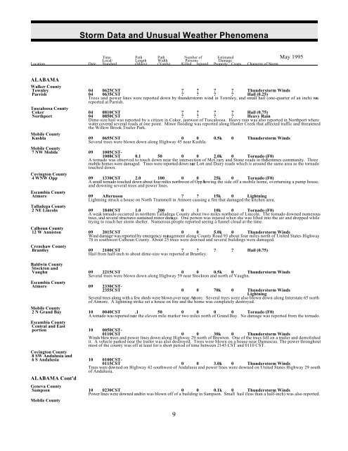
ALABAMA<br />
Walker County<br />
Townley 04 0625CST ? ? ? ? Thunderstorm Winds<br />
Parrish 04 0635CST ? ? ? ? Hail (0.25)<br />
Trees <strong>and</strong> power lines were reported down by thunderstorm wind in Townley, <strong>and</strong> small hail (one-quarter of an inch) was<br />
reported at Parrish.<br />
Tuscaloosa County<br />
Coker 04 0810CST ? ? ? ? Hail (0.75)<br />
Northport 04 0850CST ? ? ? ? Heavy Rain<br />
Dime-size hail was reported by a citizen in Coker, just west of Tuscaloosa. Heavy rain was also reported in Northport where<br />
water covered several roads at one point. Minor flooding was reported along Hunter Creek that affected traffic <strong>and</strong> threatened<br />
the Willow Brook Trailer Park.<br />
Mobile County<br />
Kushla 09 0655CST 0 0 0.5k 0 Thunderstorm Winds<br />
Several trees were blown down along Highway 45 near Kushla.<br />
Mobile County<br />
7 NW Mobile 09 1005CST-<br />
1008CST 0.1 50 0 0 2.0k 0 Tornado (F0)<br />
A tornado was observed to touch down near the intersection of McCrary <strong>and</strong> Stone roads in the Semmes community. Three<br />
mobile homes were damaged. Trees were reported down near Lott <strong>and</strong> Dairy roads which is around the same area as the tornado<br />
touched down.<br />
Covington County<br />
4 WNW Opp 09 1330CST 2.0 100 0 0 25k 0 Tornado (F0)<br />
A small tornado touched down about four miles northwest of Opp blowing the side off a mobile home, overturning a pump house,<br />
<strong>and</strong> downing several trees <strong>and</strong> power lines.<br />
Escambia County<br />
Atmore 09 Afternoon ? ? 15k 0 Lightning<br />
Lightning struck a house on North Trammell in Atmore causing a fire that damaged the kitchen area.<br />
Talladega County<br />
2 NE Lincoln 09 1840CST 1.0 200 0 1 10k 0 Tornado (F0)<br />
A weak tornado occurred in northern Talladega County about two miles northeast of Lincoln. The tornado downed numerous<br />
trees, <strong>and</strong> several structures sustained minor damage. One person was injured when she was lifted into the air <strong>and</strong> dropped while<br />
trying to reach her storm shelter. Numerous people reported seeing a funnel cloud at the time.<br />
Calhoun County<br />
12 W Anniston 09 2015CST 0 0 5.0k 0 Thunderstorm Winds<br />
Wind damage was reported by emergency management along County Road 93 about four miles north of United States Highway<br />
78 in southwest Calhoun County. About 25 trees were downed <strong>and</strong> several buildings were damaged.<br />
Crenshaw County<br />
Brantley 09 2100CST ? ?<br />
Hail from half-inch to about dime-size was reported at Brantley.<br />
? ? Hail (0.75)<br />
Baldwin County<br />
Stockton <strong>and</strong><br />
Vaughn 09 2215CST 0 0 0.5k 0 Thunderstorm Winds<br />
Several trees were blown down along Highway 59 near Stockton <strong>and</strong> north of Vaughn.<br />
Escambia County<br />
Atmore 09 2330CST-<br />
2355CST 0 0 70k 0 Thunderstorm Winds<br />
Lightning<br />
Several trees along with a few sheds were blown over near Atmore. Several trees were also blown down along Interstate 65 north<br />
of Atmore. A lightning strike set a house on fire <strong>and</strong> the home was completely destroyed.<br />
Mobile County<br />
2 N Gr<strong>and</strong> Bay 10 0040CST .1 50 0 0 0 0 Tornado (F0)<br />
A tornado was reported near the eleven mile marker two miles north of Gr<strong>and</strong> Bay. No damage was reported from the tornado.<br />
Escambia County<br />
Central <strong>and</strong> East<br />
portion 10 0050CST-<br />
0110CST 0 0 30k 0 Thunderstorm Winds<br />
Winds blew trees <strong>and</strong> power lines down along Highway 29 north of Brewton. One of the trees fell on a trailer <strong>and</strong> demolished<br />
it. A vehicle parked near the trailer was also destroyed. Trees were blown on a house near Damascus. The power throughout<br />
most of the county was off at least for a short period of time between 2145 CST <strong>and</strong> 0110 CST.<br />
Covington County<br />
8 SW Andalusia <strong>and</strong><br />
6 S Andalusia 10 0100CST-<br />
0115CST 0 0 3.0k 0 Thunderstorm Winds<br />
Trees were downed on Highway 42 southwest of Andalusia <strong>and</strong> power lines were downed on United States Highway 29 south<br />
of Andalusia.<br />
ALABAMA Cont'd<br />
Geneva County<br />
Sampson 10 0230CST 0 0 0.1k 0 Thunderstorm Winds<br />
Power lines were downed <strong>and</strong> tin was blown off of a building in Sampson. Small hail (less than a half-inch) was also reported.<br />
Mobile County<br />
9
<strong>Storm</strong> <strong>Data</strong> <strong>and</strong> <strong>Unusual</strong> <strong>Weather</strong> <strong>Phenomena</strong><br />
Time Path Path Number of Estimated May 1995<br />
Local/ Length Width Persons Damage<br />
Location Date St<strong>and</strong>ard (Miles) (Yards) Killed Injured Property Crops Character of <strong>Storm</strong><br />
Dauphin Is. 10 0325CST 0 0 0.3k 0 Hail (1.00)<br />
Thunderstorm Winds<br />
One-inch hail <strong>and</strong> wind gusts to 60 mph were reported on Dauphin Isl<strong>and</strong>.<br />
Baldwin County<br />
Fairhope<br />
power lines were blown down<br />
10<br />
Several<br />
0400CST<br />
trees <strong>and</strong><br />
0<br />
in the<br />
0<br />
Fairhope<br />
1k<br />
area.<br />
0 Thunderstorm Winds<br />
Madison County<br />
Huntsville 10 1439CST ? ? ? ? Funnel Cloud<br />
Hail (0.75)<br />
Chase 10 1508 CST ? ? ? ? Hail (1.75)<br />
A funnel cloud was observed by staff of the Environmental Science Department at the University of Alabama at Huntsville about<br />
a half mile south of the campus. Three-quarter inch hail was also observed on the campus. Golf ball-size hail was reported at<br />
Chase in the northeast part of Huntsville.<br />
Lamar County<br />
Kennedy 10 1526CST ?<br />
Half to three-quarter inch hail was reported at Kennedy.<br />
? ? ? Hail (0.75)<br />
Marion County<br />
Hamilton 10 2135CST 0 0<br />
Trees were blown down in Hamilton with a thunderstorm.<br />
0.5k 0 Thunderstorm Winds<br />
Winston County<br />
Haleyville 10 2300CST-<br />
2315CST 0<br />
Trees were down near Haleyville in Winston County.<br />
0 0.3k 0 Thunderstorm Winds<br />
Covington County<br />
? ? ? Hail (1.00)<br />
? ? ? Hail (0.75)<br />
Hail ranging from half to three-quarters of an inch was reported near Opp. Nickel to quarter-size hail was reported north fo<br />
Andalusia.<br />
2 N Andalusia<br />
Opp<br />
11<br />
11<br />
1700CST<br />
1710CST<br />
?<br />
?<br />
Houston County<br />
Wicksburg 11 1815CST ? ? ? ? Hail (0.75)<br />
12 SW Dothan 11 1825CST ? ? ? ? Hail (0.75)<br />
Hail up to three-quarters of an inch was reported across the southern portion of Houston County.<br />
Grangeburg<br />
Cottonwood<br />
11<br />
11<br />
1720CST<br />
1750CST<br />
?<br />
?<br />
?<br />
?<br />
?<br />
?<br />
?<br />
?<br />
Hail (0.50)<br />
Hail (0.75)<br />
Baldwin County<br />
Winds<br />
Seminole 11 1820CST 0 0 0.5k 0 Thunderstorm Winds<br />
Dime-size hail was reported in Gulf Shores. The storm that caused the hail then moved through Foley blowing some trees <strong>and</strong><br />
power poles down south of the city. The storm then blew trees <strong>and</strong> power lines down along Highway 90 near Seminole. The<br />
storm then weakened some as it moved into Northwest Florida.<br />
Gulf Shores<br />
Foley<br />
11<br />
11<br />
1750CST<br />
1757CST<br />
0<br />
0<br />
0<br />
0<br />
0<br />
1.0k<br />
0<br />
0<br />
Hail (0.75)<br />
Thunderstorm<br />
Escambia County<br />
Atmore 12 0920CST ? ? 15k 0 Lightning<br />
Lightning struck an office building on Highway 31 east of Atmore putting a hole in the roof but there was no fire.<br />
Morgan County<br />
10 E Hartselle 14 0845CST ? ? ? ? Hail (0.75)<br />
Three-quarter inch hail was reported at the intersection of County Road 36 <strong>and</strong> 67 about 10 miles east of Hartselle in central<br />
Morgan County.<br />
Dekalb County<br />
Powell 14 1115CST ? ? ? ? Hail (0.75)<br />
Jackson County<br />
Section 14 1115CST ? ? ? ? Hail (0.75)<br />
Three-quarter inch hail was reported from Powell in Dekalb County <strong>and</strong> Section in Jackson County. The two communities are<br />
about six miles apart on the Jackson/Dekalb county line.<br />
Franklin County<br />
South Portion<br />
15 1130CST-<br />
1145CST ? ? 95k 0 Thunderstorm Winds<br />
Hodges 15 1135CST ? ? ? ? Hail (0.75)<br />
Strong thunderstorm wind downed trees in scattered areas across the southern portion of the county. A tree fell on a house in<br />
Vina, considered one of the oldest in that town, destroying it. Damage was heaviest in the south-central <strong>and</strong> southeast<br />
ALABAMA Cont'd<br />
portion of the county.<br />
Marion County<br />
Mainly North 15 1145CST-<br />
1207CST ? ? 95k 0 Thunderstorm Winds<br />
<strong>Storm</strong> thunderstorm wind downded trees in scattered areas across the county. The emergency Medical Association director's<br />
barn was de-roofed by the wind. Most of the damage occurred across the northern portion of the county.<br />
Winston County<br />
15 1210CST-<br />
1245CST ? 1 80k 0 Thunderstorm Winds (G60)<br />
A strong thunderstorm moved southeast through Winston County on a diagonal course that took it from the northwest corner<br />
10
<strong>Storm</strong> <strong>Data</strong> <strong>and</strong> <strong>Unusual</strong> <strong>Weather</strong> <strong>Phenomena</strong><br />
Time Path Path Number of Estimated May 1995<br />
Local/ Length Width Persons Damage<br />
Location Date St<strong>and</strong>ard (Miles) (Yards) Killed Injured Property Crops Character of <strong>Storm</strong><br />
of the county to the southeast corner of the county. Widespread wind damage generally in the form of trees <strong>and</strong> power lines<br />
down was reported throughout the county. The most significant damage occurred in a narrow b<strong>and</strong> running from about five miles<br />
east of Double Springs southeast through the southern side of Arley. Damage was the heaviest to trees <strong>and</strong> some buildings on<br />
Smith Lake just to the west-northwest of Arley <strong>and</strong> on the south side of Arley. Evidence on the southside of Arley suggested<br />
the occurrence of a microburst. One person was reported injured in the Addison area, however, no specifics were available.<br />
Cullman County<br />
Hanceville 15 1222CST<br />
Golf ball-size hail was reported at Hanceville.<br />
? ? ? ? Hail (1.75)<br />
Walker County<br />
Northeast <strong>and</strong><br />
East-Central 15 1240CST-<br />
1300CST ? ? 40k 0 Thunderstorm Winds (G60)<br />
Thunderstorm wind uprooted trees, downed power lines, <strong>and</strong> caused roof damage to several structures primarily in the northeast<br />
<strong>and</strong> east-central sections of Walker County. The communities of Curry, Sipsey, Jasper, <strong>and</strong> Sumiton were affected by the storm.<br />
A church in the Smith Lake area lost its steeple in the wind.<br />
Blount County<br />
Clevel<strong>and</strong><br />
reported at Clevel<strong>and</strong>.<br />
15<br />
Quarter-size<br />
1245CST<br />
hail was<br />
? ? ? ? Hail (1.00)<br />
Jefferson County<br />
Birmingham 15 1305CST-<br />
1340CST ? 3 0.5M 0 Thunderstorm Winds (G60)<br />
Warrior 15 1310CST ? ? 25k 0 Thunderstorm Winds (G55)<br />
Airport BHM 15 1312CST ? ? ? ? Thunderstorm Winds (G62)<br />
Gardendale 15 1313CST ? ? ? ? Hail (0.88)<br />
Much of Jefferson County was affected by a strong thunderstorm with wind gusts to hurricane force <strong>and</strong> large hail. Dime <strong>and</strong><br />
nickel-size hail was reported in Gardendale. Trees were downed in scattered areas especially across the northern two-thirds of<br />
Jefferson County. Trees were uprooted in Bluff Park, a tree fell on a car near downtown Birmingham in the University fo<br />
Alabama at Birmingham area, <strong>and</strong> numerous trees were down in the Roebuck area of northeast Birmingham. All of the<br />
Birmingham television stations on Red Mountain were knocked off the air by the high wind <strong>and</strong> the large WBRC sign at Channel<br />
6 was destroyed. The buildings at Channel 6 <strong>and</strong> 13 suffered minor damage. Most of the radio stations located along Red<br />
Mountain were also off the air for a period of time. More than 99,000 electric customers were without power after the storm.<br />
A security guard was injured when he was struck in the knee with a piece of flying metal. A woman had to have the tip of her<br />
finger amputated when the wind slammed a car door on her finger. A woman was injured at the Birmingham Zoo when a tree<br />
limb fell on her arm. Wind at the Birmingham Airport was measured from the northwest at 71 miles an hour at 1312 CST.<br />
Cullman County<br />
Cullman to<br />
Hanceville 15 1315CST ? ? .65M ? Hail (3.75)<br />
Hail up to softball-size was reported in the area from southern Cullman to Hanceville. Numerous cars sustained damage in the<br />
hail including one Chevrolet dealership where every car sustained hail damage.<br />
Tuscaloosa County<br />
Tuscaloosa 15 1346CST ? ? ? ? Hail (1.00)<br />
10 E Tuscaloosa 15 1345CST ? ? ? ? Hail (0.75)<br />
Tuscaloosa 15 1349CST ? ? ? ? Hail (1.00)<br />
Quarter-size hail was reported in the Taylorville area in south Tuscaloosa, across parts of Tuscaloosa, <strong>and</strong> at Alberta about 10<br />
miles east of Tuscaloosa.<br />
Calhoun County<br />
5 W Jacksonville 15 1343CST ? ? 08k ? Thunderstorm Winds<br />
Jacksonville 15 1350CST ? ? ? ? Hail (1.00)<br />
Oxford 15 1400CST ? ? 14k 0 Thunderstorm Winds (G57)<br />
Thunderstorm wind blew down trees in the Angel Station area west of Jacksonville <strong>and</strong> quarter-size hail was reported ta<br />
Jacksonville. Wind gusted to 66 miles an hour near the interstate at Oxford. Trees were downed <strong>and</strong> at least one fell on a house.<br />
About 4,500 electric customers were without power.<br />
Talladega County<br />
Childersburg 15 1357CST ? ? 0.5k 0 Thunderstorm Winds<br />
Large trees were blown down in Childersburg.<br />
ALABAMA Cont'd<br />
Shelby County<br />
6 NW Chelsea 15 1355CST ? ? ? ? Thunderstorm Winds<br />
Chelsea 15 1402CST ? ? 0.2k 0 Thunderstorm Winds<br />
Approximately 150 trees were blown down at the Greystone Country Club in northern Shelby County. Large trees were blown<br />
down in the Chelsea area of Shelby County.<br />
Clay County<br />
Lineville 15 1423CST ? ? 0.1M 0 Thunderstorm Winds<br />
Thunderstorm wind destroyed a maintenance building <strong>and</strong> a tire company building in the Lineville Industrial Park South. A<br />
house on Highway 9 east of Ashl<strong>and</strong> was heavily damaged when a large tree fell on it. Several mobile homes in the area<br />
sustained light to moderate damage.<br />
Bibb County<br />
Centreville 15 1424CST ? ? ? ? Hail (1.00)<br />
5 SW Brent 15 1438CST ? ? ? ? Thunderstorm Winds (G50)<br />
Quarter-size hail was reported. A wind gust to 58 miles an hour was recorded at the National <strong>Weather</strong> Service Office located<br />
five miles southwest of Brent.<br />
Elmore County<br />
6 NE Eclectic 15 1445CST ? ? 2k 0 Thunderstorm Winds<br />
11
<strong>Storm</strong> <strong>Data</strong> <strong>and</strong> <strong>Unusual</strong> <strong>Weather</strong> <strong>Phenomena</strong><br />
Time Path Path Number of Estimated May 1995<br />
Local/ Length Width Persons Damage<br />
Location Date St<strong>and</strong>ard (Miles) (Yards) Killed Injured Property Crops Character of <strong>Storm</strong><br />
Power was out <strong>and</strong> trees were reported down in northeast Elmore County about six miles northeast of Eclectic. The area affected<br />
was around the Highway 63 <strong>and</strong> 229 intersection.<br />
Chilton County<br />
Maplesville 15 1454CST ?<br />
Three-quarter inch hail was reported at Maplesville.<br />
? ? ? Hail (0.75)<br />
Cleburne County<br />
Cleburne 15 1457CST ? ? 2k 0 Thunderstorm Winds<br />
Numerous reports of trees blown down in Cleburne.<br />
R<strong>and</strong>olph County<br />
15 1500CST ? ? 20k 0 Thunderstorm Winds<br />
Numerous trees were blown down by strong wind across the southern portion of R<strong>and</strong>olph County. One tree fell on a church<br />
in Roanoke, <strong>and</strong> the police department reported trees on several houses.<br />
Lee County<br />
County wide 15 1500CST-<br />
1550CST ? ? 15k 0 Thunderstorm Winds<br />
Opelika 15 1522CST ? ? ? ? Thunderstorm Winds (G50)<br />
A wind gust to 57 miles an hour was reported at the East Alabama Medical Center on their measuring equipment in Opelika.<br />
Trees were downed in scattered areas across the county. One tree fell <strong>and</strong> blocked a road for a short time on the Aubur n<br />
University campus.<br />
Macon County<br />
Tallassee 15 1515CST ? ? ? ? Thunderstorm Winds<br />
Tuskegee 15 1525CST ? ? ? ? Hail (0.75)<br />
Nr Tuskegee 15 1540CST ? ? ? ? Hail (0.75)<br />
Thunderstorm Winds<br />
Dime-size hail was reported by Tuskegee Police near mile marker 34 on Interstate 85. Three-quarter inch hail was also reported<br />
in Tuskegee where hail reportedly covered the ground. Wind with the thunderstorm also downed trees in scattered areas across<br />
the county. Numerous trees were reported down in Tallassee. A tree fell on an automobile in front of the Municipal Building<br />
in Tuskegee.<br />
Chambers County<br />
Countywide 15 1600CST ? ? 12k 0 Thunderstorm Winds<br />
Strong thunderstorm wind downed trees in scattered areas across the county. A house in Lanett sustained minor roof damage<br />
in the wind.<br />
Sumter County<br />
Livingston 15 1759CST ? ? 2k 0 Thunderstorm Winds<br />
York 15 1813CST ? ? 5k 0 Thunderstorm Winds<br />
Trees were reported blown down in Livingston <strong>and</strong> York.<br />
Marengo County<br />
6 SSW Demopolis 15 1810CST-<br />
1815CST ? ? 5k ? Thunderstorm Winds<br />
Linden 15 1845CST-<br />
1855CST ? ? 8k 0 Thunderstorm Winds<br />
Trees were reported down in the area south-southwest of Demopolis between Demopolis <strong>and</strong> Jefferson. Numerous trees were<br />
blown down in Linden especially on the north side of town.<br />
Clarke County<br />
Fulton 15 1930CST 0 0 0.5k 0 Thunderstorm Winds<br />
Several trees <strong>and</strong> power lines were blown down along State Highway 178 between Fulton <strong>and</strong> Greenwood.<br />
Wilcox County<br />
15 1939CST ? ? 5k 0 Thunderstorm Winds<br />
Numerous trees were reported down on County Road 1 <strong>and</strong> County Road 9.<br />
ALABAMA Cont'd<br />
Monroe County<br />
Franklin 15 1950CST 0 0 0.5k 0 Thunderstorm Winds<br />
Several trees were blown down along State Highway 41 between Fountain <strong>and</strong> Franklin.<br />
Clay County<br />
8 S Lineville 16 1730CST ? ? ? ? Hail (1.00)<br />
Three-quarters to one-inch hail was reported at Mellow Valley in the southeastern quarter of Clay County, about eight miles south<br />
of Lineville along Highway 49.<br />
R<strong>and</strong>olph County<br />
Almond 16 1810CST ? ? ? ? Hail (1.00)<br />
Rockdale 16 1816CST ? ? ? ? Hail (0.75)<br />
One-inch hail was reported covering the ground at Almond. Three-quarter inch hail was observed near Rockdale.<br />
Colbert County<br />
10 SE Cherokee 18 1514CST ? ? ? ? Hail (1.75)<br />
10 S Cherokee 18 1518CST ? ? ? ? Hail (1.75)<br />
Cherokee 18 1520CST ? ? ? ? Hail (1.00)<br />
2 E Cherokee 18 1525CST ? ? ? ? Hail (1.75)<br />
S Cherokee 18 1532CST ? ? ? ? Hail (2.75)<br />
2 E Muscle Shoals 18 1545CST-<br />
1551CST 6.5 150 0 0 80k 0 Tornado (F1)<br />
A supercell thunderstorm moved out of Mississippi into Colbert County producing numerous reports of large hail. A smal l<br />
tornado touched down about two miles east of the Muscle Shoals airport (MSL) <strong>and</strong> moved on a path about six <strong>and</strong> one-half<br />
miles in length. Several buildings sustained some damage along with power lines <strong>and</strong> trees down. Emergency Medica l<br />
Association reported that five houses <strong>and</strong> three mobile homes were damaged.<br />
12
<strong>Storm</strong> <strong>Data</strong> <strong>and</strong> <strong>Unusual</strong> <strong>Weather</strong> <strong>Phenomena</strong><br />
Time Path Path Number of Estimated May 1995<br />
Local/ Length Width Persons Damage<br />
Location Date St<strong>and</strong>ard (Miles) (Yards) Killed Injured Property Crops Character of <strong>Storm</strong><br />
Lauderdale County<br />
Florence 18 1540CST ? ? ? ? Hail (1.75)<br />
Killen 18 1555CST ? ? ? ? Hail (1.75)<br />
3 NW Rogersville 18 1620CST ? ? ? ? Hail (1.75)<br />
Golf ball-size hail was reported in downtown Florence, at Killen, <strong>and</strong> three miles northwest of Rogersville. The ground was white<br />
with hail at Killen.<br />
Limestone County<br />
12 NW Athens 18 1630CST ? ? ? ? Hail (3.75)<br />
11 WNW Athens 18 1630CST ? ? ? ? Thunderstorm Winds<br />
4 SE Ardmore 18 1659CST ? ? ? ? Hail (1.75)<br />
Softball-size hail was reported just south of Salem in western Limestone County. Trees were also reported down in Cairo, also<br />
in western Limestone County. Golf ball-size hail was reported in northwest Limestone County not far from the<br />
Madison/Limestone county line.<br />
Limestone, Madison,<br />
Jackson counties<br />
3 NW Athens to<br />
15 NW Scottsboro 18 1633CST-<br />
1728CST 39 1300 1 55 5M 0 Tornado (F4)<br />
A supercell thunderstorm produced a violent tornado that began 3 miles northwest of Athens in Limestone County <strong>and</strong> moved<br />
on a path just slightly north of east completely across Madison County before ending in northwestern Jackson County about 15<br />
miles northwest of Scottsboro. The tornado path varied from very narrow at the beginning <strong>and</strong> end to about three-quarters of<br />
a mile wide at the widest location in Madison County. Intensity varied from F0 intensity near both ends of the track to F4 at the<br />
strongest in several locations in Madison County. Damage along the track was primarily in the F2 <strong>and</strong> F3 category. Evidence<br />
in the damage as seen through an aerial survey indicated that the tornado was probably a multiple vortex with indications of at<br />
least two vortices within the main tornado funnel.<br />
The tornado began at 1633 CST in Limestone County crossing Interstate 65 <strong>and</strong> Highway 251 where the mobile home park was<br />
destroyed. It reached the Limestone/Madison county line at 1650 CST. The trek across Madison County saw the tornado move<br />
near the communities of Harvest, Meridianville, Buckhorn, <strong>and</strong> Fannings Crossing before moving into the rugged terrain fo<br />
eastern Madison County. The tornado crossed the Madison/Jackson county line at 1721 CST. The tornado track was much<br />
weaker in Jackson County as it moved through rugged terrain affecting very few structures. The track ended about 15 miles<br />
northwest of Scottsboro or a few miles west of the community of Hytop.<br />
Damage was the heaviest at a mobile home park about three miles northeast of Athens along Highway 251. The only fatality<br />
that occurred in this tornado occurred at this mobile home park, <strong>and</strong> the person died later from injuries received in the tornado.<br />
Twenty-six mobile homes were destroyed in Limestone County, 13 in the Oakdale Mobile Home Park. Another 35 buildings<br />
were damaged or destroyed in Limestone County where damage was estimated to be $1.5 million. About 9,500<br />
electric customers were without electricity. A cow was also killed when a large tree fell on <strong>and</strong> crushed it.<br />
Another especially hard hit area was Anderson Hills subdivision in Madison County with houses ranging in price from $175,000<br />
to $400,000. This area of well-constructed dwellings was one of the locations where F4 damage was evident as well sa<br />
indications of a multiple vortex structure. In Anderson Hills, 21 houses were destroyed <strong>and</strong> 39 sustained major damage. Damage<br />
across the rest of Madison County was less concentrated than in this one subdivision. Over 10,000 Huntsville Utility Company<br />
customers were without power.<br />
M30M<br />
Limestone County<br />
10 NNE Athens 18 1648CST ? ? ? ? Hail (1.75)<br />
Golf ball-size hail was reported in northern Limestone County along with the tornado.<br />
Madison County<br />
ALABAMA Cont'd<br />
Toney 18 1700CST<br />
Golf ball-size hail covered the ground at Toney.<br />
? ? ? ? Hail (1.75)<br />
Sumter County<br />
York<br />
11 S Livingston<br />
18<br />
18<br />
1700CST<br />
1705CST<br />
?<br />
?<br />
?<br />
?<br />
?<br />
?<br />
?<br />
?<br />
Hail (1.75)<br />
Hail (0.75)<br />
Golf ball-size hail was reported at York <strong>and</strong> dime-size hail was reported 11 miles south of Livingston.<br />
Franklin County<br />
One-inch hail was reported in at Red Bay. A funnel cloud was reported over downtown Russellville.<br />
Red Bay<br />
Russellville<br />
18<br />
18<br />
1726CST<br />
1757CST<br />
?<br />
?<br />
?<br />
?<br />
?<br />
?<br />
?<br />
?<br />
Hail (1.00)<br />
Funnel Cloud<br />
Colbert County<br />
Littleville<br />
hail was reported at Littleville<br />
18<br />
Three-quarter<br />
1758CST<br />
inch<br />
?<br />
in<br />
?<br />
southeast<br />
?<br />
Colbert<br />
?<br />
County.<br />
Hail (0.75)<br />
Marengo County<br />
Demopolis 18 1744CST 0<br />
Trees were reported down in the city of Demopolis.<br />
0 0.2k 0 Thunderstorm Winds<br />
Lauderdale County<br />
Florence 18 1753CST ? ? ? ? Funnel Cloud<br />
Petersville 18 1756CST ? ? ? ? Wall Cloud/Funnel Cloud<br />
14 NE Florence 18 1803CST 1.5 120 0 0 0.2M 0 Tornado (F1)<br />
Florence 18 1810CST ? ? ? ? Hail (1.00)<br />
4 E Killen 18 1827CST ? ? ? ? Hail (1.75)<br />
Funnel clouds were reported with a storm that moved from the northern portion of Florence northeastward to the area of the<br />
Green Hill community about 14 miles northeast of Florence. Just south of the Green Hill community, a small tornado damaged<br />
about 10 houses in the vicinity of County Road 47 <strong>and</strong> United States 43. Ten houses were damaged including several homes<br />
that lost roofs or portions of roofs <strong>and</strong> several barns were destroyed. Numerous trees <strong>and</strong> power lines were down.<br />
13
<strong>Storm</strong> <strong>Data</strong> <strong>and</strong> <strong>Unusual</strong> <strong>Weather</strong> <strong>Phenomena</strong><br />
Time Path Path Number of Estimated May 1995<br />
Local/ Length Width Persons Damage<br />
Location Date St<strong>and</strong>ard (Miles) (Yards) Killed Injured Property Crops Character of <strong>Storm</strong><br />
R<strong>and</strong>olph County<br />
Roanoke 18 2040CST ? ? 2k 0 Hail (1.00)<br />
7 NE Roanoke 18 2040CST ? ? ? ? Hail (1.00)<br />
Quarter-size hail was reported seven miles northeast of Roanoke at the Springfield community <strong>and</strong> along Highway 87 ni<br />
Roanoke.<br />
Jefferson County<br />
Fairfield 25 1655CST ? ? ? ? Hail (0.75)<br />
Dime-size hail was reported by the Jefferson County Sheriff's Department at Fairfield.<br />
Fayette County<br />
Fayette 28 1122CST 0 0 0.2k 0 Thunderstorm Winds<br />
Hail (0.75)<br />
Fayette 28 1130CST-<br />
1150CST 0 0 18k 0 Thunderstorm Winds<br />
Hail (1.00)<br />
Trees <strong>and</strong> power lines were downed by wind in Fayette along with reports of dime-size hail around 1122 CST <strong>and</strong> quarter-size<br />
hail between 1130 <strong>and</strong> 1150 CST. The worst damage reported was at the Fayette County High School where two bleachers were<br />
blown off their concrete pads <strong>and</strong> twisted into a heap of aluminum about 50 feet away. A chain link backstop was also blown<br />
down.<br />
Pickens County<br />
4 NE Carrollton 28 1130CST ? ? ? ? Hail (0.75)<br />
Dime -ze hail along with small hail was reported at Stansel about four miles northeast of Carrollton along Highway 17.<br />
Tuscaloosa County<br />
Tuscaloosa 28 1220CST ? ? ? ? Funnel Cloud<br />
Tuscaloosa 28 1240CST ? ? ? ? Thunderstorm Winds<br />
A funnel cloud was reported in the Queen City Avenue area of Tuscaloosa. Thunderstorm wind also downed trees <strong>and</strong> power<br />
lines in the city with reports of at least one store front window blown out. About 2,300 power customers were without power<br />
at one point.<br />
Bibb County<br />
5 W Centreville 28 1338CST 0 0 0.2k 0 Thunderstorm Winds<br />
Power lines were downed in western sections of Bibb County along with at least one power pole in Centreville.<br />
Sumter County<br />
Bellamy 28 1347CST 0 0 0.2k 0 Thunderstorm Winds<br />
Ward 28 1350CST ? ? ? ? Funnel Cloud<br />
Ten to 12 trees were reported downed in Bellamy in southern Sumter County. A funnel cloud was also reported near Ward in<br />
southern Sumter County.<br />
Clarke County<br />
Thomasville 28 1810CST 0 0 0.5k 0 Thunderstorm Winds<br />
ALABAMA Cont'd<br />
Several trees were blown down along State Highway 5 just northeast of Thomasville.<br />
Mobile County<br />
Dauphin Isl<strong>and</strong> 29 2030CST 0 0 0 0 Hail (0.75)<br />
Dime-size hail was reported along Daupin Isl<strong>and</strong> Parkway near Dauphin Isl<strong>and</strong>.<br />
Mobile County<br />
Mobile 30 1005CST 0 0 0.1M 0 Lightning<br />
Lightning struck a house in west Mobile causing a fire that destroyed about 75 percent of the roof.<br />
ARIZONA<br />
Maricopa County<br />
Peoria 06 2244MST 0 0 0 0 Funnel Cloud<br />
Yavapai County<br />
Lake Montezuma 12 1620MST 0 0 0 0 High Winds (G61)<br />
Lake Montezuma 13 1043MST 0 0 0 0 High Winds (G57)<br />
Strong, gusty winds were reported at Lake Montezuma. Location of spotter within canyon suggests that the strong winds were<br />
enhanced by local terrain.<br />
Yavapai County<br />
2 SW Prescott 16 1515MST 0 0 0 0 Hail (0.75)<br />
Prescott 16 1525MST 0 0 0 0 Hail (0.75)<br />
Several reports of hail up to three-quarters inches. A spotter reported hail up to one-half inch in diameter covering the ground.<br />
Coconino County<br />
Fredonia 26 1500MST 0 0 0 0 Hail (1.00), Funnel Cloud<br />
Thunderstorm produced one inch hail <strong>and</strong> accumulated two to three inches. Brief funnel cloud was spotted over Kaibab National<br />
Forest.<br />
Coconino County<br />
1 W Flagstaff 26 1605MST 0 0 0 0 Hail (0.80)<br />
Coconino County<br />
5 W Flagstaff 26 1615MST 0 0 0 0 Funnel Clouds<br />
Two funnel clouds witnessed by Flagstaff National <strong>Weather</strong> Service personnel at Bellemont <strong>Weather</strong> Service Office.<br />
Coconino County<br />
8 SE Flagstaff 26 1710MST 0 0 0 0 Funnel Cloud<br />
Funnel cloud one mile southeast of Flagstaff airport spotted by tower personnel. Simultaneous sighting by Walnut Canyon<br />
National Park Ranger.<br />
ARKANSAS, Central<br />
14
<strong>Storm</strong> <strong>Data</strong> <strong>and</strong> <strong>Unusual</strong> <strong>Weather</strong> <strong>Phenomena</strong><br />
Time Path Path Number of Estimated May 1995<br />
Local/ Length Width Persons Damage<br />
Location Date St<strong>and</strong>ard (Miles) (Yards) Killed Injured Property Crops Character of <strong>Storm</strong><br />
Faulkner County<br />
Conway 01 0005CST 0 0 0 0 Hail (1.00)<br />
Prairie County<br />
5 N Des Arc 01 0015CST 0 0 0 0 Hail (0.75)<br />
Polk County<br />
Mena 01 0030CST 0 0 0 0 Hail (0.75)<br />
Woodruff County<br />
Hunter 01 0100CST 0 0 0 0 Hail (0.75)<br />
White County<br />
Rose Bud 01 0110CST 0 0 0 0 Hail (0.75)<br />
Johnson County<br />
Hagarville 08 0030CST 0 0 ? 0 Thunderstorm Winds<br />
Thunderstorms winds damaged a barn <strong>and</strong> chicken house <strong>and</strong> also knocked down some trees.<br />
Pope County<br />
Long Pool 08 0100CST 0 0 ? 0 Thunderstorm Winds (G48)<br />
Thunderstorm winds downed a few trees.<br />
Sevier County<br />
Lockesburg 08 0125CST<br />
Thunderstorm winds downed some trees.<br />
0 0 ? 0 Thunderstorm Winds<br />
Little River County<br />
Ashdown 08 0130CST 0 0<br />
Thunderstorm winds downed numerous trees <strong>and</strong> power lines.<br />
? 0 Thunderstorm Winds<br />
Foreman 08 0130CST 0<br />
Thunderstorm winds blew down some power lines.<br />
0 ? 0 Thunderstorm Winds<br />
Miller County<br />
M<strong>and</strong>eville 08 0150CST 0<br />
Thunderstorm winds downed trees <strong>and</strong> power lines.<br />
0 ? 0 Thunderstorm Winds<br />
Pike County<br />
Delight 08 0415CST 0 0 0 0 Hail (3.00)<br />
Columbia County<br />
Taylor 08 0430CST 0 0 ? 0 Thunderstorm Winds<br />
ARKANSAS, Central Cont'd<br />
Thunderstorm winds blew the roofs off several chicken houses. Several homes also sustained roof damage. Numerous trees were<br />
also blown down.<br />
Lafayette County<br />
Walker Creek 08 0435CST<br />
Thunderstorm winds downed some trees.<br />
0 0 ? 0 Thunderstorm Winds<br />
Clark County<br />
10 SW Arkadelphia 08 0440CST<br />
Thunderstorm winds downed numerous trees.<br />
0 0 ? 0 Thunderstorm Winds<br />
Garl<strong>and</strong> County 08 0440CST-<br />
0745CST 0 0 ? 0 Flash Flood<br />
Heavy rains resulted in flash flooding across Garl<strong>and</strong> County. Several streets in Hot Springs <strong>and</strong> numerous county roads were<br />
under water.<br />
Grant County<br />
10 NW Sheridan<br />
blew down a few trees.<br />
08<br />
Thunderstorm<br />
0600CST<br />
winds<br />
0 0 ? 0 Thunderstorm Winds<br />
Jefferson County<br />
12 SW Pine Bluff 08 0640CST 0 0 0 0 Hail (0.75)<br />
White County<br />
Bald Knob 14 0115CST 0 0 ? 0 Thunderstorm Winds<br />
Hail (1.75)<br />
Thunderstorm winds downed some power lines.<br />
Woodruff County<br />
Bruno 14 1500CST 0 0 0 0 Hail (0.75)<br />
Searcy County<br />
Silver Hill 14 1815CST 0 0 0 0 Hail (0.75)<br />
Franklin County<br />
1 N Ozark 15 0510CST 0 0 0 0 Hail (0.88)<br />
Logan County<br />
3 W Paris 15 0525CST 0 0 0 0 Hail (1.75)<br />
Desha County<br />
McArthur 15 1315CST 0 0 ? 0 Lightning<br />
Lightning struck a house in McArthur which resulted in a fire. The house sustained some minor damage.<br />
5 N Augusta<br />
Marion County<br />
14 0115CST 0 0 0 0 Hail (1.00)<br />
Arkansas City 15 1340CST 0 0 0 0 Hail (1.75)<br />
Watson 15 1757CST 0 0 0 0 Hail (1.00)<br />
Drew County<br />
7 W Lacey 15 1900CST 0 0 0 1M Hail (2.00)<br />
7 W Lacey 15 1915CST 0 0 0 ? Hail (2.00)<br />
7 W Lacey 15 2009CST 0 0 0 ? Hail (2.00)<br />
15
<strong>Storm</strong> <strong>Data</strong> <strong>and</strong> <strong>Unusual</strong> <strong>Weather</strong> <strong>Phenomena</strong><br />
Time Path Path Number of Estimated May 1995<br />
Local/ Length Width Persons Damage<br />
Location Date St<strong>and</strong>ard (Miles) (Yards) Killed Injured Property Crops Character of <strong>Storm</strong><br />
Hail up to two inches in diameter fell across the southwest part of Drew County. The hail fell for more than an hour <strong>and</strong> caused<br />
extensive damage to the tomato crop. Crop damage was estimated at around $1,000,000.<br />
Monticello 15 1930CST-<br />
2200CST 0 0 ? 0 Flash Flood<br />
Heavy rains resulted in flash flooding in <strong>and</strong> around Monticello. Many low-lying areas <strong>and</strong> several county roads were under<br />
water for a period of time.<br />
6 N Monticello 15 2020CST 0 0 0 0 Hail (0.75)<br />
Bradley County<br />
5 S Warren 15 1945CST 0 0 ? ? Hail (2.00)<br />
5 S Warren 15 2000CST 0 0 ? ? Hail (2.00)<br />
5 S Warren 15 2015CST 0 0 ? ? Hail (2.00)<br />
5 S Warren 15 2045CST 0 0 ? ? Hail (2.00)<br />
5 S Warren 15 2055CST 0 0 ? ? Hail (2.00)<br />
Hail up to two inches in diameter fell over portions of eastern Bradley County. The hail fell for a little more than an hour <strong>and</strong><br />
caused some roof damage <strong>and</strong> also damaged some tomato crops.<br />
Pope County<br />
10 N Dover<br />
downed several trees.<br />
17<br />
Thunderstorm<br />
1600CST<br />
winds<br />
0 0 ? 0 Thunderstorm Winds<br />
Franklin County<br />
3 E Mulberry 17 2115CST 0<br />
Thunderstorm winds blew down a couple of trees.<br />
0 ? 0 Thunderstorm Winds<br />
Union County<br />
10 S El Dorado 18 0600CST<br />
Thunderstorm winds blew down some trees.<br />
0 0 ? 0 Thunderstorm Winds<br />
Bradley County<br />
Warren 18 0630CST 0 0 ? 0 Thunderstorm Winds<br />
ARKANSAS, Central Cont'd<br />
some roofs were damaged by fallen trees.<br />
Thunderstorm winds knocked down several large trees. A steeple was blown off a church, a small barn was destroyed <strong>and</strong><br />
Desha County<br />
Dumas 18 0640CST 0 0 0 0 Thunderstorm Winds (G50)<br />
Johnson County<br />
6 NW Scottsville 24 1820CST 0 0 0 0 Hail (0.75)<br />
Marion County<br />
Bull Shoals 24 1914CST 0 0 0 0 Hail (0.75)<br />
Howard County<br />
Dierks 24 2200CST 0 0 ? 0 Thunderstorm Winds<br />
Thunderstorm winds downed a few trees.<br />
7 N Clarksville<br />
Pope County<br />
24 1730CST 0 0 0 0 Hail (0.88)<br />
3 S Tollette 24 2330CST 0<br />
Thunderstorm winds knocked down several trees.<br />
0 ? 0 Thunderstorm Winds<br />
Arkansas County<br />
1 NW Stuttgart 25 1715CST 0 0 0<br />
Hail up to dime-size fell for several minutes <strong>and</strong> damaged some crops.<br />
? Hail (0.75)<br />
Clark County<br />
Arkadelphia 26 1330CST<br />
Thunderstorm winds downed some trees.<br />
0 0 ? 0 Thunderstorm Winds<br />
Logan County<br />
5 W Booneville 26 1330CST 0 0<br />
Golf ball-size hail damaged two Highway Department vehicles.<br />
? 0 Hail (1.75)<br />
1 W Booneville 26 1335CST 0 0 0 0 Hail (0.88)<br />
Hot Spring County<br />
Bismarck 26 1350CST 0 0 0 0 Thunderstorm Winds (G52)<br />
Garl<strong>and</strong> County<br />
Hot Springs 26 1400CST 0 0 ? 0 Thunderstorm Winds (G61)<br />
Thunderstorm winds downed a few trees.<br />
1 S Hot Springs 26 1405CST 0 0 0 0 Thunderstorm Winds (G61)<br />
Hot Springs 26 1410CST 0 0 0 0 Thunderstorm Winds (G50)<br />
Hot Springs 26 1414CST 0 0 ? 0 Thunderstorm Winds<br />
Thunderstorm winds downed trees <strong>and</strong> power lines <strong>and</strong> tore the roof off a storage building.<br />
Lonoke County<br />
Carlisle 26 1500CST 0 0 0 0 Hail (0.75)<br />
Pope County<br />
Russellville 26 1605CST 0 0 ? 0 Thunderstorm Winds<br />
Thunderstorm winds blew down a large tree onto several parked cars.<br />
Yell County 26 1615CST-<br />
Dardanelle 1915CST 0 0 ? 0 Flash Flood<br />
Heavy rains caused some flash flooding in Dardanellle. Several streets in Dardanelle were under water for a period of time.<br />
White County<br />
Beebe<br />
Jefferson County<br />
26 1625CST 0 0 0 0 Hail (1.75)<br />
16
<strong>Storm</strong> <strong>Data</strong> <strong>and</strong> <strong>Unusual</strong> <strong>Weather</strong> <strong>Phenomena</strong><br />
Time Path Path Number of Estimated May 1995<br />
Local/ Length Width Persons Damage<br />
Location Date St<strong>and</strong>ard (Miles) (Yards) Killed Injured Property Crops Character of <strong>Storm</strong><br />
1 SW Pine Bluff 27 1620CST 0 0 0 0 Hail (1.75)<br />
1 SW Pine Bluff 27 1650CST 0 0 0 0 Hail (0.75)<br />
Garl<strong>and</strong> County<br />
Hot Springs 27 1725CST 0 0 0 0 Hail (0.88), Lightning<br />
Lightning struck an apartment building in Hot Springs which resulted in a fire.<br />
Hot Springs 27 1800CST-<br />
2100CST 0 0 ? 0 Flash Flood<br />
Heavy rains caused flash flooding in <strong>and</strong> around Hot Springs. Several city streets were covered with high water for a period of<br />
time.<br />
Saline County<br />
1 S Owensville 27 1830CST 0 0 0 0 Hail (0.75)<br />
Woodl<strong>and</strong> Hills 27 1912CST 0 0 0 0 Hail (0.75)<br />
Pope County<br />
Scottsville 27 2300CST 0 0 ? 0 Thunderstorm Winds<br />
Thunderstorm winds knocked down a few trees.<br />
Bradley County<br />
Marsden 28 1550CST 0 0 0 0 Hail (1.00)<br />
Scott County<br />
Waldron 31 1245CST 0 0 0 0 Hail (0.75)<br />
Clark County<br />
Curtis 31 1410CST 0 0 ? 0 Thunderstorm Winds<br />
ARKANSAS, Central Cont'd<br />
Thunderstorm winds downed some large tree limbs.<br />
Montgomery County<br />
Pine Ridge 31 1445CST 0 0 0 0 Hail (1.00)<br />
Ouachita County<br />
1 S Camden 31 1535CST 0 0 0 Thunderstorm Winds<br />
Thunderstorm winds blew down some large tree limbs.<br />
Bradley County<br />
5 S Warren 31 1645CST 0 0 ? ? Hail (1.00)<br />
Hail up to one inch in diameter damaged some tomato crops south of Warren. Some roof damage was also reported.<br />
Drew County<br />
Rock Springs 31 1700CST<br />
Thunderstorm winds downed several trees.<br />
0 0 ? 0 Thunderstorm Winds<br />
Desha County<br />
3 E McGehee 31 1735CST 0 0 ? 0<br />
Thunderstorm winds caused some roof damage <strong>and</strong> blew over a storage building.<br />
Thunderstorm Winds<br />
ARKANSAS, Northwestern<br />
Benton County<br />
Hiawasse 07 2200CST 0 0 ? 0 Thunderstorm Winds<br />
Cherokee City<br />
Sulphur Springs<br />
07<br />
07<br />
2158CST<br />
2159CST<br />
0<br />
0<br />
0<br />
0<br />
?<br />
?<br />
0<br />
0<br />
Thunderstorm Winds<br />
Thunderstorm Winds<br />
Washington County<br />
2 W Lincoln 07 2205CST 0 0 ? 0 Hail (0.75)<br />
Carroll County<br />
Eureka Springs 07 2240CST 0 0 ? 0 Thunderstorm Winds<br />
Madison County<br />
Huntsville 07 2310CST 0 0 ? 0 Thunderstorm Winds (G52)<br />
Sebastian County<br />
Fort Smith 07 2355CST 0 0 ? 0 Hail (0.88)<br />
Greenwood 07 2355CST 0 0 ? 0 Hail (0.88)<br />
Severe thunderstorms moved through northwest Arkansas during the late evening of May 7th. Strong thunderstorm winds<br />
downed trees <strong>and</strong> power lines in Cherokee City <strong>and</strong> in Sulphur Springs, <strong>and</strong> trees were also blown down in Hiawasse. Strong<br />
thunderstorm winds blew down telephone lines in Eureka Springs, <strong>and</strong> large tree branches were blown down by 60 mile an hour<br />
winds in Huntsville. Nickel-size hail fell at Fort Smith <strong>and</strong> at Greenwood, <strong>and</strong> dime-size hail fell two miles west of Lincoln.<br />
Benton County<br />
4 NW Gentry 13 1858CST 0.1 30 0 0 ? 0 Tornado (F0)<br />
NR Bentonville 13 1933CST 0 0 ? 0 Hail (1.00)<br />
2 W Rogers 13 1946CST 0.1 30 0 0 ? 0 Tornado (F0)<br />
NR Bentonville 13 1950CST 0 0 ? 0 Hail (1.25)<br />
NR Bentonville 13 2005CST 0 0 ? 0 Hail (2.00)<br />
Monte Ne 13 2013CST 0 0 ? 0 Hail (4.50)<br />
NR Lowell 13 2040CST-<br />
2130CST 0 0 ? 0 Flash Flood<br />
Lowell 13 2050CST 0 0 ? 0 Hail (0.75)<br />
Maysville<br />
NR Gravette<br />
13<br />
13<br />
1818CST<br />
1830CST<br />
0<br />
0<br />
0<br />
0<br />
?<br />
?<br />
0<br />
0<br />
Hail (0.88)<br />
Hail (2.75)<br />
Washington County<br />
Spring Valley 13 2111CST 0 0 ? 0 Hail (1.75)<br />
Madison County<br />
Hindsville 13 2115CST 0 0 ? 0 Hail (1.75)<br />
17
<strong>Storm</strong> <strong>Data</strong> <strong>and</strong> <strong>Unusual</strong> <strong>Weather</strong> <strong>Phenomena</strong><br />
Time Path Path Number of Estimated May 1995<br />
Local/ Length Width Persons Damage<br />
Location Date St<strong>and</strong>ard (Miles) (Yards) Killed Injured Property Crops Character of <strong>Storm</strong><br />
10 W Huntsville 13 2157CST 0.1 30 0 0 ? 0 Tornado (F0)<br />
Washington County<br />
2 E Springdale 13 2215CST 0 0 3 0 Hail (1.75)<br />
Spring Valley 13 2251CST 0 0 ? 0 Hail (0.88)<br />
Goshen 13 2302CST 0 0 ? 0 Hail (0.75)<br />
Madison County<br />
3 N Huntsville 13 2305CST 0 0 ? 0 Thunderstorm Winds<br />
NR St. Paul 14 0000CST 0 0 ? 0 Hail (0.75)<br />
5 N Huntsville 14 0000CST-<br />
0030CST 0 0 ? 0 Flash Flood<br />
Severe thunderstorms developed in northwest Arkansas during the evening of May 13th <strong>and</strong> continued into the very earl y<br />
morning of May 14th. The storms produced a total of three tornadoes, as well as large hail <strong>and</strong> damaging winds.<br />
The first tornado touched down briefly four miles northwest of Gentry at 1858CST. This F0 tornado downed power lines but did<br />
not cause any structural damage. The second tornado touched down briefly two miles west of Rogers at 1946CST. No damage<br />
occurred with this F0 tornado. The third tornado touched down briefly ten miles west of Huntsville at 2157CST. No<br />
ARKANSAS, Northwestern Cont'd<br />
damage occurred with this F0 tornado.<br />
Strong straight-line winds downed trees <strong>and</strong> several large tree limbs near Withrow Spring State Park three miles north fo<br />
Huntsville. Very large hail also accompanied some of the storms. Softball-size hail fell at Monte Ne, <strong>and</strong> baseball-size hail fell<br />
near Gravette. Hail ranging from one to two inches in diameter fell at the Bentonville Airport near Bentonville, <strong>and</strong> golf ball-size<br />
hail fell at Spring Valley <strong>and</strong> at Hindsville. Golf ball-size hail broke car windshields two miles east of Springdale, <strong>and</strong> dime to<br />
nickel-size hail fell at several other locations in northwest Arkansas.<br />
Very heavy rainfall from the thunderstorms also resulted in flash flooding. Many streets <strong>and</strong> county roads were flooded near<br />
Lowell, <strong>and</strong> secondary roads were flooded near Withrow Spring State Park five miles north of Huntsville.<br />
Sebastian County<br />
4 E Hackett 17 2048CST 0 0 ? 0 Thunderstorm Winds (G52)<br />
Crawford County<br />
Alma 17 2105CST 0 0 ? 0 Thunderstorm Winds (G52)<br />
Madison County<br />
St. Paul 17 2135CST 0 0 ? 0 Thunderstorm Winds (G52)<br />
Isolated severe thunderstorms moved across northwest Arkansas during the evening of May 17th. Thunderstorm winds gusted<br />
to 60 miles an hour four miles east of Hackett, in Alma, <strong>and</strong> in St. Paul.<br />
Washington County<br />
Fayetteville 23 2330CST 0 0 4 0 Thunderstorm Winds<br />
Carroll County<br />
Eureka Springs 24 0000CST 0 0 ? 0 Thunderstorm Winds (G56)<br />
Madison County<br />
Clifty 24 0000CST 0 0 3 0 Thunderstorm Winds<br />
Severe thunderstorms moved across northwest Arkansas during the late evening of May 23rd <strong>and</strong> the very early morning of May<br />
24th. Strong thunderstorm winds destroyed an office trailer at a construction site in Fayetteville, <strong>and</strong> the windows were blown<br />
out of a 40- by 60-foot metal building in the same location. Some long, half-ton pipes at the construction site were rolled over<br />
100 feet by the wind through a chain-link fence. Thunderstorm winds gusted to 60 to 70 miles an hour in Eureka Springs, <strong>and</strong><br />
a barn framing was destroyed by strong winds in Clifty.<br />
Sebastian County<br />
2 SE Fort Smith 24 1755CST 0 0 ? 0 Hail (0.75)<br />
Jenny Lind 24 1755CST 0 0 ? 0 Hail (0.75)<br />
Bloomer 24 1810CST 0 0 ? 0 Thunderstorm Winds (G52)<br />
Washington County<br />
Strickler 24 1900CST 0 0 ? 0 Hail (0.75)<br />
Carroll County<br />
Eureka Springs 24 2010CST 0 0 ? 0 Hail (0.88)<br />
Eureka Springs 24 2013CST 0 10 ? 0 Hail (1.75)<br />
Severe thunderstorms moved across northwest Arkansas during the evening of May 24th. Thunderstorm winds gusted to 60 miles<br />
an hour in Bloomer, <strong>and</strong> hail ranging from nickel to golf ball-size fell at Eureka Springs. The hail injured approximately te n<br />
persons attending an outdoor passion play in Eureka Springs. Dime-size hail fell two miles southeast of Fort Smith, at Jenny Lind,<br />
<strong>and</strong> at Strickler.<br />
Crawford County 26 1230CST-<br />
Van Buren 1300CST 0 0 ? 0 Flash Flood<br />
Sebastian County 26 1230CST-<br />
Fort Smith 1300CST 0 0 ? 0 Flash Flood<br />
Thunderstorms during the late morning <strong>and</strong> early afternoon of May 26th produced very heavy rainfall which resulted in flash<br />
flooding in Van Buren <strong>and</strong> in Fort Smith. Water covered several roads to a depth of one to three feet in both Van Buren <strong>and</strong> Fort<br />
Smith.<br />
Benton County<br />
Bentonville 27 2113CST 0 0 ? 0 Thunderstorm Winds (G52)<br />
10 E Rogers 27 2113CST 0 0 ? 0 Thunderstorm Winds (G52)<br />
An isolated severe thunderstorm in Benton County produced wind gusts to 60 miles an hour in Bentonville <strong>and</strong> ten miles east<br />
of Rogers.<br />
ARKANSAS, Eastern<br />
Clay County<br />
Rector 13 2343CST 0 0 1.0K 0 Hail (1.00)<br />
Poinsett County<br />
18
<strong>Storm</strong> <strong>Data</strong> <strong>and</strong> <strong>Unusual</strong> <strong>Weather</strong> <strong>Phenomena</strong><br />
Time Path Path Number of Estimated May 1995<br />
Local/ Length Width Persons Damage<br />
Location Date St<strong>and</strong>ard (Miles) (Yards) Killed Injured Property Crops Character of <strong>Storm</strong><br />
Trumann<br />
Payenway 14 0120CST 0 0 5.0K 0 Hail (1.75)<br />
Mississippi County<br />
Blytheville 14 2338CST 0 0 0.1K 0 Hail (0.75)<br />
Osceola 15 0010CST 0 0 0.1K 0 Hail (0.75)<br />
Cross County<br />
2 ENE Wynne 15 0742CST 0 0 1.0K 0 Hail (1.00)<br />
Wynne 15 0800CST 0 0 0.1K 0 Hail (0.75)<br />
Crittenden County<br />
Earle 15 0812CST 0 0 0.1K 0 Hail (0.75)<br />
St. Francis County<br />
ARKANSAS, Eastern, Cont'd<br />
Heth 15 0812CST 0 0 1.0K 0 Hail (1.00)<br />
Heth 15 0912CST 0 0 2.0K 0 Hail (1.25)<br />
Clay County<br />
Knoble 18 0000CST 0 0 2.0K 0 Thunderstorm Winds<br />
A few trees were blown down.<br />
Corning 18 1130CST 0 0 1.0K 0 Thunderstorm Winds<br />
Several trees were knocked down.<br />
Critteden County<br />
Turrell 26 1615CST 0 0 30K 10K Hail (1.75)<br />
The town's high school had many of its windows broken by the hail. Numerous cars were damaged with one car totall y<br />
destroyed.<br />
Mississippi County<br />
Frenchmans Bayou 26 1645CST 0 0 1.0K 0 Hail (1.00)<br />
ARKANSAS, Southeast<br />
Ashley Co.<br />
Fountain Hill<br />
15 2045cst 0 0 0 0 Hail (1.00)<br />
Chicot Co. 31 1730cst 0 0 80K 50K Hail (1.75)<br />
Dermott<br />
Eleven houses had roof damage due to hail <strong>and</strong> two barns were damaged. Extensive crop damage was done from the hail.<br />
Chicot Co. 31 1730cst 0 0 50K 0 TSTM Wind<br />
Dermott<br />
Numerous trees were blown down. Two business were damaged <strong>and</strong> one mobile home was destroyed.<br />
CALIFORNIA, Northwest<br />
Humboldt County<br />
Orleans 24 1800PST 0 0 2K 0 Thunderstorms Winds<br />
A microburst from a thunderstorm downed several trees at the northeast end of Orleans. Two of the trees fell on fences. A Forest<br />
Service ranger reported that the storm was rotating.<br />
CALIFORNIA, South Central<br />
Fresno County<br />
2 E Fresno 01 1745PDT-<br />
1750PDT .1 5 0 0 50K 0 Tornado (F0)<br />
A National <strong>Weather</strong> Service (NWS) survey team along with eyewitness accounts concluded a weak F0 tornado briefly occurred<br />
in the vicinity of the Fresno Fairgrounds. Light roof damage, a damaged car, <strong>and</strong> an uprooted tree were observed. The tornado<br />
was observed heading east but no other damage was reported in this vicinity. Roof damage estimated at $50 thous<strong>and</strong>. A "meso"<br />
was reported by Doppler Radar about the time of the event.<br />
Fresno County<br />
15 E Fresno 01 1805PDT-<br />
1850PDT 19 5K 0 0 500K 17M Severe Thunderstorms<br />
A National <strong>Weather</strong> Service survey team along with eyewitness accounts describe the damage path of high wind <strong>and</strong> hail from<br />
a severe thunderstorm through an area three miles wide <strong>and</strong> 19 miles long starting 15 miles east of Fresno. Numerous large, old<br />
oak trees were felled taking down power lines <strong>and</strong> in two instances falling on houses. Hail in excess of one inch also occurred<br />
<strong>and</strong> combined with the high wind caused major agricultural damage to this section of rural Fresno County. Toward the<br />
easternmost portion of the damage path the width had exp<strong>and</strong>ed to a little over five miles. This cell is likely the same one that<br />
supported 1745 PDT tornado activity at Fresno. Crop damage was extensive with nearly $17 million damage caused by hail/wind<br />
stripping trees of leaves <strong>and</strong> early fruit set of both deciduous <strong>and</strong> late citrus. Five head of livestock were also killed. Rada r<br />
reflectivity reached 71 dBZ with this cell.<br />
Madera County<br />
Fresno County<br />
15 NW Fresno 01 1657PDT 0 0 50K ? Severe Thunderstorm<br />
Spotter reports of three-quarters inch hail prompted issuance of the Severe Thunderstorm Warning. While no reports of damage<br />
were received specifically, numerous automobile accidents occurred on urban Fresno streets resulting from st<strong>and</strong>ing water in<br />
heavy rain; 0.79 inches in 24 minutes. Radar showed reflectivity up to 69 dBZ in Madera. No monetary crop damage can be<br />
assessed to this particular storm although extensive damage has been done to local crops this unusually wet <strong>and</strong> violent spring.<br />
Fresno County<br />
Tulare County<br />
3 N Visalia 01 1940PDT 3 - 0 0 250K ? Severe Thunderstorm<br />
National <strong>Weather</strong> Service survey conducted with straightline winds causing damage approximately three miles from the<br />
northwest to the southeast into the City of Visalia. Trees toppled, lines downed, minor structures moved, fences downed, <strong>and</strong><br />
roof damage occurred. Newspaper accounts gave the time of start by eyewitnesses at 1940 PDT. Radar indicated 60 dBZ prior<br />
to the storm but it is unknown if the cell got stronger at the time of this report. Radar information is believed to be archived.<br />
19
<strong>Storm</strong> <strong>Data</strong> <strong>and</strong> <strong>Unusual</strong> <strong>Weather</strong> <strong>Phenomena</strong><br />
Time Path Path Number of Estimated May 1995<br />
Local/ Length Width Persons Damage<br />
Location Date St<strong>and</strong>ard (Miles) (Yards) Killed Injured Property Crops Character of <strong>Storm</strong><br />
Fresno County<br />
14 WSW Fresno 13 1415PDT 1.0 35 0 0 50K ? Tornado (F0)<br />
Spotter reports <strong>and</strong> county sheriff indicated a tornado at 1415 PDT 14 WSW of Fresno Air Terminal moving west-to-east<br />
CALIFORNIA, South Central Cont'd<br />
for approximately one mile. Occurrence in a rural area of the county with crop damage unassessed <strong>and</strong> other damage limited<br />
to broken tree limbs, small objects moved such as a camper shell, some structural damage to roofs, <strong>and</strong> windows broken. The<br />
tornado was visible from 14 miles away by the observer at the Fresno Air Terminal with an United States Aviation Observation<br />
taken. This event was also captured on video. Dime to nickel-size hail also occurred with the event; a month late spotter report<br />
also indicated that three-quarters inch hail occurred with the event (A Severe Thunderstorm Warning was being issued as the<br />
tornado was observed; Tornado Warning issuance instead).<br />
Tulare County<br />
7 SW Porterville 13 1200PDT 2.5 10 0 0 200K 0 Tornado (F0)<br />
Eyewitness reports <strong>and</strong> subsequent interviews confirm a small F0 Tornado struck the Porterville Airport at noon. Two general<br />
aviation aircraft were destroyed, minor roof damage occurred to the airport administration buildings, fences were downed, <strong>and</strong><br />
some minor farm structures were destroyed one-half mile east of the airport. One aircraft was tied down but was lifted from its<br />
tiedown chains. The tornado was seen one mile southwest of the field <strong>and</strong> moved northeast through the center of the airport.<br />
Heavy rain occurred on the airfield following the event.<br />
Kings County<br />
Fresno County<br />
16 W Fresno 13 1459PDT 0 0 ? ? Severe Thunderstorm<br />
Spotter reports of three-quarters inch hail in the city of Kerman combined with Doppler Radar reflectivity of 55-59 dBZ at this<br />
location <strong>and</strong> other locations in rural, west Kings County. Further reports of damage were not received by Fresno County Sheriff<br />
nor was crop damage assessed for these rural areas of Fresno <strong>and</strong> Kings County.<br />
Tulare County<br />
17 SW Visalia 13 1559PDT 0 0 ? ? Severe Thunderstorm<br />
Radar reports of 55-59 dBZ from the earlier Severe ThunderstormWarning for Kings County was due to track into Tulare County<br />
<strong>and</strong> near Visalia by 1700 PDT. No damage was reported by either Kings or Tulare County Sheriffs from either event.<br />
Tulare County<br />
29 ESE Fresno 24 1320PDT 0 0 ? .2M Severe Thunderstorm<br />
Spotter reports of dime-size hail 1315 <strong>and</strong> 1320 PDT at Orange Cove. No reports of damage from Tulare County Sheriff were<br />
specifically attributed to this storm.<br />
Tulare County<br />
10 SW Tulare 24 1450PDT 0 0 10K ? Severe Thunderstorm<br />
Through county sheriff, a report was relayed of wind damage to trees that was observed in Waukena associated with severe<br />
thunderstorm presence in rural southwestern Tulare County.<br />
CALIFORNIA, Western<br />
Santa Clara County 13 1750 ? ? 5K 0 Thunderstorm Winds<br />
In Morgan Hill, CA, a barn, horse stall, <strong>and</strong> two eight inch diameter trees were blown down by winds related to thunderstorm.<br />
Eyewitness described as a tornado where "clouds reached to the ground". No indication of circulation were apparent. Winds<br />
estimated 50 to 60 KTS.<br />
CALIFORNIA, West South Central<br />
Ventura County<br />
Oxnard 05 2030PDT 0 0 0 Strong Winds<br />
A sudden <strong>and</strong> very brief wind gust to near 50mph snapped power lines on the east side of the city leaving about 1600 customers<br />
without power.<br />
CAZ018 11 2230PDT-<br />
Coachella Valley 12 1500PDT 0 0 ? 0 High Winds<br />
High winds downed power lines <strong>and</strong> toppled palm trees in Palm Springs <strong>and</strong> Indio. A 10- by 15-foot metal door was ripped off<br />
the Plaza Motors building in Palm Springs, <strong>and</strong> was thrown several hundred feet onto the top of a pickup truck. The truck<br />
sustained minor damage. In Indio, a 50-foot tall palm tree crushed a car after high winds toppled it. Indian Canyon Drive<br />
between Vista Chino <strong>and</strong> Interstate 10 were closed most of the 12th due to dense blowing dust <strong>and</strong> s<strong>and</strong>.<br />
CAZ018 19 1000PDT-<br />
Coachella Valley 2000PDT 0 1 ? 0 High Winds<br />
High winds tipped over a tractor-semitrailer on Highway 111 in Palm Springs. The driver had to be taken to a nearby hospital<br />
for his injuries. The high winds also reduced visibilities to a quarter of a mile in blowing s<strong>and</strong> in the Palm Springs area.<br />
Kern County<br />
a dry microburst lines store windows out ni<br />
Ridgecrest. Awnings were ripped off mobile homes in the Whispering Winds Mobile Home Park in the 1400 block of North<br />
Wayne Street. A storage shed was also destroyed by the microburst winds.<br />
Ridgecrest 24<br />
A<br />
1600PDT<br />
thunderstorm produced<br />
0<br />
which<br />
0<br />
downed<br />
?<br />
telephone<br />
0<br />
<strong>and</strong><br />
Dry Microburst<br />
street signs, <strong>and</strong> blew<br />
COLORADO, Eastern<br />
Kit Carson County<br />
7 SSW Flagler<br />
to branches broken by<br />
12<br />
Two<br />
1335MST<br />
four inch diameter<br />
0<br />
thunderstorm<br />
0 ?<br />
winds.<br />
? Thunderstorm Winds<br />
Yuma County<br />
16 NNE Eckley 12 1920MST 0 0 ? ? Hail (0.88)<br />
Cheyenne County<br />
5 SW Kit Carson 16 1850MST 0 0 ? ? Hail (1.75)<br />
COLORADO, Eastern, Cont'd<br />
20
<strong>Storm</strong> <strong>Data</strong> <strong>and</strong> <strong>Unusual</strong> <strong>Weather</strong> <strong>Phenomena</strong><br />
Time Path Path Number of Estimated May 1995<br />
Local/ Length Width Persons Damage<br />
Location Date St<strong>and</strong>ard (Miles) (Yards) Killed Injured Property Crops Character of <strong>Storm</strong><br />
Cheyenne County<br />
5 SW Kit Carson 16 1850MST .2 30 0 0 ? 2.5K<br />
Tornado took off portion of roof, blew lumber pile apart, <strong>and</strong> turned over gas tank.<br />
Tornado (F1)<br />
Cheyenne County<br />
9 SE Kit Carson 16 1900MST 0 0 ? ? Hail (1.75)<br />
Cheyenne County<br />
Kit Carson 16 1900MST 0 0 ? 3K Hail (1.50)<br />
Large hail <strong>and</strong> high winds damaged outbuildings, carports, TV antennas, <strong>and</strong> downed branches up to one foot in diameter.<br />
Cheyenne County<br />
5 S Cheyenne Wells 16 1950MST 0 0 ? ? Hail (1.50)<br />
Cheyenne County<br />
8 SSE Arapahoe 22 2250MST 0 0 ? ? Hail (0.75)<br />
COLORADO, Western<br />
Weld County<br />
Greeley 02 1510MST 0 0<br />
Lightning struck a Greeley fire station damaging part of a wall.<br />
1.00K 0 Lightning<br />
Jefferson County<br />
Westminster 02 1820MST 0 0<br />
Lightning struck a house in Westminster causing an attic fire.<br />
20.0K 0 Lightning<br />
COZ001 03 All Day 0 0 ? ? Flooding<br />
Moffat County<br />
Rains which were spawned by an active cold front crossing western Colorado during the evening of the 2nd <strong>and</strong> into the 3rd<br />
caused streams in the eastern portion of Moffat County to run near bankfull. The local flooding occurred along Fortification<br />
Creek in Craig, but the majority of the damage occurred north of Craig where a small bridge <strong>and</strong> portion of a road had bee n<br />
washed out.<br />
Mesa County <strong>and</strong> 05 1300MST-<br />
Garfield County 1500MST 0 0 ? ? Thunderstorm Winds<br />
Thunderstorm winds estimated above 60 mph blew across Mesa <strong>and</strong> Garfield Counties from Gr<strong>and</strong> Junction north-eastward to<br />
the Glenwood Springs vicinity. Power lines <strong>and</strong> trees were downed in many communities in the path of the thunderstorms. In<br />
New Castle, 10 miles west of Glenwood Springs, the roof of a small building was blown completely off.<br />
Larimer County<br />
R<strong>and</strong> 05 1515MST 0 0 0 0 Thunderstorm Winds (G50)<br />
El Paso County<br />
Colorado Springs 05 1630MST 0 0 0 0 Hail (1.25)<br />
Larimer County<br />
Fort Collins 5 N 06 0727MST 0 0 0 0 Funnel Cloud<br />
Windsor 5 N 06 0749MST 0 0 0 0 Funnel Cloud<br />
Larimer County 06 0715MST-<br />
Fort Collins 5 N 0721MST .13 50 0 0 0 0 Tornado (F0)<br />
A tornado, evident by its debris cloud, lasted less than a minute approximately five miles north of Fort Collins in an open field.<br />
The life span of the funnel cloud was six minutes.<br />
Windsor 5 N 06 0749MST 0 0 0 0 Funnel Cloud<br />
Baca County<br />
Two Buttes 15 E 07 0110MST 0 0 0 0 Hail (0.75)<br />
Arapahoe County<br />
Byers 07 1225MST 0 0 0 0 Hail (0.75)<br />
Arapahoe County 07 1358MST-<br />
Aurora 1420MST 0 0 0 0 Hail (1.00)<br />
Hail piled four to five inches deep in the vicinity of Quincy Reservoir in south Aurora.<br />
Aurora 07 1420MST 0 0 0 0 Lightning<br />
Lightning struck an Aurora Police communications tower causing a significant malfunction to the primary system.<br />
Aurora 07 1425MST 0 0 0 0 Lightning<br />
Minor damage was sustained when lightning struck an apartment building.<br />
Aurora 07 1425MST-<br />
1440MST 0 0 ? 0 Hail (1.25)<br />
Hail, up to 1.25 inch in diameter <strong>and</strong> reported as soft <strong>and</strong> slushy, accumulated to six inches deep in 15 minutes. Many streets<br />
were closed for an hour or more due to flooding caused by heavy rain <strong>and</strong> melting hail stones. No significant structural damage<br />
had been reported, however some trees were stripped of their leaves.<br />
El Paso County<br />
Calhan 07 Unknown 0 0 ? 0 Wet Microburst<br />
Microburts winds of unknown strength blew down two farm sheds <strong>and</strong> knocked over a camper.<br />
Weld County<br />
0.50 Narrow 0 0 0<br />
Tornado was on the ground for three to four minutes in open country.<br />
Prospect<br />
Vally 2 NE<br />
07 1439MST-<br />
1443MST 0 Tornado (F0)<br />
COLORADO, Western, Cont'd<br />
Lincoln County<br />
Punkin Center 07 1800MST 0 0 0 0 Hail (0.75)<br />
COZ005-009-010-012- 07 1800MST-<br />
013-015-016-033>036-09 0800MST 0 0 0 0 Heavy Snow<br />
060<br />
21
<strong>Storm</strong> <strong>Data</strong> <strong>and</strong> <strong>Unusual</strong> <strong>Weather</strong> <strong>Phenomena</strong><br />
Time Path Path Number of Estimated May 1995<br />
Local/ Length Width Persons Damage<br />
Location Date St<strong>and</strong>ard (Miles) (Yards) Killed Injured Property Crops Character of <strong>Storm</strong><br />
Northern, Central <strong>and</strong><br />
portions of the<br />
Southwest Mountains<br />
Significant amounts of moisture <strong>and</strong> much below normal temperatures combined together for a late springs now storm across<br />
most of the Colorado high country. The two day storm dropped between 8 <strong>and</strong> 24 inches of fresh snow which brought the high<br />
country snowpack up to between 140% <strong>and</strong> 249% above normal on average. Locations above 10,800 feet collected around 24<br />
inches with 8 to 18 inches received at locations such as Leadville, Climax, Thunder Mountain Lodge, Arapahoe Basin ,<br />
Breckenridge, Crested Butte, the Steamboat vicinity, <strong>and</strong> Hourglass Lake. Due to the lack of warm, spring temperatures in the<br />
mountains, a few snowpack reporting stations were as high as 800% to 1000% of normal for this time of year.<br />
Phillips County<br />
Paoli 08 1300MST Short Narrow 0<br />
A tornado briefly touched down in open l<strong>and</strong> near Paoli.<br />
0 0 0 Tornado (F0)<br />
Sedgwick County<br />
Julesburg 4 E 08 1315MST 0 0 0 0 Funnel Cloud<br />
Weld County<br />
Greeley 08 1400MST 0 0 0 0 High Winds (G50)<br />
Fort Lupton 08 1600MST 0 0 0 0 High Winds<br />
High winds of unknown strength blew a camper off the back of a pickup truck. The truck was heading north on Highway 85<br />
near Fort Lupton when it hit the strong gust.<br />
Larimer County<br />
Wellington 5 WNW 08 1630MST 0 0 0<br />
A gust to 56 knots had been recorded near Wellington in Larimer County.<br />
0 High Winds (G56)<br />
Fort Collins 08 1630MST 0 0 0 0 High Winds<br />
Winds of unknown intensity blew the roof off a building in north Fort Collins in Larimer County. Damage as also sustained to<br />
trees <strong>and</strong> traffic lights in the north Fort Collins-Wellington vicinity.<br />
Las Animas County 12 0800MST-<br />
Trinidad 12 1900MST 0 0 0 0 High Winds (G50)<br />
Winds gusted as high 50 knots across locations from Alamosa to the Southeast Plains. A gust to 50 knots had been recorded at<br />
Trinidad in Las Animas County with a gust to 46 knots was at Pueblo in Pueblo County.<br />
Larimer County<br />
Parker 1 N 12 1731MST 0 0 0 0 Funnel Cloud<br />
Parker 2 S 12 1742MST 0 0 0 0 Funnel Cloud<br />
Parker 2 S 12 1750MST 0.25 50 0 0 0 0 Tornado (F0)<br />
A short lived debris cloud was spotted in an open field.<br />
Windsor<br />
Douglas County<br />
12 1205MST 0 0 0 0 Hail (0.88)<br />
Washington County<br />
Otis 1 ESE 12 1830MST 0 0<br />
Hail piled up to two to three inches deep in the Otis vicinity.<br />
0 0 Hail (0.75)<br />
Akron 1 SE 12 1900MST 0 0 0 0 Hail (0.75)<br />
Platner 12 1912MST 0 0 0 0 Funnel Cloud<br />
Kiowa County<br />
Br<strong>and</strong>on 2 E 15 1431MST 0 0 0 0 Hail (1.75)<br />
Sheridan Lake 1 SE 15 1520MST 0 0 0 ? Hail (1.75)<br />
Sheridan Lake 1 SE 15 1545MST-<br />
1550MST 1 50 0 0 0 0 Tornado (F0)<br />
An F0 tornado made numerous brief touchdowns on its one-mile path in open country.<br />
Prowers County<br />
Chivington 15 1640MST 0 0 0 0 Hail (2.75)<br />
Crowley County<br />
Crowley 16 1653MST 0 0 0 0 Hail (1.00)<br />
COZ009-010-012-013 16 1700MST-<br />
015-016-033>036-067 17 0800MST 0 0 0 0 Heavy Snow<br />
Wiley 3 NW<br />
Kiowa County<br />
15 1600MST 0 0 0 0 Hail (1.00)<br />
Northern <strong>and</strong> Central<br />
Mountains<br />
COLORADO, Western, Cont'd<br />
More snow was added to the Colorado high country as an upper low tossed copious amounts of moisture over the mountai n<br />
states. Accumulations of 8 to 18 inches had been received mainly in the Northern <strong>and</strong> Central Mountains above 7500 feet. The<br />
heavy, wet snow caused numerous traffic problems along Interstate 70 west of Denver to near Vail Pass <strong>and</strong> was to blame for<br />
a four to five hour traffic jam at some locations along the Interstate. The heavy snow also knocked out power to a long-distance<br />
phone service relay tower in Summit County. The power outage disrupted phone service for five hours between Denver <strong>and</strong><br />
western slope.<br />
COZ031-035-036 16 2300MST-<br />
038>045 17 2300MST 0 0 ? ? Flooding<br />
Northern Foothills<br />
Northeast Plains<br />
Significant moisture <strong>and</strong> upslope flow caused moderate to heavy rains which began late in the evening ofthe 16th. The rains<br />
which developed in the foothills east of the urban corridor eventually spread eastward out on to the plains throughout the night.<br />
The heavy rains brought many creeks <strong>and</strong> small streams to bankfull or slightly over. Locations along the northern foothill s<br />
received between three <strong>and</strong> four inches of rainfall from the storm. Boulder received around 3.60 inches of rainfall for the 24-hour<br />
period causing minor street flooding near small streams. To the northwest of Boulder, a bridge which crossed Fourmile Canyon<br />
Creek had been washed out. A second bridge had been washed out four miles northwest of Lyons in Larimer County. Numerous<br />
cases of rock <strong>and</strong> mudslides had been reported in the northern foothills <strong>and</strong> were responsible for closing portions of U.S .<br />
Highways Six, 24, 40, <strong>and</strong> State Highway 119 for a few hours at a time. Rocks were piled six feet deep on a stretch of Highway<br />
119 along with boulders as large as cars on Highway 6. Locations along the South Platte River between Greeley <strong>and</strong> Kersey<br />
overflowed the banks at a few locations causing flooding of fields. A parking lot near a creek in Golden caved in leaving a hole<br />
22
<strong>Storm</strong> <strong>Data</strong> <strong>and</strong> <strong>Unusual</strong> <strong>Weather</strong> <strong>Phenomena</strong><br />
Time Path Path Number of Estimated May 1995<br />
Local/ Length Width Persons Damage<br />
Location Date St<strong>and</strong>ard (Miles) (Yards) Killed Injured Property Crops Character of <strong>Storm</strong><br />
the size of an tractor-semitrailer. Rushing water washed out a 50 foot stretch of road in Westminster.<br />
Pueblo County<br />
Boone 16 1745MST 0 0 0 0 Hail (0.88)<br />
Otero County<br />
Fowler 16 1800MST 0 0 0 0 Hail (0.75)<br />
Crowley County<br />
Olney Springs 16 1814MST 0 0 0 0 Hail (1.00)<br />
Kiowa County<br />
2 N Haswell 16 1820MST 0 0 0 ? Hail (1.50)<br />
Crowley County<br />
Ordway 16 1822MST 0 0 0 ? Hail (1.75)<br />
Kiowa County<br />
Eads 5 N & 8 N 16 1850MST 0 0 0 ? Hail (1.75)<br />
Otero County<br />
LaJunta 16 1903MST 0 0 ? 0 Thunderstorm Winds (G81)<br />
Thunderstorm Winds gusted to as high as 81 knots (97 mph) at LaJunta Airport.<br />
Cheraw 16 1905MST 0 0 0 ? Hail (0.75)<br />
Thunderstorm Winds (G70)<br />
Bent County<br />
W Las Animas 16 1912MST 0 0 0 0 Hail(1.75)<br />
Kiowa County<br />
9 N Br<strong>and</strong>on 16 1915MST 0 0 ? ? Hail (2.75)<br />
Thunderstorm Winds (G80)<br />
Thunderstorm winds downed power lines near Br<strong>and</strong>on. A large grain bin was destroyed.<br />
Bent County<br />
20 E La Junta 16 1925MST 0 0 0 ? Hail (1.75)<br />
Thunderstorm Winds (G65)<br />
2 W Las Animas 16 1940MST ? 0 ? ? Hail (2.50)<br />
Large hail totalled a squad car.<br />
McClave 16 1958MST 1 75 0 0 0 0 Tornado (F0)<br />
A tornado briefly touchdown just south of McClave, no damage.<br />
McClave 16 2000MST 0 0 ? 0 Microburst Winds<br />
Wet Microburts winds of unknown intensity blew a truck off the road near McClave, no injuries were sustained.<br />
Prowers County<br />
2 W Lamar 16 2000MST 0 0 ? 0 Microburst Winds<br />
Straight line microburst winds damaged buildings <strong>and</strong> vehicles. Winds were estimated to be around 87 knots (100 mph).<br />
Lamar 16 2010MST 0 0 0 0 Funnel Cloud<br />
Funnel cloud spotted from about 2 N to 10 NE of Lamar.<br />
Lamar 16 2015MST 0 0 0 500K Hail (2.75)<br />
Thunderstorm Winds<br />
Extensive building damage sustained by winds estimated at 78 to 87 knots (90 to 100 mph).<br />
The severe weather that swept across southeast Colorado was responsible for an estimated $4 million damage.<br />
Jefferson County<br />
Wheat Ridge 18 1846MST 0 0 ? 0 Hail (1.25)<br />
Severe thunderstorms rumbled across the Denver Metropolitan area dropping mainly pea- to marble sized-hail. Wheat Ridge<br />
received hail stones up to 1.25 inches in diameter. Hail piled up to two inches deep in Wheat Ridge <strong>and</strong> Northwest Denver.<br />
Adams County 19 1510MST-<br />
10 NW Bennett 19 1525MST Short Narrow 0 0 0 0 Tornado (F0)<br />
A slow moving tornado, which was mainly discernable by its dust <strong>and</strong> debris cloud was spotted two miles northeast of Denver<br />
International Airport or approximately ten miles northwest of.<br />
Douglas County<br />
1 N Monument 20 1225MST 0 0 0 0 Hail (0.75)<br />
Adams County<br />
3 S Bennett 20 1448MST 0 0 0 0 Hail (0.75)<br />
COLORADO, Western Cont'd<br />
7 S Bennett 20 1503MST-<br />
1506MST 0 0 0 0 Funnel Cloud<br />
Pueblo County<br />
5 E Rye 20 1523MST 0 0 0 0 Hail (0.75)<br />
Huerfano County<br />
Walsenburg 20 1545MST 0 0 0 0 Hail (1.00)<br />
16 NE Walsenburg 20 1620MST 0 0 0 0 Hail (1.00)<br />
Pueblo County<br />
10 SE Pueblo 20 1720MST 0 0 0 0 Hail (0.75)<br />
Crowley County<br />
Ordway 20 1730MST 0 0 0 0 Hail (0.88)<br />
Las Animas County<br />
Model 1 W 20 1912MST 0 0 0 0 Hail (0.75)<br />
Pueblo County<br />
Pueblo 8 ESE 21 1703MST 0 0 0 0 Hail (0.75)<br />
Weld County<br />
LaSalle 21 1820MST 0 0 0 0 Funnel Cloud<br />
Two funnels had been sighted at the same time approximately three miles south of Greeley in LaSalle.<br />
23
<strong>Storm</strong> <strong>Data</strong> <strong>and</strong> <strong>Unusual</strong> <strong>Weather</strong> <strong>Phenomena</strong><br />
Time Path Path Number of Estimated May 1995<br />
Local/ Length Width Persons Damage<br />
Location Date St<strong>and</strong>ard (Miles) (Yards) Killed Injured Property Crops Character of <strong>Storm</strong><br />
Baca County<br />
4 S Campo 22 1530MST 0 0 0 0 Hail (1.00)<br />
Prowers County<br />
10 S Springfield 22 1555MST 0 0 0 0 Hail (0.75)<br />
Hail accumulated two to three inches deep on highway.<br />
Las Animas County<br />
Crowley County<br />
Rockyford 22 2014MST 0 0 0 0 Hail (0.88)<br />
Kiowa County<br />
Eads 10 ENE 22 2204MST 0 0 0 ? Hail (1.75)<br />
Chivington 22 2215MST 0 0 0 ? Hail (2.75)<br />
Prowers County<br />
4 W Lamar 26 1250MST 0 0 0 0 Hail (0.75)<br />
Wiley Vicinity 26 1300MST-<br />
1700MST 0 0 0 ? Heavy Rain/Flooding<br />
Two to four inches of rainfall caused some high creek levels <strong>and</strong> minor lowl<strong>and</strong> flooding.<br />
Thatcher<br />
Kim, E Kim<br />
22<br />
22<br />
1612MST<br />
1630MST<br />
0<br />
0<br />
0<br />
0<br />
0<br />
0<br />
0<br />
?<br />
Hail (1.00)<br />
Hail (1.75)<br />
Near Wiley 26 1345MST 0.5 50<br />
Brief touchdown near Wiley, no damage.<br />
0 0 0 0 Tornado (F0)<br />
Bent County<br />
Las Animas 26 1500MST 1 100 0 0 0<br />
Brief touchdown at John Martin Reservoir over l<strong>and</strong> <strong>and</strong> water, no damage.<br />
0 Tornado (F0)<br />
Elbert County<br />
2 N Agate 26 1505MST 0 0 0 0 Hail (0.75)<br />
El Paso County<br />
Colorado Springs 26 1505MST 0 0 0 0 Hail (1.00)<br />
Washington County 26 1520MST-<br />
7 S Last Chance 1540MST 0 0 0 ? Hail (0.50)<br />
Hail up to a one-half inch in diameter accumulated to four inches deep. Minor flooding had been reported in the ditches <strong>and</strong> low<br />
lying areas due to the heavy rains <strong>and</strong> melting hail.<br />
Prowers County<br />
Littleton 26 1800MST 0 0 0 0 Funnel Cloud<br />
Littleton 26 Unknown ? 0 1 0 Lightning<br />
One woman was injured when the car she had just entered was struck by lightning. All of the windows in the car were blown<br />
out with the strike.<br />
Arapahoe County<br />
Watkins 27 1846MST 0 0 0 0 Funnel Cloud<br />
COZ035-038>041 27 Evening-<br />
043-044-048-04931 All Day 0 0 0 0 Flooding<br />
A wet May continued across the Mountains <strong>and</strong> Eastern Colorado as streams <strong>and</strong> rivers maintained at bankfull or slightly above.<br />
From the 27th through the 31th, a cool period including light morning showers <strong>and</strong> moderate to heavy afternoon showers <strong>and</strong><br />
thunderstorms, pushed river levels over the banks causing minor flooding. Rivers such as Boulder Creek, Cache la Poudre, South<br />
Platte, <strong>and</strong> the St. Vrain experienced flooding confined to meadowl<strong>and</strong>s, bike paths, <strong>and</strong> roads near streams <strong>and</strong> other low lying<br />
areas. No significant property damage had been reported with crop damage unknown. A few head of livestock had perished<br />
in high waters in Weld County. Flooding in Boulder County again washed out some major thoroughfares near Lyons <strong>and</strong><br />
prompted the evacuation of four residential blocks in Lyons. The highest river levels since 1983 arrived to a stretch of the<br />
South Platte River between Greeley to Kersey (Confluence of the Cache la Poudre <strong>and</strong> South Platte Rivers) along with a portion<br />
of the Cache la Poudre River from Fort Collins to Greeley. The high waters were the result of significant rains from the last two<br />
weeks <strong>and</strong> especially the last five days over the South Platte Drainage Basin. Due to the much below normal temperatures<br />
statewide <strong>and</strong> additional snowfall in the mountains, very little snow melt had<br />
Lamar<br />
Arapahoe County<br />
26 1615MST 0 0 0 0 Hail (1.00)<br />
COLORADO, Western Cont'd<br />
contributed to the high rivers <strong>and</strong> flooding.<br />
Jefferson County<br />
Arvada 29 1515MST 0 6 0 0 Lightning<br />
Lightning struck a soccer goal post <strong>and</strong> injured six adults viewing a soccer game. Although no one received a direct hit <strong>and</strong><br />
escaping with minor injuries, one woman was hospitalized.<br />
Weld County 30 0740MST-<br />
9 SE Erie 0750MST 0 0 0 0 Funnel Cloud<br />
Adams County 30 1320MST-<br />
Watkins 30 1328MST 0 0 0 0 Funnel Cloud<br />
Baca County<br />
2 S Springfield 30 1455MST 0 0 0 0 Hail (1.00)<br />
Pueblo County<br />
Avondale 30 1516MST 0 0 0 0 Hail (0.75)<br />
Kiowa County<br />
9 N Br<strong>and</strong>on 30 1530MST 0 0 0 0 Hail (0.88)<br />
7 N Br<strong>and</strong>on 30 1640MST 0 0 0 0 Hail (0.88)<br />
Prowers County<br />
2 N Wiley 30 1845MST 0 0 0 0 Funnel Cloud<br />
Garfield County<br />
Glenwood<br />
Springs 7 W 31 1520MST 0 0 0 0 Heavy Rain<br />
Heavy rain from a thunderstorm resulted in a mud slide across two lanes of Interstate 70 below <strong>Storm</strong> King Mountain. The<br />
interstate was blocked for several hours.<br />
24
<strong>Storm</strong> <strong>Data</strong> <strong>and</strong> <strong>Unusual</strong> <strong>Weather</strong> <strong>Phenomena</strong><br />
Time Path Path Number of Estimated May 1995<br />
Local/ Length Width Persons Damage<br />
Location Date St<strong>and</strong>ard (Miles) (Yards) Killed Injured Property Crops Character of <strong>Storm</strong><br />
CONNECTICUT, Northern<br />
Fairfield County<br />
Danbury 24 2145EST 0 0 ? 0 Thunderstorm Winds<br />
Litchfield County<br />
New Milford<br />
Mulbury<br />
Bridgewater 24 2155EST 0 0 ? 0 Thunderstorm Winds<br />
Trees were reported blown down.<br />
New Haven County<br />
Britain, 29 1823EST-<br />
Fn Southbury 1835EST 2.0 75 0 0 10K 0 Tornado<br />
A tornado touched down in South Britain <strong>and</strong> moved in an easterly direction into Southbury. National <strong>Weather</strong> Servic e<br />
investigation yielded a video tape of the tornado <strong>and</strong> eyewitness accounts of a rotating funnel. Damage was confined mostly<br />
to trees: trees up to one foot in diameter were snapped off near the base; trees up to three feet in diameter had their tops snapped<br />
off; others were uprooted. Damage to homes in the area was mostly minor. One wall of a porch was ripped off of one house<br />
while most other houses were damaged as a result of falling trees. A few houses had some shingles blown off.<br />
New Haven County<br />
Wolcott 29 1845EST 0 0 0 0 Hail (0.75)<br />
Hartford County<br />
Southington 29 1845EST 0 0 0 0 Hail (0.88)<br />
Middlesex County<br />
Middletown<br />
Cromwell 29 1855EST 0 0 0 0 Hail (0.95)<br />
Litchfield County<br />
Warren 29 2018EST 0 0 ? 0 Thunderstorm Winds<br />
Hail (0.75)<br />
Torrington 29 2020EST 0 0 0 0 Hail (0.75)<br />
Severe thunderstorms brought large hail <strong>and</strong> gusty winds.<br />
There were no reports of damage.<br />
CONNECTICUT, Southern<br />
Fairfield County<br />
Danbury<br />
Bethel 24 2140EST 0 0 ? 0 Thunderstorm Winds<br />
A line of thunderstorms moving across the region generated damaging winds. Numerous trees <strong>and</strong> power lines were downed.<br />
New Haven County<br />
South Britain<br />
to Southbury 29 1823EST 2.0 75 0 0 4 0 Tornado (F1)<br />
Naugatuck<br />
Prospect<br />
Oxford<br />
Seymour 29 1830EST 0 0 ? 0 Thunderstorm Winds<br />
Walcott 29 1845EST 0 0 0 0 Hail (0.75)<br />
Middlesex County<br />
Middletown<br />
CONNECTICUT, Southern Cont'd<br />
Cromwell 29 1905EST 0 0 0 0 Hail (0.75)<br />
New London County<br />
Occum 29 2253EST 0 0 ? 0 Lightning<br />
A squall line moving across the region generateda variety of severe weather across the area. Large hail was reported <strong>and</strong> strong<br />
winds downed numerous power lines <strong>and</strong> trees. A tornado touched down briefly in South Britain then skipped along the ridges<br />
into Southbury. In Occum, a barn <strong>and</strong> motor home were completely destroyed by fire after being struck by lightning.<br />
DELAWARE<br />
Sussex County<br />
Seaford 18 1500EST 0 0 ? ? Thunderstorm Winds<br />
A severe thunderstorm toppled numerous trees <strong>and</strong> sheared limbs from other trees around Seaford. The severe thunderstorm also<br />
ripped the roof from a house along Sussex County Road 544 near Atlanta. About 4,400 homes lost power.<br />
2 S Dewey Beach 18 1530EST 0 0 ? ? Thunderstorm Winds<br />
Thunderstorm winds knocked over poles for two miles along Delaware State Highway 1.<br />
New Castle County<br />
3 S Glasgow 25 1900EST 0.2 17 0 0 ? ? Tornado (F0)<br />
A weak tornado (F0) briefly touched down near Lums Pond State Park. It knocked over trees <strong>and</strong> power lines. A camper <strong>and</strong><br />
boat were flipped over <strong>and</strong> minor damage occurred to several houses.<br />
FLORIDA<br />
Hillsborough County<br />
Lithia<br />
21 ESE TPA 04 1520EST 0 0 0 0 Hail (1.75)<br />
Polk County<br />
Mulberry<br />
29 E TPA 1540EST 0 0 0 0 Thunderstorm Winds (G45)<br />
Hail (1.75)<br />
25
<strong>Storm</strong> <strong>Data</strong> <strong>and</strong> <strong>Unusual</strong> <strong>Weather</strong> <strong>Phenomena</strong><br />
Time Path Path Number of Estimated May 1995<br />
Local/ Length Width Persons Damage<br />
Location Date St<strong>and</strong>ard (Miles) (Yards) Killed Injured Property Crops Character of <strong>Storm</strong><br />
A few power lines were downed by thunderstorm winds of 45 to 50 mph at Twilight Drive <strong>and</strong> Nichols Road.<br />
Hillsborough County<br />
Plant City<br />
22 E TPA 04 1545EST 0 0 0 0 Thunderstorm Winds (G50)<br />
Hail (1.75)<br />
Lithia<br />
21 ESE TPA 1555EST 0 0 5.0K 0 Thunderstorm Winds<br />
Severe thunderstorm winds <strong>and</strong> golf ball-size hail were observed near Plant City <strong>and</strong> a few mobile homes received minor roof<br />
<strong>and</strong> porch damage at Porter Road.<br />
Lee County<br />
Lehigh Acres<br />
14 E FMY 04 1610EST 0 0 0 0 Hail (1.00)<br />
Hillsborough County<br />
Valrico<br />
13 E TPA 04 1630EST 0 0 0 0 Hail (0.75)<br />
Hillsborough County<br />
Plant City<br />
22 E TPA<br />
Thomotosassa<br />
13 ENE TPA 04 1656EST 0 0 1.0K 0 Thunderstorm Winds<br />
Thunderstorm winds downed a few power lines in Plant City <strong>and</strong> Thomotosassa.<br />
Lee County<br />
N Ft. Myers 04 1825EST 0 0 1.0K 0<br />
Thunderstorm winds of 45 mph damaged the roof of a mobile home on Heck Drive.<br />
Thunderstorm Winds (G40)<br />
St. Johns County<br />
Crescent Bch<br />
35 SE NIP 07 1530EST 2 0 0 0 Rip Current<br />
Two boys, 10- <strong>and</strong> 14-years-old, drowned in a strong current around to 75 to 100 feet from the beach.<br />
Broward County<br />
Lighthouse Point<br />
was mortally injured when bold softball in a park. The<br />
thunderstorm was about five miles northwest of the park when the lightning struck in the midst of 10 children <strong>and</strong> coaches. The<br />
park is surrounded by trees. (F7O)<br />
11 N FLL 09<br />
A<br />
1730EST<br />
7-year-old female<br />
1<br />
a<br />
0<br />
lightning<br />
0<br />
directly<br />
0<br />
struck<br />
Lightning<br />
her as she played<br />
Walton County<br />
Paxton<br />
15 NE CEW<br />
reported north of Paxton.<br />
09<br />
Funnel<br />
1520EST<br />
clouds were<br />
0 0 0 0 Funnel Cloud<br />
Walton County<br />
FLORIDA, Cont'd<br />
3 NW Defuniak Spgs.<br />
18 E CEW 09 1630EST 0 0 0 0 Funnel Cloud<br />
SKYWARN spotter sighted a funnel cloud three miles northwest of Defuniak Springs.<br />
Holmes County<br />
Caryville<br />
36 E CEW 09 1800EST 0 0 5.0K 0 Thunderstorm Winds<br />
Severe thunderstorm winds blew the roof off of a barn near CR 179 <strong>and</strong> downed power lines.<br />
Walton County<br />
Defuniak Spgs.<br />
21 E CEW 10 0415EST 0 0 3.0K<br />
Lightning struck the county jail punching a 3-foot diameter hole in the roof.<br />
0 Lightning<br />
Franklin County<br />
St. George Isl<strong>and</strong> 10 11345EST 0 0 0<br />
Two waterspouts were sighted by spotters just offshore St. George Isl<strong>and</strong>.<br />
0 Waterspout<br />
Volusia County<br />
Port Orange<br />
4 SE DAB 10 1805EST<br />
Dime-size hail fell in Port Orange.<br />
0 0 0 0 Hail (0.75)<br />
Leon County<br />
Tallahassee 11 0902EST 0 0 200K 0 Thunderstorm Winds (G57)<br />
Hail (0.88)<br />
Severe thunderstorm winds caused damage to over 30 houses in Tallahassee. Nickel- <strong>and</strong> dime-size hail also fell.<br />
St. Lucie County<br />
Ft. Pierce<br />
12 SSE VRB<br />
drowned after being pulled 100 in a<br />
11<br />
A 73-year-old<br />
1000EST<br />
man<br />
1<br />
about<br />
0<br />
yards<br />
0<br />
offshore<br />
0<br />
rip<br />
Rip Current<br />
current. (M73O)<br />
Suwanee County<br />
Live Oak<br />
32 SSE VLD 11 1030EST<br />
Power lines blown down.<br />
0 0 1.5K 0 Thunderstorm Winds<br />
Lafayette County<br />
Mayo<br />
26
<strong>Storm</strong> <strong>Data</strong> <strong>and</strong> <strong>Unusual</strong> <strong>Weather</strong> <strong>Phenomena</strong><br />
Time Path Path Number of Estimated May 1995<br />
Local/ Length Width Persons Damage<br />
Location Date St<strong>and</strong>ard (Miles) (Yards) Killed Injured Property Crops Character of <strong>Storm</strong><br />
44 S VLD 11 1055EST<br />
Several large trees <strong>and</strong> limbs were blown down.<br />
0 0 0 0 Thunderstorm Winds<br />
Columbia County<br />
2 E Mikesville 11 1145EST 0 0 15.0K 0<br />
Several trees were blown down <strong>and</strong> numerous traffic accidents on Interstate 75.<br />
Thunderstorm Winds<br />
Alachua County<br />
Gainesville<br />
Alachua<br />
13 WNW GNV 11 1230EST 0 0 2.0K 0 Thunderstorm Winds<br />
Power lines blown down in Gainesville. A mobile home being transported on Interstate 75 was flipped over <strong>and</strong> thrown off the<br />
highway near Alachua.<br />
Clay County<br />
Middleburg<br />
13 SW NIP<br />
Green Cove Spgs<br />
13 S NIP 11 1230EST 0 0 1.5K 0 Thunderstorm Winds<br />
Power lines blown down in Middleburg. Large satellite dishes moved in Green Cove Springs.<br />
Volusia County<br />
5 E Daytona Beach 11 1240EST 0 0 0 0 Funnel Cloud<br />
A funnel cloud was sighted over the coastal waters about five miles east of Daytona Beach.<br />
St. Johns County<br />
Fruit Cove 11 1250EST<br />
A large tree was blown down.<br />
0 0 0 0 Thunderstorm Winds<br />
Gilchrist County<br />
38 N Bell 11 1235EST<br />
Large trees uprooted west of SR 37.<br />
0 0 0 0 Thunderstorm Winds<br />
Putnam County<br />
Palatka<br />
33 E GNV 11 1335EST 0<br />
A few large trees <strong>and</strong> power lines were blown down.<br />
0 2.5K 0 Thunderstorm Winds<br />
Flagler County<br />
Bunnell<br />
FLORIDA, Cont'd<br />
20 NW DAB 11 1400EST 0 0 2.0K<br />
Trees <strong>and</strong> power lines were blown down at several locations in Bunnell.<br />
0 Thunderstorm Winds<br />
Putnam County<br />
Pomona Park<br />
34 WNW DAB 11 1730EST<br />
Power lines blown down.<br />
0 0 1.5K 0 Thunderstorm Winds<br />
Jackson County<br />
Graceville<br />
21 S DHN 11 1815EST 0<br />
A severe thunderstorm blew down trees <strong>and</strong> power lines.<br />
0 5.0K 0 Thunderstorm Winds<br />
Wakulla County<br />
Buck Horn<br />
25 SW TLH 11 2130EST 0 0 5.0K 0 Thunderstorm Winds<br />
Wakulla County<br />
St. Marks<br />
14 SSW TLH 11 2145EST 0 0 5.0K 0 Thunderstorm Winds<br />
Severe thunderstorm winds downed trees <strong>and</strong> power lines in Buck Horn <strong>and</strong> St. Marks.<br />
Lafayette County<br />
Mayo<br />
44 S VLD<br />
power lines.<br />
11<br />
Large<br />
2145EST<br />
tree limbs downed<br />
0 0 1.5K 0 Thunderstorm Winds<br />
Marion County<br />
Reddick<br />
19 SSE GNV 12 0030EST Short 0 0 10K 0<br />
A greenhouse <strong>and</strong> car were damaged <strong>and</strong> trees were uprooted by a brief tornado.<br />
Tornado (FO)<br />
Pasco County<br />
Odessa<br />
13 NNW TPA<br />
Zephyrhills<br />
24 NE TPA 12 0345EST 0 0 0 0 Hail (1.75)<br />
Hillsborough County 12 0345EST 0 0 0 0 Hail (0.75)<br />
10 NE TPA 0 0 5.0K 0 Thunderstorm Winds<br />
Thunderstorm winds downed several power lines in the Tampa Palms area of northeast Tampa.<br />
Pasco County<br />
Dade City<br />
County<br />
Plant City 12 0415EST 0 0 0 0 Hail (1.00)<br />
22 E TPA 0435EST 0 0 5.0K 0 Thunderstorm Winds<br />
Thunderstorm winds downed several power lines in Plant City.<br />
30 NE TPA<br />
Hillsborough<br />
12 0415EST 0 0 0 0 Hail (1.75)<br />
27
<strong>Storm</strong> <strong>Data</strong> <strong>and</strong> <strong>Unusual</strong> <strong>Weather</strong> <strong>Phenomena</strong><br />
Time Path Path Number of Estimated May 1995<br />
Local/ Length Width Persons Damage<br />
Location Date St<strong>and</strong>ard (Miles) (Yards) Killed Injured Property Crops Character of <strong>Storm</strong><br />
Leon County 12 1245EST 0 0 10K 0 Hail (2.00)<br />
Tallahassee ? ? 5.0K 0 Thunderstorm Winds<br />
A thunderstorm dropped large hail <strong>and</strong> downed numerous trees <strong>and</strong> power lines.<br />
Hamilton County<br />
Jasper<br />
23 SE VLD<br />
near Jasper.<br />
12<br />
Dime-size<br />
1420EST<br />
hail fell<br />
0 0 0 0 Hail (0.75)<br />
Columbia County<br />
Lake City<br />
35 NNE GNV 12 1613EST<br />
Dime-size hail on CR-252.<br />
0 0 0 0 Hail (0.75)<br />
Gilchrist County<br />
Trenton<br />
28 W GNV 12 1635EST 5.0 10 0 0 20K 0 Tornado (FO)<br />
Tornado skipped through Trenton. It downed power lines <strong>and</strong> trees. Scattered power outages affected around 500 customers.<br />
Columbia County<br />
Lake City<br />
35 NNW GNV 12 1643EST 0 0 2.0K 0 Thunderstorm Winds<br />
Large trees <strong>and</strong> power lines blown down near Glyn Lake <strong>and</strong> on Peacock Road off CR-252.<br />
Nassau County<br />
Fern<strong>and</strong>ina Beach<br />
10 NE JAX 12 1615EST 0 0<br />
Wind gust of 71 mph reported at Fern<strong>and</strong>ina Harbor Marina.<br />
0 0 Thunderstorm Winds (G62)<br />
Duval County<br />
Jacksonville 12 1630EST 0 2<br />
Two boys going home from school were injured by lightning.<br />
0 0 Lightning<br />
FLORIDA, Cont'd<br />
Duval County<br />
Highl<strong>and</strong><br />
19 WSW NIP 12 1920EST<br />
Large tree was uprooted.<br />
0 0 0 0 Thunderstorm Winds<br />
Glades County<br />
Palmdale<br />
36 NE FMY 14 1610EST 0 0<br />
A funnel cloud was sighted by a sheriff's deputy near Palmdale.<br />
0 0 Funnel Cloud<br />
Polk County<br />
28 SE Bartow<br />
50 SE TPA 16 1735EST 0 0<br />
Dime-size hail was reported in the Lake Arbuckle campground.<br />
0 0 Hail (0.75)<br />
Highl<strong>and</strong>s County<br />
Lake Placid<br />
50 NNE FMY 16 1810EST 0 0 2.0K 0 Thunderstorm Winds<br />
Thunderstorm winds damaged several pool <strong>and</strong> porch screen enclosures, at the Placid Lakes subdivision five miles southwest<br />
of Lake Placid. Also, solar panels were blown off a roof in the subdivision. In Lake Placid, two large trees at least two-feet in<br />
diameter were downed by thunderstorm winds.<br />
Manatee County<br />
1 W Manatee Beach<br />
Tamarac<br />
5 N FLL 20 0430EST 0 0 2.0K 0 Thunderstorm Winds<br />
Power lines were blown down in the Tamarac area<br />
35 SSW TPA<br />
Broward County<br />
19 1525EST 0 0 0 0 Waterspout<br />
Manatee County<br />
Bradenton<br />
29 S TPA 20 0630EST 0 0<br />
Thunderstorm winds downed a few large trees in Bradenton.<br />
0 0 Thunderstorm Winds<br />
Polk County<br />
1 S Bartow<br />
37 E TPA 20 0715EST 0 0 12K 0 Thunderstorm Winds<br />
Thunderstorm winds blew a large two- to three-feet wide <strong>and</strong> 25- to 30-feet long branch onto a vehicle causing $5,000 damage.<br />
Another two-foot wide branch was downed on a home which destroyed the screen porch <strong>and</strong> severely damaged the roof causing<br />
losses of $7,000.<br />
Pinellas County<br />
1 W Indian Rocks<br />
Beach<br />
18 WSW TPA 20 1745EST 0 0 0 0 Waterspout<br />
Polk County<br />
2 SE Lakel<strong>and</strong><br />
32 E TPA 21 2000EST 0 0 8K 0 Thunderstorm Winds (G40)<br />
A thunderstorm downburst of 45 mph damaged two carport roofs at a mobile home park. Minor to moderate shingle damage<br />
occurred at an apartment building along Bartow Highway. One tree was also downed.<br />
Palm Beach County<br />
28
<strong>Storm</strong> <strong>Data</strong> <strong>and</strong> <strong>Unusual</strong> <strong>Weather</strong> <strong>Phenomena</strong><br />
Time Path Path Number of Estimated May 1995<br />
Local/ Length Width Persons Damage<br />
Location Date St<strong>and</strong>ard (Miles) (Yards) Killed Injured Property Crops Character of <strong>Storm</strong><br />
7 E PBI 24 1755EST 0 0 0 0<br />
A pilot observed a waterspout seven miles east of Palm Beach International Airport.<br />
Waterspout<br />
Dade County<br />
Miami Beach<br />
8 E MIA 25 0750EST 0 0 0<br />
A waterspout dissipated as it moved ashore near 38 street on Miami Beach.<br />
0 Waterspout<br />
Broward County<br />
Ft. Lauderdale<br />
Beach<br />
5 E FLL 29 1230EST 0 1 0 0 Rip Current<br />
A 26-year old female resident was caught in a rip current <strong>and</strong> nearly drowned. She was transported to a hospital in critica l<br />
condition but was released five days later.<br />
St. Lucie County<br />
Hutchinson Isl<strong>and</strong><br />
in a rip current. Twoescaped a taken to a local hospital<br />
in serious condition but was released two days later.<br />
20 SE VRB 30<br />
Three<br />
1200EST<br />
men were caught<br />
0<br />
unhurt<br />
1<br />
but<br />
0<br />
20-year-old<br />
0<br />
nearly<br />
Rip Current<br />
drowned. He was<br />
FLORIDA, Western Panh<strong>and</strong>le<br />
Escambia County<br />
Bratt<br />
Century<br />
09<br />
09<br />
1130CST<br />
1150CST<br />
0<br />
0<br />
0<br />
0<br />
0.5k<br />
0<br />
0<br />
0<br />
Thunderstorm Winds<br />
Funnel Cloud<br />
FLORIDA, Western Panh<strong>and</strong>le Cont'd<br />
Several trees were blown down along Higway 4 near Bratt. A funnel cloud was observed by two persons south of Century. The<br />
funnel never touched down.<br />
Escambia County<br />
Walnut Hill 09 1200CST 0 0 0.5k 0 Flash Flooding<br />
Flooding was reported at Ernest Ward Middle School in Walnut Hill. The school had to be s<strong>and</strong>bagged to keep the water from<br />
entering the school. Up to ten inches of rain was reported in the area in about a four-hour period<br />
Okaloosa County<br />
Blackman 09 1330CST 0 0 0.5k 0 Thunderstorm Winds<br />
Dorcas 09 1415CST 0 0 0.5k 0 Thunderstorm Winds<br />
Several trees <strong>and</strong> power lines were blown down near Blackman. Several trees were also blown across power lines in the east<br />
part of the county along Highway 393 near Dorcas.<br />
Santa Rosa County<br />
Berrydale 09 1425CST 0 0 0 0 Funnel Cloud<br />
A funnel cloud was observed along Highway 4 near Berrydale. The funnel receded into the cloud <strong>and</strong> did not touch down.<br />
Okaloosa County<br />
North part of 09 1500CST-<br />
County 1700CST 0 0 2.0k 10k Flash Flooding<br />
Fifteen roads in the north part of the county, generally north of Interstate 10, were closed due to high water. Highway 85, north<br />
of Interstate 10, had a foot of water in it <strong>and</strong> had to be closed for a few hours.<br />
Okaloosa County<br />
Baker 09 1550CST 0 0 0.5k 0 Thunderstorm Winds<br />
Several trees <strong>and</strong> power lines were blown down along Highway 4 just west of Baker.<br />
Santa Rosa County<br />
McClellan 10 0025CST 0 0 0.5k 0 Thunderstorm Winds<br />
McClellan 10 0120CST 0 0 0.5k 0 Thunderstorm Winds<br />
Several trees <strong>and</strong> power lines were blown down along Highway 191 near McClellan. Wind gusts of up to 60 mph were reported.<br />
Another thunderstorm moved through the same general area about an hour later <strong>and</strong> blew down several more trees.<br />
Escambia County<br />
Walnut Hill 10 0035CST 0 0 0.5k 0 Thunderstorm Winds<br />
Several trees were blown down along Highway 97 near Walnut Hill.<br />
Santa Rosa County 10 0115CST-<br />
Chumuckla 0300CST 0 0 0.3k 0 Flash Flooding<br />
Heavy rains caused flooding along Highway 197 north of Chumuckla. The highway had to be closed for a few hours until the<br />
water went down.<br />
Escambia County<br />
Century 10 0430CST 0 0 0.5k 0 Thunderstorm Winds<br />
Several trees <strong>and</strong> power lines were blown down just north of Century.<br />
Okaloosa County<br />
South part of 10 0600CST-<br />
County 0900CST 0 0 0.5k 0 Flash Flooding<br />
Heavy rains caused streets to flood in the south part of the county. The flooding took place in Niceville, Valparaiso, Mary Esther,<br />
<strong>and</strong> Okaloosa Isl<strong>and</strong>. Several streets flooded, but none were closed. The water had receded by 0930 CST.<br />
Okaloosa County<br />
Niceville <strong>and</strong> 10 1100CST-<br />
Okaloosa Isl<strong>and</strong> 1300CST 0 0 0.5k 0 Flash Flooding<br />
Heavy rains again caused streets to flood in Niceville <strong>and</strong> Okaloosa Isl<strong>and</strong>. None of the streets were closed <strong>and</strong> the water receded<br />
by 1330 CST.<br />
Escambia County<br />
Pensacola NAS 11 1813CST 0 0 0.5k 0 Thunderstorm Winds<br />
29
<strong>Storm</strong> <strong>Data</strong> <strong>and</strong> <strong>Unusual</strong> <strong>Weather</strong> <strong>Phenomena</strong><br />
Time Path Path Number of Estimated May 1995<br />
Local/ Length Width Persons Damage<br />
Location Date St<strong>and</strong>ard (Miles) (Yards) Killed Injured Property Crops Character of <strong>Storm</strong><br />
Several trees were blown down around Pensacola Naval Air Station. Wind gusts to 62 mph were reported at the Naval Ai r<br />
Station.<br />
Okaloosa County<br />
Valparaiso 12 1025CST 0 1 0 0 Lightning Injury<br />
A male working outside on Eglin Air Force Base was struck by lightning. The male was treated <strong>and</strong> released from a loca l<br />
hospital. He was possibly struck by the first lightning bolt from an approaching thunderstorm.<br />
Okaloosa County<br />
Niceville 12 1030CST 0 0 0.5 0 Thunderstorm Winds<br />
Several trees <strong>and</strong> power lines were blown down just east of Niceville.<br />
Santa Rosa County 13-<br />
Escambia County 14 0 8 0 0 Rip Current<br />
A strong surf caught swimmers off guard over the weekend <strong>and</strong> sent rescue workers out to eight near-drowning calls. No one<br />
suffered life-threatening injuries, but a few were transported to Gulf Breeze Hospital for treatment. Three people ran into trouble<br />
in the water on Saturday <strong>and</strong> another five on Sunday. All were swimming along Pensacola Beach.<br />
GEORGIA<br />
Catoosa County<br />
Ringgold 01 1915EST 0 0 6.5K 0 Thunderstorm Winds<br />
Thunderstorm winds knocked over an old barn <strong>and</strong> caused minor damage to a home. Originally it was reported as a tornado,<br />
but upon inspection by county EMA officials, it was downgraded to straightline thunderstorm winds.<br />
Hall County<br />
12 N Gainesville 01 1954EST 0 0 ? ? Thunderstorm Winds<br />
Thunderstorm winds knocked down several trees in the northern sections of Hall County.<br />
Hart County<br />
10 WNW Hartwell 01 2115EST 0 0<br />
Dime-size hail was reported in Bowersville by EMA officials.<br />
? ? Hail (0.75)<br />
Clay County<br />
Bluffton 11 1428EST 0 0 ? ? Hail (0.75)<br />
Marble- to dime-size hail was reported in Bluffton by WALB-TV, Albany. Bluffton is one mile north of the Early County border.<br />
Rabun County 14 0940EST 0 0 ? ? Hail (0.75)<br />
Dime-size hail was reported throughout northwest sections of the county. Several tree limbs were also reported downed.<br />
Stephens County<br />
Toccoa 14 1015EST 0 0 ? ? Hail (0.75)<br />
Marble- to dime-size hail was reported in <strong>and</strong> near Toccoa. A wind gust was estimated at 45 to 50 mph.<br />
Hart County<br />
5 N Hartwell 14 1100EST 0 0 2K ? Thunderstorm Winds<br />
Thunderstorm winds knocked down at least one tree. Numerous downed tree limbs were also reported by 911 dispatchers.<br />
McDuffie County<br />
Thomson 14 1150EST 0 0 25K ? Thunderstorm Winds<br />
Thunderstorm winds pulled a tin roof off of a Mr. Muffler <strong>and</strong> also knocked down several large tree limbs.<br />
Rockdale County<br />
Conyers 14 1200EST 0 1 ? ? Lightning<br />
Lightning struck a 150-foot-tall oak tree, travelled down the side of it parting bark all the way. The lightning leaped from the<br />
tree to a van, where it struck a tire <strong>and</strong> flattened it. It also struck a 36-year-old man in the chest. It apparently exited through his<br />
foot where he had a black mark. Upon exiting the man, it travelled a short distance across a yard, then up a wrought iron railing<br />
on a carport <strong>and</strong> proceeded to melt some Christmas light that had been fastened to the eaves. The victim lost all feeling in his<br />
body initially, after ten minutes, feeling returned to his left arm <strong>and</strong> gradually returned to the rest of his body overnight as he<br />
recover in a hospital.<br />
Richmond County<br />
Augusta 14 1215EST 0 4 2K ? Thunderstorm Winds<br />
Thunderstorm winds knocked over several large tree limbs. Four people suffered minor injuries when a large limb fell on their<br />
car.<br />
Gwinnett County<br />
Buford 14 1400EST 0 4 ? ? Lightning<br />
A 10-year-old was severly injured after being struck by lightning. Three playmates, ranging in age from 9- to 11-years-old were<br />
also injured although not quite as severe. The lightning apparently struck a tree in the area that the four were playing, <strong>and</strong> leapt<br />
off the tree onto the boys. The worst of the storms had passed so the boys thought it would be alright to go outside again. The<br />
10-year-old suffered burns over 60 percent of his body <strong>and</strong> had been unconscious when emergency personnel appeared on the<br />
scene.<br />
Bartow County 14 1500EST-<br />
Cartersville 1600EST 0 0 25K ?<br />
Nickel- to quarter-size hail was reported between 1600 <strong>and</strong> 1700 EST local time.<br />
Hail (0.90)<br />
Emerson 14 1600EST 0 0<br />
Pea- to softball-size hail was reported throughout the town.<br />
30K ? Hail (4.50)<br />
Cartersville 14 1642EST 0 0<br />
Baseball-size hail was reported at the sheriff's department.<br />
25K ? Hail (2.75)<br />
Cartersville 14 1649EST 0 0<br />
Golfball-size hail knocked down several trees <strong>and</strong> powerlines.<br />
15K ? Hail (1.75)<br />
30
<strong>Storm</strong> <strong>Data</strong> <strong>and</strong> <strong>Unusual</strong> <strong>Weather</strong> <strong>Phenomena</strong><br />
Time Path Path Number of Estimated May 1995<br />
Local/ Length Width Persons Damage<br />
Location Date St<strong>and</strong>ard (Miles) (Yards) Killed Injured Property Crops Character of <strong>Storm</strong><br />
Cobb County<br />
Acworth 14 1725EST 0 0 ? ? Hail (0.75)<br />
Cherokee County<br />
Woodstock 15 1524EST 0 0 ? ? Lightning<br />
Several homes were struck by lightning.<br />
Dekalb County<br />
Atlanta 15 1533EST 0 0 2K ? Thunderstorm Winds<br />
Thunderstorm winds knocked over several trees <strong>and</strong> powerlines around Atlanta, mainly near Briarcliff Road, Woodrow Way<br />
(North Dekalb), Pinebluff Street, <strong>and</strong> Presidential Way.<br />
Carroll County<br />
Carrollton 15 1600EST 0 0 30K ? Thunderstorm Winds<br />
GEORGIA, Cont'd<br />
Thunderstorm winds knocked down numerous trees along the southern portion of the county, especially in Carrollton. Winds<br />
also were responsible for tearing down a portion of a high school's roof in Carrollton.<br />
Fulton County<br />
Atlanta 15 1611EST 0 0 ? ? Thunderstorm Winds (G56)<br />
Hartsfield International recorded a 64 mph wind.<br />
Clayton County<br />
Riverdale<br />
Forest Park 15 1615EST-<br />
Jonesboro 1655EST 0 0 25K ? Thunderstorm Winds<br />
Thunderstorm winds knocked down several trees just south of the post office off King Road <strong>and</strong> also on Valley Road ni<br />
Riverdale. A chimney was knocked off on Taylor Road. In Forest Park, several homes sustained roof damage when large tree<br />
limbs fell on them. Two homes under construction in Jonesboro were completely blown over.<br />
Pike County<br />
Zebulon 15 1615EST-<br />
Thomaston 1715EST 0 0 ? ? Thunderstorm Winds<br />
Thunderstorm winds knocked down several powerlines <strong>and</strong> numerous large trees.<br />
Troup County<br />
La Grange 15 1620EST 0 0 10K ? Thunderstorm Winds<br />
Thunderstorm winds knocked down several trees in La Grange, trees were reportedly downed across the county, power outages<br />
occured across the county, <strong>and</strong> was still out after three hours.<br />
Fulton County<br />
Atlanta<br />
Palmetto<br />
College Park 15 1625EST 0 3 70K ? Thunderstorm Winds<br />
Several trees were knocked down <strong>and</strong> powerlines snapped in the Buckhead area of Atlanta <strong>and</strong> in College Park. In Palmetto,<br />
three people were injured when a giant oak tree fell on their car.<br />
Fayette County<br />
Fayetteville<br />
Peachtree City<br />
Tyrone 15 1625EST- 0 1 125K ? Thunderstorm Winds<br />
Brooks 1640EST ? ? 2.5K ? Lightning<br />
Thunderstorm winds snapped several large trees in all of the above named communities. Several areas were without power for<br />
a couple of hours. A Brooks man was hospitalized after being struck by lightning. Two homes caught fire after being struck by<br />
lightning, a dog in one of the homes died.<br />
Spalding County 15 1630EST-<br />
Griffin 1700EST 0 3 150K ? Thunderstorm Winds<br />
Thunderstorm winds knocked down several trees all over the county. Several businesses in Griffin had windows broken. Some<br />
of the trees that fell in Griffin were at least three feet in diameter, damaging several homes <strong>and</strong> blowing at least one turbine across<br />
a roof. One 19-year-old male was injured when a tree fell on him as he was trying to take shelter. Two more people were injured<br />
when trees fell onto their cars.<br />
Douglas County<br />
2 S Douglasville 15 1630EST 0 0 5K ? Thunderstorm Winds<br />
Thunderstorm winds snapped a telephone pole at Brightstar Road.<br />
Coweta County<br />
Newnan 15 1640EST 0 5 150K ? Thunderstorm Winds<br />
A National <strong>Weather</strong> Service employee reported a one-quarter-mile pile of trees were snapped in half, trees were one to two feet<br />
in diameter. Winds were estimated at 70 mph. Elsewhere in the county two workers were injured when the house they were<br />
constructing was knocked over by thunderstorm winds. Three people were also injured by a large tree limb which fell onto their<br />
car. One home in the Thomas Overby subdivision suffered slight damage <strong>and</strong> a car parked nearby was destroyed when a tree<br />
fell on them.<br />
Newton County<br />
Snapping Shoals 15 1652EST-<br />
5 SW Covington 1700EST 1 0 95K ? Thunderstorm Winds<br />
Thunderstorm winds knocked down tree limbs throughout Snapping Shoals, as well as the southern part of the county. A woman<br />
was killed by a tree limb from a six to eight foot in diameter tree which fell on her car during the height of the storm. (F43V)<br />
Henry County 15 1700EST-<br />
8 SW McDonough 1800EST 0 0 1K ? Thunderstorm Winds<br />
Thunderstorm winds knocked down several trees <strong>and</strong> powerlines between the towns of Hampton <strong>and</strong> Bridge. Trees were<br />
reported down over the entire county.<br />
Henry County<br />
31
<strong>Storm</strong> <strong>Data</strong> <strong>and</strong> <strong>Unusual</strong> <strong>Weather</strong> <strong>Phenomena</strong><br />
Time Path Path Number of Estimated May 1995<br />
Local/ Length Width Persons Damage<br />
Location Date St<strong>and</strong>ard (Miles) (Yards) Killed Injured Property Crops Character of <strong>Storm</strong><br />
2 W Hampton 15 1700EST<br />
Golf ball-size hail reported in pilot report.<br />
0 0 ? ? Hail (1.75)<br />
Paulding County<br />
Hiram 15 1700EST 0 0 ? ? Thunderstorm Winds<br />
Thunderstorm winds knocked down several trees <strong>and</strong> powerlines. Pea-size hail was also reported by an off duty police<br />
GEORGIA, Cont'd<br />
officer.<br />
Lamar County<br />
Milner<br />
Barnesville 15 1700EST 0 0 ?<br />
Thunderstorm winds knocked down numerous trees <strong>and</strong> tree limbs.<br />
? Thunderstorm Winds<br />
Butts County<br />
Jackson 15 1710EST 0 0 ? ? Thunderstorm Winds<br />
Thunderstorm winds knocked down dozens of trees <strong>and</strong> tree limbs down throughout Jackson.<br />
Jasper County<br />
Monticello 15 1710EST 0 0 500K ? Thunderstorm Winds<br />
Thunderstorm winds knocked down several trees county-wide. A chicken house was blown over four miles south of Monticello.<br />
At least one tree was uprooted within Monticello.<br />
Rockdale County<br />
Conyers 15 1710EST 0 0 10K ? Thunderstorm Winds<br />
Thunderstorm winds knocked down numerous tree limbs across the county particularly 10 miles south of Conyers where a home<br />
was damaged, eight miles south of Conyers along Union Church Road where several limbs were on the ground, four homes <strong>and</strong><br />
one store sustained damage in the county.<br />
Wilkinson County<br />
McIntyre<br />
Ivey<br />
Toomsboro 15 1715EST 0 0 100K ? Thunderstorm Winds<br />
Thunderstorm winds knocked over several large tree limbs in all communities. Ivey was the hardest hit, as fallen tree limbs<br />
destroyed several roofs <strong>and</strong> at least on greenhouse. In McIntyre at least one house fire was started by tree limbs falling on<br />
powerlines leading into the home.<br />
Muscogee County<br />
Columbus 15 1720EST 0 0 ? ? Hail (0.75)<br />
Monroe County<br />
Forsyth 15 1720EST 0 0 ? ? Thunderstorm Winds<br />
Several large trees, at least three feet in diameter, were uprooted.<br />
Baldwin County<br />
Milledgville 15 1725EST 0 0 200K ? Thunderstorm Winds<br />
Thunderstorm winds knocked several trees over on top of buildings, ripped roofs off of other buildings, <strong>and</strong> knocked over others.<br />
Putnam County<br />
Eatonton 15 1730EST 0 0 ? ? Thunderstorm Winds<br />
Thunderstorm winds knocked down numerous trees. A roof was blown off of a home. Powerlines were snapped <strong>and</strong> Eatonton<br />
was without power for several hours.<br />
Morgan County<br />
Godfrey<br />
Madison 15 1734EST 0 0 5K ? Thunderstorm Winds<br />
Thunderstorm winds knocked a couple of trees down in Godfrey. Seven to eight miles south of Madison had trees knocked over.<br />
Also had grass fire in Godfrey believed to be started by lightning.<br />
Bibb County<br />
Macon 15 1745EST 0 0 125K ? Thunderstorm Winds<br />
Winds of 57 to 70 mph were recorded at Macon, tree limbs were blown down throughout town, <strong>and</strong> fences were knocked over.<br />
Several businesses suffered wind damage to their roofs. Power was out for several hours.<br />
Bleckley County<br />
Cochran<br />
Hawkinsville<br />
Eastman 15 1745EST 0 0<br />
Thunderstorm winds knocked numerous trees down county-wide.<br />
? ? Thunderstorm Winds<br />
Bibb County<br />
Macon 15 1745EST 0 0<br />
Macon <strong>Weather</strong> Service Office recorded at 64 mph winds.<br />
? ? Thunderstorm Winds (G56)<br />
Houston County<br />
Warner Robbins 15 1755EST<br />
Warner Robins ASOS recorded a 59 mph winds.<br />
0 0 ? ? Thunderstorm Winds (G51)<br />
Twiggs County<br />
Jefferson<br />
Danville<br />
Drybranch 15 1800EST 0 0 10K ? Thunderstorm Winds<br />
Thunderstorm winds knocked down numerous trees across the county. A transformer was knocked out in Jeffersonville by<br />
falling trees. The trees were as large as two to four feet in diameter <strong>and</strong> were mainly oak <strong>and</strong> pine trees.<br />
R<strong>and</strong>olph County<br />
Cuthbert<br />
GEORGIA, Cont'd<br />
15 1800EST 0 0 ? ? Thunderstorm Winds<br />
32
<strong>Storm</strong> <strong>Data</strong> <strong>and</strong> <strong>Unusual</strong> <strong>Weather</strong> <strong>Phenomena</strong><br />
Time Path Path Number of Estimated May 1995<br />
Local/ Length Width Persons Damage<br />
Location Date St<strong>and</strong>ard (Miles) (Yards) Killed Injured Property Crops Character of <strong>Storm</strong><br />
Thunderstorm winds caused damage to outbuildings.<br />
Pulaski County<br />
Dooly 15 1800EST 0 0 ? ? Hail (1.00)<br />
Dime- to quarter-size hail was reported at Blackshear Trail near Highway 257. Trees were reported downed on Highway 257<br />
<strong>and</strong> on Liberty Road.<br />
Bibb County<br />
Macon 15 1800EST 0 0 75K ? Thunderstorm Winds<br />
Thunderstorm trees knocked down 30 to 40 trees in Macon. More than half of the county was without power for at least part<br />
of the night. Several homes sustained damage from trees falling upon them.<br />
Houston County<br />
Warner Robins<br />
Centerville 15 1805EST-<br />
Perry 1930EST 0 0 250K ? Thunderstorm Winds<br />
Several trees were knocked down by thunderstorm winds in the above locations, several cars <strong>and</strong> mobile homes were damaged.<br />
Hancock County<br />
12 E Millidgeville 15 1810EST 0 0 ? ? Thunderstorm Winds<br />
Thunderstorm winds knocked down several large trees.<br />
Treutlan County 15 1815EST-<br />
Soperton 1825EST 0 0 ? ? Thunderstorm Winds<br />
Thunderstorm winds knocked down trees which damaged two homes. Numerous tree limbs were knocked down county-wide.<br />
Dooly County<br />
Unadila 15 1825EST 0 0 ? ? Thunderstorm Winds<br />
Thunderstorm winds knocked down trees all over the northern portion of the county.<br />
Montgomery County 15 1830EST 0 0 ? ? Thunderstorm Winds<br />
Several large trees were blown down <strong>and</strong> were blocking the roadway. Sheriff said it was the strongest wind he had ever seen,<br />
but could not give an extimate.<br />
Dodge County<br />
5 W Eastman 15 1830EST 0 0 45K ? Thunderstorm Winds<br />
Thunderstorm winds knocked over a silo on Tripp Farms. Trees were knocked down county-wide.<br />
C<strong>and</strong>ler County 15 1830EST 0 0 ? ? Thunderstorm Windss<br />
Thunderstorm winds knocked down numerous trees <strong>and</strong> powerlines throughout the county, reported by the sheriff's office.<br />
Emanuel County<br />
Swainsboro 15 1838EST 0 0 ? ? Thunderstorm Winds<br />
Thunderstorm winds knocked down numerous trees <strong>and</strong> large limbs down. Power <strong>and</strong> several traffic lights were out.<br />
Telfair County<br />
Milan 15 1840EST 0 0 30K ? Thunderstorm Winds<br />
Thunderstorm winds uprooted trees, resulting in downed power lines <strong>and</strong> the lost of electricity.<br />
Laurens County<br />
7 E Dexter 15 1838EST-<br />
6 N Dublin 1853EST 1 125 0 0 15K ? Tornado (F1)<br />
A tornadoe touched down briefly seven miles east of Dexter, then lifted. The winds associated with the funnel cloud continued<br />
to leave a trail of damage. A mobile home six miles north of Dublin was knocked off of its foundation.<br />
Emanuel County 15 1850EST 0 0 30K ? Thunderstorm Winds<br />
Thunderstorm winds knocked down several trees, blocking roads <strong>and</strong> damaging cars. A deputy estimates sustained winds of<br />
50 mph with even higher gusts. Shingles were ripped off roofs, <strong>and</strong> several mobile homes blown over.<br />
Ben Hill County<br />
Fitzgerald 15 1855EST 0 0 ? ? Thunderstorm Winds<br />
Thunderstorm winds knocked down numerous trees <strong>and</strong> powerlines. A large limb, which had fallen, damaged a section of a roof<br />
before damaging a car.<br />
Toombs County<br />
Normantown<br />
Vidalia<br />
Cedar Crossing 15 1900EST 0 0 ? ? Thunderstorm Winds<br />
Thunderstorm winds knocked down several trees <strong>and</strong> large limbs in all locations across the county.<br />
Peach County<br />
Fort Valley 15 1900EST 0 0 ? ? Thunderstorm Winds<br />
Thunderstorm winds knocked down numerous trees <strong>and</strong> tree limbs down within the city limits.<br />
Wheeler County 15 1900EST-<br />
2000EST 0 0 ? ? Thunderstorm Winds<br />
Several trees were reported downed across the entire county. There were also several reports of hail (no sizes given) mainly in<br />
the northern portion of the county.<br />
Turner County<br />
GEORGIA, Cont'd<br />
Sycamore 15 1900EST 0 0<br />
Thunderstorm winds knocked several trees down across roads.<br />
? ? Thunderstorm Winds<br />
Telfair County<br />
McRae<br />
Helena 15 1900EST 0 0 7K ? Thunderstorm Winds<br />
Numerous trees were reportedly downed across the entire county. Several large tree limbs were knocked over in McRae ,<br />
33
<strong>Storm</strong> <strong>Data</strong> <strong>and</strong> <strong>Unusual</strong> <strong>Weather</strong> <strong>Phenomena</strong><br />
Time Path Path Number of Estimated May 1995<br />
Local/ Length Width Persons Damage<br />
Location Date St<strong>and</strong>ard (Miles) (Yards) Killed Injured Property Crops Character of <strong>Storm</strong><br />
damaging at least one home. Thunderstorm winds also knocked several mobile homes off of their foundations. A batting cage<br />
at one High School was completely destroyed by winds.<br />
Tattnall County 15 1915EST-<br />
Cobbtown 1930EST 0 0 ? ? Thunderstorm Winds<br />
Thunderstorm winds knocked down numerous trees <strong>and</strong> powerlines throughout the county. Cobbtown lost power for several<br />
hours.<br />
Irwin County<br />
2 E Ocilla 15 1920EST 0 0 10K ? Thunderstorm Winds<br />
Thunderstorm winds knocked down a large tree onto a general store.<br />
Evans County 15 1930EST 0 0 ? ?<br />
Sporadic power outages were reported countywide, reported by sheriff's office.<br />
Thunderstorm Windss<br />
Jeff Davis County<br />
Hazelhurst 15 1930EST 0 0 ? ? Hail (0.75)<br />
Limber City 15 1930EST 0 0 ? ? Thunderstorm Winds<br />
Thunderstorm winds caused widespread trees <strong>and</strong> powerlines down throughout the county. Several businesses in downtown<br />
Hazelhurst suffered extensive wind damage. Approximately 50 homes were without power in Lumber City, some until after 0300<br />
EST on the 16th.<br />
Bulloch County 15 1930EST-<br />
Brooklet 1945EST 0 0 ? ? Thunderstorm Winds<br />
Thunderstorm winds caused extensive damage throughout the county, 911 center reported trees blocked most major roads<br />
including U.S. Highways 301 <strong>and</strong> 24 <strong>and</strong> Georgia Highway 67. Power to Brooklet was out for several hours.<br />
Appling County 15 1930EST-<br />
Baxley 1945EST 0 0 ? ? Thunderstorm Winds<br />
Thunderstorm winds caused extensive tree damage <strong>and</strong> power outages throughout the county including much of Baxley. Winds<br />
caused damage to shingles <strong>and</strong> siding was torn off homes in <strong>and</strong> near Baxley.<br />
Long County 15 1950EST-<br />
Ludowici 2000EST 0 0 ? ? Thunderstorm Winds<br />
Thunderstorm winds knocked down numerous trees <strong>and</strong> powerlines in <strong>and</strong> around the town of Ludowici.<br />
Ben Hill County<br />
Fitzgerald<br />
knocked down several trees<br />
15<br />
Thunderstorm<br />
1955EST<br />
winds<br />
0<br />
<strong>and</strong><br />
0<br />
powerlines.<br />
? ? Thunderstorm Winds<br />
Turner County<br />
Sycamore 15 2000EST 0 0<br />
Thunderstorm winds knocked several trees down across roads.<br />
? ? Thunderstorm Winds<br />
Bryan County<br />
Richmond Hill 15 2000EST 0 0 2K ? Thunderstorm Winds<br />
Thunderstorm winds knocked several large tree limbs, knocking out a power substation.<br />
Liberty County 15 2010EST-<br />
Hinesville 2030EST 0 0 ? ? Thunderstorm Winds (G54)<br />
Thunderstorm winds of 54 knots was reported at the Hinesville tower. Extensive tree damage <strong>and</strong> power outages reported in<br />
Hinesville as well as Lake George <strong>and</strong> Sunbury.<br />
Chatham County 15 2010EST-<br />
Savannah 2030EST 0 0 250K ? Thunderstorm Winds (G82)<br />
The Savannah tower reported sustained winds of 70 knots, with a peak gust of 82 knots. The National <strong>Weather</strong> Service reported<br />
a wind gust of 58 knots. Airport police reported roof damage to two Signature Air Hangers <strong>and</strong> a small plane flipped over .<br />
Considerable tree damage was reported throughout Savannah <strong>and</strong> 28,000 people lost electricity. WJCL-TV reported a weak gust<br />
of 53 knots.<br />
Effingham County<br />
Eden<br />
Meldrin 15 2015EST 0 0 ? ? Thunderstorm Winds<br />
Thunderstorm winds knocked trees down on several houses. Numerous trees <strong>and</strong> powerlines were down all over the state. Power<br />
outages reported in Springfield <strong>and</strong> Guyton.<br />
Dade County<br />
Wildwood 18 1945EST 0 0 ? ? Hail (1.75)<br />
Thunderstorm Winds<br />
Thunderstorm winds ripped a roof off a mobile home, as well as the underpinnings. Numerous large trees were also knocked<br />
down throughout the area. Golf ball-size hail was sited by one of the mobile home occupants when running for cover.<br />
Whitfeild County<br />
GEORGIA, Cont'd<br />
E Dalton 18 2000EST 0 0 ? ? Hail (0.75)<br />
Murray County<br />
Cr<strong>and</strong>all 18 2015EST 0 0 ? ? Hail (0.75)<br />
Fannin County<br />
Mobile 18 2040EST 0 0 ? ? Hail (0.75)<br />
Laurens County 19 1105EST 0 0 ? ? Hail (0.75)<br />
McDuffie County<br />
Shell Bluff 19 1150EST 0 0 5K ? Hail (1.75)<br />
Baker County<br />
10 W Newton 19 1230EST 0 0 ? ? Thunderstorm Winds<br />
Thunderstorm winds knocked numerous large trees down along Georgia Highway 200.<br />
Dougherty County<br />
34
<strong>Storm</strong> <strong>Data</strong> <strong>and</strong> <strong>Unusual</strong> <strong>Weather</strong> <strong>Phenomena</strong><br />
Time Path Path Number of Estimated May 1995<br />
Local/ Length Width Persons Damage<br />
Location Date St<strong>and</strong>ard (Miles) (Yards) Killed Injured Property Crops Character of <strong>Storm</strong><br />
Albany 19 1245EST 0 0 600K ? Thunderstorm Winds<br />
Thunderstorm winds caused roof damage to more than 30 homes, as well as two car dealerships. At one of the dealerships, flying<br />
debris from the roof damage more than 30 cars. A family of seven had to be relocated after their roof was completely destroyed<br />
by a falling tree.<br />
Screven County<br />
Millhaven 19 1245EST 0 0 ? ? Thunderstorm Winds<br />
Hilltonia 19 1715EST 0 0 ? ? Hail (0.75)<br />
Thunderstorm winds reached 52 knots in Hilltonia. Thunderstorm winds caused powerlines to snap resulting in power outages<br />
in Millhaven.<br />
Turner County<br />
Sycamore 19 1315EST 0 0<br />
Thunderstorm winds knocked trees down across powerlines.<br />
? ? Thunderstorm Winds<br />
Irwin County<br />
Ocilla 19 1330EST 0 0 ? ? Thunderstorm Winds<br />
Thunderstorm winds knocked several large trees down across powerlines. Pea-size hail was also reported.<br />
Ben Hill County<br />
2 S Bowens Mill 19 1340EST 0 0 ? ? Thunderstorm Winds<br />
Thunderstorm winds knocked several large branches onto powerlines causing them to snap.<br />
Decatur County<br />
5 NW Bainbridge 19 1340EST 0 0 20K ? Thunderstorm Winds<br />
Thunderstorm winds flipped a plane at the Decatur County Industrial Airport. A few trees were also reported downed in the area.<br />
Mitchell County<br />
Sale City 19 1415EST 0 0 20K ? Thunderstorm Winds<br />
Thunderstorm winds knocked over numerous trees including two 60-foot Pecan trees. The fallen trees caused roof <strong>and</strong> structure<br />
damage to a home. Thunderstorm winds also blew a satellite dish off of the city's water tower. Power was also out for two <strong>and</strong><br />
one-half hours.<br />
Pelham 19 1420EST 0 0 ? ? Thunderstorm Winds<br />
Thunderstom winds knocked over several trees. The worst damage was caused by a fallen tree which destroyed a mobile home.<br />
Several tree limbs were down across the county-wide area.<br />
Colquit County<br />
5 N Thomas<br />
County Line 19 1500EST 0 0 ?<br />
Thunderstorm winds knocked a few large trees down on powerlines.<br />
? Thunderstorm Winds<br />
Macon County<br />
Montezuma 19 1600EST 0 0 ? ? Hail (1.00)<br />
Oglethorpe 19 1600EST 0 0 ? ? Hail (1.00)<br />
Houston County<br />
1 W Perry 19 1645EST 0 0 ? ? Hail (0.88)<br />
Perry 19 1655EST 0 0 ? ? Hail (0.75)<br />
Forsyth County 27 1515EST 0 0 ? ? Thunderstorm Winds<br />
Thunderstorm winds knocked down several powerlines <strong>and</strong> trees across the county.<br />
Pickens County<br />
Tate 27 1616EST 0 0 ?<br />
Thunderstorm winds knocked down several trees within the city limit.<br />
? Thunderstorm Winds<br />
Banks County<br />
Homer 27 1645EST 0 0 ? ? Hail (0.88)<br />
Forsyth County<br />
Coal Mountain 28 1729EST 0 0 ? ? Thunderstorm Winds<br />
A Dobbins Air Force Base meteorologist reported that thunderstorm winds knocked down four large trees just north of Coa l<br />
Mountain.<br />
Laurens County<br />
3 S Dublin<br />
knocked over a mobile One Georgia<br />
30<br />
Thunderstorm<br />
1405EST<br />
winds<br />
0<br />
home.<br />
1<br />
person<br />
30K<br />
was injured.<br />
?<br />
The<br />
Thunderstorm Winds<br />
mobile home was located off<br />
GEORGIA, Cont'd<br />
Highway 441 on State Road 46 near Lowery.<br />
Washington County<br />
Bulloch County<br />
Dover 31 1747EST 0 0 ? ? Hail (0.75)<br />
Golf ball-size hail fell in Dover near the Screven/Bulloch County line.<br />
Highway 24 West<br />
Screven County<br />
31 1731EST 0 0 ? ? Hail (1.75)<br />
Screven County<br />
5 NE Dover<br />
4 S Sylvania<br />
31<br />
31<br />
1800EST<br />
1810EST<br />
0<br />
0<br />
0<br />
0<br />
?<br />
?<br />
?<br />
?<br />
Hail (0.75)<br />
Hail (1.75)<br />
IDAHO<br />
Twin Falls County<br />
Buhl 01 1330MST-<br />
1530MST 0 0 3 0 Thunderstorm Winds (G60)<br />
Thunderstorms moved through Twin Falls county with wind gusting to 60 mph at Buhl downing power poles which caused<br />
several power outages.<br />
35
<strong>Storm</strong> <strong>Data</strong> <strong>and</strong> <strong>Unusual</strong> <strong>Weather</strong> <strong>Phenomena</strong><br />
Time Path Path Number of Estimated May 1995<br />
Local/ Length Width Persons Damage<br />
Location Date St<strong>and</strong>ard (Miles) (Yards) Killed Injured Property Crops Character of <strong>Storm</strong><br />
Canyon County<br />
10 S Nyssa 01 1445MST-<br />
1500MST 0 0 3 0 Heavy Rain<br />
Parma 01 1500MST-<br />
1530MST 0 0 0 0 Hail (0.75)<br />
In seven minutes, one inch of rain fell from a thunderstorm that moved south of Nyssa. The storm caused damage to the<br />
sugerbeet crops in the area. The same storm then produced three-fourths inch hail at Parma.<br />
Caribou County<br />
Soda Springs 03 1105MST-<br />
1108MST 0 0 0 0 Funnel Cloud<br />
A funnel cloud occured north of Soda Springs, Idaho, lasting only three minutes.<br />
Minidoka County<br />
Heyburn 04 1630MST-<br />
1700MST 0 0 3 0 Tornado<br />
Tornado touches down in Heyburn knocking down large TV antenna <strong>and</strong> lifting shinges off the roof of a house.<br />
Franklin County<br />
Station Creek 05 1400MST-<br />
1420MST 8 m 0 0 3 0 Tornado<br />
In Station Creek a tornado moved through destorying barns, campers <strong>and</strong> farming equipment. Winds in excess of 100 mph were<br />
reported. The tornado lasted 20 minutes.<br />
Cassia County<br />
5 W Oakley 05 1145MST-<br />
1215MST 0 0 0 0 Hail (0.75)<br />
Thunderstorms in Cassia county produced 0.75 inch-hail five miles west of Oakley, Idaho.<br />
IDZ001<br />
Ada County 05 0 0 0 0 Heavy Rain<br />
North of the Boise foothills 0.75 inches of rain fell causing minor flooding.<br />
IDZ011 06 1930PST-<br />
07 0900PST 0 0 2 0 Flood<br />
The South Fork of the Clearwater rises above flood stage in Lewis, Clearwater <strong>and</strong> Idaho Counties closing Highway 14 for two<br />
days due to mud <strong>and</strong> debris.<br />
Ada County<br />
Kuna 11 0835MST-<br />
0845MST 0 0 0 0 Funnel Cloud<br />
Two funnel clouds were spotted, one near Kuna <strong>and</strong> the other over Interstate 84 near the Black Creek exit.<br />
Boise County<br />
Idaho City 17 1500MST-<br />
1530MST 0 0 0 0 Hail (0.75)<br />
A strong thunderstorm in Idaho City produced 0.75 inches.<br />
IDZ002-003<br />
Pocatello-Eden 22 1230MST-<br />
1630MST 0 0 0 0 Heavy Rain<br />
In ten minutes, 0.38 inches of rain fell in Pocatello. Rain in the amount of 1.20 inches fell in Eden in 45 minutes. The Hansen<br />
area received one <strong>and</strong> one-half inches of rain causing some minor flooding closing highway 30 for a short period of time.<br />
Blaine County<br />
Timmerman Hills 26 1115MST-<br />
1145MST 0 0 0 0 Tornado<br />
Several funnel clouds were seen in Blaine county near highways 75 <strong>and</strong> 20. One funnel touched the earth for 30 seconds in<br />
Timmerman Hills.<br />
IDAHO Cont'd<br />
IDZ003<br />
Pocatello 31 1700MST-<br />
2000MST 0 0 7 0 Heavy Rain<br />
Two <strong>and</strong> one-half inches of rain fell in the Pocatello area in one hour causing flooding, mudslides, <strong>and</strong> power outages. Many<br />
basements <strong>and</strong> low-lying roads were affected. Some roads were closed <strong>and</strong> minor traffic accidents occurred. Raymond Park<br />
below the west bench was flooded with water two feet deep.<br />
Owyhee County<br />
Reynold Ck. 31 1630MST-<br />
1645MST 0 0 0 0 Hail (0.75)<br />
Thunderstorm produced 0.75 inch hail at Reynolds Creek damaging tree leaves.<br />
ILLINOIS, Northeast<br />
Lee County<br />
Harmon 09 1725CST 0.5 30 ? ? 0 0 Tornado (F0)<br />
2 E Dixon 09 1754CST ? ? 0 0 Hail (1.75)<br />
State Police reported a tornado on the ground southwest of Harmon. No damage was reported. Golf ball-size hail fell nea r<br />
Dixon.<br />
De Kalb County<br />
Somonauk 09 1810CST ? ? 0 0 Hail (0.75)<br />
2 NE Somonauk 09 1835CST ? ? 0 0 Hail (1.50)<br />
Will County<br />
4 W Romeoville 09 1825CST ? ? 0 0 Hail (1.00)<br />
Ford County<br />
Sibley 09 1915CST ? ? 0 0 Hail (0.75)<br />
36
<strong>Storm</strong> <strong>Data</strong> <strong>and</strong> <strong>Unusual</strong> <strong>Weather</strong> <strong>Phenomena</strong><br />
Time Path Path Number of Estimated May 1995<br />
Local/ Length Width Persons Damage<br />
Location Date St<strong>and</strong>ard (Miles) (Yards) Killed Injured Property Crops Character of <strong>Storm</strong><br />
Livingston County<br />
Strawn 09 1924CST ? ? 0 0 Hail (0.88)<br />
Iroquois County<br />
Gilman 09 2000CST ? ? 0 0 Hail (1.75)<br />
Ford <strong>and</strong> Iroquois<br />
Counties<br />
1 SW Thawville to<br />
2 W Onarrowga 09 2000CST 5 40 ? ? 10K 0 Tornado (F1)<br />
A weak narrow tornado knocked down trees <strong>and</strong> collapsed a porch on a house in Thawville. Doors were blown off a bar n<br />
southwest of Onarga. Two farm houses were damaged about two miles west of Onarga on Route 54. A brick wall collapsed on<br />
one house. An outbuilding was damaged <strong>and</strong> trees were down.<br />
Kankakee County<br />
Momence 10 1307CST 0.5 20 ? ? 0 0 Tornado (F0)<br />
A weak tornado was spotted at a farm northeast of Momence. It did no damage. There were several reports of funnel clouds<br />
in the area.<br />
Livingston County<br />
Saunemin 13 0925CST ? ? 0 0 Hail (1.75)<br />
Iroquois County<br />
0.5 S Chebanse 13 1005CST ? ? 0 0 Hail (0.88)<br />
Golf ball-size hail was reported by the fire department at Saunemin <strong>and</strong> nickel-size hail was reported by a cooperative observer<br />
just south of the Kankakee-Iroquois County line near Chebanse.<br />
La Salle County<br />
Lostant 13 1800CST ? ? 0 0 Hail (0.75)<br />
Kankakee County<br />
Herscher 13 1955CST ? ? 0 0 Hail (0.75)<br />
Iroquois County<br />
Clifton 13 2000CST ? ? 0 0 Hail (1.75)<br />
Papineau 13 2025CST 1 30 ? ? 5K 0 Tornado (F0)<br />
A tornado damaged barns <strong>and</strong> tree limbs between Papineau <strong>and</strong> Martinton. Siding was ripped off a home.<br />
ILLINOIS, Central<br />
Schuyler County<br />
Camden 09 1539CST 0 0 0 0 Hail (0.75)<br />
Morgan County<br />
1 NW Alex<strong>and</strong>er 09 1601CST Short Narrow 0 0 ? ? Tornado (F0)<br />
A tornado briefly touched down 1 NW of Alex<strong>and</strong>er destroying a couple of sheds <strong>and</strong> damaging one home. No injuries were<br />
reported <strong>and</strong> no damage estimate was available.<br />
Morgan County<br />
1 E Prentice 09 1605CST Short Narrow 0 0 ? ? Tornado (F0)<br />
A tornado briefly touched down 1 E of Prentice damaging two homes <strong>and</strong> destroying several outbuildings. Numerous trees were<br />
blown down. No injuries were reported <strong>and</strong> no damage estimate was available.<br />
Sangamon County<br />
3 NE Salisbury<br />
Menard County<br />
3 SE Athens<br />
ILLINOIS, Central Cont'd<br />
Sangamon County<br />
Cantrall<br />
Logan County<br />
Elkhart<br />
Logan County 09 1622CST-<br />
5 NE Beason 09 1756CST 40 880 0 6 10M ? Tornado (F3)<br />
A tornado developed 3 NE of Salisbury <strong>and</strong> moved northeast lifting 5 NE of Beason in Logan County at 1756 CST. The path<br />
width varied from one-quarter to three-quarters of a mile <strong>and</strong> was on the ground for 40 miles. The tornado caused significant<br />
damage in Cantrall (three homes destroyed, 10 had major damage, 11 had minor damage, <strong>and</strong> the roof <strong>and</strong> interior of a grade<br />
school suffered extensive damage). In the Brookwood Hills Subdivision in Menard County (3 SE Athens), one home wa s<br />
destroyed, one had major damage, 12 homes suffered minor damage, <strong>and</strong> one farm in the area sustained damage to barns <strong>and</strong><br />
silos. In Elkhart, 50 to 75 homes were damaged, as well as, several businesses. In Flamingo Heights subdivision (4S of Lincoln),<br />
all 23 homes were damaged. Numerous power lines, poles, trees, <strong>and</strong> a 400 foot cellular tower were blown down. With all of<br />
the damage, only six people suffered minor injuries. Preliminary damage estimates were $1 million in Sangamon County, $1<br />
Million in Menard County, <strong>and</strong> over $8 million in Logan County.<br />
Fulton County<br />
2 W Cuba 09 1635CST Short Narrow 0 0 0 0 Tornado (F0)<br />
A tornado briefly touched down in a field 2 W of Cuba. No damage or injuries were reported.<br />
Knox County<br />
Galesburg 09 1645CST 0 0 ? ? Hail (4.50)<br />
Fulton County<br />
3 SW Canton to 09 1648CST-<br />
Canton 09 1652CST 3 220 0 0 ? ? Tornado (F0)<br />
A tornado developed 3 SW of Canton <strong>and</strong> moved to the northeast. It knocked down numerous tree limbs, twisted off the tops<br />
of some trees <strong>and</strong> power poles, <strong>and</strong> bent a communications tower at a 45 degree angle. No injuries were reported <strong>and</strong> no damage<br />
estimate was available.<br />
Tazwell County<br />
2 W Parkl<strong>and</strong> 09 1654CST 0 0 0 0 Hail (0.75)<br />
Fulton County<br />
Canton 09 1702CST 0 0 0 0 Thunderstorm Winds (G60)<br />
37
<strong>Storm</strong> <strong>Data</strong> <strong>and</strong> <strong>Unusual</strong> <strong>Weather</strong> <strong>Phenomena</strong><br />
Time Path Path Number of Estimated May 1995<br />
Local/ Length Width Persons Damage<br />
Location Date St<strong>and</strong>ard (Miles) (Yards) Killed Injured Property Crops Character of <strong>Storm</strong><br />
Tazwell County<br />
3 SW South Pekin 09 1704CSTto<br />
1NE South Pekin 1710CST 4 220 0 2 1M ? Tornado (F1)<br />
A tornado touched down 3 SW of South Pekin <strong>and</strong> moved to the northeast. Several barns were destroyed just south of South<br />
Pekin <strong>and</strong> one house had minor damage. The tornado sent a 2" x 4" through the grill of a pickup truck. As it moved through<br />
the northern part of South Pekin, it destroyed a railroad workers' barracks, slightly injuring one worker, <strong>and</strong> blew over four empty<br />
railroad cars. Numerous large trees were blown over. Several cars were smashed by fallen trees (three people were trapped in<br />
one car-none were injured). Also, four or five garages were destroyed <strong>and</strong> part of the roof was missing from a Lutheran church.<br />
Damage was estimated around $1 million.<br />
Tazwell County<br />
Schaeferville 09 1715CST 0 0 0 0 Hail (1.75)<br />
Logan County<br />
Lincoln<br />
2 E Lincoln 09 1716CST 0 0 12M ? Hail (2.25)<br />
WFO ILX reported 2.25-inch hail on the east side of Lincoln. Hail of various sizes fell for 40 minutes ending at 1730 CST. The<br />
hail damaged thous<strong>and</strong>s of cars <strong>and</strong> homes (mainly roof damage) in Lincoln, causing $12 million in damage.<br />
Peoria County<br />
Bartonville 09 1725CST 0 0 0 0 Thunderstorm Winds<br />
Thunderstorms winds blew down numerous large tree branches in Bartonville.<br />
DeWitt County<br />
2 N Wapella to<br />
McLean County 09 1810CST-<br />
LeRoy 09 1833CST 13 220 0 0 150K ? Tornado (F1)<br />
A tornado touched down 2 N of Wapella destroying several outbuildings, then it hopped <strong>and</strong> skipped along a 13-mile pat h<br />
causing sporadic damage along the way, mainly to trees <strong>and</strong> power lines. It did damage two to three homes in LeRoy before it<br />
finally dissipated. No one was injured <strong>and</strong> damage was estimated around $150,000.<br />
Shelby County<br />
2 SE Oconee 09 1856CST Short Narrow 0 0 ? ? Tornado (F1)<br />
A tornado briefly touched down 2 SE of Oconee destroying two mobile homes, as well as, several outbuildings. No injuries were<br />
reported <strong>and</strong> no damage estimate was available.<br />
McLean County<br />
3 SW Saybrook 09 1907CST 2 220 0 0 ? ? Tornado (F0)<br />
A tornado touched down 3 SW of Saybrook knocking down numerous large trees before lifting 2 NW of Saybrook. No one was<br />
injured <strong>and</strong> no damage estimates were available.<br />
Shelby County<br />
Cowden 09 1910CST 0 0 0 0 Hail (1.75)<br />
Shelbyville 09 1917CST 0 0 0 0 Hail (0.75)<br />
ILLINOIS, Central Cont'd<br />
McLean County<br />
2 NW Saybrook 09 1913CSTto<br />
4 N Saybrook 09 1917CST 3 220 0 0 106K ? Tornado (F1)<br />
A tornado touched down 2 NW of Saybrook <strong>and</strong> traveled to the northeast. Five homes were damaged, several outbuilding s<br />
destroyed, <strong>and</strong> numerous large trees were blown down. No one was injured <strong>and</strong> damage was estimated around $106,000.<br />
Shelby County<br />
2 E Cold Spring 09 1930CST 1 220 0 0 ? ? Tornado (F0)<br />
A tornado touched down 2 E of Cold Spring destroying three large barns <strong>and</strong> causing minor damage to several homes. Numerous<br />
trees were blown down. No injuries were reported <strong>and</strong> no damage estimate was available.<br />
Tazwell County 13 0600CST-<br />
18 0600CST 0 0 ? ? Flood<br />
The Mackinaw River went above flood stage May 13th after several periods of heavy rain over the area. The flooding mainly<br />
affected roads <strong>and</strong> numerous farm fields. No homes were threatened by the flooding. The river went below flood stage on May<br />
18th.<br />
Knox County<br />
1 N St Augustine 13 1618CSTto<br />
1 NE Maquon 13 1655CST 14 880 0 2 1.6M ? Tornado (F2)<br />
A tornado touched down 1 N of St. Augustine <strong>and</strong> traveled to the northeast. Twelve farm structures <strong>and</strong> 14 pieces of farm<br />
equipment were destroyed. Eighteen homes were either damaged or destroyed. Numerous trees were blown over <strong>and</strong> a 10 acre<br />
orchard with over 1200 trees was destroyed. The tornado also took off the roof of the Maquon Fire Department before it lifted<br />
<strong>and</strong> dissipated 1 NE of Maquon. Two people sustained minor injuries <strong>and</strong> damage was estimated around $1.6 million.<br />
Fulton County<br />
Lewistown 13 1655CST 0 0 0 0 Hail (1.25)<br />
Fulton County<br />
1 NE Ipava to 13 1655CST-<br />
2 NE Lewistown 13 1706CST 7 880 0 45 6M ? Tornado (F4)<br />
A tornado touched down 1 NE of Ipava <strong>and</strong> traveled to the northeast for seven miles, lifting <strong>and</strong> dissipating 2 NE of Lewistown.<br />
The tops of some high power line structures were broken off <strong>and</strong> 12 homes were destroyed. Numerous livestock were killed.<br />
Numerous cars <strong>and</strong> farm equipment were either damaged or destroyed. One car was thrown over a 100 yards into a farm field.<br />
Forty-five people sustained minor injuries, mainly from flying debris. Damage was estimated around $6 million.<br />
Fulton County<br />
Smithfield 13 1700CST 0 0 0 0 Hail (0.75)<br />
Mason County<br />
3 NE Goofy Ridge to<br />
38
<strong>Storm</strong> <strong>Data</strong> <strong>and</strong> <strong>Unusual</strong> <strong>Weather</strong> <strong>Phenomena</strong><br />
Time Path Path Number of Estimated May 1995<br />
Local/ Length Width Persons Damage<br />
Location Date St<strong>and</strong>ard (Miles) (Yards) Killed Injured Property Crops Character of <strong>Storm</strong><br />
Tazwell County 13 1715CST-<br />
Tremont 13 1747CST 25 880 0 25 4M ? Tornado (F3)<br />
A tornado touched down along the Illinois River (3 NE of Goofy Ridge) <strong>and</strong> traveled to the northeast for 25 miles before lifting<br />
<strong>and</strong> dissipating in Tremont (Tazwell County). The tornado damaged or destroyed over 36 homes <strong>and</strong> mobile homes in Mason<br />
County <strong>and</strong> injured 23 people. Numerous trees were blown down, especially in the S<strong>and</strong> Ridge State Forest, as well as, numerous<br />
power poles. In Tazwell County, 25 homes were either damaged or destroyed (seven homes were destroyed in a subdivision 1<br />
S of South Pekin were two people suffered minor injuries). Numerous silos <strong>and</strong> machine sheds were destroyed. Damage was<br />
estimated around $4 million.<br />
Peoria County<br />
1 W Princeville 13 1715CSTto<br />
Edelstein 13 1730CST 7 220 0 0 ? ? Tornado (F1)<br />
A tornado touched down 1 W of Princeville <strong>and</strong> traveled to the east northeast. Two homes were destroyed <strong>and</strong> two homes had<br />
major damage. Several outbuildings were either damaged or destroyed, as well as, numerous trees. Also, a country club ni<br />
Edelstein sustained major roof damage. Numerous power poles were blown down as well. No injuries were reported <strong>and</strong> no<br />
damage estimate was available.<br />
Tazwell County<br />
Powerton Lake 13 1746CST 0 0 0 0 Hail (1.75)<br />
Woodford County<br />
2 SW Congerville 13 1810CST Short Narrow 0 0 ? ? Tornado (F0)<br />
A tornado briefly touched down 2 SW of Congerville damaging one home <strong>and</strong> five outbuildings. The roof of a mobile home<br />
was blown off <strong>and</strong> several trees <strong>and</strong> power poles were blown over. No one was injured <strong>and</strong> no damage estimate was available.<br />
McLean County<br />
1 SW Carlock 13 1815CST Short Narrow 0 0 150K ? Tornado (F0)<br />
A tornado briefly touched down 1 SW of Carlock damaging two homes <strong>and</strong> three outbuildings. No injuries were reported <strong>and</strong><br />
damage was estimated around $150,000.<br />
Woodford County<br />
1 W El Paso 13 1829CST 0 0 0 0 Hail (1.75)<br />
Woodford County<br />
Cruger 13 1851CST 0 0 0 0 Hail (0.75)<br />
McLean County<br />
3 W Sabina to 13 2015CST-<br />
1 E Sabina 13 2025CST 4 220 0 0 518K ? Tornado (F1)<br />
A tornado touched down 3 W of Sabina <strong>and</strong> traveled to the east lifting <strong>and</strong> dissipating 1 E of Sabina. The tornado destroyed<br />
ILLINOIS, Central Cont'd<br />
one home <strong>and</strong> damaged 14 homes. Several grain bins <strong>and</strong> outbuildings were either damaged or destroyed. Numerous trees <strong>and</strong><br />
power poles were blown down. No one was injured <strong>and</strong> damage was estimated around $518,000.<br />
Macon County<br />
Forsyth 13 2045CST 0 0 1.4M 0 Thunderstorm Winds<br />
A downburst occurred in Forsyth damaging 43 homes (one home was destroyed, three homes had major damage, <strong>and</strong> fou r<br />
businesses had minor damage). There was also some minor damage to a public park. Damage was estimated around $1,400,000.<br />
Champaign County<br />
Ivesdale 13 2145CST 0 0 ? 0 Thunderstorm Winds<br />
Power lines down. One home had roof damage from a fallen tree <strong>and</strong> other homes had minor wind damage.<br />
Champaign County<br />
Tolono 13 2200CST 0 0 ? 0 Thunderstorm Winds<br />
Thunderstorm winds destroyed 10 mini-warehouse structures, blowing them onto the railroad tracks nearby. No one was injured<br />
<strong>and</strong> no damage estimate was available.<br />
Vermillion County<br />
Georgetown 13 2230CST 0 0 140K ? Thunderstorm Winds<br />
Thunderstorm winds tore the roof off of a gym in Mary Miller Junior High <strong>and</strong> did significant structural damage to an adjoining<br />
administration building. Damage was estimated around $140,000.<br />
Piatt County 14 0600CST-<br />
31 2359CST 0 0 ? ? Flood<br />
Macon County 16 0600CST-<br />
31 2359CST 0 0 ? ? Flood<br />
Sangamon County 18 0600CST-<br />
31 2359CST 0 0 ? ? Flood<br />
Cass County 18 0600CST-<br />
31 2359CST 0 0 ? ? Flood<br />
Menarrowd County 20 0600CST-<br />
27 0600CST 1 0 0 ? Flood<br />
The Sangamon River went above flood stage in Monticello (Piatt County) on May 14th after very heavy amounts of rain fell over<br />
the area in the first part of May. The river went above flood stage in Macon County on the 16th, in Sangamon County on the<br />
18th, <strong>and</strong> in Menard <strong>and</strong> Cass counties on the 18th through the 20th. More rain fell over the area in the last half of May which<br />
kept the river above flood stage into the first part of June in most places. A man fell into the Sangamon River near Petersburg<br />
on May 21st while helping some friends movetheir belongings. He drowned in the river <strong>and</strong> was not found till May 28th. Most<br />
of the damage sustained was to cropl<strong>and</strong> <strong>and</strong> roads throughout the area. Only a few homes sustained any flood damage. No<br />
damage estimate was available for the flooding along the Sangamon River yet.<br />
Marshall County 14 0600CST-<br />
31 2359CST 0 0 ? ? Flood<br />
Peoria County 14 0600CST-<br />
31 2359CST 0 2 0 ? Flood<br />
Woodford County 14 0600CST-<br />
31 2359CST 0 0 ? ? Flood<br />
Tazwell County 14 0600CST-<br />
31 2359CST 0 0 ? ? Flood<br />
39
<strong>Storm</strong> <strong>Data</strong> <strong>and</strong> <strong>Unusual</strong> <strong>Weather</strong> <strong>Phenomena</strong><br />
Time Path Path Number of Estimated May 1995<br />
Local/ Length Width Persons Damage<br />
Location Date St<strong>and</strong>ard (Miles) (Yards) Killed Injured Property Crops Character of <strong>Storm</strong><br />
Fulton County 14 0600CST-<br />
31 2359CST 0 0 400K ? Flood<br />
Mason County 15 0600CST-<br />
31 2359CST 0 0 ? ? Flood<br />
Schuyler County 15 0600CST-<br />
31 2359CST 0 2 500K ? Flood<br />
Cass County 16 0600CST-<br />
31 2359CST 0 0 1M ? Flood<br />
Morgan County 16 0600CST-<br />
31 2359CST 0 0 ? ? Flood<br />
The Illinois River <strong>and</strong> many of its tributaries began to rise above flood stage on May 14th due to excessive amounts of rain over<br />
the Illinois River basin in the first 14 days of May. The flooding continued into June as even more rain fell over the area in the<br />
last half of May <strong>and</strong> first part of June. No damage was reported in Peoria County, however, two people had to be rescued when<br />
the raft they were floating on in Kickapoo Creek capsized <strong>and</strong> the flood waters carried them downstream for a ways. The two<br />
people <strong>and</strong> one recue worker were taken to a nearby hospital where they were treated <strong>and</strong> released. Numerous homes ni<br />
Woodford, Tazwell, Fulton, Mason, Schuyler, <strong>and</strong> Cass Counties were damaged or destroyed by the flooding along the Illinois,<br />
Spoon, <strong>and</strong> LaMoine Rivers. In Schuyler County, one man was sweptoff the road in his car on May 19 where the LaMoine River<br />
the roadway. He escaped <strong>and</strong> was rescued the next morning from a little isl<strong>and</strong> area in the flood waters. Another man ni<br />
Schuyler County nearly drowned on May 19 when he went onto the flood-swollen LaMoine River to test the motor on his fishing<br />
boat. The boat capsized <strong>and</strong> the man reportedly grabbed onto some low-hanging tree limbs <strong>and</strong> waited for help. He was rescued<br />
a little while later. Also, numerous farm fields <strong>and</strong> roads were flooded throughout the Illinois River Basin.<br />
Menard County<br />
Petersburg 16 0530CST 0 0 ? ? Hail (0.75)<br />
Woodford County 16 1800CST-<br />
17 0000CST 0 0 ? ? Flash Flood<br />
Fulton County 16 1800CST-<br />
17 0000CST 0 0 0 0 Flash Flood<br />
ILLINOIS, Central Cont'd<br />
Schuyler County 16 1800CST-<br />
17 0000CST 0 2 ? ? Flash Flood<br />
Mason County 16 1800CST-<br />
17 0000CST 0 0 ? ? Flash Flood<br />
Cass County 16 1800CST-<br />
17 0000CST 0 0 ? ? Flash Flood<br />
Menard County 16 1800CST-<br />
17 0045CST 0 0 0 0 Flash Flood<br />
Morgan County 16 1925CST-<br />
17 0000CST 0 0 0 0 Flash Flood<br />
Logan County 16 2000CST-<br />
Lincoln 17 0000CST 0 0 2M 0 Flash Flood<br />
De Witt County 16 2002CST-<br />
Clinton 17 0115CST 0 0 ? 0 Flash Flood<br />
Macon County 16 2033CST-<br />
17 0115CST 0 0 80K ? Flash Flood<br />
Heavy thunderstorm rains dropped three to four inches of rain over a large portion of central Illinois in a short amount of time.<br />
The heavy rains caused flash flooding of small streams <strong>and</strong> closures to flooded roads. There were several reports of flooded<br />
basements in Menard <strong>and</strong> Logan Counties. The Lincoln Developmental Center, GTE Phone Center, <strong>and</strong> several homes in the<br />
Lincoln Lakes subdivision in Logan County experienced major flooding, causing over $2 million in damage. Several roads in<br />
Macon County were washed out causing $80,000 in damage. Two people were injured in Schuyler County around 2130 CST<br />
when a man <strong>and</strong> his 4-year-old daughter were washed out of their vehicle when the road on which they were driving was washed<br />
away. The father was able to pull his daughter to safety <strong>and</strong> both only sustained cuts, scrapes, <strong>and</strong> bruises from their ordeal.<br />
Also, the rain in Schuyler County caused flooding to numerous basements throughout the county, washed out a section of the<br />
old city water line in the city of Rushville, <strong>and</strong> caused a mud slide onto Route 24 near Sugar Creek. Panther Creek in Woodford<br />
County flash flooded in the town of Roanoke, flooding some basements <strong>and</strong> several businesses in the area.<br />
Cass County<br />
2 W Virginia 16 1905CST 0 0 ? ? Hail (1.75)<br />
Sangamon County<br />
3 N Chatham to 16 1930CST-<br />
Rochester 16 1945CST 0 0 300K ? Thunderstorm Winds<br />
A downburst damaged a garage on one house in the Panther Creek Subdivion then moved to the east, knocking down numerous<br />
trees <strong>and</strong> causing some siding <strong>and</strong> roof damage to several homes. It also blew down a barn where several antique cars were<br />
stored <strong>and</strong> destroyed an uncompleted room addition on one house in Rochester. Damage was estimated around $300,000.<br />
Morgan County<br />
1 S Alex<strong>and</strong>er 16 1945CST 0 0 ? ? Thunderstorm Winds<br />
A couple of trees were blown down <strong>and</strong> a garage <strong>and</strong> home sustained some minor damage. No damage estimate was available.<br />
Macon County<br />
Decatur 16 2030CST 0 0 135K 0 Thunderstorm Winds<br />
A Decatur Sanitary District storage building was destroyed by thunderstorm winds. Four detached garages were blown down<br />
<strong>and</strong> three businesses had minor roof damage. Also, numerous trees <strong>and</strong> power lines were blown down. Damage was estimated<br />
around $135,000.<br />
Macon County<br />
Argenta 16 2045CST 0 0 ? ? Thunderstorm Winds<br />
Thunderstorm winds blew down several large trees.<br />
Mason County<br />
7 S Havana 18 1012CST 0 0 0 0 Hail (1.75)<br />
Logan County<br />
Lincoln 18 1120CST 0 0 0 0 Hail (0.75)<br />
5 NW Atlanta 18 1145CST 0 0 5K 0 Thunderstorm Winds<br />
Thunderstorm winds damaged the roof on one home 5 NW of Atlanta. Damage was estimated around $5,000.<br />
40
<strong>Storm</strong> <strong>Data</strong> <strong>and</strong> <strong>Unusual</strong> <strong>Weather</strong> <strong>Phenomena</strong><br />
Time Path Path Number of Estimated May 1995<br />
Local/ Length Width Persons Damage<br />
Location Date St<strong>and</strong>ard (Miles) (Yards) Killed Injured Property Crops Character of <strong>Storm</strong><br />
Macon County 18 1130CST-<br />
Countywide 1445CST 0 0 0 0 Flash Flood<br />
Heavy thunderstorm rains caused flash flooding closing numerous roads countywide. No homes were affected by the flooding.<br />
Morgan County<br />
<strong>and</strong> reported down <strong>and</strong> there<br />
was some crop damage. No damage estimate was available.<br />
Meredosia 27<br />
A tornado<br />
1745CST<br />
caused minor<br />
Short<br />
damage to<br />
Narrow<br />
several buildings<br />
0<br />
in<br />
0<br />
Meredosia.<br />
?<br />
Several<br />
?<br />
trees<br />
Tornado (F0)<br />
power lines were<br />
Knox County<br />
1 NE Galesburg<br />
blew down 35 to 40 trees in 1 NE<br />
27<br />
Thunderstorm<br />
1750CST<br />
winds<br />
0<br />
a<br />
0<br />
cemetary<br />
?<br />
of<br />
0<br />
Galesburg.<br />
Thunderstorm Winds<br />
Christian County<br />
Mt. Auburn 27 1828CST 0<br />
Thunderstorm winds damaged the doors on a shed.<br />
0 ? ? Thunderstorm Winds<br />
Stonington 27 1855CST 0 0 ? ? Thunderstorm Winds<br />
ILLINOIS, Central Cont'd<br />
A large maple tree was blown over onto County Road 4.<br />
Macon County<br />
1 NE Niantic 27 1905CST Short Narrow 0 0 0<br />
A tornado briefly touched down in a field. No damage was reported.<br />
0 Tornado (F0)<br />
Peoria County<br />
Elmwood 27 1920CST 0 0 ? 0 Thunderstorm Winds<br />
Thunderstorm winds blew down numerous trees. One tree fell onto a house <strong>and</strong> caused minor damage to the roof. Also, there<br />
was some damage to five outbuildings. No damage estimate was available.<br />
Edgar County<br />
Winds blew three large trees over onto a house that used to be a funeral home. Several other homes <strong>and</strong> businesses were<br />
damaged by fallen trees. Also, an airport hanger was damaged. Crops in the area sustained wind <strong>and</strong> hail damage. Damage was<br />
estimated around $110,000 for properties <strong>and</strong> around $35,000 in crop damage.<br />
Paris<br />
Paris<br />
27<br />
27<br />
1920CST<br />
1920CST<br />
0<br />
0<br />
0<br />
0<br />
110K<br />
0<br />
0<br />
35K<br />
Thunderstorm Winds<br />
Hail (0.75)<br />
Marshall County 27 1930CST-<br />
Sparl<strong>and</strong> 28 0200CST 0 0 ? ? Flash Flood<br />
Between two to three inches of rain fell in just two hours, causing the Thenius Creek in Sparl<strong>and</strong> to flash flood. No one was<br />
injured, however, two homes were destroyed, eight suffered major damage, <strong>and</strong> nine homes sustained minor damage. Also, a<br />
dog kennel was damaged <strong>and</strong> 17 dogs were killed. Routes 29 <strong>and</strong> 17 were closed for a time due to the flash flooding in the area.<br />
No damage estimate was available.<br />
Macon County<br />
Decatur<br />
trees <strong>and</strong> power lines were down.<br />
28<br />
A couple<br />
0100CST<br />
of large<br />
0<br />
blown<br />
0 ? ? Thunderstorm Winds<br />
ILLINOIS, Southeastern<br />
Wayne County<br />
Wayne City 13 2348CST 0 0<br />
Several trees <strong>and</strong> large limbs were blown down in Wayne City.<br />
10K 0 Thunderstorm Winds<br />
Gallatin County<br />
Shawneetown 14 0220CST 0 0 1K 0 Hail (0.75)<br />
White County<br />
Enfield 16 0725CST 0 0 1K 0 Hail (0.75)<br />
White County<br />
Carmi 17 2350CST 0 0 10K 0 Thunderstorm Winds<br />
A few trees <strong>and</strong> large limbs were blown down in the Carmi area.<br />
Clay County<br />
Countywide<br />
blown down across the<br />
18<br />
Numerous<br />
1330CST<br />
trees were<br />
0<br />
county.<br />
0 100K 0 Thunderstorm Winds<br />
Richl<strong>and</strong> County<br />
Countywide 18 1345CST 0<br />
Numerous trees were blown down across the county.<br />
0 100K 0 Thunderstorm Winds<br />
Wayne County<br />
Countywide 18 1355CST 0<br />
Numerous trees were blown down across the county.<br />
0 100K 0 Thunderstorm Winds<br />
Edwards County<br />
Countywide 18 1410CST 2 0 200K 0 Thunderstorm Winds<br />
Two fatalities occurred when straight-line winds overturned a tractor-semitrailer into the path of an oncoming automobile. Both<br />
drivers were killed instantly. Numerous trees were blown down across the county with widespread power outages.<br />
White County<br />
Norris City<br />
were blown down in the of<br />
18<br />
Numerous<br />
1420CST<br />
large limbs<br />
0<br />
vicinity<br />
0<br />
Norris<br />
5K<br />
City.<br />
0 Thunderstorm Winds<br />
Crawford County<br />
Countywide 18 1425CST 0 0 10K<br />
Several trees <strong>and</strong> power lines were blown down across the county.<br />
0 Thunderstorm Winds<br />
Lawrence County<br />
41
<strong>Storm</strong> <strong>Data</strong> <strong>and</strong> <strong>Unusual</strong> <strong>Weather</strong> <strong>Phenomena</strong><br />
Time Path Path Number of Estimated May 1995<br />
Local/ Length Width Persons Damage<br />
Location Date St<strong>and</strong>ard (Miles) (Yards) Killed Injured Property Crops Character of <strong>Storm</strong><br />
Countywide 18 1425CST 0<br />
Several trees were blown down across the county.<br />
0 10K 0 Thunderstorm Winds<br />
Wabash County<br />
3 N Mt Carmel 18 1425CST 0.5 50 0 0 50K 0 Tornado (F1)<br />
A brief tornado touchdown produced minor damage to three homes just north of Mt. Carmel along Highway 1. Elsewhere across<br />
the county several trees <strong>and</strong> power lines were blown down by straight-<br />
Wayne County<br />
NW JASPER 24 1820CST 0 0 50K 0 Thunderstorm Winds<br />
ILLINOIS, Southeastern Cont'd<br />
Fairfield<br />
JASPER COUNTY<br />
24 1345CST 0 0 1K 0 Hail (0.75)<br />
Numerous trees <strong>and</strong> power lines were blown down over northwest Jasper county.<br />
Lawrence County<br />
Lawrenceville 24 1845CST 0 0 50K 0 Thunderstorm Winds<br />
Numerous trees were blown down in the vicinity of Lawrenceville <strong>and</strong> Bridgeport Illinois. Several homes sustained minor<br />
damage. Record or near record rainfall across southwest Indiana, southeast Illinois, as well as west <strong>and</strong> south-central Kentucky<br />
produced widespread flashlooding during the month of May. Thirteen <strong>and</strong> fifty-one hundredths inches of rain was recorded in<br />
Evansville, with 4.92 inches falling on the 17th. Numerous roads were closed across the tri state area.<br />
Edwards County 17 0146CST 0 0 10K 0 Flash Flood<br />
Wabash County 17 0146CST 0 0 10K 0 Flash Flood<br />
Wayne County 17 0146CST 0 0 10K 0 Flash Flood<br />
White County 17 0442CST 0 0 10K 0 Flash Flood<br />
Edwards County 17 0704CST 0 0 10K 0 Flash Flood<br />
Gallatin County 17 0704CST 0 0 10K 0 Flash Flood<br />
Wabash County 17 0704CST 0 0 10K 0 Flash Flood<br />
Wayne County 17 0704CST 0 0 10K 0 Flash Flood<br />
White County 17 0704CST 0 0 10K 0 Flash Flood<br />
Gallatin County 17 2119CST 0 0 10K 0 Flash Flood<br />
Edwards County 17 2220CST 0 0 10K 0 Flash Flood<br />
Gallatin County 17 2220CST 0 0 10K 0 Flash Flood<br />
Lawrence County 17 2220CST 0 0 10K 0 Flash Flood<br />
Richl<strong>and</strong> County 17 2220CST 0 0 10K 0 Flash Flood<br />
Wabash County 17 2220CST 0 0 10K 0 Flash Flood<br />
White County 17 2220CST 0 0 10K 0 Flash Flood<br />
Edwards County 18 0215CST 0 0 10K 0 Flash Flood<br />
Gallatin County 18 0215CST 0 0 10K 0 Flash Flood<br />
Lawrence County 18 0215CST 0 0 10K 0 Flash Flood<br />
Richl<strong>and</strong> County 18 0215CST 0 0 10K 0 Flash Flood<br />
Wabash County 18 0215CST 0 0 10K 0 Flash Flood<br />
White County 18 0215CST 0 0 10K 0 Flash Flood<br />
Wayne County 18 0223CST 0 0 10K 0 Flash Flood<br />
Clay County 18 1419CST 0 0 10K 0 Flash Flood<br />
Crawford County 18 1419CST 0 0 10K 0 Flash Flood<br />
Edwards County 18 1419CST 0 0 10K 0 Flash Flood<br />
Jasper County 18 1419CST 0 0 10K 0 Flash Flood<br />
Lawrence County 18 1419CST 0 0 10K 0 Flash Flood<br />
Richl<strong>and</strong> County 18 1419CST 0 0 10K 0 Flash Flood<br />
Wabash County 18 1419CST 0 0 10K 0 Flash Flood<br />
Wayne County 18 1419CST 0 0 10K 0 Flash Flood<br />
ILLINOIS, Southern<br />
Alex<strong>and</strong>er County<br />
Cairo 13 0330CST 0 0 0 0 Hail (0.75)<br />
Union County<br />
Jonesboro 13 2100CST 0 0 0 0 Hail (1.00)<br />
ILZ081-084-085 15-<br />
-092 31 0 1 ? ? River Flood<br />
Near the Big<br />
Muddy River<br />
<strong>and</strong> Rend Lake<br />
Rend Lake in Franklin County set a new record high level as a result of frequent thunderstorms in mid May. Over six inches of<br />
rain fell in 48 hours at Mount Vernon. The Big Muddy River, which drains Rend Lake, crested about 20 feet above flood stage<br />
at Murphysboro. The river crested on May 23 at 35.9 feet, about two feet below the record crest of 37.97 feet in May 1961.<br />
During the event, several state highways <strong>and</strong> numerous secondary roads were closed. In Franklin County, two vehicles were<br />
lost after being washed off bridges. A pickup truck was swept off a bridge about 0100 CST on May 25. The male driver was<br />
found clinging to a tree above floodwaters about three hours later. Although the man briefly lost consciousness during the rescue<br />
effort, he was treated <strong>and</strong> released by a local hospital that night. The man's truck was swept away when he drove through river<br />
floodwaters about six feet deep <strong>and</strong> 200 yards from dry l<strong>and</strong>. The bridge was closed at the time, but the man ignored the warning<br />
signs. In Murphysboro, the Big Muddy River caused extensive flooding of Riverside Park. Three homes were evacuated ni<br />
Murphysboro. The Big Muddy River came close to washing over the Illinois Route 3 bridge near Gr<strong>and</strong> Tower. Damage<br />
estimates were still being calculated.<br />
ILZ084-088- 16-<br />
092 31 0 0 ? ? River Flood<br />
Near the<br />
Mississippi River<br />
The Mississippi River flooded tens of thous<strong>and</strong>s of acres of cropl<strong>and</strong>. Losses were mainly agricultural, however estimates of crop<br />
damage were not yet available. In Alex<strong>and</strong>er County, it was estimated 25,000 acres of planted cropl<strong>and</strong> were lost. In the Olive<br />
Branch area, state <strong>and</strong> county work crews worked alongside private citizens to raise up the Len Small levy. The levy broke in<br />
42
<strong>Storm</strong> <strong>Data</strong> <strong>and</strong> <strong>Unusual</strong> <strong>Weather</strong> <strong>Phenomena</strong><br />
Time Path Path Number of Estimated May 1995<br />
Local/ Length Width Persons Damage<br />
Location Date St<strong>and</strong>ard (Miles) (Yards) Killed Injured Property Crops Character of <strong>Storm</strong><br />
the 1993 <strong>and</strong> 1994 floods <strong>and</strong> was in danger of being topped in this flood. Over 60 trucks from the Illinois Department of<br />
Transportation shuttled tons of s<strong>and</strong> <strong>and</strong> rock to raise low spots in the levy. The efforts to raise the height of the levy paid off.<br />
Water came within a foot of topping the raised levy. Several communities were saved by the efforts to raise the levy, including<br />
Miller City, Willard, <strong>and</strong> Olive Branch. Because the water levels were not high for as long a time as in 1993, the levies were not<br />
weakened by saturation.<br />
ILLINOIS, Southern Cont'd<br />
Illinois declared Jackson, Union, <strong>and</strong> Alex<strong>and</strong>er Counties state disaster areas. Water entered the Thebes village hall, <strong>and</strong> homes<br />
in Thebes were evacuated or protected with s<strong>and</strong>bag walls. A number of camper trailers had to be moved togher ground ni<br />
Thebes. Most of the non-agricultural damage was done to roads <strong>and</strong> bridges. In Union County, it was estimated $700,00<br />
damage was done to roads, levies, <strong>and</strong> other public structures. In Alex<strong>and</strong>er County, the damage to public property was estimated<br />
at $800,000. Almost all the damage to private property was crop damage, for which figures were unavailable. The American Red<br />
Cross set up a disaster relief center in Olive Branch to provide food <strong>and</strong> clean-up kits for flood victims <strong>and</strong> relief workers. Only<br />
three homes were evacuated in Alex<strong>and</strong>er County, but well water was contaminated for many more, <strong>and</strong> electricity was shut off<br />
for others.<br />
A vital link between Illinois <strong>and</strong> Kentucky, the U.S. 60 bridge between Cairo, Illinois <strong>and</strong> Wickliffe, Kentucky, was closed over<br />
Memorial Day weekend. Officials were forced to close it when the water depth reached 15 inches over the Kentucky approach<br />
to the bridge. This was the first time since 1973 that floodwaters forced the closing of the bridge. Flooding in the Cairo area was<br />
considerably worse than in 1993 because the Ohio River was also over flood stage. At the confluence of the Ohio <strong>and</strong> Mississippi<br />
Rivers at Cairo, a state park was totally underwater. The 60 foot levee wall at Cairo was reinforced with s<strong>and</strong>bags, but was not<br />
in any danger of failing. Steep water coming upthrough the ground behind the levees was the main concern in Cairo. S<strong>and</strong>bag<br />
walls were built to contain this sort of flooding, so damage was very minor. The flooding upstream from Cairo did not reach the<br />
levels of the 1993 flood. The U.S. Coast Guard halted all barge traffic from Cairo, Illinois northward for over a week. This was<br />
done in an effort to prevent wake damage, especially to levies which were in danger of being topped. The closure of the river<br />
was very expensive to the barge industry. The river crested at 47 feet, about 14 feet over flood stage, at Cape Girardeau, Missouri<br />
on May 24. The Ohio River crested at 55.6 feet at Cairo on May 25.<br />
Union County<br />
Jonesboro 16 0741CST 0 0 0 0 Hail (0.75)<br />
Jackson County<br />
Carbondale 16 0800CST 0 0 5K 0 Thunderstorm Winds (G52)<br />
Union County<br />
Ware 16 0820CST 0 0 0 0 Hail (0.75)<br />
Alex<strong>and</strong>er County<br />
Olive Branch 16 0846CST 0 0 0 0 Hail (0.75)<br />
Pope County<br />
Dixon Springs 16 0905CST 0 0 0 0 Thunderstorm Winds (G52)<br />
Alex<strong>and</strong>er County<br />
Cairo 16 0907CST 0 0 0 0 Hail (0.75)<br />
Massac County<br />
Joppa 16 0930CST 0 0 0 0 Hail (1.00)<br />
Massac County<br />
Metropolis 16 0935CST 0 0 0 0 Thunderstorm Winds (G50)<br />
Jackson County<br />
Gr<strong>and</strong> Tower 17 0505CST 0 0 0 0 Thunderstorm Winds (G52)<br />
Union County<br />
Jonesboro 17 0516CST 0 20K 0 0 Hail (1.00)<br />
About ten damage claims were filed with insurance companies as a result of the hailstorm. Enough hail fell to clog storm drains<br />
<strong>and</strong> turn the ground white. Undetermined damage was done to apple orchards.<br />
Johnson County<br />
1 S Vienna 17 0520CST 0 0 0 0 Thunderstorm Winds (G52)<br />
Alex<strong>and</strong>er County<br />
Countywide 17 0525CST 0 0 0 0 Thunderstorm Winds (G50)<br />
Union County<br />
Reynoldsville 17 0525CST 0 0 0 0 Thunderstorm Winds (G50)<br />
Pulaski County<br />
Ullin 17 0550CST 0 0 0 0 Thunderstorm Winds (G50)<br />
Massac County<br />
Hillerman 17 0600CST 0 0 0 0 Thunderstorm Winds (G50)<br />
Massac County<br />
Metropolis 17 0600CST 0 0 0 0 Thunderstorm Winds (G50)<br />
Franklin County<br />
1 W Benton 17 2245CST 0 0 0 0 Thunderstorm Winds (G52)<br />
Hamilton County<br />
McLeansboro 17 2324CST 0 0 10K 0 Thunderstorm Winds<br />
Hamilton County<br />
McLeansboro 17 2234CST 0 0 0 0 Thunderstorm Winds<br />
Union County<br />
2 W Jonesboro 18 0004CST 0 0 0 0 Thunderstorm Winds (G52)<br />
Alex<strong>and</strong>er County<br />
Countywide 18 0010CST 0 0 10K 0 Thunderstorm Winds<br />
Numerous trees were downed. Hardest hit was the area along the Union County line, where trees fell across roads <strong>and</strong> damaged<br />
utility lines.<br />
Pulaski County<br />
Wetaug 18 0038CST 0 0 0 0 Thunderstorm Winds (G50)<br />
Saline County<br />
2 S Harrisburg 18 0040CST 0 0 0 0 Thunderstorm Winds (G50)<br />
Massac County<br />
1 S Unionville 18 0050CST 0 0 0 0 Thunderstorm Winds (G50)<br />
ILLINOIS, Southern Cont'd<br />
43
<strong>Storm</strong> <strong>Data</strong> <strong>and</strong> <strong>Unusual</strong> <strong>Weather</strong> <strong>Phenomena</strong><br />
Time Path Path Number of Estimated May 1995<br />
Local/ Length Width Persons Damage<br />
Location Date St<strong>and</strong>ard (Miles) (Yards) Killed Injured Property Crops Character of <strong>Storm</strong><br />
Hamilton County<br />
Jackson County<br />
Saline County<br />
Williamson County<br />
Franklin County 18 0100CST 0 0 ? ? Flash Flood<br />
Two to three inches of rain fell in less than three hours on saturated ground. Several highways were closed by high water in each<br />
county. A section of Interstate 57 was closed near Marion for a few hours. Numerous gravel roads were under water or closed<br />
in the flash flood area. Some houses were evacuated in the Dowell area of northern Jackson County. Damage to roads, bridges,<br />
<strong>and</strong> flood control projects was being assessed.<br />
Hardin County<br />
4 NE Elizabethtown 18 0100CST 0 0 0 0 Thunderstorm Winds (G50)<br />
Massac County<br />
Brookport 18 0125CST 0 0 0 0 Thunderstorm Winds (G52)<br />
Jackson County<br />
Several locations 18 1245CST 0 0 10K 0 Thunderstorm Winds (G50)<br />
A large tree fell on a garage <strong>and</strong> house in Vergennes. The garage was very heavily damaged.<br />
Union County<br />
Anna 18 1315CST 0 0 0 0 Thunderstorm Winds (G50)<br />
Johnson County<br />
Vienna 18 1345CST 0 0 0 0 Thunderstorm Winds (G50)<br />
Johnson County<br />
Vienna 18 1345CST 0 0 0 0 Hail (0.75)<br />
ILZ90>094 19- 0 0 ? ? River Flood<br />
Near Ohio 31<br />
River<br />
Extensive flooding of botoml<strong>and</strong>s occurred as the Ohio River crested well above floodstage. Thous<strong>and</strong>s of acres of crops were<br />
submerged. Several secondary roads were impassable. Fort Massac State Park in Metropolis was partially underwater, causing<br />
minor damage to park roads <strong>and</strong> playground equipment. Road damage in Pulaski County was estimated to be around $100,000.<br />
No estimate of crop damage was available yet. The Ohio reached flood stage at Brookport, Illinois on May 19. It crested ta<br />
Shawneetown May 26, <strong>and</strong> at<br />
Shawneetown, 10 feet over flood at Brookport, <strong>and</strong> 13 feet over flood stage at Gr<strong>and</strong> Chain.<br />
ILLINOIS, Southwestern<br />
Macoupin County<br />
Brighton 09 1644CST 0 0 0 0 Hail (0.75)<br />
Carlinville 09 1715CST 0 0 0 0 Hail (1.75)<br />
Brookport <strong>and</strong> Gr<strong>and</strong> Chain on May 27. Crest heights were 14 feet over flood stage ta<br />
Ham radio spotters reported threee-quarters inch diameter hail in the Brighton area. Several minutes later, the Illinois State Police<br />
<strong>and</strong> the county sheriff reported golf ball-size hail in <strong>and</strong> around Carlinville, lasting for about ten minutes .<br />
Montgomery County<br />
10 N Old Ripley 09 1738CST .2 40 0 0 0 0 Tornado (F0)<br />
A small tornado touched down briefly in the extreme southwest part of the county. Reported by a SKYWARN spotter.<br />
Montgomery County<br />
Irving 09 1800CST .2 40 0 0<br />
The Illinois State Police reported a brief tornado touchdown.<br />
0 0 Tornado (F0)<br />
Montgomery County<br />
4 E Nokomis 09 1815CST .7 70 0 0 8.2K 0 Tornado (F1)<br />
A tornado struck three farms briefly just east of Nokomis doing significant damage to several outbuildings. One farm lost a<br />
machine shed <strong>and</strong> a grain bin. Homes on the farms suffered superficial roof damage. The tornado was only on the ground for<br />
a few minutes.<br />
Montgomery County<br />
Nokomis <strong>and</strong><br />
0 0 .8K 0 Flash Flood<br />
Flash flooding was reported in <strong>and</strong> east of Nokomis after a series of severe thunderstorms moved through the area. As much as<br />
two to three feet of water was over some roads prompting the Highway Department to close sections of Highway 16 around Witt.<br />
Flash flooding was also reported between Hillsboro <strong>and</strong> Irving when a 91 year-old woman had to be rescued at the "broken<br />
bridge". She attempted to cross the flood waters when her car got caught in the current.<br />
Witt 09 1844CST-<br />
2132CST<br />
St. Clair County<br />
Belleville<br />
officials.<br />
13<br />
Reported<br />
2110CST<br />
by county<br />
0 0 0 0 Hail (1.75)<br />
Washington County<br />
Lively Grove 13 2135CST 0 0 0 0 Hail (1.00)<br />
Nashville 13 2135CST 0 0 0 0 Hail (0.75)<br />
12W Nashville 13 2145CST 0 0 0 0 Hail (1.75)<br />
Oakdale 13 2200CST 0 0 0 0 Hail (0.75)<br />
Reported by the county sheriff's department <strong>and</strong> SKYWARN spotters.<br />
Monroe County<br />
Waterloo<br />
ILLINOIS, Southwestern<br />
13<br />
Cont'd<br />
2200CST 0 0 0 0 Hail (0.75)<br />
Reported by the county sheriff's department.<br />
St. Clair County<br />
Mascoutah 13 2205CST 0 0 .3K 0 Thunderstorm Winds<br />
County officials reported power lines <strong>and</strong> poles down.<br />
Jefferson County<br />
Mount Vernon 13 2339CST 0 0 0 0 Hail (0.75)<br />
44
<strong>Storm</strong> <strong>Data</strong> <strong>and</strong> <strong>Unusual</strong> <strong>Weather</strong> <strong>Phenomena</strong><br />
Time Path Path Number of Estimated May 1995<br />
Local/ Length Width Persons Damage<br />
Location Date St<strong>and</strong>ard (Miles) (Yards) Killed Injured Property Crops Character of <strong>Storm</strong><br />
Reported by the Illinois State Police.<br />
Clinton County<br />
Breese 16 0340CST 0 0<br />
Strong thunderstorm winds blew debris into numerous windows.<br />
1.4K 0 Thunderstorm Winds<br />
Madison County<br />
Alton 16 0445CST 0 0 0 0 Hail (0.75)<br />
Granite City 16 0510CST 0 0 .2K 0 Thunderstorm Winds<br />
Several large trees were knocked down in Granite City.<br />
Madison County 16 0510CST-<br />
1132CST 0 0 7.7K 0 Flash Flood<br />
Rain falling at the rate of 2.5 inches an hour produced widespread flash flooding. Especially hard hit was the Granite City area.<br />
Flash flooding closed numerous roads around Alton <strong>and</strong> Wood River as well.<br />
St. Clair County<br />
Freeburg 16 0555CST 0 0 0 0 Thunderstorm Winds (G52)<br />
Along with large hail, wind gusts to 60 miles an hour were reported.<br />
Smithton<br />
Freeburg<br />
16<br />
16<br />
0532CST<br />
0536CST<br />
0<br />
0<br />
0<br />
0<br />
0<br />
0<br />
0<br />
0<br />
Hail (0,75)<br />
Hail (0.75)<br />
Clinton County<br />
Breese 16 0610CST 0 0 0 0 Thunderstorm Winds (G52)<br />
A local newspaper reported wind gusts as high as 60 miles an hour. No damage was reported.<br />
St. Clair County 16 0715CST-<br />
1130CST 0 0 .6K 0 Flash Flood<br />
Several inches of rain in only a few hours produced flash floding across the county. U.S. Highway 50 was closed in the Lebanon<br />
area along with roads near Mascoutah, Tildon, <strong>and</strong> Freeburg. Underpasses had nearly ten feet of water in them.<br />
Marion County 16 0800CST-<br />
1120CST 0 0 .5K 0 Flash Flood<br />
Flash flooding was reported over U.S. Highway 50 near Salem <strong>and</strong> along Highway 51 in the S<strong>and</strong>oval area.<br />
Clinton County 16 0800CST-<br />
1130CST 0 0 .8K 0 Flash Flood<br />
Several small creeks rose out of their bank <strong>and</strong> flash flooded roads near Posey <strong>and</strong> Hoffman. Highways 127 <strong>and</strong> 161 were<br />
especially hard hit with several feet of water across sections of the road. Nearly all secondary <strong>and</strong> county roads had flash<br />
flooding <strong>and</strong> were closed at one point.<br />
Adams County<br />
5 SE Quincy<br />
funnel clouds were reported for east of<br />
16<br />
Several<br />
1905CST<br />
reports of<br />
0<br />
about<br />
0<br />
15<br />
0<br />
minutes south<br />
0<br />
<strong>and</strong><br />
Funnel Cloud<br />
Quincy.<br />
Pike County<br />
East Hannibal 16 1920CST 0 0<br />
The Illinois State Police reported several large trees down.<br />
.2K 0 Thunderstorm Winds<br />
Montgomery County<br />
Litchfield 16 2020CST<br />
Reported by the Illinois State Police.<br />
0 0 0 0 Funnel Cloud<br />
Madison County<br />
Alton 16 2023CST 0 0 1.4K 0 Thunderstorm Winds<br />
East Alton 16 2030CST 0 0 0 0 Thunderstorm Winds<br />
Ham radio spotters reported power lines <strong>and</strong> poles down in Alton. Tree limbs up to five inches in diameter were snapped off in<br />
East Alton several minutes later.<br />
St. Clair County<br />
Swansea 16 2045CST 0 0 .6K 0 Thunderstorm Winds<br />
Scott A.F.B. 16 2055CST 0 0 .2K 0 Thunderstorm Winds<br />
Belleville 16 2055CST 0 0 1.5K 0 Thunderstorm Winds<br />
O'Fallon 16 2055CST 0 0 .8K 0 Thunderstorm Winds<br />
Numerous power lines <strong>and</strong> large trees were knocked down across the county.<br />
Madison County<br />
Edwardsville 16 2055CST 0 0 .2K 0 Thunderstorm Winds<br />
Ham radio spotters reported several large trees <strong>and</strong> limbs down along Highway 159.<br />
St. Clair County<br />
Mascoutah 16 2105CST 0 0 15K 0 Thunderstorm Winds<br />
The roof of an apartment complex collapsed after being damaged from high winds. Numerous large trees <strong>and</strong> power lines<br />
ILLINOIS, Southwestern Cont'd<br />
were blown down through out the Mascoutah area. Reported by ham radio spotters.<br />
Madison County<br />
Marine 16 2106CST 0 0 0<br />
Ham radio spotters reported power lines down <strong>and</strong> power outages.<br />
0 Thunderstorm Winds<br />
Clinton County<br />
Breese 16 2115CST<br />
The county sheriff reported power lines down.<br />
0 0 0 0 Thunderstorm Winds<br />
Jersey County<br />
Jerseyville 16 2130CST-<br />
18 0200CST 0 0 1.7K 0 Flash Flood<br />
Flash flooding was reported over most of the county. At one point, Jerseyville received an inch of rain in 35 minutes.<br />
45
<strong>Storm</strong> <strong>Data</strong> <strong>and</strong> <strong>Unusual</strong> <strong>Weather</strong> <strong>Phenomena</strong><br />
Time Path Path Number of Estimated May 1995<br />
Local/ Length Width Persons Damage<br />
Location Date St<strong>and</strong>ard (Miles) (Yards) Killed Injured Property Crops Character of <strong>Storm</strong><br />
Calhoun County 16 2145CST-<br />
18 0145CST 0 0 .6K 0 Flash Flood<br />
Flash flooding was reported over much of the county. Highway 96 was closed for a period near Mozier.<br />
Madison County 16 2210CST-<br />
18 0130CST 0 0 2.0M 90K Flash Flood<br />
Over ten inches of rain caused widespread flash flooding across the county with numerous mobile home parks <strong>and</strong> intersections<br />
flooded. Several highways <strong>and</strong> sections of nearby interstates were closed. Especially hard hit were the Granite City, Pontoon<br />
Beach, <strong>and</strong> Collinsville areas where evacuations were needed in several mobile home parks near <strong>and</strong> along Interstate 270 .<br />
Fairmont Race track was completely flooded out <strong>and</strong> horses had to be evacuated.<br />
St. Clair County 16 2220CST-<br />
18 0130CST 0 0 1.8M 90K Flash Flood<br />
Several storms passing over the area dumped 10 to 12 inches of rain leading to widespread flash flooding over northern sections<br />
of the county, along <strong>and</strong> north of Interstate 64. Some roads had several feet of water over them. A nursing home was evacuated<br />
in Caseyville when flood waters caused levees along the Canteen Creek to fail.<br />
Clinton County 17 0030CST-<br />
18 0055CST 0 0 ? ? Flash Flood<br />
Flash flooding was reported on Old Highway 50 two to three miles east of Trenton. Many secondary roads were closed due to<br />
flash flooding.<br />
Monroe County 17 0145CST-<br />
18 0215CST 0 0 12K 0 Flash Flood<br />
Several secondary roads were washed out due to flash flooding. One low-water bridge was completely destroyed after flood<br />
waters topped the banks.<br />
Washington County 17 0330CST-<br />
18 0230CST 0 0 1.5K 0 Flash Flood<br />
Many smaller creeks flash flooded covering secondary roads, including County Roads 22, 12, <strong>and</strong> 6.<br />
Marion County 17 0337CST-<br />
Centralia 18 0244CST 0 3 7.6K 0 Flash Flood<br />
Flash flooding led to the evacuation of at least one mobile home park in Centralia. Three boys were slightly injured <strong>and</strong> had to<br />
be rescued from swollen Crooked Creek after they attempted to cross the flood waters. Sections of Highway 161 were also closed<br />
due to flash flooding along Crooked Creek.<br />
Fayette County <strong>and</strong><br />
Effingham County 17 2300CST-<br />
18 0230CST 0 0 1.5K 0 Flash Flood<br />
Flash flooding was reported along Hickory Creek in Fayette County<strong>and</strong> Fulfer Creek in Effingham County. Many smallers roads<br />
between St. James <strong>and</strong> Mason were also closed due to high water.<br />
Bond County 17 2345CST-<br />
18 0230CST 0 0 .8K 0 Flash Flood<br />
Flash flooding was reported by the county sheriff's department on many secondary roads.<br />
R<strong>and</strong>olph County 17 2345CST-<br />
18 0230CST 0 0 0 0 Flash Flood<br />
The county Emergency Management Director reported flash flooding in the Chester area <strong>and</strong> across northern sections of the<br />
county.<br />
Perry County 18 0000CST-<br />
0300CST 0 0 0 0 Flash Flood<br />
Flash flooding was reported by the Illinois State Police on some county roads.<br />
Monroe County<br />
Waterloo 18 1137CST .6 85 0 0 88.5K 0 Tornado (F1)<br />
A tornado briefly touched down on the western side of town <strong>and</strong> lifted the roof off a business. In one area where several homes<br />
were damaged, a recreational vehicle was picked up <strong>and</strong> set down in the middle of a destroyed house. Trees <strong>and</strong> large branches<br />
were also downed <strong>and</strong> large hail was also reported by local law enforcement.<br />
Monroe County<br />
1 SE Columbia 18 1140CST 0 0 12.5K 0 Thunderstorm Winds<br />
Several homes southeast of Columbia sustained minor roof damage.<br />
ILLINOIS, Southwestern Cont'd<br />
Monroe County<br />
1 SW Monroe City to<br />
2.4 NW Burksville 18 1140CST-<br />
1146CST 4 300 0 0 75K 0 Tornado (F2)<br />
A tornado initially touched down at the intersection of Mayestown <strong>and</strong> Koch Roads then heavily damaged the second story of<br />
a brick home. Several farm buildings were flattened as well. The tornado tracked northeast <strong>and</strong> crossed the intersection of<br />
County Road KK <strong>and</strong> Rock Road. Four farm buildings <strong>and</strong> two homes sustained varying degrees of damage including broken<br />
windows <strong>and</strong> sections of roofs torn off. Before the tornado lifted, it damaged several large trees.<br />
Monroe County<br />
3 NE Mayestown to<br />
3 N Burksville 18 1142CST-<br />
1148CST 4.5 100 0 0 23K 0 Tornado (F1)<br />
A tornado touched down near the intersection of Fischer <strong>and</strong> Rock Roads <strong>and</strong> moved northeast. Two homes sustained minor<br />
roof damage, a number of farm buildings were knocked down, <strong>and</strong> two grain bins were toppled.<br />
Monroe County<br />
1.5 SW Burksville to<br />
2.2SE Waterloo 18 1144CST-<br />
1150CST 6 200 0 0 50K 0 Tornado (F1)<br />
46
<strong>Storm</strong> <strong>Data</strong> <strong>and</strong> <strong>Unusual</strong> <strong>Weather</strong> <strong>Phenomena</strong><br />
Time Path Path Number of Estimated May 1995<br />
Local/ Length Width Persons Damage<br />
Location Date St<strong>and</strong>ard (Miles) (Yards) Killed Injured Property Crops Character of <strong>Storm</strong><br />
A tornado touched down southwest of Burksville knocking down several trees <strong>and</strong> power lines. It moved northeast <strong>and</strong> through<br />
the town of Burksville shearing off trees <strong>and</strong> damaging about 20 homes <strong>and</strong> businesses. Northeast of town, two farms also<br />
sustained damage, including home roofs, barns, <strong>and</strong> grain bins. The tornado crossed Highway 3 <strong>and</strong> lifted a few minutes later<br />
knocking down trees <strong>and</strong> power poles.<br />
Monroe County<br />
0.5 SE Burksville to<br />
4.2SE Waterloo 18 1146CST-<br />
1152CST 4.2 170 0 0 110K 0 Tornado (F2)<br />
A tornado touched down southeast of Burksville in open country then traveled through a residential area as it moved northeast.<br />
Five homes sustained minor roof damage, although several garages <strong>and</strong> large utility buildings suffered severe damage where the<br />
roof was completely removed or sides of the buildings were knocked out. A farm implement store <strong>and</strong> storage building were<br />
also heavily damaged, with insulation from the store carried 300 yards northeast. Several high tension electrical lines were<br />
snapped after the tornado crossed Highway 3.<br />
St. Clair County<br />
1.5 SE Millstadt 18 1146CST .4 75 0 0 4.3K 0 Tornado (F0)<br />
A tornado touched down briefly damaging one outbuilding <strong>and</strong> knocking down several large trees.<br />
Monroe County<br />
2.7 E Burksville to<br />
1.5 W Hecker 18 1148CST-<br />
1154CST 4.8 150 0 0 100K 0 Tornado (F1)<br />
A tornado touched down along Sportman Road just south of Highway 3 knocking down nearby trees. As the tornado moved<br />
northeast, a home <strong>and</strong> barn were damaged less than a mile northeast of Highway 3. The roof of the home had structural roof<br />
damage <strong>and</strong> debris from the barn was blown 200 to 300 yards to the northeast. The tornado then damaged three homes north<br />
of County Road KK <strong>and</strong> knocked down trees. One farm had a house <strong>and</strong> barn heavily damaged just south of Highway 156 before<br />
the tornado lifted.<br />
St. Clair County<br />
Smithton 18 1155CST 0 0 0 0 Hail (1.75)<br />
Freeburg 18 1155CST 0 0 .8K 0 Thunderstorm Winds<br />
Golf ball-size hail was reported in Smithton along with minor roof damage <strong>and</strong> trees snapped off in Freeburg.<br />
St. Clair County<br />
Fayetteville 18 1205CST<br />
Trees <strong>and</strong> power lines were blown down.<br />
0 0 .6K 0 Thunderstorm Winds<br />
St. Clair County to<br />
Washington County<br />
3 W Darmstadt to<br />
2 NW Lively Grove 18 1205CST<br />
1215CST 8 120 0 0 1.5K 0 Tornado (F0)<br />
A tornado tracked from west of Darmstadt into Washington County before lifting just south of Highway 15. The tornado crossed<br />
the county line just northeast of Darmstadt arond 1210 CST. Only trees <strong>and</strong> power lines were reported down since the tornado<br />
crossed over mainly open fields.<br />
Clinton County<br />
3 W Albers<br />
down along Highway by a<br />
18<br />
Large<br />
1210CST<br />
trees were blown<br />
0<br />
161.<br />
0<br />
Reported<br />
.3K<br />
local<br />
0<br />
newspaper.<br />
Thunderstorm Winds<br />
R<strong>and</strong>olph County to<br />
Washington County<br />
1 S Tilden to<br />
4.3 SW Oakdale 18 1215CST<br />
1224CST 6 70 0 0 6.7K 0 Tornado (F0)<br />
A tornado touched down along Highway 4 where a barn <strong>and</strong> shed sustained minor damage. Several trees <strong>and</strong> branches were also<br />
downed. The tornado crossed Highway 13 <strong>and</strong> moved into Washington County about a mile west of Highway 153 at 1219 CST.<br />
A home sustained minor roof damage <strong>and</strong> two large utility buildings had their roofs <strong>and</strong> sides damaged right<br />
ILLINOIS, Southwestern Cont'd<br />
inside the county lines.<br />
R<strong>and</strong>olph County<br />
2.4 SE Tilden to<br />
1.5 N Coulterville 18 1217CST-<br />
1223CST 3.5 55 0 0 35.8K 0 Tornado (F0)<br />
A mobile home was detroyed <strong>and</strong> several others were damaged shortly after a tornado touched down southeast of Tilden. The<br />
tornado tracked northeast knocking down clusters of trees but mainly was over open l<strong>and</strong>. It lifted just before entering Perry<br />
County north <strong>and</strong> northeast of Coulterville.<br />
Washington County<br />
5 W Okawville 18 1220CST 0 0 0 0 Hail (1.75)<br />
Golf ball-size hail fell for ten minutes west of Okawville but no damage was reported.<br />
Clinton County<br />
Carlyle 18 1225CST<br />
Golf ball-size hail was reported.<br />
0 0 0 0 Hail (1.75)<br />
Washington County<br />
1 SW Plum Hill to<br />
2 N Nashville 18 1226CST-<br />
1236CST 7.5 60 0 0 23K 0 Tornado (F0)<br />
Shortly after the tornado touched down, it caused significant roof damage to a large church in Plum Hill. The eastern section<br />
of the roof was completely removed <strong>and</strong> several large trees were snapped off. Large hail was also reported around Plum Hill<br />
as the storm moved through. The tornado continued to travel east-northeast crossing Highways 15 <strong>and</strong> 160 knocking down trees<br />
<strong>and</strong> power poles. It lifted north of Nashville after crossing several open fields.<br />
47
<strong>Storm</strong> <strong>Data</strong> <strong>and</strong> <strong>Unusual</strong> <strong>Weather</strong> <strong>Phenomena</strong><br />
Time Path Path Number of Estimated May 1995<br />
Local/ Length Width Persons Damage<br />
Location Date St<strong>and</strong>ard (Miles) (Yards) Killed Injured Property Crops Character of <strong>Storm</strong><br />
Washington County<br />
1.5 SW Addieville to<br />
2 S Hoyleton 18 1228CST-<br />
1252CST 18 200 0 0 130K 0 Tornado (F1)<br />
A tornado touched down west-southwest of Addieville damaging several homes on the southern part of town. Several roofs were<br />
partially torn off or damaged by falling trees. It crossed Interstate 64 knocking down several trees <strong>and</strong> shearing highway signs<br />
off. As the vortex crossed Highway 127, an 80-foot radio tower was destroyed <strong>and</strong> two large utility buildings were heavil y<br />
damaged. As it continued to move east-northeast it damaged homes<strong>and</strong> buildings on two area farms reaching its maximum width<br />
at this point. Before lifting south of Hoyleton, the tornado damaged more farm buildings, a grain silo, <strong>and</strong> numerous large trees.<br />
Clinton County<br />
Hoffman 18 1235CST 0<br />
Minor structural damage was reported to some homes.<br />
0 3.4K 0 Thunderstorm Winds<br />
R<strong>and</strong>olph County<br />
Evansville 18 1240CST<br />
Golf ball-size hail was reported.<br />
0 0 0 0 Hail (1.75)<br />
Perry County<br />
Du Quoin 18 1246CST 0 0 0 0 Hail (1.50)<br />
Du Quoin 18 1246CST 0 0 1.2K 0 Thunderstorm Winds (G61)<br />
The county sheriff reported large hail <strong>and</strong> numerous trees <strong>and</strong> power lines down. Wind gusts were estimated at 70 mph.<br />
Jefferson County<br />
Waltonville<br />
was in the area.<br />
18<br />
A brief<br />
1250CST<br />
tornado touch<br />
.3<br />
down<br />
40<br />
reported<br />
0<br />
Waltonville<br />
0 0 0 Tornado (F0)<br />
Marion County<br />
Centralia 18 1250CST 0 0 4.1K 0 Thunderstorm Winds<br />
1S Odin 18 1253CST 0 0 3.5K 0 Thunderstorm Winds<br />
3S Salem 18 1255CST 0 0 15.6K 0 Thunderstorm Winds<br />
Numerous trees were snapped off <strong>and</strong> roofs damaged south of Odin while a mobile home south of Salem was completel y<br />
destroyed. Several stores in Centralia also had broken windows <strong>and</strong> trees were blown down damaging parked cars.<br />
Fayette County<br />
Farina<br />
mph knocked down several the<br />
18<br />
Wind<br />
1304CST<br />
gusts to 60<br />
0<br />
trees in<br />
0<br />
area.<br />
.2K 0 Thunderstorm Winds (G52)<br />
Jefferson County<br />
2 S Mt.Vernon 18 1307CST 0 0 2K<br />
A mobile home was damaged along Interstate 64 south of Mt.Vernon.<br />
0 Thunderstorm Winds<br />
Fayette County<br />
Farina 18 1315CST 0 0 0 0 Hail (0.75)<br />
Clinton County<br />
St.Rose 27 1620CST 0 0 24.6K 0 Thunderstorm Winds<br />
Numerous barns in <strong>and</strong> around St. Rose sustained damage <strong>and</strong> grain bins were toppled over. Power lines were also knocked<br />
down with power outages in Trenton <strong>and</strong> New Baden.<br />
Marion County<br />
S<strong>and</strong>oval<br />
ILLINOIS, Southwestern<br />
27<br />
Cont'd<br />
1652CST 0 0 .2K 0 Thunderstorm Winds<br />
Large trees were blown down along Highway 51.<br />
Greene County to<br />
Scott County<br />
White Hall to<br />
Manchester 27 1715CST-<br />
1735CST 8 120 0 0 14.5K 0 Tornado (F1)<br />
The Illinois State Police <strong>and</strong> storm spotters followed a tornado from the White Hall area to near Manchester. The tornado lifted<br />
off the ground at times but did damage several farm buildings <strong>and</strong> trees as it traveled nearly parallel to Highway 267.<br />
Montgomery County<br />
Hillsboro 27 1717CST 0 0 10.4K 0 Thunderstorm Winds<br />
Trees <strong>and</strong> power lines were blown down. A house also sustained heavy structural damage to the roof.<br />
ILZ049-058-095>102 09 1800CST- 0 0 15M 12M River Flood<br />
West Central <strong>and</strong> 31 2359CST<br />
Southwest Illinois<br />
Serious flooding returned to the Mississippi River Valley in May, two short years after the record flood of 1993.<br />
The Flood of 1995 brought back a lot of rainfall memories from 1993 but damage was substantially less due to aggresive buyouts.<br />
While the flood did cause a great deal of hardship <strong>and</strong> disruption to the economy <strong>and</strong> daily lives, it was estimated that people,<br />
homes, <strong>and</strong> business affected by the flood in 1995 were 50%less than in 1993. This was primarily due to the federally sponsored<br />
buyout programs which moved many people out of the floodplains.<br />
May 1995 was the wettest May on record in the St. Louis area. Several days of heavy rain from May 16-18 brought as much<br />
as 15 inches of rain to local areas just east of St. Louis. The spring (March, April, May) was the fifth wettest on record.<br />
On the Mississippi River down to Grafton, Illinois, crest stages were three to seven feet above flood stage, 6 to 11 feet below<br />
1993 levels. In the area of the Mississippi where the Illinois <strong>and</strong> the Missouri Rivers join, crest stages were 11 to 14 feet above<br />
flood stage <strong>and</strong> seven to eight feet below 1993 records. From Chester, Illinois downstream through Caruthersville, crest stages<br />
were 9 to 17 feet above flood stage <strong>and</strong> up to five feet below the 1993 records. A new record was recorded at Thebes, Illinois<br />
at 45.57 feet. The previous record was 45.50 feet during 1993. The 1993 flood had a much higher flow than this year but due<br />
to the broken levees in the Thebes area, the water was not contained in the proper river channel <strong>and</strong> therefore did not reach the<br />
high stage that was recorded this year.<br />
At the end of May, the river points had crested <strong>and</strong> the rivers were beginning a slow fall. Additional lighter rainfall slowed the<br />
fall <strong>and</strong> prolonged the event for several more weeks.<br />
One of the major differences between the floods of 1993 <strong>and</strong> 1995 was the length of occurrence. The Flood of 1993 covered<br />
48
<strong>Storm</strong> <strong>Data</strong> <strong>and</strong> <strong>Unusual</strong> <strong>Weather</strong> <strong>Phenomena</strong><br />
Time Path Path Number of Estimated May 1995<br />
Local/ Length Width Persons Damage<br />
Location Date St<strong>and</strong>ard (Miles) (Yards) Killed Injured Property Crops Character of <strong>Storm</strong><br />
two events, a spring flood, <strong>and</strong> then the major summer flooding which continued into September. While many rivers were still<br />
above flood stage at the end of May, they were falling fairly significantly <strong>and</strong> were not expected to remain above flood stage<br />
through June. Another difference was the lack of levees that remained along the rivers. Many agricultural levees destroyed by<br />
the Flood of 1993 were not rebuilt. What was left, was quickly overtopped or washed away in 1995.<br />
Similar to 1993, many roads <strong>and</strong> bridges were closed, creating transportation problems. The Mississippi River was closed to<br />
barge traffic, bringing that industry to a st<strong>and</strong>still. An estimated 1,000 barges had to be parked in the Mississippi River as the<br />
river was closed to traffic from St.Louis south to Cairo, IL.<br />
A fairly new industry, riverboat gambling, also suffered. Boats were made inaccessible by the flooding, causing a loss of up to<br />
$20 thous<strong>and</strong> per day in tax revenue for some cities. It was estimated that at least $2.8 million in casino tax revenue was lost<br />
to the state.<br />
FLOOD STAGE REPORT<br />
Flood Above Flood Stage Crest<br />
River <strong>and</strong> Station Stage From To Stage Date<br />
KASKASKIA RIVER<br />
V<strong>and</strong>alia 18 5/ 9 /12 22.8 5/11<br />
5/17 /21 27.2 5/18<br />
Carlyle 423.5 5/21 -- 425.2 5/28<br />
ILLINOIS RIVER<br />
Hardin 25 5/ 1 -- 36.7 5/29<br />
Counties on the Illinois side of the Mississippi also suffered, but losses were less, again due to the aggressive buyout program<br />
after the 1993 flood. Calhoun, Madison, St.Clair, Monroe, <strong>and</strong> R<strong>and</strong>olph Counties all saw some degree of flooding.<br />
Much of the flood damage in Madison <strong>and</strong> St.Clair counties was due to a flash flood event on the 17th <strong>and</strong> 18th. In East St. Louis<br />
on the 18th, at least 600 families had to be evacuated due to flash flooding.<br />
While the Mississippi River flooding primarily affected agricultural l<strong>and</strong>s <strong>and</strong> ab<strong>and</strong>oned communities, the Illinois Rive r<br />
approached record levels <strong>and</strong> caused considerable problems. Flooding affected Scott, Pike, Greene, Calhoun, <strong>and</strong> Jersey<br />
counties.<br />
In Calhoun County, the cities of Hardin <strong>and</strong> Kampsville had flooding. Highway 100 in Jersey County was closed in some<br />
locations due to the flooding.<br />
Damage estimates from Illinois counties had not yet been compiled as of this report.<br />
ILLINOIS, Northwest<br />
Rock Isl<strong>and</strong> County<br />
East Moline 09 1535CST 0 0 0 0 Hail (0.75)<br />
Hancock County<br />
Carthage 09 1535CST 0 0 0 0 Hail (1.50)<br />
Henry County<br />
Green Rock 09 1550CST 0 0 0 0 Hail (0.80)<br />
ILLINOIS, Northwest Cont'd<br />
Green Rock 09 1552CST 0 0 0 0 Hail (0.75)<br />
Bureau County<br />
Sheffield 09 1625CST 0 0 0 0 Hail (1.75)<br />
Wyanet 09 1625CSTto<br />
Princeton 09 1701CST 11 75 0 0 200K 0 Tornado (F0)<br />
The damage produced by this tornado was mainly restricted to out buildings. Some homes received minor damage.<br />
Rock Isl<strong>and</strong> County<br />
Whiteside County<br />
5 S Rapids City 09 1626CSTto<br />
5 E Erie 09 1640CST 25 200 0 0 200K 0 Tornado (F3)<br />
Port Byron, Hillsdale, <strong>and</strong> Cordova were the hardest hit communities from this tornado. The Gerald Smeltzly farm sustained<br />
$50.000 of damage <strong>and</strong> the Jimmy Franks farm received $30.000 of damage. Most out buildings received heavy damage while<br />
both homes received moderate damage. A tree branch was blown through the bedroom wall of the Smeltzly home protruding<br />
into the home at least a foot.<br />
Henry County<br />
1 N Geneseo 09 1700CST Short 75 0 0 20K 0 Tornado (F0)<br />
A small tornado briefly touched down near the Ebenezer Church north of Geneseo at about 1800 CDT. Gordon Sammons '<br />
mobile home was blown over on its side against a utility pole which apparently prevented it from continuing its role. As Mr.<br />
Sammons crawled up <strong>and</strong> out of his home he looked skyward <strong>and</strong> saw the funnel dipping down from the clouds.<br />
Jo Daviess County<br />
Stockton 09 1700CST 0 0 ? 0 Thunderstorm Winds<br />
Whiteside County<br />
Carroll County<br />
1 NE Albany 09 1701CSTto<br />
4 SE Mt. Carroll 09 1803CST 50 500 0 0 2M 0 Tornado (F3)<br />
The heaviest damage was in the Twin Oaks area which is five miles east of Fulton. Four homes were destroyed <strong>and</strong> six homes<br />
had major damage. Thirty-six farm buildings were damaged or destroyed on the 15 or 16 farm sites that were hit. Fields <strong>and</strong><br />
ditches along U.S. 30 looked like a battle zone with twisted metal sticking from the ground. Gary Engelkens survived the tornado<br />
inside his mobile home. "I saw it coming, <strong>and</strong> I thought this was it," he said. He hid under a day-bed when the walls started<br />
flying <strong>and</strong> the bed started shaking. He leaped into the bathroom <strong>and</strong> then realized there was no roof anymore. "My ears popped<br />
<strong>and</strong> the pressure went up <strong>and</strong> then p<strong>and</strong>emonium," he said. The Gary Dykstra farm site, east of Fulton, had nearly all farm<br />
buildings destroyed. Gary <strong>and</strong> his wife were halfway down the basement steps when the tornado hit. The clock stopped at 1825<br />
CDT. Mrs. Dykstra said it got blacker than coal before the tornado struck. Mr. Dykstra said thirty years of work was wiped out<br />
<strong>and</strong> he will not go back into the cattle business. The Jeff Holeginger home on Fenton Road near Fulton was also hit hard .<br />
Holesinger saw the tornado moments before it reached his home. Mr. Holeginger said it sounded like a great big freight train<br />
going right over the top. The whole house was picked up <strong>and</strong> dropped down again. Frank George, who farms at the Twin Oaks<br />
curve south of Route 30, was in his barn feeding the hogs when the tornado threw the barn across the road. He was not injured.<br />
49
<strong>Storm</strong> <strong>Data</strong> <strong>and</strong> <strong>Unusual</strong> <strong>Weather</strong> <strong>Phenomena</strong><br />
Time Path Path Number of Estimated May 1995<br />
Local/ Length Width Persons Damage<br />
Location Date St<strong>and</strong>ard (Miles) (Yards) Killed Injured Property Crops Character of <strong>Storm</strong><br />
The tornado produced minor damage <strong>and</strong> emptied itself of debris as it lifted across central Carroll County.<br />
Bureau County<br />
Neponset 09 1701CSTto<br />
2 NE Walnut 09 1730CST 42 300 0 0 3M 0 Tornado (F3)<br />
This tornado was first reported near Neponset at 1730 CDT - near highway 92 by 1800 CDT <strong>and</strong> photographed just west fo<br />
Walnut at 1815 CDT. Photographs taken by Kevin Hladik verified that at least two tornadoes were on the ground at the same<br />
time in the Walnut area. The tornadoes appeared to be several hundred yards apart. The Melvin "Red" Donovan farm had some<br />
of the most extensive damage including their two story farm house that was totally destroyed. Most of the house debris was little<br />
more than kindling wood. The basement was almost entirely filled with tornado debris so thankfully the Donovans were not<br />
home when the tornado struck. Damage was estimated at $300,000 to $500,000 in the Walnut area alone. Two sheriff squad<br />
cars were dented by golf ball-size hail as deputies were tracking the tornadoes. On one of the cars the windshield <strong>and</strong> one<br />
headlight were broken out.<br />
Bureau County<br />
Neponset 09 1715CST 0 0 ? 0 Hail (1.75)<br />
Whiteside County<br />
Fulton 09 1724CST 0 0 ? 0 Hail (1.75)<br />
Fulton 09 1724CST 0 0 0 ? Thunderstorm Winds<br />
Bureau County<br />
2 NE Walnut 09 1730CST 0 0 ? 0 Hail (2.75)<br />
Henry County<br />
Galva 09 1730CST 0 0 ? 0 Thunderstorm Winds<br />
Whiteside County<br />
Garden Plain 09 1730CST 0 0 ? 0 Hail (1.00)<br />
Garden Plain 09 1730CST 0 0 ? 0 Thunderstorm Winds<br />
Bureau County<br />
2 W Norm<strong>and</strong>y 09 1738CST 0 0 ? 0 Hail (1.75)<br />
Whiteside County<br />
7 S Rock Falls 09 1745CSTto<br />
6 S Rock Falls 09 1800CST 1 75 0 0 0 0 Tornado (F0<br />
A small tornado touched down briefly causing little if any damage. A major outbreak of tornado <strong>and</strong> severe weather occurred<br />
across eastern Iowa <strong>and</strong> parts of northwest <strong>and</strong> west-central Illinois. There were no injuries or fatalities. Total damage estimates<br />
across northwest Illinois were well in excess of $5 million.<br />
ILLINOIS, Northwest Cont'd<br />
Hancock County<br />
Henderson County<br />
Warren County<br />
1.5 S Niota 13 1518CSTto<br />
6 SW Abingdon 13 1615CST 50 1000 0 7 10M ? Tornado (F4)<br />
The supercell storm that produced this tornado developed over Clark County, Missouri <strong>and</strong> produced a funnel cloud over Fort<br />
Madison, Iowa before it moved into west-central Illinois <strong>and</strong> preceded to produce a large tornado. The tornado started out as<br />
an F0 when it first touched down south of Niota <strong>and</strong>, based on damage surveyed the following day, grew to F3 strength by the<br />
time it reached Dallas City. Eye witnesses saw threeseparate funnels at on point. The Dallas City school received major damage<br />
<strong>and</strong> one older house was blown off its foundation. Several mobile homes were destroyed <strong>and</strong> a car was rolled six feet up a hill.<br />
The tornado preceded to the northeast <strong>and</strong> gained in strength. About one mile northwest of Disco the tornado reached F4<br />
strength. At this time the tornado was just about right on the county line between Hancock <strong>and</strong> Henderson Counties <strong>and</strong> struck<br />
the Maxine Clover farm site. The Clover brick home was totally destroyed with only a few parts of walls still st<strong>and</strong>ing. The<br />
tornado appeared to be about one-half mile wide. The tornado continued to the northeast where it struck the Dick Edmunds farm<br />
site. The Edmunds seventeen year old brick home was destroyed along with most of the other farm buildings. Sixty animals<br />
had to be destroyed. As the tornado crossed highway 94 just south of Terre Haute it only produced F0 to F1 damage, but still<br />
appeared to be about one-half mile wide bythe scoured dirt path it ground into the area farm fields. At this time the tornado was<br />
approaching the small community of Raritan. The Wendell Shaner farm site, located one <strong>and</strong> one-half miles southwest of<br />
Raritan, was hit at this time. Mr. Shaner was thrown about 70 yards out of his home into a field east of the house. Mr. Shaner<br />
received broken rips <strong>and</strong> other internal injuries. The Shaner farm site was totally destroyed. Where the home had been located<br />
there was nothing left, but the basement stuffed full of debris. Hundreds of dead hogs were scattered along <strong>and</strong> up a hill to the<br />
northeast of the home site. The tornado then clipped thesoutheast corner of the community of Raritan where damage was limited<br />
to areas along <strong>and</strong> south of main street. The Carl Huss home was totally destroyed while he was in the basement. Mr. Huss<br />
received a large bruise on his back when cement blocks were pulled in from the west side of the basement as the home wa s<br />
shredded off its foundation. The 137-year-old farmstead of John <strong>and</strong> Bev Livermore was also hit at about this time. Mr .<br />
Livermore was in the basement with his two gr<strong>and</strong>-children when the tornado struck. The home heating fuel tank, located in the<br />
basement, was sucked up <strong>and</strong> thrown 50 yards away from the house. Mr. Livermore literally had to lay on his gr<strong>and</strong>son to keep<br />
him from being pulled out of the basement. The home was totally destroyed. The Richard Likes home, also on the east side of<br />
Raritan, was totally blown off the foundation <strong>and</strong> pushed 50 yards into the field to the east. The Likes were not home at the time.<br />
This is also about the time the tornado appeared to reach its maximum width of 0.6 miles. One to two miles northeast of Rariton<br />
the large tornado either weakened or dissipated. Regardless, F0 to F1 damage <strong>and</strong> debris continued across Warren County from<br />
either the weakened tornado or multiple spinoff tornados. The tornado finally exited Warren county about six miles southwest<br />
of Abingdon. This large tornado produced no fatalities <strong>and</strong> only one injury was of a serious nature.<br />
Henderson County<br />
5 SW Rariton 13 1540CST 0 0 ? 0 Hail (1.75)<br />
Terre Haute 13 1540CST 0 0 ? 0 Hail (4.50)<br />
0.5 N Terre Haute 13 1544CST 0 0 0 0 Hail (1.75)<br />
Warren County<br />
3 N Roseville 13 1550CST 0 0 ? 0 Hail (1.75)<br />
Hancock County<br />
Bentley 13 1555CST 0 0 ? 0 Hail (2.00)<br />
McDonough County<br />
6 S Macomb 13 1625CST 0 0 ? 0 Hail (4.00)<br />
8 S Macomb 13 1628CST 0 0 ? 0 Hail (4.00)<br />
5 E F<strong>and</strong>on 13 1630CST 0 0 ? 0 Hail (3.00)<br />
50
<strong>Storm</strong> <strong>Data</strong> <strong>and</strong> <strong>Unusual</strong> <strong>Weather</strong> <strong>Phenomena</strong><br />
Time Path Path Number of Estimated May 1995<br />
Local/ Length Width Persons Damage<br />
Location Date St<strong>and</strong>ard (Miles) (Yards) Killed Injured Property Crops Character of <strong>Storm</strong><br />
1 S Macomb 13 1637CST 0 0 ? 0 Hail (2.75<br />
Putnam County<br />
2.5 NE Bradford 13 1854CST 0 0 ? 0 Hail (1.75)<br />
This was one of the largest tornados to strike west-central Illinois in many years. Hancock <strong>and</strong> Henderson Counties were both<br />
declared disaster areas by Governor Jim Edgar. Damage from the entire event was estimated at $10 million. The smal l<br />
community of Raritan was by far the hardest hit area where damage was estimated at $2 million. Twenty-five homes were<br />
destroyed, forty-eight homes were damaged, <strong>and</strong> ten farmsteads received heavy damage. Seventy-five other homes received<br />
damage of a lesser nature. Hundreds of farm buildings were damaged or destroyed <strong>and</strong> hundreds of head of livestock were killed<br />
by the tornado or later had to be destroyed due to injury. Damage in Dallas City was estimated at $1.2 million where the<br />
elementary school received heavy damage <strong>and</strong> four of their school busses were damaged. Eight mobile homes were destroyed<br />
<strong>and</strong> four were damaged in Dallas City. What could be listed a interesting tidbits: a Montgomery Ward order form from Dallas<br />
City was found 135 miles away in Princeton, a four <strong>and</strong> one-half pound hail stone was found <strong>and</strong> saved in Lomax by Roy<br />
McVeigh, volunteers served 1000 to 1400 meals per day during cleanup operations.<br />
Hancock County<br />
Plymouth 16 1635CST 0 0 ? 0 Hail (1.75)<br />
Augusta 16 1636CST 0 0 ? 0 Hail (1.75)<br />
Hancock County<br />
Carthage 16 1947CST 0 0 ? 0 Flash Flooding<br />
McDonough County<br />
2 S Macomb 16 2355CST 0 1 ? 0 Flash Flooding<br />
Golf ball-sized hail was reported to be nearly two inches deep near the Hancock/Schuyler County line. Shortly before 2100 CDT<br />
water was reported to be 14 to 15 inches deep in places in Carthage, eight inches deep in Elvaston on Route 136, <strong>and</strong> two to four<br />
feet deep in Macomb. U.S 67 south of Macomb <strong>and</strong> U.S. 136 north of Adair were closed for several hours. One person was<br />
slightly injured when their car was washed off the road <strong>and</strong> they had to cling to a fence until rescue personnel could reach them.<br />
Warren County<br />
1 S Little York 27 1725CST 0.1 50 0 0 5K 0 Tornado (F0)<br />
ILLINOIS, Northwest Cont'd<br />
A brief tornado touchdown tossed one grain bin off its foundation striking power lines. Tree damage was also reported.<br />
Henry County<br />
Galva 27 1820CST 0.1 50 0 0 0 0 Tornado (F0)<br />
A small tornado ripped large tree limbs off three trees of the Don <strong>and</strong> LeAnn Doubler residence. A nearby railroad crossing sign<br />
was snapped off <strong>and</strong> tossed on the ground.<br />
Bureau County<br />
Sheffield 27 1845CST 0.5 50 0 0 20K 0 Tornado (F0)<br />
A tornado touched down just on the edge of town causing severe damage to a large barn on the Robert V<strong>and</strong>er-Meersch farm.<br />
Some trees were also twisted <strong>and</strong> damaged at this time. The short damage path of this tornado skipped into town where t i<br />
destroyed several out buildings near the school.<br />
Whiteside County<br />
2 N Lyndon 27 1910CST 0.1 50 0 0 0 0 Tornado (F0)<br />
A tornado touched down briefly on Interstate 88 near mile marker 27. No damage was reported.<br />
Henry County<br />
Galva 28 1600CST 0 1 0 0 High Winds<br />
A strong gust of wind caused a large limb to crack <strong>and</strong> crash down on top of four ninth grade girls. One of the girls, Kat e<br />
Grafelman, was pinned until rescuers could cut away the limbs. She was later air-lifted to the Peoria hospital where she had to<br />
have her spleen removed. The large tree limb may have been weakened from a small tornado that struck the central part of Galva<br />
the day before.<br />
INDIANA, Central<br />
Lawrence County<br />
Bedford 13 0940EST ? 5 ? ? Lightning<br />
Five men at a bowhunting competition were injured when lightning struck one of the individuals.<br />
Cass County<br />
Leases Corner 13 2313EST 2.8 40 0 0 0.1M 0 Tornado (F1)<br />
Brief tornado touchdown resulted in one house <strong>and</strong> one mobile home being destroyed. Four other homes were damaged. The<br />
tornado lifted near the town of Metea. Numerous trees <strong>and</strong> power lines were downed also.<br />
Miami County<br />
Mexico 13 2324EST 1.5 70 0 1 0.7M 0 Tornado (F1)<br />
Brief tornado touchdown damaged 20 homes, destroyed two mobile homes, damaged the roof <strong>and</strong> steeple of a church in Mexico.<br />
A 15-year-old boy received cuts <strong>and</strong> bruises in one of the damaged homes. Numerous trees <strong>and</strong> power lines were downed by<br />
the storms in Mexico <strong>and</strong> the nearby town of Denver.<br />
Howard County 13 2325EST 0 0 0<br />
Numerous power lines downed across the county by thunderstorm winds.<br />
0 Thunderstorm Winds<br />
Miami County<br />
Peru 13 2330EST 0 0 ? ? Hail (0.75)<br />
Miami County 13 2330EST 0 0 ? ? Thunderstorm Winds<br />
Trees <strong>and</strong> power lines were downed across the county.<br />
Cass County<br />
Onward<br />
Winds<br />
Thunderstorms blew down tree limbs <strong>and</strong> power lines in the north part of the county near Middlefork <strong>and</strong> Forest.<br />
Walton<br />
Tipton County<br />
13<br />
13<br />
2330EST<br />
2357EST<br />
0<br />
0<br />
0<br />
0<br />
?<br />
?<br />
?<br />
?<br />
Hail (0.75)<br />
Thunderstorm<br />
Montgomery County<br />
3 S Crawfordsville 13 2358EST 9.0 250 3 5 3.5M 0 Tornado (F2)<br />
51
<strong>Storm</strong> <strong>Data</strong> <strong>and</strong> <strong>Unusual</strong> <strong>Weather</strong> <strong>Phenomena</strong><br />
Time Path Path Number of Estimated May 1995<br />
Local/ Length Width Persons Damage<br />
Location Date St<strong>and</strong>ard (Miles) (Yards) Killed Injured Property Crops Character of <strong>Storm</strong><br />
The tornado touched down near Ladoga Road <strong>and</strong> County Road 400S damaging a home. The tornado continued east nea r<br />
Linnsburg <strong>and</strong> New Ross destroying eight homes <strong>and</strong> damaging eight others. Two businesses were destroyed <strong>and</strong> an elementary<br />
school received major damage. The fatalities occurred in prefabricated homes of rural Montgomery County, just west <strong>and</strong> south<br />
of Linnsburg. The tornado exited the county near Interstate 74 <strong>and</strong> County Road 400S at 0008 EST. (M42P, F36P, M94P)<br />
Boone County<br />
12 SW Lebanon 14 0008EST 5.0 200 0 5 2.0M 0 Tornado (F2)<br />
The Montgomery County tornado entered Boone County at 0008 EST near Interstate 74 <strong>and</strong> moved through the south side of<br />
the town of Advance before lifting near County Roads 325S <strong>and</strong> 700W. Nine homes were destroyed <strong>and</strong> 28 were damaged in<br />
Advance. Two businesses received major damage including the Boone County Frontier CO-OP.<br />
Tipton County<br />
5 NW Tipton 14 0025EST 0.1 40 0 0 1.0K 0 Tornado (F0)<br />
Sharpsville Fire Department reported a tornado briefly touched down in a field at U.S. 31 <strong>and</strong> County Road 300N. Numerous<br />
trees <strong>and</strong> power lines were knocked down in the vicinity of Sharpsville.<br />
Marion County<br />
Indianapolis 14 0047EST 6.5 400 0 0 0.4M 0 Tornado (F2)<br />
The tornado damaged 30 homes, five businesses <strong>and</strong> a school as it traveled along 86th <strong>and</strong> 82nd streets in the Nora area of<br />
northeast Indianapolis. Numerous trees <strong>and</strong> power lines were downed by the storm. One boat was flipped on top of another at<br />
Geist Reservoir.<br />
INDIANA, Central Cont'd<br />
Morgan County<br />
Monrovia 14 0100EST 0 0 ? ? Hail (0.75)<br />
Hendricks County<br />
Plainfield 14 0102EST 0 0 ? ? Thunderstorm Winds<br />
Thunderstorm winds blew down numerous trees <strong>and</strong> carried a trampoline nearly a quarter mile in the air.<br />
Johnson County<br />
Hopewell 14 0144EST 0 0 ? ? Thunderstorm Winds<br />
Thunderstorm winds blew a large tree <strong>and</strong> power lines down. A large permanent sign was blown down on Interstate 65 near<br />
Whitel<strong>and</strong>.<br />
Henry County<br />
Lewisville 14 0146EST<br />
A 90-foot tower collapsed.<br />
0 0 ? ? Thunderstorm Winds<br />
Rush County<br />
Milroy 14 0233EST 0<br />
Trees <strong>and</strong> power lines were blown down in Milroy.<br />
0 ? ? Thunderstorm Winds<br />
Shelby County 16 1100EST 0 0 4K 0 Thunderstorm Winds<br />
Trees were downed, a utility pole was snapped, <strong>and</strong> there was some roof damage.<br />
Johnson County 16 1100EST<br />
Trees were downed.<br />
0 0 ? 0 Thunderstorm Winds<br />
Greene, Lawrence,<br />
<strong>and</strong> Sullivan 18 0230EST-<br />
Counties 0700EST 0 0 ? ? Flash Flood<br />
Brown, Jackson,<br />
Monroe, <strong>and</strong> 18 0330EST-<br />
Johnson Counties 0800EST 0 0 ? ? Flash Flood<br />
Bartholomew,<br />
Decatur, <strong>and</strong> 18 0400EST-<br />
Jennings Counties 0800EST 0 0 ? ? Flash Flood<br />
Heavy rain of two to five inches resulted in flash flooding over parts of southwest, south central, <strong>and</strong> southeast Indiana during<br />
the early morning of May 18. Numerous roads were flooded across the area. In Springville, in Lawrence County, a family had<br />
to evacuated from their home.<br />
Fountain County<br />
Mulberry 18 1543EST 0 0 ? ? Hail (1.75)<br />
Vigo, Clay, Owen,Sullivan, Greene,<br />
Monroe, Bartholomew, Boone, Hamilton, Brown<br />
Johnson, Marion, Morgan, Fountain,<br />
Montgomery, Putnam, Rush, Jackson,<br />
Lawrence <strong>and</strong> 18 1545EST-<br />
Jennings Counties 1830EST 0 0 ? ? Flash Flood<br />
Heavy rain brought flash flooding to muchof central Indiana during the afternoon of May 18. Numerous county <strong>and</strong> state roads<br />
were flooded across the area. Bridges were washed out in the southeast part of Vigo County, <strong>and</strong> in Jennings County.<br />
4 E Attica<br />
Clinton County<br />
18 1450EST 0 0 ? ? Hail (0.88)<br />
Bartholomew County<br />
Columbus<br />
lines were downed on the west of<br />
24<br />
Trees<br />
1615EST<br />
<strong>and</strong> power<br />
0<br />
side<br />
0<br />
Columbus.<br />
3K 0 Thunderstorm Winds<br />
Columbus 24 1615EST 0 0 ? ? Hail (0.88)<br />
Greene County 27 2130EST-<br />
2230EST 0 0 ? ? Flash Flood<br />
Numerous roads in the Linton area were flooded. State Road 54 in Linton had to be closed due to high water.<br />
R<strong>and</strong>olph County<br />
5 NW Winchester<br />
poles were downed.<br />
28<br />
Trees<br />
2045EST<br />
<strong>and</strong> power<br />
0 0 2K 0 Thunderstorm Winds<br />
52
<strong>Storm</strong> <strong>Data</strong> <strong>and</strong> <strong>Unusual</strong> <strong>Weather</strong> <strong>Phenomena</strong><br />
Time Path Path Number of Estimated May 1995<br />
Local/ Length Width Persons Damage<br />
Location Date St<strong>and</strong>ard (Miles) (Yards) Killed Injured Property Crops Character of <strong>Storm</strong><br />
Losantville 28 2120EST 0 0 ? ? Hail (1.00)<br />
Decatur County 28 2155EST 0 0 ? 0 Thunderstorm Winds<br />
Trees were downed in the Greensburg area.<br />
Bartholomew County 28 2200EST 0 0 ? 0 Thunderstorm Winds<br />
Trees were downed in the southern part of the county.<br />
Jackson County<br />
Seymour 28 2200EST<br />
Trees <strong>and</strong> power lines were downed.<br />
0 0 2K 0 Thunderstorm Winds<br />
Jennings County 28 2200EST<br />
Trees were downed.<br />
0 0 ? 0 Thunderstorm Winds<br />
INDIANA, Northwest<br />
Newton County<br />
Brook 13 2145EST ? ? 0 0 Hail (1.00)<br />
Starke County<br />
North Judson 13 2240EST ? ? 0 0 Hail (1.00)<br />
INDIANA, Northeast<br />
Wabash County 13 2350 EST 0 0 0<br />
A number of large trees were blown down at La Fontaine.<br />
3.00 K Thunderstorm Winds<br />
INDIANA, Southeast<br />
Fayette County<br />
Connersville 14 0145EST<br />
Trees downed, some across railroad tracks.<br />
0 0 3K 0 Thunderstorm Winds<br />
Wayne County<br />
South half 14 0150EST-<br />
14 0235EST 0 0 100K 0 Thunderstorm Winds<br />
A bow echo tracked east across the southern portion of Wayne County, causing numerous trees to be downed, some knocking<br />
down power lines, telephone lines, <strong>and</strong> onto roads. In Cambridge City, two mobile homes at a construction site of a school were<br />
turned over. In Dublin, trees were downed onto a r of of a mobile home, destroying the roof. 500 people were without electrical<br />
power for three to ten hours.<br />
Union County<br />
Liberty<br />
downed.<br />
14<br />
Several<br />
0155EST<br />
large trees<br />
0 0 3K 0 Thunderstorm Winds<br />
Ripley County<br />
Milan <strong>and</strong><br />
Pierceville<br />
16<br />
16<br />
2205EST-<br />
2220 EST 0 0 0 0 Hail (0.75)<br />
Fayette County<br />
Countywide 17<br />
17<br />
0045EST-<br />
0900EST 0 0 7K 0 Flash Flood<br />
Union County<br />
Countywide 17<br />
17<br />
0130EST-<br />
0600EST 0 0 7K 0 Flash Flood<br />
Franklin County<br />
Countywide 17 0100EST-<br />
17 0630EST 0 0 7K 0 Flash Flood<br />
Thunderstorms dropped two to three inches of rain, which produced flooding of streams, streets, <strong>and</strong> poor drainage areas. Several<br />
roads had to be closed for several hours due to high water.<br />
Fayette County<br />
0 0 3K 0 Flood<br />
The West Fork of the Whitewater River at Alpine exceeded flood stage of 12 feet <strong>and</strong> crested at 12.86 feet at 0700 EST.<br />
Flooding of low lying farml<strong>and</strong> occurred.<br />
Alpine 17<br />
17<br />
0500EST-<br />
2100EST<br />
Dearborn County<br />
Countywide 18 0345EST-<br />
18 0845EST 0 0 15K 0 Flash Flood<br />
One to two inches of rain fell on top of saturated ground causing flooding. Some roads were flooded, <strong>and</strong> many streams<br />
overflowed their banks. Near Guilford, a car was washed into a flooded creek, the driver escaped unharmed.<br />
Fayette County<br />
Alpine 18 0630EST-<br />
20 0700EST 0 0 5K 0 Flood<br />
The West Fork of the Whitewater River at Alpine exceeded flood stage of 12 feet <strong>and</strong> crested at 13.85 feet at 0600 EST on the<br />
19th. Flooding of farml<strong>and</strong> occurred.<br />
Wayne County<br />
Countywide 18 0845EST-<br />
18 1315EST 0 0 7K 0 Flash Flood<br />
Heavy rains of one to two inches produced flooding of streets, small streams, <strong>and</strong> poor drainage areas. Some roads were closed<br />
due to high water.<br />
Union County<br />
53
<strong>Storm</strong> <strong>Data</strong> <strong>and</strong> <strong>Unusual</strong> <strong>Weather</strong> <strong>Phenomena</strong><br />
Time Path Path Number of Estimated May 1995<br />
Local/ Length Width Persons Damage<br />
Location Date St<strong>and</strong>ard (Miles) (Yards) Killed Injured Property Crops Character of <strong>Storm</strong><br />
Countywide 18<br />
19<br />
0855EST-<br />
0400EST 0 0 10K 0 Flash Flood<br />
Franklin County<br />
Countywide 18 0900EST-<br />
18 1130EST 0 0 7K 0 Flash Flood<br />
Thunderstorms brought heavy rains which caused flash flooding of county roads <strong>and</strong> some streams. Due to high water, several<br />
county roads had to be closed.<br />
INDIANA, Southeast Cont'd<br />
Ripley County<br />
Countywide 18 1130EST-<br />
18 1730EST 0 0 10K 0 Flash Flood<br />
Flooding rains closed State Route 62 near Friendship for some time. Several creeks, including Nol<strong>and</strong>s Fork Creek, also flooded.<br />
Ripley County<br />
3 N Napoleon 18 1722EST 0 0 0 0 Hail (0.75)<br />
Wayne County<br />
Countywide 18 1805EST-<br />
18 2230EST 0 0 10K 0 Flash Flood<br />
Another round of thunderstorms dropped one to two inches of additional rain on already saturated soil. This caused flooding<br />
of streams <strong>and</strong> some county roads.<br />
Ripley County<br />
Versailles 24 1915EST 0 0 0 0 Hail (0.75)<br />
Franklin County<br />
Mount Carmel 28 2150EST 0 0 4K<br />
Trees were downed, some on power lines <strong>and</strong> across a county road.<br />
0 Thunderstorm Winds<br />
Ripley County<br />
Northwest part<br />
of county 28 2208EST<br />
Trees were downed across Route 700.<br />
0 0 4K 0 Thunderstorm Winds<br />
Ripley County<br />
Western part<br />
of county 28 2220EST<br />
Trees downed, some across Route 525 West.<br />
0 0 4K 0 Thunderstorm Winds<br />
Ripley County<br />
Countywide 28 2255EST-<br />
28 2305EST 0 0 10K 0 Thunderstorm Winds<br />
Hail (0.75)<br />
Trees were downed in several locations. In Versailles, two large trees feel on a car. Large hail was reported five miles south of<br />
Correct.<br />
Dearborn County<br />
Manchester 28 2310EST 0 0 3K 0 Thunderstorm Winds<br />
Trees downed.<br />
INDIANA, South Central<br />
Floyd County 14 0249EDT 0 0 0 0 Funnel Cloud<br />
Funnel cloud reported at 114 mile marker of Interstate 64 by Jefferson County Kentucky Department of Emergency Service.<br />
Floyd County 17 2235EDT 0 0 0 0 Flash Flooding<br />
Water reported over some roads in the counties.<br />
Washington/<br />
Orange County<br />
Salem/Paoli 18 1735EDT<br />
Sheriff's office reported flooding countywide.<br />
0 0 0 0 Flash Flooding<br />
Floyd County<br />
New Albany 18 1959EDT<br />
Funnel cloud was spotted along Old River Road.<br />
0 0 0 0 Funnel Cloud<br />
Clark County<br />
Jeffersonville 18 2006EDT<br />
Power lines down.<br />
0 0 0 0 Thunderstorm Winds<br />
Clark/Floyd County 18 2010EDT 0 0 0 0 Thunderstorm Winds<br />
Trees <strong>and</strong> power lines down on Clark/Floyd County Line Road.<br />
Harrison County<br />
Corydon 18 2200EDT 0 0 0 0 Flash Flooding<br />
Water on four roads: Old Goshen Road, Bousalbarger Road, Corydon-Ramsey Road, Pondersoa Road, <strong>and</strong> Elizabeth-<br />
Middletown Road. Water was approximately eight inches deep over these roads. Reported by county sheriff.<br />
Clark County<br />
Jeffersonville 25 0029EDT<br />
Three-quarters inch hail reported by police.<br />
0 0 0 0 Hail (0.75)<br />
Near Bennettsville 25 0335EDT 0 0 0 0 Flash Flooding<br />
County officials reported water over roadways over State Highway 60 near Bennettsville.<br />
54
<strong>Storm</strong> <strong>Data</strong> <strong>and</strong> <strong>Unusual</strong> <strong>Weather</strong> <strong>Phenomena</strong><br />
Time Path Path Number of Estimated May 1995<br />
Local/ Length Width Persons Damage<br />
Location Date St<strong>and</strong>ard (Miles) (Yards) Killed Injured Property Crops Character of <strong>Storm</strong><br />
INDIANA, South Central Cont'd<br />
Charlestown 25 0452EDT 0 0 0<br />
Local law enforcement report a few roads completely under water.<br />
0 Flash Flooding<br />
Clark County 25 Unknown<br />
Trees <strong>and</strong> power lines down on State Hwy. 60.<br />
0 0 0 0 Thunderstorm Winds<br />
Washington County<br />
Pekin 25 0910EDT 0 0 0 0 Flash Flooding<br />
Several creeks out of their banks. Blue River was out of its banks. Several inches of water was over roads at many locations.<br />
Clark County<br />
Borden 25 0910EDT 0 0<br />
Several creeks out of their banks over parts of State Highway 60.<br />
0 0 Flash Flooding<br />
Henryville 25 0955EDT 0 0 0 0 Flash Flooding<br />
Several roads were closed with cars str<strong>and</strong>ed in high water. Some evacuations took place.<br />
Crawford County<br />
English 25 1020EDT<br />
Underpasses were impassable.<br />
0 0 0 0 Flash Flooding<br />
Clark County<br />
Near Henryville 25 1832EDT 1 0 0 0 Flash Flooding<br />
A 13-year-old boy was found near Memphis-Blue Lick Road in debris in Lodge Creek. The boy was missing since 1500 EDT.<br />
The boy fell off a bridge into the creek which was flooded. The boy then drowned as he was swept down stream by the flooded<br />
waters.<br />
Washington County<br />
Campbellsburg 27 2300EDT 1/2 100 0 0 2 0 Tornado (F0)<br />
Two barns damaged <strong>and</strong> a tool shed damaged by a possible tornado. Also, several fruit trees were strewn out over the roadway.<br />
Report from county sheriff.<br />
INDIANA, Southwest<br />
Gibson County<br />
Countywide 18 1430CST 0 0 100K 0 Thunderstorm Winds<br />
Numerous trees were blown down across the county. Baseball-size hail was reported along the Gibson <strong>and</strong> Knox county line.<br />
Knox County<br />
Countywide 18 1430CST 0 0 100K 0 Thunderstorm Winds<br />
Numerous trees were blown down across the county. Baseball-size hail was reported along the Gibson <strong>and</strong> Knox county line.<br />
Pike County<br />
Countywide 18 1500CST 0<br />
Several trees were blown down across the county.<br />
0 10K 0 Thunderstorm Winds<br />
Martin County<br />
SE Martin 18 1500CST 0.1 50 0 0 25K 0 Tornado (F1)<br />
A brief tornado touchdown over a rural area of southeast Martin county clipped a few tree tops off. Elsewhere across the county,<br />
several trees <strong>and</strong> power lines were blown down by straight-line winds.<br />
Daviess County<br />
down across the or across Illinois, as<br />
well as west <strong>and</strong> south-central Kentucky produced widespread flash flooding during the month of May. Thirteen <strong>and</strong> fifty-one<br />
hundredths inches of rain was recorded in Evansville, with 4.92 inches falling on the 17th. Numerous roads were closed across<br />
the tri-state area.<br />
Countywide 18<br />
Several<br />
1528CST<br />
trees were blown<br />
0<br />
county.Record<br />
0<br />
near<br />
10K<br />
record rainfall<br />
0 Thunderstorm Winds<br />
southwest Indiana, southeast<br />
V<strong>and</strong>erburgh County 14 0300CST 0 0 10K 0 Flash Flood<br />
Dubois County 17 0146CST 0 0 10K 0 Flash Flood<br />
Gibson County 17 0146CST 0 0 10K 0 Flash Flood<br />
Pike County 17 0146CST 0 0 10K 0 Flash Flood<br />
Posey County 17 0442CST 0 0 10K 0 Flash Flood<br />
V<strong>and</strong>erburgh County 17 0442CST 0 0 10K 0 Flash Flood<br />
Perry County 17 0532CST 0 0 10K 0 Flash Flood<br />
Spencer County 17 0532CST 0 0 10K 0 Flash Flood<br />
Warrick County 17 0532CST 0 0 10K 0 Flash Flood<br />
Dubois County 17 0704CST 0 0 10K 0 Flash Flood<br />
Gibson County 17 0704CST 0 0 10K 0 Flash Flood<br />
Perry County 17 0704CST 0 0 10K 0 Flash Flood<br />
Pike County 17 0704CST 0 0 10K 0 Flash Flood<br />
Posey County 17 0704CST 0 0 10K 0 Flash Flood<br />
Spencer County 17 0704CST 0 0 10K 0 Flash Flood<br />
V<strong>and</strong>erburgh County 17 0704CST 0 0 10K 0 Flash Flood<br />
Warrick County 17 0704CST 0 0 10K 0 Flash Flood<br />
Posey County 17 2013CST 0 0 10K 0 Flash Flood<br />
Spencer County 17 2013CST 0 0 10K 0 Flash Flood<br />
V<strong>and</strong>erburgh County 17 2013CST 0 0 10K 0 Flash Flood<br />
Warrick County 17 2013CST 0 0 10K 0 Flash Flood<br />
Perry County 17 2126CST 0 0 10K 0 Flash Flood<br />
INDIANA, Southwest Cont'd<br />
Daviess County 17 2220CST 0 0 10K 0 Flash Flood<br />
Dubois County 17 2220CST 0 0 10K 0 Flash Flood<br />
Gibson County 17 2220CST 0 0 10K 0 Flash Flood<br />
55
<strong>Storm</strong> <strong>Data</strong> <strong>and</strong> <strong>Unusual</strong> <strong>Weather</strong> <strong>Phenomena</strong><br />
Time Path Path Number of Estimated May 1995<br />
Local/ Length Width Persons Damage<br />
Location Date St<strong>and</strong>ard (Miles) (Yards) Killed Injured Property Crops Character of <strong>Storm</strong><br />
Knox County 17 2220CST 0 0 10K 0 Flash Flood<br />
Perry County 17 2220CST 0 0 10K 0 Flash Flood<br />
Posey County 17 2220CST 0 0 10K 0 Flash Flood<br />
Spencer County 17 2220CST 0 0 10K 0 Flash Flood<br />
V<strong>and</strong>erburgh County 17 2220CST 0 0 10K 0 Flash Flood<br />
Warrick County 17 2220CST 0 0 10K 0 Flash Flood<br />
Daviess County 18 0215CST 0 0 10K 0 Flash Flood<br />
Dubois County 18 0215CST 0 0 10K 0 Flash Flood<br />
Gibson County 18 0215CST 0 0 10K 0 Flash Flood<br />
Knox County 18 0215CST 0 0 10K 0 Flash Flood<br />
Perry County 18 0215CST 0 0 10K 0 Flash Flood<br />
Pike County 18 0215CST 0 0 10K 0 Flash Flood<br />
Posey County 18 0215CST 0 0 10K 0 Flash Flood<br />
V<strong>and</strong>erburgh County 18 0215CST 0 0 10K 0 Flash Flood<br />
Warrick County 18 0215CST 0 0 10K 0 Flash Flood<br />
Spencer County 18 0223CST 0 0 10K 0 Flash Flood<br />
IOWA, Central<br />
IAZ004>011-015> 01 0000CST-<br />
019-023>030-033> 31 2400CST<br />
042-044>054-057><br />
068-070>078-081><br />
0 0 0 66M Cold <strong>and</strong> Wet<br />
Conditions<br />
089-092>099<br />
All of Iowa<br />
May was a very wet month across all of Iowa. Rain fall was both frequent <strong>and</strong> excessive. This coupled with the fact that rainfall<br />
had been above normal since late March resulted in significant planting delays. As of months end, about 80 percent of the states<br />
corn crop had been planted, normal is 100 percent. Soybean plantings were well behind the normal of 57 percent, with only 43<br />
percent planted. Although not a total disaster at this point, yield reductions will certainly result due to one of two factors. One<br />
being the yield loss caused by planting the corn crop late, the other yield loss due to the switching to a shorter season corn. By<br />
months end, no losses were expected in the soybean crop as there was the possibility of getting it planted in the first couple weeks<br />
of June <strong>and</strong> catching up with normal planting times. The Governor of Iowa declared 31 southern Iowa counties as disaster areas.<br />
The area included was the south three tiers of counties. The flooding in those counties was described as worse then the flooding<br />
of 1993.<br />
IAZ033-034-045>052- 07 1200SCT-<br />
057>068-070>078- 15 0600CST 0 0 200K 10K Flooding<br />
081>089-092>099<br />
South two thirds<br />
of Iowa<br />
Preliminary information provided by the State Climatologist Harry Hillaker, Iowa Department of Agriculture <strong>and</strong> L<strong>and</strong><br />
Stewardship, indicated a statewide rainfall average of 5.99 inches during May 1995. This is 151 percent of the normal rainfall<br />
<strong>and</strong> made the month the sixth wettest May in the 123 year record for Iowa. The abundance of rainfall during April <strong>and</strong> May<br />
contributed to more flooding than had been observed in the state since the great flood of 1993. South-central Iowa experienced<br />
the wettest May in almost 90 years. Several stations in thearea received over 10 inches of rain for the month. The first rain event<br />
occurred form the 7th through the 9th <strong>and</strong> was the heaviest of three events for the month. Statewide rainfall averaged 1.84 inches.<br />
The headwater areas of the Chariton River basin in south-central Iowa received two <strong>and</strong> one-half to three inches of rain. This<br />
resulted in flooding over most of the basin. Flood producing rains also fell over parts of the North Raccoon River basin in westcentral<br />
Iowa, <strong>and</strong> over the Des Moines River basin downstream of Des Moines. This resulted in flooding over a wide area. The<br />
flooding was relatively minor <strong>and</strong> mainly effected agricultural l<strong>and</strong>s, delaying planting further.<br />
Poweshiek County<br />
Guernsey 07 1800CST 0 0 10K 0 Lightning<br />
Thunderstorms moved across Poweshiek County. One ofthem resulted in a lightning strike at a gas station. The lightning struck<br />
the gas pumps <strong>and</strong> put the computerized cash register system out of service. Damage was not major <strong>and</strong> was able to restored<br />
quickly. The gas pumps required most of the next day to repair however.<br />
Des Moines County<br />
Burlington 08 0630CST 0 0 75K 0 Lightning<br />
Thunderstorms moved across southeast Iowa during the early morning hours. Lightning struck a tree in Burlington. The tree<br />
fell across three vehicles. A camper trailer was destroyed <strong>and</strong> two other cars were seriously damaged.<br />
Clinton County <strong>and</strong> 08 0800CST-<br />
Jackson County 1000CST 0 0 100K 0 High Winds<br />
As the thunderstorms mentioned aboveexited, high winds blew across east-central Iowa. The winds were apparently part of the<br />
rear flank downdraft behind the storm complex. Winds gusted to around 55 mph, causing some damage. A drive-in theater was<br />
blown down south of Maquoketa.<br />
Webster County<br />
Fort Dodge 09 0247CST 0 0 150K 0 Lightning<br />
Early morning thunderstorms rumbled across Webster County. Lightning from one of the storms struck a retail outlet stor e<br />
blowing out the electrical box <strong>and</strong> starting the building on fire. There was extensive smoke <strong>and</strong> water damage to the building<br />
<strong>and</strong> its contents.<br />
IOWA, Central Cont'd<br />
Green County 09 1200CST-<br />
1500CST 0 0 40K 0 Flash Flooding<br />
Polk County 09 1230CST-<br />
1400CST 0 0 50K 0 Flash Flooding<br />
Warren County 09 1230CST-<br />
1400CST 0 0 25K 0 Flash Flooding<br />
Pocahontas County<br />
3 W Pocahontas 09 1345CST 0 0 0 0 Funnel Cloud<br />
Calhoun County<br />
Lohrville 09 1347CST 0 0 0 0 Funnel Cloud<br />
56
<strong>Storm</strong> <strong>Data</strong> <strong>and</strong> <strong>Unusual</strong> <strong>Weather</strong> <strong>Phenomena</strong><br />
Time Path Path Number of Estimated May 1995<br />
Local/ Length Width Persons Damage<br />
Location Date St<strong>and</strong>ard (Miles) (Yards) Killed Injured Property Crops Character of <strong>Storm</strong><br />
Pocahontas County<br />
Pocahontas 09 1400CST 0 0 30K 0 Thunderstorm Winds(G50+)<br />
Pocahontas 09 1405CST 0 0 10K 0 Lightning<br />
Muscatine County<br />
1 W Muscatine 09 1443CST 0.5 40 0 0 5K 0 Tornado (F0)<br />
Muscatine Airport 09 1450CST 0 0 30K 0 Hail (1.75)<br />
Benton County<br />
Newhall 09 1455CST 0 0 25K 0 Hail (1.75)<br />
Muscatine County<br />
6 W Muscatine 09 1501CST 0 0 20K 0 Hail (1.75)<br />
Muscatine 09 1506CST 0.2 25 0 0 20K 0 Tornado (F0)<br />
2 W Muscatine 09 1507CST 0 0 20K 0 Hail (1.75)<br />
3 S Wilton 09 1507CST 0.5 40 0 0 10K 0 Tornado (F0)<br />
Benton County<br />
Walford 09 1510CST 0 0 5K 0 Hail (0.88)<br />
Norway 09 1510CST 0 0 5K 0 Hail (0.88)<br />
Cedar County<br />
2 N Cedar Bluff 09 1511CST-<br />
Mechanicsville 1527CST 7.0 100 0 0 500K 0 Tornado (F2)<br />
Muscatine County<br />
5 S Wilton 09 1520CST 0 0 2K 0 Hail (0.75)<br />
Linn County<br />
Cedar Rapids 09 1520CST 0 0 5K 0 Thunderstorm Winds (G54)<br />
Muscatine County<br />
2 W Walcott 09 1529CST 0.2 30 0 0 5K 0 Tornado (F0)<br />
Linn County<br />
6 W Springville 09 1530CST 0 0 75K 0 Thunderstorm Winds (G70)<br />
Jones County<br />
Martelle 09 1545CST 0 0 30K 0 Thunderstorm Winds(G50+)<br />
Cedar County<br />
1 W Durant 09 1550CST 0 0 3K 0 Hail (0.88)<br />
Scott County<br />
1 1/2 W Walcott 09 1550CST 0.2 25 0 0 5K 0 Tornado (F0)<br />
Muscatine County <strong>and</strong><br />
Scott County<br />
Stockton to 09 1555CST-<br />
New Liberty 1608CST 10.0 75 0 0 650K 0 Tornado (F3)<br />
Linn County 09 1600CST-<br />
1930CST 0 0 100K 0 Flash Flooding<br />
Scott County<br />
Walcott 09 1608CST 0 0 0 0 Funnel Cloud<br />
Jones County<br />
Center Junction 09 1610CST 0 0 400K 0 Thunderstorm Winds(G50+)<br />
Scotch Grove 09 1610CST 0 0 600K 0 Thunderstorm Winds(G50+)<br />
Scott County<br />
Lock <strong>and</strong> Dam-14 09 1617CST-<br />
Le Clair 1622CST 3.0 50 0 0 125K 0 Tornado (F1)<br />
Jackson County<br />
2 N Bellevue 09 1630CST 0 0 100K 0 Hail (2.75)<br />
Jones County 09 1630CST-<br />
2045CST 0 0 100K 0 Flash Flooding<br />
Scott County<br />
Le Clair 09 1640CST 0.2 30 0 0 10K 0 Tornado (F0)<br />
1 S Princeton 09 1640CST 0.2 30 0 0 10K 0 Tornado (F0)<br />
4 W Long Grove 09 1640CST 0.2 30 0 0 5K 0 Tornado (F0)<br />
Davenport Airport 09 1642CST 0 0 2K 0 Thunderstorm Winds (G51)<br />
Clinton County<br />
3 N De Witt 09 1643CST 0 0 15K 0 Thunderstorm Winds(G50+)<br />
Scott County 09 1645CST-<br />
1 N Eldridge 1650CST 0.5 40 0 0 20K 0 Tornado (F1)<br />
Clinton County<br />
Camanche 09 1650CST 0 0 5K 0 Hail (1.00)<br />
Jones County<br />
Anamosa 09 1658CST 0 0 100K 0 Thunderstorm Winds(G50+)<br />
IOWA, Central Cont'd<br />
Clinton County<br />
De Witt 09 1658CST 0 0 0 0 Funnel Cloud<br />
Clinton 09 1700CST 0 0 50K 0 Hail (1.75)<br />
1 W Welton 09 1730CST 0 0 20K 0 Thunderstorm Winds(G50+)<br />
Eastern Dubuque 09 1830CST-<br />
County 2145CST 0 0 100K 0 Flash Flooding<br />
A strong upper level low pressure move northeast out of the southwest United States. The storm was slow moving <strong>and</strong> reached<br />
Iowa by the afternoon of the 9th. Along with the low was a significant cold pool associated with it. Temperatures aloft were<br />
quite cold for the season with readings at the 500 mb level around -18 C. The atmosphere was very unstable as a result. Very<br />
little heating was required to erode the cap <strong>and</strong> thus convection fired up rapidly during the late morning hours. Lifted indices<br />
dropped to between -7 <strong>and</strong> -10 C by the afternoon hours. The upper system moved across northwest Missouri into southwest<br />
Iowa during the afternoon. A line of thunderstorms formed quickly during the late morning hours. The line extended across most<br />
of Iowa. The storms became severe very rapidly. Convective Available Potential Energy (CAPE) values were in the 2500 J-kḡ 1<br />
range. The storms became tornadic over eastern Iowa with numerous report of tornadoes. Many of the tornadoes were short<br />
lived <strong>and</strong> quite weak. The situation could probably be best described as a family of tornadoes. Most of them occurred in just<br />
two counties. The strongest tornado touched down in northern Muscatine County near Stockton <strong>and</strong> moved north into Scott<br />
County. This tornado destroyed several buildings in both Stockton <strong>and</strong> New Liberty as it moved through. Another strong<br />
57
<strong>Storm</strong> <strong>Data</strong> <strong>and</strong> <strong>Unusual</strong> <strong>Weather</strong> <strong>Phenomena</strong><br />
Time Path Path Number of Estimated May 1995<br />
Local/ Length Width Persons Damage<br />
Location Date St<strong>and</strong>ard (Miles) (Yards) Killed Injured Property Crops Character of <strong>Storm</strong><br />
tornado touched down in Ceder County <strong>and</strong> was on the ground for a few miles. This tornado destroyed several buildings ni<br />
Mechanicsville shortly before it lifted. Damage was also reported with some of the weaker tornadoes in Scott County as the<br />
population density is significantly higher there than in many other areas of the state. A gas pump was destroyed north of<br />
Eldridge. Damage was also reported between Lock <strong>and</strong> Dam 14 <strong>and</strong> Le Clair. Reports in the area north of Interstate 80 along<br />
the tornado paths indicated at least 8 to 10 houses destroyed <strong>and</strong> several others with serious damage. A number of farm<br />
outbuildings were either destroyed or damaged as well. Much of the damage was caused by the Stockton tornado <strong>and</strong> the tornado<br />
near Mechanicsville. In Scott County, officials placed damage estimates across the county at $3.1 million. There was also<br />
livestock loss at many farms. On one for example, six hogs were crushed <strong>and</strong> three others needed to be put asleep. Farthe r<br />
northwest along the line, there were several reports of funnel clouds over Calhoun <strong>and</strong> Pocahontas Counties. These funnel cloud<br />
reports were in addition to the numerous reports over east-central Iowa. A house was struck by lightning in Pocahontas. The<br />
storms did not produce a great deal in the way of wind <strong>and</strong> large hail. Toward the end of the event in Iowa, considerable wind<br />
damage was reported in Jones County. Twelve to thirteen farmsteads reported significant wind damage over the central <strong>and</strong><br />
northeast part of the county. On one farmstead south of Amber, a barn was flattened. The young girl was raising piglets <strong>and</strong><br />
feared for her three little pigs. It was with amazement she discovered they had survived the barn collapse. High winds in Linn<br />
County blew apart a 300 foot steel building west of Springville. One storm produced high winds north of De Witt, removing<br />
the roof off of a barn there. Though most of the storms did produce pea- to marble size-hail, few contained the larger hail. Spotty<br />
reports of hail up to golf ball-size were received across east-central Iowa. Some of the more significant hail was just northwest<br />
of Muscatine, where golf ball-size hail covered the ground. The largest hail occurred in the area north of Bellevue. A report of<br />
baseball size-hail was received from two miles north of Bellevue. Wind damage occurred in Pocahontas as the storm the<br />
produced the funnel clouds moved across the city. A few of the storms over east-central Iowa produced high winds. Winds were<br />
recorded at 59 mph winds at the ASOS reporting station at Davenport, while 63 mph winds were recorded in downtown Cedar<br />
Rapids. Winds struck Jones County a short time later with a report of five mobile homes destroyed in Anamosa. The othe r<br />
problem with the system was the heavy rainfall. Soil conditions were very saturated over the state. A few areas received<br />
significant rainfall in spite of the fact that the dry slot had already moved over Iowa. Rainfall of two to four inches or more fell<br />
over much of Green County, resulting in flash flooding. U.S. Highway 30 was under water for about two hours. Flash flooding<br />
also occurred in the metro Des Moines Area. Rainfallof one to two <strong>and</strong> one-half inches occurred over Polk <strong>and</strong> northern Warren<br />
Counties. Many roads in the metro Des Moines area flooded. Some flash flooding was reported across all of Polk <strong>and</strong> Warren<br />
Counties. Flash flooding also occurred over eastern Iowa in Linn, Jones, <strong>and</strong> eastern Dubuque Counties as heavy rainfall soaked<br />
already saturated ground. Damage was relatively minor in spite of the large area affected.<br />
Lee County<br />
4 N New Boston 13 0955CST 0 0 2K 0 Hail (0.75)<br />
A mesoscale convective system moved across northern Missouri during the night of the 12th <strong>and</strong> early morning of the 13th. The<br />
north edge of the storms clipped extreme southeast Iowa during the mid morning hours. Dime-size hail was reported north of<br />
New Boston as the storms passed.<br />
Wright County<br />
8 NE Goldfield 13 1255CST 0 0 10K 0 Hail (2.00)<br />
7 N Goldfield 13 1258CST 0 0 5K 0 Hail (1.00)<br />
Hancock County<br />
Klemme 13 1307CST 0 0 5K 0 Hail (1.00)<br />
1 SE Klemme 13 1312CST 0 0 10K 0 Hail (1.75)<br />
Cerro Gordo County<br />
3 S Ventura 13 1326CST 0 0 5K 0 Hail (1.00)<br />
1 W Mason City 13 1340CST 0 0 0 0 Funnel Cloud<br />
Wright County<br />
Dows 13 1345CST 0 0 75K 0 Hail (1.75)<br />
Franklin County<br />
Alex<strong>and</strong>er 13 1357CST 0 0 5K 0 Hail (1.00)<br />
Van Buren County<br />
Farmington 13 1435CST 0 0 2K 0 Hail (0.80)<br />
Lee County<br />
Donnellson 13 1454CST 0 0 5K 0 Hail (0.88)<br />
Emmet County<br />
Estherville Airport 13 1600CST 0 0 1K 0 Thunderstorm Winds (G53)<br />
Hamilton County<br />
5 W Kamrar 13 1601CST 0 0 10K 0 Hail (1.75)<br />
IOWA, Central Cont'd<br />
Franklin County<br />
2 E Dows 13 1601CST 0 0 10K 0 Hail (1.75)<br />
Emmet County<br />
Estherville Airport 13 1612CST 0 0 1K 0 Thunderstorm Winds (G52)<br />
Franklin County<br />
3 E Chapin 13 1615CST 0 0 1K 0 Hail (0.75)<br />
Butler County<br />
1 S Greene 13 1635CST 0 0 1K 0 Hail (0.75)<br />
Floyd County<br />
5 SE Marblerock 13 1640CST 0 0 2K 0 Hail (0.75)<br />
Chickasaw County<br />
2 S Ionia 13 1645CST 0 0 2K 0 Hail (0.75)<br />
An intense storm system moved out of the southwest United States northeast across the plains. The center of the surface low<br />
tracked across far northwest Iowa into southern Minnesota by the afternoon of the 14th. The dry slot moved north ahead of the<br />
low <strong>and</strong> had punched into Iowa by sunrise on the 13th. The combination of cooling aloft <strong>and</strong> the afternoon heating destabilized<br />
the atmosphere. Thunderstorms erupted during the afternoon along the nose of the dry slot from northwest Iowa across the<br />
-1 2 -2<br />
eastern counties. Afternoon CAPE values were in the 3500 J-kg range with helicity between 400-650 m-s around the time<br />
the storms developed. The main severe event with these storms was hail. There were numerous reports of hail in the one to two<br />
inch diameter range. This was especially true over the northern Iowa counties closer to the upper level low pressure system. Golf<br />
ball-size hail caused considerable damage to the greens at a golf course in Dows. Most of the hail over the eastern counties was<br />
around an inch or less in diameter. Just about all of the storms<br />
produced hail of at least pea- to marble-size, along with winds gusts in the 40 to 50 mph range. There was one funnel cloud<br />
reported over northern Iowa. The funnel cloud occurred west of Mason City, in Cerro Gordo County.<br />
Lee County 16 1200CST-<br />
58
<strong>Storm</strong> <strong>Data</strong> <strong>and</strong> <strong>Unusual</strong> <strong>Weather</strong> <strong>Phenomena</strong><br />
Time Path Path Number of Estimated May 1995<br />
Local/ Length Width Persons Damage<br />
Location Date St<strong>and</strong>ard (Miles) (Yards) Killed Injured Property Crops Character of <strong>Storm</strong><br />
17 0600CST 0 0 50K 0 Flooding<br />
Heavy rainfall clipped the southeast corner if Iowa with rainfall in excess of three inches in many parts of the county. Keokuk<br />
recorded a 24 hour rainfall of 4.30 inches. Flooding was widespread across the county, especially over the southeast part. The<br />
nature of the rainfall was such that the flooding was not of the flash flooding nature however.<br />
Hamilton County 22 1430CST-<br />
1700CST 0 0 25K 0 Urban Flooding<br />
Webster County 22 1430CST-<br />
1700CST 0 0 25K 0 Urban Flooding<br />
A cold front sagged slowly southeast into Iowa during the afternoon hours. Considerable moisture was drawn north ahead of<br />
the front with dew point temperatures at the 850 mb level around 15C. Thunderstorms fired ahead of the front <strong>and</strong> produced<br />
heavy rainfall amounts. Two to three inches of rain was common over central Webster into northern Hamilton Counties. The<br />
heaviest report came from five miles west of Fort Dodge. One <strong>and</strong> one-half inches of rain fell in less than an hour there for a<br />
storm total in a three hour period of 3.8 inches. Flooding was relatively minor, but considerable street flooding was reported in<br />
the cities across the two counties.<br />
IAZ070>076-081> 23 0000CST-<br />
084-092>096 25 1800CST 0 0 50K 0 Flooding<br />
South-Central<br />
Iowa<br />
The second heavy rain event occurred from the 22nd through the 23rd, when a statewide average rainfall of 1.16 inches occurred.<br />
South-central Iowa was once again the primary target, where rainfall amounts on the order of one to three inches were common<br />
over counties adjacent to the Missouri border. This caused mostly minor flooding once again within the Chariton River basin,<br />
as well as within the Thompson River Basin. Flooding was again restricted to agricultural l<strong>and</strong>s <strong>and</strong> delayed planting further.<br />
Carroll County<br />
2 SW Carroll 27 1819CST 0 0 0 0 Funnel Cloud<br />
Carroll County,<br />
Sac County,<br />
Calhoun County, <strong>and</strong><br />
Pocahontas County<br />
1 W Carroll to 27 1822CST-<br />
1/2 S Fonda 1947CST 37.0 400 0 0 3M 43K Tornado (F4)<br />
Multiple vortex at times.<br />
Adair County<br />
1 S Adair 27 1850CST 0 0 0 0 Funnel Cloud<br />
Crawford County<br />
2 E Schleswig 27 1855CST 0 0 40K 0 Thunderstorm Winds (G65)<br />
Union County,<br />
Adair County,<br />
Guthrie County, <strong>and</strong><br />
Dallas County<br />
2 W Creston to 27 1855CST-<br />
4 SSW Perry 2024CST 55.0 500 0 2 3M 80K Tornado (F4)<br />
Twin vortex tornado.<br />
Guthrie County,<br />
Greene County, <strong>and</strong><br />
Carroll County<br />
4 1/2 SW Bayard 27 1856CSTto<br />
2 N Churdan 2008CST 30.0 250 0 1 2M 22K Tornado (F4)<br />
IOWA, Central Cont'd<br />
Crawford County<br />
3 SW Westside to 27 1901CST-<br />
1/2 W Westside 1905CST 2.5 50 0 0 100K 500 Tornado (F1)<br />
Carroll County<br />
2 S Dedham to 27 1928CST-<br />
2 S Lanesboro 2000CST 22.5 100 0 0 300K 6K Tornado (F2)<br />
Adair County<br />
3 E Greenfield 27 1930CST 0 0 10K 1K Hail (1.75)<br />
3 SE Menlo 27 1945CST 0 0 0 0 Rotating Wall Cloud<br />
Greene County<br />
Churdan 27 2013CST 0 0 5K 0 Thunderstorm Winds (G52)<br />
Webster County<br />
Gowrie 27 2030CST 0 0 0 0 Funnel Cloud<br />
Pocahontas County<br />
Havelock 27 2039CST 0 0 0 0 Rotating Wall Cloud<br />
Union County<br />
Cromwell 27 2039CST 0 0 0 0 Wall Cloud<br />
Cromwell 27 2040CST 0 0 100K 0 Thunderstorm Winds (G75)<br />
2 W Creston 27 2045CST 0 0 0 0 Rotating Wall Cloud<br />
Webster County<br />
2 SW Moorl<strong>and</strong> 27 2045CST 0 0 0 0 Rotating Wall Cloud<br />
1 SE Moorl<strong>and</strong> to 27 2049CST-<br />
3 SW Fort Dodge 2057CST 4.0 40 0 0 40K 500 Tornado (F1)<br />
Decatur County <strong>and</strong><br />
Clarke County<br />
4 SW Lamoni to 27 2104CST-<br />
3 NE Weldon 2147CST 30.5 150 0 0 200K 12K Tornado (F3)<br />
Border crosser from Missouri at beginning point.<br />
Ringgold County<br />
8 SSE Mt Ayr to 27 2119CST-<br />
4 SW Kellerton 2129CST 5.5 40 0 0 30K 600 Tornado (F1)<br />
Guthrie County 27 2130CST-<br />
59
<strong>Storm</strong> <strong>Data</strong> <strong>and</strong> <strong>Unusual</strong> <strong>Weather</strong> <strong>Phenomena</strong><br />
Time Path Path Number of Estimated May 1995<br />
Local/ Length Width Persons Damage<br />
Location Date St<strong>and</strong>ard (Miles) (Yards) Killed Injured Property Crops Character of <strong>Storm</strong><br />
28 0000CST 0 0 50K 0 Urban Flooding<br />
Decatur County<br />
Weldon 27 2140CST 0 0 50K 0 Thunderstorm Winds(G50+)<br />
SERN Leon 27 2152CST 0 0 25K 1K Hail (1.75)<br />
Boone County<br />
Pilot Mound 27 2225CST 0 0 0 0 Large Wall Cloud<br />
Hamilton County<br />
Ellsworth 27 2230CST 0 0 5K 1K Hail (1.00)<br />
Boone County<br />
Fraser 27 2259CST 0 0 0 0 Funnel Cloud<br />
Apppanoose County<br />
Rathbun 27 2348CST 0 0 0 0 Funnel Cloud<br />
1 NW Rathbun 27 2350CST 0.2 25 0 0 1K 0 Tornado (F0)<br />
A powerful storm system developed over the southern Rockies <strong>and</strong> moved northeast into the central United States during the<br />
Memorial Day weekend. The storm brought with it a significant cold pool with 500 mb temperatures falling to around -15 C<br />
during the late afternoon hours of the 27th. The surface low pressure area moved across north-central Kansas into northeas t<br />
Nebraska. Aloft, the dry slot punched into western Iowa. This set the stage for a major tornado outbreak as the jet stream<br />
dynamics were also very strong. During the afternoon, temperatures warmed into the 70s F. with dew point temperatures in the<br />
-1<br />
middle to upper 60s F. This combination produced a CAPE by thelate afternoon hours in the 2500 J-kg . The lifted indices were<br />
2 -2<br />
in the -7 to -9 C range with helicity values approaching 600 m-s . Strong thunderstorms fired over eastern Nebraska along<br />
the surface dry line. The storms quickly became tornadic as the moved into Iowa. There were several major tornadoes in Iowa.<br />
One tornado of F4 strength moved from near Carroll to near Fonda. This tornado caused extensive damage. Many farmsteads<br />
were damaged along its path, some of which were totally wiped out. The tornado was between one-fourth <strong>and</strong> one-half mile wide<br />
during part of its path. Reports also indicate that the tornado took on a multiple vortex structure as it passed north of Mt. Carmel.<br />
Another tornado of lesser strength moved from near Glidden towards Lanesboro. There was some house damage with thi s<br />
tornado. It was about 200 meters wide. Carroll County was also clipped by another F4 strength tornado. This tornado moved<br />
from near Coon Rapids to near Churdan. It was at least 200 meters wide during much of its path. At one point between Bayard<br />
<strong>and</strong> Scranton it was three-fourths of a mile wide. The tornado picked up a car <strong>and</strong> tossed it more than one-fourth mile out into<br />
a field. Debris from houses could be found one-half mile from their origin. In addition, one girls homework papers were found<br />
some 55 miles away in the town of Gilmore City. A receipt was also found in Gilmore City from the Bates residence, 75 miles<br />
to the south. There was one injury from this tornado. This tornado alone caused $2 million in damage. Another tornado, <strong>and</strong><br />
the one with the longest track, touched down near Creston <strong>and</strong> tracked north to near Perry. This tornado had an interesting<br />
feature. Aside from the fact that it was one-half mile wide at times, the tornado took on a double vortex structure around 2050<br />
CST <strong>and</strong> continued this way for some time. The double structure lasted at least 20 minutes <strong>and</strong> was captured on film as it crossed<br />
Interstate 80 between the 94 <strong>and</strong> 95 mile marker at 2058 CST. Aerial photography revealed a definite split in the tornado track<br />
over Adair County. The Iowa State Patrol closed off a four mile section of the Interstate to allow the half mile wide tornado to<br />
pass. The track of this, as well as several other of the stronger tornadoes, was clearly visible from the air as striations in the soil<br />
of many fields. Many farmsteads were also damaged or completely leveled by this tornado. It resulted in at least one injury as<br />
a woman fled to her basement as the tornado approached. The tornado hit her house, completely destroying it. As the house<br />
collapsed she was struck with a fuel oil tank. The tank broke her hip. She was taken to a hospital in Greenfield, treated <strong>and</strong><br />
released the next day. The other two members of the family reported struggling to remain in the basement as the suction of the<br />
tornado<br />
IOWA, Central Cont'd<br />
nearly pulled them out. There were also other minor injuries reported around the Greenfield area. Another woman was injured<br />
in Stuart as she was thrown by the tornado while attempting to flee. There was also one injury in Carroll County. As the tornado<br />
moved through, there was one farmstead that lost five of the six buildings on it. Two cars were destroyed almost beyond<br />
recognition. A strong tornado set down in Decatur County near Lamoni. This tornado moved into south-central Clarke County<br />
before dissipation. Damage from it was relatively minor as it traversed open country as it paralleled Interstate 35 for some time.<br />
The other tornadoes in the state were fairly small <strong>and</strong> did not cause catastrophic damage. Some preliminary damage estimates<br />
from the harder hit counties include: $2 million in Greene County, $1.2 million in Carroll County, $1,146,000 in Union County,<br />
$828,000 in Adair County, $642,000 in Sac County, <strong>and</strong> $160,000 in Guthrie County. Six counties were declared disaster areas.<br />
They were Greene, Adair, Carroll, Guthrie, Sac, <strong>and</strong> Union. A quick run down of damages indicated a total of 52 homes were<br />
damaged, 13 of which were destroyed with 16 receiving heavy damage, <strong>and</strong> 10 businesses damaged or destroyed in the si x<br />
named counties. A total of 41 farmsteads reported damage caused by the tornadoes. Several of the farm buildings were<br />
completely wiped off the map. A break down by county showed seven homes <strong>and</strong> three businesses damaged in Sac County, 18<br />
homes <strong>and</strong> two businesses damaged or destroyed in Carroll County, eight homes <strong>and</strong> two business damaged or destroyed ni<br />
Greene County, two homes <strong>and</strong> two businesses damaged or destroyed in Guthrie County, seven homes <strong>and</strong> one business damaged<br />
or destroyed in Adair County, <strong>and</strong> ten homes damaged or destroyed in Union County. Home <strong>and</strong> business damage alone in these<br />
counties amounted to between $4 <strong>and</strong> $5 million. Iowa was very fortunate the tornadoes did not move directly into any large<br />
population areas. In spite of the significant advance warning provided for these tornadoes, there would almost certainly have<br />
been significant loss of life has a major population area taken a direct hit. The closest call was when the tornado headed for a<br />
state park in southern Iowa. There was enough advance warning that officials evacuated the park before the tornado hit. The<br />
park was hit <strong>and</strong> this could have been adisaster since it was a holiday weekend <strong>and</strong> all. There was a significant loss of livestock<br />
along the tornadoes paths. Numerous accounts were received of either dead or seriously injured livestock. At the time of this<br />
writing there was on official tally of livestock loss. As amazing as it may seem, there was not a great deal of severe weather<br />
associated with the storms. One news report indicated that the title papers from a persons car in Creston was found in tact over<br />
50 miles away in the town of Adel. The freezing level was relatively low, 10,500 msl, yet there were only scattered reports of<br />
large hail. Golf ball-size hail pelted the southeast side of Leon as well as the Greenfield area. Hail of an inch diameter was also<br />
reported in the Ellsworth area. Most of the hail was pea- to marble-size, <strong>and</strong> even at that, there were few reports. Winds also<br />
were not a major problem. There were some reports, such as the 60 mph wind gust at Churdan in Greene County. The most<br />
significant wind occurred near Cromwell in Union County. Eighty to 90 mph winds caused structural damage to severa l<br />
buildings there. The storms produced some locally heavy rainfall in the state. The scattered nature of the storms helped to reduce<br />
the amount of flash flooding. Guthrie County did have some problems with the water as two <strong>and</strong> one-half inches of rain fell in<br />
Guthrie Center in two hours. Flooding was reported in the Lake Panora area as well. <strong>Storm</strong> total rainfall approached two inches<br />
in parts of the county. The flooding was relatively minor <strong>and</strong> generally just ditches overtopping roads in spots.<br />
IAZ023>025-033> 27 2100CST-<br />
037-044>047-057> 29 1800CST 0 0 100K 10K Flooding<br />
060-070>074-081>084-091>095<br />
Western <strong>and</strong><br />
Southern Iowa<br />
The third rainfall event occurred on the 27th through the 28th, producing a statewide average rainfall average of 1.22 inches.<br />
The most effected area was west-central Iowa, where isolated rainfall amounts of three inches or more were observed. Thi s<br />
60
<strong>Storm</strong> <strong>Data</strong> <strong>and</strong> <strong>Unusual</strong> <strong>Weather</strong> <strong>Phenomena</strong><br />
Time Path Path Number of Estimated May 1995<br />
Local/ Length Width Persons Damage<br />
Location Date St<strong>and</strong>ard (Miles) (Yards) Killed Injured Property Crops Character of <strong>Storm</strong><br />
caused flooding at nearly all forecast points within theNorth Raccoon River basin, <strong>and</strong> again within the Chariton river basin even<br />
though lesser rainfall amounts were experienced in that area. Flooding was described as relatively minor as once again the<br />
flooding was restricted to agricultural areas for the most part. Planting remained delayed as we moved into June dow to wet<br />
ground from rains <strong>and</strong> flooded areas.<br />
IOWA, Northwest<br />
Osceola County<br />
Allendorf 13 1415CST 0 0 .03M 0 Lightning<br />
Lightning struck a wind turbine, burning off a blade, <strong>and</strong> damaging wiring, electronics, <strong>and</strong> a concrete base.<br />
Woodbury County<br />
East of Sioux City 27 1830CST-<br />
27 2000CST 0 0 2.0K .01M Heavy Rain<br />
Heavy rain up to three inches flooded a few roads, but the main damaged was judged to be erosion <strong>and</strong> flooding of farm fields.<br />
Ida County<br />
Holstien 27 1900CST 0 0 2.0K ? Hail (1.75)<br />
Buena Vista County<br />
Alta 28 0330CST-<br />
28 0400CST 0 0 0 1.0K Hail (0.25)<br />
Small hail accumulated up to six inches. Damage was mainly to tomato <strong>and</strong> other garden plants. Although corn was exposed<br />
to the hail, little damage occurred as the growing point of the corn plants had not yet emerged to the surface.<br />
IOWA, East-Central <strong>and</strong> Southeast<br />
Jones County<br />
Monticello 08 0445CST 0 0 ? 0 Thunderstorm Winds<br />
Des Moines County<br />
Sperry 08 0630CST 0 0 50K 0 Lightning<br />
Jackson County<br />
2 S Maquoketa 08 0900CST 0 0 ? 0 High Winds<br />
Clinton County<br />
Clinton 08 0930CST 0 0 10K 0 High Winds<br />
Thunderstorm winds blew a large tree limb onto a car in Monticello doing heavy damage to the cars windshield <strong>and</strong> roof .<br />
Lightning struck a large tree which fell on two cars <strong>and</strong> a camper in Sperry. Later in the morning high winds developed after<br />
IOWA, East-Central <strong>and</strong> Southeast Cont'd<br />
thunderstorms had cleared the area. These high winds, not directly related to thunderstorms, blew down the 61 DRIVE-IN<br />
Theater screen south of Maquoketa <strong>and</strong> a large tree on a residence in Clinton.<br />
Muscatine County<br />
1 W Muscatine 09 1443CST 0.1 50 0 0 0 0 Tornado (F0)<br />
Capt. Lowell Snyder of the Muscatine County Sheriff's Department was pelted with marble- to golf ball-size hail <strong>and</strong> reported<br />
that Iowa 22 west of Muscatine was covered within minutes. He couldn't hear his dispatcher because of the hail pounding his<br />
car. Capt. Snyder then watched a tornado touch down briefly just west of Muscatine. He later stated that this was some of the<br />
worst weather he had ever seen is his 22 years on the force.<br />
Muscatine<br />
Airport 09 1450CST 0 0 ? 0 Hail (1.75)<br />
Benton County<br />
4 N Norway 09 1455CST 0 0 0 Hail (1.75)<br />
Muscatine County<br />
6 W Muscatine 09 1501CST 0 0 ? 0 Hail (1.75)<br />
Muscatine 09 1506CST 0.1 50 0 0 ? 0 Tornado (F0)<br />
3 W Muscatine 09 1507CST 0 0 ? 0 Hail (1.75)<br />
3 S Wilton 09 1507CST 0.2 75 0 0 0 0 Tornado (F1)<br />
Numerous small <strong>and</strong> brief tornadoes touched down west of Muscatine at this time. Some vehicles were damaged by hail, but<br />
no damage was caused by the tornadoes.<br />
Benton County<br />
Walford 09 1510CST 0 0 ? 0 Hail (0.80)<br />
Norway 09 1510CST 0 0 ? 0 Hail (0.80)<br />
Muscatine County<br />
5 S Walton 09 1520CST 0 0 ? 0 Hail (0.75)<br />
Cedar County<br />
1 S Mechanicsville 09 1525CST 0.5 50 0 0 60K 0 Tornado (F0)<br />
A small tornado moved through a grove of trees just missing a home before striking two outbuildings. One of the buildings was<br />
newly constructed.<br />
Scott County<br />
1 NE Stockton 09 1529CST-<br />
2 SE New Liberty 09 1610CST 7 500 0 0 3M 0 Tornado (F3)<br />
This tornado destroyed 26 farm buildings, 20 of them with major damage. Nine homes were hit, one destroyed, two with major<br />
damage <strong>and</strong> six with minor damage. Seven of the nine homes were farmhouses. Roxanne Paper, with baby boy Logan in arm,<br />
was downstairs when the tornado struck. She reported that it sounded like something big was tearing through the house. The<br />
Gary Meincke farm was hit very hard. He <strong>and</strong> his wife watched the tornado touch down south of their farm at around 1630 CDT.<br />
Shortly after that they ran with their children to the basement. Debris from the Leroy Feldhahn farm near Stockton was spread<br />
over nearby Interstate 80 causing a two mile long traffic jam. Governor Terry Branstad later proclaimed a Disaster Emergency<br />
for Scott County.<br />
Linn County<br />
5 W Springville 09 1530CST 0 0 15K 0 Thunderstorm Winds<br />
The Meyer farm on Sutton Road had the top half of a barn blown off.<br />
Cedar County<br />
61
<strong>Storm</strong> <strong>Data</strong> <strong>and</strong> <strong>Unusual</strong> <strong>Weather</strong> <strong>Phenomena</strong><br />
Time Path Path Number of Estimated May 1995<br />
Local/ Length Width Persons Damage<br />
Location Date St<strong>and</strong>ard (Miles) (Yards) Killed Injured Property Crops Character of <strong>Storm</strong><br />
1 W Durant 09 1550CST 0 0 0 0 Hail (1.00)<br />
Jones County<br />
5 N Olin 09 1600CSTto<br />
4 SE Monticello 09 1620CST 0 0 100K 0 Thunderstorm Winds<br />
This path of damage was either produced by down burst type winds or possibly gustnado type winds. The Amber area was hit<br />
hardest. Damage occurred to the following: 30 trees, 15 structures, several mobile homes, five roofs <strong>and</strong> overturned campers.<br />
2 50 0 0 0<br />
Several small tornadoes touched down briefly but no damage occurred.<br />
Scott County<br />
Lock & Dam 14<br />
to Le Claire<br />
09<br />
09<br />
1620CST-<br />
1640CST 0 Tornado (F0)<br />
Jackson County<br />
Spruce Creek 0 Hail (1.75)<br />
located just north of Bellevue, Till baseball-size hail but no major damage.<br />
09<br />
At<br />
1630CST<br />
Spruce Creek,<br />
0<br />
resident<br />
0<br />
Paul<br />
0<br />
reported<br />
Scott County<br />
6 75 0 0 80K 0 Tornado (F0)<br />
Two businesses in Park View, a car wash <strong>and</strong> a business garage, received major damage. A Kwik Shop, insurance building <strong>and</strong><br />
six cars received minor damage also in the Park View area.<br />
4 W Long Grove<br />
to Park View<br />
09<br />
09<br />
1640CST<br />
1650CST<br />
Scott County<br />
Davenport<br />
Anamosa 09 1658CST 0 0 ? ? Thunderstorm Winds<br />
Clinton County<br />
Clinton 09 1700CST 0 0 ? 0 Hail (1.75)<br />
1 W Welton 09 1730CST 0 0 ? 0 Thunderstorm Winds<br />
IOWA, East-Central <strong>and</strong> Southeast Cont'd<br />
Airport<br />
Jones County<br />
09 1642CST 0 0 0 0 Thunderstorm Winds (G50)<br />
A major tornado <strong>and</strong> severe thunderstorm outbreak occurred on this day. Numerous tornado touch downs were reported across<br />
eastern Iowa <strong>and</strong> northwest <strong>and</strong> west-central Illinois. No injuries or fatalities occurred. Total damage estimates across southeast<br />
<strong>and</strong> east-central Iowa were in excess of $5 million.<br />
Lee County<br />
5 SW Fort<br />
Madison 13 0955CST 0 0 0 0 Hail (0.75)<br />
Van Buren County<br />
Farmington 13 1435CST 0 0 ? 0 Hail (0.75)<br />
Lee County<br />
Donnellson 13 1454CST 0 0 ? 0 Hail (0.80)<br />
The supercell storm that produced this hail developed over Clark County, Missouri <strong>and</strong> produced a funnel cloud over For t<br />
Madison, Iowa before it moved into west-central Illinois <strong>and</strong> preceded to produce a large tornado.<br />
Lee County<br />
Keokuk 16 1300CST 0 0 1K 0 Urban Flooding<br />
Over four inches of rain fell over parts of Lee County producing urban flooding in Keokuk. Some of the worse flooding occurred<br />
at the intersection of 11th <strong>and</strong> Main streets where a local restaurant was partially flooded.<br />
IOWA, Southwestern<br />
Fremont County<br />
7 S Farragut 08 2028CST 0 0 0 0 Hail (0.75)<br />
Riverton 08 2040CST 0 0 1K 0 Thunderstorm Winds (G54)<br />
Northern Hamburg 08 2058CST 0 0 0 0 Tornado (F0)<br />
Pottawattamie County<br />
Bentley 13 1555CST 0 0 0 0 Hail (2.00)<br />
Harrison County<br />
Missouri Valley 27 1730CST 0 0 0 0 Hail (1.75)<br />
Mills County<br />
2 N R<strong>and</strong>olph 27 1742CST 0 0 0 0 Hail (1.75)<br />
Fremont County<br />
2 S R<strong>and</strong>olph 27 1742CST 0 0 0 0 Hail (1.75)<br />
KANSAS, Northeastern<br />
Johnson Co<br />
Edgerton 12 1500cst 0 0 0 0 2K 0 Tstm Wind<br />
Stillwell 12 1520cst 0 0 0 0 0 0 Hail (0.75)<br />
Stanley 12 1524cst 0 0 0 0 0 0 Hail (0.88)<br />
Severe thunderstorms downed several large tree limbs in Edgerton, <strong>and</strong> produced dime size hail in Stillwell, <strong>and</strong> nickel size hail<br />
in Stanley.<br />
Wy<strong>and</strong>otte Co<br />
Kansas City 16 1630cst 0 0 0 0 20K 0<br />
Strong winds knocked a tree down onto a Home at 14th street <strong>and</strong> Ohio Avenue.<br />
Tstm Wind<br />
Wy<strong>and</strong>otte Co<br />
Kansas City 16 0045cst 0 0 0 0 2K 0 Tstm Wind<br />
Kansas City 16 0115cst 0 0 0 0 10K 0 Flash Flood<br />
Severe thunderstorms produced damaging winds <strong>and</strong> torrential rainfall in the Kansas City area. Some trees were downed, <strong>and</strong><br />
several roads were closed <strong>and</strong> under water across the southern part of the county.<br />
Johnson Co<br />
62
<strong>Storm</strong> <strong>Data</strong> <strong>and</strong> <strong>Unusual</strong> <strong>Weather</strong> <strong>Phenomena</strong><br />
Time Path Path Number of Estimated May 1995<br />
Local/ Length Width Persons Damage<br />
Location Date St<strong>and</strong>ard (Miles) (Yards) Killed Injured Property Crops Character of <strong>Storm</strong><br />
Olathe 16 0130cst 0 0 0 0 10K 0 Flash Flood<br />
Heavy rains produced flash flooding, with a low water bridge on Lakeshore Drive was washed out.<br />
Miami Co<br />
Hillsdale 16 1643cst 0 0 0 0 0<br />
Several trees were downed, as well as several road signs <strong>and</strong> billboards.<br />
0 Tstm Wind (G52)<br />
Johnson Co<br />
Edgerton 16 2049cst 0 0 0 0 3K 0 Tstm Wind (G52)<br />
Edgerton 16 2052cst 0 0 0 0 0 0 Hail (1.75)<br />
Gardner 16 2055cst 0 0 0 0 0 0 Hail (2.75)<br />
Gardner 16 2104cst 0 0 0 0 12K 0 Tstm Wind (G69)<br />
Johnson Co<br />
2 SW Edgerton to 16 2047 - 0 0 0 0 25K 0 Tstm Wind<br />
2 E Stillwell 2130cst<br />
A 3 mile path of wind damage associated with strong straight line winds, or a downburst moved across the far southern portion<br />
of the county, from the Douglas county line west <strong>and</strong> southwest of Edgerton all the way to the Cass county (MO) line east of<br />
Stillwell. The damage was observed mainly along 199th street, with numerous trees broken or tipped leaning to the south. Trees<br />
were also downed in the Edgerton cemetery. A brief tornado was also attributed to this storm, crossing into the county west of<br />
Edgerton from Douglas county. (See additional entries for more information, <strong>and</strong> also see reports from Topeka - TOP.)<br />
2 SW Edgerton to 16 2050- 1 60 0 2 10K 0 Tornado (F1)<br />
1 SW Edgerton 2055cst<br />
KANSAS, Northwestern Cont'd<br />
A small tornado was associated with strong thunderstorms which produced downburst winds. It crossed into the far southwest<br />
portion of the county, west of Interstate 35, from Douglas county. In this area, 20 to 25 utility poles were snapped off <strong>and</strong> there<br />
was some minor structural damage to outbuildings. Several trees were also broken off <strong>and</strong> downed. The damage path ended<br />
after being into Johnson county about 1 mile.<br />
Miami Co<br />
6 W Antioch to 16 2050- 0 0 0 0 6K 0 Tstm Wind<br />
Bucyrus 2120cst<br />
Wind damage associated with strong straight line winds moved across the far northern portion of the county, from the<br />
Franklin county line west of Antioch, all the way to the Cass county (MO) line southeast of Stillwell.<br />
Paola 16 2108cst 0 0 0 0 0 0 Hail (1.75)<br />
Paola 16 2108cst 0 0 0 0 0 0 Tstm Wind (G52)<br />
Johnson Co<br />
Spring Hill 16 2120cst 0 0 0 0 2K 0 Tstm Wind<br />
Severe thunderstorms produced large hail <strong>and</strong> wind damage in <strong>and</strong> around Spring Hill. There were reports of a tornado<br />
in this area, but no ground-truth evidence could be found. There may have been a funnel aloft, as there were additional<br />
reports to the east into Cass county, Missouri.<br />
Miami Co<br />
1 N Louisburg 16 2123cst 0 0 0 0 0 0 Hail (1.75)<br />
Johnson Co<br />
2 N Olathe 16 2235cst 0 0 0 0 0 0 Hail (0.75)<br />
Overl<strong>and</strong> Park 16 2240cst 0 0 0 0 1K 0 Lightning<br />
Spring Hill 16 2245cst 0 0 0 0 30K 0 Lightning<br />
Lightning struck a tree in Overl<strong>and</strong> Park, causing branches <strong>and</strong> bark to fly through 4 windows into the home. Lightning also<br />
struck a home in Spring Hill, creating a large hole in the roof.<br />
Miami Co<br />
Hillsdale Lake 16 2310cst 0 0 0 0 0 0 Hail (1.00)<br />
Hillsdale Lake 16 2315cst 0 0 0 0 0 0 Hail (1.75)<br />
Paola 16 2315cst 0 0 0 0 6K 0 Tstm Wind<br />
Severe thunderstorms produced up to Golfball size hail in the Hillsdale lake area, with damaging winds striking Paola. Several<br />
tree limbs fell onto a car in Paola, causing substantial damage.<br />
Johnson Co<br />
Kansas City 16 2337cst 0 0 0 0 0 0 Flash Flood<br />
Merriam 16 2337cst 0 0 0 0 15K 0 Flash Flood<br />
Rosedale 16 2337cst 0 0 0 0 0 0 Flash Flood<br />
Heavy rains caused Turkey creek to come out of its banks, flooding low areas along Southwest Boulevard. Some residential<br />
areas in Merriam were flooded around 63rd Terrace, <strong>and</strong> were evacuated. Water also flowed into several businesses in the<br />
Rosedale area.<br />
Wy<strong>and</strong>otte Co<br />
Armordale <strong>and</strong> 16 2337cst 0 0 0 0 10K 0 Flash Flood<br />
Argentine areas<br />
Heavy rains caused flash flooding in the low spots along the Kansas river, in the Armordale <strong>and</strong> Argentine areas. Some<br />
businesses were flooded.<br />
Miami Co<br />
3 NW Beagle to 16 2345- 8 75 0 5 500K 0 Tornado (F1)<br />
2 N Fontana 2355cst<br />
An F1 tornado touched down just west ofU.S. Route 169 about 1/10 mile south of the junction with state Route 7. Damage was<br />
intermittent along the path as the tornado skipped east for about 8 miles, finally lifting 2 miles north of Fontana. The mos t<br />
significant damage was along Route 7 where a mobile home was overturned, <strong>and</strong> its 5 occupants received minor injuries. Several<br />
trees were also downed in this same general area, <strong>and</strong> siding <strong>and</strong> roofing was ripped from a home on the east side of the road.<br />
A horse barn on the west side of the road also sustained damage. Another mobile home was destroyed about 2 miles east of<br />
Route 7. Mainly tree damage occurred from here to the lift point.<br />
63
<strong>Storm</strong> <strong>Data</strong> <strong>and</strong> <strong>Unusual</strong> <strong>Weather</strong> <strong>Phenomena</strong><br />
Time Path Path Number of Estimated May 1995<br />
Local/ Length Width Persons Damage<br />
Location Date St<strong>and</strong>ard (Miles) (Yards) Killed Injured Property Crops Character of <strong>Storm</strong><br />
3 NW Fontana to 16 2358- 0 0 0 0 70K 0 Tstm Wind<br />
5 E New Lancaster 0010cst<br />
A 7 mile path of wind damage associated with strong straight line winds, or a downburst moved across the southeast portion of<br />
the county. Damage was associated with a storm that had previously produced a tornado (see above entry), <strong>and</strong> reached from<br />
northeast of Fontana all the way to the Bates county (MO) line near <strong>and</strong> south of Drexel, MO. Damage along the path consisted<br />
mainly of tree damage, but some of those trees fell on cars <strong>and</strong> utility lines. Several trees also fell on homes in the area, <strong>and</strong> the<br />
winds also knocked down some utility poles.<br />
Johnson Co<br />
Overl<strong>and</strong> Park 17 0010cst 0 0 0 0 2K 0 Flash Flood<br />
Flooding was reported along the Blue river near East Mission road <strong>and</strong> Kenneth street, near the Missouri state line.<br />
Miami Co<br />
All over county 17 0300cst 0 0 0 0 5K 0 Flash Flood<br />
Many areas over the entire county suffered flash flooding with numerous reports of roads closed due to high water. Some of the<br />
roads included State route 152, Pleasant Valley Road, 223rd street <strong>and</strong> the intersection at 247th <strong>and</strong> Metcalf.<br />
KANSAS, Northwestern Cont'd<br />
Johnson Co<br />
Merriam - 17 0700cst 0 0 0 0 0 0 Flood<br />
Kansas City<br />
Continued heavy rainfall kept Turkey creek out of its banks most of the night. As a result, Southwest boulevard remained under<br />
water <strong>and</strong> closed.<br />
Leavenworth Co<br />
All over the 23 0826cst 0 0 0 0 0 0 Flash Flood<br />
county<br />
Heavy rains caused flooding of streets, ditches <strong>and</strong> drainage systems in many areas of the county.<br />
Wy<strong>and</strong>otte Co<br />
Kansas City 23 0915cst 0 0 0 0 4K<br />
Heavy rains caused street flooding in many areas in the Kansas City area.<br />
0 Flash Flood<br />
KSZ057-060-102>105<br />
Extreme northeast<br />
<strong>and</strong> east-central 08 1500- 0 0 0 0 350K 500K River Flood<br />
Kansas 30 1800cst<br />
Minor to Moderate flooding occurred across extreme northeast <strong>and</strong> east-central Kansas, covering all of the MCI warning area.<br />
This spurred many comparisons to the record flooding across the area just two short years ago, in 1993. While some areas came<br />
very near to 1993 flood levels, most fell well short. But this was of little consequence to those who still did fall victim. The<br />
general effects <strong>and</strong> damage amounts were notas extensive, due to the fact that many buildings were still not repaired or replaced<br />
after the 1993 floods, <strong>and</strong> businesses <strong>and</strong> residents relocated.<br />
The floods were caused by abnormally heavy rainfall through the month. The Kansas City area experienced their wettest May<br />
in the 106-year record, with a 12.75 inch deluge. This was 7.71 inches above normal <strong>and</strong> easily eclipsed the previous record<br />
rainfall of 11.00 inches, set in 1915. Amounts <strong>and</strong> conditions were similar across nearly all of the area, <strong>and</strong> widespread flooding<br />
was the result. All nine of the forecast points in the Kansas portion of the warning area went above flood stage. Most only went<br />
a few feet above their respective flood stage, but at Osawatomie on the Maries Des Cygnes river, the level topped out 10.6 feet<br />
above flood stage. At all but one of the sites, flood stage wasexceeded more than once, with some sites flooding as many as three<br />
or four separate times.<br />
Flooding began on the 8th, with additional flooding peaks on the 17th, 23rd, <strong>and</strong> the 27th. Most rivers were back below flood<br />
levels by the end of the month, although the mainstem Missouri remained above flood stage at Atchison <strong>and</strong> Leavenworth into<br />
June, thanks in part to reservoir releases upstream.<br />
Most of the damage was to agricultural areas. Although the major federal levees were all repaired by the Corps of Engineers prior<br />
to the onset of flooding, many of the smaller agricultural levees were not. This resulted in widespread flooding of lowl<strong>and</strong> areas<br />
along the rivers. However, heavy rains across all of the area caused localized flooding on smaller rivers, creeks, <strong>and</strong> streams as<br />
well. This resulted in very wet soil conditions, <strong>and</strong> planting was severely delayed. Most farmers did not even get into the fields<br />
to plant, <strong>and</strong> those who did saw their early crops flooded out. Several roads were damaged by the high water across the region<br />
with costs at about $150,000. Damage to recreational areas <strong>and</strong> state facilities was estimated at nearly $200,000. Total damage<br />
to agriculture, which includes crops already planted <strong>and</strong> delays to planting causing yeild losses was estimated at around $500,000.<br />
FLOOD STAGE REPORT<br />
River <strong>and</strong> Station FS Above FS Crest Date<br />
MARIES DES CYGNES RIVER<br />
Osawatomie 28 5/17 to 5/21 38.6 5/19<br />
5/27 to 5/29 30.8 5/28<br />
La Cygne 25 5/8 to 5/10 27.12 5/9<br />
5/17 to 5/23 31.52 5/20<br />
5/27 to 5/30 28.07 5/29<br />
Trading Post 25 5/9 to 5/11 26.48 5/10<br />
5/17 to 5/24 31.31 5/20<br />
5/28 to 5/30 25.63 5/28<br />
DELAWARE RIVER<br />
Muscotah 27 5/13 to 5/13 28.15 5/13<br />
STRANGER CREEK<br />
Easton 17 5/18 to 5/18 18.1 5/18<br />
5/24 to 5/26 20.33 5/25<br />
5/28 to 5/28 E20.0 5/28<br />
Tonganoxie 22 5/17 to 5/18 22.35 5/17<br />
5/24 to 5/26 24.8 5/26<br />
KANSAS RIVER<br />
Kansas City 33 5/14 to 5/15 34.61 5/14<br />
5/17 to 5/20 38.54 5/19<br />
64
<strong>Storm</strong> <strong>Data</strong> <strong>and</strong> <strong>Unusual</strong> <strong>Weather</strong> <strong>Phenomena</strong><br />
Time Path Path Number of Estimated May 1995<br />
Local/ Length Width Persons Damage<br />
Location Date St<strong>and</strong>ard (Miles) (Yards) Killed Injured Property Crops Character of <strong>Storm</strong><br />
5/24 to 5/26 38.65 5/26<br />
5/28 to 5/30 36.56 5/29<br />
MISSOURI RIVER<br />
Atchison 22 5/8 to 5/21 25.7 5/14<br />
5/23 to 5/25 E24.0 5/24<br />
5/27 to cont E24.5 5/28<br />
Leavenworth 20 5/8 to 5/21 23.9 5/14<br />
5/23 to 5/25 22.7 5/24<br />
5/27 to cont 23.4 5.28<br />
KANSAS, Eastern<br />
Ottawa County<br />
2 N Ada 07 0805CST 0 0 ? ? Hail (0.75)<br />
Cloud County<br />
1 W Glasco 07 0820CST 0 0 ? ? Hail (0.75)<br />
Clay County<br />
2 E Oak Hill 07 0924CST 0 0 ? ? Hail (0.75)<br />
Brown County<br />
Hiawatha 07 1215CST 0 1 2K ? Lightning<br />
Lightning hit a building or nearby electrical lines as a man was locking the door to his metal shop. The man reported his arm felt<br />
"red hot <strong>and</strong> his feet tingled for a while" after the strike. He was taken to the local hospital <strong>and</strong> held overnight for observation.<br />
There was minor damage to the building.<br />
Ottawa County<br />
Bennington 12 1955CST 0 0 ? ? Hail (2.00)<br />
Ottawa County<br />
Minneapolis 12 1955CST 0 0 ? ? Hail (1.75)<br />
Ottawa County<br />
5 S Minneapolis 12 2000CST 0<br />
High winds knocked down power lines <strong>and</strong> power poles.<br />
0 5K ? Thunderstorm Winds (G60)<br />
Ottawa County<br />
2 SE Bennington 12 2001CST-<br />
2010CST 3.0 80 0 0 ? ? Tornado (F0)<br />
A tornado was spotted by storm chasers in southeast Ottawa county moving east through open fields. No damage was reported.<br />
Dickinson County<br />
4 N Chapman 12 2042CST 0 0 ? ? Hail (1.50)<br />
Dickinson County<br />
Chapman 12 2048CST 0 0 5K<br />
High winds accompanied by large hail knocked down power lines.<br />
? Thunderstorm Winds (G55)<br />
Geary County<br />
Junction City 12 2100CST 0 0 5K 400K Hail (1.00)<br />
Damage by both wind <strong>and</strong> hail to crops is estimated.<br />
Geary County<br />
Junction City 12 2100CST 0 0 6K ? Thunderstorm Winds (G55)<br />
High winds <strong>and</strong> hail to one inch caused property <strong>and</strong> power line damage.<br />
Geary County<br />
Junction City 12 2100CST 0 0 8K ? Hail (2.00)<br />
Large hail caused damage to buildings <strong>and</strong> vehicles near the Gr<strong>and</strong>view Plaza.<br />
Geary County<br />
Ft Riley Base 12 2107CST 0 0 3K ? Hail (1.00)<br />
Large hail fell in Custer Hill area of the military base.<br />
Riley County<br />
7 S Manhattan 12 2130CST 0 0 ? ? Hail (0.75)<br />
Wabaunsee County<br />
7 N Alma 12 2200CST<br />
High winds knocked down trees <strong>and</strong> tree limbs.<br />
0 0 ? ? Thunderstorm Winds (G60)<br />
Wabaunsee County<br />
Maple Hill 12 2220CST 0 0 ? ? Hail (1.50)<br />
Clay County<br />
4 S Clay Center 12 2335CST 0 0 ? ? Hail (0.75)<br />
Cloud County<br />
Concordia 13 0050CST 0 0 5K ? Hail (1.50)<br />
Washington County<br />
65
<strong>Storm</strong> <strong>Data</strong> <strong>and</strong> <strong>Unusual</strong> <strong>Weather</strong> <strong>Phenomena</strong><br />
Time Path Path Number of Estimated May 1995<br />
Local/ Length Width Persons Damage<br />
Location Date St<strong>and</strong>ard (Miles) (Yards) Killed Injured Property Crops Character of <strong>Storm</strong><br />
3 W Washington 13 0135CST 0 0 ? ? Hail (0.75)<br />
KANSAS, Eastern Cont'd<br />
Shawnee County<br />
Topeka 15 2355CST 0 0 4K ? Lightning<br />
Lightning struck a home in southeast Topeka knocking a hole in the wall about three feet from a sleeping child. The child was<br />
not injuried, however the lightning damaged two TV's, a VCR <strong>and</strong> other electronic equipment in the home. There was no fire,<br />
but the electricity was knocked out.<br />
Shawnee County<br />
3 E Dover 16 1521CST 0 0 ? ? Thunderstorm Winds (G52)<br />
Dickinson County<br />
Elmo 16 1727CST 0 0 5K 5K Hail (1.50)<br />
Dickinson County<br />
Chapman 16 1750CST 0 0 750K 20K Hail (2.50)<br />
Large hail driven by high winds caused widespread roof, window <strong>and</strong> vehicle damage in <strong>and</strong> around the area. At the thre e<br />
Chapman schools, nearly 100 windows <strong>and</strong>10 skylights were knocked out. In addition, widespread roof damage occurred at the<br />
schools <strong>and</strong> other buildings around the town. School was cancelled for at least one day. Many county rural roads were under<br />
water <strong>and</strong> closed from heavy rains.<br />
Dickinson County<br />
3 W Herington 16 1815CST 0 0 ? ? Hail (0.75)<br />
Morris County<br />
5.5 SW<br />
White City 16 1837CST 0 0 45K 8K Hail (2.50)<br />
Large hail <strong>and</strong> high winds combined to damage windows, siding <strong>and</strong> vehicles.<br />
Morris County<br />
White City 16 1845CST 0 0 200K 25K Hail (4.00)<br />
Hail near the size of softballs did extensive damage to the White City school building. Skylights <strong>and</strong> windows were blown out<br />
with severe damage to the roof <strong>and</strong> nearby buildings <strong>and</strong> vehicles.<br />
Morris County<br />
Parkerville 16 1855CST 0 0 130K 25K Hail (3.00)<br />
Large hail driven by high winds caused widespread roof, window <strong>and</strong> vehicle damage in <strong>and</strong> around the area. Two of the counties<br />
sheriff's cars <strong>and</strong> one Emergency Medical Transport vehicle received enough hail damage to render them out-of-sevice.<br />
Dickinson County<br />
4 W Carlton<br />
Herington<br />
16 1900CST<br />
2330CST 0 0 80K 25K Flash Flood<br />
Heavy rains of three to six inches produced flash flooding in south half of Dickinson county. Highway K-4 was closed for several<br />
hours between Gypsum <strong>and</strong> Elmo. The water lingered over the area until late on the 17th.<br />
Wabaunsee County<br />
3 S Harveyville 16 1915CST 0.5 50 0 0 15K 3K Tornado (F0)<br />
A small weak tornado damaged some buildings, a barn <strong>and</strong> knocked down power poles <strong>and</strong> lines. Wheat <strong>and</strong> a few other crops<br />
were also damaged or destroyed.<br />
Dickinson County<br />
Abilene 16 1925CST 0 0 5K 5K Hail (1.75)<br />
Lyon County<br />
5 N Miller 16 1925CST<br />
High winds damaged a house <strong>and</strong> outbuildings.<br />
0 0 25K ? Thunderstorm Winds (G52)<br />
Osage County<br />
Burlingame 16 1945CST 0 0 500K 20K Hail (1.75)<br />
Large hail <strong>and</strong> high winds combined to produced a 1.5 mile wide west to east swath of damage through the northern part of the<br />
county.<br />
Osage County<br />
2.5 NE<br />
Wilmington 16 1948CST 0 0 25K 10K Thunderstorm Winds (G65)<br />
High winds flipped a truck on its side that was parked on the Kansas turnpike.<br />
Osage County<br />
1 S Carbondale 16 2001CST 0 0 125K 45K Hail (2.75)<br />
Large hail <strong>and</strong> high winds combined to produced a 1.5 mile wide west to east swath of damage through the northern of the<br />
county, mainly along highway 56 from Overbrook <strong>and</strong> then west near highway 31.<br />
KANSAS, Eastern Cont'd<br />
Douglas County<br />
2 SW Globe<br />
66
<strong>Storm</strong> <strong>Data</strong> <strong>and</strong> <strong>Unusual</strong> <strong>Weather</strong> <strong>Phenomena</strong><br />
Time Path Path Number of Estimated May 1995<br />
Local/ Length Width Persons Damage<br />
Location Date St<strong>and</strong>ard (Miles) (Yards) Killed Injured Property Crops Character of <strong>Storm</strong><br />
7 SE Baldwin City 16 2010CST-<br />
2100CST 0 0 1.8M 100K Thunderstorm Winds (G70)<br />
A 1.5 mile wide swath of very strong straight line or downburst winds moved west to east across the southern section of the<br />
county, just south of US Highway 56. Numerous homes, buildings, farms <strong>and</strong> barns reported varying degrees of damage. Crops<br />
in the area were also damaged or destroyed. This supercell storm also produced a brief tornado near Baldwin City (see other<br />
entries for details).<br />
Osage County<br />
3 N Burlingame 16 2010CST 0 0 25K 5K Thunderstorm Winds (G60)<br />
High winds tore down trees <strong>and</strong> large hail accumulated to a depth of two inches.<br />
Ottawa County<br />
Tescott 16 2011CST 0 0 ? ? Hail (0.75)<br />
Geary County<br />
10 S Junction City 16 2022CST 0 0 ? ? Hail (0.75)<br />
Franklin County<br />
Wellsville 16 2030CST 0 0 100K 30K Hail (2.50)<br />
Large hail accompanied by high winds caused widespread damage in <strong>and</strong> north of Wellsville. This supercell storm had originated<br />
in central Kansas <strong>and</strong> produced extensive <strong>and</strong> widespread, mainly straightline/ downburst wind damage, as it moved east across<br />
the region, finally exiting the state around 2200 CST.<br />
Douglas County<br />
3 W Baldwin City<br />
8 SE Baldwin City 16 2030CST-<br />
2050CST 10.0 100 0 0 1M 90K Tornado (F1)<br />
A small tornado formed along the north edge of a strong downburst <strong>and</strong> moved mainly across open fields. The tornado skipped<br />
across the county destroying several farm buildings, a motorhome <strong>and</strong> farm equipment. However, with widespread straightline<br />
wind damage in the area, it was difficult to distinguish betwen the cause(s) of the damage. The most significant damage occurred<br />
along <strong>and</strong> about one to two miles west of highway 33.<br />
Geary County<br />
Junction City<br />
4 N Dwight 16 2120CST-<br />
0700CST 0 0 100K 25K Flash Flood<br />
Heavy rains caused flash flooding across all but the the county. Several rural roads were under water <strong>and</strong> closed. Highway 57<br />
was closed until 0600 CST on the 17th between Junction City <strong>and</strong> Dwight. Widespread street flooding occurred in Junction City.<br />
Dickinson County<br />
Most of County 16 2200CST-<br />
0900CST 0 0 300K 50K Flash Flood<br />
Very heavy rains of three to six inches produced widespread flooding across most of the county. Many rural roads were under<br />
water <strong>and</strong> closed. Several state highways were also closed until mid morning of the 17th.<br />
Douglas County<br />
Worden 16 2200CST-<br />
0600CST 0 0 ? 25K Flash Flood<br />
Heavy rains produced flash flooding in the south half of the county. Several county roads were under water <strong>and</strong> closed. US<br />
highway 59 between Pleasant Grove <strong>and</strong> Ottawa was covered with water in spots <strong>and</strong> closed to traffic for several hours.<br />
Franklin County<br />
Most of county 16 2200CST-<br />
1800CST 0 0 5M 500K Flash Flood<br />
Widespread <strong>and</strong> very heavy rainfall produce flash floodin <strong>and</strong> flooding across most of the county. Numerous roads, especially<br />
rural county ones, were under water, closed <strong>and</strong> damaged. US Highway 59 was closed in several places between Ottawa <strong>and</strong><br />
Lawrence. The flooding continued for several days.<br />
Osage County<br />
North half county 16 2200CST-<br />
1800CST 0 0 1.5M 500k Flash Flood<br />
Heavy <strong>and</strong> persistent rains of three to eight inches in eight to twelve hours produced widespread <strong>and</strong> severe flash flooding.<br />
Several roads <strong>and</strong> highways were under water <strong>and</strong> closed until mid to late morning on the 17th. Areas near the Wakarusa River<br />
saw the worst damage <strong>and</strong> flooding. Several bridges <strong>and</strong> roads were washed out.<br />
Shawnee County<br />
KANSAS, Eastern Cont'd<br />
Wakarusa 16 2200CST-<br />
1500CST 0 0 1M 50K Flash Flood<br />
The Wakarusa river overspread its banks <strong>and</strong> flooded a wide area along <strong>and</strong> near the river. Several people were evacuated <strong>and</strong><br />
flood <strong>and</strong> crop damage was widespread. The water did not recede for about two days. Several roads near the river were under<br />
water. Other parts of the county reported minor flooding. Rainfall during the month of May 1995 at the National <strong>Weather</strong> Service<br />
office totaled 11.82 inches...the 2nd highest amount for any May.<br />
Osage County<br />
Lyndon 16 2240CST 0 0 ? ? Hail (0.75)<br />
Franklin County<br />
Ottawa 16 2300CST 0 0 100K 30K Hail (2.75)<br />
67
<strong>Storm</strong> <strong>Data</strong> <strong>and</strong> <strong>Unusual</strong> <strong>Weather</strong> <strong>Phenomena</strong><br />
Time Path Path Number of Estimated May 1995<br />
Local/ Length Width Persons Damage<br />
Location Date St<strong>and</strong>ard (Miles) (Yards) Killed Injured Property Crops Character of <strong>Storm</strong><br />
Large hail accompanied by high winds caused widespread damage to roofs, cars <strong>and</strong> windows.<br />
Morris County<br />
North half county 16 2300CST<br />
1800CST 0 0 750K 100K Flash Flood<br />
Persistent heavy rains of two to eight inches caused flash flooding across a good part of the county. Several roads were closed<br />
including K-4, K149 <strong>and</strong> K57 at one or more times. The flooding continued until about midday on the 17th.<br />
Wabaunsee County<br />
Most of county 16 2330CST-<br />
1800CST 0 0 100K 40K Flash Flood<br />
Heavy rainfall of three to six inches caused widespread flooding across much of the county. Mill creek crested about ten feet<br />
above flood stage <strong>and</strong> many roads were under water <strong>and</strong> closed.<br />
Ottawa County<br />
Bennington 17 0034CST 0 0 ? ? Hail (0.75)<br />
Dickinson County<br />
10 NE Abilene 17 0107CST 0<br />
Hail <strong>and</strong> high winds combined for widespread damage.<br />
0 75K 25K Hail (2.00)<br />
Dickinson County<br />
Detroit 17 0114CST 0 0 30K ? Hail (1.75)<br />
High winds occurred with the hail <strong>and</strong> knocked down trees.<br />
Dickinson County<br />
Detroit 17 0114CST 0 0 50K 10K Thunderstorm Winds (G60)<br />
High winds <strong>and</strong> large hail produced widespread damage in the area.<br />
Dickinson County<br />
Abilene 17 0116CST 0 0<br />
High winds did substantial damage to the Abilene airport.<br />
100K ? Thunderstorm Winds (G65)<br />
Ottawa County<br />
Ada 17 0126CST 0 0 ? ? Hail (1.75)<br />
Ottawa County<br />
Minneapolis 17 0126CST 0 0 ? ? Hail (0.75)<br />
Ottawa County<br />
Minneapolis 17 0126CST 0 0 50K<br />
Large hail <strong>and</strong> high winds produced widespread damage in the county.<br />
25K Hail (0.75)<br />
Geary County<br />
Ft Riley Military 17 0130CST 0 0 125K 25K Hail (3.00)<br />
Large hail with by high winds caused widespread damage to roofs, cars <strong>and</strong> windows. The supercell thunderstorm that produced<br />
the damage began near Salina <strong>and</strong> moved quickly east to north of Lawrence before diminishing.<br />
Clay County<br />
Longford 17 0145CST 0 0 ? ? Hail (1.75)<br />
Clay County<br />
Longford 17 0145CST 0 0 25K 10K Hail (1.75)<br />
Geary County<br />
5 W Junction City 17 0145CST 0 1 ? ? Hail (2.50)<br />
A man riding a bike was caught in a hail storm west of Junction City. He was knocked from the bike <strong>and</strong> took refuge in a ditch,<br />
but was pelted by the wind driven large hail. He was treated <strong>and</strong> then released from the local community hospital.<br />
KANSAS, Eastern Cont'd<br />
Wabaunsee County<br />
Alma 17 0200CST 0 0 400K 40K Hail (1.75)<br />
Large hail driven by 60 to 80 mph winds caused widespread damage throughout the north half of the county. Many windows<br />
were broken, siding chip <strong>and</strong> riped <strong>and</strong> vehicles damaged. Several school buildings suffered enough damage to cancel class for<br />
at least a day.<br />
Shawnee County<br />
Silver Lake 17 0221CST 0.5 50 0 0 100K 15K Tornado (F0)<br />
A small weak tornado touched down briefly on the west side of Silver Lake, near the COOP business, damaging severa l<br />
buildings, a storage tank <strong>and</strong> a shed.<br />
Shawnee County<br />
Topeka 17 0233CST ? 0 0 10K Thunderstorm Winds (G51)<br />
A wind gust to 51 kts was measured at the National <strong>Weather</strong> Service office along with 2.30 inch hail that damaged vehicles, roofs<br />
<strong>and</strong> trees.<br />
68
<strong>Storm</strong> <strong>Data</strong> <strong>and</strong> <strong>Unusual</strong> <strong>Weather</strong> <strong>Phenomena</strong><br />
Time Path Path Number of Estimated May 1995<br />
Local/ Length Width Persons Damage<br />
Location Date St<strong>and</strong>ard (Miles) (Yards) Killed Injured Property Crops Character of <strong>Storm</strong><br />
Shawnee County<br />
Topeka 17 0233CST 0 0 30K 5K Hail (2.50)<br />
Large hail <strong>and</strong> a wind gust to 59 mph damaged vehicles, roofs <strong>and</strong> tore down tree <strong>and</strong> tree limbs.<br />
Jefferson County<br />
2 N Grantville 17 0235CST 0 0 15K 5K Hail (1.00)<br />
Shawnee County<br />
3 E Silver Lake 17 0237CST 0 0 25K ? Thunderstorm Winds (G63)<br />
High winds <strong>and</strong> hail to nearly two inches produced damage in the area.<br />
Jefferson County<br />
Perry 17 0250CST 0 0 10K ? Hail (0.75)<br />
Dickinson County<br />
Herington 17 0301CST 0 0 ? ? Hail (0.75)<br />
Morris County<br />
Delavan 17 0320CST 0 0 25K 5K Hail (1.75)<br />
Morris County<br />
Council Grove 17 0335CST 0 0 500K 75K Hail (1.75)<br />
Large hail produced extensive damage across the county including both property <strong>and</strong> crop. Many roofs, vehicles <strong>and</strong> windows<br />
were broken or damaged.<br />
Lyon County<br />
Bushong 17 0353CST 0 0 50K 15K Hail (2.75)<br />
Osage County<br />
Osage City 17 0423CST 0 0 ? ? Hail (0.75)<br />
Riley County<br />
Manhattan 23 0630CST 0 0 750K ? Flood<br />
Persistent heavy rains <strong>and</strong> flooding over several days caused a mud slide that destroyed about one-quarter mile of McDowell<br />
Creek Road. The pavement was displaced as much as 15 to 20 fee horizontally <strong>and</strong> 10 to 12 feet vertically. The damaged road<br />
looked like an earthquake had occurred.<br />
Shawnee County<br />
8 SW Topeka 23 0705CST 0 0 ? ? Hail (0.75)<br />
Large hail was reported near Lake Sherwood. Very heavy rainfall fell across most of the city from the same storm.<br />
Shawnee County<br />
Topeka 23 0730CST-<br />
1000CST 0 0 75K 10K Flash Flood<br />
Heavy rains in a short period of time produced widespread street<strong>and</strong> low lying flooding in <strong>and</strong> around the city of Topeka. Several<br />
city streets were under water <strong>and</strong> closed for an hour or two during the morning rush hour.<br />
Dickinson County<br />
Most of county 23 0830CST-<br />
1300CST 0 0 100K 50K Flash Flood<br />
Additional heavy rains on already saturated soils caused flash flooding across parts of the county.<br />
Morris County<br />
Most of county 23 0900CST-<br />
1200CST 0 0 50K 10K Flash Flood<br />
KANSAS, Eastern Cont'd<br />
Heavy rains on saturated soil caused flash flooding across most of the county. Highway K-4 was closed for several hours ni<br />
Latimer area.<br />
Riley County<br />
Manhattan 23 1900CST 0 0 700K ? Heavy Rain<br />
Persistent heavy rainfall pooling on the roof of a bookstore caused the roof to collapse leaving a large hole in the ceiling <strong>and</strong> roof<br />
<strong>and</strong> causing widespread water damage to the store <strong>and</strong> contents.<br />
KANSAS, Southeastern<br />
Sell County 07 0634CST 0 0 0 0 Thunderstorm Winds (G54)<br />
Barton County<br />
Great Bend 07 0840CST 0 0 0 0 Hail (1.00)<br />
Rice County<br />
Chase 07 0920CST 0 0 0 0 Thunderstorm Winds (G52)<br />
Reno County<br />
3 N Nickerson 07 0935CST 0 0 0 0 Thunderstorm Winds (G70)<br />
Eighty mph straight line winds caused considerable damage to a farm three miles north of Nickerson. Most of the damage was<br />
tin roofs <strong>and</strong> buildings being blown down. Irrigation system was tipped over <strong>and</strong> a large horse trailer was rolled over several<br />
times.<br />
Rice County<br />
69
<strong>Storm</strong> <strong>Data</strong> <strong>and</strong> <strong>Unusual</strong> <strong>Weather</strong> <strong>Phenomena</strong><br />
Time Path Path Number of Estimated May 1995<br />
Local/ Length Width Persons Damage<br />
Location Date St<strong>and</strong>ard (Miles) (Yards) Killed Injured Property Crops Character of <strong>Storm</strong><br />
6 N Nickerson 07 0935CST 0 0 0 0 Thunderstorm Winds (G70)<br />
Reno County<br />
South Hutchinson 07 1015CST 0 0 0 0 Hail (0.88)<br />
Sumner County<br />
3 S Wellington 07 1823CST 0 0 0 0 Thunderstorm Winds (G52)<br />
Sedgwick County<br />
Haysville 07 1845CST 0 0 0 0 Thunderstorm Winds (G87)<br />
Window on the south side of a building was blown out <strong>and</strong> the roof taken off. The roof blew over the house to the north <strong>and</strong> then<br />
slammed into a second house. Numerous trees <strong>and</strong> power poles were blown down.<br />
Sedgwick County<br />
Derby 07 1852CST 0 0 0 0 Thunderstorm Winds (G87)<br />
Press box blown off football stadium bleachers on field. Power lines <strong>and</strong> tree limbs downed.<br />
Butler County<br />
El Dorado 07 1915CST 0 0 0 0 Thunderstorm Winds (G65)<br />
Power lines <strong>and</strong> large trees downed. Front of building blown off in El Dorado.<br />
Crawford County<br />
Girardo 07 2120CST 0 0<br />
Power lines <strong>and</strong> large trees downed. Out buildings damaged.<br />
0 0 Thunderstorm Winds (G65)<br />
Bourbon County<br />
Fort Scott 07 2155CST 0 0 0 0<br />
Windows blown out in the city of Fort Scott. Large trees <strong>and</strong> power lines downed.<br />
Thunderstorm Winds (G65)<br />
Crawford County<br />
Girard 12 1404CST 0 0 0 0 Hail (1.00)<br />
Russell County<br />
Waldo 12 1812CST 0 0 0 0 Hail (4.00)<br />
Russell County<br />
3 W Lucas 12 1818CST 4.0 50 0 0 0 0 Tornado (F1)<br />
1 E LUCAS 12 1826CST ? ? ? ?<br />
Tornado touched down 3 W Lucas <strong>and</strong> moved east along Highway 18 <strong>and</strong> then lifted as it left the town of Lucas. It destroyed<br />
a 100,000 buildings, grain bins partially removed the roof of a feed store <strong>and</strong> downed numerous trees <strong>and</strong> power lines.<br />
Lincoln County<br />
Tornado went mainly over open country but did do considerable damage to several farm homes.<br />
5 N Sylvan Grove<br />
6 NE Sylvan Grove<br />
12<br />
12<br />
1830CST<br />
1832CST<br />
1.0 50 0<br />
?<br />
0<br />
?<br />
0<br />
?<br />
0<br />
?<br />
Tornado (F1)<br />
Russell County<br />
3 E Lucas 12 1841CST 0 0 0 0 Hail (2.50)<br />
Lincoln County<br />
6 N Sylvan Grove 12 1853CST 0 0 0 0 Hail (1.50)<br />
Lincoln County<br />
Lincoln 12 1900CST 0 0 0 0 Hail (0.75)<br />
KANSAS, Southeastern Cont'd<br />
Lincoln County<br />
6 NE Beverly 12 1931CST 0 0 0 0 Hail (1.00)<br />
Saline County<br />
Smolan 13 0135CST 0 0 0 0 Thunderstorm Winds (G52)<br />
Allen County<br />
La Harpe 16 0325CST 0 0 0 0 Thunderstorm Winds (G52)<br />
Bourbon County<br />
Fort Scott 16 0345CST 0 0 0 0 Thunderstorm Winds (G56)<br />
Saline County<br />
4 S Gypsum 16 1733CST 0 0 0 0 Hail (0.75)<br />
Saline County<br />
4 S Gupsum 16 1740CST 0 0 0 0 Hail (1.50)<br />
Russell County<br />
Gorham 16 1822CST 0 0 0 0 Hail (1.50)<br />
Russell County<br />
Russell 16 1840CST 0 0 0 0 Hail (1.50)<br />
Lincoln County<br />
Lincoln 16 1917CST 0 0 0 0 Hail (1.00)<br />
Lincoln County<br />
1 E Lincoln 16 1942CST 0 0 0 0 Hail (1.00)<br />
Saline County<br />
10 N Salina 16 1959CST 0 0 0 0 Thunderstorm Winds (G61)<br />
Saline County<br />
Salina 16 2038CST 0 0 0 0 Hail (1.00)<br />
Russell County<br />
70
<strong>Storm</strong> <strong>Data</strong> <strong>and</strong> <strong>Unusual</strong> <strong>Weather</strong> <strong>Phenomena</strong><br />
Time Path Path Number of Estimated May 1995<br />
Local/ Length Width Persons Damage<br />
Location Date St<strong>and</strong>ard (Miles) (Yards) Killed Injured Property Crops Character of <strong>Storm</strong><br />
Gorham 16 2350CST 0 0 0 0 Hail (4.00)<br />
Russell County<br />
Gorham 16 2350CST 0 0 0 0 Thunderstorm Winds (G81)<br />
Lincoln County<br />
Saylan Grove 17 0043CST 0 0 0 0 Thunderstorm Winds (G70)<br />
Lincoln County<br />
Lincoln 17 0045CST 0 0 0 0 Thunderstorm Winds (G61)<br />
Barton County<br />
3 N Albert 17 0119CST 0 0 0 0 Hail (1.00)<br />
Barton County<br />
3 W Hoisington 17 0135CST 0 0 0 0 Hail (1.50)<br />
Barton County<br />
3 W Hoisington 17 0135CST 0 0 0 0 Thunderstorm Winds (G52)<br />
Ellsworth County<br />
3 N Bushton 17 0159CST 0 0 0 0 Hail (1.00)<br />
Rice County<br />
Bushton 17 0159CST 0 0 0 0 Hail (1.00)<br />
McPherson County<br />
10 W McPherson 17 0228CST 0 0 0 0 Hail (1.00)<br />
McPherson County<br />
McPherson 17 0235CST 0 0 0 0 Hail (1.00)<br />
Marion County<br />
Lehigh 17 0300CST 0 0 0 0 Thunderstorm Winds (G52)<br />
Cowley County<br />
Geuda Springs 17 0542CST 0 0 0 0 Thunderstorm Winds (G52)<br />
Cowley County<br />
Winfield 17 0551CST 0 0 0 0 Thunderstorm Winds (G61)<br />
Greenwood County<br />
1 E Eureka 17 1546CST 0 0 0 0 Hail (1.00)<br />
Greenwood County<br />
Hamilton 17 1603CST 0 0 0 0 Hail (1.00)<br />
Sumner County<br />
Caldwell 17 1619CST 0 0 0 0 Hail (1.00)<br />
Montgomery County<br />
Coffeyville 17 1710CST 0 0 0 0 Thunderstorm Winds (G52)<br />
Bourbon County<br />
3 N Fort Scott 17 1733CST 0 0 0 0 Hail (1.00)<br />
Neosho County<br />
Galesburg 17 1738CST 0 0 0 0 Hail (0.75)<br />
KANSAS, Southeastern Cont'd<br />
Neosho County<br />
Thayer 17 1738CST 0 0 0 0 Hail (0.75)<br />
Labette County<br />
Big Hill 17 1740CST 0 0 0 0 Thunderstorm Winds (G52)<br />
Sumner County<br />
South Haven 17 1740CST 0 0 0 0 Hail (0.75)<br />
Crawford County<br />
Columbus 17 1812CST 0 0 0 0 Thunderstorm Winds (G52)<br />
Bourbon County<br />
Hammond 17 1815CST 0 0 0 0 Thunderstorm Winds (G52)<br />
Cherokee County<br />
8 W Columbus 17 1820CST 0 0 0 0 Thunderstorm Winds (G52)<br />
Crawford County<br />
Pittsburg 17 1831CST 0 0 0 0 Thunderstorm Winds (G52)<br />
Pittsburg<br />
Cherokee County<br />
17 1810CST 0 0 0 0 Thunderstorm Winds (G52)<br />
Kingman County<br />
3 W Spivey 22 1532CST 0 0 0 0 Hail (1.50)<br />
Reno County<br />
Turon 22 1541CST 0 0 0 0 Hail (5.00)<br />
Reno County<br />
Turon 22 1555CST 0 0 0 0 Hail (0.75)<br />
Kingman County<br />
5 N Cunningham 22 1602CST 0 0 0 0 Funnel Cloud<br />
Kingman County<br />
Murdock 22 1612CST 0 0 0 0 Hail (1.50)<br />
Kingman County<br />
6 SE Kingman 22 1620CST 0 0 0 0 Hail (1.50)<br />
Sedgwick County<br />
Cheney 22 1630CST 0 0 0 0 Hail (1.00)<br />
Sedgwick County<br />
71
<strong>Storm</strong> <strong>Data</strong> <strong>and</strong> <strong>Unusual</strong> <strong>Weather</strong> <strong>Phenomena</strong><br />
Time Path Path Number of Estimated May 1995<br />
Local/ Length Width Persons Damage<br />
Location Date St<strong>and</strong>ard (Miles) (Yards) Killed Injured Property Crops Character of <strong>Storm</strong><br />
Cheney Lake 22 1650CST 0 0 0 0 Hail (0.75)<br />
Reno County<br />
1 W Pretty Prairie 22 1655CST .0 20 0 0 0 0 Tornado (F0)<br />
Brief tornado touched down 1 W of Pretty Prairie.<br />
Reno County<br />
Arlington 22 1655CST .0 20<br />
Brief tornado touched down at Arlington.<br />
0 0 0 0 Tornado (F0)<br />
Reno County<br />
8 S Arlington 22 1702CST 0 0 0 0 Hail (1.00)<br />
Reno County<br />
5 W Nickerson 22 1708CST 0 0 0 0 Hail (0.75)<br />
Russell County<br />
4 W Milburger 22 1723CST 0 0 0 0 Hail (0.75)<br />
Reno County<br />
Haven 22 1736CST 0 0 0 0 Hail (1.50)<br />
Russell County<br />
Milberger 22 1745CST 0 0 0 0 Hail (4.00)<br />
Sedgwick County<br />
Mount Hope 22 1757CST 0 0 0 0 Hail (1.00)<br />
Barton County<br />
Susank 22 1800CST 0 0 0 0 Thunderstorm Winds (G61)<br />
Harvey County<br />
5 S Halstead 22 1805CST .0 20 0 0 0 0 Tornado (F0)<br />
Brief tornado touched down on Harvey <strong>and</strong> Sedgwick County lines.<br />
Sedgwick County<br />
2 N Bentley 22 1805CST .0 20 0 0 0<br />
Brief tornado touched down on Sedgwick <strong>and</strong> Harvey Countylines.<br />
0 Tornado (F0)<br />
Harvey County<br />
Burrton 22 1807CST 0 0 0 0 Hail (1.00)<br />
Reno County<br />
Sylvia 22 2032CST 0 0 0 0 Thunderstorm Winds (G61)<br />
KANSAS, Southwestern<br />
Stevens County<br />
Hugoton<br />
<strong>and</strong> light poles down.<br />
07<br />
Roof<br />
0300CDT<br />
heavily damaged<br />
0 0 15k 0 Thunderstorm Winds<br />
Haskell County<br />
1 NE Satanta 07 0325CDT 0 0 ? 0 Thunderstorm Winds<br />
One <strong>and</strong> one-half mile of power poles snapped off five feet above ground. They all were laying to the north.<br />
9 N 2 E Satanta 07 0330CDT 0 0 25k<br />
Cow shed <strong>and</strong> trailer damaged. There was damage to two houses also.<br />
0 Thunderstorm Winds<br />
4 W Sublette 07 0420CDT<br />
Sheds <strong>and</strong> power poles down.<br />
0 0 ? 0 Thunderstorm Winds<br />
Scott County<br />
Scott City 07 0430CDT 0 0 350k 0 Thunderstorm Winds (G90)<br />
Four house with severe roof damage; many windows blown out; many vehicles with windows blown out due to flying debris;<br />
10- by 32-foot building demolished; other smaller ones heavily damaged; mobile home overturned; <strong>and</strong> two campers damaged.<br />
Finney County<br />
10 S Garden City<br />
overturned.<br />
07<br />
Two<br />
0435CDT<br />
mobile home<br />
0 0 10k 0 Thunderstorm Winds<br />
5 S Garden City 07 0440CDT 0 0 ? 0 Thunderstorm Winds<br />
Power lines <strong>and</strong> trees blown down.<br />
Garden City Airport 07 0447CDT 0 0 0 0 Thunderstorm Winds (G65)<br />
Clark County<br />
Minneola 07 0720CDT 0 0 0 0 Hail (1.00)<br />
Ford County<br />
Bloom 07 0725CDT 0 0 0 0 Hail (1.00)<br />
Meade County<br />
Meade 07 0646CDT 0 0 0 0 Thunderstorm Winds (G52)<br />
Meade 07 0752CDT 0 0 0 0 Thunderstorm Winds (G52)<br />
4 S Meade 07 0915CDT 0 0 0 0 Flash Flooding<br />
Water running over Highway 23.<br />
Kiowa County<br />
5 N 3 W Mullinville 07 0820CDT 0 0 0 0 Hail (0.75)<br />
Mullinville 07 0830CDT 0 0 0 0 Hail (0.88)<br />
4 N 2 E Greensburg 07 0835CDT 0 0 5k 0 Thunderstorm Winds (G80)<br />
Damage to siding from 90 mph wind <strong>and</strong> dime-size hail.<br />
2 NE Greensburg 07 0843CDT 0 0 0 0 Thunderstorm Winds (G80)<br />
Large tree limbs blown down.<br />
72
<strong>Storm</strong> <strong>Data</strong> <strong>and</strong> <strong>Unusual</strong> <strong>Weather</strong> <strong>Phenomena</strong><br />
Time Path Path Number of Estimated May 1995<br />
Local/ Length Width Persons Damage<br />
Location Date St<strong>and</strong>ard (Miles) (Yards) Killed Injured Property Crops Character of <strong>Storm</strong><br />
Havil<strong>and</strong> 07 0900CDT 0 0 0 0 Hail (0.75)<br />
Pratt County<br />
Pratt 07 0902CDT 0 0 0 0 Hail (0.75)<br />
Stafford County<br />
Macksville 07 0903CDT 0 0 ? 0 Hail (1.75)<br />
Wind gusts in excess of 60 mph.<br />
Stevens County<br />
4 S Moscow 07 0920CDT 0 0 0 0 Hail (1.00)<br />
Moscow 07 0950CDT 0 0 0 0 Hail (0.75)<br />
Hail completely covering the ground.<br />
Seward County<br />
14 N 4 W Liberal 07 1220CDT 0 0<br />
Six to eight inches tree branches down, also dime size-hail.<br />
0 0 Thunderstorm Winds (G52)<br />
5 W 5 N Liberal 07 1345CDT 0 0 0 0 Hail (0.75)<br />
Finney County<br />
6 W to<br />
2 N Garden City 07 1335CDT 0 0 20k 0 Thunderstorm Winds<br />
Power lines down <strong>and</strong> outbuildings damaged.<br />
Gray County<br />
Montezuma 07 1440CDT 0 0 0 0 Hail (1.00)<br />
Ford County<br />
4 W Offerle 07 1645CDT 0 0 1.5k 0 Thunderstorm Winds<br />
Windows blown out of house.<br />
Edwards County<br />
4 E Offerle 07 1705CDT 0 0 40k 0 Thunderstorm Winds<br />
Machine shed <strong>and</strong> barn blown down by straight line wind.<br />
Ellis County<br />
16 N Hays 12 1820CDT 0.1 50 0 0 0 0 Tornado (F0)<br />
12 N Ellis 12 1830CDT 0 0 0 0 40k 0 Thunderstorm Winds (G80)<br />
KANSAS, Southwestern Cont'd<br />
A silo was destroyed <strong>and</strong> power lines down.<br />
Kearny County<br />
12 NW Lakin 15 2008CDT .2 50 0 0 0 0 Tornado (F0)<br />
5 E Lakin 15 2027CDT 0 0 ? 0 Hail (1.75)<br />
6 S Deerfield 15 2030CDT-<br />
2033CDT 1.0 100 0 0 70k 0 Tornado (F1)<br />
One mobile home was completely destroyed. One pivot sprinkler was also destroyed.<br />
2 N Deerfield 15 2110CDT 0 0 ? ? Hail (2.50)<br />
Hamilton County<br />
14 N 1W Kendall 15 2113CDT 0 0 0 0 Hail (0.75)<br />
Finney County<br />
18 NW Garden City 15 2120CDT 0 0 0 0 Hail (0.88)<br />
Garden City 15 2127CDT 0 0 0 0 Hail (1.00)<br />
Garden City 15 2200CDT 0 0 0 0 Hail (1.00)<br />
7 N Pierceville 15 2210CDT 0 0 0 0 Hail (1.00)<br />
Finney County<br />
Garden City Airport 15 2214CDT 0 0 150k 0 Hail (1.75)<br />
Garden City Airport 15 2214CDT 0 0 50k 0 Thunderstorm Winds (G65)<br />
1 NW Pierceville 15 2215CDT 0 0 20K 0 Thunderstorm Winds<br />
Two mobile homes blown over <strong>and</strong> windows blown out others.<br />
Gray County<br />
4 N 5 W Charleston 15 2215CDT-<br />
2218CDT 3.0 300 0 0 175k 0 Tornado (F2)<br />
A silo was blown into large machine shed, a roof was blown off a house, <strong>and</strong> numerous trees <strong>and</strong> power lines down.<br />
4 N 5 W Charleston 15 2220CDTto<br />
4 N Charleston 2230CDT 6.0 900 0 3 400k 0 Tornado (F3)<br />
Tornado formed one-half mile south of 2215 CDT entry. Three minor injuries when a modular home was destroyed. Othe r<br />
damage to several barns, sheds, implements, trees, fences, <strong>and</strong> five pivot sprinklers.<br />
5 NW Charleston 15 2220CDTto<br />
5 N Ingalls 2230CDT 0 0 2m Thunderstorm Winds (G90)<br />
Rear flank downdraft damage over five miles wide <strong>and</strong> 12 miles long. Wind speeds estimated to be over 100 mph. Over 150<br />
power poles were snapped off <strong>and</strong> 40 Pivot Sprinklers were damaged or destroyed, along with trees <strong>and</strong> fences.<br />
Ford County<br />
Dodge City 15 2330CDT 0 0 150k 0 Hail (2.25)<br />
Wright 15 2340CDT 0 0 0 0 Hail (0.88)<br />
Kearny County<br />
6 W Lakin 16 1738CDT 0 0 0 0 Hail (1.25)<br />
Lakin 16 1745CDT 0 0 0 0 Hail (0.75)<br />
Finney County<br />
1 S Holcomb 16 1806CDT 0 0 0 0 Hail (1.00)<br />
1 E Holcomb 16 1810CDT 0 0 0 0 Hail (1.50)<br />
5 SSW Garden City 16 1816CDTto<br />
3 N G.C. airport 16 1835CDT 10.0 800 0 0 150k 0 Tornado (F3)<br />
Although damage was F1, this tornado was rated higher based on observation <strong>and</strong> video. Damage was done to two golf courses,<br />
73
<strong>Storm</strong> <strong>Data</strong> <strong>and</strong> <strong>Unusual</strong> <strong>Weather</strong> <strong>Phenomena</strong><br />
Time Path Path Number of Estimated May 1995<br />
Local/ Length Width Persons Damage<br />
Location Date St<strong>and</strong>ard (Miles) (Yards) Killed Injured Property Crops Character of <strong>Storm</strong><br />
a few house roofs, power lines, <strong>and</strong> one overturned tractor-semitrailer at the dying stage of the tornado.<br />
3 W Garden City 16 1816CDT 0 0 0 0 Hail (1.00)<br />
Garden City 16 1820CDT 0 0 4.9m ? Hail (4.50)<br />
Numerous houses <strong>and</strong> automobiles damaged or destroyed from baseball to softball size hail.<br />
2 NE Garden City 16 1823CDT 0 0 ? ? Hail (2.75)<br />
Garden City airport 16 1835CDT 0 0 100k ? Thunderstorm Winds (G78)<br />
Had half dollar size-hail, this occurred for the second day in a row with hail <strong>and</strong> high wind.<br />
Finney County <strong>and</strong><br />
Gray County<br />
2.0 100 0 0<br />
The tornado entered Gray County two miles north of Pierceville.<br />
2 NW Pierceville to<br />
2 NE Pierceville<br />
16 1840CDT-<br />
1845CDT 0 0 Tornado (F0)<br />
Finney County <strong>and</strong><br />
Gray County<br />
8 NW Charleston<br />
into<br />
16<br />
The<br />
1850CDT<br />
Tornado barely<br />
0.5<br />
crossed<br />
50<br />
Gray County.<br />
0 0 0 0 Tornado (F0)<br />
Finney County<br />
4 S 14 W Kalvesta 16 1900CDT 0 0 ? ? Hail (1.50)<br />
Ellis County<br />
1 N Victoria 16 1909CDT 0 0 0 0 Hail (0.88)<br />
Walker 16 1915CDT 0 0 0 0 Hail (1.25)<br />
Hodgeman County<br />
19 W Jetmore 16 1924CDT 0 0 ? ? Hail (1.75)<br />
6 E Kalvesta 16 1926CDT 0 0 0 0 Hail (1.00)<br />
KANSAS, Southwestern Cont'd<br />
4 N 10 W Jetmore 16 1936CDT 0 0 0 0 Hail (0.75)<br />
2 N 15 W Jetmore 16 1938CDT 0 0 ? ? Hail (1.75)<br />
8 NW Jetmore to 16 1945CDT-<br />
10 NW Jetmore 1948CDT 1.0 0 0 0 0 Tornado (F0)<br />
4 N 10 W Jetmore 16 946CDT 0 0 Hail (1.75)<br />
11 W Jetmore to 16 1949CDT-<br />
9 WNW Jetmore 1954CDT 2.0 100 0 0 0 0 Tornado (F0)<br />
4 W Jetmore 16 1950CDT 0.1 30 0 0 0 0 Tornado (F0)<br />
2 N Jetmore to 16 2012CDT-<br />
2 NE Jetmore 2014CDT 1.5 100 0 0 0 0 Tornado (F0)<br />
1 SW Hanston to 16 2039CDT-<br />
3 SE Hanston 2044CDT 2.5 200 0 0 0 0 Tornado (F2)<br />
The tornado was rated F0 for damage, but F2 for intensity based on observation.<br />
Hodgeman County <strong>and</strong><br />
Pawnee County<br />
4 ESE Hanston to 16 2046CDT-<br />
5 SE Rozel 2130CDT 19.0 1000 0 0 0 0 Tornado (F3)<br />
The tornado was rated F0 for damage, but F3 for intensity based on observation. Entered Pawnee County six miles southwest<br />
of Burdett.<br />
Hodgeman County <strong>and</strong><br />
Pawnee County<br />
6 WSW Burdett to 16 2057CDT-<br />
3 SW Burdett 2105CDT 3.0 100 0 0 0 0 Tornado (F0)<br />
Rush County<br />
Alex<strong>and</strong>er 16 2240CDT 0 0 0 0 Hail (1.25)<br />
3 N Bison 16 2325CDT 0 0 0 500k Hail (1.75)<br />
Hamilton County<br />
13 N 1 E Coolidge 16 2315CDT 0 0 0 0 Hail (1.25)<br />
Trego County<br />
Trego Center 16 2328CDT 0 0 0 0 Hail (0.88)<br />
Cedar Bluff Dam 16 2350CDT 0 0 0 0 Hail (0.75)<br />
Scott County<br />
Modoc 16 2358CDT 0 0 ? ? Hail (1.75)<br />
Ellis County<br />
Ellis 17 0002CDT 0 0 ? ? Hail (1.25)<br />
Over a million dollars damage was done to crops in Ellis County.<br />
10 W Hays 17 0009CDT 0 0 0 0 Hail (0.75)<br />
5 W Hays 17 0011CDT 0 0 0 0 Hail (0.75)<br />
Wind gusts over 60 mph.<br />
Hays 17 0021CDT 0 0 50k 0 Hail (1.75)<br />
Wind gusts of 60 to 70 mph reported. Lots of broken glass.<br />
3 N Walker 17 0025CDT 0 0 ? ? Hail (1.75)<br />
Gorham 17 0035CDT 0 0 300k ? Hail (1.75)<br />
Wind of 70 to 80 mph with the hail. A grain bin was destroyed by the winds while numerous cars <strong>and</strong> homes were damaged by<br />
the hail.<br />
Scott County<br />
4 W Scott City 17 0005CDT 0 0 ? ? Hail (2.50)<br />
Lane County<br />
Dighton 17 0045CDT 0 0 ? ? Hail (1.75)<br />
Finney County<br />
74
<strong>Storm</strong> <strong>Data</strong> <strong>and</strong> <strong>Unusual</strong> <strong>Weather</strong> <strong>Phenomena</strong><br />
Time Path Path Number of Estimated May 1995<br />
Local/ Length Width Persons Damage<br />
Location Date St<strong>and</strong>ard (Miles) (Yards) Killed Injured Property Crops Character of <strong>Storm</strong><br />
11 N 20W Kalvesta 17 0115CDT 0 0 0 0 Hail (1.00)<br />
22 NE Garden City 17 0120CDTto<br />
3 NW Kalvesta 0125CDT 2.0 0 0 0 0 Tornado (F0)<br />
Ness County<br />
Ransom 17 0123CDT 0 0 0 0 Hail (0.75)<br />
Ness City 17 0128CDT 0 0 0 0 Hail (1.00)<br />
Damage was $720,000 done to crops across all of the county.<br />
Rush County<br />
Timken 17 0210CDT 0 0 ? ? Hail (1.75)<br />
Ness County<br />
11 S Beeler 22 1415CDT 0 0 0 0 Hail (1.00)<br />
7 S 7 W Ness City 22 1515CDT 0 0 5k ? Hail (2.75)<br />
Kiowa County<br />
Havil<strong>and</strong> 22 1505CDT 0 0 ? ? Hail (1.75)<br />
Barber County<br />
Medicine Lodge 22 1505CDT 0 0 0 0 Hail (1.75)<br />
Pratt County<br />
1 W Cullison 22 1537CDT 0 0 ? ? Hail 175<br />
Cullison 22 1550CDT 0 0 Hail 450<br />
7 W 1 S Pratt 22 1553CDT 1.0 100 0 0 0 0 Tornado F0<br />
Pratt 22 1605CDT 0 0 100k ? Hail (1.75)<br />
KANSAS, Southwestern Cont'd<br />
7 NE Pratt 22 1640CDT 0 0 ? ? Hail (4.00)<br />
Preston 22 1645CDT 0 0 ? ? Hail (6.00)<br />
Hail the size of cantaloupes was reported. Unspecified damage was done.<br />
4 NE Pratt 22 1646CDT 0 0 ? ? Hail (4.00)<br />
2 N Iuka 22 1817CDT 0 0 ? ? Hail (2.75)<br />
4 W Iuka 22 1821CDT 0.5 50 0 0 0 0 Tornado (F0)<br />
Trego County<br />
6 SW Wakeeney 22 1555CDT 0 0 0 0 Hail (0.75)<br />
1 E Trego Center 22 1603CDT 0.5 50 0 0 0 0 Tornado (F0)<br />
Ogalla 22 1623CDT 0 0 ? ? Hail (1.75)<br />
Trego Center 22 1623CDT 0 0 10k ? Hail (1.75)<br />
Nearly $2 million damage to crops occurred across the county.<br />
Pawnee County<br />
5 SE Burdett 22 1610CDT 0.2 50 0 0 0 0 Tornado (F0)<br />
26 W Larned 22 1644CDT 0 0 ? ? Hail (1.75)<br />
3 NW Garfield 22 1715CDT 0 0 ? ? Hail (1.75)<br />
Hodgeman County<br />
2 SW Hanston 22 1615CDT 0.2 50 0 0 0 0 Tornado (F0)<br />
27 W Larned 22 1644CDT 0 0 ? ? Hail (1.75)<br />
18 W Jetmore 22 1713CDT 0 0 ? ? Hail (3.50)<br />
Ellis County<br />
Yocemento 22 1703CDT 0 0 ? ? Hail (1.75)<br />
Antonino 22 1705CDT 0 0 ? ? Hail (1.75)<br />
2 S Antonino 22 1710CDT 1.5 100 0 0 40k 0 Tornado (F1)<br />
Antonino 22 1730CDT 0 0 ? ? Hail (1.75)<br />
Damage was $1 million done to crops across the county.<br />
Edwards County<br />
7 S Rozel 22 1708CDT<br />
Hail was reported on the county line.<br />
0 0 ? ? Hail (1.75)<br />
3 E Kinsley 22 1738CDT 0 0 ? ? Hail (1.75)<br />
Lewis 22 1808CDT 0 0 ? ? Hail (1.75)<br />
3 SW Macksville 22 1823CDT 0 0 0 0 Hail (0.75)<br />
12 S 3 E Belpre 22 1850CDT 0 0 0 0 Hail (1.00)<br />
Trousedale 22 1922CDT 0 0 ? ? Hail (1.75)<br />
Kinsley 22 1937CDT 0 0 500k ? Hail (2.50)<br />
Hail smashed numerous building <strong>and</strong> vehicle windows. A hospital had to be evacuated when broken windows allowed heavy<br />
rain to flood the facilities.<br />
12 S 3 E Belpre 22 2019CDT 0 0 0 0 Hail (0.75)<br />
5 S Lewis 22 2020CDT 0 0 0 0 Hail (0.88)<br />
1 NE Offerle 22 2110CDT 0 0 0 0 Hail (1.00)<br />
Kinsley 22 2111CDT 0 0 ? ? Flash flooding<br />
Water rose fast everywhere covering some roads.<br />
12 S 1 E Kinsley 22 2150CDT 0 0 ? ? Hail (1.50)<br />
Stevens County<br />
Hugoton 22 1738CDT 0 0 ? ? Hail (1.75)<br />
1 1/2 E Hugoton 22 1759CDT 0.2 50 0 0 0 0 Tornado (F0)<br />
5 NE Hugoton 22 1759CDT 0 0 Hail (1.25)<br />
4 E 3 S Hugoton 22 1801CDT 0.5 50 0 0 0 0 Tornado (F0)<br />
6 ESE Hugoton 22 1820CDT 0.2 30 0 0 0 0 Tornado (F0)<br />
6 ESE Hugoton 22 1825CDT 0.5 50 0 0 0 0 Tornado (F0)<br />
This was a second tornado that developed in the same vicinity as the 1825 entry.<br />
Hugoton 22 1830CDT 0 0 ? ? Hail (1.75)<br />
13 E 4 S Hugoton 22 1840CDTto<br />
15 E 7 S Hugoton 1850CDT 3.5 200 0 0 300k 0 Tornado (F2)<br />
Tornado heavily damaged two farms <strong>and</strong> destroyed five pivot irrigation sprinklers.<br />
75
<strong>Storm</strong> <strong>Data</strong> <strong>and</strong> <strong>Unusual</strong> <strong>Weather</strong> <strong>Phenomena</strong><br />
Time Path Path Number of Estimated May 1995<br />
Local/ Length Width Persons Damage<br />
Location Date St<strong>and</strong>ard (Miles) (Yards) Killed Injured Property Crops Character of <strong>Storm</strong><br />
2 W Woods 22 1841CDT 0 0 ? ? Hail (1.75)<br />
10 E Hugoton 22 1855CDT 0 0 0 ? Hail (1.50)<br />
Ellis County<br />
Hays 22 1806CDT 0 0 ? ? Flooding<br />
Numerous reports of flooding in the Hays area <strong>and</strong> west to Yocemento. Many county roads under water.<br />
Stafford County<br />
7 S Macksville 22 1830CDT 0 0 0 0 Hail (75)<br />
7 S 3 E Macksville 22 1917CDT 0 0 0 0 Hail (1.00)<br />
12 S St. John 22 1918CDT 1.0 50 0 0 10k 0 Tornado (F1)<br />
1 S Dillwyn 22 1932CDT 0 0 0 0 Hail (1.00)<br />
7 S Stafford 22 1950CDT 0 0 ? ? Hail (1.75)<br />
8 S 2 W Macksville 22 2013CDT 0 0 0 0 Hail (1.00)<br />
Finney County<br />
Garden City 22 1836CDT 0 0 0 0 Hail (0.75)<br />
KANSAS, Southwestern Cont'd<br />
2 NE Garden City 22 1842CDT 0 0 ? ? Hail (2.00)<br />
11 S Garden City 22 1845CDT 0 0 0 0 Hail (0.88)<br />
Seward County<br />
5 WNW Liberal to 22 1857CDT-<br />
3 WNW Liberal 1905CDT 2.5 100 0 0 0 0 Tornado (FO)<br />
No damage reported, but rated F1 based on observation.<br />
4 E Woods 22 1905CDT 0 0 ? ? Hail (1.75)<br />
9 N 1 W Liberal 22 1910CDT 0 0 0 0 Hail (1.00)<br />
Hodgeman County<br />
Jetmore 22 1927CDT 0 0 0 0 Hail (0.88)<br />
Finney County<br />
Eastern part 22 1951CDT 0 0 0 ? Flooding<br />
Water over many county roads.<br />
Pawnee County<br />
Western part 22 1952CDT 0 0<br />
Water "everywhere" with many county roads under water.<br />
0 ? Flooding<br />
Trego County<br />
1 S Wakeeney 22 2004CDT<br />
Big Creek flowing across county road bridges.<br />
0 0 0 0 Flooding<br />
Pratt County<br />
Byers 22 2040CDT<br />
In addition, 70 mph wind reported.<br />
0 0 ? ? Hail (1.00)<br />
2 E Hopewell 22 2040CDT<br />
Dime-size hail was also reported.<br />
0 0 ? ? Thunderstorm Winds (G78)<br />
8 N Pratt 22 2228CDT<br />
Hail two inches deep was reported.<br />
0 0 0 0 Hail (0.75)<br />
2 W Cullison 22 2231CDT 0 0 ? ? Hail (1.75)<br />
Pratt 22 2250CDT 0 0 0 0 Hail (0.75)<br />
Kiowa County<br />
7 N 3 W Greensburg 22 2150CDT 0 0 0 0 Hail (1.50)<br />
Stafford County<br />
9 S 1 W Macksville 22 2151CDT 0 0 0 ? Flooding<br />
Rattle Snake creek flooding from torrential rain of up to 11 inches.<br />
Barber County<br />
9 S Copel<strong>and</strong> 22 2320CDT 0 0 ? ? Hail (1.75)<br />
Hamilton County<br />
5 WNW Syracuse 31 1915CDT 0 0 0 0 Hail (0.75)<br />
Stanton County<br />
2 W Johnson 31 2015CDT 0 0 5k ? Hail (1.75)<br />
3 S Sawyer<br />
Meade County<br />
22 2301CDT 0 0 50k 350k Hail (2.75)<br />
KANSAS, Northwestern<br />
Wallace County<br />
Weskan 11 1710CST 0 0 ? ? Hail (0.75)<br />
Wallace County<br />
1 N Weskan 11 1720CST-<br />
1721CST 0 0 ? ? Funnel Cloud<br />
Wallace County<br />
2 E Weskan 11 1740CST 0 0 ? ? Hail (0.75)<br />
Wichita County<br />
12 N Marienthal 12 0100CST 0 0 ? ? Hail (0.75)<br />
Thomas County<br />
13 N Brewster 12 1340CST 0 0 ? ? Hail (2.50)<br />
Thomas County<br />
8 N Levant 12 1355CST 0 0 ? ? Hail (1.75)<br />
Cheyenne County<br />
76
<strong>Storm</strong> <strong>Data</strong> <strong>and</strong> <strong>Unusual</strong> <strong>Weather</strong> <strong>Phenomena</strong><br />
Time Path Path Number of Estimated May 1995<br />
Local/ Length Width Persons Damage<br />
Location Date St<strong>and</strong>ard (Miles) (Yards) Killed Injured Property Crops Character of <strong>Storm</strong><br />
8 SE Bird City 12 1400CST 0 0 ? ? Hail (0.75)<br />
Sherman County<br />
15 NNE Edson 12 1400CST 0 0 ? ? Hail (1.75)<br />
Rawlins County<br />
15 S Atwood 12 1410CST 0 0 ? ? Hail (1.50)<br />
Thomas County<br />
2 NNW Colby 12 1412CST .1 50 0 0 ? ? Tornado (F0)<br />
KANSAS, Northwestern Cont'd<br />
Brief tornado observed by ham radio spotter.<br />
Thomas County<br />
1 N Colby 12 1415CST 18.0 1500 0 1 .7M 3.5M Tornado (F2)<br />
1 N Menlo 1500CST<br />
Intermittent tornado damage included farm residence <strong>and</strong> storage buildings roofs torn off, high voltage electricty tower s<br />
destroyed,irrigation rigs over-turned, trees snapped. Extensive crop damage from tornado, highs winds, <strong>and</strong> large hail. Tornado<br />
moved nearly due east at 25 mph <strong>and</strong> entered Sheridan County. One woman was slightly injured while in her home during the<br />
tornado. A mobile home was completely destroyed.<br />
Thomas County<br />
6 N Colby 12 1430CST 0 0 ? ? Hail (1.75)<br />
Thomas County<br />
7 N Gem 12 1450CST 0 0 ? ? Hail (1.75)<br />
Sheridan County<br />
8 NW Seguin 12 1455CST 0 0 ? ? Hail (2.50)<br />
Sheridan County<br />
1 N Menlo 12 1500CST 14.0 1000 0 0 ? .3M Tornado (F2)<br />
1 NW Hoxie 1535CST<br />
Intermittent tornado damage continued from Thomas County <strong>and</strong> unroofed homes, tipped over irrigation rigs, damaged trees,<br />
<strong>and</strong> farm outbuildings. Power lines were also taken down.<br />
Thomas County<br />
15 SE Colby<br />
by weather service<br />
12<br />
Gustnado<br />
1500CST<br />
observed<br />
0<br />
employees.<br />
0 ? ? Thunderstorm Winds (G52)<br />
Sheridan County<br />
5 N Hoxie 12 1512CST 0 0 ? ? Hail (1.75)<br />
Sheridan County<br />
6 NE Hoxie 12 1530CST 0 0 ? ? Hail (1.00)<br />
Sheridan County<br />
1 NE Tasco 12 1545CST .8 200 0 0 ? 50K Tornado (F2)<br />
2 NE Tasco 1547CST<br />
Tornado snapped large trees.<br />
Graham County<br />
.2 50<br />
Brief tornado reported by law enforcement.<br />
1 E Studley 12 1550CST<br />
1551CST 0 0 ? ? Tornado (F1)<br />
Sheridan County<br />
0 0 ? ? Hail (1.00)<br />
Graham County<br />
Penokee 12 1558CST 0 0 ? ? Hail (1.75)<br />
Graham County<br />
6 S Studley 12 1600CST 0 0 ? ? Hail (2.75)<br />
Sheridan County<br />
7 SW Studley 12 1604CST 0 0 ? ? Hail (1.00)<br />
Graham County<br />
3 N Hill City 12 1618CST 0 0 ? ? Hail (1.75)<br />
Golf ball-size hail also reported at Hill City 1607 CST.<br />
6 NE Tasco 12 1550CST-<br />
1550CST<br />
Cheyenne County<br />
16 NW<br />
Bogue 12 1641CST 0 0 ? ? Hail (2.00)<br />
Golf ball-size hail also reported 1E Bogue at 1645 CST.<br />
St. Francis<br />
Graham County<br />
12 1635CST 0 0 ? ? Hail (1.00)<br />
Cheyenne County<br />
8 SSW<br />
St. Francis 12 1930CST 0 0 ? ? Hail (1.50)<br />
Greeley County<br />
12 SW Tribune 15 1720CST 0 0 ? ? Hail (1.00)<br />
Greeley County<br />
10 SW Tribune 15 1744CST 0 0 ? ? Hail (1.75)<br />
Greeley County<br />
.1 20 0<br />
Brief tornado over open country reported by spotter.<br />
7 S Kanco 15 1824CST-<br />
1824CST 0 ? ? Tornado (F0)<br />
77
<strong>Storm</strong> <strong>Data</strong> <strong>and</strong> <strong>Unusual</strong> <strong>Weather</strong> <strong>Phenomena</strong><br />
Time Path Path Number of Estimated May 1995<br />
Local/ Length Width Persons Damage<br />
Location Date St<strong>and</strong>ard (Miles) (Yards) Killed Injured Property Crops Character of <strong>Storm</strong><br />
Greeley County<br />
KANSAS, Northwestern Cont'd<br />
13 S Tribune 15 1835CST-<br />
1835CST .1 20 0 0 ? ? Tornado (F0)<br />
Brief tornado near highway 27 observed by law enforcement.<br />
Wichita County<br />
14 S Leoti 15 1902CST 0 0 ? ? Hail (1.00)<br />
Greeley County<br />
12 SW Tribune 15 1915CST 0 0 ? ? Hail (1.75)<br />
Gove County<br />
18 SW Gove 16 2110CST 0 0 ? ? Hail (1.00)<br />
Greeley County<br />
14 NNW Tribune 16 2125CST 0 0 ? ? Hail (2.75)<br />
Gove County<br />
11 SSE Gove 16 2130CST 0 0 2.5M 15K Hail (1.75)<br />
Hail <strong>and</strong> high winds damaged 25,000 acres of wheat <strong>and</strong> 30 farm structures.<br />
Thomas County<br />
2 ESE Edson 16 2140CST-<br />
2140CST .2 20 0 0 ? ? Tornado (F0)<br />
Rope tornado videographed by law enforcement.<br />
1 N Oakley<br />
Sherman County<br />
16 2140CST 0 0 ? ? Hail (1.25)<br />
Greeley County<br />
.1<br />
Brief tornado over open country.<br />
10 NNE Whitelaw 16 2145CST-<br />
2145CST 20 0 0 ? ? Tornado (F0)<br />
Wallace County<br />
10 S Sharon Spring 16 2148CST 0 0 ? ? Hail (1.25)<br />
Logan County<br />
Oakley 16 2230CST 0 0 ? ? Hail (1.50)<br />
Greeley County<br />
1 N Horace 16 2231CST .1 20 0 0<br />
Several public reports of brief tornado over open country.<br />
? ? Tornado (F0)<br />
Wichita County<br />
13 N Leoti 16 2240CST 0 0 ? ? Hail (0.88)<br />
Leoti 16 2240CST 0 0 ? ? Hail (0.88)<br />
Sheridan County<br />
3 S Angelus 16 2250CST 0 0 ? ? Hail (1.00)<br />
Gove County<br />
Grinnell 16 2315CST 0 0 ? ? Hail (1.75)<br />
Sheridan County<br />
7 ESE Angelus 16 2315CST 0 0 ? .2K Hail (1.00)<br />
Hail broke windows.<br />
Sherman County<br />
antenna tower, traveled into a caused equipment, sheetrock, <strong>and</strong><br />
siding. Damage was also inflicted to televisions in a 6 block area surrounding the home.<br />
Goodl<strong>and</strong> 16<br />
Lightning<br />
2346CST<br />
struck an<br />
0<br />
home<br />
0<br />
<strong>and</strong><br />
?<br />
extensive<br />
20K<br />
damage<br />
Lightning<br />
to electrical<br />
Rawlins County<br />
3 N Herndon 21 2100CST 0 0 ? ? Hail (1.75)<br />
Decatur County<br />
11 WNW Oberlin 21 2120CST 0 0 ? ? Hail (0.88)<br />
Rawlins County<br />
2 NE Herndon 21 2122CST 0 0 ? ? Hail (1.00)<br />
Logan County<br />
7 WSW Monument 22 1205CST 0 0 ? ? Hail (0.88)<br />
Thomas County<br />
16 S Colby 22 1215CST 0 0 ? ? Hail (0.88)<br />
Logan County<br />
1 SW Monument 22 1225CST 0 0 ? ? Hail (1.00)<br />
Three-quarters inch hail also reported 4 SW Monument at 1219 CST.<br />
1 SE Herndon<br />
Rawlins County<br />
21 2045CST 0 0 ? ? Hail (1.75)<br />
Logan County<br />
5 S Campus 22 1300CST 0 0 ? ? Hail (1.75)<br />
Gove County<br />
2 S Grinnell 22 1315CST 0 0 ? ? Hail (1.00)<br />
Sheridan County<br />
2 N Grinnell 22 1330CST 0 0 ? ? Hail (1.75)<br />
Gove County<br />
1 N Grainfield 22 1340CST 0 0 2.5M 30K Hail (2.50)<br />
One <strong>and</strong> one-half inch hail also at Grainfield 1335 CST. The hail combined with winds damaged 60 farm structures <strong>and</strong><br />
KANSAS, Northwestern Cont'd<br />
Oakley<br />
Gove County<br />
22 1247CST 0 0 ? ? Hail (1.00)<br />
25,000 acres of wheat.<br />
78
<strong>Storm</strong> <strong>Data</strong> <strong>and</strong> <strong>Unusual</strong> <strong>Weather</strong> <strong>Phenomena</strong><br />
Time Path Path Number of Estimated May 1995<br />
Local/ Length Width Persons Damage<br />
Location Date St<strong>and</strong>ard (Miles) (Yards) Killed Injured Property Crops Character of <strong>Storm</strong><br />
Sheridan County<br />
12 S Tasco 22 1355CST 0 0 ? ? Hail (1.00)<br />
Gove County<br />
5 SE Quinter 22 1425CST 0 0 ? ? Hail (1.00)<br />
Graham County<br />
Hill City 27 0700CST-<br />
1800CST 0 0 ?<br />
Flood waters damaged roads <strong>and</strong> bridges throughout Graham County.<br />
? Flood<br />
Norton County<br />
Two bridges were washed out.<br />
Edmond 27 0800CST-<br />
1600CST 0 0 ? 12K Flood<br />
Greeley County<br />
7 SSW Weskan 31 1615CST 0 0 ? ? Hail (1.75)<br />
Greeley County<br />
15 N Kanco 31 1630CST 0 0 ? ? Hail (0.75)<br />
KANSAS, North Central<br />
Phillips County<br />
Logan 07 0515CST 0 0 0 0 Hail (0.75)<br />
Rooks County<br />
Damar 12 1610CST 0 0 10K 150K Hail(2.75)<br />
Palco 12 1642CST 0 0 30K 50K Thunderstorm Winds (G56)<br />
5 S Palco 12 1657CST 0 0 0 0 Funnel Cloud<br />
6 SW Zurich 12 1700CST 0 0 10K 100K Hail(1.75)<br />
Codell 12 1724CST .1 25 0 0 0 0 Tornado (F0)<br />
2 S Plainville 12 1745CST .1 25 0 0 0 0 Tornado (F0)<br />
Osborne County<br />
Osborne 12 1758CST 0 0 ? ? Hail (2.75)<br />
7 SE Covert 12 1808CST 0 0 ? ? Hail (1.75)<br />
18 S Osborne 12 1811CST 0 0 ? ? Hail (1.75)<br />
Supercell thunderstorms produced baseball-size hail at Osborne<strong>and</strong> Damar <strong>and</strong> wind gusts to 65 mph at Palco. In Rooks County,<br />
the wind <strong>and</strong> hail combined to destroy 15 percent of the wheat crop <strong>and</strong> 25 percent of the alfalfa crop. Damage to 22 farm<br />
buildings was estimated at $50 thous<strong>and</strong>. Brief tornado touchdowns occurred near Codell <strong>and</strong> Plainville.<br />
3 SE Natoma<br />
11 S Alton<br />
12<br />
12<br />
1755CST<br />
1757CST<br />
0<br />
0<br />
0<br />
0<br />
?<br />
?<br />
?<br />
?<br />
Hail (1.75)<br />
Hail (1.75)<br />
KSZ018<br />
Solomon River<br />
13<br />
13<br />
0600CST-<br />
2000CST 0 0 1K 1K Flood<br />
The South Fork of the Solomon River overflowed its banks cresting a foot above the 14-foot flood stage. Minor flooding of<br />
agricultural l<strong>and</strong> occurred <strong>and</strong> a portion of a golf course was submerged.<br />
Rooks County<br />
3 NE Woodston 23 0330CST 0 0 100K 0 Lightning<br />
The historic Thomas Barn was struck by lightning <strong>and</strong> burned to the ground. Nearly $100 thous<strong>and</strong> had been spent in the past<br />
five years to restore it. Restoration was to be completed during the summer of 1995. Several pieces of antique farm machinery<br />
stored inside the barn were also destroyed.<br />
KSZ005-006- 23 1000CST-<br />
017>019 30 1800CST 0 0 850K 200K Flood<br />
Solomon River<br />
Extensive rainfall during the month of May over northwest <strong>and</strong> north- central Kansas caused the Solomon River to run out of<br />
its banks for the latter part of the month. Most of the property damage occurred in Rooks County, where numerous bridges <strong>and</strong><br />
roads along with 50 farm buildings,<br />
including several residences, were damaged. Property damage in Rooks County was estimated at $850 thous<strong>and</strong>. Also in Rooks<br />
County, 24,000 acres of cropl<strong>and</strong>, mostly wheat, were flooded <strong>and</strong> another 112,000 acres of farml<strong>and</strong> suffered significant erosion.<br />
The South Fork of the Solomon crested on the afternoon of the 24th at 18.5 feet, 4.5 feet above flood stage. The North Fork<br />
crested at Portis during the morning of the 29th just over 22 feet. Flood stage is 15 feet. Upstream at Glade the river reached<br />
14.7 feet on the morning of the 28th, which is nearly four feet above flood stage.<br />
Smith County<br />
2 NW Smith<br />
Center<br />
rural home causing fire <strong>and</strong><br />
26<br />
Lightning<br />
0620CST<br />
struck a<br />
0<br />
smoke<br />
0<br />
damage.<br />
10K 0 Lightning<br />
Rooks County 27 0400CST-<br />
27 1000CST 0 0 20K 5K Flash Flood<br />
Over five inches of rain which fell on saturated ground caused many streams to overflow their banks <strong>and</strong> flood roadways. One<br />
home north of Webster State Park near the South Fork of the Solomon River was flooded.<br />
KENTUCKY, Northern<br />
Mason County<br />
Maysville 10 1507EST 0 0 0 0 Hail (0.75)<br />
Boone County<br />
Burlington 14 0100EST<br />
Large trees were downed.<br />
0 0 3K 0 Thunderstorm Winds<br />
Bracken County<br />
79
<strong>Storm</strong> <strong>Data</strong> <strong>and</strong> <strong>Unusual</strong> <strong>Weather</strong> <strong>Phenomena</strong><br />
Time Path Path Number of Estimated May 1995<br />
Local/ Length Width Persons Damage<br />
Location Date St<strong>and</strong>ard (Miles) (Yards) Killed Injured Property Crops Character of <strong>Storm</strong><br />
Berlin 14 0220EST<br />
Trees downed, some into power lines.<br />
0 0 6K 0 Thunderstorm Winds<br />
Mason County<br />
Plumville 14 0225EST 0 0 4K 0 Thunderstorm Winds<br />
Hail (0.75)<br />
Several trees downed, some knocking down power lines.<br />
Lewis County<br />
Vanceburg<br />
some across State Route 8.<br />
14<br />
Several<br />
0234EST<br />
trees downed,<br />
0 0 4K 0 Thunderstorm Winds<br />
Robertson County<br />
North half 14 0300EST 0<br />
Several trees downed, some bringing down power<br />
0 4K 0 Thunderstorm Winds<br />
Boone County<br />
Countywide 18 0400EST-<br />
18 0745EST 0 0 10K 0 Flash Flood<br />
Heavy rains produced some flooding of streets <strong>and</strong> poor drainage areas. Some roads were covered by six inches of st<strong>and</strong>ing<br />
water.<br />
Lewis County<br />
Countywide 18 2030EST-<br />
19 0100EST 0 0 7K 0 Flash Flood<br />
Between one <strong>and</strong> two inches of rain fell on saturated ground, causing flooding of streets, streams, <strong>and</strong> poor drainage areas. High<br />
water was reported to have covered several county roads.<br />
Pendleton County<br />
Falmouth 19 0700EST-<br />
19 1700EST 0 0 3K 0 Flood<br />
The Licking River at Falmouth exceeded flood stage of 28 feet <strong>and</strong> crested at 29.0 feet at 1200 EST. Flooding was minor.<br />
Owen County<br />
Owenton 24 2025EST 0 0 5K 0 Thunderstorm Winds<br />
Trees were downed, some knocking down power lines.<br />
Owen County<br />
Countywide 24 2200EST-<br />
25 0200EST 0 0 3K 0 Flash Flood<br />
Thunderstorms brought one to two inches of rain on top of saturated soil causing flooding of roads, streams, <strong>and</strong> low lying areas.<br />
Pendleton County<br />
Countywide 25<br />
25<br />
0700EST-<br />
1200EST 0 0 5K 0 Flash Flood<br />
Carroll County<br />
Countywide 25 0720EST-<br />
25 1500EST 0 0 6K 0 Flash Flood<br />
Heavy rains of generally two inches on top of saturated ground, caused flooding of small streams, streets, <strong>and</strong> poor drainage<br />
areas. Some roads were closed due to high water.<br />
Gallatin County<br />
Countywide 25 0800EST-<br />
25 1300EST 0 0 5K 0 Flash Flood<br />
Heavy rains of nearly three inches caused flooding of numerous roads <strong>and</strong> streams. Flooding along Eagle Creek closed sections<br />
of Route 467.<br />
Grant County<br />
Countywide 25 0830EST-<br />
25 1500EST 0 0 6K 0 Flash Flood<br />
Thunderstorm rains of between one <strong>and</strong> one-half <strong>and</strong> two inches caused flooding of streams <strong>and</strong> roads. Some roads had to be<br />
closed due to the flood waters. A low water bridge was flooded out.<br />
Boone County<br />
Countywide 25 0850EST-<br />
25 1445EST 0 0 6K 0 Flash Flood<br />
Heavy rains of nearly one <strong>and</strong> one-half inches caused flooding of streams <strong>and</strong> roads. Some roads were closed due to high water.<br />
KENTUCKY, Northern Cont'd<br />
Bracken County<br />
Countywide 25 1200EST-<br />
25 1500EST 0 0 4K 0 Flash Flood<br />
Campbell County<br />
Countywide 25 1300EST-<br />
25 1600EST 0 0 4K 0 Flash Flood<br />
Owen County<br />
Countywide 25 1300EST-<br />
25 1600EST 0 0 4K 0 Flash Flood<br />
Thunderstorms brought between one <strong>and</strong> one-half to two inches of rain on top of saturated soil. This caused flooding of streets,<br />
streams, <strong>and</strong> poor drainage areas. Several roads were closed due to the flood waters.<br />
KENTUCKY, Northeast<br />
Martin County<br />
Inez 10 1430EST 0 0 0 0 Hail (0.88)<br />
80
<strong>Storm</strong> <strong>Data</strong> <strong>and</strong> <strong>Unusual</strong> <strong>Weather</strong> <strong>Phenomena</strong><br />
Time Path Path Number of Estimated May 1995<br />
Local/ Length Width Persons Damage<br />
Location Date St<strong>and</strong>ard (Miles) (Yards) Killed Injured Property Crops Character of <strong>Storm</strong><br />
Carter County<br />
Grayson 10 1815EST 0 0 0 0 Hail (1.00), Thunderstorm Winds<br />
Boyd County<br />
Ashl<strong>and</strong> 10 1810EST 0 0 20K 0 Thunderstorm Winds<br />
Ashl<strong>and</strong> 10 1815EST 0 0 0 0 Hail (0.75)<br />
Ashl<strong>and</strong> police closed several streets until crews removed fallen trees. One tree destroyed a carport <strong>and</strong> damaged the roof of a<br />
home. One resident said, "It looked like war zone." Carter County also had several trees <strong>and</strong> power lines blown down.<br />
Carter County<br />
Countywide 18 0750EST-<br />
0815EST 0 1 1M ? Thunderstorm Winds<br />
Elliott County<br />
Countywide 18 0800EST 0 2 1M ? Thunderstorm Winds<br />
Johnson County<br />
Paintsville 18 0815EST 0 0 0 0 Hail (0.88)<br />
Martin County<br />
Inez 18 0830EST 0 0 0 0 Hail (1.00)<br />
Greenup County 18 1530EST-<br />
2100EST 0 0 5K 0 Flash Flood<br />
Johnson County<br />
Paintsville 18 2018EST 0 0 0 0 Hail (0.88)<br />
Lawrence County 18 2100EST-<br />
19 0100EST 0 0 5K 0 Flash Flood<br />
A morning squall line was accompanied by strong wind gusts along its leading edge. Wind gusts estimated around 80 mph<br />
caused substantial damage in southern Carter <strong>and</strong> northern Elliott Counties. On Bear <strong>and</strong> Mauk Ridges, mobile homes were<br />
overturned or blown off their foundations <strong>and</strong> demolished. Occupants received minor injuries. At Grayson Lake, the marina<br />
<strong>and</strong> the administration building to Camp Webb were heavily damaged. Carter County's emergency director reported substantial<br />
damage to at least 30 homes. The counterpart in Elliott County stated 16 homes had major damage. Barns, outbuildings, <strong>and</strong><br />
vehicles were also damaged by the wind or fallen trees in Carter <strong>and</strong> Elliott Counties.<br />
Additional rounds of showers <strong>and</strong> thunderstorms caused small stream flooding in Greenup <strong>and</strong> Lawrence Counties. Roads <strong>and</strong><br />
bridges were affected, but no evacuations were known to have taken place.<br />
A severe thunderstorm developed in the evening, prompting tornado warnings for Johnson <strong>and</strong> Martin Counties. Large hail was<br />
reported, but no tornado touched down.<br />
KENTUCKY, Central<br />
Leslie County 10 1330EDT 0 0 0 0 Hail (1.00)<br />
Pike County 10 1500EDT 0 0 0 0 Hail (1.75)<br />
Knox County 10 1540EDT 0 0 0 0 Hail (0.75)<br />
Clay County 10 1600EDT 0 0 0 0 Hail (1.75)<br />
Clay City 10 1600EDT 0 0 0 0 Thunderstorm Winds<br />
Car reported damaged.<br />
Breckinridge County<br />
Hardinsburg 10 1600EDT 0 0 0 0 Hail (0.75)<br />
Breckinridge County dispatch reports three-quarters inch hail.<br />
Clay County 10 1615EDT 0 0 0 0 Hail (0.75)<br />
Hardin County<br />
Radcliff 10 1630EDT 0 0 0 0 Hail (0.75)<br />
Hardin County Department of Emergency Service reports three-quarters inch hail.<br />
Magoffin County 10 1637EDT 0 0 0 0 Hail (1.00)<br />
Estill County<br />
Irvine 10 1638EDT 0 0 0 0 Hail (1.75)<br />
Police <strong>and</strong> local residents report golf ball-size hail.<br />
Bullitt County<br />
Mount Washington 10 1645EDT 0 0 0 0 Hail (0.75)<br />
Public reports three-quarters inch hail.<br />
Taylor County 10 1645EDT 0 0 0 0 Hail (0.75)<br />
KENTUCKY, Central Cont'd<br />
Three-quaters inch hail reported along Highway 210 by Taylor County Department of Emergency Service.<br />
Jackson County 10 1645EDT 0 0 0 0 Hail (1.75)<br />
Nelson County<br />
Near Bardstown 10 1700EDT 0 0 0 0 Hail (1.00)<br />
National <strong>Weather</strong> Service employee reports one inch hail.<br />
Floyd County 10 1700EDT 0 0 0 0 Hail (0.75)<br />
Marion County <strong>and</strong><br />
Taylor County 10 1700EDT 0 0 0 0 Hail (1.00)<br />
Public reports one inch hail along county line.<br />
Nelson County<br />
Near Nazareth 10 1700EDT<br />
Funnel cloud spotted by police.<br />
0 0 0 0 Funnel Cloud<br />
Nelson County<br />
Near Chaplin 10 1710EDT 0 0 0 0<br />
Tree limbs downed reported by off duty National <strong>Weather</strong> Service employee.<br />
Thunderstorm Winds<br />
Wolfe/Morgan<br />
Nelson County<br />
10 1715EDT 0 0 0 0 Hail (2.00)<br />
81
<strong>Storm</strong> <strong>Data</strong> <strong>and</strong> <strong>Unusual</strong> <strong>Weather</strong> <strong>Phenomena</strong><br />
Time Path Path Number of Estimated May 1995<br />
Local/ Length Width Persons Damage<br />
Location Date St<strong>and</strong>ard (Miles) (Yards) Killed Injured Property Crops Character of <strong>Storm</strong><br />
Near Chaplin 10 1720EDT 0 0 0<br />
Trees limbs down reported by National <strong>Weather</strong> Service employee.<br />
0 Thunderstorm Winds<br />
Taylor County 10 1721EDT<br />
Campbellsville 911 reports trees down.<br />
0 0 0 0 Thunderstorm Winds<br />
Taylor County 10 1721EDT 0<br />
Campbellsville 911 reports three-quarters inch hail.<br />
0 0 0 Hail (0.75)<br />
Shelby County<br />
Waddy 10 1725EDT 0 0 0 0 Thunderstorm Winds<br />
Ham radio operators report 40 to 50 mph sustained winds with gusts up to 60 mph.<br />
Shelby County 10 1730EDT 0 0 0 0 Thunderstorm Winds<br />
Winds downed trees <strong>and</strong> blocked State Road 151 at Highway 64. Report from HAM radio operator.<br />
Lincoln County<br />
Near Stanford 10 1730EDT 0 0 0<br />
Funnel cloud reported by police eight miles southwest of Stanford.<br />
0 Funnel Cloud<br />
Boyle County 10 1730EDT<br />
Citizen reports golf ball-size hail.<br />
0 0 0 0 Hail (1.75)<br />
Lincoln County 10 1730EDT 0 0 4 0 Hail (1.75)<br />
Golf ball-size hail damages three cars.<br />
Franklin County 10 1730EDT 0 0 0 0 Hail (0.75)<br />
Three-quarters inch hail, broken limbs, <strong>and</strong> downed power lines reported by Department of Emergency Service.<br />
Woodford County 10 1730EDT 0 0<br />
Dispatch reports golf ball-size hail <strong>and</strong> trees blown down.<br />
0 0 Hail (1.75)<br />
Lincoln County 10 1745EDT 0 0 0 0<br />
One inch hail reported by Lincoln County Department of Emergency Service.<br />
Hail (1.00)<br />
Anderson County 10 1745EDT<br />
Dispatch reports trees <strong>and</strong> limbs down.<br />
0 0 0 0 Thunderstorm Winds<br />
Fayette County<br />
Lexington 10 1749EDT 0<br />
Three-quarters inch hail report at Bluegrass Airport.<br />
0 0 0 Hail (0.75)<br />
Bourbon County<br />
Near Paris 10 1755EDT 0 0<br />
Paris police reports golf ball-size hail <strong>and</strong> tree limbs down.<br />
0 0 Hail (1.75)<br />
Boyle County<br />
Junction City 10 1800EDT<br />
Dispatch reports marble-size hail.<br />
0 0 0 0 Hail (0.75)<br />
Jackson County 10 1845EDT 0 0 0 0 Hail (0.75)<br />
Knox County 10 1852EDT 0 0 0 0 Hail (0.75)<br />
Pulaski County<br />
Near Science Hill 10 1900EDT 1 400 0 0 4 0 Tornado (F1)<br />
Numerous trees <strong>and</strong> power lines blown down. Also,a few roofs blown off <strong>and</strong> barns destroyed reported by fire department. The<br />
damage path was from East Todd Road to Old Bull Road.<br />
Pulaski County<br />
Near Science Hill 10 1900EDT 0 0 0 0 2 0 Hail (1.75)<br />
KENTUCKY, Central Cont'd<br />
Several reports of hail damage including damage to Morris <strong>and</strong> Hislop Funeral Home.<br />
Boyle County<br />
Danville 10 1910EDT 0 0 0 0 Hail (0.75)<br />
Dispatch reported three-quarters inch hail.<br />
Owsley County 10 1955EDT 0 0 0 0 Hail (0.75)<br />
Bell County 10 2005EDT 0 0 0 0 Tornado<br />
Pike County 10 2055EDT 0 0 0 0 Hail (0.75)<br />
Casey County<br />
SE Casey County 12 1143EDT 0 0 0 0 Flash Flooding<br />
Flash flooding was reported in low lying areas.<br />
Adair County<br />
KY70 <strong>and</strong> US 68 13 1055EDT 0 0 0 0 Flash Flooding<br />
Water was reported over these roads. Rain fell in the amount of 1.25 inches over Campbellsvile in one hour.<br />
Glens Fork<br />
Taylor County<br />
13 1043EDT 0 0 0 0 Hail (1.00)<br />
Hardin County<br />
Glendale<br />
the amount of 2.4 inches.<br />
13<br />
Raind<br />
1115EDT<br />
reported in<br />
0 0 0 0 Flash Flooding<br />
Casey County<br />
Gilpin 13 1120EDT 0 0 0 0 Flash Flooding<br />
Fire chief reports three to four inches of rain in two hours. Two pepole were rescued from a car in flooded waters.<br />
Liberty 13 1120EDT 0 0 6 0 Flash Flooding<br />
82
<strong>Storm</strong> <strong>Data</strong> <strong>and</strong> <strong>Unusual</strong> <strong>Weather</strong> <strong>Phenomena</strong><br />
Time Path Path Number of Estimated May 1995<br />
Local/ Length Width Persons Damage<br />
Location Date St<strong>and</strong>ard (Miles) (Yards) Killed Injured Property Crops Character of <strong>Storm</strong><br />
In two hours rain fell in the amount of 2.32 inches. A few homes were flooded <strong>and</strong> $1 million worth of damage was noted across<br />
the county.<br />
Taylor County <strong>and</strong><br />
Green County 13 1200EDT 0 0 0 0 Flash Flooding<br />
Flash flooding reported was reported across these counties. In particular, Kentucky Route 76 near Wilson Creek was was closed.<br />
Green County 13 1208EDT 0 0 0 0 Flash Flooding<br />
Basement flooding reported throughout the county.<br />
Adair County 13 1245EDT 0 0 0 0 Flash Flooding<br />
The Adair County Department of Emergency Service reported several state <strong>and</strong> county roads closed. Also, flash flooding was<br />
reported in the town square of Columbia.<br />
Lincoln County 13 1245EDT 0 0 0 0 Flash Flooding<br />
Law enforcement officials reported several roadways under water.<br />
Bell County 13 1245EDT 0 0 0 0 Hail (0.75)<br />
Casey County 13 1340EDT 0 0 0 0 Flash Flooding<br />
A car was washed away on Kentucky Route 501. No injuries noted.<br />
Clinton County<br />
Albany 13<br />
Dime-size<br />
1343EDT<br />
hail reported.<br />
0 0 0 0 Hail (0.75)<br />
Boyle County<br />
Perryville 13 1355EDT 0 0 0 0 Flash Flooding<br />
Flash flooding over a bridge reported by Danville police. Several county roads also water covered.<br />
Rockcastle County<br />
Mt. Vernon 13 1356EDT 0<br />
Law enforcement reported a shopping mall flooded.<br />
0 0 0 Flash Flooding<br />
Pulaski County<br />
Somerset 13 1356EDT<br />
Water over several roads.<br />
0 0 0 0 Flash Flooding<br />
Estill County<br />
Irvine 13 1500EDT 0 0 0 0 Flash Flooding<br />
Irvine Elementary school had some water damage. Water covered many roads in the county.<br />
Breathitt County 13 1652EDT 0 0 0 0 Flash Flooding<br />
Floyd County<br />
Near Martin 13 1740EDT 0 0 0 0 Flash Flooding<br />
Spotter reports two inches of rain in two hours.<br />
Breckinridge County<br />
Hardinsburg<br />
<strong>and</strong> power lines down the<br />
14<br />
Dispatch<br />
0205EDT<br />
reports trees<br />
0<br />
across<br />
0<br />
county.<br />
0 0 Thunderstorm Winds<br />
Irvington 14 0205EDT 0 0 0 0 Thunderstorm Winds<br />
Winds in excess of 60 mph reported by HAM radio operator.<br />
KENTUCKY, Central Cont'd<br />
Meade County<br />
Br<strong>and</strong>enburg 14 0220EDT 0 0 4 0 Thunderstorm Winds<br />
Trees <strong>and</strong> power lines down. Mobile home off its foundation. Relayed by Department of Emergency Service.<br />
Hardin County <strong>and</strong><br />
Bullitt County<br />
by Service directions with<br />
twisting evident. Path length estimated to be around 15 miles, path width about 100 to 300 yards. Winds estimated over 100 mph<br />
along parts of path. Tornado was F1 to week F2 on Fujita Scale. One roof was damged.<br />
Near Lebanon Jct. 14<br />
Confirmed<br />
0235EDT<br />
tornado<br />
15<br />
National<br />
200<br />
<strong>Weather</strong><br />
0<br />
storm<br />
0<br />
survey.<br />
3<br />
Tornado<br />
0<br />
downed/snapped<br />
Tornado (F1 or F2)<br />
off trees in varying<br />
Meade County<br />
received substantial damage. for injuries. A<br />
total of 18 minor injuries was reported across the county. The total damage included a destroyed church <strong>and</strong> 656 damaged homes<br />
<strong>and</strong> businesses. The damage was attributed to downburst winds up to 120 mph with embedded weak F1 tornadoes not out of<br />
the question.<br />
Flaherty 14<br />
Mobile<br />
0245EDT<br />
home park<br />
0<br />
Medical<br />
18<br />
assistance<br />
0<br />
was<br />
0<br />
requested<br />
Thunderstorm Winds<br />
from surrounding counties<br />
Hardin County<br />
Ft. Knox<br />
a<br />
14<br />
HAM<br />
0248EDT<br />
radio operator<br />
1/2<br />
reports<br />
200<br />
tornado.<br />
0 0 0 0 Tornado<br />
Jefferson County<br />
Louisville 14 0300EDT 0 0 0 0<br />
A one inch diameter tree down reported by National <strong>Weather</strong> Service employee.<br />
Thunderstorm Winds<br />
Valley Station 14 0305EDT 0 0<br />
Large tree down reported by Department of Emergency Service.<br />
0 0 Thunderstorm Winds<br />
Bullitt County<br />
Shepersville 14 0310EDT 0 0 0<br />
Department of Emergency Service reported trees <strong>and</strong> power lines down.<br />
0 Thunderstorm Winds<br />
Shelby County<br />
83
<strong>Storm</strong> <strong>Data</strong> <strong>and</strong> <strong>Unusual</strong> <strong>Weather</strong> <strong>Phenomena</strong><br />
Time Path Path Number of Estimated May 1995<br />
Local/ Length Width Persons Damage<br />
Location Date St<strong>and</strong>ard (Miles) (Yards) Killed Injured Property Crops Character of <strong>Storm</strong><br />
Shelbyville 14 0311EDT<br />
Sixty mph gust reported.<br />
0 0 0 0 Thunderstorm Winds<br />
Spencer County<br />
Taylorsville 14 0320EDT 0 0<br />
Trees down report from Department of Emergency Service.<br />
0 0 Thunderstorm Winds<br />
Nelson County<br />
New Haven 14 0325EDT<br />
Three roofs damaged by thunderstorm winds.<br />
0 0 4 0 Thunderstorm Winds<br />
Nelson County 14 0325EDT 0 0 4 0 Thunderstorm Winds<br />
A car catches fire <strong>and</strong> is totaled when a tree is blown down the car. The driver managed to escape.<br />
New Haven 14 0325EDT 0 1 5 0 Lightning<br />
A house is hit by lightning <strong>and</strong> is destroyed. A 17-year-old boy is struck by lightning <strong>and</strong> injured.<br />
Spencer County 14 0325EDT 0 0 4 0 Thunderstorm Winds<br />
Dispatch reports a tree down on a house <strong>and</strong> another blocking half a road. In addition, a HAM radio operator reported winds<br />
gusting at 60 mph just South of Shelbyville.<br />
Hardin County<br />
Cecilia<br />
by radio<br />
14<br />
Brief<br />
0325EDT<br />
tornado touchdown<br />
1/2<br />
relayed<br />
200<br />
HAM<br />
0<br />
operator.<br />
0<br />
Intensity<br />
0<br />
probably<br />
0<br />
F1.<br />
Tornado (F1)<br />
Anderson County<br />
Lawrenceberg 14 0325EDT<br />
Anderson County dispatch reports trees down.<br />
0 0 0 0 Thunderstorm Winds<br />
Hardin County<br />
Vine Grove 14 0330EDT 0 0 7 0 Thunderstorm Winds<br />
Numerous trees <strong>and</strong> power lines reported down by Vine Grove police. Hundreds of homes <strong>and</strong> businesses damaged. Damage<br />
estimate at $6 million.<br />
Franklin County<br />
Frankfort 14 0330EDT 0 0 6 0 Thunderstorm Winds<br />
Twelve small aircraft destroyed by Capital City Airport, reported by Department of Emergency Service, relayed by TV36.<br />
Graefenburg 14 0335EDT 0 0 5 0 Thunderstorm Winds<br />
Seventy-five mph gust reported by HAM radio operator. Homes <strong>and</strong> barns were damaged <strong>and</strong> trees were down.<br />
Hardin County<br />
Radcliff 14 0345EDT 0 46 6 0 Thunderstorm Winds<br />
Department of Emergency Service reports three mobile home parks received substantial damage. Forty-six minor injuries were<br />
also reported throughout the county. In all, 421 homes were damaged <strong>and</strong> 100 destroyed across the county. Damage wa s<br />
estimated at $10.9 million across the county including $6 million in Vine Grove <strong>and</strong> $3.5 million in Radcliff. The damage was<br />
attributed to downburst winds up to 120 mph with embedded weak F1 tornadoes not out of the question.<br />
KENTUCKY, Central Cont'd<br />
Franklin County<br />
Frankfort 14 0345EDT 0 0<br />
Power lines down <strong>and</strong> damage to Lowe's Hardware store.<br />
5 0 Thunderstorm Winds<br />
Mercer County<br />
Salvisa 14 0355EDT 1/2<br />
Citizen reports tornado touchdown.<br />
200 0 0 0 0 Tornado<br />
Franklin County<br />
Frankfort 14 0400EDT 1/2 200 0 0 0<br />
Tornado touchdown along Route 421 reported by county dispatch.<br />
0 Tornado<br />
Scott County<br />
Georgetown 14 0405EDT<br />
County dispatch reports trees down.<br />
0 0 0 0 Thunderstorm Winds<br />
Georgetown 14 0410EDT 0 0 4 0 Thunderstorm Winds<br />
Spotter reports overturned mobile home. Also, mobile homes <strong>and</strong> cars were damaged.<br />
Fayette County<br />
Lexington 14 0430EDT 0 0<br />
Trees blocking several roads reported by Lexington police.<br />
0 0 Thunderstorm Winds<br />
Shelby County<br />
Todds Point 14 0433EDT 0<br />
HAM radio operater reports winds in excess of 65 mph.<br />
0 0 0 Thunderstorm Winds<br />
Franklin County<br />
Frankfort 14 0435EDT 0 0 4 0 Thunderstorm Winds<br />
Trees <strong>and</strong> power lines down. House damaged along U.S. 60 in Western Frankfort reported by city police.<br />
Woodford County<br />
Midway 14 0435EDT 0 0 4 0 Thunderstorm Winds<br />
Trees down, many houses damaged with one or two roofs blown off reported by Woodford County police.<br />
Bourbon County<br />
Paris 14 0438EDT 0 0<br />
Trees <strong>and</strong> power lines down. Report from county dispatch.<br />
0 0 Thunderstorm Winds<br />
Nicholas County<br />
Moorefield 14 0500EDT 0 0 4 0 Thunderstorm Winds<br />
84
<strong>Storm</strong> <strong>Data</strong> <strong>and</strong> <strong>Unusual</strong> <strong>Weather</strong> <strong>Phenomena</strong><br />
Time Path Path Number of Estimated May 1995<br />
Local/ Length Width Persons Damage<br />
Location Date St<strong>and</strong>ard (Miles) (Yards) Killed Injured Property Crops Character of <strong>Storm</strong><br />
Resident reported several barns down <strong>and</strong> a few roofs blown off homes, relayed by TV36.<br />
Clinton County<br />
Albany 14 0605EDT 0 0 4 0 Thunderstorm Winds<br />
Trees down <strong>and</strong> power lines down county wide. A roof was blown off a mobile home in Huntersville.<br />
Breathitt County 14 0635EDT 0 0 0 0 Flash Flooding<br />
A man was rescued from a flooded mobile home in Vancleave about five miles north of Jackson.<br />
Adair County 14 0700EDT 0 0<br />
Several roads throughout county were closed due to high water.<br />
0 0 Flash Flooding<br />
Scott County<br />
Georgetown 14 0700EDT 0 0 5<br />
A mobile home was blown into two cars. No injuries reported by resident.<br />
0 Thunderstorm Winds<br />
Cinton County<br />
Shipley 14 0700EDT<br />
Spotter report of downed trees.<br />
0 0 0 0 Thunderstorm Winds<br />
Marion County<br />
Lebanon 14 0810EDT<br />
Creeks out of their banks.<br />
0 0 0 0 Flash Flooding<br />
Green County<br />
Greensburg 14 0813EDT 0 0 0 0 Flash Flooding<br />
Bridges out in Haskenville. Two <strong>and</strong> one-half feet of water over a road in Greensburg. Highway 61 flooded. South end fo<br />
county flooded.<br />
Taylor County<br />
Campbellsville 14 0819EDT<br />
Roads water covered <strong>and</strong> some washed out.<br />
0 0 0 0 Flash Flooding<br />
Floyd County 14 0834EDT<br />
Secondary roads were water covered.<br />
0 0 0 0 Flash Flooding<br />
Cumberl<strong>and</strong> County<br />
Burkesville 14 0840EDT<br />
Trees down as well as flooding.<br />
0 0 0 0 Thunderstorm Winds<br />
KENTUCKY, Central Cont'd<br />
Casey County 14 0845EDT 0 0 0 0 Flash Flooding<br />
One vehicle was washed off the road. A couple were rescued from the flooded waters. Many roads in the county were water<br />
covered.<br />
Marion County 14 2200EDT 0 0 5 0 Thunderstorm Winds<br />
Public reports hundreds of roofs damaged <strong>and</strong> trees down.<br />
Marion County 14 2200EDT 0 0 6 0 Hail (2.75)<br />
Hundreds of cars <strong>and</strong> homes damaged by baseball-size hail.<br />
Boyle County<br />
Near Danville 14 2215EDT 0<br />
One inch hail reported by citizen relayed by TV36.<br />
0 0 0 Hail (1.00)<br />
Washington County 14 2230EDT 0 0 4 0 Hail (1.75)<br />
Several reports of window <strong>and</strong> car damage from golf ball-size hail reported by public.<br />
Boyle County 14 2230EDT 0 0 4 0 Hail (1.75)<br />
Golf ball-size hail reported by Danville Department of Emergency Service. Several homes <strong>and</strong> cars damaged.<br />
Garrad County 14 2245EDT 0 0 0 0<br />
One inch hail report from Garrad County Department of Emergency Service.<br />
Hail (1.00)<br />
Jessamine County 14 2300EDT 0 0 0 0 Thunderstorm Winds<br />
Trees down in subdivision along Tates Creek Pike reported by sheriff.<br />
Jessamine County 14 2305EDT 0 0<br />
Three-quarters inch hail reported by resident near Camp Nelson.<br />
0 0 Hail (0.75)<br />
Fayette County<br />
Lexington 14 2310EDT 0 0 0<br />
Trees <strong>and</strong> metal light poles down along Alumni drive reported by TV36.<br />
0 Thunderstorm Winds<br />
Clark County 14 2330EDT 0 0 0 0 Thunderstorm Winds<br />
Trees down <strong>and</strong> flooded roadways in Southern part of county reported by winchester police.<br />
Green County<br />
Near Thurlow 15 0015EDT<br />
Golf ball-size hail reported.<br />
0 0 0 0 Hail (1.75)<br />
Donansberg 15 0015EDT 0<br />
A few homes <strong>and</strong> cars damged by golf ball-size hail.<br />
0 4 0 Hail (1.75)<br />
Donansberg 15 0015EDT 1 300 0 0 4 0 Tornado (F1)<br />
85
<strong>Storm</strong> <strong>Data</strong> <strong>and</strong> <strong>Unusual</strong> <strong>Weather</strong> <strong>Phenomena</strong><br />
Time Path Path Number of Estimated May 1995<br />
Local/ Length Width Persons Damage<br />
Location Date St<strong>and</strong>ard (Miles) (Yards) Killed Injured Property Crops Character of <strong>Storm</strong><br />
A brief tornado blew several roofs off homes <strong>and</strong> uprooted trees.<br />
Adair County<br />
Milltown 15 0025EDT<br />
Dime-size hail reported.<br />
0 0 0 0 Hail (0.75)<br />
Rowan County<br />
Farmers 15 0030EDT 0 0 0 0 Thunderstorm Winds<br />
Power lines down seven miles West of Morehead along U.S. 60 reported by Morehead police <strong>and</strong> relayed by TV36.<br />
Breathitt County 15 0455EDT 0 0 0 0 Flash Flooding<br />
Flooding was reported near houses in Hays Branch about seven miles South of Jackson. Spotter reports that water has left the<br />
creek banks <strong>and</strong> was flowing down Highway 30 leaving debris in the road about two miles Southwest of Jackson.<br />
Jefferson County<br />
Louisville<br />
Department of Emergency were<br />
17<br />
Jefferson<br />
0937EDT<br />
County<br />
0<br />
Service<br />
0<br />
reported<br />
0<br />
several<br />
0<br />
viaducts<br />
Flash Flooding<br />
covered by high water.<br />
Breathitt County 17 1020EDT 0 0 0 0 Flash Flooding<br />
Twenty-four-hour warning point reported 18 inches of water covering Highway 421 in Morrill.<br />
Magoffin County 17 1030EDT 0 0 3 0 Thunderstorm Winds<br />
Four trees were down along with shingles being ripped off a roof in Magoffin City.<br />
Meade County<br />
Br<strong>and</strong>enburg 17 2230EDT 0 0 0 0 Flash Flooding<br />
U.S. 60 was water covered in some spots. Several streets in Muldraugh were covered with water. Report from county sheriff.<br />
Breckinridge County<br />
Irvington 17 2230EDT 0 0<br />
Water covered parts of U.S. 60. Report from county sheriff.<br />
0 0 Flash Flooding<br />
Bullitt County<br />
Sheperdsville 17 2245EDT 0 0 0 0 Flash Flooding<br />
KENTUCKY, Central Cont'd<br />
Dispatch reports water was over many roads during storms.<br />
Jefferson County<br />
Louisville 17 2300EDT 0 0 0 0 Flash Flooding<br />
Seventh <strong>and</strong> Berry, Third <strong>and</strong> Eastern Parkway were covered with water reported by Louisville police.<br />
Nelson County<br />
Stoner Road in Bloomfield two feet of water over<br />
it. Report from County Dispatch.<br />
Bardstown 17<br />
Plum<br />
2315EDT<br />
Run Road <strong>and</strong><br />
0<br />
were<br />
0<br />
impassable.<br />
0<br />
High<br />
0<br />
Grove Road<br />
Flash Flooding<br />
had approximately<br />
Spencer County<br />
Taylorsville<br />
<strong>and</strong> Highway 55 South had over but has dispatch.<br />
17<br />
Water<br />
2315EDT<br />
in low spots<br />
0<br />
water<br />
0<br />
it,<br />
0<br />
since<br />
0<br />
gone<br />
Flash Flooding<br />
down. Report from county<br />
Shelby County<br />
55, Brunerstown Road, <strong>and</strong> all due to to three feet reported<br />
by county dispatch.<br />
Shelbyville 17<br />
Highway<br />
2315EDT<br />
636, Highway<br />
0<br />
Snowhill<br />
0<br />
Road<br />
0<br />
were<br />
0<br />
closed<br />
Flash Flooding<br />
high water. Two<br />
Hardin County<br />
a barn onto a mobile home by of many trees<br />
were down. A steeple from a church was blown off.<br />
Glendale 18<br />
A roof<br />
0620EDT<br />
was blown off<br />
0<br />
reported<br />
0<br />
Elizabethtown<br />
4 0<br />
Department<br />
Thunderstorm Winds<br />
Emergency Service. Also,<br />
Nelson County<br />
Bardstown<br />
reports several trees down.<br />
18<br />
Bardstown<br />
0700EDT<br />
police<br />
0 0 0 0 Thunderstorm Winds<br />
Anderson County 18 0715EDT<br />
County dispatch reports creeks over roadways.<br />
0 0 0 0 Flash Flooding<br />
Marion County<br />
Lebanon 18 0720EDT<br />
Public reports trees <strong>and</strong> power lines down.<br />
0 0 0 0 Thunderstorm Winds<br />
Taylor County<br />
Campbellsville 18 0730EDT<br />
Public reports trees <strong>and</strong> awnings down.<br />
0 0 2 0 Thunderstorm Winds<br />
Mercer County 18 0735EDT 1 200 0 8 6 0 Tornado (F2)<br />
Three houses destroyed <strong>and</strong> five damaged, barns blown down along Route 1160. There were also two cars damaged <strong>and</strong> eight<br />
minor injuries. The tornado touched down near U.S. 127 <strong>and</strong> moved Northeast one mile before lifting.<br />
Woodford County<br />
Salvisa 18 0735EDT 1 200 0 0 6 0 Tornado (F2)<br />
A trained spotter spotted a tornado. Cars were blown upside down, <strong>and</strong> homes were demolished.<br />
Jessamine County 18 0740EDT 0 24 6 0 Thunderstorm Winds<br />
Much of Jessamine County High School was demolished. There were 24 minor injuries mainly attributed to broken windows<br />
on school buses. Also, the roof was blown off a Walmart.<br />
Woodford County 18 0745EDT 0 0 0 0 Thunderstorm Winds<br />
86
<strong>Storm</strong> <strong>Data</strong> <strong>and</strong> <strong>Unusual</strong> <strong>Weather</strong> <strong>Phenomena</strong><br />
Time Path Path Number of Estimated May 1995<br />
Local/ Length Width Persons Damage<br />
Location Date St<strong>and</strong>ard (Miles) (Yards) Killed Injured Property Crops Character of <strong>Storm</strong><br />
Three barns destroyed 15 miles South of Versailles. Also, several houses with roofs blown off.<br />
Woodford County 18 0745EDT 0 0 0 0 Flash Flooding<br />
County road closed due to flooding.<br />
Bourbon County<br />
Paris 18 0745EDT 0<br />
Roads flooded <strong>and</strong> blocked reported by Paris police.<br />
0 0 0 Flash Flooding<br />
Clark County<br />
Winchester 18 0800EDT 0 3 7 0 Thunderstorm Winds<br />
The damage path was from Combs Ferry Road Northeast through thecounty. The roof off the Red Carpet Inn on West Lexington<br />
Avenue was blown off. Debris from the roof was thrown on Shoney's Restaurant <strong>and</strong> Hatfield Chrysler-Plymouth. Three<br />
workers at OHI America were injured when the roof collapsed. Three tractor-semitrailers were blown into a building. Also, there<br />
was extensive damage to homes <strong>and</strong> barns. Winds greater than 100 mph estimated.<br />
Bath County<br />
Owengsville<br />
by Department of<br />
18<br />
Funnel<br />
0830EDT<br />
cloud spotted<br />
0<br />
Emergency<br />
0<br />
Service.<br />
0 0 Funnel Cloud<br />
Rowan County<br />
Farmers 18 0840EDT 0 0 5 0 Thunderstorm Winds<br />
Several barns leveled. The True Value <strong>and</strong> Dollar General stores received extensive damage.<br />
Morehead 18 0845EDT 0 0 0 0 Thunderstorm Winds<br />
KENTUCKY, Central Cont'd<br />
Morehead Dispatch reports trees down <strong>and</strong> power out.<br />
Montomery County<br />
Mt. Sterling 18 0845EDT 0 0 6 0 Thunderstorm Winds<br />
Possible tornado touchdown. Four rooms at Days Inn blown out. Heliy Meyers Furniture Store was halfway knocked down.<br />
Tractor-semitrailers were turned over. Jockey International Factory roof was blown off. Margo Auto Part Store was destroyed.<br />
Traffic lights were out, <strong>and</strong> a local radio station was out.<br />
Rowan County<br />
Clearfield 18 0845EDT 0 12 5 0 Thunderstorm Winds<br />
Considerable damage East through town. Buildings <strong>and</strong> homes were damaged. Twelve people received minor injuries across<br />
the county.<br />
Lakeview Heights 18 0845EDT 2 200 0 0 0 0 Tornado (F2)<br />
Department of Emergency Service reports tree damage in a 360 degree pattern. Tornado lifted up just West of Morehead.<br />
Jackson County 18 0900EDT 0 0 0 0 Thunderstorm Winds<br />
Fayette County 18 0930EDT 0 0 5 0 Thunderstorm Winds<br />
Numerous trees uprooted <strong>and</strong> tractor-semitrailers blown on their side in Southern part of county.<br />
Wolfe County 18 0947EDT 0 0 0 0 Thunderstorm Winds<br />
Perry County 18 1001EDT 0 0 0 0 Thunderstorm Winds<br />
Knott County 18 1010EDT 0 0 0 0 Thunderstorm Winds<br />
Adair County<br />
Columbia 18 1015EDT 0 0 6 6 Flash Flooding<br />
Several creeks out of their banks. Damage was $2 million across the county consisting of crop damage <strong>and</strong> home damage due<br />
to flooding.<br />
Letcher County 18 1020EDT 0 0 0 0 Thunderstorm Winds<br />
Pike County 18 1040EDT 0 0 0 0 Thunderstorm Winds<br />
Floyd County 18 1055EDT 0 0 0 0 Thunderstorm Winds<br />
Pike County 18 1109EDT 0 0 0 0 Thunderstorm Winds<br />
Hardin County<br />
Elizabethtown 18 1400EDT 0 0 0 0 Flash Flooding<br />
Many streets were reported flooded <strong>and</strong> closed.<br />
Lincoln County<br />
Rowl<strong>and</strong><br />
edge. Dix River Bridge be county are underwater.<br />
18<br />
The<br />
1405EDT<br />
river was at banks<br />
0<br />
soon to<br />
0<br />
underwater.<br />
0 0<br />
Numerous<br />
Flash Flooding<br />
roads throughout the<br />
Taylor County<br />
Mansville 18 1430EDT 0 0 0<br />
Many trees across Highway 70 were down one mile south of town.<br />
0 Thunderstorm Winds<br />
Campbellsville 18 1430EDT 0 0 4 0 Thunderstorm Winds<br />
Many trees blown over onto top of garage. Many roads have also been reported underwater across the county.<br />
Metcalfe County<br />
Summershade 18 1430EDT 0 0<br />
Trees <strong>and</strong> some barns blown down reported by Fire Department.<br />
3 0 Thunderstorm Winds<br />
Green County<br />
Greensburg 18 1440EDT 0 0 0<br />
Numerous city streets were flooded <strong>and</strong> Highway 61 was underwater.<br />
0 Flash Flooding<br />
Lincoln County<br />
Stanford 18 1450EDT 0 0<br />
Twenty-four-hour warning point reports flooding in streets.<br />
0 0 Flash Flooding<br />
Russell County 18 1505EDT 0 0 0 0 Thunderstorm Winds<br />
87
<strong>Storm</strong> <strong>Data</strong> <strong>and</strong> <strong>Unusual</strong> <strong>Weather</strong> <strong>Phenomena</strong><br />
Time Path Path Number of Estimated May 1995<br />
Local/ Length Width Persons Damage<br />
Location Date St<strong>and</strong>ard (Miles) (Yards) Killed Injured Property Crops Character of <strong>Storm</strong><br />
County Department of Emergency Service reported 60 mph winds <strong>and</strong> large trees down.<br />
Jackson County 18 1545EDT 0 0 0 0 Thunderstorm Winds<br />
Breathitt County 18 1600EDT 0 0 0 0 Thunderstorm Winds<br />
Owsley County 18 1600EDT 0 0 0 0 Thunderstorm Winds<br />
Clay County 18 1620EDT 0 0 0 0 Thunderstorm Winds<br />
Knox County 18 1630EDT 0 0 0 0 Flash Flooding<br />
Knox County 18 1632EDT 0 0 0 0 Thunderstorm Winds<br />
Knott County 18 1645EDT 0 0 0 0 Hail (0.75)<br />
Casey County<br />
Western Casey 18 1650EDT 0 0 0 0 Flash Flooding<br />
Many roads were closed due to high water. Report from county dispatch.<br />
Lincoln County 18 1650EDT 0 0 0 0 Flash Flooding<br />
Flooding in low-lying areas reported county wide.<br />
Floyd County 18 1715EDT 0 0 0 0 Thunderstorm Winds<br />
Leslie County 18 1725EDT 0 0 0 0 Hail (2.00)<br />
Breckinridge County<br />
KENTUCKY, Central Cont'd<br />
New Bethel 18 1740EDT 1 200 0 0 5 0 Tornado (F2)<br />
Tornado damaged some homes. Mobile Home parks was damaged, a McDonald's roof <strong>and</strong> a Kroger's roof were damaged.<br />
Letcher County 18 1750EDT 0 0 0 0 Hail (2.75)<br />
Metcalfe County<br />
Edmonton 18 1804EDT 14 200 0 0 0 0 Tornado (F0)<br />
State trooper reported a tornado touchdown at the fairgrounds. No reports of injuries or damage.<br />
Perry County 18 1805EDT 0 0 0 0 Thunderstorm Winds<br />
Metcalfe County<br />
Edmonton 18 1810EDT 14 200 0 0 5 0 Tornado (F2)<br />
Tornado touched down in Edmonton then traveled along U.S. 80 to the Adair County line 14 miles to the West. A mobile <strong>and</strong><br />
three barns were destroyed. Several homes <strong>and</strong> a factory were damaged. Many trees <strong>and</strong> power lines were also blown down.<br />
Summershade 18 1815EDT<br />
Twelve barns were damaged.<br />
0 0 3 0 Thunderstorm Winds<br />
Green County<br />
Near Allendale 18 1815EDT 0 0<br />
One inch hail, downed trees <strong>and</strong> a funnel cloud were reported.<br />
0 0 Hail (1.00)<br />
Green County 18 1820EDT 0 0 0 0 Thunderstorm Winds<br />
Central dispatch reports a barn <strong>and</strong> a mobile home damaged.<br />
Breathitt County 18 1820EDT 0 0 0 0 Flash Flooding<br />
Adair County<br />
Columbia 18 1830EDT 0 0 0 0 Hail (1.75)<br />
Golf ball-size hail <strong>and</strong> downed power lines reported by Columbia State Police Post.<br />
Adair County<br />
Breeding 18 1830EDT 0 0 0 0 Thunderstorm Winds<br />
County Department of Emergency Service reports a barn destroyed <strong>and</strong> trees blown down.<br />
Casey County<br />
All low-lying roads flooded. Funnel clouds reported from county sheriff.<br />
Antioch Hill<br />
Antioch Hill<br />
18<br />
18<br />
1855EDT<br />
1855EDT<br />
0<br />
0<br />
0<br />
0<br />
0<br />
0<br />
0<br />
0<br />
Hail (0.75)<br />
Flash Flooding<br />
Hardin County<br />
Radcliff<br />
Fort<br />
18<br />
Tornado<br />
1915EDT<br />
sighted at<br />
1/2<br />
Knox.<br />
200<br />
Several buildings<br />
0<br />
damaged.<br />
0 5 0 Tornado (F2)<br />
Henry County<br />
Eminence 18 1915EDT<br />
Ponding of water on roads.<br />
0 0 0 0 Flash Flooding<br />
Oldham County<br />
Centerfield 18 1915EDT<br />
Dime- to quarter-size hail reported by dispatch.<br />
0 0 0 0 Hail (0.75)<br />
Pee Wee Valley 18 1925EDT<br />
Oldham county police report a funnel cloud.<br />
0 0 0 0 Funnel Cloud<br />
Hardin County<br />
Elizabethtown 18 1925EDT<br />
Elizabethtown police reports a funnel cloud.<br />
0 0 0 0 Funnel Cloud<br />
Russell County<br />
Russell Springs 18 1925EDT<br />
Golf ball-size hail reported.<br />
0 0 0 0 Hail (1.75)<br />
Russell Springs 18 1925EDT 0 0 0 0 Flash Flooding<br />
Flooded roads reported.<br />
Russell Springs 18 1925EDT 0 2 4 0 Thunderstorm Winds<br />
Winds blew a tractor-semitrailer over, injuring two people. Four barns were destroyed <strong>and</strong> two mobile homes damaged.<br />
88
<strong>Storm</strong> <strong>Data</strong> <strong>and</strong> <strong>Unusual</strong> <strong>Weather</strong> <strong>Phenomena</strong><br />
Time Path Path Number of Estimated May 1995<br />
Local/ Length Width Persons Damage<br />
Location Date St<strong>and</strong>ard (Miles) (Yards) Killed Injured Property Crops Character of <strong>Storm</strong><br />
Adair County<br />
Columbia 18 1925EDT 0 0 0 0 Funnel Cloud<br />
Two funnel clouds spotted three miles east of Columbia on Highway 206 by Columbia State Police.<br />
Estill County<br />
Irvine 18 1928EDT<br />
Dime-size hail reported by HAM radio operator.<br />
0 0 0 0 Hail (0.75)<br />
Jefferson County<br />
Louisville 18 1930EDT 0 0 0 0<br />
Several power lines downed reported by Department of Emergency Service.<br />
Thunderstorm Winds<br />
Taylor County<br />
KENTUCKY, Central Cont'd<br />
Campbellsville 18 1930EDT 0 0 0<br />
County department of Emergency Service reports several trees down.<br />
0 Thunderstorm Winds<br />
Bullitt County<br />
Shepardsville 18 1930EDT 2 200 0 0 4 0 Tornado (F1)<br />
Funnel cloud sighted West of Shepardsville moving northeast. Barns, buildings, <strong>and</strong> mobile homes were damaged.<br />
Taylor County<br />
Campbellsville 18 1930EDT<br />
Taylor County Sherrif reports funnel cloud.<br />
0 0 0 0 Funnel Cloud<br />
Estill County<br />
Irvine 18 1930EDT<br />
Numerous trees covering roads.<br />
0 0 0 0 Thunderstorm Winds<br />
Jackson County 18 1930EDT 0 0 0 0 Hail (0.75)<br />
Lee County 18 1930EDT 0 0 0 0 Thunderstorm Winds<br />
Bourbon County 18 1933EDT 0 0 0 0 Funnel cloud<br />
Funnel cloud spotted by Department of Emergency Service.<br />
Hardin County<br />
Service reports several due to $2 million<br />
worth of crop damage for the month of May. Mainly corn was damaged.<br />
Elizabethtown 18<br />
Department<br />
1940EDT<br />
of Emergency<br />
0<br />
roads<br />
0<br />
blocked<br />
0<br />
off<br />
6<br />
high<br />
Flash Flooding<br />
water. There was approximately<br />
Pulaski County<br />
Etna<br />
ball-size hail.<br />
18<br />
Spotter<br />
1945EDT<br />
reports golf<br />
0 0 0 0 Hail (1.75)<br />
Rockcastle County 18 1955EDT 0 0 0 0 Funnel Cloud<br />
Pulaski County 18 2000EDT 1/2 200 0 0 0 0 Tornado (F1)<br />
A tornado touched down at U.S. 80 <strong>and</strong> 461. A mobile home was damaged <strong>and</strong> several trees were blown down.<br />
Pulaski County 18 2000EDT 0 0 4 0 Thunderstorm Winds<br />
Wind damage reported, roads blocked by trees. A tree was thrown through a mobile home, <strong>and</strong> funnel clouds spotted.<br />
Laurel County<br />
East Bernstat 18 2010EDT 3 300 0 0 6 0 Tornado (F2)<br />
A tornado touched down north of London. Buildings were damaged <strong>and</strong> trees were down. Sloan Furniture was destroyed.<br />
Laurel County<br />
Breathitt County 18 2015EDT 0 0 0 0 Hail (1.75)<br />
Wolfe County 18 2015EDT 0 0 0 0 Hail (0.75)<br />
Breathitt County 18 2025EDT 0 0 0 0 Tornado<br />
Oldham County<br />
Buckner 18 2030EDT 0 0 0 0 Thunderstorm Winds<br />
Sixty mph wind gusts reported by HAM radio operator.<br />
London<br />
Clay County<br />
18<br />
18<br />
2010EDT<br />
2010EDT<br />
0<br />
0<br />
0<br />
0<br />
0<br />
0<br />
0<br />
0<br />
Hail (0.75)<br />
Tornado<br />
Russell County<br />
Russell County<br />
18 2030EDT<br />
18 2030EDT<br />
0<br />
0<br />
0<br />
0<br />
0<br />
0<br />
0<br />
0<br />
Hail (1.75)<br />
Thunderstorm Winds<br />
Trees <strong>and</strong> power lines down.<br />
Russell County 18 2030EDT 0 0 0 0 Flash Flooding<br />
Roads washed across the county.<br />
Magoffin County 18 2030EDT 0 0 0 0 Hail (0.75)<br />
Perry County 18 2045EDT 0 0 0 0 Thunderstorm Winds<br />
Owsley County 18 2100EDT 0 0 0 0 Thunderstorm Winds<br />
Henry County<br />
Drennon Springs 18 2100EDT 0 0 0 0 Thunderstorm Winds<br />
Trees downed.<br />
Owsley County 18 2100EDT 0 0 0 0 Flash Flooding<br />
Clay County 18 2110EDT 0 0 0 0 Hail (1.75)<br />
Leslie County 18 2115EDT 0 0 0 0 Hail (1.75)<br />
Perry County 18 2130EDT 0 0 0 0 Hail (1.75)<br />
Magoffin County 18 2130EDT 0 0 0 0 Thunderstorm Winds<br />
Pike County 18 2141EDT 0 0 0 0 Thunderstorm Winds<br />
89
<strong>Storm</strong> <strong>Data</strong> <strong>and</strong> <strong>Unusual</strong> <strong>Weather</strong> <strong>Phenomena</strong><br />
Time Path Path Number of Estimated May 1995<br />
Local/ Length Width Persons Damage<br />
Location Date St<strong>and</strong>ard (Miles) (Yards) Killed Injured Property Crops Character of <strong>Storm</strong><br />
Russell County 18 2155EDT<br />
Many county roads flooded.<br />
0 0 0 0 Flash Flooding<br />
Lincoln County 18 2155EDT<br />
Many roads were reported flooded.<br />
0 0 0 0 Flash Flooding<br />
Casey County<br />
Liberty 18 2155EDT 0 0 0 0 Flash Flooding<br />
KENTUCKY, Central Cont'd<br />
Flooding was reported on U.S. 70 out of Liberty, <strong>and</strong> on Middleburg Road a car was str<strong>and</strong>ed due to high water.<br />
Estill County 18 2200EDT 0 0 0 0 Flash Flooding<br />
Numerous water covered roads.<br />
Letcher County 18 2200EDT 0 0 0 0 Flash Flooding<br />
Pike County 18 2215EDT 0 0 0 0 Hail (2.75)<br />
Clay County 18 2229EDT 0 0 0 0 Thunderstorm Winds<br />
Letcher County 18 2300EDT 0 0 0 0 Flash Flooding<br />
Bell County 18 2310EDT 0 0 0 0 Flash Flooding<br />
Knott County 19 0230EDT 0 0 0 0 Flash Flooding<br />
Floyd County 19 0700EDT 0 0 0 0 Flash Flooding<br />
Oldam County<br />
Prospect 25 1006EDT 0 0 0 0 Flash Flooding<br />
Small streams out of their banks. Roadside ditches full, <strong>and</strong> basements are flooding.<br />
Laurel County<br />
Near Keavy 25 1810EDT 0 0 0 0 Hail (0.75)<br />
Breckinridge County<br />
Near Hardinsburg 25 2355EDT 0 0 0 0 Thunderstorm Winds<br />
Sheriff reports power lines down.<br />
Laurel County<br />
Holly Bay 27 2130EDT 1 0 0 0 Thunderstorm Winds<br />
A downed tree l<strong>and</strong>s on 23-year-old Lexington man killing him at the Holly Bay Camp Ground.<br />
KENTUCKY, Southwestern<br />
Hickman<br />
Hampton 13 0445CST 0 0 0 0 Hail (1.75)<br />
Marshall<br />
Calvert City 13 0512CST 0 0 0 0 Hail (0.75)<br />
TriggCounty<br />
2 N Cadiz 13 0515CST 0 0 0 0 Thunderstorm Winds (G50)<br />
Trigg County<br />
Cerulean 13 0535CST 0 0 0 0 Thunderstorm Winds (G50)<br />
Caldwell County<br />
Cobb 13 0545CST 0 0 0 0 Hail (0.75)<br />
Crittenden County<br />
Shady Grove 13 0550CST 0 0 0 0 Hail (0.75)<br />
Crittenden County<br />
2 S Frances 13 2315CST 3.0 75 0 0 250K 50K Tornado (F2)<br />
Caldwell County<br />
4 E Fredonia 13 2340CST 5.0 75 0 0 500K 50K Tornado (F2)<br />
The damage path began in extreme southern Crittenden County two miles south of Frances, <strong>and</strong> it ended four miles east of<br />
Fredonia in Caldwell County. The track was through sparsely populated farm country, so damage figures were relatively low<br />
for such a long track tornado. At each of five farmsteads in the direct path of the tornado, farm buildings were destroyed .<br />
Destroyed farm buildings included hen houses, hog sheds, several barns, <strong>and</strong> storage sheds. The worst damage, apparently of<br />
F2 intensity, occurred at a farm one mile south of Fredonia. About $250,000 damage occurred at this farmstead alone, where<br />
a 70 foot tall concrete silo was sheared in two. Elsewhere along the track, barns were flattened, a garage was turned sideways,<br />
<strong>and</strong> a roof was lifted off a house. Scraps of building debris were blown over a mile. A storage building at an appliance store was<br />
moved 20 to 30 feet, exposing new appliances for sale. At one residence, a child was moved off its bed moments before a 2x4<br />
blew through the window into the child's bedroom. Damage to outdoor objects <strong>and</strong> equipment was extensive. A 1,000 gallon<br />
tank was blown away, <strong>and</strong> grain bins were moved. Fences <strong>and</strong> satellite dishes were destroyed. Damage to expensive farm<br />
equipment, such as combines <strong>and</strong> hay balers, was moderate. Along wooded sections of the damage path, every tree was snapped<br />
or uprooted. Utility poles were snapped or blown over.<br />
Clinton<br />
Livingston<br />
13 0345CST 0 0 0 0 Hail (0.88)<br />
Graves County<br />
Cuba<br />
down on houses.<br />
14<br />
Some<br />
0100CST<br />
trees were blown<br />
0 0 20K 0 Thunderstorm Winds<br />
Trigg County<br />
Cadiz 14 0145CST 0 0 0 0 Thunderstorm Winds (G50)<br />
Calloway County<br />
Murray 14 0145CST 0 0 80K 0K Thunderstorm Winds<br />
A roof was blown off a house, <strong>and</strong> a mobile home was heavily damaged.A sign <strong>and</strong> window were blown out of a supermarket.<br />
Numerous trees <strong>and</strong> power lines were blown down.<br />
Hickman County<br />
Clinton<br />
falling on a business.<br />
14<br />
A tree<br />
0336CST<br />
blew down,<br />
0 0 10K 0 Thunderstorm Winds<br />
Hickman County<br />
Beulah 14 0345CST 0 0 0 0 Hail (0.75)<br />
90
<strong>Storm</strong> <strong>Data</strong> <strong>and</strong> <strong>Unusual</strong> <strong>Weather</strong> <strong>Phenomena</strong><br />
Time Path Path Number of Estimated May 1995<br />
Local/ Length Width Persons Damage<br />
Location Date St<strong>and</strong>ard (Miles) (Yards) Killed Injured Property Crops Character of <strong>Storm</strong><br />
KENTUCKY, Southwestern Cont'd<br />
Graves County<br />
Sedalia 14 0350CST 0 0 20K 0 Thunderstorm Winds<br />
Graves County<br />
Mayfield 14 0400CST 0 0 0 0 Hail (0.75)<br />
Trigg County<br />
Roaring Spring 14 0436CST 0 0 0 0 Thunderstorm Wind (G50)<br />
Fulton County<br />
Fulton 14 2120CST 0 0 0 0 Hail (1.00)<br />
Calloway County<br />
Murray 14 2220CST 0 0 0 0 Hail (1.00)<br />
KYZ001>004 15 ? 0 0 ? ? River Flood<br />
Near the 31<br />
Mississippi River<br />
Frequent thunderstorms during mid-May raised the Mississippi River well above flood stage. Since the Ohio River was also in<br />
flood, the Mississippi River was not able to back into the Ohio River as it did in the Great Flood of 1993. Near the confluence<br />
of these rivers at Wickliffe, the worst flooding since 1973 occurred. A vital link over the Ohio River between Cairo, Illinois <strong>and</strong><br />
Wickliffe, Kentucky was closed for the first time since 1973. The U.S. 62 bridge was closed when high water covered the<br />
Kentucky approach to the bridge. The bridge was closed for most of the Memorial Day weekend. U.S. 51 was closed just south<br />
of Wickliffe, Kentucky due to high water. All four Kentucky<br />
counties along the Mississippi River declared states of emergency. Since the floodwaters were still receding in June, damage<br />
assessments had not been completed in some counties. The following is a county by county list of flood related damage, along<br />
with any available damage estimates: In Ballard County, thous<strong>and</strong>s of acres of cropl<strong>and</strong> were flooded. A total of 15 buildings<br />
sustained water damage. Several of these buildings were adjacento Wickliffe City Park, which was also flooded. Damage figures<br />
for the river flooding, including crop damage, were estimated at $525,000. This included damage to roads <strong>and</strong> public property.<br />
In Carlisle County, the Mississippi River flood damage was confined to crops <strong>and</strong> roads. A total of 8,000 acres of bottoml<strong>and</strong><br />
was flooded, including 1,200 acres of crops. About 23 miles of Carlisle County roads were flooded. No monetary estimate of<br />
crop or road damage was made. Both types of damage were relatively light <strong>and</strong> are expected to be under a million dollars. In<br />
Hickman County, floodwaters in undated 10,000 acres of farml<strong>and</strong>, closed a couple of state roads, <strong>and</strong> forced a couple of families<br />
from their homes. Damage estimates for roads <strong>and</strong> bridges will not be available until the water subsides. In Fulton County ,<br />
damage was confined to crops <strong>and</strong> roads. Three families in the New Madrid bend area were displaced when floodwaters cut off<br />
their access routes. Another three families off Route 94 near Hickman were displaced. Damage to the property of displaced<br />
families was minimal or nil. About 20 miles of roads were water at the height of the flood. Farml<strong>and</strong> flooding was extensive<br />
in Fulton County, where about 40,000 acres were flooded. Fortunately for many farmers, the spring planting had not been done<br />
before the floods.<br />
McCracken<br />
4 W Paducah 16 0924CST 0 0 0 0 Thunderstorm Winds (G52)<br />
Carlisle County<br />
2 W Bardwell 16 0935CST 0 0 0 0 Thunderstorm Winds (G50)<br />
Graves County<br />
Boaz 16 0943CST 0 0 0 0 Hail (0.75)<br />
Hickman County<br />
Clinton 16 1000CST 0 0 0 0 Hail (0.75)<br />
Marshall County<br />
2 W Hardin 16 1010CST 0 0 0 0 Hail (0.75)<br />
Marshall County<br />
2 W Hardin 16 1010CST 0 0 0 0 Thunderstorm Winds (G52)<br />
Lyon County<br />
Eddyville 16 1015CST 0 0 0 0 Hail (0.75)<br />
Ballard County<br />
Monkeys Eyebrow 17 0555CST 0 0 0 0 Thunderstorm Winds (G52)<br />
McCracken<br />
Paducah 17 0555CST 0 0 0 0 Thunderstorm Winds (G52)<br />
Ballard County<br />
4 W Future City 18 0055CST 0 0 0 0 Thunderstorm Winds (G55)<br />
McCracken<br />
2 W Paducah 18 0112CST 0 0 20K 0 Thunderstorm Winds (G73)<br />
A wind gust to 84 MPH was clocked at the National <strong>Weather</strong> Service office in West Paducah. Damage to trees, signs, <strong>and</strong><br />
unsecured outdoor objects occurred from the Barkley Regional Airport to the western city limits of Paducah. Spotty roof damage<br />
was also observed, <strong>and</strong> siding was ripped from the National <strong>Weather</strong> Service office.<br />
Carlisle County<br />
2 N Bardwell 18 0130CST 0 0 0 0 Thunderstorm Winds (G52)<br />
Livingston County<br />
New Liberty 18 0140CST 0 0 0 0 Thunderstorm Winds (G50)<br />
Lyon County<br />
3 NE Eddyville 18 0210CST 0 0 0 0 Thunderstorm Winds (G52)<br />
Marshall<br />
2 E Draffenville 18 0215CST 0 0 0 0 Thunderstorm Winds (G50)<br />
Crittenden County<br />
3 S Marion 18 0215CST 0 0 10K 0 Thunderstorm Winds<br />
Caldwell County<br />
2 N Princeton 18 0240CST 0 0 0 0 Hail (1.00)<br />
Marshall County<br />
KENTUCKY, Southwestern Cont'd<br />
Benton 18 0316CST 0 0 2K 0 Thunderstorm Winds (G50)<br />
91
<strong>Storm</strong> <strong>Data</strong> <strong>and</strong> <strong>Unusual</strong> <strong>Weather</strong> <strong>Phenomena</strong><br />
Time Path Path Number of Estimated May 1995<br />
Local/ Length Width Persons Damage<br />
Location Date St<strong>and</strong>ard (Miles) (Yards) Killed Injured Property Crops Character of <strong>Storm</strong><br />
Marshall County<br />
1 S Calvert City 18 0330CST 0 0 0 0 ThunderstormW 50<br />
Marshall County<br />
2 W Hardin 18 0335CST 0 0 0 0 Thunderstorm Winds (G50)<br />
Ballard County<br />
Wickliffe 18 1305CST 0 0 0 0 Hail (0.75)<br />
Fulton<br />
9 SW Hickman to<br />
2 S Hickman 18 1312CST 9.0 50 0 0 30K 0 Tornado (F1)<br />
The tornado entered Kentucky from Lake County, Tennessee near State Route 94. It tracked northeast through Fulton County<br />
parallel to <strong>and</strong> one mile south of the Illinois Central Gulf railroad tracks. It finally lifted after passing about two miles south of<br />
Hickman, the second largest town in the county. The track was through open country, so damage was confined mainly to trees.<br />
A few roofs were damaged. The tornado was photographed by Fulton County officials <strong>and</strong> National <strong>Weather</strong> Service staff.<br />
Ballard County<br />
LaCenter 18 1315CST 0 0 0 0 Thunderstorm Winds (G50)<br />
Hickman County<br />
E Clinton 18 1320CST 0 0 0 0 Thunderstorm Winds (G50)<br />
Hickman County<br />
4 E Clinton 18 1326CST 0 0 0 0 Hail (1.75)<br />
Marshall County<br />
Benton 18 1415CST 0 0 70K 0 Thunderstorm Winds<br />
About 60 homes were damaged in the storm, mostly by falling trees.<br />
Marshall County<br />
1 W Hardin 18 1422CST 0 0 0 0 Hail (1.75)<br />
Graves County<br />
Mayfield 18 1422CST 0 0 0 0 Hail (1.00)<br />
Graves County<br />
4 W Cuba 18 1426CST 0 0 0 0 Hail (1.75)<br />
Fulton County<br />
Fulton 18 1430CST 0 0 0 0 Thunderstorm Winds (G50)<br />
Lyon County<br />
7 SE Gr<strong>and</strong> Rivers 18 1448CST 0 0 0 0 Hail (1.75)<br />
Calloway County<br />
Murray 18 1451CST 0 0 30K ? Hail (1.75)<br />
Trigg County<br />
Cadiz 18 1454CST 0 0 100K ? Hail (2.75)<br />
Baseball-size hail damaged cars, windows, <strong>and</strong> siding. Extensive damage was done to a greenhouse.<br />
Calloway County<br />
SE Murray 18 1504CST 0 0 100K ? Hail (2.00)<br />
Windows were broken <strong>and</strong> cars were dented by hail slightly larger than golf balls.<br />
Trigg County<br />
2 S Cadiz 18 1512CST 0.5 50 0 0 2K 0 Tornado (F1)<br />
This was the first of two tornadoes spawned by a supercell thunderstorm that moved through Trigg County. The second more<br />
powerful <strong>and</strong> longer-lived tornado is detailed in the next entry. This first brief tornado only knocked down several trees.<br />
Trigg County<br />
3 SE Cadiz to<br />
2 E Caledonia 18 1515CST 4.0 75 0 0 250K ? Tornado (F2)<br />
Six houses were damaged, one extensively. Vehicles were moved, including a camper trailer picked up <strong>and</strong> tossed across a road.<br />
A mobile home was blown over 300 feet.Numerous trees were downed, <strong>and</strong> two barns were destroyed. The tornado moved into<br />
Christian County.<br />
Calloway<br />
Murray 18 1530CST 0 0 50K 0 Flash Flood<br />
Two storms during the day left behind a total of about three inches of rain. The second severe storm in the late afternoon swept<br />
a vehicle off a bridge <strong>and</strong> downriver. The occupant of the car was rescued from the roof of his vehicle by firefighters using<br />
watercraft. Water entered a hospital in Murray, causing $30,000 damage there.<br />
KYZ005-007- 19-<br />
010 31 0 0 ? ? River Flood<br />
Near the Ohio River<br />
The Ohio River rose above flood stage as a result of a series of thunderstorm complexes. The bottoml<strong>and</strong> flooding resulted in<br />
some crop losses. The river crested just a foot below the stage at which the city of Paducah closes its floodgates. The last time<br />
floodgates were closed at Paducah was in 1991. State road 137 in Livingston County was closed by the river flood. Damage<br />
estimates were not yet available. The river rose above flood stage at Brookport, Illinois on May 19 <strong>and</strong> at Paducah, KY on May<br />
21. It crested at Paducah at 44.9 feet on May 28. Flood stage at Paducah is 39 feet.<br />
KYZ008-009- 25-<br />
<strong>and</strong> Lake Barkley 31 0 0 30K 0 Lake Flood<br />
011-012<br />
Near Kentucky Lake<br />
KENTUCKY, Southwestern Cont'd<br />
Releases from Kentucky Dam <strong>and</strong> Barkley Dam were curtailed to minimize the impact on already-flooded areas of the lower<br />
Ohio <strong>and</strong> Mississippi Rivers. As a result, water levels on Kentucky Lake <strong>and</strong> Lake Kleyrose to damaging levels. Low shoreline<br />
areas experienced significant erosion <strong>and</strong> water damage. Some campgrounds along the lakeshores were evacuated, <strong>and</strong><br />
campground roads were damaged. At least one campground road was completely washed out. At one marina, high water rendered<br />
a breakwater ineffective, raising the potential for damage to watercraft. Since the flooding occurred over Memorial Da y<br />
weekend, business owners in the recreation area experienced significant losses of tourist revenue.<br />
92
<strong>Storm</strong> <strong>Data</strong> <strong>and</strong> <strong>Unusual</strong> <strong>Weather</strong> <strong>Phenomena</strong><br />
Time Path Path Number of Estimated May 1995<br />
Local/ Length Width Persons Damage<br />
Location Date St<strong>and</strong>ard (Miles) (Yards) Killed Injured Property Crops Character of <strong>Storm</strong><br />
Livingston County<br />
3 SE Smith 28 1755CST 0 0 0 0 Hail (1.75)<br />
Lyon County<br />
Eddyville 28 1833CST 0 0 0 0 Hail (0.75)<br />
Caldwell County<br />
2 S Princeton 28 1930CST 0 0 0 0 Thunderstorm Winds (G50)<br />
Ballard County<br />
B<strong>and</strong>ana 28 2015CST 0 0 0 0 Hail (1.75)<br />
Crittenden County<br />
1 SW Tolu 28 2120CST 0 0 5K 0 Thunderstorm Winds<br />
Trees, power lines, <strong>and</strong> a power pole were downed.<br />
KENTUCKY, Western<br />
Union County<br />
Bowling Green 13 0730CST 0 0 1K 0 Hail (0.75)<br />
Warren County<br />
Bowling Green 13 0925CST 0 0 1K 0 Hail (0.75)<br />
Henderson County<br />
Henderson 13 2215CST 0 0 10K 0 Thunderstorm Winds<br />
Several trees <strong>and</strong> large limbs were blown down in Henderson.<br />
Morganfield<br />
Warren County<br />
13 0453CST 0 0 5K 0 Hail (1.00)<br />
Union County<br />
Uniontown 13 2250CST 0 0 10K 0 Thunderstorm Winds<br />
Several trees <strong>and</strong> large limbs were blown down in Uniontown.<br />
Sturgis<br />
Union County<br />
13 2225CST 0 0 1K 0 Hail (0.75)<br />
Henderson County<br />
Corydon<br />
large limbs were blown down in<br />
13<br />
Several<br />
2305CST<br />
trees <strong>and</strong><br />
0<br />
Corydon.<br />
0 10K 0 Thunderstorm Winds<br />
Hancock County<br />
Hawesville 13 2345CST 0 0<br />
Several trees <strong>and</strong> large limbs were blown down in Hawesville.<br />
10K 0 Thunderstorm Winds<br />
Hopkins County<br />
Madisonville 14 0015CST 0 0<br />
Several trees <strong>and</strong> large limbs were blown down in Madisonville.<br />
10K 0 Thunderstorm Winds<br />
Muhlenberg County<br />
Breman 14 0050CST 0 0<br />
Several trees <strong>and</strong> large limbs were blown down in Breman.<br />
10K 0 Thunderstorm Winds<br />
Cristian County<br />
Oak Grove 14 0230CST 0 0 330K 0 Thunderstorm Winds<br />
Numerous trees were toppled from thunderstorm winds in the vicinity of Oak Grove. Six cars <strong>and</strong> nine mobile homes were<br />
destroyed, <strong>and</strong> mobile homes in four mobile home parks sustained extensive damage from falling trees.<br />
Hart County<br />
Mumfordsville<br />
a few power lines were blown in<br />
14<br />
Several<br />
0230CST<br />
trees <strong>and</strong><br />
0<br />
down<br />
0<br />
Mumfordsville.<br />
10K 0 Thunderstorm Winds<br />
Union County<br />
Uniontown 14 0240CST 0<br />
Several large limbs were blown down in Uniontown.<br />
0 5K 0 Thunderstorms Winds<br />
Todd Count<br />
Elkton 14 0300CST 0 0<br />
Several trees <strong>and</strong> power lines were blown down in Elkton.<br />
10K 0 Thunderstorm Winds<br />
Logan County<br />
Russellville 14 0300CST<br />
Several trees were blown down in Russellville.<br />
0 0 10K 0 Thunderstorm Winds<br />
Warren County<br />
Bowling Green 14 0315CST 0<br />
Several trees were blown down in Bowling Green.<br />
0 10K 0 Thunderstorm Winds<br />
KENTUCKY, Western Cont'd<br />
Allen County<br />
Scotsville 14 0324CST<br />
Several trees were blown down in Scotsville.<br />
0 0 10K 0 Thunderstorm Winds<br />
Logan County<br />
Russellville 14 0415CST<br />
Several trees were blown down in Russellville.<br />
0 0 10K 0 Thunderstorm Winds<br />
Todd County<br />
Elkton 14 1657CST 0 0 75K 0 Hail (1.75)<br />
Logan County<br />
Auburn 14 1725CST 0 0 75K 0 Hail (1.75)<br />
93
<strong>Storm</strong> <strong>Data</strong> <strong>and</strong> <strong>Unusual</strong> <strong>Weather</strong> <strong>Phenomena</strong><br />
Time Path Path Number of Estimated May 1995<br />
Local/ Length Width Persons Damage<br />
Location Date St<strong>and</strong>ard (Miles) (Yards) Killed Injured Property Crops Character of <strong>Storm</strong><br />
Simpson County<br />
Bowling Green 14 1805CST 0 0 75K 0 Hail (1.75)<br />
Warren County<br />
Rich Pond 14 1909CST 0 0 75K 0 Hail (1.75)<br />
Hart County<br />
Mumfordsville 14 1910CST 0 0 75K 0 Hail (1.75)<br />
Muhlenberg County<br />
Powderly 16 1020CST 0 0 10K 0 Thunderstorm Winds<br />
Fifty to sixty mph winds were reported in Powderly. Several trees <strong>and</strong> power lines were blown down.<br />
Pilot Knob<br />
Warren County<br />
14 1800CST 0 0 75K 0 Hail (1.75)<br />
Christian County<br />
Hopkinsville<br />
blown down in Hopkinsville.<br />
16<br />
Several<br />
1030CST<br />
trees were<br />
0 0 10K 0 Thunderstorm Winds<br />
Logan County 16 1130CST 0 0 1K 0 Hail (0.75)<br />
Simpson County 16 1130CST 0 0 1K 0 Hail (0.75)<br />
Hopkins County<br />
Madisonville 18 0245CST 0 0 30K 0 Thunderstorm Winds<br />
Several trees were blown down in <strong>and</strong> near the Madisonville area. One tree fell on a mobile home resulting in substantial damage.<br />
Ohio County<br />
Hartford<br />
blown down in Hartford.<br />
18<br />
Several<br />
0315CST<br />
trees were<br />
0 0 10K 0 Thunderstorm Winds<br />
Muhlenberg County<br />
Greenville 18 0320CST<br />
Several trees were blown down in Greenville.<br />
0 0 10K 0 Thunderstorm Winds<br />
Warren County<br />
Countywide 18 1430CST 0 0 10K 0 Thunderstorm Winds<br />
Several trees were blown down across the county.<br />
Bowling Green<br />
Edmonson County<br />
18 1430CST 0 0 75K 0 Hail (1.75)<br />
Todd County<br />
rural Todd barn <strong>and</strong> several smalle r<br />
buildings were destroyed, <strong>and</strong> numerous trees in the vicinity were blown down.<br />
5 NW Allegre 18<br />
A<br />
1500CST<br />
tornado touchdown<br />
0.5<br />
over<br />
50<br />
northern<br />
0<br />
county<br />
0<br />
produced<br />
30K<br />
substantial<br />
0 Tornado (F1)<br />
damage at a farm. A<br />
Christian County<br />
moved county mobile homes were<br />
damaged or detroyed in the vicinity of Julian. The tornado was on the ground for seven miles, then intermittently touched down<br />
over the central portion of the county icluding the Hopkinsville area. The tornado again remained on the ground for another<br />
seven miles over east-central Christian county generally maintaining an F3 intensity. Seven homes were destroyed in Lacey.<br />
Countywide 18 1510CST<br />
An F2 tornado<br />
16<br />
from eastcentral<br />
100<br />
Trigg<br />
0<br />
into<br />
0<br />
west-central<br />
800K<br />
Christian<br />
0<br />
county<br />
Tornado (F2-F3)<br />
near Julian. Several<br />
Warren County<br />
Countywide<br />
of golf ball-size hail were<br />
18<br />
Numerous<br />
1515CST<br />
reports<br />
0<br />
received<br />
0<br />
from across<br />
75K<br />
the county.<br />
0 Hail (1.75)<br />
Warren County<br />
Countywide 18 1540CST 0 0 75K 0 Hail (1.75)<br />
Barren County<br />
Glascow 18 1545CST 0 0 250K 0 Hail (2.75)<br />
Numerous roofs <strong>and</strong> automobiles were damaged from baseball-size hail in the Glascow area.<br />
Logan County<br />
Auburn<br />
over near Auburn.<br />
18<br />
A grain<br />
1600CST<br />
bin was blown<br />
0 0 30K 0 Thunderstorm Winds<br />
Warren County<br />
5 W Bowling-<br />
Green 18 1625CST 2.5 100 0 0 140K 0 Tornado (F2)<br />
An F2 tornado was intermittently on the ground over a two <strong>and</strong> one-half mile length. Several homes <strong>and</strong> businesses were<br />
KENTUCKY, Western Cont'd<br />
damaged or destroyed.<br />
Warren County<br />
Bowling Green 18 1630CST 1.5 100 0 0 303K 0 Tornado (F2)<br />
An F2 tornado was intermittently on the ground over a one <strong>and</strong> one-half mile length. Numerous homes <strong>and</strong> businesses were<br />
damaged or destroyed on the north side of Bowling Green.<br />
Warren County<br />
5 E Bowling-<br />
Green 18 1647CST 5.0 100 0 0 80K 0 Tornado (F2)<br />
An F2 tornado was intermittently on the ground over a five mile length. Several homes <strong>and</strong> businesses were damaged or<br />
destroyed.<br />
Barren County<br />
Glascow 18 1710CST 0 0 40K 0 Hail (2.75)<br />
Baseball-size hail fell again in the vicinity of Glascow. Straight-line winds produced residential <strong>and</strong> business damage across the<br />
county.<br />
Monroe County<br />
Countywide 18 1900CST 0 0 10K 0 Thunderstorm Winds<br />
94
<strong>Storm</strong> <strong>Data</strong> <strong>and</strong> <strong>Unusual</strong> <strong>Weather</strong> <strong>Phenomena</strong><br />
Time Path Path Number of Estimated May 1995<br />
Local/ Length Width Persons Damage<br />
Location Date St<strong>and</strong>ard (Miles) (Yards) Killed Injured Property Crops Character of <strong>Storm</strong><br />
Several trees were blown down across the county.<br />
Warren County<br />
Bowling Green 24 1535CST 0 0 25K 0 Hail (1.75)<br />
Butler County<br />
N. Butler 24 1715CST 0 0 1K 0 Hail (0.75)<br />
Hart County<br />
Bonnieville 24 1745CST 0 0 25K 0 Hail (1.75)<br />
Hopkins County<br />
Dawson Springs 24 1830CST 0 0 2K 0 Thunderstorm Winds<br />
A large tree was uprooted in Dawson Springs by thunderstorm winds.<br />
Webster County<br />
SE Union 24 1845CST 0 0 1K 0 Hail (1.00)<br />
Henderson County<br />
Henderson 24 1910CST 0 0 5K 0 Hail (1.75)<br />
Christian County<br />
Croften 24 1940CST 0 0 5K 0 Hail (1.75)<br />
Henderson County 24 2014CST 0 0 2K 0 Thunderstorm Winds<br />
Todd County<br />
Clifty 24 2040CST 0 0 30K 0 Hail (4.50)<br />
Softball-size hail fell in the vicinity of Clifty <strong>and</strong> Kirkmansville. Several roofs <strong>and</strong> automobiles were damaged.<br />
NW Webster<br />
Union County<br />
24 1845LCST 0 0 1K 0 Hail (1.00)<br />
Christian County 24 2040CST 0 0 3K 0<br />
Thunderstorm winds blew siding off a house in the vicinity of Hopkinsville.<br />
Thunderstorm Winds<br />
Logan County<br />
Lewisburg 24 2105lCST 0 0 5K 0 Hail (1.75)<br />
Logan County<br />
Deer Lick 24 2134CST 0 0 2K 0 Hail (0.88)<br />
Record or near record rainfall across southwest Indiana, southeast llinois, as well as west <strong>and</strong> south-central Kentucky produced<br />
widespread flash flooding during the month of May. Thirteen <strong>and</strong> fifty-one hundredths inches of rain was recorded in Evansville,<br />
with 4.92 inches falling on the 17th. Numerous roads were closed across the tri-state area.<br />
Warren County 09 0748CST 0 0 10K 0 Flash Flood<br />
BARREN COUNTY 09 0949CST 0 0 10K 0 FLASH FLOOD<br />
BARREN COUNTY 13 0851CST 0 0 10K 0 FLASH FLOOD<br />
GRAYSON COUNTY 13 0851CST 0 0 10K 0 FLASH FLOOD<br />
HART COUNTY 13 0851CST 0 0 10K 0 FLASH FLOOD<br />
HENDERSON COUNTY 17 0442CST 0 0 10K 0 FLASH FLOOD<br />
DAVIESS COUNTY 17 0532CST 0 0 10K 0 FLASH FLOOD<br />
HANCOCK COUNTY 17 0532CST 0 0 10K 0 FLASH FLOOD<br />
DAVIESS COUNTY 17 0714CST 0 0 10K 0 FLASH FLOOD<br />
HOPKINS COUNTY 17 0714CST 0 0 10K 0 FLASH FLOOD<br />
MCLEAN COUNTY 17 0714CST 0 0 10K 0 FLASH FLOOD<br />
OHIO COUNTY 17 0714CST 0 0 10K 0 FLASH FLOOD<br />
UNION COUNTY 17 0714CST 0 0 10K 0 FLASH FLOOD<br />
WEBSTER COUNTY 17 0714CST 0 0 10K 0 FLASH FLOOD<br />
BUTLER COUNTY 17 0714CST 0 0 10K 0 FLASH FLOOD<br />
EDMONSON COUNTY 17 0714CST 0 0 10K 0 FLASH FLOOD<br />
GRAYSON COUNTY 17 0714CST 0 0 10K 0 FLASH FLOOD<br />
HART COUNTY 17 0714CST 0 0 10K 0 FLASH FLOOD<br />
MUHLENBERG COUNTY 17 0714CST 0 0 10K 0 FLASH FLOOD<br />
UNION COUNTY 17 2119CST 0 0 10K 0 FLASH FLOOD<br />
Daviess County 17 2226CST 0 0 10K 0 Flash Flood<br />
Hancock County 17 2226CST 0 0 10K 0 Flash Flood<br />
KENTUCKY, Western Cont'd<br />
Union County 17 2226CST 0 0 10K 0 Flash Flood<br />
Henderson County 17 2226CST 0 0 10K 0 Flash Flood<br />
Daviess County 18 0223CST 0 0 10K 0 Flash Flood<br />
Hancock County 18 0223CST 0 0 10K 0 Flash Flood<br />
Henderson County 18 0223CST 0 0 10K 0 Flash Flood<br />
Union County 18 0223CST 0 0 10K 0 Flash Flood<br />
Mclean County 18 0421CST 0 0 10K 0 Flash Flood<br />
Ohio County 18 0421CST 0 0 10K 0 Flash Flood<br />
Allen County 18 0421CST 0 0 10K 0 Flash Flood<br />
Barren County 18 0421CST 0 0 10K 0 Flash Flood<br />
Butler County 18 0421CST 0 0 10K 0 Flash Flood<br />
Christian County 18 0421CST 0 0 10K 0 Flash Flood<br />
Edmonson County 18 0421CST 0 0 10K 0 Flash Flood<br />
Grayson County 18 0421CST 0 0 10K 0 Flash Flood<br />
Hart County 18 0421CST 0 0 10K 0 Flash Flood<br />
Logan County 18 0421CST 0 0 10K 0 Flash Flood<br />
Monroe County 18 0421CST 0 0 10K 0 Flash Flood<br />
Muhlenberg County 18 0421CST 0 0 10K 0 Flash Flood<br />
Simpson County 18 0421CST 0 0 10K 0 Flash Flood<br />
Todd County 18 0421CST 0 0 10K 0 Flash Flood<br />
Warren County 18 0421CST 0 0 10K 0 Flash Flood<br />
Hopkins County 18 1112CST 0 0 10K 0 Flash Flood<br />
Mclean County 18 1112CST 0 0 10K 0 Flash Flood<br />
Ohio County 18 1112CST 0 0 10K 0 Flash Flood<br />
95
<strong>Storm</strong> <strong>Data</strong> <strong>and</strong> <strong>Unusual</strong> <strong>Weather</strong> <strong>Phenomena</strong><br />
Time Path Path Number of Estimated May 1995<br />
Local/ Length Width Persons Damage<br />
Location Date St<strong>and</strong>ard (Miles) (Yards) Killed Injured Property Crops Character of <strong>Storm</strong><br />
Allen County 18 1112CST 0 0 10K 0 Flash Flood<br />
Barren County 18 1112CST 0 0 10K 0 Flash Flood<br />
Butler County 18 1112CST 10K Flash Flood<br />
Christian County 18 1112CST 0 0 10K 0 Flash Flood<br />
Edmonson County 18 1112CST 0 0 10K 0 Flash Flood<br />
Grayson County 18 1112CST 0 0 10K 0 Flash Flood<br />
Hart County 18 1112CST 0 0 10K 0 Flash Flood<br />
Logan County 18 1112CST 0 0 10K 0 Flash Flood<br />
Muhlenberg County 18 1112CST 0 0 10K 0 Flash Flood<br />
Simpson County 18 1112CST 0 0 10K 0 Flash Flood<br />
Todd County 18 1112CST 0 0 10K 0 Flash Flood<br />
Warren County 18 1112CST 0 0 10K 0 Flash Flood<br />
Daviess County 18 1211CST 0 0 10K 0 Flash Flood<br />
Hancock County 18 1211CST 0 0 10K 0 Flash Flood<br />
Henderson County 18 1211CST 0 0 10K 0 Flash Flood<br />
Union County 18 1211CST 0 0 10K 0 Flash Flood<br />
Webster County 18 1211CST 0 0 10K 0 Flash Flood<br />
LOUISIANA, Northwest<br />
Natchitoches Parish<br />
Fort Jesup 03<br />
Dime-size<br />
1310CST<br />
hail reported.<br />
0 0 0 0 Hail (0.75)<br />
Sabine Parish<br />
Fort Jesup 03 1330CST<br />
Dime- size hail reported.<br />
0 0 0 0 Hail (0.75)<br />
De Soto Parish<br />
Keatchie 08 0330CST 0<br />
Trees <strong>and</strong> power lines blown down on Highway 5.<br />
0 0 0 Thunderstorm Winds<br />
Logansport 08 0335CST<br />
High winds blew several trees down.<br />
0 0 0 0 Thunderstorm Winds<br />
Caddo Parish<br />
Gilliam 08 0335CST 0 1 3K 0 Thunderstorm Winds<br />
High winds blew a tree onto a mobile home trapping a women inside. Fortunately she only suffered minor injuries. An informal<br />
survey by the Warning Coordination Meteorologist stationed at Shreveport determined the high wind event in Gilliam wa s<br />
microburst related <strong>and</strong> produced a path of damage 1.8-miles wide by 3.4-miles long resulting in numerous trees <strong>and</strong> power lines<br />
down.<br />
Bossier Parish<br />
Bossier City<br />
numerous trees.<br />
08<br />
High<br />
0340CST<br />
winds downed<br />
0 0 0 0 Thunderstorm Winds<br />
Webster Parish<br />
2 S Cotton Valley 08 0357CST<br />
Trees <strong>and</strong> power lines downed by high winds.<br />
0 0 0 0 Thunderstorm Winds<br />
Bossier Parish<br />
Elm Grove 18 0422CST 0 0 2K 0 Thunderstorm Winds<br />
A truck was blown off U.S. Highway 71. Large tree limbs were also reported to be blown down.<br />
De Soto Parish<br />
LOUISIANA, Northwest Cont'd<br />
3 N Stonewall 18 0428CST 0 0 0 0 Thunderstorm Winds<br />
Trees <strong>and</strong> power lines downed north of Stonewall at Wallace Lake.<br />
Caddo Parish<br />
Keithville 18 0428CST 0 0<br />
Trees <strong>and</strong> powerlines downed over the Keithville-Keatchie road.<br />
0 0 Thunderstorm Winds<br />
Shreveport 18 0432CST 0 0 0 0 Thunderstorm Winds (G60)<br />
Local television meteorologist reported wind gusts which blew power lines down in south Shreveport.<br />
Webster Parish<br />
2 N Minden 18 0440CST 0 0 0 0 Thunderstorm Winds (G57)<br />
High winds downed numerous trees <strong>and</strong> power lines along Lewisville <strong>and</strong> Sexton Roads.<br />
3 W Bistineau 18 0442CST 0 0 0 0 Thunderstorm Winds (G52)<br />
The Webster Parish Sheriff reported high winds which blew several power lines down near Lake Bistineau.<br />
Bossier Parish<br />
Haughton 18 0448CST 0<br />
Numerous trees were reported to be blown down.<br />
0 0 0 Thunderstorm Winds (G60)<br />
Red River Parish<br />
5 E Crossroads 18 0458CST<br />
Trees downed by wind gusts.<br />
0 0 0 0 Thunderstorm Winds (G58)<br />
Caddo Parish<br />
Robson 18 0500CST 0 0 1K 0 Thunderstorm Winds (G67)<br />
A roof of a telescope observatory was uplifted <strong>and</strong> blown some 150 yards. The telescope itself suffered no damage.<br />
Claiborne Parish<br />
Homer 18 0512CST 0 0<br />
Numerous trees <strong>and</strong> power lines were downed due to high winds.<br />
0 0 Thunderstorm Winds<br />
96
<strong>Storm</strong> <strong>Data</strong> <strong>and</strong> <strong>Unusual</strong> <strong>Weather</strong> <strong>Phenomena</strong><br />
Time Path Path Number of Estimated May 1995<br />
Local/ Length Width Persons Damage<br />
Location Date St<strong>and</strong>ard (Miles) (Yards) Killed Injured Property Crops Character of <strong>Storm</strong><br />
Lincoln Parish<br />
Mount Zion 18 0552CST 0<br />
High winds downed trees along Louisiana Highway 151.<br />
0 0 0 Thunderstorm Winds (G52)<br />
Union Parish 18 0557CST-<br />
0602CST 0 0 0 0 Thunderstorm Winds (G62)<br />
Numerous trees <strong>and</strong> power lines down across the entire parish with some state <strong>and</strong> secondary roadways blocked.<br />
Bienville Parish<br />
3 SW Koran 28 1450CST 0 0 0 0 Thunderstorm Winds<br />
Several trees were blown down near Lake Bistineau.<br />
Arcadia<br />
Bossier Parish<br />
28 1422CST 0 0 0 0 Hail (1.00)<br />
Webster Parish<br />
Doyline<br />
down on Highway 151.<br />
28<br />
Several<br />
1456CST<br />
trees blown<br />
0 0 0 0 Thunderstorm Winds<br />
Lincoln Parish<br />
Downsville 28 1505CST 0<br />
Several trees were blown down across Highway 151.<br />
0 0 0 Thunderstorm Winds<br />
Sabine Parish<br />
Many 31 1920CST<br />
High winds destroyed a billboard sign.<br />
0 0 1K 0 Thunderstorm Winds<br />
LOUISIANA, Northeast<br />
East Carroll Pa.<br />
Lake Providence<br />
15 1824cst 0 0 0 0 Hail (1.00)<br />
East Carroll Pa. 15 1830cst 0 0 40K 0 TSTM Wind<br />
Lake Providence<br />
Strong wind blew down three walls of a building that was under construction.<br />
Tensas Pa.<br />
Newellton<br />
18<br />
18<br />
1500cst<br />
1500cst<br />
0<br />
0<br />
0<br />
0<br />
50K<br />
0<br />
0<br />
50K<br />
TSTM Wind<br />
Hail (1.00)<br />
Several storage buildings <strong>and</strong> numerous farm buildings were destroyed. Hundreds of trees <strong>and</strong> numerous power lines were blown<br />
down. Approximately 3000 to 4000 acres of cotton <strong>and</strong> several hundred acres of corn were destroyed by quarter size hail.<br />
LOUISIANA, Southeast<br />
Vernon Parish<br />
Anacoco<br />
Rapides Parish<br />
03 1340CST 0 0 ? ? Hail (0.75)<br />
LOUISIANA, Southeast Cont'd<br />
Lena 03 1437CST 0 0 ? ? Hail (0.75)<br />
St. Helena<br />
Greensburg 04 1212CST 0 0 ? ? Hail (0.88)<br />
St. Tammany Parish<br />
Folsom 04 1345CST 0 0 ? ? Thunderstorm Winds<br />
Waldheim 04 1425CST 0 0 ? ? Hail (1.25)<br />
Covington 04 1440CST 0 0 ? ? Hail (1.00)<br />
Golf ball-size hail covered the ground at Waldheim.<br />
Calcasieu Parish<br />
Vinton 08 0830CST 0 0 ? ? Thunderstorm Winds<br />
Sulphur 08 0835CST 0 0 ? ? Thunderstorm Winds<br />
Lake Charles 08 0845CST-<br />
08 0915CST 0 0 ? ? Thunderstorm Winds<br />
Sheriff <strong>and</strong> city officials reported trees blown down in Vinton, Sulphur, <strong>and</strong> Lake Charles. Winds were estimated near 70 mph<br />
on the Ellender Bridge.<br />
Allen Parish<br />
5 N Kinder 08 0930CST 0 0 ? ? Thunderstorm Winds<br />
Oberlin 08 0930CST 0 0 ? ? Hail (1.75)<br />
Trees were reported blown down north of Kinder.<br />
Evangeline Parish<br />
Reddell 08 1005CST 0 0 ? ? Thunderstorm Winds<br />
Sheriffs offices reported several trees blown down.<br />
Allen Parish<br />
Oberlin 08 1015CST 0 0 ? ? Thunderstorm Winds<br />
Trees were reported blown down.<br />
Evangeline parish<br />
St. L<strong>and</strong>ry 08 1022CST 0<br />
Sheriffs office reported several trees blown down.<br />
0 ? ? Thunderstorm Winds<br />
Acadia Parish<br />
Crowley 08 1124CST 0<br />
A telephone pole was blown down onto three cars.<br />
0 ? ? Thunderstorm Winds<br />
97
<strong>Storm</strong> <strong>Data</strong> <strong>and</strong> <strong>Unusual</strong> <strong>Weather</strong> <strong>Phenomena</strong><br />
Time Path Path Number of Estimated May 1995<br />
Local/ Length Width Persons Damage<br />
Location Date St<strong>and</strong>ard (Miles) (Yards) Killed Injured Property Crops Character of <strong>Storm</strong><br />
East Baton Rouge Parish<br />
Baton Rouge 08 1345CST 0<br />
Siding was ripped off the side of an apartment building.<br />
0 ? ? Thunderstorm Winds<br />
Livingston Parish<br />
Walker 08 1415CST 0 0 30K 0 Thunderstorm Winds<br />
Several mobile homes were damaged by thunderstorm wind gusts. Numerous trees were downed by wind gusts.<br />
Lafourche Parish<br />
Racel<strong>and</strong> 08 1445CST 0 0<br />
Large tree limbs were downed by thunderstorm wind gusts.<br />
? ? Thunderstorm Winds<br />
Southeast Louisiana 08 1800CST-<br />
10 1300CST 0 0 2.5B ? Heavy Rain/Severe <strong>Weather</strong><br />
A potent weather system stalled over southeast Louisiana from the evening of May 8 through mid day of May 10 producing two<br />
bouts of heavy rain <strong>and</strong> severe thunderstorms. The first event occurred the evening of May 8 <strong>and</strong> early morning of May 9<br />
producing several tornadoes <strong>and</strong> widespread heavy rain of 8 to 15 inches across the greater New Orleans metro area int o<br />
southeast St. Tammany Parish. The second bout of severe weather struck during the evening of May 9 <strong>and</strong> continued into the<br />
morning of May 10, producing rainfall of 10 to 15 inches primarily from St. Tammany Parish into south Mississippi. Drainage<br />
capacity was overwhelmed by the torrential rainfall on each of these nights <strong>and</strong> water flooded tens of thous<strong>and</strong>s of homes in<br />
southeast Louisiana. By early June, the Federal Emergency Management Agency (FEMA) reported approximately 60,00<br />
addresses representing single family units, multifamily units, <strong>and</strong> businesses had filed for assistance due to weather damage.<br />
In late May, the Red Cross estimated 36,000 homes in southeast Louisiana were affected by flood water. Newspaper accounts<br />
indicated weather related damage to reach the $2.5 to $3.0 billion range. Parish by parish detail follows.<br />
Orleans Parish<br />
Lakefront<br />
Airport (NEW) 08 2133CST 0 0 250K 0 Thunderstorm Winds (G50)<br />
New Orleans 08 2125CST-<br />
2150CST 0 0 750K 0 Thunderstorm Winds<br />
Twenty light aircraft were damaged by thunderstorm wind gusts at Lakefront Airport. Wind damage to trees <strong>and</strong> roofs wa s<br />
reported throughout the New Orleans area from the Uptown <strong>and</strong> Garden District neighborhoods through the lakefront area <strong>and</strong><br />
into east New Orleans. Several houses <strong>and</strong> businesses were heavily damaged by wind gusts in the Garden District. Property<br />
damage estimated.<br />
St Bernard Parish<br />
Arabi 08 2130CST 0.8 40 0 0 250K 0 Tornado (F2)<br />
A strong tornado touched down briefly overturning eight railroad tank cars <strong>and</strong> heavily damaging several commercial buildings.<br />
Property damage was estimated. Tornado path width <strong>and</strong> length estimated.<br />
St Tammany Parish<br />
LOUISIANA, Southeast Cont'd<br />
Slidell 08 2233CST 2.0 30 0 0 1.5M 0 Tornado (F1)<br />
A tornado touched down in the Eden Isles subdivision on the south side of Slidell. Approximately 25 houses were damaged,<br />
mainly to the roofs. Newspaper account indicated damage would be around $1.5 million. A National <strong>Weather</strong> Service employee<br />
surveyed the tornado damaged area.<br />
Terrebonne Parish 08 1830CSTnorth<br />
portion 09 0200CST 0 0 ? ? Flash Flood<br />
Approximatly 100 homes were flooded after 8 to 10 inches of rain fell during the evening hours.<br />
Lafourche Parish 08 1830CSTnorth<br />
portion 09 0200CST 0 0 ? ? Flash Flood<br />
Approximatly 110 homes had flood damage after 8 to 10 inches of rain fell during the evening hours. A cooperative rainfall<br />
observer recorded 10.3 inches of rain overnight.<br />
St. James Parish 08 1900CSTentire<br />
parish 09 0200CST 0 0 ? ? Flash Flood<br />
Approximately 35 houses <strong>and</strong> three businesses suffered water damage after heavy rainfall of five to seven inches during the<br />
evening.<br />
Assumption Parish 08 2000CSTeast<br />
portion 09 0300CST 0 0 ? ? Flash Flood<br />
Emergency management reported about 25 structure received significant water damage.<br />
St. John the Baptist 08 2100CSTentire<br />
area 09 0200CST 0 0 ? ? Flash Flood<br />
Emergency management reported about144 houses were affected by flood damage when five to seven inches of rain fell across<br />
the parish.<br />
St. Charles Parish 08 2000CSTentire<br />
parish 09 1000CST 0 0 ? ? Flash Flood<br />
Parish emergency management reported nearly 3,000 structures had water damage with 1,400 being heavily damaged. Between<br />
8 <strong>and</strong> 12 inches of rain fell across the parish between between 1900 CST <strong>and</strong> 2400 CST overwhelming local drainage capacity.<br />
Orleans Parish 08 2030CST-<br />
New Orleans 09 1000CST 4 0 ? ? Flash Flood<br />
Widespread rainfall of 8 to 12 inches in less than four hours overwhelmed capacity of drainage pumps with some of the most<br />
widespread <strong>and</strong> severe flooding reported in the city in the past 50 years. Most streets were heavily flooded <strong>and</strong> the water rose<br />
into nummerous houses <strong>and</strong> businesses. FEMA reported between 25,000 <strong>and</strong> 30,000 addresses applied for flood assistance in<br />
the aftermath of the event. Audubon Park raingage recorded 8.5 inches of rain from 2000 CST to 2200 CST. A few cooperative<br />
observers recorded 13 to 14 inches of rainfall during the night, with one cooperative rainfall station recording 18 inche s<br />
overnight. Four fatalities were attributed to the flooding. Two men drowned in an automobile after they attempted to cross a<br />
flooded railroad underpass. A man drowned in a drainage canal in east New Orleans, <strong>and</strong> another man was found drowned in<br />
floodwaters in central New Orleans. (M27VE, M32VE, M56OU, M45OU)<br />
Jefferson Parish 08 2030CST-<br />
98
<strong>Storm</strong> <strong>Data</strong> <strong>and</strong> <strong>Unusual</strong> <strong>Weather</strong> <strong>Phenomena</strong><br />
Time Path Path Number of Estimated May 1995<br />
Local/ Length Width Persons Damage<br />
Location Date St<strong>and</strong>ard (Miles) (Yards) Killed Injured Property Crops Character of <strong>Storm</strong><br />
09 1000CST 1 0 ? ? Flash Flood<br />
Widespread rainfall of 9 to 15 inches caused some of the worst flooding in Jefferson Parish during the past 50 years. New<br />
Orleans International Airport in Kenner recorded 9.69 inches between 1900 CST <strong>and</strong> 2200 CST. Numerous homes <strong>and</strong> business<br />
reported flood damage. Parish emergency management officials reported approximately 20,000 addresses applied for flood<br />
assistance in the aftermath of the flood. One man was found drowned in overflowing canal. (M32OU)<br />
St. Bernard Parish 08 2100CSTnorth<br />
portion 09 0900CST 0 0 ? ? Flash Flood<br />
Approximately 500 addresses applied for assistance after four to six inches of rain fell across the parish. Rainfall in the north<br />
portion of parish averaged four to six inches.<br />
St. Tammany Parish 08 2300CSTsoutheast<br />
portion 09 0800CST 0 0 ? ? Flash Flood<br />
In Slidell, rainfall of 7.70 inches was recorded at the National <strong>Weather</strong> Service office at airport between the 8th at 2200 CST <strong>and</strong><br />
the 09th at 0100 CST. The heavy rainfall caused widespread street flooding <strong>and</strong> several homes reported water damage.<br />
St Tammany Parish<br />
1 W Slidell 09 2038CST<br />
Trees were downed by thunderstorm wind gusts.<br />
0 0 ? ? Thundestorm Winds<br />
8 S M<strong>and</strong>eville 09 2210CST 0 0 ?<br />
Wind gust of 60 mph were recorded on the Lake Pontchartrain Causeway.<br />
? Thunderstorm Winds (G53)<br />
Orleans Parish<br />
Lake Catherine 09 2235CST 0 0 ? ? Thunderstorm Winds (G70)<br />
St Tammany Parish<br />
Pearl River 10 0246CST 0 0 ? ? Thunderstorm Winds<br />
Wind damage was reported in a mobile home park.<br />
St. Tammany Parish 09 2300CSTsouth<br />
portion 10 1200CST 0 0 ? ? Flash Flood<br />
Between 11 <strong>and</strong> 16 inches of rain fell across the south portion of St. Tammany Paraish during the late night <strong>and</strong> early morning<br />
hours with severe flooding reported in communities in the south part of the parish. The National <strong>Weather</strong> Service Office ni<br />
Slidell recorded 15.75 inches of rain overnight. Interstate Highway 12 was flooded for a short period of time as<br />
LOUISIANA, Southeast Cont'd<br />
well as U.S. Highway 190 near Lacombe. Hundreds were evacuated from flooded homes during the night <strong>and</strong> morning hours.<br />
FEMA reported nearly 6,000 addresses applied for flood assistance in the aftermath of the flood.<br />
Plaquemine Parish<br />
Port Sulphur 11 1530CST 0 0 ? ? Thunderstorm Winds (G50)<br />
Venice 11 1540CST 0 0 ? ? Thunderstorm Winds<br />
In Port Sulphur, wind gusts to 58 mph were recorded at a marina along with minor wind damage. A marina in Venice reported<br />
minor damage due to thunderstorm wind gusts. A funnel cloud was also observed.<br />
Jefferson Parish<br />
Gr<strong>and</strong> Isle 11 1545CST 0 0 ? ? Thunderstorm Winds (G60)<br />
Wind gusts to 69 mph were recorded at City Hall at Gr<strong>and</strong> Isle.<br />
St. John the<br />
Baptist Parish<br />
5 N Frenier 11 1810CST<br />
Several trees were blown down.<br />
0 0 ? ? Thunderstorm Winds<br />
Livingston Parish<br />
French Settlement 12 0145CST 0 0 ? ? Hail (1.50)<br />
Ascension Parish<br />
Galvez 12 0137CST 0 0 ? ? Thunderstorm Winds<br />
A few trees were downed by thunderstorm wind gusts.<br />
St. Tammany Parish<br />
M<strong>and</strong>eville 12 0312CST 0 0 ? ? Hail(1.00)<br />
Beauregard Parish<br />
Dry Creek 12 0450CST 0 0 ? ? Hail (0.75)<br />
Allen Parish<br />
3 E Grant 12 0524CST 0 0 ? ? Hail (0.75)<br />
Avoyelles Parish<br />
Bunkie 12 0450CST 0 0 ? ? Hail (1.75)<br />
Hessmer 12 0500CST 0 0 ? ? Thunderstorm Winds<br />
Thunderstorm wind gusts caused roof damage to several house in the Hessmer area <strong>and</strong> knocked down several power poles.<br />
Beauregard Parish<br />
Longville 12 0606CST 0 0 ? ? Hail (0.75)<br />
St. Mary Parish<br />
Morgan City 12 1200CST .5 25 0 1 ? ? Tornado (F1)<br />
A tornado touched down briefly on the east side of Morgan City. The roof of a building was torn off <strong>and</strong> several telephone pole<br />
snapped.<br />
Terrebonne Parish<br />
2 NW Houma 12 1330CST 0 0 ? ? Thunderstorm Winds<br />
Several trees were toppled by thunderstorm wind gusts, windows were blown out of several buildings, <strong>and</strong> four mobile homes<br />
damage.<br />
Beauregard Parish<br />
DeRidder 18 1330CST 0 0 ? ? Hail(0.75)<br />
DeRidder 18 1330CST 0 0 ? ? Thunderstorm Winds<br />
6 S DeRidder 18 1335CST 0.3 30 0 0 ? ? Tornado (F1)<br />
99
<strong>Storm</strong> <strong>Data</strong> <strong>and</strong> <strong>Unusual</strong> <strong>Weather</strong> <strong>Phenomena</strong><br />
Time Path Path Number of Estimated May 1995<br />
Local/ Length Width Persons Damage<br />
Location Date St<strong>and</strong>ard (Miles) (Yards) Killed Injured Property Crops Character of <strong>Storm</strong><br />
Dime-size hail <strong>and</strong> thunderstorm wind gusts which downed trees was reported in DeRidder. South of DeRidder a tornado<br />
touched down, damaging several house roofs <strong>and</strong> sheared off trees. Tornado path length <strong>and</strong> width estimated.<br />
Allen Parish<br />
down minor to nurse A number of trees were<br />
also blown down. Tornado path length <strong>and</strong> width estimated.<br />
Oakdale 18<br />
A tornado<br />
1430CST<br />
touched<br />
0.5<br />
in Oakdale<br />
30<br />
causing<br />
0<br />
damge<br />
1<br />
a hospital.<br />
?<br />
A<br />
?<br />
suffered<br />
Tornado (F1)<br />
minor injuries.<br />
Evangeline Parish<br />
Winds<br />
Mamou 18 1445CST 0 0 ? ? Thunderstorm Winds<br />
A tornado touched down near Beaver damaging a few houses <strong>and</strong> downing trees. Tornado path length <strong>and</strong> width estimated. In<br />
Mamou <strong>and</strong> Ville Platte, numerous trees <strong>and</strong> large tree limbs were downed by thunderstorm winds.<br />
Beaver<br />
Ville Platte<br />
18<br />
18<br />
1430CST<br />
1430CST<br />
0.5 25 0<br />
0<br />
0<br />
0<br />
?<br />
?<br />
?<br />
?<br />
Tornado (F1)<br />
Thunderstorm<br />
Avoyelles Parish<br />
Cottonport<br />
toppled by<br />
18<br />
A large<br />
1510CST<br />
tree was reported<br />
0<br />
thunderstorm wind<br />
0<br />
gusts.<br />
? ? Thunderstorm Winds<br />
St. L<strong>and</strong>ry Parish<br />
Palmetto 18 1517CST 0<br />
Several trees were downed by thunderstorm wind gusts.<br />
0 ? ? Thunderstorm Winds<br />
Beauregard Parish<br />
Fields 18 1638CST 0 0 ? ? Hail (0.75)<br />
Jefferson Davis Parish<br />
Lacasssine 18 1801CST 0 0 ? ? Hail (0.75)<br />
Lafayette Parish<br />
LOUISIANA, Southeast Cont'd<br />
Milton 18 1957CST 0 0 ? ? Thunderstorm Winds<br />
East Baton<br />
Rouge Parish 18 1830CST-<br />
Baton Rouge 2100CST 0 0 ? 0 Urban Flooding<br />
Rainfall of three to five inches during the evening caused considerable street flooding.<br />
West Baton Rouge Parish<br />
east portion<br />
reported blown down.<br />
18<br />
A few<br />
1912CST<br />
trees were<br />
0 0 ? 0 Thunderstorm Winds<br />
East Baton Rouge Parish<br />
Baker 18 1800CST 0.3 20 0 0 ? ? Tornado (F1)<br />
A tornado touched down briefly damaging the roof of a house <strong>and</strong> causing damage to several trees. Tornado path length <strong>and</strong><br />
width estimated.<br />
East Feliciana Parish<br />
Clinton<br />
several trees blown down.<br />
18<br />
Sheriffs<br />
1944CCST<br />
office reported<br />
0 0 ? ? Thunderstorm Winds<br />
Iberia Parish<br />
18 2030CST 0 0 ? ? Thunderstorm Winds<br />
A tornado touched down near Loreauville Road heavily damaging a home <strong>and</strong> a mobile home. Tornado length <strong>and</strong> path width<br />
were estimated. Trees, tree limbs, <strong>and</strong> power lines were reported downed by thunderstorm wind gusts in scattered locations<br />
around New Iberia.<br />
3 NE New Iberia<br />
New Iberia<br />
18<br />
18<br />
2017CST<br />
2015CST-<br />
0.5 30 0 0 ? ? Tornado (F1)<br />
St. Helena Parish<br />
Greensburg<br />
roadways were flooded after<br />
18<br />
Several<br />
2135CST<br />
secondary<br />
0<br />
heavy<br />
0<br />
rainfall.<br />
0 0 Small Stream Flooding<br />
Tangipahoa Parish<br />
north portion 18 2143CST 0 0<br />
Several secondary roadway were flooded after heavy rainfall.<br />
0 0 Small Stream Flooding<br />
Washington Parish<br />
Bogalusa 18 2300CST 0 0 ? 0 Thunderstorm Winds<br />
Trees were downed by thunderstorm wind gusts.<br />
Pike County<br />
Osyka 28 1415CST 0 0 ? ? Hail (0.75)<br />
Tangipahoa Parish<br />
Several trees were downed by wind gusts.<br />
Tangipahoa<br />
Pontchatoula<br />
28<br />
28<br />
1420CST<br />
1715CST<br />
0<br />
0<br />
0<br />
0<br />
?<br />
?<br />
0<br />
0<br />
Thunderstorm Winds<br />
Thunderstorm Winds<br />
Jefferson Parish<br />
injured by a lightning strike on<br />
Orleans Parish<br />
Algiers 30 1455CST 0 2 0 0 Lightning<br />
Two persons were injured by a lightning strike in the Fischer Housing Project.<br />
Avondale 30<br />
A man<br />
1400CST<br />
was critically<br />
0<br />
while<br />
1<br />
jogging<br />
0<br />
the<br />
0<br />
Mississippi<br />
Lightning<br />
River levee.<br />
MAINE<br />
None reported.<br />
100
<strong>Storm</strong> <strong>Data</strong> <strong>and</strong> <strong>Unusual</strong> <strong>Weather</strong> <strong>Phenomena</strong><br />
Time Path Path Number of Estimated May 1995<br />
Local/ Length Width Persons Damage<br />
Location Date St<strong>and</strong>ard (Miles) (Yards) Killed Injured Property Crops Character of <strong>Storm</strong><br />
MARYLAND, Northeast<br />
Talbot County<br />
St. Michaels 18 1403EST 0<br />
A wind gust to 87 mph was measured at Saint Michael's.<br />
0 ? ? Thunderstorm Winds (G76)<br />
Talbot County<br />
Caroline County<br />
1 S Cordova to<br />
3 NE Williston 18 1430EST-<br />
18 1445EST 10.0 200 0 0 ? ? Tornado (F2)<br />
A strong (F2) tornado touched down along the eastern shore of Chesapeake Bay just south of Cordova in the Kittys Corner area<br />
at 1430 EST. The tornado destroyed two homes <strong>and</strong> damaged about ten other structures, mostly in the Cordova area. In the<br />
Cordova area the tornado destroyed two chicken houses at the Dunmore Heath Farms <strong>and</strong> killed about 40,000 birds. The tornado<br />
blew a house 30 feet from its foundation. A two-story barn was twisted <strong>and</strong> destroyed. The roof of another barn was carried one<br />
mile <strong>and</strong> l<strong>and</strong>ed near the Fairview Church of the Brethren. The tornado tossed a car 30 feet <strong>and</strong> twisted trees <strong>and</strong> telephone poles<br />
along Chapel Road.<br />
The tornado proceeded through an unpopulated area of eastern Talbot <strong>and</strong> Southwest Caroline County. It crossed into Caroline<br />
County about four miles south of Hillsboro along the Tuckahoe Creek. The tornado lifted in Martinak State Park, just south of<br />
Denton. Before lifting, it snapped <strong>and</strong> twisted more than 100 trees in the park. Several persons within the park avoided injury<br />
by clinging to trees or hiding in phone booths. About 1,800 homes lost power in the two counties. No serious injuries were<br />
reported.<br />
MARYLAND, Northeast Cont'd<br />
Caroline County<br />
Denton<br />
that produced a tornado of from<br />
18<br />
The<br />
1455EST<br />
same thunderstorm<br />
0<br />
south<br />
0<br />
Denton<br />
?<br />
ripped<br />
?<br />
siding<br />
Thunderstorm Winds<br />
houses within Denton.<br />
MDZ008-012-015- season long 0 0 ? ? Unseasonably Dry<br />
019-020<br />
The spring months of 1995 (March through May) were unseasonably dry throughout the Delmarva Region. It was the 6th driest<br />
spring on record at Baltimore-Washington International Airport (7.44 inches) <strong>and</strong> a drier than normal spring in Wilmington ,<br />
Delaware.<br />
MARYLAND, Central<br />
Montgomery County<br />
<strong>and</strong> 355, a two foot diameter the streets were<br />
impassible as large limbs, some up to two feet in diameter, fell across them. A few power outages occurred from limbs falling<br />
onto power lines.<br />
Garrett Park 17<br />
At<br />
1630EST<br />
state routes 547<br />
0<br />
tree<br />
0<br />
was knocked<br />
5K<br />
down.<br />
0<br />
In<br />
Thunderstorm Winds<br />
town of Garrett Park, several<br />
Prince Georges County<br />
College Park<br />
downed on Cherry Hill Road of<br />
17<br />
A few<br />
1645EST<br />
trees were<br />
0<br />
just east<br />
0<br />
the<br />
0<br />
Montgomery/Prince<br />
0 Thunderstorm Winds<br />
George's County line.<br />
Prince Georges County<br />
Western portion 18 1329EST-<br />
1340EST 0 0 10K 0 Thunderstorm Winds<br />
Thunderstorm winds blew several trees down along the CSX railroad tracks <strong>and</strong> along federal highway 50 near Cheverly. Other<br />
trees <strong>and</strong> power lines were knocked down in Oxon Hill. Pepco reported 14,000 customers without power during the peak of the<br />
storm in the central <strong>and</strong> southern portions of the county.<br />
Prince Georges County<br />
Cheverly 18 1330EST 0.3 33 0 2 2M 0 Tornado (F1)<br />
A small tornado, embedded within a larger macroburst, caused substantial damage to three businesses in Cheverly on Tuxedo<br />
<strong>and</strong> Arbor Roads. Two persons were injured at the scene. Jim's Air Compressor, an air conditioning <strong>and</strong> construction equipment<br />
rental company, sustained the most damage. The building's cinder block north wall was totally destroyed, <strong>and</strong> half of its sheetmetal<br />
roof was shredded, with several pieces found wrapped around trees <strong>and</strong> telephone poles. A nearby contracting company<br />
had one-quarter of its east-facing sheet metal wall destroyed. A third building, located two down from Jim's Air Compressor,<br />
had a 10- to 15-foot section of it's east-facing cinder block wall blown out, <strong>and</strong> much of the debris buried a nearby automobile.<br />
Two nearby homes sustained damage as well. One home had an eight foot section torn from the roof <strong>and</strong> top floor; another had<br />
minor but extensive roof damage.<br />
Two persons sustained minor injuries. A customer was hurt by an airborne brick, as was the driver of a pickup truck which was<br />
crushed by flying debris.<br />
Prince Georges County<br />
Bowie 18 1345EST 0 0 0 0 Hail (0.75)<br />
Dime-size hail was reported in Bowie.<br />
Anne Arundel County 18 1400EST 0 0 5K 0 Thunderstorm Winds<br />
In Harwood <strong>and</strong> Pasadena, several trees <strong>and</strong>power lines were reported down from the same storms that ravaged Prince George's<br />
county <strong>and</strong> northern Virginia. Another tree fell onto a car near the Navy-Marine Corps Memorial Stadium in Annapolis .<br />
Baltimore Gas <strong>and</strong> Electric noted 5,400 persons without power countywide.<br />
Washington County<br />
N portion 25 1700EST 0 0 1K 0 Hail (1.75)<br />
Near golf ball-size hail was reported by the county emergency management office near the Mason-Dixon line.<br />
Carroll County 25 1615EST-<br />
1700EST 0 0 20K 0 Lightning<br />
Lightning set fire to several trees <strong>and</strong> power lines in the central portion of the county. Over 10,000 customers were without power<br />
at some point during the storm.<br />
Baltimore County<br />
N portion 25 1745EST-<br />
101
<strong>Storm</strong> <strong>Data</strong> <strong>and</strong> <strong>Unusual</strong> <strong>Weather</strong> <strong>Phenomena</strong><br />
Time Path Path Number of Estimated May 1995<br />
Local/ Length Width Persons Damage<br />
Location Date St<strong>and</strong>ard (Miles) (Yards) Killed Injured Property Crops Character of <strong>Storm</strong><br />
1800EST 0 0 10K 0<br />
Trees <strong>and</strong> power lines were knocked down, with 3,300 customers losing power.<br />
Thunderstorm Winds<br />
Harford County<br />
0 0 10K 0 Thunderstorm Winds (G50)<br />
A wind gust of 58 mph was clocked in Bel Air, <strong>and</strong> trees <strong>and</strong> power lines were knocked down. Baltimore Gas <strong>and</strong> Electri c<br />
reported 4,800 customers without power at the height of the storm.<br />
Central portion 25 1750EST-<br />
1815EST<br />
Prince Georges County<br />
0 0<br />
Trees were blown down between Piscataway <strong>and</strong> Br<strong>and</strong>ywine.<br />
Br<strong>and</strong>ywine 25 1815EST-<br />
1830EST 1K 0 Thunderstorm Winds<br />
Prince Georges County<br />
S portion 25 1815EST-<br />
MARYLAND, Central Cont'd<br />
1830EST 0 0<br />
Lightning struck four homes in southern Prince George's County<br />
20K 0 Lightning<br />
Prince George's County<br />
Beltsville 29 1830EST 0 0 3K 0 Thunderstorm Winds<br />
Several trees were blown down, <strong>and</strong> power lines fell onto automobiles on Rhode Isl<strong>and</strong> Avenue.<br />
MARYLAND, Southern<br />
Dorchester County<br />
Near Hurlock 18 1425EST 0<br />
Trees down in Hurlock, Eldorado, <strong>and</strong> Sharptown areas.<br />
0 0 0 Thunderstorm Winds<br />
Wicomico County 25 1715EST-<br />
Salisbury 1740EST 0 0 0 0 Flash Flood<br />
Up to three feet at some intersections in <strong>and</strong> east of downtown Salisbury. Several vehicles trapped by flooding. Occupants had<br />
to be rescued.<br />
MARYLAND, Western<br />
Garrett County<br />
Friendsville 10 1634EST 0 0 2K 0 Thunderstorm Winds<br />
Trees downed by thunderstorm winds.<br />
DISTRICT OF COLUMBIA<br />
Washington DC 18 1320EST 0 0 20K 0 Thunderstorm Winds<br />
A line of severe thunderstorms moved through the district during the afternoon of the 18th. Several trees were down on Beach<br />
Drive in NW D.C., <strong>and</strong> numerous others were reported down in the Federal sector (downtown). Other widespread tree damage<br />
was noted near Gallaudet University just south of New York Avenue (federal highway 50).<br />
Washington DC 18 1322EST 0.5 50 0 0 50K 0 Tornado (F0)<br />
A small tornado uprooted dozens of trees at the National Arboretum, just west of the Anacostia River. No personal property<br />
damage was reported. Immediately east, a large oak was uprooted, <strong>and</strong> several tree tops were snapped off.<br />
Washington DC 29 1825EST<br />
Several trees were knocked down in Northwest.<br />
0 0 1K 0 Thunderstorm Winds<br />
MASSACHUSETTS<br />
MAZ018-01907<br />
Lakeville<br />
Plymouth<br />
The National <strong>Weather</strong> Service issued a rare "red flag warning" for the weekend -- it had been many years since the last one was<br />
issued. One forest fire began in Lakeville around 1000 EST. By 1300 EST the fire had spread, covering approximately 30 acres<br />
when it was briefly under control. Gusty winds then sent the fire out of control <strong>and</strong> it continued to increase in area, whic h<br />
included part of Freetown. Fire crews responded from Plymouth, Barnstable, <strong>and</strong> Bristol Counties. Additional fire crews still<br />
were arriving into the evening. The total number of acres burned was not known. Another fire started in the south part of the<br />
town of Plymouth around 1400 EST. It spread quickly <strong>and</strong> involved a woodl<strong>and</strong>/urban interface covering approximately 45 acres<br />
by 1600 EST before being surrounded. Numerous homes <strong>and</strong> several hundred people had to be evacuated. More than 100 fire<br />
trucks were at the scene, responding from across Plymouth County <strong>and</strong> Cape Cod.<br />
Berkshire County<br />
Williamstown 29 1710EST 0 0 0 0 Hail (0.75)<br />
Williamstown 29 1715EST 0 0 ? 0 Hail (1.75)<br />
Franklin County<br />
Colrain 29 1744EST 0 0 0 0 Hail (0.75)<br />
Severe thunderstorms produced large hail. There were no reports of damage received.<br />
Berkshire County<br />
N. Egremont<br />
Great Barrington<br />
Monterey<br />
S<strong>and</strong>isfield 29 1806EST-<br />
1824EST 300 11.5 3 24 25.0M 0 Tornado (F4)<br />
A tornado touched down near Prospect Lake in North Egremontat 1906 EST <strong>and</strong> moved in an easterly direction at about 40 mph,<br />
crossing into Great Barrington <strong>and</strong> then Monterey. The last damage occurred near Morley Hill in S<strong>and</strong>isfield at 1924 EST.<br />
Officially, the track extended from one mile southeast of north Egremont to one <strong>and</strong> one-half miles southwest of West Otis .<br />
Three people were killed when the automobile they were in was lifted several hundred feet in the air <strong>and</strong> then dropped into a<br />
wooded hillside. Two of the dead were male students around 20 years old <strong>and</strong> the other was their male teacher, who was<br />
102
<strong>Storm</strong> <strong>Data</strong> <strong>and</strong> <strong>Unusual</strong> <strong>Weather</strong> <strong>Phenomena</strong><br />
Time Path Path Number of Estimated May 1995<br />
Local/ Length Width Persons Damage<br />
Location Date St<strong>and</strong>ard (Miles) (Yards) Killed Injured Property Crops Character of <strong>Storm</strong><br />
approximately in his late 50s. Twenty-four people were injured. National <strong>Weather</strong> Service investigation classified this storm<br />
as a "devastating" tornado. Property damage (according to the Federal Emergency Management Agency) included the following:<br />
two homes were destroyed, eleven homes had major damage, nineteen homes had medium damage, thirty-four homes had minor<br />
damage; one rental unit had major damage, three had medium damage, <strong>and</strong> four had minor damage. Many of the injuries were<br />
from flying glass. One motorist was very lucky when the tremendous force of the wind drove a large wooden timber through<br />
the door <strong>and</strong> front seat of his van <strong>and</strong> he escaped with his life <strong>and</strong> a hip injury. A nursing home lost its roof <strong>and</strong> buildings at the<br />
local fairgrounds were destroyed. A gas station was destroyed. A truck smashed into a supermarket causing a large hole in the<br />
building. Many roads were blocked for more than 24 hours by numerous fallen trees. Total damage was estimated at between<br />
$20 <strong>and</strong> $25 million, with many losses covered by insurance. Debris was carried more than 45 miles to the northeast ot<br />
Belchertown in eastern Hampshire County, where a racing ticket from the fairgrounds<br />
MASSACHUSETTS Cont'd<br />
was found along with white, corrugated plastic roofing material. Other debris was found in Huntington <strong>and</strong> Montgomery ni<br />
western Hampden County, about 25 miles away. The last deaths caused by a tornado in Massachusetts occurred in 1979. (M20V,<br />
M20V, M58V)<br />
Hampden County<br />
Berlin 29 1912EST 0 0 ? 0 Thunderstorm Winds<br />
Franklin County<br />
Orange 29 1913EST 0 0 0 0 Hail (1.00)<br />
Hampden County<br />
Holyoke 29 1913EST 0 0 0 0 Funnel Cloud<br />
Holyoke 29 1913EST 0 0 ? 0 Thunderstorm Winds<br />
Worcester County<br />
Athol 29 1915EST 0 0 0 0 Hail (1.00)<br />
Gardner 29 1915EST 0 0 0 0 Hail (0.75)<br />
Hampden County<br />
Chicopee 29 2011EST 0 0 0 0 Hail (0.75)<br />
Severe thunderstorms produced many reports of large hail as they moved east from Berkshire County to Worcester County. One<br />
storm, which had produced a tornado in southern Berkshire County moved east <strong>and</strong> dropped golf ball-size hail in Russell.<br />
Russell<br />
Worcester County<br />
29 1840EST 0 0 ? 0 Hail (1.75)<br />
Norfolk County<br />
Mansfield 29 2215EST 0 0 5.0K 0 Lightning<br />
Lightning struck homes in Norfolk <strong>and</strong> Mansfield, resulting in damage to two homes.<br />
Norfolk<br />
Bristol County<br />
29 2200EST 0 0 30.0K 0 Lightning<br />
MICHIGAN, Northern<br />
Ogemaw County 06 1301EDT-<br />
9 ESE West Branch 1305EDT 0 0 2 0 Dust Devil, Waterspout<br />
A dust devil developed 100 to 125 feet from the west side of Lake Ogemaw, nine miles east-southeast of the community of West<br />
Branch. As the vortex moved southeast toward a local marina along the shore, it lifted a section of a dock 20 to 30 feet in the<br />
air <strong>and</strong> hurled it 155 feet to the southwest, where it l<strong>and</strong>ed on top of a local convenience store, puncturing the roof. The feature<br />
became a waterspout as it continued to move southeast across Lake Ogemaw. Witnesses observed water being lifted 20 to 30<br />
feet by the time the waterspout was half way across the lake, at which point it began to weaken. Once it reached the southeast<br />
shore of the lake, the vortex strengthened briefly before dissipating in a nearby forest. There was no resultant tree damage. All<br />
totaled, the vortex traveled approximately one-quarter mile in four minutes. The sky was completely free of clouds at the time<br />
of the event.<br />
Ogemaw County 13 1900EDT-<br />
Foster Township 0200EDT 0 0 4 0 Wild Fires<br />
Strong, sustained southeast winds at 15 to 30 mph, combined with extremely low relative humidities, caused a forest fire ignited<br />
by an arsonist to spread from the intersection of Perry Holt <strong>and</strong> Turney Ranch Roads rapidly northwest through a large portion<br />
of the Ogemaw State Forest in extreme northwest Ogemaw County. Approximately 778 acres of forested l<strong>and</strong> were lost in the<br />
fire, including 652 acres of state l<strong>and</strong> <strong>and</strong> 126 acres of federal l<strong>and</strong>. Efforts to extinguish the blaze were generally fruitless until<br />
locally heavy rainfall in thunderstorms moved through the area just after midnight. Timber damage was estimated between<br />
$20,000 <strong>and</strong> $30,000, while the cost to suppress the fire was approximated between $9,000 <strong>and</strong> $10,000. In addition to the<br />
monetary losses, much of the area burned served as a primary breeding area for the endangered Kirtl<strong>and</strong>'s Warbler.<br />
Cheboygan County<br />
60 WNW APN<br />
18 SSW Cheboygan<br />
hail reported at Burt Lake by<br />
13<br />
Three-quarters<br />
2130EST<br />
inch<br />
0<br />
Cheboygan<br />
0 0<br />
County<br />
0<br />
Sheriff.<br />
Hail (0.75)<br />
Presque Isle County<br />
25 NW APN 13 2235EST 0 0 ?<br />
Three-quarters inch hail reported in Rogers City by Rogers City Police.<br />
? HAIL (.75)<br />
Gladwin County<br />
4 NW Gladwin 16 2326EDT 0 0<br />
Dime-sized hail was reported by a spotter just north of Pratt Lake.<br />
0 0 Hail (0.75)<br />
Oscoda County<br />
44 SW APN<br />
in the moved south of Mio. The<br />
path of the tornado was determined to be one-mile-long <strong>and</strong> 0.5-mile-wide. Numerous trees along the path were snapped off<br />
at 5 to 10 feet above the ground, while others were totally uprooted. The affected trees ranged from 6 to 20 inches in diameter,<br />
<strong>and</strong> as tall as 60 feet.<br />
5 S Mio 28<br />
A weak<br />
1455EST<br />
F2 tornado<br />
1<br />
developed<br />
880<br />
Huron National<br />
0<br />
Forest<br />
0<br />
<strong>and</strong><br />
?<br />
across<br />
0<br />
M-33<br />
TORNADO (F2)<br />
approximately five miles<br />
Alcona County<br />
29 SW APN<br />
reported by a spotter in Curran.<br />
28<br />
Nickle-sized<br />
1540EST<br />
hail<br />
0 0 ? ? Hail (.75)<br />
Iosco County<br />
103
<strong>Storm</strong> <strong>Data</strong> <strong>and</strong> <strong>Unusual</strong> <strong>Weather</strong> <strong>Phenomena</strong><br />
Time Path Path Number of Estimated May 1995<br />
Local/ Length Width Persons Damage<br />
Location Date St<strong>and</strong>ard (Miles) (Yards) Killed Injured Property Crops Character of <strong>Storm</strong><br />
55 SSW APN<br />
5 S Hale 28 1555EST 0 0<br />
Quarter-sized hail reported by a spotter five miles south of Hale.<br />
? ? HAIL (1.00)<br />
MICHIGAN, Eastern<br />
Saint Clair<br />
5 SE Yale 28 1814EST 0.6 10 0 0 5K 0 Tornado (F1)<br />
A tornado touched down <strong>and</strong> remained on the ground for a couple of minutes. While on the ground it destroyed a small barn,<br />
peeled siding off of a house, <strong>and</strong> destroyed a high voltage tower.<br />
Sanilac<br />
3 E Lexington<br />
Heights<br />
reported by the county sheriff over<br />
28<br />
A waterspout<br />
1835EST<br />
was<br />
0<br />
three<br />
0<br />
miles<br />
0<br />
offshore<br />
0<br />
Lake<br />
Waterspout<br />
Huron.<br />
Saint Clair<br />
Marine City 28 1843EST 0 0 0 0 Thunderstorm Winds<br />
Several trees were blow over.<br />
Oakl<strong>and</strong> County<br />
Troy 28 1910EST 0 0 1K 0 Thunderstorm Winds<br />
About 6,000 people were without power after strong winds blew down power lines.<br />
Waterford<br />
Farmington Hills<br />
28<br />
28<br />
1900EST<br />
1900EST<br />
0<br />
0<br />
0<br />
0<br />
1K<br />
1K<br />
0<br />
0<br />
Thunderstorm Winds<br />
Thunderstorm Winds<br />
Macomb<br />
Sterling Heights<br />
power lines down.<br />
28<br />
Strong<br />
1920EST<br />
winds blew<br />
0 0 1K 0 Thunderstorm Wind<br />
Marine City 28 1945EST 0 0 0 0 Hail (0.75)<br />
MICHIGAN, Western<br />
Kalamazoo County<br />
0 0 0 0 Flood/Flash Flood<br />
One to three inches of rain fell over the Kalamazoo area in lessthan an hour, flooding streets <strong>and</strong> str<strong>and</strong>ing motorists. Water stood<br />
as much as three feet deep under one viaduct.<br />
Kalamazoo 10<br />
10<br />
1500EST-<br />
1700EST<br />
Mason County<br />
A spotter in Ludington observed a gust of 59 mph in the shore area south of downtown Ludington. Three large trees were<br />
reported downed by the wind two miles northeast of Freesoil. One of the tree trunks was about 18 inches in diameter.<br />
1 S Ludington<br />
2 NE Freesoil<br />
13<br />
13<br />
2102EST-<br />
2125EST<br />
0<br />
0<br />
0<br />
0<br />
0<br />
0<br />
0<br />
0<br />
Thunderstorm Winds (G51)<br />
Thunderstorm Winds<br />
Allegan County<br />
Graafschap<br />
a fire that damaged the attic <strong>and</strong> a<br />
15<br />
Lightning<br />
2300EST<br />
ignited<br />
0<br />
garage<br />
0<br />
of<br />
4K<br />
condominium.<br />
0 Lightning<br />
Newaygo County<br />
Fremont 16 0000EST 0 0 4.0k<br />
Lightning struck a house <strong>and</strong> ignited a fire that damaged the upper story.<br />
0 Lightning<br />
MINNESOTA, Central <strong>and</strong> South Central<br />
Winona County<br />
5 SE Winona 13 1555CST 0 0 ? 0 Hail (0.75)<br />
Freeborn County<br />
3 NW Emmons 13 1710CST 0 0 1K 0 Thunderstorm Winds<br />
Strong thunderstorm winds caused minor roof damage <strong>and</strong> blew down an ab<strong>and</strong>oned <strong>and</strong> derelict barn. Fourteen trees were also<br />
damaged.<br />
Mower County<br />
Austin 13 1900CST 0 0 8K 0 Hail (1.75)<br />
Hail <strong>and</strong> high winds damaged the Mower County highway department vehicles. A restaurant under contruction was blown over.<br />
A roof air conditioner was damaged.<br />
Olmsted County<br />
Rochester 13 1920CST 0 0 ? 0 Thunderstorm Winds (G60)<br />
High winds damaged antiques at a fairground <strong>and</strong> pushed an aluminum support pole into a car windshield <strong>and</strong> recreationa l<br />
vehicle. Falling tree limbs severed cable television lines with 3,000 to 5,000 people without service.<br />
Fillmore County<br />
1 S Harmony 16 1522CST 0 0 ? 0 Hail (1.75)<br />
MINNESOTA, Western None reported.<br />
MISSISSIPPI, Northern<br />
Lowndes County<br />
104
<strong>Storm</strong> <strong>Data</strong> <strong>and</strong> <strong>Unusual</strong> <strong>Weather</strong> <strong>Phenomena</strong><br />
Time Path Path Number of Estimated May 1995<br />
Local/ Length Width Persons Damage<br />
Location Date St<strong>and</strong>ard (Miles) (Yards) Killed Injured Property Crops Character of <strong>Storm</strong><br />
Caledonia 10 1410CST 0 0 0.1K 0 Hail (0.75)<br />
DeSoto County<br />
Hern<strong>and</strong>o 15 0909CST 0 0 5.0K 0 Hail (1.75)<br />
Marshall County<br />
Barton 15 0920CST 0 0 0.2K 0 Hail (0.88)<br />
12 N Holly Springs 15 0925CST 0 0 5.0K 0 Hail (1.75)<br />
Marshall County<br />
Holly Springs 15 0930CST 0 0 5.0K 0 Thunderstorm Winds<br />
Several trees were blown down.<br />
Benton County<br />
Hickory Flat 15 1005CST 0.25 20 0 0 .01M 0 Tornado (F0)<br />
A tornado briefly touched down knocking over a couple of trees <strong>and</strong> damaging several homes.<br />
Benton County<br />
Ashl<strong>and</strong> 15 1015CST<br />
A few trees were blown over.<br />
0 0 5.0K 0 Thunderstorm Winds<br />
Lee County<br />
Baldwyn 15 1040CST 0 0 0.2K 0 Hail (0.88)<br />
Itawamba County<br />
Fulton 15 1115CST 0 0 5.0K 0 Thunderstorm Winds<br />
Several trees were knocked down across Highway 25.<br />
Lowndes County<br />
2 E Penton 18 0216CST 0 0 1.0K 0 Hail (1.00)<br />
Panola County<br />
Sardis 18 0900CST 0 0 .05M 0 Thunderstorm Winds<br />
Two large windows were blown out. Several stop sign were pulled out of the ground. Several roofs were damaged including<br />
the gynasium to the local high school. One home lost aporch as well. Several trees <strong>and</strong> power lines were knocked down as well.<br />
New Hope<br />
DeSoto County<br />
15 1241CST 0 0 0.1K 0 Hail (0.75)<br />
Union County<br />
New Albany<br />
limbs were blown down.<br />
18<br />
Several<br />
1030CST<br />
large tree<br />
0 0 5.0K 0 Thunderstorm Winds<br />
Prentiss County<br />
Booneville 18 1052CST 0 0 0.1K 0 Hail (0.75)<br />
Lafayette County<br />
Keel 18 1350CST 0 0 5.0K 0 Hail (1.75)<br />
Union County<br />
Etta 18 1400CST 0 0 0.1K 0 Hail (0.75)<br />
Prentiss County<br />
Booneville 18 1450CST 0 0 5.0K 0 Hail (1.75)<br />
Booneville 18 1450CST 0 0 5.0K 0 Thunderstorm Winds (G55)<br />
Winds of over 60 mph blew a few trees down.<br />
Tishomingo County<br />
Iuka 18 1515CST 0 0 0.1K 0 Hail (0.75)<br />
Yalobusha County<br />
Water Valley 18 1532CST 0 0 0.1K 0 Hail (0.75)<br />
Prentiss County<br />
2 NE Booneville 18 1540CST 1.0 25 0 0 .01M 0 Tornado (F0)<br />
A tornado briefly touched down just northeast of Booneville. Several houses were damaged <strong>and</strong> a few trees were knocked down.<br />
Lafayette County<br />
Lafayette Springs 18 1545CST 0 0 0.1K 0 Hail (0.75)<br />
Pontotoc County<br />
Sherman 18 1630CST 0 0 0.1K 0 Hail (0.75)<br />
Lee County<br />
Tupelo 18 1640CST 0 0 5.0K 0 Hail (1.00)<br />
Lee County 18 1644CST-<br />
Itawamba County 1650CST 2.0 50 0 0 .01M 0 Tornado (F1)<br />
The tornado first touched down briefly near Tupelo. The storm continued northeast <strong>and</strong> eventually touched down again near<br />
Mantachie in Itawamba County. A few outbuildings were destroyed. Some signs were blown down. Several windows were<br />
shattered <strong>and</strong> some trees were uprooted.<br />
Lafayette County<br />
Harmontown 18 1725CST 0 0 1.0K 0 Hail (1.00)<br />
Paris 18 1900CST 0 0 2.0K 0 Thunderstorm Winds<br />
Several trees were knocked down.<br />
MISSISSIPPI, Central<br />
Claiborne Co. 08 1410cst 0 0 2K 0 TSTM Wind<br />
4 N Carlisle<br />
Several trees <strong>and</strong> power lines were blown down.<br />
Hinds Co. 08 1415cst 0 0 2K 0 TSTM Wind<br />
1 W Utica<br />
Hinds Co. 08 1415cst 0 0 2K 0 TSTM Wind<br />
1 S Newman<br />
Several trees were blown down along Highway 27.<br />
105
<strong>Storm</strong> <strong>Data</strong> <strong>and</strong> <strong>Unusual</strong> <strong>Weather</strong> <strong>Phenomena</strong><br />
Time Path Path Number of Estimated May 1995<br />
Local/ Length Width Persons Damage<br />
Location Date St<strong>and</strong>ard (Miles) (Yards) Killed Injured Property Crops Character of <strong>Storm</strong><br />
Hinds Co. 08 1425cst 0 0 20K 0 TSTM Wind<br />
Raymond<br />
Several trees were blown down <strong>and</strong> several houses were damaged..<br />
Lincoln Co. 08 1430cst 0 0 4K 0 TSTM Wind<br />
3 E McCall Creek<br />
Numerous trees were blown down along Highway 84 in extreme western Lincoln county.<br />
Hinds Co. 08 1435cst 0 0 20K 0 TSTM Wind<br />
3 S Clinton<br />
Strong thunderstorm wind destroyed a mobile home.<br />
Jefferson Davis 08 1440cst 0 0 4K 0 TSTM Wind<br />
Prentiss<br />
Numerous trees <strong>and</strong> power lines were blown down in <strong>and</strong> around Prentiss.<br />
Lawrence Co. 08 1400cst 0 0 2K 0 TSTM Wind<br />
1 N Oma G70<br />
Three houses were damaged by strong wind. Several trees were blown down. One tree fell on a car.<br />
Hinds Co. 08 1500cst 0 0 4K 0 TSTM Wind<br />
Midway<br />
Numerous trees were blown down across Myers road.<br />
Simpson Co. 08 1514cst 0 0 10K 0 TSTM Wind<br />
Pinola<br />
Several trees were blown down <strong>and</strong> a chicken house was destroyed.<br />
Rankin <strong>and</strong> Scott<br />
Counties 08 1519- 7.0 440 0 0 60K 0 Tornado (F2)<br />
1.5 W Crossroads to 1533cst<br />
1 NE Clarksburg<br />
The tornado touched down between Shiloh Road <strong>and</strong> Tower road or 1.5 miles west of Crossroads at 1515cst <strong>and</strong> traveled<br />
northeast seven miles <strong>and</strong> lifted between Interstate 20 <strong>and</strong> U.S.> Highway 80 about one mile east of the Scott county line <strong>and</strong><br />
1 mile northeast of Clarksburg. Major damage was don to one house. Numerous large trees were uprooted along the path of the<br />
tornado.<br />
Rankin Co. 08 1520cst 0 0 5K 0 TSTM Wind<br />
Pelehatchie<br />
The roof of an auto repair shop was blown off.<br />
Jasper Co. 08 1615cst 0 0 4K 0 TSTM Wind<br />
Rosehill<br />
Numerous trees <strong>and</strong> power lines were blown down at five different locations.. Some roads were blocked by fallen trees.<br />
Montgomery Co.<br />
Winona<br />
15 1355cst 0 0 0 0 Hail (0.75)<br />
Bolivar Co. 15 1400cst 0 0 0 0 Hail (1.75)<br />
Shaw<br />
Golfball size hail covered the ground in Shaw.<br />
Washington Co.<br />
Greenville<br />
15 1430cst 0 0 0 0 Hail (1.00)<br />
Washington Co.<br />
Greenville<br />
15 1436cst 0 0 0 0 Hail (1.75)<br />
Carroll Co.<br />
Carrollton<br />
15 1450cst 0 0 0 0 Hail (1.75)<br />
Attalla Co. 15 1620cst 0 0 4K 0 TSTM Wind<br />
6 S Ethel<br />
Numerous trees were blown down along Highways 19 <strong>and</strong> 14.<br />
Attalla Co. 15 1630cst 0 0 50k 0 Hail (4.00)<br />
Ethel<br />
Numerous houses had roof damage. Many windows were broken out of houses <strong>and</strong> automobiles.<br />
MISSISSIPPI, Central Cont'd<br />
Winston Co.<br />
2 SE Vowell<br />
15 1638cst 0 0 0 0 Hail (1.00)<br />
Neshoba Co.<br />
Philadelphia<br />
15 1700cst 0 0 0 0 Hail (0.75)<br />
Bolivar Co.<br />
2 W Mound Bayou<br />
15 1730cst 0 0 0 0 Hail (1.75)<br />
Newton Co.<br />
2 E Little Rock<br />
15 1755cst 0 0 0 0 Hail (0.75)<br />
Newton Co.<br />
6 SE Little Rock<br />
15 1810cst 0 0 0 0 Hail (1.75)<br />
Lauderdale Co.<br />
Collinsville<br />
15 1815cst 0 0 0 0 Hail (1.75)<br />
106
<strong>Storm</strong> <strong>Data</strong> <strong>and</strong> <strong>Unusual</strong> <strong>Weather</strong> <strong>Phenomena</strong><br />
Time Path Path Number of Estimated May 1995<br />
Local/ Length Width Persons Damage<br />
Location Date St<strong>and</strong>ard (Miles) (Yards) Killed Injured Property Crops Character of <strong>Storm</strong><br />
Warren Co. 18 1515cst 0 0 0 0 Hail (1.00)<br />
1 W Yokena<br />
Claiborne Co. 18 1525cst 0 0 10K 0 TSTM Wind<br />
Port Gibson<br />
The roof of a saw mill was blown off.<br />
Claiborne Co. 18 1526cst 0 0 30K 0 Hail (1.75)<br />
Port Gibson<br />
At least sixty automobiles were damaged by hail.<br />
Rankin Co.<br />
Br<strong>and</strong>on<br />
18 1603cst 0 0 0 0 Hail (1.75)<br />
Copiah Co.<br />
Dentville<br />
18 1607cst 0 0 0 0 Hail (1.75)<br />
Hinds Co. 18 1610cst 0 0 2K 0 TSTM Wind<br />
Utica<br />
Several trees were blown down.<br />
Rankin Co.<br />
10 SE Br<strong>and</strong>on<br />
18 1610cst 0 0 0 0 Hail (0.88)<br />
Copiah Co.<br />
9 W Hazelhurst<br />
18 1630cst 0 0 2K 0 TSTM Wind<br />
Simpson Co.<br />
Harrisville<br />
18 1650cst 0 0 0 0 Hail (0.75)<br />
Lauderdale Co.<br />
Meridian<br />
18 1710cst 0 0 0 0 Hail (0.75)<br />
Smith Co. 18 1715cst 0 0 2K 0 TSTM Wind<br />
8 N Raleigh<br />
Several trees were blown down along Highway 35.<br />
Lauderdale Co.<br />
9 NE Meridian<br />
18 1730cst 0 0 0 0 Hail (0.75)<br />
Jasper Co.<br />
4 W Louin<br />
18 1735cst 0 0 0 0 Hail (0.75)<br />
Lauderdale Co.<br />
5 S Meridian<br />
18 1825cst 0 0 0 0 Hail (0.75)<br />
Newton Co.<br />
Lake<br />
18 1904cst 0 0 0 0 Hail (0.75)<br />
Lauderdale Co.<br />
5 S Meridian<br />
18 2000cst 0 0 0 0 Hail (0.75)<br />
Lauderdale Co. 18 2023cst 0.5 30 0 0 0 0 Tornado (F0)<br />
Whynot<br />
This tornado was sighted by a spotter. It touched down briefly <strong>and</strong> dissipated.<br />
Neshoba Co. 28 1250cst 0 0 1K 0 TSTM Wind<br />
Philadelphia<br />
A couple of trees were blown down.<br />
Leake Co. 28 1312cst 0 0 2K 0 TSTM Wind<br />
2 NE Renfroe<br />
A few trees were blown down along Highway 25.<br />
MISSISSIPPI, Central Cont'd<br />
Newton Co. 28 1420cst 0 0 0 0 Hail (0.88)<br />
2 N Newton<br />
Jones Co. 28 1550cst 0 0 2K 0 TSTM Wind<br />
10 S Laurel<br />
Several trees <strong>and</strong> power lines were blown down.<br />
Kempher Co. 29 1325cst 0 0 2K 0 TSTM Wind<br />
4 W Dekalb<br />
A few trees were blown down.<br />
Neshoba Co.<br />
3 SE Philadelphia<br />
29 1333cst 0 0 0 0 Hail (0.75)<br />
Clarke <strong>and</strong> Jasper<br />
Cos. 29 1730cst 0 0 0 0<br />
Highway 513 in northeast Jasper <strong>and</strong> northwest Clark counties was under water.<br />
Flash Flooding<br />
Madison Co.<br />
7 S Canton<br />
31 2115cst 0 0 0 0 Hail (0.75)<br />
MISSISSIPPI, Southeast<br />
Stone County<br />
107
<strong>Storm</strong> <strong>Data</strong> <strong>and</strong> <strong>Unusual</strong> <strong>Weather</strong> <strong>Phenomena</strong><br />
Time Path Path Number of Estimated May 1995<br />
Local/ Length Width Persons Damage<br />
Location Date St<strong>and</strong>ard (Miles) (Yards) Killed Injured Property Crops Character of <strong>Storm</strong><br />
5 E Silver Run<br />
Lake 09 0300CST 0 0 0.5k 0 Thunderstorm Winds<br />
Several trees <strong>and</strong> limbs were blown down across power lines five miles east of Silver Run Lake.<br />
Stone County<br />
blown down across power A blown across<br />
a mobile home <strong>and</strong> damaged it.<br />
5 NE Wiggins 09<br />
Several<br />
0435CST<br />
trees were<br />
0<br />
linesfive miles<br />
0<br />
northeast<br />
2.0k<br />
of Wiggins.<br />
0 Thunderstorm Winds<br />
couple of the trees were also<br />
George County<br />
Benndale<br />
power lines were blown down 26<br />
09<br />
Several<br />
0506CST<br />
trees <strong>and</strong><br />
0<br />
along<br />
0<br />
Highway<br />
0.5k<br />
in <strong>and</strong><br />
0<br />
around<br />
Thunderstorm Winds<br />
Benndale.<br />
Stone County<br />
Silver Run Lake 09 2140CST 0<br />
Several trees were blown down around Silver Run Lake.<br />
0 0.5k 0 Thunderstorm Winds<br />
Stone County<br />
Wiggins 09 2200CST 0 0 0.5k 0 Thunderstorm Winds<br />
Several trees <strong>and</strong> power lines were blown down in Big Level which is a small community just east of Wiggins.<br />
George County<br />
lines were blown down in part in <strong>and</strong> around<br />
Agricola.<br />
Agricola 09<br />
Several<br />
2225CST<br />
trees <strong>and</strong> power<br />
0<br />
the<br />
0<br />
southeast<br />
1.0k<br />
of George<br />
0<br />
County<br />
Thunderstorm Winds<br />
with most of the damage<br />
George County<br />
Winds<br />
Dime-size hail was observed 10 milessouth of Lucedale. Several trees <strong>and</strong> power lines were also blown down in the same area.<br />
10 S Lucedale 12 0620CST 0 0 0.5k 0 Hail (0.75)<br />
Thunderstorm<br />
Shipman 12 0620CST 0 0 0.5k 0<br />
Several large limbs were blown down along Highway 98 in the Shipman area.<br />
Thunderstorm Winds<br />
Wayne County<br />
10 NW Whistler 28 1640CST 0 0 0.5k 0 Thunderstorm Winds<br />
Several large tree limbs were blown down in the road 10 miles northwest of Whistler.<br />
MISSISSIPPI, Southern<br />
Wilkinson County<br />
1 N Woodville 08 1230CST 0 0 ?<br />
Sheriffs office reported several trees blown down just north of Woodville.<br />
? Thunderstorm Winds<br />
Amite County<br />
Berwick to 08 1315CST-<br />
Smithdale 1345CST 15.0 35 0 0 300K ? Tornado (F1)<br />
A tornado moved across Amite County on an intermittent path from near Berwick to Smithdale. Seven houses were heavily<br />
damaged <strong>and</strong> widespread damage to trees was reported. Two mobile homes were destroyed. Path length <strong>and</strong> width wer e<br />
estimated. Damage estimated.<br />
Pike County<br />
McComb 08 1355CST 0 0 ? ? Thunderstorm Winds<br />
Summit 08 1355CST 0 0 ? ? Thunderstorm Winds<br />
Numerous trees were downed by thunderstorm wind gusts.<br />
MISSISSIPPI, Southern Cont'd<br />
Mississippi 09 0000CST-<br />
Coastal Area 10 1500CST 0 0 ? ? Heavy Rain/Severe <strong>Weather</strong><br />
A potent weather system stalled over southeast Louisiana <strong>and</strong> extreme south Mississippi producing two episodes of heavy rain<br />
<strong>and</strong> severe weather. The first episode occurred during the early morning hours of May 9th with 8 to 11 inches of rain falling in<br />
extreme south Pearl River County <strong>and</strong> north portions of Harrison <strong>and</strong> Hancock Counties. A second episode of heavy rai n<br />
occurred during the early morning hours of May 10 with a rain totals of 10 to 15 inches extending across south Mississippi. Two<br />
day rainfall totals exceeded 20 inches in several locations. Flash flooding <strong>and</strong> river flooding ensued, <strong>and</strong> is described on a county<br />
by county basis below. Preliminary reports indicated 680 structures were flooded in Harrison County, 135 units flooded in Pearl<br />
River County, <strong>and</strong> 224 units affected in Hancock County.<br />
Hancock County<br />
Pearlington 08 2310CST 0 0 ? ? Thunderstorm Winds<br />
Numerous trees were downed by thunderstorm wind gusts.<br />
Harrison County<br />
Saucier 09 0310CST 0 0 ? ? Thunderstorm Winds<br />
Lyman 09 0315CST 0 0 ? ? Thunderstorm Winds<br />
Sheriffs office reported a thunderstorm wind gusts damaged several houses <strong>and</strong> knocking several trees down.<br />
Pearl River County 09 0030CSTsouth<br />
portion 09 1100CST 0 0 ? ? Flash Flood<br />
Approximately 10 inches of rain fell across much of the south portion of the county during the early morning hours flooding<br />
numerous county <strong>and</strong> secondary highways. Some areas of Picayune, which reported 11.74 inches of rain, had extensive street<br />
flooding with water entering numerous homes <strong>and</strong> business. Nearly 200 residents were reported evacuated from flooded homes.<br />
Hancock County 08 2330CSTnorth<br />
portion 09 1100CST 0 0 ? ? Flash Flood<br />
Approximately 10 inches of rain fell acros the north portion of the county. Several secondary roads were flooded, <strong>and</strong> flooding<br />
of homes waas reported in poorly drained areas. Flooding was also reported along the Jourdan River.<br />
Harrison County 09 0100CST-<br />
108
<strong>Storm</strong> <strong>Data</strong> <strong>and</strong> <strong>Unusual</strong> <strong>Weather</strong> <strong>Phenomena</strong><br />
Time Path Path Number of Estimated May 1995<br />
Local/ Length Width Persons Damage<br />
Location Date St<strong>and</strong>ard (Miles) (Yards) Killed Injured Property Crops Character of <strong>Storm</strong><br />
north portion 09 1100CST 0 0 ? ? Flash Flood<br />
Heavy rainfall of 7 to 11 inches occurred across the north <strong>and</strong> west portion of the county with Saucier recording 11.77 inches.<br />
Extensive flooding of low lying areas was reported with many secondary roadways flooded.<br />
Harrison County 09 1200CST-<br />
12 1800CST 1 0 ? ? Flood<br />
Two episodes of heavy rainfall, the night of May 08/09 <strong>and</strong> night of May 09/10 produced rainfall totals of 20 to 25 inches across<br />
the Biloxi <strong>and</strong> Wolf River basins. Record flood crests were recorded on both rivers. The United States Geological Service<br />
reported Biloxi River peaked on May 9 at Wortham at 28.94 feet <strong>and</strong> on May 10 National <strong>Weather</strong> Service gages at Lyman<br />
recorded a stage of 20.95 feet. Both of these stages were record crests, with the period of gage record 1948-95. The Wolf River<br />
crested on May 10 at L<strong>and</strong>on at 28.85 feet according to U.S. Geological Survey gages, the highest stage reported since records<br />
began in 1971. The Wolf River crested at Gulfport at 15.39 feet on May 10, another record stage. The Tchoutacaboufa River<br />
also set a record crest on May 10 with a stage of 18.1 feet at D'Iberville. Approximately 50 percent of the bridges across the<br />
Biloxi River were reported overtopped during the event. A 32-year-old man was drowned during the early morning hours of<br />
May 11 when his truck was swept off secondary road near the Wolf River north of Long Beach. (M32VE)<br />
Harrison County<br />
Gulfport 09 0619CST 0 0 0 0 Funnel Cloud<br />
Harrison County<br />
Biloxi to<br />
Jackson County 09 0800CST-<br />
2 NW Ocean<br />
Springs 09 0815CST 4.0 30 0 0 ? ? Waterspout/ Tornado (F1)<br />
A waterspout moved onshore then traveled northeast across Keesler Air Force Base. Trees were knocked down, several cars<br />
damaged, <strong>and</strong> commercial signs damaged. The tornado moved into extreme west Jackson County damaging a mobile home <strong>and</strong><br />
a couple of storage buildings.<br />
Jackson County<br />
10 N Moss Point 09 0915CST 1.0 30 0 0 ? ? Tornado (F1)<br />
Several houses were damaged when a tornado touched down. Path length <strong>and</strong> width estimated.<br />
Jackson County<br />
1 N Ocean Springs 09 1940CST 0.2 25 0 0 ?<br />
A tornado touched down briefly with only minor damage reported.<br />
? Tornado (F1)<br />
Pearl River County<br />
Poplarville 09 2115CST 0 0 0 0 Hail (0.75)<br />
Hancock County<br />
Lakeshore 09 2240CST 0.3 25 0 0 ? ? Tornado (F0)<br />
Kiln 09 2245CST 0 0 ? ? Thunderstorm Winds<br />
A tornado touched down briefly in Lakeshore with no significant damage. Path length <strong>and</strong> width were estimated. Several trees<br />
were blown down near Kiln.<br />
MISSISSIPPI, Southern Cont'd<br />
Pearl River County 09 2300CSTsouth<br />
portion 10 1200CST 0 0 ? ? Flash Flood<br />
Picayune recorded 10.00 inches of rain during the second night of heavy rain <strong>and</strong> severe weather. Extensive street flooding was<br />
reported with some water entering buildings.<br />
Hancock County 09 2300CST-<br />
10 1200CST 0 0 ? ? Flash Flood<br />
Eight to eleven inches of rain fell across the south<strong>and</strong> central sections of the county. Bay St. Louis recorded 11.81 inches of rain<br />
overnight. Extensive flooding in poorly drained areas was reported with some structures reporting flooding. Flooding was also<br />
reported along the Jordan River.<br />
Harrison County 09 2300CST-<br />
10 1200CST 0 0 ? ? Flash Flood<br />
Gulfport recorded 9.66 inches of rain <strong>and</strong> Biloxi received 14.6 inches overnight resulting in extensive street <strong>and</strong> house flooding<br />
in poorly drained areas.<br />
Harrison County<br />
Pass Christian 09 2340CST 0 0 0 0 Funnel Cloud<br />
Jackson County<br />
Pascagoula 09 2352CST 0 0 ? ? Thunderstorm Wind (G60)<br />
Thunderstorm wind gust to around 66 mph damaged ship loading equipment in the harbor.<br />
Jackson County 09 0100CSTwest<br />
portion 09 1200CST 0 0 ? ? Flash Flood<br />
Most areas of the county received three to five inches of rain overnight. However, Van Cleave in western Jackson Count y<br />
received 11.26 inches overnight. Many streets were flooded in the west portion of the county <strong>and</strong> several homes were flooded.<br />
Pearl River County<br />
4 S Poplarville 19 0010CST 0.3 25 0 0 ? ? Tornado (F1)<br />
Sheriffs office reported a tornado touched down south of Poplarville damaging a mobile home <strong>and</strong> downing trees. Tornado path<br />
length <strong>and</strong> width estimated.<br />
Walthall County<br />
Tylertown 28 1440CST 0 0 ?<br />
The sheriffs office reported several trees <strong>and</strong> large tree limbs blown down.<br />
? Thunderstorm Winds<br />
MISSOURI, Eastern<br />
109
<strong>Storm</strong> <strong>Data</strong> <strong>and</strong> <strong>Unusual</strong> <strong>Weather</strong> <strong>Phenomena</strong><br />
Time Path Path Number of Estimated May 1995<br />
Local/ Length Width Persons Damage<br />
Location Date St<strong>and</strong>ard (Miles) (Yards) Killed Injured Property Crops Character of <strong>Storm</strong><br />
Boone County<br />
2 S Centralia 07 1915CST-<br />
2230CST 0 0 0 0 Rural Flood<br />
Six to eight inches of rain produced rural flooding over several county roads between Centralia <strong>and</strong> Hallsville. County Road Z<br />
had two to three feet of water over the road way at one point. Minor street flooding was also reported in Centralia, Hallsville,<br />
<strong>and</strong> Columbia.<br />
Reynolds County<br />
Centerville 09 1920CST 0 0 .3K 0 Thunderstorm Winds<br />
The county sheriff reported several large trees down.<br />
Phelps County<br />
2 W Rolla 12 1830CST 0 0 1.7K 0 Hail (1.75)<br />
Rolla 12 1845CST 0 0 4.2K 0 Hail (1.75)<br />
The Missouri Highway Patrol <strong>and</strong> Rolla Police Department reported golf ball-size hail in <strong>and</strong> around the Rolla area between 1830<br />
<strong>and</strong> 1845CST. Damage was mainly confined to dents in automobiles.<br />
Clark County<br />
4 NW Athens 13 0950CST 0 0 0 0 Hail (1.00)<br />
Reported by local law enforcement.<br />
Scotl<strong>and</strong> County to<br />
Clark County<br />
Arbela to<br />
4 NE Luray 13 1420CST-<br />
1440CST 8 200 0 3 630K 0 Tornado (F2)<br />
A tornado touched down near Arbela damaging at least half a dozen moble homes at a camp ground. As it moved east, just north<br />
of Highway 136, several homes, businesses, barns, <strong>and</strong> outbuildings were destroyed. Two people were slightly injured when<br />
the windows in their car shattered as the vehicle was tossed around by the tornado. A woman was injured in the Granger area<br />
when the roof of her home was torn off <strong>and</strong> a 2x6 support beam fell in. The tornado crossed the county line around 1430 CST<br />
<strong>and</strong> leveled a home <strong>and</strong> nearby farm before dissipating over an open field northeast of Luray.<br />
Jefferson County<br />
House Springs 13 1945CST 0 0 0 0 Hail (0.88)<br />
MISSOURI, Eastern Cont'd<br />
5 S Eureka 13 1945CST 0 0 0 0 Hail (1.00)<br />
Reported by the county sheriff's department <strong>and</strong> the public.<br />
St. Louis County<br />
Valley Park 13 1948CST 0 0 0 0 Hail (1.00)<br />
Fenton 13 1950CST 0 0 0 0 Hail (0.88)<br />
Fenton 13 1952CST 0 0 0 0 Hail (1.75)<br />
1 S Fenton 13 1955CST 0 0 0 0 Hail (1.25)<br />
<strong>Storm</strong> spotters <strong>and</strong> the county sheriff reported large hail over much of southern sections of the county, ranging from nickel to<br />
golf ball-size. It lasted for several mintues right near the St. Louis-Jefferson County line.<br />
Jefferson County<br />
High Ridge 13 2000CST 0 0 0 0 Hail (1.75)<br />
Festus 13 2020CST 0 0 0 0 Hail (1.00)<br />
Reported by local media <strong>and</strong> the county sheriff's department.<br />
Washington County<br />
Richwoods 13 2125CST 0 0 0 0 Hail (0.75)<br />
Reported by ham radio spotters.<br />
Callaway County<br />
Holts Summit 16 0345CST 0 0 0 0 Hail (0.75)<br />
St.Louis County<br />
Maryl<strong>and</strong> Heights 16 0405CST 0 0 0 0 Hail (0.75)<br />
Spanish Lake 16 0434CST 0 0 0 0 Hail (1.00)<br />
Bridgeton 16 0434CST 0 0 0 0 Hail (1.00)<br />
Florissant 16 0440CST 0 0 0 0 Hail (0.75)<br />
Reported by local law enforcement agencies.<br />
St. Louis County 16 0510CST-<br />
1045CST 0 0 12.5K 0 Flash Flood<br />
Numerous roads were closed due to flash flooding across northern sections of the county. Interstate 70 was closed between<br />
Bermuda Road <strong>and</strong> Lucas/Hunt for several hours. A few motorists were briefly trapped in the rising water.<br />
Lincoln County 16 0530CST-<br />
0830CST 0 0 0 0 Flash Flood<br />
Many creeks <strong>and</strong> small streams flash flooded across the county. No damage was reported.<br />
Montgomery County<br />
Callaway County 16 0530CST-<br />
0830CST 0 0 0 0 Flash Flood<br />
Three to four inches of rain fell over much of each county leading to flash flooding along secondary roads <strong>and</strong> at low wate r<br />
crossings.<br />
Warren County 16 0535CST-<br />
0835CST<br />
Reported by the county sheriff's department.<br />
0 0 0 0 Flash Flood<br />
110
<strong>Storm</strong> <strong>Data</strong> <strong>and</strong> <strong>Unusual</strong> <strong>Weather</strong> <strong>Phenomena</strong><br />
Time Path Path Number of Estimated May 1995<br />
Local/ Length Width Persons Damage<br />
Location Date St<strong>and</strong>ard (Miles) (Yards) Killed Injured Property Crops Character of <strong>Storm</strong><br />
St. Charles County 16 0545CST-<br />
0900CST 0 0 .9K 0 Flash Flood<br />
Flash flooding was reported along County Road D <strong>and</strong> in the New Melle area.<br />
St. Louis City 16 0600CST-<br />
1000CST 0 0 8.7K 0 Flash Flood<br />
Flash flooding was reported along <strong>and</strong> near Interstate 70 trapping several motorists. A few cars were floating at one point.<br />
Ste Genevieve County<br />
2 S Ste Genevieve 16 0710CST 0 0 .2K 0 Thunderstorm Winds<br />
Several large trees were blown down.<br />
Perry County<br />
Brewer 16 0727CST 0 0 0 0 Hail (0.75)<br />
Shelby County<br />
Shelbyville 16 1745CST 0 0 8.5K 0 Thunderstorm Winds<br />
2 S Shelbyville 16 1750CST 0 0 20.3K 2.5K Thunderstorm Winds<br />
The county sheriff reported numerous windows broken <strong>and</strong> large tree limbs down in Shelbyville from high wind gusts. As the<br />
storms moved south, four barns were heavily damaged south of town. Numerous large trees across the county were blown over<br />
as well.<br />
Boone County<br />
Rocheport 16 1820CST 0 0 12K 0 Thunderstorm Winds<br />
2 W Columbia 16 1830CST 0 0 .6K 0 Thunderstorm Winds<br />
A barn was demolished in the Rocheport area with debris spread out 200 yards wide. Several large trees, approaching three feet<br />
in diameter, were also snapped off from near Rocheport to west of Columbia. Reported by the Columbia Emergency Operations<br />
Center.<br />
Moniteau County<br />
California 16 1835CST 0 0 .6K 0 Thunderstorm Winds<br />
MISSOURI, Eastern Cont'd<br />
The county sheriff's department reported trees <strong>and</strong> power lines down.<br />
Marion County<br />
1 S Palmyra 16 1835CST 0 0 .2K 0 Thunderstorm Winds<br />
3 S Palmyra 16 1838CST 0 0 1.3K 0 Thunderstorm Winds<br />
The county sheriff reported several large trees down along Highways 24 <strong>and</strong> 61 south of Palmyra. Two large 10- by 10-foot<br />
signs were blown down in the southern part of the county several minutes later.<br />
Ralls County<br />
3 N New London 16 1840CST 0 0 7.5K 0 Thunderstorm Winds<br />
New London 16 1850CST 0 0 .2K 0 Thunderstorm Winds<br />
Strong winds uprooted trees <strong>and</strong> destroyed a chicken coop along Highway 61. Closer to New London, the county sheriff reported<br />
many large trees blown down.<br />
Callaway County<br />
Fulton 16 1905CST 0 0 .2K 0 Thunderstorm Winds<br />
The county sheriff's department reported large trees down.<br />
Shelby County 16 1915CST-<br />
2200CST 0 0 1.5K 0 Flash Flood<br />
Numerous county roads were closed due to flash flooding.<br />
Knox County 16 1927CST-<br />
2200CST 0 0 0 0 Flash Flood<br />
Flash flooding was reported across southern sections of the county. Several county roads were closed.<br />
Lewis County 16 1930CST-<br />
2122CST<br />
Flash flooding was reported over Highway 16.<br />
0 0 0 0 Flash Flood<br />
Marion County 16 1930CST-<br />
2125CST 0 0 0 0<br />
Smaller creeks across the county flash flooded closing a few secondary roads.<br />
Flash Flood<br />
Flash flooding was reported along Highway 24.<br />
Monroe County<br />
2 S Monroe City 16 1945CST-<br />
2100CST 0 0 0 0 Flash Flood<br />
Montgomery County<br />
Montgomery City 0 0 .2K<br />
reported large trees down <strong>and</strong> minor street flooding.<br />
16<br />
Ham<br />
1940CST<br />
radio spotters<br />
0 Thunderstorm Winds<br />
St. Louis County<br />
Chesterfield 16 1958CST 0 0 0 0 Thunderstorm Winds (G55)<br />
Chesterfield 16 2002CST 0 0 1.3K 0 Thunderstorm Winds<br />
Clayton 16 2020CST 0 0 4.4K 0 Thunderstorm Winds<br />
Winds gusted to 63 miles an hour at the Spirit of St. Louis Airport <strong>and</strong> power lines were blown down in Chesterfield. Ham radio<br />
spotters also reported downed trees <strong>and</strong> power lines across various other sections of the county as the storms moved through.<br />
St. Louis City 16 2025CST 0 0 2.5K 0 Thunderstorm Winds<br />
Power lines <strong>and</strong> large trees were blown down across many sections of the city causing widespread power outages. Damage<br />
occurred over a five minute period.<br />
111
<strong>Storm</strong> <strong>Data</strong> <strong>and</strong> <strong>Unusual</strong> <strong>Weather</strong> <strong>Phenomena</strong><br />
Time Path Path Number of Estimated May 1995<br />
Local/ Length Width Persons Damage<br />
Location Date St<strong>and</strong>ard (Miles) (Yards) Killed Injured Property Crops Character of <strong>Storm</strong><br />
Warren County<br />
Wright City 16 2130CST-<br />
17 2200CST 0 0 .9K 0 Flash Flood<br />
Many creeks <strong>and</strong> streams in the county flash flooded. Many streets in Wright City were closed due to rising water.<br />
Lincoln County 16 2130CST-<br />
17 0545CST 0 0 .3K 0 Flash Flood<br />
Several secondary roads were closed due to flash flooding, including County Roads A <strong>and</strong> H.<br />
St. Charles County 16 2140CST-<br />
18 0120CST 0 0 40K 0 Flash Flood<br />
Numerous roads were closed mainly north of Interstate 70 due to flash flooding. Some apartment complexes <strong>and</strong> mobile home<br />
parks in St. Charles had to be evacuated after Boschert Creek broke through a levee. Sections of eastbound traffic on Interstate<br />
70 were closed around St. Peters as Spencer Creek <strong>and</strong> Dardenne Creek flash flooded.<br />
St. Louis County 16 2140CST-<br />
18 0145CST 0 0 125K 0 Flash Flood<br />
Flash flooding was reported across much of the county, including Clayton, Fenton, <strong>and</strong> Jennings. At Lambert Field, over three<br />
inches of rain fell in six hours <strong>and</strong> 5.59 inches fell overnight setting a record for the day. Sections of Interstate 70 near the airport<br />
were closed for a short period until flood waters could recede. Fenton picked up 1.8 inches of rain in an hour during the heaviest<br />
rain. Sewers backed up in many neighborhoods <strong>and</strong> 20-30 roads were closed. Coldwater Creek flash flooded causing the<br />
evacuation of two apartment complexes.<br />
St. Louis City 16 2200CST-<br />
18 0100CST 0 0 155K 0 Flash Flood<br />
MISSOURI, Eastern Cont'd<br />
Flash flooding closed numerous streets <strong>and</strong> intersections. A roof of an apartment complex collapsed from the weight of st<strong>and</strong>ing<br />
water when over six inches fell in a short period of time. <strong>Storm</strong> sewers backed up <strong>and</strong> flooded numerous basements as well.<br />
Boone County<br />
Hallsville 16 2235CST 0 0<br />
Reported by the Boone County Emergency Operations Center.<br />
0 0 Hail (0.75)<br />
Franklin County 17 0300CST-<br />
18 0130CST 0 0 1.7K 0 Flash Flood<br />
The county sheriff reported numerous flash flood problems with several closed secondary roads. Evacuations were needed for<br />
residences in low-lying areas.<br />
Jefferson County 17 0300CST-<br />
0700CST 0 0 0 0 Flash Flood<br />
Flash flooding was reported across northern sections of the county by the Missouri Highway Patrol. Numerous creeks in the<br />
Maxville <strong>and</strong> Arnold areas rose out of their banks.<br />
Washington County<br />
Potosi<br />
reported quarter-size hail.<br />
17<br />
The<br />
0335CST<br />
county sheriff<br />
0 0 0 0 Hail (1.00)<br />
Washington County <strong>and</strong><br />
St.Francois County<br />
6 W Bonne Terre 17 0346CST 0 0 8K 0 Hail (2.75)<br />
The county sheriff reported baseball-size hail right on the Washington-St. Francois County line. A few cars in the area had minor<br />
damage.<br />
St. Francois County<br />
Bonne Terre 17 0349CST 0 0 0 0 Hail (1.75)<br />
Park Hills 17 0350CST 0 0 20K 0 Thunderstorm Winds<br />
4 NW Farmington 17 0355CST 0 0 0 0 Hail (1.00)<br />
Golf ball-size hail fell in Bonne Terre with numerous large trees down over central parts of the county. Several windows were<br />
broken in the Park Hills area due to large hail <strong>and</strong> the strong wind gusts. A commercial building in Park Hills also sustained roof<br />
damage when a section of the roof peeled back. The county sheriff's department also reported hail the size of quarters before<br />
the storm moved out of the county.<br />
Ste Genevieve County<br />
Weingarten 17 0423CST 0 0 .9K<br />
The county sheriff reported downed power lines with power outages.<br />
0 Thunderstorm Winds<br />
Madison County<br />
3 SE Fredericktown 17 0432CST 0 0<br />
The Missouri Highway Patrol reported several large trees down.<br />
.2K 0 Thunderstorm Winds<br />
Perry County<br />
Perryville 17 0438CST 0 0<br />
The county sheriff reported large hail <strong>and</strong> strong wind gusts.<br />
0 0 Hail (0.75)<br />
Callaway County 17 0600CST-<br />
2240CST 0 0 .4K 0<br />
Numerous roads in the Holts Summit area were closed due to flash flooding.<br />
Flash Flood<br />
Montgomery County 17 0630CST-<br />
2230CST 0 0 4.5K 0 Flash Flood<br />
After receiving three to four inches of rain the morning before, nearly five inches of rain fell during a short period leading to more<br />
widespread flash flooding. Numerous county roads were closed, including County Roads J, K, E, Y, <strong>and</strong> Highways 61 <strong>and</strong> 94.<br />
Boone County <strong>and</strong> 17 0715CST-<br />
Cole County 2230CST 0 0 5.5K 0 Flash Flood<br />
Several inches of rain caused widespread flash flooding across both counties. Twenty-two roads in the Columbia area were<br />
112
<strong>Storm</strong> <strong>Data</strong> <strong>and</strong> <strong>Unusual</strong> <strong>Weather</strong> <strong>Phenomena</strong><br />
Time Path Path Number of Estimated May 1995<br />
Local/ Length Width Persons Damage<br />
Location Date St<strong>and</strong>ard (Miles) (Yards) Killed Injured Property Crops Character of <strong>Storm</strong><br />
closed alone. Evacuations were needed at a mobile home park in Columbia <strong>and</strong> in the McBaine area where flash flooding<br />
threatened several homes. Many smallers roads in Cole County were closed due to flash flooding as well.<br />
Osage County 17 0820CST-<br />
2110CST 1 0 5.2K 0 Flash Flood<br />
A 53 year-old man died when his pickup truck was swept away in a flood-swollen creek near Linn. He was trying to cross the<br />
creek when his car stalled in several feet of water. Upon leaving his vehicle, he drowned <strong>and</strong> was found four <strong>and</strong> one-half miles<br />
down river. Flash flooding was also reported over sections of Highway 100 near Chamois. Numerous secondary roads were<br />
washed out or closed. Elementary school children were evacuated from a school near Meta when Sugar Creek flash flooded.<br />
(M53V)<br />
Moniteau County 17 0845CST-<br />
2230CST 0 0 0 0 Flash Flood<br />
Water quickly flooded many roads across the county but no road closures were reported. Cooperative observers from the area<br />
also reported flash flooding over many small creeks.<br />
Gasconade County 17 0845CST-<br />
2230CST 0 0 .7K 0 Flash Flood<br />
MISSOURI, Easterm Cont'd<br />
Flash flooding was reported over sections of Highway 100 near Morrison. Nearly two feet of water was over the roadway at one<br />
point. Flash flooding also led to the closing of Highways 28 <strong>and</strong> 19.<br />
Jefferson County 17 0907CST-<br />
18 0130CST 0 0 2K 0 Flash Flood<br />
County Road P was closed between De Soto <strong>and</strong> Festus due to flash flooding.<br />
Lincoln County 17 1055CST-<br />
2200CST 0 0 .6K 0 Flash Flood<br />
Flash flooding was reported on several secondary roads <strong>and</strong> at low-water crossings.<br />
Audrain County 17 1715CSST-<br />
2300CST 0 0 0 0 Flash Flood<br />
Flash flooding was reported along some county roads by the Missouri Highway Patrol.<br />
Ste.Genevieve County 17 2330CST-<br />
18 0230CST 0 0 0 0 Flash Flood<br />
Flash flooding was reported by the local Agriculture State Conservation Service office.<br />
Perry County 17 2345CST-<br />
18 0230CST 0 0 1.5K 0 Flash Flood<br />
Flash flooding washed out a bridge on County Road 702 <strong>and</strong> 930 off of Road H in northern parts of the county. Closer ot<br />
Perryville, about ten people were evacuated from a mobile home court when Perryville Creek topped its bank.<br />
Boone County<br />
Sturgeon<br />
was reported.<br />
18<br />
Golf<br />
0723CST<br />
ball-size hail<br />
0 0 0 0 Hail (1.75)<br />
Audrain County<br />
4 N Centralia 18 0739CST<br />
Golf ball-size hail was reported.<br />
0 0 0 0 Hail (1.75)<br />
Monroe County<br />
Santa Fe 18 0805CST 0 0 0<br />
Hail ranged in size from three-quarters inch to one <strong>and</strong> one-quarter inches.<br />
0 Hail (1.25)<br />
Ralls County<br />
Perry 18 0825CST 0 0 0 0 Hail (1.00)<br />
Phelps County<br />
2 N Rolla 18 0950CST 0 0<br />
Several trees <strong>and</strong> power lines were knocked down north of Rolla.<br />
.5K 0 Thunderstorm Winds<br />
Crawford County<br />
2 SW Cuba<br />
Cuba<br />
18<br />
18<br />
1004CST<br />
1013CST<br />
0<br />
0<br />
0<br />
0<br />
0<br />
0<br />
0<br />
0<br />
Hail (0.75)<br />
Hail (1.75)<br />
.5 S Sullivan 18 1030CST 0 0 0 0 Hail (1.75)<br />
Dime-size hail was reported southwest of Cuba but increased to the size of golf balls once the storm moved across the city.<br />
Franklin County<br />
Sullivan 18 1030CST<br />
Golf ball-size hail was reported.<br />
0 0 0 0 Hail (1.75)<br />
Washington County<br />
Richwoods 18 1041CST 0 0 3.2K 0 Thunderstorm Winds<br />
Richwoods 18 1050CST 0 0 0 0 Hail (1.75)<br />
Minor structural damage was caused to a home <strong>and</strong> large trees were blown over. Gold ball-size hail was also reported.<br />
Jefferson County<br />
Cedar Hill 18 1055CST 0 0 0 0 Hail (1.75)<br />
House Springs 18 1100CST 0 0 0 0 Hail (1.75)<br />
High Ridge 18 1105CST 0 0 0 0 Hail (1.75)<br />
Victoria 18 1110CST 0 0 0 0 Thunderstorm Winds (G52)<br />
Golf ball-size hail was reported at many locations with a 60 mph wind gust reported at Victoria by the county sheriff' s<br />
department.<br />
St.Louis County<br />
1 E Mehlville 18 1105CST 0 0 0 0 Hail (1.75)<br />
A local television meteorologist reported hail up to golf ball-size just before the Jefferson Barracks Bridge along Interstate 255.<br />
113
<strong>Storm</strong> <strong>Data</strong> <strong>and</strong> <strong>Unusual</strong> <strong>Weather</strong> <strong>Phenomena</strong><br />
Time Path Path Number of Estimated May 1995<br />
Local/ Length Width Persons Damage<br />
Location Date St<strong>and</strong>ard (Miles) (Yards) Killed Injured Property Crops Character of <strong>Storm</strong><br />
Jefferson County<br />
6 SW Festus to<br />
.5 SE Herculaneum 18 1105CST-<br />
1125CST 7.2 150 0 3 195K 0 Tornado (F2)<br />
A tornado touched down six miles southwest of Festus, near Old County Road A <strong>and</strong> Frontier Road where a high tension power<br />
pole, power lines, <strong>and</strong> several large trees were downed. The tornado continued along Old County Road A damaging numerous<br />
trees, sheds, <strong>and</strong> roofs of homes. Several people were slightly injured. Debris was blown on to the sides of many of the<br />
buildings.<br />
The tornado then crossed over Interstate 55 <strong>and</strong> damaged four homes in the Brookshire subdivision before crossing over<br />
MISSOURI, Eastern Cont'd<br />
Highway 61 between Herculaneum <strong>and</strong> Festus. Before the storm lifted, it struck an apartment complex <strong>and</strong> caused minor roof<br />
damage to one side of an apartment building. Insulation from the apartment attic was blown on to all sides of nearby buildings.<br />
Ste. Genevieve County<br />
Ste. Genevieve 18 1205CST 0 0 3.5K 0 Hail (1.00)<br />
Ste. Genevieve 18 1205CST 0 0 .4K 0 Thunderstorm Winds<br />
Hail damaged several cars <strong>and</strong> large trees were blown down.<br />
St.Charles County<br />
West Alton 18 2230CST-<br />
19 0400CST 0 0 25K 40K Flash Flood<br />
A levee failed along the Mississippi River near West Alton quickly flooding the community.<br />
Knox County 27 1440CST-<br />
1700CST 0 0 0 30K Flash Flood<br />
Nearly two inches of rain fell in 30 minutes causing flash flooding in Edina <strong>and</strong> over southern sections of the county. Highway<br />
15 had water over the road <strong>and</strong> Highway 151 was closed.<br />
Dent County<br />
Montauk State Park 27 1910CST 0 0 0 0 Thunderstorm Winds (G52)<br />
A wind gust to 60 mph was reported at Montauk State Park along with marble-size hail.<br />
Iron County<br />
Viburnum 27 1955CST 0 0<br />
Wind gusts were estimated at 60 mph by a county sherrif deputy.<br />
0 0 Thunderstorm Winds (G52)<br />
Gasconade County 27 2130CST-<br />
2400CST 0 0 0 0 Flash Flood<br />
Over an inch of rain fell in 30 minutes which led to a period of flash flooding across northern parts of the county.<br />
Franklin County 27 2130CST-<br />
28 0100CST 0 0 20K 0 Flash Flood<br />
Several inches of rain produced flash flooding over much of the county. Especially hard hit was the New Haven area where<br />
storm sewers backed up <strong>and</strong> flooded much of the area. Several secondary roads were closed.<br />
Warren County 27 2155CST-<br />
2400CST 0 0 0 0 Flash Flood<br />
Several smaller creeks across southern parts of the county rose out of their banks <strong>and</strong> flash flooded secondary roads.<br />
St. Charles County 27 2155CST-<br />
28 0030CST 0 0 0 0 Flash Flood<br />
Flash flooding was reported in the Augusta area <strong>and</strong> along the Dardenne Creek.<br />
MOZ010-019-027-035- 08 1800CST- 0 0 29M 15M River Flood<br />
036-041-047>052- 31 2359CST<br />
059>065-075-076<br />
Central <strong>and</strong> Eastern<br />
Missouri<br />
Serious flooding returned to the Missouri <strong>and</strong> Mississippi River Valley's in Missouri, two short years after the record flood of<br />
1993.<br />
The Flood of 1995 brought back a lot of rainfall memories from 1993 but damage was substantially less due to aggresive buyouts.<br />
While the flood did cause a great deal of hardship <strong>and</strong> disruption to the economy <strong>and</strong> daily lives, it was estimated that people,<br />
homes, <strong>and</strong> business affected by the flood in 1995 were 50%less than in 1993. This was primarily due to the federally sponsored<br />
buyout programs which moved many people out of the flood plains.<br />
The Flood of 1995 was triggered, as most floods are, by abnormally heavy rain. In this case the bulk of the rain fell in May .<br />
Rainfall averages across Missouri ranged from three inches above normal at Springfield to nine inches above normal at St. Louis.<br />
May 1995 was the wettest May on record for St. Louis when 12.92 inches fell. A 24-hour rainfall record was set on the 16th<br />
<strong>and</strong> 17th after 6.55 inches fell. Individual daily records were set on the 16th (5.95 inches) <strong>and</strong> 17th (3.95 inches) as well. The<br />
spring (March, April, May) of 1995 was the 5th wettest in St.Louis history with a total of 19.44 inches.<br />
The majority of serious flooding was on the main stream Missouri <strong>and</strong> Mississippi Rivers, as well as backwater points on<br />
tributaries.<br />
Points on the Missouri River were 10 to 14 feet above flood stage <strong>and</strong> two to six feet below record levels set during 1993.<br />
On the Mississippi River down to Grafton, Illinois, crest stages were three to seven feet above flood stage, 6 to 11 feet below<br />
1993 levels. In the area of the Mississippi where the Illinois <strong>and</strong> the Missouri Rivers join, crest stages were 11 to 14 feet above<br />
flood stage <strong>and</strong> seven to eight feet below 1993 records. From Chester, Illinois downstream through Caruthersville, crest stages<br />
were 9 to 17 feet above flood stage <strong>and</strong> up to five feet below the 1993 records.<br />
At the end of May, the river points had crested <strong>and</strong> the rivers were beginning a slow fall. Additional lighter rainfall slowed the<br />
fall <strong>and</strong> prolonged the event for several more weeks.<br />
A total of 53 counties were declared Federal Disaster Areas making them eligible for individual <strong>and</strong> or public assistance. The<br />
majority of the counties in the declarations suffered damages from either river flooding or flash flooding.<br />
One of the major differences between the floods of 1993 <strong>and</strong> 1995 was the length of occurrence. The Flood of 1993 covered<br />
two events, a spring flood, <strong>and</strong> then the major summer flooding which continued into September. While many rivers were still<br />
above flood stage at the end of May, they were falling fairly significantly <strong>and</strong> were not expected to remain above flood stage<br />
114
<strong>Storm</strong> <strong>Data</strong> <strong>and</strong> <strong>Unusual</strong> <strong>Weather</strong> <strong>Phenomena</strong><br />
Time Path Path Number of Estimated May 1995<br />
Local/ Length Width Persons Damage<br />
Location Date St<strong>and</strong>ard (Miles) (Yards) Killed Injured Property Crops Character of <strong>Storm</strong><br />
MISSOURI, Eastern Cont'd<br />
through June. Another difference was the lack of levees that remained along the rivers. Many agricultural levees destroyed by<br />
the Flood of 1993 were not rebuilt. What was left, was quickly overtopped or washed away in 1995.<br />
Similar to 1993, many roads <strong>and</strong> bridges were closed, creating transportation problems. The Missouri <strong>and</strong> Mississippi Rivers<br />
were closed to barge traffic, bringing that industry to a st<strong>and</strong>still. An estimated 1,000 barges had to be parked in the Mississippi<br />
River as the river was closed to traffic from St. Louis south to Cairo, IL. The Missouri was closed to river traffic from Kansas<br />
City to its confluence with the Mississippi.<br />
Fertile agricultural l<strong>and</strong>s were flooded destroying newly planted crops or eliminating planting not yet completed. A fairly new<br />
industry, riverboat gambling, also suffered. Boats were made inaccessible by the flooding, causing a loss of up to $20 thous<strong>and</strong><br />
per day in tax revenue for some cities. It was estimated that at least $2.8 million in casino tax revenue was lost to the state.<br />
By late May, Missouri officials estimated $10 million in damage to public facilities. The State Highway <strong>and</strong> Transportation<br />
Department estimated $2.1 million dollars damage to state highways.<br />
The Red Cross estimated that at least 1,300 families were affected by the floods <strong>and</strong> flash floods.<br />
FLOOD STAGE REPORT<br />
Flood Above Flood Stage Crest<br />
River <strong>and</strong> Station Stage From To Stage Date<br />
CUIVRE RIVER<br />
Troy 21 5/17 /19 28.7 5/18<br />
5/24 /25 22.9 5/24<br />
Old Monroe 24 5/12 /13 24.1 5/12<br />
5/15 33.0 5/18<br />
28.9 5/28<br />
FOX RIVER<br />
Wayl<strong>and</strong> 15 5/ 8 /9 15.1 5/9<br />
5/14 /14 15.6 5/14<br />
5/17 /18 15.3 5/17<br />
5/24 /26 17.8 5/25<br />
MERAMEC RIVER<br />
Steelville 12 5/17 /18 15.6 5/18<br />
Sullivan 15 5/17 /21 20.4 5/18<br />
Pacific 15 5/18 /21 22.3 5/20<br />
Eureka 18 5/18 /22 30.4 5/20<br />
Valley Park 16 5/17 -- 29.3 5/21<br />
Arnold 24 5/ 2 -- 27.0 5/ 4<br />
41.1 5/21<br />
BOURBEUSE RIVER<br />
Union 15 5/18 /21 23.5 5/20<br />
BIG RIVER<br />
Byrnesville 16 5/17 /20 23.3 5/19<br />
MIDDLE FABIUS RIVER<br />
Monticello 13 5/ 8 /10 16.5 5/10<br />
5/15 /19 18.5 5/17<br />
5/24 /29 19.5 5/27<br />
NORTH FABIUS RIVER<br />
Monticello 17 5/ 8 /10 24.9 5/9<br />
5/14 /14 22.8 5/14<br />
5/17 /18 20.8 5/17<br />
5/24 /26 26.6 5/25<br />
NORTH RIVER<br />
Palmyra 16 5/ 8 / 8 19.4 5/ 8<br />
5/17 /18 22.3 5/18<br />
5/24 /25 25.2 5/24<br />
SOUTH FABIUS RIVER<br />
Taylor 9.5 5/17 /20 13.8 5/18<br />
5/24 /29 12.9 5/24<br />
MISSOURI RIVER<br />
Jefferson City 23 5/ 9 -- 32.6 5/19<br />
Gasconade 22 5/ 1 / 5 e25 5/ 2<br />
5/ 7 -- 37.6 5/19<br />
Hermann 21 5/ 1 / 3 22.7 5/ 2<br />
5/ 8 -- 35.7 5/18<br />
Washington 20 5/ 2 / 2 20.0 5/ 2<br />
5/ 9 -- 32.8 5/19<br />
St Charles 25 5/ 2 / 3 25.2 5/ 3<br />
5/ 9 -- 36.68 5/21<br />
MISSISSIPPI RIVER<br />
Gregory L<strong>and</strong>ing 15 5/ 1 / 4 15.4 5/ 3<br />
5/ 8 /19 18.0 5/14<br />
5/25 /30 17.9 5/25<br />
Quincy 17 4/30 5/ 5 17.7 5/ 3<br />
5/ 8 /21 21.4 5/18<br />
5/24 /31 21.4 5/26<br />
Hannibal 16 4/29 -- 21.9 5/18,26<br />
Louisiana 15 4/29 -- 20.9 5/19<br />
20.6 5/26<br />
Clarksville L24 25 4/29 -- 31.4 5/19<br />
31.0 5/27<br />
MISSOURI, Eastern, Cont'd<br />
Winfield L25 26 5/ 1 33.8 5/20<br />
115
<strong>Storm</strong> <strong>Data</strong> <strong>and</strong> <strong>Unusual</strong> <strong>Weather</strong> <strong>Phenomena</strong><br />
Time Path Path Number of Estimated May 1995<br />
Local/ Length Width Persons Damage<br />
Location Date St<strong>and</strong>ard (Miles) (Yards) Killed Injured Property Crops Character of <strong>Storm</strong><br />
33.2 5/28<br />
Grafton 18 4/30 -- 30.4 5/22,29<br />
Melvin Price L26 21 5/ 2 5/ 7 22.0 5/ 3<br />
5/ 9 -- e35.1 5/22<br />
St Louis 30 5/11 -- 41.9 5/22<br />
Chester 27 5/ 2 -- 44.0 5/23<br />
Cape Girardeau 32 5/ 3 -- 46.7 5/24<br />
Thebes 33 5/11 -- 45.57 5/24<br />
(Record crest - 45.57, Previous record 45.5 August 1993)<br />
Cairo (Ohio River) 40 5/15 -- 55.7 5/28<br />
New Madrid 34 5/19 -- 43.1 5/29<br />
Caruthersville 32 5/19 -- 42.0 5/28<br />
NOTE: "--" indicates the river stage had not fallen below flood stage.<br />
The following is some specific damage information from counties affected by the flood.<br />
MISSOURI RIVER<br />
MONITEAU<br />
Flood damage was primarily restricted to roads <strong>and</strong> farml<strong>and</strong> along the river. Damage to public facilities (roads, bridges, etc.)<br />
was estimated at $125.5 thous<strong>and</strong>.<br />
BOONE<br />
Communities affected by the flood included Huntsdale, McBaine, Easley, Wilton, <strong>and</strong> Hartsburg. By the 12th, 8 miles of the<br />
Katy Trail State Park had been closed by flooding. On the 23rd, 19 roads in the county were still under water. Damages to public<br />
facilities was estimated at $660,000.<br />
COLE<br />
Communities affected by the flood included Marion <strong>and</strong> Jefferson City, including the State Capitol. Highway 179, <strong>and</strong> county<br />
roads NN, Z, T, <strong>and</strong> J were also affected. On the 23rd, county officials estimated damage to public facilities at $170 thous<strong>and</strong><br />
the majority of which occurred at the airport which went underwater. Many losses were avoided due to commercial <strong>and</strong><br />
residential buyouts after the Flood of 1993. About 12 homes <strong>and</strong> businesses in Jefferson City were flooded. In Osage City, near<br />
the confluence of the Missouri <strong>and</strong> Osage rivers, about 100 permanent <strong>and</strong>/or seasonal structures were flooded.<br />
CALLAWAY<br />
Communities affected included Wainright, Tebbetts, Mokane, Steadman, <strong>and</strong> Portl<strong>and</strong>. Highway 94,<br />
which runs along the south end of the county along the Missouri River, was closed much of the month. Farml<strong>and</strong> flooded along<br />
the river accounted for the most damage. Damage to public facilities was estimated at $118.7 thous<strong>and</strong>.<br />
OSAGE<br />
Primary damage was to agricultural l<strong>and</strong>s. Communities affected included Bonnots Mill, Frankenstein, <strong>and</strong> Chamois. Highway<br />
100 was closed at times during the month. Flood damage was estimated by county officials at $55,600.<br />
MONTGOMERY<br />
Only a small part of the county borders on the Missouri River. Highway 19 was closed at the Hermann Bridge, as was parts of<br />
Highway 94. Agricultural l<strong>and</strong>s around Rhinel<strong>and</strong> <strong>and</strong> Mckittrick were flooded. Damage to public facilities was estimated at<br />
$226 thous<strong>and</strong>.<br />
GASCONADE<br />
The city of Hermann suffered most from the fl od, primarily due to lost revenue from a lack of tourism. At the heart of Missouri<br />
wine country, Hermann has long been known for its annual Maifest, which celebrates its German heritage. The festival had to<br />
be cancelled due to lack of access to the town. The bridge on Highway 19 was closed, as was parts of Highway 100. Damage<br />
to public facilities was estimated at $140 thous<strong>and</strong>.<br />
WARREN<br />
Communities affected included Treloar, Marthasville, <strong>and</strong> Dutzow. Highway 94 was closed at many points <strong>and</strong> the Katy Trail<br />
was also under water. The Washington Airport near Dutzow was underwater <strong>and</strong> had to be evacuated. Many acres of farml<strong>and</strong><br />
was also underwater. One farm near Marthasville was under eight feet of water. Damage to public facilities was estimated at<br />
$227 thous<strong>and</strong>.<br />
FRANKLIN<br />
Several levees, including the Beger, St. John, <strong>and</strong> Holtmeier, failed. Communities affected included Berger, New Haven, <strong>and</strong><br />
Washington. The Highway 47 bridge at Washington was closed. Many acres of agricultural l<strong>and</strong>s were also flooded. Damage<br />
to public facilities was estimated at $258.2 thous<strong>and</strong>.<br />
ST.CHARLES<br />
Considering 43% of St. Charles Countyis in a flood plain, you can imagine the problems caused by flooding in this area. It was<br />
estimated that about 5,000 residents <strong>and</strong> 50 businesses were affected by the flood, about half of the total in 1993 (due to previous<br />
buyouts).<br />
In St. Charles, the decision was made not to s<strong>and</strong>bag the MKT railroad levee. It was felt the cost would not be worth the gain.<br />
Much of the area that would be affected if the levee was topped had been evacuated since the 1993 flood.<br />
The towns of West Alton <strong>and</strong> Portage Des Sioux suffered substantially. West Alton, a veritable ghost town since 1993, was again<br />
under 6 to 12 feet of water. Portage Des Sioux was isolated as water from the Mississippi <strong>and</strong> Missouri River surrounded it. The<br />
Missouri National Guard had to set up a special rafting operation to allow access to the city. Parts of all roads in the north part<br />
of the county were closed at various times.<br />
In the southwest part of the county along the Missouri River, parts of the town of Defiance was again flooded. Highway 94 was<br />
closed making access to the tourist town of Augusta very difficult.<br />
By the end of May, damage in St. Charles County was approaching $1 million.<br />
MISSOURI, Eastern Cont'd<br />
ST. LOUIS<br />
JEFFERSON<br />
Damage from flooding by the Missouri <strong>and</strong> Mississippi Rivers was considerably less than in 1993, mainly due to the buyout<br />
program initiated after the Flood of 1993. Some agricultural l<strong>and</strong>s <strong>and</strong> a few neighborhoods were flooded in the north part of<br />
the county. However a flash flood event on May 16-18 caused considerable damage. Damage to public facilities from the river<br />
<strong>and</strong> flash flooding was estimated at $3,629,200.<br />
Several communities, including Arnold, Kimmswick, <strong>and</strong> Crystal City, all saw the Mississippi River flood portions of their towns.<br />
116
<strong>Storm</strong> <strong>Data</strong> <strong>and</strong> <strong>Unusual</strong> <strong>Weather</strong> <strong>Phenomena</strong><br />
Time Path Path Number of Estimated May 1995<br />
Local/ Length Width Persons Damage<br />
Location Date St<strong>and</strong>ard (Miles) (Yards) Killed Injured Property Crops Character of <strong>Storm</strong><br />
Damage to public facilities was estimated at nearly $350 thous<strong>and</strong>.<br />
STE. GENEVIEVE<br />
This historic Mississippi River town fared much better than in 1993. The temporary levee built in 1993, was still in place <strong>and</strong><br />
was primarily fortified to hold back the 1995 flood. Some areas on the north side of town were flooded due to water backing<br />
up in creeks. Damage to public facilities was estimated at nearly $650 thous<strong>and</strong>s.<br />
PERRY<br />
Agricultural l<strong>and</strong>s were mainly affected in Perry County. Damage to public facilities was estimated at $125 thous<strong>and</strong>.<br />
MISSOURI, Southeastern<br />
New Madrid County<br />
Marston 13 2355CST 0 0 30K ? Thunderstorm Winds<br />
Cotton trailers were blown across Highway 61.One trailer's roof was shifted.<br />
New Madrid County<br />
Portageville 14 2100CST 0 0 0 0 Hail (1.00)<br />
MOZ087-111- 15- 0 0 ? ? River flood<br />
112-114 31<br />
Near Mississippi<br />
River<br />
The Mississippi River inundated tens of thous<strong>and</strong>s of acres of farml<strong>and</strong>, causing millions of dollars in crop damage. Due ot<br />
buyouts after the 1993 flood, damage to homes <strong>and</strong> businesses was relatively light. The worst residential flooding occurred in<br />
the town of Commerce in Scott County, which was about 80 percent underwater. Nearly all of the town of 150 people was forced<br />
to evacuate after a levy broke. Damage to roads,bridges, levies, <strong>and</strong> other public structures was still being assessed. Total crop<br />
damage in the four southeast Missouri counties of New Madrid, Mississippi, Scott, <strong>and</strong> Cape Girardeau will likely be around ten<br />
million dollars. The breakdown of preliminary damage statistics by county follows: In Cape Girardeau County, 18,000 acres<br />
of planted cropl<strong>and</strong> were flooded, resulting in about $6 million damage. More than half the crop damage was to cornfields. Many<br />
roads were flooded or closed, especially in the Delta <strong>and</strong> Chaffee backwater areas. A 24 hour curfew was imposed by law<br />
enforcement agencies in this area, which primarily extended from the south end of Cape Girardeau city to the Delta <strong>and</strong> Chaffee<br />
area. State route 25 was closed between Delta <strong>and</strong> Dutchtown to allow the construction of a temporary s<strong>and</strong>bag levy on the<br />
highway. In Scott County, about 8,000 acres of planted cropl<strong>and</strong> was flooded. This resulted in a loss of $2 to $3 million. nI<br />
Mississippi County, about 50,000 acresof farml<strong>and</strong> was flooded, but only half of this was planted. Unrecoverable out-of-pocket<br />
expenses incurred by farmers were estimated to be $649,000 in the Mississippi County floodway. In New Madrid County, about<br />
$517,000 in unrecoverable losses were incurred. Scott <strong>and</strong> Cape Girardeau Counties were among 24 Missouri counties to receive<br />
federal disaster relief funds. The United States Coast Guard halted all barge traffic on the river north of the confluence of the Ohio<br />
River for weeks. The river crested at Cape Girardeau on May 24 at 47 feet, about 14 feet over flood stage.<br />
Cape Girardeau County<br />
Fruitl<strong>and</strong> 16 0817CST 0 0 0 ? Hail (1.75)<br />
Stoddard County<br />
6 E Dexter 16 0855CST 0 0 0 ? Hail (1.50)<br />
Cape Girardeau County<br />
Jackson 17 0454CST 0 0 0 0 Hail (0.75)<br />
Bollinger County<br />
Marble Hill 17 0512CST 0 0 0 0 Thunderstorm Winds (G52)<br />
Cape Girardeau County<br />
Fruitl<strong>and</strong> 17 0512CST 0 0 0 0 Thunderstorm Winds (G50)<br />
Cape Girardeau County<br />
Cape Girardeau 17 0534CST 0 0 100K 0 Thunderstorm Winds<br />
The siding was blown off a house. Numerous large trees were blown down, some onto houses.<br />
Mississippi County<br />
9 NE Charleston 17 0550CST 0 0 0 0 Thunderstorm Winds (G50)<br />
Bollinger County<br />
Arab 17 2335CST 0 0 75K 0 Thunderstorm Winds (G70+)<br />
A house was destroyed by thunderstorm winds in excess of 100 MPH. Only a few interior walls were left st<strong>and</strong>ing.<br />
Cape Girardeau<br />
Cape Girardeau 17 2350CST 0 0 10K 0 Thunderstorm Winds<br />
Scott County<br />
Chaffee 18 0001CST 0 0 40K 0 Thunderstorm Winds<br />
Cape Girardeau County<br />
Countywide 18 0005CST 0 0 0 0 Thunderstorm Winds<br />
New Madrid County<br />
New Madrid 18 0020CST 0 0 20K 0 Thunderstorm Winds<br />
MISSOURI, Southeastern Cont'd<br />
Mississippi County<br />
Countywide 18 0033CST 0 0 0 0 Thunderstorm Winds<br />
Cape Girardeau County<br />
Bollinger<br />
Countywide 18 0100 0 0 ? ? Flash Flood<br />
Three inches of rain fell in less than three hours on saturated ground. Extensive road flooding occurred in both counties.<br />
Cape Girardeau<br />
<strong>and</strong> Scott County<br />
R<strong>and</strong>les to<br />
2 S Cape Girardeau 18 1229CST 8.0 50 0 0 70K 0 Tornado F1<br />
A tornado skipped along an eight mile path from ten miles southwest to two miles south of Cape Girardeau. This path wa s<br />
roughly along the border between Scott <strong>and</strong> Cape Girardeau Counties. The tornado, witnessed by numerous spotters, destroyed<br />
outbuildings <strong>and</strong> barns. The funnel lifted before crossing the Mississippi River, <strong>and</strong> it was not known to have touched down in<br />
117
<strong>Storm</strong> <strong>Data</strong> <strong>and</strong> <strong>Unusual</strong> <strong>Weather</strong> <strong>Phenomena</strong><br />
Time Path Path Number of Estimated May 1995<br />
Local/ Length Width Persons Damage<br />
Location Date St<strong>and</strong>ard (Miles) (Yards) Killed Injured Property Crops Character of <strong>Storm</strong><br />
Illinois.<br />
Mississippi County<br />
Charleston 18 1230CST 0 0 0 0 Thunderstorm Winds (G50)<br />
Cape Girardeau<br />
Delta 18 1230CST 0 0 0 0 Hail (1.75)<br />
New Madrid County<br />
Portageville 18 1233CST 0 0 0 0 Hail (1.75)<br />
New Madrid County<br />
5 N Portageville 18 1257CST 0 0 0 0 Thunderstorm Winds (G50)<br />
Cape Girardeau County<br />
2 E Delta 27 1440CST 0 0 0 0 Thunderstorm Winds<br />
Numerous trees were downed between Chaffee <strong>and</strong> Delta.<br />
Cape Girardeau County<br />
Gordonville 27 1445CST 0 0 25K ? Thunderstorm Winds<br />
Cape Girardeau County<br />
Jackson 27 1500CST 0 0 25K ? Thunderstorm Winds<br />
MISSOURI, Lower<br />
Dunklin County<br />
Kennett 14 0005CST 0 0 1.0K 0 Hail (1.00)<br />
Kennett 14 0015CST 0 0 1.0K 0 Hail (1.00)<br />
Kennett 14 0024CST 0 0 1.0K 0 Hail (1.00)<br />
Pemiscot County<br />
2 W Hayti 14 0045CST 0 0 5.0K 0 Hail (1.75)<br />
Hayti 14 0054CST 0 0 5.0K 0 Hail (1.75)<br />
Homestown 14 2129CST 0 0 5.0K 0 Hail (1.75)<br />
Wardell 14 2135CST 0 0 5.0K 0 Hail (1.75)<br />
Dunklin County<br />
Kennett 14 2240CST 0 0 7.0K 0 Thunderstorm Winds<br />
A truck was rolled over <strong>and</strong> several large tree limbs were blown down.<br />
Dunklin County<br />
Campbell 18 0007CST 0 0 2.0K 0 Thunderstorm Winds<br />
Dunklin County<br />
Campbell<br />
Octa 18 1150CST-<br />
Kennett 1212CST 0 0 0.1K 0 Hail (0.75)<br />
Dunklin County<br />
Northern Dunklin<br />
County 18 1230CST 0 0 2.0K 0 Thunderstorm Winds<br />
A few trees were blown down.<br />
Dunklin County<br />
Southern Dunklin<br />
County 26 1740CST 0 0 .02M 0 Hail (2.75)<br />
Kennett 26 1755CST 0 0 5.0K 0 Hail (1.75)<br />
Senath 26 1812CST 0 0 5.0K 0 Thunderstorm Winds<br />
Several large tree limbs were blown down. A few of these limbs damaged a home <strong>and</strong> a car.<br />
Malden<br />
Clarkton 26 1842CST 0 0 1.0K 0 Hail (1.00)<br />
MISSOURI, Southwestern<br />
Barton County<br />
5 S Mindemines<br />
5.0 100 0 0 20K 0 Tornado (F1)<br />
A tornado downed trees <strong>and</strong> power lines, removed a roof <strong>and</strong> destroyed a barn in <strong>and</strong> to the south of Mindenmines.<br />
to Mindemines 07 1645CST<br />
1649CST<br />
McDonald County<br />
MISSOURI, Southwestern Cont'd<br />
Tiff City 07 2138CST 0 0<br />
Thunderstorm winds downed trees in Tiff City <strong>and</strong> Pineville.<br />
0 0 Thunderstorm Winds (G60)<br />
Barton County<br />
4 N Lamar 07 2157CST 0<br />
Thunderstorm winds broke windows <strong>and</strong> downed trees.<br />
0 0 0 Thunderstorm Winds<br />
Jasper County<br />
Waco 07 2145CST 0 0 0 0 Thunderstorm Winds (G52)<br />
Newton County<br />
5 S Joplin 07 2150CST 0 0 0 0 Hail (1.00)<br />
Neosho 07 2155CST 0 0 10K 0 Thunderstorm Winds<br />
A severe thunderstorm produced one inch hail <strong>and</strong> blew the roofs off of homes <strong>and</strong> the Masonic Lodge in Neosho.<br />
Vernon County<br />
5 N Nevada 07 2205CST 0 0 0 0 Thunderstorm Winds (G52)<br />
Barry County<br />
Purdy 07 2215CST 0 0 0 0 Thunderstorm Winds<br />
118
<strong>Storm</strong> <strong>Data</strong> <strong>and</strong> <strong>Unusual</strong> <strong>Weather</strong> <strong>Phenomena</strong><br />
Time Path Path Number of Estimated May 1995<br />
Local/ Length Width Persons Damage<br />
Location Date St<strong>and</strong>ard (Miles) (Yards) Killed Injured Property Crops Character of <strong>Storm</strong><br />
Trees were uprooted by thunderstorm winds.<br />
Cedar County<br />
Filley 07 2230CST<br />
Thunderstorm winds downed several trees.<br />
0 0 0 0 Thunderstorm Winds<br />
Lawrence County<br />
Chesapeake 07 2245CST 0 0 5K 0 Thunderstorm Winds<br />
Thunderstorm winds did some minor damage to homes <strong>and</strong> uprooted trees.<br />
Christian County<br />
Billings 07 2305CST 0 0 0 0 Hail (0.75)<br />
Greene County<br />
Walnut Grove<br />
Springfield<br />
07<br />
07<br />
2312CST<br />
2318CST<br />
0<br />
0<br />
0<br />
0<br />
0<br />
50K<br />
0<br />
0<br />
Hail (0.88)<br />
Thunderstorm Winds<br />
A macroburst damaged many homes, schools <strong>and</strong> businesses across northern Springfield. A smaller microburst also downed<br />
trees in Brookline.<br />
Stone County<br />
Kimberling City 07 2320CST 0<br />
Thunderstorm wind downed trees on Highway DD.<br />
0 0 0 Thunderstorm Winds<br />
Webster County<br />
Rogersville 07 2340CST 0 0 1.0M 0 Thunderstorm Winds<br />
3 NW Fordl<strong>and</strong> 07 2342CST 1 0 0.1M 0 Thunderstorm Winds<br />
Mobile homes in Rogersville, Fordl<strong>and</strong>, <strong>and</strong> Seymour were destroyed by macrobursts. One macroburst to the northwest of<br />
Fordl<strong>and</strong> produced an estimated 90 mph wind that destroyed a tied down mobile home <strong>and</strong> killed a 45 year old man. nI<br />
Rogersville, 50 structures were heavily damaged. (M45M)<br />
Polk County<br />
Humansville<br />
damaged by thunderstorm<br />
07<br />
Several<br />
2350CST<br />
trees were<br />
0<br />
winds.<br />
0 0 0 Thunderstorm Winds<br />
Wright County<br />
Mountain Grove 07 0030CST 0<br />
Thunderstorm winds tore a roof off of a building.<br />
0 5K 0 Thunderstorm Winds<br />
Douglas County<br />
Ava 07 0030CST 0<br />
Several limbs were downed by thunderstorm limbs.<br />
0 0 0 Thunderstorm Winds<br />
Laclede County<br />
5 NW Lebanon 08 0040CST 0<br />
Thunderstorm winds downed trees on Highway AA.<br />
0 0 0 Thunderstorm Winds<br />
Texas County<br />
Houston 08 0055CST 0 0 0 0 Thunderstorm Winds (G50)<br />
Howell County<br />
West Plains 08 0100CST<br />
Thunderstorm winds downed several trees.<br />
0 0 0 0 Thunderstorm Winds<br />
Vernon County 08 0500CST 0 0 0 0 Flash Flood<br />
Barton County 08 0500CST Flash Flood<br />
Jasper County 08 0500CST 0 0 0 0 Flash Flood<br />
Heavy thunderstorm rains that followed the nights severe thunderstorms flooded many roads, including parts of Highways 126<br />
west of Liberal, C east of Milford, 54 between Nevada <strong>and</strong> the state line, <strong>and</strong> roads near Waco.<br />
Lawrence County 08 1000CST 1 0 0 25K River Flood<br />
MISSOURI, Southwestern Cont'd<br />
One to three inches of rain that fell on the area the night before caused the Spring River to climb out of its banks in southwest<br />
Missouri. In Lawrence County, a 81 year old man drowned after driving into flood water on county road 1150 to the west of Mt.<br />
Vernon. (M81V)<br />
Barton County<br />
Liberal 12 1425CST 0 0 0 0 Hail (1.00)<br />
Vernon County<br />
5 NW Moundville 12 1435CST<br />
Thunderstorm winds uprooted several trees.<br />
0 0 0 0 Thunderstorm Winds<br />
Cedar County<br />
Stockton 12 1545CST 0 0 0 0 Hail (1.00)<br />
Polk County<br />
Humansville 12 1600CST 0 0 0 0 Hail (0.75)<br />
Barry County<br />
Wheelerville<br />
5 N Wheelerville<br />
13<br />
13<br />
1840CST<br />
1900CST<br />
0<br />
0<br />
0<br />
0<br />
0<br />
0<br />
0<br />
0<br />
Hail (2.00)<br />
Hail (1.00)<br />
Stone County<br />
Hurley 13 1915CST 0 0 25K 0 Hail (2.75)<br />
A severe storm produced a slim path of up to baseball-size hail that damaged roofs <strong>and</strong> cars in the Hurley area.<br />
119
<strong>Storm</strong> <strong>Data</strong> <strong>and</strong> <strong>Unusual</strong> <strong>Weather</strong> <strong>Phenomena</strong><br />
Time Path Path Number of Estimated May 1995<br />
Local/ Length Width Persons Damage<br />
Location Date St<strong>and</strong>ard (Miles) (Yards) Killed Injured Property Crops Character of <strong>Storm</strong><br />
Christian County<br />
Christian Center 13 1940CST 0 0 0 0 Thunderstorm Winds<br />
2 N Ozark 13 2005CST 0 0 0 0 Hail (1.00)<br />
Thunderstorm winds downed large tree limbs <strong>and</strong> produced penny size hail.<br />
Douglas County<br />
Ava 13 2101CST 0 0 0 0 Hail (1.00)<br />
20 E Ava 13 2140CST 0 0 0 0 0 0 Hail (1.00)<br />
Dallas County<br />
Winds<br />
Thunderstorms produced nickel size-hail at Buffalo <strong>and</strong> then later downed limbs to the east of Tunas.<br />
Buffalo<br />
2 E Tunas<br />
16<br />
16<br />
0445CST<br />
0545CST<br />
0<br />
0<br />
0<br />
0<br />
0<br />
0<br />
0<br />
0<br />
Hail (0.88)<br />
Thunderstorm<br />
Webster County<br />
Forkners Hill 16 0550CST 0 0 0 0 Hail (0.75)<br />
Vernon County<br />
4 N Oskaloosa 17 0730CST 0 0 0 0 Hail (1.50)<br />
Barton County<br />
Lamar 17 0735CST 0 0 0 0 Hail (1.75)<br />
Vernon County<br />
5 W Nevada<br />
to 3 NW Dederick 17 0834CST-<br />
0848CST 14 400 0 9 7.0M 0 Tornado (F3)<br />
A tornado destroyed homes <strong>and</strong> buildings to the west of Nevada, then heavily damaged brick buildings within the city. Th e<br />
tornado weakened as it tracked east northeast towards Dederick, but was still strong enough to uproot trees <strong>and</strong> destroy<br />
outbuildings. Witnesses reported extremely heavy rain with the tornadoes passage. The 3M industrial plant on the east side of<br />
Nevada recorded an 107 mph wind with the event.<br />
Barton County<br />
(G69)<br />
Iantha 17 1841CST 0 0 0 0 Hail (0.75)<br />
Mindenmines<br />
Iantha<br />
17<br />
17<br />
1830CST<br />
1841CST<br />
0<br />
0<br />
0<br />
0<br />
25K<br />
0<br />
0<br />
0<br />
Thunderstorm Winds<br />
Thunderstorm Winds<br />
Thunderstorm winds destroyed a house trailer <strong>and</strong> several outbuildings in Mindenmines, as well as penny-size hail <strong>and</strong> an<br />
estimated 80 mph wind at Iantha.<br />
Jasper County<br />
Ashbury 17 1906CST 0 0 0 0 Hail (0.75)<br />
Cedar County<br />
7 N Bearcreek 17 1920CST<br />
Thunderstorm winds downed limbs.<br />
0 0 0 0 Thunderstorm Winds<br />
Polk County<br />
Polk 17 2010CST<br />
Thunderstorm winds downed several limbs.<br />
0 0 0 0 Thunderstorm Winds<br />
Greene County<br />
Springfield<br />
Springfield<br />
18<br />
18<br />
0750CST<br />
0815CST<br />
0<br />
0<br />
0<br />
0<br />
0<br />
0<br />
0<br />
0<br />
Hail (1.00)<br />
Hail (1.75)<br />
MISSOURI, Southwestern Cont'd<br />
Webster County<br />
2 S Elkl<strong>and</strong> 18 0815CST 0 0 0 0 Hail (1.00)<br />
Laclede<br />
Lebanon 18 0855CST 0 0 0 0 Hail (1.75)<br />
Christian County<br />
Bruner 18 0900CST 0 0 0 0 Hail (0.75)<br />
Laclede County<br />
9 E Lebanon 18 0905CST 0 0 0 ? Hail (1.75)<br />
Jasper County<br />
Medoc 23 1715CST 0 0 0 0 Hail (0.88)<br />
Barton County<br />
3 W Lamar<br />
Golden City<br />
23<br />
23<br />
1725CST<br />
1742CST<br />
0<br />
0<br />
0<br />
0<br />
0<br />
0<br />
0<br />
0<br />
Thunderstorm Winds<br />
Hail (1.00)<br />
A severe storm downed limbs to the west of Lamar. A second severe storm later developed over the southeastern section fo<br />
Barton County.<br />
Polk County<br />
Bolivar 23 1842CST 0 0 0 0 Hail (0.75)<br />
Newton County<br />
Neosho 23 2305CST 0 0 0 0 Thunderstorm Winds<br />
Neosho 23 2330CST 0 0 0 0 Thunderstorm Winds<br />
Thunderstorms repeatedly downed trees in <strong>and</strong> around Neosho.<br />
McDonald County<br />
120
<strong>Storm</strong> <strong>Data</strong> <strong>and</strong> <strong>Unusual</strong> <strong>Weather</strong> <strong>Phenomena</strong><br />
Time Path Path Number of Estimated May 1995<br />
Local/ Length Width Persons Damage<br />
Location Date St<strong>and</strong>ard (Miles) (Yards) Killed Injured Property Crops Character of <strong>Storm</strong><br />
Pineville 23 2325CST 0 0 5K<br />
Power lines <strong>and</strong> numerous trees were downed by thunderstorm winds.<br />
0 Thunderstorm Winds<br />
Jasper County<br />
Carthage 24 2355CST 0 0 0 0 Thunderstorm Winds (G62)<br />
Sarcoxie 24 0005CST 0 0 0 0 Thunderstorm Winds<br />
Barry County<br />
4 W Monett 24 0005CST 0 0 0 0 Thunderstorm Winds<br />
Lawrence County<br />
Stotts City 24 0005CST 0 0 5K 0 Thunderstorm Winds<br />
Greene County<br />
Ash Grove 24 0030CST 0 0 0 0 Thunderstorm Winds<br />
Thunderstorm winds downed trees <strong>and</strong> a power line to the west of Monett, <strong>and</strong> trees in Sarcoxie. Trees <strong>and</strong> a barn was als o<br />
downed in Lawrence County. Trees were later downed in Ash Grove.<br />
Stone County<br />
2 NW Lampe 24 2045CST 0 0 0 0 Hail (0.88)<br />
Taney County<br />
2 NW Branson<br />
3 SW Branson<br />
24<br />
24<br />
2055CST<br />
2105CST<br />
0<br />
0<br />
0<br />
0<br />
0<br />
0<br />
0<br />
0<br />
Hail (0.75)<br />
Hail (1.00)<br />
Ozark County 24 2230CST 0 0 0 0 Flash Flood<br />
Douglas County 24 2232CST 0 0 0 0 Flash Flood<br />
One to three inches of rain flooded parts of Ozark <strong>and</strong> Douglas Counties, including areas along Bryant Creek to the southwest<br />
of Vanzant, <strong>and</strong> streets in Gainseville <strong>and</strong> Thornfield.<br />
Jasper County<br />
Joplin 27 0400CST<br />
Limbs were downed by thunderstorm winds.<br />
0 0 0 0 Thunderstorm Winds<br />
Barry County<br />
Cassville 27 1335CST 0 0 10.0K 0 Thunderstorm Winds<br />
Thunderstorm winds blew down a cinder block wall of a building <strong>and</strong> downed trees in Cassville.<br />
Stone County<br />
Kimberling City<br />
West Branson<br />
27<br />
27<br />
1412CST<br />
1450CST<br />
0<br />
0<br />
0<br />
0<br />
0<br />
0<br />
0<br />
0<br />
Hail (0.75)<br />
Hail (0.75)<br />
Taney County<br />
2 W Walnut Shade 27 1503CST 0 0 0 0 Hail (0.75)<br />
Ozark County<br />
Christian 27 1525CST 0 0 10K 0 Thunderstorm Wind<br />
Thunderstorm winds downed power lines <strong>and</strong> a tree into a car.<br />
Christian County<br />
Chadwick 27 1535CST 0 0 0 0 Hail (1.75)<br />
Wright County<br />
2 W Mountain Grove 27 1700CST 0 0 0 0 Hail (1.75)<br />
MISSOURI, Southwestern Cont'd<br />
Newton County<br />
Winds<br />
Severe thunderstorms produced golf ball-size hail <strong>and</strong> 60 mph winds.<br />
Neosho<br />
Wentworth<br />
27<br />
27<br />
1707CST<br />
1730CST<br />
0<br />
0<br />
0<br />
0<br />
0<br />
0<br />
0<br />
0<br />
Hail (1.75)<br />
Thunderstorm<br />
Lawrence County<br />
Mt Vernon 27 1748CST 0 0 0 0 Hail (1.00)<br />
Greene County<br />
Republic 27 1837CST 0 0 0 0 Hail (1.75)<br />
Jasper County<br />
3 N Avilla 27 1830CST 0 0<br />
Numerous trees were blown down by thunderstorm winds.<br />
0 0 Thunderstorm Winds<br />
Barton County<br />
Golden City 27 1840CST 0 0 0 0 Hail (1.50)<br />
Dade County<br />
Bona 27 1849CST .1 50 0 0 0 0 Tornado (F0)<br />
A tornado was reported to have skimmed the tops of trees.<br />
Greene County<br />
Springfield 27 1905CST 0 0 0 0 Hail (0.88)<br />
10 E Springfield<br />
to 5 S Strafford 27 1930CST-<br />
1934CST 4 400 0 0 .3M 0 Tornado (F1)<br />
A severe thunderstorm became tornadic on the east side of Springfield. Pockets of cyclonicly orientated damage within the debris<br />
path indicated the tornado was multi-vortex. The tornado downed numerous trees, heavily damaged outbuildings <strong>and</strong> blew a<br />
garage door into a garage.<br />
Webster County<br />
Marshfield 27 1930CST 0 0 0 0 Hail (0.75)<br />
10 N Northview 27 1945CST 0 0 5K 0 Thunderstorm Winds<br />
The tornadic storm in eastern Greene County continued into Webster County downing trees to the north of Northview.<br />
Dime-size hail was also reported in Marshfield.<br />
121
<strong>Storm</strong> <strong>Data</strong> <strong>and</strong> <strong>Unusual</strong> <strong>Weather</strong> <strong>Phenomena</strong><br />
Time Path Path Number of Estimated May 1995<br />
Local/ Length Width Persons Damage<br />
Location Date St<strong>and</strong>ard (Miles) (Yards) Killed Injured Property Crops Character of <strong>Storm</strong><br />
Laclede County<br />
Lebanon 27 2000CST 0 0 0 0 Thunderstorm Winds (G52)<br />
Webster County<br />
Niangua 27 2010CST 0 0 5K 0 Thunderstorm Winds<br />
Outbuildings, trees <strong>and</strong> power lines were downed by thunderstorm winds.<br />
Polk County<br />
Bolivar 27 2013CST 0 0 5K 0 Thunderstorm Winds<br />
Thunderstorm winds downed trees <strong>and</strong> power lines.<br />
Jasper County<br />
Joplin 27 2030CST 0 0 5K<br />
Thunderstorm winds downed a tree which heavily damaged a house.<br />
0 Thunderstorm Winds<br />
Laclede County<br />
Nebo 27 2038CST 0 0 0 0 Hail (0.75)<br />
Greene County<br />
Springfield<br />
Springfield<br />
27<br />
27<br />
2119CST<br />
2138CST<br />
0<br />
0<br />
0<br />
0<br />
0<br />
0<br />
0<br />
0<br />
Hail (0.75)<br />
Hail (0.88)<br />
Christian County<br />
2 W Ozark 27 2157CST 0 0 0 0 Hail (0.75)<br />
MISSOURI, Northwestern<br />
St. Clair Co<br />
3 Ne Collins 2310cst 0 0 0 0 50K 0 Tstm Wind<br />
Strong winds associated with severe thunderstorms downed a large tree in Osceola, destroyed a mobile home 2 miles south of<br />
Collins along state Route 13, <strong>and</strong> caused damage to another mobile home <strong>and</strong> 5 barns from south of Collins to 3 miles northeast<br />
of Collins near U.S. Route 54.<br />
Osceola<br />
2 S Collins to<br />
07<br />
07<br />
2240cst<br />
2300-<br />
0<br />
0<br />
0<br />
0<br />
0<br />
0<br />
0<br />
0<br />
1K<br />
30K<br />
0<br />
0<br />
Tstm Wind<br />
Tstm Wind<br />
Cass Co<br />
Belton 12 1530cst 0 0 0 0 0 0 Hail (0.75)<br />
Jackson Co<br />
Lees Summit 12 1534cst 0 0 0 0 0 0 Hail (0.75)<br />
Cass Co<br />
Lake Winnebago 12 1534cst 0 0 0 0 0 0 Hail (0.88)<br />
MISSOURI, Northwestern Cont'd<br />
Holt Co<br />
Mound City 12 2326cst 0 0 0 0 0 0 Hail (0.88)<br />
Sullivan Co<br />
3 NE Milan 13 1315cst 0 0 0 0 0 0 Hail (0.88)<br />
Schuyler Co<br />
Queen City<br />
Greentop<br />
13<br />
13<br />
1342cst<br />
1350cst<br />
0<br />
0<br />
0<br />
0<br />
0<br />
0<br />
0<br />
0<br />
0<br />
0<br />
0<br />
0<br />
Hail (0.75)<br />
Hail (1.00)<br />
Adair Co<br />
Shelby's Point 13 1330cst 0 0 0 0 2K 0 Hail (1.75)<br />
Jackson Co<br />
Kansas City 16 0050cst 0 0 0 0 0 0 Tstm Wind (G52)<br />
Kansas City 16 0055cst 0 0 0 0 200K 0 Lightning<br />
Kansas City 16 0100cst 0 0 0 0 50K 0 Tstm Wind<br />
Kansas City 16 0115cst 0 0 0 0 8K 0 Flash Flood<br />
Blue Springs 16 0115cst 0 0 0 0 2K 0 Tstm Wind<br />
Severe Thunderstorms moved through downtown Kansas City with damaging winds <strong>and</strong> torrential rains. 60 mph winds were<br />
reported at the Federal building, <strong>and</strong> the roof was blown off of the Lincoln Academy Prep School at 22nd <strong>and</strong> Woodl<strong>and</strong>. Heavy<br />
rains causing flash flooding, with Southwest Trafficway closed near 25th street, in addition to other flooding of city streets. The<br />
storms continued east to Blue Springs, where numerous small tree limbs were broken off. Lightning struck a house in the south<br />
part of Kansas City, igniting the wood shingles. The home <strong>and</strong> its contents were nearly a total loss due to the ensuing fire.<br />
Lafayette Co<br />
3 S Bates City<br />
were near Z TT 2 3 of the roads.<br />
16<br />
Numerous<br />
0154cst<br />
trees<br />
0<br />
downed<br />
0<br />
<strong>and</strong><br />
0<br />
highways,<br />
0<br />
to<br />
5K<br />
miles south<br />
0<br />
Bates<br />
Tstm Wind<br />
city, partially blocking<br />
Macon Co<br />
3 S Ethel 16 0255cst 0 0 0 0 0 0 Hail (0.75)<br />
Cass Co<br />
Pleasant Hill 16 0400cst 0 0 0 0 15K 0 Flash Flood<br />
Heavy rains caused flooding in <strong>and</strong> around Pleasant Hill along Big Creek. Water was over State route 7 on the south side of<br />
town, just south of the bridge that crosses Big Creek. Route 58 was also closed on the west <strong>and</strong> south sides of town along Big<br />
Creek. The high water forced the evacuation of seven families.<br />
Clay Co<br />
Kansas City<br />
at the North<br />
16<br />
One-inch<br />
1515cst<br />
hail fell<br />
0<br />
Metro<br />
0<br />
Mall.<br />
0 0 0 0 Hail (1.00)<br />
122
<strong>Storm</strong> <strong>Data</strong> <strong>and</strong> <strong>Unusual</strong> <strong>Weather</strong> <strong>Phenomena</strong><br />
Time Path Path Number of Estimated May 1995<br />
Local/ Length Width Persons Damage<br />
Location Date St<strong>and</strong>ard (Miles) (Yards) Killed Injured Property Crops Character of <strong>Storm</strong><br />
Kansas City 16 1550cst 0 0 0 0 0 0 Hail (0.88)<br />
Nickel size hail fell at the junction of U.S. Route 69 <strong>and</strong><br />
Stockdale road.<br />
Grundy Co<br />
Trenton 16 1615cst 0 0 0 0 0 0 Flash Flood<br />
Four inches of rain occurred in a one hour time, causingflooding of roadways. Several roads were closed in <strong>and</strong> around Trenton.<br />
Clay Co<br />
Gladstone 16 1616cst 0 0 0 0 0 0 Tstm Wind (G57)<br />
Severe thunderstorms produced wind gusts up to 65 mph around the Gladstone area, breaking off several large tree limbs.<br />
Kearney 16 1631cst 0 0 0 0 0 0 Tstm Wind (G52)<br />
Linn Co<br />
Brookfield 16 1645cst 0 0 0<br />
Trees were downed by strong winds in Brookfield.<br />
0 0 0 Tstm Wind<br />
Cass Co<br />
Raymore 16 1658cst 0 0 0 0 10K 0 Tstm Wind<br />
Severe thunderstorms produced damaging winds, with trees <strong>and</strong> power lines downed around the junction of Route J <strong>and</strong> Route<br />
195.<br />
Clay Co<br />
Liberty 16 1700cst 0 0 0 0 0 0 Flash Flood<br />
Very heavy rains caused flooding of ditches <strong>and</strong> small streams. Water flowed off of flooded streets into some homes, <strong>and</strong> Route<br />
D was closed.<br />
Jackson Co<br />
5 SE Lees Summit 16 1700cst 0 0 0 0 0 0 Tstm Wind<br />
Several large tree limbs were downed along State route 7 from U.S. route 50 southward to the Cass county line.<br />
Cass Co<br />
Pleasant Hill 16 1705cst 0 0 0 0 20K 0 Tstm Wind (G69)<br />
Winds gusted up to between 70 <strong>and</strong> 80 mph at the National <strong>Weather</strong> Service Office on the north side of Pleasant Hill.<br />
MISSOURI, Northwestern Cont'd<br />
Numerous signs, trees, <strong>and</strong> limbs were down all over town. One home had a tree fall onto the roof, <strong>and</strong> the plastic roof was torn<br />
off of a greenhouse. Even the flagpoles at the cemetery were bent over.<br />
Lafayette Co<br />
Odessa 16 1715cst 0 0 0 0 0 0 Tstm Wind (G52)<br />
Johnson Co<br />
Holden 16 1735cst 0 0 0 0 0 0 Tstm Wind (G61)<br />
Macon Co<br />
Ethel 16 1720cst 0 0 0 0 2K 0 Tstm Wind<br />
Macon 16 1735cst 0 0 0 0 0 0 Tstm Wind (G52)<br />
3 SE Macon 16 1736cst 0 0 0 0 0 0 Tstm Wind<br />
Severe thunderstorms moved through the county, causing significant wind damage. Several trees were downed in the Ethel area,<br />
with more widespread damage around Macon. Wind gusts to 60 mph were recorded at the Macon airport, with several reports<br />
of downed trees in <strong>and</strong> around the city. Trees partially blocked PP highway southeast of town. A barn was damaged at the<br />
fairgrounds, <strong>and</strong> a grain bin was blown over onto the street. Damage was done to the screen at the drive-in theater, as well as<br />
to the marquis <strong>and</strong> surrounding fences. Five power poles were downed, <strong>and</strong> a roof was blown off of a building at the Heartl<strong>and</strong><br />
Building Supply.<br />
Pettis Co<br />
Severe thunderstorms produced wind gusts up to 70 mph in both La Monte <strong>and</strong> Sedalia. Several large trees were blown down,<br />
<strong>and</strong> a television antenna was toppled just northwest of La Monte.<br />
La Monte<br />
Sedalia<br />
16<br />
16<br />
1737cst<br />
1740cst<br />
0<br />
0<br />
0<br />
0<br />
0<br />
0<br />
0<br />
0<br />
25K<br />
5K<br />
0<br />
0<br />
Tstm Wind (G61)<br />
Tstm Wind (G61)<br />
Macon Co<br />
Macon 16 1752cst 0 0 0 0 0 0 Flash Flood<br />
All over county 16 1800cst 0 0 0 0 3K 0 Flash Flood<br />
Heavy rains in a short period of time caused the closure of several roads near Macon, as well as street flooding in town. Water<br />
also flowed into a few homes. Route DD 3 miles east of U.S. 63 was closed, as was Route PP where the water was several feet<br />
deep over the road. Route J was closed 2 miles west of U.S. 63, <strong>and</strong> also 1 mile east of New Boston.<br />
Livingston Co<br />
4 E Chula 16 1815cst 0 0 0 0 2K 0 Flash Flood<br />
Heavy rains flooded intersections <strong>and</strong> low spots in Chillicothe, str<strong>and</strong>ing some motorists. Some roads were partially washed<br />
away as ditches overflowed. Roads were covered with debris, including one road blocked by rocks up to 3 inches in diameter.<br />
East of Chula, the rains caused Medicine Creek to rise out of its banks, with water flowing over Route K. Water was also over<br />
Route KK a little further to the east as Muddy Creek ran out of its banks.<br />
Chillicothe<br />
2 E Chula<br />
16<br />
16<br />
1800cst<br />
1815cst<br />
0<br />
0<br />
0<br />
0<br />
0<br />
0<br />
0<br />
0<br />
12K<br />
3K<br />
0<br />
0<br />
Flash Flood<br />
Flash Flood<br />
Howard Co<br />
New Franklin<br />
in <strong>and</strong> the area by<br />
16<br />
Several<br />
1830cst<br />
trees were<br />
0<br />
downed<br />
0<br />
around<br />
0<br />
New Franklin<br />
0 0<br />
severe<br />
0<br />
thunderstorms.<br />
Tstm Wind<br />
Cass Co<br />
Belton<br />
Belton<br />
16<br />
16<br />
2130cst<br />
2130cst<br />
0<br />
0<br />
0<br />
0<br />
0<br />
0<br />
0<br />
0<br />
0<br />
2K<br />
0<br />
0<br />
Hail (1.75)<br />
Tstm Wind<br />
123
<strong>Storm</strong> <strong>Data</strong> <strong>and</strong> <strong>Unusual</strong> <strong>Weather</strong> <strong>Phenomena</strong><br />
Time Path Path Number of Estimated May 1995<br />
Local/ Length Width Persons Damage<br />
Location Date St<strong>and</strong>ard (Miles) (Yards) Killed Injured Property Crops Character of <strong>Storm</strong><br />
2 W Peculiar 16 2136cst 0 0 0 0 2K 0 Hail (2.75)<br />
Pleasant Hill 16 2152cst 0 0 0 0 0 0 Hail (1.75)<br />
Pleasant Hill 16 2153cst 0 0 0 0 3K 0 Tstm Wind (G70)<br />
1S Pleasant Hill 16 2158cst 0 0 0 0 2K 0 Hail (2.75)<br />
Severe thunderstorms produced hail up to baseball size in several places around the county, <strong>and</strong> also produced wind<br />
gusts up to 80 mph. Numerous trees <strong>and</strong> large branches were downed around both the Pleasant Hill <strong>and</strong> Belton areas.<br />
Jackson Co<br />
Gr<strong>and</strong>view to<br />
Greenwood 16 2145cst 0 0 0 0 0 0 Flash Flood<br />
Lees Summit 16 2200cst 0 0 0 0 0 0 Hail (1.00)<br />
Lees Summit 16 2200cst 0 0 0 0 0 0 Tstm Wind<br />
Severe thunderstorms dropped 1-inch diameter hail on Lees Summit, <strong>and</strong> produced damaging winds which downed a few trees.<br />
Heavy rains caused several areas of flooding along State Route 150 from the Gr<strong>and</strong>view area over to Greenwood.<br />
Clay Co<br />
No. Kansas City 16 2150cst 0 0 0 0 0 0 Flash Flood<br />
Liberty 16 2150cst 0 0 0 0 0 0 Flash Flood<br />
Heavy rains caused street flooding in many areas in both Liberty <strong>and</strong> North Kansas City.<br />
Johnson Co<br />
Holden 16 2200cst 0 0 0 0 9K 0 Lightning<br />
One farmer lost 9 head of brood cows as lightning struck near where the herd was st<strong>and</strong>ing.<br />
Jackson Co<br />
Independence 16 2215cst 0 0 0 1 2K 0 Flash Flood<br />
Several city streets <strong>and</strong> low water crossings were flooded by heavy rains. At one of these, a police officer was knocked down<br />
<strong>and</strong> carried away by rapidly flowing water at 32nd street <strong>and</strong> Crysler Avenue as he attempted to assist a str<strong>and</strong>ed<br />
MISSOURI, Northwestern Cont'd<br />
motorist. The officer received minor injuries to his arm, as well as cuts <strong>and</strong> bruises.<br />
Lafayette Co<br />
across the county<br />
Severe thunderstorms produced damaging winds south of Higginsville, downing power lines <strong>and</strong> some roadside billboard signs.<br />
Heavy rainfalls caused widespread flooding of low spots <strong>and</strong> rural roads all across the county.<br />
5 S Higginsville<br />
Several areas<br />
16<br />
16<br />
2230cst<br />
2230cst<br />
0<br />
0<br />
0<br />
0<br />
0<br />
0<br />
0<br />
0<br />
0<br />
0<br />
0<br />
0<br />
Tstm Wind<br />
Flash Flood<br />
Johnson Co<br />
Warrensburg 16 2230cst 0 0 0 0 0 0 Hail (0.88)<br />
Jackson Co<br />
Lees Summit<br />
Lees Summit<br />
16<br />
16<br />
2300cst<br />
2302cst<br />
0<br />
0<br />
0<br />
0<br />
0<br />
0<br />
0<br />
0<br />
0<br />
0<br />
0<br />
0<br />
Hail (1.75)<br />
Hail (1.00)<br />
Saline Co<br />
Sweet Springs 16 2313cst 0 0 0 0 0 0 Hail (1.75)<br />
Jackson Co<br />
South part of 17 2344cst 0 0 0 0 1K 0 Flash Flood<br />
Kansas City<br />
Flooding was reported along the Blue river in the south part of Kansas City.<br />
Bates Co<br />
A brief tornado touched down in the northwest part of the county, about 5 miles east of Merwin. It moved east for about 5 miles<br />
along state Route 18 before lifting about 4 miles west of Adrian near the junction with route FF. Numerous large trees were<br />
knocked down, as well as several utility poles <strong>and</strong> signs.<br />
5 E Merwin to<br />
4 W Adrian<br />
17 0010-<br />
0018cst<br />
5 75 0 0 25K 0 Tornado (F1)<br />
Adrian 17 0017cst 0 0 0 0 0 0 Tstm Wind<br />
A severe thunderstorm, which was earlier responsible for a tornado west of Adrian, produced damaging winds, downing trees<br />
along state Route 18 in Adrian.<br />
Jackson Co<br />
heavy at in of areas City City Fire Department<br />
station at 31st <strong>and</strong> Fairmont received some flooding from Turkey Creek, <strong>and</strong> several other city streets <strong>and</strong> low spots were flooded.<br />
Kansas City 17<br />
Repeated<br />
0119cst<br />
rainfall,<br />
0<br />
times<br />
0<br />
resulted<br />
0<br />
flooding<br />
0<br />
many<br />
30K<br />
in the<br />
0<br />
Kansas<br />
Flash Flood<br />
area. The Kansas<br />
Cass Co<br />
flooding the along small creeks <strong>and</strong><br />
drainage ditches. Some street flooding occurred in Belton.<br />
All over county 17<br />
Heavy<br />
0200cst<br />
rains caused<br />
0<br />
widespread<br />
0<br />
flash<br />
0<br />
over<br />
0<br />
entire<br />
8K<br />
county,<br />
5K<br />
mainly affecting<br />
Flash Flood<br />
rural roads<br />
Jackson Co<br />
Gr<strong>and</strong>view<br />
an oil causing to rupture on fire.<br />
17<br />
Lightning<br />
0300cst<br />
struck<br />
0<br />
tank,<br />
0<br />
it<br />
0<br />
<strong>and</strong><br />
0<br />
catch<br />
18K 0 Lightning<br />
Pettis Co<br />
Sedalia 17 0400cst 0 0 0 0 0 0 Flash Flood<br />
All over county 17 0400cst 0 0 0 0 20K 0 Flash Flood<br />
Heavy rains caused flash flooding all over the county. Officials reported between 50 <strong>and</strong> 75 low-water crossings were flooded<br />
out, as well as parts of several rural blacktop <strong>and</strong> gravel roads. A small part of Gr<strong>and</strong> Avenue in Sedalia was under water from<br />
the flooding of Brushy Creek.<br />
124
<strong>Storm</strong> <strong>Data</strong> <strong>and</strong> <strong>Unusual</strong> <strong>Weather</strong> <strong>Phenomena</strong><br />
Time Path Path Number of Estimated May 1995<br />
Local/ Length Width Persons Damage<br />
Location Date St<strong>and</strong>ard (Miles) (Yards) Killed Injured Property Crops Character of <strong>Storm</strong><br />
Kansas City 17 0700cst 0 0 0 0 10K 0 Flood<br />
Continued heavy rainfall overnight resulted in repeated flooding of many city streets. Turkey Creek remained out of its banks<br />
all night, keeping parts of Southwest Boulevard under water <strong>and</strong> closed. The Blue River on the south side of town had water 5<br />
feet deep over Prospect Avenue, <strong>and</strong> one car<br />
was swamped.<br />
Henry Co<br />
4 W Deepwater 17 0700cst 0 0 0 0 3K 0 Flash Flood<br />
Heavy rainfall caused flooding of roads in the Clinton area, with water up to 2 feet deep in spots. State Route 52 closed west of<br />
Deepwater due to water over the roadway from Marshall Creek.<br />
Howard Co<br />
5 W New Franklin 17 0700cst 0 0 0 0 0 0 Flash Flood<br />
Heavy rainfall caused water to go over Route Z west of New Franklin, near the Missouri river.<br />
St. Clair Co<br />
Osceola 17 0905cst 0 0 0 0 2K 0 Tstm Wind<br />
7 N Osceola 17 0907cst 0 0 0 0 0 0 Tstm Wind (G52)<br />
Severe thunderstorms produced damaging winds in <strong>and</strong> north of Osceola, with several trees downed. Gusts to 60 mph were<br />
reported north of town.<br />
Bates Co<br />
All around 17 1900cst 0 0 0 0 2K 0 Flash Flood<br />
MISSOURI, Northwestern Cont'd<br />
the county<br />
Several small streams <strong>and</strong> creeks were out of their banks across the county, causing flooding of rural roads.<br />
Bates Co<br />
4 S Butler 17 1915cst 0 0 0 0 0 0 Flash Flood<br />
Heavy rains caused Possum Creek to go out of its banks, flowing over U.S. Route 71 south of Butler.<br />
Pettis Co<br />
All around 17 2030cst 0 0 0 0 7K 2K Flash Flood<br />
the county<br />
Several small streams <strong>and</strong> creeks were out of their banks across the county, causing flooding of rural roads. Flat Creek <strong>and</strong><br />
Muddy Creek were both out of their banks, with flooding of adjacent roads. U.S. Route 50 in Sedalia was also experiencing<br />
flooding.<br />
Saline Co<br />
All around 17 2030cst 0 0 0 0 2K 0 Flash Flood<br />
the county<br />
Several small streams <strong>and</strong> creeks were out of their banks across the county, causing flooding of rural roads.<br />
Buchanan Co<br />
St. Joseph 23 1745cst 0 0 0 0 0<br />
Heavy rains across the area caused street flooding in the St. Joseph area.<br />
0 Flash Flood<br />
Cooper Co<br />
Boonville 23 0600cst 0 0 0 0 50K 0 Flood<br />
The flooding Missouri river washed away a600 foot section of railroad track, str<strong>and</strong>ing a 117-car Union Pacific Railroad freight<br />
train.<br />
Jackson Co<br />
Kansas City 23 0915cst 0 0 0 0 2K 0 Flooding<br />
Street flooding was reported in parts of Kansas City due to heavy rainfall in a short period of time.<br />
Cooper Co<br />
4 SE Boonville 24 0540cst 0 0 0 0 0 0 Flash Flood<br />
Heavy rains caused the Petite Saline Creek to rise out of its banks, flooding Route U southeast of Boonville.<br />
Adair Co<br />
Kirksville 26 0740cst 0 0 0 0 0 0<br />
Heavy rains caused flooding of small creeks <strong>and</strong> streams around the Kirksville area.<br />
Flash Flood<br />
Saline Co<br />
Marshall 26 1245cst 0 0 0 0 2K 0 Flash Flood<br />
Heavy rains caused flooding of small creeks, with water over both state Route 20 <strong>and</strong> U.S. Route 65 near <strong>and</strong> just northwest of<br />
Marshall.<br />
Jackson Co<br />
4 N Grain Valley 27 1738cst 0 0 0 0 0 0 Hail (0.75)<br />
Atchison Co<br />
6 S Rockport 27 1756cst 0 0 0 0 0 0 Hail (0.75)<br />
Lafayette Co<br />
Bates City 27 1805cst 0 0 0 0 0 0 Hail (1.00)<br />
Bates City 27 1810cst 0 0 0 0 0 0 Hail (1.75)<br />
2 S Bates City - 27 1820 - 4 30 0 0 3K 0 Tornado (F0)<br />
2 N Odessa 1835cst<br />
3NW Higginsville 27 1845- 4.5 40 0 0 25K 4K Tornado (F0<br />
to 1 SW Dover<br />
1906cst<br />
Corder 27 1902cst 0 0 0 0 0 0 Tstm Wind<br />
A severe thunderstorm dropped up to golfball size hail on Bates City, <strong>and</strong> then went on to develop 2 weak tornadoes. The first<br />
tornado touched down south of Bates City at 1820 CST <strong>and</strong> was crossing Interstate 70 3 miles west of Odessa at 1831 CST. Only<br />
125
<strong>Storm</strong> <strong>Data</strong> <strong>and</strong> <strong>Unusual</strong> <strong>Weather</strong> <strong>Phenomena</strong><br />
Time Path Path Number of Estimated May 1995<br />
Local/ Length Width Persons Damage<br />
Location Date St<strong>and</strong>ard (Miles) (Yards) Killed Injured Property Crops Character of <strong>Storm</strong><br />
minor tree damage was reported. It then lifted north of Odessa. A second touchdown occurred about 5 miles northwest of<br />
Higginsville at 1845 CST. The track took it across State Route 13 5 miles northwest of Higginsville near the Tabo Creek bridge<br />
at 1900 CST. At 1905 CST, the tornado crossed Route 213 3 milessouthwest of Dover, <strong>and</strong> then lifted 1 mile southwest of Dover<br />
at 1906 CST. A house along state Route 13, 6 miles southeast of the junction with Route E, had shingles removed from the roof<br />
as the funnel apparently lifted as it passed overhead. Eyewitnesses reported that the tornado bounced up <strong>and</strong> down as it continued<br />
on a path about 4.5 miles to the east-northeast. The damage path varied from about 30 to 40 yards wide, with most of the path<br />
over cultivated farm fields. Most damage was minimal, but the most significant damage occurred at the Humfeldt farm 2.6 miles<br />
south of U.S. Route 24 along state Route 213. A corrugated steel equipment building was destroyed when the south <strong>and</strong> west<br />
walls were blown in, <strong>and</strong> the roof was partially peeled off. There was only minor damage to the equipment inside. The tornado<br />
passed to the south of the house <strong>and</strong> garage, missing them by 25 feet. Only one shutter was blown off of the upper floor of the<br />
house with no other damage. Mud was splattered on all four sides of both the house <strong>and</strong> garage. The tornado was photographed<br />
as it was dissipating, in its rope stage between 1901 <strong>and</strong> 1906 CST. In addition, tree damage occurred in Corder with the gust<br />
front ahead of the parent thunderstorm.<br />
Cass Co<br />
3 N Gunn City 27 1855cst 0 0 0 0 0 0 Hail (0.75)<br />
MISSOURI, Northwestern Cont'd<br />
Johnson Co<br />
Pittsville 27 1916cst 0 0 0 0 0 0 Hail (0.75)<br />
Gentry Co<br />
1 N Albany 27 2015cst 0 0 0 0 5K 0 Tstm Wind<br />
Albany 27 2056cst 0 0 0 0 0 0 Tstm Wind (G52)<br />
Severe Thunderstorms produced damaging winds north of Albany, causing light damage to a few buildings. Another line of<br />
storms later produced 60 mph winds as it passed.<br />
Martinsville 27 2105 - .2 20 0 0 3K 0 Tornado (F0)<br />
2107CST<br />
A weak tornado briefly touched down near Martinsville, with only very minor damage.<br />
Harrison Co<br />
6 W Andover 27 2103cst .4 15 0 0 0 0 Tornado (F0)<br />
A weak tornado touched down 4 miles west of Interstate 35, near Route KK just south of the Iowa border, <strong>and</strong> about 5 miles<br />
southwest of Lamoni, IA. No reports of damage were received in Missouri, however the tornado crossed into Decatur county<br />
Iowa where it damaged a farm just across the border. (See additional reports from the Des Moines, IA office - DSM).<br />
5 W Eagleville 27 2112 - .2 20 0 0 2K 0 Tornado (F0)<br />
2114cst<br />
A weak tornado briefly touched down west of Eagleville, uprooting a large tree at the junction of Routes D <strong>and</strong> M.<br />
Eagleville 27 2125cst 0 0 0 0 5K 0 Tstm Wind<br />
Severe thunderstorms produced damaging winds which downed power lines in Eagleville.<br />
MOZ001>008-011>017-<br />
020>025-037>040-<br />
043>046-053-054-067<br />
Northern, Central,<br />
<strong>and</strong> West-Central 07 1800- 0 0 0 0 2.8M 2M River Flood<br />
Missouri 31 2359cst<br />
Minor to Moderate flooding occurred across all of the warning area, including much of northern, central <strong>and</strong> west-centra l<br />
Missouri. This spurred many comparisons to the record flooding across the region just two short years ago, in 1993. While some<br />
areas came very near to 1993 flood levels, most fell well short. But this was of little consequence to those who still did fal l<br />
victim. The general effects <strong>and</strong> damage amounts were not as extensive, due to the fact that several communities were moved<br />
out of the floodplain, <strong>and</strong> the fact that many buildings were still not repaired or replaced after the 1993 floods.<br />
The floods were caused by abnormally heavy rainfall through the month. The Kansas City area experienced their wettest May<br />
in the 106-year record, with a 12.75 inch deluge. This was 7.71 inches above normal <strong>and</strong> easily eclipsed the previous record<br />
rainfall of 11.00 inches, set in 1915. Amounts <strong>and</strong> conditions were similar across nearly all of the area, <strong>and</strong> widespread flooding<br />
was the result. Thirty-three forecast points on rivers in the area went above flood stage. Thirteen of these sites only went a few<br />
feet above their respective flood stage, but 20 crested at least six feet above flood stage. Eight of those were over 10 feet above,<br />
with the greatest amount on the Gr<strong>and</strong>river at Sumner, topping out 12.8 feet above flood stage. At most of the sites, flood stage<br />
was exceeded more than once, with some sites flooding as many as four separate times.<br />
Flooding began on the 8th, with additional flooding peaks on the 17th, 24th, <strong>and</strong> the 27th. Most rivers were back below flood<br />
levels by the end of the month, although the mainstem Missouri remained above flood stage downstream from Sibley into June,<br />
<strong>and</strong> in some cases, into early July.<br />
Most of the damage was to agricultural areas. Although the major federal levees were all repaired by the Corps of Engineers prior<br />
to the onset of flooding, many of the smaller agricultural levees were not. This resulted in widespread flooding of lowl<strong>and</strong> areas<br />
along the rivers. However, heavy rains across all of the area caused localized flooding on smaller rivers, creeks, <strong>and</strong> streams as<br />
well. This resulted in very wet soil conditions, <strong>and</strong> planting was severely delayed. Most farmers did not even get into the fields<br />
to plant, <strong>and</strong> those who did saw their early crops flooded out. The Missouri river was closed to river traffic from Kansas City<br />
to its confluence with the Mississippi for much of the month. Several roads were damaged by the high water across the region<br />
with costs at about $750,000. Damage to recreational areas <strong>and</strong> state facilities was estimated at nearly $2 Million. Total damage<br />
to agriculture, which includes crops already planted <strong>and</strong> delays to planting causing yeild losses was estimated at around $2<br />
Million.<br />
FLOOD STAGE REPORT<br />
River <strong>and</strong> Station FS Above FS Crest Date<br />
BLUE RIVER<br />
Kansas City 24 5/16 to 5/18 33.81 5/17<br />
LITTLE BLUE RIVER<br />
Lake City 18 5/8 to 5/8 19.0 5/8<br />
5/17 to 5/18 20.2 5/17<br />
SOUTH GRAND RIVER<br />
Urich 24 5/2 to 5/2 24.4 5/2<br />
5/7 to 5/10 26.5 5/8<br />
5/16 to 5/21 28.2 5/18<br />
126
<strong>Storm</strong> <strong>Data</strong> <strong>and</strong> <strong>Unusual</strong> <strong>Weather</strong> <strong>Phenomena</strong><br />
Time Path Path Number of Estimated May 1995<br />
Local/ Length Width Persons Damage<br />
Location Date St<strong>and</strong>ard (Miles) (Yards) Killed Injured Property Crops Character of <strong>Storm</strong><br />
MISSOURI, Northwestern Cont'd<br />
5/24 to 5/30 27.8 5/25<br />
BIG CREEK<br />
Blairstown 20 5/8 to 5/10 23.8 5/8<br />
5/16 to 5/20 25.95 5/18<br />
5/27 to 5/29 23.2 5/28<br />
TARKIO RIVER<br />
Fairfax 17 5/23 to 5/24 17.3 5/23<br />
5/27 to 5/28 E22.3 5/28<br />
NODAWAY RIVER<br />
Burlington Jct 18 5/23 to 5/24 E18.5 5/23<br />
PLATTE RIVER<br />
Agency 20 5/7 to 5/12 26.87 5/9<br />
5/13 to 5/20 28.1 5/14<br />
5/23 to 5/30 27.2 5/24<br />
Sharps Station 23 5/8 to 5/22 32.3 5/16<br />
5/24 to cont 32.24 5/26<br />
Platte City 18 5/8 to 5/22 27.0 5/17<br />
5/24 to cont 28.0 5/28<br />
LITTLE PLATTE RIVER<br />
Smithville 24 5/17 to 5/17 25.52 5/17<br />
5/24 to 5/24 27.44 5/24<br />
102 RIVER<br />
Maryville 14 5/8 to 5/8 14.7 5/8<br />
5/13 to 5/13 14.2 5/13<br />
5/23 to 5/24 15.2 5/23<br />
CROOKED RIVER<br />
Richmond 20 5/8 to 5/9 E23.0 5/8<br />
5/17 to 5/19 E23.5 5/17<br />
5/24 to 5/25 E23.0 5/24<br />
5/28 to 5/28 E20.5 5/28<br />
WAKENDA CREEK<br />
Carrollton 20 5/8 to 5/9 E24.0 5/8<br />
5/17 to 5/19 E23.0 5/17<br />
5/24 to 5/29 E23.4 5/25<br />
GRAND RIVER<br />
Pattonsburg 25 5/8 to 5/11 28.9 5/9<br />
5/13 to 5/15 29.5 5/14<br />
5/17 to 5/17 25.9 5/17<br />
5/24 to 5/25 29.9 5/24<br />
Gallatin 26 5/8 to 5/10 30.3 5/10<br />
5/13 to 5/15 31.11 5/13<br />
5/17 to 5/18 29.24 5/17<br />
5/24 to 5/26 31.07 5/25<br />
Chillicothe 24 5/8 to 5/21 33.49 5/14<br />
5/23 to 5/30 35.8 5/25<br />
Sumner 26 5/8 to cont 38.79 5/19<br />
Brunswick 19 5/8 to cont 29.6 5/28<br />
BLACKWATER RIVER<br />
Valley City 22 5/1 to 5/2 E22.5 5/1<br />
5/7 to 5/10 26.6 5/8<br />
5/16 to 5/20 E28.8 5/17<br />
5/27 to 5/29 27.5 5/28<br />
Blue Lick 25 5/8 to 5/10 E27.0 5/9<br />
5/12 to 5/13 28.75 5/12<br />
5/17 to cont 35.35 5/20<br />
LAMINE RIVER<br />
Otterville 15 5/17 to 5/20 E25.0 5/18<br />
PETITE SALINE CREEK<br />
Boonville 16 5/8 to 5/9 E18.0 5/8<br />
5/17 to 5/19 E22.0 5/17<br />
5/27 to 5/28 E17.5 5/27<br />
CHARITON RIVER<br />
Novinger 20 5/8 to 5/8 21.8 5/8<br />
5/24 to 5/25 22.15 5/24<br />
Prairie Hill 15 5/8 to 5/11 22.0 5/8<br />
5/13 to 5/15 19.16 5/14<br />
5/16 to 5/19 20.17 5/17<br />
5/24 to 5/29 21.96 5/24<br />
THOMPSON RIVER<br />
Trenton 20 5/13 to 5/13 E21.0 5/13<br />
MISSOURI RIVER<br />
St. Joseph 17 5/7 to cont 23.84 5/14<br />
Kansas City 32 5/17 to 5/19 33.75 5/18<br />
5/24 to 5/26 33.11 5/25<br />
5/28 to 5/29 32.96 5/29<br />
Sibley 22 5/8 to 5/21 E28.0 5/19<br />
5/24 to cont E25.7 5/25<br />
Napoleon 17 5/8 to cont 26.56 5/25<br />
Waverly 20 5/8 to cont 28.6 5/18<br />
Miami 18 5/8 to cont 28.4 5/20<br />
127
<strong>Storm</strong> <strong>Data</strong> <strong>and</strong> <strong>Unusual</strong> <strong>Weather</strong> <strong>Phenomena</strong><br />
Time Path Path Number of Estimated May 1995<br />
Local/ Length Width Persons Damage<br />
Location Date St<strong>and</strong>ard (Miles) (Yards) Killed Injured Property Crops Character of <strong>Storm</strong><br />
Glasgow<br />
Boonville<br />
25<br />
21<br />
5/8 to cont<br />
5/8 to cont<br />
34.76<br />
33.14<br />
5/29<br />
5/19<br />
MISSOURI, Central<br />
Hickory County 01 0730CST-<br />
0930CST 0 0 0<br />
Heavy rain caused several streams to flood adjacent low l<strong>and</strong> areas.<br />
0 Urban/Small Stream Flood<br />
Camden County 01 0730CST-<br />
01 0930CST 0 0 0 0 Urban/Small Stream Flood<br />
Several creeks overflowed their banks <strong>and</strong> reached the edge of several roads. No roads were flooded enough to be closed.<br />
Pulaski County<br />
0<br />
Heavy rain caused brief flooding on County Route O.<br />
3 S Dixon 01<br />
01<br />
0930CST-<br />
1030CST 0 0 0 Urban/Small Stream Flood<br />
Maries County<br />
0 0 0<br />
Heavy rain caused flooding of gravel roads in southwest Maries County.<br />
4 N Dixon 01<br />
01<br />
1000CST-<br />
1100CST 0 Urban/Small Stream Flood<br />
Morgan County<br />
Versailles 07 0600CST-<br />
07 0900CST 0 0 0 0 Urban/Small Stream Flood<br />
County sheriff reported flooding of several streets <strong>and</strong> low bridges in Versailles.<br />
Hickory County<br />
1 W Weaubleau 07 2250CST 0.4 50 0 0 20K 0 Tornado (F1)<br />
A county sheriff reported that a tornado touched down one mile west of Weaubleau near the Saint Clair County line. The tornado<br />
damaged a farm house, barn, shed <strong>and</strong> several utility poles. Specifics of the tornado's path were estimated based on damage<br />
reports.<br />
Pulaski County<br />
Dixon 08 0100CST 0 0 0 0 Thunderstorm Winds<br />
Pulaski County Sheriff <strong>and</strong> weather spotters reported numerous trees down in the northeast part of the county.<br />
Maries County<br />
Vienna 08 0115CST 0 0 0<br />
Strong winds knocked down several cable lines <strong>and</strong> large tree limbs.<br />
0 Thunderstorm Winds<br />
Camden County<br />
Camdenton 12 1730CST<br />
A county sheriff reported large hail.<br />
0 0 0 0 Hail (1.00)<br />
Camden County<br />
Montreal 12 1740CST 0 0 0 0 Hail (0.75)<br />
Large <strong>and</strong> small hail damaged gardens but no major damage to farm crops was reported.<br />
Pulaski County<br />
Dixon 12 1825CST<br />
Large hail dented several cars.<br />
0 0 5K 0 Hail (1.25)<br />
Maries County<br />
3 SW 12 1835CST 0 0 0 0<br />
Large hail fell southwest of Hayden while small hail fell within the town itself.<br />
Hail (1.00)<br />
Camden County<br />
Osage Beach 16 0530CST 0 0 0 0 Lightning<br />
Lightning struck a radio tower at Osage Beach <strong>and</strong> knocked the WXJ-90 National <strong>Weather</strong> Service radio broadcast off the air.<br />
Benton County 17 0215CST-<br />
17 1445CST 0 0 ? 0 Flash Flood<br />
Heavy rain caused flooding which destroyed sections of several low bridges <strong>and</strong> gravel roads. Flooding on the Deer Creek forced<br />
Highway 7 one mile east of Edwards to be closed for much of the daylight hours. The sheriff's office also reported street flooding<br />
in Warsaw.<br />
Morgan County 17 0300CST-<br />
17 2000CST 0 0 ? 0 Flash Flood<br />
Several periods of heavy rain caused widespread flooding with the flooding most persistent in <strong>and</strong> near Versailles. Flooding<br />
occurred on many low bridges in the county. A few were washed out. Flooded roads included Highway 5 in Gravois Mills,<br />
County Route T four miles south of Versailles,<br />
<strong>and</strong> County Route zero between two <strong>and</strong> four miles northeast of Laurie.<br />
Camden County 17 0600CST-<br />
17 1300CST 0 0 0 0 Flash Flood<br />
Heavy rain triggered widespread flooding on roads <strong>and</strong> low bridges along the Lake of the Ozarks.<br />
Miller County 17 0500CST-<br />
17 1400CST 0 0 0 0 Flash Flood<br />
Flooding occurred on numerous secondary county roads as well as a few major roads including Highway 52 <strong>and</strong> Highway 87.<br />
Maries County 17 0500CST-<br />
MISSOURI, Central Cont'd<br />
17 1400CST 0 0 0 0 Flash Flood<br />
Sheriff's office received reports of flooding on several county roads.<br />
128
<strong>Storm</strong> <strong>Data</strong> <strong>and</strong> <strong>Unusual</strong> <strong>Weather</strong> <strong>Phenomena</strong><br />
Time Path Path Number of Estimated May 1995<br />
Local/ Length Width Persons Damage<br />
Location Date St<strong>and</strong>ard (Miles) (Yards) Killed Injured Property Crops Character of <strong>Storm</strong><br />
Morgan County<br />
5 NE Versailles 17 0800CST 0<br />
A strong wind gust knocked down three large trees.<br />
0 0 0 Thunderstorm Winds<br />
Camden County<br />
Camdenton 17 0830CST 0 0 2K 0 Lightning<br />
County sheriff reported that lightning struck the Country Bob's grocery store near the court house in Camdenton. The lightning<br />
started a small fire, but no injuries were reported.<br />
Benton County<br />
No to Specifics of the<br />
length <strong>and</strong> width of path were not available.<br />
1 E Fristoe 17<br />
County<br />
0945CST<br />
sheriff reported<br />
0.5<br />
that a tornado<br />
50<br />
touched<br />
0<br />
down just<br />
0<br />
east of<br />
0<br />
Fristoe.<br />
0<br />
damage<br />
Tornado (F0)<br />
property was reported.<br />
Pulaski County 17 1200CST-<br />
17 1400CST 0 0 0 0 Flash Flood<br />
Heavy rain caused flooding on several county roads, especially on low bridges. Some of the roads were closed as a result of the<br />
flooding.<br />
Camden County<br />
0<br />
Sheriff's office received reports of large trees down.<br />
Lake of the Ozarks 17<br />
17<br />
2030CST-<br />
2045CST 0 0 0 Thunderstorm Winds<br />
Pulaski County<br />
2 30K 0 Tornado (F1)<br />
down miles along the Roubidoux Creek at a s<strong>and</strong> <strong>and</strong> gravel company. The tornado<br />
heavily damaged a building at the company as well as some of the vehicles in the parking lot. Two people inside of a pick-up<br />
truck received cuts when gravel blown by the tornado shattered the windows of the vehicle. Once the event was over gravel had<br />
accumulated two inches on the floor of the truck. The tornado then travelled one mile to the east <strong>and</strong> turned over a trailer ,<br />
damaged two barns <strong>and</strong> twisted apart several power line poles. Only scattered tree damage was reported between the two<br />
locations where the property damage occurred.<br />
6 S Waynesville 18<br />
A tornado<br />
0925CST<br />
touched<br />
1<br />
six<br />
100<br />
south of Waynesville<br />
0<br />
Pulaski County<br />
Dixon 18 0940CST 0 0 0 0 Thunderstorm Winds<br />
A large severe thunderstorm produced large hail in Waynesville, including the sheriff's office. The same storm knocked down<br />
several trees <strong>and</strong> produced large hail at Dixon. A few cars were dented by the hail.<br />
Waynesville<br />
Dixon<br />
18<br />
18<br />
0925CST<br />
0940CST<br />
0<br />
0<br />
0<br />
0<br />
2K<br />
2K<br />
0<br />
0<br />
Hail (1.00)<br />
Hail (1.00)<br />
Maries County<br />
4 SE Vienna 18 1020CST 0 0 0 0 Hail (1.00)<br />
A county sheriff reported large hail on Highway 63 at the Gasconade River between Vienna <strong>and</strong> Vichy.<br />
Camden County 27 2000CST-<br />
27 2300CST 0 0 0 0 Flash Flood<br />
B<strong>and</strong>s of heavy rain produced widespread flash flooding on secondary roads along the Lake of the Ozarks. Several county roads<br />
also experienced flooding.<br />
Miller County<br />
3 S Iberia 27 2030CST-<br />
27 2200CST 0 0 0 0 Flash Flood<br />
Heavy rain caused flooding on Highway 17 between Iberia <strong>and</strong> Crocker. The water rose as high as two feet over the road. Most<br />
other flooding occurred in the usual flood prone locations including the lower bridges in the south half of the county.<br />
MONTANA<br />
MTZ007 01 0000MST-<br />
01 2000MST 0 0 0 0 Heavy Snow<br />
Six inches of snow fell at the town of Fishtail.<br />
MTZ004 06 0300MST-<br />
06 2300MST 0 0 0 0 Heavy Snow<br />
Six inches of snow fell at Hebgen Dam.<br />
MTZ004 06 0600MST-<br />
06 0200MST 0 0 ? 0 Urban/Small Stream<br />
Flooding caused by torrent rains. Snowmelt caused flooding on portions of the Dearborn River. Parts of Montana highway 200<br />
were under water, <strong>and</strong> a private bridge <strong>and</strong> dam (earthen) were washed out. Also, a couple of garages <strong>and</strong> barns were flooded.<br />
MTZ003-004-006- 12- 0600MST-<br />
007-009 13 1300MST 0 0 0 0 Winter <strong>Storm</strong><br />
A late season winter storm dropped four to eight inches of wet snow over most of Montana, east of the continental divide. Gibson<br />
Dam reported 13 new inches. Forty mph winds caused local two to three feet drifts in southeast Montana, near Rock<br />
MONTANA, Cont'd<br />
Springs.<br />
Big Horn<br />
Lodge Grass 15 SE 11 1145MST ? ? 0 0<br />
A storm spotter reported a brief touchdown of a tornado.<br />
0 0 Tornado (F0)<br />
MTZ007 17- 0600MST-<br />
19 2000MST 0 0 ? ? Urban Flooding<br />
Recent heavy rains combined with snow melt to produce flooding on the Little Bighorn River, between Wyola <strong>and</strong> Lodge Grass.<br />
Several homes had basements flooded <strong>and</strong> 20 to 30 acres of alfalfa crop were destroyed.<br />
129
<strong>Storm</strong> <strong>Data</strong> <strong>and</strong> <strong>Unusual</strong> <strong>Weather</strong> <strong>Phenomena</strong><br />
Time Path Path Number of Estimated May 1995<br />
Local/ Length Width Persons Damage<br />
Location Date St<strong>and</strong>ard (Miles) (Yards) Killed Injured Property Crops Character of <strong>Storm</strong><br />
Treasure<br />
S<strong>and</strong>ers 20 1745MST 0 0 0 0 Hail (0.75)<br />
Rosebud<br />
12 W Forsyth 20 1800MST 0 0 0 0 Hail (0.75)<br />
Rosebud<br />
Br<strong>and</strong>enburg 20 1945MST 0 0 0 0 Hail (1.00)<br />
MTZ003 25 2100MST-<br />
26 1200MST 0 0 0 0 Heavy Snow<br />
Four to six inches of snow fell along the northern portion, the front range of the Rocky montains.<br />
NEBRASKA, Extreme Northeast<br />
Dixon County<br />
Dixon 27 1555CST 0.5 ? 0 0 5.0K 0 Tornado (F0)<br />
A tornado damaged sheds, power lines <strong>and</strong> trees. The tornado was observed <strong>and</strong> reported by fire department personnel.<br />
Dakota County<br />
10 SW Sioux City<br />
Airport 27 1638CST 0.1 ? 0 0 0 0 Tornado (F0)<br />
A tornado touched down briefly <strong>and</strong> caused no damage. The tornado was observed, by the observer on duty, at the Sioux City<br />
Iowa Airport.<br />
Dakota County<br />
S. Sioux City 27 1645CST 0 0 3.0K 0 Thunderstorm Winds<br />
(G60)<br />
Thunderstorm winds blew the roof off of a horse stable.<br />
Dixon County<br />
Dixon, Allen,<br />
Concord 27 1700CST-<br />
2100CST 0 0 .05M .01M Heavy Rain<br />
Over four inches of rain covered <strong>and</strong> washed out roads <strong>and</strong> flooded basements. Farm fields suffered flooding <strong>and</strong> erosion<br />
damage.<br />
NEBRASKA, Eastern<br />
Johnson County<br />
3.5 S Sterling 08 1915CST 0.75 250 0 0 30K 0 Tornado (F1)<br />
A tornado lifted the roof off a house, leveled a 8- by 10-foot playhouse, damaged a storage shed, <strong>and</strong> knocked down several trees<br />
three <strong>and</strong> one-half miles south of Sterling.<br />
Nemaha County<br />
Central Nemaha<br />
County 08 1915CST 0 0 0 0 Hail (2.50)<br />
3 SW to 4 W Auburn 08 1922CST-<br />
08 1930CST 1.5 400 0 0 450K 0 Tornado (F2)<br />
A tornado touched down four miles west <strong>and</strong> one-half mile south of Auburn <strong>and</strong> did extensive damage to a house, farm, sit<br />
outbuildings, <strong>and</strong> power lines along the path of the tornado. A second farmsite was damage three <strong>and</strong> one-half miles west of<br />
Auburn.<br />
1 W 1/2 S Julian 08 1924CST<br />
Two funnel clouds lasted 15 minutes.<br />
0 0 0 0 Funnel Clouds<br />
Johnson County<br />
Northern Crab<br />
Orchard 08 1924CST 0 0 0 0<br />
A tornado touched down briefly 10 miles south of Sterling near Crab Orchard.<br />
Tornado (F0)<br />
1 SW Sterling to 08 1930CST-<br />
3 NNE Sterling 08 1940CST 4 150 0 0 10K 0 Tornado (F0)<br />
A brief touchdown was reported just southwest of Sterling with the roof blown off a quonset one <strong>and</strong> one-half miles just east of<br />
the city. A steel corn crib was blow off its foundation one milenortheast of Sterling with trees downed three miles north northeast<br />
of Sterling.<br />
W Brownville 08 1930CST 0 0<br />
A local photographer spotted a tornado just west of Brownville.<br />
0 0 Tornado F0<br />
Auburn 08 1930CST 0 0 0 0 Hail (1.75)<br />
NEBRASKA, Eastern Cont'd<br />
Nemaha County<br />
north of <strong>and</strong> of farms. was done to hog barns ,<br />
outbuildings, <strong>and</strong> a house.<br />
4 N 1 W Auburn 08<br />
A<br />
1942CST<br />
tornado touched<br />
1<br />
down<br />
200<br />
Auburn<br />
0<br />
west<br />
0<br />
Peru,<br />
350K<br />
damaging<br />
0<br />
two<br />
Tornado (F1)<br />
Roof damage<br />
3 W Peru 08 1945CST 0 0<br />
A brief touchdown with a tornado was reported just west of Peru.<br />
0 0 Tornado (F0)<br />
Otoe County<br />
7 S 1 E Nebraska<br />
City 08 1946CST<br />
A brief touchdown was reported in a field.<br />
0 0 0 0 Tornado (F0)<br />
Lancaster County<br />
5 S Lincoln 08 1947CST 0 0 0 0 Funnel Clouds<br />
130
<strong>Storm</strong> <strong>Data</strong> <strong>and</strong> <strong>Unusual</strong> <strong>Weather</strong> <strong>Phenomena</strong><br />
Time Path Path Number of Estimated May 1995<br />
Local/ Length Width Persons Damage<br />
Location Date St<strong>and</strong>ard (Miles) (Yards) Killed Injured Property Crops Character of <strong>Storm</strong><br />
Two funnel clouds were reported.<br />
Otoe County<br />
5 S Nebraska City 08 2005CST 0 0 0 0 Hail (1.00)<br />
Cass County<br />
4 W 1 S Eagle 08 2124CST 0 0 0 0 Funnel Cloud<br />
12 W Murray 08 2133CST 0 0 0 0 Tornado (F0)<br />
6 W Weeping Water 08 2134CST 0 0 0 0 Tornado (F0)<br />
2 W 1 N Alvo<br />
2 W Alvo 08 2145CST 0 0 0 0 Tornado (F0)<br />
1 E 3 N Weeping<br />
Water 08 2146CST 0 0 0 0 Tornado (F0)<br />
4 N 1 E Alvo 08 2146CST 0 0 0 0 Tornado (F0)<br />
Cass County Emergency Services had 40 to 50 spotters throughout the county with several reports of brief tornado touchdowns,<br />
but no damage.<br />
Louisville 08 2205CST 0 0 0 0 Hail (1.75)<br />
A vertically stacked area of low pressure over Kansas produced a large area of thunderstorms over the northern half of Kansas<br />
late in the afternoon. By early evening, these thunderstorms had moved into southeast Nebraska. Strong cyclonic flow around<br />
the cold upper low allowed tornadoes to spin down over Nemaha, Johnson, Cass, <strong>and</strong> Lancaster Counties in Nebraska; <strong>and</strong><br />
Fremont County in Iowa.<br />
Chase County<br />
15 E Imperial 12 2215CST 0 0 0 0 Hail (0.75)<br />
Seward County<br />
Staplehurst 16 1000CST 0 0 0 0 Hail (1.75)<br />
Sarpy County <strong>and</strong><br />
Douglas County<br />
8 W Bellevue<br />
Papillion<br />
La Vista 16 1020CST-<br />
Omaha 1030CST 0 0 20M 0 Hail (3.00)<br />
A lunchtime hailstorm pounded parts of the Omaha metropolitan area, resulting in at least 12,000 damage claims. One to three<br />
inch hail produced damage estimates to homes <strong>and</strong> cars close to $20 million.<br />
Cass County<br />
5 S Ashl<strong>and</strong> 16 1050CST 0 0 0 0 Hail (1.00)<br />
Jefferson County<br />
Northern Daykin 16 1540CST 2 100 0 0 10K 0 Tornado (F0)<br />
A tornado did damage to a center pivot west of Alex<strong>and</strong>ria, uprooted trees near Alex<strong>and</strong>ria <strong>and</strong> did wind damage to a barn <strong>and</strong><br />
took large tree limbs about three miles east <strong>and</strong> southeast of Daykin.<br />
Daykin<br />
Plymouth<br />
16<br />
16<br />
1540CST<br />
1600CST<br />
0<br />
0<br />
0<br />
0<br />
1K<br />
0<br />
0<br />
0<br />
Hail (1.75)<br />
Hail (1.75)<br />
Gage County<br />
5 W Beatrice 16 1625CST 0 0 5K 0 Tornado (F0)<br />
An off duty police officer had truck thrown off the road into a ditch. The liner was ripped out of his vehicle.<br />
Beatrice 16 1625CST 0 0 0 0 Hail (1.75)<br />
S Wymore 16 1630CST 0 0 0 0 Tornado (F0)<br />
Barneston 16 1645CST 0 0 0 0 Flooding<br />
Two inches of heavy rain fell in 15 minutes.<br />
Pawnee County<br />
Steinauer <strong>and</strong><br />
Burch<br />
of 1.25 <strong>and</strong> 1.60 inches in<br />
16<br />
Rain<br />
1700CST<br />
fell in the amounts<br />
0<br />
of respectively<br />
0 0<br />
15<br />
0<br />
minutes.<br />
Flooding<br />
1 E DuBois 16 1718CST 0 0 0 0 Funnel Cloud<br />
A surface trof of low pressure over southeast Nebraska set up an area for thunderstorms to develop where instability was high<br />
<strong>and</strong> dewpoints were increasing to near 70 degrees. Isolated severe thunderstorms rapidly developed <strong>and</strong> moved across eas t<br />
central Nebraska, producing hail as large as three inches in La Vista. By the time the storms reached southwest Iowa, most of<br />
the storms had weakened but were still producing pea- to marble-size hail <strong>and</strong> heavy rains.<br />
Later in the afternoon, more thunderstorms were spreading north from Kansas as thunderstorms also began redeveloping<br />
NEBRASKA, Eastern Cont'd<br />
near Gr<strong>and</strong> Isl<strong>and</strong>. Isolated tornadic thunderstorms developed from a high precipitation supercell in Jefferson County <strong>and</strong><br />
localized flooding resulted from the merger of two cells in Gage County.<br />
Dundy County<br />
1 W Parks 21 1440CST 0 0 ? ? Hail (0.88)<br />
2 N Max 21 1520CST 0 0 ? ? Hail (1.00)<br />
Hitchcock County<br />
5 S Palisade 21 1550CST 0 0 ? ? Hail (1.00)<br />
Trenton 21 1935CST 0 0 ? ? Hail (1.75)<br />
15 SE Trenton 21 2015CST 0 0 ? ? Hail (1.00)<br />
14 S Culbertson 21 2100CST 0 0 ? ? Hail (1.50)<br />
Keith County<br />
5 SW Roscoe 21 1530CST 0 0 0 0 Hail (0.88)<br />
5 S Roscoe 21 1530CST 0 0 0 0 Hail (0.88)<br />
12 SE Roscoe 21 1600CST 0 0 0 0 Hail (1.75)<br />
Perkins County<br />
6 NE Madrid 21 1630CST 0 0 0 150K Hail (2.75)<br />
Total crop loss in area due to large hail.<br />
131
<strong>Storm</strong> <strong>Data</strong> <strong>and</strong> <strong>Unusual</strong> <strong>Weather</strong> <strong>Phenomena</strong><br />
Time Path Path Number of Estimated May 1995<br />
Local/ Length Width Persons Damage<br />
Location Date St<strong>and</strong>ard (Miles) (Yards) Killed Injured Property Crops Character of <strong>Storm</strong><br />
1 NE to<br />
4 ESE Madrid 21 1633CST 5 1000 0 0 350K 0 Tornado (F2)<br />
A tornado touched down just to the northeast of Madrid <strong>and</strong> moved to the southeast at 15 miles an hour. The tornado was on<br />
the ground for approximately 15 minutes <strong>and</strong> caused damage to six pivot irrigation systems. A dozen light poles were taken out<br />
leaving Elsie without power for 12 hours. A barn, granaries, <strong>and</strong> other buildings were also severely damaged.<br />
Perkins County<br />
10 S Elsie 21 1723CST .5 10 0 0 0<br />
A small tornado touched down for two to four minutes in open country.<br />
0 Tornado (F0)<br />
Hayes County<br />
13 SSW Wallace 21 1730CST 0 0 0 0 Hail (1.75)<br />
Hayes County<br />
8 N to 2 N Hayes 21 1800CST 0 0 0 0 Hail (0.75)<br />
5 S Hayes Center 21 1900CST 0 0 0 0 Hail (0.75)<br />
Butler County<br />
Ulysses 27 1450CST 0 0 0 0 Hail (1.75)<br />
2 N Brainard 27 1500CST 0 0 15K 0 Thunderstorm Winds (G60)<br />
Wind damage to trees <strong>and</strong> building destroyed.<br />
Wayne County<br />
8 W 2 S Wayne<br />
6 N Wayne<br />
from a tornado did minor to utility shed.<br />
27<br />
Brief<br />
1514CST<br />
touchdowns<br />
0<br />
damage<br />
0<br />
maintenance<br />
20K<br />
sheds,<br />
0<br />
hog<br />
Tornado (F0)<br />
feeders, trees, <strong>and</strong> a<br />
Wayne 27 1520CST<br />
Roof blown off equipment building.<br />
0 0 10K 0 Thunderstorm Winds (G61)<br />
NEZ006>010 27 1600CST-<br />
North Central 27 2100CST 0 0 2.24M 0 Flash Flood<br />
Nebraska<br />
Heavy rains of three to four inches fell across this area with rapid rises of two to three feet on area streams <strong>and</strong> creeks. Flooding<br />
occurred on the Elkhorn <strong>and</strong> Niobrara river <strong>and</strong> their many tributaries. Highways 20, 275, <strong>and</strong> 281 were closed in many locations<br />
due to running water over roads. Numerous county roadswere closed due to washed out bridge abutments <strong>and</strong> culverts. In Rock<br />
County, three bridges were totally washed out. Flood waters entered the towns of Lynch (Boyd County), Inman (Holt County),<br />
<strong>and</strong> Bassett (Rock County) with numerous basements flooded. Damage by county: Boyd-380K, Brown-550K, Holt-249K, Keya<br />
Paha-60K, <strong>and</strong> Rock-1M.<br />
Dodge County<br />
Fremont 27 1615CST 0 0 0 0 Hail (0.88)<br />
Douglas County<br />
1 N Valley 27 1637CST 0 0 0 0 Thunderstorm Winds (G54)<br />
Washington County<br />
Blair 27 1708CST 0 0 0 0 Hail (1.75)<br />
NEZ016-031>033- 28 1800CST-<br />
044 31 2400CST 0 0 897K 332K Flood<br />
Northeast<br />
Nebraska<br />
Widespread rains of two to four inches fell in north-central Nebraska over the weekend of May 27-28 bringing about record<br />
flooding along the upper Elkhorn River at Norfolk <strong>and</strong> Neligh. Points downstream of Norfolk suffered only localized lowl<strong>and</strong><br />
flooding to Winslow. Damages in Antelope County included 363K to roads <strong>and</strong> bridges, 233K to state roads <strong>and</strong> parks, 225K<br />
to farm dwellings <strong>and</strong> structures, 40K to erosion, <strong>and</strong> 332K to corn, soybeans, <strong>and</strong> alfalfa. S<strong>and</strong>bagging kept Clearwater clear<br />
of urban flood damages. Nelight suffered flooding to several homes on its south bank near the gage. Many access roads leading<br />
to Elkhorn were temporarily flooded as high water moved slowly downriver from above Norfolk to Ewing. Damages to Madison<br />
County of 36K included roads, bridges, a home, cabin, <strong>and</strong> a golf course.<br />
NEBRASKA, South Central<br />
Thayer County<br />
.5 S Bruning 16 1510CST 0 0 0 2K Hail (1.00)<br />
NEBRASKA, South Central Cont'd<br />
4 S Ohiowa 16 1525CST 0 0 0 1K Hail (0.75)<br />
Fillmore County<br />
3 S Ohiowa 16 1525CST 0 0 0 1K Hail (0.75)<br />
Clay County<br />
Saronville 27 1315CST 0 0 0 2K Hail (1.75)<br />
NEZ062 29 0600CST-<br />
Wood River 31 2300CST 0 0 1K 25K Flood<br />
The Wood River in Hall County overflowed its banks cresting about a half of a foot above the 4.8 flood stage on the 30th. Some<br />
minor flooding of agricultural l<strong>and</strong> near the river occurred <strong>and</strong> a golf course on the south side of Gr<strong>and</strong> Isl<strong>and</strong> was flooded.<br />
NEZ060 30 0300CST-<br />
Platte River 31 2400CST 0 0 0 10K Flood<br />
The Platte River in Dawson County overflowed its banks causing flooding of agricultural l<strong>and</strong> near the river.<br />
NEBRASKA, Extreme Southwest<br />
Dundy County<br />
Parks 1 W 21 1440CST 0 0 0 0 Hail (0.88)<br />
Dundy County<br />
Max 2 N 21 1520CST 0 0 0 0 Hail (1.00)<br />
Hitchcock County<br />
Palisade 5 S 21 1550CST 0 0 0 0 Hail (1.00)<br />
132
<strong>Storm</strong> <strong>Data</strong> <strong>and</strong> <strong>Unusual</strong> <strong>Weather</strong> <strong>Phenomena</strong><br />
Time Path Path Number of Estimated May 1995<br />
Local/ Length Width Persons Damage<br />
Location Date St<strong>and</strong>ard (Miles) (Yards) Killed Injured Property Crops Character of <strong>Storm</strong><br />
Hitchcock County<br />
Trenton 21 1935CST 0 0 0 0 Hail (1.75)<br />
Hitchcock County<br />
Trenton 15 SE 21 2015CST 0 0 0 0 Hail (1.00)<br />
Hitchcock County<br />
Culbertson 14 S 21 2100CST 0 0 0 0 Hail (1.50)<br />
NEBRASKA, Western<br />
Sioux County 16 2000MST-<br />
17 0300MST 0 0 0 0 Flood<br />
Scottsbluff County 16 2000MST-<br />
17 0300MST 0 0 0 0 Flood<br />
Moderate to heavy rain fell in a short period of time late on the 16th. Extreme northern Scottsbluff County <strong>and</strong> far southern Sioux<br />
County had one to three inches of rainfall on already saturated ground. This led to some street flooding <strong>and</strong> water was reported<br />
to be running over roads.<br />
Cheyenne County 28 1525MST-<br />
12 N Sidney 28 1535MST 0 0 0 0 Funnel Cloud<br />
Law enforcement official relayed a report from the public of a funnel cloud around Gurley (12 miles north of Sidney).<br />
NEVADA<br />
NVZ001-002 01 0330PDT- 0 0 ? ? Heavy Snow<br />
Lake Tahoe- 03 0820PDT ? ? ? ? Urban Flood<br />
Truckee Area,<br />
Central Sierra<br />
East Slopes,<br />
A strong Pacific storm spread moderate to locally heavy snow over the Lake Tahoe/Truckee area <strong>and</strong> the east slopes of the central<br />
Sierra.<br />
eight to ten inches of snow fell near Markleeville in a 24 hour period, beginning at 1500 PDT on May 1st. Heavy rains fell down<br />
below 7000 feet causing significant snowmelt which lead to urban <strong>and</strong> small stream flooding. Street flooding was reported in<br />
Mammoth <strong>and</strong> Markleeville. Streams were at bankfull in Sierra Valley, with widespread reports of minor flooding.<br />
NVZ00704 04 1438PDT-<br />
East Central 1545PDT 0 0 ? ? Hail<br />
Nevada<br />
A weather spotter in Jackpot reported three-quarters inch diameter hail in a thunderstorm.<br />
NVZ004 04 0800PDT-<br />
West Central 05 1800PDT 0 0 ? ? Urban Flood<br />
Nevada<br />
An eastern Pacific low pressure system moved into Nevada <strong>and</strong> brought very heavy rainfall to the area. Fallon received 1.61<br />
inches of rain in showers <strong>and</strong> thunderstorms during a 24 hour period beginning 0800 PDT on the 4th. Local street <strong>and</strong> small<br />
stream flooding was reported throughout Churchill county.<br />
NVZ006 07 1102PDT-<br />
Northeast Nevada 07 1200PDT<br />
NEVADA, Cont'd<br />
0 0 0 0 Funnel Clouds<br />
Funnel clouds developed in unstable air behind a departing storm system. An off-duty weather service meteorologist reported<br />
three funnel clouds developing about 12 miles north of the Spring Creek area.<br />
NVZ006 10 1100PDT-<br />
Northeast Nevada 10 1200PDT 0 0 1 0 Hail<br />
Hail falling from a strong thunderstorm forced a woman to pull her car off of Interstate 80 in Elko County. She was hit by<br />
another car <strong>and</strong> killed.<br />
NVZ003 11 1300PDT-<br />
Extreme Western 11 1400PDT 0 0 ? 0 High Winds<br />
Nevada<br />
Wind gusts to 59 mph were reported SW of Gardnerville as a strong system approached Western Nevada.<br />
NVZ001-002-003- 11 1500PDT-<br />
004 15 1815PDT 0 0 ? ? Heavy Snow<br />
Lake Tahoe-Truckee<br />
Urban Flooding<br />
Area, Central Sierra,East Slopes, Extreme<br />
Western Nevada, West-Central Nevada<br />
A cold low pressure system dropped south from the Gulfof Alaska <strong>and</strong> brought a cold <strong>and</strong> unstable air mass to most of the Silver<br />
State. The system brought heavy snows to the Sierra at elevations above 6,000 feet. At lower elevations, showers <strong>and</strong><br />
thunderstorms dropped pea size- hail at many locations throughout western <strong>and</strong> west-central Nevada. Up to three feet of new<br />
snow fell at the Kirkwood Ski Resort from this system, with a foot of new snow at the 8,000 foot level near Alpine Meadows.<br />
A spotter five miles east of Gardnerville reported 12 inches of snow in a 12 hour period. Interstate 80 was closed for four hours<br />
near the Truckee area <strong>and</strong> numerous accidents occurred on the slick roads. At lower elevations, heavy showers flooded roads<br />
in the Carson valley.<br />
NVZ003 17 1800PDT-<br />
Extreme Western 17 2000PDT 0 0 ? 0 Urban Flooding<br />
Nevada<br />
Localized flooding was reported in the Sparks area as thunderstorms continued to hit extreme western Nevada. Some of the<br />
storms contained brief heavy rain <strong>and</strong> small hail.<br />
NVZ001-002-003- 21 0800PDT-<br />
004-005-00622 2300PDT 0 0 ? ? Hail<br />
Lake Tahoe-<br />
Urban Flooding<br />
Truckee Area,<br />
Central Sierra<br />
An upper level low pressure system centered over northeast Nevada helped to develop more showers <strong>and</strong> thunderstorms over<br />
133
<strong>Storm</strong> <strong>Data</strong> <strong>and</strong> <strong>Unusual</strong> <strong>Weather</strong> <strong>Phenomena</strong><br />
Time Path Path Number of Estimated May 1995<br />
Local/ Length Width Persons Damage<br />
Location Date St<strong>and</strong>ard (Miles) (Yards) Killed Injured Property Crops Character of <strong>Storm</strong><br />
the area. There was a report of three-quarters inch hail during a thunderstorm at Wells in Elko county. Darlin, also in Elko<br />
county, received 1.2 inches of rain in 20 minutes. Hail was reported with other storms at Reno, Yearington, Carson City <strong>and</strong><br />
Galena. Bodie State Park received 1.42 inches of rain in a 24 hour period. The rain caused minor flooding of streets <strong>and</strong> urban<br />
streams near the Yearington area. Several accidents were reported on slick roads along Interstate 80 near Winnemucca <strong>and</strong> in<br />
the Reno <strong>and</strong> Carson City areas.<br />
NVZ008-009 23 1600PDT-<br />
South Central 24 2117PDT 0 0 ? ? Flash Flood<br />
Nevada, Extreme<br />
Southern Nevada<br />
Strong thunderstorms produced heavy showers across southern Nevada. Rainfall from these storms produced flash flooding in<br />
the Indian Springs area, in Clark county. Water flooded many roadways <strong>and</strong> underpasses throughout the area, resulting in many<br />
accidents. Some of the storms also produced gusty winds <strong>and</strong> small hail.<br />
NVZ006-007 31 1400PDT-<br />
Northeast Nevada, 31 1745PDT 0 0 ? 0 Thunderstorm Winds<br />
East-Central<br />
Nevada<br />
Wind gusts to 84 mph were reported by weather spotters at the Battle Mountain airport during a thunderstorm, prompting a severe<br />
thunderstorm warning. Two hanger doors were damaged by the winds.<br />
NEW HAMPSHIRE<br />
None reported.<br />
NEW JERSEY, Northeastern<br />
Union County<br />
Elizabeth 29 2057EST 0 0 0 0 Hail (0.75)<br />
Hudson County<br />
Harrison<br />
Bayonne 29 2108EST 0 0 0 0 Hail (0.75)<br />
Hudson County<br />
Bayonne 29 2115EST 0 0 ? 0 Thunderstorm Winds<br />
Passaic County<br />
Little Falls 29 2125EST 0 0 0 0 Hail (1.00)<br />
Bergen County<br />
Lynhurst 29 2126EST 0 0 ? 0 Thunderstorm Winds<br />
A squall line moving across the region generateda variety of severe weather across the area. Large hail was reported <strong>and</strong> strong<br />
winds downed numerous power lines <strong>and</strong> trees.<br />
NEW JERSEY, Northwest <strong>and</strong> Southern<br />
Sussex County<br />
Northern 24 2045EST 0 0 ? ? Thunderstorm Winds<br />
Severe thunderstorms pulled down power lines <strong>and</strong> caused outages across northern parts of Sussex County.<br />
NEW JERSEY, Northwest <strong>and</strong> Southern Cont'd<br />
Sussex County<br />
Fredon 29 1712EST 0 0 ? ? Hail (0.75)<br />
Burlington County<br />
Burlington City 29 1745EST 0 0 ? ? Funnel Cloud<br />
Funnel clouds were spotted on the Delaware River near the Burlington/Bristol Bridge. One funnel later touched down <strong>and</strong><br />
became a tornado in Chesterfield.<br />
Burlington County<br />
Winds<br />
Tennis ball-size hail fell in Florence. The hail damaged vehicles traveling along Interstate 295. The severe thunderstorm also<br />
uprooted trees, one which blocked three lanes of traffic on Interstate 295.<br />
Florence 29 1745EST 0 0 ? ? Hail (2.50) <strong>and</strong><br />
Thunderstorm<br />
Mercer County<br />
Hamilton Square<br />
throughout a large portion of<br />
29<br />
Hail<br />
1759EST<br />
was reported<br />
0<br />
Hamilton<br />
0<br />
Township.<br />
? ? Hail (0.75)<br />
Burlington County<br />
Bordentown 29 1800EST 0 0 ? ? Hail (1.75)<br />
Burlington County<br />
Chesterfield 29 1800EST 0.8 50 0 0 ? ? Tornado (F1)<br />
Hail (1.75)<br />
The same thunderstorm that produced the Norristown tornado <strong>and</strong> funnel clouds over the Burlington Bristol Bridge droppe d<br />
another tornado on Chesterfield Township. The tornado (F1) touched down near the intersection of Old York <strong>and</strong> Bordentown-<br />
Chesterfield Road (County Road 528). The tornado paralleled Bordentown-Chesterfield Road for most of its lifetime. Fou r<br />
houses suffered damage from both the tornado <strong>and</strong> the hail. The remaining damage was toppled trees, twisted limbs <strong>and</strong> downed<br />
power lines. No injuries were reported.<br />
Monmouth County<br />
4 SE Allentown<br />
in Upper Freehold.<br />
29<br />
Dime-size<br />
1806EST<br />
hail fell<br />
0 0 ? ? Hail (0.75)<br />
Ocean County<br />
Cassville 29 1815EST 0 0 ? ? Hail (1.75)<br />
Burlington County<br />
Wrightstown 29 1825EST 0 0 ? ? Hail (1.75)<br />
Funnel Cloud<br />
McGuire Air Force Base<br />
(WRI) Wrightstown 29 1840EST 0 0 ? ? Hail (0.75)<br />
134
<strong>Storm</strong> <strong>Data</strong> <strong>and</strong> <strong>Unusual</strong> <strong>Weather</strong> <strong>Phenomena</strong><br />
Time Path Path Number of Estimated May 1995<br />
Local/ Length Width Persons Damage<br />
Location Date St<strong>and</strong>ard (Miles) (Yards) Killed Injured Property Crops Character of <strong>Storm</strong><br />
Funnel Cloud<br />
Penny to golf ball-size hail fell in the Wrightstown area. There were several reports of funnel clouds both on <strong>and</strong> off McGuire<br />
Air Force Base.<br />
Monmouth County<br />
Howell<br />
Sea Girt<br />
29<br />
29<br />
1840EST<br />
1852EST<br />
0<br />
0<br />
0<br />
0<br />
?<br />
?<br />
?<br />
?<br />
Hail (0.75)<br />
Hail (0.75)<br />
Burlington County<br />
Willingboro 29 1855EST 0<br />
Dime size-hail also fell in Burlington City at 1905 EST.<br />
0 ? ? Hail (0.88)<br />
Burlington County<br />
Northwestern 29 1855EST-<br />
29 1935EST 0 0 ? ? Funnel Cloud<br />
A thunderstorm produced several funnel clouds as it moved across northwestern Burlington County <strong>and</strong> was seen by SKYWARN<br />
spotters, National <strong>Weather</strong> Service Personnel <strong>and</strong> Observers at McGuire Air Force Base. The same thunderstorm earlier in the<br />
day produced a strong tornado near Millersville (Lancaster County), Pennsylvania. This funnel cloud never touched the ground.<br />
It moved along Burlington County Road 537 in Moorestown, Mount Laurel <strong>and</strong> Hainesport <strong>and</strong> passed over Lumberton <strong>and</strong><br />
McGuire Air Force Base.<br />
Monmouth County<br />
Belmar 29 1900EST 0 0 ? ? Hail (0.75)<br />
Burlington County<br />
Florence 29 1907EST 0 0 ? ? Hail (1.00)<br />
Wrightstown 29 1915EST 0 0 ? ? Hail (1.50)<br />
One inch hail also fell in Springville.<br />
Ocean County<br />
Northern 29 1945EST-<br />
29 2000EST 0 0 ? ? Thunderstorm Winds<br />
Hail (1.50)<br />
Brick 29 2000EST 0 0 4K ? Lightning<br />
Severe thunderstorms uprooted trees <strong>and</strong> dropped hail as large as walnuts across Jackson, Lakewood <strong>and</strong> Brick Townships .<br />
About 30 vehicles <strong>and</strong> several houses received hail damage. In Brick Township, a lightning strike fried the computer system<br />
at a real estate office.<br />
Hunterdon County<br />
Northern 29 2100EST 0 0 ? ? Thunderstorm Winds<br />
NEW JERSEY, Northwest <strong>and</strong> Southern Cont'd<br />
A few trees were uprooted across extreme northern Hunterdon County.<br />
Morris County<br />
Mendham 29 2145EST 0 0 ?<br />
A severe thunderstorm uprooted a few trees in Mendham Township.<br />
? Thunderstorm Winds<br />
Monmouth County<br />
Howell 29 2320EST 0 0 ? ? Hail (0.75)<br />
Atlantic County<br />
McKee City 30 0055EST 0 0 ? ? Thunderstorm Winds<br />
A severe thunderstorm destroyed a gazebo <strong>and</strong> pulled out some fencing at Tom's Garden World along the Black Horse Pike.<br />
NJZ008>010-012 05-<br />
06 0 0 ? ? Unseasonably Dry<br />
May 1995 continued the trend of a dry spring across central New Jersey as precipitation deficiencies of around one <strong>and</strong> one-half<br />
inches (60 to 70 percent of normal) occurred.<br />
NJZ001-007>010- Season Long 0 0 ? ? Unseasonably Dry<br />
012-013-015><br />
020<br />
Three consecutive months of below normal precipitation culminated in one of the driest springs on record for most of inl<strong>and</strong> New<br />
Jersey. It was the fifth driest spring on record in nearby Philadelphia where only 6.30 inches fell. In Mount Holly, only 7.66<br />
inches fell.<br />
NJZ015>019 Season Long 0 0 ? ? Unseasonably Warm<br />
Spring 1995 (March through May) was one of the ten warmest springs on record in the Philadelphia Area. The mean temperature<br />
of 55.4 degrees was 2.8 degrees above normal <strong>and</strong> the ninth warmest on record at Philadelphia International Airport.<br />
NEW MEXICO, Central <strong>and</strong> Northern<br />
Lea County<br />
Maljamar 05 0225MST 0 0 0 0 Hail (0.75)<br />
Cooperative observer report.<br />
Eddy County<br />
Carlsbad 05 0420MST 0 0 0 0 Hail (0.75)<br />
4 SSW Carlsbad 05 0430MST 0 0 0 0 Hail (0.75)<br />
6 SE Carlsbad 05 0439MST 0 0 0 0 Hail (1.00)<br />
Reports relayed by cooperative observer.<br />
Guadalupe County<br />
Dilia 05 1500MST 0 0 0 0 Hail (0.75)<br />
San Miguel County<br />
Conchas 05 1825MST 0 0 0 0 Hail (1.00)<br />
1910MST 0 0 0 0 Hail (1.25)<br />
2 SW Conchas 05 1930MST 0 0 0 0 Hail (1.75)<br />
135
<strong>Storm</strong> <strong>Data</strong> <strong>and</strong> <strong>Unusual</strong> <strong>Weather</strong> <strong>Phenomena</strong><br />
Time Path Path Number of Estimated May 1995<br />
Local/ Length Width Persons Damage<br />
Location Date St<strong>and</strong>ard (Miles) (Yards) Killed Injured Property Crops Character of <strong>Storm</strong><br />
Conchas Lake officials reported nickle- to golf ball-size hail at times covering the ground over two inches deep.<br />
Colfax County<br />
Cimarron 05 1833MST 0 0 0 0 Hail (0.75)<br />
Angel Fire 05 2010MST 0 0 0 0 Hail (0.75)<br />
Cimarron 05 2025MST Hail (0.75)<br />
10 NNE Raton 05 2030MST 0 0 0 0 Hail (0.75)<br />
<strong>Storm</strong>s over the county produced widespread hail which reached depths of two inches deep at Lake Maloya northeast of Raton.<br />
Harding County<br />
5 NW Roy 05 2000MST 0 0 0 0 Hail (0.75)<br />
5 NNE Roy 05 2015MST-<br />
2100MST 0 0 ? 0 Thunderstorm Winds<br />
Hail (1.25)<br />
5 NNE Roy 05 2230MST 0 0 200K 0 Thunderstorm Winds<br />
Several severe thunderstorms passed over western Harding County producing large hail <strong>and</strong> damaging winds, some of which<br />
were tornado-like. A mid-evening storm damaged or destroyed five barns at the Chicosa Lake State Park northeast of Roy. A<br />
second storm just before midnight tore a porch off a park bunk house <strong>and</strong> blew over a radio communications tower. Tota l<br />
damage from the two storms was estimated at $200,000.<br />
Eddy County<br />
1 NE Artesia 06 2004MST 0 0 0 0 Hail (0.75)<br />
Artesia 06 2010MST 0 0 1.5M 0 Hail (1.75)<br />
Chaves County<br />
Hagerman 06 2058MST 0 0 ? 0 Hail (0.75)<br />
A severe thunderstorm pounded northern Eddy Countywith hail to golf ball-size <strong>and</strong> reached north into southern Chaves County<br />
with dime-size hail. Damage of $1.5 million at Artesia included numerous cars dented <strong>and</strong> with broken windshields, <strong>and</strong><br />
considerable hail damage to homes, businesses <strong>and</strong> school buildings.<br />
NMZ002-004- 07 0600MST-<br />
NEW MEXICO, Central <strong>and</strong> Northern Cont'd<br />
08 1800MST 0 0 0 0 Heavy Snow<br />
NMZ019- 07 1900MST 0 0 ? 0 High Winds<br />
An upper level low pressure system moving eastward over the state whipped the winds to gusty levels <strong>and</strong> produce numerous<br />
showers <strong>and</strong> thunderstorms. Winds of 45 mph damaged tool sheds at Roswell in southeastern New Mexico. Heavy late snow<br />
of nearly 12 inches was recorded in the northern mountains at Wolf Canyon <strong>and</strong> Angel Fire.<br />
NMZ001- 12 1515MST 0 0<br />
Winds ripped part of the roof from a home in Farmington.<br />
? 0 High Winds<br />
Eddy County<br />
1 NE Whites City 15 1305MST 0 0 0 0 Hail (1.25)<br />
Malaga 15 1335MST 0 0 0 0 Hail (0.75)<br />
A severe thunderstorm formed in southwestern Eddy County. The storm began its life moving northeastward but soon turned<br />
right <strong>and</strong> intensified. Reports received from SKYWARN personnel.<br />
Lea County<br />
Lovington 15 1520MST 0 0 2K 0 Thunderstorm Winds<br />
A severe thunderstorm moved east out of Eddy County crossing southwestern Lea County <strong>and</strong> then moving southeast into Texas.<br />
Strong winds struck a ranch three miles north of the Texas border that destroyed a shed <strong>and</strong> carried a trampoline one-quarter mile.<br />
Golf ball- to tennis ball-size hail was reported farther north along State Highway 128 by a trucking company that suspended<br />
transportation along the highway until the storm turned south. High winds ripped a carport from a home in Lovington.<br />
19 W Bennett<br />
15 WNW Jal<br />
15<br />
15<br />
1510MST<br />
1520MST<br />
0<br />
0<br />
0<br />
0<br />
4K<br />
10K<br />
0<br />
0<br />
Thunderstorm Winds (G65)<br />
Hail (2.50)<br />
Lea County<br />
15 E Lovington 16<br />
Sheriff's<br />
2336MST<br />
office report.<br />
0 0 0 0 Hail (0.75)<br />
NMZ004- 17 0600MST-<br />
1800MST 0<br />
Red River recorded a late season snowfall of 12 inches.<br />
0 0 0 Heavy Snow<br />
NMZ028- 24 0200MST 0 0 ? 0 High Winds<br />
Winds blew off parts of a barn roof <strong>and</strong> spread the pieces several hundred feet near Hambone Heights just south of Carlsbad.<br />
Valencia County<br />
Belen 25 1530MST 0 0 ? 0 Other<br />
A large dust devil caused wind <strong>and</strong> flying debris damage to a church, 10 homes <strong>and</strong> several parked cars.<br />
Eddy County<br />
Spotter reports.<br />
11 NW Carlsbad<br />
12 W Carlsbad<br />
25<br />
25<br />
1950MST<br />
1959MST<br />
0<br />
0<br />
0<br />
0<br />
0<br />
0<br />
0<br />
0<br />
Hail (1.00)<br />
Hail (1.00)<br />
Eddy County<br />
Winds (G52)<br />
SKYWARN report.<br />
Queen<br />
3 N Carlsbad<br />
26<br />
26<br />
1220MST<br />
1350MST<br />
0<br />
0<br />
0<br />
0<br />
0<br />
0<br />
0<br />
0<br />
Hail (0.75)<br />
Thundestorm<br />
Lea County 26 1351MST-<br />
10 E Maljamar 1359MST 2.5 100 0 0 0 0 Tornado (F1)<br />
Reported by sheriff's office <strong>and</strong> public along U.S. Highway 82 between Malajmar <strong>and</strong> Lovington.<br />
Guadalupe County<br />
Newkirk<br />
Eddy County<br />
28 1820MST 0 0 0 0 Hail (0.75)<br />
136
<strong>Storm</strong> <strong>Data</strong> <strong>and</strong> <strong>Unusual</strong> <strong>Weather</strong> <strong>Phenomena</strong><br />
Time Path Path Number of Estimated May 1995<br />
Local/ Length Width Persons Damage<br />
Location Date St<strong>and</strong>ard (Miles) (Yards) Killed Injured Property Crops Character of <strong>Storm</strong><br />
Carlsbad 29 0024MST<br />
Reported by a cooperative observer.<br />
0 0 0 0 Hail (0.75)<br />
Lea County<br />
3 NW Hobbs 29 0156MST 0 0 0 0 Hail (3.50)<br />
7 W Hobbs 29 0223MST 0 0 0 0 Hail (1.00)<br />
Reported by the Hobbs Police Department.<br />
Roosevelt County<br />
Jal 29 0726MST 0 0 0 0 Hail (1.00)<br />
Reported by the Jal Police Department.<br />
Causey<br />
Lea County<br />
29 0240MST 0 0 0 0 Hail (0.88)<br />
Eddy County<br />
15 W Carlsbad<br />
Spotter.<br />
30<br />
Reported<br />
1441MST<br />
by a SKYWARN<br />
0 0 0 0 Hail (1.50)<br />
Eddy County<br />
8 NW Artesia 30 1651MST 0 0 0 0 Hail (1.50)<br />
4 NW Artesia 30 1704MST 0 0 0 0 Hail (1.50)<br />
Reported by SKYWARN Spotters.<br />
NEW MEXICO, Central <strong>and</strong> Northern Cont'd<br />
Eddy County<br />
27 NE Carlsbad 30 1806MST 0 0 0 0 Hail (0.75)<br />
Lea County<br />
3 SW Maljamar 30 1820MST 0 0 0 0 Hail (0.75)<br />
Reported by SKYWARN Spotters.<br />
Lea County<br />
5 N Eunice 30 1932MST 0 0 0 0 Hail (0.75)<br />
Reported by the Police Department.<br />
NEW MEXICO, Eastern<br />
Roosevelt County<br />
1 S Portales 06 2143MST 0 0 0 0 Hail (1.75)<br />
Curry County 06 2215MST-<br />
Clovis 2225MST 0 0 1.5M 0 Thunderstorm Winds (G75+)<br />
Clovis 06 2220MST 0 0 0.5M 0 Hail (1.75)<br />
Late evening thunderstorms developed in east-central New Mexico <strong>and</strong> produced an estimated $2 million damage across the city.<br />
Most of the damage was consistent with microburst type winds <strong>and</strong> hail. There could have been a small embedded tornado, but<br />
this could not be confirmed. Mobile homes were blown over, power poles snapped, roofs, autos (including a couple of new car<br />
dealerships), <strong>and</strong> numerous businesses received significant wind <strong>and</strong> hail damage.<br />
Roosevelt County<br />
10 E Elida 16 2305MST 0 0 0 0 Hail (1.00)<br />
Thunderstorm in Roosevelt County produced quarter-size hail.<br />
Quay County<br />
10 S Tucumcari 28 1930MST 0 0 0 0 Hail (0.75)<br />
1 S Tucumcari 28 1930MST 0 0 0 0 Hail (1.00)<br />
Tucumcari 28 2025MST 0 0 20K 0 Thunderstorm Winds<br />
Severe thunderstorms in Quay County produced hail up to quarter size <strong>and</strong> strong winds which snapped some power poles in<br />
town.<br />
Roosevelt County<br />
1 N Causey 29 0240MST 0 0 0 0 Hail (1.00)<br />
Early morning storm produced one-inch hail.<br />
NEW MEXICO, Southeast<br />
Lea County<br />
Maljamar 05 0225MST 0 0 0 0 Hail (0.75)<br />
Reported by a cooperative observer.<br />
Eddy County<br />
Carlsbad 05 0420MST 0 0 0 0 Hail (0.75)<br />
4 SSW Carlsbad 05 0430MST 0 0 0 0 Hail (0.75)<br />
6 SE Carlsbad 05 0439MST 0 0 0 0 Hail (1.00)<br />
Reports were relayed by a cooperative observer.<br />
Eddy County<br />
1 NE Artesia 06 2004MST 0 0 0 0 Hail (0.75)<br />
Artesia 06 2010MST 0 0 1.5M 0 Hail (1.75)<br />
Dime-size hail was first reported by the New Mexico State Police. Shortly afterward, a SKYWARN spotter reported golf ball-size<br />
hail that pounded much of Artesia. Numerous cars had broken windshields <strong>and</strong> large dents in their bodies, <strong>and</strong> roofs of houses<br />
received heavy damage as well.<br />
Eddy County<br />
1 NE Whites City 15 1305MST 0 0 0 0 Hail (1.25)<br />
Malaga 15 1335MST 0 0 0 0 Hail (0.75)<br />
A severe thunderstorm formed in southwestern Eddy County. The storm began its life moving northeastward, but soon turned<br />
right as it became a supercell. Reports received from SKYWARN personnel.<br />
Lea County<br />
137
<strong>Storm</strong> <strong>Data</strong> <strong>and</strong> <strong>Unusual</strong> <strong>Weather</strong> <strong>Phenomena</strong><br />
Time Path Path Number of Estimated May 1995<br />
Local/ Length Width Persons Damage<br />
Location Date St<strong>and</strong>ard (Miles) (Yards) Killed Injured Property Crops Character of <strong>Storm</strong><br />
19 W Bennett 15 1510MST 0 0 4K 0 Thunderstorm Winds (G65)<br />
15 WNW Jal 15 1520MST 0 0 10K 0 Hail (2.50)<br />
As the Eddy County storm entered southwestern Lea County it became an HP Supercell. As it entered the county it was moving<br />
to the east, but soon continued turning right <strong>and</strong> headed to the southeast into Texas. Strong winds struck a ranch three miles north<br />
of the Texas border that destroyed a shed <strong>and</strong> carried a trampoline one-quarter mile. Golf ball- to tennis ball-size hail wa s<br />
reported farther north along State Highway 128 by a trucking company that suspended transportation along the highway until<br />
the storm turned south.<br />
Lea County<br />
15 E Lovington 16<br />
Sheriff's<br />
2336MST<br />
office report.<br />
0 0 0 0 Hail (0.75)<br />
Eddy County<br />
11 NW Carlsbad 25 1950MST 0 0 0 0 Hail (1.00)<br />
12 W Carlsbad 25 1959MST 0 0 0 0 Hail (1.00)<br />
Spotter reports.<br />
NEW MEXICO, Southeast Cont'd<br />
Eddy County<br />
Queen 26 1220MST 0 0 0 0 Hail (0.75)<br />
3 N Carlsbad 26 1350MST 0 0 0 0 Thunderstorm Winds (G52)<br />
SKYWARN report.<br />
Lea County 26 1351MST-<br />
10 E Maljamar 1359MST 2.5 100 0 0 0 0 Tornado (F1)<br />
Reported by sheriff's office <strong>and</strong> public along U.S. Highway 82 between Malajmar <strong>and</strong> Lovington.<br />
Eddy County<br />
Carlsbad<br />
observer.<br />
29<br />
Reported<br />
0024MST<br />
by a cooperative<br />
0 0 0 0 Hail (0.75)<br />
Lea County<br />
3 NW Hobbs 29 0156MST 0 0 0 0 Hail (3.50)<br />
7 W Hobbs 29 0223MST 0 0 0 0 Hail (1.00)<br />
Reported by the Hobbs Police Department.<br />
Lea County<br />
Jal<br />
Police Department.<br />
29<br />
Reported<br />
0726MST<br />
by the Jal<br />
0 0 0 0 Hail (1.00)<br />
Eddy County<br />
15 W Carlsbad 30 1441MST<br />
Reported by a SKYWARN Spotter.<br />
0 0 0 0 Hail (1.50)<br />
8 NW Artesia 30 1651MST 0 0 0 0 Hail (1.50)<br />
4 NW Artesia 30 1704MST 0 0 0 0 Hail (1.50)<br />
Reported by SKYWARN Spotters.<br />
27 NE Carlsbad 30 1806MST 0 0 0 0 Hail (0.75)<br />
Lea County<br />
3 SW Maljamar 30 1820MST 0 0 0 0 Hail (0.75)<br />
Reported by SKYWARN Spotters.<br />
5 N Eunice 30 1932MST<br />
Reported by the Police Department.<br />
0 0 0 0 Hail (0.75)<br />
NEW YORK, Eastern<br />
Areawide 07 AM 0 0 0 ? Frost<br />
A widespread frost occurred across much of eastern New York on the morning of May 7th. A clear, calm, <strong>and</strong> cold night was<br />
responsible for the frost as high pressure crested over the area. Temperatures were in the 20s to lower 30s in many areas <strong>and</strong> even<br />
urban areas were not sparred. The temperature dropped to 26 degrees at Glens Falls, 30 degrees at Albany, <strong>and</strong> 31 degrees at<br />
Poughkeepsie. The lowest temperatures occurred inthe sheltered valleys of northern New York where Ellenburg Depot reported<br />
21 degrees <strong>and</strong> Ray Brook reported 24 degrees.<br />
Greene County<br />
Athens 22 2100EST 0 0 20K 0 Lightning<br />
A bolt of lightning struck a mobile home in Athens which caused extensive damage to the mobile home <strong>and</strong> its contents <strong>and</strong><br />
tossed the occupants of the mobile home out of their beds. No one was injured by the lightning.<br />
Otsego County<br />
Morris 24 2000EST 0 0 5K 0 Lightning<br />
Sullivan County<br />
Monticello 24 2010EST 0 0 5K 0 Thunderstorm Winds<br />
Rockhill 24 2017EST 0 0 5K 0 Thunderstorm Winds<br />
Wurtsboro 24 2025EST 0 0 5K 0 Thunderstorm Winds<br />
Ulster County<br />
Marlboro 24 2100EST 0 0 10K 0 Thunderstorm Winds<br />
Dutchess County<br />
Wappingers Falls 24 2105EST 0 0 5K 0 Thunderstorm Winds<br />
Pawling 24 2115EST 0 0 5K 0 Thunderstorm Winds<br />
A strong cold front moved through eastern New York during the evening of April 24th resulting in severe thunderstorms across<br />
parts of the area. Thunderstorm winds downed trees <strong>and</strong> power lines across parts of Sullivan, Ulster, <strong>and</strong> Dutchess Counties.<br />
Hardest hit were the towns of Pawling <strong>and</strong> Marlboro where over 5,000 customers were left without power.<br />
Oneida County<br />
Rome 29 1316EST 0 0 5K 0 Lightning<br />
138
<strong>Storm</strong> <strong>Data</strong> <strong>and</strong> <strong>Unusual</strong> <strong>Weather</strong> <strong>Phenomena</strong><br />
Time Path Path Number of Estimated May 1995<br />
Local/ Length Width Persons Damage<br />
Location Date St<strong>and</strong>ard (Miles) (Yards) Killed Injured Property Crops Character of <strong>Storm</strong><br />
Herkimer County<br />
Russia 29 1330EST 0 0 5K 0 Thunderstorm Winds<br />
Cortl<strong>and</strong> County<br />
Cortl<strong>and</strong>ville 29 1330EST 0 0 0 0 Hail (0.75)<br />
Chenango County<br />
Greene 29 1513EST 0 0 5K 0 Thunderstorm Winds<br />
Oxford 29 1520EST 0 0 5K 0 Thunderstorm Winds<br />
Mount Upton 29 1530EST 0 0 5K 0 Thunderstorm Winds<br />
Guilford 29 1530EST 0 0 50K 0 Thunderstorm Winds<br />
Otsego County<br />
NEW YORK, Eastern cont'd<br />
Unadilla 29 1544EST 0 0 25K 0 Thunderstorm Winds<br />
Chenango County<br />
Bainbridge 29 1545EST 0 0 50K 0 Thunderstorm Winds<br />
Otsego County<br />
Worcester 29 1555EST 0 0 5K 0 Thunderstorm Winds<br />
Washington County<br />
Salem 29 1600EST 0 0 5K 0 Thunderstorm Winds<br />
Whitehall 29 1600EST 0 0 5K 0 Thunderstorm Winds<br />
Delaware County<br />
Bovina Center 29 1610EST 0 0 5K 0 Thunderstorm Winds<br />
Delhi 29 1610EST 0 0 5K 0 Thunderstorm Winds<br />
Otsego County<br />
Edmeston 29 1617EST 0 0 5K 0 Thunderstorm Winds<br />
Ulster County<br />
Wallkill 29 1630EST 0 0 0 0 Hail (0.75)<br />
Marlboro 29 1645EST 0 0 5K 0 Thunderstorm Winds<br />
Rensselaer County<br />
Postenkill 29 1655EST 0 0 0 0 Hail (0.88)<br />
Grafton 29 1700EST 0 0 5K 0 Thunderstorm Winds<br />
Berlin 29 1700EST 0 0 10K 0 Thunderstorm Winds<br />
Postenkill 29 1704EST 0 0 0 0 Hail (1.00)<br />
Dutchess County<br />
Hopewell Junction 29 1721EST 0 0 0.5M 0 Thunderstorm Winds<br />
Greene County<br />
Coxsackie 29 1730EST 0 0 5K 0 Thunderstorm Winds<br />
Earlton 29 1730EST 0 0 5K 0 Thunderstorm Winds<br />
Columbia County<br />
3 S Hudson to 29 1740EST-<br />
1 N East Hillsdale 1800EST 15.0 300 0 5 10M ? Tornado (F2)<br />
Ulster County<br />
West Hurley 29 1830EST 0 0 0 0 Hail (0.75)<br />
Lake Katrine 29 1830EST 0 0 0 0 Hail (1.00)<br />
Dutchess County<br />
Salt Point 29 1955EST 0 0 0 0 Hail (1.25)<br />
Poughkeepsie 29 2015EST 0 0 0 0 Hail (1.00)<br />
North Clove 29 2030EST 0 0 0 0 Hail (0.75)<br />
A warm front <strong>and</strong> a strong cold front moved across eastern New York during the afternoon <strong>and</strong> evening hours of May 29t h<br />
resulting in severe weather across parts of the area. A tornado touched down in Columbia County at 1740 EST just south of<br />
Hudson <strong>and</strong> the first significant damage occurred along Fingar Road in the Town of Greeport where numerous trees, including<br />
several 200 year old black walnut trees, were uprooted. Also five people sustained minor injuries when their home collapsed<br />
under the weight of fallen trees. As the tornado moved east it caused extensive damage to homes <strong>and</strong> trees in the towns of<br />
Greenport, Claverack, <strong>and</strong> Hillsdale. The hardest hit areas included Spook Rock Road, Stone Mill Road, Snydertown Road,<br />
Bates Road, the Taconic State Parkway,Palmer Road, <strong>and</strong> Texas Hill Road. The tornado ended along Collins Street in the town<br />
of Hillsdale. The tornado destroyed seven homes, with 13 others sustaining major damage <strong>and</strong> another 29 with minor damage.<br />
In addition 30 to 50 outbuildings were either damaged or destroyed. Total damage estimate for the tornado was $10 million.<br />
Other areas hard hit by the severe thunderstorms included Unadilla, Bainbridge, <strong>and</strong> Guilford where trees fell on homes <strong>and</strong><br />
mobile homes. Also in Hopewell Junction thunderstorm winds downed numerous trees some of which fell on homes along Lake<br />
Walton Road <strong>and</strong> Zerner Boulevard.<br />
NEW YORK, Coastal<br />
Orange County<br />
Huguenot 06 1621EST 0 12 ? 0 High Winds<br />
The difference in pressure between a strong low over Quebec <strong>and</strong> a high building in from the west generated gusty northwesterly<br />
winds across the region. The winds where strong enough to cause a large tent to collapse. Nearly 100 people were inside <strong>and</strong><br />
about a dozen received minor injuries.<br />
Scotchtown<br />
Walden<br />
Newburgh 24 2045EST 0 0 ? 0 Thunderstorm Winds<br />
Cornwall 24 2109EST 0 0 ? 0 Thunderstorm Winds<br />
Middle Hope 24 2115EST 1 1 ? 0 Thunderstorm Winds<br />
Putnam County<br />
Eastern Section 24 2115EST 0 0 ? 0 Thunderstorm Winds<br />
A line of thunderstorms moving across the region generated damaging winds. Numerous trees <strong>and</strong> power lines were downed.<br />
In Middle Hope a woman was killed <strong>and</strong> her daughter injured when a 50- by 25-foot section of a roof l<strong>and</strong>ed on their Jeep<br />
Cherokee after being ripped off a nearby condominium. In Scotchtown, high winds also ripped the roof off a house, but no<br />
injuries were reported. (F63V)<br />
Orange County<br />
Cuddebackville 29 1630EST 0 0 0 0 Hail (1.75)<br />
Sterling Forest 29 1635EST 0 0 ? 0 Thunderstorm Winds<br />
139
<strong>Storm</strong> <strong>Data</strong> <strong>and</strong> <strong>Unusual</strong> <strong>Weather</strong> <strong>Phenomena</strong><br />
Time Path Path Number of Estimated May 1995<br />
Local/ Length Width Persons Damage<br />
Location Date St<strong>and</strong>ard (Miles) (Yards) Killed Injured Property Crops Character of <strong>Storm</strong><br />
Circleville 29 1642EST 0 0 0 0 Hail (0.75)<br />
NEW YORK, Coastal Cont'd<br />
Schawangunk 29 1708EST 0 0 ? 0 Lightning<br />
Two miles west<br />
of Stewart AP 29 1710EST 0.5 50 0 0 3 0 Tornado (F0)<br />
Newburgh 29 1710EST 0 0 0 0 Hail (1.25)<br />
Nassau County<br />
Oceanside 29 2155EST 0 0 ? 0 Thunderstorm Winds<br />
Merrick 29 2156EST 0 0 0 0 Hail (1.00)<br />
Suffolk County<br />
Smithtown 29 2215EST 0 0 ? 0 Thunderstorm Winds<br />
Nassau County<br />
Valley Stream 29 2230EST 0 0 ? 0 Lightning<br />
A squall line moving across the region generateda variety of severe weather across the area. Large hail was reported <strong>and</strong> strong<br />
winds downed numerous power lines <strong>and</strong> trees. A short lived tornado touched down a couple of miles west of Stewart Airport.<br />
It downed several trees before it lifted back into the clouds.<br />
NEW YORK, Western<br />
Chautauqua County<br />
Sherman 10 1400EST 0 0 3K 5K Hail (1.0)<br />
Panama 10 1400EST 0 1 0 0 Lightning<br />
Sinclairville 10 1647EST 0 0 5K 0 Thunderstorm Winds<br />
Thunderstorms developed in a warm, moist, southerly flow of air. One woman suffered minor injuries when lightning struck<br />
a tree 10 feet away.<br />
Cassadaga 14 1530EST 0 0 15K 0 Thunderstorm Winds<br />
Erie County<br />
Buffalo 14 1605EST 0 0 10K 0 Hail (0.75)<br />
Thunderstorm Winds<br />
Cattaraugus County<br />
Great Valley 14 1630EST 0 0 5K 0 Thunderstorm Winds<br />
Severe thunderstorm winds downed treelimbs <strong>and</strong> power lines over parts of western New York. A roof was blown off a mobile<br />
home in Cassadaga.<br />
Chautauqua County<br />
Mayville 24 1530EST 0 0 10K 0 Thunderstorm Winds<br />
Cattaraugus County<br />
Allegany State<br />
Park 24 1625EST 0 0 5K 0 Thunderstorm Winds<br />
Allegany County<br />
Stannard 24 1645EST 0 0 5K 0 Thunderstorm Winds<br />
Severe thunderstorms downed trees <strong>and</strong> power lines.<br />
NORTH CAROLINA, North Coastal<br />
Currituck County<br />
Whitehall 05 1413EST 0 0 0 0 Hail (0.75)<br />
Three-quarters-inch hail in Whitehall.<br />
Bertie County<br />
5 WNW Askewville 11 1755EST 0 0 0 0 Thunderstorm Winds<br />
Few trees <strong>and</strong> large limbs down.<br />
Bertie County 11 1757EST-<br />
Askewville 1810EST 0 0 125K 0 Tornado (F1)<br />
Brief tornado touchdown caused damage (some major) to several sheds/outbuilding. Numerous trees down, a couple of which<br />
were on automobiles. Tornado path was east-west <strong>and</strong> about three-eighths mile long from approximately one-quarter mil e<br />
northeast to one-half mile east-northeast of Askewville. Path was approximately 100 yards wide.<br />
Bertie County<br />
Edenhouse 11 1815EST 0 0 0 0 Thunderstorm Winds<br />
Hail (1.00)<br />
Quarter-size hail <strong>and</strong> trees down in <strong>and</strong> just east of Edenhouse.<br />
Chowan County 11 1820EST 0 0 0 0 Hail (1.00)<br />
3 NW Edenton 11 1820EST 0 0 0 0 Thunderstorm Winds (G60)<br />
Funnel Cloud<br />
Quarter-size hail <strong>and</strong> 60 knot winds at Chowan River bridge. Anemometer blown off mooring after winds reached 60 knot .<br />
Funnel cloud observed by bridge personnel.<br />
Chowan County<br />
Edenton 11 1825EST 0 0 0 0 Hail (0.75)<br />
Dime-size hail reported partially covering ground in Edenton.<br />
NORTH CAROLINA, Central Coastal<br />
Lenoir County<br />
Grifton 02 0215EST 0 0 4 0 Thunderstorm Winds<br />
Pitt County<br />
Black Jack 02 0221EST 0 0 4 0 Thunderstorm Winds<br />
Ayden<br />
NORTH CAROLINA, Central Coastal Cont'd<br />
Beaufort County<br />
140
<strong>Storm</strong> <strong>Data</strong> <strong>and</strong> <strong>Unusual</strong> <strong>Weather</strong> <strong>Phenomena</strong><br />
Time Path Path Number of Estimated May 1995<br />
Local/ Length Width Persons Damage<br />
Location Date St<strong>and</strong>ard (Miles) (Yards) Killed Injured Property Crops Character of <strong>Storm</strong><br />
Washington 02 0240EST 0 0 3 0 Thunderstorm Winds (G60)<br />
Chocowinity 02 0245EST 0 0 0 0 Thunderstorm Winds<br />
Belhaven 02 0313EST 0 0 0 2 Hail (0.75)<br />
Bath 02 0313EST 0 0 0 3 Hail (1.75)<br />
Hyde County<br />
Fairfield 02 0330EST 0 0 0 0 Thunderstorm Winds<br />
Swan Quarter 02 0335EST 0 0 4 3 Hail (3.50)<br />
Dare County<br />
Salvo 02 0450EST 0 0 0 0 Thunderstorm Winds<br />
Rodanthe 02 0450EST 0 0 0 0 Hail (1.00)<br />
Wave 02 0450EST 0 0 0 0 Thunderstorm Winds<br />
Severe thunderstorms swept across eastern North Carolina during the early morning hours. Trees were down on one mobile<br />
home <strong>and</strong> two houses in Grifton <strong>and</strong> a mobile home in Black Jack. Mobile homes were overturned in Ayden. Sixty mph winds<br />
were reported by spotters in Washington. Marble-size <strong>and</strong> golf ball-size hail occurred in Belhaven <strong>and</strong> Bath. Soft ball-size hail<br />
in Swan Quarter punched holes in the roofs of metal buildings.<br />
Tyrrell County<br />
Creswell 11 1850EST 0 0 0 0 Hail (0.75)<br />
Columbia 11 1859EST 0 0 0 0 Hail (1.75)<br />
Lenoir County<br />
LaGrange 11 1946EST 0 0 4 3 Hail (0.75)<br />
Kinston 11 1946EST 0 0 0 0 Hail (0.75)<br />
Pitt County<br />
Black Jack 11 2005EST 0 0 0 0 Hail (0.75)<br />
Beaufort County<br />
Blounts Creek 11 2040EST 0 0 0 0 Thunderstorm Winds<br />
Scattered thunderstorms produced dime- to golf ball-size hail across eastern North Carolina. In LaGrange trees were down <strong>and</strong><br />
porches were knocked off mobile homes. In Blounts Creek strong winds knocked eight large pine trees to the ground.<br />
Duplin County<br />
Chinquapin 15 1550EST 0 0 0 0 Hail (0.75)<br />
Wallace 15 1635EST 0 0 0 0 Hail (0.75)<br />
Onslow County<br />
Holly Ridge 15 1650EST 0 0 0 0 Hail (0.75)<br />
Dime-size hail covered the ground two inches deep in Chinquapin.<br />
Lenoir County<br />
Kinston 17 1755EST 0 0<br />
Tree fell on a car on Tyree Road just southeast of Kinston.<br />
4 0 Thunderstorm Winds<br />
Duplin County<br />
Faison 19 0950EST 0 0 3 0 Thunderstorm Winds<br />
Lenoir County<br />
4 E LaGrange 19 1002EST 0 0 0 0 Hail (0.75)<br />
Kinston 19 1010EST 0 0 4 0 Hail (1.00)<br />
Pitt County<br />
Grifton 19 1020EST 0 0 4 0 Thunderstorm Winds<br />
Craven County<br />
Ft. Barnwell 19 1025EST 0 0 0 0 Thunderstorm Winds<br />
Outbuildings were overturned <strong>and</strong> trees downed in Faison. Two funnel clouds were reported just north of Kinston. Trees fell<br />
on King, Hadden <strong>and</strong> James Streets in Kinston. Trees were also down in the village of Fort Barnwell.<br />
NORTH CAROLINA, South Coastal<br />
Columbus County<br />
Cerro Gordo 10 1125EST ? ? ? ? Thunderstorm Winds<br />
Columbus County 10 1215EST ? ? ? ? Thunderstorm Winds<br />
Robeson County<br />
St Pauls 15 1626EST ? ? 20 ? Thunderstorm Winds<br />
Down trees. Roofs off a business <strong>and</strong> a barn.<br />
Robeson County<br />
Red Springs 15 1645EST<br />
Down power lines.<br />
? ? 5 ? Thunderstorm Winds<br />
Bladen County<br />
Bladenboro 15 1655EST ? ? ? ? Hail (1.25)<br />
Pender County<br />
Rocky Point 15 1700EST<br />
Down trees, power lines.<br />
? ? 5 ? Thunderstorm Winds<br />
Pender County<br />
Scotts Hill 15 1725EST ? ? ? ? Hail (0.75)<br />
NORTH CAROLINA, South Coastal Cont'd<br />
Bladen County<br />
Bladenboro 2 W 15 1730EST ? ? 5 ? Thunderstorm Winds<br />
Down trees.<br />
New Hanover County<br />
Wrightsboro 15 1720EST ? ? 1 ? Thunderstorm Winds<br />
141
<strong>Storm</strong> <strong>Data</strong> <strong>and</strong> <strong>Unusual</strong> <strong>Weather</strong> <strong>Phenomena</strong><br />
Time Path Path Number of Estimated May 1995<br />
Local/ Length Width Persons Damage<br />
Location Date St<strong>and</strong>ard (Miles) (Yards) Killed Injured Property Crops Character of <strong>Storm</strong><br />
Down trees.<br />
New Hanover County<br />
Wilmington 15 1730EST ? ? 15 ? Thunderstorm Winds<br />
Business roof damage.<br />
Columbus County<br />
Chadborn 19 1037EST ? ? ? ? Thunderstorm Winds<br />
Bladen County<br />
Clarkton 19 1040EST ? ? ? ? Thunderstorm Winds<br />
Columbus County<br />
Whiteville 19 1045EST ? ? ? ? Thunderstorm Winds<br />
Bladen County<br />
Elizabethtown 8 E 19 1058EST<br />
Trees down.<br />
? ? ? ? Thunderstorm Winds<br />
Pender<br />
Currie 19 1135EST<br />
Trees <strong>and</strong> power lines down<br />
? ? ? ? Thunderstorm Winds<br />
Pender<br />
Brunswick<br />
Shallotte 5 SW 19 1330EST ? ? ? ? Thunderstorm Winds<br />
Hail (0.75)<br />
NORTH CAROLINA, Central<br />
Clevel<strong>and</strong> County 01 2010EST<br />
Trees down.<br />
0 0 0 0 0 0 Thunderstorm Winds<br />
Clevel<strong>and</strong> County<br />
Nr Grover 01 2040EST 0 0 0 0 0 0 Hail (1.75)<br />
Cabarrus County<br />
Nr Kannapolis 01 2059EST 0 0 0 0 0 0 Hail (0.75)<br />
Gaston County<br />
Gastonia 01 2103EST 0 0 0 0 0 0 Hail (1.75)<br />
Union County<br />
New Salem 01 2107EST 0 0 0 0 0 0 Hail (1.75)<br />
Golf ball-size hail at Highway 218 <strong>and</strong> 205.<br />
Cabarrus County<br />
Mt Pleasant 01 2111EST 0 0 0 0 0 0 Hail (0.88)<br />
Mecklenburg County<br />
Charlotte 01 2117EST 0 0 0 0 0 0 Hail (1.00)<br />
Hail at South Tryon <strong>and</strong> Nations Ford Road.<br />
Carbarrus County<br />
Kannapolis 01 2125EST 0 0 0 0 0 0 Hail (0.75)<br />
Clevel<strong>and</strong> County 01 2140EST 0 0 0 0 0 0 Hail (1.75)<br />
Union County 01 2141EST 0 0 0 0 0 0 Hail (1.75)<br />
Union County<br />
Indian Trail 01 2142EST 0 0 0 0 0 0 Hail (0.75)<br />
Anson County 01 2220EST 0 0 0 0 0 0 Hail (1.75)<br />
Golf ball-size hail near Union County line.<br />
Clevel<strong>and</strong> County<br />
Lattimore 10 0100EST 0 0 0 0 15K 0 Lightning<br />
Lightning started a fire in an outbuilding on Lee Street in Lattimore.<br />
Rutherford County<br />
Rutherfordton 10 0100EST 0<br />
Trees fell on two automobiles.<br />
0 0 0 15K 0 Thunderstorm Winds<br />
Rutherford County<br />
Forest City 10 0100EST 0 0 0 0 176K<br />
Lightning started a fire that destroyed a home on Pinnacle Mountain.<br />
0 Lightning<br />
Lincoln County<br />
Crouse 10 0228EST 0 0 0 0 0 0 Thunderstorm Winds<br />
NORTH CAROLINA, Central Cont'd<br />
Large trees <strong>and</strong> power lines down near Highway 73.<br />
Wilson County 10 0530EST 0 0 0 0<br />
Trees down on Hwy 42 in the western portion of the county.<br />
0 0 Thunderstorm Winds<br />
Johnson County<br />
Smithfield 10 0538EST 0 0 0 0 0 0<br />
Trees down between Smithfield <strong>and</strong> Princeton in the southern portion of the county.<br />
Thunderstorm Winds<br />
Wayne County<br />
Goldsboro 10 0930EST 0 0 0 0 20K 0 Thunderstorm Winds<br />
A mobile home was overturned. <strong>Weather</strong> observers at Seymour Johnson Air Force Base reported a funnel cloud south of the<br />
base.<br />
142
<strong>Storm</strong> <strong>Data</strong> <strong>and</strong> <strong>Unusual</strong> <strong>Weather</strong> <strong>Phenomena</strong><br />
Time Path Path Number of Estimated May 1995<br />
Local/ Length Width Persons Damage<br />
Location Date St<strong>and</strong>ard (Miles) (Yards) Killed Injured Property Crops Character of <strong>Storm</strong><br />
Durham County 10 2317EST 0 0 0<br />
Trees down in the northern portion of the county.<br />
0 0 0 Thunderstorm Winds<br />
Granville County<br />
Butner 11 1722EST 0 0 0<br />
Ping-Pong ball-size hail reported in the town of Butner.<br />
0 0 0 Hail (1.50)<br />
Lincoln County<br />
3 S Selma 11 1815EST 0 0 0 0 0 0 Hail (1.00)<br />
Johnston County<br />
Pine Level 11 1815EST 0 0 0 0 3K 0 Thunderstorm Winds<br />
Tree fell on a house.<br />
Crouse<br />
Johnston County<br />
11 1800EST 0 0 0 0 0 0 Hail (0.75)<br />
Wayne County 11 1837EST 0 0 0 0 0 0<br />
Nickel-size hail reported on Highway 70 in the western portion of the county.<br />
Hail (0.88)<br />
Johnston County<br />
2 S Smithfield 11 1830EST 0 0 0<br />
Winds peeled back the roof of a tobacco warehouse.<br />
0 15K 0 Thunderstorm Winds<br />
Johnston County<br />
Smithfield 11 1839EST 0 0 0 0 80K<br />
Trees down in the town of Smithfield. Several houses sustained damage.<br />
0 Thunderstorm Winds<br />
Johnston County<br />
Princeton 11 1842EST 0 0 0 0 0 0 Hail (1.00)<br />
Johnston County<br />
SW Selma 11 1845EST 0 0 0 0 20K 0 Thunderstorm Winds<br />
About 3000 square feet of roof was blown approximately 250 yards from a steel refinery.<br />
R<strong>and</strong>olph County<br />
5 SE Asheboro 11 1926EST 1.0 35 0 0 0 0 Tornado (F0)<br />
A small tornado was sighted by an emergency rescue team <strong>and</strong> the public. Trees <strong>and</strong> power lines were blown down.<br />
Stanly County 13 1730EST 0 0 0 0 0 0 Thunderstorm Winds<br />
Trees down on the Montgomery County line <strong>and</strong> at the edge of the Pee Dee River south of Morrow Mountain State Park.<br />
Stanly County 13 1733EST 0 0 0 0 0 0 Hail (0.75)<br />
Rowan County 13 1750EST 0 0 0 0 0 0 Thunderstorm Winds<br />
Rowan County Sheriff reported numerous trees <strong>and</strong> power lines down throughout the county.<br />
Montgomery County<br />
Nr Mt. Gilead 13 1825EST 0 0 0<br />
Trees <strong>and</strong> power lines down. Six houses damaged.<br />
0 170K 0 Thunderstorm Winds<br />
Richmond County 13 1845EST<br />
Trees down.<br />
0 0 0 0 0 0 Thunderstorm Winds<br />
Richmond County 13 1845EST 0 0 0 0 0 0 Hail (0.75)<br />
Scotl<strong>and</strong> County<br />
5 W Laurenburg 13 1906EST 0 0 0 0 90K 0 Thunderstorm Winds<br />
Trees down. Several homes damaged.<br />
Graham County<br />
Robbinsville<br />
lines<br />
14<br />
Trees<br />
0800EST<br />
<strong>and</strong> power<br />
0<br />
down.<br />
0 0 0 0 0 Thunderstorm Winds<br />
Haywood County<br />
Waynesville 14 0830EST 0 0 0 0 30K 0<br />
Sheriff reported trees down with one car destroyed <strong>and</strong> one house damaged.<br />
Thunderstorm Winds<br />
Macon County<br />
Nr Franklin 14 0845EST 0 0 0 0 0 0 Hail (1.50)<br />
Clay County<br />
Hayesville 14 0925EST 0 0 0 0 0 0 Hail (0.75)<br />
NORTH CAROLINA, Central Cont'd<br />
Cherokee County<br />
Nr Andrews 14 0952EST 0<br />
Trees <strong>and</strong> power lines down.<br />
0 0 0 0 0 Thunderstorm Winds<br />
Moore County 15 1503EST 0 0 0 0 0 0 Hail (1.75)<br />
Harnett County 15 1505EST 0 0 0 0 0 0 Hail (1.75)<br />
Johnston County 15 1520EST 0 0 0 0 0 0 Hail (0.88)<br />
Hoke County 15 1530EST 0 0 0 0 30K 0 Thunderstorm Winds<br />
Trees fell on two homes <strong>and</strong> a church. Numerous other trees down in the area.<br />
Sampson County 15 1600EST 0 0 0 0 0 2M Hail (1.75)<br />
Over $2 million in crop damage was done at Sinclair Farms as hail <strong>and</strong> high winds destroyed over 100 acres of cucumbers ,<br />
peppers, <strong>and</strong> tobacco.<br />
Sampson County<br />
N Clinton<br />
in area. houses<br />
15<br />
Large<br />
1600EST<br />
trees down<br />
0<br />
Keener<br />
0<br />
Several<br />
0<br />
<strong>and</strong><br />
0<br />
automobiles<br />
100K<br />
were damaged<br />
0 Thunderstorm Winds<br />
from falling trees <strong>and</strong> branches.<br />
Sampson County<br />
143
<strong>Storm</strong> <strong>Data</strong> <strong>and</strong> <strong>Unusual</strong> <strong>Weather</strong> <strong>Phenomena</strong><br />
Time Path Path Number of Estimated May 1995<br />
Local/ Length Width Persons Damage<br />
Location Date St<strong>and</strong>ard (Miles) (Yards) Killed Injured Property Crops Character of <strong>Storm</strong><br />
24 SE Clinton 15 1610EST<br />
Large trees down.<br />
0 0 0 0 0 0 Thunderstorm Winds<br />
Jackson County<br />
Sylva, Dillsboro 18 2225EST 0 0 0 0<br />
Trees <strong>and</strong> power lines down. One mobile home damaged.<br />
10K 0 Thunderstorm Winds<br />
Graham County<br />
Snowbird 18 2230EST 0 0<br />
Numerous trees down in the Snowbird area.<br />
0 0 0 0 Thunderstorm Winds<br />
Haywood County<br />
Waynesville 18 2330EST 0 0 0 0 0 0 Hail (0.75)<br />
Jackson County 18 2330EST 0 0 0 1 80K 0 Thunderstorm Winds<br />
Microburst demolished two mobile homes <strong>and</strong> damaged seven other homes.<br />
Jackson County 18 2330EST 0 0 0 0 0 0 Hail (1.75)<br />
Haywood County<br />
Lake Junaluska 18 2330EST 0 0 0 0 0 0 Thunderstorm Winds<br />
Trees down.<br />
Graham County 19 0015EST<br />
Trees down.<br />
0 0 0 0 0 0 Thunderstorm Winds<br />
Orange County 19 0625EST<br />
Trees down.<br />
0 0 0 0 0 0 Thunderstorm Winds<br />
R<strong>and</strong>olph County 19 0630EST<br />
Trees down.<br />
0 0 0 0 0 0 Thunderstorm Winds<br />
Chatham County 19 0719EST 0<br />
Trees <strong>and</strong> power lines down.<br />
0 0 0 0 0 Thunderstorm Winds<br />
Wake County 19 0735EST 0 0 0<br />
Trees down. One fell on a house on Fairview Road.<br />
0 40K 0 Thunderstorm Winds<br />
Scotl<strong>and</strong> County 19 0820EST 0 0 0 0 65K<br />
Trees down. Several houses had roofs either torn off or heavily damaged.<br />
0 Thunderstorm Winds<br />
Hoke County 19 0838EST 6.0 50 0 1 200K 0 Tornado (F1)<br />
Tornado damage across the county from State Roads # 401 <strong>and</strong> # 1207 eastward to near State Road 211. Numerous trees down,<br />
some across houses. Damage to several mobile homes. Twelve roads impassable.<br />
Wayne County<br />
Mt. Olive<br />
car A school<br />
19<br />
Trees<br />
0800EST<br />
down. One<br />
0<br />
damaged.<br />
0<br />
high<br />
0<br />
<strong>and</strong><br />
0<br />
mobile home<br />
70K<br />
damaged.<br />
0 Thunderstorm Winds<br />
Cumberl<strong>and</strong> County 19 0935EST<br />
Trees down.<br />
0 0 0 0 0 0 Thunderstorm Winds<br />
Sampson County 19 1130EST 0 0 0 0 0 0 Hail (0.88)<br />
Gaston County<br />
Crowders Mt. 19 1304EST 0 0 0 0 0 0 Hail (0.75)<br />
Montgomery County 19 1410EST 0 0 0 0 25K 0 Thunderstorm Winds<br />
Trees down. Some roof damage.<br />
Mecklenburg County<br />
Charlotte 19 1435EST 0 0 0 0 0 0 Hail (1.00)<br />
Moore County<br />
Southern Pines 19 1455EST 0 0 0 0 0 0 Hail (1.75)<br />
Montgomery County 19 1520EST 0 0 0 0 0 0 Hail (1.75)<br />
Harnett County<br />
NORTH CAROLINA, Central Cont'd<br />
3 S Lillington 19 1530EST 0 0 0 0 0 0 Hail (1.00)<br />
Mecklenburg County<br />
Charlotte 19 1532EST 0 0 0 0 0 0 Hail (0.75)<br />
Hoke County 19 1630EST 0 0 0 0 0 0 Hail (0.75)<br />
Union County<br />
Waxhaw 19 1643EST 0 0 0 0 0 0 Hail (0.75)<br />
Franklin County<br />
Centerville 26 1545EST 0 0 0 0 0 0 Hail (1.75)<br />
Orange County 26 1745EST 0 0 0 0 0 0 Thunderstorm Winds<br />
Trees down.<br />
Wake County<br />
Zebulon 26 1800EST 0 0 0 0 0 0 Hail (0.75)<br />
Wake County 26 1825EST 0 0 0 0 0 0 Hail (1.75)<br />
Orange County<br />
S Chapel Hill 26 1940EST 0 0 0 0 0 0 Thunderstorm Winds<br />
Large trees down.<br />
NORTH CAROLINA, Northwestern <strong>and</strong> North Central<br />
Yadkin County<br />
Courtney 10 1600EST 0 0 ? ? Hail (0.88)<br />
Rockingham County<br />
144
<strong>Storm</strong> <strong>Data</strong> <strong>and</strong> <strong>Unusual</strong> <strong>Weather</strong> <strong>Phenomena</strong><br />
Time Path Path Number of Estimated May 1995<br />
Local/ Length Width Persons Damage<br />
Location Date St<strong>and</strong>ard (Miles) (Yards) Killed Injured Property Crops Character of <strong>Storm</strong><br />
2 SE Reidsville 10 1957EST 0 0 ? ? Hail (0.88)<br />
Caswell County<br />
2 E Locust Hill 10 2000EST 0 0 ? ? Hail (1.00)<br />
Thunderstorms in north-central North Carolina during the afternoon <strong>and</strong> evening hours on the 10th produced hail to up to quartersize.<br />
Watauga County<br />
Sugar Grove 13 1506EST 0 0 ? ? Hail (0.75)<br />
Watauga County<br />
Boone 13 1515EST 0 0 ? ? Hail (0.88)<br />
Watauga County<br />
Blowing Rock 13 1520EST 0 0 ? ? Hail (1.10)<br />
Watauga County<br />
Blowing Rock 13 1540EST 0 0 ? ? Hail (0.88)<br />
Thunderstorms developed in the mountains of northwest North Carolina during the afternoon hours on the 13th <strong>and</strong> produced<br />
hail to slightly larger than quarter-size. Nickel-size hail covered the ground in Boone.<br />
Rockingham County<br />
Nr Eden<br />
thunderstorm in northern Eden.<br />
19<br />
An<br />
1445EST<br />
isolated severe<br />
0<br />
North Carolina<br />
0 ?<br />
produced<br />
?<br />
damaging<br />
Thunderstorm Winds<br />
winds which downed trees near<br />
NORTH DAKOTA<br />
Morton County<br />
Bismarck 21 1705CST ? ? ? ? Hail (1.00)<br />
Bismarck 21 1710CST ? ? ? ? Thunderstorm Winds (G55)<br />
South Bismarck 21 1718CST ? ? ? ? Hail (1.00)<br />
Bismarck (BIS) 21 1721CST ? ? ? ? Hail (1.25)<br />
Two thunderstorms merged north of M<strong>and</strong>an causing torrential rain, hail up to golf ball-size for over 20 minutes, <strong>and</strong> winds to<br />
65 mph, in Bismarck <strong>and</strong> M<strong>and</strong>an. Piles of peato golf ball-size hail covered the ground. Homes in M<strong>and</strong>an had windows broke<br />
due to the hail.<br />
7 N Judson<br />
Burleigh County<br />
21 1630CST ? ? ? ? Hail (0.75)<br />
Emmons County<br />
Hazelton 21 1815CST ? ? ? ? Hail (1.75)<br />
N of Linton 21 1830CST ? ? ? ? Thunderstorm Winds (G52)<br />
12 W Linton 21 1835CST ? ? ? ? Winds (G52)<br />
4 W Hazelton 21 1850CST ? ? ? ? Hail (0.75)<br />
McIntosh County<br />
10 SW Wishek 21 1900CST ? ? ? ? Thunderstorm Winds (G60)<br />
Hail (0.75)<br />
Strong thunderstorm winds tore the doors off a barn <strong>and</strong> blew a 1000 gallon water tank one <strong>and</strong> one-half miles away.<br />
OHIO, Northern<br />
Hancock County 10 1150 EST 0 0 0 0 Hail (125)<br />
South of Fostoria<br />
on the Seneca County<br />
Line<br />
OHIO, Northern Cont'd<br />
Seneca County 10 1155 EST 0 0 40K 0 Hail (175)<br />
Southwest part<br />
Large hail fell in several locations including Bascom. Funnel clouds were sighted but no touchdown occurred.<br />
S<strong>and</strong>usky County 10 1215 EST 1 0 0 0 Lightning<br />
Near Freemont<br />
A 49 year old man was struck <strong>and</strong> killed by lightning after fishing as he <strong>and</strong> a friend headed back to their car to avoid the storm.<br />
He was struck crossing a levy along the S<strong>and</strong>usky River. His friend was not hurt.<br />
Summit County<br />
Green<br />
10 1330 EST 0 0 0 0 Hail (175)<br />
Portage County<br />
West half<br />
10 1410 EST 0 0 0 0 Hail (175)<br />
Cuyahoga County 10 1430 EST 0 0 0 0 Waterspout<br />
Offshore Clevel<strong>and</strong><br />
A waterspout was reported offshore from Burke Lakefront Airport. It did not come onshore <strong>and</strong> no known damage occurred.<br />
Cuyahoga County 10 1445 EST 0 0 0 0 Hail (075)<br />
Clevel<strong>and</strong><br />
Large hail was reported at West 130th <strong>and</strong> I-480.<br />
Ashtabula County 14 0345 EST 0 0 30K 0 Thunderstorm Winds<br />
Ashtabula Hail (175)<br />
Winds of 60 mph <strong>and</strong> large hail was reported.<br />
Lorain County<br />
Vermilion<br />
14 1320 EST<br />
Trees were downed.<br />
0 0 3K 0 Thunderstorm Winds<br />
Cuyahoga County<br />
Countywide<br />
14 1330 EST 0 0 20K 0 Thunderstorm Winds<br />
Trees were downed in a number of locations including Rocky River, Garfield Heights, <strong>and</strong> North Olmsted.<br />
145
<strong>Storm</strong> <strong>Data</strong> <strong>and</strong> <strong>Unusual</strong> <strong>Weather</strong> <strong>Phenomena</strong><br />
Time Path Path Number of Estimated May 1995<br />
Local/ Length Width Persons Damage<br />
Location Date St<strong>and</strong>ard (Miles) (Yards) Killed Injured Property Crops Character of <strong>Storm</strong><br />
Lake County 14 1400 EST 0 0 18K 0 Thunderstorm Winds<br />
Kirtl<strong>and</strong> <strong>and</strong><br />
Painesville<br />
Trees were downed, one on a car in Painesville.<br />
Geauga County 14 1420 EST 0 0 10K 0 Thunderstorm Winds<br />
Countywide<br />
Trees <strong>and</strong> limbs were downed in a number of locations. A funnel cloud was reported at Fowlers Mill but no touchdown occurred.<br />
Ashtabula County 14 1432 EST 0 0 0 0 Thunderstorm Winds<br />
Ashtabula<br />
Winds were measured at 58 mph at the lighthouse.<br />
Marion County 20 0700- 0 0 0 0 Flood<br />
Larue 20 0800 EST<br />
The Scioto River crested just above flood stage at 11.1 feet at 0711 EST exceeding the flood stage of 11 feet. Minor flooding<br />
occurred on low lying areas along the river.<br />
Lucas County 20 2000 EST 0 0 0 0 Hail (075)<br />
East part<br />
Morrow County 24 1330 EST 0 0 3K 0 Thunderstorm Winds<br />
Mt. Gilead Hail (100)<br />
Trees were downed <strong>and</strong> large hail fell.<br />
Marion County<br />
East of Marion<br />
24 1330 EST<br />
Trees were downed.<br />
0 0 3K 0 Thunderstorm Winds<br />
Richl<strong>and</strong> County<br />
Bellville <strong>and</strong> Butler<br />
24 1355 EST 0 0 20K 0 Thunderstorm Winds<br />
Winds of 60 mph were reported at Bellville. A house roof was partially removed <strong>and</strong> trees were downed in Butler.<br />
Medina County<br />
Southwest part<br />
24 1400 EST 0 0 30K 0 Thunderstorm Winds<br />
Trees <strong>and</strong> limbs were downed at several locations including Wadsworth where a motor home was damaged by a falling tree.<br />
Portage County 24 1400 EST 1 0 0 0 Lightning<br />
Suffield<br />
A twenty year-old Akron University student was struck <strong>and</strong> killed by lightning. He was outdoors of his place of residence pushing<br />
an all-terrain vehicle toward a garage.<br />
Cuyahoga County<br />
Garfield Heights<br />
24 1400 EST 0 0 0 0 Hail (075)<br />
Summit County 24 1402 EST 0 0 100K 0 Thunderstorm Winds<br />
Countywide Hail (100)<br />
Large hail was reported at a number of locations including Twinsburg <strong>and</strong> Northfield Center. Trees were downed at severa l<br />
locations including Macedonia where a downed tree caused significant damage to a house <strong>and</strong> hail accumulated up to 6 inches.<br />
The roof of Manchester High School in southern Summit County suffered significant wind damage.<br />
Portage County 24 1415 EST 0 0 150K 0 Thunderstorm Winds<br />
Countywide Hail (100)<br />
Considerable trees <strong>and</strong> limbs were downed, some on structures, cars <strong>and</strong> power lines. Some roof damage occurred. Winds were<br />
estimated at 60 mph in Ravenna. Large hail covered the ground in some areas.<br />
OHIO, Northern Cont'd<br />
Portage County 24 1425- 8 100 0 0 600K 0 Tornado F1<br />
Mantua <strong>and</strong> 24 1435 EST<br />
Hiram Township A tornado touched down in Mantua Township along Diagonal Road near Mantua Center <strong>and</strong> traveled 8 miles east-northeast to<br />
just north of Hiram, occasionally not in contact with the ground. Trees were downed <strong>and</strong> uprooted, some on structures <strong>and</strong><br />
vehicles. Several barns were destroyed. Several buildings <strong>and</strong> homes had significant roof damage <strong>and</strong> broken windows. Large<br />
hail covered the ground in some areas.<br />
Stark County 24 1430 EST 0 0 15K 0 Thunderstorm Winds<br />
Unionville <strong>and</strong><br />
Hartville<br />
Trees <strong>and</strong> telephone poles were downed. in addition, a construction trailer was overturned in Hartville.<br />
Trumbull County 24 1446 EST 0 1 40K 0 Thunderstorm Winds<br />
Countywide<br />
Trees were downed in a number of locations including Warren where several trees fell on structures <strong>and</strong> cars. A 43 year ol d<br />
warren woman was treated for minor injuries after a tree fell on her car.<br />
Morrow County 24 1453 EST 0 0 3K 0 Thunderstorm Winds<br />
Mt. Gilead Trees were downed on the north side of town between state route 61 <strong>and</strong> City Road 102.<br />
Mahoning County 24 1510 EST 0 0 5K 0 Thunderstorm Winds<br />
Boardman<br />
Trees were downed, some on power lines.<br />
Richl<strong>and</strong> County 24 1515 EST 0 0 20K 0 Thunderstorm Winds<br />
Mansfield 14 S Hail (175)<br />
Winds were reported at 65 mph <strong>and</strong> large hail fell. Trees were downed <strong>and</strong> a roof of a home suffered significant damage.<br />
Mahoning County 24 1525 EST 0 0 20K 0 Thunderstorm Winds<br />
Countywide<br />
Trees <strong>and</strong> limbs were downed in several locations including the north side of Youngstown <strong>and</strong> Boardman.<br />
Ashl<strong>and</strong> County 24 1555 EST 0 0 3K 0 Thunderstorm Winds<br />
Near Loudonville Trees were downed.<br />
Knox County 24 1625 EST 0 0 5K 0 Thunderstorm Winds<br />
Mt. Hope <strong>and</strong><br />
Winesburg<br />
Trees were downed.<br />
Wood County 28 1930 EST 0 0 3K 0 Thunderstorm Winds<br />
Bowling Green<br />
Flash Flood<br />
Trees were downed. A funnel cloud was sighted but no touchdown occurred. The heavy thunderstorm rains produced flood<br />
waters a foot deep on Interstate 75.<br />
146
<strong>Storm</strong> <strong>Data</strong> <strong>and</strong> <strong>Unusual</strong> <strong>Weather</strong> <strong>Phenomena</strong><br />
Time Path Path Number of Estimated May 1995<br />
Local/ Length Width Persons Damage<br />
Location Date St<strong>and</strong>ard (Miles) (Yards) Killed Injured Property Crops Character of <strong>Storm</strong><br />
Ottawa County<br />
East part<br />
28 2009 EST 0 0<br />
Trees were downed in several locations, some on power lines.<br />
5K 0 Thunderstorm Winds<br />
Ottawa County 28 2040 EST 0 0 25K 0 Thunderstorm Winds<br />
West part including<br />
Bass Isl<strong>and</strong><br />
Numerous trees were downed, some on power lines, structures <strong>and</strong> vehicles.<br />
Hancock County<br />
Countywide<br />
28 2100 EST<br />
Trees were downed.<br />
0 0 15K 0 Thunderstorm Winds<br />
Huron County<br />
Hanville Corners<br />
28 2213 EST<br />
Trees were downed, some on power lines.<br />
0 0 5K 0 Thunderstorm Winds<br />
Seneca County<br />
Countywide<br />
28 2120 EST 0 0 30K<br />
Trees were downed. Campers were rolled over <strong>and</strong> damaged near Tiffin.<br />
0 Thunderstorm Winds<br />
Erie County 28 2130 EST 0 0 5K 0 Thunderstorm Winds<br />
S<strong>and</strong>usky <strong>and</strong><br />
Kelleys Isl<strong>and</strong><br />
Winds were measured at 58 mph on Kelleys Isl<strong>and</strong>. Limbs were downed on the isl<strong>and</strong> <strong>and</strong> in S<strong>and</strong>usky.<br />
Huron County<br />
Countywide<br />
28 2140 EST<br />
Numerous trees down, some on power lines.<br />
0 0 10K 0 Thunderstorm Winds<br />
Lorain County 28 2245 EST 0 0 5K 0 Thunderstorm Winds<br />
Elyria <strong>and</strong><br />
Oberlin<br />
Trees were downed in Elyria, a funnel cloud was sighted in Oberlin but no touch down occurred.<br />
Lake County 28 2255 EST 0 0 3K 0 Thunderstorm Winds<br />
Madison-on-the-Lake Hail (175)<br />
Trees were downed <strong>and</strong> large hail fell.<br />
Cuyahoga County 28 2255 EST 0 0 250K 0 Thunderstorm Winds<br />
Berea<br />
Downburst winds reached as high as 100 mph <strong>and</strong> numerous trees were downed, some on power lines, cars <strong>and</strong> structures .<br />
Several buildings suffered significantroof damage. Some of the damage occurred on the Baldwin-Wallace College Campus <strong>and</strong><br />
a roof was damaged at a childrens home in Berea but no one was hurt. Several reports of tornadoes were received but a storm<br />
survey showed the damage pattern indicative of straight line winds.<br />
Cuyahoga County 28 2305 EST 0 0 400K 0 Thunderstorm Winds<br />
Middleburg Heights Hail (075)<br />
<strong>and</strong> Parma Heights Downburst winds of up to 100 mph downed numerous trees, some on power lines, cars <strong>and</strong> structures. Several buildings suffered<br />
significant roof damage. An apartment buildingin Middleburg Heights had part of the roof <strong>and</strong> a number of windows blown out.<br />
The roof was blown off a residential parking garage at an apartment complex in Parma Heights. The<br />
OHIO, Northern Cont'd<br />
section that lost the roof housed more than a dozen cars but it was unclear how many were damaged. The roof then l<strong>and</strong>ed<br />
downwind <strong>and</strong> damaged neighboring homes <strong>and</strong> cars. Several reports of tornadoes were received but a storm survey showed<br />
the damage pattern indicative of straight line winds.<br />
Lake County 28 2305 EST 0 0 10K 0 Thunderstorm Winds<br />
Countywide<br />
Trees were downed in several locations, some on power lines.<br />
Lorain County 28 2312 EST 0 0 30K 0 Flash Flood<br />
Countywide<br />
Flooding from torrential downpours from thunderstorms produced over two inches of rain in about an hour. Flooding occurred<br />
on streets <strong>and</strong> streams <strong>and</strong> several roads were under water. Cars were reported stalled in high water on route 58 near Oberlin.<br />
Flooding closed Eastern Junior High School for a day.<br />
Ashtabula County 28 2323 EST 0 0 5K 0 Thunderstorm Winds<br />
Ashtabula Hail (075)<br />
Winds were measured at 60 mph at the lighthouse. Trees were downed <strong>and</strong> large hail fell.<br />
Medina County 28 2335 EST 0 0 5K 0 Thunderstorm Winds<br />
Montville Township Trees were downed, some on power lines.<br />
Medina County 28 2340- .75 150 0 0 200K 0 Tornado F1<br />
Sharon Township 28 2342 EST<br />
A tornado touched down just north of the intersection of State Road <strong>and</strong> Copley Road <strong>and</strong> moved east parallel to Copley Road.<br />
Six homes suffered minor to moderate damage near the location of the touchdown. Numerous trees were downed. Several horses<br />
in a nearby field were injured from flying<br />
debris.<br />
Geauga County 28 2350 EST 0 0 30K 0 Thunderstorm Winds<br />
Countywide<br />
Trees were downed in a number of locations, some on power lines <strong>and</strong> structures.<br />
Richl<strong>and</strong> County 29 0000 EST 0 0 60K 0 Thunderstorm Winds<br />
Countywide<br />
Trees were downed, some on power lines.<br />
Geauga County 29 0003- .75 60 0 4 1M 0 Tornado F2<br />
Middlefield 29 0005 EST<br />
The tornado touched down near the Aims Department store just north of route 87 <strong>and</strong> moved northeast downing trees. An<br />
apartment complex suffered minor roof <strong>and</strong> structural damage. The tornado then moved into a residential neighborhood. Four<br />
homes were destroyed as the roofs were removed <strong>and</strong> each house lost one or two walls. Several outbuildings were also destroyed.<br />
About 12 other homes suffered minorto moderate damage. The tornado lifted just northeast of route 608 causing additional tree<br />
damage <strong>and</strong> minor damage to a few structures. Injuries were minor <strong>and</strong> consisted of lacerations <strong>and</strong> bruises. One woman was<br />
knocked unconscious by flying debris.<br />
Trumbull County 29 0014 EST 0 0 5K 0 Thunderstorm Winds<br />
Northwest part<br />
Trees were downed in several locations.<br />
147
<strong>Storm</strong> <strong>Data</strong> <strong>and</strong> <strong>Unusual</strong> <strong>Weather</strong> <strong>Phenomena</strong><br />
Time Path Path Number of Estimated May 1995<br />
Local/ Length Width Persons Damage<br />
Location Date St<strong>and</strong>ard (Miles) (Yards) Killed Injured Property Crops Character of <strong>Storm</strong><br />
Summit County 29 0015- 1 100 0 0 1.5M 0 Tornado F1<br />
Copley Center 29 0017 EST<br />
A tornado touched down just north of the intersection of Hametown Road <strong>and</strong> Copley Road <strong>and</strong> moved east to Copley Center.<br />
Several businesses were damaged including a plastics manufacturer where an office building <strong>and</strong> warehouse suffered roof <strong>and</strong><br />
structural damage. Several trucks were overturned. A lumber <strong>and</strong> home center just outside of Copley Center suffered signifcant<br />
damage, estimated at about $500,000. About 20 homes suffered minor to moderate damage. Numerous trees were downed. A<br />
local haunted house business was struck <strong>and</strong> several dummy bodies were blown from the building. Residents mistook the<br />
dummies for real bodies <strong>and</strong> reported them to the police.<br />
Summit County 29 0017 EST 0 0 40K 0 Thunderstorm Winds<br />
Barberton to Hail (100)<br />
Akron<br />
Trees were downed in several locations, some on power lines <strong>and</strong> structures. Large hail was reported at Barberton. The straight<br />
line winds <strong>and</strong> hail were likely caused from the same storm that produced the Copley tornado (see above).<br />
Portage County 29 0027 EST 0 0 40K 0 Thunderstorm Winds Countywide<br />
H a i l ( 0 7 5 )<br />
Trees were downed in a number of locations including Brimfield, Kent, <strong>and</strong> Ravenna. Large hail was reported in Ravenna <strong>and</strong><br />
south of Brimfield.<br />
Ashtabula County 29 0030 EST 0 0 80K 0 Thunderstorm Winds<br />
Southern two-thirds Trees were downed in a number of locations including Colebrook Township where a barn <strong>and</strong> several outbuildings were damaged<br />
<strong>and</strong> utility poles were downed. Barns also suffered significant damage in Wayne <strong>and</strong> Wayne Township. Minor roof damage<br />
occurred to several homes.<br />
Trumbull County<br />
South two-thirds<br />
29 0130 EST 0 0 60K<br />
Trees were downed. Some on power lines, structures <strong>and</strong> vehicles.<br />
0 Thunderstorm Winds<br />
OHIO, Eastern<br />
Jefferson County<br />
Steubenville 10 1430EST 0 0<br />
Large branches <strong>and</strong> a few trees downed by thunderstorm winds.<br />
2K 0 Thunderstorm Winds<br />
Tuscarawas County<br />
2 N Dover 10 1536EST<br />
Trees downed by thunderstorm winds.<br />
0 0 2K 0 Thunderstorm Winds<br />
Muskingum County<br />
OHIO, Eastern Cont'd<br />
Zanesville 10 1542EST 0 0 0 0 Thunderstorm Winds (G61)<br />
Thunderstorm winds measured at 70 mph at the Zanesville Municipal Airport (ZZV).<br />
Guernsey County<br />
5 NW Cambridge 10 1600EST 0 0 20K 0 Thunderstorm Winds<br />
Thunderstorm winds collapsed a barn, killing two cows inside. Damage was also reported to three vehicles <strong>and</strong> a boat.<br />
Columbiana County<br />
Salinville 10 1655EST<br />
Trees downed by thunderstorm winds.<br />
0 0 2K 0 Thunderstorm Winds<br />
Tuscarawas County<br />
Urichsville 10 1705EST<br />
Trees downed by thunderstorm winds.<br />
0 0 2K 0 Thunderstorm Winds<br />
Columbiana County<br />
East Palestine<br />
Palestine 14 0420EST 0 0 0 0 Hail (0.75)<br />
Tuscarawas County<br />
New Philadelphia 24 1700EST 0 0 2K 0 Thunderstorm Winds<br />
Hail (0.75)<br />
Trees downed by thunderstorm winds.<br />
Carroll County<br />
Augusta 24 1705EST 0 0 2K 0 Thunderstorm Winds<br />
Trees downed by thunderstorm winds.<br />
Jefferson County<br />
Empire 24 1710EST 0 0 2K 0 Thunderstorm Winds<br />
Stratton 24 1710EST 0 0 2K 0 Thunderstorm Winds<br />
Trees downed by thunderstorm winds.<br />
Carroll County<br />
Carrollton 24 1715EST 0 0 0 0 Funnel<br />
Sheriff's office reported a funnel cloud near Carrollton.<br />
Tuscarawas County<br />
Dover 24 1725EST 0 0 2K 0 Thunderstorm Winds<br />
Dundee 24 1725EST 0 0 20K 0 Thunderstorm Winds<br />
Trees downed by thunderstorm winds in Dover. In Dundee a large barn collapsed during a thunderstorm. Losses included 2700<br />
bales of hay <strong>and</strong> straw <strong>and</strong> 20 pigs.<br />
OHIO, Southeast<br />
Gallia County<br />
Ewington 10 1645EST 0 0 0 0 Hail (1.00)<br />
Meigs County<br />
Langsville 10 1700EST 0 0 0 0 Hail (0.75)<br />
148
<strong>Storm</strong> <strong>Data</strong> <strong>and</strong> <strong>Unusual</strong> <strong>Weather</strong> <strong>Phenomena</strong><br />
Time Path Path Number of Estimated May 1995<br />
Local/ Length Width Persons Damage<br />
Location Date St<strong>and</strong>ard (Miles) (Yards) Killed Injured Property Crops Character of <strong>Storm</strong><br />
Lawrence County<br />
Ironton 10 1815EST 0 0 10K 0 Thunderstorm Winds<br />
Gallia County<br />
Gallipolis 10 1825EST 0 0 2K 0 Thunderstorm Winds<br />
Ironton police reported many large trees were blown down <strong>and</strong> a utility trailer was overturned at a construction site. The Corps<br />
of Engineers said one of their trailers was blown off its foundation at Gallipolis.<br />
Jackson County<br />
Jackson 14 0225EST 0 0 0 0 Hail (0.75)<br />
Vinton County<br />
McArthur 14 0235EST 0 0 0 0 Hail (0.75)<br />
Vinton County 14 0300EST-<br />
0800EST 0 0 35K 0 Flash Flood<br />
Jackson County 14 0330EST-<br />
0800EST 0 0 10K 0 Flash Flood<br />
Gallia County<br />
northern portion 14 0330EST-<br />
1000EST 0 0 300K 0 Flash Flood<br />
Meigs County<br />
Countywide 14 0400EST-<br />
1100EST 0 0 3M 0 Flash Flood<br />
Athens County<br />
Countywide 14 0430EST-<br />
1000EST 0 11 40K 0 Flash Flood<br />
Predawn thunderstorms dumped a widespread swath of two to three inches of rain in two to four hours across northern Jackson,<br />
Vinton, northern Gallia, Meigs, <strong>and</strong> Athens Counties. Isolated amounts of three to five inches occurred. A spotter in Rutl<strong>and</strong><br />
of Meigs County reported five inches of rain. Severe flash flooding occurred in Meigs County. Thomas Fork, Leading Creek,<br />
Little Leading Creek, Bailey Run were the streams that caused the most damage. This included areas near Pomeroy, Rutl<strong>and</strong>,<br />
<strong>and</strong> Langsville. Approximately 200 people evacuated their homes in Meigs County. Also in Meigs County, 10 to 12 businesses<br />
<strong>and</strong> six churches sustained heavy damage. Several vehicles were flooded. Around 250 propane tanks floated away from their<br />
location. All were recovered.<br />
OHIO, Southeast Cont'd<br />
In Gallia County, the northern townships of Morgan, Huntington, Cheshire, Addison, <strong>and</strong> Springfield were affected. Ten ot<br />
twelve homes were damaged. On Route 554, one str<strong>and</strong>ed motorist had to be rescued from the vehicle's roof. In Athens County,<br />
several roads around Nelsonville were flooded. Around 40 people were evacuated. County emergency officals reported 1<br />
citizens with minor injuries.<br />
Damage to roads, bridges, <strong>and</strong> culverts were commonplace across the five county region of southeast Ohio. In the aftermath,<br />
a state of emergency was declared by the governor for Meigs <strong>and</strong> Gallia Counties.<br />
Gallia County 17 0900EST-<br />
1030EST<br />
Streams overflowed near Cheshire <strong>and</strong> Cadmus.<br />
0 0 0 0 Flash Flood<br />
Gallia County<br />
0 0 20K 0 Flash Flood<br />
Athens County<br />
Jackson County<br />
Lawrence County<br />
Vinton County 18 1530EST-<br />
2200EST 0 0 20K 0 Flash Flood<br />
Several rounds of showers <strong>and</strong> thunderstorms caused one <strong>and</strong> one-half to three inches of rain in 36 hours on already saturated<br />
ground. Minor flooding occurred on small streams. Many secondary roads were closed <strong>and</strong> damage to culverts took place .<br />
Some evacuations were required around Burlington of Meigs County, but the flooding was not as severe as four days earlier.<br />
Ohio Army National Guard was sent to help in the cleanup across Meigs County as a result of the events on the 14th <strong>and</strong> 18th.<br />
Following the small stream flooding, the crest on the Hocking River remained below flood stage at Athens.<br />
Meigs County 18 0930EST-<br />
2200EST<br />
OHIO, Southwestern<br />
Putnam County<br />
Eastern Half<br />
10<br />
10<br />
1230EST-<br />
1400EST 0 0 5K 0 Flash Flood<br />
Heavy rains produced one <strong>and</strong> one-half to two inches of rain in less than two hours. Water was reported running across State<br />
Routes 109 <strong>and</strong> 613 near Leipsic <strong>and</strong> West Leipsic.<br />
Butler County<br />
Western Half 10 1245EST<br />
10 1400EST 0 0 4K 0 Flash Flood<br />
Thunderstorms quickly dropped one to two inches of rain which produced street flooding on several roads, especially in Oxford.<br />
Flooding of low lying areas also occurred.<br />
Darke County<br />
Arcannum 10 1309EST<br />
Trees were downed, some into telephone lines.<br />
0 0 3K 0 Thunderstorm Winds<br />
Butler County<br />
Hamilton 10 1335EST 0 0 4K 0 Thunderstorm Winds<br />
Trees were downed into power lines <strong>and</strong> across roads, causing 600 people to lose power.<br />
OHZ055-<br />
ahead of distant gusts be home being towed on<br />
Interstate 70 was knocked over, blocking one lane of the highway. On Interstate 71, the strong winds blew pieces of concrete<br />
Columbus 10<br />
Strong<br />
1430EST<br />
outflow winds<br />
0<br />
thunderstorms<br />
0<br />
produced<br />
10K<br />
estimated<br />
0<br />
to<br />
High Winds<br />
60 MPH. A mobile<br />
149
<strong>Storm</strong> <strong>Data</strong> <strong>and</strong> <strong>Unusual</strong> <strong>Weather</strong> <strong>Phenomena</strong><br />
Time Path Path Number of Estimated May 1995<br />
Local/ Length Width Persons Damage<br />
Location Date St<strong>and</strong>ard (Miles) (Yards) Killed Injured Property Crops Character of <strong>Storm</strong><br />
decking from a bridge, forcing cars in the northbound lanes to dodge the falling chunks.<br />
Preble County<br />
Lewisburg 10 1527EST 0 0 0 0 Hail (0.75)<br />
Adams County<br />
Manchester 10 1539EST 0 0 0 0 Hail (0.75)<br />
Scioto County<br />
13 N Portsmouth 10 1559EST 0 0 0 0 Hail (0.75)<br />
Pike County<br />
Wakefield 10 1615EST 0 0 1K 0 Hail (0.88)<br />
Franklin County<br />
Columbus 14 0026EST 0 0 0 0 Hail (0.75)<br />
Adams County<br />
West Union 14 0030EST<br />
Trees were downed, one on an automobile.<br />
0 0 6K 0 Thunderstorm Winds<br />
Warren County<br />
Springboro 14 0033EST 0 0 0 0 Hail (0.75)<br />
Hamilton County<br />
Wyoming 14 0050EST 0 0 1K 0 Hail (1.00)<br />
Greene County<br />
OHIO, Southwestern Cont'd<br />
Xenia 14 0100EST 0 0 2K 0 Hail (1.00)<br />
Hocking County<br />
Greendale 14 0115EST 0<br />
Several large trees were downed, some across roads.<br />
0 3K 0 Thunderstorm Winds<br />
Ross County<br />
Southern Half 14 0130EST 0 0<br />
Numerous trees were downed, some knocked down power lines.<br />
6K 0 Thunderstorm Winds<br />
Pickaway County<br />
Circleville 14 0145EST 0 0<br />
Several trees were downed, some knocking down power lines.<br />
6K 0 Thunderstorm Winds<br />
Auglaize County<br />
2 W Wapakoneta 14 0147EST 0 0 8K<br />
Several trees downed, <strong>and</strong> windows were reported blown out of a house.<br />
0 Thunderstorm Winds<br />
Adams County<br />
Manchester 14 0213EST 0 0 3K 0 Hail (1.75)<br />
Brown County<br />
Mount Orab 14 0229EST<br />
Large trees reported downed.<br />
0 0 3K 0 Thunderstorm Winds<br />
Preble County<br />
3 SW Eaton 14 0245EST 0 0 20K 0 Thunderstorm Winds<br />
Several large trees were reported downed, one damaged a large barn. Other trees fell across Route 732.<br />
Montgomery County<br />
Kettering 14 0250EST<br />
Numerous trees downed, some into power lines.<br />
0 0 6K 0 Thunderstorm Winds<br />
Greene County<br />
Bellbrook 14 0300EST<br />
Several large trees downed.<br />
0 0 3K 0 Thunderstorm Winds<br />
Butler County<br />
Northern Half 14 0315EST 0 0 4K 0 Thunderstorm Winds<br />
Several large trees downed. Also, a large trampoline was blown into power lines.<br />
Warren County<br />
Lebanon 14 0322EST<br />
Several trees downed, some across roads.<br />
0 0 5K 0 Thunderstorm Winds<br />
Madison County<br />
Midway 14 0336EST<br />
Several large trees downed.<br />
0 0 3K 0 Thunderstorm Winds<br />
Butler County<br />
Countywide 14 0415EST-<br />
14 0600EST 0 0 3K 0 Flash Flood<br />
Several thunderstorms that trained across Butler county, dropped two to three inches of rain. Many streams <strong>and</strong> creeks went out<br />
of their banks causing minor flooding problems.<br />
Highl<strong>and</strong> County<br />
Countywide 14<br />
14<br />
0430EST-<br />
0900EST 0 0 8K 0 Flash Flood<br />
150
<strong>Storm</strong> <strong>Data</strong> <strong>and</strong> <strong>Unusual</strong> <strong>Weather</strong> <strong>Phenomena</strong><br />
Time Path Path Number of Estimated May 1995<br />
Local/ Length Width Persons Damage<br />
Location Date St<strong>and</strong>ard (Miles) (Yards) Killed Injured Property Crops Character of <strong>Storm</strong><br />
Between two <strong>and</strong> two <strong>and</strong> one-half inches of rain fell from a series of thunderstorms. Several roads were close due to high<br />
water, including sections of United States highways 50 <strong>and</strong> 62. Many basements were also flooded.<br />
Ross County<br />
Countywide 14 0430EST-<br />
14 0830EST 0 0 20K 0 Flash Flood<br />
Numerous thunderstorms produced between two <strong>and</strong> three inches of rain. This caused a mud slide near Chillicothe, which<br />
dumped a 75-foot wide mound of dirt into the side of a home. Streams <strong>and</strong> poor drainage areas across the county also flooded.<br />
Ross County<br />
Bourneville 14 0715EST-<br />
14 1600EST 0 0 3K 0 Flood<br />
The Paint Creek at Bourneville exceeded flood stage of 10 feet <strong>and</strong> crested at 12.75 feet at 1030 EST. Some farml<strong>and</strong>s<br />
experienced minor flooding.<br />
Hocking County<br />
Enterprise 14 1600EST-<br />
15 0700EST 0 0 3K 0 Flood<br />
OHIO, Southwestern Cont'd<br />
The Hocking River at Enterprise exceeded flood stage of 12 feet <strong>and</strong> crested at 12.99 feet at 2300 EST on the 14th. Flooding<br />
was minor.<br />
Pike County<br />
Piketon 15 0700EST-<br />
15 2100EST 0 0 4K 0 Flood<br />
The Scioto river at Piketon exceeded flood stage of 16 feet <strong>and</strong> crested at 19 feet at 1800 EST. Flooding was confined to low<br />
lying areas.<br />
Clermont County<br />
Owensville 17 0130EST 0 0 50K 0 Lightning<br />
A lightning strike produced a fire which caused extensive damage to a storage building.<br />
Butler County<br />
Countywide 17 0130EST-<br />
17 0630EST 0 0 210K 0 Flash Flood<br />
Numerous thunderstorms quickly produced two to three inchesof rain on top of saturated ground, producing flooding. Four Mile<br />
Creek quickly rose out of its banks, forcing four families <strong>and</strong> people in 30 campers to be evacuated from Champion Employee's<br />
Campsite Park. Several roads across the county also had to be closed due to high<br />
water.<br />
Preble County<br />
Countywide 17 0130EST-<br />
17 1600EST 0 0 415K 0 Flash Flood<br />
Heavy rains of two to threes inches fell quickly on saturated ground. Flooding of streams, roads, <strong>and</strong> basements was widespread.<br />
100 people in a trailer park near Camden had to be evacuated due to swelling creeks. Overflown creeks <strong>and</strong> streams caused two<br />
bridges <strong>and</strong> 12 roads to be washed out. Several other roads were also closed due to flooding waters.<br />
Hamilton County<br />
Countywide 17 0145EST-<br />
17 0630EST 0 0 7K 0 Flash Flood<br />
Warren County<br />
Countywide 17<br />
17<br />
0200EST-<br />
0630EST 0 0 6K 0 Flash Flood<br />
Madison County 17 0200EST-<br />
Countywide 17 0700EST 0 0 10K 0 Flash Flood<br />
Thunderstorms produced nearly two inches of rain causing flooding of streets basements, <strong>and</strong> poor drainage areas. Some roads<br />
were closed due to high water.<br />
Scioto County<br />
Countywide 17 0930EST-<br />
17 1230EST 0 0 10K 0 Flash Flood<br />
Heavy rains of about two inches produced flooding of small streams <strong>and</strong> streets. State Route 140, just northeast of Nort h<br />
Webster, was closed due to high water.<br />
Hamilton County<br />
Miamitown 18 0000EST-<br />
19 1500EST 0 0 15K 0 Flood<br />
The Great Miami River at Miamitown exceeded flood stage of 16 feet <strong>and</strong> crested at 18.5 feet at 1200 EST on the 19th. Some<br />
homes experienced flooding.<br />
Hamilton County<br />
Countywide 18 0400EST-<br />
18 0845EST 0 0 15K 0 Flash Flood<br />
Butler County 18 0415EST-<br />
Countywide 18 0845EST 0 0 7K 0 Flash Flood<br />
Thunderstorms dropped one to two inches of rain on top of saturated ground, <strong>and</strong> caused flooding of streams, roads, <strong>and</strong><br />
basements. Overflown creeks closed some roads, <strong>and</strong> in Hamilton county water was as high as three feet in some basements.<br />
Pike County<br />
Countywide 18 0530EST-<br />
21 0430EST 0 0 4K 0 Flood<br />
151
<strong>Storm</strong> <strong>Data</strong> <strong>and</strong> <strong>Unusual</strong> <strong>Weather</strong> <strong>Phenomena</strong><br />
Time Path Path Number of Estimated May 1995<br />
Local/ Length Width Persons Damage<br />
Location Date St<strong>and</strong>ard (Miles) (Yards) Killed Injured Property Crops Character of <strong>Storm</strong><br />
The Scioto River at Piketon exceeded flood stage of 16 feet <strong>and</strong> crested at 19.19 feet at 0400 EST on the 19th. Flooding was<br />
confined to low lying areas.<br />
Montgomery County<br />
Countywide 18<br />
18<br />
0600EST-<br />
0845EST 0 0 7K 0 Flash Flood<br />
Clark County<br />
Countywide 18 0615EST-<br />
18 0845EST 0 0 7K 0 Flash Flood<br />
Heavy rains of one to two inches on saturated soils produced flooding of streams, roads, <strong>and</strong> poor drainage areas. High water<br />
was reported on some roadways.<br />
OHIO, Southwestern Cont'd<br />
Warren County<br />
Countywide 18 0620EST-<br />
18 1015EST 0 0 10K 0 Flash Flood<br />
Nearly two inches of rain caused flooding of streams, streets, <strong>and</strong> poor drainage areas. Some roads in South Lebanon had to be<br />
closed due to flood waters.<br />
Ross County<br />
Countywide 18 0822EST-<br />
18 1130EST 0 0 20K 0 Flash Flood<br />
Pike County<br />
Countywide 18 0830EST-<br />
18 1130EST 0 0 10K 0 Flash Flood<br />
Heavy rains between one <strong>and</strong> two inches produced flooding of streams <strong>and</strong> streets. In Ross county State Route 41 <strong>and</strong> County<br />
Road 550 had to be closed due to high water. State Routes 72 <strong>and</strong> 124 were closed in Pike county due to high water.<br />
Preble County<br />
Countywide 18 0845EST-<br />
18 0115EST 0 0 20K 0 Flash Flood<br />
With the ground already saturated from previous heavy rains, thunderstorms brought another inch of rain causing flooding of<br />
several streams <strong>and</strong> creeks. Overflowing creeks caused some roads to be closed, <strong>and</strong> high water was reported on State Routes<br />
222 <strong>and</strong> 744.<br />
Scioto County<br />
Countywide 18 0855EST-<br />
19 0300EST 0 0 10K 0 Flash Flood<br />
Heavy rains of one to two inches produced flooding of small streams, county roads, <strong>and</strong> poor drainage areas. Before the flooding<br />
could subside, another round of thunderstorms during the evening of the 18th caused additional flooding. Several county roads<br />
were closed due to flood waters.<br />
Fayette County<br />
Countywide 18 0855EST-<br />
18 1130EST 0 0 30K 0 Flash Flood<br />
Thunderstorms dropped one to two inches of rain causing flooding of streams <strong>and</strong> some county roads. One low water bridge<br />
sustained damage due to a flooding stream.<br />
Darke County<br />
Countywide 18 0900EST-<br />
18 1130EST 0 0 7K 0 Flash Flood<br />
Heavy rains on top of saturated ground caused flooding of streets <strong>and</strong> poor drainage areas. Several roads were reported to have<br />
been water covered.<br />
Warren County<br />
Kings Mills 18 0930EST-<br />
18 1601EST 0 0 2K 0 Flood<br />
The Little Miami river at Kings Mills exceeded flood stage of 17 feet <strong>and</strong> crested at 17.5 feet at 1100 EST. Flooding was minor.<br />
Clermont County<br />
Countywide 18<br />
18<br />
0935EST-<br />
1330EST 0 0 7K 0 Flash Flood<br />
Thunderstorms brought one to two inches of rain, causing Stonelick creek to run out of its banks. Some county road <strong>and</strong> poor<br />
drainage areas also flooded.<br />
Clermont County<br />
Milford 18 1100EST-<br />
11 1600EST 0 0 2K 0 Flood<br />
The Little Miami river at Milford exceeded flood stage of 17 feet <strong>and</strong> crested at 17.89 feet at 1300 EST. Flooding was minor.<br />
Ross County<br />
Bourneville 18 1130EST-<br />
18 1700EST 0 0 2K 0 Flood<br />
Paint Creek at Bourneville exceeded flood stage of 10 feet <strong>and</strong> crested at 10.99 feet at 1330 EST. Some farml<strong>and</strong>s experienced<br />
minor flooding.<br />
Hocking County<br />
Enterprise 18 1600EST-<br />
19 1700EST 0 0 3K 0 Flood<br />
The Hocking river at Enterprise exceeded flood stage of 12 feet <strong>and</strong> crested at 13.33 feet at 0000 EST on the 19th. Flooding was<br />
minor.<br />
Ross County<br />
Countywide 18 1845EST-<br />
152
<strong>Storm</strong> <strong>Data</strong> <strong>and</strong> <strong>Unusual</strong> <strong>Weather</strong> <strong>Phenomena</strong><br />
Time Path Path Number of Estimated May 1995<br />
Local/ Length Width Persons Damage<br />
Location Date St<strong>and</strong>ard (Miles) (Yards) Killed Injured Property Crops Character of <strong>Storm</strong><br />
18 2330EST 0 0 500K 0 Flash Flood<br />
Pike County<br />
Countywide 18 1900EST-<br />
18 2330EST 0 0 7K 0 Flash Flood<br />
OHIO, Southwestern Cont'd<br />
Another round of thunderstorms produced nearly two additional inches of rain on top of already saturated ground. This caused<br />
flooding of several streams, streets, basements <strong>and</strong> poor drainage<br />
areas. In Ross County, blocks were torn off a flood wall due to the rushing water. State route 41 <strong>and</strong> county route 772 were<br />
closed due to high water.<br />
Pickaway County<br />
Countywide 18 1910EST-<br />
19 0010EST 0 0 8K 0 Flash Flood<br />
Additional heavy rains caused flooding of some roads <strong>and</strong> streams. Several roads around Circleville had to closed due to flood<br />
waters.<br />
Butler County<br />
Countywide 18 1935EST-<br />
18 2330EST 0 0 4K 0 Flash Flood<br />
Between one <strong>and</strong> two <strong>and</strong> one half inches of rain caused flooding of streets, streams <strong>and</strong> poor drainage areas. Several county<br />
roads were closed due to high water.<br />
Darke County<br />
Countywide 18 2030EST-<br />
19 0100EST 0 0 10K 0 Flash Flood<br />
Additional thunderstorms brought another one to two inches of rain on top of saturated ground. This caused flooding of roads,<br />
streams <strong>and</strong> poor drainage areas. Several county roads, including County Routes 571 <strong>and</strong> 118, had to be closed due to high<br />
water.<br />
Brown County<br />
Countywide 18 2035EST-<br />
19 0400EST 0 0 10K 0 Flash Flood<br />
Heavy rains of one to two inches on top of saturated soil caused flooding of roads, streams, <strong>and</strong> low lying areas. State Route 3<br />
<strong>and</strong> several county roads, including County Route 131, had to be closed due to flood waters.<br />
Pickaway County<br />
Circleville 19 1600EST-<br />
20 1800EST 0 0 8K 0 Flood<br />
The Scio1to river at Circleville exceeded flood stage of 14 feet <strong>and</strong> crested at 14.48 feet at 0700 EST on the 20th. Some roads<br />
along with low lying areas experienced flooding.<br />
Shelby County<br />
Southeast part 24 1425EST 0 0 5K 0 Thunderstorm Winds<br />
Trees were downed, some across roads <strong>and</strong> power lines. 120 people were without power.<br />
Logan County<br />
DeGraff <strong>and</strong><br />
Bellefontaine 24 1430EST 0 0 30K 0<br />
Trees were downed. In Bellfontaine, trees fell on 18 golf carts, smashing them.<br />
Thunderstorm Winds<br />
Champaign County<br />
Urbana 24 1530EST<br />
Trees downed.<br />
0 0 3K 0 Thunderstorm Winds<br />
Clark County<br />
Western half 24 1540EST 0 0 0 0 Hail (0.75)<br />
Delaware County<br />
Berkshire 24 1552EST 0 0 10K 0 Thunderstorm Winds<br />
Measured winds of 60 miles an hour knocked down several large trees, some feel on power lines <strong>and</strong> across roads. Ten thous<strong>and</strong><br />
three hundred people temporarily lost power.<br />
Clark County<br />
Spingfield 24 1604EST 0 0 10K 0 Thunderstorm Winds<br />
Trees downed, some across power lines <strong>and</strong> roads. 5,000 people were without power <strong>and</strong> State Route 41 was closed briefly to<br />
remove fallen trees.<br />
Madison County<br />
North half 24 1615EST<br />
24 1630EST 0 0 100K 0 Thunderstorm Winds Hail (0.75)<br />
Two barns were destroyed <strong>and</strong> a silo <strong>and</strong> combine were severely damaged. Trees were downed, some across power line, which<br />
knocked out power to 1,200 people.<br />
Miami County<br />
Countywide 24 1625EST-<br />
24 1800EST 0 0 3K 0 Flash Flood<br />
Heavy rains brought nearly two inches of rain in less than three hours. This caused minor street flooding <strong>and</strong> flooding of low<br />
lying areas. High water was reported across some low lying roads in Piqua.<br />
Butler County<br />
Oxford 24 1630EST 0 0 40K 0 Thunderstorm Winds<br />
OHIO, Southwestern Cont'd<br />
A barn was destroyed <strong>and</strong> several trees were downed.<br />
153
<strong>Storm</strong> <strong>Data</strong> <strong>and</strong> <strong>Unusual</strong> <strong>Weather</strong> <strong>Phenomena</strong><br />
Time Path Path Number of Estimated May 1995<br />
Local/ Length Width Persons Damage<br />
Location Date St<strong>and</strong>ard (Miles) (Yards) Killed Injured Property Crops Character of <strong>Storm</strong><br />
Delaware County<br />
Countywide 24<br />
24<br />
1645EST-<br />
1815EST 0 0 3K 0 Flash Flood<br />
Thunderstorms brought one <strong>and</strong> one half to two inches of rain in one hour causing flooding of streets <strong>and</strong> poor drainage areas.<br />
Franklin County<br />
Westerville 24 1700EST 0 0 3K 0 Thunderstorm Winds<br />
Trees downed.<br />
Montgomery County<br />
Dayton 24 1704EST 0 0 6K 0 Thunderstorm Winds<br />
Several trees were downed, some across power lines. Eight-three people were without power for a short period of time.<br />
Greene County<br />
Fairborn 24 1705EST 0 0 0 0 Hail (0.75)<br />
Montgomery County<br />
0 0 3K 0 Flash Flood<br />
One <strong>and</strong> one-half to three inches of rain on top of saturated ground, produced street flooding <strong>and</strong> flooding of poor drainage areas.<br />
A few roads in low lying areas were flooded in West Carrollton.<br />
Countywide 24<br />
24<br />
1815EST-<br />
2100EST<br />
Hamilton County<br />
Countywide 24<br />
24<br />
2000EST-<br />
2245EST 0 0 6K 0 Flash Flood<br />
Clermont County<br />
Countywide 24 2020EST-<br />
24 2300EST 0 0 5K 0 Flash Flood<br />
Heavy rains, between one <strong>and</strong> two inches, on top of saturated soil produced flooding of roads, basements, <strong>and</strong> poor drainage<br />
areas. A few roads were closed for a short period of time due to high water.<br />
Scioto County<br />
Otway<br />
downed.<br />
24<br />
Several<br />
2200EST<br />
trees were<br />
0 0 3K 0 Thunderstorm Winds<br />
Clermont County<br />
Countywide 25 0945EST-<br />
25 1200EST 0 0 6K 0 Flash Flood<br />
Heavy rains of one <strong>and</strong> one-half to two inches on top of saturated ground produced flooding of streets, small streams, <strong>and</strong><br />
basements. 15 roads were closed due to high water, including State Route 222.<br />
Adams County<br />
0 0 10K 0 Flood<br />
The Ohio Brush creek at West Unionexceeded flood stage of 15 feet <strong>and</strong> crested at 18.2 feet at 2115 EST. Low lying areas <strong>and</strong><br />
several roads, including State Route 348, experienced flooding.<br />
West Union 25<br />
25<br />
1630EST-<br />
2330EST<br />
Allen County<br />
0 0 7K 0 Thunderstorm Winds<br />
Trees were downed into power lines at Lima. In Spencerville, winds knocked down live power lines onto a car. A family of three<br />
had to be rescued from the car. No injuries occurred.<br />
Lima <strong>and</strong><br />
Spencerville<br />
28<br />
28<br />
1955EST-<br />
2000EST<br />
Putnam County<br />
Columbus Grove<br />
hour winds were measured,<br />
28<br />
Sixty-one<br />
2000EST<br />
mile an<br />
0<br />
uprooting<br />
0<br />
several<br />
3K<br />
large trees.<br />
0 Thunderstorm Winds<br />
Mercer County<br />
Celina 28 2100EST 0 0 3K 0 Thunderstorm Winds<br />
Trees were downed.<br />
Auglaize County<br />
Northwest part<br />
of county 28 2125EST<br />
Several large trees downed.<br />
0 0 3K 0 Thunderstorm Winds<br />
Logan County<br />
Northwest part<br />
of county 28 2140EST 0 0 0 0 Hail (0.75)<br />
Darke County<br />
North half 28 2213EST 0 0 4K 0 Thunderstorm Winds<br />
Trees downed in several locations.<br />
OHIO, Southwestern Cont'd<br />
Hardin County<br />
Kenton<br />
one on a car.<br />
28<br />
Several<br />
2213EST<br />
trees downed,<br />
0 0 6K 0 Thunderstorm Winds<br />
Auglaize County<br />
2 S Wapakoneta 28 2215EST<br />
Two large trees were uprooted.<br />
0 0 3K 0 Thunderstorm Winds<br />
Butler County<br />
154
<strong>Storm</strong> <strong>Data</strong> <strong>and</strong> <strong>Unusual</strong> <strong>Weather</strong> <strong>Phenomena</strong><br />
Time Path Path Number of Estimated May 1995<br />
Local/ Length Width Persons Damage<br />
Location Date St<strong>and</strong>ard (Miles) (Yards) Killed Injured Property Crops Character of <strong>Storm</strong><br />
Eastern half 28 2240EST<br />
Several trees downed.<br />
0 0 3K 0 Thunderstorm Winds<br />
Shelby County<br />
Port Jefferson 28 2243EST<br />
Large trees reported downed.<br />
0 0 3K 0 Thunderstorm Winds<br />
Butler County<br />
Monroe 28 2300EST<br />
Several trees downed.<br />
0 0 3K 0 Thunderstorm Winds<br />
Logan County<br />
Indian Creek 28 2300EST<br />
Five large trees downed.<br />
0 0 3K 0 Thunderstorm Winds<br />
Warren County<br />
Corwin 28 2315EST<br />
Trees downed.<br />
0 0 3K 0 Thunderstorm Winds<br />
Hamilton County<br />
3 W Cincinnati 28 2320EST 0 0 2K 0 Hail(1.00)<br />
Butler County<br />
2 S Middletown 28 2340EST<br />
Several trees downed.<br />
0 0 3K 0 Thunderstorm Winds<br />
Warren County<br />
Maineville 28 2345EST<br />
Four large trees were uprooted.<br />
0 0 3K 0 Thunderstorm Winds<br />
Hamilton County<br />
Countywide 28<br />
29<br />
2345EST-<br />
0200EST 0 0 4K 0 Flash Flood<br />
Clermont County<br />
Countywide 29 0000EST-<br />
29 0300EST 0 0 7K 0 Flash Flood<br />
Heavy rains of nearly two inches caused flooding of roads, basements, <strong>and</strong> poor drainage areas. In Fairfax (Hamilton County)<br />
three feet of water was flowing across one road. Several roads in Clermont <strong>and</strong> Hamilton counties had to be closed due to flood<br />
waters.<br />
Hamilton County<br />
0 0 75K 0 Thunderstorm Winds<br />
Trees were downed in several locations, some across power lines. Golf ball-size hail fell in north Cincinnati, causing significant<br />
damage to a greenhouse.<br />
Countywide 28<br />
28<br />
2347EST-<br />
2355EST<br />
Clinton County<br />
Wilmington 29 0000EST<br />
Several trees downed.<br />
0 0 3K 0 Thunderstorm Winds<br />
Hamilton County<br />
Reading 29 0005EST 0<br />
Large trees were downed, some knocking down power<br />
0 4K 0 Thunderstorm Winds<br />
Clermont County<br />
Batavia <strong>and</strong> 29 0030 EST-<br />
OKLAHOMA, Northeastern<br />
Goshen 29 0037 EST 0 0<br />
Trees were downed. In Goshen, some fell into power lines.<br />
7K 0 Thunderstorm Winds<br />
Tulsa County<br />
Tulsa-Owasso<br />
07 1515CST-<br />
2345CST 0 0 3 0 Flash Flood<br />
Pawnee County<br />
Clevel<strong>and</strong><br />
07 1530CST-<br />
1600CST 0 0 ? 0 Flash Flood<br />
Creek County<br />
Bristow<br />
07 1530CST-<br />
1600CST 0 0 ? 0 Flash Flood<br />
OKLAHOMA, Northeastern Cont'd<br />
Tulsa County<br />
Sperry<br />
07 1600CST-<br />
1630CST 0 0 ? 0 Flash Flood<br />
Osage County<br />
5 NW Tulsa<br />
07 1600CST-<br />
1830CST 0 0 ? 0 Flash Flood<br />
Creek County 07 1630CST-<br />
N of Sapulpa 1700CST 0 0 ? 0 Flash Flood<br />
Thunderstorms during the afternoon of May 7th produced very heavy rainfall which resulted in flash flooding in parts of<br />
northeast Oklahoma. Serious street flooding occurred in the city of Tulsa, where numerous streets were closed <strong>and</strong> severa l<br />
vehicles were str<strong>and</strong>ed in high water up to four feet deep. Numerous creeks in the Tulsa <strong>and</strong> Owasso areas overflowed thei r<br />
banks, <strong>and</strong> water entered some homes on the west side of Tulsa <strong>and</strong> on the east side of Owasso. High water flooded a bridge at<br />
36th Street North <strong>and</strong> Osage Drive five miles northwest of Tulsa, <strong>and</strong> one person had to be rescued from a str<strong>and</strong>ed van on the<br />
bridge. Widespread street flooding also occurred in Clevel<strong>and</strong>, Bristow, <strong>and</strong> Sperry, <strong>and</strong> water covered roads to a depth of one<br />
foot north of Sapulpa in the Sahoma Lake <strong>and</strong> Pretty Water Lake areas.<br />
155
<strong>Storm</strong> <strong>Data</strong> <strong>and</strong> <strong>Unusual</strong> <strong>Weather</strong> <strong>Phenomena</strong><br />
Time Path Path Number of Estimated May 1995<br />
Local/ Length Width Persons Damage<br />
Location Date St<strong>and</strong>ard (Miles) (Yards) Killed Injured Property Crops Character of <strong>Storm</strong><br />
Okfuskee County<br />
3 ESE Okemah 07 1638CST 0.1 30 0 0 4 0 Tornado (F0)<br />
A tornado touched down briefly three miles east southeast of Okemah at 1638CST. This F0 tornado damaged several homes <strong>and</strong><br />
downed power lines.<br />
Pawnee County<br />
Pawnee 07 1855CST 0 0 ? 0 Thunderstorm Winds<br />
Osage County<br />
Foraker 07 1905CST 0 0 ? 0 Thunderstorm Winds (G52)<br />
Creek County<br />
Drumright<br />
Bristow<br />
07<br />
07<br />
1910CST<br />
1920CST<br />
0<br />
0<br />
0<br />
0<br />
?<br />
3<br />
0<br />
0<br />
Hail (0.88)<br />
Thunderstorm Winds<br />
Pawnee County<br />
Terlton 07 1925CST 0 0 ? 0 Thunderstorm Winds<br />
Okfuskee County<br />
Paden 07 1925CST 0 0 ? 0 Thunderstorm Winds<br />
Osage County<br />
5 S Pawhuska 07 1930CST 0 0 ? 0 Thunderstorm Winds<br />
Tulsa County<br />
S<strong>and</strong> Springs 07 1950CST 0 0 ? 0 Hail (0.75)<br />
Thunderstorm Winds (G52)<br />
Tulsa 07 2000CST-<br />
2030CST 0 0 5 0 Lightning<br />
Tulsa 07 2005CST-<br />
2030CST 0 0 5 0 Thunderstorm Winds (G61)<br />
Washington County<br />
Bartlesville 07 2005CST 0 0 3 0 Thunderstorm Winds<br />
Muskogee County<br />
Haskell 07 2005CST 0 0 ? 0 Thunderstorm Winds<br />
Nowata County<br />
Wann 07 2010CST 0 0 ? 0 Thunderstorm Winds<br />
Rogers County<br />
Claremore 07 2015CST 0 0 ? 0 Thunderstorm Winds (G52)<br />
Wagoner County<br />
0.5 W Coweta 07 2015CST 0 0 ? 0 Thunderstorm Winds<br />
Okmulgee County<br />
Okmulgee 07 2015CST 0 0 ? 0 Thunderstorm Winds<br />
Tulsa County<br />
4 S Glenpool 07 2020CST 0 0 4 0 Hail (1.25)<br />
Thunderstorm Winds<br />
2 N Bixby 07 2026CST 0 1 5 0 Thunderstorm Winds<br />
Tulsa 07 2030CST 0 0 ? 0 Hail (0.88)<br />
Mayes County<br />
Pryor 07 2040CST 0 0 3 0 Thunderstorm Winds<br />
McIntosh County<br />
Hanna 07 2040CST 0 0 ? 0 Hail (0.88)<br />
Thunderstorm Winds<br />
OKLAHOMA, Northeastern Cont'd<br />
Craig County<br />
5 E Big Cabin 07 2045CST 0 0 5 0 Thunderstorm Winds<br />
Delaware County<br />
2 S Afton 07 2100CST 0 0 3 0 Thunderstorm Winds<br />
Cherokee County<br />
Tahlequah<br />
2 NNE Fort Gibson<br />
07<br />
07<br />
2100CST<br />
2110CST<br />
0<br />
0<br />
0<br />
0<br />
?<br />
?<br />
0<br />
0<br />
Thunderstorm Winds<br />
Thunderstorm Winds<br />
McIntosh County<br />
Stidham<br />
Vivian<br />
07<br />
07<br />
2110CST<br />
2110CST<br />
0<br />
0<br />
0<br />
0<br />
?<br />
?<br />
0<br />
0<br />
Thunderstorm Winds<br />
Thunderstorm Winds<br />
Delaware County<br />
10 W Jay 07 2112CST 0 0 ? 0 Thunderstorm Winds (G52)<br />
3 N Jay 07 2112CST 0 0 ? 0 Thunderstorm Winds<br />
NR Bernice 07 2112CST 0 0 ? 0 Thunderstorm Winds<br />
1 W Bernice 07 2115CST 0 0 ? 0 Thunderstorm Winds<br />
8 N Grove 07 2115CST 0 0 ? 0 Thunderstorm Winds<br />
1 NW Grove 07 2115CST 0 0 ? 0 Thunderstorm Winds<br />
2.5 W Jay 07 2120CST 0 0 ? 0 Hail (0.75)<br />
156
<strong>Storm</strong> <strong>Data</strong> <strong>and</strong> <strong>Unusual</strong> <strong>Weather</strong> <strong>Phenomena</strong><br />
Time Path Path Number of Estimated May 1995<br />
Local/ Length Width Persons Damage<br />
Location Date St<strong>and</strong>ard (Miles) (Yards) Killed Injured Property Crops Character of <strong>Storm</strong><br />
Ottawa County<br />
Canadian 07 2125CST 0 0 ? 0 Thunderstorm Winds<br />
Picher<br />
Pittsburg County<br />
07 2120CST 0 0 ? 0 Thunderstorm Winds (G65)<br />
Ottawa County<br />
Miami 07 2127CST 0 0 ? 0 Hail (0.88)<br />
Muskogee County<br />
1 S Muskogee 07 2145CST 0 0 ? 0 Hail (0.75)<br />
Cherokee County<br />
Cookson 07 2145CST 0 0 3 0 Thunderstorm Winds<br />
Pittsburg County<br />
Kiowa 07 2153CST 0 0 ? 0 Hail (0.75)<br />
Adair County<br />
5.5 SE Stilwell 07 2200CST 0 0 ? 0 Hail (0.75)<br />
Pittsburg County<br />
Hartshorne 07 2220CST 0 0 ? 0 Hail (0.75)<br />
Latimer County<br />
2 W Talihina 07 2240CST 0 0 ? 0 Hail (1.00)<br />
Haskell County<br />
2 W Stigler<br />
8 W Stigler<br />
07<br />
07<br />
2240CST<br />
2243CST<br />
0<br />
0<br />
0<br />
0<br />
?<br />
?<br />
0<br />
0<br />
Hail (0.75)<br />
Hail (0.75)<br />
Latimer County<br />
Wilburton 07 2250CST 0 0 ? 0 Hail (0.88)<br />
Sequoyah County<br />
5 NNW Sallisaw 07 2315CST 0 0 ? 0 Thunderstorm Winds<br />
Le Flore County<br />
Panama 07 2325CST 0 0 ? 0 Hail (0.75)<br />
Severe thunderstorms moved across eastern Oklahoma during the evening of May 7th. Widespread wind damage occurred in<br />
the city of Tulsa between 2005CST <strong>and</strong> 2030CST. Numerous homes, businesses, <strong>and</strong> vehicles in Tulsa were damaged by the<br />
winds, <strong>and</strong> numerous trees, power lines, fences, <strong>and</strong> signs were blown down throughout the city. Winds were estimated at 70<br />
miles an hour at the National <strong>Weather</strong> Service Office in Tulsa. Lightning also started several house fires in the city of Tulsa.<br />
Strong thunderstorm winds damaged 50 to 60 mobile homes at the Riverbend Trailer Park two miles north of Bixby, <strong>and</strong> one<br />
resident of the park was injured. 2 mobile homes were damaged by strong winds four miles south of Glenpool, <strong>and</strong> several mobile<br />
homes were blown over five miles east of Big Cabin. Several trees <strong>and</strong> power poles were also blown down five miles east of Big<br />
Cabin.<br />
Strong thunderstorm winds in Pryor blew gaspumps over <strong>and</strong> blew part of the roof off a Circle K store. A barn was blown down<br />
two miles south of Afton, <strong>and</strong> strong winds damaged a barn roof in Cookson. Strong thunderstorm winds blew down power poles<br />
in Haskell, <strong>and</strong> power poles <strong>and</strong> telephone poles were blown down by strong winds just west of Coweta. Numerous trees, power<br />
lines, <strong>and</strong> signs were blown down in Bartlesville, <strong>and</strong> trees, power lines, <strong>and</strong> transformers were blown down in Bristow. Power<br />
lines <strong>and</strong> two trees were blown down one mile west of Bernice, <strong>and</strong> power lines were blown down across a road just northwest<br />
of Grove. Trees were blown down across a road three miles north of Jay, <strong>and</strong> a large tree<br />
OKLAHOMA, Northeastern Cont'd<br />
was blown down onto State Highway 80 two miles north- northeast of Fort Gibson.<br />
Strong thunderstorm winds blew down trees in Pawnee, in Terlton, in Paden, five miles south of Pawhuska, in Okmulgee, in<br />
Hanna, in Stidham, in Vivian, near Bernice, eight miles north of Grove, <strong>and</strong> five miles north northwest of Sallisaw. Sixty mile<br />
an hour winds blew trees down in Claremore, <strong>and</strong> strong winds blew down large tree limbs in Wann, in Tahlequah, <strong>and</strong> ni<br />
Canadian. Thunderstorm winds gusted to 75 miles an hour in Picher <strong>and</strong> to 60 miles an hour in Foraker, in S<strong>and</strong> Springs, <strong>and</strong><br />
10 miles west of Jay. Half-dollar-size hail fell four miles south of Glenpool, <strong>and</strong> quarter-size hail fell two miles west of Talihina.<br />
Dime to nickel-size hail fell at numerous other locations in eastern Oklahoma.<br />
Delaware County<br />
1 S Colcord 13 1850CST 0 0 ? 0 Hail (0.75)<br />
Isolated severe thunderstorms in Delaware County produced nickel-size hail one mile west of Maysville <strong>and</strong> dime-size hail one<br />
mile south of Colcord. Lightning killed a young man who was on top of a silo four miles north of Kansas. (M??OU)<br />
4 N Kansas<br />
1 W Maysville<br />
13<br />
13<br />
1800CST<br />
1816CST<br />
1<br />
0<br />
0<br />
0<br />
?<br />
?<br />
0<br />
0<br />
Lightning<br />
Hail (0.88)<br />
Haskell County<br />
Keota 15 0345CST 0 0 ? 0 Hail (0.88)<br />
Sequoyah County<br />
2 NE Sallisaw 15 0415CST 0 0 ? 0 Thunderstorm Winds<br />
Isolated severe thunderstorms developed in eastern Oklahoma during the early morning of May 15th. Strong thunderstorm winds<br />
blew down large tree limbs two miles northeast of Sallisaw, <strong>and</strong> nickel-size hail fell at Keota.<br />
Okfuskee County<br />
5 SW Okfuskee 17 1045CST 0 0 ? 0 Hail (0.88)<br />
Okmulgee County<br />
7 W Okmulgee 17 1053CST 0 0 ? 0 Hail (1.75)<br />
3 N Okmulgee 17 1100CST 0 0 ? 0 Hail (0.88)<br />
157
<strong>Storm</strong> <strong>Data</strong> <strong>and</strong> <strong>Unusual</strong> <strong>Weather</strong> <strong>Phenomena</strong><br />
Time Path Path Number of Estimated May 1995<br />
Local/ Length Width Persons Damage<br />
Location Date St<strong>and</strong>ard (Miles) (Yards) Killed Injured Property Crops Character of <strong>Storm</strong><br />
Okmulgee 17 1100CST 0 0 ? 0 Hail (0.88)<br />
Muskogee County<br />
Haskell 17 1120CST 0 0 ? 0 Hail (1.00)<br />
Wagoner County<br />
1 W Porter<br />
Wagoner<br />
17<br />
17<br />
1130CST<br />
1145CST<br />
0<br />
0<br />
0<br />
0<br />
?<br />
?<br />
0<br />
0<br />
Hail (0.75)<br />
Hail (0.75)<br />
Delaware County<br />
5 NW Colcord 17 1230CST 0 0 ? 0 Hail (0.75)<br />
An isolated severe thunderstorm moved across northeast Oklahoma from Okfuskee County to Delaware County during the late<br />
morning <strong>and</strong> early afternoon of May 17th. Golf ball-size hail fell seven miles west of Okmulgee, <strong>and</strong> quarter-size hail fell ta<br />
Haskell. Dime to nickel-size hail fell at several other locations in northeast Oklahoma.<br />
Pawnee County<br />
Pawnee 17 1545CST 0 0 ? 0<br />
Winds<br />
Hail (0.75)<br />
Thunderstorm<br />
Osage County<br />
1 S Wynona 17 1613CST 0 0 ? 0 Thunderstorm Winds (G78)<br />
Creek County<br />
Sapulpa 17 1622CST 0 0 ? 0 Hail (0.88)<br />
Osage County<br />
Wynona 17 1627CST 0 0 ? 0 Hail (1.00)<br />
Tulsa County<br />
Bixby 17 1652CST 0 0 ? 0 Hail (0.88)<br />
Osage County<br />
7 NE Barnsdall 17 1700CST 0 0 ? 0 Thunderstorm Winds<br />
Washington County<br />
Dewey 17 1700CST 0 0 ? 0 Hail (0.75)<br />
Wagoner County<br />
2 SW Oneta 17 1700CST 0 0 ? 0 Hail (0.88)<br />
Tulsa County<br />
Broken Arrow 17 1710CST 0 0 ? 0 Hail (1.00)<br />
Washington County<br />
5 S Bartlesville 17 1715CST 0 0 ? 0 Hail (1.00)<br />
Thunderstorm Winds (G61)<br />
Rogers County<br />
5 E Inola 17 1735CST 0 0 ? 0 Hail (0.88)<br />
Thunderstorm Winds (G61)<br />
Mayes County<br />
2 E Chouteau 17 1745CST 0 0 ? 0 Hail (1.00)<br />
Severe thunderstorms redeveloped in northeast Oklahoma during the late afternoon of May 17th. Thunderstorm winds estimated<br />
at 80 to 100 miles an hour just south of Wynona blew a car off a highway into a bar ditch. Strong thunderstorm<br />
OKLAHOMA, Northeastern Cont'd<br />
winds uprooted a large tree in Pawnee <strong>and</strong> blew down several large tree limbs seven miles northeast of Barnsdall. Thunderstorm<br />
winds gusted to 70 miles an hour five miles south of Bartlesville <strong>and</strong> five miles east of Inola. Quarter-size hail fell at Wynona,<br />
at Broken Arrow, <strong>and</strong> five miles south of Bartlesville. Dime to quarter-size hail fell two miles east of Chouteau, <strong>and</strong> dime ot<br />
nickel- size hail fell at several other locations in northeast Oklahoma.<br />
Pittsburg County<br />
Haileyville 17 1915CST 0 0 ? 0 Hail (0.75)<br />
Latimer County<br />
Wilburton 17 1930CST 0 0 ? 0 Thunderstorm Winds (G52)<br />
Haskell County<br />
2 E McCurtain 17 2005CST 0 0 ? 0 Thunderstorm Winds (G52)<br />
Le Flore County<br />
Spiro 17 2025CST 0 0 ? 0 Thunderstorm Winds<br />
Arkoma 17 2040CST 0 0 ? 0 Thunderstorm Winds (G52)<br />
Severe thunderstorms developed in southeast Oklahoma during the evening of May 17th. Thunderstorm winds gusted to 60 miles<br />
an hour in Wilburton, two miles east of McCurtain, <strong>and</strong> in Arkoma. Strong thunderstorm winds blew down several large tree<br />
limbs in Spiro, <strong>and</strong> dime-size hail fell at Haileyville.<br />
Ottawa County<br />
An isolated severe thunderstorm in Ottawa County produced dime-size hail at Miami <strong>and</strong> near Commerce.<br />
Miami<br />
NR Commerce<br />
23<br />
23<br />
1728CST<br />
1735CST<br />
0<br />
0<br />
0<br />
0<br />
?<br />
?<br />
0<br />
0<br />
Hail (0.75)<br />
Hail (0.75)<br />
Okfuskee County<br />
Okemah 23 2035CST 0 0 ? 0 Hail (0.75)<br />
Thunderstorm Winds (G52)<br />
Okmulgee County<br />
10 WSW Okmulgee 23 2043CST 0 0 ? 0 Hail (0.88)<br />
5 E Morris 23 2043CST 0 0 ? 0 Thunderstorm Winds<br />
Bearden<br />
3 E Boley<br />
23<br />
23<br />
2023CST<br />
2025CST<br />
0<br />
0<br />
0<br />
0<br />
?<br />
?<br />
0<br />
0<br />
Hail (0.75)<br />
Hail (0.75)<br />
Okmulgee County<br />
158
<strong>Storm</strong> <strong>Data</strong> <strong>and</strong> <strong>Unusual</strong> <strong>Weather</strong> <strong>Phenomena</strong><br />
Time Path Path Number of Estimated May 1995<br />
Local/ Length Width Persons Damage<br />
Location Date St<strong>and</strong>ard (Miles) (Yards) Killed Injured Property Crops Character of <strong>Storm</strong><br />
1 E Hectorville 23 2105CST 0 0 ? 0 Thunderstorm Winds (G52)<br />
Tulsa County<br />
Bixby 23 2118CST 0 0 ? 0 Thunderstorm Winds<br />
Pittsburg County<br />
McAlester 23 2130CST 0 0 4 0 Thunderstorm Winds (G61)<br />
Tulsa County<br />
Tulsa 23 2135CST 0 0 ? 0 Thunderstorm Winds (G52)<br />
Broken Arrow 23 2140CST 0 0 ? 0 Thunderstorm Winds<br />
Rogers County<br />
Tiawah 23 2145CST 0 0 ? 0 Thunderstorm Winds<br />
Wagoner County<br />
1 W Coweta 23 2145CST 0 0 ? 0 Thunderstorm Winds<br />
Latimer County<br />
NR Yanush 23 2155CST 0 0 ? 0 Thunderstorm Winds<br />
Pittsburg County<br />
Quinton 23 2200CST 0 0 ? 0 Thunderstorm Winds (G52)<br />
Mayes County<br />
Chouteau-<br />
Locust Grove 23 2200CST 0 0 ? 0 Thunderstorm Winds<br />
Locust Grove 23 2205CST 0 0 ? 0 Thunderstorm Winds<br />
Haskell County<br />
Stigler 23 2225CST 0 0 ? 0 Thunderstorm Winds<br />
Le Flore County<br />
Wister 23 2230CST 0 0 ? 0 Thunderstorm Winds<br />
Delaware County<br />
Bernice 23 2236CST 0 0 ? 0 Thunderstorm Winds (G52)<br />
Grove 23 2240CST 0 0 ? 0 Thunderstorm Winds (G52)<br />
0.75 E Ketchum 23 2250CST 0 0 ? 0 Thunderstorm Winds<br />
Ottawa County<br />
moved across eastern the of estimated at 70<br />
miles an hour in McAlester destroyed a car wash, tore the roofs off two buildings, <strong>and</strong> overturned two tractor-semitrailers in the<br />
northeast part of town. Windows were blown out of a flower shop in downtown McAlester, <strong>and</strong> numerous power lines were<br />
blown down in McAlester. Strong thunderstorm winds blew down trees <strong>and</strong> power lines in Locust Grove <strong>and</strong> in Stigler, <strong>and</strong><br />
power lines were blown down from Chouteau to Locust Grove. Trees were blown down by strong thunderstorm winds<br />
Fairl<strong>and</strong> 23<br />
Severe<br />
2255CST<br />
thunderstorms<br />
0<br />
Oklahoma<br />
0<br />
during<br />
?<br />
evening<br />
0<br />
May<br />
Thunderstorm Winds<br />
23rd. Thunderstorm winds<br />
OKLAHOMA, Northeastern Cont'd<br />
in Bixby, near Yanush, <strong>and</strong> 0.75 miles east of Ketchum. Trees were blown down by 60 mile an winds in Quinton, <strong>and</strong> a large<br />
tree was blown down by strong winds in Fairl<strong>and</strong>.<br />
Strong thunderstorm winds blew down large tree limbs five miles east of Morris, in Tiawah, just west of Coweta, <strong>and</strong> in Wister.<br />
Large tree limbs were also blown down at the intersection of 81st Street South <strong>and</strong> 129th East Avenue in Broken Arrow, <strong>and</strong><br />
thunderstorm winds gusted to 60 miles an hour at the intersection of 77th Street South <strong>and</strong> Riverside Drive in the city of Tulsa.<br />
Thunderstorm winds also gusted to 60 miles an hour in Okemah, one mile east of Hectorville, in Bernice, <strong>and</strong> in Grove. Nickelsize<br />
hail fell ten miles west southwest of Okmulgee, <strong>and</strong>dime- size hail fell at Bearden, three miles east of Boley, <strong>and</strong> at Okemah.<br />
Haskell County<br />
2 S Keota<br />
5 E Keota<br />
24<br />
24<br />
1620CST<br />
1630CST<br />
0<br />
0<br />
0<br />
0<br />
?<br />
?<br />
0<br />
0<br />
Hail (1.75)<br />
Hail (0.75)<br />
Pittsburg County<br />
1 NW McAlester<br />
24 1640CST-<br />
1650CST 0.1 30 0 0 3 0 Tornado (F0)<br />
Le Flore County<br />
Spiro 24 1655CST 0 0 ? 0 Hail (0.75)<br />
Severe thunderstorms developed in southeast Oklahoma during the late afternoon of May 24th. A tornado touched down just<br />
northwest of McAlester at 1640CST <strong>and</strong> remained nearly stationary until lifting at 1650CST. This F0 tornado damaged a dairy<br />
barn <strong>and</strong> was apparently a "l<strong>and</strong>spout" type tornado which formed within a developing rainshower. Golf ball-size hail fell two<br />
miles south of Keota, <strong>and</strong> dime-size hail fell five miles east of Keota <strong>and</strong> at Spiro.<br />
Creek County 26 0815CST-<br />
Sapulpa-W of Kiefer 1200CST 0 0 5 0 Flash Flood<br />
Thunderstorms produced very heavy rainfall which resulted in flash flooding from Sapulpa to west of Kiefer. Widespread street<br />
flooding occurred in Sapulpa, <strong>and</strong> high water flooded numerous bridges <strong>and</strong> entered several buildings in Sapulpa. One building<br />
in downtown Sapulpa collapsed as a result of the flooding. Nickel Creek overflowed its banks near 81st Street <strong>and</strong> 45th West<br />
Avenue, <strong>and</strong> water from the creek entered several homes. Skull Creek also overflowed its banks west of Kiefer, <strong>and</strong> severa l<br />
homes in this area were also flooded.<br />
Sequoyah County<br />
8 NW Vian 26 1030CST 0 0 ? 0 Hail (0.75)<br />
Sallisaw 26 1100CST 0 0 ? 0 Thunderstorm Winds (G52)<br />
Delaware County<br />
1 SW Colcord 26 1110CST 0 0 3 0 Thunderstorm Winds<br />
1.5 SW Colcord 26 1115CST 0.1 30 0 0 4 0 Tornado (F0)<br />
0.5 SW Colcord 26 1115CST 0 0 ? 0 Thunderstorm Winds<br />
Le Flore County<br />
5 W Spiro 26 1155CST 0 0 ? 0 Thunderstorm Winds<br />
Spiro 26 1155CST 0 0 ? 0 Hail (0.75)<br />
159
<strong>Storm</strong> <strong>Data</strong> <strong>and</strong> <strong>Unusual</strong> <strong>Weather</strong> <strong>Phenomena</strong><br />
Time Path Path Number of Estimated May 1995<br />
Local/ Length Width Persons Damage<br />
Location Date St<strong>and</strong>ard (Miles) (Yards) Killed Injured Property Crops Character of <strong>Storm</strong><br />
Severe thunderstorms moved across extreme eastern Oklahoma during the late morning of May 26th. A tornado touched down<br />
briefly 1.5 miles southwest of Colcord at 1115CST. This F0 tornado<br />
downed trees <strong>and</strong> power lines <strong>and</strong> damaged outbuildings. One house was also "rolled over" by the tornado. Strong straight-line<br />
winds downed trees <strong>and</strong> power lines <strong>and</strong> destroyed small outbuildings one mile southwest of Colcord, <strong>and</strong> trees were blown down<br />
one-half mile southwest of Colcord. Thunderstorm winds gusted to 60 miles an hour in Sallisaw, <strong>and</strong> 12 to 15 trees were uprooted<br />
by strong winds five miles west of Spiro. Dime-size hail fell at the Tenkiller Dam eight miles northwest of Vian <strong>and</strong> also at Spiro.<br />
Craig County<br />
4.5 NNW Ketchum 27 1530CST 0 0 ? 0 Hail (0.75)<br />
Ottawa County<br />
Fairl<strong>and</strong> 27 1600CST 0 0 ? 0 Thunderstorm Winds (G52)<br />
Washington County<br />
Bartlesville 27 1755CST 0 0 4 0 Thunderstorm Winds<br />
Isolated severe thunderstorms developed in northeast Oklahoma during the late afternoon of May 27th. Strong thunderstorm<br />
winds damaged several roofs <strong>and</strong> broke windows in downtown Bartlesville, <strong>and</strong> trees <strong>and</strong> power lines were also blown down<br />
in Bartlesville. Large tree limbs <strong>and</strong> one small tree were blown down by 60 mile an hour winds in Fairl<strong>and</strong>, <strong>and</strong> dime-size hail<br />
covered the ground 4.5 miles north northwest of Ketchum.<br />
Okmulgee County<br />
5 E Okmulgee<br />
Morris<br />
31<br />
31<br />
0915CST<br />
0920CST<br />
0<br />
0<br />
0<br />
0<br />
?<br />
?<br />
0<br />
0<br />
Hail (1.00)<br />
Hail (0.75)<br />
Muskogee County<br />
1 S Oktaha 31 0958CST 0 0 ? 0 Hail (0.75)<br />
Isolated severe thunderstorms developed in northeast Oklahoma during the morning of May 31st. Quarter- size hail fell five miles<br />
east of Okmulgee, <strong>and</strong> dime-size hail fell at Morris <strong>and</strong> one mile south of Oktaha.<br />
Pittsburg County<br />
7 WNW McAlester 31 1205CST 0 0 ? 0 Hail (0.88)<br />
Hartshorne 31 1315CST-<br />
1400CST 0 0 3 0 Flash Flood<br />
An isolated severe thunderstorm in Pittsburg County produced hail up to nickel-size seven miles west northwest of McAlester.<br />
Thunderstorms also produced very heavy rainfall which resulted in flash flooding. Street flooding occurred in<br />
OKLAHOMA, Northeastern Cont'd<br />
Hartshorne, <strong>and</strong> water entered City Hall in Hartshorne.<br />
Osage County<br />
1 N Osage 31 1822CST 0 0 ? 0 Hail (1.25)<br />
1 W Prue 31 1845CST 0 0 ? 0 Hail (1.00)<br />
1 S Hominy<br />
3 N Clevel<strong>and</strong><br />
31<br />
31<br />
1820CST<br />
1820CST<br />
0<br />
0<br />
0<br />
0<br />
?<br />
?<br />
0<br />
0<br />
Hail (0.75)<br />
Hail (0.75)<br />
Pawnee County<br />
Westport<br />
Westport<br />
31<br />
31<br />
1845CST<br />
1847CST<br />
0<br />
0<br />
0<br />
0<br />
?<br />
?<br />
0<br />
0<br />
Hail (1.75)<br />
Hail (1.00)<br />
Tulsa County<br />
8 W S<strong>and</strong> Springs 31 1852CST 0 0 ? 0 Hail (1.00)<br />
Osage County<br />
2 N S<strong>and</strong> Springs 31 1903CST 0 0 ? 0 Hail (1.25)<br />
Tulsa County<br />
S<strong>and</strong> Springs 31 1929CST 0 0 ? 0 Hail (0.88)<br />
S<strong>and</strong> Springs 31 1930CST 0 0 ? 0 Hail (1.75)<br />
Severe thunderstorms developed in northeast Oklahoma during the early evening of May 31st. Hail ranging from quarter to golf<br />
ball-size fell at Westport, <strong>and</strong> hail ranging from nickel to golf ball-size fell at S<strong>and</strong> Springs. Half-dollar-size hail fell one mile<br />
north of Osage <strong>and</strong> two miles north of S<strong>and</strong> Springs, <strong>and</strong> quarter-size hail fell one mile west of Prue. Dime to quarter-size hail<br />
fell at the Keystone Dam eight miles west of S<strong>and</strong> Springs, <strong>and</strong> dime-size hail also fell one mile south of<br />
Hominy <strong>and</strong> three miles north of Clevel<strong>and</strong>.<br />
OKLAHOMA, Western, Central, <strong>and</strong> Southeastern<br />
Atoka County<br />
7 W Caney 01 0000CST 0 0 ? ? Thunderstorm Winds<br />
Bryan County<br />
Brown 01 0010CST 0 0 ? ? Thunderstorm Winds<br />
Severe thunderstorms continued from the evening of April 30th through very early morning on May 1st. Gusty winds snapped<br />
two inch tree branches seven miles west of Caney in Atoka County <strong>and</strong> downed trees in Brown in Bryan County.<br />
Comanche County<br />
1 SW Meers 03 0330CST 0 0 3 ? Lightning<br />
Lightning from an early morning thunderstorm in Comanche County struck a stone tower at the Wichita Mountain Wildlif e<br />
Refuge. The strike blew the battlement apart <strong>and</strong> set fire to the roof beams. Damage to the structure was extensive with an<br />
estimated $4000 in damage.<br />
Jackson County<br />
Friendship 03 1733CST 0 0 ? ? Hail (1.00)<br />
1 SE Friendship 03 1742CST 0 0 ? ? Hail (2.50)<br />
Kiowa County<br />
3 E Snyder 03 1807CST 0 0 ? ? Hail (0.75)<br />
160
<strong>Storm</strong> <strong>Data</strong> <strong>and</strong> <strong>Unusual</strong> <strong>Weather</strong> <strong>Phenomena</strong><br />
Time Path Path Number of Estimated May 1995<br />
Local/ Length Width Persons Damage<br />
Location Date St<strong>and</strong>ard (Miles) (Yards) Killed Injured Property Crops Character of <strong>Storm</strong><br />
3 SE Roosevelt 03 1826CST 0 0 ? ? Hail (1.00)<br />
Comanche County<br />
Indiahoma 03 1828CST 0 0 ? ? Hail (0.75)<br />
Tillman County<br />
Tipton 03 1844CST 0 0 ? ? Hail (0.88)<br />
Comanche County<br />
2 SE Cooperton 03 1845CST 0 0 ? ? Hail (1.00)<br />
Kiowa County<br />
5 W Lawton 03 1845CST 0 0 ? ? Hail (0.88)<br />
3 E Cooperton 03 1850CST 0 0 ? ? Hail (1.75)<br />
Comanche County 03 1851CST-<br />
SW Lawton 03 1900CST 0 0 ? ? Hail (1.50)<br />
Stephens County<br />
4 S Duncan 03 1920CST 0 0 ? ? Hail (1.00)<br />
Comanche 03 1921CST 0 0 3 ? Hail (1.75)<br />
1 S Comanche 03 1925CST 0 0 ? ? Hail (2.75)<br />
5 E Comanche 03 1930CST 0 0 ? ? Hail (2.75)<br />
Jefferson County<br />
Ringling 03 1954CST 0 0 ? ? Hail (1.75)<br />
Carter County<br />
Healdton 03 2000CST 0 0 ? ? Hail (1.75)<br />
11 W Springer 03 2008CST 0 0 ? ? Hail (1.75)<br />
Ardmore 03 2038CST 0 0 ? ? Hail (1.75)<br />
Love County<br />
Overbrook 03 2045CST 0 0 ? ? Hail (0.88)<br />
Johnston County<br />
Ravia 03 2057CST 0 0 ? ? Hail (0.75)<br />
Marshall County<br />
OKLAHOMA, Western, Central, <strong>and</strong> Southeastern Cont'd<br />
5 W Madill 03 2108CST 0 0 ? ? Hail (1.75)<br />
4 S Little City 03 2133CST 0 0 ? ? Hail (0.75)<br />
Bryan County<br />
3 SW Calera 03 2150CST 0 0 ? ? Hail (1.00)<br />
Achille 03 2155CST 0 0 ? ? Hail (1.00)<br />
Severe thunderstorms producing large hail moved across southern Oklahoma during the evening of the 3rd. In Comanche<br />
County, Ping-Pong ball-size hail lasted for almost 10 minutes <strong>and</strong> was reported covering the ground southwest of Lawton at 1900<br />
CST. In Stephens County hail as large<br />
as baseballs was reported one mile south of Comanche <strong>and</strong> five miles east of Comanche. In the town of Comanche itself, police<br />
car windshields were broken out by large hail.<br />
Bryan County<br />
Achille 05 2300CST 0 0 ? ? Thunderstorm Winds<br />
9 ESE Durant 05 2315CST 0 0 4 ? Thunderstorm Winds<br />
Severe thunderstorm winds in Bryan County downed power lines <strong>and</strong> uprooted trees in Achille <strong>and</strong> blew two barns down nine<br />
miles east-southeast of Durant.<br />
2 N Bomarton 06 0650CST 0 0 ? ? Hail (0.88)<br />
A severe thunderstorm in Bryan County produced nickel-sized hail 2 miles north of Bomarton.<br />
Love County<br />
2 NE Thackerville 06 1103CST 0 0 ? ? Hail (0.75)<br />
Caddo County<br />
2 SE Anadarko 06 1130CST 0 0 ? ? Hail (0.88)<br />
Clevel<strong>and</strong> County 06 1159CST-<br />
Norman (OUN) 06 1204CST 0 0 ? ? Hail (0.75)<br />
Severe thunderstorms in southern <strong>and</strong> central Oklahoma produced hail as large as nickels two miles north of Bomarton in Bryan<br />
County <strong>and</strong> two miles southeast of Anadarko in Caddo County.<br />
Washita County<br />
Sentinel 07 0825CST 0 0 ? ? Hail (1.75)<br />
Custer County<br />
<strong>Weather</strong>ford 07 0905CST 0 0 ? ? Hail (0.75)<br />
Grady County<br />
Nr Acme 07 1005CST 0 0 ? ? Thunderstorm Winds (G55)<br />
Caddo County<br />
2 NW Verden 07 1015CST 0 0 ? ? Thunderstorm Winds (G61)<br />
Grady County<br />
SE Chickasha 07 1015CST 0 0 ? ? Thunderstorm Winds (G56)<br />
Amber 07 1025CST 0 1 4 ? Thunderstorm Winds<br />
Stephens County<br />
E Marlow 07 1240CST 0 0 ? ? Flash Flooding<br />
Harmon County<br />
Hollis 07 1431CST 0 0 ? ? Hail (0.88)<br />
SE Hollis 07 1435CST 0 0 ? ? Thunderstorm Winds (G60)<br />
Woodward County<br />
Fort Supply 07 1450CST 0 0 ? ? Hail (1.00)<br />
Greer County<br />
Willow 07 1455CST 0 0 5 ? Thunderstorm Winds<br />
10 SW Mangum 07 1456CST .25 70 0 0 ? ? Tornado (F0)<br />
SW Greer Co 07 1500CST 0 0 ? ? Hail (1.00)<br />
Murray County<br />
Davis 07 1500CST 2 100 0 0 5 ? Tornado (F1)<br />
Greer County<br />
161
<strong>Storm</strong> <strong>Data</strong> <strong>and</strong> <strong>Unusual</strong> <strong>Weather</strong> <strong>Phenomena</strong><br />
Time Path Path Number of Estimated May 1995<br />
Local/ Length Width Persons Damage<br />
Location Date St<strong>and</strong>ard (Miles) (Yards) Killed Injured Property Crops Character of <strong>Storm</strong><br />
Hester 07 1505CST 0 0 ? ? Thunderstorm Winds (G56)<br />
Harmon County<br />
9 N Gould 07 1505CST 0 0 ? ? Hail (1.75)<br />
Garvin County<br />
11 SSW Stratford 07 1510CSTto<br />
6 SSW Stratford 07 1520CST 6 200 0 0 4 ? Tornado (F1)<br />
Beckham County<br />
Carter 07 1515CST 0 0 ? ? Hail (2.75)<br />
Johnston County<br />
1.5 W Mill Creek 07 1520CST .2 50 0 0 3 ? Tornado (F1)<br />
Love County<br />
Carter County<br />
4 SSE Leon to 07 1524CST-<br />
2 WNW Ardmore 07 1614CST 34 700 3 6 8 ? Tornado (F3)<br />
Beckham County<br />
3 SE Carter 07 1530CST 0 0 ? ? Hail (2.75)<br />
Seminole County<br />
Saskawa 07 1545CST .25 70 0 0 ? ? Tornado (F0)<br />
Hughes County<br />
5 S Holdenville 07 1555CST 1 30 0 0 3 ? Tornado (F0)<br />
OKLAHOMA, Western, Central, <strong>and</strong> Southeastern Cont'd<br />
Jackson County<br />
Nr Elmer 07 1555CST 0 0 ? ? Hail (0.88)<br />
Washita County<br />
Cordell 07 1600CST 0 0 ? ? Hail (0.75)<br />
Carter County<br />
3 W Ardmore 07 1603CST 0 0 ? ? Hail (1.00)<br />
Washita County<br />
Canute 07 1603CST 0 0 ? ? Thunderstorm Winds (G52)<br />
Hail (0.75)<br />
Custer County<br />
Clinton 07 1607CST 0 0 5 ? Thunderstorm Winds<br />
Hughes County<br />
1 NE Holdenville 07 1608CSTto<br />
2 S Wetumka 07 1613CST 6 50 0 0 4 ? Tornado (F2)<br />
Washita County<br />
Cordell 07 1620CST 0 0 ? ? Hail (0.75)<br />
Carter County<br />
Murray County<br />
Nr Gene Autry 07 1629CSTto<br />
Dougherty 07 1636CST 3 200 0 0 5 ? Tornado (F1)<br />
Tillman County<br />
Manitou 07 1643CST 0 0 ? ? Hail (0.88)<br />
Blaine County<br />
Watonga 07 1645CST 0 0 4 ? Thunderstorm Winds<br />
Custer County<br />
Custer City 07 1645CST 0 0 ? ? Thunderstorm Winds (G61)<br />
Dewey County<br />
Nr Putnam 07 1645CST 0 0 ? ? Thunderstorm Winds (G55)<br />
Murray County<br />
N Sulphur 07 1653CST .01 20 0 0 4 ? Tornado (F1)<br />
Pontotoc County<br />
Ada 07 1655CST 0 0 3 ? Lightning<br />
Custer County<br />
4 W Arapahoe 07 1700CST 0 0 ? ? Thunderstorm Winds<br />
Kingfisher County<br />
6 SW Loyal 07 1715CST 0 0 ? ? Thunderstorm Winds (G52)<br />
Hail (0.88)<br />
Alfalfa County<br />
1 S Helena 07 1735CST 0 0 ? ? Hail (0.75)<br />
Comanche County<br />
Lawton 07 1742CST 0 0 ? ? Hail (1.00)<br />
Stephens County<br />
Marlow 07 1745CST 0 0 ? ? Thunderstorm Winds<br />
Garfield County<br />
1 N Garber 07 1755CST 0 0 ? ? Hail (0.75)<br />
Grady County<br />
Rush Springs 07 1800CST 0 0 ? ? Flash Flooding<br />
2 NE Rush Springs 07 1805CST 0 0 ? ? Thunderstorm Winds (G50)<br />
Kay County<br />
Newkirk 07 1805CST 0 0 ? ? Thunderstorm Winds<br />
Stephens County<br />
Duncan 07 1806CST 0 0 ? ? Hail (0.88)<br />
Noble County<br />
1 S Lucien 07 1810CST 0 0 ? ? Thunderstorm Winds (G52)<br />
Grant County<br />
5 SE Renfro 07 1815CST 0 0 ? ? Thunderstorm Winds<br />
Stephens County<br />
1 WSW Marlow 07 1815CST 0 0 3 ? Thunderstorm Winds <strong>and</strong><br />
162
<strong>Storm</strong> <strong>Data</strong> <strong>and</strong> <strong>Unusual</strong> <strong>Weather</strong> <strong>Phenomena</strong><br />
Time Path Path Number of Estimated May 1995<br />
Local/ Length Width Persons Damage<br />
Location Date St<strong>and</strong>ard (Miles) (Yards) Killed Injured Property Crops Character of <strong>Storm</strong><br />
Lightning<br />
Duncan <strong>and</strong> Marlow 07 1817CST 0 0 ? ? Flash Flooding<br />
Noble County<br />
Perry 07 1820CST 0 0 ? ? Thunderstorm Winds<br />
Comanche County<br />
12 ENE Geronimo 07 1822CST 0 0 4 ? Lightning<br />
Clevel<strong>and</strong> County<br />
Norman 07 1830CST 0 0 ? ? Hail (0.75)<br />
McClain County<br />
Wayne 07 1830CST 0 0 ? ? Thunderstorm Winds<br />
Lincoln County<br />
Meeker 07 1905CST 0 0 ? ? Thunderstorm Winds (G52)<br />
Stroud 07 1915CST 0 0 4 ? Thunderstorm Winds<br />
Murray County<br />
Dougherty 07 2100CST 0 0 ? ? Flash Flooding<br />
Carter County<br />
Nr Lone Grove 07 2230CST 0 0 4 ? Flash Flooding<br />
Three lines of thunderstorms <strong>and</strong> one isolated supercell moved across western, central, <strong>and</strong> southern Oklahoma from morning<br />
OKLAHOMA, Western, Central, <strong>and</strong> Southeastern Cont'd<br />
through late evening on the 7th. In all, 10 tornados were confirmed, including a long-track tornado that crossed from Cooke<br />
County Texas into Love County Oklahoma <strong>and</strong> remained on the ground in Oklahoma for 34 miles. Large hail, severe straightline<br />
winds, <strong>and</strong> flash flooding were also reported.<br />
The first tornado occurred with a line of storms in southwestern Oklahoma 10 miles southwest of Mangum in Greer County at<br />
1456 CST. The tornado was a brief F0 with no damage reported.<br />
The second tornado, an F1, touched down in central Oklahoma six miles north of Davis in Murray County. Along a damage path<br />
about two miles long, one mobile homewas destroyed, five barns <strong>and</strong> six houses were damaged, <strong>and</strong> power lines <strong>and</strong> trees were<br />
downed.<br />
The third tornado spun up from the same storm as it moved across eastern Garvin County. A damage survey revealed a path<br />
starting 11 miles south-southwest of Stratford, continuing for six miles to a point six miles south of Stratford. Along this path,<br />
a total of three outbuildings were destroyed, while one framehouse <strong>and</strong> eight other outbuildings were damaged. The frame house<br />
was located 12 miles south-southwest of Stratford <strong>and</strong> sustained shingle damage <strong>and</strong> one broken window. Within 25 feet of the<br />
house, a 10-ton box type tractor-semitrailer was picked up <strong>and</strong> tossed 75 feet onto the roof of a pole barn which collapsed under<br />
the wind force <strong>and</strong> weight of the trailer. All 18 trees (20 to 24 inches diameter) near the sight were topped or sheared at the trunk.<br />
Along the rest of the damage path, tree damage was extensive <strong>and</strong> farm outbuildings sustained major damage. Maximum width<br />
along this path was 200 yards <strong>and</strong> the tornado was rated as F1.<br />
It is also noteworthy that at least one location in heavy wooded areas was visible where the rear flank downdraft, accompanying<br />
the tornado, flattened 15 to 25 large trees (10 to 15 inches diameter) 100 to 150 feet to the right of the tornado path.<br />
The fourth tornado was brief <strong>and</strong> struck a farm one mile west of Mill Creek in Johnston County at 1520 CST. A water trough,<br />
a 500-gallon diesel tank, four metal feed sheds, <strong>and</strong> the roof of the house were damaged. The porch was destroyed, <strong>and</strong> a dump<br />
truck was overturned. Tree damage was extensive, <strong>and</strong> this tornado was rated at F1.<br />
The fifth tornado occurred with an isolated supercell that moved northeastward from Texas across the Red River into southern<br />
Love County, <strong>and</strong> then north-northeastward into Carter County. Air <strong>and</strong> ground surveys conducted on May 8 (the day after the<br />
tornado) revealed a damage path 500 to 700 yards wide <strong>and</strong> 34 miles long across Love <strong>and</strong> Carter Counties in Oklahoma, with<br />
damage in places consistent with a strong tornado on the high end of the F3 category. Three fatalities <strong>and</strong> at least six injuries<br />
are attributed to this tornado. Following the tornado's path as it moved across Oklahoma, the tornado crossed the Red River into<br />
Oklahoma at a point four miles south-southeast of Leon (or about three <strong>and</strong> one-half miles south-southwest of Jimtown) ta<br />
approximately 1524 CST. The tornado moved northeast <strong>and</strong> remained near F0/F1 intensity until it reached the Red River RV<br />
Ranch on the south side of Highway 96 about one mile west of Burneyville. At this RV park, 18 RV's, 12 cabins, one store, one<br />
guard shack, one equestrian center, seven outbuildings, five single family homes, <strong>and</strong> one mobile home were destroyed. One<br />
other single family home also suffered minor damage. At the entrance to the park, several vehicles, including a delivery van,<br />
were rolled off the highway <strong>and</strong> flipped over. The damage path at this point was 400 to 500 yards wide, <strong>and</strong> damage was rated<br />
as F2. From there, the tornado crossed Highway 96 to the Falconhead Resort area, where the worst damage was suffered .<br />
Twenty homes were destroyed <strong>and</strong> 20 others sustained major or minor damage, including numerous brick homes. At least one<br />
of these homes lost all but the northeast exterior wall <strong>and</strong> a few interior walls in the northeast part of the house. An aircraft hangar<br />
<strong>and</strong> a maintenance building were also destroyed. The damage was rated on the high end of F3 at this point, <strong>and</strong> the path was<br />
measured to be 500- to 600-yards wide.<br />
One-half mile north of the Highway 32/Highway 96 intersection, two of the three fatalities occurred. An 83-year-old female <strong>and</strong><br />
her 87-year-old sister were killed when their frame home on the west side of the road was picked up <strong>and</strong> blown 50 feet into a<br />
wooded area on the east side of the road. Less than a mile north of this site, the third fatality occurred. A 78-year-old man was<br />
killed in his home, while his wife was severely injured. Widespread tree damage was evident along this entire section of the<br />
tornado's path, <strong>and</strong> the intensity along this stretch was rated as F2. The tornado then decreased to F0/F1 strength <strong>and</strong> continued<br />
north-northeastward across the Love/Carter County Line <strong>and</strong> toward Ardmore. In Carter County, at least four homes, two<br />
businesses, <strong>and</strong> one public building were destroyed. Four other homes, five businesses, <strong>and</strong> one public building received major<br />
damage, with minor damage at an additional five homes, six businesses, <strong>and</strong> one public building. Specifically, on the southwest<br />
side of Ardmore, the tornado strengthened <strong>and</strong> hit a subdivision of new, well-built homes. The worst damage consisted of one<br />
or two homes that were almost completely unroofed, <strong>and</strong> had some interior walls down. Damage here was rated at F2. The<br />
tornado also hit a high school just north of this subdivision, removing portions of the roof <strong>and</strong> damaging windows. This damage<br />
was rated at the high end of the F1 category.<br />
The tornado then continued northward, paralleling Interstate 35 on the west edge of Ardmore, <strong>and</strong> struck a Uniroyal/Michelin<br />
tire plant on the west side of the interstate. Significant damage to the sheet metal exterior <strong>and</strong> roof were noted; however, no<br />
structural damage to the steel frame was apparent. In the parking lot immediately to the east of the plant, dozens of automobiles<br />
<strong>and</strong> pickup trucks were damaged or destroyed. Some were tossed, flipped, <strong>and</strong> stacked on top of one another. At least one<br />
tractor-semitrailer was flipped over on the southwest side of the plant. Based on the damage to the plant <strong>and</strong> vehicles, the<br />
intensity at this point was rated F2.<br />
Immediately north of the tire plant, witnesses reported that the tornado began to go into its dissipation stage. One or two plate<br />
glass windows were blown out at a Love's Truck Stop. The canopies over the pump areas <strong>and</strong> most signs were also destroyed.<br />
Damage was rated at F1 here. An electronics warehouse under construction just north of this truck stop had three of four exterior<br />
walls knocked down. At a point about two miles north of the Uniroyal/Michelin plant, the tornado took a sharp east-northeast<br />
turn <strong>and</strong> rapidly dissipated at 1614 CST.<br />
Total damage across Love <strong>and</strong> Carter Counties exceeded $100 million, with $75 million worth of damage in Ardmore alone.<br />
163
<strong>Storm</strong> <strong>Data</strong> <strong>and</strong> <strong>Unusual</strong> <strong>Weather</strong> <strong>Phenomena</strong><br />
Time Path Path Number of Estimated May 1995<br />
Local/ Length Width Persons Damage<br />
Location Date St<strong>and</strong>ard (Miles) (Yards) Killed Injured Property Crops Character of <strong>Storm</strong><br />
Actual damage at the Uniroyal Plant was valued at $45 million, <strong>and</strong> later production losses due to the damage were estimated<br />
at 1.5 million tires.<br />
The sixth through eighth tornados occurred simultaneously with the Love/Carter County tornado, but with a separate storm. The<br />
sixth tornado was a brief F0 touchdown near Saskawa in Seminole County around 1545 CST. Two-inch tree limbs were downed,<br />
but no other damage was reported. The storm then moved into Hughes County <strong>and</strong> produced the seventh tornado five miles south<br />
of Holdenville at 1555 CST. Along its one-mile track, a small house was shifted 30 feet off its foundation <strong>and</strong> a wall was blown<br />
out. Other houses nearby sustained only minor roof damage. Two large trees were also uprooted. Damage was rated at F0 by<br />
a survey team. This same storm continued northeastward <strong>and</strong> produced the eighth tornado one mile southwest of Yeager at 1608<br />
CST, where a small outbuilding was destroyed. This tornado remained on the ground as it moved through Yeager <strong>and</strong> then to<br />
two miles south of Wetumka. In Yeager a barn <strong>and</strong> two other outbuildings were destroyed, <strong>and</strong> a frame house was heavil y<br />
damaged.<br />
OKLAHOMA, Western, Central, <strong>and</strong> Southeastern Cont'd<br />
Two horse trailers were moved 75 feet <strong>and</strong> 40 trees sustained serious damage. The damage path was about 50 yards wide at this<br />
point <strong>and</strong> the damage was rated F2.<br />
The ninth <strong>and</strong> tenth tornados occurred from the same isolated supercell that earlier produced the Love/Carter County tornado.<br />
The ninth tornado, an F1, began near Gene Autry in Carter County at 1629 CST, moved into Murray County, <strong>and</strong> dissipated in<br />
Dougherty at 1636 CST. Along this three-mile path, two barns <strong>and</strong> one storage building were destroyed, windows were blown<br />
out of 25 homes, <strong>and</strong> part of a lumber company roof was blown off. Two homes <strong>and</strong> one pickup were also damaged by fallen<br />
trees.<br />
The tenth tornado was a brief F1 north of Sulphur in Murray County at 1653 CST. A barn was destroyed, a mobile home was<br />
blown over, <strong>and</strong> a van was picked up <strong>and</strong> moved.<br />
In addition to these tornados, the storms also produced baseball-size hail in Carter <strong>and</strong> three miles southeast of Carter in Beckham<br />
County. Wind speeds up to 70 mph were reported two miles northwest of Verden in Caddo County <strong>and</strong> in Custer City in Custer<br />
County, where minor building damage was also reported. Also in Custer County four miles west of Arapahoe, a 10-inch tree<br />
was downed. Later in the afternoon severe thunderstorm winds in Clinton broke the plate glass windows out of a store, destroyed<br />
fences <strong>and</strong> a storage shed, <strong>and</strong> uprooted <strong>and</strong>/or snapped two large trees. Three other businesses sustained major roof damage,<br />
<strong>and</strong> a mobile home was flipped over onto a car. Total damage in Clinton was estimated at $117,000.<br />
Other straight-line wind damage was reported in GradyCounty in Amber, where a roof was blown off of a mobile home, injuring<br />
a woman. A neighboring brick home also sustained extensive damage, with large portions of the roof blown off <strong>and</strong> a new<br />
addition destroyed. A nearby camper was also tossed on end. In Greer County in Willow, 18 houses <strong>and</strong> two businesses were<br />
damaged by severe thunderstorm winds. Numerous trees <strong>and</strong> power lines were also downed. In Watonga in Blaine County, 18-<br />
inch trees were snapped, three roofs were blown off houses, an airplane hangar was destroyed, <strong>and</strong> three power poles were<br />
downed by strong winds. In Lincoln County in Stroud severe thunderstorm winds damaged one home <strong>and</strong> four outbuildings,<br />
<strong>and</strong> uprooted several large trees.<br />
In Newkirk in Kay County <strong>and</strong> in Stephens County in Marlow <strong>and</strong> one mile west-southwest of Marlow, branches up to six-inches<br />
were snapped. A tree also blew onto a car in Marlow. In Grant County five miles southeast of Renfro, severe thunderstorm<br />
winds downed eight-inch tree limbs <strong>and</strong> blew shingles off a house. In Noble County in Perry, trees were downed, <strong>and</strong> a threeinch<br />
tree was also uprooted in Wayne in McClain County.<br />
In Pontotoc County in Ada, lightning struck <strong>and</strong> set fire to a house, resulting in $3,000 in damage. Lightning also struck a home<br />
one mile west-southwest of Marlow, damaging the appliances, but did not set the house on fire. In Comanche County 12 miles<br />
east-northeast of Geronimo lightning struck an antenna, causing the TV to explode <strong>and</strong> setting fire to the house. Damage to the<br />
house <strong>and</strong> contents was estimated at $40,000.<br />
Flash flooding was reported in Stephens County east of Marlow, in Marlow, <strong>and</strong> in Duncan due to widespread street flooding,<br />
including Highway 81 south of Duncan. In Grady County in Rush Springs, part of downtown was closed due to high water, <strong>and</strong><br />
in Murray County in Dougherty, flooding caused the evacuation of four homes <strong>and</strong> the post office. In Carter County near Lone<br />
Grove, flash flooding washed out a bridge. Repair costs were placed at $23,000. (F83P, F87P, M78P)<br />
Hughes County<br />
W Wetumka 08 0000CST 0 0 4 ? Lightning<br />
Stephens County<br />
Loco 08 0200CST 0 0 4 ? Lightning<br />
Lightning from early morning thunderstorms damaged several structures. In Hughes County west of Wetumka a house wa s<br />
struck by lightning, igniting several fires <strong>and</strong> causing extensive damage. Lightning from another storm struck a two story house<br />
near a mobile home in Loco in Stephens County. The house burned to the ground <strong>and</strong> a utility pole fell into the bedroom of the<br />
mobile home.<br />
Jackson County<br />
Altus 14 2315CST 0 0 3 ? Thunderstorm Winds<br />
Cotton County<br />
Nr Walters 14 2325CST 0 0 ? ? Thunderstorm Winds (G50)<br />
Stephens County<br />
Velma 15 0030CST 0 0 ? ? Hail (1.00)<br />
Garvin County<br />
Hennepin 15 0100CST 0 0 ? ? Hail (0.88)<br />
Murray County<br />
Sulphur 15 0115CST 0 0 3 ? Thunderstorm Winds<br />
Thunderstorms continued across southern Oklahoma from late in the evening of the 14th through early morning on the 15th.<br />
Hail as large as quarters was reported in Velma in Stephens County, <strong>and</strong> wind speeds up to 58 mph were measured near Walters<br />
in Cotton County. Severe thunderstorm winds also shattered a large sign in Altus in Jackson County <strong>and</strong> removed part of the<br />
roof from a restaurant in Sulphur in Murray County.<br />
Jefferson County<br />
Ryan 16 1845CST 0 0 4 ? Thunderstorm Winds<br />
Severe thunderstorm winds in Ryan in Jefferson County uprooted a two-foot tree, caused the roof of an old store to collapse, <strong>and</strong><br />
felled a large tree onto a travel trailer.<br />
Ellis County<br />
26 N Shattuck 16 2003CST 0 0 ? ? Hail (1.00)<br />
Harper County<br />
6 S Laverne 16 2003CST 0 0 ? ? Hail (1.00)<br />
Harper County<br />
5 S Selman 16 2039CST 0 0 ? ? Hail (1.25)<br />
164
<strong>Storm</strong> <strong>Data</strong> <strong>and</strong> <strong>Unusual</strong> <strong>Weather</strong> <strong>Phenomena</strong><br />
Time Path Path Number of Estimated May 1995<br />
Local/ Length Width Persons Damage<br />
Location Date St<strong>and</strong>ard (Miles) (Yards) Killed Injured Property Crops Character of <strong>Storm</strong><br />
Severe thunderstorms in northwest Oklahoma dropped hail as large as half-dollars five miles south of Selman in Harper County.<br />
Dewey County<br />
Nr Camargo<br />
Grant County<br />
17 0345CST 0 0 ? ? Thunderstorm Winds (G50)<br />
OKLAHOMA, Western, Central, <strong>and</strong> Southeastern Cont'd<br />
Medford 17 0400CST 0 0 4 ? Thunderstorm Winds<br />
Woodward County<br />
Moorel<strong>and</strong> 17 0411CST 0 0 ? ? Thunderstorm Winds (G54)<br />
Early morning thunderstorms in northern Oklahoma produced winds as high as 62 mph in Moorel<strong>and</strong> in Woodward County.<br />
In Medford in Grant County the roof was blown off of a plane hangar <strong>and</strong> the walls were blown out of another. Total damage<br />
was estimated at $20,000.<br />
Kingfisher County<br />
10 ENE Dover 17 1420CST 0 0 ? ? Hail (0.75)<br />
Garfield County/<br />
Logan County<br />
7 S Hayward<br />
(7 W Orl<strong>and</strong>o) 17 1445CST 0 0 ? ? Hail (0.75)<br />
Noble County<br />
7 SW Perry 17 1455CST 0 0 ? ? Hail (1.00)<br />
Harper County<br />
6 S Laverne 17 1500CST 0 0 ? ? Hail (1.00)<br />
Noble County<br />
7 SE Perry 17 1515CST 0 0 ? ? Thunderstorm Winds<br />
Grant County<br />
3 W Salt Fork 17 1537CST 0 0 ? ? Hail (0.75)<br />
Woods County<br />
Alfalfa County<br />
12 S Dacoma 17 1552CSTto<br />
McWillie 17 1610CST 12 400 0 0 4 ? Tornado (F2)<br />
Grant County<br />
Medford 17 1630CST 0 0 ? ? Hail (0.75)<br />
Alfalfa County<br />
Great Salt<br />
Plains Dam 17 1633CST 0 0 ? ? Hail (1.00)<br />
Grant County<br />
6 NE Medford 17 1710CST 0 0 ? ? Hail (1.00)<br />
Severe thunderstorms developed <strong>and</strong> moved across northern Oklahoma during the afternoon. Large<br />
hail, damaging winds, <strong>and</strong> one tornado were reported.<br />
The tornado was spotted by a highway patrol officer as it touched down in Woods County about 12 miles south of Dacoma, just<br />
west of the Alfalfa County line. The tornado then moved east-northeast into Alfalfa County <strong>and</strong> evolved into a multiple-vortex<br />
tornado as it reached the Carmen area. The tornado finally lifted as it approached McWillie. Damage was concentrated in the<br />
Carmen area of Alfalfa County <strong>and</strong> included: a travel trailer flipped <strong>and</strong> destroyed south of Carmen <strong>and</strong> four houses <strong>and</strong> several<br />
outbuildings damaged from one mile south to two miles east of Carmen. In the McWillie area a barn was damaged. Highlines<br />
<strong>and</strong> trees were downed along much of this path. Based on video <strong>and</strong> eyewitness reports, the tornado was rated as an F2.<br />
Other reports from severe thunderstorms included a large peach tree blown down by straight-line winds seven miles southeast<br />
of Perry in Noble County. Hail as large as quarters was reported seven miles southwest of Perry in Noble County, in Harper<br />
County six miles south of Laverne, in Alfalfa County at the Great Salt Plains Dam, <strong>and</strong> in Grant County six miles northeast of<br />
Medford.<br />
Woodward County<br />
7 N Quinlan 22 1150CST 0 0 ? ? Hail (1.00)<br />
Woods County<br />
6 NE Waynoka 22 1225CST 0 0 ? ? Hail (1.75)<br />
Midday thunderstorms across northwest Oklahoma dropped hail as large as golf balls six miles northeast of Waynoka in Woods<br />
County.<br />
Beckham County<br />
12 S Erick 22 1851CST 0 0 ? ? Hail (1.00)<br />
Harmon County<br />
1 E Madge 22 1902CST 0 0 ? ? Hail (2.00)<br />
Harmon County<br />
5 NE Madge 22 1903CST 0 0 ? ? Hail (2.50)<br />
Harmon County<br />
3 NE Vinson 22 1925CST 0 0 ? ? Hail (2.75)<br />
Greer County 22 1928CST-<br />
Reed 22 1940CST 0 0 ? ? Hail (2.75)<br />
Greer County 22 1950CST-<br />
Mangum 22 1952CST 0 0 ? ? Hail (1.50)<br />
Beckham County 22 1955CST-<br />
Texola 22 2000CST 0 0 3 ? Hail (3.00)<br />
Beckham County<br />
Texola 22 2011CST 0.01 30 0 0 ? ? Tornado (F0)<br />
Beckham County<br />
12 SW Erick 22 2025CST 0 0 ? ? Hail (1.75)<br />
Beckham County<br />
8 S Erick 22 2030CST 0 0 ? ? Hail (2.50)<br />
Beckham County<br />
5 S Texola 22 2033CST 0 0 ? ? Hail (2.75)<br />
Beckham County<br />
OKLAHOMA, Western, Central, <strong>and</strong> Southeastern Cont'd<br />
165
<strong>Storm</strong> <strong>Data</strong> <strong>and</strong> <strong>Unusual</strong> <strong>Weather</strong> <strong>Phenomena</strong><br />
Time Path Path Number of Estimated May 1995<br />
Local/ Length Width Persons Damage<br />
Location Date St<strong>and</strong>ard (Miles) (Yards) Killed Injured Property Crops Character of <strong>Storm</strong><br />
9 SW Erick 22 2036CST 0 0 ? ? Hail (1.50)<br />
Greer County<br />
16 WNW Willow 22 2040CST 0 0 ? ? Hail (0.75)<br />
Greer County 22 2050CST-<br />
10 W Willow 22 2115CST 0 0 ? ? Hail (1.75)<br />
Kiowa County<br />
3 S Lone Wolf 22 2052CST 0 0 ? ? Hail (1.50)<br />
Greer County 22 2105CST-<br />
16 WNW Willow 22 2125CST 0 0 3 ? Hail (2.50)<br />
Greer County<br />
Willow 22 2135CST 0 0 ? ? Hail (0.88)<br />
Severe thunderstorms moved into southwest Oklahoma from the Texas panh<strong>and</strong>le, producing giant hail <strong>and</strong> one tornado. The<br />
tornado, a brief F0, occurred in Texola in Beckham County <strong>and</strong> did no reported damage.<br />
The largest hail reported was three-inch diameter in Texola in Beckham County, where car<br />
windshields were broken. Also, baseball-size hail was reported in Harmon County three miles northeast of Vinson, in Beckham<br />
County five miles south of Texola, <strong>and</strong> in Greer County throughout a five mile radius of Reed. Tennis ball-size hail 16 miles<br />
west-northwest of Willow in Greer County knocked out house windows.<br />
Kiowa County<br />
1 S Mountain Park 23 1400CST 0 0 ? ? Hail (0.88)<br />
Tillman County<br />
Davidson 23 1515CST 0 0 ? ? Thunderstorm Winds (G52)<br />
Comanche County<br />
7 E Faxon 23 1626CST 0 0 ? ? Hail (0.88)<br />
3 E Lawton 23 1636CST 0 0 ? ? Hail (0.88)<br />
Cotton County<br />
5 S R<strong>and</strong>lett 23 1845CST 0 0 ? ? Thunderstorm Winds (G56)<br />
Jefferson County<br />
Ryan 23 1910CST 0 0 3 ? Thunderstorm Winds (G69)<br />
Waurika 23 1915CST 0 0 3 ? Thunderstorm Winds (G61)<br />
Carter County<br />
2 S Fox 23 1920CST 0 0 3 ? Thunderstorm Winds<br />
Stephens County<br />
Marlow 23 1925CST 0 0 ? ? Flash Flooding<br />
Jefferson County<br />
Ringling 23 1930CST 0 0 ? ? Thunderstorm Winds<br />
Love County<br />
1 SW Rubottom 23 1935CST 0 0 ? ? Thunderstorm Winds (G61)<br />
Carter County<br />
Ardmore 23 1940CST 0 0 ? ? Thunderstorm Winds<br />
Murray County<br />
10 N Springer 23 1950CST 0 0 ? ? Thunderstorm Winds (G69)<br />
Garvin County<br />
Wynnewood 23 2000CST 0 0 ? ? Thunderstorm Winds<br />
Murray County<br />
Sulphur 23 2010CST 0 0 ? ? Thunderstorm Winds<br />
Pontotoc County<br />
Roff 23 2012CST 0 0 ? ? Thunderstorm Winds (G52)<br />
Seminole County<br />
Cromwell 23 2020CST 0 0 ? ? Hail (0.75)<br />
Pontotoc County<br />
Ada 23 2030CST 0 0 4 ? Thunderstorm Winds (G52)<br />
Johnston County<br />
3 E Tishomingo 23 2050CST 0 0 ? ? Thunderstorm Winds<br />
Atoka County<br />
Stringtown 23 2200CST 0 0 5 ? Thunderstorm Winds<br />
Severe thunderstorms moved across southern Oklahoma from mid-afternoon through late evening, producing large hail ,<br />
damaging winds, <strong>and</strong> flash flooding. Nickel-size hail was reported in Kiowa County one mile south of Mountain Park, <strong>and</strong> in<br />
Comanche County seven miles east of Faxon <strong>and</strong> three miles east of Lawton. Wind speeds as high as 80 mph were reported 10<br />
miles north of Springer in Murray County, <strong>and</strong> in Ryan in Jefferson County where around 50 utility poles were downed. Other<br />
damage in Jefferson County included a store front window shattered <strong>and</strong> a horse barn flattened in Waurika by winds estimated<br />
at 70 mph. In Ringling a tree was split by severe straight-line winds.<br />
In Carter County two miles south of Fox, a mobile home, a camping trailer, <strong>and</strong> an outbuilding were destroyed. Extensive roof<br />
damage was also done to one home, a tree blew over onto a car, <strong>and</strong> another tree blew down into a kitchen. Also in Carter County<br />
trees <strong>and</strong> power lines were downed in Ardmore.<br />
Trees <strong>and</strong> power lines were also reported down in Garvin County in Wynnewood <strong>and</strong> in Murray County in Sulphur. Two-inch<br />
limbs were snapped three miles east of Tishomingo in Johnston County. In Pontotoc County in Ada wind speeds were estimated<br />
at 60 mph. Damage included: at least three large trees downed, three power poles snapped, stop signs flattened, a roof blown<br />
off a packing plant, <strong>and</strong> several large windows blown out of a car dealership. In Stringtown in Atoka County a 60- by 70-foot<br />
section of roof was lifted off of the dining hall of a prison. Damage was estimated at $200,000.<br />
Flash flooding also became a problem in some areas of Stephens County. Six inches of water covered several streets in Marlow.<br />
Oklahoma County<br />
Southern Oklahoma<br />
OKLAHOMA, Western, Central, <strong>and</strong> Southeastern Cont'd<br />
City <strong>and</strong> Midwest<br />
City 23 2347CST 0 0 3 ? High Winds<br />
Strong outflow in southern Oklahoma City (not directly associated with a severe thunderstorm) produced wind gusts near 70 mph<br />
at Tinker Air Force Base. Signs were damaged, <strong>and</strong> wind driven gravel from rooftops broke windows <strong>and</strong> damaged 15 cars.<br />
Marshall County<br />
Little City 24 1645CST 0 0 ? ? Thunderstorm Winds (G52)<br />
Hail (0.88)<br />
166
<strong>Storm</strong> <strong>Data</strong> <strong>and</strong> <strong>Unusual</strong> <strong>Weather</strong> <strong>Phenomena</strong><br />
Time Path Path Number of Estimated May 1995<br />
Local/ Length Width Persons Damage<br />
Location Date St<strong>and</strong>ard (Miles) (Yards) Killed Injured Property Crops Character of <strong>Storm</strong><br />
Murray County<br />
Dougherty 24 1651CST 0 0 ? ? Hail (1.00)<br />
Marshall County<br />
8 ESE Kingston 24 1700CST 0 0 3 ? Thunderstorm Winds<br />
Bryan County<br />
Bennington 24 1750CST 0 0 ? ? Hail (0.75)<br />
Durant 24 1800CST 0 0 ? ? Flash Flooding<br />
Choctaw County<br />
Boswell 24 1800CST 0 0 ? ? Flash Flooding<br />
Bryan County<br />
Durant 24 1830CST 0 0 ? ? Flash Flooding<br />
Choctaw County<br />
Hugo 24 1830CST 0 0 ? ? Flash Flooding<br />
7 SE Boswell 24 1840CST 0 0 ? ? Flash Flooding,<br />
Thunderstorm Winds<br />
Severe thunderstorms across south-central <strong>and</strong> southeast Oklahoma produced large hail, damaging winds, <strong>and</strong> several reports<br />
of flash flooding in Bryan <strong>and</strong> Choctaw Counties during the late afternoon <strong>and</strong> early evening.<br />
Hail as large as quarters was reported in Dougherty inMurray County, <strong>and</strong> wind speeds up to 60 mph were reported in Little City<br />
in Marshall County. Also in Marshall County, severe thunderstorm winds downed power lines <strong>and</strong> felled trees onto the golf<br />
clubhouse at Lake Texoma State Park (eight miles east-southeast of Kingston). In Choctaw County seven miles southeast fo<br />
Boswell, shingles were blown off a house.<br />
In Bryan County in Durant several homes <strong>and</strong> a day care center were flooded. The fence at the day care center, which ran next<br />
to a small creek, was washed away. In Choctaw County street flooding was reported in Boswell, Hugo, <strong>and</strong> seven miles southeast<br />
of Boswell.<br />
Canadian County 26 0600CST-<br />
N Mustang 26 0700CST 0 0 ? ? Flash Flooding<br />
McClain County<br />
Northern McClain 26 0600CST-<br />
County 26 0700CST 0 0 ? ? Flash Flooding<br />
Oklahoma County 26 0600CST-<br />
Oklahoma City 26 0700CST 0 0 ? ? Flash Flooding<br />
Grady County<br />
S Minco <strong>and</strong><br />
E Tuttle 26 0640CST 0 0 ? ? Flash Flooding<br />
Clevel<strong>and</strong> County<br />
Norman 26 0645CST 0 0 4 ? Flash Flooding<br />
Clevel<strong>and</strong> County 26 0700CST-<br />
Norman 26 0830CST<br />
0 0 ? ? Flash Flooding<br />
Pottawatomie County 26 0800CST-<br />
N Shawnee 26 0900CST 0 0 ? ? Flash Flooding<br />
Thunderstorms moving across already saturated ground resulted in flash flooding across parts of central Oklahoma during the<br />
morning of the 26th. In Canadian County north of Mustang, Mustang Road <strong>and</strong> a state highway south of Interstate 40 were<br />
closed due to high water. One police car became str<strong>and</strong>ed <strong>and</strong> the officer had to climb through the car window to escape. In<br />
McClain County numerous bridges <strong>and</strong> roads were washed out throughout the northern part of the county.<br />
In Oklahoma County in Oklahoma City widespread street <strong>and</strong> bridge flooding was reported, with numerous cars str<strong>and</strong>ed in high<br />
water. Lightning Creek flooded <strong>and</strong> resulted in the flooding <strong>and</strong> evacuation of two homes in southwest Oklahoma City.<br />
In Grady County water covered U.S. 81 south of Minco, <strong>and</strong> flood waters carried one-foot diameter logs <strong>and</strong> other debris onto<br />
Highway 37 east of Tuttle, blocking the roadway. In Pottawatomie County north of Shawnee, water from a small drainage creek<br />
rose into at least four homes, resulting in their evacuation.<br />
In Clevel<strong>and</strong> County in Norman, widespread street <strong>and</strong> bridge flooding made numerous roads impassible. The first report came<br />
from the north part of the town at about 0645 CST, when water flowed across a bridge on Rock Creek Road <strong>and</strong> reached up to<br />
car headlights in places. Other reports of flash flooding followed through about 0830 CST. Water as high as 12 inches rose into<br />
several houses <strong>and</strong> apartments. About 20 cars were str<strong>and</strong>ed in water as high as car windshields, <strong>and</strong> Franklin Road washed out<br />
in several places. A school bus driver <strong>and</strong> two children were str<strong>and</strong>ed <strong>and</strong> had to be rescued after their bus stalled on a flooded<br />
bridge in water up to the bus headlights.<br />
Beckham County<br />
4 S Elk City 26 1700CST 0 0 ? ? Hail (0.75)<br />
Custer County<br />
Foss Reservoir 26 1741CST 0 0 ? ? Hail (0.75)<br />
Foss Reservoir 26 2210CST 0 0 ? ? Thunderstorm Winds (G50)<br />
McClain County<br />
Blanchard 26 2320CST 0 0 ? ? Thunderstorm Winds<br />
Grady County<br />
3 E Middleberg 26 2325CST 0 0 ? ? Thunderstorm Winds (G52)<br />
OKLAHOMA, Western, Central, <strong>and</strong> Southeastern Cont'd<br />
Clevel<strong>and</strong> County<br />
Norman 26 2345CST 0 0 ? ? Thunderstorm Winds<br />
Pottawatomie County<br />
3 NNW Shawnee 27 0020CST 0 0 ? ? Thunderstorm Winds (G58)<br />
Late night thunderstorms in western <strong>and</strong> central Oklahoma produced hail up to three-quarters inch <strong>and</strong> severe winds. Threequaters<br />
inch hail was reported in Beckham County four miles south of Elk City <strong>and</strong> in Custer County at Foss Reservoir.<br />
Severe thunderstorm winds snapped large tree limbs in Blanchard in McClain County, <strong>and</strong> downed fences <strong>and</strong> trees in Norman<br />
in Clevel<strong>and</strong> County. In Pottawatomie County three miles north-northwest of Shawnee, wind speeds measured at 67 mph felled<br />
one- to two-foot diameter trees.<br />
Stephens County/<br />
Cotton County<br />
2 SW Corum 27 1400CST 1 0 ? ? Flooding<br />
An apparently intoxicated man tried to drive through four feet of water at a well-marked low water crossing on the<br />
Stephens/Cotton County line. The driver, a 67-year-old male, was washed down the creek <strong>and</strong> drowned. (M67V)<br />
167
<strong>Storm</strong> <strong>Data</strong> <strong>and</strong> <strong>Unusual</strong> <strong>Weather</strong> <strong>Phenomena</strong><br />
Time Path Path Number of Estimated May 1995<br />
Local/ Length Width Persons Damage<br />
Location Date St<strong>and</strong>ard (Miles) (Yards) Killed Injured Property Crops Character of <strong>Storm</strong><br />
OKLAHOMA, Panh<strong>and</strong>le<br />
Texas County<br />
1 N Texhoma 07 0458CST 0 0 0 0 Hail (0.75)<br />
20 NW Guymon 07 0510CST 0 0 0 0 Hail (0.75)<br />
Beaver County<br />
Elmwood 07 0559CST<br />
0 0 0 0 Hail (1.00)<br />
Texas County<br />
Hardesty 07 0630CST 0 0 0 0 Hail (0.75)<br />
Beaver County<br />
Turpin 07 0745CST 0 0 0 0 Hail (1.00)<br />
2 W Gray 07 0815CST 0 0 10K 0 Thunderstorm Winds (G60)<br />
Texas County<br />
Hooker 07 1015CST 0 0 0 0 Hail (0.75)<br />
Guymon 07 1113CST 0 0 0 0 Hail (0.75)<br />
Guymon 07 1135CST 0 0 0 0 Hail (1.00)<br />
Texas County 07 1155CST-<br />
1300CST 0 0 0 0 Flash Flooding<br />
Texas County<br />
Hooker 07 1240CST 0 0 0 0 Hail (0.75)<br />
Morning thunderstorms produced marginal severe weather <strong>and</strong> heavy rains. The high winds west of Gray blew a barn over. By<br />
noon the heavy rains required the closing of several roads around Guymon.<br />
Beaver County<br />
2 W Beaver 16 1903CST 0 0 0 ? Hail (1.75)<br />
Beaver 16 1911CST 0 0 0.1M 0 Hail (1.75)<br />
5 N Darrouzett 16 1941CST 0 0 0 0 Hail (1.00)<br />
<strong>Storm</strong>s produce golf ball-size hail damaging cars <strong>and</strong> roofs in Beaver.<br />
Beaver County<br />
Slapout 17 1338CST 0 0 0 0 Hail (1.00)<br />
5 N Follett 17 1416CST-<br />
1424CST 2 100 0 0 0 0 Tornado (F0)<br />
Texas County<br />
6 W Eva 17 1455CST 0 0 0 0 Hail (0.75)<br />
Eva 17 1500CST 0 0 20K 0 Hail (1.75)<br />
4 S Eva 17 1510CST 0 0 0 0 Hail (1.75)<br />
Guymon 17 1525CST 0 0 50K 0 Hail (1.75)<br />
2 SE Guymon 17 1530CST 0 0 0 0 Hail (1.00)<br />
11 E Guymon 17 1540CST 0 0 0 0 Hail (1.75)<br />
Severe thunderstorms moved throughthe Oklahoma panh<strong>and</strong>le dropping large hail up to golf ball-size. The damage in Eva <strong>and</strong><br />
Guymon was mostly to automobiles.<br />
Texas County<br />
13 W Guymon 30 1805CST 0 0 0 ? Hail (1.75)<br />
5 W Guymon 30 1816CST 0.5 50 0 0 0 0 Tornado (F0)<br />
8 N Texhoma 30 1840CST 0 0 ? ? Hail (1.75)<br />
The storm north of Texhoma damaged two barns, some hay, <strong>and</strong> destroyed some livestock. The hail fell to a depth of over six<br />
inches. Reports came in from the Oklahoma Highway Patrol <strong>and</strong> the Texas County EMC.<br />
OREGON<br />
Morrow County 06 0000PST- ? ? ? ? Flooding<br />
06 1200PST<br />
Heavy rain fell in Northeastern Oregon on the evening of the 5th into the early part of the 6th, resulting in swollen rivers. Hinton<br />
<strong>and</strong> Shobe creeks near Heppner <strong>and</strong> East Birch creek near Pilot Rock reached bankfull, <strong>and</strong> a small bridge outside Heppner was<br />
reportedly underwater briefly.<br />
Umatilla County 09 1630PST ? ? ? ? Hail (1.00)<br />
Pilot Rock<br />
Strong thunderstorms rumbled into Umatilla County mid-afternoon. A spotter near Pilot Rock reported one inch diameter<br />
OREGON, Cont'd<br />
hail, while small hail piled up to a depth of 4 inches at Deadmans Pass on I-84 southeast of Pendleton. In the Athens-Weston area<br />
brief heavy rain resulted in near zero visibility <strong>and</strong> water flowing over roadways.<br />
Baker County 11 1330PST ? ? ? ? ? ? Tornado (F0)<br />
Baker City<br />
A small tornado touched down briefly near the Sheriff's Office in Baker City. No damages or injuries were reported.<br />
Umatilla County 11 1300PST- ? ? ? ? Flooding<br />
Mckay Reservoir<br />
1500PST<br />
Heavy rains accompanying thunderstorms resulted in Birch Creek briefly spilling its banks west of Mckay Reservoir. No<br />
damages were reported.<br />
Umatilla County 25 1830PST- ? ? 5K ? Tstm Wind Damage<br />
Pendleton<br />
1900PST<br />
Thunderstorm wind blew sheets of metal roofing off of a gas station at U.S. Highway 30 <strong>and</strong> Airport Road. No injuries were<br />
reported.<br />
Klamath County 30 1530PST- ? 10 ? ? 20K ? Tornado (F0)<br />
Klamath Falls 1600PST Hail (1.50)<br />
A small tornado, one <strong>and</strong> one-half inch hail, <strong>and</strong> heavy rain accompanied strong thunderstorms in the Klamath Falls area. The<br />
tornado ripped the roof off of a Klamath Falls School District bus barn. No one was injured. Hail from the same storm did some<br />
168
<strong>Storm</strong> <strong>Data</strong> <strong>and</strong> <strong>Unusual</strong> <strong>Weather</strong> <strong>Phenomena</strong><br />
Time Path Path Number of Estimated May 1995<br />
Local/ Length Width Persons Damage<br />
Location Date St<strong>and</strong>ard (Miles) (Yards) Killed Injured Property Crops Character of <strong>Storm</strong><br />
minor crop damage to local sugar beet fields.<br />
PENNSYLVANIA, Northwestern<br />
Erie County<br />
Albion<br />
10 1305 EST 0 0 0 0 Hail (125)<br />
Erie County 14 1522 EST 0 0 0 0 Thunderstorm Winds<br />
Near Edinboro<br />
Winds were reported at 60 mph.<br />
Erie County 14 1555 EST 0 0 0 0 Thunderstorm Winds<br />
Corry Hail (075)<br />
Numerous trees downed <strong>and</strong> large hail fell.<br />
Crawford County 24 1501 EST 0 0 10K 0 Thunderstorm Winds<br />
Countywide<br />
Trees were downed in a number of locations, some on power lines, <strong>and</strong> structures.<br />
Crawford County 24 1510- 1 20 0 0 50K 0 Tornado F0<br />
Saegertown 24 1512 EST<br />
A small tornado touched down on the northside of the small community <strong>and</strong> skipped southeast entering neighboring Woodcock<br />
Township before lifting back into the clouds. Numerous trees were downed. Seven homes <strong>and</strong> several cars suffered minor<br />
damage from falling trees.<br />
Crawford County 29 0050 EST 0 0 5K 0 Thunderstorm Winds<br />
Southern half<br />
Trees were downed in several locations, some on power lines..<br />
PENNSYLVANIA, Eastern<br />
Tioga County<br />
Knoxville<br />
tore down power lines in<br />
24<br />
A severe<br />
1745EST<br />
thunderstorm<br />
0<br />
Knoxville<br />
0<br />
<strong>and</strong><br />
?<br />
Osceola.<br />
? Thunderstorm Winds<br />
Tioga County<br />
Jackson Summit 24 1755EST 0 0 ? ?<br />
A thunderstorm with damaging winds toppled power lines in Jackson Summit.<br />
Thunderstorm Winds<br />
Bradford County<br />
Tow<strong>and</strong>a 24 1830EST 0 0 ? ? Thunderstorm Winds<br />
Wyalusing 24 1845EST 0 0 ? ? Thunderstorm Winds<br />
Severe thunderstorms knocked over trees <strong>and</strong> power lines in Tow<strong>and</strong>a <strong>and</strong> numerous trees in Wyalusing.<br />
Wyoming County<br />
Northwest 24 1850EST 0 0 ? ? Thunderstorm Winds<br />
Severe thunderstorms toppled trees <strong>and</strong> wires in several townshipsin the northwest part of Wyoming County. Forkston Mountain<br />
(Meshoppen Township), Mehoopany <strong>and</strong> Jenningsville reported wind damage.<br />
Lackawanna County<br />
Clarks Summit 24 1920EST-<br />
24 1930EST 0 0 ? ? Thunderstorm Winds<br />
A severe thunderstorm damaged two roofs within Clark Summit. The same storm downed trees onto houses <strong>and</strong> cars in nearby<br />
Dalton <strong>and</strong> Waverly.<br />
Luzerne County<br />
Wilkes Barre-<br />
Scranton Airport 24 1924EST 0 0 ? ? Thunderstorm Wind (G56)<br />
PENNSYLVANIA, Eastern Cont'd<br />
A wind gust to 64 mph was measured at Wilkes Barre-Scranton Airport in Avoca.<br />
Wayne County<br />
A severe thunderstorm uprooted large trees in Waymart. A severe thunderstorm caused widespread tree damage withi n<br />
Honesdale. Hardest hit locations included Cliff, 14th <strong>and</strong> 15th Streets. Other trees <strong>and</strong> wires were knocked down in Cherry<br />
Ridge <strong>and</strong> Texas Townships.<br />
Waymart<br />
Honesdale<br />
24<br />
24<br />
1940EST<br />
1945EST<br />
0<br />
0<br />
0<br />
0<br />
?<br />
?<br />
?<br />
?<br />
Thunderstorm Winds<br />
Thunderstorm Winds<br />
Pike County<br />
Eastern<br />
caused wind damage in the <strong>and</strong> Westfall).<br />
24<br />
A severe<br />
2015EST<br />
thunderstorm<br />
0<br />
three<br />
0<br />
townships<br />
?<br />
along<br />
?<br />
Delaware<br />
Thunderstorm Winds<br />
River (Delaware, Dingman<br />
Perry County<br />
Newport 24 2036EST 0 0<br />
A severe thunderstorm knocked over power lines in Newport.<br />
? ? Thunderstorm Winds<br />
Dauphin County<br />
Millersburg 24 2042EST-<br />
24 2055EST 0 0 ? ? Thunderstorm Winds<br />
A severe thunderstorm snapped many old <strong>and</strong> tall trees in Millersburg. The roof was peeled from a house on Union Street. Wind<br />
gusts were estimated at 90 to 100 mph. A couple of trees were also uprooted in communities surrounding Millersburg.<br />
Cumberl<strong>and</strong> County<br />
Camp Hill 24 2100EST 0 0 ? ? Thunderstorm Winds<br />
Severe thunderstorms toppled a few trees around the Camp Hill area within Hampden Township.<br />
Dauphin County<br />
169
<strong>Storm</strong> <strong>Data</strong> <strong>and</strong> <strong>Unusual</strong> <strong>Weather</strong> <strong>Phenomena</strong><br />
Time Path Path Number of Estimated May 1995<br />
Local/ Length Width Persons Damage<br />
Location Date St<strong>and</strong>ard (Miles) (Yards) Killed Injured Property Crops Character of <strong>Storm</strong><br />
Harrisburg 24 2108EST 0 0<br />
A severe thunderstorm uprooted trees onto wires in Harrisburg.<br />
? ? Thunderstorm Winds<br />
Schuylkill County<br />
Tower City 24 2130EST 0 0<br />
Damaging winds uprooted several trees, one that crushed a car.<br />
? ? Thunderstorm Winds<br />
Lebanon County<br />
Northern 24 2200EST 0 0 ? ? Thunderstorm Winds<br />
Severe thunderstorms ripped down wires along Long <strong>and</strong> Short Roads in Bethel Township <strong>and</strong> Houtztown Road in Jackson<br />
Township.<br />
Lebanon County<br />
2 W Lickdale 24 2215EST 0 0 5K ? Lightning<br />
A lightning strike triggered a fire along the main electrical line leading to a house. The fire spread along the exterior wall of the<br />
home before fire fighters contained it.<br />
Perry County<br />
Marysville 29 1505EST 0 0 ?<br />
A severe thunderstorm toppled trees <strong>and</strong> power lines in Marysville.<br />
? Thunderstorm Winds<br />
Dauphin County<br />
Harrisburg 29 1505EST 0 0 ? ? Hail (1.75) <strong>and</strong><br />
Thunderstorm Winds<br />
Harrisburg 29 1510EST 0 0 ? ? Hail (0.75) <strong>and</strong><br />
Thunderstorm Winds<br />
1 SW Hershey 29 1515EST 0 0 ? ? Thunderstorm Winds<br />
Severe thunderstorms uprooted trees <strong>and</strong> dropped hail as big as golf balls around Harrisburg. They uprooted trees also in the<br />
Harrisburg suburb of Linglestown <strong>and</strong> farther east within Derry Township. About 378 homes lost power within Harrisburg.<br />
Lebanon County<br />
Palmyra 29 1517EST 0 0 ? ? Hail (0.75)<br />
York County<br />
1 S Newberrytown 29 1530EST 0 0 ?<br />
A severe thunderstorm uprooted a few trees in Newberry Township.<br />
? Thunderstorm Winds<br />
Adams County<br />
Abbottstown 29 1533EST<br />
Penny-size hail also fell in Clear Spring.<br />
0 0 ? ? Hail (0.75)<br />
York County<br />
Dillsburg 29 1535EST 0 0 ? ? Hail (0.75)<br />
Lebanon County<br />
Lebanon 29 1536EST 0 0 ? ? Hail (1.00)<br />
Southern 29 1545EST-<br />
Two-Thirds 29 1555EST 0 0 ? ? Thunderstorm Winds<br />
Hail (1.75)<br />
Severe thunderstorms produced widespread wind damage <strong>and</strong> scattered large hail in the southern two-thirds of the county south<br />
of Interstate 78. The hardest hit locations were Cornwall, Myerstown <strong>and</strong> Palmyra. Quarter-size hail fell in Iona,<br />
PENNSYLVANIA, Eastern Cont'd<br />
Jonestown, Lebanon <strong>and</strong> Palmyra. Golf ball-size hail fell in West Lebanon.<br />
Wayne County<br />
Waymart 29 1545EST 0 0 ?<br />
A severe thunderstorm toppled numerous trees <strong>and</strong> wires in Waymart.<br />
? Thunderstorm Winds<br />
York County<br />
Dover 29 1545EST 0 0 ? ? Hail (1.75)<br />
Thunderstorm Winds<br />
Hanover 29 1545EST 0 0 ? ? Hail (1.75)<br />
Golf ball-size hail fell in Dover <strong>and</strong> Hanover. In addition, trees <strong>and</strong> power lines were knocked over in Dover. About 100 homes<br />
lost power.<br />
Wayne County<br />
Honesdale<br />
wires were knocked over by in<br />
29<br />
Numerous<br />
1600EST<br />
trees <strong>and</strong><br />
0<br />
a severe<br />
0<br />
thunderstorm<br />
? ?<br />
Honesdale.<br />
Thunderstorm Winds<br />
Lackawanna County<br />
1 N Scranton 29 1600EST 0 0 ? ? Hail (0.75)<br />
Lancaster County<br />
1.5 SW Schoeneck 29 1600EST 1.0 20 0 0 ? ? Tornado (F1)<br />
A tornado (F1) touched down in northern Lancaster County around 1600 EST near Indian <strong>and</strong> Camp Rogers Road about one<br />
<strong>and</strong> one-half miles southwest of Schoeneck. The tornado moved parallel with Camp Rogers Road for most of its duration, before<br />
crossing it near the intersection of Indiantown Road. The tornado lifted before reaching Schoeneck Road. The tornado peeled<br />
the roof from five barns <strong>and</strong> destroyed another. One chicken house collapsed killing most of its 750 chickens. Damage from<br />
this <strong>and</strong> a later tornado near Millersville totaled $750,000.<br />
York County<br />
West York 29 1609EST 0 0 ? ? Thunderstorm Winds<br />
A severe thunderstorm knocked down trees <strong>and</strong> power lines in West York.<br />
Lancaster County<br />
Reamstown 29 1610EST 0 0 ?<br />
A 100 year old tree was uprooted by a severe thunderstorm in Reamstown.<br />
? Thunderstorm Winds<br />
170
<strong>Storm</strong> <strong>Data</strong> <strong>and</strong> <strong>Unusual</strong> <strong>Weather</strong> <strong>Phenomena</strong><br />
Time Path Path Number of Estimated May 1995<br />
Local/ Length Width Persons Damage<br />
Location Date St<strong>and</strong>ard (Miles) (Yards) Killed Injured Property Crops Character of <strong>Storm</strong><br />
Berks County<br />
5 E Topton 29 1610EST 0 0 ? ? Hail (1.75)<br />
Lancaster County<br />
2.5 W Millersville<br />
to Millersville 29 1625EST-<br />
29 1630EST 2.5 100 0 1 ? ? Tornado (F2)<br />
The second <strong>and</strong> stronger (F2 on Fujita Scale) of the two tornadoes to affect Lancaster County touched down about two <strong>and</strong> onehalf<br />
miles west of Millersville in the Nicholas <strong>and</strong> Bender Mill Road area of Manor Township. It proceeded east <strong>and</strong> remained<br />
a relatively weak tornado (F0 or F1) until it crossed the Little Conestoga Creek. There it intensified into a strong tornado (F2)<br />
before lifting off the ground just to the east of Sun Lane.<br />
The only injury caused by the tornado occurred when it lifted <strong>and</strong> dropped two tobacco sheds from the Barley Farm onto two<br />
vehicles on a roadway. A mother <strong>and</strong> the driver of one vehicle was slightly injured. Her two children in the back seat were<br />
unharmed as were the occupants of the second vehicle.<br />
The tornado damaged several barns <strong>and</strong> homes, mostly peeling their roofs. It destroyed two homes. It also uprooted dozens of<br />
old trees causing the most damage as it reached its peak strength around Sun Lane. Damage from both tornadoes withi n<br />
Lancaster County this afternoon was estimated at $750,000.<br />
Lancaster County<br />
Northern 29 1630EST-<br />
29 1635EST 0 0 ? ? Hail (2.75) <strong>and</strong><br />
Thunderstorm Winds<br />
A severe thunderstorm produced damaging wind gusts <strong>and</strong> hail as large as baseballs in the northern Chester County Townships<br />
of Warwick, East Vincent <strong>and</strong> all of the Coventries. The very large hail (The report of baseball-size hail came from Eas t<br />
Coventry Township) caused damage to homes, vehicles <strong>and</strong> businesses. Four greenhouse establishments suffered substantial<br />
damage estimated at around $3 million. About 45 greenhouse buildings were badly damaged by the large hail. Damaging winds<br />
destroyed a mobile home in Warwick. Trees were uprooted in Elverson. In East Vincent Township straight line wind gust<br />
tossed a picnic table through a window, destroyed a swingset, tore away roof shingles <strong>and</strong> snapped large trees. No injuries were<br />
reported.<br />
Rohrerstown<br />
Chester County<br />
29 1630EST 0 0 ? ? Hail (1.75)<br />
Lehigh County<br />
Hosensack 29 1635EST 0.5 50 0 0 ? ? Tornado (F1)<br />
A tornado (F1) briefly touched down in a relatively rural area of Lower Milford Township. The tornado peeled away roofs from<br />
two barns. The rest of the damage was confined to trees as hundreds were toppled. Two acres of trees were damaged on one<br />
property.<br />
Montgomery County<br />
Palm 29 1635EST 0 0 ? ? Thunderstorm Winds<br />
A severe thunderstorm produced damaging wind gusts on Buhm<strong>and</strong> <strong>and</strong> Schultz Bridge Roads around Palm in the far northeast<br />
corner of Montgomery County. About 100 to 125 mature trees were damaged. Also, the severe thunderstorm partially pulled<br />
the roof from a barn.<br />
PENNSYLVANIA, Eastern Cont'd<br />
Monroe County<br />
Stroudsburg 29 1640EST 0 0 ? ? Thunderstorm Winds<br />
A severe thunderstorm tore down large tree limbs, one that damaged a car. The storm also damaged fences <strong>and</strong> caused minor<br />
property damage.<br />
Chester County<br />
Phoenixville 29 1645EST 0 0 75K ? Thunderstorm Winds<br />
Funnel Cloud<br />
A severe thunderstorm caused about $75,000 in damage within the township. Most occurred between the Schuylkill River <strong>and</strong><br />
Pennsylvania State Route 113. Evergreen Lane, Freemont <strong>and</strong> Heckle Streets reported the most damage. One large tree fell on<br />
a house, while roof shingles <strong>and</strong> siding were ripped from several other homes. Several residents reported seeing a funnel cloud,<br />
which did not touch down. This was the same parent thunderstorm that later did produce a tornado in Norristown.<br />
Montgomery County<br />
Royersford 29 1650EST 0 0 ? ? Hail (1.75)<br />
A severe thunderstorm with large hail caused considerable property damage in <strong>and</strong> around the Royersford area. A Chevrolet<br />
Geo Dealership suffered $150,000 in hail damage to 100 cars. About a dozen school buses were damaged by hail as were other<br />
vehicles, siding <strong>and</strong> windows. About five minutes later in Trappe, quarter size-hail fell. No damage was reported in Trappe.<br />
Montgomery County<br />
3 W Norristown 29 1655EST 0 0 100K ? Thunderstorm Winds<br />
In West Norriton a severe thunderstorm caused about $100,000 in damage within the Valley Forge Business Center. Uprooted<br />
trees <strong>and</strong> flying debris caused the building damage.<br />
Monroe County<br />
East Stroudsburg 29 1700EST 0 0 ? ? Funnel Cloud<br />
A funnel cloud was sighted over East Stroudsburg, but never touched down.<br />
Montgomery County<br />
Norristown to<br />
1 E Norristown 29 1700EST 1.5 50 0 0 ? ? Tornado (F1)<br />
A severe thunderstorm caused wind damage in downtown Norristown. As the storm was exiting Norristown, it dropped a tornado<br />
(F1 estimated winds 80 mph) between High <strong>and</strong> Tremont Streets. The tornado proceeded east into Plymouth Township <strong>and</strong> lifted<br />
around the Plymouth Country Club. Nevertheless, damaging wind gusts associated with the severe thunderstorm continued along<br />
a east path until the Germantown Pike. The worst damage in Norristown was inflicted upon the Curren Terrace Apartment<br />
Complex as a piece of the roof was removed. Two dozen residents of the complex were evacuated from the damaged building.<br />
Several other houses, mainly in Norristown, had structural damage to their roofs <strong>and</strong> chimneys. Two were rendered structurally<br />
unsound. The remaining damage was inflicted upon trees which were sheared <strong>and</strong> toppled. Streets which reported the most<br />
damage included DeKalb, Elm <strong>and</strong> Hamilton in Norristown <strong>and</strong> Graves, Nursery Drive S<strong>and</strong>y Hill, Thomas <strong>and</strong> Walnut Lane<br />
in Plymouth. No injuries were reported. The severe thunderstorms throughout Montgomery County caused 17,000 homes to<br />
171
<strong>Storm</strong> <strong>Data</strong> <strong>and</strong> <strong>Unusual</strong> <strong>Weather</strong> <strong>Phenomena</strong><br />
Time Path Path Number of Estimated May 1995<br />
Local/ Length Width Persons Damage<br />
Location Date St<strong>and</strong>ard (Miles) (Yards) Killed Injured Property Crops Character of <strong>Storm</strong><br />
lose electricity.<br />
Montgomery County<br />
Gwynedd Valley<br />
Plymouth Meeting<br />
29<br />
29<br />
1715EST<br />
1715EST<br />
0<br />
0<br />
0<br />
0<br />
?<br />
?<br />
?<br />
?<br />
Hail (1.75)<br />
Hail (1.75)<br />
Philadelphia County<br />
Philadelphia 29 1730EST 0 0<br />
Several trees were uprooted in the northern part of Philadelphia.<br />
? ? Thunderstorm Winds<br />
Montgomery County<br />
4 S Ambler 29 1730EST 0 0 ? ? Thunderstorm Winds<br />
In Springfield township, a severe thunderstorm uprooted a few trees <strong>and</strong> numerous limbs. One tree crushed a minivan.<br />
Damaging winds also caused roof damage to two buildings in the Orel<strong>and</strong> Industrial Park.<br />
Bucks County<br />
29 1745EST 0 0 ? ? Funnel Cloud<br />
A severe thunderstorm uprooted numerous trees in Levittown <strong>and</strong> neighboring Falls Township. The combination of damaging<br />
winds <strong>and</strong> frequent lightning caused 22,000homes to lose power, mainly in the southern part of the county. Funnel clouds were<br />
spotted on the Delaware River between Burlington City, New Jersey <strong>and</strong> Levittown.<br />
Levittown 29 1730EST 0 0 ? ? Thunderstorm Winds <strong>and</strong><br />
Hail<br />
Chester County<br />
West Chester 29 1800EST 0 0 ? ? Funnel Cloud<br />
A SKYWARN Spotter detected a funnel cloud over West Chester. This funnel cloud was spawned by the same thunderstorm<br />
that produced a strong (F2) tornado near Millersville (Lancaster County) about 1630 EST.<br />
Montgomery County<br />
1 NW Marbeth 29 1820EST 0 0 ? ? Hail (0.75)<br />
Philadelphia County<br />
Philadelphia 29 1850EST 0 0 ? ? Funnel Cloud<br />
Funnel clouds were sighted around Northeast Philadelphia Airport. This was the same parent thunderstorm that produced funnel<br />
clouds around West Chester (Chester County) <strong>and</strong> a F2 tornado near Millersville.<br />
Berks County<br />
PENNSYLVANIA, Eastern Cont'd<br />
Robesonia 29 2045EST 0<br />
A severe thunderstorm toppled trees in Robesonia.<br />
0 ? ? Thunderstorm Winds<br />
Northampton County<br />
Nazareth 29 2100EST 0 0<br />
Damaging winds uprooted trees <strong>and</strong> tore down wires in Nazareth.<br />
? ? Thunderstorm Winds<br />
Bucks County<br />
5 S New Hope 29 2200EST 0 0 ? ? Lightning<br />
Lightning ignited a house fire in Upper Makefield Township. The lightning <strong>and</strong> fire damaged the kitchen. There was smoke<br />
damage throughout the house <strong>and</strong> slight roof damage also.<br />
PAZ038>040-043- May- ? ? ? ? Unseasonably Dry<br />
044-047-050-053- June<br />
054-057-058<br />
May 1995 was an unseasonably dry month throughout most of Northeast Pennsylvania <strong>and</strong> parts of the Middle <strong>and</strong> Lowe r<br />
Susquehanna Valley. Departures from normal exceeded one inch in this area (Close to two inches in Wayne, Luzerne <strong>and</strong><br />
Lackawanna Counties). Wilkes-Barre Scranton Airport<br />
in Avoca had only 1.40 inches of rain during May. Normal is 3.65 inches.<br />
PAZ040-045-046- Season Long 0 0 ? ? Unseasonably Dry<br />
048>055-058-070-<br />
071 Three consecutive months of below normal precipitation culminated in one of the driest springs on record for the Poconos ,<br />
Middle Susquehanna Valley <strong>and</strong> parts of the Philadelphia Metropolitan Area. It was the second driest spring on record ta<br />
Williamsport with only 5.55 inches falling. It was the 5th driest spring on record in Philadelphia with only 6.30 inches falling.<br />
PAZ067>071 Season Long 0 0 ? ? Unseasonably Warm<br />
Spring 1995 (March through May) was one of the ten warmest springs on record in the Philadelphia Area. The mean temperature<br />
of 55.4 degrees was 2.8 degrees above normal <strong>and</strong> the ninth warmest on record at Philadelphia International Airport.<br />
PENNSYLVANIA, Central<br />
Warren County<br />
Sheffield<br />
golf ball-size fell in Sheffield.<br />
10<br />
Hail<br />
1530EST<br />
from pea- to<br />
0 0 0 0 Hail (1.75)<br />
Somerset County<br />
New Centerville 10 1640EST<br />
Winds downed trees near New Centerville.<br />
0 0 0 0 Thunderstorm Winds<br />
Berlin 10 1650EST 0 1 0 0 Lightning<br />
A 53-year-old female was injured by lightning while talking on the phone. Injuries were minor.<br />
Cambria County<br />
Johnstown 10 1706EST 0 0 0<br />
Trees were blown down in Johnstown. A tree fell on a car in Westmont.<br />
0 Thunderstorm Winds<br />
Mckean County<br />
Derrick 10 1710EST 0 0 0 0 Thunderstorm Winds<br />
172
<strong>Storm</strong> <strong>Data</strong> <strong>and</strong> <strong>Unusual</strong> <strong>Weather</strong> <strong>Phenomena</strong><br />
Time Path Path Number of Estimated May 1995<br />
Local/ Length Width Persons Damage<br />
Location Date St<strong>and</strong>ard (Miles) (Yards) Killed Injured Property Crops Character of <strong>Storm</strong><br />
Trees <strong>and</strong> power lines were down in Derrick five miles east of Bradford.<br />
Clearfield County<br />
Mahaffey 10 1725EST 0<br />
Winds downed trees on Route 219 near Mahaffey.<br />
0 0 0 Thunderstorm Winds<br />
Warren County<br />
L<strong>and</strong>er 14 1635EST 0 0 0 0 Thunderstorm Winds<br />
14 1635EST 0 0 0 0 Hail (0.75)<br />
Trees <strong>and</strong> power lines were taken down in L<strong>and</strong>er. Dime-size hail was also observed.<br />
Mckean County<br />
Bradford<br />
as inch fell in<br />
14<br />
Hail<br />
1708EST<br />
large as three-quarters<br />
0<br />
Bradford.<br />
0 0 0 Hail (0.75)<br />
Clearfield County<br />
10 N Phillipsburg 14 1800EST 0<br />
Golf ball-size hail fell 10 miles north of Phillipsburg.<br />
0 0 0 Hail (1.75)<br />
Centre County<br />
Julian 14 1850EST 0<br />
Winds damaged a shed <strong>and</strong> took down a tree in Julian.<br />
0 0 0 Thunderstorm Winds<br />
Warren County<br />
Youngsville 24 1550EST 0 0 0 0 Thunderstorm Winds<br />
Warren 24 1550EST 0 0 0 0 Thunderstorm Winds<br />
Trees were blown down in Youngsville <strong>and</strong> Warren.<br />
Mckean County<br />
Bradford 24 1605EST 0 0 0 0 Thunderstorm Winds<br />
PENNSYLVANIA, Central Cont'd<br />
Thunderstorms blew down trees in Bradford.<br />
Warren County<br />
Sheffield 24 1612EST 0 0 0 0 Thunderstorm Winds<br />
Trees were taken down in Sheffield.<br />
Mckean County<br />
Eldred 24 1620EST 0 0 0 0 Thunderstorm Winds<br />
9 N of Kane 24 1622EST 0 0 0 0 Thunderstorm Winds<br />
Thunderstorms downed trees across Mckean County with reports of damage in Eldred <strong>and</strong> nine miles north of Kane.<br />
Potter County<br />
Shinglehouse 24 1700EST<br />
Winds took down power lines in Shinglehouse.<br />
0 0 0 0 Thunderstorm Winds<br />
Clearfield County<br />
Penfield 24 1730EST 0<br />
Winds downed trees <strong>and</strong> power lines in Penfield.<br />
0 0 0 Thunderstorm Winds<br />
Franklin County<br />
Greencastle 25 1715EST<br />
Trees down in vicinity of Greencastle.<br />
0 0 0 0 Thunderstorm Winds<br />
Centre County<br />
Aaronsburg 29 1340EST<br />
Dime-size hail fell in Aaronsburg.<br />
0 0 0 0 Hail (0.75)<br />
PENNSYLVANIA, Western<br />
Fayette County<br />
Belle Vernon 10 1556EST<br />
Trees downed by thunderstorm winds.<br />
0 0 2K 0 Thunderstorm Winds<br />
Westmorel<strong>and</strong> County<br />
West Newton 10 1618EST 0 0 2K 0 Thunderstorm Winds<br />
V<strong>and</strong>ergrift 10 1622EST 0 0 2K 0 Thunderstorm Winds<br />
Trees downed by thunderstorm winds.<br />
Indiana County<br />
2 S Indiana 10 1635EST<br />
Trees downed by thunderstorm winds.<br />
0 0 2K 0 Thunderstorm Winds<br />
Beaver County<br />
Beaver 10 1720EST<br />
Trees downed by thunderstorm winds.<br />
0 0 2K 0 Thunderstorm Winds<br />
Butler County<br />
Mars 10 1730EST 0 0 5K 0 Thunderstorm Winds<br />
Saxonburg 10 1740EST 0 0 2K 0 Thunderstorm Winds<br />
Numerous trees downed by thunderstorm winds.<br />
Mercer County<br />
Farrell<br />
downed by thunderstorm<br />
14<br />
Two<br />
1540EST<br />
trees reported<br />
0<br />
winds.<br />
0 1K 0 Thunderstorm Winds<br />
Venango County<br />
Oil City 14 1610EST<br />
Trees downed by thunderstorm winds.<br />
0 0 2K 0 Thunderstorm Winds<br />
173
<strong>Storm</strong> <strong>Data</strong> <strong>and</strong> <strong>Unusual</strong> <strong>Weather</strong> <strong>Phenomena</strong><br />
Time Path Path Number of Estimated May 1995<br />
Local/ Length Width Persons Damage<br />
Location Date St<strong>and</strong>ard (Miles) (Yards) Killed Injured Property Crops Character of <strong>Storm</strong><br />
Mercer County<br />
Sharon 24 1515EST<br />
Trees downed by thunderstorm winds.<br />
0 0 2K 0 Thunderstorm Winds<br />
Mercer County<br />
Mercer 24 1515EST 0 0 375K 0 Thunderstorm Winds (G130)<br />
Millbrook 24 1525EST 0 0 75K 0 Thunderstorm Winds (G80)<br />
A severe thunderstorm caused widespread damage in the city of Mercer. Most of the damage was due to large trees falling onto<br />
houses. In addition, several garages were blown off their foundations, the aluminum siding was stripped off the side of one house<br />
<strong>and</strong> the roof was blown off of another. The director of the Emergency Management Agency reported that in the city of Mercer<br />
42 homes were damaged, one mobile home destroyed, one mobile home damaged, 10 apartments damaged, <strong>and</strong> one business<br />
damaged. Structural damage was also reported to an inn <strong>and</strong> to two historical sites. About 50 trees were downed at the Spring<br />
Valley Golf Course, one <strong>and</strong> one-half miles west of Mercer. Trees were also downed, 17 homes damaged, <strong>and</strong> two mobile homes<br />
destroyed about 10 miles east of the city in the village of Millbrook in Worth Township. About 7,000 people were left without<br />
power after the storm hit. It was determined, after a damage survey that included eyewitness reports <strong>and</strong> an aerial assessment<br />
of the damage patterns, that straight line winds with microburst speed maximum of up to 150 mph caused the damage.<br />
Lawrence County<br />
Mahoningtown<br />
thunderstorm winds.<br />
24<br />
Trees<br />
1530EST<br />
downed by<br />
0 0 2K 0 Thunderstorm Winds<br />
Butler County<br />
PENNSYLVANIA, Western Cont'd<br />
Slippery Rock 24 1540EST<br />
Trees downed by thunderstorm winds.<br />
0 0 2K 0 Thunderstorm Winds<br />
Venango County<br />
Clintonville 24 1540EST 0 0 5K 0 Thunderstorm Winds<br />
Kennerdell 24 1540EST 0 0 2K 0 Thunderstorm Winds<br />
Emlenton 24 1550EST 0 0 5K 0 Thunderstorm Winds<br />
Numerous trees downed by thunderstorm winds.<br />
Clarion County<br />
Clarion 24 1605EST 0 0 5K 0 Thunderstorm Winds<br />
Thunderstorm winds caused a tree to fall onto a car. Also there were several large branches down.<br />
Venango County<br />
Winds<br />
Trees <strong>and</strong> power lines downed by thunderstorm winds.<br />
Oil City<br />
Clintonville<br />
24<br />
24<br />
1608EST<br />
1608EST<br />
0<br />
0<br />
0<br />
0<br />
0<br />
5K<br />
0<br />
0<br />
Hail (0.75)<br />
Thunderstorm<br />
Clarion County<br />
Millcreek<br />
by fire department.<br />
24<br />
Funnel<br />
1625EST<br />
cloud spotted<br />
0 0 0 0 Funnel<br />
Jefferson County<br />
Sigel 24 1700EST<br />
Trees downed by thunderstorm winds.<br />
0 0 2K 0 Thunderstorm Winds<br />
Butler County<br />
Butler 24 1730EST<br />
Trees downed by thunderstorm winds.<br />
0 0 2K 0 Thunderstorm Winds<br />
Beaver County<br />
Baden 24 1745EST<br />
Trees downed by thunderstorm winds.<br />
0 0 2K 0 Thunderstorm Winds<br />
Allegheny County<br />
Perrysville 24 1755EST 0 0 2K 0 Thunderstorm Winds<br />
West View 24 1755EST 0 0 0 0 Thunderstorm Winds (G57)<br />
Trees downed by thunderstorm winds across Route 19 near Perrysville. Thunderstorm winds measured at 66 mph in West View.<br />
Armstrong County<br />
Trees <strong>and</strong> power lines downed by thunderstorm winds.<br />
Kittanning<br />
Leechburg<br />
24<br />
24<br />
1805EST<br />
1805EST<br />
0<br />
0<br />
0<br />
0<br />
2K<br />
5K<br />
0<br />
0<br />
Thunderstorm Winds<br />
Thunderstorm Winds<br />
Indiana County<br />
Trees downed by thunderstorm winds.<br />
Marion Center<br />
Armagh<br />
24<br />
24<br />
1830EST<br />
1845EST<br />
0<br />
0<br />
0<br />
0<br />
2K<br />
2K<br />
0<br />
0<br />
Thunderstorm Winds<br />
Thunderstorm Winds<br />
Mercer County<br />
Hermitage 29 0200EST 0 0 2K 0 Thunderstorm Winds<br />
Numerous reports of trees <strong>and</strong> large limbs downed by thunderstorm winds.<br />
Sharon<br />
Jamestown<br />
29<br />
29<br />
0140EST<br />
0200EST<br />
0<br />
0<br />
0<br />
0<br />
2K<br />
2K<br />
0<br />
0<br />
Thunderstorm Winds<br />
Thunderstorm Winds<br />
RHODE ISLAND<br />
None reported.<br />
SOUTH CAROLINA, North Coastal<br />
Darlington County<br />
Hartsville 10 1000EST ? ? ? ? Thunderstorm Winds<br />
174
<strong>Storm</strong> <strong>Data</strong> <strong>and</strong> <strong>Unusual</strong> <strong>Weather</strong> <strong>Phenomena</strong><br />
Time Path Path Number of Estimated May 1995<br />
Local/ Length Width Persons Damage<br />
Location Date St<strong>and</strong>ard (Miles) (Yards) Killed Injured Property Crops Character of <strong>Storm</strong><br />
Dillon County<br />
Little Rock 10 1035EST ? ? ? ? Thunderstorm Winds<br />
Marlboro County<br />
Wallace 2 SE 10 1530EST ? ? ? ? Thunderstorm Winds<br />
Hail (0.75)<br />
Marlboro County<br />
McColl 13 1930EST ? ? ? ? Thunderstorm Winds<br />
Marlboro County<br />
Bennetsville 1 SE 13 2010EST ? ? ? ? Thunderstorm Winds<br />
Horry County<br />
Myrtle Beach<br />
Andrews 5 W 15 1755EST ? ? ? ? Hail (1.00)<br />
Springmaid Pier<br />
Williamsburg County<br />
14 0115EST ? ? ? ? Thunderstorm Winds (G44)<br />
SOUTH CAROLINA, North Coastal Cont'd<br />
Georgetown County<br />
Andrews 15 1800EST ? ? ? ? Thunderstorm Winds<br />
Hail (1.00)<br />
Marlboro County<br />
Bennetsville 19 0815EST ? ? ? ? Thunderstorm Wind<br />
Hail (0.5<br />
Darlington County<br />
Darlington 19 0950EST ? ? ? ? Thunderstorm Wind<br />
Trees down.<br />
Florence County<br />
Latta 19 1100EST ? ? 3 ? Thunderstorm Wind<br />
Power outage.<br />
Florence Airport<br />
Dillon County<br />
19 1020EST ? ? ? ? Thunderstorm Winds (G55)<br />
Florence County<br />
Georgetown County<br />
Pleasant Hill 19 1245EST ? ? ? ? Thunderstorm Winds<br />
Hail (0.5)<br />
Horry County<br />
Socastee 19 1317EST ? 2 ? ? Thunderstorm Winds<br />
Trees down.<br />
Effingham 19 1110EST ? ? ? ? Thunderstorm Winds<br />
Hail (0.50)<br />
Horry County<br />
South Myrtle Beach 19<br />
Telephone<br />
1320EST<br />
pole down.<br />
? ? 3 ? Thunderstorm Winds<br />
Georgetown County<br />
Georgetown 19 1343EST<br />
Lightning injury.<br />
? 1 2 ? Thunderstorm Winds<br />
SOUTH CAROLINA, Central<br />
Pickens County 01 1830EST-<br />
3 N Six Mile 1832EST 1 30 0 0 5K 0 Tornado (F0)<br />
Cherokee County<br />
1 N Gaffney to 01 2025EST-<br />
Blacksburg 2040EST 9 50 0 0 70K 0 Tornado (F0)<br />
Gaffney 01 2025EST 0 0 5K 0 Thunderstorm Winds<br />
Supercell thunderstorm which lasted for many hours developed west of Pickens <strong>and</strong> produced two tornadoes in the upstate. The<br />
first tornado was weak but still caused nuisance type damage - blowing out underpinning from mobile homes, blowing ove r<br />
sheds, etc. The second tornado which developed after the storm strengthened was a strong FO tornado <strong>and</strong> caused a fair amount<br />
of damage from Gaffney to Blacksburg. Inflow into the tornado blew down a storage building <strong>and</strong> knocked down some trees<br />
in the city of Gaffney. Along Interstate 85 the tornado'swinds blew down some billboards, trees <strong>and</strong> power lines. Several people<br />
saw the tornado funnel. There were a number of reports of pea to marble-size hail with the storm. The supercell <strong>and</strong> its severe<br />
weather moved into North Carolina.<br />
York County 01 2103EST-<br />
York 2108EST 1 50 0 0 50K 0 Tornado (F0)<br />
Clover 01 2108EST 0 0 10K 0 Thunderstorm Winds<br />
Lake Wylie<br />
Clover area 01 2111EST 0 0 5K 0 Hail (1.00)<br />
2 NW FortMill 01 2118EST 0 0 0 0 Hail (0.75)<br />
Tornado moved from SC46-43 in southwest York northeastward to U.S. 321 in northern York. The tornado was mostly a "treetopper"<br />
with four separate touchdowns. The first touchdown blew trees on a home, flattened a garage onto a car with tota l<br />
damage of 20K, The second touchdown destroyed a large lumber storage building at ACE Hardware <strong>and</strong> partially deroofed<br />
another causing a loss of $15,000. The third touchdown took down a grove of trees <strong>and</strong> sheared off the top of others. The last<br />
touchdown took half the roof off a building with a loss of $10,000. Thunderstorm blew down trees <strong>and</strong> power lines in Clover.<br />
Anderson County 01 2125EST 0 0 10K 0 Thunderstorm wind<br />
near Starr<br />
Abbeville County<br />
Loundersville 01 2145EST 0 0 2K 0 Thunderstorm winds<br />
Laurens County<br />
175
<strong>Storm</strong> <strong>Data</strong> <strong>and</strong> <strong>Unusual</strong> <strong>Weather</strong> <strong>Phenomena</strong><br />
Time Path Path Number of Estimated May 1995<br />
Local/ Length Width Persons Damage<br />
Location Date St<strong>and</strong>ard (Miles) (Yards) Killed Injured Property Crops Character of <strong>Storm</strong><br />
County wide 01 2200EST 0 0 ? ? Thunderstorm winds<br />
A second severe thunderstorm complex moved into western upstate counties from Georgia causing areas of wind damage. A<br />
barn was blown over near Starr <strong>and</strong> numerous trees <strong>and</strong> power lines were blown down from there into northern Abbeville County<br />
<strong>and</strong> across Laurens County.<br />
Chester County<br />
Chester 9 WNW 01 2305EST 0.2 20 0 0 5K 0 Tornado (F0)<br />
Small tornado touched down nine miles west-northwest of Chester on Prospect Church Road. It deroofed a barn, completely<br />
destroyed a small metal building <strong>and</strong> scattered its contents over a several hundred yard area.<br />
SOUTH CAROLINA, Central Cont'd<br />
Cherokee County<br />
N of Gaffney 09 2300EST 0 0 ? ? Thunderstorm winds<br />
A thunderstorm became briefly severe blowing down trees north of Gaffney. Earlier, this thunderstorm complex produced wind<br />
gusts to 45 knots <strong>and</strong> pea- to marble-size hail from Greenville to Greer <strong>and</strong> Spartanburg.<br />
Fairfield County<br />
Winnsboro 10 0830EST 0 0 1K 0 Hail (0.75)<br />
Darlington County<br />
Hartsville 10 1000EST 0 0 30K 0 Lightning<br />
Lightning started several housefires in Hartsville<br />
Chesterfield County<br />
Cheraw 10 1000EST 0 0 ? ? Hail (0.75)<br />
Marlboro County<br />
McColl area 13 night 0 0 2K 0 Thunderstorm Winds<br />
Thunderstorm winds uprooted or broke off trees like matchsticks along SC381 near Gibson. In the town of McColl damage from<br />
falling trees was reported on Tatum Avenue <strong>and</strong> Marlboro Street.<br />
Colleton County<br />
Ravenel 13 2255EST 0 0 1K ? Thunderstorm Winds<br />
Tree limbs down <strong>and</strong> power outages.<br />
Ruffin<br />
Charleston County<br />
13 2200EST 0 0 ? ? Hail (0.75)<br />
Oconee County<br />
Six Mile <strong>and</strong><br />
Central communities 14 1050EST ? ? 0 0 Thunderstorm Winds<br />
Anderson County<br />
Anderson <strong>and</strong><br />
vicinity 14 1100EST 0 0 ? 0 Thunderstorm Winds<br />
A weakening multi-cell storm moved out of the mountains of western North Carolina into western upstate counties causing<br />
scattered wind damage. Trees <strong>and</strong> power lines were blown down causing scattered power outages.<br />
Mountain Rest<br />
Pickens County<br />
14 1030EST ? ? 0 0 Thunderstorm Winds<br />
Orangeburg County<br />
Norway<br />
blown down across highway.<br />
15<br />
Several<br />
0022EST<br />
large trees<br />
0 0 1K 0 Thunderstorm winds<br />
Spartanburg County<br />
Pauline 15 1354EST 0 0 ? ? Hail (1.75)<br />
Union County<br />
Buffalo 15 1420EST 0 0 ? ? Hail (1.75)<br />
Spartanburg County<br />
Springfield 15 1430EST 0 0 ? ? Hail (0.88)<br />
Inman 15 1449EST 0 0 ? ? Hail (1.50)<br />
Spartanburg 15 1457EST 0 0 ? ? Hail (1.50)<br />
Converse 15 1506EST 0 0 ? ? Hail (1.75)<br />
Union County<br />
2 SW Union <strong>and</strong><br />
4 NW Union 15 1522EST 0 0 ? ? Hail (0.88)<br />
Laurens County<br />
Clinton <strong>and</strong><br />
Joanna 15 1530EST 0 0 ? ? Hail (1.75)<br />
Thunderstorm Winds<br />
Funnel Cloud<br />
Lancaster County<br />
E part 15 1530EST 0 0 5K 0 Hail (1.75)<br />
Greenville County<br />
5 E Simpsonville 15 1532EST 0 0 ? ? Hail (0.88)<br />
Newberry County<br />
9 NW 15 1553EST 0.1 30 0 0 ? ? Tornado (F0)<br />
Anderson County<br />
6 S Anderson 15 1610EST 0 0 ? ? Hail (1.75)<br />
2 E Starr 15 1625EST 0 0 ? ? Hail (1.75)<br />
Greenville County<br />
Simpsonville 15 1630EST 0 0 ? ? Hail (1.75)<br />
5 NE Simsonville 15 1636EST 0 0 ? ? Hail (0.88)<br />
Fountain Inn 15 1638EST 0 0 ? ? Hail (1.75)<br />
Laurens County<br />
Fountain 15 1638EST 0 0 ? ? Hail (1.75)<br />
Gray Court 15 1654EST 0 0 ? ? Hail (1.75)<br />
Greenville County<br />
3 W Greenville-<br />
176
<strong>Storm</strong> <strong>Data</strong> <strong>and</strong> <strong>Unusual</strong> <strong>Weather</strong> <strong>Phenomena</strong><br />
Time Path Path Number of Estimated May 1995<br />
Local/ Length Width Persons Damage<br />
Location Date St<strong>and</strong>ard (Miles) (Yards) Killed Injured Property Crops Character of <strong>Storm</strong><br />
Spartanburg Airport 15 1718EST 0 0 ? ? Hail (0.75)<br />
Spartanburg County<br />
Sugartit 15 1740EST 0 0 ? ? Hail (1.00)<br />
SOUTH CAROLINA, Central Cont'd<br />
Greenville County<br />
3 W Greenville-<br />
Spartanburg Airport 15 1742EST 0 0 ? ? Hail (1.75)<br />
Thunderstorm Winds<br />
Several severe thunderstorms developed in the northwest flowunder very unstable atmospheric conditions. Optimum availability<br />
of cold air aloft caused these thunderstorm to produce primarily large hail. The hail fell in large amounts. Although damage will<br />
be quite extensive from these storms - estimates were not available at the time of writing. In some areas multiple storms caused<br />
two to three hail events. A tornadic storm developed along the Union/Laurens County border, but did not produce a tornado until<br />
it moved into Newberry County.<br />
Fairfield County<br />
SW part 15 1600EST 0 0 1K 0 Hail (1.00)<br />
Kershaw County<br />
East part 15 1600EST 0 0 5K 0 Hail (1.75)<br />
Newberry County<br />
3 NE Newberry 15 1610EST 0 0 ? 0 Hail (0.75)<br />
Lee County<br />
North part 15 1645EST 0 0 10K 0 Hail (0.75)<br />
Richl<strong>and</strong> County<br />
Irmo 15 1705EST 0 0 10K 0 Hail (1.75)<br />
Sumter County<br />
Manchester 15 1710EST 0 0 10K 0 Thunderstorm Winds<br />
Large trees down in Manchester area.<br />
Lexington County<br />
U.S. <strong>and</strong><br />
Interstate 20 15 1720EST 0 0 ? 0 Hail (1.00)<br />
Calhoun City-<br />
5 NW St Matthews 15 1730EST 0 0 ? 0 Thunderstorm Winds<br />
Calhoun County<br />
Lonestar 15 1740EST 0 0 0 0 Hail(1.00)<br />
Lexington County 15 1755EST 0 0 0 0 Hail (0.75)<br />
Thunderstorm winds blew roof off a mobile home.<br />
Berkeley County<br />
Cross<br />
Cross<br />
15<br />
15<br />
1800EST<br />
1800EST 0.2 30<br />
0<br />
0<br />
0<br />
0<br />
1K<br />
3K<br />
?<br />
?<br />
Hail (2.00)<br />
Tornado (F0)<br />
Tied down mobile home was blown off its foundation. Hail (2.00 inch) was also observed with this thunderstorm.<br />
Orangeburg County<br />
Orangeburg 15 1800EST 0 0 0 0 Hail (0.75)<br />
Holly Hill 15 1805EST 0 0 0 0 Hail (0.75)<br />
Clarendon County<br />
Paxville 15 1805EST 0 0 0 0 Hail (1.00)<br />
Orangeburg County<br />
east part of County 15 1825EST 0 0 20K 0 Thunderstorm Winds<br />
High winds <strong>and</strong> heavy rains wreaked havoc throughout eastern Orangeburg County. Holly Hill streets were flooded, power lines<br />
<strong>and</strong> trees blown down <strong>and</strong> roof blown off a mobile home in Eutawville. A pontoon boat was turned over by the wind at Rock<br />
Pond Campground.<br />
DorChester County<br />
5 SW Summerville 15 1825EST 0 1 ? ? Thunderstorm Winds (G60)<br />
Summerville 15 1830EST 0 0 ? ? Thunderstorm Winds (G65)<br />
2 E Summerville 15 1840EST 0 0 ? ? Thunderstorm winds (G60)<br />
5 SW Summervile 15 1847EST 0 0 ? ? Thunderstorm Winds (G60)<br />
Thunderstorm winds blew down trees, downed power lines, <strong>and</strong> caused considerable minor damage. There were several small<br />
fires started when limbs fell on power lines. One injury occurred when a tree crushed the roof of a car near Ridgeville.<br />
Berkeley County<br />
Moncks Corner-<br />
Berkeley H.S. 15 1847EST 0 0 ? ? Hail (0.75)<br />
Thunderstorm Winds(G49)<br />
Charleston County<br />
North Charleston 15 1854EST 0 0 ? ? Hail (1.00)<br />
Folly Beach 15 1900EST 0 0 ? ? Thunderstorm Winds<br />
Large tree limbs down.<br />
Navy Base 15 1900EST 0 0 ? ? Thunderstorm Winds (G57)<br />
Greenwood County<br />
between Callison <strong>and</strong><br />
Ninety Six 19 0700EST 0 0 ? ? Thunderstorm Winds<br />
An early morning thunderstorm became marginally severe <strong>and</strong> blew down a few trees.<br />
Lancaster County<br />
Lancaster 19 0740EST 0 0 ? ? Thunderstorm winds<br />
Marlboro County<br />
SOUTH CAROLINA, Central Cont'd<br />
177
<strong>Storm</strong> <strong>Data</strong> <strong>and</strong> <strong>Unusual</strong> <strong>Weather</strong> <strong>Phenomena</strong><br />
Time Path Path Number of Estimated May 1995<br />
Local/ Length Width Persons Damage<br />
Location Date St<strong>and</strong>ard (Miles) (Yards) Killed Injured Property Crops Character of <strong>Storm</strong><br />
Bennettsville 19 0815EST 0 0 ? ? Thunderstorm winds<br />
Chesterfield County<br />
2 E of Pagel<strong>and</strong> 19 0820EST 0 0 ? ? Thunderstorm winds.<br />
An area of heavy thunderstorms moved across northern portion of South Carolina, accompanied by small hail, strong winds <strong>and</strong><br />
heavy rain.<br />
Saluda County<br />
4 NE Saluda 19 0835EST 0 0 ? ? Hail (0.75<br />
Richl<strong>and</strong> County<br />
Pontiac 19 0905EST 0 0 ? ? Hail (0.75)<br />
Saluda County<br />
Saluda 19 0920EST 0 0 ? ? Hail (0.75)<br />
Richl<strong>and</strong> County<br />
East Columbia 19 0920EST 0 0 15K 0 Thunderstorm Winds<br />
Kershaw County<br />
Elgin 19 0922EST 0 0 5K 0 Thunderstorm Winds<br />
Sumter County<br />
3 SW Rembert to<br />
2 S Rembert 19 0949EST 0 0 1K 0 Thunderstorm Winds<br />
Darlington County<br />
Darlington 19 0950EST 0 0 1K 0 Thunderestorm Winds<br />
Florence County<br />
Florence 19 1020EST 0 0 0 0 Thunderstorm Winds (G63)<br />
A line of thunderstorms passed across central South Carolina causing 6,600 power outages, <strong>and</strong> some small hail <strong>and</strong> a<br />
considereable amount of damage to roofs, signs, etc.<br />
Lexington County<br />
Gaston 19 1030EST 0 0 ? ? Hail (1.25)<br />
Richl<strong>and</strong> County<br />
Hopkins 19 1047EST 0 0 ? ? Hail (0.75)<br />
Aiken County<br />
2S Aiken 19 1100EST 0 0 ? ? Hail (0.75)<br />
Dillon County<br />
Latta 19 1100EST 0 0 5K 0 Thunderstorm Winds<br />
Florence County<br />
Effingham 19 1110EST 0 0 1K 0 Thunderstorm Winds<br />
Thunderstorm winds accompanied by scattered areas of small hail caused considerable minor damage <strong>and</strong> several power outages.<br />
Calhoun County<br />
15 NW <strong>and</strong> 2 W<br />
St.Matthews 19 1128EST 0 0 ? ? Hail (0.75)<br />
Sumter County<br />
Pinewood 19 1144EST 0 0 ? ? Hail (0.75)<br />
Aiken County<br />
Jackson 19 1205EST 0 0 ? ? Hail (0.75)<br />
Barnwell County<br />
Snelling 19 1220EST 0 0 3K 0 Hail (0.75)<br />
Thunderstorm Winds<br />
Trees blown down by thunderstorm winds<br />
Orangeburg County<br />
3 S Orangeburg 19 1226EST 0 0 ? ? Hail (0.75)<br />
Barnwell County<br />
3 SW Barnwell 19 1227EST 0 0 ? ? Hail (1.75)<br />
Bamberg County<br />
Denmark 19 1300EST 0 0 ? ? Hail (0.75)<br />
Aiken County<br />
Graniteville 19 1305EST 0 0 2K 0 Hail (0.75)<br />
Thunderstorm Winds<br />
Trees down in Graniteville.<br />
Clarendon County<br />
4 W Manning 19 1312EST 0 0 1K 0 Hail (1.00)<br />
Trees down four miles west of Manning.<br />
Jasper County<br />
Ridgel<strong>and</strong> 19 1316EST 0 0 ? ? Hail (0.75)<br />
Horry County<br />
Socastee 19 1317EST 0 0 5K 0 Thunderstorm Winds<br />
South Myrtle Beach 19 1320EST 0 0 5K 0 Thunderstorm Winds<br />
Georgetown County<br />
Georgetown 19 1343EST 0 1 0 0 Lightning<br />
2 N Georgetown 19 1350EST 0 0 5K 0 Thunderstorm Wind<br />
A girl working at a cash register was injured by lightning. Thunderstorm winds blew down telephone pole <strong>and</strong> caused other<br />
SOUTH CAROLINA, Central Cont'd<br />
minor damage. Heavy rains accompanied by small hail caused ponding of water in low areas.<br />
Dorchester County<br />
Ridgeville 19 1342EST 0 0 ? ? Hail (1.00)<br />
Berkeley County<br />
Shulerville 19 1340EST 0 0 ? ? Hail (0.75)<br />
Beaufort County<br />
178
<strong>Storm</strong> <strong>Data</strong> <strong>and</strong> <strong>Unusual</strong> <strong>Weather</strong> <strong>Phenomena</strong><br />
Time Path Path Number of Estimated May 1995<br />
Local/ Length Width Persons Damage<br />
Location Date St<strong>and</strong>ard (Miles) (Yards) Killed Injured Property Crops Character of <strong>Storm</strong><br />
Countywide 19 1345EST 0 0 10K ? Thunderstorm Winds<br />
Trees down throughout county <strong>and</strong> areas of power outages. Tree down on mobile home 20 west of the city of Beaufort.<br />
Berkeley County<br />
West part of town 19 1430EST<br />
Power lines downed.<br />
? ? 0 0 Thunderstorm Winds<br />
Moncks Corner 19 1700EST 0 0 ? ? Thunderstorm Winds<br />
Oak tree limbs down.<br />
Chesterfield County 19 1716EST 0 0 ? ? Hail (0.75)<br />
Winds (G30-50)<br />
Pagel<strong>and</strong> 19 1723EST 0 0 ? ? Hail (1.75)<br />
Thunderstorm Winds<br />
Chesterfiels 19 1742EST 0 0 ? ? Hail (0.75)<br />
Thunderstorm Winds<br />
An area of thunderstorms moved across Chesterfield County blowing down trees, powerlines <strong>and</strong> causing other damage.<br />
Greenwood County<br />
5 SW Greenwood 27 1420EST 0 0 ? ? Thunderstorm Winds<br />
Union County<br />
Union 27 1628EST 0 0 ? ? Hail (0.75)<br />
Abbeville County<br />
Donalds 27 1700EST 1 0 0 0 Lightning<br />
Oconee County<br />
10 W Westministher 27 1754EST 0 0 ? ? Hail (0.75)<br />
A number of strong thunderstorms crossed the upstate <strong>and</strong> a few became severe. Trees were blown down near Greenwood <strong>and</strong><br />
large hail fell at Union <strong>and</strong> west of Westminister. A man at Donalds was struck <strong>and</strong> killed by lightning as he stepped outside to<br />
check his garden. (M40O)<br />
Chester County<br />
North of Chester 27 1505EST<br />
Trees <strong>and</strong> powerlines down.<br />
0 0 ? ? Thunderstorm winds<br />
York County<br />
Rock Hill 27 1542EST 0 0 ? ? Hail (0.75)<br />
Chester County<br />
10W Chester 27 1721EST 0 0 ? ? Hail (1.00)<br />
Greenville County<br />
Taylors<br />
blew down a number trees a building.<br />
28<br />
A pulse<br />
1830EST<br />
severe thunderstorm<br />
0<br />
of<br />
0<br />
in<br />
2K<br />
Taylors<br />
?<br />
neighborhood.<br />
THUNDERSTORM WINDS<br />
One tree fell across a storage<br />
SCZ 001-50 01- ?<br />
Statewide 31 ? 0 0 0 20M Drought<br />
Below normal rainfall March through May hasreduced the potential wheat yield approximately 30 percent. Water use restricted<br />
at few locations in southeast part of state.<br />
SOUTH DAKOTA, Central <strong>and</strong> Northern<br />
Brown County 01 0000CST-<br />
Spink County 31 2400CST 0 0 ? 0 Flooding<br />
Snowmelt in April <strong>and</strong> heavy rains in early May kept the James River above flood stage throughout the month. The James River<br />
was one to six feet above flood stage at the beginning of the month <strong>and</strong> three to four feet above flood stage at the end of the<br />
month. Flooded farml<strong>and</strong> continued to delay planting. Several roads were also flooded causing damage <strong>and</strong> disrupting travel.<br />
SDZ003>008-009>011- 01 0000CST-<br />
016>018-033>037-045 31 2400CST 0 1 0.4M 0 Flooding<br />
-048-051-052<br />
Central, North<br />
Central, <strong>and</strong><br />
Northeast SD<br />
Snowmelt flooding from two significant snowstorms in April continued throughout May. The flooding was aggravated by<br />
widespread heavy rains especially from the early morning of the 8th through the early morning of the 9th of May. Rainfal l<br />
amounts generally ranged from one to three inches. Some higher rainfall amounts included, 3.91 inches at (ABR) Aberdeen,<br />
around four inches in southern H<strong>and</strong> County, 4.10 inches 12 N Mclaughlin, 4.20 inches at Ipswich, 4.50 inches at Chelsea <strong>and</strong><br />
Leola, <strong>and</strong> 5.50 inches at Wakpala. A worker was injured near Claremont when the train derailed due to the weakening of the<br />
railbed caused by high water. The extensive flooding continued to cause road damage <strong>and</strong> many road closures interrupting the<br />
normal flow of emergency, school, mail, <strong>and</strong> farm traffic. Some bridges were damaged or lost due to the<br />
SOUTH DAKOTA, Central <strong>and</strong> Northern Cont'd<br />
flooding. Many lakes in the northeast were well overfull. Some businesses <strong>and</strong> schools were closed. Basement flooding was<br />
a common problem with several homes <strong>and</strong> businesses receiving damage. Sewer backups were also a common problem. Crop<br />
planting continued to be delayed due to the flooded farml<strong>and</strong>. The total damage estimate from the April <strong>and</strong> May flooding was<br />
6.2 million.<br />
Potter County<br />
13 N Gettysburg 21 1955CST 0 0 25K<br />
Grain bin <strong>and</strong> a livestock trailer were destroyed by a narrow path tornado.<br />
0 Tornado (F0)<br />
Walworth County<br />
4 S Lowry 21 1958CST 0 0 0 0 Hail (0.75)<br />
Mcpherson County<br />
10 NE Eureka 21 2000CST 0 0 0 0 Hail (0.75)<br />
Edmunds County 21 2030CST 0 0 0 0 Tornado (F0)<br />
179
<strong>Storm</strong> <strong>Data</strong> <strong>and</strong> <strong>Unusual</strong> <strong>Weather</strong> <strong>Phenomena</strong><br />
Time Path Path Number of Estimated May 1995<br />
Local/ Length Width Persons Damage<br />
Location Date St<strong>and</strong>ard (Miles) (Yards) Killed Injured Property Crops Character of <strong>Storm</strong><br />
A brief touchdown of a narrow path tornado sighted 4 S of Mina Lake.<br />
Mcpherson County<br />
Leola 21 2045CST 0 0 ? 0 Hail (0.75)<br />
Brown County<br />
Stratford 21 2159CST 0 0 ? 0 Hail (0.75)<br />
SOUTH DAKOTA, Southeast<br />
SDZ038-053-059-060- 01 0000CST-<br />
065-068-069- 31 2400CST<br />
James River in East<br />
Central/Southeast<br />
0 0 0.5M 1.0M Flood<br />
Flooding along the James River continued from the end of April through all of May. An all time record stage was recorded at<br />
Huron on the 19th, <strong>and</strong> the river further south reached levels not far below all time record stages which were reached in April.<br />
Continued flooding of homes, other buildings, parks, <strong>and</strong> roads occurred. Agricultural losses due to delayed or impossibl e<br />
planting were expected to be very large.<br />
SDZ019-020-022-023- 01 0000CST-<br />
038>040-050-052>056-31 2400CST 0 0 2.0M 2.0M Flood<br />
057>066-<br />
East Central <strong>and</strong><br />
Southeast<br />
Heavy rains during the month aggravated lowl<strong>and</strong>, basement, lake,<strong>and</strong> agricultural flooding over the area. The heaviest <strong>and</strong> most<br />
widespread rain event occurred on the 8th <strong>and</strong> 9th when one to five inches fell. Flooding of roads, basements, homes, <strong>and</strong> other<br />
buildings occurred due to high water tables. This was reflected in ponding of water, flooding of small streams, <strong>and</strong> persistently<br />
rising levels of many lakes. Road <strong>and</strong> utility damage was quite high. Delays in planting or an inability to plant became certain<br />
as widespread flooding of agricultural l<strong>and</strong> continued. This agricultural flooding <strong>and</strong> the high lake levels were especiall y<br />
persistent throughout the month.<br />
Aurora County<br />
Stickney 09 0030CST-<br />
09 0400CST 0 0 0.1M 0 Heavy rain<br />
Almost five inches of rain flooded roads, lawns, parks, <strong>and</strong> basements; <strong>and</strong> backed up sewer systems.<br />
Deuel County<br />
4 N Astoria 23 0300CST 0 0 .05M 0 Lightning<br />
Lightning started a fire which destroyed a barn <strong>and</strong> killed 57 milk cows.<br />
Yankton County<br />
Mission Hill,<br />
Volin, Irene 27 1700CST-<br />
27 2300CST 0 0 0.2M .05M Heavy Rain<br />
Heavy rain of up to six inches caused flooding <strong>and</strong> washing out of roads, bridges, <strong>and</strong> parks. Some homes were also flooded<br />
<strong>and</strong> residents were evacuated. Farm fields were flooded <strong>and</strong> damaged by erosion. The magnitude of the flood was worsened<br />
by already high water levels.<br />
Hutchinson County<br />
Parkston 28 0200CST-<br />
28 1800CST 0 0 0.1M .02M Heavy Rain<br />
Over four inches of rain caused Pony Cr ek to flood through most of town. Water was one to two feet over many streets. Many<br />
basements <strong>and</strong> some ground level floors of buildings were flooded. There was damage to homes, bridges, roads, <strong>and</strong> farm fields.<br />
TENNESSEE<br />
Davidson County<br />
Goodlettsville 09 0701CST 0 0 0.02M 0 Lightning<br />
A mobile home was destroyed by a fire started by lightning. A 3-year-old girl <strong>and</strong> a 26-year-old woman were injured in the fire.<br />
TENNESSEE, Cont'd<br />
Several roads had water over them.<br />
Sumner County<br />
Henderson<br />
Portl<strong>and</strong><br />
09 0730CST-<br />
0815CST 0 0 5.0K 0 Flash Flooding<br />
Maury County 09 0740CST-<br />
Columbia 0845CST 0 0 0.01M 0 Flash Flooding<br />
Locally heavy rainfall caused Town Creek to overflow. Several homes had their basements flooded <strong>and</strong> a few residents had to<br />
be evacuated. Numerous streets were flooded as well.<br />
Rutherford County 09 0815CST-<br />
Murfreesboro 0930CST<br />
A few roads were closed due to flooding.<br />
0 0 2.0K 0 Flash Flooding<br />
Williamson County<br />
Nolensville 09 0830CST-<br />
Thompsons Station 0930CST 0 0 5.0K 0 Flash Flooding<br />
Heavy rainfall produced flooding along Mill Creek. A propane tank was broken loose. Several roads were closed due ot<br />
flooding.<br />
Cannon County<br />
Pleasant View 09 0945CST 0 0 5.0K 0 Thunderstorm Winds<br />
180
<strong>Storm</strong> <strong>Data</strong> <strong>and</strong> <strong>Unusual</strong> <strong>Weather</strong> <strong>Phenomena</strong><br />
Time Path Path Number of Estimated May 1995<br />
Local/ Length Width Persons Damage<br />
Location Date St<strong>and</strong>ard (Miles) (Yards) Killed Injured Property Crops Character of <strong>Storm</strong><br />
Several trees <strong>and</strong> power lines were blown down.<br />
Smith County 09 1000CST-<br />
Carthage 1100CST 0 0 2.0K 0 Flash Flooding<br />
Several roads were flooded.<br />
Cannon County<br />
Southern Cannon<br />
County 09 1045CST<br />
Several trees <strong>and</strong> power lines were blown down.<br />
0 0 2.0K 0 Thunderstorm Winds<br />
DeKalb County<br />
Smithville 09 1045CST<br />
A few large trees limbs were knocked down.<br />
0 0 1.0K 0 Thunderstorm Winds<br />
Coffee County 09 1059CST-<br />
Beech Grove 1200CST<br />
Several roads had water over them.<br />
0 0 2.0K 0 Flash Flooding<br />
Warren County<br />
Morrison<br />
were knocked down.<br />
09<br />
A few<br />
1109CST<br />
power lines<br />
0 0 2.0K 0 Thunderstorm Winds<br />
Warren County 09 1141CST-<br />
McMinnville 1300CST 0 0 .02M 0 Flash Flooding<br />
A bridge was washed out. As much as three to four feet of water covered several roads in the area.<br />
Warren County 09 1145CST-<br />
McMinnville 1200CST<br />
Several trees were blown down.<br />
0 0 2.0K 0 Thunderstorm Winds<br />
White County<br />
Sparta<br />
in its basement.<br />
09<br />
One<br />
1230CST<br />
house had water<br />
0 0 2.0K 0 Flash Flooding<br />
Cumberl<strong>and</strong> County<br />
Southern Cumberl<strong>and</strong><br />
County 09 1230CST 0 0<br />
A home was completely destroyed by a fire started by lightning.<br />
.05M 0 Lightning<br />
Roane County<br />
Kingston 09 1455CST<br />
Several trees <strong>and</strong> power lines were blown down.<br />
0 0 5.0K 0 Thunderstorm Winds<br />
Knox County<br />
Karns 09 1505CST 0 0 5.0K 0 Hail (1.75)<br />
Roane County<br />
Rockwood 09 1510CST 0 0 0.01M 0 Thunderstorm Winds<br />
Numerous power lines were blown down.<br />
Knox County<br />
NW Knox County<br />
knocked down.<br />
09<br />
Numerous<br />
1535CST<br />
trees were<br />
0 0 .01M 0 Thunderstorm Winds<br />
Anderson County<br />
Oak Ridge 09 1535CST 0 0 0.1K 0 Hail (0.75)<br />
Roane County<br />
Rockwood 09 1545CST 0 0 0.1K 0 Hail (0.75)<br />
TENNESSEE, Cont'd<br />
Anderson County<br />
Clinton<br />
Oak Ridge 09 1557CST 0<br />
Heavy rainfall produced minor flooding on a few streets.<br />
0 1.0K 0 Urban Flooding<br />
Knox County<br />
Knoxville 09 1610CST 0 0 1.0K 0 Hail (1.00)<br />
Knoxville 09 1610CST 0 0 .01M 0 Thunderstorm Winds<br />
Numerous trees <strong>and</strong> power lines were blown down.<br />
Anderson County<br />
Kodak 09 1625CST 0 0 2.0K 0 Thunderstorm Winds<br />
Knox County 09 1630CST-<br />
Knoxville 1645CST 0 0 5.0K 0 Thunderstorm Winds<br />
A restaurant sign was blown down. Over forty trees were knocked down as well.<br />
Oak Ridge<br />
Sevier County<br />
09 1625CST 0 0 1.0K 0 Hail (1.00)<br />
Jefferson County<br />
0<br />
Numerous trees <strong>and</strong> power lines were knocked down.<br />
Piedmont<br />
D<strong>and</strong>ridge<br />
09 1630CST-<br />
1700CST 0 .01M 0 Thunderstorm Winds<br />
Jefferson County<br />
0 0 7.0K 0 Thunderstorm Winds<br />
A storage building was detroyed in Piedmont. A large tree was also uprooted. Several trees <strong>and</strong> power lines were blown down<br />
in D<strong>and</strong>ridge.<br />
Piedmont<br />
D<strong>and</strong>ridge<br />
09 1732CST-<br />
1755CST<br />
181
<strong>Storm</strong> <strong>Data</strong> <strong>and</strong> <strong>Unusual</strong> <strong>Weather</strong> <strong>Phenomena</strong><br />
Time Path Path Number of Estimated May 1995<br />
Local/ Length Width Persons Damage<br />
Location Date St<strong>and</strong>ard (Miles) (Yards) Killed Injured Property Crops Character of <strong>Storm</strong><br />
Knox County<br />
Knoxville 09 1950CST 0 0 5.0K 0 Flash Flooding<br />
Several roads were closed due to flooding. One family was trapped in their on one of these roads.<br />
Anderson County<br />
Norris 10 1310CST 0 0 1.0K 0 Hail (1.00)<br />
Knox County<br />
Harbison 10 1350CST 0 0 0.02M 0 Hail (2.50)<br />
Union County<br />
Maynardville 10 1350CST 0 0 0.02M 0 Hail (2.50)<br />
Lincoln County<br />
Mulberry 10 1405CST 0 0 0.5K 0 Hail (0.88)<br />
Moore County<br />
Lynchburg 10 1415CST 0 0 0.5K 0 Hail (0.88)<br />
Unicoi County 10 1420CST-<br />
Erwin 1430CST 0 0 0.1K 0 Hail (0.75)<br />
Coffee County<br />
Tullahoma 10 1425CST 0 0 5.0K 0 Hail (1.75)<br />
Coffee County<br />
Tullahoma 10 1425CST 0 0 2.0K 0 Thunderstorm Winds<br />
A few trees were knocked down.<br />
Carter County<br />
Elizabethton 10 1455CST 0 0 1.0K 0 Hail (1.00)<br />
Marion County<br />
Whitwell 10 1600CST 1.0 20 0 1 0.1M 0 Tornado (F0)<br />
Four mobile homes were destroyed with one person injured while seeking shelter in one of the mobile homes. Many trees <strong>and</strong><br />
power lines were knocked down. One fallen tree damaged a nearby car.<br />
Morgan County<br />
Wartburg 10 1630CST<br />
A few trees were knocked down.<br />
0 0 1.0K 0 Thunderstorm Winds<br />
Fentress County<br />
Allardt 10 1635CST 0 0 1.0K 0 Hail (0.75)<br />
Clarkrange 10 1635CST 0 0 1.0K 0 Thunderstorm Winds<br />
A few trees were blown down.<br />
Morgan County<br />
Maynardville 10 1800CST 0 0 2.0K 0 Thunderstorm Winds<br />
Several trees <strong>and</strong> power lines were knocked down.<br />
Wartburg<br />
Union County<br />
10 1650CST 0 0 1.0K 0 Hail (0.75)<br />
Rutherford County<br />
Murfreesboro 10 1905CST<br />
One large tree were blown down.<br />
0 0 1.0K 0 Thunderstorm Winds<br />
TENNESSEE, Cont'd<br />
Cannon County<br />
Northern Cannon<br />
County 10 1910CST 0 0 0.02M 0 Thunderstorm Winds<br />
The roof of a dentist office was damaged. Numerous trees <strong>and</strong> power lines were knocked down.<br />
Roane County<br />
Southern Roane<br />
County 10 2110CST<br />
Some trees were blown down.<br />
0 0 1.0K 0 Thunderstorm Winds<br />
Loudon County<br />
Loudon 10 2115CST<br />
A few trees were knocked down.<br />
0 0 2.0K 0 Thunderstorm Winds<br />
Loudon County<br />
Loudon 10 2115CST 0 0<br />
A house was badly damaged by a fire started by lightning.<br />
.02M 0 Lightning<br />
Rhea County<br />
Center Rhea County 10 2115CST<br />
Several trees were blown down.<br />
0 0 5.0K 0 Thunderstorm Winds<br />
Meigs County<br />
Decatur 10 2120CST 0 0 .01M 0 Thunderstorm Winds<br />
A roof was blown off of a house. A barn, two cars <strong>and</strong> a recreational vehicle were damaged as well.<br />
Monroe County<br />
Vonore 10 2120CST 0 0 7.0K 0 Hail (2.00)<br />
Sweetwater 10 2120CST-<br />
2130CST 0 0 .01M 0 Thunderstorm Winds<br />
Numerous trees <strong>and</strong> power poles were knocked down.<br />
McMinn County<br />
Northern McMinn<br />
County 10 2125CST 3.0 200 0 0 .01M 0 Tornado (F1)<br />
The roof to a barn was blown off. The side of a utility building was knocked down. A carport was blown down <strong>and</strong> a 28-foot<br />
182
<strong>Storm</strong> <strong>Data</strong> <strong>and</strong> <strong>Unusual</strong> <strong>Weather</strong> <strong>Phenomena</strong><br />
Time Path Path Number of Estimated May 1995<br />
Local/ Length Width Persons Damage<br />
Location Date St<strong>and</strong>ard (Miles) (Yards) Killed Injured Property Crops Character of <strong>Storm</strong><br />
motorhome was moved several feet. Several trees were twisted out of the ground.<br />
Blount County<br />
Alcoa 10 2130CST 0<br />
A house was damaged by a fire started by lightning.<br />
0 0.02M 0 Lightning<br />
Blount County<br />
Friendsville 10 2140CST<br />
Numerous trees wwere knocked down.<br />
0 0 0.01M 0 Thunderstorm Winds<br />
Blount County<br />
Louisville 10 2145CST-<br />
Alcoa 2150CST 0 0 0.01M 0 Thunderstorm Winds (G57)<br />
A 65 mph wind gust was measured at the Knoxville National <strong>Weather</strong> Service Office. Numerous trees <strong>and</strong> power lines were<br />
knocked down in Alcoa.<br />
Blount County<br />
Maryville<br />
due to a lightning strike.<br />
10<br />
A house<br />
2156CST<br />
caught fire<br />
0 0 0.02M 0 Lightning<br />
Union County<br />
Maynardville 10 2300CST 0 0 0.02M 0 Hail (2.75)<br />
Morgan County<br />
Sunbright 13 0430CST 0 0 5.0K 0 Hail (0.75)<br />
Morgan County<br />
Sunbright 13 0430CST 0 0 2.0K 0 Thunderstorm Winds<br />
Several trees were knocked down.<br />
Scott County<br />
Onieda<br />
down.<br />
13<br />
Some<br />
0430CST<br />
trees were knocked<br />
0 0 2.0K 0 Thunderstorm Winds<br />
Campbell County<br />
Jacksboro 13 0500CST<br />
A few trees were blown down.<br />
0 0 2.0K 0 Thunderstorm Winds<br />
Union County<br />
Maynardville 13 0510CST<br />
Several trees were blown down.<br />
0 0 2.0K 0 Thunderstorm Winds<br />
Anderson County<br />
Norris 13 0515CST 0 0 .01M 0 Thunderstorm Winds<br />
Several trees were knocked down. One fallen tree damaged the deck of a house <strong>and</strong> a van.<br />
TENNESSEE, Cont'd<br />
Claiborne County<br />
Tazewell 13 0515CST<br />
Some trees were blown down.<br />
0 0 2.0K 0 Thunderstorm Winds<br />
Knox County<br />
Knoxville 13 0530CST<br />
A few tress were blown down.<br />
0 0 2.0K 0 Thunderstorm Winds<br />
McMinn County<br />
Southern McMinn<br />
County 13 0730CST 0 0 0.1K 0 Hail (0.75)<br />
Jackson County<br />
Gainesboro 13 0800CST 0 0 0.2K 0 Hail (0.88)<br />
Putnam County<br />
Cookeville 13 0805CST 0 0 1.0K 0 Hail (1.25)<br />
Clay County<br />
Celina 13 0810CST 0 0 2.0K 0 Thunderstorm Winds<br />
Several trees were blown on top of some power lines.<br />
Morgan County<br />
Rugby<br />
Burrville 13 0930CST 0 0 5.0K 0 Hail (1.75)<br />
White County<br />
Sparta 13 1010CST 0 0 0.2K 0 Hail (0.88)<br />
Jackson County<br />
Gainesboro 13 1200CST 0 0 0.1K 0 Hail (0.75)<br />
Overton County<br />
Livingston 13 1220CST 0 0 0.2K 0 Hail (0.88)<br />
Hawkins County<br />
Rogersville 13 1225CST 0 0 0.1K 0 Hail (0.75)<br />
Fentress County<br />
Jamestown 13 1305CST 0 0 0.1K 0 Hail (0.75)<br />
Scott County<br />
Capitol Hill<br />
Buffalo 13 1325CST 0 0 2.0K 0 Hail (1.25)<br />
Carter County<br />
Elizabethton 13 1355CST 0 0 0.1K 0 Hail (0.75)<br />
Union County<br />
Maynardville 13 1400CST 0 0 0.1K 0 Hail (0.75)<br />
Union County<br />
Maynardville 13 1400CST 0 0 .01M 0 Thunderstorm Winds<br />
183
<strong>Storm</strong> <strong>Data</strong> <strong>and</strong> <strong>Unusual</strong> <strong>Weather</strong> <strong>Phenomena</strong><br />
Time Path Path Number of Estimated May 1995<br />
Local/ Length Width Persons Damage<br />
Location Date St<strong>and</strong>ard (Miles) (Yards) Killed Injured Property Crops Character of <strong>Storm</strong><br />
Numerous trees were blown down.<br />
Campbell County<br />
LaFollette 13 1410CST 0 0 0.1K 0 Hail (0.75)<br />
Greene County<br />
Greeneville 13 1450CST<br />
A few trees were knocked down.<br />
0 0 2.0K 0 Thunderstorm Winds<br />
Jefferson County<br />
Talbott 13 1600CST 0 0 1.0K 0 Hail (1.00)<br />
Hamblen County<br />
Southern Hamblen<br />
County 13 1600CST 0 0 0.1K 0 Hail (0.75)<br />
Carter County 13 1600CST-<br />
Elizabethton 1800CST 0 0 5.0K 0 Flash Flooding<br />
Hawkins County 13 1600CST-<br />
Church Hill 1800CST 0 0 5.0K 0 Flash Flooding<br />
Washington County 13 1600CST-<br />
Johnson City 1800CST 0 0 5.0K 0 Flash Flooding<br />
Claiborne County 13 1600CST-<br />
Tazewell 1800CST 0 0 .01M 0 Flash Flooding<br />
Sullivan County 13 1600CST-<br />
Kingsport 1800CST 0 0 5.0K 0 Flash Flooding<br />
Greene County<br />
Northern Greene<br />
County 13 1600CST 0 0 5.0K 0 Flash Flooding<br />
Heavy rainfall porduced flash flooding across parts of extreme northeast Tennessee. Many roads were closed due to the flooding.<br />
Several roads <strong>and</strong> bridges were closed in Claiborne County. Some mud slides occurred in northern Greene County.<br />
Greene County<br />
Baileyton<br />
blown down.<br />
13<br />
Several<br />
1618CST<br />
trees were<br />
0 0 2.0K 0 Thunderstorm Winds<br />
Weakley County<br />
Martin 14 0130CST 0 0 .02M 0 Thunderstorm Winds<br />
TENNESSEE, Cont'd<br />
A large oak tree was blown over <strong>and</strong> into a house destroying the den, hallway, <strong>and</strong> one bedroom.<br />
Dresden 14 0140CST 0 0 5.0K 0 Hail (1.75)<br />
Dresden 14 0149CST 0 0 0.1K 0 Hail (0.75)<br />
Henry County<br />
Paris 14 0230CST 0 0 2.0K 0 Thunderstorm Winds<br />
A telephone pole was blown down.<br />
Houston County<br />
Watertown 1000CST 0 0 .01M 0 Flash Flooding<br />
Two persons were evacuated <strong>and</strong> numerous roads were impassable due to over five inches of rain falling in a few hours.<br />
Erin<br />
Wilson County<br />
14<br />
14<br />
0230CST<br />
0300CST-<br />
0 0 0.1K 0 Hail (0.75)<br />
Rutherford County<br />
Lascassas<br />
knocked down.<br />
14<br />
A few<br />
0330CST<br />
trees were<br />
0 0 2.0K 0 Thunderstorm Winds<br />
Scott County<br />
Winfield<br />
Onieda 14 0330CST 0 0 5.0K 0 Hail (1.75)<br />
Huntsville 14 0330CST 0 0 5.0K 0 Thunderstorm Winds<br />
A few trees <strong>and</strong> power lines were blown down.<br />
Wilson County<br />
Lebanon<br />
Mt. Juliet<br />
blown down.<br />
14<br />
Several<br />
0345CST<br />
trees were<br />
0 0 7.0K 0 Thunderstorm Winds<br />
Putnam County<br />
Blackburn Hills 14 0355CST 0.5 20 0 0 0.01M 0 Tornado (F0)<br />
A tornado briefly touched down uprooting a few large trees <strong>and</strong> damaging a couple of stroage buildings <strong>and</strong> a porch.<br />
Pickett County<br />
Byrdstown 14 0400CST 0<br />
A few trees <strong>and</strong> power lines were knocked down.<br />
0 2.0K 0 Thunderstorm Winds<br />
Cannon County<br />
Pleasant Ridge<br />
Woodbury 14 0400CST 0 0 0.02M 0 Thunderstorm Winds<br />
The county jail suffered roof damage. A dentist's office was damaged. Several trees were uprooted.<br />
Cumberl<strong>and</strong> County 14 0400CST-<br />
Crossville 0500CST 0 0 0.01M 0 Thunderstorm Winds<br />
Numerous telephone <strong>and</strong> power lines were blown down.<br />
Fentress County 14 0400CST-<br />
Jamestown 0500CST 0 0 5.0K 0 Thunderstorm Winds<br />
Putnam County<br />
Cookeville 14 0415CST 0 0 2.0K 0 Thunderstorm Winds<br />
184
<strong>Storm</strong> <strong>Data</strong> <strong>and</strong> <strong>Unusual</strong> <strong>Weather</strong> <strong>Phenomena</strong><br />
Time Path Path Number of Estimated May 1995<br />
Local/ Length Width Persons Damage<br />
Location Date St<strong>and</strong>ard (Miles) (Yards) Killed Injured Property Crops Character of <strong>Storm</strong><br />
A few trees were knocked down.<br />
Northern Sections 14 0427CST<br />
Numerous trees down.<br />
0 0 0.1K 0 Thunderstorm Winds<br />
Claiborne County 14 0500CST-<br />
Tazewell 0515CST<br />
A few trees were blown down.<br />
0 0 2.0K 0 Thunderstorm Winds<br />
Morgan County 14 0500CST-<br />
Deer Lodge 0630CST 0 0 5.0K 0 Thunderstorm Winds<br />
Several trees were knocked down across some power lines.<br />
Dickson County<br />
SE Dickson County 14 0500CST 0<br />
A large poplar tree was destroyed by a lightning strike.<br />
0 2.0K 0 Lightning<br />
Anderson County<br />
Oak Ridge 14 0530CST 0<br />
Some trees <strong>and</strong> power lines were knocked down.<br />
0 5.0K 0 Thunderstorm Winds<br />
Union County<br />
Maynardville 14 0530CST<br />
Several trees <strong>and</strong> power lines were blown down.<br />
0 0 5.0K 0 Thunderstorm Winds<br />
Knox County<br />
Northern Knox<br />
County 14 0545CST<br />
A few trees were knocked down.<br />
0 0 2.0K 0 Thunderstorm Winds<br />
Campbell County<br />
Jacksboro 14 0545CST 0 0 0.01M 0 Thunderstorm Winds<br />
TENNESSEE, Cont'd<br />
A roof was blown off of a barn. Several trees <strong>and</strong> power lines were blown down as well.<br />
Bledsoe County<br />
NE Bledsoe County 14 0552CST 0 0 0.1K 0 Hail (0.75)<br />
Roane County<br />
Rockwood 14 0600CST 0 0 2.0K 0 Thunderstorm Winds<br />
A few trees <strong>and</strong> power lines were knocked down.<br />
Sevier County 14 0600CST-<br />
Sevierville 0630CST 0 0 2.0K 0 Thunderstorm Winds<br />
Some trees <strong>and</strong> power lines were blown down.<br />
Loudon County<br />
Loudon City 14 0617CST 0 0 0.1K 0 Hail (0.75)<br />
Blount County<br />
Maryville 14 0620CST 0 0 2.0K 0 Thunderstorm Winds<br />
Several large trees limbs were blown down.<br />
Rhea County<br />
Northern Rhea<br />
County 14 0630CST<br />
A few trees were knocked down.<br />
0 0 5.0K 0 Thunderstorm Winds<br />
Jefferson County<br />
D<strong>and</strong>ridge 14 0630CST<br />
Some trees were blown down.<br />
0 0 2.0K 0 Thunderstorm Winds<br />
Hamblen County<br />
Morristown 14 0640CST<br />
Several trees were knocked down.<br />
0 0 2.0K 0 Thunderstorm Winds<br />
Cocke County<br />
Newport 14 0645CST<br />
One large tree was knocked down.<br />
0 0 1.0K 0 Thunderstorm Winds<br />
Marion County<br />
Jasper 14 0648CST 0 0 5.0K 0 Hail (1.75)<br />
Cannon County<br />
Woodbury 14 0700CST 0 0 2.0K 0 Flash Flooding<br />
Over five inches of rain produced flash flooding. Two roads were closed due to the flooding.<br />
McMinn County<br />
Sorthern McMinn<br />
Dickson 1100CST 0 0 5.0K 0 Flash Flooding<br />
One family was swept 200-feet down a creek while trying to cross a flooded bridge. Two people waded to safety while two<br />
others were trapped on the roof of their submerged car <strong>and</strong> had to be rescued.<br />
County<br />
Dickson County<br />
14<br />
14<br />
0745CST<br />
0800CST-<br />
0 0 0.1K 0 Hail (0.75)<br />
Hamilton County<br />
Bradley County<br />
Charleston 14 0830CST 0 0 0.1K 0 Hail (0.75)<br />
Davidson County 14 0900CST-<br />
Hixon<br />
Chattanooga<br />
14<br />
14<br />
0810CST<br />
0812CST<br />
0<br />
0<br />
0<br />
0<br />
5.0K<br />
5.0K<br />
0<br />
0<br />
Hail (1.75)<br />
Hail (1.75)<br />
185
<strong>Storm</strong> <strong>Data</strong> <strong>and</strong> <strong>Unusual</strong> <strong>Weather</strong> <strong>Phenomena</strong><br />
Time Path Path Number of Estimated May 1995<br />
Local/ Length Width Persons Damage<br />
Location Date St<strong>and</strong>ard (Miles) (Yards) Killed Injured Property Crops Character of <strong>Storm</strong><br />
Nashville 1100CST 0 0 5.0K 0 Flash Flooding<br />
The New Song Christian Fellowship Church had about two feet of water in their parking lot after a nearby creek flooded.<br />
Unicoi County<br />
Erwin 14 0914CST<br />
A few trees were knocked down.<br />
0 0 5.0K 0 Thunderstorm Winds<br />
Washington County<br />
Johnson City 14 0920CST<br />
Several trees were blown down.<br />
0 0 5.0K 0 Thunderstorm Winds<br />
Houston County 14 1500CST-<br />
Erin 1900CST 0 0 5.0K 0 FLASH FLOODING<br />
A woman was swept away as she walked from her car to her home. Water reached up to several houses in the area.<br />
Dickson County<br />
Kenton 14 1612CST 0 0 0.1K 0 Hail (0.75)<br />
Montgomery County<br />
Clarksville 14 1626CST 0 0 .01M 0 Hail (1.75)<br />
Several cars had windows broken by hail.<br />
15 N Dickson<br />
Gibson County<br />
14 1600CST 0 0 5.0K 0 Hail (1.75)<br />
Montgomery County<br />
Clarksville<br />
were knocked down.<br />
14<br />
Some<br />
1630CST<br />
power lines<br />
0 0 5.0K 0 Thunderstorm Winds<br />
TENNESSEE, Cont'd<br />
Weakley County<br />
Dresden 14 1635CST 0 0 1.0K 0 Hail (1.00)<br />
Henry County<br />
Paris 14 1706CST 0 0 5.0K 0 Hail (1.75)<br />
Hickman County<br />
Shady Grove 14 2000CST 0 0 5.0K 0 Thunderstorm Winds<br />
A few homes were damaged. Several trees <strong>and</strong> power lines were knocked down.<br />
Hickman County<br />
Missionarrowy Ridge 14 2015CST 0 0 .05M 0 Lightning<br />
A house was completely destroyed by a fire started by lightning.<br />
Maury County<br />
Western Maury<br />
County 14 2030CST 0 0 .01M 0<br />
Many trees were blown down. Some of the trees fell on top of houses <strong>and</strong> cars.<br />
Thunderstorm Winds<br />
Lake County<br />
Wynnburg 14 2150CST 0 0 0.5K 0 Hail (0.88)<br />
Weakley County<br />
Palmersville 14 2219CST 0 0 0.1K 0 Hail (0.75)<br />
Lauderdale County<br />
Ripley 15 0040CST 0 0 5.0K 0 Thunderstorm Winds<br />
A few large trees were knocked down.<br />
Haywood County<br />
Brownsville 15 0050CST 0 0 5.0K 0 Hail (1.75)<br />
Shelby County<br />
Frayser 15 0816CST 0 0 5.0K 0 Hail (1.75)<br />
Memphis 15 0839CST 0 0 .05M 0 Hail (2.75)<br />
Memphis 15 0945CST-<br />
0950CST 0.5 25 0 0 5.0K 0 Tornado (F0)<br />
A tree <strong>and</strong> light pole fell on a pickup truck. A few other trees were knocked down.<br />
Shelby County<br />
Whitehaven 15 1000CST 0 0 5.0K 0 Thunderstorm Winds<br />
Several trees were knocked down.<br />
Henry County<br />
Buchanan 16 1056CST 0 0 5.0K 0 Hail (1.00)<br />
Paris 16 1100CST 0 0 0.1K 0 Hail (0.75)<br />
Hamilton County<br />
Sale Creek 16 1515CST 0 0 0.1K 0 Hail (0.75)<br />
Sale Creek 16 1515CST 0 0 5.0K 0 Thunderstorm Winds<br />
Several trees <strong>and</strong> power lines were blown down.<br />
McMinn County<br />
Calhoun 16 1535CST<br />
A few trees were knocked down.<br />
0 0 5.0K 0 Thunderstorm Winds<br />
Bradley County<br />
Clevel<strong>and</strong> 16 1545CST<br />
Several trees were knocked down.<br />
0 0 5.0K 0 Thunderstorm Winds<br />
Dyer County<br />
RoEllen 18 0100CST 0<br />
Six head of cattle were killed when lightning struck a<br />
0 5.0K 0 Lightning<br />
tree that they were under.<br />
Shelby County<br />
Memphis 18 0234CST 0 0 2.0K 0 Thunderstorm Winds<br />
186
<strong>Storm</strong> <strong>Data</strong> <strong>and</strong> <strong>Unusual</strong> <strong>Weather</strong> <strong>Phenomena</strong><br />
Time Path Path Number of Estimated May 1995<br />
Local/ Length Width Persons Damage<br />
Location Date St<strong>and</strong>ard (Miles) (Yards) Killed Injured Property Crops Character of <strong>Storm</strong><br />
A power pole was blown down.<br />
Crockett County<br />
Southern Crockett<br />
County 18 0235CST<br />
Several trees <strong>and</strong> signs were knocked down.<br />
0 0 5.0K 0 Thunderstorm Winds<br />
Gibson County<br />
Southern Gibson<br />
County 18 0235CST<br />
A few trees were blown down.<br />
0 0 5.0K 0 Thunderstorm Winds<br />
Haywood County<br />
2 N Brownsville 18 0235CST<br />
A large tree fell on a house.<br />
0 0 2.0K 0 Thunderstorm Winds<br />
Fayette County<br />
Somerville 18 0245CST 0 0<br />
A storage building was damaged. Several trees <strong>and</strong> power<br />
.02M 0 Thunderstorm Winds<br />
lines were blown down.<br />
TENNESSEE, Cont'd<br />
Hardeman County<br />
New Castle 18 0300CST 0 0 0.03M 0 Thunderstorm Winds<br />
A mobile home was blown over <strong>and</strong> rolled one <strong>and</strong> one-half times. Four persons were inside the mobile home, but were not badly<br />
injured. A few trees were knocked down as well.<br />
Williamson County<br />
Franklin 18 0520CST 0 0 0.1K 0 Hail (0.75)<br />
Franklin 18 0520CST 0 0 5.0K 0 Thunderstorm Winds<br />
A few trees were blown on top of some power lines.<br />
Tipton County<br />
Munford 18 0820CST 0 0 5.0K 0 Thunderstorm Winds<br />
Several trees were knocked down.<br />
Shelby County<br />
Memphis 18 0830CST 0 0 5.0K 0 Thunderstorm Winds<br />
Several tents at the Memphis in May International Barbecue cooking contest were knocked down.<br />
Houston County 18 0830CST-<br />
0900CST<br />
A few small creeks went out of their banks.<br />
0 0 2.0K 0 Flash Flooding<br />
Carroll County<br />
0 0 0.1K 0 Hail (0.75)<br />
0 0 0.01M 0 Thunderstorm Winds<br />
Several trees were knocked down. One fallen tree damaged a church roof.<br />
Huntingdon<br />
Huntingdon<br />
18<br />
18<br />
0837CST<br />
0840CST<br />
Shelby County<br />
about one city block away. poles were<br />
blown down.<br />
Memphis 18<br />
A trampoline<br />
0845CST<br />
was blown<br />
0<br />
Several<br />
0<br />
homes<br />
.02M<br />
suffered<br />
0<br />
roof<br />
Thunderstorm Winds<br />
damage. Several trees <strong>and</strong> power<br />
Tipton County<br />
Munford<br />
knocked on top of some<br />
18<br />
Several<br />
0845CST<br />
trees were<br />
0<br />
mobile homes.<br />
0 5.0K 0 Thunderstorm Winds<br />
Lauderdale County<br />
2 N Ft. Pillow 18 0850CST 0 0 1.0K 0 Hail (1.00)<br />
Tipton County<br />
Southern Tipton<br />
County 18 0850CST 0 0 5.0K 0 Thunderstorm Winds<br />
A few trees were blown down.<br />
Shelby County<br />
Millington<br />
by a fire started by<br />
18<br />
A home<br />
0900CST<br />
was destroyed<br />
0<br />
lightning.<br />
0 0.07M 0 Lightning<br />
Dyer County<br />
Dyersburg 18 0900CST<br />
Numerous trees were blown down.<br />
0 0 5.0K 0 Thunderstorm Winds (G40)<br />
Montgomery County<br />
Clarksville 18 0930CST<br />
A few streets were closed due to flooding.<br />
0 0 5.0K 0 Flash Flooding<br />
Dickson County<br />
White Bluff 18 1058CST 1.0 50 0 0 .05M 0 Tornado (F1)<br />
One house was demolished when two large trees were uprooted <strong>and</strong> fell on it. Another nine houses were damaged.<br />
Robertson County<br />
Springfield 18 1100CST<br />
A few roads were washed out due to flooding.<br />
0 0 .01M 0 Flash Flooding<br />
Cheatham County<br />
Kingston Springs 18 1119CST 0<br />
Several trees <strong>and</strong> power lines were knocked down.<br />
0 5.0K 0 Thunderstorm Winds<br />
187
<strong>Storm</strong> <strong>Data</strong> <strong>and</strong> <strong>Unusual</strong> <strong>Weather</strong> <strong>Phenomena</strong><br />
Time Path Path Number of Estimated May 1995<br />
Local/ Length Width Persons Damage<br />
Location Date St<strong>and</strong>ard (Miles) (Yards) Killed Injured Property Crops Character of <strong>Storm</strong><br />
Perry County<br />
Linden 18 1120CST<br />
Several roads were closed due to flooding.<br />
0 0 5.0K 0 Flash Flooding<br />
Davidson County<br />
Nashville 18 1126CST 0<br />
A few roads had water over them <strong>and</strong> were closed.<br />
0 5.0K 0 Flash Flooding<br />
Davidson County<br />
Nashville<br />
Madison 18 1127CST 0 0 0.02K 0<br />
Part of a roof was torn off. Many trees <strong>and</strong> telephone poles were blown down.<br />
Thunderstorm Winds (G57)<br />
Davidson County 18 1130CST-<br />
TENNESSEE, Cont'd<br />
Sumner County 1200CST 5.0 75 0 28 3.0M 0 Tornado (F2)<br />
The tornado first touched down near Goodlettsville <strong>and</strong> moved northeast. The tornado struck near the Rivergate Mall. At least<br />
two dozen business were damaged. Nearly 500 cars were damaged beyond repair at a nearby auto dealership. In Sumne r<br />
County, 35 apartments were destroyed along with three mobile homes. Several business were damaged. An elementary school<br />
in Westmorel<strong>and</strong> lost a large area of roofing above the gymnasium. The Gallatin Civic Center suffered major damage to sit<br />
swimming pool. Several high tension towers were bent. Numerous trees <strong>and</strong> power lines were knocked down.<br />
Wilson County<br />
Mt. Juliet<br />
a house.<br />
18<br />
A large<br />
1130CST<br />
tree fell on<br />
0 0 5.0K 0 Thunderstorm Winds<br />
Sumner County<br />
White House<br />
Portl<strong>and</strong> 18 1200CST 0 0 0.01M 0 Thunderstorm Winds<br />
Several trees were blown down. One tree took down some power lines, clipped the side of a house, <strong>and</strong> damaged several cars.<br />
A tin roof to a barn was damaged in Portl<strong>and</strong>.<br />
Trousdale County<br />
Hartsville<br />
Authority transmission tower<br />
18<br />
A Tennessee<br />
1200CST<br />
Valley<br />
0<br />
along<br />
0<br />
with<br />
0.01M<br />
several trees<br />
0<br />
were<br />
Thunderstorm Winds<br />
blown down.<br />
Macon County<br />
down the Green barn while another barn was<br />
blown down. Several homes were damaged. Eighty tombstones were destroyed. Numerous trees were knocked down.<br />
Green Grove 18<br />
A tornado<br />
1215CST<br />
touched<br />
1.0<br />
near<br />
25<br />
town of<br />
0<br />
Grove.<br />
0<br />
One<br />
0.1M<br />
was blown<br />
0<br />
entirely<br />
Tornado (F1)<br />
on the roadway<br />
Smith County<br />
Carthage<br />
blown down.<br />
18<br />
A few<br />
1230CST<br />
trees were<br />
0 0 2.0K 0 Thunderstorm Winds<br />
Fayette County<br />
Eastern Fayette<br />
County 18 1240CST<br />
A mobile home was overturned.<br />
0 0 0.01M 0 Thunderstorm Winds<br />
Clay County<br />
Moss 18 1240CST<br />
Many trees were blown bown.<br />
0 0 5.0K 0 Thunderstorm Winds<br />
Lake County 18 1255CST-<br />
Obion County 1315CST 15 150 0 0 .07M 5.0K Tornado (F2)<br />
The tornado first tocuhed down about seven miles north of Tiptonville <strong>and</strong> continued to move northeast through the Reelfoot<br />
Lake area. The tornado then moved into Obion County near the town of Walnut Log <strong>and</strong> eventually moved into Fulton County,<br />
Kentucky. Two horses were killed when they were picked up by the tornado. One house had part of its roof torn off, lost part<br />
of his carport <strong>and</strong> had several windows broken. Another house lost part of its siding. Several boats <strong>and</strong> boat trailers were<br />
destroyed. A barn <strong>and</strong> six grain silos were destroyed. Some cotton trailers were blown over. Several trees <strong>and</strong> power lines were<br />
knocked down. Some crops were damaged as well.<br />
Fayette County<br />
1 10 0 0<br />
A small tornado briefly touched down knocking down a few trees.<br />
Eastern Fayette<br />
County<br />
18 1255CST-<br />
1300CST 2.0K 0 Tornado (F0)<br />
Hardeman County 18 1255CST-<br />
Chester County 1310CST 8 50 0 0 5.0K 0 Tornado (F0)<br />
The tornado started just west of Silerton in Hardeman County <strong>and</strong> traveled east into Crockett County <strong>and</strong> finally lifted up near<br />
Hickory Corners.<br />
Chester County<br />
3 N Milledgeville 18 1305CST<br />
Several cars were damaged by the hail.<br />
0 0 0.05M 0 Hail (2.75)<br />
Perry County<br />
Linden 18 1330CST<br />
Several trees were knocked down.<br />
0 0 2.0K 0 Thunderstorm Winds<br />
Chester County<br />
Enville 18 1335CST 0 0 5.0K 0 Hail (1.75)<br />
Henderson County<br />
Rugent<br />
Sardis 18 1345CST 0 0 5.0K 0 Hail (1.75)<br />
188
<strong>Storm</strong> <strong>Data</strong> <strong>and</strong> <strong>Unusual</strong> <strong>Weather</strong> <strong>Phenomena</strong><br />
Time Path Path Number of Estimated May 1995<br />
Local/ Length Width Persons Damage<br />
Location Date St<strong>and</strong>ard (Miles) (Yards) Killed Injured Property Crops Character of <strong>Storm</strong><br />
Decatur County 18 1345CST-<br />
Decaturville 1350CST<br />
Several cars had their windshield broken by hail.<br />
0 0 0.01M 0 Hail (2.75)<br />
Henderson County<br />
Lexington 0 0 2.0K<br />
near knocking over a few trees.<br />
18<br />
A tornado<br />
1355CST<br />
briefly<br />
0.5<br />
touched down<br />
10<br />
Lexington<br />
0 Tornado (F0)<br />
TENNESSEE, Cont'd<br />
Obion County<br />
when she was pinned limb was other trees <strong>and</strong><br />
power lines were knocked down as well.<br />
2 N Union City 18<br />
A child<br />
1410CST<br />
escaped unharmed<br />
0<br />
underneath<br />
0<br />
the<br />
5.0K<br />
of a tree<br />
0<br />
that<br />
Thunderstorm Winds<br />
knocked down. Several<br />
Decatur County<br />
Southern Decatur<br />
County 18 1411CST 0 0 0.05M 0 Hail (2.75)<br />
Hickman County<br />
Centerville 18 1415CST 0 0<br />
A few houses were damaged. Numerous trees were blown down.<br />
0.01M 0 Thunderstorm Winds<br />
Perry County<br />
7 S Linden 18 1415CST 0 0 0.05M 0 Hail (2.75)<br />
Lewis County<br />
3 E Hohenwald 18 1424CST 0 0 0.08M 0 Hail (2.75)<br />
Several homes <strong>and</strong> several hundered vehicle were damaged.<br />
Lewis County<br />
Hohenwald<br />
down.<br />
18<br />
Some<br />
1425CST<br />
trees were blown<br />
0 0 5.0K 0 Thunderstorm Winds<br />
Dickson County<br />
Northern Dickson<br />
County 18 1430CST<br />
Several trees were knocked down.<br />
0 0 2.0K 0 Thunderstorm Winds<br />
Weakley County<br />
Dukedom 18 1432CST 0 0 2.0K 0 Hail (1.00)<br />
Lewis County<br />
Hohenwald 18 1455CST 0 0 0.05M 0 Hail (2.75)<br />
Maury County<br />
Southern Maury<br />
County 18 1459CST 0 0 5.0K 0 Hail (1.75)<br />
Columbia 18 1510CST-<br />
1514CST 0 0 1.0K 0 Hail (1.25)<br />
Columbia 18 1515CST 0 0 0.01M 0 Thunderstorm Winds<br />
Many trees were blown down. A stock barn was damaged.<br />
Maury County<br />
Williamsport 18 1514CST 0 0 0.07M<br />
Several houses had windows broken <strong>and</strong> numerous cars were damaged.<br />
0 Hail (3.00)<br />
Wayne County 18 1514CST-<br />
Scout Branch 1545CST 0 0 0.1K 0 Hail (0.75)<br />
Scout Branch 18 1514CST-<br />
1545CST 0 0 4.0K 0 Thunderstorm Winds<br />
Around 40 trees were blown down.<br />
Stewart County 18 1530CST-<br />
3 W Dover 1600CST 0 0 1.0K 0 Thunderstorm Winds<br />
A few trees were knocked down.<br />
Wayne County<br />
Western Wayne<br />
County 18 1530CST 0.5 10 0 0 1.0K 0 Tornado (F0)<br />
A tornado briefly touched down in the western part of Wayne County. Only a few trees were knocked down.<br />
Williamson County<br />
Southern Williamson<br />
County 18 1530CST<br />
Several trees were blown down.<br />
0 0 2.0K 0 Thunderstorm Winds<br />
Lawrence County<br />
Giles County<br />
Piney to 18 1552CST-<br />
Ethridge 1600CST 29 1000 3 32 4.6M 0 Tornado (F4)<br />
The tornado touched down near the Lawrence/Wayne County line near Deerfield <strong>and</strong> lifted near Campbellsville in Giles County.<br />
Two people were killed while outside their trailer in the extreme western part of Lawrence County <strong>and</strong> a third person was killed<br />
while inside a house near Deerfield. Thirty-four houses, 16 mobi le homes <strong>and</strong> one business were destroyed. Ninety-eight houses,<br />
three mobile homes <strong>and</strong> two other buildings were damaged. The tornado pulled corn stalks that were two feet tall out fo the<br />
ground <strong>and</strong> destroyed 6 TVA steel high-tension-wire towers. Three of these towers were never found. A cancelled check from<br />
Etheridge was found in Cannon County, some 90 miles away. Seventy-five to 100 people were evacuated in Ethridge because<br />
of downed power lines. (F48H,M65H,M67H)<br />
Marshall County<br />
Chapel Hill 18 1540CST 0 0 2.0K 0 Thunderstorm Winds<br />
189
<strong>Storm</strong> <strong>Data</strong> <strong>and</strong> <strong>Unusual</strong> <strong>Weather</strong> <strong>Phenomena</strong><br />
Time Path Path Number of Estimated May 1995<br />
Local/ Length Width Persons Damage<br />
Location Date St<strong>and</strong>ard (Miles) (Yards) Killed Injured Property Crops Character of <strong>Storm</strong><br />
TENNESSEE, Cont'd<br />
Several trees were knocked down.<br />
Rutherford County<br />
Eagleville to<br />
Rockvale 18 1555CST 8 75 0 4 .05M 5.0K Tornado (F0)<br />
The tornado first touched down in Eagleville where it ripped the roof off of one house <strong>and</strong> produced minor damage to a second<br />
house. The tornado skipped along <strong>and</strong> damaged three homes <strong>and</strong> one business in Rockvale. One person was injured ni<br />
Eagleville <strong>and</strong> three other were injured in Rockvale.<br />
Bedford County<br />
Unionville 18 1555CST 0 0 5.0K 0 Hail (1.75)<br />
Houston County 18 1600CST-<br />
Erin 1615CST 0 0 2.0K 0 Thunderstorm Winds<br />
Marshall County 18 1615CST-<br />
Northern Marshall<br />
County 1630CST 0 0 0.05M 0 Hail (2.75)<br />
Cannon County<br />
Woodbury 18 1615CST 0 0 1.0K 0 Hail (1.00)<br />
Cannon County<br />
Woodbury 18 1615CST 0 0 2.0K 0 Thunderstorm Winds<br />
A few large trees were blown down.<br />
DeKalb County<br />
Smithville 18 1620CST 0 0 1.5M 0 Hail (1.75)<br />
Golf ball-size hail produced significant damage to Smithville <strong>and</strong> other parts of DeKalb County. Several homes, businesses, <strong>and</strong><br />
automobiles were damaged.<br />
Smithville 18 1620CST 0 0 0.5M 0 Thunderstorm Winds<br />
Two business <strong>and</strong> six homes were damaged. Fifteen outbuildings <strong>and</strong> barns were also damaged. Several trees <strong>and</strong> power lines<br />
were knocked down.<br />
Maury County<br />
Etheridge 18 1625CST 0 0 5.0K 0 Hail (1.75)<br />
Warren County 18 1630CST 0 0 2.0K 0 Thunderstorm Winds<br />
A few large trees were knocked down.<br />
Culleoka<br />
Lawrence County<br />
18 1624CST 0 0 5.0K 0 Hail (1.75)<br />
DeKalb County 18 1630CST-<br />
Warren County 1700CST 2.0 25 0 0 5.0K 0 Tornado (F0)<br />
The tornado first touched in southern DeKalb County<strong>and</strong> moved southeast in the northeast part of Warren County. Several trees<br />
were knocked down, particulary in the town of Pigeon Hill in Warren County.<br />
Marshall County<br />
Winds<br />
Several trees were blown down.<br />
Farmington<br />
Dickson County<br />
18<br />
18<br />
1638CST<br />
1645CST<br />
0<br />
0<br />
0<br />
0<br />
5.0K<br />
2.0K<br />
0<br />
0<br />
Hail (1.75)<br />
Thunderstorm<br />
Giles County<br />
Liberty Hill to<br />
to A trees in Liberty Hill as<br />
he sought shelter in his camp trailer. Eight power poles were blown down.<br />
Campbellsville 18<br />
Over<br />
1647CST<br />
40 building<br />
3<br />
suffered structural<br />
50<br />
damage<br />
0<br />
them.<br />
1<br />
few<br />
0.07M<br />
were knocked<br />
0 Tornado (F0)<br />
down. A man was injured<br />
Cheatham County<br />
Henrietta<br />
down a<br />
18<br />
A tornado<br />
1650CST<br />
briefly<br />
0.5<br />
touched down<br />
10<br />
knocking<br />
0<br />
few<br />
0<br />
trees.<br />
5.0K 0 Tornado (F0)<br />
Sumner County<br />
Millersville to<br />
White House 18 1652CST-<br />
1710CST 3.0<br />
Several trees were blown down.<br />
25 0 0 5.0K 0 Tornado (F1)<br />
Lincoln County<br />
Fayetteville<br />
blown down.<br />
18<br />
Several<br />
1700CST<br />
trees were<br />
0 0 2.0K 0 Thunderstorm Winds<br />
Macon County<br />
Lafayette 18 1700CST 0 0<br />
A building <strong>and</strong> a barn both suffered damage to their roofs.<br />
5.0K 0 Thunderstorm Winds<br />
White County<br />
Sparta 18 1700CST 0 0 0.01M 0 Hail (1.75)<br />
Several homes, vehicles <strong>and</strong> businesses were damaged. Several birds <strong>and</strong> rabbits were killed by the hail.<br />
Bedford County 18 1700CST-<br />
Coffee County 1725CST 10 50 0 1 0.2M 0 Tornado (F1)<br />
The tornado first touched down on the west side of Shelbyville. The tornado continued east <strong>and</strong> eventually hit the city of<br />
Norm<strong>and</strong>y <strong>and</strong> continued into the extreme western part of Coffee County. A fire hall was destroyed in Norm<strong>and</strong>y. A<br />
TENNESSEE, Cont'd<br />
supermarket lost its roof in Shelbyville. Several other business sustained roof damage. Four barns at a nearby animal exhibition<br />
park were damaged. A mobile home was destroyed in Norm<strong>and</strong>y. A few homes were damaged. Many trees, power poles <strong>and</strong><br />
power lines were knocked down as well. One horse was badly injured when a tree fell on it <strong>and</strong> the horse had to be destroyed.<br />
190
<strong>Storm</strong> <strong>Data</strong> <strong>and</strong> <strong>Unusual</strong> <strong>Weather</strong> <strong>Phenomena</strong><br />
Time Path Path Number of Estimated May 1995<br />
Local/ Length Width Persons Damage<br />
Location Date St<strong>and</strong>ard (Miles) (Yards) Killed Injured Property Crops Character of <strong>Storm</strong><br />
Bedford County<br />
Shelbyville 18 1705CST 0 0 0.05M 0 Hail (2.75)<br />
Cumberl<strong>and</strong> County<br />
Crossville 18 1707CST 0 0 0.01M 0 Hail (1.75)<br />
Robertson County<br />
Southern Robertson<br />
County 18 1715CST 0.5 10 0 0 5.0K 0 Tornado (F0)<br />
A tornado touched down near the intersection of Interstate 24 <strong>and</strong> Highway 49. Several trees were knocked down.<br />
Cumberl<strong>and</strong> County<br />
9 100 0 20 2.0M 0 Tornado (F3)<br />
The tornado first touched down in the southwest part of Cumberl<strong>and</strong> County <strong>and</strong> moved northeast. Two business were destroyed.<br />
Eleven homes <strong>and</strong> 14 mobiles homes were destroyed. Many other homes were damaged. One house had a gas leak in ti<br />
prompting emergency management officials to evacuate a h<strong>and</strong>ful of nearby residents. Other homes had roof damage .<br />
Numerous trees <strong>and</strong> power lines were knocked down.<br />
Newton to<br />
Crossville<br />
18 1721CST-<br />
1740CST<br />
Franklin County<br />
Several trees were knocked down.<br />
Sewannee<br />
Belvedere<br />
18 1730CST-<br />
1745CST 0 0 2.0K 0 Thunderstorm Winds<br />
Coffee County<br />
Manchester 20 0 0 0.01M<br />
Several large trees were blown down.<br />
18<br />
A house<br />
1730CST<br />
trailer was<br />
1<br />
overturned.<br />
0 Tornado (F0)<br />
Cheatham County<br />
Thomasville 18 1730CST-<br />
Lillamay 1800CST<br />
Some trees were blown down.<br />
0 0 2.0K 0 Thunderstorm Winds<br />
Morgan County<br />
Sunbright<br />
knocked down.<br />
18<br />
A few<br />
1740CST<br />
trees were<br />
0 0 5.0K 0 Thunderstorm Winds<br />
Roane County<br />
Oliver Springs 18 1740CST 0 0 .05M 0 Hail (2.75)<br />
Several houses had roofs caved in <strong>and</strong> skylights broken. Several police cars were damaged. The roof of a pickup truck caved<br />
in. The hail accumulated to about four inches on the ground.<br />
Roane County<br />
Oliver Springs<br />
power lines were knocked<br />
18<br />
Numerous<br />
1745CST<br />
trees <strong>and</strong><br />
0<br />
down.<br />
0 5.0K 0 Thunderstorm Winds<br />
Anderson County<br />
Clinton 18 1745CST-<br />
Oak Ridge 1755CST 0 0 .02M 0 Thunderstorm Winds<br />
The county courthouse was damaged. Many trees <strong>and</strong> power lines were blown down. One tree fell on a house.<br />
Morgan County<br />
Coalfield 18 1745CST 0 0 0.5M<br />
Many automobiles <strong>and</strong> a few homes were damaged by the large hail.<br />
0 Hail (2.75)<br />
Morgan County<br />
Coalfield 18 1750CST 0.5 25 0 0 .01M 0<br />
A tornado briefly touched down knocking over several trees <strong>and</strong> power lines.<br />
Tornado (F0)<br />
Anderson County<br />
Clinton<br />
Oak Ridge 18 1750CST 0 9 0.5M 0 Hail (2.75)<br />
Several vehicles were badly damaged by hail. Nine persons were treated for bruises after being hit in the head by hail. A local<br />
newspaper had a skylight broken in the press room. A few auto dealerships had about 400 cars damaged. Other cars were<br />
damaged as well.<br />
Wilson County<br />
Lebanon 18 1757CST 0<br />
Several trees <strong>and</strong> a light pole were knocked down.<br />
0 5.0K 0 Thunderstorm Winds<br />
Warren County<br />
Viola 18 1800CST<br />
A few trees were blown down.<br />
0 0 2.0K 0 Thunderstorm Winds<br />
Sequatchie County<br />
Dunlap<br />
Cartwright 18 1815CST 0 0 0.01M 0 Thunderstorm Winds<br />
TENNESSEE, Cont'd<br />
Several homes were damaged.<br />
A few trees were knocked down.<br />
Davidson County<br />
Southeastern<br />
Davidson County<br />
18 1825CST-<br />
1855CST 0 0 2.0K 0 Thunderstorm Winds<br />
Clay County<br />
Oak Grove 18 1830CST-<br />
191
<strong>Storm</strong> <strong>Data</strong> <strong>and</strong> <strong>Unusual</strong> <strong>Weather</strong> <strong>Phenomena</strong><br />
Time Path Path Number of Estimated May 1995<br />
Local/ Length Width Persons Damage<br />
Location Date St<strong>and</strong>ard (Miles) (Yards) Killed Injured Property Crops Character of <strong>Storm</strong><br />
Moss 1840CST 0 0 5.0K 0<br />
Several buildings were damaged. Many trees were knocked down.<br />
Thunderstorm Winds<br />
Marshall County<br />
Mooresville 18 1830CST-<br />
Chapel Hill 1845CST 0 0 .01M 0 Thunderstorm Winds<br />
A barn was blown down in Mooresville with several trees konkced down in Chapel Hill.<br />
Rhea County<br />
Winds<br />
Numerous trees <strong>and</strong> power lines were knocked down.<br />
Dayton<br />
Dayton<br />
18<br />
18<br />
1830CST<br />
1830CST<br />
0<br />
0<br />
0<br />
0<br />
5.0K<br />
.01M<br />
0<br />
0<br />
Hail (1.75)<br />
Thunderstorm<br />
DeKalb County 18 1840CST<br />
Several trees were blown down.<br />
0 0 5.0K 0 Thunderstorm Winds<br />
Marion County<br />
South Pittsburg 18 1840CST 0 0 5.0K 0 Hail (1.75)<br />
Whitwell 18 1845CST 0 0 .01M 0 Thunderstorm Winds<br />
Scores of trees <strong>and</strong> power lines were knocked down.<br />
Van Buren County<br />
Fall Creek Falls<br />
touched at the Fall Creek Falls Park. down.<br />
18<br />
A tornado<br />
1845CST<br />
briefly<br />
0<br />
State<br />
0<br />
State<br />
5.0K<br />
Several<br />
0<br />
power<br />
Tornado (F0)<br />
lines were knocked<br />
Hamilton County<br />
Chattanooga<br />
down. One tree damaged few A its roof was blown<br />
off.<br />
Red Bank 18<br />
Many<br />
1855CST<br />
trees were knocked<br />
0<br />
a<br />
0<br />
cars.<br />
0.02M<br />
restaurant<br />
0<br />
had<br />
Thunderstorm Winds<br />
windows blown out <strong>and</strong> its<br />
McMinn County<br />
Athens<br />
power lines were knocked a car.<br />
18<br />
Numerous<br />
1900CST<br />
trees <strong>and</strong><br />
0<br />
down.<br />
0<br />
Part of<br />
0.01M<br />
house fell on<br />
0<br />
a<br />
Thunderstorm Winds<br />
Bradley County<br />
Clevel<strong>and</strong> 18 1900CST 0 0 0.5K 0 Hail (0.75)<br />
Clevel<strong>and</strong> 18 1900CST 0 0 5.0K 0 Thunderstorm Winds<br />
Several trees were blown down.<br />
Lawrence County<br />
Five Points 18 1910CST 0 0 5.0K 0 Hail (1.75)<br />
Cumberl<strong>and</strong> County<br />
Lake Tanzi Village 18 1930CST 2.0 25 0 0 0.01M 0 Tornado (F1)<br />
At least 30 homes <strong>and</strong> house trailers were damaged.<br />
Warren County 18 1945CST-<br />
McMinnville 2015CST 0<br />
Several large trees were blown down.<br />
0 2.0K 0 Thunderstorm Winds<br />
Putnam County<br />
8 E Cookeville<br />
knocked down.<br />
18<br />
A few<br />
1945CST<br />
trees were<br />
0 0 2.0K 0 Thunderstorm Winds<br />
Hawkins County 18 1950CST 0 0 0.5K 0 Hail (1.00)<br />
Church Hill 18 1950CST 0 0 5.0K 0 Thunderstorm Winds<br />
A few trees were blown down.<br />
Knox County<br />
North Knoxville 18 1955CST 0 0<br />
Several roofs, cars, <strong>and</strong> satellite dishes were damaged by the hail.<br />
.05M 0 Hail (2.75)<br />
Knox County<br />
North Knoxville 18 2000CST 2.0 25 0 0 0.01M 0 Tornado (F1)<br />
An large awning was blown off of a house. Other parts of houses were blown onto the ground. At least a dozen homes were<br />
damaged. Around 55 trees <strong>and</strong> some power lines were knocked down. One tree knocked down was 151-years-old.<br />
Greene County<br />
Baileyton 18 2010CST<br />
A few trees were blown down.<br />
0 0 5.0K 0 Thunderstorm Winds<br />
TENNESSEE, Cont'd<br />
Hamblen County<br />
Morristown 18 2015CST 0<br />
Several cars were damaged <strong>and</strong> windows were broken.<br />
0 0.05M 0 Hail (2.75)<br />
Anderson County<br />
Oak Ridge 18 2018CST 0<br />
A storage shed caught fire due to a lightning strike.<br />
0 5.0K 0 Lightning<br />
Loudon County<br />
Fort Loodon Lake 18 2100CST 1.0 20 0 0 0.01M 0<br />
A houseboat was torn loose from a boat dock. Several trees were knocked down.<br />
Tornado (F0)<br />
Washington County<br />
Fall Branch 18 2100CST<br />
A few trees were blown down.<br />
0 0 5.0K 0 Thunderstorm Winds<br />
Blount County<br />
192
<strong>Storm</strong> <strong>Data</strong> <strong>and</strong> <strong>Unusual</strong> <strong>Weather</strong> <strong>Phenomena</strong><br />
Time Path Path Number of Estimated May 1995<br />
Local/ Length Width Persons Damage<br />
Location Date St<strong>and</strong>ard (Miles) (Yards) Killed Injured Property Crops Character of <strong>Storm</strong><br />
Fountain City 18 2105CST 0 0 0.01M<br />
Several trees were uprooted. One tree fell <strong>and</strong> heavily damaged a house.<br />
0 Thunderstorm Winds<br />
Hawkins County<br />
Church Hill 18 2115CST<br />
A few trees were knocked down.<br />
0 0 5.0K 0 Thunderstorm Winds<br />
Blount County<br />
Maryville 18 2130CST 0 0 0.03M 0<br />
A house under construction was heavily damaged by a fire started by lightning.<br />
Lightning<br />
Hawkins County<br />
Southern Hawkins<br />
County 18 2159CST<br />
Several trees were knocked down.<br />
0 0 5.0K 0 Thunderstorm Winds<br />
Cocke County<br />
Newport 18 2215CST<br />
A large tree was blown down.<br />
0 0 2.0K 0 Thunderstorm Winds<br />
Sevier County<br />
Pigeon Forge 18 2230CST 0 0 0.05M 0 Thunderstorm Winds<br />
A large awning for a shopping center was torn off. A hotel had a 25 foot X 25 foot section of its roof torn off. Many trees <strong>and</strong><br />
power lines were knocked down.<br />
Unicoi County<br />
Erwin<br />
knocked down.<br />
18<br />
A few<br />
2310CST<br />
trees were<br />
0 0 5.0K 0 Thunderstorm Winds<br />
Lake, Dyer,<br />
Lauderdale,<br />
Tipton <strong>and</strong> 23 1200CST-<br />
Shelby Counties 30 2359CST 0 0 0.7M 0.2M Flooding<br />
Heavy rains across the Midwest forced the Mississippi River <strong>and</strong> some of its tributaries above flood stage. In Lake County, five<br />
homes had water in them while 54 homes <strong>and</strong> two churches had water under them. Sixty-five families had to evacuated <strong>and</strong> a<br />
levee had to be repaired. About 35 miles of roads were under water. Over 35,000 acres of crops were under water. In Dyer<br />
County, two children drowned on May 29 while swimming in flood waters. Six families had to be evacuated <strong>and</strong> one home had<br />
water in it. One highway had to be closed. Over 35,000 acres were under water. In Lauderdale County, one person drowned<br />
on May 29 while wadding across a flooded roadway. Fifty homes were evacuated <strong>and</strong> two highways had to be closed. Over<br />
65,000 acres were under water. Around 105 miles of gravel <strong>and</strong> hard surface roads were damaged. In Tipton County, eight<br />
homes were cut off. Around 10,000 acres of cropl<strong>and</strong> were under water. Around 40 miles of road was under water. In Shelby<br />
County, some areas of the Shelby Forest were flooded. A few roads in the area were flooded. (M14O,F11O,M17O)<br />
Lake County<br />
Tiptonville<br />
were damaged.<br />
26<br />
A few<br />
1400CST<br />
farm buildings<br />
0 0 0.01M 0 Thunderstorm Winds<br />
Tipton County<br />
Brighton 26 1530CST 1 0 0 0 Lightning<br />
A boy was struck <strong>and</strong> killed by a lightning strike while st<strong>and</strong>ing outside his home. (M12O)<br />
Fayette County<br />
2 N Lambert 26 1715CST 0 0<br />
Eight to nine inches of water covered several roads in the area.<br />
5.0K 0 Flash Flooding<br />
Lawrence County<br />
Loretto 26 1730CST 0 0 0.1K 0 Hail (0.75)<br />
Lawrence County<br />
St. Joseph,<br />
Loretto, Leoma, 26 1855CST<strong>and</strong><br />
Fall River 2000CST 0 0 0.01M 0 Flash Flooding<br />
Heavy rainfall produced flash flooding in several towns in the county. Several roads were closed due because of the<br />
TENNESSEE, Cont'd<br />
flooding.<br />
Lawrence County<br />
St. Joseph 26 1900CST 0 0 0.1K 0 Hail (0.75)<br />
St. Joseph 26 1900CST 0 0 2.0K 0 Thunderstorm Winds<br />
Several trees were knocked down.<br />
Johnson County 27 1235CST-<br />
2 N Mountain City 1300CST 0 0 5.0K 0 Flash Flooding<br />
Heavy rainfall caused Furnace Creek to overflow producing flooding at radio station WMCT.<br />
Johnson County<br />
Mountain City 27 1245CST 0 0 1.0K 0 Hail (1.00)<br />
Carter County 27 1350CST-<br />
Unaka 1400CST 0 0 5.0K 0 Flash Flooding<br />
Numerous roads were closed due to flash flooding.<br />
Fentress County<br />
Northern Fentress<br />
County 27 1400CST 0 0 5.0K 0 Thunderstorm Winds<br />
The roof to a chicken house was torn off <strong>and</strong> blown one-quarter-mile. A few trees were blown down.<br />
Fentress County 27 1445CST-<br />
Jamestown 1545CST 0 0 5.0K 0 Flash Flooding<br />
193
<strong>Storm</strong> <strong>Data</strong> <strong>and</strong> <strong>Unusual</strong> <strong>Weather</strong> <strong>Phenomena</strong><br />
Time Path Path Number of Estimated May 1995<br />
Local/ Length Width Persons Damage<br />
Location Date St<strong>and</strong>ard (Miles) (Yards) Killed Injured Property Crops Character of <strong>Storm</strong><br />
An apartment building was evacuated due to flash flooding.<br />
Monroe County<br />
Pleasant Hill 27 1505CST 0 0 0.1K 0 Hail (0.75)<br />
Blount County<br />
Seymour 27 1820CST 0 0 5.0K 0 Thunderstorm Winds<br />
A few trees were knocked down.<br />
Tellico Plains<br />
Cumberl<strong>and</strong> County<br />
27 1500CST 0 0 0.1K 0 Hail (0.75)<br />
Knox County 27 1900CST-<br />
SE Knox County 1930CST<br />
Several trees were blown down.<br />
0 0 5.0K 0 Thunderstorm Winds<br />
Jefferson County<br />
Strawberry Plains<br />
were knocked down.<br />
27<br />
A few<br />
1915CST<br />
large tree limbs<br />
0 0 1.0K 0 Thunderstorm Winds<br />
Jefferson City 27 1930CST<br />
A few trees were blown down.<br />
0 0 2.0K 0 Thunderstorm Winds<br />
Grainger County<br />
Rutledge 27 2000CST<br />
Several trees were knocked down.<br />
0 0 2.0K 0 Thunderstorm Winds<br />
Obion County<br />
Obion 28 2130CST 0 0 1.0K 0 Hail (1.00)<br />
TEXAS, North Panh<strong>and</strong>le<br />
Sherman County<br />
Stratford 02 1805CST 0<br />
The sheriff's office in Stratford reported dime-size hail.<br />
0 0 0 Hail (0.75)<br />
Oldham County<br />
Boys Ranch 03 1450CST 0 0 0 0 Hail (1.00)<br />
Potter County<br />
Valley De Oro 03 1500CST 0 0 0 0 Hail (1.00)<br />
11 N Amarillo 03 1520CST 0 0 0 0 Hail (0.75)<br />
Thunderstorms produced dime- to quarter-size hail.<br />
Childress County<br />
Childress 06 0415CST 0 0 0 0 Hail (0.75)<br />
A cluster of early morning thunderstorms produced dime-size hail.<br />
Castro County<br />
2 N Sunnyside 06 2315CST 0 0 0 0 Hail (1.00)<br />
14 NW Dimmitt 06 2325CST 0 0 0 0 Hail (2.75)<br />
Hart 06 2330CST 0 0 0.1M 0 Thunderstorm Winds (G60)<br />
R<strong>and</strong>all County<br />
Umbarger 07 0030CST 0 0 50K 0 Hail (1.75)<br />
4 W Canyon 07 0040CST-<br />
3 SW Amarillo 07 0100CST 12 200 1 12 0.5M 0.1M Tornado (F2)<br />
1 N Canyon 07 0045CST 0 0 20K 0 Hail (1.75)<br />
Oldham County<br />
Boys Ranch 07 0100CST 0 0 25K 0 Thunderstorm Winds (G65)<br />
TEXAS, North Panh<strong>and</strong>le Cont'd<br />
R<strong>and</strong>all County<br />
Amarillo 07 0100CST 0 0 0 0 Hail (1.25)<br />
2 SW Amarillo 07 0105CST 0 0 0.1M 0 Thunderstorm Winds (G65)<br />
2 S Amarillo 07 0105CST 0 0 0 0 Hail (1.25)<br />
Potter County<br />
2 N Amarillo 07 0108CST 0 0 0 0 Hail (1.00)<br />
R<strong>and</strong>all County 07 0115CST-<br />
0230CST 0 0 20K 0 Flash Flooding<br />
Potter County<br />
2 NW Amarillo 07 0115CST 0 0 0 0 Hail (1.00)<br />
3 E Amarillo 07 0132CST 0 0 0.1M 0 Thunderstorm Winds (G60)<br />
Hail (1.00)<br />
8 E Amarillo 07 0145CST 0 0 0 0 Thunderstorm Winds (G52)<br />
Hail (1.75)<br />
The storms which started in New Mexico increased inseverity as they headed for Amarillo. The tornado that touched down west<br />
of Canyon destroyed about 20 homes, injuried 12 people, two seriously <strong>and</strong> was responsible for the death of a 39-year-old male.<br />
It is uncertain if he was outside or in his mobile home. His wife <strong>and</strong> four children were in the bathroom of the mobile home when<br />
the tornado hit. The mobile home was completely demolished <strong>and</strong> they survived with only minor injuries. Two women in an<br />
automobile had stopped on Highway 60 <strong>and</strong> were attempting to ab<strong>and</strong>on their car when the tornado picked it up <strong>and</strong> dropped<br />
in about 60 yards from where they had stopped. The tornado also cut across a corner of a cattle feed yard killing a few cattle <strong>and</strong><br />
damaging the yard. On the southwest side <strong>and</strong> the east side of Amarillo significant microburst wind damage occurred, effecting<br />
fences, roofs, mobile homes, <strong>and</strong> trees. The largest hail associated with these storms was mostly over open ranch l<strong>and</strong>. The<br />
damage in Castro County occurred when strong outflow winds damaged several structures.<br />
Carson County<br />
2 N Pantex 07 0155CST 0 0 0 0 Hail (1.00)<br />
Hutchinson County<br />
1 S Borger 07 0210CST 0 0 0 0 Hail (1.00)<br />
Borger 07 0215CST 0 0 0.2M 0 Hail (1.75)<br />
194
<strong>Storm</strong> <strong>Data</strong> <strong>and</strong> <strong>Unusual</strong> <strong>Weather</strong> <strong>Phenomena</strong><br />
Time Path Path Number of Estimated May 1995<br />
Local/ Length Width Persons Damage<br />
Location Date St<strong>and</strong>ard (Miles) (Yards) Killed Injured Property Crops Character of <strong>Storm</strong><br />
Hansford County<br />
Spearman 07 0230CST 0 0 0 0 Thunderstorm Winds (G50)<br />
Gruver 07 0312CST 0 0 25K 0 Hail (1.75)<br />
Hutchinson County<br />
2 N Stinnett 07 0320CST 0 0 50K ? Hail (2.75)<br />
6 N Stinnett 07 0330CST 0 0 20K ? Hail (2.75)<br />
Morse 07 0332CST 0 0 0 0 Hail (1.75)<br />
Hansford County<br />
6 S Spearman 07 0340CST 0 0 0 0 Hail (1.75)<br />
Ochiltree County<br />
7 E Farnsworth 07 0425CST 0 0 0 0 Hail (2.00)<br />
2 W Perryton 07 0505CST 0 0 0 0 Hail (0.75)<br />
Hansford County<br />
2 SSE Spearman 07 0705CST 0.2 25 0 0 0 0 Tornado (F0)<br />
The storms continued to move rapidly northeast producing large hail, heavy rains, <strong>and</strong> a brief tornado. The heaviest damage<br />
occurred in Borger from the large hail. Another $500,000 water damage occurred indirectly because of clogged storm drains<br />
in Borger.<br />
Donley County<br />
Clarendon 07 1120CST 0 0 0 0 Hail (0.75)<br />
Gray County<br />
McLean 07 1220CST 0 0 0 0 Hail (0.75)<br />
Hemphill County<br />
10 S Canadian 07 1250CST 0 0 0 0 Hail (0.75)<br />
Wheeler County<br />
Wheeler 07 1300CST 0 0 0 0 Hail (0.75)<br />
Hemphill County<br />
5 E Canadian 07 1310CST 0 0 0 0 Hail (0.75)<br />
Childress County<br />
Childress 07 1345CST 0 0 0 0 Hail (1.00)<br />
Wheeler County<br />
6 E Wheeler 07 1345CST 0 0 0 0 Hail (1.00)<br />
Childress County<br />
Childress 07 1350CST 0 0 ? ? Hail (1.75)<br />
3 W Childress 07 1350CST 0 0 0 0 Hail (0.75)<br />
Lipscomb County<br />
10 NE Higgins 07 1355CST 0 0 0 0 Hail (1.00)<br />
Midday redevelopment of storms produced hail up to golf ball-size. At the same time golf ball-size hail was occurring ni<br />
Childress the Childress surface observation report three-quarters-inch hail.<br />
Dallam County<br />
Dalhart 15 1659CST 0 0 0 0 Hail (1.00)<br />
Briscoe County<br />
Quitaque 15 1742CST 0 0 0 0 Hail (0.75)<br />
4 S Quitaque 15 1810CST 0 0 0 0 Hail (1.00)<br />
Late afternoon thunderstorms produced dime- to quarter-size hail.<br />
TEXAS, North Panh<strong>and</strong>le Cont'd<br />
Lipscomb County<br />
Booker 16 1909CST 0 0 0 0 Hail (1.00)<br />
Booker 16 1910CST 0 0 0 0 Hail (1.00)<br />
10 S Booker 16 1912CST 0 0 0 0 Hail (1.00)<br />
10 S Booker 16 1930CST 0 0 2K 0 Hail (2.50)<br />
<strong>Storm</strong>s in northwest Lipscomb County produced hail up to tennis ball-size causing damage to a storm chaser's vehicle.<br />
Parmer County<br />
7 SW Lazbuddie 17 0040CST-<br />
3.5 ENE Lazbuddie 0055CST 0 0 0.1M ? Thunderstorm Winds<br />
Castro County<br />
5 S Dimmitt 17 0042CST 0 0 0 0 Hail (0.75)<br />
Nazareth 17 0051CST 0 0 0 0 Hail (1.00)<br />
Parmer County<br />
3.5 ENE Lazbuddie 17 0055CST 0.3 75 0 0 0.25M 0 Tornado (F1)<br />
Swisher County<br />
Happy 17 0115CST 0 0 0 0 Hail (0.75)<br />
R<strong>and</strong>all County<br />
8 S Canyon 17 0116CST 0 0 ? ? Hail (1.75)<br />
Potter County<br />
3 NW Amarillo 17 0119CST 0 0 0 0 Hail (0.75)<br />
R<strong>and</strong>all County<br />
12 S Canyon 17 0130CST 0 0 0 0 Hail (1.00)<br />
8 S Canyon 17 0142CST 0 0 0 0 Hail (0.75)<br />
Armstrong County<br />
Claude 17 0153CST 0 0 0 0 Hail (0.75)<br />
9 S Washburn 17 0155CST 0 0 0 0 Hail (0.75)<br />
R<strong>and</strong>all County<br />
1 N Happy 17 0203CST 0 0 0 0 Hail (1.00)<br />
Armstrong County<br />
Claude 17 0210CST 0 0 0 0 Hail (1.00)<br />
Swisher County<br />
Happy 17 0210CST 0 0 ? ? Hail (1.75)<br />
Carson County<br />
3 S Skellytown 17 0217CST 0 0 0 0 Hail (1.00)<br />
195
<strong>Storm</strong> <strong>Data</strong> <strong>and</strong> <strong>Unusual</strong> <strong>Weather</strong> <strong>Phenomena</strong><br />
Time Path Path Number of Estimated May 1995<br />
Local/ Length Width Persons Damage<br />
Location Date St<strong>and</strong>ard (Miles) (Yards) Killed Injured Property Crops Character of <strong>Storm</strong><br />
Armstrong County<br />
5 NW Wayside 17 0240CST 0 0 0 0 Hail (1.00)<br />
Early morning thunderstorms produced hail up to golf ball-size. Property damage occurred early in the outbreak with strong<br />
winds in Parmer County taking out pivot sprinklers, windmills, <strong>and</strong> power poles. Near the end of the outflow wind damage in<br />
Parmer County, a brief tornado hit a grain<br />
elevator complex. Total damage in Parmer County was estimate at $350,000.<br />
Ochiltree County 17 1305CST-<br />
10 E Perryton 1315CST 3 75 0 0 0 0 Tornado (F0)<br />
Evening storms developed in northern Texas panh<strong>and</strong>le <strong>and</strong> moved northward. A small tornado was report east of Perryton by<br />
the sheriff's office. It occurred over open country with no damage.<br />
Potter County<br />
6 E Amarillo 20 1628CST 0 0 0 0 Hail (0.75)<br />
Moore County<br />
6 NW Dumas 20 1920CST 0 0 0 0 Hail (1.00)<br />
Gray County<br />
Pampa 20 1924CST 0 0 0 0 Hail (0.75)<br />
Moore County<br />
Dumas 20 1933CST 0 0 25K 0 Hail (1.75)<br />
Dumas 20 1940CST 0 0 0 0 Hail (0.75)<br />
Gray County<br />
Lefors 20 1940CST 0 0 0 0 Hail (0.75)<br />
Ochiltree County<br />
Perryton 20 2002CST 0 0 0 0 Hail (1.00)<br />
Wheeler County<br />
2 W Shamrock 20 2028CST 0 0 0 0 Hail (0.75)<br />
Thunderstorms produced dime- to golf ball-size hail. In Dumas the large hail damaged several automobiles <strong>and</strong> fell to a depth<br />
of two inches in places.<br />
Hutchinson County<br />
3 W Borger 22 1443CST 0 0 10K 0 Hail (1.00)<br />
Stinnett 22 1445CST 0 0 0 0 Hail (1.00)<br />
6 E Borger 22 1511CST 0 0 15K 0 Hail (1.00)<br />
Ochiltree County<br />
15 W Perryton 22 1513CST 0 0 0 0 Hail (0.75)<br />
Hutchinson County 22 1514CST-<br />
8 NE Stinnett 1521CST 2 200 0 0 0 0 Tornado (F1)<br />
Carson County<br />
3 NNW White Deer 22 1515CST 0.5 25 0 0 0 0 Tornado (F0)<br />
Skellytown 22 1515CST 0 0 0 0 Hail (1.75)<br />
1 SW Skellytown 22 1520CST 0 0 2K 0 Hail (1.75)<br />
TEXAS, North Panh<strong>and</strong>le Cont'd<br />
Skellytown 22 1523CST 0 0 25K 0 Hail (2.75)<br />
Gray County<br />
4 W Pampa 22 1535CST 0 0 0 0 Hail (1.75)<br />
1 E Pampa 22 1554CST 0 0 ? 0 Hail (1.75)<br />
Pampa 22 1602CST 0 0 0.2M 0 Hail (2.50)<br />
2 N Allanreed 22 1650CST 0 0 0 0 Hail (1.75)<br />
Gray County<br />
McLean 22 1708CST 0 0 ? 0 Hail (1.75)<br />
McLean 22 1722CST 0 0 ? 0 Hail (1.75)<br />
3 N McLean 22 1727CST 0 0 0 ? Hail (2.75)<br />
Laketon 22 1727CST 0 0 0 0 Hail (1.00)<br />
Laketon 22 1731CST 0 0 0 0 Hail (1.25)<br />
Wheeler County<br />
5 W Wheeler 22 1745CST 0 0 75K Hail (4.50)<br />
2 W Wheeler 22 1745CST 0 0 0 0 Hail (1.00)<br />
12 W Shamrock 22 1803CST 0 0 25K 0 Hail (1.75)<br />
Collingsworth County<br />
5 S Shamrock 22 1815CST 0 0 0 0 Hail (0.75)<br />
Wheeler County 22 1818CST-<br />
3 W Wheeler 1821CST 1 50 0 0 0 0 Tornado (F0)<br />
Collingsworth County<br />
4 E Lutie 22 1835CST 0 0 ? 0 Hail (2.75)<br />
Wheeler County<br />
10 S Wheeler 22 1912CST Hail (1.75)<br />
2 NE Lela 22 1935CST 0.3 25 0 0 0 0 Tornado (F0)<br />
7 W Texola 22 1950CST 0 0 35K ? Hail (1.75)<br />
8 E Shamrock 22 2001CST 1 75 0 0 0 0 Tornado (F0)<br />
A significant severe weather day with five tornadoes <strong>and</strong> hail up to softball-size. Damage in Pampa was estimate at ove r<br />
$200,000. The majority of the remaining damage occurred to automobile along highway corridors. All five tornadoes we over<br />
open county <strong>and</strong> were reported by Skywarn spotters, Vortex spotters or local TV meteorologists.<br />
Parmer County<br />
1 N Lazbuddie 26 1358CST 0 0 0 0 Hail (0.75)<br />
7 W Lazbuddie 26 1410CST 0 0 75K ? Thunderstorm Winds (G65)<br />
Castro County<br />
Dimmitt 26 1430CST 0 0 0 0 Hail (0.75)<br />
3 W Dimmitt 26 1433CST 0.1 20 0 0 0 0 Tornado (F0)<br />
Hart 26 1450CST 0 0 30K 0 Thunderstorm Winds<br />
R<strong>and</strong>all County<br />
1 N Happy 26 1510CST 0 0 0 0 Hail (0.75)<br />
196
<strong>Storm</strong> <strong>Data</strong> <strong>and</strong> <strong>Unusual</strong> <strong>Weather</strong> <strong>Phenomena</strong><br />
Time Path Path Number of Estimated May 1995<br />
Local/ Length Width Persons Damage<br />
Location Date St<strong>and</strong>ard (Miles) (Yards) Killed Injured Property Crops Character of <strong>Storm</strong><br />
Swisher County<br />
9 N Tulia 26 1515CST 0 0 0 0 Hail (0.75)<br />
11 E Happy 26 1520CST 0 0 0 0 Hail (1.75)<br />
R<strong>and</strong>all County<br />
11 E Happy 26 1520CST 0 0 0 0 Hail (1.75)<br />
Armstrong County<br />
Wayside 26 1545CST 0 0 0 0 Hail (1.00)<br />
5 NE Wayside 26 1555CST 1 100 0 0 0 0 Tornado (F0)<br />
Donley County<br />
Ashtola 26 1700CST 0 0 0 0 Hail (0.75)<br />
Clarendon 26 1732CST 0 0 0 0 Hail (0.75)<br />
Thunderstorms moved across the southern half of the Texas panh<strong>and</strong>le producing hail up to golf ball-size. Two brief tornadoes<br />
occurred over open pasture l<strong>and</strong> causing no damage. Strong outflow winds did damage some pivot sprinklers, a grain elevator,<br />
some outbuildings, <strong>and</strong> snapped a couple of power poles west of Lazbuddie. In Hart the winds damaged a couple of buildings.<br />
The golf ball-size hail east of Happy occurred on the R<strong>and</strong>all/Swisher County line.<br />
Potter County<br />
4 N Amarillo 30 1743CST 0 0 0 0 Hail (0.75)<br />
7 N Amarillo 30 1750CST 0 0 0 0 Hail (0.75)<br />
Bushl<strong>and</strong> 30 1813CST 0 0 0 0 Hail (0.75)<br />
R<strong>and</strong>all County<br />
1 W Canyon 30 1830CST 0 0 0 0 Hail (0.75)<br />
Potter County<br />
11 E Amarillo 30 1833CST 0 0 0 0 Hail (0.75)<br />
Carson County<br />
Skellytown 30 1857CST 0 0 0 0 Hail (0.75)<br />
Armstrong County<br />
1 N Claude 30 1905CST 0 0 0 0 Hail (0.75)<br />
Gray County<br />
12 NW Alanreed 30 1915CST 2 200 0 0 0 0 Tornado (F0)<br />
Armstrong County<br />
8 E Claude 30 1915CST 0 0 0 0 Hail (0.75)<br />
1 E Claude 30 1915CST 0 0 0 0 Hail (0.75)<br />
Hansford County<br />
12 NW Gruver 30 1922CST 0 0 0 0 Hail (1.00)<br />
1 N Spearman 30 1943CST 0 0 0 0 Hail (0.75)<br />
TEXAS, North Panh<strong>and</strong>le Cont'd<br />
Spearman 30 2000CST 0 0 0 0 Thunderstorm Winds (G52)<br />
Hail (0.75)<br />
Donley County<br />
Clarendon 30 2007CST 0 0 0 0 Hail (0.75)<br />
Swisher County<br />
Kress 30 2055CST 0 0 0 0 Hail (1.00)<br />
Tulia 30 2125CST 0 0 0 0 Hail (1.00)1 N Tuli<br />
30 2125CST 0 0 0 0 Hail (1.00)<br />
Carson County 30 2330CST-<br />
31 0030CST 0 0 ? 0 Flash Flooding<br />
A very active thunderstorm evening with no reported damage. One brief tornado occurred over open country <strong>and</strong> was reported<br />
by an OSF employee <strong>and</strong> the Lefors Firechief. High winds in Spearman were estimated to be greater than 60 mph. Heavy rains<br />
in Carson County had water pooling deep enough to enter four homes.<br />
Swisher County<br />
4 N Tulia 31 0553CST 0 0 0 0 Hail (1.00)<br />
Swisher County 31 0600CST-<br />
0800CST 0 0 20K 0 Flash Flooding<br />
Armstrong County<br />
7 W Claude 31 1215CST 0 0 0 0 Hail (0.75)<br />
Claude 31 1230CST 0 0 0 0 Hail (0.75)<br />
Gray County<br />
McLean 31 1230CST 0 0 0 0 Hail (0.75)<br />
10 NE Groom 31 1230CST 0.1 25 0 0 0 0 Tornado (F0)<br />
Alanreed 31 1315CST 0 0 0 0 Hail (1.00)<br />
Alanreed 31 1321CST 0 0 0 0 Hail (0.75)<br />
Donley<br />
1 N Clarendon 31 1355CST 0 0 0 0 Hail (0.75)<br />
5 N Clarendon 31 1358CST 0 0 0 0 Hail (0.75)<br />
Lelia Lake 31 1408CST 0 0 0 0 Hail (0.75)<br />
3 W Lelia Lake 31 1415CST 0 0 0 0 Hail (1.00)<br />
7 E Clarendon 31 1423CST 0 0 0 0 Hail (1.00)<br />
Hall County<br />
2 SW Memphis 31 1500CST 0 0 0 0 Hail (1.00)<br />
Memphis 31 1505CST 0 0 0 0 Hail (0.75)<br />
Turkey 31 1512CST 0 0 0 0 Hail (0.75)<br />
Turkey 31 1524CST 0 0 0.2M ? Hail (2.75)<br />
Briscoe County<br />
6 N Quitaque 31 1525CST 0 0 0 0 Hail (0.75)<br />
Childress<br />
Childress 31 1600CST 0 0 0 0 Hail (1.00)<br />
11 NW Childress 31 1600CST 0 0 0 ? Hail (1.75)<br />
3 W Childress 31 1604CST 0 0 0 0 Hail (0.75)<br />
Early morning rains in Swisher county put three to fourfeet of water over Interstate 25 south of Tulia forcing closure for a couple<br />
of hours. Some minor damage occurred to stalled vehicles. Baseball-size hail did about $200,000 damage to roofs <strong>and</strong> autos<br />
in Turkey. Sheriff's offices, fire departments, TV storm spotters, <strong>and</strong> Skywarn spotters relayed the information to the weather<br />
197
<strong>Storm</strong> <strong>Data</strong> <strong>and</strong> <strong>Unusual</strong> <strong>Weather</strong> <strong>Phenomena</strong><br />
Time Path Path Number of Estimated May 1995<br />
Local/ Length Width Persons Damage<br />
Location Date St<strong>and</strong>ard (Miles) (Yards) Killed Injured Property Crops Character of <strong>Storm</strong><br />
office.<br />
TEXAS, South Panh<strong>and</strong>le<br />
Bailey County<br />
4 N Muleshoe 02 1815CST 0 0 0 0 Hail (0.75)<br />
Muleshoe 02 1820CST 0 0 0 0 Hail (0.88)<br />
Fisher County<br />
Rotan 05 0035CST 0 0 0 ? Hail (1.00)<br />
Kent County<br />
6 W Girard 05 0045CST 0 0 0 ? Hail (1.75)<br />
Mitchell County<br />
Colorado City 05 1345CST 0 0 0 50K Hail (2.75)<br />
Crockett County<br />
15 S Ozona 05 1815CST 0 0 10K ? Thunderstorm Winds<br />
Hail (1.75)<br />
Sutton County<br />
10 SW Sonora 05 1930CST 0 0 0 ? Hail (1.75)<br />
Terry County<br />
Meadow 06 0030CST 0 0 0 ? Hail (0.88)<br />
Lubbock County<br />
10 SW Lubbock 06 0055CST 0 0 0 0 Hail (0.75)<br />
10 SW Lubbock 06 0105CST 0 0 0 0 Hail (0.75)<br />
Floyd County<br />
Cedar Hill 06 0230CST 0 0 0 0 Hail (0.75)<br />
Terry County<br />
13 SW Brownfield 06 1933CST 0 0 0 ? Hail (0.75)<br />
10 S Brownfield 06 1954CST 0 0 0 50K Hail (1.00)<br />
TEXAS, South Panh<strong>and</strong>le Cont'd<br />
2 N Brownfield 06 2003CST 0 0 0 ? Hail (0.88)<br />
Lamb County<br />
Earth 06 2300CST 0 0 ? 20K Hail (1.75)<br />
Lynn County<br />
6 ENE Wilson 07 0115CST 0 0 5K 0 Thunderstorm Winds (G60)<br />
Tom Green County<br />
10 NW San Angelo 07 0620CST 0 0 0 ? Hail (0.75)<br />
Runnels County<br />
4 SW Ballinger 07 0835CST 0 0 0 ? Hail (0.75)<br />
Ballinger 07 0845CST 0 0 0 ? Hail (0.75)<br />
Garza County<br />
12 E Post 07 1230CST 0 0 0 0 Hail (1.00)<br />
Motley County<br />
14 E Matador 07 1258CST 0 0 ? ? Hail (1.75)<br />
Garza County<br />
15 SE Post 07 1320CST 0 0 ? ? Hail (1.75)<br />
Cottle County<br />
15 NNW Paducah 07 1330CST 0 0 ? ? Hail (1.75)<br />
Garza County<br />
19 SE Post 07 1345CST 0 0 0 ? Hail (1.00)<br />
Dickens County<br />
Dickens 07 1355CST 0 0 0 0 Hail (0.88)<br />
Crockett County<br />
Ozona 07 1355CST 0 0 0 0 Hail (0.75)<br />
Kent County<br />
Girard 07 1405CST 0 0 0 0 Hail (0.75)<br />
Mitchell County<br />
8 N Colorado City 07 1420CST 0 0 0 ? Hail (1.00)<br />
Schleicher County<br />
15 NW Eldorado 07 1440CST 0 0 5K ? Hail (2.50)<br />
Fisher County<br />
4 W Rotan 07 1505CST 0 0 ? ? Hail (1.75)<br />
Tom Green County<br />
20 S SJT 07 1505CST 0 0 ? ? Hail (1.75)<br />
Stonewall County<br />
12 SW Aspermont 07 1505CST 0 0 ? ? Hail (1.75)<br />
Tom Green County<br />
7 N SJT 07 1515CST 0 0 0 0 Hail (0.75)<br />
3 S SJT 07 1515CST 0 0 0 0 Hail (0.75)<br />
12 SE San Angelo 07 1528CST 0 0 0 ? Hail (1.00)<br />
Wall 07 1535CST 0 0 ? ? Hail (1.75)<br />
2 E Wall 07 1542CST 0 0 0 ? Hail (1.00)<br />
Stonewall County<br />
Old Glory 07 1550CST 0 0 20K 40K Hail (2.75)<br />
Concho County<br />
Vick 07 1610CST 0 0 10K ? Hail (2.75)<br />
Paint Rock 07 1700CST 0 0 0 ? Hail (1.00)<br />
16 NE Eden 07 1700CST 0.2 20 0 0 15K 0 Tornado (F0)<br />
Tom Green County<br />
San Angelo 07 1725CST 0 0 0 0 Hail (0.75)<br />
1 W SJT 07 1732CST 0 0 0 0 Hail (0.75)<br />
Concho County<br />
198
<strong>Storm</strong> <strong>Data</strong> <strong>and</strong> <strong>Unusual</strong> <strong>Weather</strong> <strong>Phenomena</strong><br />
Time Path Path Number of Estimated May 1995<br />
Local/ Length Width Persons Damage<br />
Location Date St<strong>and</strong>ard (Miles) (Yards) Killed Injured Property Crops Character of <strong>Storm</strong><br />
11 E Paint Rock 07 1825CST 0 0 10K ? Hail (2.75)<br />
Sutton County<br />
13 SE Sonora 07 1830CST 0 0 30K 0 Thunderstorm Winds<br />
Severe thunderstorms, mainly consisting of large hail on the 6th<strong>and</strong> 7th, caused limited property <strong>and</strong> crop damage in West Texas.<br />
However, high winds south of Ozona damaged outbuildings <strong>and</strong> a shed. Strong winds also destroyed a large metal storage shed<br />
in Lynn County on the 7th. Small trees were uprooted <strong>and</strong> a barn was damaged by a tornado in northeast Concho County.<br />
Tom Green County<br />
4 N San Angelo 11 0605CST 0 0 20K ? Hail (1.75)<br />
San Angelo 11 0605CST 0 0 0 0 Hail (1.00)<br />
7 N San Angelo 14 1725CST 0 0 0 ? Hail (1.00)<br />
13 N San Angelo 14 1730CST Funnel Cloud<br />
1 N Water Valley 14 1738CST 0.2 30 0 0 10K 0 Tornado (F0)<br />
Orient 14 1745CST 0 0 ? ? Hail (1.75)<br />
15 N San Angelo 14 1800CST 0 0 40K ? Hail (2.75)<br />
Runnels County<br />
Miles 14 1823CST 0 0 0 0 Hail (0.75)<br />
Concho County<br />
3 S Lowake 14 1833CST 0.2 30 0 0 50K ? Tornado (F0)<br />
Eden 14 1842CST 0 0 30K ? Hail (1.75)<br />
Tom Green County<br />
1 N Mereta to 14 1844CST-<br />
2 W Eola 1910CST 5.0 100 0 0 300K 0 Tornado (F3)<br />
TEXAS, South Panh<strong>and</strong>le Cont'd<br />
1 S Vancourt 14 1910CST 0.5 50 0 2 250K ? Tornado (F1)<br />
8 W Mereta 14 1914CST 0.4 50 0 0 150K ? Tornado (F1)<br />
2 W Eola 14 1920CST 0 1 10K ? Hail (2.75)<br />
Concho County<br />
Eola 14 1922CST 0.2 30 0 0 20K ? Tornado (F0)<br />
Vick 14 1923CST 0 0 20K ? Thunderstorm Winds (G65)<br />
Tom Green County<br />
Vancourt 14 1927CST 0 0 0 0 Thunderstorm Winds (G60)<br />
Vancourt 14 1927CST 0 0 0 0 Hail (0.75)<br />
3.5 E Vancourt 14 2010CST 0 0 15K ? Hail (2.75)<br />
Concho County<br />
5 S Vick 14 2220CST ? ? ? ? Funnel Cloud<br />
Severe thunderstorms (including at least one supercell) moved south through mostly rural northeastern Tom Green <strong>and</strong> western<br />
Concho Counties. These storms caused six tornadoes, over $750,000 damage, <strong>and</strong> three injuries. Two injuries occurred ot<br />
passengers when their vehicle flipped over; the other was caused when hail struck a man's head. Eleven homes were destroyed,<br />
several others were severely damaged, <strong>and</strong> 40barns/sheds were heavily damaged as well. At least 75 utility poles were downed.<br />
Cochran County<br />
19 S Morton 15 1600CST 0 0 0 0 Hail (1.75)<br />
Lamb County<br />
4 NW Sudan 15 1630CST 0 0 0 ? Hail (1.00)<br />
Hale County<br />
3 S Cotton Center 15 1630CST 0 0 5K 25K Hail (1.75)<br />
Halfway 15 1630CST 0 0 ? 25K Hail (1.75)<br />
1 NW Hale Center 15 1655CST 0 0 15K ? Thunderstorm Winds<br />
Terry County<br />
3 NW Brownfield 15 1700CST 0 0 10K ? Thunderstorm Winds<br />
Bailey County<br />
5 SW Baileyboro 15 1715CST 0 0 0 10K Hail (1.75)<br />
Lamb County<br />
3 SE Littlefield 15 1715CST 0 0 5K 0 Thunderstorm Winds<br />
Hale County<br />
5 S Hale Center 15 1720CST 0 0 0 10K Hail (0.88)<br />
Lubbock County<br />
Reese Air Force<br />
Base 15 1730CST 0 0 0 0 Thunderstorm Winds (G53)<br />
Shallowater 15 1745CST 0 0 2K ? Thunderstorm Winds (G55)<br />
Motley County<br />
1 E Flomot 15 1805CST 0 0 0 ? Hail (0.88)<br />
2 W Flomot 15 1812CST 0 0 ? ? Hail (1.75)<br />
0.5 E Flomot 15 1820CST 0.1 10 0 0 0 ? Tornado (F0)<br />
Hale County<br />
Petersburg 15 1820CST 0 0 50K 0 Thunderstorm Winds<br />
Lubbock County<br />
5 S Lubbock 15 1827CST 0 0 0 ? Hail (0.88)<br />
Motley County<br />
2 E Flomot 15 1828CST 0 0 ? ? Hail (1.00)<br />
Floyd County<br />
Lockney 15 1830CST 0 0 0 10K Hail (0.75)<br />
Motley County<br />
2 E Flomot 15 1904CST 0 0 ? ? Thunderstorm Winds<br />
Dickens County<br />
4 E Afton 15 1930CST 0 0 5K ? Thunderstorm Winds<br />
12 E Dickens 15 1930CST 0 0 5K ? Thunderstorm Winds<br />
Severe storms battered the Texas South Plains on the evening of the 15th. Up to golf ball-size hail caused some crop damage<br />
<strong>and</strong> minor property damage. However, strong winds caused most of the damage. Trees were uprooted <strong>and</strong> roofs were damaged<br />
near Hale Center <strong>and</strong> Brownfield. Spotters reported a brief tornado east of Flomot. In Petersburg, two barns <strong>and</strong> several roofs<br />
were damaged, plus trees were uprooted <strong>and</strong> windows shattered by strong wind. Sheds were damaged east of Afton <strong>and</strong> Dickens.<br />
199
<strong>Storm</strong> <strong>Data</strong> <strong>and</strong> <strong>Unusual</strong> <strong>Weather</strong> <strong>Phenomena</strong><br />
Time Path Path Number of Estimated May 1995<br />
Local/ Length Width Persons Damage<br />
Location Date St<strong>and</strong>ard (Miles) (Yards) Killed Injured Property Crops Character of <strong>Storm</strong><br />
Bailey County<br />
7 W Progress 17 0040CST 0 0 0 0 Hail (0.75)<br />
4 NE Muleshoe 17 0050CST 0 0 5K 0 Thunderstorm Winds<br />
Hockley County<br />
2 W Smyer 17 0050CST 0 0 5K ? Thunderstorm Winds<br />
3 N Smyer 17 0050CST 0 0 0 ? Hail (1.75)<br />
Lubbock County<br />
3 W Shallowater 17 0115CST 0 0 0 ? Hail (1.00)<br />
5 NE Shallowater 17 0125CST 0 0 0 ? Hail (1.25)<br />
Early morning severe storms uprooted a few trees in northwest Bailey County. One tree fell on a house but only slightly damaged<br />
it. The public reported quarter- to golf ball-size hail near Smyer <strong>and</strong> Shallowater. Winds damaged a shed <strong>and</strong> barn near Smyer.<br />
Garza County<br />
2 N Post 23 1500CST 0 0 5K ? Thunderstorm Winds<br />
Scurry County<br />
TEXAS, South Panh<strong>and</strong>le Cont'd<br />
3 E Ira 23 1500CST 0 0 ? ? Hail (1.75)<br />
Kent County<br />
Jayton 23 1534CST 0 0 0 0 Hail (0.75)<br />
Stonewall County<br />
5 SE Jayton 23 1538CST 0 0 0 0 Hail (0.75)<br />
1 E Aspermont 23 1554CST 0.1 20 0 0 0 0 Tornado (F0)<br />
Aspermont 23 1558CST 0 0 0 0 Thunderstorm Winds (G56)<br />
Strong wind damaged a carport, car, shed, roof, fence, <strong>and</strong> trees north of Post. A tornado briefly touched down in an open field<br />
near Aspermont.<br />
Lubbock County<br />
6 S Lubbock 26 1710CST 0 0 1K 0 Thunderstorm Winds<br />
Hale County<br />
Plainview 26 1725CST 0 0 5K 0 Thunderstorm Winds<br />
Mitchell County<br />
Colorado City 26 1850CST 0 0 20K 0 Thunderstorm Winds (G52)<br />
Hail (0.75)<br />
Colorado City 26 1930CST 0 0 0 0 Thunderstorm Winds<br />
Strong outflow winds from thunderstorms caused minor damage. Some wooden fences were knocked down near Lubbock <strong>and</strong><br />
part of a warehouse's roof was blown off in Plainview. In Colorado City, trees were uprooted <strong>and</strong> roofs were damaged on several<br />
mobile homes.<br />
Sterling County<br />
18 S Sterling 28 1522CST 0 0 0 0 Hail (1.75)<br />
Tom Green County<br />
7 NW San Angelo 28 1550CST 0 0 0 0 Hail (0.75)<br />
2 W San Angelo 28 1605CST 0 0 ? ? Thunderstorm Winds (G65)<br />
2 W San Angelo 28 1605CST 0 0 0 0 Hail (0.75)<br />
Sterling County<br />
3 W Sterling City 28 1610CST 0 0 0 0 Hail (0.75)<br />
Tom Green County<br />
2 SW San Angelo 28 1614CST 0 0 0 ? Hail (1.00)<br />
3 N San Angelo 28 1614CST 0 0 0 ? Hail (1.00)<br />
2 S San Angelo 28 1615CST 0 0 5.0M ? Hail (1.75)<br />
4 SW San Angelo 28 1616CST 0 0 5.0M 100K Hail (1.75)<br />
San Angelo 28 1616CST 0 50 60M ? Thunderstorm Winds (G75)<br />
Sterling County<br />
17 S Sterling City 28 1622CST 0 0 0 0 Hail (1.75)<br />
Tom Green County<br />
4 SW San Angelo 28 1624CST 0 0 0 0 Hail (0.75)<br />
18 S Vancourt 28 1625CST 0 0 40K 10K Hail (1.75)<br />
3 SE SJT 28 1626CST 0 10 50K ? Hail (2.75)<br />
2 E San Angelo 28 1628CST 0 10 20M 0 Hail (4.00)<br />
3 E San Angelo 28 1630CST 0 10 25M 0 Hail (4.50)<br />
2 S Wall 28 1634CST 0 0 10K ? Hail (1.00)<br />
2 S Wall 28 1634CST 0 0 0 0 Thunderstorm Winds (G60)<br />
4 N San Angelo 28 1640CST 0 0 50K ? Hail (1.75)<br />
5 E San Angelo 28 1659CST 0 0 50K ? Hail (1.75)<br />
Concho County<br />
Vick 28 1750CST 0.2 30 0 0 10K 0 Tornado (F0)<br />
Extreme winds <strong>and</strong> giant hail slammed SanAngelo, injuring at least 80 people <strong>and</strong> causing about $120,000,000 in damage. The<br />
bulk of the damage occurred in a path that spread from two miles wide at O.C. Fisher Dam to five miles wide at Goodfellow Air<br />
Force Base. Sixty-one dwellings were destroyed, 650 sustained major damage, <strong>and</strong> over 9,000 were slightly damaged. Te n<br />
thous<strong>and</strong> street <strong>and</strong> security lights were damaged, thous<strong>and</strong>s of trees were uprooted or heavily damaged, <strong>and</strong> thous<strong>and</strong>s fo<br />
vehicles were dented. Near the core of the damage path, hail was six inches deep with drifts to two feet. An additiona l<br />
$8,000,000 in damage was sustained by Goodfellow Air Force Base.<br />
The storm that inflicted the destruction was a right-turning supercell that initially formed in Upton County, 75 miles west of San<br />
Angelo. By the time it reached San Angelo, it was moving southeast. The tremendous damage lead many to believe that a<br />
tornado had struck. However, a survey team determined that the damage was mainly due to large hail <strong>and</strong> high winds.<br />
Lamb County<br />
Littlefield 29 0059CST 0 0 0 0 Hail (0.75)<br />
Hale County<br />
2 NW Hale Center 29 0130CST 0 0 0 ? Hail (1.25)<br />
Scurry County<br />
11 SE Snyder 29 0645CST 0 0 15K 0 Lightning<br />
Brewster County<br />
200
<strong>Storm</strong> <strong>Data</strong> <strong>and</strong> <strong>Unusual</strong> <strong>Weather</strong> <strong>Phenomena</strong><br />
Time Path Path Number of Estimated May 1995<br />
Local/ Length Width Persons Damage<br />
Location Date St<strong>and</strong>ard (Miles) (Yards) Killed Injured Property Crops Character of <strong>Storm</strong><br />
5 W Alpine 29 1515CST 0 0 0 0 Hail (0.88)<br />
15 S Alpine 29 1515CST 0 0 ? 0 Hail (2.75)<br />
Lightning caused three oil tank fires in Scurry County. One <strong>and</strong> one-half feet of hail fell at Paisano Pass on Highway 90 west<br />
of Alpine, creating a winter-like scene.<br />
Crockett County<br />
20 SW Ozona 30 1002CST 0 0 0 0 Hail (0.75)<br />
Crockett County 30 1010CST-<br />
1130CST 0 0 0 0 Flash Flood<br />
Sutton County 30 1010CST-<br />
TEXAS, South Panh<strong>and</strong>le Cont'd<br />
1130CST 0 0 0 0 Flash Flood<br />
Bailey County<br />
1 N Needmore 30 2105CST 0 0 0 0 Hail (0.75)<br />
Lamb County<br />
Olton 30 2108CST 0 0 0 0 Hail (1.75)<br />
Hale County<br />
Plainview 30 2130CST 0 Hail (0.88)<br />
5 SE Edmonson 30 2135CST 0 0 0 Hail (1.00)<br />
Floyd County<br />
Lockney 30 2200CST 0 0 0 0 Hail (0.75)<br />
Cottle County<br />
2 S Paducah 30 2300CST 0 0 0 ? Hail (1.00)<br />
Floyd County<br />
South Plains 31 0802CST Hail (1.75)<br />
6 N Lockney 31 0804CST 0 0 ? ? Hail (1.75)<br />
Lamb County<br />
3 N Springlake 31 0933CST 0.2 20 0 0 0 0 Tornado (F0)<br />
Garza County<br />
7 E Justiceburg 31 1338CST 0 0 0 0 Hail (0.88)<br />
Lubbock County<br />
10 SW Lubbock 31 1340CST 0 0 0 0 Hail (0.75)<br />
Dickens County<br />
Spur 31 1347CST 0 0 0 0 Hail (0.88)<br />
Garza County<br />
7 E Justiceburg 31 1348CST 0 0 5K ? Hail (4.50)<br />
Lubbock County<br />
4 SW Lubbock 31 1350CST 5K Hail (1.75)<br />
5 S Lubbock 31 1400CST 0 0 ? ? Hail (1.25)<br />
Dickens County<br />
1 S Spur 31 1404CST 0 0 5K ? Hail (4.50)<br />
Lubbock County<br />
2 N Woodrow 31 1410CST 0 0 ? 50K Hail (1.75)<br />
Kent County<br />
10 SW Clairemont 31 1415CST 0 0 ? ? Hail (1.75)<br />
Dickens County<br />
Spur 31 1425CST 0 0 20K ? Hail (2.75)<br />
Kent County<br />
2 W Girard 31 1445CST 0 0 0 0 Hail (1.00)<br />
Lynn County<br />
2 N Wilson 31 1457CST 0 0 ? 50K Hail (1.75)<br />
Scurry County<br />
5 E Snyder 31 1500CST 0 0 5K ? Thunderstorm Winds<br />
Coke County<br />
14 NE Robert Lee 31 1530CST 0 0 Hail (1.75)<br />
14 NE Robert Lee 31 1530CST ? ? ? ? Funnel Cloud<br />
Scurry County<br />
Hermleigh 31 1530CST 0.5 50 0 0 50K 0 Tornado (F1)<br />
Motley County<br />
5 E Flomot 31 1545CST 0 0 ? ? Hail (1.75)<br />
Nolan County<br />
Roscoe 31 1545CST 50K Thunderstorm Winds<br />
1 SW Sweetwater 31 1545CST 0 300K Hail (3.00)<br />
Sweetwater 31 1545CST 1 1.0M Thunderstorm Winds<br />
3 S Sweetwater 31 1550CST 0.2 20 0 0 ? ? Tornado (F0)<br />
Motley County<br />
Matador 31 1608CST Hail (1.00)<br />
5 E Matador 31 1615CST 0 0 0 0 Hail (0.75)<br />
Coke County<br />
1 E Bronte to 31 1615CST-<br />
2 N Tennison 1650CST 8.0 50 0 0 ? ? Tornado (F1)<br />
Runnels County<br />
Norton 31 1615CST 0 0 20K ? Hail (2.75)<br />
Garza County<br />
1 SE Post 31 1616CST 0 0 0 0 Hail (0.75)<br />
Motley County<br />
Matador 31 1624CST 0 0 0 0 Hail (0.75)<br />
Runnels County<br />
6 W Ballinger to 31 1633CST 6.0 50 0 0 0 0 Tornado (F0)<br />
1 N Rowera 1657CST<br />
4 SW Ballinger 31 1703CST 0 0 ? ? Hail (1.75)<br />
Floyd County<br />
2 N Dougherty 31 1705 CST 0 0 0 0 Hail (0.75)<br />
King County<br />
Dumont 31 1729CST 0 0 0 0 Hail (0.75)<br />
Tom Green County<br />
3 N San Angelo 31 1732CST 0.1 10 0 0 ? 0 Tornado (F0)<br />
Concho County<br />
11 E Paint Rock 31 1735CST 0.1 10 0 0 0 0 Tornado (F0)<br />
Dickens County<br />
11 E Dickens 31 1755CST 0 0 5K ? Hail (1.75)<br />
Dickens 31 1801CST 0 0 0 0 Hail (1.00)<br />
McAdoo 31 1804CST 0 0 0 0 Hail (0.88)<br />
Tom Green County<br />
12 NE San Angelo 31 1808CST 0 0 0 0 Hail (0.75)<br />
Concho County<br />
1 S Lowake 31 1811CST 0.1 10 0 0 0 0 Tornado (F0)<br />
Millersview 31 1937CST 0 0 ? ? Hail (2.75)<br />
Severe storms produced hail in a few locationson the South Plains <strong>and</strong> minor flash flooding on the Edwards Plateau on the 30th.<br />
However, severe storms pounded many areas of West Texas on the 31st. A brief tornado was reported by spotters in Lamb<br />
County. A National <strong>Weather</strong> Service coop observer reported vehicle damage due to softball-size hail in Garza County. Very<br />
large hail also fell at Dickens, but caused only minor damage. Strong winds knocked down power poles east of Snyder. A<br />
tornado near Hermleigh damaged three homes, a barn, <strong>and</strong> a storage shed. Strong winds also uprooted trees, damaged roofs, <strong>and</strong><br />
201
<strong>Storm</strong> <strong>Data</strong> <strong>and</strong> <strong>Unusual</strong> <strong>Weather</strong> <strong>Phenomena</strong><br />
Time Path Path Number of Estimated May 1995<br />
Local/ Length Width Persons Damage<br />
Location Date St<strong>and</strong>ard (Miles) (Yards) Killed Injured Property Crops Character of <strong>Storm</strong><br />
TEXAS, South Panh<strong>and</strong>le Cont'd<br />
broke windows around 1545 CST in Roscoe. Nearby, Sweetwater was the hardest hit by the storm. Hail <strong>and</strong> high winds caused<br />
over $1,250,000 in damages to roofs, vehicles, buildings, windows, high-voltage towers, billboards, <strong>and</strong> trees. One man was<br />
slightly injured when winds rolled his tractor-semitrailer on Interstate 20 at Sweetwater. At 1615 CST, a tornado moved through<br />
open fields in Coke County, <strong>and</strong> another moved south through Runnels County after<br />
1630 CST. Two weak, brief tornadoes were reported by spotters <strong>and</strong> sheriff's offices north of San Angelo <strong>and</strong> in northeas t<br />
Concho County.<br />
TEXAS, North Central<br />
Knox County, 06 0530CST<br />
Benjamin, Munday, <strong>and</strong> Knox City<br />
0 0 Hail (0.88)<br />
Wilbarger County,<br />
Vernon<br />
06 0615CST 0 0 Hail (0.75)<br />
Knox County,<br />
Knox City<br />
06 0630CST 0 0 Hail (0.75)<br />
Baylor County,<br />
2 N Bomarton<br />
06 0650CST 0 0 Hail (0.88)<br />
Archer County,<br />
W Holliday<br />
06 0745CST 0 0 Hail (1.00)<br />
Wichita County,<br />
Wichita Falls<br />
06<br />
06<br />
0807CST-<br />
0815CST<br />
0 0 TSTM Wind<br />
Wichita County,<br />
1 S Wichita Falls<br />
06 0845CST 0 0 Hail (1.00)<br />
Archer County,<br />
15 N Scotl<strong>and</strong><br />
06 0849CST 0 0 Hail (0.75)<br />
Clay County, 06 0902CST 0 0 Hail (0.88)<br />
9 N Henrietta<br />
Severe thunderstorms moved across western portions of North Texas, producing hail as large as quarters west of Holliday in<br />
Archer County <strong>and</strong> 1 mile south of Wichita Falls in Wichita County. Power lines <strong>and</strong> an 18-inch diameter tree were also downed<br />
by severe thunderstorm winds in Wichita Falls.<br />
Knox County,<br />
6 E Knox City<br />
07 0730CST 0 0 Hail (0.75)<br />
Baylor County,<br />
Mabelle<br />
07 0815CST 0 0 Hail (0.75)<br />
Archer County,<br />
8 E Archer City<br />
07 1205CST .01 25 0 0 Tornado (F0)<br />
Wichita County,<br />
Wichita Falls<br />
07 1215CST 0 0 3 Lightning<br />
Wichita County,<br />
Wichita Falls<br />
07 1450CST 0 0 Flash Flooding<br />
Hardeman County,<br />
Medicine Mound<br />
07 1525CST 0 0 Hail (1.00)<br />
Hardeman County,<br />
Chillicothe<br />
07 1529CST 0 0 TSTM Wind (59)<br />
Hardeman County,<br />
Quanah<br />
07 1545CST 0 0 Hail (0.75)<br />
Hardeman County,<br />
3 S Chillicothe<br />
07 1555CST 0 0 Hail (0.75)<br />
Foard County,<br />
Crowell<br />
07 1600CST 0 0 Hail (1.00)<br />
Foard County,<br />
Crowell<br />
07 1600CST 0 0 TSTM Wind (52)<br />
Knox County,<br />
Knox City<br />
07 1610CST 0 0 Hail (1.00)<br />
Wichita County,<br />
Wichita Falls<br />
07 1745CST 0 0 Hail (0.88)<br />
Wichita County, 07 1746CST 0 0 Hail (0.75)<br />
Shepherd AFB<br />
Severe thunderstorms produced large hail, flash flooding, strong winds, <strong>and</strong> 1 tornado as they moved across North Texas.<br />
The tornado, a brief F0, occurred 8 miles east of Archer City in Archer County. A 300 pound piece of farm equipment was turned<br />
over, calf hutches were tossed, <strong>and</strong> a large trampoline was blown against a farmhouse.<br />
Hail as large as quarters was reported in Medicine Mound in Hardeman County, in Crowell in Foard County, <strong>and</strong> in Knox City<br />
in Knox County. Severe straight-line winds as high as 68 mph were also reported in Chillicothe in Hardeman County.<br />
TEXAS, North Central Cont'd<br />
202
<strong>Storm</strong> <strong>Data</strong> <strong>and</strong> <strong>Unusual</strong> <strong>Weather</strong> <strong>Phenomena</strong><br />
Time Path Path Number of Estimated May 1995<br />
Local/ Length Width Persons Damage<br />
Location Date St<strong>and</strong>ard (Miles) (Yards) Killed Injured Property Crops Character of <strong>Storm</strong><br />
In Wichita Falls in Wichita County several streets in downtown were covered with water. Lightning also struck a house ,<br />
knocking several holes in the roof.<br />
Clay County, 08 1220CST 0 0 3 Lightning<br />
Petrolia<br />
A house was set on fire by a lightning strike in Petrolia in Clay County.<br />
Archer County,<br />
3 S Megargel<br />
14 2131CST 0 0 Hail (1.00)<br />
Wichita County,<br />
10 S Electra<br />
14 2210CST 0 0 Hail (1.00)<br />
Wichita County,<br />
3 NW Iowa Park<br />
14 2246CST 0 0 Hail (0.88)<br />
Wichita County,<br />
Nrn Wichita Falls<br />
14 2246CST 0 0 Hail (0.88)<br />
Wilbarger County, 14 2307CST 0 0 Hail (1.25)<br />
3 NW Vernon<br />
Late evening thunderstorms in North Texas dropped hail as large as half dollars 3 miles northwest of Vernon in Wilbarge r<br />
County.<br />
Foard County,<br />
12 SW Crowell<br />
23 1340CST 0 0 Hail (2.75)<br />
Foard County,<br />
7 SW Crowell<br />
23 1355CST 0 0 Hail (1.00)<br />
Knox County,<br />
15 N Benjamin<br />
23 1412CST 0 0 Hail (1.75)<br />
Foard County,<br />
10 S Crowell<br />
23 1430CST 0 0 Hail (2.50)<br />
Wilbarger County,<br />
7 SW Lockett<br />
23 1440CST 0 0 Hail (0.88)<br />
Baylor County,<br />
3 S Seymour<br />
23 1700CST 0 0 Hail (1.75)<br />
Hardeman County,<br />
Chillicothe<br />
23 1743CST 0 0 TSTM Wind<br />
Archer County, 23<br />
Lake Kickapoo <strong>and</strong> Archer City<br />
1745CST 0 0 4 TSTM Wind (52)<br />
Archer County,<br />
Lake Kickapoo<br />
23 1745CST 0 0 Hail (0.88)<br />
Archer County,<br />
Archer City<br />
23 1800CST 0 0 Hail (1.00)<br />
Wichita County,<br />
Wichita Falls<br />
23<br />
23<br />
1800CST-<br />
1810CST<br />
0 0 4 TSTM Wind (59)<br />
Archer County,<br />
Scotl<strong>and</strong><br />
23 1815CST 0 0 Hail (0.88)<br />
Archer County,<br />
Scotl<strong>and</strong><br />
23 1815CST 0 0 TSTM Wind (61)<br />
Clay County,<br />
Jolly<br />
23 1830CST 0 0 TSTM Wind (52)<br />
Clay County,<br />
Petrolia<br />
23 1840CST 0 0 4 TSTM Wind<br />
Clay County,<br />
Byers<br />
23 1845CST 0 0 Hail (0.88)<br />
Wichita County, 23 1845CST 0 0 TSTM Wind (57)<br />
5 S R<strong>and</strong>lett<br />
Severe thunderstorms during the afternoon<strong>and</strong> evening produced large hail <strong>and</strong> damaging winds. Hail as large as baseballs was<br />
reported 12 miles southwest of Crowell in Foard County, <strong>and</strong> wind speeds as high as 70 mph were reported in Scotl<strong>and</strong> in Archer<br />
County. At Lake Kickapoo <strong>and</strong> in Archer City in Archer County, winds reached 60 mph, blowing the roof off the newspaper<br />
office <strong>and</strong> resulting in water damage to the computers.<br />
Severe thunderstorm winds downed power lines in Chillicothe in Hardeman County <strong>and</strong> in Wichita Falls in Wichita County.<br />
Also in Wichita Falls, numerous branches were snapped, metal sheds <strong>and</strong> wood fences were damaged, <strong>and</strong> 14 to 16-inch<br />
TEXAS, North Central Cont'd<br />
trees were uprooted by winds measured at 68 mph.<br />
In Clay County in Petrolia power poles were downed, a roof was blown off a service station, <strong>and</strong> a barn was blown over.<br />
Archer County, 25 0955CST 0 0 Hail (0.75)<br />
Megargel<br />
203
<strong>Storm</strong> <strong>Data</strong> <strong>and</strong> <strong>Unusual</strong> <strong>Weather</strong> <strong>Phenomena</strong><br />
Time Path Path Number of Estimated May 1995<br />
Local/ Length Width Persons Damage<br />
Location Date St<strong>and</strong>ard (Miles) (Yards) Killed Injured Property Crops Character of <strong>Storm</strong><br />
Clay County, 25 1225CST 0 0 Hail (0.88)<br />
Ern Henrietta<br />
Archer County, 25 1320CST 0 0 Flash Flooding<br />
Holliday<br />
Severe thunderstorms produced hail as large as nickels in eastern Henrietta in Clay County, <strong>and</strong> resulted in flash flooding as<br />
several inches of water flowed across some roads in Holliday in Archer County.<br />
Knox County,<br />
Gillil<strong>and</strong><br />
26 1400CST 0 0 Hail (0.75)<br />
Wilbarger County,<br />
11 S Vernon<br />
26 1503CST 0 0 Hail (0.88)<br />
Wichita County,<br />
5 SW Burkburnett<br />
26<br />
26<br />
1838CST-<br />
1852CST<br />
4 30 0 0 Tornado (F0)<br />
Wichita County,<br />
3 W Burkburnett<br />
26<br />
26<br />
1844CST-<br />
1852CST<br />
2 30 0 0 Tornado (F0)<br />
Wilbarger County,<br />
N Vernon<br />
26 2000CST 0 0 Flash Flooding<br />
Wilbarger County, 26 2035CST- 0 0 4 TSTM Wind<br />
Vernon 26 2040CST<br />
Severe thunderstorms produced large hail, flash flooding <strong>and</strong> 2 tornados.<br />
The first tornado was reported 5 miles southwest of Burkburnett in Wichita County, <strong>and</strong> the second was 3 miles west of<br />
Burkburnett. The second tornado touched down 6 minutes after the first began, <strong>and</strong> both tornados lifted at the same time. No<br />
damage was reported, <strong>and</strong> both were rated as F0.<br />
Significant damage occurred in Vernon with straight-line winds along a strong gust front. Numerous fences <strong>and</strong> trees as large<br />
as 4-feet in diameter <strong>and</strong> fences were downed(3 fell onto houses), 8 homes received major roof damage, <strong>and</strong> 4 storage buildings<br />
were destroyed. In addition, 2 businesses were damaged: parts of the roof were blown off a boot store, <strong>and</strong> a second stor e<br />
received major air conditioner <strong>and</strong> roof damage.<br />
Other reports included nickel sized hail in Vernon in Wilbarger County <strong>and</strong> water covering Highway 183 north of Vernon in<br />
Wilbarger County.<br />
TEXAS, North<br />
Red River County<br />
Bogata 01 0000CST 0 0 0 0 Hail (0.75)<br />
Camp County<br />
Pittsburg 01 0000CST 0 0 0 0 Hail (1.75)<br />
Delta County<br />
Ben Franklin 01 0000CST 0 0 0 0 Thunderstorm Winds (G52)<br />
Lamar County<br />
Roxton 01 0015CST 0 0 0 0 Hail (0.75)<br />
6 S Paris 01 0020CST 0 0 0 0 Hail (1.75)<br />
Montague County<br />
Nocona 01 0020CST 0 0 0 0 Hail (1.75)<br />
Cooke County<br />
8 E Gainesville 01 0020CST 0 0 0 0 Hail (1.00)<br />
Morris County<br />
Lone Star 01 0030CST 0 0 0 0 Hail (0.88)<br />
Franklin County<br />
7 N Mount Vernon 01 0030CST 0 0 0 0 Hail (0.75)<br />
Grayson County<br />
2 E Sherman 01 0035CST 0 0 0 0 Thunderstorm Winds (G52)<br />
Sherman 01 0035CST 0 0 5K 0 Thunderstorm Winds<br />
Power lines were blown down <strong>and</strong> a store sign was destroyed by high winds.<br />
5 E Sherman 01 0047CST<br />
Golf ball-size hail broke windows.<br />
0 0 20K 0 Hail (1.75)<br />
Whitewright 01 0103CST 0 0 0 0 Hail (0.75)<br />
TEXAS, North Cont'd<br />
Hopkins County<br />
Sulphur Bluff 01 0040CST 0 0 0 0 Hail (1.75)<br />
Fannin County<br />
Bonham<br />
8 SW Bonham<br />
01<br />
01<br />
0100CST<br />
0100CST<br />
0<br />
0<br />
0<br />
0<br />
0<br />
0<br />
0<br />
0<br />
Thunderstorm Winds (G52)<br />
Hail (1.00)<br />
Leonard 01 0115CST<br />
High winds blew trees down.<br />
0 0 0 0 Thunderstorm Winds (G52)<br />
Collin County<br />
Westminster 01 0108CST 0 0 0 0 Hail (0.75)<br />
Hunt County<br />
204
<strong>Storm</strong> <strong>Data</strong> <strong>and</strong> <strong>Unusual</strong> <strong>Weather</strong> <strong>Phenomena</strong><br />
Time Path Path Number of Estimated May 1995<br />
Local/ Length Width Persons Damage<br />
Location Date St<strong>and</strong>ard (Miles) (Yards) Killed Injured Property Crops Character of <strong>Storm</strong><br />
Celeste 01 0120CST 0 0 2K 0 Thunderstorm Winds<br />
High winds blew power lines down.<br />
Grayson County<br />
Lake Texhoma East 03 2140CST 0 0 0 0 Hail (0.75)<br />
Fannin County<br />
7 NW Bonham 03 2210CST 0<br />
Baseball-size hail broke automobile windshields.<br />
0 25K 0 Hail (2.75)<br />
Selfs<br />
Honey Grove<br />
03<br />
03<br />
2235CST<br />
2235CST<br />
0<br />
0<br />
0<br />
0<br />
0<br />
0<br />
0<br />
0<br />
Hail (1.75)<br />
Hail (1.75)<br />
Lamar County<br />
Roxton 03 2255CST Hail (1.75)<br />
6 S Paris 03 2315CST 0 0 0 0 Hail (1.75)<br />
Roxton 03 2315CST 0 0 0 0 Hail (2.00)<br />
Broadway 03 2315CST 0 0 0 0 Hail (2.50)<br />
Delta County<br />
Pecan Gap<br />
Pacio<br />
03<br />
03<br />
2310CST<br />
2320CST<br />
0<br />
0<br />
0<br />
0<br />
0<br />
0<br />
0<br />
0<br />
Hail (0.75)<br />
Hail (0.88)<br />
Taylor County<br />
Abilene 05 1520CST 0 0 0 0 Hail (1.00)<br />
Haskell County<br />
Haksell<br />
5 S Sagerton<br />
05<br />
05<br />
1530CST<br />
1530CST<br />
0<br />
0<br />
0<br />
0<br />
0<br />
0<br />
0<br />
0<br />
Hail (1.75)<br />
Hail (1.75)<br />
Jones County<br />
Hawley 05 1605CST 0 0 0 0 Hail (1.75)<br />
Stephens County<br />
Breckenridge 05 1700CST<br />
Power lines were blown down by high winds.<br />
0 0 2K 0 Thunderstorm Winds<br />
Young County<br />
Loving 05 1715CST 0 0 0 0 Hail (0.75)<br />
North Central<br />
Texas 05 evening/nighttime ? ? 1.2B ? Severe Thunderstorm<br />
Just after 1730 CDT, a thunderstorm developed rapidly on the Palo Pinto/Parker County line ahead of an intense squall line over<br />
the western part of north Texas. This storm quickly became severe, producing hail up to golf ball-size 18 inches deep across<br />
southern parts of Parker County, <strong>and</strong> flash flooding resulting in two deaths. The storm continued to intensify as it moved into<br />
Tarrant County around 1900 CDT, producing baseball-size hail in Benbrook. As the storm moved east-northeast across Fort<br />
Worth, softball-size hail was reported at many locations. At Mayfest, a large outdoor festival located at Trinity Park in For t<br />
Worth, an estimated 10,000 people were caught in the open with little available shelter. Hail up to softball-size injured many<br />
people. The storm continued moving east-northeast across Tarrant County producing large hail, wind damage, <strong>and</strong> flash flooding<br />
producing rainfall, with one flash flood death. At 1948 CDT, as the storm began moving into Dallas County, the squall line that<br />
was to the west merged with the severe thunderstorm. This merger resulted in record rainfall <strong>and</strong> massive flash flooding the<br />
remainder of the night across Dallas County, with 17 people drowned <strong>and</strong> many str<strong>and</strong>ed by high water. Total estimated damage<br />
across Parker, Tarrant, <strong>and</strong> Dallas counties, from this storm, is estimated at over $1.2 billion, the costliest thunderstorm event<br />
in the history of the United States.<br />
Parker County<br />
<strong>Weather</strong>ford 05 1719CST 0 0 ? 0 Hail (1.75)<br />
<strong>Weather</strong>ford 05 1720CST 0 0 ? 0 Thunderstorm Winds (G52)<br />
Southeast Parker<br />
County 05 1730CST 0 0 ? ? Hail (1.75)<br />
Golf ball-size hail was reported in the Anetta area 18 inches deep with drifts three feet deep. County roads became iced over<br />
resulting in accidents <strong>and</strong> cars sliding into bar ditches. The area was described as "looking like the dead of winter with vegetation<br />
totally stripped from trees <strong>and</strong> shrubs <strong>and</strong> the ground white as if covered with snow". Total damage across Parker County for<br />
this storm was estimated at $20 million.<br />
Dennis 05 1717CST 0 0 ? 0 Severe Thunderstorm<br />
Hail (1.75)<br />
TEXAS, North Cont'd<br />
Southeast Parker<br />
County 05 1730CST<br />
Several roads were reported under water.<br />
0 0 0 0 Flash Flood<br />
Aledo 05 1800CST 0 0 4M 0 Hail (2.75)<br />
Large hail damaged automobiles, businesses <strong>and</strong> at least 380 homes resulting in an estimated $4 million in damages.<br />
Tarrant County 05 1800CST-<br />
05 1850CST ? ? ? ? Severe Thunderstorm<br />
Tarrant County Races logged over 80 reports of large hail from Benbrook east-northeast into northeast Tarrant County .<br />
Thous<strong>and</strong>s of homes <strong>and</strong> cars received significant damage. Flash flooding was a problem with one person drowned, several<br />
roofs collapsed by water, <strong>and</strong> numerous intersections flooded. Wind damage also occurred with several reports of wind gusts<br />
over 70 miles an hour. Across the County, 257 business structures were damaged by a combination of wind, hail <strong>and</strong> water.<br />
West Fort Worth 05 1800CST 0 0 ? 0 Hail (2.75)<br />
White Settlement 05 1803CST 0 0 ? 0 Hail (2.00)<br />
205
<strong>Storm</strong> <strong>Data</strong> <strong>and</strong> <strong>Unusual</strong> <strong>Weather</strong> <strong>Phenomena</strong><br />
Time Path Path Number of Estimated May 1995<br />
Local/ Length Width Persons Damage<br />
Location Date St<strong>and</strong>ard (Miles) (Yards) Killed Injured Property Crops Character of <strong>Storm</strong><br />
Benbrook 05 1805CST 0 0 ? 0 Hail (2.75)<br />
Lake Benbrook 05 1805CST 0 0 0 0 Thunderstorm Winds<br />
Several trees were blown down along with some large tree limbs on the south end of Lake Benbrook.<br />
Carswell Naval<br />
Air Station 05 1808CST 0 0 0 0 Hail (1.00)<br />
Western Tarrant<br />
County 05 1810CST 1 0 0 0 Flash Flood<br />
A 21 year old man drowned while attempting to cross St. Marys Creek at Link Hill Drive, about one mile east of the<br />
Parker/Tarrant County line. (M21V).<br />
Fort Worth 05 1820CST 0 0 ?<br />
Baseball-size hail was reported just west of downtown Fort Worth.<br />
0 Hail (2.75)<br />
Fort Worth 05 1820CST-<br />
05 1830CST 0 109 ? 0 Hail (3.50)<br />
At Trinity Park, just west of downtown Fort Worth, an outdoor festival, called Mayfest, was in progress. Over 10,000 people<br />
were caught in the open with little shelter by hail up to softball-size. One hundred nine people were treated for injuries ta<br />
hospitals, four people were in critical condition. Many injuries occurred as parents covered their children with their bodies to<br />
protect them from the hail.<br />
Fort Worth 05 1830CST 0 0 ?<br />
Considerable damage was sustained to buildings in the downtown area.<br />
0 Hail (4.00)<br />
Fort Worth 05 1835CST 0 0 ? 0 Hail (4.00)<br />
Grapefruit-size hail was reported at Television Station KXAS in southeast Fort Worth.<br />
Fort Worth 05 1835CST 0 0 0 0 Thunderstorm Winds (G65)<br />
The wind gusted to 75 miles an hour at Television Station KXAS in southeast Fort Worth.<br />
Fort Worth 05 1835CST 0<br />
Baseball-size hail was reported in east Fort Worth.<br />
0 ? 0 Hail (2.75)<br />
Fort Worth 05 1835CST 0 0 0 0 Hail (1.50)<br />
Half dollar-size hail was reported at the National <strong>Weather</strong> Service Office in north Fort Worth.<br />
North Richl<strong>and</strong><br />
Hills 05 1846CST 0 0 0 0 Hail (0.75)<br />
Watauga 05 1850CST 0 0 0 0 Flash Flood<br />
Widespread street flooding was reported, <strong>and</strong> water rose into several homes.<br />
Redford 05 1850CST 0 0 0 0 Hail (1.00)<br />
Hurst 05 1850CST 0 0 ? 0 Hail (1.75)<br />
Hurst 05 1850CST 0 0 ? 0 Flash Flood<br />
Seventeen apartment units <strong>and</strong> some cars were flooded with evacuations necessary.<br />
Fort Worth 05 1850CST 0 0 ? 0 Thunderstorm Winds<br />
A wall was blown in at the GE warehouse in south Fort Worth.<br />
Keller 05 1855CST 0 0 0 0 Flash Flood<br />
Denton Highway <strong>and</strong> Rufe Snow Drive were flooded.<br />
Colleyville 05 1855CST 0 0 ? 0 Flash Flood<br />
The police department was flooded, <strong>and</strong> widespread street flooding occurred.<br />
TEXAS, North Cont'd<br />
Fort Worth 05 1900CST 0 0 ? 0 Thunderstorm Winds<br />
A GM parts plant at I-35 <strong>and</strong> Everman Parkway had $20 million damage done to a collapsed roof <strong>and</strong> blown in wall. In the same<br />
area Morgan Spa reported major damage, <strong>and</strong> an RV park just north of Morgan Spa had 15 to 20 RV's blown from west to east<br />
<strong>and</strong> stacked up against a cyclone fence.<br />
Arlington 05 1900CST 0 0 ? 0 Thunderstorm Winds (G70)<br />
The roof of a girl's dormitory was partially blown off at the Arlington Baptist College.<br />
Arlington 05 1900CST 0 0 ? 0 Hail (1.75)<br />
Large hail caused considerable damage at a mobile home park on the west side of Lake Arlington.<br />
Arlington 05 1910CST 0 0 ? 0<br />
Twenty-five homes were flooded in east Arlington after a creek went out of banks.<br />
Flash Flood<br />
Comanche County<br />
5 N Comanche 05 1800CST 0 0 0 0 Thunderstorm Winds (G52)<br />
5 N Comanche 05 1800CST 0 0 0 0 Hail (0.88)<br />
Comanche 05 1830CST 0 0 40K 0 Thunderstorm Winds<br />
A downburst blew a chicken house away, did roof damage to a barn, <strong>and</strong> blew windows out.<br />
Comanche 05 1830CST 0 0 ? 0 Flash Flood<br />
Three to four inches of rain caused flooding in town. Some roads were washed out <strong>and</strong> several businesses were flooded by high<br />
water.<br />
Energy 05 1900CST 0 0 25K 0 Thunderstorm Winds<br />
Wind damage to roofs <strong>and</strong> barns was reported.<br />
206
<strong>Storm</strong> <strong>Data</strong> <strong>and</strong> <strong>Unusual</strong> <strong>Weather</strong> <strong>Phenomena</strong><br />
Time Path Path Number of Estimated May 1995<br />
Local/ Length Width Persons Damage<br />
Location Date St<strong>and</strong>ard (Miles) (Yards) Killed Injured Property Crops Character of <strong>Storm</strong><br />
Brown County<br />
Blanket 05 1830CST 0<br />
The roofs were blown off two houses by high winds.<br />
0 40K 0 Thunderstorm Winds<br />
5 S May 05 1830CST<br />
Power lines were blown down by high winds.<br />
0 0 2K 0 Thunderstorm Winds<br />
Erath County<br />
Bluff Dale 05 1830CST 0 0 0 0 Thunderstorm Winds<br />
High winds caused extensive tree damage.<br />
Hood County<br />
Tolar 05 1830CST 0 0 25K 0 Thunderstorm Winds<br />
The front of a building was collapsed by high winds.<br />
Denton County<br />
Denton<br />
flooding was reported in with down<br />
05<br />
Widespread<br />
1900CST<br />
street<br />
0<br />
Denton,<br />
0<br />
cars<br />
0<br />
floating<br />
0<br />
streets.<br />
Flash Flood<br />
Dallas County ? ? ? ? Severe Thunderstorm<br />
At 1948 CDT, a large, slow moving high precipitation supercell began moving into western Dallas County. A squall line merged<br />
with this storm producing record rainfall across Dallas. In some areas over three inches of rain fell in 30 minutes <strong>and</strong> five inches<br />
in one hour. Massive flash flooding occurred, with areas flooding that have never flooded before. Sixteen people drowned <strong>and</strong><br />
many people were str<strong>and</strong>ed <strong>and</strong> had to be rescued.<br />
Irving 05 1905CST 1 0 0 0 Lightning<br />
A 15-year-old boy was killed by lightning at a birthday party. (M15O)<br />
Northwest Dallas 05 1920CST 0 0 ? 0 Hail (2.00)<br />
Farmers Branch 05 1932CST 0 0 ? 0 Thunderstorm Winds (G61)<br />
Dallas 05 1940CST 0 0 ? 0 Flash Flood<br />
The emergency rooms at Parkl<strong>and</strong> <strong>and</strong> Baylor Hospitals were closed due to high water.<br />
Gr<strong>and</strong> Prairie 05 1950CST 0 0 ? 0 Flash Flood<br />
Flood waters damaged 59 homes, five businesses, two townhomes, <strong>and</strong> one apartment unit.<br />
Gr<strong>and</strong> Prairie 05 1950CST 0 0 ? 0 Thunderstorm Winds (G61)<br />
Dallas 05 2000CST 2 21 ? 0 Excessive Rainfall<br />
The roof of the Haggar Plant near Love Field collapsed from too much water, crushing two people to death. In addition, 21<br />
people were injured, <strong>and</strong> 100 people were trapped by fallen debris. (F60O, F26O)<br />
Dallas 05 2000CST-<br />
05 2400CST 16 2 ? 0 Flash Flood<br />
Over three inches of rain in 30 minutes <strong>and</strong> up to five inches in one hour caused massive flash flooding across the city of Dallas.<br />
16 perople drowned, most were in cars trying to cross flooded intersections, low lying areas, or flooded creeks. The flooding<br />
destroyed four single family homes <strong>and</strong> damaged 93. 166 multi-family housing units were destroyed. Major damage occurred<br />
to 54 businesses. $375 thous<strong>and</strong> damage was reported to public schools. (F53V, M52V, F10V, M02V, F25V, M34O, M33O,<br />
F63V, F38V, M41V, M69V, M40O, F38V, F68V, M??O, M??O)<br />
Garl<strong>and</strong> 05 2000CST-<br />
05 2400CST 0 0 ? 0 Flash Flood<br />
TEXAS, North Cont'd<br />
Five homes along Cedar Creek Drive were flooded, along with a few across the rest of the city.<br />
Hamilton County<br />
5 W Hamilton 05 1948CST 0 0 0 0 Hail (1.25)<br />
Aleman 05 2100CST 0 0 0 0 Thunderstorm Winds (G52)<br />
Hamilton 05 2140CST 0 0 0 0 Hail (1.75)<br />
Collin County<br />
Plano 05 2000CST-<br />
05 2400CST 0 0 0 0 Flash Flood<br />
Widespread street flooding occurred, <strong>and</strong> two water rescues were performed due to cars driving into high water.<br />
Ellis County<br />
Waxahachie 05 2003CST 0 0 4K<br />
Numerous power lines <strong>and</strong> a tree were blown down by high winds.<br />
0 Thunderstorm Winds<br />
County-Wide 05 2015CST<br />
Numerous roads were under water.<br />
0 0 0 0 Flash Flood<br />
Kaufman County<br />
Terrell 05 2045CST 0 0 0 0 Thunderstorm Winds (G52)<br />
Forney 05 2230CST 0 0 5K 0 Thunderstorm Winds<br />
A tree was blown down onto a car by high winds.<br />
Hill County<br />
Whitney 05 2055CST 0 0 ? 0 Flash Flood<br />
Major flooding was reported in Whitney, with numerous roads covered with water, the sewer plant was washed out, creeks were<br />
overflowing their banks, numerous evacuations of apartments occurred, <strong>and</strong> some homes were flooded.<br />
Hillsboro 05 2130CST 0 0 0 0 Thunderstorm Winds<br />
207
<strong>Storm</strong> <strong>Data</strong> <strong>and</strong> <strong>Unusual</strong> <strong>Weather</strong> <strong>Phenomena</strong><br />
Time Path Path Number of Estimated May 1995<br />
Local/ Length Width Persons Damage<br />
Location Date St<strong>and</strong>ard (Miles) (Yards) Killed Injured Property Crops Character of <strong>Storm</strong><br />
Large tree limbs were blown down by high winds.<br />
Bosque County<br />
Valley Mills 05 2100CST<br />
A tree was uprooted by high winds.<br />
0 0 0 0 Thunderstorm Winds<br />
Morgan 05 2243CST 0 0 0 0 Flash Flood<br />
Some roads were closed by high water. Roads were flooded across other areas of the county.<br />
Van Z<strong>and</strong>t County<br />
Canton 05 2108CST 0 0 0 0 Thunderstorm Winds (G52)<br />
5 E Edom 05 2130CST<br />
Trees were blown down by high winds.<br />
0 0 0 0 Thunderstorm Winds<br />
Edom 05 2350CST 0 0 0 0 Thunderstorm Winds G(52)<br />
Navarro County<br />
4 W Frost 05 2134CST<br />
Water was reported over Highway 22.<br />
0 0 0 0 Flash Flood<br />
Limestone County<br />
Coolidge 05 2140CST 0<br />
Trees <strong>and</strong> power lines were blown down by high winds.<br />
0 2K 0 Thunderstorm Winds<br />
Mexia 05 2250CST 0 0 0 0 Thunderstorm Winds (G52)<br />
Prairie Hill 05 2330CST 0 0 0 0 Hail (0.75)<br />
Smith County<br />
Noonday 05 2145CST<br />
Trees were blown down by high winds.<br />
0 0 0 0 Thunderstorm Winds<br />
McLennan County<br />
Lorena 05 2150CST 0 0 0 0 Hail (0.75)<br />
4 NW Leroy 05 2310CST 0<br />
A foot of water was over Farm-to-Market Road 308.<br />
0 0 0 Flash Flood<br />
Taylor County<br />
Abilene 06 0625CST 0 0 0 0 Hail (0.88)<br />
Erath County<br />
Huckabay 06 0715CST 0 0 0 0 Hail (0.75)<br />
Montague County<br />
1 S Saint Jo 06 1020CST 0 0 0 0 Hail (1.75)<br />
TEXAS, North Cont'd<br />
Cooke County<br />
Gainesville 06 1100CST 0 0 0 0 Hail (1.75)<br />
Grayson County<br />
Whitesboro 06 1130CST 0 0 0 0 Hail (0.75)<br />
3 N Sherman 06 1140CST 0 0 0 0 Hail (0.75)<br />
Wise County<br />
Decatur 06 1315CST 0 0 0 0 Hail (1.00)<br />
Taylor County<br />
6 NW Tuscola 07 0835CST 0 0 0 0 Hail (0.75)<br />
Buffalo Gap 07 0840CST 0 0 0 0 Hail (0.75)<br />
Caps 07 1653CST 0 0 0 0 Hail (1.00)<br />
Tye 07 1745CST 0 0<br />
Roof damage occurred from high winds to buildings in Tye.<br />
30K 0 Thunderstorm Winds<br />
Callahan County:<br />
Dudley<br />
6 S Clyde<br />
07<br />
07<br />
0940CST<br />
0940CST<br />
0<br />
0<br />
0<br />
0<br />
0<br />
0<br />
0<br />
0<br />
Hail (0.75<br />
Hail (0.75)<br />
North Central Texas 07 afternoon<br />
A severe thunderstorm developed across southeast Jack County around 1500 CST <strong>and</strong> moved northeast producing at least four<br />
tornadoes before crossing the Red River into Oklahoma, where it continued to produce tornadoes. The first tornado touched<br />
down in eastern Jack County near Wizard Wells <strong>and</strong> moved northeast into western Wise County in the Lake Bridgeport area.<br />
The second tornado first touched down five miles northeast ofSunset in Montague County, moved northeast to just south of Saint<br />
Jo, then moved into Cooke County northwest of Muenster. Tornado number two lifted <strong>and</strong> tornado number three developed near<br />
Bulcher. Tornado number three remained on the ground as the storm tracked into Oklahoma.<br />
Jack County<br />
Jacksboro 07 1330CST 0 0 0 0 Hail (0.75)<br />
Wizard Wells 07 1417CST short narrow 0 0 0 0 Tornado (F0)<br />
Tornado number one touched down just east of Wizard Wells.<br />
208
<strong>Storm</strong> <strong>Data</strong> <strong>and</strong> <strong>Unusual</strong> <strong>Weather</strong> <strong>Phenomena</strong><br />
Time Path Path Number of Estimated May 1995<br />
Local/ Length Width Persons Damage<br />
Location Date St<strong>and</strong>ard (Miles) (Yards) Killed Injured Property Crops Character of <strong>Storm</strong><br />
Wise County<br />
Lake Bridgeport 07 1425CST 0.5 100 0 0 25K 0 Tornado (F0)<br />
The supercell east of Wizard Wells continued to move northeast <strong>and</strong> produced another tornado near the Cid Richardson Boy<br />
Scout Ranch west of Lake Bridgeport. The tornado then moved northeast across the Lake before lifting. There was damage to<br />
a maintenance yard at the boy scout ranch <strong>and</strong> a few trees 12 inches in diameter were uprooted.<br />
1 N Park Springs 07 1445CST 0 0 0 0 Hail (1.75)<br />
5 W Alvord 07 1450CST<br />
Numerous trees were damaged by high winds.<br />
0 0 0 0 Thunderstorm Winds<br />
Southern Wise<br />
County 07 2040CST 0 0 0<br />
Water was over the road at Farm-to-Market Road 730 at "Bobo Crossing".<br />
0 Flash Flood<br />
Montague County<br />
11 S Saint Jo 07 1505CST 0 0 0 0 Hail (1.75)<br />
5 NE Sunset-<br />
3 NE Saint Jo 07 1510CST 19.0 880 1 11 2M 0 Tornado (F3)<br />
Tornado number two was a large tornado with a path one-half mile wide <strong>and</strong> 19 miles long. The<br />
storm ripped through Montague County, killing a 97 year-old man near Forestburg <strong>and</strong> injuring 11 other people. At least 30<br />
houses <strong>and</strong> two mobile homes were destroyed, numerous barns<strong>and</strong> other outbuildings were destroyed, telephone <strong>and</strong> power lines<br />
were downed across the eastern half of the county, <strong>and</strong> an undetermined number of cattle <strong>and</strong> dairy cows were killed or injured.<br />
(M97O)<br />
Cooke County<br />
3 NE Saint Jo-<br />
Bulcher 07 1525CST 7.0 880 0 0 600K 0 Tornado (F3)<br />
The Montague County tornado continued moving northeast into Cooke County three miles northeast of Saint Jo, then across<br />
northwest Cooke County to near Bulcher before dissipating. The tornado heavily damaged or destroyed seven homes, damaged<br />
or destroyed numerous barns, outbuildings, telephone <strong>and</strong> power lines, <strong>and</strong> trees.<br />
Bulcher 07 1540CST short 880 0 0 0 0 Tornado (F3)<br />
Tornado number three developed near Bulcher <strong>and</strong> merged into the damage track of tornado number two. This storm moved<br />
northeast across the Red River into Oklahoma.<br />
TEXAS, North Cont'd<br />
County-wide 07 2130CST 0<br />
Water was reported over rural roads <strong>and</strong> city streets.<br />
0 0 0 Flash Flood<br />
Haskell County<br />
Rochester 07 1600CST 0 0 0 0 Hail (1.75)<br />
Coleman County<br />
Coleman 07 1630CST 0 0 0 0 Hail (1.75)<br />
1 S Coleman 07 1644CST 0 0 0 0 Hail (1.75)<br />
Coleman 07 1652CST-<br />
07 1658CST short narrow 0 0 120K 0 Tornado (F1)<br />
A tornado touched down in Coleman destroying one house <strong>and</strong> damaging several others.<br />
Burkett 07 1722CST short narrow 0 0 60K 0 Tornado (F0)<br />
A tornado touched down on Farm-to-Market Road 586 near Burkett, destroying a barn, downing power lines, <strong>and</strong> damaging three<br />
homes.<br />
Coleman 07 1752CST<br />
Power lines were blown down by high winds.<br />
0 0 2K 0 Thunderstorm Winds<br />
4 NE Coleman 07 1820CST 0 0 0 0 Hail (2.75)<br />
Coleman 07 1900CST 0 0 0 0 Flash Flood<br />
Flash flooding in Coleman resulted in water rescues on three streets.<br />
Brown County<br />
short narrow<br />
Trees <strong>and</strong> power lines were blown down by a tornado.<br />
Bangs<br />
Grosvenor<br />
07<br />
07<br />
1750CST<br />
1830CST<br />
0<br />
0<br />
0<br />
0<br />
0<br />
2K<br />
0<br />
0<br />
Hail (2.75)<br />
Tornado (F0)<br />
6 NW Maya<br />
vacant <strong>and</strong> power lines were<br />
downed.<br />
6 N May 07<br />
A house<br />
1900CST<br />
was heavily<br />
5.0<br />
damaged,<br />
narrow<br />
mobile home<br />
0<br />
was<br />
0<br />
destroyed,<br />
90K<br />
several<br />
0<br />
outbuildings<br />
Tornado (F1)<br />
were destroyed,<br />
Northern Brown<br />
County<br />
in one hour caused flooding 279.<br />
07<br />
Four<br />
1910CST<br />
inches of rain<br />
0<br />
on Highway<br />
0 0 0 Flash Flood<br />
4 S Brownwood 07 1915CST 0 0 0 0 Hail (3.50)<br />
Zephyr 07 1920CST 0 0 0 0 Hail (1.75)<br />
Brownwood 07 1920CST 0 0 0 0 Hail (2.50)<br />
Eastl<strong>and</strong> County<br />
1 E Rising Star 07 1820CST 0 0 0 0 Thunderstorm Winds<br />
Trees were blown down by high winds.<br />
Rising Star-<br />
209
<strong>Storm</strong> <strong>Data</strong> <strong>and</strong> <strong>Unusual</strong> <strong>Weather</strong> <strong>Phenomena</strong><br />
Time Path Path Number of Estimated May 1995<br />
Local/ Length Width Persons Damage<br />
Location Date St<strong>and</strong>ard (Miles) (Yards) Killed Injured Property Crops Character of <strong>Storm</strong><br />
Gorman 07 1830CST 18.0 narrow 0 0 40K 0 Tornado (F0)<br />
Mobile homes were damaged by a tornado. There was widespread damage to barns, outbuildings, <strong>and</strong> trees.<br />
Gorman 07 1841CST 0 0 15K 0 Thunderstorm Winds (G61)<br />
Wind gusts to 70 miles an hour blew down trees, damaged carports <strong>and</strong> outbuildings.<br />
Desdemona 07 1850CST<br />
Structural damage was done to buildings.<br />
0 0 ? 0 Thunderstorm Winds<br />
6 E Ranger 07 1858CST 0 0 0 0 Hail (1.75)<br />
Comanche County<br />
Sipe Springs 07 1847CST 0 0 0 0 Hail (1.00)<br />
DeLeon 07 1923CST 0<br />
Trees <strong>and</strong> power lines were blown down by high winds.<br />
0 2K 0 Thunderstorm Winds<br />
Erath County<br />
3 W Thurber 07 1908CST 0 0 0 0 Thunderstorm Winds (G52)<br />
Edna Hill 07 1940CST 0 0 0 0 Hail (2.50)<br />
Dublin 07 2002CST 0 0 0 0 Hail (0.75)<br />
10 SE Stephenville 07 2020CST short narrow 0 0 10K 0 Tornado (F0)<br />
A tornado touched down near Selden, uprooted several large pecan trees, <strong>and</strong> killed one cow <strong>and</strong> injured 17 at a diary.<br />
Palo Pinto County<br />
Santo 07 1934CST 0 0 0 0 Hail (1.00)<br />
Santo 07 2145CST 0 0 0 0 Flash Flood<br />
Two men had to be rescued after driving into high water where Farm to Market Road 4 crossed a rain swollen creek.<br />
Parker County<br />
Springtown 07 2030CST 0 0 0 0 Hail (2.75)<br />
8 S <strong>Weather</strong>ford<br />
5 W <strong>Weather</strong>ford<br />
07<br />
07<br />
2002CST<br />
2010CST<br />
0<br />
0<br />
0<br />
0<br />
0<br />
0<br />
0<br />
0<br />
Thunderstorm Winds (G52)<br />
Hail (1.00)<br />
Hamilton County<br />
TEXAS, North Cont'd<br />
2 W Hico 07 2029CST 0<br />
Numerous trees were blown down by high winds.<br />
0 0 0 Thunderstorm Winds<br />
Bosque County<br />
Iredell 07 2045CST<br />
A building was unroofed by high winds.<br />
0 0 20K 0 Thunderstorm Winds<br />
Meridian 07 2045CST<br />
A tree was blown onto a building by high winds.<br />
0 0 10K 0 Thunderstorm Winds<br />
Hood County<br />
Lipan 07 2050CST<br />
One foot of water was over Highway 4 at Lipan.<br />
0 0 0 0 Flash Flood<br />
Granbury 07 2053CST-<br />
2056CST 0 0 0 0 Hail (1.00)<br />
Somervell County<br />
Glen Rose 07 2057CST 0 0 0 0 Hail (2.75)<br />
Tarrant County<br />
North Richl<strong>and</strong> Hills-<br />
Grapevine 07 2115CST 10.0 300 0 4 3.3M 0 Tornado (F1)<br />
A tornado touched down at the Iron Horse Golf Course, then moved northeast across Watauga, Colleyville <strong>and</strong> Grapevine for<br />
10 miles. Damage occurred to 485 homes <strong>and</strong> 27 businesses. There were also a considerable number of trees blown down, as<br />
well as damage to fences.<br />
North Richl<strong>and</strong><br />
Hills 07 2115CST 0 0 0 0 Thunderstorm Winds (G61)<br />
Channel 5 reported wind gusts to 70 miles an hour.<br />
3 SW Blue Mound 07 2119CST 0 0 0 0 Hail (1.00)<br />
North Richl<strong>and</strong><br />
Hills 07 2130CST 0 0 5K 0 Thunderstorm Winds (G69)<br />
A tractor-semitrailer was overturned by high winds at Loop 820 <strong>and</strong> Rufe Snow.<br />
Watauga 07 2137CST<br />
Widespread street flooding was reported.<br />
0 0 0 0 Flash Flood<br />
Hurst 07 2140CST<br />
At least 40 homes were flooded.<br />
0 0 ? 0 Flash Flood<br />
Euless 07 2140CST 0 0 100K<br />
At least $100 thous<strong>and</strong> damage was done to city parks from flooding.<br />
0 Flash Flood<br />
Johnson County<br />
Rio Vista 07 2115CST 0<br />
Extensive damage was done to outbuildings <strong>and</strong> trees.<br />
0 35K 0 Thunderstorm Winds<br />
2 E Godley 07 2115CST 0 0 0 0 Hail (0.75)<br />
Cleburne 07 2120CST 0 0 0 0 Hail (1.00)<br />
2 S Cleburne 07 2121CST 0 0 0 0 Hail (1.00)<br />
210
<strong>Storm</strong> <strong>Data</strong> <strong>and</strong> <strong>Unusual</strong> <strong>Weather</strong> <strong>Phenomena</strong><br />
Time Path Path Number of Estimated May 1995<br />
Local/ Length Width Persons Damage<br />
Location Date St<strong>and</strong>ard (Miles) (Yards) Killed Injured Property Crops Character of <strong>Storm</strong><br />
Alvarado 07 2130CST<br />
A garage was destroyed by high winds.<br />
0 0 10K 0 Thunderstorm Winds<br />
Gr<strong>and</strong>view 07 2141CST<br />
Several trees were blown down by high winds.<br />
0 0 0 0 Thunderstorm Winds<br />
Denton County<br />
Denton 07 2130CST 0 0 0 0 Hail (1.75)<br />
Denton 07 2130CST 0 0 0 0 Thunderstorm Winds<br />
Trees were blown down by high winds.<br />
Krum 07 2140CST<br />
High water was reported over a road near Krum.<br />
0 0 0 0 Flash Flood<br />
Dallas County<br />
Coppell 07 2145CST 0 0 50K 0 Thunderstorm Winds<br />
There was widespread damage to roofs, fences, <strong>and</strong> trees. Four utility poles were blown down, resulting in power outages.<br />
Dallas 07 2154CST 0 0<br />
A one foot diameter tree was blown down by high winds.<br />
0 0 Thunderstorm Winds<br />
Dallas 07 2232CST 0 0 0<br />
Lancaster Road was under 18 inches of water with one car flooded out.<br />
0 Flash Flood<br />
Dallas 07 2241CST<br />
Power lines were blown down by high winds.<br />
0 0 2K 0 Thunderstorm Winds<br />
Hill County<br />
Hillsboro 07 2200CST 0 0 10K 0 Thunderstorm Winds<br />
TEXAS, North Cont'd<br />
Two construction trailers were blown over, <strong>and</strong> a large sign was blown down.<br />
County-wide 07 2200CST-<br />
07 2400CST<br />
Numerous county roads were under water.<br />
0 0 0 0 Flash Flood<br />
Collin County<br />
Parker 0 0 ? 0<br />
destroyed along with a building that housed exotic birds.<br />
07<br />
A mobile<br />
2210CST<br />
home was<br />
Thunderstorm Winds<br />
Culleoka 07 2239CST<br />
A house was unroofed by high winds.<br />
0 0 15K 0 Thunderstorm Winds<br />
McKinney 07 2240CST 0 0 0 0 Hail (0.75)<br />
Farmersville 07 2250CST 0 0 200K 0 Thunderstorm Winds<br />
Widespread wind damage was done to homes <strong>and</strong> barns, with hundreds of trees being blown down.<br />
Ellis County<br />
power lines were blown down on of was flipped<br />
upside down <strong>and</strong> the porch of a house was ripped loose <strong>and</strong> tossed into the front yard.<br />
2 S Waxahachie 07<br />
Numerous<br />
2215CST<br />
trees <strong>and</strong><br />
0<br />
the<br />
0<br />
north <strong>and</strong><br />
10K<br />
south side<br />
0<br />
Lake<br />
Thunderstorm Winds<br />
Waxahachie. A pontoon boat<br />
Ellis County 07 2239CST 0 0 0 0<br />
Interstate 35 was blocked by high water between mile markers 395 <strong>and</strong> 396.<br />
Flash Flood<br />
Waxahachie 07 2240CST 0 0 0 0 Hail (1.00)<br />
Kaufman County<br />
Terrell 07 2300CST<br />
Several areas in Terrell reported flooding.<br />
0 0 0 0 Flash Flood<br />
Kemp 07 2300CST 0 0 50K 0<br />
Roof damage occurred at several schools. Trees were also blown down in the area.<br />
Thunderstorm Winds<br />
Kemp<br />
Cr<strong>and</strong>all<br />
07<br />
07<br />
2309CST<br />
2315CST<br />
0<br />
0<br />
0<br />
0<br />
0<br />
0<br />
0<br />
0<br />
Thunderstorm Winds (G67)<br />
Hail (1.00)<br />
Hunt County<br />
Commerce 07 2305CST-<br />
07 2315CST 0 0 0 0 Thunderstorm Winds<br />
A large tree was blown down in front of the high school, <strong>and</strong> some trees were blown down around town.<br />
Quinlan 07 2330CST 0 0 0 0 Flash Flood<br />
Flooding occurred west <strong>and</strong> northwest of Quinlan on State Highway 276, Farm Road 36, <strong>and</strong> at least one bridge was washed out.<br />
Van Z<strong>and</strong>t County<br />
9 W Canton 07 2315CST 0 0<br />
Seventeen buildings were damaged or destroyed by high winds.<br />
200K 0 Thunderstorm Winds<br />
Canton 07 2340CST 0 0 0 0 Thunderstorm Winds (G52)<br />
Van Z<strong>and</strong>t County<br />
Gr<strong>and</strong> Saline 08 0005CST 0 0 0 0 Hail (0.75)<br />
10 W Canton 08 0005CST 0 0 15K 0 Thunderstorm Winds<br />
Utility poles <strong>and</strong> numerous large trees were blown down by high winds. Some roads were closed due to downed trees.<br />
10 W Canton 08 0110CST-<br />
08 0425CST 0 0 0 0 Flash Flood<br />
211
<strong>Storm</strong> <strong>Data</strong> <strong>and</strong> <strong>Unusual</strong> <strong>Weather</strong> <strong>Phenomena</strong><br />
Time Path Path Number of Estimated May 1995<br />
Local/ Length Width Persons Damage<br />
Location Date St<strong>and</strong>ard (Miles) (Yards) Killed Injured Property Crops Character of <strong>Storm</strong><br />
Highways 243 <strong>and</strong> 47 were flooded.<br />
10 W Canton 08 0200CST<br />
Highways 198 <strong>and</strong> 2520 were under water.<br />
0 0 0 0 Flash Flood<br />
Smith County<br />
1 W Lindale 08 0030CST<br />
Trees were blown down by high winds.<br />
0 0 0 0 Thunderstorm Winds<br />
County-wide 08 0030CST<br />
Numerous Farm-to-Market Roads were flooded.<br />
0 0 0 0 Flash Flood<br />
Wood County<br />
1 N Quitman 08 0035CST<br />
Trees were blown down by high winds.<br />
0 0 0 0 Thunderstorm Winds<br />
Mineola 08 0100CST 0 0<br />
Damage occurred to structures <strong>and</strong> trees from high winds.<br />
25K 0 Thunderstorm Winds<br />
9 N Quitman 08 0100CST 0 0<br />
The roof of a mobile home collapsed due to water loading.<br />
10K 0 Flash Flood<br />
TEXAS, North Cont'd<br />
Hopkins County<br />
Saltillo 08 0100CST<br />
Trees were blown down by high winds.<br />
0 0 0 0 Thunderstorm Winds<br />
County-wide 08 0325CST 0 0 0<br />
Trees were blown down by high winds at scattered areas across the county.<br />
0 Thunderstorm Winds<br />
Upshur County<br />
8 W Gilmer 08 0115CST<br />
A large tree was blown down onto a house.<br />
0 0 15K 0 Thunderstorm Winds<br />
Kaufman County<br />
Cr<strong>and</strong>all 08 0120CST 0 0<br />
Farm-to-Market Road 148 was covered with four feet of water.<br />
0 0 Flash Flood<br />
5 NW Mabank 08 0120CST<br />
Flooding was reported on Highway 175.<br />
0 0 0 0 Flash Flood<br />
Denton County<br />
Roanoke 08 0122CST 0 0 0 0<br />
The intersection of Highway 114 <strong>and</strong> Highway 377 was closed due to high water.<br />
Flash Flood<br />
Collin County<br />
McKinney 08 0124CST-<br />
08 0405CST 0 0 0 0 Flash Flood<br />
Highway 380 east of McKinney was under water at 0124 CST <strong>and</strong> detours were set up at 0405 CST.<br />
Rockwall County<br />
County-wide<br />
the county were under<br />
08<br />
Low<br />
0130CST<br />
lying areas across<br />
0<br />
water.<br />
0 0 0 Flash Flood<br />
Rockwall 08 0420CST 0<br />
Widespread street flooding was reported in Rockwall.<br />
0 0 0 Flash Flood<br />
Ellis County<br />
Ovilla 08 0130CST<br />
One foot of water was over Red Oak Road.<br />
0 0 0 0 Flash Flood<br />
6 NW Palmer 08 0130CST<br />
Farm-to-Market Road 813 was flooded.<br />
0 0 0 0 Flash Flood<br />
Midlothian 08 0430CST<br />
Several roads in town were flooded.<br />
0 0 0 0 Flash Flood<br />
Palmer 08 0430CST 0 0 0 0 Flash Flood<br />
The Interstate 45 service road between Palmer <strong>and</strong> Ferris was covered with three to four feet of water.<br />
Johnson County<br />
County-wide 08 0132CST 0<br />
Low lying areas across the county were under water.<br />
0 0 0 Flash Flood<br />
County-wide 08 0438CST<br />
Numerous roads <strong>and</strong> highways were flooded.<br />
0 0 0 0 Flash Flood<br />
Cherokee County<br />
Jacksonville 08 0140CST 0 0 0 0 Thunderstorm Winds (G55)<br />
Bosque County<br />
5 E Morgan 08 0150CST 0 0 0 0 Flash Flood<br />
Farm-to-Market Road 927 was closed due to high water.<br />
Hill County<br />
Itasca 08 0152CST<br />
Some roads were closed due to high water.<br />
0 0 0 0 Flash Flood<br />
212
<strong>Storm</strong> <strong>Data</strong> <strong>and</strong> <strong>Unusual</strong> <strong>Weather</strong> <strong>Phenomena</strong><br />
Time Path Path Number of Estimated May 1995<br />
Local/ Length Width Persons Damage<br />
Location Date St<strong>and</strong>ard (Miles) (Yards) Killed Injured Property Crops Character of <strong>Storm</strong><br />
7 S Itasca 08 0152CST<br />
Some roads were closed due to high water.<br />
0 0 0 0 Flash Flood<br />
County-wide 08 0442CST<br />
Several county roads were flooded.<br />
0 0 0 0 Flash Flood<br />
2 N Blum 08 0152CST 0<br />
Highways 174 <strong>and</strong> 934 were closed due to high water.<br />
0 0 0 Flash Flood<br />
Red River County<br />
Avery 08 0156CST<br />
Roofs were blown off businesses by high winds.<br />
0 0 75K 0 Thunderstorm Winds<br />
Camp County<br />
Pittsburg 08 0207CST 0 0 0 0 Flash Flood<br />
TEXAS, North Cont'd<br />
Highway 271 in Pittsburg was flooded.<br />
Franklin County<br />
Mount Vernon 08 0209CST<br />
Numerous city streets were flooded.<br />
0 0 0 0 Flash Flood<br />
Rains County<br />
Emory 08 0217CST 0<br />
Farm-to-Market Road 275 north of Emory was flooded.<br />
0 0 0 Flash Flood<br />
Cass County<br />
Mc Leod 08 0240CST<br />
High winds blew down trees.<br />
0 0 0 0 Thunderstorm Winds<br />
Coryell County<br />
Gatesville 08 0245CST<br />
The Leon River was out of its banks.<br />
0 0 0 0 Flood<br />
Mound 08 0510CST<br />
Highway 1829 was flooded.<br />
0 0 0 0 Flash Flood<br />
Hamilton County<br />
Hamilton 08 0248CST 0 0 0 0 Flash Flood<br />
Pecan Creek was out of its banks. All streets <strong>and</strong> highways crossing the creek were barricaded.<br />
Hamilton 08 0508CST 0 0 0 0 Flash Flood<br />
Highway 218 between Hamilton <strong>and</strong> Pottsville was covered with water.<br />
Navarro County<br />
Countywide 08 0320CST<br />
Flooding was continuing across the county.<br />
0 0 0 0 Flash Flood<br />
Dallas County<br />
Dallas 08 0330CST 0 0 0<br />
Numerous city streets <strong>and</strong> intersections remain closed due to high water.<br />
0 Flash Flood<br />
Tarrant County<br />
Countywide 08 0400CST 0<br />
Many streets <strong>and</strong> roads were covered with high water.<br />
0 0 0 Flash Flood<br />
Hunt County<br />
Countywide 08 0415CST<br />
Numerous roads <strong>and</strong> highways were flooded.<br />
0 0 0 0 Flash Flood<br />
Countywide 08 0550CST 0 0 0 0 Flash Flood<br />
High water was reported on numerous Farm-to-Market Roads <strong>and</strong> the Interstate 30 service roads.<br />
Hood County<br />
3 NW Granbury 08 0430CST<br />
Highway 4 across Strouds Creek was flooded.<br />
0 0 0 0 Flash Flood<br />
Granbury 08 0430CST 0 0 0<br />
Water was over the intersection of Highway 202 <strong>and</strong> Highway 377.<br />
0 Flash Flood<br />
Delta County<br />
Countywide 08 0605CST 0<br />
Several roads were under water around the county.<br />
0 0 0 Flash Flood<br />
Lamar County<br />
Paris 08 0605CST<br />
A county road north of Paris was flooded.<br />
0 0 0 0 Flash Flood<br />
Coryell County<br />
5 S Gatesville 11 0525CST 0 0 0 0 Hail (1.00)<br />
Taylor County<br />
Caps 14 1900CST 0<br />
Trees <strong>and</strong> power lines were blown down by high winds.<br />
0 2K 0 Thunderstorm Winds (G52)<br />
Abilene 14 1900CST 0 0 5K 0 Thunderstorm Winds<br />
Signs <strong>and</strong> large tree limbs were blown down west of ACU Hill in the northern part of Abilene.<br />
213
<strong>Storm</strong> <strong>Data</strong> <strong>and</strong> <strong>Unusual</strong> <strong>Weather</strong> <strong>Phenomena</strong><br />
Time Path Path Number of Estimated May 1995<br />
Local/ Length Width Persons Damage<br />
Location Date St<strong>and</strong>ard (Miles) (Yards) Killed Injured Property Crops Character of <strong>Storm</strong><br />
WSO Abilene 14 1900CST 0 0 1K 0 Thunderstorm Winds<br />
A large tent was blown down at the fairgrounds one mile northwest of the weather office.<br />
Callahan County<br />
Baird 14 2041CST 0 0 0 0 Hail (1.75)<br />
Parker County<br />
<strong>Weather</strong>ford 17 0720CST 0 0 0 0 Hail (0.88)<br />
Tarrant County<br />
TEXAS, North Cont'd<br />
Eagle Mountain<br />
Lake 17 0735CST 0 0 0 0 Hail (0.88)<br />
Denton County<br />
Argyle<br />
Lewisville<br />
17<br />
17<br />
0807CST<br />
0832CST<br />
0<br />
0<br />
0<br />
0<br />
0<br />
0<br />
0<br />
0<br />
Hail (0.88)<br />
Hail (0.75)<br />
Johnson County<br />
1 E Cleburne 17 1515CST 0 0 0 0 Hail (1.00)<br />
Bell County<br />
Killeen<br />
Belton<br />
17<br />
17<br />
1743CST<br />
1800CST<br />
0<br />
0<br />
0<br />
0<br />
0<br />
0<br />
0<br />
0<br />
Hail (1.00)<br />
Hail (0.75)<br />
Milam County<br />
1 SE Thorndale 17 2215CST 0 0 0 0 Hail (1.75)<br />
1 SE Thorndale 17 2215CST 0 0 0 0 Thunderstorm Winds<br />
A large tree was blown down across a county road.<br />
Rockdale 17 2230CST 0 0 40K 0<br />
Golf ball to baseball-size hail broke windows <strong>and</strong> damaged automobiles <strong>and</strong> roofs.<br />
Hail (2.75)<br />
Shelby County<br />
4 W Shelbyville 18 0338CST<br />
High winds blew down trees.<br />
0 0 0 0 Thunderstorm Winds<br />
Center 18 0339CST<br />
High winds blew down trees <strong>and</strong> power lines.<br />
0 0 2K 0 Thunderstorm Winds<br />
Gary 18 0342CST<br />
High winds blew down numerous trees.<br />
0 0 0 0 Thunderstorm Winds<br />
Deadwood 18 0342CST<br />
High winds blew down numerous trees.<br />
0 0 0 0 Thunderstorm Winds<br />
Harrison County<br />
18 W Marshall 18 0345CST 0 0<br />
Several large oak trees were blown along with a billboard.<br />
5K 0 Thunderstorm Winds<br />
Nacogdoches County<br />
15 NW Nacogdoches 18 0404CST<br />
A large tree was blown onto a house.<br />
0 0 15K 0 Thunderstorm Winds<br />
Haskell County<br />
Abilene 23 1717CST 0 0 0 0 Thunderstorm Winds (G61)<br />
Abilene 23 1815CST 0 0 2K 0 Thunderstorm Winds<br />
Power lines were blown down by high winds.<br />
4 SE Sagerton<br />
Taylor County<br />
23 1630CST 0 0 0 0 Thunderstorm Winds (G61)<br />
Stephens County<br />
Breckenridge<br />
out of several buildings by<br />
23<br />
Windows<br />
1820CST<br />
were broken<br />
0<br />
high<br />
0<br />
winds.<br />
5K 0 Thunderstorm Winds<br />
Palo Pinto County<br />
Possum Kingdom<br />
Lake 23 1825CST 0 0 0 0 Thunderstorm Winds (G52)<br />
Wise County<br />
Lake Bridgeport 23 1907CST 0 0 3K 0 Thunderstorm Winds<br />
Three utility poles were blown down by high winds.<br />
7 S Decatur 23 1949CST 0 0<br />
A large cottonwood tree was blown down across a driveway.<br />
0 0 Thunderstorm Winds<br />
Parker County<br />
5 SW <strong>Weather</strong>ford 23 2100CST 0 0 0 0 Hail (0.75)<br />
Jack County<br />
Jacksboro 24 0240CST<br />
Trees around the courthouse were blown down.<br />
0 0 0 0 Thunderstorm Winds<br />
Erath County<br />
Stephenville 24 0705CST<br />
Roof damage was reported from high winds.<br />
0 0 10K 0 Thunderstorm Winds<br />
214
<strong>Storm</strong> <strong>Data</strong> <strong>and</strong> <strong>Unusual</strong> <strong>Weather</strong> <strong>Phenomena</strong><br />
Time Path Path Number of Estimated May 1995<br />
Local/ Length Width Persons Damage<br />
Location Date St<strong>and</strong>ard (Miles) (Yards) Killed Injured Property Crops Character of <strong>Storm</strong><br />
Ellis County<br />
Maypearl 24 1610CST 0 0 0 0 Hail (0.75)<br />
Italy 24 1615CST 0 0 0 0 Thunderstorm Winds<br />
Trees were blown down by high winds.<br />
TEXAS, North Cont'd<br />
Dallas County<br />
Farmers Branch 24 1627CST 0 0 0 0 Hail (0.75)<br />
Dallas 24 1630CST 0 0 0 0 Hail (1.00)<br />
Collin County<br />
Plano 24<br />
24<br />
1637CST-<br />
1643CST 0 0 0 0 Hail (1.75)<br />
1 E Melissa 24 1700CST 0 0 100K 0 Thunderstorm Winds<br />
Along Farm-to-Market Road 2933, 1.5 miles south of Farm-to-Market Road 545, high winds blew five mobile homes over ,<br />
damaged another mobile home, damaged three barns, <strong>and</strong> blew down trees <strong>and</strong> power lines.<br />
Anna 24 1705CST 0 0 0 0 Hail (0.75)<br />
McKinney 24 1710CST 0 0 0 0 Thunderstorm Winds<br />
Trees were blown down by high winds.<br />
Countywide 24 1730CST 0 0 0 0 Flash Flood<br />
Numerous county roads were closed due to high water or water damage.<br />
Countywide 24 1730CST 0 0 0 0 Thunderstorm Winds<br />
Numerous county roads were closed due to fallen trees.<br />
Lamar County<br />
Garretts Bluff 24 1840CST<br />
Trees were blown down by high winds.<br />
0 0 0 0 Thunderstorm Winds<br />
Arthur City 24 1845CST<br />
Trees were blown down by high winds.<br />
0 0 0 0 Thunderstorm Winds<br />
Fannin County<br />
4 N Bonham 24 1945CST 0 0 0 0 Hail (0.75)<br />
Red River County<br />
Woodl<strong>and</strong> 24 1955CST<br />
Flooding was reported in Woodl<strong>and</strong>.<br />
0 0 0 0 Flash Flood<br />
8 N Clarksville 24 2000CST<br />
A tree was blown down onto a house.<br />
0 0 10K 0 Thunderstorm Winds<br />
Detroit 24 2040CST 0 0 0<br />
Water was over Farm-to-Market Road 410 between Detroit <strong>and</strong> Woodl<strong>and</strong>.<br />
0 Flash Flood<br />
Fannin County<br />
R<strong>and</strong>olph-<br />
Whitewright 25 morning 0 0 0 0 Flash Flood<br />
Bois d' Arc creek went out of its banks along Highway 11 between R<strong>and</strong>olph <strong>and</strong> Whitewright the morning of May 25th.<br />
Honey Grove 25 afternoon 0 0 0 0 Flash Flood<br />
Boise d' Arc creek closed Highway 100 north of Honey Grove <strong>and</strong> the State Park Road temporarily during the afternoon.<br />
Wise County<br />
Bridgeport 25 1514CST<br />
Water was up to the hoods of cars in some areas.<br />
0 0 0 0 Flash Flood<br />
Denton County<br />
Countywide 25 1635CST<br />
Several county roads were flooded.<br />
0 0 0 0 Flash Flood<br />
Collin County<br />
Celina 25 1640CST<br />
Street flooding was reported in town.<br />
0 0 0 0 Flash Flood<br />
Princeton 25 1705CST 0 0 0 0 Hail (1.00)<br />
Countywide 25 1725CST 0 0 0 0 Flash Flood<br />
Several highways were flooded<br />
Coryell County<br />
Gatesville 28 2115CST 0 0 2K 0 Thunderstorm Winds<br />
Trees <strong>and</strong> power lines were blown down by high winds.<br />
Hill County<br />
Mt. Calm 28 2150CST 0 0 0 0 Hail (0.75)<br />
McLennan County<br />
Bellmead 28 2247CST 0 0<br />
A fence <strong>and</strong> large tree limbs were blown down by high winds.<br />
1K 0 Thunderstorm Winds<br />
Limestone County<br />
Mexia 29 0945CST 0 0<br />
Trees were blown down by high winds on the west side of town.<br />
0 0 Thunderstorm Winds (G61)<br />
Comanche County<br />
215
<strong>Storm</strong> <strong>Data</strong> <strong>and</strong> <strong>Unusual</strong> <strong>Weather</strong> <strong>Phenomena</strong><br />
Time Path Path Number of Estimated May 1995<br />
Local/ Length Width Persons Damage<br />
Location Date St<strong>and</strong>ard (Miles) (Yards) Killed Injured Property Crops Character of <strong>Storm</strong><br />
TEXAS, North Cont'd<br />
Gustine 29 1945CST 0 0 0 0 Hail (1.50)<br />
5 SW Gustine 29 1945CST 0 0 0 ? Hail (1.75)<br />
Up to golf ball-size hail fell, accumulating to a foot deep, causing severe crop damage.<br />
4 SW Gustine 29 1945CST 0 0 20K 0<br />
Two homes were damaged, <strong>and</strong> numerous trees were uprooted by high winds.<br />
Thunderstorm Winds<br />
Hamilton County<br />
Hamilton 29 1959CST 0 0 20K<br />
Four homes had all their west side windows blown out by high winds.<br />
0 Thunderstorm Winds (G69)<br />
Pottsville 29 2005CST 0 0 0 0 Hail (1.00)<br />
Hamilton 29 2015CST 0 0 0 0 Hail (1.00)<br />
Hamilton 29 2015CST 0 0 0 0 Thunderstorm Winds (G52)<br />
2 NW Pottsville 29 2045CST 0 0 120K 0 Thunderstorm Winds<br />
Two mobile homes <strong>and</strong> a barn were destroyed, roofs were blown off, windows were blown out, <strong>and</strong> trees were uprooted by high<br />
winds.<br />
Hill County<br />
Roads were under water<br />
Hillsboro 29 2259CST 0 0 0 0 Flash Flood<br />
Several streets were flooded on the west side of town.<br />
Whitney 29<br />
Several<br />
2235CST<br />
Farm-to-Market<br />
0<br />
near<br />
0<br />
Whitney.<br />
0 0 Flash Flood<br />
Fannin County<br />
Bonham<br />
impassable due to high water.<br />
30<br />
Three<br />
1747CST<br />
roads were<br />
0 0 0 0 Flash Flood<br />
Van Z<strong>and</strong>t County<br />
Gr<strong>and</strong> Saline 30 2335CST<br />
Highway 80 east of Gr<strong>and</strong> Saline was flooded.<br />
0 0 0 0 Flash Flood<br />
Stephens County<br />
Caddo 31 1245CST 0 0 0 0 Hail (3.50)<br />
Hood County<br />
Tolar 31 1415CST 0 0 0 0 Hail (0.88)<br />
8 S Tolar 31 1850CST 0 0 0 0 Flash Flood<br />
Water was over Highway 51 south of Paluxy.<br />
Granbury 31 1855CST<br />
Large tree limbs were blown down in Granbury.<br />
0 0 0 0 Thunderstorm Winds<br />
1 S Tolar 31 1900CST 0 0<br />
Hail occurred just south of Tolar on Farm-to-Market Road 2870.<br />
0 0 Hail (2.50)<br />
Somervell County<br />
Glen Rose 31 1443CST 0 0 0 0 Hail (1.75)<br />
5 W Glen Rose 31 1840CST 0 0 0 0 Thunderstorm Winds (G61)<br />
Glen Rose 31 1846CST 0 0 0 0 Thunderstorm Winds (G52)<br />
Taylor County<br />
Trent 31 1535CST short narrow 0 0 0 0 Tornado (F0)<br />
A brief tornado touchdown was reported.<br />
20 SW Abilene 31 1602CST short narrow 0 0 0 0<br />
The tornado was reported by National <strong>Weather</strong> Service personnel at WSO Abilene.<br />
Tornado (F0)<br />
Ellis County<br />
Red Oak<br />
Bardwell<br />
31<br />
31<br />
1537CST<br />
1610CST<br />
0<br />
0<br />
0<br />
0<br />
0<br />
0<br />
0<br />
0<br />
Hail (0.75)<br />
Hail (0.75)<br />
Bosque County<br />
Laguna Park 31 1554CST 0 0 0 0 Hail (1.75)<br />
Laguna Park 31 1607CST 0 0 0 0 Hail (1.75)<br />
Meridian 31 1909CST 0 0 0 0 Thunderstorm Winds (G52)<br />
Trees were blown down by high winds.<br />
Hill County<br />
Whitney 31 1925CST 0 0 0 0 Thunderstorm Winds (G52)<br />
Aquilla 31 1934CST 0 0 0 0 Thunderstorm Winds<br />
Trees were blown down by high winds.<br />
3 S Whitney<br />
2 E Mount Calm<br />
31<br />
31<br />
1615CST<br />
1708CST<br />
0<br />
0<br />
0<br />
0<br />
0<br />
0<br />
0<br />
0<br />
Hail (0.75)<br />
Hail (0.75)<br />
Kaufman County<br />
Kaufman 31 1615CST 0 0 0 0 Hail (0.75)<br />
McLennan County<br />
3 N Gholson<br />
Elm Mott<br />
31<br />
31<br />
1639CST<br />
1655CST<br />
0<br />
0<br />
0<br />
0<br />
0<br />
0<br />
0<br />
0<br />
Hail (0.75)<br />
Hail (1.75)<br />
TEXAS, North Cont'd<br />
Waco 31 1705CST 0 0 0 0 Hail (3.50)<br />
Softball-size hail fell at TSTI.<br />
216
<strong>Storm</strong> <strong>Data</strong> <strong>and</strong> <strong>Unusual</strong> <strong>Weather</strong> <strong>Phenomena</strong><br />
Time Path Path Number of Estimated May 1995<br />
Local/ Length Width Persons Damage<br />
Location Date St<strong>and</strong>ard (Miles) (Yards) Killed Injured Property Crops Character of <strong>Storm</strong><br />
Bellmead 31 1715CST 0 0 0 0 Hail (0.75)<br />
3 E Bellmead 31 1739CST 0 0 0 0 Hail (1.75)<br />
Mart 31 1745CST 0 0 0 0 Hail (0.75)<br />
Waco 31 1953CST 0 0 0 0 Thunderstorm Winds (G52)<br />
Woodway 31 2011CST 0 0 0 0 Hail (0.75)<br />
Waco 31 2019CST-<br />
31 2022CST 0 0 0 0 Hail (0.75)<br />
Cass County<br />
Hughes Springs<br />
Kildare<br />
31<br />
31<br />
1655CST<br />
1740CST<br />
0<br />
0<br />
0<br />
0<br />
0<br />
0<br />
0<br />
0<br />
Hail (0.75)<br />
Hail (0.75)<br />
Henderson County<br />
Athens 31 1710CST 0 0 0 0 Hail (1.75)<br />
2 N Eustace 31 1730CST 0 0 0 0 Thunderstorm Winds<br />
Large tree limbs were blown down by high winds.<br />
Navarro County<br />
Corsicana 31 1710CST<br />
A tree was blown down by high winds.<br />
0 0 0 0 Thunderstorm Winds<br />
Falls County<br />
Marlin 31 1800CST<br />
Trees were blown down by high winds.<br />
0 0 0 0 Thunderstorm Winds<br />
Anderson County<br />
Elkhart 31 1810CST<br />
A tree was blown down by high winds.<br />
0 0 0 0 Thunderstorm Winds<br />
Comanche County<br />
DeLeon 31 1810CST<br />
Water was over roads <strong>and</strong> streets.<br />
0 0 0 0 Flash Flood<br />
McCulloch County<br />
7 W Brady 31 1815CST 0 0 0 0 Hail (3.50)<br />
1 W Brady 31 1833CST short narrow 0 0 0 0 Tornado (F0)<br />
A brief tornado touchdown was reported by a spotter just west of Brady Lake.<br />
Erath County<br />
Stephenville<br />
<strong>and</strong> power lines were down high<br />
31<br />
Trees,<br />
1845CST<br />
large tree limbs<br />
0<br />
blown<br />
0<br />
by<br />
2K<br />
winds.<br />
0 Thunderstorm Winds<br />
Upshur County<br />
Rosewood 31 1855CST 0 0 0 0 Hail (1.00)<br />
Parker County<br />
3 NE Willow Park 31 1900CST 0 0 0 0 Thunderstorm Winds (G57)<br />
San Saba County<br />
1 NW San Saba 31 1930CST 0<br />
Trees <strong>and</strong> outbuildings were damaged by high winds.<br />
0 5K 0 Thunderstorm Winds<br />
Sabine County<br />
Yellow Pine 31 1950CST 0 0 0 0 Hail (0.75)<br />
TEXAS, Southeast<br />
Montgomery County<br />
8 50 0 0 120K 0 Tornado (F1)<br />
Local sheriff reported two houses destroyed, concretedamage, <strong>and</strong> trees <strong>and</strong> power lines downed just to the northeast of Cut And<br />
Shoot <strong>and</strong> into western San Jacinto County. The storm first touched down at 1625 CST near the town of Cut-N-Shoot in eastern<br />
Montgomery County. It crossed the county line at 1640 CST before lifting approximately five miles southwest of Coldspring.<br />
San Jacinto County 07 1625CST-<br />
1650CST<br />
Washington County<br />
Brenham 08 0435CST 0 0 0 0 Hail (0.75)<br />
Sheriff reported three-quarters inch hail near Brenham.<br />
Waller County<br />
Prairie View 08 0455CST<br />
Sheriff reported trees down in Prairie View.<br />
0 0 2K 0 Thunderstorm Winds<br />
Montgomery County 08 0530CST 0 0 50K 0 Thunderstorm Winds<br />
TEXAS, Southeast, Cont'd Emergency management officials reported a house blown off its foundation <strong>and</strong> four other houses with wind damage.<br />
Harris County 08 0605CST 0 0 4K 0 Thunderstorm Winds<br />
Emergency management officials reported numerous trees downed throughout the county.<br />
Eastern Harris<br />
County 08 0630CST 0 0 2K 0 Thunderstorm Winds<br />
Numerous trees reported blown down as squall line continued moving east through Harris County.<br />
Liberty County<br />
Raywood 08 0650CST<br />
Sheriffs reported a tree downed in Raywood.<br />
0 0 1K 0 Thunderstorm Winds<br />
217
<strong>Storm</strong> <strong>Data</strong> <strong>and</strong> <strong>Unusual</strong> <strong>Weather</strong> <strong>Phenomena</strong><br />
Time Path Path Number of Estimated May 1995<br />
Local/ Length Width Persons Damage<br />
Location Date St<strong>and</strong>ard (Miles) (Yards) Killed Injured Property Crops Character of <strong>Storm</strong><br />
Chambers County<br />
Anahuac 08 0700CST 0 0 1K<br />
Emergency management officials reported trees downed near Anahuac.<br />
0 Thunderstorm Winds<br />
Brazoria County<br />
Alvin 11 1115CST 0 0 2K 0 Hail (1.00)<br />
National <strong>Weather</strong> Service employee reported golf ball-size hail at his home in Alvin.<br />
Fort Bend County<br />
Brazos Bend<br />
State Park 11 1115CST 0 0 0 0 Hail (0.75)<br />
Galveston County<br />
Dickinson 11 1135CST 0 0 2K 0 Hail (1.00)<br />
Local police reported one inch hail at Dickinson High School.<br />
Chambers County 11 1215CST 0 0 0 0 Hail (0.75)<br />
Washington County 11 1230CST 0 0 1K 0 Hail (0.75)<br />
Sheriff reported three-quarters inch hail.<br />
Waller County<br />
Waller 11 1300CST 0 0 0 0 Hail (0.75)<br />
Harris County<br />
Katy 11 1338CST 0 0 1K 0 Hail (0.75)<br />
Amateur radio operators reported three-quarters inch hail in Katy at the intersection of Highways 6 <strong>and</strong> 290.<br />
Burleson County 11 1345CST 0 0 1K 0 Hail (2.00)<br />
United States Army Corp of Engineers reported two inch hail at Birch Creek Park.<br />
Chambers County 11 1438CST 0 0 1K 0<br />
Local sheriff reported three-quarters inch hail in the western part of the county.<br />
Hail (0.75)<br />
Galveston County<br />
Texas City 11 1600CST 0 0 1K 0 Hail (0.75)<br />
Public call that reported three-quarters inch hail in Texas City.<br />
Burleson County<br />
Caldwell 17 2310CST 0 0 1K 0 Hail (1.75)<br />
Sheriff reported golf ball-size hail in Caldwell.<br />
Brazos County<br />
College Station 17 2320CST 0 0 1K 0 Hail (1.75)<br />
Local television station <strong>and</strong> sheriff reported golf ball-size hail along Highway 21 <strong>and</strong> FM 2818.<br />
Burleson County<br />
Caldwell 18 0210CST<br />
Sheriff reported 60 mph winds at Caldwell.<br />
0 0 5K 0 Thunderstorm Winds<br />
Brazos County<br />
College Station 18 0140CST 0 0 2K 0 Hail (1.75)<br />
Local television station reported golf ball-size hail at Highway 21 <strong>and</strong> W.J. Bryan Parkway.<br />
Burleson County 18 0210CST 0 0 1K 0 Thunderstorm Winds<br />
Sheriff reported 60 mph wind gusts.<br />
Madison County<br />
North Zulch 18 0226CST 0<br />
Sheriff reported golf ball-size hail in North Zulch.<br />
0 1K 0 Hail (1.75)<br />
Brazos County<br />
2 E of Edge 18 0230CST 100 1 0 0 60K 0 Tornado (F0)<br />
Emergency management officials reported a barn destroyed <strong>and</strong> a 60- foot tower downed in the Edge community.<br />
TEXAS, Southeast Cont'd<br />
Grimes County 18 0250CST 0 0 2K 0 Thunderstorm Winds<br />
Sheriff reported trees downed along County Road 153 between Bedias <strong>and</strong> Singleton.<br />
Houston County<br />
Crockett 18 0330CST 0 0<br />
Local sheriff reported trees downed along 6th street in Crockett.<br />
2K 0 Thunderstorm Winds<br />
Walker County 18 0330CST 0 0 5K 0 Thunderstorm Winds<br />
Sheriff reported utility poles downed along Highway 247...twelve miles north of Huntsville.<br />
Madison County 18 0300CST 0 0<br />
Sheriff reported trees downed at Circle Loop 160 <strong>and</strong> 7th street.<br />
2K 0 Thunderstorm Winds<br />
Liberty County<br />
6 W of Dayton 18 0700CST 1 50 0 0 20K 1K Tornado (F0)<br />
3 W of Dayton 18 0708CST 1 75 0 0 40K 2K Tornado (F0)<br />
218
<strong>Storm</strong> <strong>Data</strong> <strong>and</strong> <strong>Unusual</strong> <strong>Weather</strong> <strong>Phenomena</strong><br />
Time Path Path Number of Estimated May 1995<br />
Local/ Length Width Persons Damage<br />
Location Date St<strong>and</strong>ard (Miles) (Yards) Killed Injured Property Crops Character of <strong>Storm</strong><br />
Liberty 18 0720CST 6.5 500 0 12 750k 10K Tornado (F1)<br />
3/4 SW Daisetta 18 0740CST 0.2 20 0 0 5K 0 Tornado (F0)<br />
Super cell moved across Lake Houston <strong>and</strong> intensified to form a mesocyclone as it moved into Liberty County. This super cell<br />
produced four tornadoes as it moved from west to east across the county. The third of the four tornadoes touched down ni<br />
downtown Liberty <strong>and</strong> was the most significant. Twelve people were injured with two requiring to be hospitalized.<br />
Harris County<br />
Houston 18 1415CST 0 0 5k 0 Hail (0.75)<br />
Amateur radio operators reported three-quarters inch size hail in southwest Houston.<br />
Liberty County 28 1630CST-<br />
2230CST 0 0 10K 1K Flash Flood<br />
Local police reported that the Dayton Lakes <strong>and</strong> Liberty Plaza subdivisions cut off due to flooding on roadways.<br />
Polk County 28 1740CST-<br />
2230CST 0 0 20K 0 Flash Flood<br />
Shultz Creek Bridge flooded.<br />
Liberty County<br />
Moss Hill 28 1726CST 0 0 0 0 Hail (0.75)<br />
Grimes County<br />
Singleton 28 2307CST 0 0 2K 0 Hail (1.00)<br />
Sheriff reported quarter-size hail <strong>and</strong> tree limbs downed onto roads in the Singleton area.<br />
Grimes County 29 0100CST 0 0 1K 0 Thunderstorm Winds<br />
Sheriff reported trees downed across Highway 90 about two miles north of Roans Prairie.<br />
Matagorda County<br />
Bay City 29 0715CST 0 0 10K 0 Thunderstorm Winds<br />
Local sheriff reported a roof blown off in Bay City <strong>and</strong> trees down in the city.<br />
Harris County<br />
Clear Lake City 30 0430CST-<br />
1000CST 0 0 50K 0 Flash Flood<br />
Galveston County<br />
League City<br />
Dickinson 30 0530CST-<br />
1000CST 0 0 40K 0 Flash Flood<br />
Brazoria County<br />
Friendswood 30 0600CST-<br />
1000CST 0 0 20K 0 Flash Flood<br />
Heavy rains began early in the morning on the 30th dumping six to ten inches of rain over southern Harris...northern Brazoria<br />
<strong>and</strong> northern Galveston Counties. Main damage was to automobiles that were flooded <strong>and</strong> a few homes in Kemah had water<br />
in them.<br />
Harris County 30 0615CST 0 0<br />
Amateur radio operators reported wind gusts of 50 to 60 mph.<br />
3K 0 Thunderstorm Winds<br />
San Jacinto County 30 0615CST<br />
Sheriff reported wind gusts of 50 to 60 mph.<br />
0 0 0 0 Thunderstorm Winds<br />
Matagorda County<br />
Sargent 30 0655CST 0 0 20K 0 Thunderstorm Winds<br />
State of Texas Department of Transportation personnel at the barge bridge in Sargent reported 60 to 70 mph wind gusts <strong>and</strong> an<br />
outbuilding blown into the water.<br />
Galveston County<br />
Galveston 30 0710CST 0 0 0 0 Urban Flood<br />
TEXAS, Southeast Cont'd<br />
Local police reported street flooding on the isl<strong>and</strong>.<br />
Montgomery County 31 2010CST 0 0 1K 0 Hail (1.00)<br />
Sheriff reported quarter-size hail.<br />
Polk County<br />
Soda 31 2011CST<br />
Spotter reported one inch hail in Soda.<br />
0 0 2K 0 Hail (1.00)<br />
Montgomery County<br />
Porter 31 2110CST-<br />
2300CST 0<br />
Spotter reported street flooding just west of Porter.<br />
0 0 0 Flash Flood<br />
Liberty County<br />
Tarkington<br />
ball-size hail in Tarkington.<br />
31<br />
Spotter<br />
2230CST<br />
reported golf<br />
0 0 3K 0 Hail (2.00)<br />
Colorado County<br />
Columbus 31 2330CST 0<br />
Power lines down throughout the city of Columbus.<br />
0 10K 0 Thunderstorm Winds<br />
Montgomery County 31 2350CST 0 0 1K 0 Thunderstorm Winds<br />
219
<strong>Storm</strong> <strong>Data</strong> <strong>and</strong> <strong>Unusual</strong> <strong>Weather</strong> <strong>Phenomena</strong><br />
Time Path Path Number of Estimated May 1995<br />
Local/ Length Width Persons Damage<br />
Location Date St<strong>and</strong>ard (Miles) (Yards) Killed Injured Property Crops Character of <strong>Storm</strong><br />
Trees blown down on Highway 105.<br />
Wharton County 31 2350CST 0 0 1K 0<br />
Trees blown down between Glenfora <strong>and</strong> Colorado River <strong>and</strong> on Caney Road.<br />
Thunderstorm Winds<br />
TEXAS, Central Southeast<br />
Montgomery County<br />
Local sheriffs reported 2 houses destroyed, concrete damage, <strong>and</strong> trees <strong>and</strong> power lines downed just to the northeast of Cut And<br />
Shoot <strong>and</strong> into western San Jacinto County. The storm first touched down at 1725 CST near the town of Cut-N-Shoot in eastern<br />
Montgomery County. It crossed the county line at 1740 CST before lifting approximately 5 miles southwest of Coldspring.<br />
San Jacinto County 07 1725 CST-<br />
1750 CST<br />
50 8 0 0 120K 0 Tornado (F1)<br />
Washington County<br />
Brenham 08 0435 CST 0 0 0 0 Hail (75)<br />
Sheriffs reported 3/4 inch hail near Brenham.<br />
Waller County<br />
Prairie View 08 0455 CST 0 0 2K 0 Tstm winds<br />
Sheriffs reported trees down in Prairie View.<br />
Montgomery County 08 0530 CST 0 0 50K 0 Tstm winds<br />
Emergency management officials reported a house blown off its foundation <strong>and</strong> four other houses with wind damage.<br />
Harris County 08 0605 CST 0 0 4K 0 Tstm winds<br />
Emergency management officials reported numerous trees downed throughout the county.<br />
Eastern Harris County<br />
08 0630 CST 0 0 2K 0 TSTM Winds<br />
Numerous trees reported blown down as squall line continued moving east through Harris County.<br />
Liberty County<br />
Raywood 08 0650 CST<br />
Sheriffs reported a tree downed in Raywood.<br />
0 0 1K 0 Tstm winds<br />
Chambers County<br />
Anahuac 08 0700 CST 0 0 1K<br />
Emergency management officials reported trees downed near Anahuac.<br />
0 Thunderstorm winds<br />
Brazoria County<br />
Alvin 11 1115 CST 0 0 2K 0<br />
National <strong>Weather</strong> Service employee reported golfball-size hail at his home in Alvin.<br />
Hail (100)<br />
Fort Bend County<br />
Brazos Bend State Park<br />
11 1115 CST 0 0 0 0 Hail (075)<br />
Galveston County<br />
Dickinson 11 1135 CST 0 0<br />
Local police reported one inch hail at Dickinson High School.<br />
2K 0 Hail (100)<br />
Chambers County 11 1215 CST 0 0 0 0 Hail (075)<br />
Washington County 11 1230 CST<br />
Sheriffs reported 3/4 inch hail.<br />
0 0 1K 0 Hail (075)<br />
TEXAS, Central Southeast Cont'd<br />
Waller County<br />
Katy 11 1338 CST 0 0 1K 0 Hail (075)<br />
Waller<br />
Harris County<br />
11 1300 CST 0 0 0 0 Hail (075)<br />
Amateur radio operators reported 3/4 inch hail in Katy at the intersection of Highways 6 <strong>and</strong> 290.<br />
Burleson County 11 1345 CST 0 0 1K<br />
U.S. Army Corp of Engineers reported two inch hail at Birch Creek Park.<br />
0 Hail (200)<br />
Chambers County 11 1438 CST 0 0 1K<br />
Local sheriffs reported 3/4 inch hail in the western part of the county.<br />
0 Hail (075)<br />
Galveston County<br />
Texas City 11 1600 CST 0 0 1K 0 Hail (075)<br />
Public call that reported 3/4 inch hail in Texas City.<br />
Burleson County<br />
Caldwell 17 2310 CST 0 0 1K 0 Hail (175)<br />
Sheriffs reported golfball hail in Caldwell.<br />
Brazos County<br />
College Station 17 2320 CST 0 0 1K 0 Hail (175)<br />
Local television station <strong>and</strong> sheriffs reported golf ball size hail along Highway 21 <strong>and</strong> FM 2818.<br />
Burleson County<br />
Caldwell 18 0210 CST 0 0 5K 0 Tstm wind<br />
220
<strong>Storm</strong> <strong>Data</strong> <strong>and</strong> <strong>Unusual</strong> <strong>Weather</strong> <strong>Phenomena</strong><br />
Time Path Path Number of Estimated May 1995<br />
Local/ Length Width Persons Damage<br />
Location Date St<strong>and</strong>ard (Miles) (Yards) Killed Injured Property Crops Character of <strong>Storm</strong><br />
Sheriffs reported 60 mph winds at Caldwell.<br />
Brazos County<br />
College Station 18 0140 CST 0 0 2K 0 Hail (175)<br />
Local television station reported golfball hail at Highway 21 <strong>and</strong> W.J. Bryan Parkway.<br />
Burleson County 18 0210 CST<br />
Sheriffs reported 60 mph wind gusts.<br />
0 0 1K 0 Tstm wind<br />
Madison County<br />
North Zulch 18 0226 CST 0 0 1K 0 Hail (175)<br />
Sheriffs reported golfball size hail in North Zulch.<br />
Brazos County<br />
2E if Edge 18 0230 CST 100 1 0 0 60K 0 Tornado (F0)<br />
Emergency management officials reported a barn destroyed <strong>and</strong> a 60 foot tower downed in the Edge community.<br />
Grimes County 18 0310 CST 0 0 2K 0 Tstm wind<br />
Sheriffs reported trees downed along County Road 153 between Bedias <strong>and</strong> Singleton.<br />
Houston County<br />
Crockett 18 0330 CST 0 0 2K 0 Tstm wind<br />
Local sheriffs reported trees downed along 6th street in Crockett.<br />
Walker County 18 0330 CST 0 0 5K 0 Tstm wind<br />
Sheriffs reported utility poles downed along Highway 247...twelve miles north of Huntsville.<br />
Madison County 18 0300 CST 0 0<br />
Sheriffs reported trees downed at Circle Loop 160 <strong>and</strong> 7th street.<br />
2K 0 Tstm wind<br />
Liberty County<br />
6W of Dayton 18 0700 CST 50 1 0 0 20K 1K Tornado (F0)<br />
3W of Dayton 18 0708 CST 75 1 0 0 40K 2K Tornado (F0)<br />
Liberty 18 0720 CST 500 6.5 0 12 750k 10K Tornado (F1)<br />
3/4SW Daisetta 18 0740 CST 20 0.2 0 0 5K 0 Tornado (F0)<br />
Super cell moved across Lake Houston <strong>and</strong> intensified to form a mesocyclone as it moved into Liberty County. This super cell<br />
produced four tornadoes as moved from west to east across the county. The third of the four tornadoes touched down ni<br />
downtown Liberty <strong>and</strong> was the most significant. Twelve people were injured with two requiring to be hospitalized.<br />
Harris County<br />
Houston 18 1415 CST 0 0 5k 0 Hail (075)<br />
Amateur radio operators reported 3/4 inch size hail in southwest Houston.<br />
Liberty County 28 1630 CST- 0 0 10K 1K Flash Flood<br />
2230 CST<br />
Local police reported that the Dayton Lakes <strong>and</strong> Liberty Plaza subdivisions cut off due to flooding on roadways.<br />
Polk County 28 1740 CST- 0 0 20K 0 Flash Flood<br />
2230 CST<br />
Shultz Creek Bridge Flooded.<br />
TEXAS, Central Southeast Cont'd<br />
Liberty County<br />
Moss Hill 28 1726 CST 0 0 0 0 Hail (075)<br />
Grimes County<br />
Singleton 28 2307 CST 0 0 2K 0 Hail (100)<br />
Sheriffs reported quarter size hail <strong>and</strong> tree limbs downed onto roads in the Singleton area.<br />
Grimes County 29 0100 CST 0 0 1K 0 Tstm wind<br />
Sheriffs reported trees downed across Highway 90 about two miles north of Roans Prairie.<br />
Matagorda County<br />
Bay City 29 0745 CST 0 0 10K 0<br />
Local sheriffs reported a roof blown off in Bay City <strong>and</strong> trees down in the city.<br />
Tstm wind<br />
Harris County<br />
Clear Lake City 30 0430 CST-<br />
1000 CST<br />
0 0 50K 0 Flash Flood<br />
Galveston County<br />
League City<br />
Dickinson 30 0530 CST-<br />
1000 CST<br />
0 0 40K 0 Flash Flood<br />
Brazoria County<br />
Friendswood 30 0600 CST- 0 0 20K 0 Flash Flood<br />
1000 CST<br />
Heavy rains began early in the morning on the 30th dumping 6-10 inches of rain over southern Harris...northern Brazoria <strong>and</strong><br />
northern Galveston Counties. Main damage was to automobiles that were flooded <strong>and</strong> a few homes in Kemah had water in them.<br />
Harris County 30 0615 CST 0 0<br />
Amateur radio operators reported wind gusts of 50 to 60 mph.<br />
3K 0 Tstm wind<br />
San Jacinto County 30 0615 CST<br />
Sheriffs reported wind gusts of 50 to 60 mph.<br />
0 0 0 0 Tstm wind<br />
221
<strong>Storm</strong> <strong>Data</strong> <strong>and</strong> <strong>Unusual</strong> <strong>Weather</strong> <strong>Phenomena</strong><br />
Time Path Path Number of Estimated May 1995<br />
Local/ Length Width Persons Damage<br />
Location Date St<strong>and</strong>ard (Miles) (Yards) Killed Injured Property Crops Character of <strong>Storm</strong><br />
Matagorda County<br />
of of Transportation at barge in 70 mph wind gusts <strong>and</strong> an<br />
outbuilding blown into the water.<br />
Sargent 30<br />
State<br />
0655 CST<br />
Texas Department<br />
0<br />
personnel<br />
0<br />
the<br />
20K<br />
bridge<br />
0<br />
Sargent<br />
Tstm wind<br />
reported 60 to<br />
Galveston County<br />
Galveston<br />
street flooding on the<br />
30<br />
Local<br />
0710 CST<br />
police reported<br />
0<br />
isl<strong>and</strong>.<br />
0 0 0 Urban flooding<br />
Polk County<br />
Soda 31 2011 CST<br />
Spotter reported one inch hail in Soda.<br />
0 0 2K 0 Hail (100)<br />
Montgomery County<br />
Porter 31 2110 CST- 0 0 0 0 Flash Flood<br />
2300 CST<br />
Spotter reported street flooding just west of Porter.<br />
Montgomery County 31 2110 CST<br />
Sheriffs reported quarter size hail.<br />
0 0 1K 0 Hail (100)<br />
Liberty County<br />
Tarkington 31 2230 CST<br />
Spotter reported golfball hail in Tarkington.<br />
0 0 3K 0 Hail (200)<br />
TEXAS, South Central<br />
Val Verde County<br />
Del Rio 07 1750CDT 0 0 ? ? Hail (0.75)<br />
NWS Del Rio 07 1803CDT 0 0 6.6M ? Hail (2.75)<br />
Damage was reported to over 1,400 vehicles <strong>and</strong> to more than 2,200 homes <strong>and</strong> businesses in the Del Rio area.<br />
Val Verde County<br />
20 N Comstock 07 2022CDT 0 0 ? ? Hail (1.00)<br />
Menard County<br />
5 E Menard 07 2030CDT 0 0 ? ? Thunderstorm Winds<br />
Damaging winds uprooted trees in eastern Menard County.<br />
Real County<br />
16 N Leakey 07 2038CDT 0 0 3K 2K Hail (4.50)<br />
16 N Leakey 07 2041CDT 2 300 0 2 30K 0 Tornado (F2)<br />
TEXAS, South Central Cont'd<br />
The tornadic thunderstorm moved northeastward, dropping nearly two inches of rain as it approached the Horton ranch .<br />
Softball-size hail began falling just in advance of the tornado. It uprooted trees along a two mile path as it moved northeastward.<br />
The tornado destroyed a barn <strong>and</strong> a mobile home, injuring two ranch h<strong>and</strong>s in the mobile home. It also destroyed a half-mile<br />
of strong fencing as it moved northeastward.<br />
Val Verde County<br />
Loma Alta 07 2110CDT 0 0 ? ? Hail (1.75)<br />
15 NW Del Rio 07 2130CDT 0 0 ? ? Hail (1.00)<br />
Kerr County<br />
Mountain Home 07 2110CDT small narrow 0 0 ? ? Tornado (F0)<br />
Mountain Home 07 2110CDT 0 0 ? ? Hail (1.75)<br />
4 NE Mountain<br />
Home 07 2120CDT 0 0 ? ? Hail (4.50)<br />
Real County<br />
15 N Leakey 07 2136CDT small narrow 0 5 5K 2K Tornado (F1)<br />
A small tornado destroyed a barn <strong>and</strong> overturned mobile homes, causing some minor injuries. It also blew powerlines down.<br />
Kerr County<br />
4 NE Mountain<br />
Home 07 2136CDT 2 400 0 2 30K 2K Tornado (F2)<br />
Kerrville 07 2148CDT 0 0 ? ? Hail (1.75)<br />
The tornado blew cars off Interstate 7 as it moved northeastward from near Mountain Home. It destroyed a grain elevator <strong>and</strong><br />
a mobile home. The two occupants of the mobile home sustained minor injuries. Hail was reported up to three inches deep along<br />
roadsides.<br />
Val Verde County<br />
10 NW Del Rio 07 2203CDT 0 0 ? ? Hail (1.00)<br />
10 NW Del Rio 07 2214CDT 0 0 ? ? Hail (1.00)<br />
Gillespie County<br />
Doss 07 2300CDT 0 0 ? ? Hail (0.75)<br />
Burnet County<br />
5 E Burnet 07 2350CDT 0 0 20K 5K Thunderstorm Winds (G52)<br />
Trees were uprooted <strong>and</strong> roofs were damaged between Burnet <strong>and</strong> Bertram.<br />
Maverick County<br />
Quemado 08 0002CDT 0 0 20K 0 Hail (1.75)<br />
Damage was reported to homes from the hail.<br />
Burnet County<br />
Burnet 08 0035CDT<br />
Tree <strong>and</strong> roof damage was indicated.<br />
0 0 20K 0 Thunderstorm Winds<br />
222
<strong>Storm</strong> <strong>Data</strong> <strong>and</strong> <strong>Unusual</strong> <strong>Weather</strong> <strong>Phenomena</strong><br />
Time Path Path Number of Estimated May 1995<br />
Local/ Length Width Persons Damage<br />
Location Date St<strong>and</strong>ard (Miles) (Yards) Killed Injured Property Crops Character of <strong>Storm</strong><br />
Williamson County<br />
Georgetown 08 0100CDT 0 0 20K 10K Thunderstorm Winds<br />
Thunderstorm winds caused damage to trees <strong>and</strong> roofs. Over two inches of rain fell as well.<br />
Jefferson County<br />
Hampshire 08 0915CDT 0 0 ? ? Thunderstorm Winds<br />
Department of Public Safety officers report power lines down <strong>and</strong> street signs blown over.<br />
Beaumont Airport<br />
Beaumont<br />
08<br />
08<br />
0845CDT<br />
0910CDT<br />
0<br />
0<br />
0<br />
0<br />
?<br />
?<br />
?<br />
?<br />
Thunderstorm Winds (G52)<br />
Hail (1.75)<br />
Orange County<br />
Orange<br />
trees uprooted.<br />
08<br />
Sheriffs<br />
0920CDT<br />
Office reports<br />
0 0 ? ? Thunderstorm Winds<br />
Jefferson County<br />
Port Arthur 08 0945CDT 0 0 ?<br />
Port Arthur police report trees <strong>and</strong> power lines down along Highway 87.<br />
? Thunderstorm Winds<br />
Val Verde County<br />
5 NW Del Rio 10 2145CDT 0 0 ? ? Hail (0.88)<br />
2 NW Del Rio 10 2150CDT .5 200 0 22 250K 5K Tornado (F2)<br />
9 N Del Rio 10 2153CDT 0 2 ? ? Thunderstorm Winds (G59)<br />
Del Rio 10 2220CDT small narrow 0 0 10K 0 Tornado (F1)<br />
The tornado was first spotted by public <strong>and</strong> later confirmed by the sheriff <strong>and</strong> a spotter. It caused only minor damage. It was<br />
the larger of the two tornadoes that formed that evening. Residents near the tornado reported hail the size of a quarter before the<br />
tornado arrived, then hearing a "freight train" type of sound as it touched down. It damaged boats <strong>and</strong> trailers in the Lake<br />
Amistad area, then passed across rural subdivisions, damaging several mobile homes <strong>and</strong> houses <strong>and</strong> injuring nearly two dozen<br />
people. Two people in a pop-up trailer were injured shortly afterward as a strong thunderstorm gust blew the trailer into a tree.<br />
A second tornado was spotted shortly afterward behind the mall. The two tornadoes knocked down about a dozen power poles.<br />
Comal County<br />
New Braunfels 11 1105CDT 0 0 ? ? Hail (1.00)<br />
Gruene 11 1115CDT 0 0 ? ? Hail (0.75)<br />
New Braunfels 11 1130CDT 0 0 ? ? Hail (1.25)<br />
Travis County<br />
Austin Airport 11 1130CDT 0 0 ? ? Hail (1.50)<br />
Guadalupe County<br />
TEXAS, South Central Cont'd<br />
4 SE New Braunfels 11 1130CDT 0 0 ? ? Hail (1.25)<br />
Caldwell County<br />
Luling 11 1205CDT 0 0 ? ? Hail (1.00)<br />
Llano County<br />
Kingsl<strong>and</strong> 11 1220CDT 0 0 ? ? Hail (1.75)<br />
Bastrop County<br />
Bastrop 11 1325CDT 0 0 ? ? Hail (1.75)<br />
Bastrop 11 1335CDT 0 0 ? ? Hail (1.75)<br />
Williamson County<br />
Noack 17 2330CDT 0 0 20K 50K Hail (2.75)<br />
Thrall 17 2335CDT 0 0 20K 20K Thunderstorm Winds<br />
Western Williamson County escaped the very large hail, reporting only small hail <strong>and</strong> moderate wind gusts. Hail grew ot<br />
baseball-size in the eastern part of the county where high winds also knocked over trees near Thrall. Widespread crop damage<br />
was also reported with the storms.<br />
Bexar County<br />
Somerset 17 2340CDT 0 0 ? ? Hail (1.75)<br />
Medina County<br />
Devine 18 0010CDT 0 0 15K 2K Thunderstorm Winds<br />
Thunderstorm winds tore the roof off a volunteer fire station <strong>and</strong> caused damage to several buildings in Devine. Half-inch hail<br />
was reported with the storm <strong>and</strong> city power was knocked out for an hour after midnight.<br />
Bexar County<br />
3 S Elmendorf 18 0012CDT 0 0 ? ? Hail (1.75)<br />
Atascosa County<br />
3 W Poteet 18 0018CDT 0 0 ? ? Hail (1.75)<br />
12 N Poteet 18 0020CDT 0 0 ? ? Hail (1.75)<br />
Wilson County<br />
6 N Floresville 18 0030CDT 0 0 ? ? Hail (1.75)<br />
Wilson County<br />
Floresville 18 0135CDT 0 0 20K .1M Thunderstorm Winds<br />
Poth 18 0135CDT 0 0 20K .1M Thunderstorm Winds<br />
Damaging thunderstorm winds blew the roofs off eight homes in Floresville <strong>and</strong> caused widespread window damage. The roof<br />
was blown off buildings at the Boening Dairy between Floresville <strong>and</strong><br />
Pleasanton in southwest Wilson County. Trees were also leveled by the storm. Over 10,000 acres of corn, cotton, milo ,<br />
vegetables <strong>and</strong> watermelons were destroyed, mostly in the western part of the county.<br />
Atascosa County<br />
Charlotte 18 0230CDT 0 0 20K 5K Hail (1.75)<br />
Charlotte 18 0230CDT 0 0 20K 5K Thunderstorm Winds<br />
Jourdanton 18 0235CDT 0 0 40K 5K Hail (1.75)<br />
Jourdanton 18 0235CDT 0 0 40K 5K Thunderstorm Winds<br />
Pleasanton 18 0240CDT 0 0 40K 5K Thunderstorm Winds (G71)<br />
A bow-shaped thunderstorm system moved rapidly through Atascosa County, producing large hail <strong>and</strong> damaging winds .<br />
Windows were blown out in Jourdanton by large hail, driven horizontally by strong winds. Trees <strong>and</strong> power lines were knocked<br />
down. Mobile homes were overturned near Charlotte. A barn was destroyed near Charlotte. One man asleep in his mobile home<br />
223
<strong>Storm</strong> <strong>Data</strong> <strong>and</strong> <strong>Unusual</strong> <strong>Weather</strong> <strong>Phenomena</strong><br />
Time Path Path Number of Estimated May 1995<br />
Local/ Length Width Persons Damage<br />
Location Date St<strong>and</strong>ard (Miles) (Yards) Killed Injured Property Crops Character of <strong>Storm</strong><br />
was blown into the closet as it was destroyed by the winds. He was not injured. A storage shed company was destroyed; one<br />
of the sheds was blown nearly two miles down the road. Also destroyed were a finance company <strong>and</strong> an aircraft maintenance<br />
company. Two mobile homes were destroyed <strong>and</strong> another dozen damaged in Pleasanton.<br />
Live Oak County<br />
George West 18 0425CDT 0 0 ? ? Hail (0.75)<br />
Three Rivers 18 0430CDT 0 0 ? ? Hail (0.75)<br />
Sheriff reports of dime-size hail.<br />
Jefferson County<br />
5 N Beaumont 18 1649CDT ? ? ? ? Hail (0.75)<br />
Thunderstorms in the area produced dime-size hail on Highway 69 north of Beaumont.<br />
Val Verde County<br />
Del Rio 23 2200CDT 0 0 50K 10K Flash Flood<br />
Del Rio 23 2205CDT 0 0 15K 0 Thunderstorm Winds (G54)<br />
Del Rio 23 2206CDT small narrow 0 0 0 0 Tornado (F1)<br />
A severe thunderstorm produced heavy rain, followed by damaging wind <strong>and</strong> finally a tornado as it moved into the Del Rio area.<br />
Winds damaged a houseboat <strong>and</strong> small outbuildings at Lake Amistad as the storm approached the city. Damage was reported<br />
to trees as it entered the western edge of the city. As much as three to five inches of rain, in less than a half-hour, produce d<br />
widespread flooding along San Gabriel Creek, causing damages to homes <strong>and</strong> buildings. Nearly two dozen motorists were<br />
str<strong>and</strong>ed in their vehicles in high water <strong>and</strong> had to be rescued. Widespread power outages were reported across Del Rio.<br />
Kleberg County<br />
Malaquite Beach/<br />
Padre Isl<strong>and</strong> 28 1017CDT 0.1 25 0 0 ? ? Tornado (F0)<br />
A waterspout moved onshore <strong>and</strong> inl<strong>and</strong> to the entrance of the the Padre Isl<strong>and</strong> National Seashore Park.<br />
Jasper County<br />
Evadale 28 1420CDT ? ? ? ? Thunderstorm Winds<br />
Small downburst from thunderstorm felled a tree on Highway 2246 in Evadale.<br />
TEXAS, South Central Cont'd<br />
Hardin County<br />
Lumberton 28 1455CDT ? ? ? ? Thunderstorm Winds<br />
Thunderstorm winds blew down power lines in Lumberton.<br />
Zavala County<br />
Crystal City 28 2330CDT 0 0<br />
Damage was reported to roofs, with numerous trees uprooted.<br />
20K 5K Thunderstorm Winds<br />
Webb County<br />
Laredo 29 0050CDT 0 0 2K 0 Flash Flood<br />
Rainfall of two to three inches from storms moving north out of Mexico caused brief flash flooding in the city area.<br />
Gillespie County<br />
Countywide 29 0100CDT 0 0<br />
Rainfall of up to five inches caused widespread flash flooding.<br />
? ? Flash Flood<br />
Williamson County 29 0130CDT-<br />
Taylor 0600CDT 0 0 30K 0 Flash Flood<br />
Several families were evacuated as seven inches of rain washed out a bridge at Washburn Street. Many of the city streets flooded<br />
with police units stalled out. Twelve rescues were carried out due to the flooding.<br />
Travis County<br />
inches of rain fell in the early rain part of the county. Three<br />
transients were rescued in downtown flooding in Austin. Eleven people were evacuated from their three homes just south of<br />
Manor due to flooding. Four homes were evacuated near Pflugerville. Around 20 head of cattle were swept away in the flash<br />
flood just east of Manor.<br />
Countywide 29<br />
Between<br />
0230CDT<br />
two <strong>and</strong> five<br />
0<br />
morning<br />
0<br />
hours,<br />
40K<br />
with the<br />
5K<br />
heaviest<br />
Flash Flood<br />
in the eastern<br />
Blanco County<br />
Countywide 29 0400CDT 0 0 ? ? Flash Flood<br />
Tyler County<br />
Chester 29 0451CDT ? ? ? ? Hail (1.00)<br />
Countywide<br />
Burnet County<br />
29 0400CDT 0 0 ? ? Flash Flood<br />
Early morning thunderstorm produced nickle-size hail in Chester.<br />
Menard County<br />
8 W Menard 29 1835CDT 0 0 ? ? Hail (0.75)<br />
Menard County<br />
Countywide 29 1930CDT 0 0 ? ? Flash Flood<br />
Sheriff's Office reports numerous Farm-to-Market roads closed across the county.<br />
Kimble County<br />
Countywide 29 2130CDT 0 0 ? ? Flash Flood<br />
Highway Department reports numerous Farm-to-Market roads closed across the county.<br />
Mason County<br />
Countywide 29 2130CDT 0 0 ? ?<br />
Sheriff's Office reports numerous Farm-to-Market roads closed across the county.<br />
Flash Flood<br />
Gillespie County<br />
Northern Half 29 2230CDT 0 0 .5M 30K Flash Flood<br />
Between three <strong>and</strong> five inches of rain fell from 2000 CDT to 2300 CDT, with the heaviest amount near Enchanted Rock. Flash<br />
flooding developed along S<strong>and</strong>y Creek, in the northeastern corner of county. Most Farm-to-market roads in this area of the<br />
224
<strong>Storm</strong> <strong>Data</strong> <strong>and</strong> <strong>Unusual</strong> <strong>Weather</strong> <strong>Phenomena</strong><br />
Time Path Path Number of Estimated May 1995<br />
Local/ Length Width Persons Damage<br />
Location Date St<strong>and</strong>ard (Miles) (Yards) Killed Injured Property Crops Character of <strong>Storm</strong><br />
county were closed. A bridge washed out over Legion Creek. Four people <strong>and</strong> a dog were rescued from the top of their vehicle<br />
after driving into a flooded low water crossing just north of Doss. Two other rescues were carried out just east of Doss .<br />
Widespread power outages were reported across the north part of the county.<br />
Llano County<br />
Southern Half 29 2230CDT 0 2 2.5M 0 Flash Flood<br />
Rainfall of up to five inches, mainly in the southern part of the county, produced widespread <strong>and</strong> very severe flash flooding along<br />
the continuation of S<strong>and</strong>y Creek. S<strong>and</strong>y Creek rose to a record27 feet (the previous flood of record was 17 feet.) Over 25 homes<br />
were flooded, mostly residences in<br />
S<strong>and</strong>y Harbor, along Lake LBJ in the southeast part of the county. Farm-to-market roads were closed throughout this part of<br />
the county. A resident of S<strong>and</strong>y Harbor, his wife, <strong>and</strong> their gr<strong>and</strong>daughter, were trapped in a hallway by the floodwaters that<br />
left them only six inches of breathing space for several minutes until rescued by neighbors.<br />
Travis County<br />
Countywide 30 0030CDT 0 0 ? ? Flash Flood<br />
Gonzales County<br />
Gonzales 30 0340CDT 0 0 0 0 Funnel<br />
Calhoun County<br />
Port Lavaca 30 0605CDT 0 0 ? ? Thunderstorm Winds<br />
Spotter reports winds near 52 kts knocking over trees.<br />
Comal County<br />
Eastern Half 30 0600CDT 0 0 20K 0 Flash Flood<br />
A bow-echo thunderstorm system produced nearly three inches of rain in 30 minutes, causing flash flooding on the<br />
TEXAS, South Central Cont'd<br />
Guadalupe River along River Road just below Canyon Dam. Flow onthe Guadalupe increased from typical 200 cfs to over 7,000<br />
cfs in a matter of minutes. Several people were rescued from vehicles swept into the flooded river. One was asleep in her truck<br />
as it was pulled into the river.<br />
Live Oak County<br />
Three Rivers 30 1530CDT 0 0 ? ? Hail (0.25)<br />
Three Rivers 30 1530CDT 0 0 ? ? Thunderstorm Winds (G52)<br />
Sheriff reports of pea-size hail <strong>and</strong> 52 kt winds with severallarge trees <strong>and</strong> power poles downed. A section of the roof was blown<br />
off of the sheriff's building.<br />
San Patricio County<br />
trees <strong>and</strong> utility poles an spotter<br />
recorded a wind gust of 78 kt with an anemometer.<br />
Mathis 30<br />
Sheriff<br />
1643CDT<br />
reports of large<br />
0<br />
downedby<br />
0<br />
strong winds<br />
?<br />
<strong>and</strong><br />
?<br />
unconfirmed<br />
Thunderstorm Winds (G78)<br />
report of a tornado. A weather<br />
Nueces County<br />
KCCT 1190 AM reported kt with large radi o<br />
transmitter was also damaged with the station reported off-the-air for three days with a total damage estimated at $30 thous<strong>and</strong>.<br />
Corpus Christi 30<br />
A<br />
1720CDT<br />
local radio station<br />
0<br />
52<br />
0<br />
winds<br />
30K<br />
damage<br />
?<br />
to<br />
Thunderstorm Winds (G52)<br />
sections of the station's roof. The<br />
San Patricio County<br />
Odem<br />
reports of several utility <strong>and</strong><br />
30<br />
Sheriff<br />
1725CDT<br />
<strong>and</strong> local police<br />
0<br />
poles<br />
0<br />
large<br />
?<br />
trees<br />
?<br />
downed by<br />
Thunderstorm Winds<br />
thunderstorm winds.<br />
Jim Hobb County<br />
Power lines down. Streets flooded.<br />
Hebbronville<br />
Hebbronville<br />
30<br />
30<br />
1730CDT<br />
1730CDT<br />
0<br />
0<br />
0<br />
0<br />
5K<br />
?<br />
?<br />
?<br />
Thunderstorm Winds<br />
Flood<br />
Brooks County<br />
Falfurrias<br />
down. Large tree limbs Local<br />
30<br />
Power<br />
1745CDT<br />
lines blown<br />
0<br />
broken.<br />
0<br />
street<br />
5K<br />
flooding.<br />
? Thunderstorm Winds<br />
Zapata County<br />
Zapata 30 1900CDT<br />
Trees <strong>and</strong> power lines down.<br />
0 0 5K ? Thunderstorm Winds<br />
Kenedy County<br />
Countywide 30 1930CDT 0 0 10K<br />
Ranch house damaged. Outbuildings damaged, killing some livestock.<br />
? Thunderstorm Winds<br />
Starr County<br />
Northern Portion 30 2000CDT<br />
Telephone lines down. Tree damage.<br />
0 0 5K ? Thunderstorm Winds<br />
Hidalgo County<br />
McCook 30 2020CDT 0 0 0 ? Thunderstorm Winds (G50)<br />
Tyler County<br />
Chester 31 2030CDT ? ? ? ? Hail (0.75)<br />
Three-quarter inch hail reported in Chester from thunderstorm activity. The thunderstorm complex produced in excess of five<br />
inches of rain over Tyler, Jasper, <strong>and</strong> Newton Counties. A flash flood warning was issued for these three counties.<br />
Llano County<br />
Llano 31 2100CDT 0 0 ? ? Thunderstorm Winds (G57)<br />
Burnet County<br />
Marble Falls 31 2144CDT 0 0 ? ? Thunderstorm Winds (G68)<br />
Travis County<br />
West Lake Hills 31 2302CDT 0 0 .1M 0 Thunderstorm Winds (G68)<br />
Damage was mainly to roofs <strong>and</strong> windows of businesses. Numerous trees uprooted.<br />
Hays County<br />
225
<strong>Storm</strong> <strong>Data</strong> <strong>and</strong> <strong>Unusual</strong> <strong>Weather</strong> <strong>Phenomena</strong><br />
Time Path Path Number of Estimated May 1995<br />
Local/ Length Width Persons Damage<br />
Location Date St<strong>and</strong>ard (Miles) (Yards) Killed Injured Property Crops Character of <strong>Storm</strong><br />
Buda 31 2305CDT<br />
Large trees were knocked over.<br />
0 0 ? ? Thunderstorm Winds<br />
Bastrop County<br />
NR Smithville 31 2320CDT 0 0 ? ? Thunderstorm Winds<br />
Smithville 31 2345CDT 0 0 ? ? Thunderstorm Winds<br />
Widespread damage was reported to trees, roofs <strong>and</strong> to large signs.<br />
Fayette County<br />
La Grange<br />
roofs, knocked over blew several<br />
31<br />
Winds<br />
2330CDT<br />
damaged 10<br />
0<br />
numerous trees<br />
0<br />
<strong>and</strong><br />
?<br />
out<br />
?<br />
transformers.<br />
Thunderstorm Winds (G68)<br />
TEXAS, West<br />
Ward County<br />
2 S Monahans 02 1711CST 0 0 1K<br />
Sheriff's office reported golf ball-size hail just south of Monahans.<br />
0 Hail (1.75)<br />
TEXAS, West Cont'd<br />
Crane County<br />
5 N Crane 02 1900CST 0 0 0 0 Thunderstorm Winds (G52)<br />
An off-duty National <strong>Weather</strong> Service employee reported 60 mph winds on U.S. Highway 385.<br />
Howard County<br />
Coahoma 04 2231CST 0 0 0 0 Hail (1.00)<br />
4 SSW Big Spring 04 2249CST 0 0 0 0 Hail (1.00)<br />
Reported by SKYWARN Spotters. Up to 10 inches of water was also reported running over roadways in the community fo<br />
Elbow.<br />
Martin County 05 1010CST-<br />
4 W Tarzan 1014CST 1.0 50 0 0 3K 10K Tornado (F1)<br />
4 W Tarzan 05 1010CST 0 0 0 0 Hail (1.00)<br />
A farmer reported a tornado that damaged eight trees, as well as a metal grain bin <strong>and</strong> four sections of an irrigation system.<br />
Quarter-size hail accompanied this storm.<br />
Ector County<br />
2 N Odessa 05 1342CST<br />
Reported by a SKYWARN spotter.<br />
0 0 0 0 Hail (1.00)<br />
Midl<strong>and</strong> County<br />
3 W Midl<strong>and</strong> 05 1405CST 0 0 0 0 Hail (0.75)<br />
5 S Midl<strong>and</strong> 05 1415CST 0 0 0 0 Hail (1.00)<br />
An off-duty NWS employee reported dime size hail in west Midl<strong>and</strong>, <strong>and</strong> a SKYWARN Spotter reported quarter-size hail south<br />
of Midl<strong>and</strong>.<br />
Pecos County<br />
Bakersfield 05 1505CST 0 0<br />
Up to nickel-size hail lasted for 15 minutes in Bakersfield.<br />
0 0 Hail (0.88)<br />
Gaines County<br />
Seagraves 06 1930CST 0 0 100K 0 Hail (1.75)<br />
Reported by the Seagraves Fire Department. Numerous vehicles damaged by golf ball-size hail.<br />
Ector County<br />
<strong>and</strong> downbursting winds cause part of<br />
the county. Large tree limbs were broken, along with roof damage <strong>and</strong> much corrugated metal thrown about. An instrumented<br />
tower in the heart of the damage recorded an 81.1 mph peak gust at 10 meters <strong>and</strong> an 89.8 peak gust at 50 meters.<br />
2 E Gardendale 06<br />
Strong<br />
2225CST<br />
gradient winds<br />
0<br />
combined<br />
0<br />
to<br />
30K<br />
damage<br />
0<br />
in a<br />
Thunderstorm Winds (G71)<br />
4.5-mile-wide path in the northeastern<br />
Dawson County<br />
Lamesa<br />
Spotter.<br />
07<br />
Reported<br />
0029CST<br />
by a SKYWARN<br />
0 0 0 0 Hail (1.00)<br />
Midl<strong>and</strong> County<br />
Greenwood 07 1230CST 0 0<br />
Reported by off-duty National <strong>Weather</strong> Service employee.<br />
0 0 Hail (0.75)<br />
Howard County<br />
9 N Big Spring 07 1303CST 0 0 0 0 Hail (0.75)<br />
2 S Big Spring 07 1322CST 0 0 0 0 Hail (0.75)<br />
SKYWARN reports.<br />
Winkler County 15 1739CST-<br />
7 NW Kermit 1744CST 0.8 80 0 0 0 0 Tornado (F1)<br />
Kermit 15 1757CST 0 0 0 0 Hail (1.00)<br />
INK 15 1846CST 0 0 0 0 Hail (0.75)<br />
INK 15 1855CST 0 0 0 0 Hail (1.13)<br />
Ward County<br />
8 ENE Monahans 15 1930CST 0 0 0 0 Hail (1.00)<br />
Crane County 15 1952CST-<br />
22 NW Crane 1955CST 0.2 40 0 0 0 0 Tornado (F0)<br />
21 NW Crane 15 1957CST 0 0 0 0 Hail (0.75)<br />
Ector County<br />
1 S Penwell 15 1952CST 0 0 0 0 Hail (1.00)<br />
5 S Penwell 15 2020CST 0 0 ? 0 Hail (1.75)<br />
An HP supercell that caused wind damage <strong>and</strong> dropped large hail in southeastern New Mexico turned right <strong>and</strong> crossed the<br />
border into Winkler County, Texas. A rotating wall cloud was reported by SKYWARN spotters, then a brief tornado occurred<br />
226
<strong>Storm</strong> <strong>Data</strong> <strong>and</strong> <strong>Unusual</strong> <strong>Weather</strong> <strong>Phenomena</strong><br />
Time Path Path Number of Estimated May 1995<br />
Local/ Length Width Persons Damage<br />
Location Date St<strong>and</strong>ard (Miles) (Yards) Killed Injured Property Crops Character of <strong>Storm</strong><br />
five minutes later. Spotters reported the hail in Kermit as the storm continued to move southeast. <strong>Weather</strong> observer recorded<br />
hail in surface observations from the Winkler County Airport near Wink. The storm continued to track southeastward through<br />
parts of the next three counties, dropping large hail <strong>and</strong> another brief tornado.<br />
Upton County<br />
20 N Rankin 15 2050CST 0 0 0 0 Hail (1.00)<br />
Reported from off-duty Ft. Worth National <strong>Weather</strong> Service employee along State Highway 349 in the northern part of the<br />
county.<br />
TEXAS, West Cont'd<br />
Pecos County<br />
3 N Ft Stockton 23 1310CST 0 0 1K 0 Thunderstorm Winds (G52)<br />
4 NNE Imperial 23 1344CST 0 0 0 0 Thunderstorm Winds (G52)<br />
Crane County<br />
17 W Crane 23 1339CST 0 0 0 0 Hail (1.00)<br />
20 WSW Crane 23 1344CST 0 0 0 0 Thunderstorm Winds (G52)<br />
Downburst winds took the roof off a shed <strong>and</strong> blew other debris on the north side of Fort Stockton. Wind was estimated at near<br />
60 mph by sheriff's office personnel. About a half hour later strong winds estimated at 60 mph by the Crane PD blew at the Pecos<br />
River along the Pecos/Crane County line. Quarter-size hail was reported just north of the State Highway 329/FM 123<br />
intersection.<br />
Reeves County<br />
1 SE Toyah 25 1348CST 0 0 ? ? Hail (1.75)<br />
Terrell County 25 1950CST-<br />
12 ESE S<strong>and</strong>erson 1953CST 0.4 50 0 0 0 0 Tornado (F1)<br />
42 NE S<strong>and</strong>erson 25 2025CST 0 0 0 0 Thunderstorm Winds (G52)<br />
Dryden 25 2035CST 0 0 0 0 Hail (0.75)<br />
Sheriff's office reported a brief tornado touchdown along U.S. Highway 90 east of S<strong>and</strong>erson. Sixty mph winds were reported<br />
along State Highway 349 in the northeastern part of the county. A coop observer reported three-quarters-inch hail in Dryden.<br />
Loving County 26 1445CST-<br />
18 NW Mentone 1450CST 1.0 50 0 0 0 0 Tornado (F0)<br />
Reported by Reeves County Sheriff's Office as they assisted in spotting for rural Loving County.<br />
Reeves County<br />
8 SE Orla 26 1532CST 0 0 0 0 Hail (1.75)<br />
Verhalen 26 1545CST 0 0 0 0 Hail (0.88)<br />
1 S Balmorhea 26 1550CST-<br />
1555CST 1.0 50 0 0 0 0 Tornado (F0)<br />
Reports by public <strong>and</strong> USDA officials. Tornado reported by public near Lake Balmorhea. Golf ball-size hail fell along U.S.<br />
Highway 285 <strong>and</strong> nickel-size hail fell along State Highway 17.<br />
Pecos County<br />
Fort Stockton 26 1646CST 0 0 500 0 Thunderstorm Winds (G50)<br />
SKYWARN HAM report of tree damage in the city (wind estimated).<br />
Ector County<br />
West Odessa 26 1705CST 0 0 0 0 Thunderstorm Winds (G52)<br />
12 SSE Odessa 26 1717CST 0 0 0 0 Thunderstorm Winds (G59)<br />
3 NE Odessa 26 1720CST 0 0 0 0 Hail (0.88)<br />
SKYWARN HAM report of estimated 60 mph wind in West Odessa <strong>and</strong> measured wind of 68 mph in southeastern corner of<br />
county. Off-duty National <strong>Weather</strong> Service employee with nickel-size hail report in eastern part of Odessa.<br />
Crane County<br />
16 N Crane 26 1712CST 0 0 0 0 Thunderstorm Winds (G56)<br />
4 S Crane 26 1731CST 0 0 0 0 Thuderstorm Winds (G52)<br />
Public report 1.5 miles south of Ector County line on U.S. Highway 385 in northeastern corner of county. Other report as line<br />
passed through southern parts of county.<br />
Midl<strong>and</strong> County<br />
4 S Midl<strong>and</strong> 26 1735CST 0 0 0 0 Hail (0.88)<br />
Greenwood 26 1755CST 0 0 700 0 Thunderstorm Winds (G60)<br />
SKYWARN HAM reports. Two metal sheds were destroyed in Greenwood as the strong bow echo winds passed through.<br />
Upton County<br />
McCamey 26 1740CST 0 0 0 0 Thunderstorm Winds (G52)<br />
Sheriff's office reported 60 mph winds town.<br />
Glasscock County<br />
17 WNW Garden<br />
City 26 1759CST 0 0 0 0 Thunderstorm Winds (G52)<br />
Public report of 60 mph wind five miles north of intersections of State Highways 158 <strong>and</strong> 137.<br />
Terrell County<br />
Dryden 26 1905CST 0 0 200 0 Thunderstorm Winds (G52)<br />
Sixty mph wind <strong>and</strong> downed trees reported by co-op observer.<br />
Severe weather was widespread during the afternoon <strong>and</strong> evening of the 26th. The first storms (west of the Pecos River) were<br />
in cells, where some tornadoes were reported. As the organized convection moved eastward a line of severe thunderstorms<br />
formed. Strong downbursting winds <strong>and</strong> winds from bow echoes caused scattered damage up <strong>and</strong> down the line of storms. The<br />
farther the storms progressed eastward hail reports decreased but more strong winds <strong>and</strong> wind damage reports were received.<br />
Upton County<br />
6 S Midkiff 28 1414CST 0 0 0 0 Hail (4.00)<br />
McCamey 28 1804CST 0 0 0 0 Hail (0.75)<br />
Reports from the sheriff's office.<br />
227
<strong>Storm</strong> <strong>Data</strong> <strong>and</strong> <strong>Unusual</strong> <strong>Weather</strong> <strong>Phenomena</strong><br />
Time Path Path Number of Estimated May 1995<br />
Local/ Length Width Persons Damage<br />
Location Date St<strong>and</strong>ard (Miles) (Yards) Killed Injured Property Crops Character of <strong>Storm</strong><br />
TEXAS, West Cont'd<br />
Gaines County<br />
ball-size hail fell from a storm sustained $60K in roof<br />
damage alone.<br />
Loop 29<br />
Hen<br />
0400CST<br />
egg- to tennis<br />
0<br />
that<br />
0<br />
move across<br />
250K<br />
the town<br />
0<br />
of Loop.<br />
Hail (2.50)<br />
The local school<br />
Reeves County<br />
Pecos<br />
office.<br />
29<br />
Reported<br />
0735CST<br />
by the sheriff's<br />
0 0 0 0 Hail (1.00)<br />
Pecos County<br />
28 S Ft Stockton 29 1625CST<br />
Reported by the sheriff's office on Highway 385.<br />
0 0 0 0 Hail (0.88)<br />
Terrell County<br />
36 NE S<strong>and</strong>erson 29 1910CST<br />
Reported by the public on Highway 349.<br />
0 0 0 0 Thunderstorm Winds (G56)<br />
Martin County<br />
Ackerly 31 1626CST<br />
Reported by the public.<br />
0 0 0 0 Hail (0.75)<br />
Borden County<br />
12 NE Gail 31 1633CST<br />
Reported by the sheriff's office.<br />
0 0 0 0 Hail (1.00)<br />
UTAH<br />
Utah County<br />
Orem 01 1712MST 0 0 0 0 Thunderstorm Winds (G52)<br />
Tooele County<br />
Rush Valley 01 1715MST 0 0 0 0 Hail (0.75)<br />
Utah County<br />
Orem 01 1736MST 0 0 0 0 Hail (0.75)<br />
UTZ-003-010- 12- 1025MST<br />
13 0430MST 0 0 0 0 Heavy Snow<br />
A late season snow storm brought five inches of snow to Tooele, 18 inches to Snowbird, <strong>and</strong> 24 inches to Alta.<br />
Utah County<br />
Goshen<br />
tree <strong>and</strong> traveled down into a cabin fire was<br />
15<br />
Lightning<br />
unknown<br />
struck a<br />
0<br />
cabin.<br />
0<br />
The<br />
0<br />
caught<br />
0<br />
<strong>and</strong><br />
Lightning<br />
destroyed.<br />
Salt Lake County<br />
Salt Lake City 16 1352MST 0 0 0 0 Hail (1.00)<br />
Utah County<br />
Orem 16 1530MST 0 0 0 0 Thunderstorm Winds (G63)<br />
Thunderstorms developed over the eastern portions of the Salt Lake <strong>and</strong> Provo valleys. One inch hail was reported at the<br />
University of Utah in Salt Lake City.<br />
San Juan County<br />
30 SW Moab 17 unknown 0 0 0 0 Flash Flood<br />
In Canyonl<strong>and</strong>s National Park, a flash flood originating from Salt Creek canyon destroyed a portion of a dirt road leading to the<br />
Angel Arch.<br />
Box Elder County<br />
Brigham City 22 1615MST<br />
22 1702MST 0 0 0 0 Hail (1.00)<br />
A severe thunderstorm put down hail up to one inch in diameter at the Thiokol plant.<br />
Tooele County<br />
Skull Valley 24 1355MST<br />
24 1404MST 0 0 0 0 Funnel Clouds<br />
Four funnel clouds were observed in the Skull Valley by meteorologists from the Dugway Proving Grounds.<br />
Tooele County<br />
10 W Tooele 24 1424MST 0 1 0 0 Lightning<br />
Lightning struck a 16 year old male who was fishing from shore at the Grantsville reservoir.<br />
UTZ-001- 24 1115MST<br />
24 1500MST 0 0 ? 0 High Winds<br />
Easterly winds between 40 <strong>and</strong> 50 mph with gusts to 60 mph took off roof shingles <strong>and</strong> caused tree damage to several homes<br />
in the East Logan <strong>and</strong> Hyde Park areas.<br />
Salt Lake County<br />
10 N Salt Lake City 26 1607MST 0 0 0<br />
Funnel clouds were observed by airport personnel over the Great Salt Lake.<br />
0 Funnel Clouds<br />
VERMONT<br />
Statewide 07 AM 0 0 0 ? Frost<br />
A widespread frost occurred across much ofVermont on the morning of May 7th. A clear, calm, <strong>and</strong> cold night was responsible<br />
228
<strong>Storm</strong> <strong>Data</strong> <strong>and</strong> <strong>Unusual</strong> <strong>Weather</strong> <strong>Phenomena</strong><br />
Time Path Path Number of Estimated May 1995<br />
Local/ Length Width Persons Damage<br />
Location Date St<strong>and</strong>ard (Miles) (Yards) Killed Injured Property Crops Character of <strong>Storm</strong><br />
for the frost as high pressure crested over the state. Temperatures were in the 20s to lower 30s in many areas <strong>and</strong> even urban<br />
areas were not sparred. The temperature dropped to 30 degrees at Bennington <strong>and</strong> Montpelier <strong>and</strong> 31 degrees at Burlington.<br />
The lowest temperatures occurred in the sheltered valleys of the Green Mountains where Chelsea reported 20 degrees, <strong>and</strong><br />
Canaan <strong>and</strong> South Lincoln reported 23 degrees.<br />
Chittenden County<br />
Colchester 21 PM 0 0 5K 0 Lightning<br />
An area of low pressure moved across southern canada during the afternoon <strong>and</strong> evening of May 21st dragging a cold fron t<br />
through Vermont. Thunderstorms moved across northern Vermont ahead of the cold front. Lightning struck a house ni<br />
Colchester resulting in roof damage.<br />
Rutl<strong>and</strong> County<br />
Londonderry 29 1645EST 0 0 0.5K 0 Thunderstorm Winds<br />
Windsor County<br />
Plymouth 29 1645EST 0 0 0.5K 0 Thunderstorm Winds<br />
Cavendish 29 1655EST 0 0 0.5K 0 Thunderstorm Winds<br />
A strong cold front moved across southern Vermont during the afternoon <strong>and</strong> evening hours of May 29th resulting in severe<br />
weather across parts of the area. Trees were blown down by thunderstorm winds in Castleton in Rutl<strong>and</strong> County, Plymouth <strong>and</strong><br />
Cavendish in Windsor County, <strong>and</strong> Londonderry in Windham County.<br />
Castleton<br />
Windham County<br />
29 1605EST 0 0 0.5K 0 Thunderstorm Winds<br />
VIRGINIA, Northern<br />
Rappahannock County<br />
Washington<br />
reported in Washington,<br />
10<br />
Dime-size<br />
1620EST<br />
hail was<br />
0<br />
Virginia.<br />
0 0 0 Hail (0.75)<br />
Rappahannock County<br />
Sperryville 10 1644EST 0<br />
Dime-size hail covered the ground in Sperryville.<br />
0 0 0 Hail (0.75)<br />
Orange County<br />
Burr Hill 10 1720EST-<br />
1730EST 0 0 2K 0 Thunderstorm Winds<br />
Trees were knocked down near the town of Burr Hill in northeastern Orange County.<br />
Culpeper County<br />
Richardsville<br />
reported in the extreme of the<br />
10<br />
Nickel-size<br />
1730EST<br />
hail was<br />
0<br />
eastern<br />
0<br />
portion<br />
0<br />
county.<br />
0 Hail (0.88)<br />
Stafford County<br />
S portion 10 1813EST 0 0 0 0 Hail (0.75)<br />
Dime-size hail was reported just north of Fredericksburg in extreme southern Stafford County.<br />
Shen<strong>and</strong>oah County<br />
SW portion 10 1815EST 0 0 0<br />
Nickel- to quarter-size hail fell in southwestern Shen<strong>and</strong>oah County.<br />
0 Hail (1.00)<br />
Warren County<br />
Strasburg 10 1835EST 0 0 5K 0 Thunderstorm Winds<br />
A microburst struck a horse stable at the Northern Virginia 4-H Education Center in Strasburg, tearing off a portion of the sheet<br />
metal roof. A nearby tree was also knocked down.<br />
Frederick County 10 1835EST 0 0 10K 0 Lightning<br />
Lightning struck two homes in Winchester. One home's outdoor television antenna sustained damage; another had a small garage<br />
fire. A resident's puppy was electrocuted, but was unharmed.<br />
Lee County<br />
Rose Hill<br />
struck several residences in<br />
10<br />
Tennis<br />
1850EST<br />
ball-size hail<br />
0<br />
Lee<br />
0<br />
County,<br />
5K<br />
causing minor<br />
0<br />
property<br />
Hail(2.50)<br />
damage.<br />
Augusta County<br />
Staunton 10 1900EST 0 0 0 0 Thunderstorm Winds<br />
A large maple tree fell across federal highway 11 south of the state route 275 intersection, blocking<br />
two southbound lanes <strong>and</strong> causing a minor traffic jam.<br />
Clarke County<br />
Berryville 10 1900EST 0 0 10K 0 Lightning<br />
Lightning started a fire at a Berryville apartment building <strong>and</strong> spread through the ceiling <strong>and</strong> down a wall before fire fighters<br />
could contain it.<br />
Wise County 10 1910EST-<br />
1930EST 0 0 5K 0 Thunderstorm Winds<br />
Thunderstorm winds knocked down trees which snapped power lines <strong>and</strong> blocked roads in portions of Wise County<br />
Highl<strong>and</strong> County<br />
6 NE Monterey 14 0600EST 0 0 25K 0 Lightning<br />
VIRGINIA, Northern Con'd<br />
Lightning struck <strong>and</strong> burned down two outbuildings, <strong>and</strong> knocked out electrical appliances to another nearby home.<br />
Prince William County<br />
Dumfries 14 0810EST 0 0 25K 0 Lightning<br />
Lightning struck the LY Professional Building in Dumfries, crumbling six rows of brick <strong>and</strong> destroying a fire wall. The strike<br />
left a deep hole on the top floor.<br />
229
<strong>Storm</strong> <strong>Data</strong> <strong>and</strong> <strong>Unusual</strong> <strong>Weather</strong> <strong>Phenomena</strong><br />
Time Path Path Number of Estimated May 1995<br />
Local/ Length Width Persons Damage<br />
Location Date St<strong>and</strong>ard (Miles) (Yards) Killed Injured Property Crops Character of <strong>Storm</strong><br />
Highl<strong>and</strong> County<br />
Sounding Knob 18 1045EST-<br />
1100EST 0 0 20K 0 Thunderstorm Winds<br />
Thunderstorm winds damaged a paging tower in Sounding Knob. A few trees <strong>and</strong> power lines were also knocked down.<br />
Fauquier County 18 1230EST 0 0 20K 0 Thunderstorm Winds<br />
Fairfax County<br />
Countywide 18 1300EST-<br />
1325EST 0 0 100K 0 Thunderstorm Winds<br />
18 1310EST 0 0 0 0 Hail (0.75)<br />
18 1315EST 0 0 20K 0 Lightning<br />
A line of severe thunderstorms swept through the county, causing widespread power outages <strong>and</strong> several separate areas of felled<br />
trees <strong>and</strong> power lines. Several large trees fell in anAnn<strong>and</strong>ale neighborhood, producing structural damage at three homes. Trees<br />
fell on power lines in the Clifton area <strong>and</strong> in Centreville; a dozen trees were knocked down at a golf course in Reston. Dime-size<br />
hail was reported in McLean. Virginia Power reported 6,000 customers without power at the height of the storm in the county;<br />
a total of 18,000 were without power in Virginia Power's northern Virginia district. In Alex<strong>and</strong>ria, the roof was torn off a house<br />
under construction, <strong>and</strong> there were 30 reports of downed trees <strong>and</strong> power lines. Lightning struck a residence in McLean, starting<br />
a small fire which was quickly extinguished.<br />
Arlington County 18 1325EST 0 0 3K<br />
Several trees were knocked down, <strong>and</strong> traffic signals were knocked out.<br />
0 Thunderstorm Winds<br />
Prince William County<br />
Woodbridge 18 1330EST 0 0 30K 0 Thunderstorm Winds<br />
Substantial thunderstorm wind damage was sustained at Prince William Stadium near Woodbridge. Billboards were blown into<br />
right field, a tent which protects a picnic area partially collapsed, <strong>and</strong> a tarp covering the field was bunched up along the right<br />
field foul line.<br />
Loudoun County<br />
Bluemont 25 1445EST 0 0 0 0 Hail (0.75)<br />
Fauquier County<br />
Sumerduck 25 1430EST- 0 0 5K 0 Thunderstorm Winds<br />
1445EST 0 0 0 0 Hail (1.00)<br />
Thunderstorm winds damaged two 1.5 foot diameter trees, <strong>and</strong> felled Several more in a nearby forest near Sumerduck. Quartersize<br />
hail was also reported.<br />
Frederick County<br />
an umbrella, was struck by a suffered first-degree burns<br />
on her left h<strong>and</strong> <strong>and</strong> right foot.<br />
Winchester 25<br />
A woman,<br />
1615EST<br />
carrying<br />
0<br />
lightning<br />
1<br />
outside<br />
0<br />
high school<br />
0<br />
near<br />
Lightning<br />
Winchester. She<br />
Albemarle County<br />
Scottsville/<br />
Batesville<br />
fell, <strong>and</strong> several trees <strong>and</strong> lines both<br />
25<br />
Golf<br />
1722EST<br />
ball-size hail<br />
0<br />
power<br />
0<br />
were<br />
3K<br />
felled, at<br />
0<br />
locations.<br />
Hail (1.75)<br />
Madison County<br />
4 E Madison 25 1740EST<br />
Trees were blown down just east of Madison.<br />
0 0 2K 0 Thunderstorm Winds<br />
Spotsylvania County 25 1800EST 0 0 2K 0 Thunderstorm Winds<br />
Power lines were knocked down in the extreme southern portion of the county near Lake Anna.<br />
Frederick County<br />
Stephens City 29 1415EST 0 0 0 0 Hail (0.75)<br />
Augusta County<br />
Staunton 29 1510EST 0 0 0 0 Hail (0.75)<br />
Fauquier County<br />
The Plains 29 1720EST-<br />
1730EST 0 0 1K 0 Thunderstorm Winds<br />
Several trees were knocked down - most only one foot in diameter, in the Bull Run Mountain area.<br />
Loudoun County<br />
E portion 29 1735EST-<br />
1740EST 0 0 5K 0 Thunderstorm Winds (G51)<br />
Thunderstorm winds gusted to 59 mph at Dulles International Airport in Sterling, <strong>and</strong> trees <strong>and</strong> power lines were downed ni<br />
nearby Gilbert's Corner.<br />
Fairfax County<br />
VIRGINIA, Northern Cont'd<br />
Centreville 29 1745EST-<br />
W Fairfax City 1755EST 0 0 100K 0 Thunderstorm Winds (G78)<br />
A microburst, containing a measured gust of 90 mph at the Fairfax County Police heliport, blew down dozens of trees <strong>and</strong> caused<br />
structural damage to several homes <strong>and</strong> property in western Fairfax County A residential HAM radio tower was blown apart,<br />
some aluminum chimneys were blown down, <strong>and</strong> other homes suffered siding <strong>and</strong> roof damage. At the police heliport, large<br />
(30- by 50-foot) doors were blown off a hangar. Trees were also reported down in nearby Reston <strong>and</strong> at the intersection of<br />
federal highway 50 <strong>and</strong> Interstate 66 in Fairfax City.<br />
Arlington County 29 1815EST 0 0 10K 0 Thunderstorm Winds<br />
Trees were knocked down in the north portion of the county. One tree crushed a sport utility vehicle parked outside a home.<br />
VIRGINIA, Eastern<br />
230
<strong>Storm</strong> <strong>Data</strong> <strong>and</strong> <strong>Unusual</strong> <strong>Weather</strong> <strong>Phenomena</strong><br />
Time Path Path Number of Estimated May 1995<br />
Local/ Length Width Persons Damage<br />
Location Date St<strong>and</strong>ard (Miles) (Yards) Killed Injured Property Crops Character of <strong>Storm</strong><br />
Lunenburg County<br />
4 ESE Victoria 05 1225EST 0 0 0<br />
Dime- to nickel-size hail reported between Victoria <strong>and</strong> Kenbridge.<br />
0 Hail (0.75-0.88)<br />
Brunswick County<br />
Lawrenceville 05 1309EST<br />
Three-quarter-inch hail in Lawrenceville.<br />
0 0 0 0 Hail (0.75)<br />
Chesterfield County<br />
Chesterfield 11 0100EST<br />
House set on fire by lightning.<br />
0 0 0 0 Lightning<br />
Chesterfield County<br />
near Robious 11 0105EST 0 0 0<br />
Several trees down northwestern part of county northwest of Robious.<br />
0 Thunderstorm Winds<br />
Northampton County<br />
3 NNW Kiptopeke 11 1330EST 0 0 0<br />
Quarter-size hail <strong>and</strong> 50 mph winds reported at Kiptopeke State Park.<br />
0 Hail (1.00)<br />
James City County<br />
2 S Williamsburg 17 1747EST 0 0<br />
Quarter-size hail reported between Williamsburg <strong>and</strong> Newport.<br />
0 0 Hail (1.00)<br />
York County<br />
Williamsburg 17 1800EST 0 0 0 0 Thunderstorm Winds<br />
Numerous trees down across city. Several power lines down. Power out to 360 Virginia Power customers.<br />
York County<br />
4 ESE Williamsburg 17 1815EST 0 0 0 0 Thunderstorm Winds<br />
Trees <strong>and</strong> power lines down near Merrimack Trail, Penniman, <strong>and</strong> Government Roads.<br />
Fluvanna County<br />
Fork Union 18 1310EST<br />
Tress down across road in Fork Union area.<br />
0 0 0 0 Thunderstorm Winds<br />
Goochl<strong>and</strong> County<br />
1 N Hadensville 18 1320EST 0<br />
Large tree limbs down near Royal Virginia Golf Course.<br />
0 0 0 Thunderstorm Winds<br />
Louisa County<br />
near Locust Creek 18 1330EST 0 0 0<br />
Several trees down west of Montpelier near Louisa/Hanover County line.<br />
0 Thunderstorm Winds<br />
Prince Edward County<br />
near Darlington<br />
Heigts 18 2045EST<br />
Dime-size hail reported by resident<br />
0 0 0 0 Hail (0.75)<br />
Essex County<br />
Centercross 19 0500EST<br />
House destroyed by lightning ignited fire.<br />
0 0 $50K 0 Lightning<br />
Sussex County<br />
4 E Sussex 19 1505EST 0 0 0 0 Thunderstorm Winds<br />
Numerous trees down near the intersection of Routes 35 & 40 between Sussex/Homeville.<br />
Sussex County<br />
1 W Wakefield 19 1519EST<br />
Dime-size hail at NWSO Wakefield<br />
0 0 0 0 Hail (0.75)<br />
Southampton County<br />
Ivor 19 1530EST<br />
Trees down.<br />
0 0 0 0 Thunderstorm Winds<br />
Isle of Wight County<br />
near Walters 19 1540EST 0 0 0<br />
One tree <strong>and</strong> several large branches down near Walters on Route 258.<br />
0 Thunderstorm Winds<br />
VIRGINIA, Eastern Cont'd<br />
York County<br />
Seaford 19 1540EST<br />
Dime-size hail in Seaford.<br />
0 0 0 0 Hail (0.75)<br />
Chesapeake<br />
Portsmouth 19 1615EST 0 0 0<br />
Dime-size hail in south Portsmouth along George Washington Highway.<br />
0 Hail (0.75)<br />
Chesapeake<br />
Portsmouth 19 1620EST<br />
Several trees down.<br />
0 0 0 0 Thunderstorm Winds<br />
Virginia Beach<br />
Virginia Beach 19 1636EST<br />
Dime-size hail.<br />
0 0 0 0 Hail (0.75)<br />
Caroline County<br />
Ladysmith 25 1825EST 0 0 0 0 Thunderstorm Winds<br />
Several trees down in Ladysmith <strong>and</strong> Bowling Green. Trees down on power lines in Lake Caroline area.<br />
231
<strong>Storm</strong> <strong>Data</strong> <strong>and</strong> <strong>Unusual</strong> <strong>Weather</strong> <strong>Phenomena</strong><br />
Time Path Path Number of Estimated May 1995<br />
Local/ Length Width Persons Damage<br />
Location Date St<strong>and</strong>ard (Miles) (Yards) Killed Injured Property Crops Character of <strong>Storm</strong><br />
Caroline County 25 1850EST 0<br />
Numerous reports of dime-size hail across county.<br />
0 0 0 Hail (0.75)<br />
New Kent County 25 2040EST<br />
Trees down.<br />
0 0 0 0 Thunderstorm Winds<br />
Charles City County 25 2044EST<br />
Trees <strong>and</strong> utility pole down on Route 658.<br />
0 0 0 0 Thunderstorm Winds<br />
Goochl<strong>and</strong> County<br />
Hadensville 29 1650EST<br />
Marble-size hail reported.<br />
0 0 0 0 Hail (0.50)<br />
Prince Edward County<br />
near Prospect 29 1710EST<br />
Marble-size hail reported near Prospect.<br />
0 0 0 0 HAIL (0.50)<br />
Prince Edward County<br />
near Farmville 20 1715EST<br />
Hail larger than thumb-size reported.<br />
0 0 0 0 Hail (1.00)<br />
Prince Edward County<br />
South of Farmville 29 1720EST<br />
Hen egg-size hail reported south of Farmville.<br />
0 0 0 0 Hail (2.00)<br />
Nottoway County<br />
Crewe 29 1943EST<br />
Marble-size hail reported.<br />
0 0 0 0 Hail (0.50)<br />
Hanover County<br />
Rockville 29 2117EST 0 0 0<br />
One-inch hail reported by off-duty National <strong>Weather</strong> Service personnel.<br />
0 Hail (1.00)<br />
Hanover County<br />
2 S Ashl<strong>and</strong> 29 2140EST 0 0<br />
Golfball-size hail <strong>and</strong> possible funnel cloud reported by resident.<br />
0 0 Hail (1.75)<br />
VIRGINIA, Central<br />
Franklin County<br />
Callaway<br />
10 1256EST 0 0 ? ? Hail (0.75)<br />
Franklin County<br />
Burnt Chimney<br />
10 1325EST 0 0 ? ? Hail (0.88)<br />
Wythe County<br />
Wytheville<br />
10 1530EST 0 0 ? ? Hail (0.75)<br />
Wythe County<br />
10 E Wytheville<br />
10 1645EST 0 0 ? ? Hail (0.75)<br />
Montgomery County<br />
Pilot 10<br />
10<br />
1705EST-<br />
1710EST 0 0 ? ? Hail (1.75)<br />
Giles County<br />
Eggleston 10 1714EST 0 0 ? ? Hail (0.75)<br />
Grayson County<br />
3 S Galax 10 1730EST 0 0 ? ? Hail (0.75)<br />
Carroll County<br />
Woodlawn 10 1730EST 0 0 ? ? Hail (0.75)<br />
VIRGINIA, Central Cont'd<br />
Floyd County<br />
Copper Hill 10 1735EST 0 0 ? ? Hail (1.00)<br />
Rockbridge County<br />
1 S Buena Vista 10<br />
10<br />
1750EST-<br />
1755EST 0 0 ? ? Hail (0.88)<br />
Rockbridge County<br />
Buena Vista 10<br />
10<br />
1805EST-<br />
1810EST 0 0 ? ? Hail (1.00)<br />
Amherst County<br />
4 W Forks of<br />
Buffalo 10 1815EST 0 0 ? ? Thunderstorm Winds<br />
Amherst County<br />
1 SE Forks of<br />
Buffalo 10 1820EST 0 0 ? ? Hail (0.75)<br />
Amherst County<br />
2.5 S Forks of<br />
Buffalo 10 1830EST 0 0 ? ? Hail (0.88)<br />
Thunderstorms developed across southwest Virginiaduring the afternoon hours on the 10th <strong>and</strong> persisted into the evening hours.<br />
Severe thunderstorms produced hail up to golf ball-size <strong>and</strong> damaging winds. Dime-size hail covered the ground 10 miles east<br />
of Wytheville. Nickel-size hail covered the ground one mile south of Buena Vista <strong>and</strong> 2.5 miles south of Forks of Buffalo .<br />
232
<strong>Storm</strong> <strong>Data</strong> <strong>and</strong> <strong>Unusual</strong> <strong>Weather</strong> <strong>Phenomena</strong><br />
Time Path Path Number of Estimated May 1995<br />
Local/ Length Width Persons Damage<br />
Location Date St<strong>and</strong>ard (Miles) (Yards) Killed Injured Property Crops Character of <strong>Storm</strong><br />
Thunderstorm winds knocked down 16 to 18 inch diameter trees four miles west of Forks of Buffalo.<br />
Tazewell County<br />
Nr Tazewell 13 1600EST 0 0 5.00K ? Lightning<br />
Lightning struck a cable system tower near Tazewell resulting in several thous<strong>and</strong> dollars in damage.<br />
Giles County<br />
Pearisburg 18 1050EST 0 0 ? ? Thunderstorm Winds<br />
Giles County<br />
Countywide 18<br />
18<br />
1055EST-<br />
1110EST 0 0 ? ? Thunderstorm Winds<br />
Craig County<br />
8 WNW New Castle 18 1128EST 0 0 ? ? Thunderstorm Winds<br />
Craig County<br />
New Castle 18 1135EST 0 0 ? ? Thunderstorm Winds<br />
Roanoke County<br />
Roanoke Airport 18 1138EST 0 0 10.0K ? Thunderstorm Winds (G51)<br />
Botetourt County<br />
Fincastle 18 1140EST 0 0 5.00K ? Thunderstorm Winds<br />
Roanoke County<br />
NE Roanoke City 18 1142EST 0 0 2.00K ? Thunderstorm Winds<br />
Botetourt County<br />
Buchanan 18 1155EST 0 0 20.0K ? Thunderstorm Winds<br />
Rockbridge County<br />
Nr Lexington 18 1155EST 0 0 1.50K ? Lightning<br />
Botetourt County<br />
S Buchanan 18 1156EST 0 1 ? ? Thunderstorm Winds<br />
Rockbridge County<br />
Glasgow 18 1205EST 0 0 ? ? Thunderstorm Winds (G57)<br />
Bedford County<br />
Nrn Ptn 18 1207EST-<br />
18 1218EST 0 0 ? ? Thunderstorm Winds<br />
Bedford County<br />
Big Isl<strong>and</strong> 18 1210EST 0 0 ? ? Thunderstorm Winds<br />
Amherst County<br />
Nr Pedlar Mills 18 1212EST 0 0 ? ? Thunderstorm Winds<br />
Amherst County<br />
Countywide 18<br />
18<br />
1220EST-<br />
1235EST 0 0 ? ? Thunderstorm Winds<br />
Amherst County<br />
Madison Heights 18 1222EST 0 0 ? ? Thunderstorm Winds<br />
Amherst County<br />
NW Amherst 18 1222EST 0 0 2.00K ? Thunderstorm Winds<br />
VIRGINIA, Central Cont'd<br />
Amherst County<br />
Amherst 18 1225EST 0 0 ? ? Thunderstorm Winds<br />
Amherst County<br />
SE Amherst 18 1227EST 0 0 12.0K ? Thunderstorm Winds<br />
Thunderstorms developed in the mountains of southwest Virginia during the late morning hours, raced eastward <strong>and</strong> produced<br />
damaging winds which injured one person. Thunderstorm winds knocked down trees <strong>and</strong> power lines in Pearisburg, Big Isl<strong>and</strong>,<br />
Madison Heights <strong>and</strong> on Potts Mountain eight miles west-northwest of New Castle, flipped a small plane over at Roanoke Airport<br />
<strong>and</strong> knocked a tree onto a car in northeast Roanoke City. And just northwest of Amherst, thunderstorm winds downed power<br />
lines <strong>and</strong> 12 to 20 inch diameter trees in New Castle, downed numerous trees across all of Giles <strong>and</strong> Amherst counties <strong>and</strong> the<br />
northern portion of Bedford County, ripped the roofs off two buildings, downed numerous trees, blew out windows <strong>and</strong> downed<br />
power lines in Buchanan <strong>and</strong> damaged roofs <strong>and</strong> downed trees, power lines <strong>and</strong> power poles in Amherst. Thunderstorm winds<br />
estimated at 65 mph blew the screen out of a screen door <strong>and</strong> downed power lines in Glasgow. Near Pedlar Mills, strong<br />
thunderstorm winds knocked a tree down across a road which caused a tractor-semitrailer to jackknife. Thunderstorm winds<br />
knocked a large tree onto a house just southeast of Amherst. As a result, several windows were knocked out, a wall was severely<br />
damaged <strong>and</strong> the roof was damaged. Thunderstorm winds destroyed a shed <strong>and</strong> downed trees in Fincastle. Trees l<strong>and</strong>ed on a<br />
house <strong>and</strong> on a shed, damaging the house <strong>and</strong> destroying the shed. Just south of Buchanan, a man was injured while on his riding<br />
lawn mower when strong thunderstorm winds knocked a tree down on top of him. A lightning strike knocked out a residential<br />
transformer near Lexington.<br />
Henry County<br />
E Martinsville 18 1530EST 0 0 ? ? Hail (0.75)<br />
Pittsylvania County<br />
Chatham 18 1600EST 0 1 ? ? Lightning<br />
Patrick County<br />
Stuart 18 1605EST 0 0 ? ? Hail (0.75)<br />
Henry County<br />
Fieldale 18 1620EST 0 0 5.00K ? Hail (1.75)<br />
233
<strong>Storm</strong> <strong>Data</strong> <strong>and</strong> <strong>Unusual</strong> <strong>Weather</strong> <strong>Phenomena</strong><br />
Time Path Path Number of Estimated May 1995<br />
Local/ Length Width Persons Damage<br />
Location Date St<strong>and</strong>ard (Miles) (Yards) Killed Injured Property Crops Character of <strong>Storm</strong><br />
Henry County<br />
Axton 18 1620EST 0 0 ? ? Hail (0.75)<br />
Henry County<br />
Martinsville 18 1625EST 0 0 ? ? Hail (0.88)<br />
Henry County<br />
Martinsville 18 1629EST 0 0 3.00K ? Thunderstorm Winds (G63)<br />
Pittsylvania County<br />
1 S Chatham 18 1630EST 0 0 ? 5K Hail (1.00)<br />
Pittsylvania County<br />
2.5 W Danville 18 1710EST 0 0 ? ? Thunderstorm Winds<br />
Pittsylvania County<br />
5 S Chatham 18 1715EST 0 0 5.00K ? Lightning<br />
Floyd County<br />
Bent Mountain 18 1840EST 0 0 ? ? Hail (1.00)<br />
Montgomery County<br />
W Pilot 18 1847EST 0 0 ? ? Hail (1.00)<br />
Floyd County<br />
NE Copper Hill 18 1905EST 0 0 ? ? Hail (1.00)<br />
Roanoke County<br />
Vinton 18 1905EST 0 0 ? ? Hail (0.88)<br />
Franklin County<br />
3 N Burnt Chimney 18 1920EST 0 0 ? ? Hail (0.75)<br />
Franklin County<br />
7 E Burnt Chimney 18 1935EST 0 0 ? ? Hail (1.75)<br />
Bedford County<br />
10 SW Huddleston 18 1940EST 0 0 40.0K ? Hail (2.50)<br />
Franklin County<br />
9 ESE Burnt Chimney 18 1942EST 0 0 ? ? Hail (0.75)<br />
Campbell County<br />
Altavista 18 2000EST 0 0 ? ? Hail (0.75)<br />
Campbell County<br />
Nr Altavista 18 2000EST 0 0 12.0K ? Thunderstorm Winds<br />
Pittsylvania County<br />
Hurt 18 2012EST 0 0 ? ? Hail (1.75)<br />
VIRGINIA, Central Cont'd<br />
Campbell County<br />
Naruna 18 2022EST 0 0 35.0K ? Hail (1.75)<br />
Campbell County<br />
Naruna 18 2022EST 0 0 ? ? Thunderstorm Winds<br />
Campbell County<br />
4 E Naruna 18 2030EST 0 0 ? ? Hail (1.00)<br />
Thunderstorms in southwest Virginia during the afternoon <strong>and</strong> evening hours on the 18th produced hail up to baseball-size ,<br />
damaging winds <strong>and</strong> lightning which injured one person. Baseball-size hail broke out windows <strong>and</strong> skylights, damaged sidings<br />
<strong>and</strong> roofs, smashed vehicle windshields <strong>and</strong> damaged vehicles roofs 10 miles southwest of Huddleston. The hail accumulated<br />
to a depth of several inches. Some of the hail was still visible the next morning. Dime-size hail covered the ground just east of<br />
Martinsville <strong>and</strong> in Axton. Hail up to golf ball-size covered the ground in Naruna. The hail severely damaged the William<br />
Campbell high school green house <strong>and</strong> damaged several vehicles <strong>and</strong> the roofs of homes in Naruna. Golf ball-size hail damaged<br />
vehicles including a police car in Fieldale. Quarter-size hail damaged crops one mile south of Chatham. Thunderstorm winds<br />
knocked down trees <strong>and</strong> broke off tree limbs in Naruna <strong>and</strong> Martinsville. In Martinsville, a mobile home was damaged when<br />
strong thunderstorm winds knocked a tree on top of it. Thunderstorm winds knocked down trees <strong>and</strong> power lines two <strong>and</strong> onehalf<br />
miles west of Danville. Near Altavista, a car, a house <strong>and</strong> a carport were damaged when strong thunderstorm winds knocked<br />
trees on them. Lightning struck a house in Chatham which injured a man. Lightning started a fire which destroyed a barn five<br />
miles south of Chatham.<br />
Henry County<br />
Nr Axton 26 1500EST 0 0 ? ? Thunderstorm Winds<br />
Pittsylvania County<br />
10 NNW Danville 26 1600EST 0 0 ? ? Thunderstorm Winds<br />
Halifax County<br />
Halifax 26 1625EST 0 0 ? ? Hail (0.75)<br />
Appomattox County<br />
5 W Appomattox 26 1640EST 0 0 ? ? Hail (1.75)<br />
Appomattox County<br />
N Appomattox 26 1645EST 0 0 ? ? Hail (0.75)<br />
Appomattox County<br />
Appomattox 26 1650EST 0 0 1.50K ? Lightning<br />
234
<strong>Storm</strong> <strong>Data</strong> <strong>and</strong> <strong>Unusual</strong> <strong>Weather</strong> <strong>Phenomena</strong><br />
Time Path Path Number of Estimated May 1995<br />
Local/ Length Width Persons Damage<br />
Location Date St<strong>and</strong>ard (Miles) (Yards) Killed Injured Property Crops Character of <strong>Storm</strong><br />
Appomattox County<br />
Appomattox 26 1655EST 0 0 ? ? Hail (1.00)<br />
Charlotte County<br />
8 NW Phenix 26 1718EST 0 0 20K 5K Thunderstorm Winds<br />
Charlotte County<br />
5 NE Brookneal 26 1723EST 0 0 ? ? Thunderstorm Winds<br />
Charlotte County<br />
6 NW Phenix-<br />
6 SW Phenix 26<br />
26<br />
1725EST-<br />
1738EST 0 0 40K 5K Thunderstorm Winds<br />
Charlotte County<br />
6 NW Phenix -<br />
6 SW Phenix 26<br />
26<br />
1725EST-<br />
1738EST 0 0 40K 10K Hail (2.75)<br />
Charlotte County<br />
Nr Phenix 26 1735EST 0 0 5K ? Thunderstorm Winds<br />
Charlotte County<br />
5 SSW Charlotte<br />
Court House 26 1800EST 0 0 ? ? Hail (1.50)<br />
Charlotte County<br />
5 SSW Charlotte<br />
Court House 26 1800EST 0 0 ? ? Thunderstorm Winds<br />
Charlotte County<br />
Nr Saxe 26 1820EST 0 0 ? ? Thunderstorm Winds<br />
Thunderstorms in south-central Virginia during the afternoon <strong>and</strong> early evening hours on the 26th produced hail up to baseballsize<br />
<strong>and</strong> damaging winds. Thunderstorm winds produced extensive damage in a two mile wide path from six miles northwest<br />
of Phoenix to six miles southwest of Phoenix. Thunderstorm winds knocked trees into a house <strong>and</strong> an outbuilding, downed<br />
numerous large trees <strong>and</strong> damaged roofs in this area. The combinat ion of strong winds <strong>and</strong> hail up to baseball-size damaged many<br />
vehicles <strong>and</strong> the tobacco crop <strong>and</strong> broke out some windows on the northwest sides of houses from two miles north to two miles<br />
south of route 40. Thunderstorm winds damaged crops, riped the roofs off of barns <strong>and</strong> pushed a mobile home off its foundation<br />
eight miles northwest of Phoenix <strong>and</strong> knocked a large tree onto a house near Phoenix. Thunderstorm winds knocked a large tree<br />
into a power line near Axton, downed telephone lines <strong>and</strong> a telephone pole 10 miles north-northwest of Danville, knocked down<br />
large trees five miles south-southwest of Charlotte Court House <strong>and</strong> downed trees on route 40, five miles northeast of Brookneal<br />
<strong>and</strong> near Saxe. Dime-size hail covered the ground in Appomattox. Dime-size<br />
VIRGINIA, Central Cont'd<br />
hail accumulated to a depth of one inch just north of Appomattox. Lightning knocked out a residential transformer ni<br />
Appomattox.<br />
Botetourt County<br />
Fincastle 29 1505EST 0 0 ? ? Hail (0.75)<br />
Botetourt County<br />
Fincastle 29 1505EST 0 0 ? ? Thunderstorm Winds<br />
Botetourt County<br />
5 WSW Buchanan 29 1515EST 0 0 ? ? Hail (0.75)<br />
Bedford County<br />
Boonesboro 29 1630EST 0 0 ? ? Thunderstorm Winds<br />
Campbell County<br />
Lynchburg 29 1645EST 0 0 ? ? Thunderstorm Winds<br />
Thunderstorms developed during the afternoon hours on the 29th in the mountains of southwest<br />
Virginia <strong>and</strong> moved eastward. Severe thunderstorms produced hail up to dime-size <strong>and</strong> damaging winds. Thunderstorm wind<br />
downed trees in Lynchburg <strong>and</strong> Fincastle <strong>and</strong> knocked a tree onto a propane tank in Boonesboro.<br />
VIRGINIA, Northwestern<br />
VAZ004<br />
a saturated ground caused an mine rocks, <strong>and</strong> dirt cascaded<br />
into a home along Laurel Creek, about three miles south of Whitewood. A 26-year-old woman was buried in the basement by<br />
debris.<br />
Buchanan County 13<br />
Previous<br />
0330EST<br />
rains <strong>and</strong><br />
1<br />
ab<strong>and</strong>oned/sealed<br />
0 15K<br />
underground<br />
0 L<strong>and</strong>slide<br />
to burst. Water,<br />
Buchanan County<br />
Countywide<br />
a tree fell through the of a Patterson.<br />
18<br />
Along<br />
1000EST<br />
Rocklick Creek<br />
0<br />
middle<br />
0<br />
mobile<br />
10K<br />
home.<br />
0<br />
Trees were<br />
Thunderstorm Winds<br />
blown around Harman <strong>and</strong><br />
Dickenson County<br />
7 E Clintwood 18 1715EST 0 0 0 0 Hail (1.75)<br />
Buchanan County<br />
1 S Davenport 18 1745EST 0 0 0 0 Hail (2.00)<br />
WASHINGTON<br />
None reported.<br />
WEST VIRGINIA, Northern<br />
235
<strong>Storm</strong> <strong>Data</strong> <strong>and</strong> <strong>Unusual</strong> <strong>Weather</strong> <strong>Phenomena</strong><br />
Time Path Path Number of Estimated May 1995<br />
Local/ Length Width Persons Damage<br />
Location Date St<strong>and</strong>ard (Miles) (Yards) Killed Injured Property Crops Character of <strong>Storm</strong><br />
Monongalia County<br />
Richard 10 1530EST 0 0 20K 0 Thunderstorm Winds<br />
Thunderstorm winds ripped the roof off <strong>and</strong> buckled the walls of a mobile home. Many of the contents were destroyed.<br />
Preston County<br />
Reedsville 10 1600EST<br />
Trees downed by thunderstorm winds.<br />
0 0 2K 0 Thunderstorm Winds<br />
Hancock County<br />
New Cumberl<strong>and</strong> 10 1708EST<br />
Trees downed by thunderstorm winds.<br />
0 0 2K 0 Thunderstorm Winds<br />
Preston County<br />
Tunnelton 14 0430EST 0 0 15K 0 Lightning<br />
County-wide 14 0430EST 0 0 2K 0 Thunderstorm Winds<br />
Lightning sparked a house fire. Trees were downed by thunderstorm winds.<br />
Preston County<br />
Fellowsville 14 0800EST 0 0 ?<br />
Runoff from heavy rain pushed the Little S<strong>and</strong>y Creek over its banks.<br />
0 Flood/Flash Flood<br />
Tucker County<br />
Preston 14 0800EST<br />
Small stream flooding reported near Preston.<br />
0 0 ? 0 Flood/Flash Flood<br />
Marion County<br />
Farmington 14 0800EST 0 0 ? 0 Flood/Flash Flood<br />
Mannington 14 0800EST 0 0 ? 0 Flood/Flash Flood<br />
Mannington 14 1000EST 0 0 ? 0 Flood/Flash Flood<br />
Many small streams were pushed over their banks following heavy rain.<br />
Tucker County<br />
Preston<br />
streams near Preston went out of<br />
14<br />
Additional<br />
1000EST<br />
small<br />
0<br />
their<br />
0<br />
banks.<br />
? 0 Flood/Flash Flood<br />
Marion County<br />
Mannington 18 1030EST 0 0 ? 0 Flood/Flash Flood<br />
WEST VIRGINIA, Northern Cont'd<br />
Buffalo creek <strong>and</strong> its tributaries went over their banks near Mannington.<br />
Hancock County<br />
Chester 24 1747EST 0 0 2K 0 Thunderstorm Winds<br />
Lawrenceville 24 1750EST 0 0 2K 0 Thunderstorm Winds<br />
Trees downed by thunderstorm winds.<br />
WEST VIRGINIA, Eastern<br />
Berkeley Co 25 1540EST- 0 0 2K 0 Hail(0.75)<br />
Martinsburg 1600EST 0 0 40K 0 Tstm Wind(61)<br />
Three-quarter-inch hail was reported, <strong>and</strong> several trees <strong>and</strong> power lines were knocked down in Martinsburg. Thunderstorm<br />
winds, as high as 70 mph, blew down trees <strong>and</strong> power lines, <strong>and</strong> knocked the skirting from several mobile homes in Bake r<br />
Heights. Another home six miles south of Martinsburg sustained $25 thous<strong>and</strong> in damage. Potomac Edison reported 300<br />
customers without power during the peak of the storm.<br />
Jefferson Co 29 1445EST 0 0 0 0 Hail(0.75)<br />
Cabletown<br />
Dime-sized hail was reported in Cabletown.<br />
WEST VIRGINIA, Southeastern<br />
Greenbrier County<br />
10 NE Neola 18 2310EST 0 0 ? ? Thunderstorm Winds<br />
A severe thunderstorm during the late evening hours on the 18th produced damaging winds which broke off four inch diameter<br />
tree limbs 10 miles northeast of Neola.<br />
WEST VIRGINIA, Western<br />
Wayne County<br />
Dunlow 10 1440EST 0 0 0 0 Hail (0.75)<br />
Lincoln County<br />
Hamlin 10 1500EST 0 0 0 0 Hail (0.75)<br />
Wayne County<br />
Kenova-Ceredo 10 1810EST 0 0 5K 0 Thunderstorm Winds<br />
Mason County<br />
Gallipolis<br />
Ferry 10 1830EST 0 0 15K 0 Thunderstorm Winds<br />
Cabell County<br />
Huntington 10 1830EST 0 0 15K 0 Thunderstorm Winds<br />
Wood County<br />
Vienna 10 1850EST 0 0 1K 0 Thunderstorm Winds<br />
Wirt County<br />
Elizabeth 10 1900EST 0 0 0 0 Thunderstorm Winds<br />
Mason County, a downburst destroyed one small wooden building <strong>and</strong> another porch. In Cabell County many trees were<br />
uprooted, one smashed into a house.<br />
Jackson County<br />
Ripley 14 0430EST 0 0 0 0 Hail (1.25)<br />
236
<strong>Storm</strong> <strong>Data</strong> <strong>and</strong> <strong>Unusual</strong> <strong>Weather</strong> <strong>Phenomena</strong><br />
Time Path Path Number of Estimated May 1995<br />
Local/ Length Width Persons Damage<br />
Location Date St<strong>and</strong>ard (Miles) (Yards) Killed Injured Property Crops Character of <strong>Storm</strong><br />
Mason County 14 0500EST-<br />
0900EST 0 0 10K 0 Flash Flood<br />
Jackson County 14 0500EST-<br />
0930EST 0 0 350K 0 Flash Flood<br />
Roane County 14 0600EST-<br />
Wirt County 1000EST 0 0 25K 0 Flash Flood<br />
Wood County 14 0700EST-<br />
1000EST 0 0 10K 0 Flash Flood<br />
Tyler County<br />
Doddridge County<br />
Lewis County<br />
Barbour County<br />
Taylor County 14 0800EST-<br />
1130EST 0 0 50K 0 Flash Flood<br />
Ritchie County 14 0900EST-<br />
1130EST 0 0 20K 0 Flash Flood<br />
Rains of two to three <strong>and</strong> one-half inches in three hours brought numerous small streams out of their banks. One mother had a<br />
narrow escape during the predawn darkness of Mother's Day. Little Mill Creek near Mt. Alto of Jackson County had swept her<br />
mobile home off its foundation. Her husb<strong>and</strong> waded to safety, but she had to be rescued from a tree by volunteer fire personnel<br />
<strong>and</strong> neighbors using a boat tied to the fire truck. Luck was with her though, as the tree was washed away after her rescue. Also,<br />
their four children, all under ten years of age were spending the night at gr<strong>and</strong>mom's house located on higher ground.<br />
Mill <strong>and</strong> Syramore Creeks caused damage around Ripley. Ripley police rescued two people from a pickup truck that was swept<br />
off the road. The water was waist deep. State officials declared three homes destroyed in Jackson County with another 20<br />
receiving substantial damage.<br />
In Ritchie County, Goose Creek caused minor damage in homes around Nutter Farm. Flood waters from Neal Run in Wood<br />
County inundated the fairground of a weekend auto show. Stonecoal Creek flooded a few homes in Lewis County near Weston.<br />
Otherwise, most affected areas saw flooded roads <strong>and</strong> bridges.<br />
WEST VIRGINIA, Western Cont'd<br />
Roane County 17 1300EST-<br />
1430EST 0 0 10K 0 Flash Flood<br />
Calhoun County 17 1300EST-<br />
1430EST 0 0 0 0 Flash Flood<br />
Spring Creek overflowed in Spencer forcing two families to be evacuated. Two boys were pulled out of the water after riding<br />
their bikes into the flooded area. Route 16 in Calhoun County was blocked by flooding, south of Grantsville.<br />
Wayne County<br />
Countywide 18 0900EST 0 1 30K 0 Thunderstorm Winds<br />
Lincoln County<br />
Countywide 18 0910EST 0 0 15K 0 Thunderstorm Winds<br />
Cabell County<br />
Barboursville 18 0915EST 0 0 25K 0 Thunderstorm Winds<br />
Putnam County<br />
Hurricane 18 0920EST 0 0 10K 0 Thunderstorm Winds<br />
Kanawha County<br />
St. Albans 18 0925EST 0 0 10K 0 Thunderstorm Winds<br />
S. Charleston 18 0930EST 0 0 20K 0 Thunderstorm Winds<br />
Charleston 18 0940EST 0 0 50K 0 Thunderstorm Winds<br />
(G58)<br />
Boone County<br />
3 S Madison 18 0930EST 0 0 10K 0 Thunderstorm Winds<br />
Cambell County<br />
Calhoun County<br />
Gilmer County<br />
Harrison County<br />
Lincoln County<br />
Putnam County<br />
Ritchie County<br />
Roane County<br />
Wayne County<br />
Wood County 18 0930EST-<br />
1430EST 0 0 30K 0 Flash Flood<br />
Doddridge County<br />
Jackson County<br />
Lewis County<br />
Mason County<br />
Wirt County 18 0930EST-<br />
2000EST 0 0 15K 0 Flash Flood<br />
Clay County<br />
Countywide 18 1000EST 0 0 10K 0 Thunderstorm Winds<br />
Fayette County<br />
Fayetteville 18 1000EST 0 0 10K 0 Thunderstorm Winds<br />
Nicholas County<br />
Birch River 18 1000EST 0 0 0 0 Thunderstorm Winds<br />
Braxton County<br />
Sutton 18 1000EST 0 0 0 0 Thunderstorm Winds<br />
Webster County<br />
Countywide 18 1020EST 0 0 5K 0 Thunderstorm Winds<br />
Wyoming County<br />
Countywide 18 1020EST 0 0 5K 0 Thunderstorm Winds<br />
McDowell County<br />
Countywide 18 1020EST 0 0 5K 0 Thunderstorm Winds<br />
Pocahontas County<br />
237
<strong>Storm</strong> <strong>Data</strong> <strong>and</strong> <strong>Unusual</strong> <strong>Weather</strong> <strong>Phenomena</strong><br />
Time Path Path Number of Estimated May 1995<br />
Local/ Length Width Persons Damage<br />
Location Date St<strong>and</strong>ard (Miles) (Yards) Killed Injured Property Crops Character of <strong>Storm</strong><br />
Greenbank 18 1040EST 0 0 0 0 Thunderstorm Winds (G52)<br />
Tyler County 18 1830EST-<br />
2200EST 0 0 0 0 Flash Flood<br />
Clay County<br />
Widen 18 2030EST 0 0 0 0 Hail (0.88)<br />
Mingo County<br />
Countywide 18 2100EST 0 0 20K 0 Thunderstorm Winds<br />
Gilbert 18 2100EST 0 0 0 0 Hail (0.88)<br />
Cabell County<br />
Kanawha County<br />
Lincoln County<br />
Wayne County 18 2100EST-<br />
19 0100EST 0 0 10K 0 Flash Flood<br />
Wyoming County<br />
Pineville <strong>and</strong><br />
Hanover 18 2115EST 0 0 10K 0 Thunderstorm Winds<br />
McDowell County<br />
Yukon 18 2115EST 0 0 10K 0 Thunderstorm Winds<br />
Welch 18 2130EST 0 0 0 0 Hail (0.88)<br />
Several rounds of showers <strong>and</strong> thunderstorms dumped one <strong>and</strong> one-half to three <strong>and</strong> one-half inches of rain in 36 hours. The<br />
morning thunderstorms caused wind gusts of 60 to 70 mph across much of southern <strong>and</strong> central West Virginia. Power lines <strong>and</strong><br />
trees were blown down, a few onto homes. In Charleston, hundreds of bricks were blown off the facade of a<br />
WEST VIRGINIA, Western Cont'd<br />
county building, damaging four vehicles below. One person was injured when a tree fell on a school bus. In the evening, wind<br />
damage was concentrated over the extreme south.<br />
Widespread minor stream flooding occurred. Small headwater rivers, such as the Mud, the Pocatalico, <strong>and</strong> the Hughes als o<br />
flooded. Damage was mostly to culverts <strong>and</strong> roads. A few people were evacuated from trailer parks along Route 95 in Wood<br />
County <strong>and</strong> along Spring Creek in Roane County. Fl oded basements were most common in the urban area around Parkersburg.<br />
McDowell County<br />
Cucumber War 27 2000EST-<br />
Warriormine 2200EST 0 0 15K 0 Flash Flood<br />
A small, but slow moving thunderstorm dumped two to two <strong>and</strong> one-half inches of rain in about two hours. Cucumber <strong>and</strong> War<br />
Creeks overflowed, plus Johns Branch. A few homes had damaged carpets. Over 100 people were evacuated below an earth<br />
impoundment in Warriormine when there were fears the dam may break. Residents returned two hours later when inspections<br />
revealed the dam was secure.<br />
Barbour County<br />
Belington 29 1415EST 0 0<br />
Leaves were stripped off trees <strong>and</strong> a few cars were dented.<br />
5K 0 Hail (0.88)<br />
WISCONSIN<br />
Washburn County<br />
Minong 06 1300CST 0.2 20 0 0 4K 0 Dust Devil<br />
A rare dust devil hit the village of Minong <strong>and</strong> was on the ground for 300 yards. It tore up a snow fence near a baseball field;<br />
ripped part of a roof <strong>and</strong> some shingles off a home; <strong>and</strong> brought down some electrical lines which started a small fire. Total<br />
damage was estimated at $4,000. Four people, including a local policeman, witnessed this rare event, but no one took pictures.<br />
This dust devil occurred under sunny skies with temperatures in the upper 60s <strong>and</strong> relative humidities about 25 percent.<br />
Lafayetta County<br />
Juda 09 1910CST 0 0 ? 0 Thunderstorm Winds<br />
Scattered severe thunderstorms moved through southwest Wisconsin <strong>and</strong> generated damaging winds which blew down several<br />
large trees two miles south of Argyle (Lafayette County). In addition, powerful winds blew down several large trees around Juda.<br />
2 S Argyle<br />
Green County<br />
09 1900CST 0 0 ? 0 Thunderstorm Winds<br />
Green Lake County<br />
1 S Berlin 13 1740CST 0 0 0 0 Hail (0.75)<br />
Winnebago County<br />
5 SW Omro 13 1750CST 0 0 0 0 Hail (0.75)<br />
Adams County<br />
1 E Monroe Center 13 1859CST 0 0 0 0 Hail (1.75)<br />
Milwaukee County<br />
Wauwatosa 13 1916CST 0 0 0 0 Hail (0.88)<br />
Trempealeau County<br />
Strum 13 1940CST 0 0 0 0 Thunderstorm Winds<br />
Scattered severe thunderstorms moved through the southern half of Wisconsin <strong>and</strong> generated damaging winds <strong>and</strong> large hail.<br />
For west-central Wisconsin it was the first severe weather of the season. Three-quarter inch hail fell just south of Berlin (Green<br />
Lake County) <strong>and</strong> southwest of Omro (Winnebago County). Hail up to 1.75 inches in diameter fell just east of Monroe Center<br />
(Adams County), but did no damage. Another powerful storm generated spotter-estimated winds gusts to 65 mph at Strum<br />
(Trempeauleau County). As the severe storms moved east they dumped hail up to mothball-size in Wauwatosa (Milwaukee<br />
County).<br />
Oconto County<br />
Oconto 16 0930CST 0 0 0 0 Hail (0.88)<br />
La Crosse County<br />
Onalaska 16 1450CST 0 0 0 0 Hail (0.75)<br />
Vernon County<br />
3 W Coon Valley 16 1500CST 0 0 0 0 Hail (1.75)<br />
Westby 16 1520CST 0 0 30K 0 Thunderstorm Winds<br />
Juneau County<br />
Cutler to<br />
Necedah 16 1525CST 0 0 0 0 Hail (0.75)<br />
238
<strong>Storm</strong> <strong>Data</strong> <strong>and</strong> <strong>Unusual</strong> <strong>Weather</strong> <strong>Phenomena</strong><br />
Time Path Path Number of Estimated May 1995<br />
Local/ Length Width Persons Damage<br />
Location Date St<strong>and</strong>ard (Miles) (Yards) Killed Injured Property Crops Character of <strong>Storm</strong><br />
Forest County<br />
Carter 16 1600CST 0 0 0 0 Hail (1.00)<br />
Richl<strong>and</strong> County<br />
Yuba 16 1610CST 0 0 0 0 Hail (1.75)<br />
Green County<br />
3 SE Monticello 16 1630CST 0 0 ? 0 Thunderstorm Winds<br />
Oconto County<br />
Pensaukee 16 1630CST 0 0 0 0 Hail (0.75)<br />
Portage County<br />
2 NW Almond 16 1635CST 0 0 0 0 Hail (1.75)<br />
Door County<br />
Little Sturgeon 16 1700CST 0 0 ? ? Thunderstorm Winds<br />
Waupaca County<br />
3 NW Bear Creek 16 1715CST 0 0 0 0 Hail (0.75)<br />
WISCONSIN Cont'd<br />
Portage County<br />
Stevens Point 16 1720CST 0 0 0.2K 0 Hail (0.88)<br />
Waupaca County<br />
Big Falls 16 1744CST 0 0 0 0 Hail (0.75)<br />
Shawano County<br />
4 SW Shawano 16 1755CST 0 0 ? 0 Thunderstorm Winds<br />
Sauk County<br />
Rock Springs 16 1800CST 0 0 0 ? Heavy Rains<br />
Scattered severe thunderstorms moved east through the southern two-thirds of Wisconsin during the late afternoon <strong>and</strong> evening<br />
hours. A morning storm dropped seven-eighths-inch-diameter hail in Oconto (Oconto County). Scattered locations reported<br />
three-quarters- to one-inch-diameter hail in the afternoon <strong>and</strong> early evening. Golf ball-size hail hit west of Coon Valley (Vernon<br />
County), Yuba (Richl<strong>and</strong> County), near Almond (Portage County), <strong>and</strong> in Big Falls (Waupaca County), but did no damage at<br />
any of these locations! The nickel-size hail that fell at Stevens Point (Portage County) damaged a car windshield ($200). One<br />
severe storm generated powerful winds three mileswest of Westby (Vernon County) which ripped one-third of a roof off a home<br />
<strong>and</strong> flipped over a tractor-semitrailer on State Highway 14/61. The driver was not injured, but this storm caused an estimated<br />
$30,000 in damage. A severe storm with powerful winds toppled a farm wind-mill onto electrical power lines southeast fo<br />
Monticello, disrupting electrical service to some local residents for a short time. A powerful storm hit Little Sturgeon (Doo r<br />
County), toppling a two-foot-diameter trees in the process, <strong>and</strong> another storm blew down large trees in Shawano. A series of<br />
strong storms dumped heavy rains of two to three inches in the Rock Springs (Sauk County) area which resulted in considerable<br />
soil erosion <strong>and</strong> washed out recently planted seed corn.<br />
WYOMING<br />
WYZ023-061-063 02 1800MST-<br />
03 0600MST 0 0 0 0 Heavy Snow<br />
Heavy snow fell in the southeast Wyoming mountains <strong>and</strong> in parts of south-central Wyoming. Wamsutter (38 miles west of<br />
Rawlins) had six inches of snow. In the mountains, 8 to 12 inches of snow was reported. Elk Mountain (43 miles east of<br />
Rawlins) had a foot of snow.<br />
Platte County 07 1800MST-<br />
08 0600MST ? ? 0 0 Flood<br />
Goshen County 07 1800MST-<br />
08 1600MST 0 ? 0 ? Flood<br />
Niobrara County 07 1800MST-<br />
08 1500MST 0 0 ? ? Flood<br />
Moderate to heavy rain fell in these counties during the evening hours. Rainfall between one <strong>and</strong> one-half <strong>and</strong> three inches<br />
occurred in these areas on top of already saturated soils. This produced flooding of creeks <strong>and</strong> streams in the three counties.<br />
In Niobrara county, three bridges were washed out on county roads. Some flooding of farml<strong>and</strong> was also reported.<br />
WYZ050-052- 07 1800MST-<br />
061>066 09 1800MST 0 0 0 0 Heavy Snow<br />
A wet storm system along with prolonged upslope flow produced two days of snow. In the Big Horn mountains of northern<br />
Wyoming, one to two feet of snow fell. In the higher mountains above Burgess Junction (28 miles west of Sheridan), four feet<br />
of snow was reported. The Snowy <strong>and</strong> Laramie ranges of southeast Wyoming also had one to two feet of snow. The northern<br />
Laramie range, Casper mountain had three to four feet snow. A remote location in the Snowy range mountains reported nearly<br />
four feet of snow. Laramie had 6.5 inches of snow on the 8th.<br />
Natrona County 08 0000MST-<br />
1800MST 0 0 ? ? Flood<br />
Converse County 08 0300MST-<br />
08 1800MST 0 0 ? ? Flood<br />
Moderate to heavy rain fell in these two counties on this day. Amounts between one <strong>and</strong> one-half <strong>and</strong> three inches fell on already<br />
saturated soil. This produced some flooding of creeks <strong>and</strong> streams in these two counties. In the Capser area, high water washed<br />
out sections of three roads <strong>and</strong> partially washed out two others.<br />
Crook County 08 0000MST-<br />
10 1200MST 0 0 ? ? Flood/Flash Flood<br />
Moderate to heavy rain caused flash flooding in the Wyoming Black Hills in Crook county. Three to six inches of rain fell on<br />
the 8th of May. Aladdin (19 miles northeast of Sundance) had seven inches of rain over the two day period. Seventeen roads<br />
in the Wyoming Black Hills were reported washed out. A part of Wyoming highway 24 under construction was washed out by<br />
flood waters. The Belle Fourche river rose above flood stage early on the 9th <strong>and</strong> caused a lot of rural flooding.<br />
Sheridan County 09 1900MST-<br />
10 1500MST 0 0 ? ? Flood<br />
A combination of moderate to heavy rain <strong>and</strong> snow melted from the adjacent Big Horn mountains caused some creeks <strong>and</strong><br />
streams to over flow their banks. In the town of Big Horn (eight miles south of Sheridan), the Jackson Creek flooded several<br />
roads in town. In Story (16 miles south of Sheridan), the North Piney Creek washed out portions of two roads <strong>and</strong> closed two<br />
other roads due to high water.<br />
239
<strong>Storm</strong> <strong>Data</strong> <strong>and</strong> <strong>Unusual</strong> <strong>Weather</strong> <strong>Phenomena</strong><br />
Time Path Path Number of Estimated May 1995<br />
Local/ Length Width Persons Damage<br />
Location Date St<strong>and</strong>ard (Miles) (Yards) Killed Injured Property Crops Character of <strong>Storm</strong><br />
Sheridan County 11 1230MST-<br />
11 1234MST 0.1 25 0 0 0 0 Tornado (F0)<br />
A short lived tornado touched down four miles east of Parkman, Wyoming. Parkman is 22 miles northwest of Sheridan. No<br />
damage was reported. The path length <strong>and</strong> width of the tornado were estimated.<br />
Albany County 12 1520MST 0 0 0 0 Funnel Cloud<br />
A funnel cloud was reported by the public 20 miles southwest of Laramie. It lasted only five minutes.<br />
WYOMING Cont'd<br />
WYZ50>052-002> 12 1800MST-<br />
004-011-064 14 0000MST 0 0 0 0 Heavy Snow<br />
A moist weather system moved through Wyoming bringing areas of heavy snow. Cody had six inches of snow while reports<br />
in the mountains west of Cody were in the 6- to 10-inch range. Casper mountain in the northern Laramie range had a foot of<br />
snow. South Pass City (25 miles south of L<strong>and</strong>er) had nine inches of snow. An observer nine miles north of Leiter (35 miles<br />
east of Sheridan) had eight inches of snow. In the Big Horn mountains of northern Wyoming, 12 to 20 inches of snow wa s<br />
reported. Story (16 miles south of Sheridan) had 26 inches of snow from the storm.<br />
WYZ059-062-064 23 0000MST-<br />
23 1800MST 0 0 0 0 Heavy Snow<br />
Heavy snow fell in the northern Laramie Range of southeast Wyoming <strong>and</strong> in adjacent lower elevations. Six to eight inches of<br />
snow was reported in the mountains. Esterbrook (24 miles south of Douglas) had eight inches of snow. Douglas picked up six<br />
inches of snow.<br />
Sweetwater County 25 1330MST-<br />
10 W Wamsutter 25 1340MST 0.5 50 0 0 0 0 Tornado (F0)<br />
Sweetwater county sheriff deputy reported a tornado 10 miles west of Wamsutter or 48 miles west of Rawlins. No damage was<br />
reported. The path length <strong>and</strong> width of the tornado were estimated by the deputy.<br />
Carbon County 25 1525MST-<br />
13 N Rawlins 25 1540MST 0.5 40 0 0 0 0 Tornado (F0)<br />
Rawlins 25 1526MST 0 0 0 0 Thunderstorm Winds (G58)<br />
A slow moving tornado was reported by the public 13 miles north of Rawlins. No damage occurred<br />
<strong>and</strong> the path length <strong>and</strong> width were estimated. The Rawlins airport recorded a wind gust of 67 mph from a thunderstorm. No<br />
damage was reported at the airport.<br />
Carbon County 25 1555MST 0 0 0 0 Funnel Cloud<br />
30 NE Rawlins 25 1555MST 0 0 0 0 Hail (1.00)<br />
A thunderstorm in northern Carbon County produced a funnel cloud <strong>and</strong> hailstones up to one inch in diameter. No damage was<br />
reported as a result of the hail.<br />
Carbon County 26 1300MST-<br />
26 1315MST 0 0 0 0 Funnel Cloud<br />
Bureau of L<strong>and</strong> Management personnel reported a funnel cloud three to four miles north of Interstate 80 at 8 to 10 miles west<br />
of Rawlins.<br />
Niobrara County 26 1640MST-<br />
2 S Lusk 26 1730MST 0 0 0 0 Funnel Cloud<br />
Three funnel clouds were reported over a 50 minute time period by the public. A photograph showed two of them occuring<br />
within a couple miles of each other.<br />
ALASKA, Northern<br />
None reported.<br />
ALASKA, Southern<br />
Anchorage 01 0 0 ? ? Record High Temperature<br />
Anchorage 68 degrees broke old record of 62 degrees set in 1917. King Salmon 63 degrees broke old record of 59 degrees set<br />
in 1958.<br />
Anchorage<br />
King Salmon<br />
McGrath 02 0 0 ? ? Record High Temperature<br />
Anchorage 64 degrees broke old record of 58 degrees set in 1978. King Salmon 64 degrees broke old record of 60 degrees set<br />
in 1961. McGrath 69 degrees broke old record of 60 degrees set in 1979.<br />
Anchorage<br />
(hillside) 02 0 0 ? ? High Winds<br />
A moderate cold front passed through the area early the 2nd. High pressure building into the Prince William Sound <strong>and</strong> Kenai<br />
Peninsula behind the front caused wind gusts to 51 mph at the Rabbit Creek Fire Station along the Upper Anchorage hillside later<br />
in the day.<br />
Southwest Alaska<br />
South-central Alaska<br />
Kodiak Isl<strong>and</strong><br />
Prince William Sound 05-<br />
Middleton Isl<strong>and</strong> 07 0 0 ? ? High Winds<br />
A "triple point" low developed along a north-central Pacific front early the 5th. The low then curved north northwest to S<strong>and</strong><br />
Point at 0400 UTC on the 6th with the front extending in an arc through the Barren Isl<strong>and</strong>s <strong>and</strong> the Western Gulf of Alaska. By<br />
the morning of the 7th the front extended from Sparrevohn Air Force Base into the Barren Isl<strong>and</strong>s to a 991 mb low 360 miles<br />
south of Cape Yakataga. Peak winds at reporting l<strong>and</strong> stations affected by this system were...<br />
Place Date Wind (mph)<br />
Farewell Lakes 6 52<br />
Iliamna 6 48<br />
Port Alsworth 5 40<br />
Kodiak 5 47<br />
Homer 6 39<br />
240
<strong>Storm</strong> <strong>Data</strong> <strong>and</strong> <strong>Unusual</strong> <strong>Weather</strong> <strong>Phenomena</strong><br />
Time Path Path Number of Estimated May 1995<br />
Local/ Length Width Persons Damage<br />
Location Date St<strong>and</strong>ard (Miles) (Yards) Killed Injured Property Crops Character of <strong>Storm</strong><br />
Anchorage (hillside)<br />
Whittier<br />
7<br />
7<br />
56<br />
39<br />
ALASKA, Southern, Cont'd<br />
Middleton Isl<strong>and</strong> 6 56<br />
Southwest Alaska 01-<br />
31 0 0 20K+ ? Breakup Flooding<br />
Typical of this time of year is the seasonal breakup process across mainl<strong>and</strong> Alaska. Major rivers, which serve as transportation<br />
corridors around the state, undergo the change from ice covered roadways (even plowed by the state) to summer boat/barge<br />
traffic. May 6th <strong>and</strong> 7th brought flooding to Bethel, on the Kuskokwim River. Damage occurred to the seawall <strong>and</strong> cause d<br />
Brown Slough to back up. Areas along the waterfront <strong>and</strong> low areas bordering the slough were flooded, worst of which occurred<br />
along Alder Street, East Avenue, Fourth through Seventh Avenues, Main Street, <strong>and</strong> Settler Drive. Several vehicles were nearly<br />
submerged <strong>and</strong> several people were rescued from homes that had flood water coming in. Additionally, there were several oil<br />
spills from local tanks used to heat homes. Other villages affected by breakup on the Kuskokwim River were (in order) Aniak<br />
(damaged roads <strong>and</strong> damaged dike), Akiak, Akiachak, Kwethluk (airport road damage, extensive boardwalk damage, <strong>and</strong><br />
insulation damage to 13 homes), Oscarville (flooded sewage lagoon, flooded streets <strong>and</strong> boardwalk, <strong>and</strong> a few flooded<br />
structures), <strong>and</strong> then Napaskiak (flooded roads <strong>and</strong> the new runway was isolated, insulation damage to six homes). Upper <strong>and</strong><br />
Lower Kalskag were also affected by "minor" breakup flooding. Minor flooding was reported along the Yukon River at Pilot<br />
Station, Marshall, Emmonak (six houses), <strong>and</strong> Alakanuk (roads <strong>and</strong> other low lying areas).<br />
McGrath 09 0 0<br />
McGrath 70 degrees broke old record of 65 degrees set in 1957.<br />
? ? High Temperature Record<br />
McGrath<br />
Bethel 10 0 0 ? ? High Temperature Record<br />
McGrath 75 degrees broke old record of 68 degrees set in 1978. Bethel 64 degrees broke old record of 62 degrees set in 1951.<br />
McGrath 11 0 0<br />
McGrath 75 degrees broke old record of 71 degrees set in 1994.<br />
? ? High Temperature Record<br />
Western Aleutians 17-<br />
19 0 0 ? ? High Winds<br />
A northwest Pacific low intensified to 975 mbs <strong>and</strong> moved to 180 miles southwest of Attu early the 18th. The low reformed<br />
eastward <strong>and</strong> began to slowly weaken 120 miles south of Adak late the 19th. Winds from 40 to 50 mph were estimated across<br />
the western Aleutians <strong>and</strong> offshore waters from Amchitka to Adak. L<strong>and</strong> station data was missing for many hours, however<br />
offshore ship reports confirmed the speeds.<br />
Southwest Alaska 19-<br />
20 0 0 ? ? High Winds<br />
An area of moderate winds, gusting 52 mph at Cape Newenham <strong>and</strong> 43 mph at King Salmon <strong>and</strong> Port Heiden, developed from<br />
the southwest tip of Kodiak Isl<strong>and</strong> across the upper Alaska Peninsula <strong>and</strong> into coastal areas of central <strong>and</strong> eastern Bristol Bay.<br />
Cold Bay 21 0 0 ? ? High Winds<br />
Southeast wind gusted 41 mph.<br />
Kodiak Isl<strong>and</strong><br />
Southwest Alaska 23-<br />
South-Central Alaska 24 0 0 ? ? High Winds<br />
A small 994 mb low moved up from the north-central Pacific to S<strong>and</strong> Point at 0400 UTC the 23rd then began to weaken about<br />
100 miles east of the Pribilof Isl<strong>and</strong>s late at night. The front associated with the low moved onto the Alaska Peninsula early the<br />
23rd then rapidly north-northwest into Norton Sound <strong>and</strong> into lower Cook Inlet at 2200 UTC on the 23rd. Winds gusted 43 mph<br />
along the Anchorage hillside, 45 mph at King Salmon, 60 mph at Port Heiden, 40 mph at Egegik <strong>and</strong> Cold Bay, <strong>and</strong> 54 mph at<br />
Cape Newenham.<br />
South-Central Alaska 25-<br />
26 0 0 20K ? High Winds<br />
A moderate low in the western Gulf of Alaska reformed rapidly north-northwest into the west-central interior of Alaska early<br />
the 26th. Wind gusts reached 75 mph along the upper Anchorage hi llside at the head of Bear Valley. Gusty southeast winds were<br />
reported in portions of Prince William Sound, through Turnagain Arm <strong>and</strong> even into the Matanuska Valley around the Kni k<br />
River. Five cars were reported damaged as winds lifted a wooden carport out of its concrete foundation onto several cars. Pieces<br />
of plywood were tossed into the air <strong>and</strong> hit several vehicles.<br />
Cold Bay 30 0 0 ? ? Low Temperature Record<br />
Cold Bay 32 degrees broke old record of 33 set in 1977.<br />
ALASKA, Southeastern Report not received.<br />
HAWAII<br />
None reported<br />
PACIFIC<br />
None reported<br />
PUERTO RICO<br />
Carolina 01 1445AST 0 0 0 Record Heat<br />
New record high temperature of 94 degrees was set at the Luis Munoz Marlin airport. Previous record was 92 set back in 1980.<br />
PUERTO RICO Cont'd<br />
Guaynabo 0 1645AST .2 5 0 0 0 0 Tornado (F0<br />
A small tornado touched down in a vacant field near Los Filtros Avenue <strong>and</strong> the 7up Bottling Company at Guaynabo. Lots of<br />
debris <strong>and</strong> dust was flung into the air.<br />
241
<strong>Storm</strong> <strong>Data</strong> <strong>and</strong> <strong>Unusual</strong> <strong>Weather</strong> <strong>Phenomena</strong><br />
Time Path Path Number of Estimated May 1995<br />
Local/ Length Width Persons Damage<br />
Location Date St<strong>and</strong>ard (Miles) (Yards) Killed Injured Property Crops Character of <strong>Storm</strong><br />
PRZ002- 03 1855AST 0 0 0 0<br />
A waterspout was reported by a pilot 3 miles south of the Fajardo Lighthouse.<br />
Waterspout<br />
Aibonito 07 1400AST<br />
A house was reported flooded in Aibonito.<br />
0 O 3K 0 Heavy Rain<br />
Morovis 07 1500AST<br />
A house was reported flooded at Barrio Perchas.<br />
0 0 ? 0 Heavy Rain<br />
Manati 08 1217AST 0 0 3K 0 R i v e r F l o o d<br />
River Rio Gr<strong>and</strong>e de Manati was reported out of its banks at Road 2, intersection 667.<br />
Santa 09 PM 0 0 0 0 River Flood<br />
Isabel<br />
River Coamo was reported out of its banks <strong>and</strong> flowing over highway 545 at los Globos sector in Barrio Paso Seco.<br />
Barceloneta 09 1850AST 0 0 l0K 0 River Flood<br />
Manati<br />
Heavy rainfall Tuesday afternoon <strong>and</strong> evening across the interior of Puerto rico left an area of rainfall accumulation from two<br />
to three inches. News Media T.V. Channel 11 reported flooding along River Rio Gr<strong>and</strong>e de Manati <strong>and</strong> Barceloneta. Road 642<br />
<strong>and</strong> 666 were reported underwater. Eight persons were evacuated <strong>and</strong> some houses at Barrio Vuelta de Dos were flooded.<br />
PRZ005- 10 PM 0 0 0 0 Heavy Showers<br />
Scattered heavy showers over the central interior <strong>and</strong> westerninterior of Puerto rico dropped one <strong>and</strong> a half inches of rain causing<br />
several l<strong>and</strong>slides in the vicinity of Lares.<br />
PRZ005- 11 1610AST 0 0 1K 0 Thunderstorm Winds<br />
Civil Defense reported heavy rains in the Lares, Las Marias, <strong>and</strong> Jayuya municipalities. Some downed trees were reported at<br />
Lares.<br />
PRZ001- 13 165ZAST 0 0 0 0 River Flood<br />
River Rio Abajo was reported overflowing its banks near the baseball stadium in Vega Baja. Highway 9 was flooded.<br />
Lares 13 1750AST 0 0 0 0 Heavy Rain<br />
Civil Defense reported heavy rain at Lares <strong>and</strong> minor flooding.<br />
Lares 14 1745AST 0 0 0 0 L<strong>and</strong>slides<br />
L<strong>and</strong>slides were reported along Road 111 due to previous days rainfall.<br />
PRZ001- 15 0015AST 0 0 0 0 Urban Flood<br />
Civil Defense reported flooding at Barrio Amelia in Catano in sectors of Guaynabo, Sabana Seca, <strong>and</strong> other areas of San Juan<br />
from heavy rains.<br />
Jayuya 15 1635AST 0 0 0 0 L<strong>and</strong>slide<br />
L<strong>and</strong>slide was reported at Barrio Rio Gr<strong>and</strong>e, Road 141.<br />
San Juan 15 1800AST 0 0 0 0 Urban Flood<br />
Minor stream, street, <strong>and</strong> road flooding was reported at Isla Verde, Puerto Nuevo, <strong>and</strong> Hato Rey.<br />
PRZ001- 15 2040AST 0 0 0 0 Flash Flood<br />
Civil Defense reported overflowing streams <strong>and</strong> blocked roads along with other widespread flooding problems in Toa Baja ,<br />
Levittowwn, Sabana Seca, <strong>and</strong> Catano.<br />
Vega Alta 15 1925AST 0 0 0 0 Flash Flood<br />
Civil Defense reported that the River Cibuco was overflowing its banks adjacent to Road 640 in Fatima sector of Vega Alta.<br />
Manati 15 PM 0 0 0 0 Heavy Rain<br />
River Rio Gr<strong>and</strong>e de Manati reached flood stage elevation. n<br />
Arecibo 16 1620AST 0 0 5K 0 Thunderstorm Winds<br />
Strong winds at Arecibo blew off the roof of some<br />
houses, downed trees <strong>and</strong> electrical cables.<br />
Arecibo 19 PM 0 0 3K 0 Heavy Rain<br />
A house was reported flooded at Barrio Bajadero,<br />
km. 1.1, number 656.<br />
Naranjito 19 PM 0 0 0 0 L<strong>and</strong>slide<br />
A l<strong>and</strong>31ide was reported at Road 152, km. 18.4 due to the heavy rain.<br />
PRZ001- 24 13OAST 0 0 1K 0 Thunderstorm Winds<br />
PRZ005-<br />
Ham radio operator reported strong wind gusts at Moca, San Sebastian, <strong>and</strong> downed trees at Manati.<br />
PRZ004- 27 PM 0 0 0 0 Urban Flood<br />
Civil Defense reported street flooding in Mayaguez <strong>and</strong> Aguadilla.<br />
PRZO02- 30 1250AST 0 0 0 0 Heavy Rain<br />
PUERTO RICO Cont'd Civil Defense reported River Fajardo close to overflowing its banks due to the heavy rains in Rio Gr<strong>and</strong>e <strong>and</strong> Fajardo.<br />
VIRGIN ISLANDS<br />
PRZ006- 02 1711AST 0 0 0 0<br />
A waterspout was sighted by a pilot 23 miles northwest of the St. Croix airport.<br />
Waterspout<br />
PRZ007- 08 0913AST 0 0 0 0 Waterspout<br />
A pilot reported a waterspout 4.3 miles north of the St. Croix airport.<br />
PRZ006- 15 1002AST 0 0 0 0 Funnel Cloud<br />
242
<strong>Storm</strong> <strong>Data</strong> <strong>and</strong> <strong>Unusual</strong> <strong>Weather</strong> <strong>Phenomena</strong><br />
Time Path Path Number of Estimated May 1995<br />
Local/ Length Width Persons Damage<br />
Location Date St<strong>and</strong>ard (Miles) (Yards) Killed Injured Property Crops Character of <strong>Storm</strong><br />
A pilot reported a funnel cloud 15 miles south of St. Thomas.<br />
PRZ00~- 20 0620AST 0 0 0 0 Waterspouts<br />
A pilot reported two waterspouts 20 miles west of St. Thomas.<br />
PRZ007- 26 1614AST 0 0 0 0 Waterspout<br />
A waterspout was sighted 3 miles southeast of the St. Croix airport moving west around 15 mph.<br />
PRZ007- 28 1217AST 0 0 0 0 Waterspouts<br />
A pilot reported two waterspouts 14 miles northwest of the St. Croix airport.<br />
PRZ007- 30 1840AST 0 0 0 0 Waterspout<br />
A weather spotter reported a waterspout developing on the east end of St. Croix, over the Buck Isl<strong>and</strong> Channel.<br />
243


