

Storm Data and Unusual Weather Phenomena - CIG
Storm Data and Unusual Weather Phenomena - CIG
Storm Data and Unusual Weather Phenomena - CIG

You also want an ePaper? Increase the reach of your titles
YUMPU automatically turns print PDFs into web optimized ePapers that Google loves.
<strong>Storm</strong> <strong>Data</strong> <strong>and</strong> <strong>Unusual</strong> <strong>Weather</strong> <strong>Phenomena</strong><br />
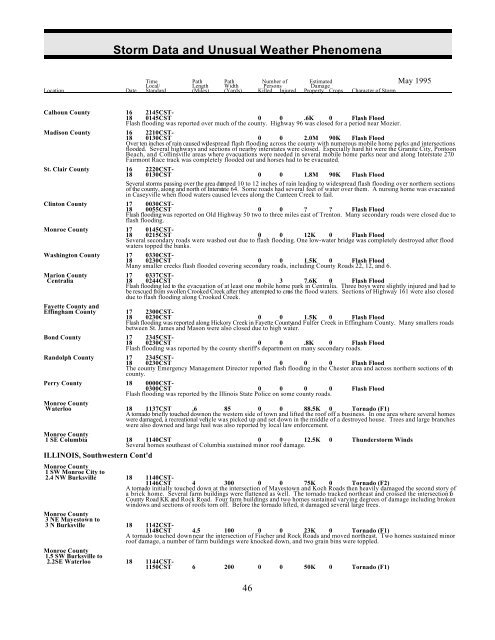
Time Path Path Number of Estimated May 1995<br />
Local/ Length Width Persons Damage<br />
Location Date St<strong>and</strong>ard (Miles) (Yards) Killed Injured Property Crops Character of <strong>Storm</strong><br />
Calhoun County 16 2145CST-<br />
18 0145CST 0 0 .6K 0 Flash Flood<br />
Flash flooding was reported over much of the county. Highway 96 was closed for a period near Mozier.<br />
Madison County 16 2210CST-<br />
18 0130CST 0 0 2.0M 90K Flash Flood<br />
Over ten inches of rain caused widespread flash flooding across the county with numerous mobile home parks <strong>and</strong> intersections<br />
flooded. Several highways <strong>and</strong> sections of nearby interstates were closed. Especially hard hit were the Granite City, Pontoon<br />
Beach, <strong>and</strong> Collinsville areas where evacuations were needed in several mobile home parks near <strong>and</strong> along Interstate 270 .<br />
Fairmont Race track was completely flooded out <strong>and</strong> horses had to be evacuated.<br />
St. Clair County 16 2220CST-<br />
18 0130CST 0 0 1.8M 90K Flash Flood<br />
Several storms passing over the area dumped 10 to 12 inches of rain leading to widespread flash flooding over northern sections<br />
of the county, along <strong>and</strong> north of Interstate 64. Some roads had several feet of water over them. A nursing home was evacuated<br />
in Caseyville when flood waters caused levees along the Canteen Creek to fail.<br />
Clinton County 17 0030CST-<br />
18 0055CST 0 0 ? ? Flash Flood<br />
Flash flooding was reported on Old Highway 50 two to three miles east of Trenton. Many secondary roads were closed due to<br />
flash flooding.<br />
Monroe County 17 0145CST-<br />
18 0215CST 0 0 12K 0 Flash Flood<br />
Several secondary roads were washed out due to flash flooding. One low-water bridge was completely destroyed after flood<br />
waters topped the banks.<br />
Washington County 17 0330CST-<br />
18 0230CST 0 0 1.5K 0 Flash Flood<br />
Many smaller creeks flash flooded covering secondary roads, including County Roads 22, 12, <strong>and</strong> 6.<br />
Marion County 17 0337CST-<br />
Centralia 18 0244CST 0 3 7.6K 0 Flash Flood<br />
Flash flooding led to the evacuation of at least one mobile home park in Centralia. Three boys were slightly injured <strong>and</strong> had to<br />
be rescued from swollen Crooked Creek after they attempted to cross the flood waters. Sections of Highway 161 were also closed<br />
due to flash flooding along Crooked Creek.<br />
Fayette County <strong>and</strong><br />
Effingham County 17 2300CST-<br />
18 0230CST 0 0 1.5K 0 Flash Flood<br />
Flash flooding was reported along Hickory Creek in Fayette County<strong>and</strong> Fulfer Creek in Effingham County. Many smallers roads<br />
between St. James <strong>and</strong> Mason were also closed due to high water.<br />
Bond County 17 2345CST-<br />
18 0230CST 0 0 .8K 0 Flash Flood<br />
Flash flooding was reported by the county sheriff's department on many secondary roads.<br />
R<strong>and</strong>olph County 17 2345CST-<br />
18 0230CST 0 0 0 0 Flash Flood<br />
The county Emergency Management Director reported flash flooding in the Chester area <strong>and</strong> across northern sections of the<br />
county.<br />
Perry County 18 0000CST-<br />
0300CST 0 0 0 0 Flash Flood<br />
Flash flooding was reported by the Illinois State Police on some county roads.<br />
Monroe County<br />
Waterloo 18 1137CST .6 85 0 0 88.5K 0 Tornado (F1)<br />
A tornado briefly touched down on the western side of town <strong>and</strong> lifted the roof off a business. In one area where several homes<br />
were damaged, a recreational vehicle was picked up <strong>and</strong> set down in the middle of a destroyed house. Trees <strong>and</strong> large branches<br />
were also downed <strong>and</strong> large hail was also reported by local law enforcement.<br />
Monroe County<br />
1 SE Columbia 18 1140CST 0 0 12.5K 0 Thunderstorm Winds<br />
Several homes southeast of Columbia sustained minor roof damage.<br />
ILLINOIS, Southwestern Cont'd<br />
Monroe County<br />
1 SW Monroe City to<br />
2.4 NW Burksville 18 1140CST-<br />
1146CST 4 300 0 0 75K 0 Tornado (F2)<br />
A tornado initially touched down at the intersection of Mayestown <strong>and</strong> Koch Roads then heavily damaged the second story of<br />
a brick home. Several farm buildings were flattened as well. The tornado tracked northeast <strong>and</strong> crossed the intersection of<br />
County Road KK <strong>and</strong> Rock Road. Four farm buildings <strong>and</strong> two homes sustained varying degrees of damage including broken<br />
windows <strong>and</strong> sections of roofs torn off. Before the tornado lifted, it damaged several large trees.<br />
Monroe County<br />
3 NE Mayestown to<br />
3 N Burksville 18 1142CST-<br />
1148CST 4.5 100 0 0 23K 0 Tornado (F1)<br />
A tornado touched down near the intersection of Fischer <strong>and</strong> Rock Roads <strong>and</strong> moved northeast. Two homes sustained minor<br />
roof damage, a number of farm buildings were knocked down, <strong>and</strong> two grain bins were toppled.<br />
Monroe County<br />
1.5 SW Burksville to<br />
2.2SE Waterloo 18 1144CST-<br />
1150CST 6 200 0 0 50K 0 Tornado (F1)<br />
46


